Totale Sonnenfinsternis vom 25.02.1077
| Wochentag: | Sonntag |
| Maximale Dauer der Verfinsterung: | 03m40s |
| Maximale Breite des Finsternispfades: | 290 km |
| Saroszyklus: | 115 |
| Bedeckungsgrad: | 100% |
| Magnitude: | 1.051 |
| Gamma: | 0.8214 |
Wo kann man die Sonnenfinsternis vom 25.02.1077 sehen?
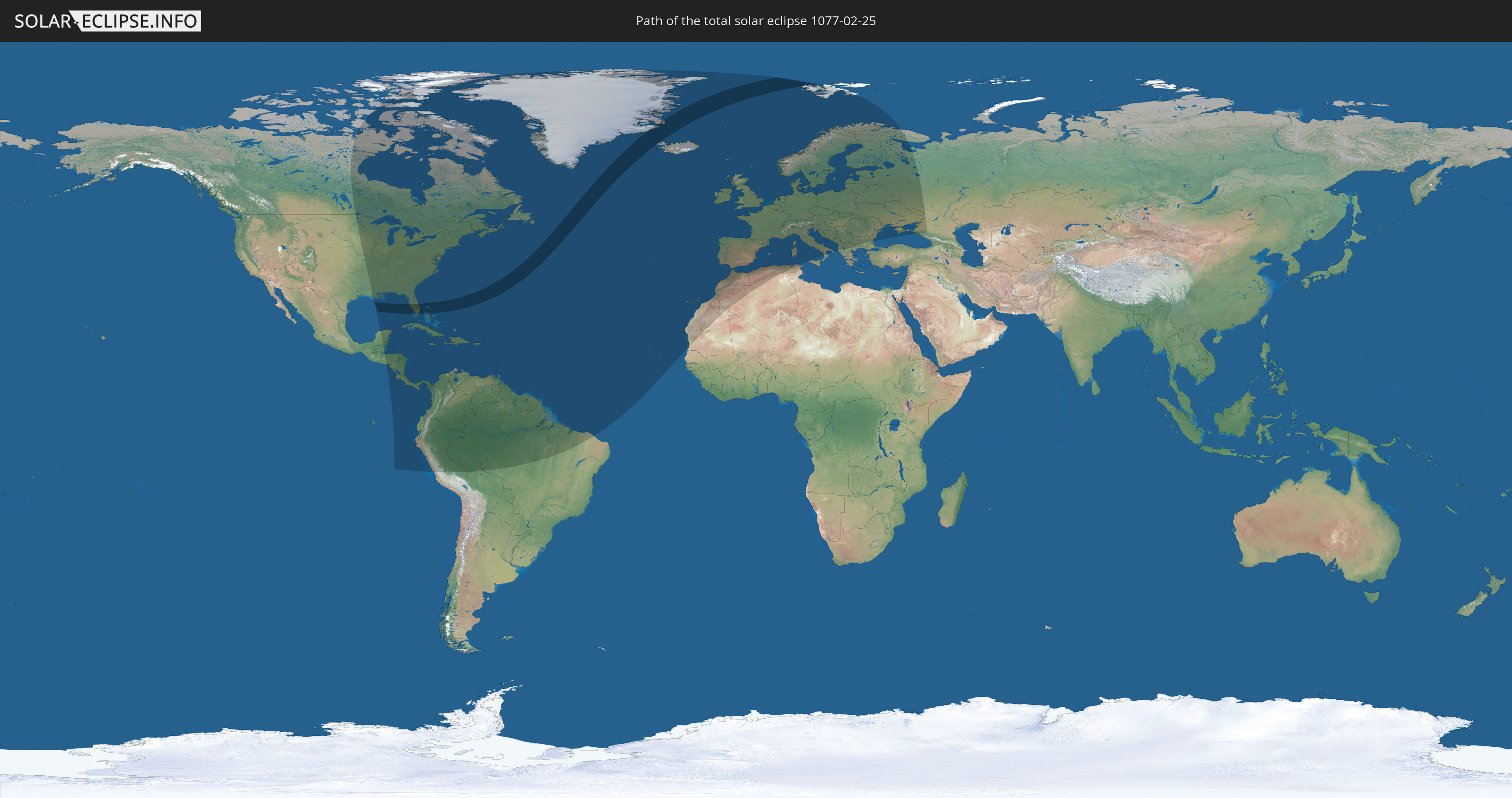
Die Sonnenfinsternis am 25.02.1077 kann man in 103 Ländern als partielle Sonnenfinsternis beobachten.
Der Finsternispfad verläuft durch 5 Länder. Nur in diesen Ländern ist sie als totale Sonnenfinsternis zu sehen.
In den folgenden Ländern ist die Sonnenfinsternis total zu sehen
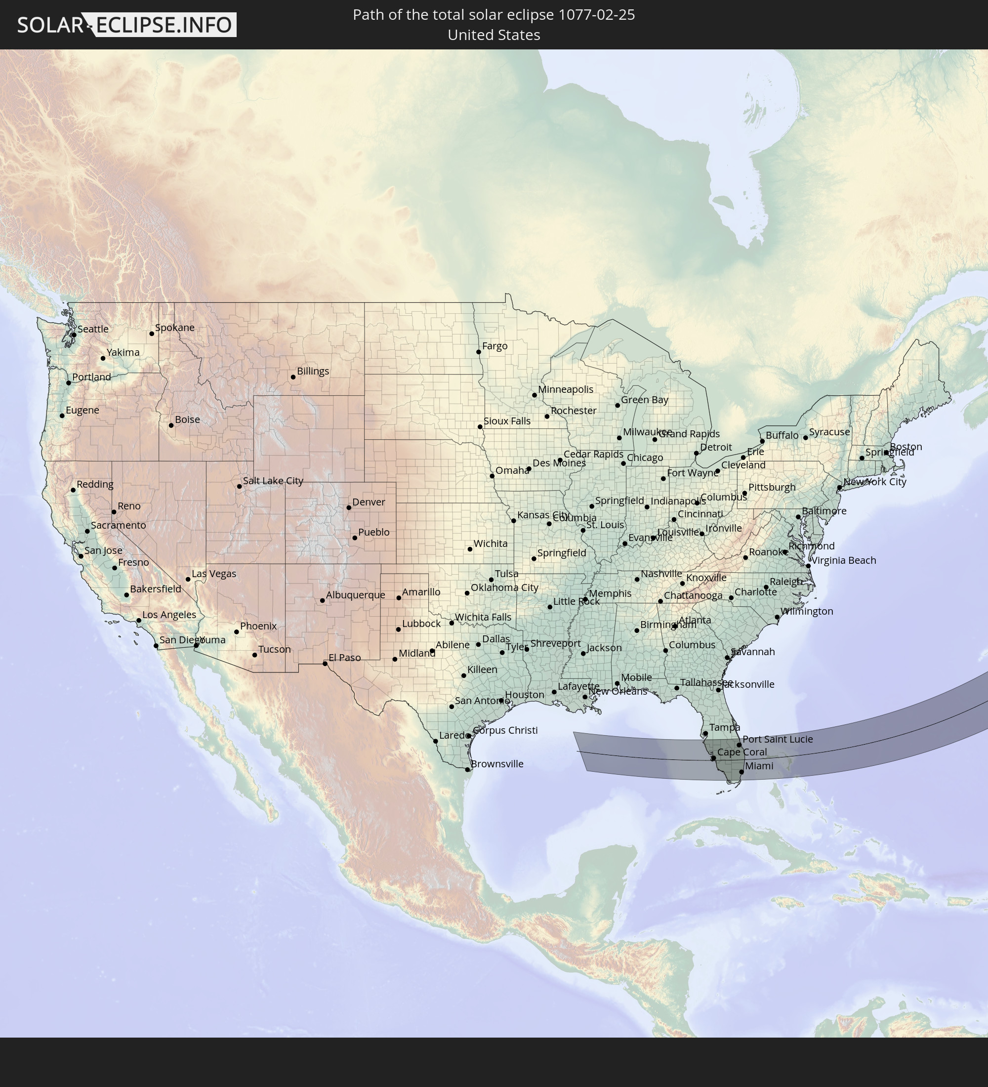 Vereinigte Staaten
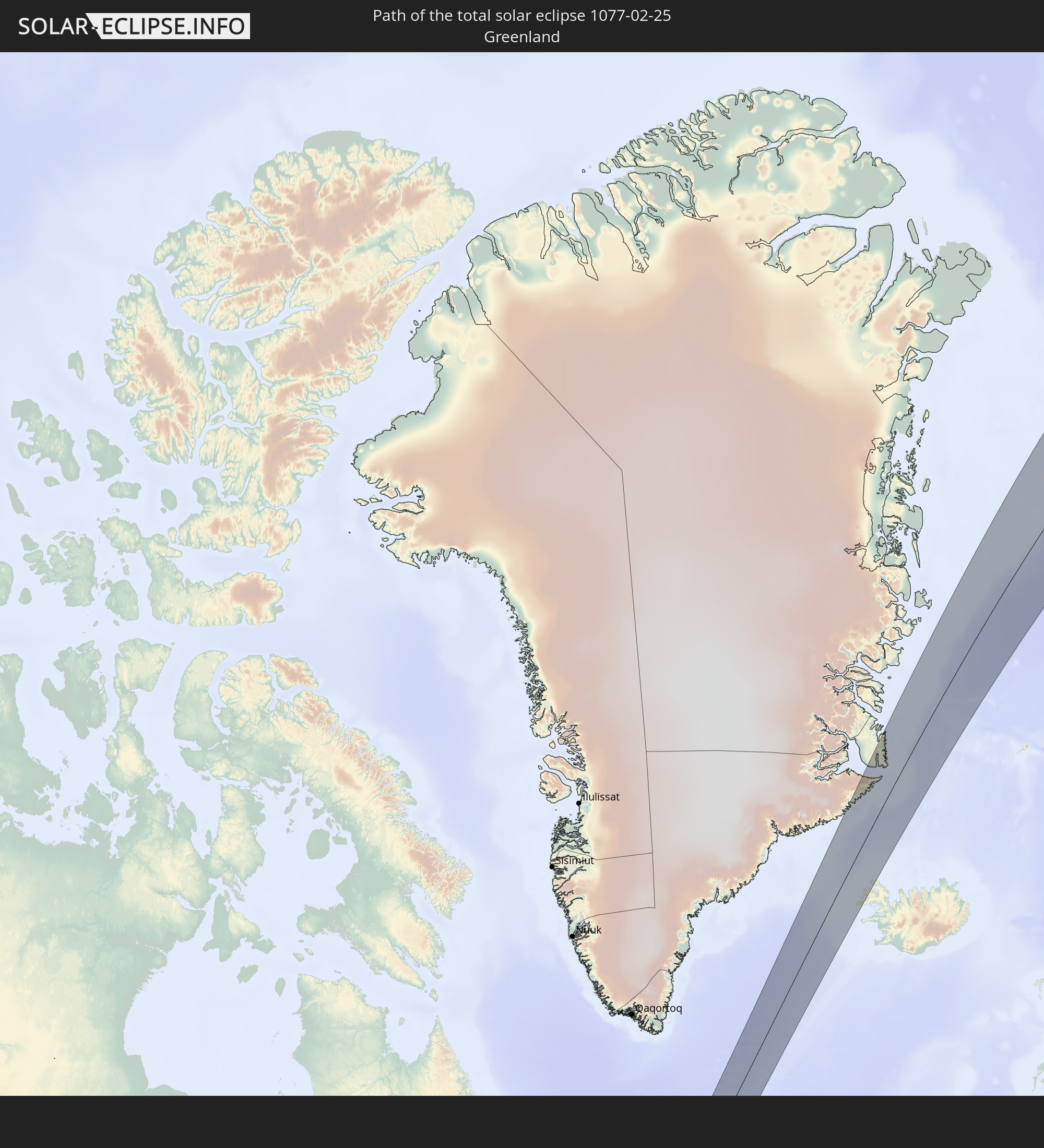 Grönland
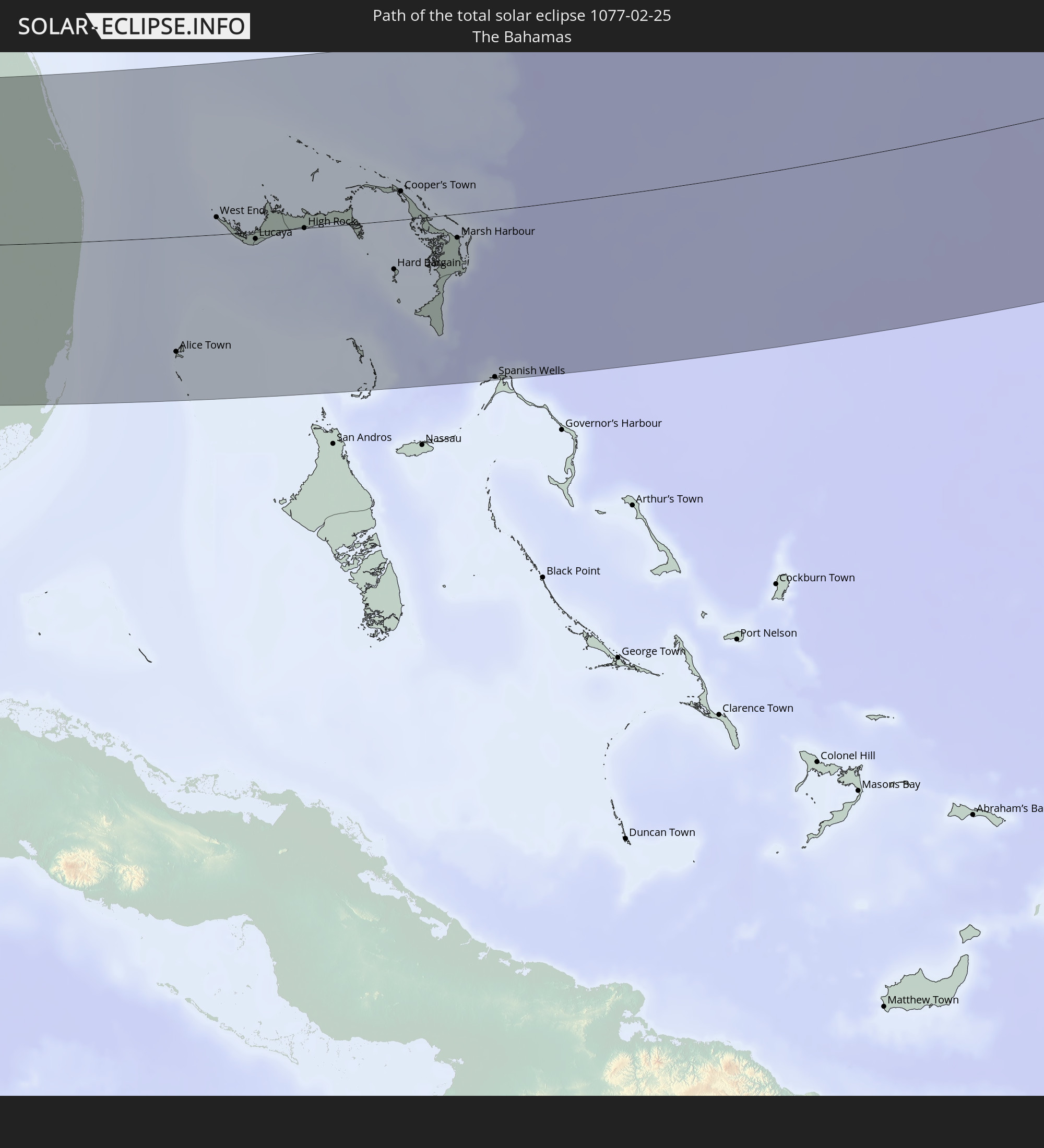 Bahamas
 Island
 Spitzbergen
In den folgenden Ländern ist die Sonnenfinsternis partiell zu sehen
 Russland
 Vereinigte Staaten
 United States Minor Outlying Islands
 Kanada
 Mexiko
 Grönland
 Guatemala
 Ecuador
 El Salvador
 Honduras
 Belize
 Nicaragua
 Costa Rica
 Kuba
Kuba
 Panama
 Kolumbien
 Kaimaninseln
 Peru
Peru
 Bahamas
 Jamaika
 Haiti
Haiti
 Brasilien
 Venezuela
 Turks- und Caicosinseln
 Dominikanische Republik
 Aruba
Aruba
 Bolivien
 Puerto Rico
 Amerikanische Jungferninseln
 Bermuda
 Britische Jungferninseln
 Anguilla
 Saint-Martin
 Saint-Barthélemy
 St. Kitts und Nevis
 Antigua und Barbuda
 Montserrat
 Trinidad und Tobago
 Guadeloupe
 Grenada
 Dominica
 St. Vincent und die Grenadinen
 Guyana
 Martinique
 St. Lucia
 Barbados
 Suriname
 Saint-Pierre und Miquelon
 Französisch-Guayana
 Portugal
 Kap Verde
 Island
 Spanien
 Mauretanien
 Marokko
 Irland
 Spitzbergen
 Algerien
 Vereinigtes Königreich
 Färöer
 Gibraltar
 Frankreich
 Isle of Man
 Guernsey
 Jersey
 Andorra
 Belgien
 Niederlande
 Norwegen
 Luxemburg
 Deutschland
 Schweiz
 Italien
 Monaco
 Tunesien
 Dänemark
 Liechtenstein
 Österreich
 Schweden
 Tschechien
 San Marino
 Vatikanstadt
 Slowenien
 Kroatien
 Polen
Polen
 Bosnien und Herzegowina
 Ungarn
 Slowakei
 Montenegro
 Serbien
 Albanien
 Åland Islands
 Griechenland
 Rumänien
 Mazedonien
 Finnland
 Litauen
 Lettland
 Estland
 Ukraine
 Bulgarien
 Weißrussland
 Moldawien
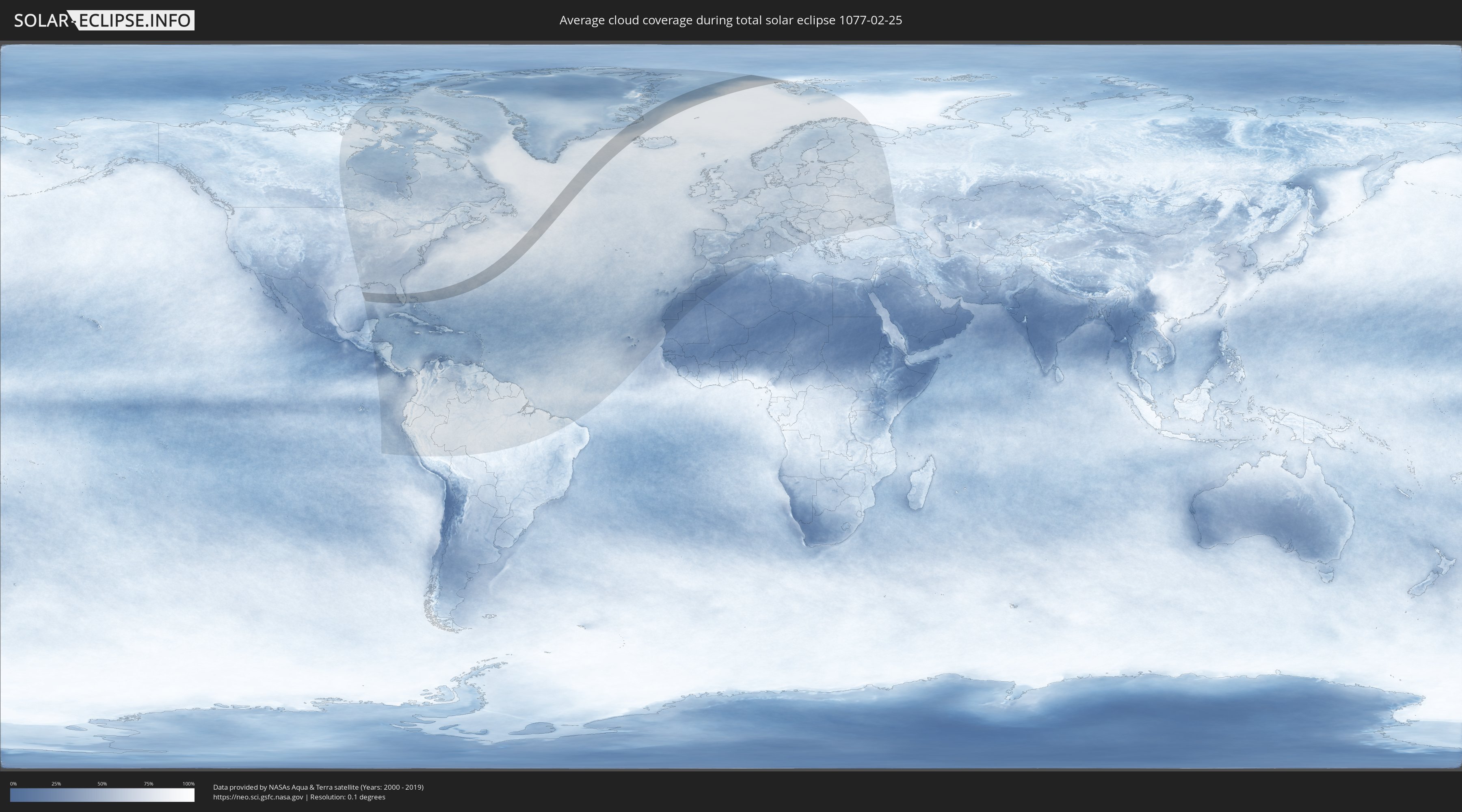
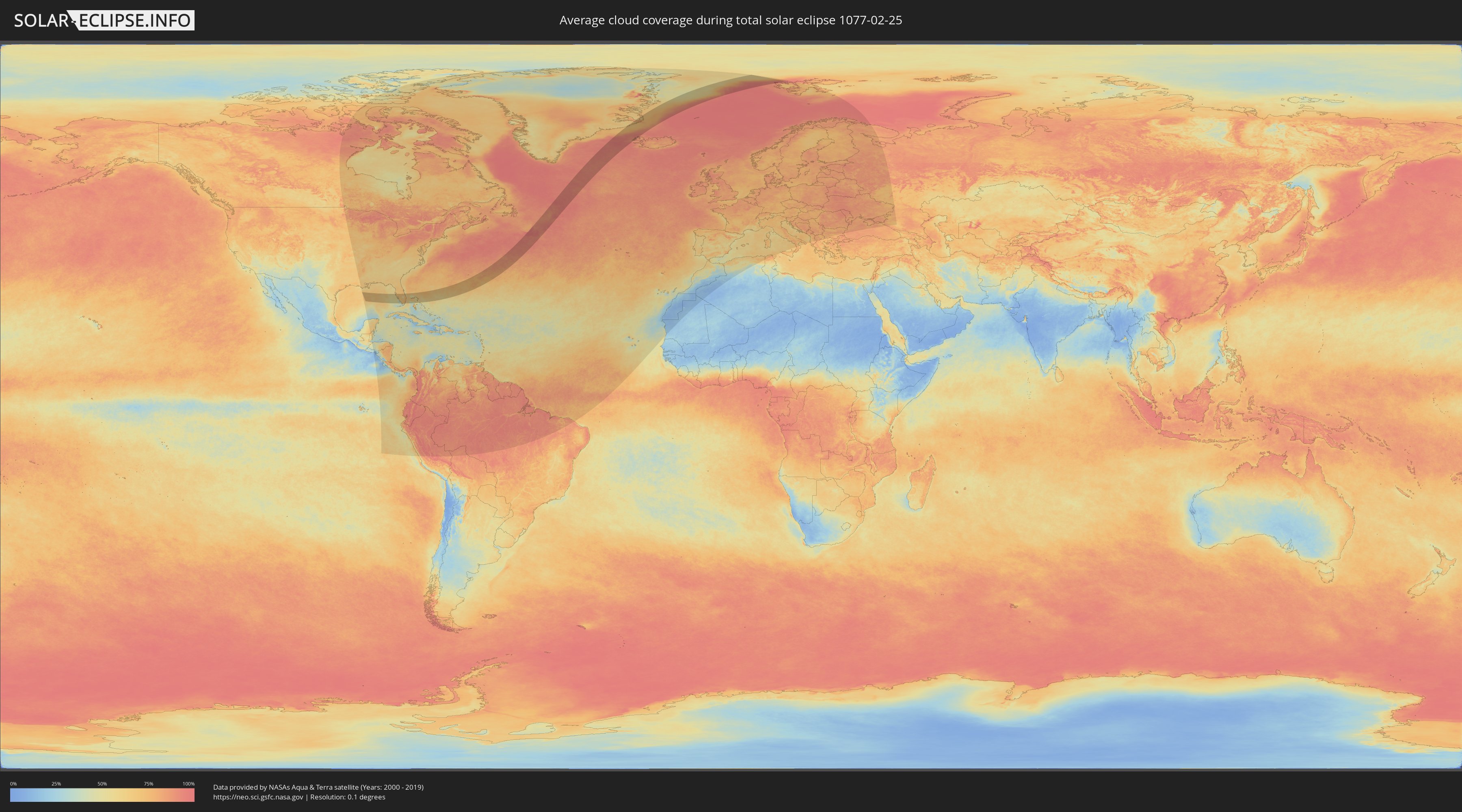
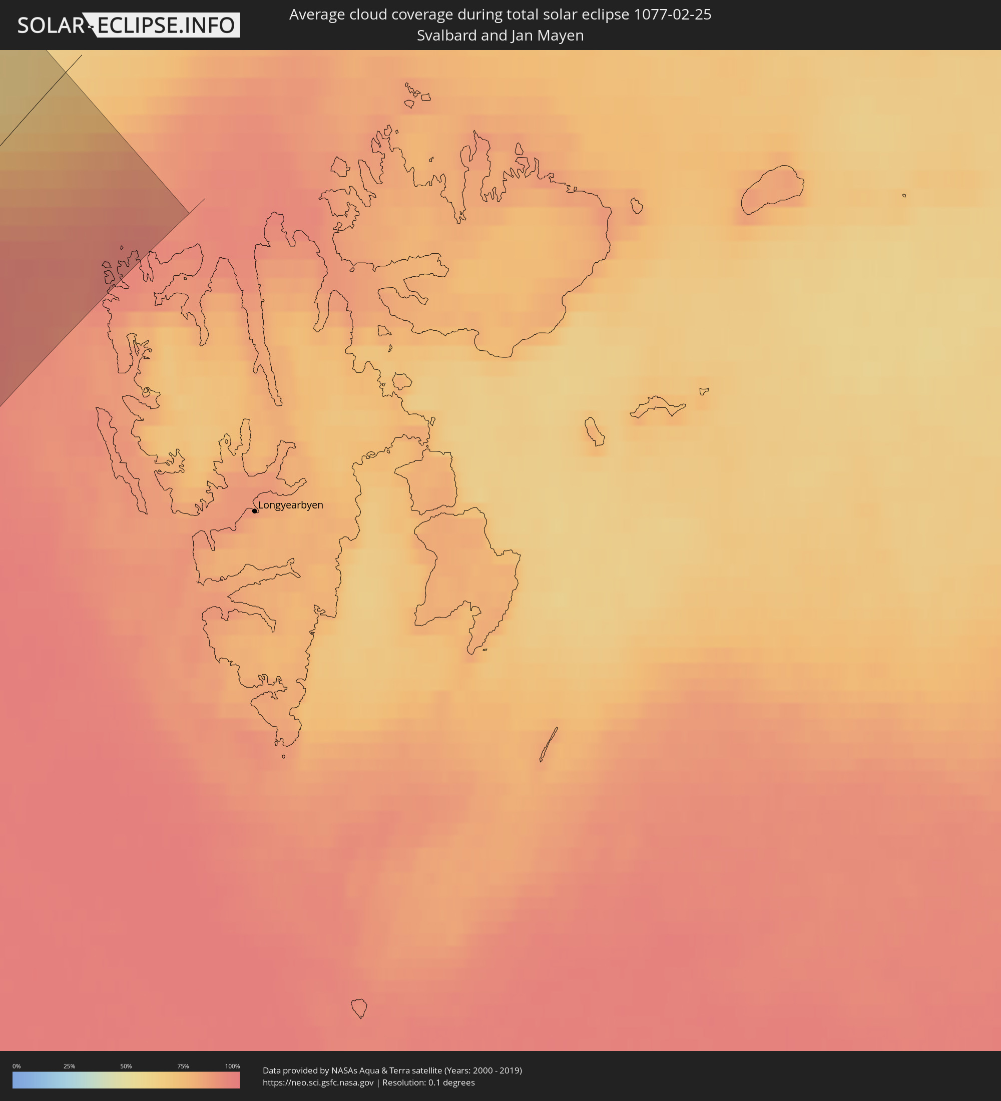
Wie wird das Wetter während der totalen Sonnenfinsternis am 25.02.1077?
Wo ist der beste Ort, um die totale Sonnenfinsternis vom 25.02.1077 zu beobachten?
Die folgenden Karten zeigen die durchschnittliche Bewölkung für den Tag, an dem die totale Sonnenfinsternis
stattfindet. Mit Hilfe der Karten lässt sich der Ort entlang des Finsternispfades eingrenzen,
der die besten Aussichen auf einen klaren wolkenfreien Himmel bietet.
Trotzdem muss man immer lokale Gegenenheiten beachten und sollte sich genau über das Wetter an seinem
gewählten Beobachtungsort informieren.
Die Daten stammen von den beiden NASA-Satelliten
AQUA und TERRA
und wurden über einen Zeitraum von 19 Jahren (2000 - 2019) gemittelt.
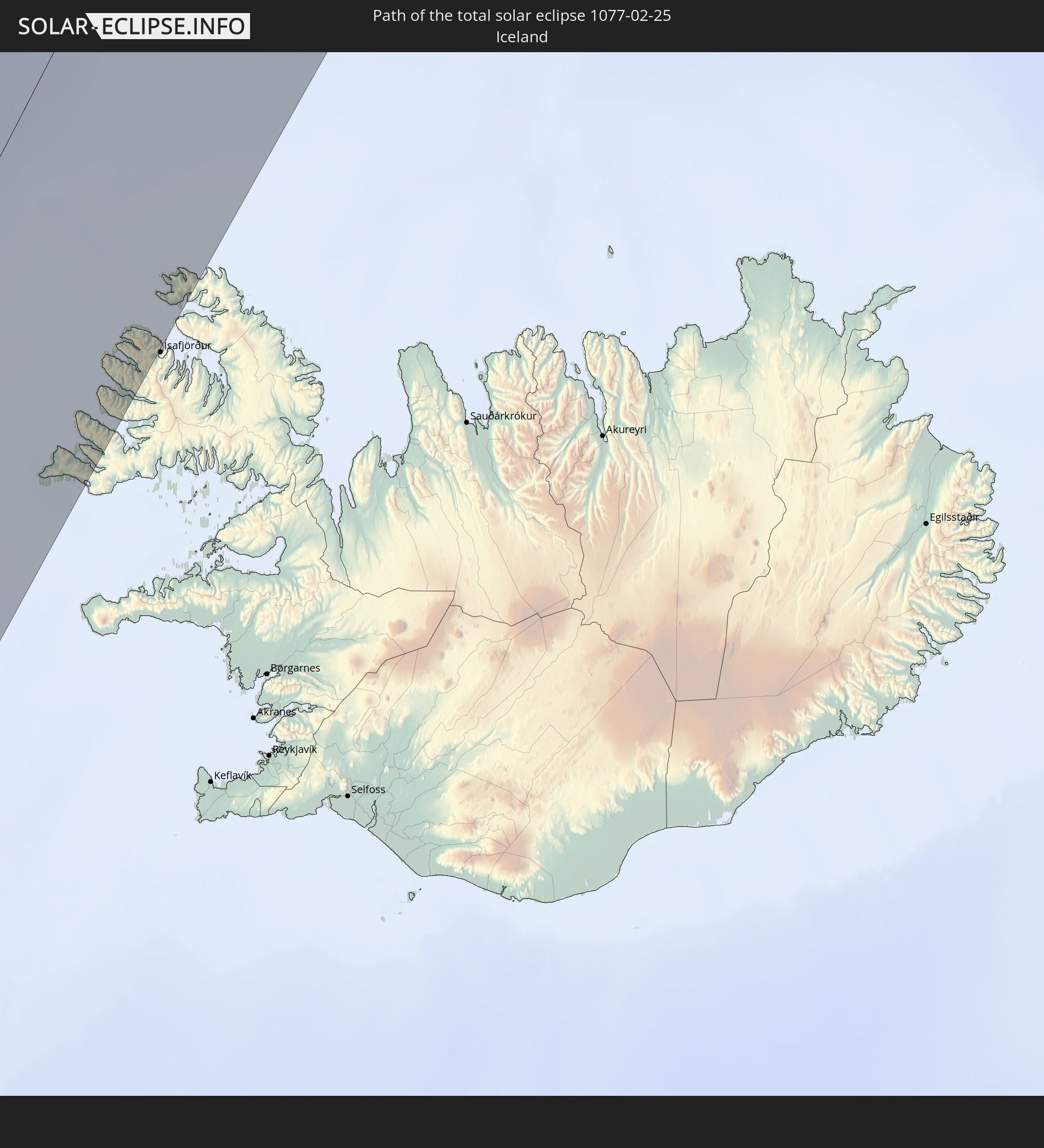
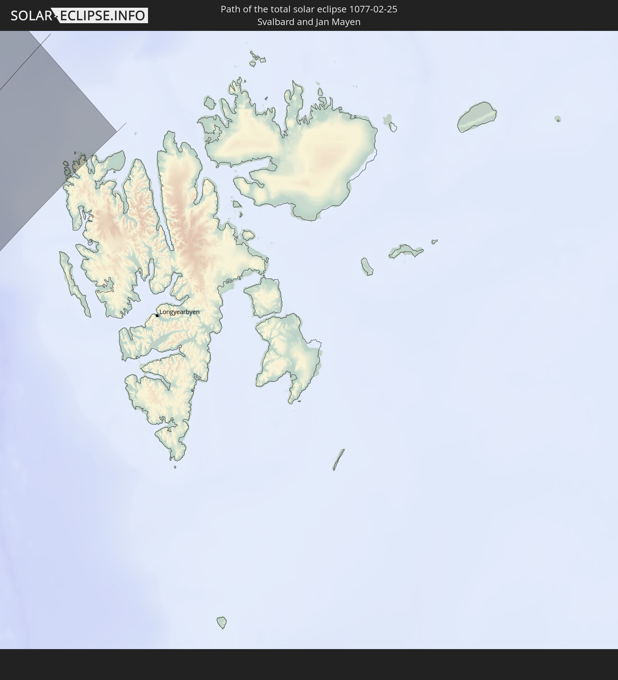
Detaillierte Länderkarten
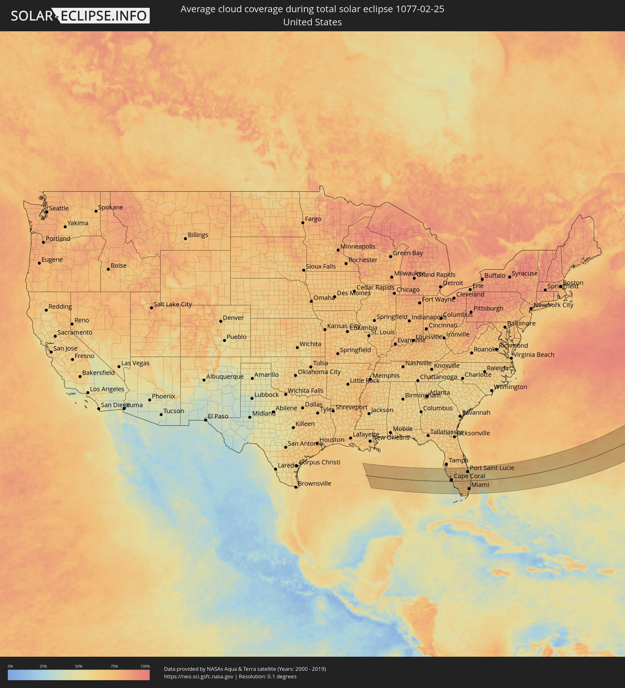 Vereinigte Staaten
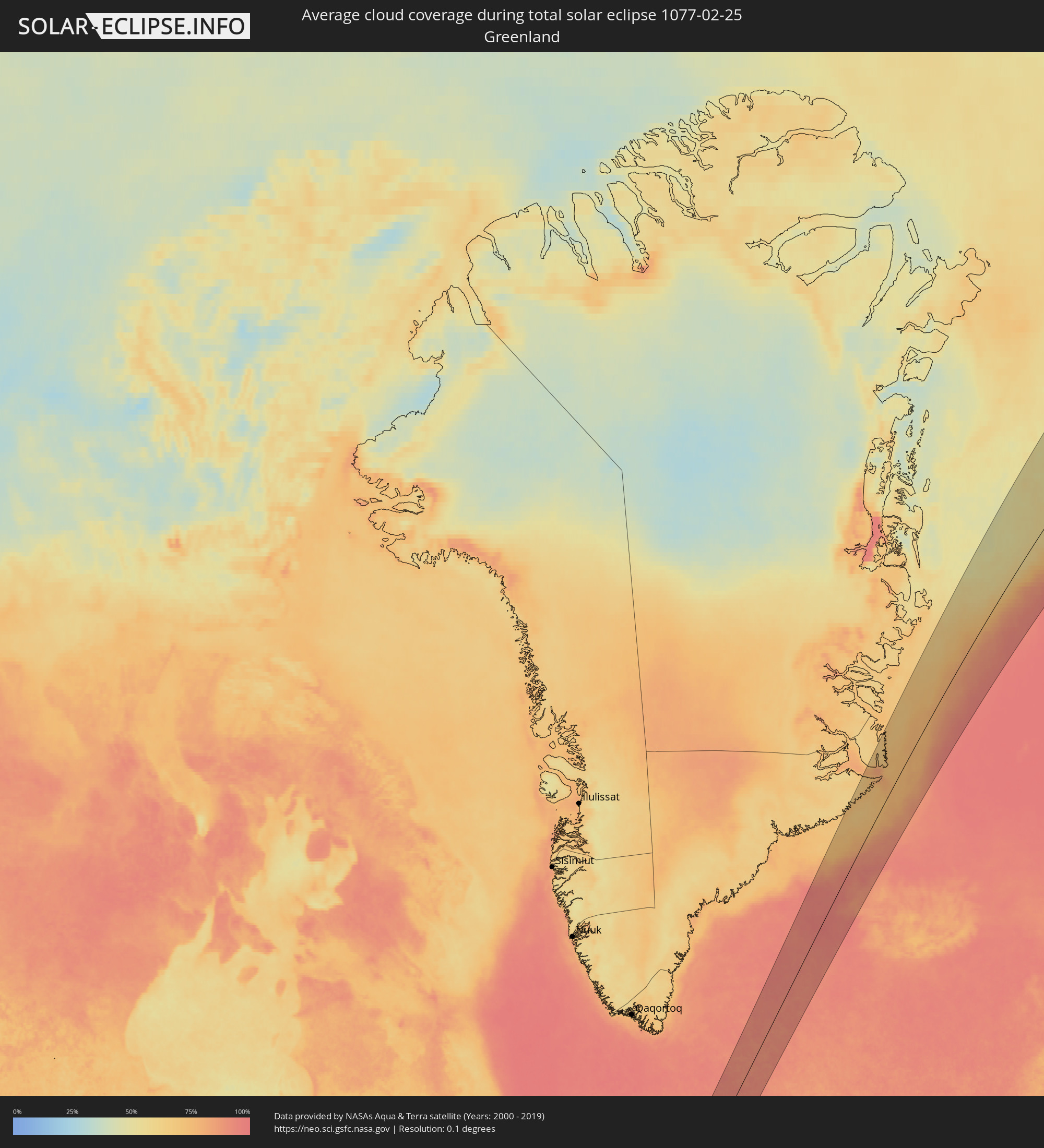 Grönland
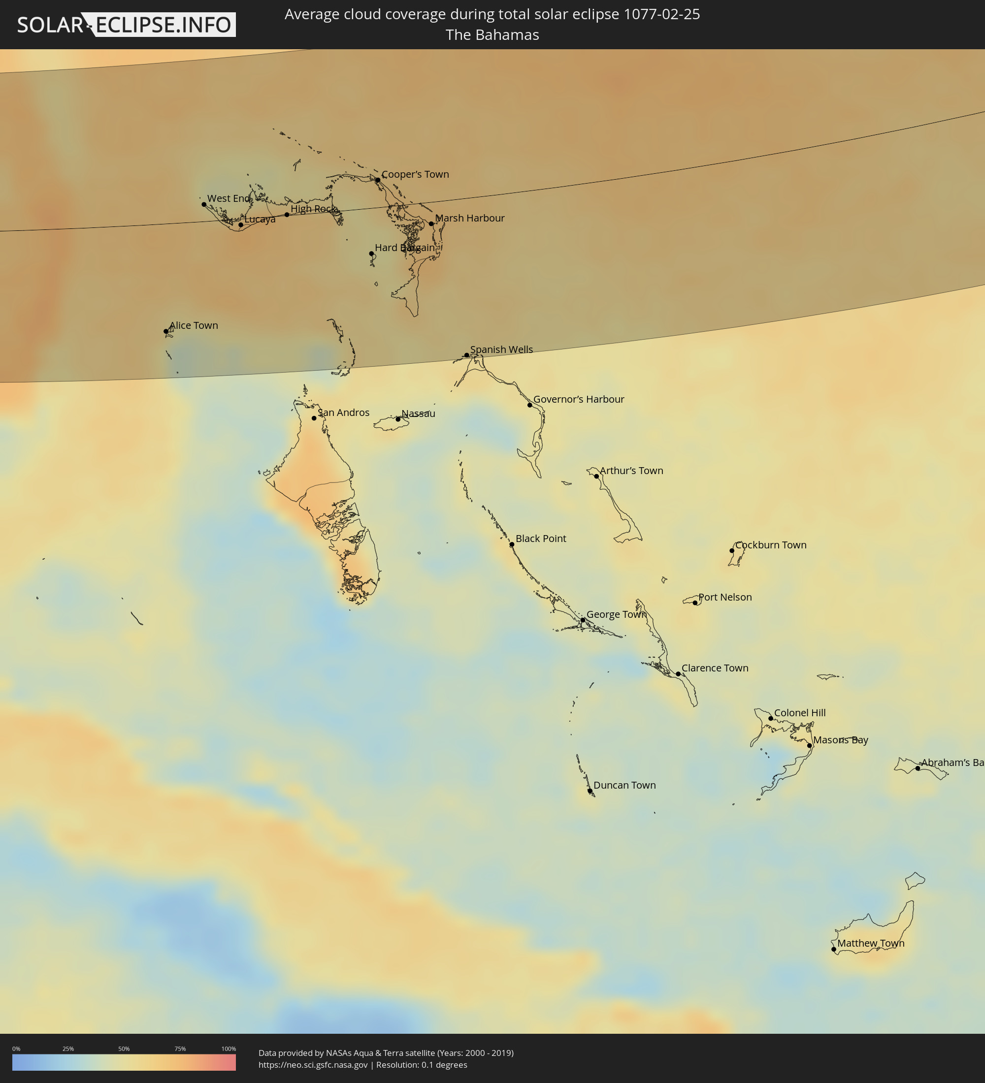 Bahamas
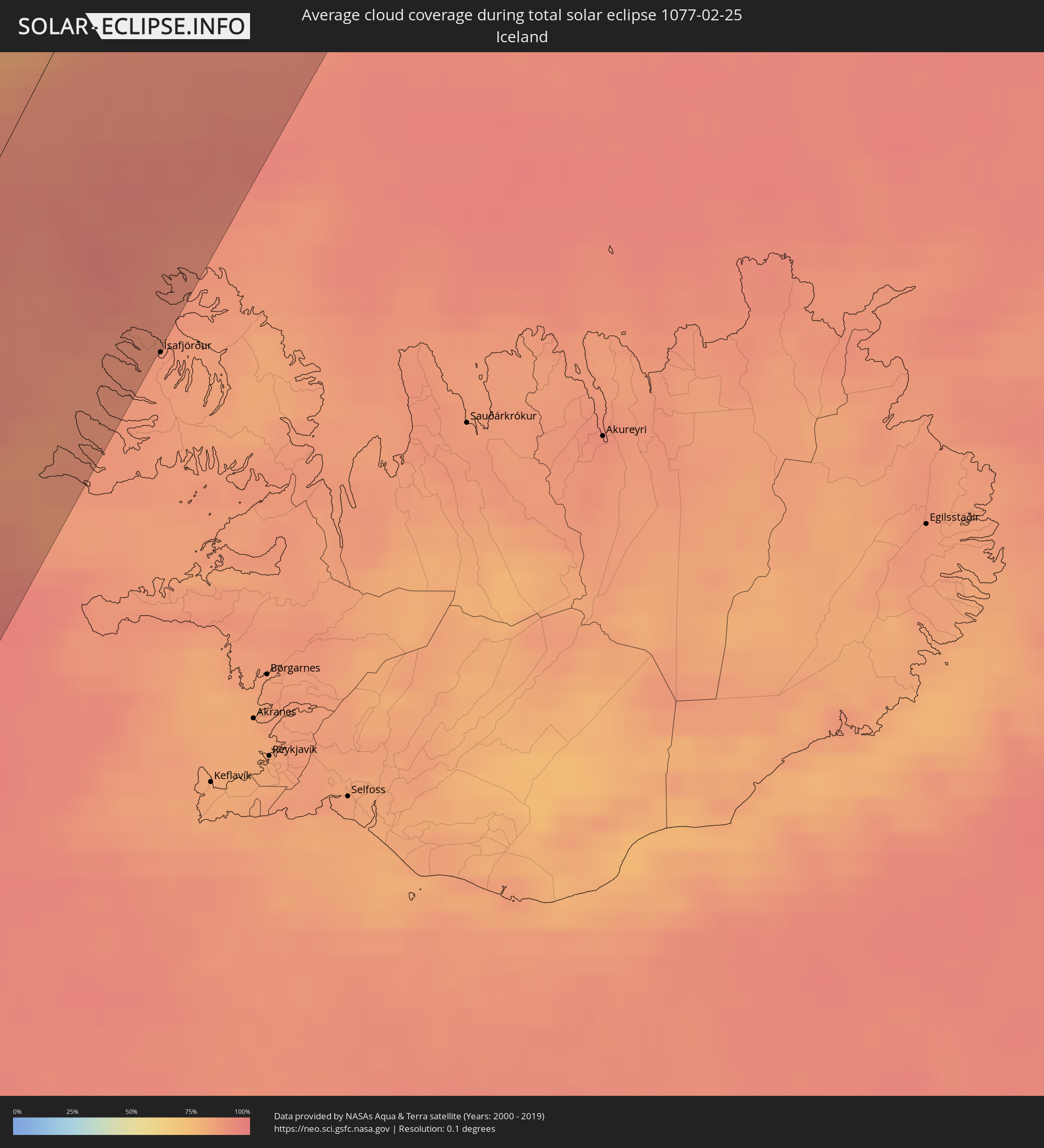 Island
 Spitzbergen
Orte im Finsternispfad
Die nachfolgene Tabelle zeigt Städte und Orte mit mehr als 5.000 Einwohnern, die sich im Finsternispfad befinden. Städte mit mehr als 100.000 Einwohnern sind dick gekennzeichnet. Mit einem Klick auf den Ort öffnet sich eine Detailkarte die die Lage des jeweiligen Ortes zusammen mit dem Verlauf der zentralen Finsternis präsentiert.
| Ort | Typ | Dauer der Verfinsterung | Ortszeit bei maximaler Verfinsterung | Entfernung zur Zentrallinie | Ø Bewölkung |
|
Longboat Key, Florida
|
total | - | 07:32:14 UTC-05:00 | 105 km | 56% |
|
Bradenton, Florida
|
total | - | 07:32:24 UTC-05:00 | 114 km | 62% |
|
Palmetto, Florida
|
total | - | 07:32:27 UTC-05:00 | 117 km | 62% |
|
Memphis, Florida
|
total | - | 07:32:28 UTC-05:00 | 118 km | 62% |
|
Siesta Key, Florida
|
total | - | 07:32:03 UTC-05:00 | 89 km | 64% |
|
Sarasota, Florida
|
total | - | 07:32:10 UTC-05:00 | 96 km | 64% |
|
North Sarasota, Florida
|
total | - | 07:32:14 UTC-05:00 | 100 km | 67% |
|
Gulf Gate Estates, Florida
|
total | - | 07:32:02 UTC-05:00 | 87 km | 64% |
|
Southgate, Florida
|
total | - | 07:32:08 UTC-05:00 | 93 km | 64% |
|
Bee Ridge, Florida
|
total | - | 07:32:06 UTC-05:00 | 90 km | 64% |
|
Sarasota Springs, Florida
|
total | - | 07:32:09 UTC-05:00 | 93 km | 64% |
|
Laurel, Florida
|
total | - | 07:31:53 UTC-05:00 | 75 km | 53% |
|
Fruitville, Florida
|
total | - | 07:32:11 UTC-05:00 | 96 km | 64% |
|
Venice, Florida
|
total | - | 07:31:49 UTC-05:00 | 70 km | 53% |
|
South Venice, Florida
|
total | - | 07:31:45 UTC-05:00 | 65 km | 61% |
|
Venice Gardens, Florida
|
total | - | 07:31:48 UTC-05:00 | 67 km | 61% |
|
Englewood, Florida
|
total | - | 07:31:39 UTC-05:00 | 55 km | 57% |
|
Rotonda, Florida
|
total | - | 07:31:33 UTC-05:00 | 46 km | 55% |
|
North Port, Florida
|
total | - | 07:31:49 UTC-05:00 | 64 km | 59% |
|
Port Charlotte, Florida
|
total | - | 07:31:47 UTC-05:00 | 56 km | 62% |
|
Iona, Florida
|
total | - | 07:31:07 UTC-05:00 | 5 km | 51% |
|
Cape Coral, Florida
|
total | - | 07:31:11 UTC-05:00 | 10 km | 60% |
|
McGregor, Florida
|
total | - | 07:31:12 UTC-05:00 | 10 km | 60% |
|
Cypress Lake, Florida
|
total | - | 07:31:10 UTC-05:00 | 7 km | 58% |
|
Villas, Florida
|
total | - | 07:31:12 UTC-05:00 | 9 km | 60% |
|
Arcadia, Florida
|
total | - | 07:32:16 UTC-05:00 | 83 km | 70% |
|
Southeast Arcadia, Florida
|
total | - | 07:32:13 UTC-05:00 | 79 km | 70% |
|
Bonita Springs, Florida
|
total | - | 07:30:54 UTC-05:00 | 15 km | 58% |
|
Gateway, Florida
|
total | - | 07:31:18 UTC-05:00 | 12 km | 65% |
|
Marco, Florida
|
total | - | 07:30:21 UTC-05:00 | 56 km | 53% |
|
Golden Gate, Florida
|
total | - | 07:30:42 UTC-05:00 | 32 km | 65% |
|
Lehigh Acres, Florida
|
total | - | 07:31:26 UTC-05:00 | 17 km | 65% |
|
Avon Park, Florida
|
total | - | 07:33:02 UTC-05:00 | 125 km | 68% |
|
Sebring, Florida
|
total | - | 07:32:55 UTC-05:00 | 113 km | 69% |
|
Immokalee, Florida
|
total | - | 07:31:12 UTC-05:00 | 7 km | 68% |
|
Clewiston, Florida
|
total | - | 07:31:57 UTC-05:00 | 30 km | 57% |
|
Belle Glade, Florida
|
total | - | 07:31:58 UTC-05:00 | 21 km | 65% |
|
West Vero Corridor, Florida
|
total | - | 07:33:36 UTC-05:00 | 127 km | 71% |
|
Florida City, Florida
|
total | - | 07:30:05 UTC-05:00 | 117 km | 69% |
|
Homestead, Florida
|
total | - | 07:30:07 UTC-05:00 | 114 km | 71% |
|
Naranja, Florida
|
total | - | 07:30:14 UTC-05:00 | 109 km | 67% |
|
Vero Beach South, Florida
|
total | - | 07:33:36 UTC-05:00 | 124 km | 66% |
|
Gifford, Florida
|
total | - | 07:33:42 UTC-05:00 | 131 km | 65% |
|
Lakewood Park, Florida
|
total | - | 07:33:29 UTC-05:00 | 116 km | 71% |
|
Weston, Florida
|
total | - | 07:31:10 UTC-05:00 | 45 km | 73% |
|
Three Lakes, Florida
|
total | - | 07:30:26 UTC-05:00 | 95 km | 69% |
|
Vero Beach, Florida
|
total | - | 07:33:39 UTC-05:00 | 127 km | 66% |
|
Goulds, Florida
|
total | - | 07:30:19 UTC-05:00 | 104 km | 69% |
|
Lakewood Park, Florida
|
total | - | 07:33:24 UTC-05:00 | 109 km | 71% |
|
Sweetwater, Florida
|
total | - | 07:30:38 UTC-05:00 | 82 km | 75% |
|
Westwood Lake, Florida
|
total | - | 07:30:35 UTC-05:00 | 86 km | 73% |
|
Richmond Heights, Florida
|
total | - | 07:30:26 UTC-05:00 | 97 km | 69% |
|
West Perrine, Florida
|
total | - | 07:30:24 UTC-05:00 | 100 km | 69% |
|
Palmetto Estates, Florida
|
total | - | 07:30:25 UTC-05:00 | 98 km | 69% |
|
Fort Pierce North, Florida
|
total | - | 07:33:24 UTC-05:00 | 108 km | 71% |
|
Olympia Heights, Florida
|
total | - | 07:30:35 UTC-05:00 | 86 km | 73% |
|
Doral, Florida
|
total | - | 07:30:44 UTC-05:00 | 76 km | 75% |
|
Port Saint Lucie, Florida
|
total | - | 07:33:07 UTC-05:00 | 88 km | 70% |
|
East Perrine, Florida
|
total | - | 07:30:25 UTC-05:00 | 99 km | 55% |
|
Southwest Ranches, Florida
|
total | - | 07:31:08 UTC-05:00 | 49 km | 76% |
|
Fort Pierce, Florida
|
total | - | 07:33:22 UTC-05:00 | 105 km | 67% |
|
Lakes by the Bay, Florida
|
total | - | 07:30:22 UTC-05:00 | 104 km | 55% |
|
Kendall, Florida
|
total | - | 07:30:32 UTC-05:00 | 92 km | 63% |
|
South Miami, Florida
|
total | - | 07:30:35 UTC-05:00 | 89 km | 63% |
|
Miami Springs, Florida
|
total | - | 07:30:46 UTC-05:00 | 76 km | 71% |
|
Coral Springs, Florida
|
total | - | 07:31:30 UTC-05:00 | 26 km | 74% |
|
Palm City, Florida
|
total | - | 07:32:57 UTC-05:00 | 74 km | 70% |
|
Opa-locka, Florida
|
total | - | 07:30:55 UTC-05:00 | 67 km | 75% |
|
Westview, Florida
|
total | - | 07:30:53 UTC-05:00 | 69 km | 71% |
|
Lake Lucerne, Florida
|
total | - | 07:31:01 UTC-05:00 | 60 km | 72% |
|
Wellington, Florida
|
total | - | 07:32:08 UTC-05:00 | 17 km | 78% |
|
Brownsville, Florida
|
total | - | 07:30:48 UTC-05:00 | 76 km | 65% |
|
Gladeview, Florida
|
total | - | 07:30:50 UTC-05:00 | 74 km | 65% |
|
Scott Lake, Florida
|
total | - | 07:30:59 UTC-05:00 | 63 km | 71% |
|
Jensen Beach, Florida
|
total | - | 07:33:06 UTC-05:00 | 83 km | 61% |
|
Pembroke Pines, Florida
|
total | - | 07:31:06 UTC-05:00 | 56 km | 72% |
|
Andover, Florida
|
total | - | 07:31:03 UTC-05:00 | 60 km | 72% |
|
Broadview Park, Florida
|
total | - | 07:31:15 UTC-05:00 | 45 km | 74% |
|
Port Salerno, Florida
|
total | - | 07:32:56 UTC-05:00 | 71 km | 67% |
|
West Park, Florida
|
total | - | 07:31:05 UTC-05:00 | 58 km | 72% |
|
Miami, Florida
|
total | - | 07:30:45 UTC-05:00 | 82 km | 65% |
|
Melrose Park, Florida
|
total | - | 07:31:17 UTC-05:00 | 44 km | 74% |
|
Miami Shores, Florida
|
total | - | 07:30:53 UTC-05:00 | 72 km | 71% |
|
Key Biscayne, Florida
|
total | - | 07:30:38 UTC-05:00 | 91 km | 55% |
|
North Bay Village, Florida
|
total | - | 07:30:53 UTC-05:00 | 74 km | 65% |
|
North Andrews Gardens, Florida
|
total | - | 07:31:26 UTC-05:00 | 35 km | 65% |
|
Fort Lauderdale, Florida
|
total | - | 07:31:19 UTC-05:00 | 43 km | 63% |
|
Kings Point, Florida
|
total | - | 07:31:51 UTC-05:00 | 7 km | 70% |
|
Wilton Manors, Florida
|
total | - | 07:31:23 UTC-05:00 | 39 km | 65% |
|
Hobe Sound, Florida
|
total | - | 07:32:50 UTC-05:00 | 61 km | 59% |
|
Pompano Beach Highlands, Florida
|
total | - | 07:31:36 UTC-05:00 | 25 km | 67% |
|
Jupiter, Florida
|
total | - | 07:32:39 UTC-05:00 | 47 km | 72% |
|
Lighthouse Point, Florida
|
total | - | 07:31:36 UTC-05:00 | 26 km | 67% |
|
Boca Raton, Florida
|
total | - | 07:31:44 UTC-05:00 | 17 km | 70% |
|
North Palm Beach, Florida
|
total | - | 07:32:28 UTC-05:00 | 34 km | 74% |
|
Lake Park, Florida
|
total | - | 07:32:27 UTC-05:00 | 32 km | 74% |
|
Boynton Beach, Florida
|
total | - | 07:32:01 UTC-05:00 | 2 km | 74% |
|
West Palm Beach, Florida
|
total | - | 07:32:19 UTC-05:00 | 23 km | 73% |
|
Lantana, Florida
|
total | - | 07:32:07 UTC-05:00 | 8 km | 75% |
|
Palm Beach, Florida
|
total | - | 07:32:19 UTC-05:00 | 21 km | 68% |
|
Alice Town, Bimini
|
total | - | 07:21:37 UTC-05:09 | 91 km | 49% |
|
West End, West Grand Bahama
|
total | - | 07:23:20 UTC-05:09 | 14 km | 62% |
|
Freeport, Freeport
|
total | - | 07:23:14 UTC-05:09 | 5 km | 69% |
|
Lucaya, Freeport
|
total | - | 07:23:15 UTC-05:09 | 6 km | 69% |
|
High Rock, East Grand Bahama
|
total | - | 12:33:06 UTC+00:00 | 0 km | 67% |
|
Hard Bargain, Moore’s Island
|
total | - | 07:23:31 UTC-05:09 | 39 km | 56% |
|
Cooper’s Town, North Abaco
|
total | - | 07:24:28 UTC-05:09 | 22 km | 63% |
|
Marsh Harbour, Central Abaco
|
total | - | 07:24:11 UTC-05:09 | 19 km | 68% |
|
Spanish Wells, Spanish Wells
|
total | - | 07:22:44 UTC-05:09 | 132 km | 55% |