Totale Sonnenfinsternis vom 01.07.1098
| Wochentag: | Freitag |
| Maximale Dauer der Verfinsterung: | 07m05s |
| Maximale Breite des Finsternispfades: | 263 km |
| Saroszyklus: | 112 |
| Bedeckungsgrad: | 100% |
| Magnitude: | 1.0768 |
| Gamma: | -0.332 |
Wo kann man die Sonnenfinsternis vom 01.07.1098 sehen?
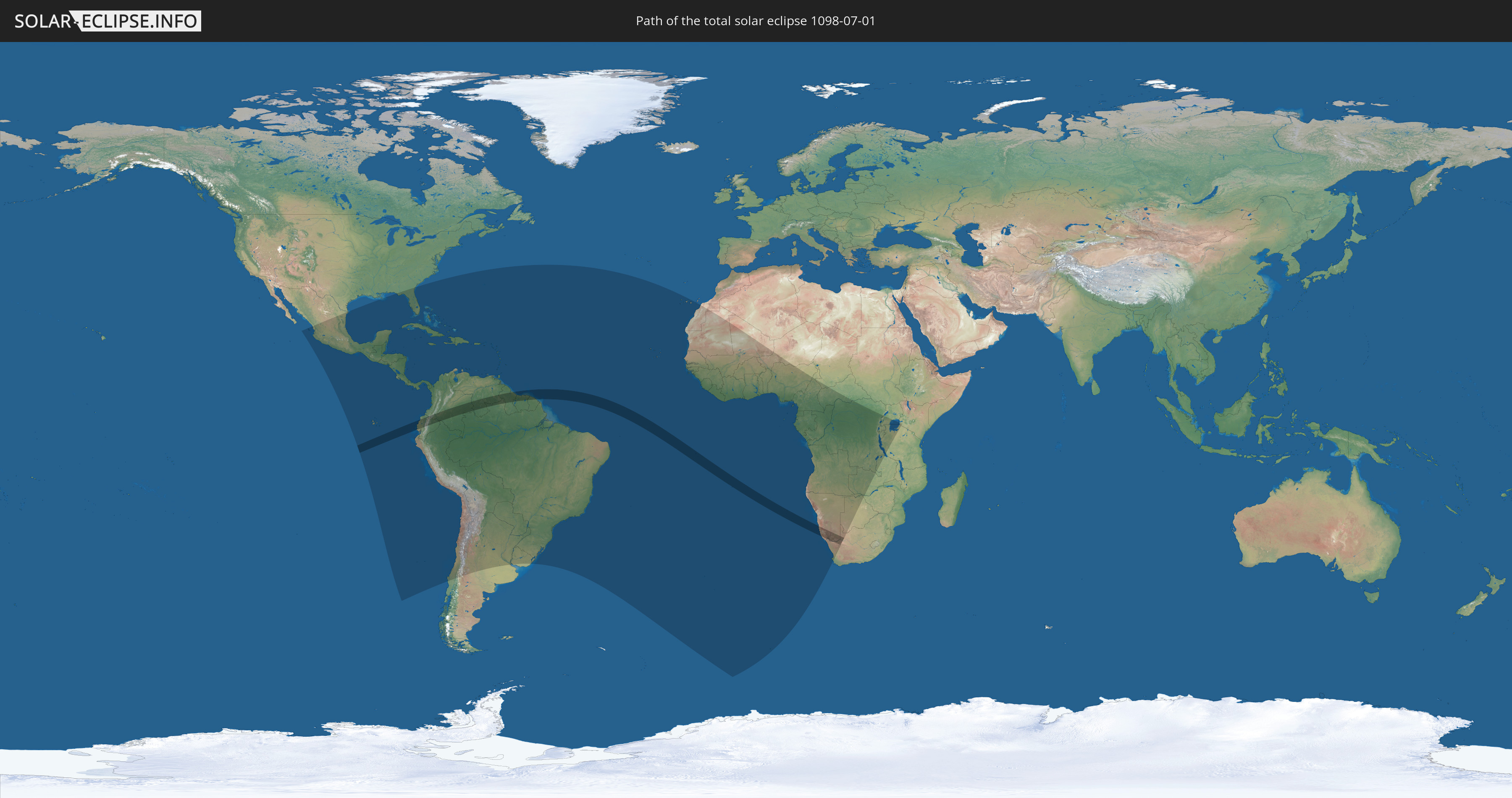
Die Sonnenfinsternis am 01.07.1098 kann man in 87 Ländern als partielle Sonnenfinsternis beobachten.
Der Finsternispfad verläuft durch 11 Länder. Nur in diesen Ländern ist sie als totale Sonnenfinsternis zu sehen.
In den folgenden Ländern ist die Sonnenfinsternis total zu sehen
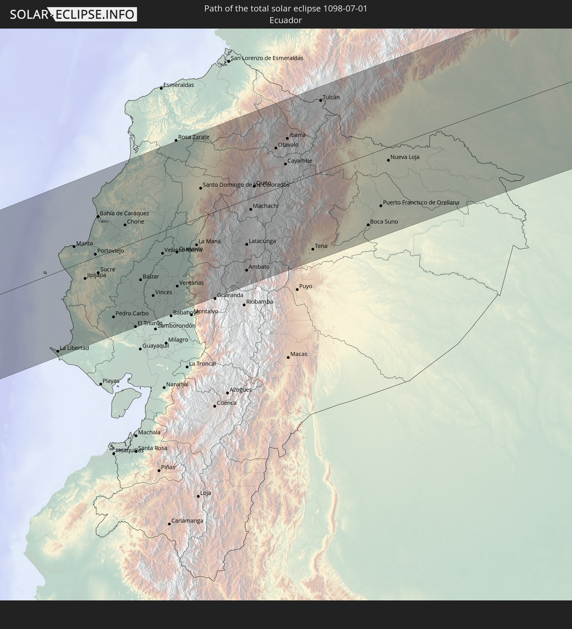 Ecuador
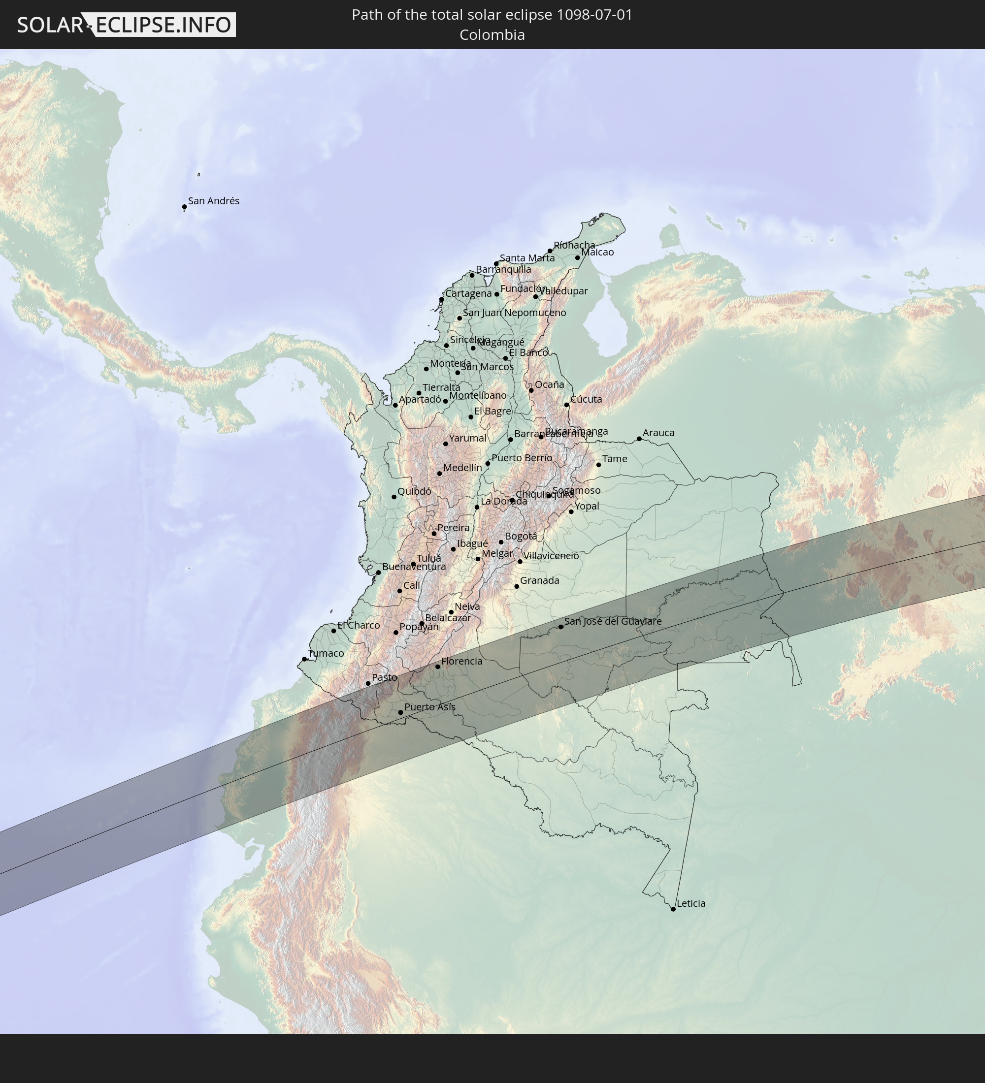 Kolumbien
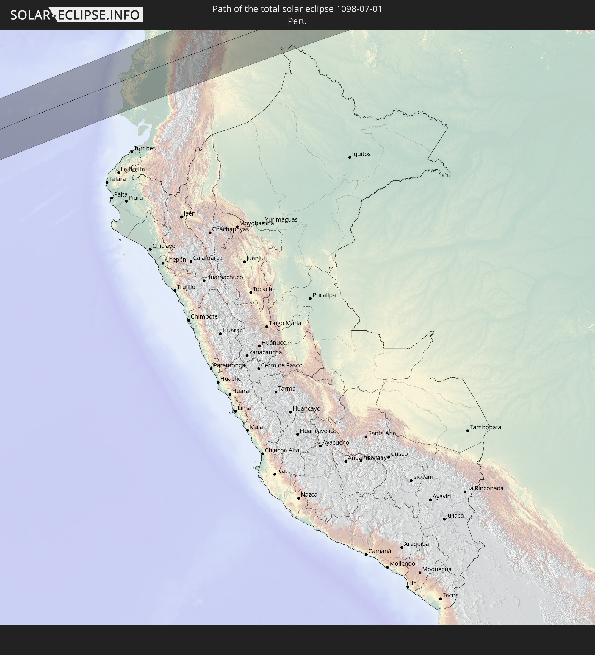 Peru
Peru
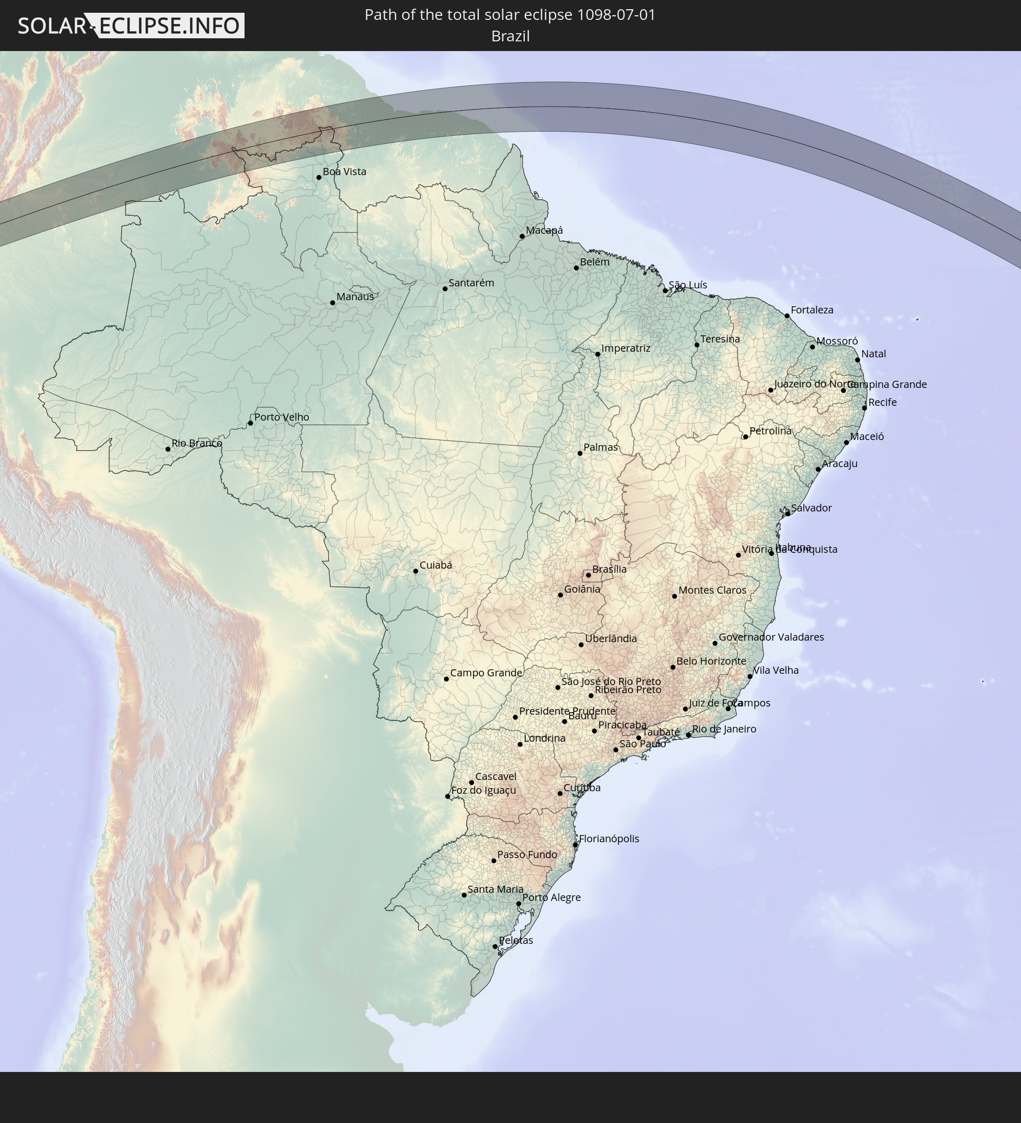 Brasilien
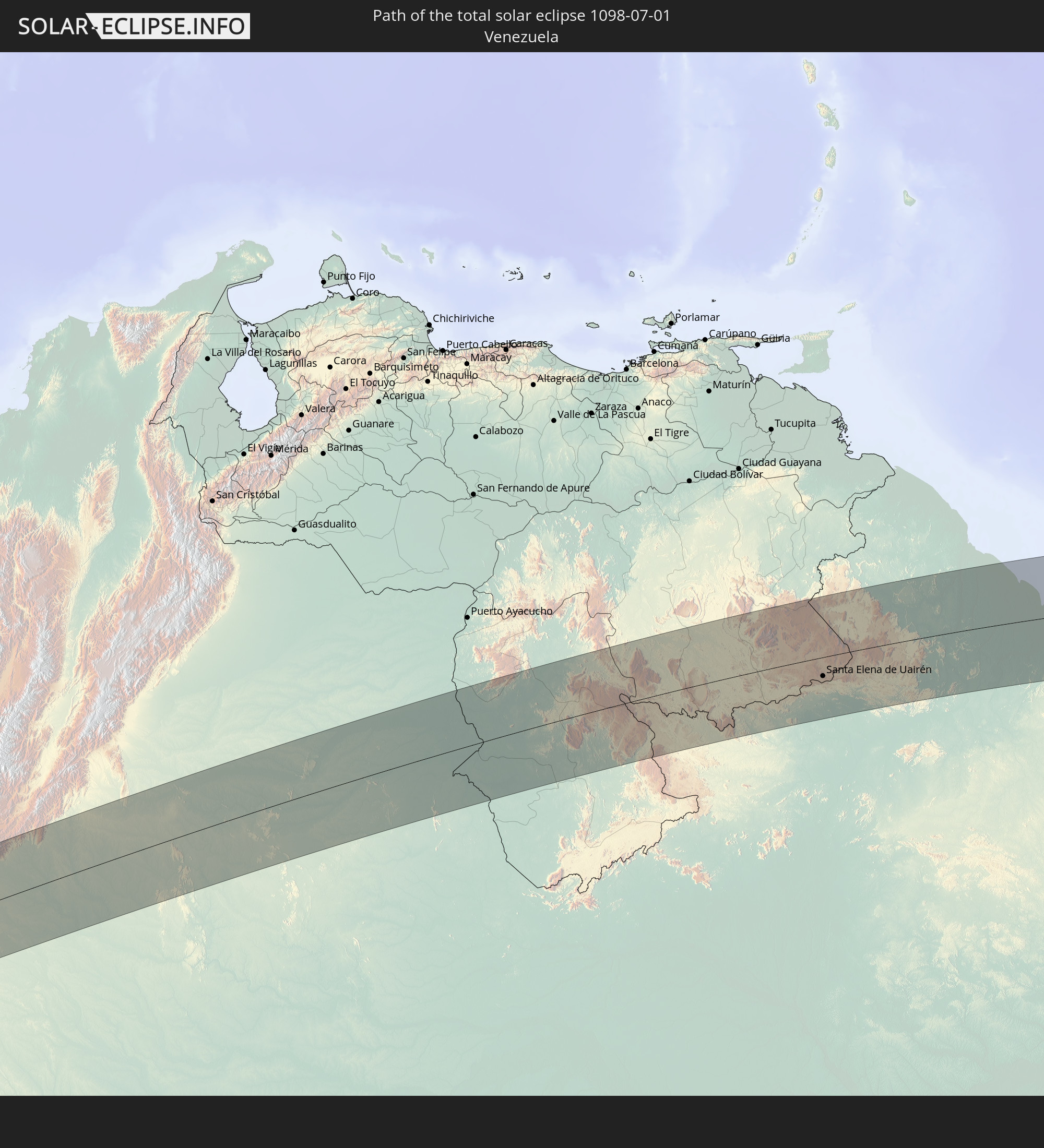 Venezuela
 Guyana
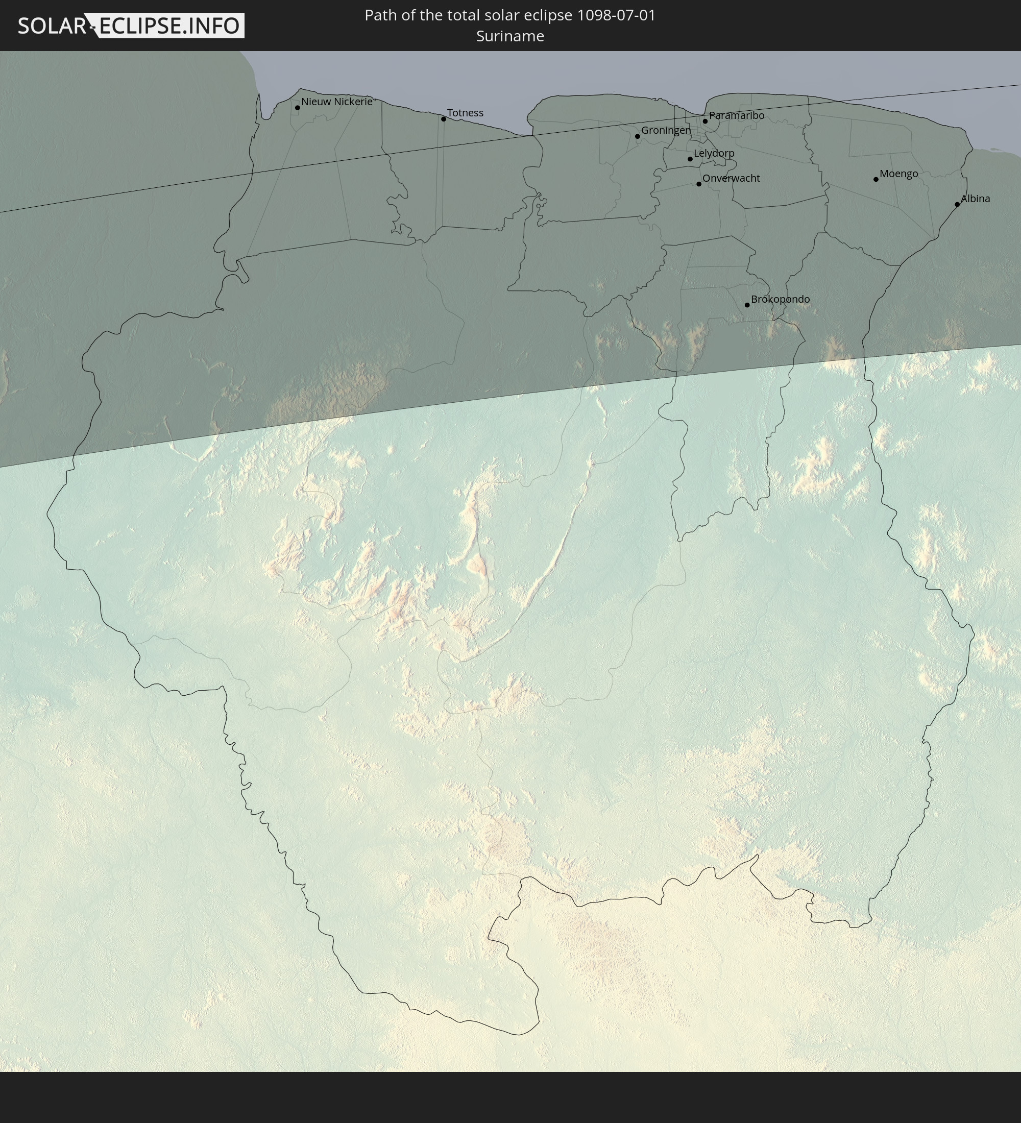 Suriname
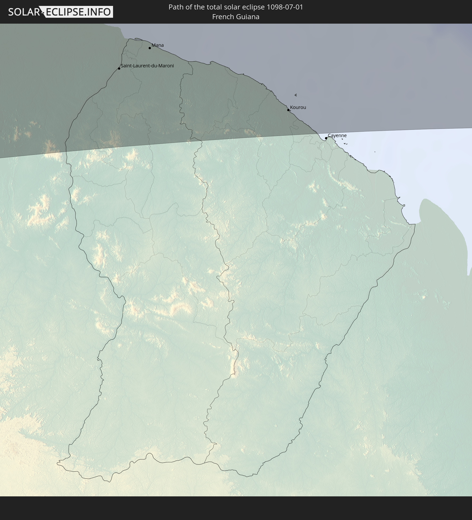 Französisch-Guayana
 St. Helena
 Namibia
 Südafrika
In den folgenden Ländern ist die Sonnenfinsternis partiell zu sehen
 Vereinigte Staaten
 United States Minor Outlying Islands
 Mexiko
 Chile
Chile
 Guatemala
 Ecuador
 El Salvador
 Honduras
 Belize
 Nicaragua
 Costa Rica
 Kuba
Kuba
 Panama
 Kolumbien
 Kaimaninseln
 Peru
Peru
 Bahamas
 Jamaika
 Haiti
Haiti
 Brasilien
 Argentinien
 Venezuela
 Turks- und Caicosinseln
 Dominikanische Republik
 Aruba
Aruba
 Bolivien
 Puerto Rico
 Amerikanische Jungferninseln
 Bermuda
 Britische Jungferninseln
 Anguilla
 Saint-Martin
 Saint-Barthélemy
 St. Kitts und Nevis
 Paraguay
 Antigua und Barbuda
 Montserrat
 Trinidad und Tobago
 Guadeloupe
 Grenada
 Dominica
 St. Vincent und die Grenadinen
 Guyana
 Martinique
 St. Lucia
 Barbados
 Uruguay
 Suriname
 Französisch-Guayana
 Kap Verde
 Spanien
 Senegal
 Mauretanien
 Gambia
 Guinea-Bissau
 Guinea
 St. Helena
 Sierra Leone
 Mali
Mali
 Liberia
 Elfenbeinküste
 Burkina Faso
 Ghana
Ghana
 Togo
Togo
 Niger
Niger
 Benin
Benin
 Nigeria
 Bouvetinsel
 Äquatorialguinea
 São Tomé und Príncipe
 Kamerun
 Gabun
Gabun
 Republik Kongo
 Angola
 Namibia
 Demokratische Republik Kongo
 Tschad
 Zentralafrikanische Republik
 Südafrika
 Botswana
 Sambia
 Simbabwe
 Ruanda
 Burundi
 Tansania
 Uganda
 Kenia
Kenia
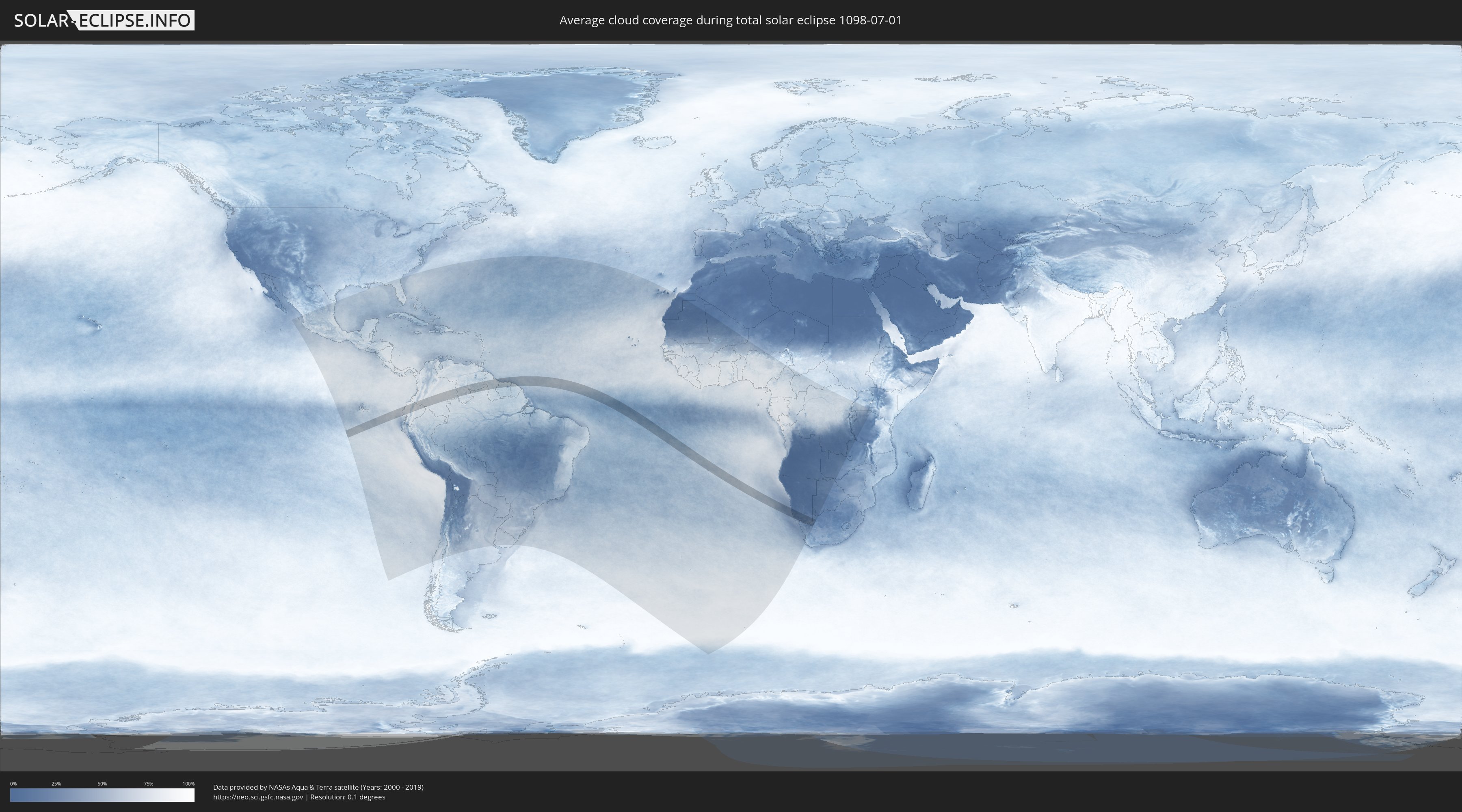
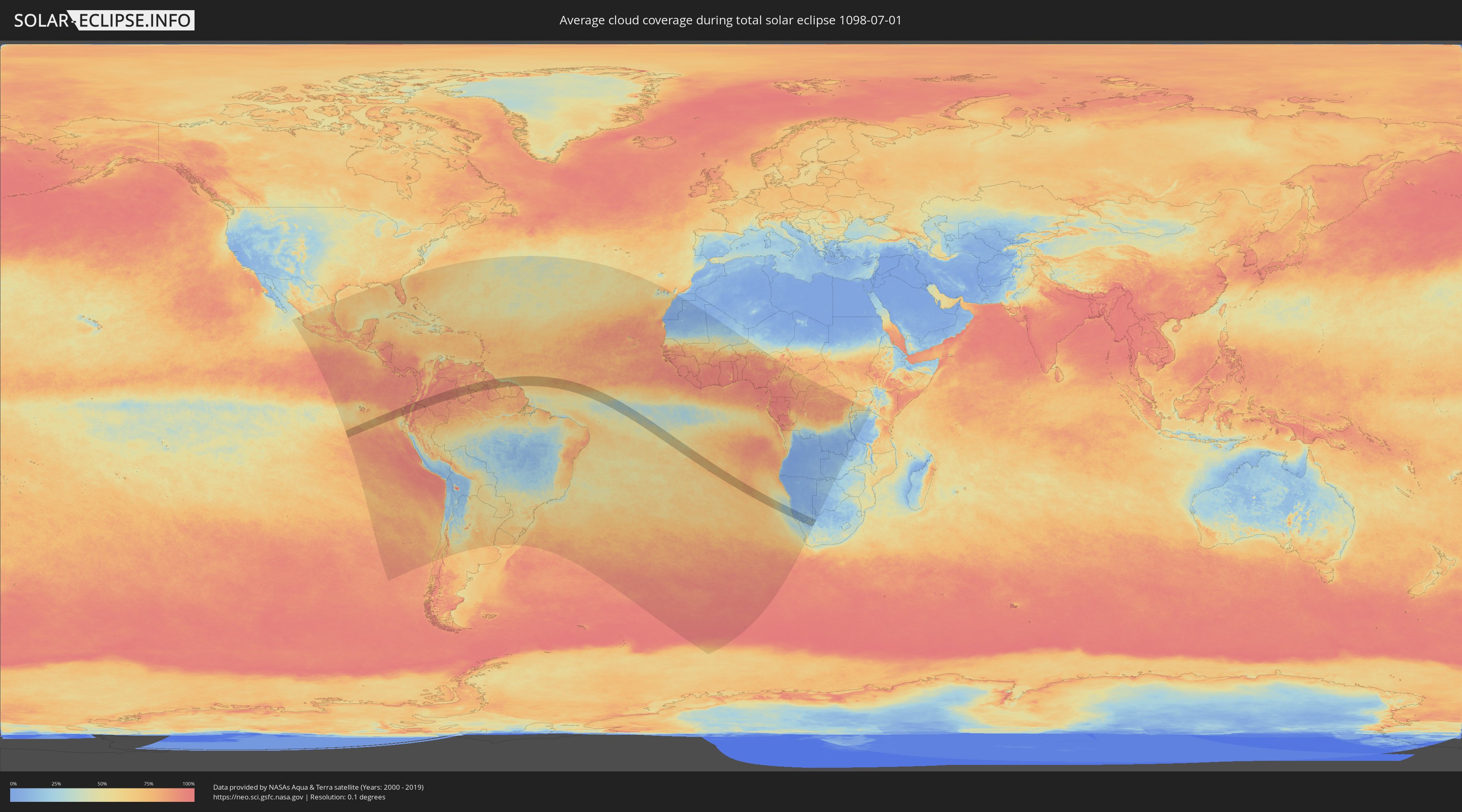
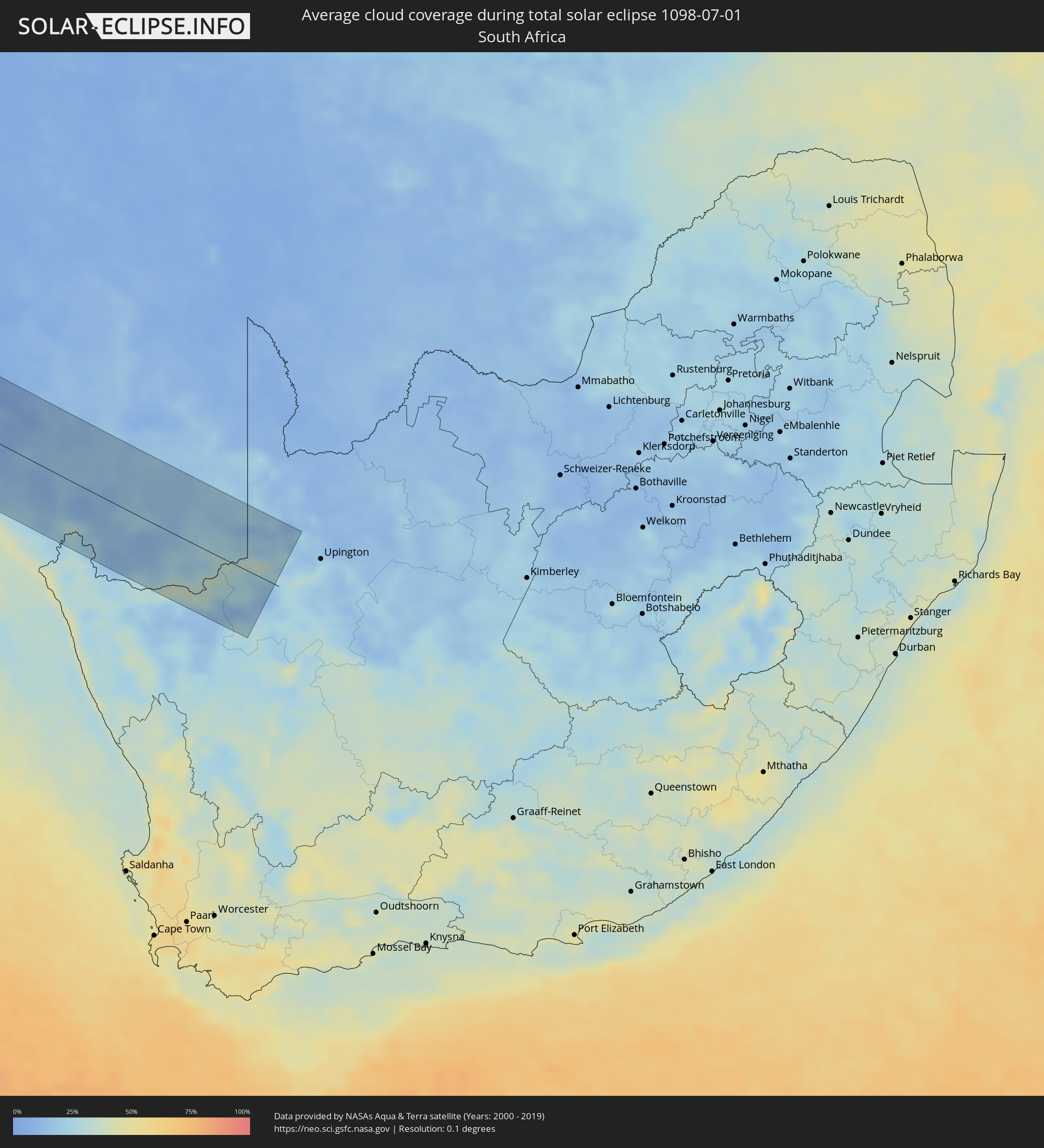
Wie wird das Wetter während der totalen Sonnenfinsternis am 01.07.1098?
Wo ist der beste Ort, um die totale Sonnenfinsternis vom 01.07.1098 zu beobachten?
Die folgenden Karten zeigen die durchschnittliche Bewölkung für den Tag, an dem die totale Sonnenfinsternis
stattfindet. Mit Hilfe der Karten lässt sich der Ort entlang des Finsternispfades eingrenzen,
der die besten Aussichen auf einen klaren wolkenfreien Himmel bietet.
Trotzdem muss man immer lokale Gegenenheiten beachten und sollte sich genau über das Wetter an seinem
gewählten Beobachtungsort informieren.
Die Daten stammen von den beiden NASA-Satelliten
AQUA und TERRA
und wurden über einen Zeitraum von 19 Jahren (2000 - 2019) gemittelt.
Detaillierte Länderkarten
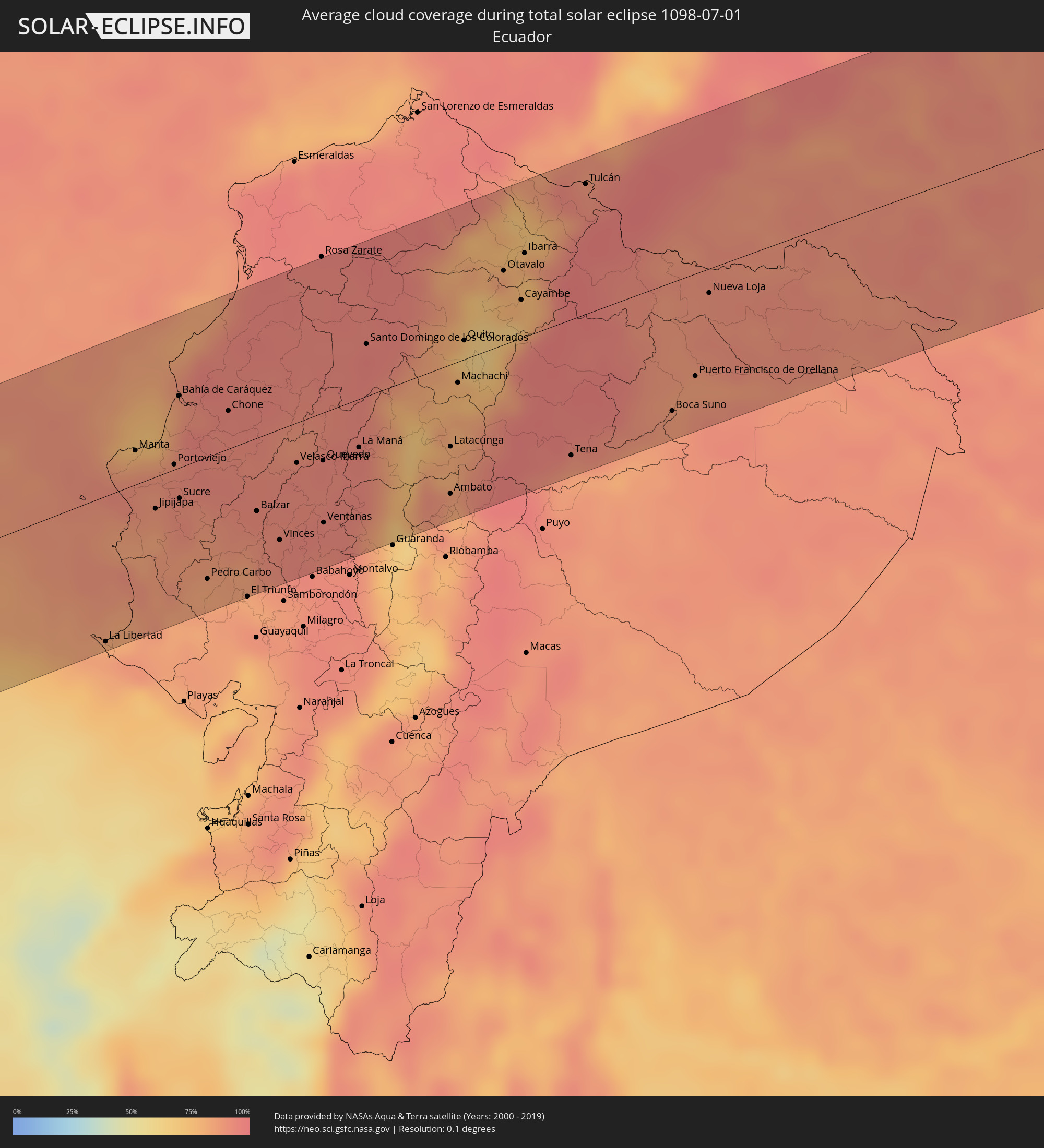 Ecuador
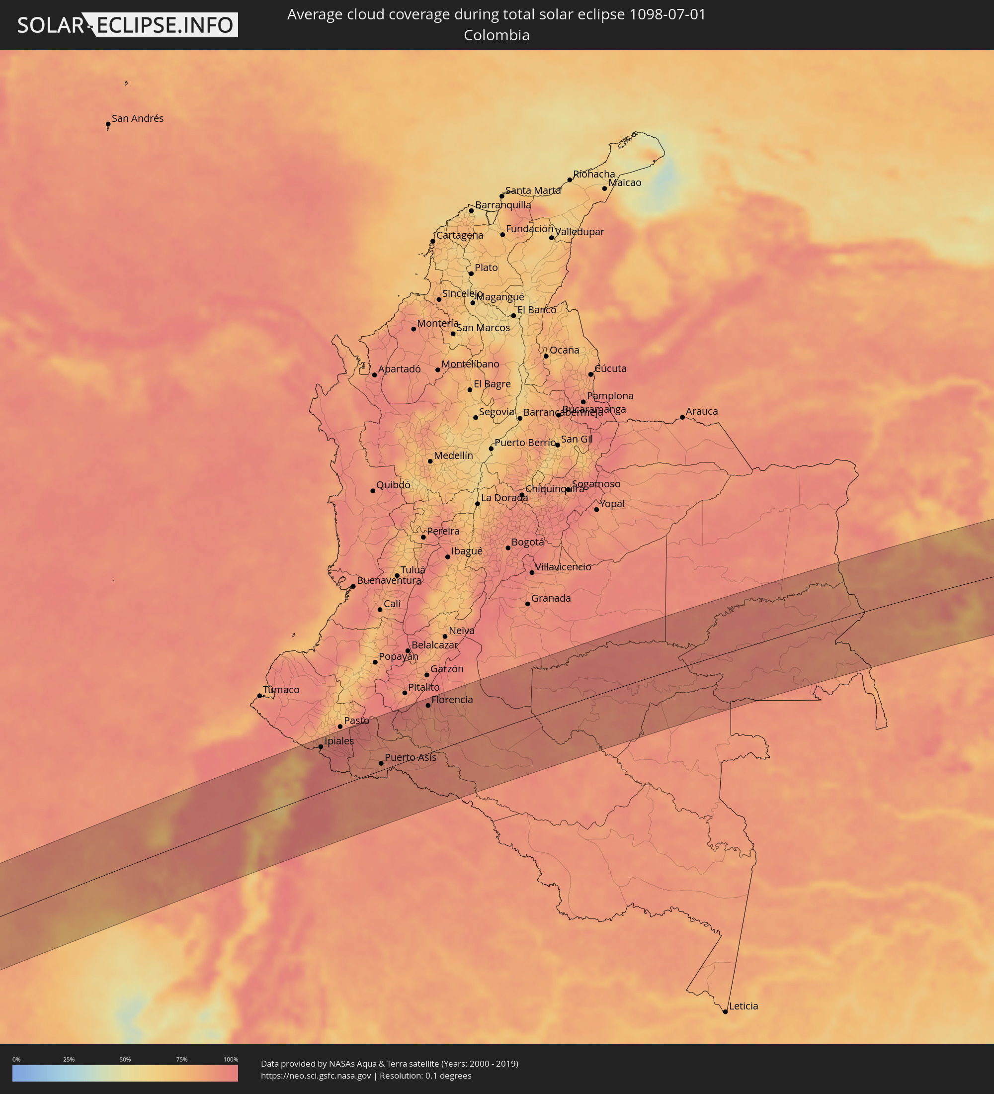 Kolumbien
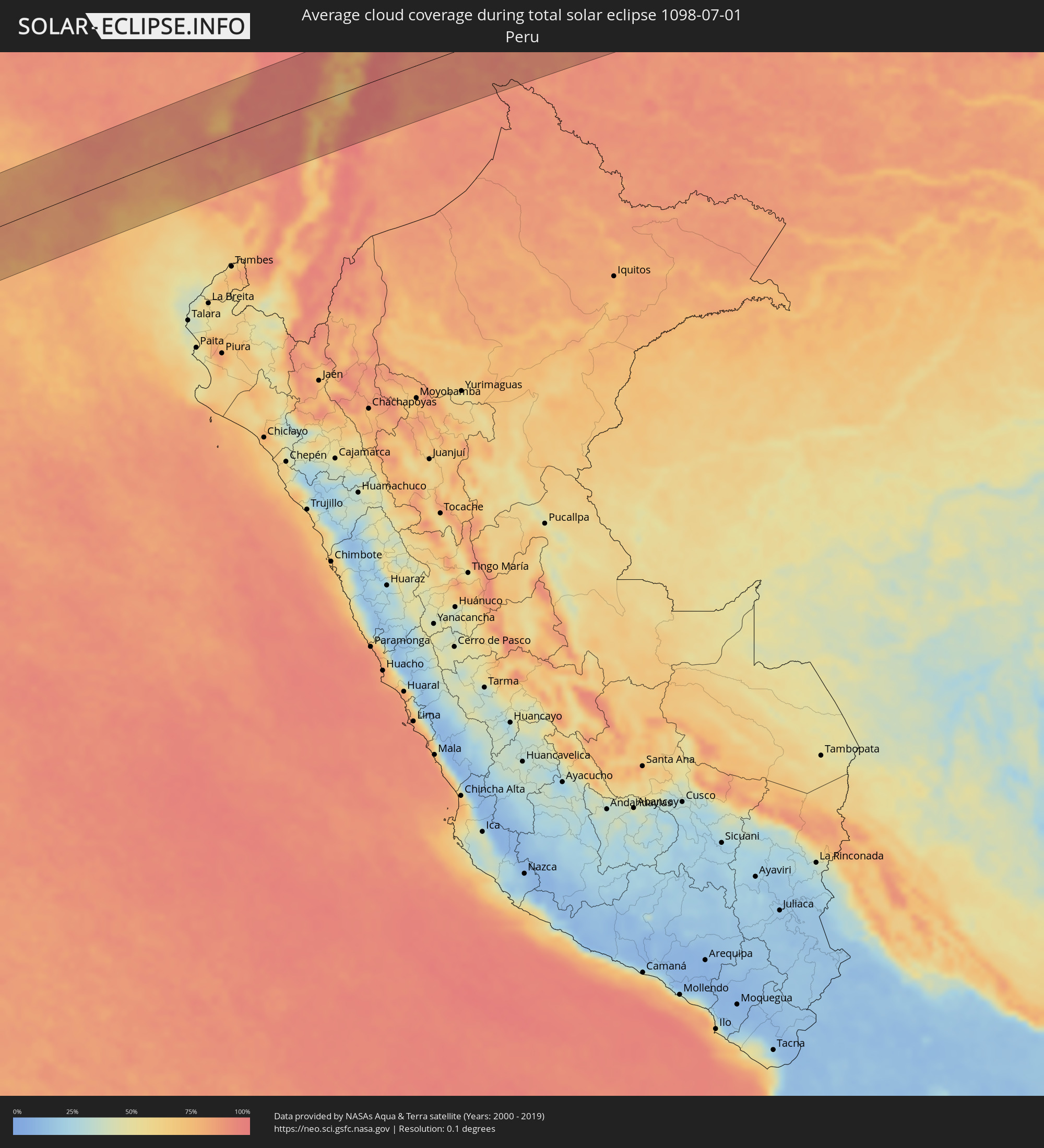 Peru
Peru
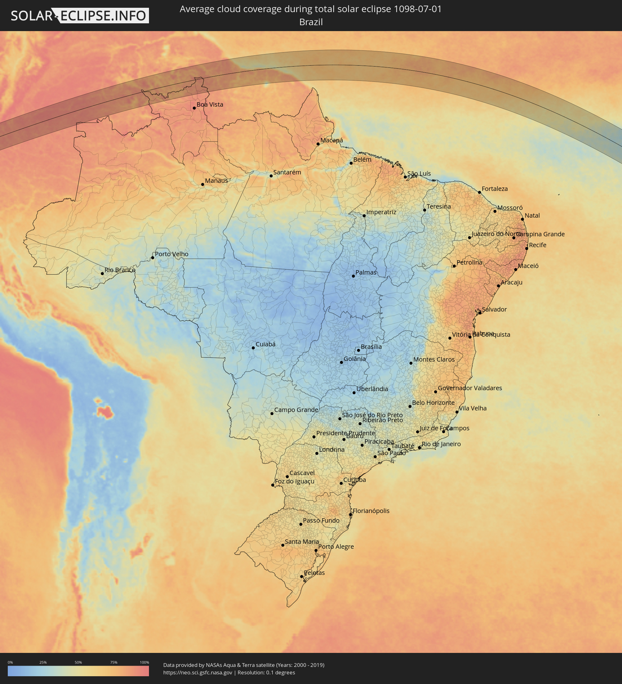 Brasilien
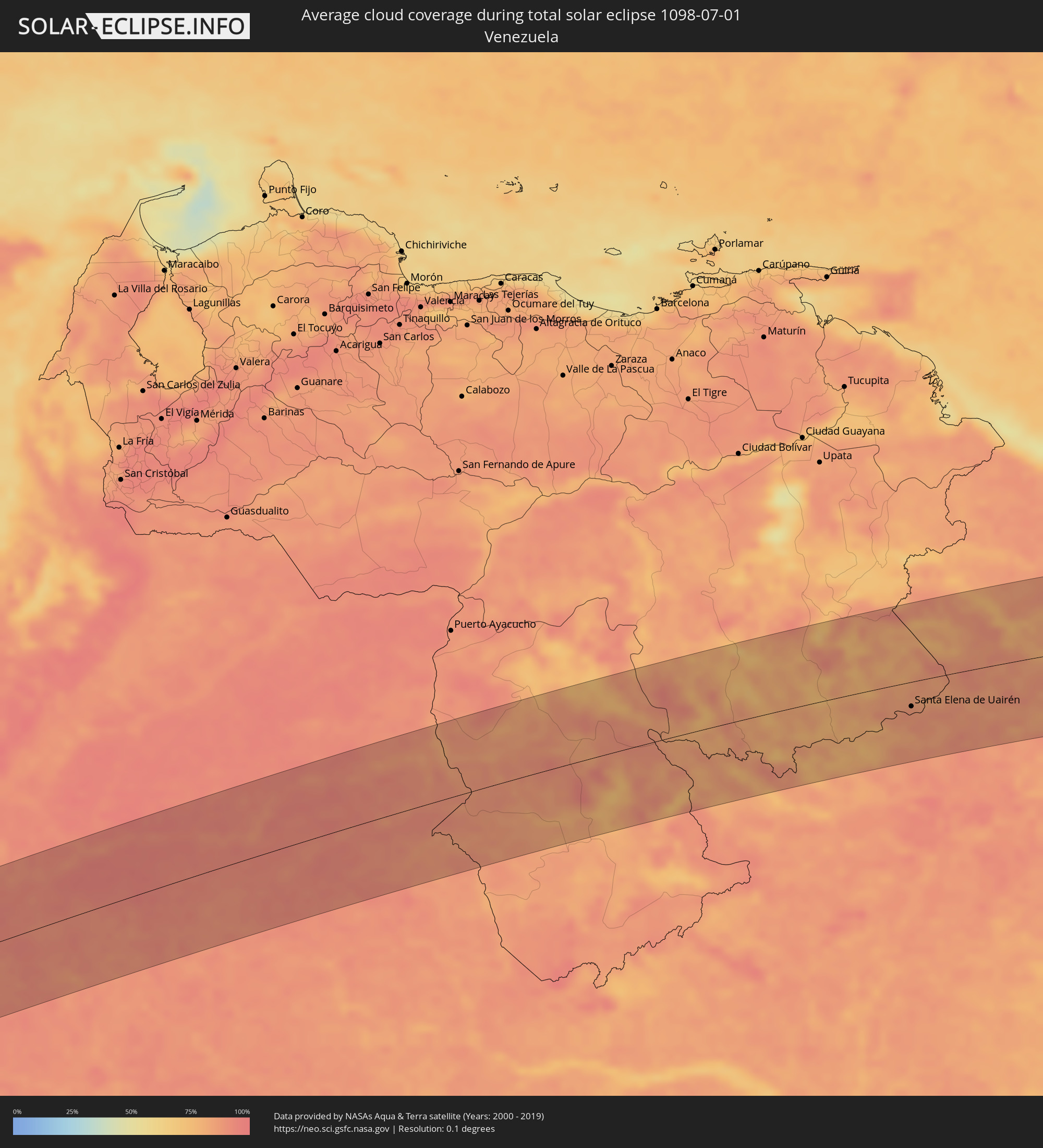 Venezuela
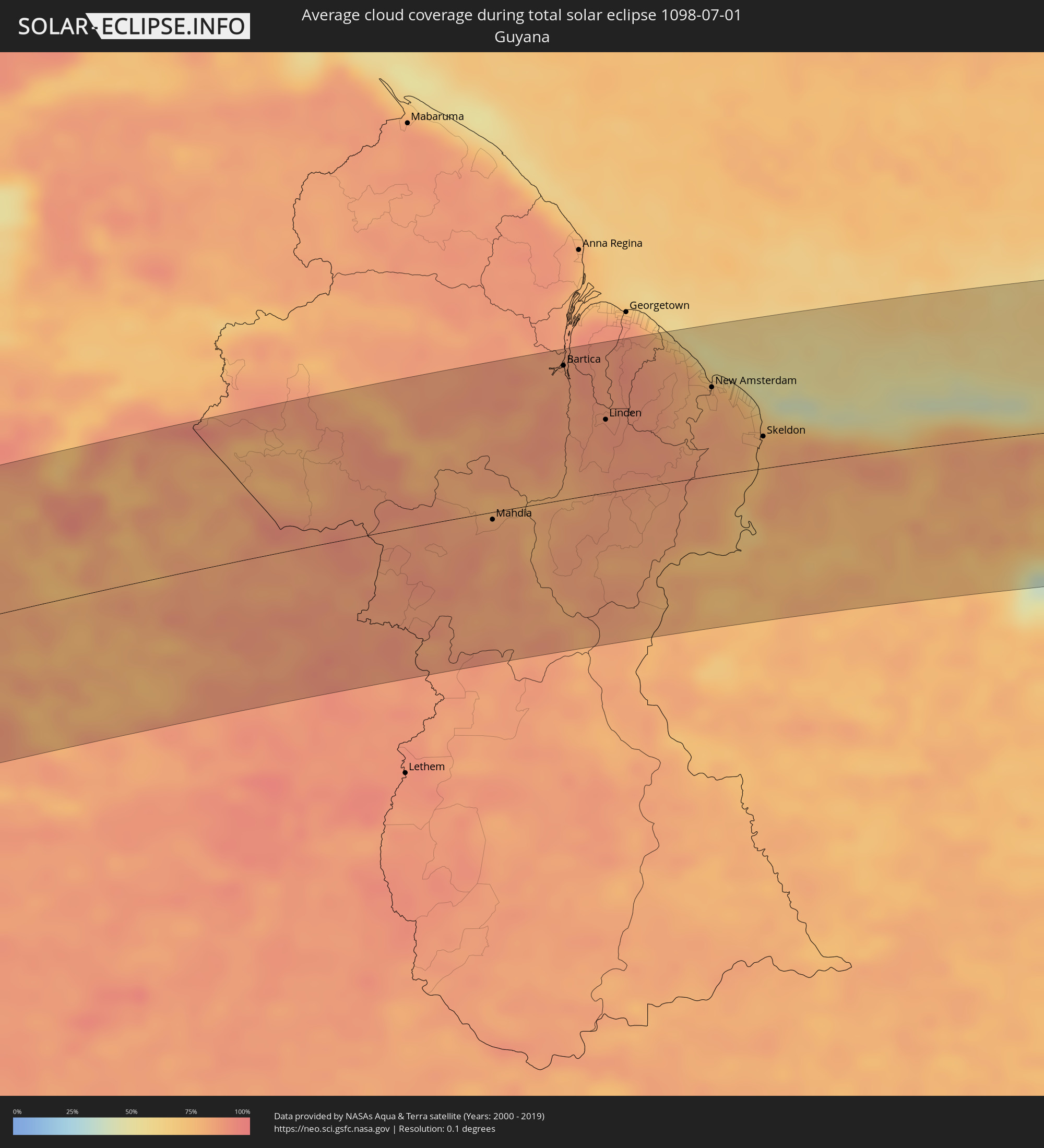 Guyana
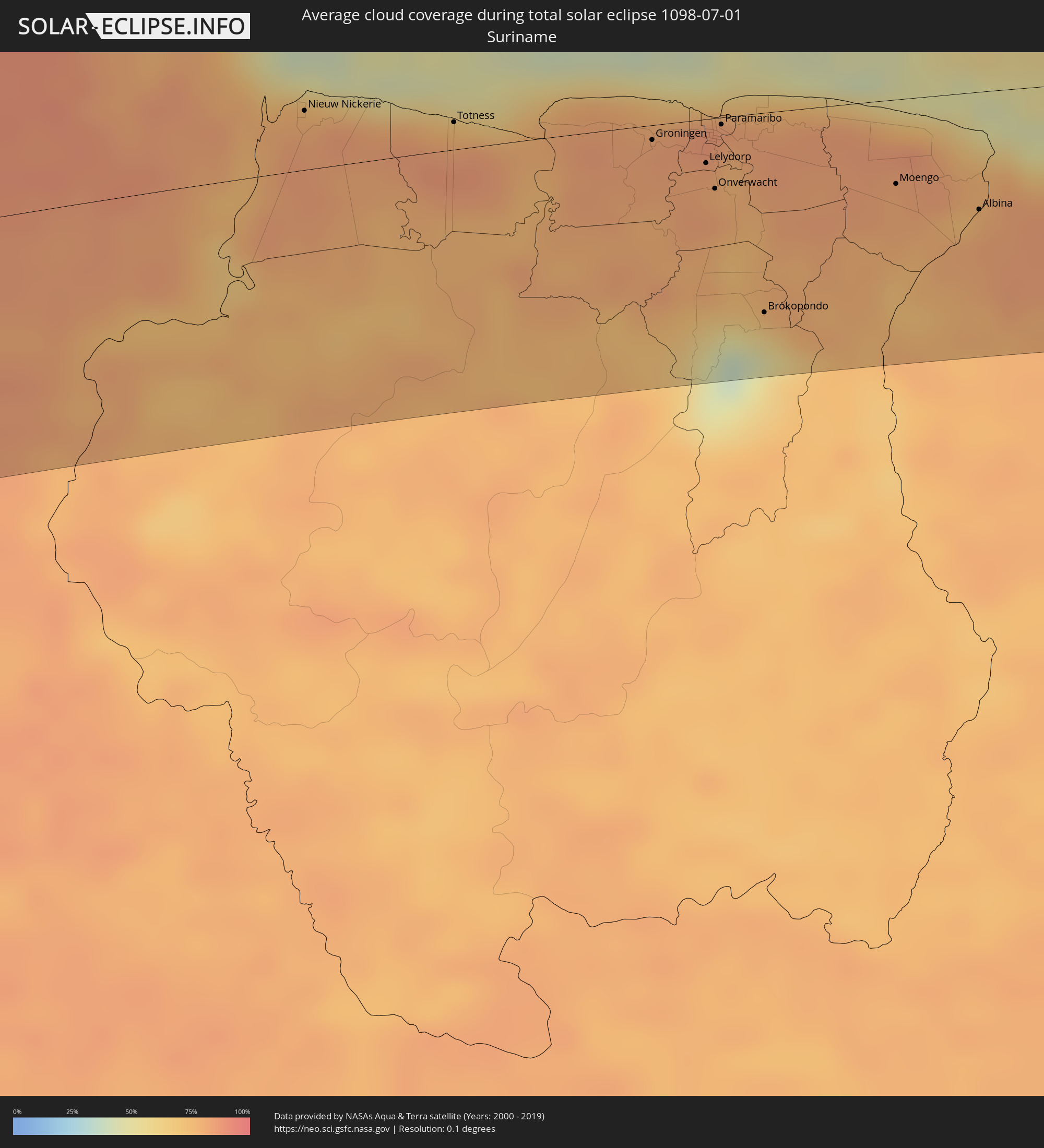 Suriname
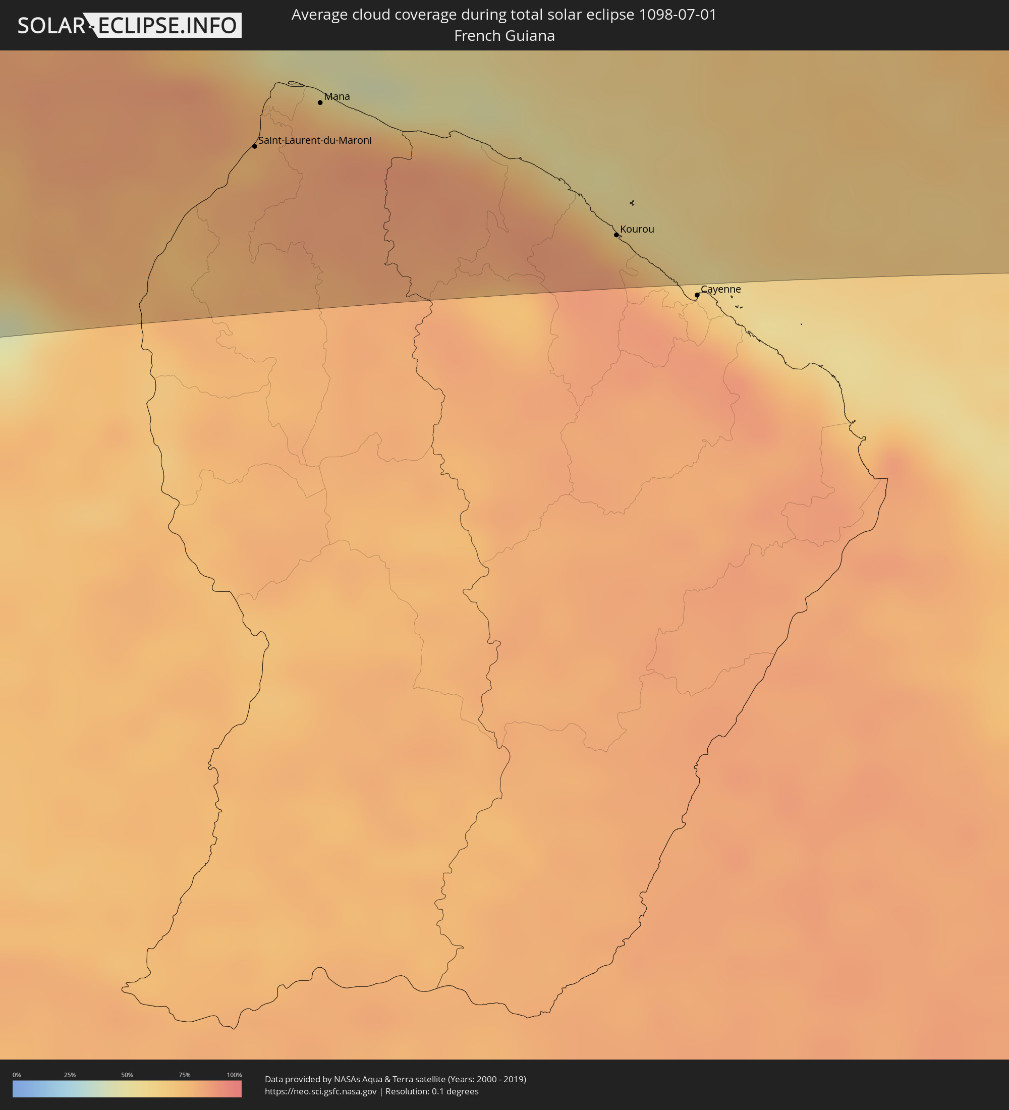 Französisch-Guayana
 St. Helena
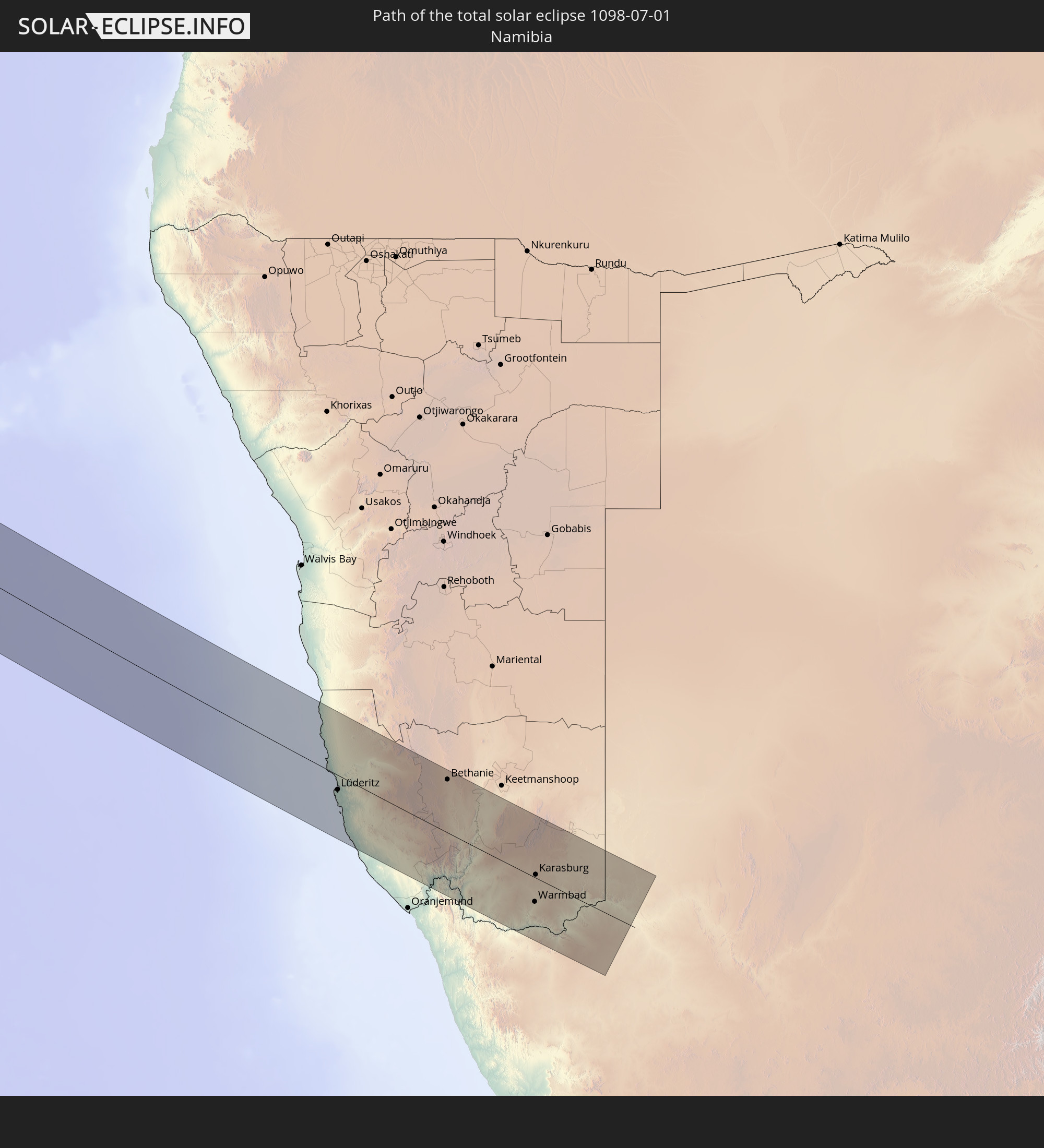
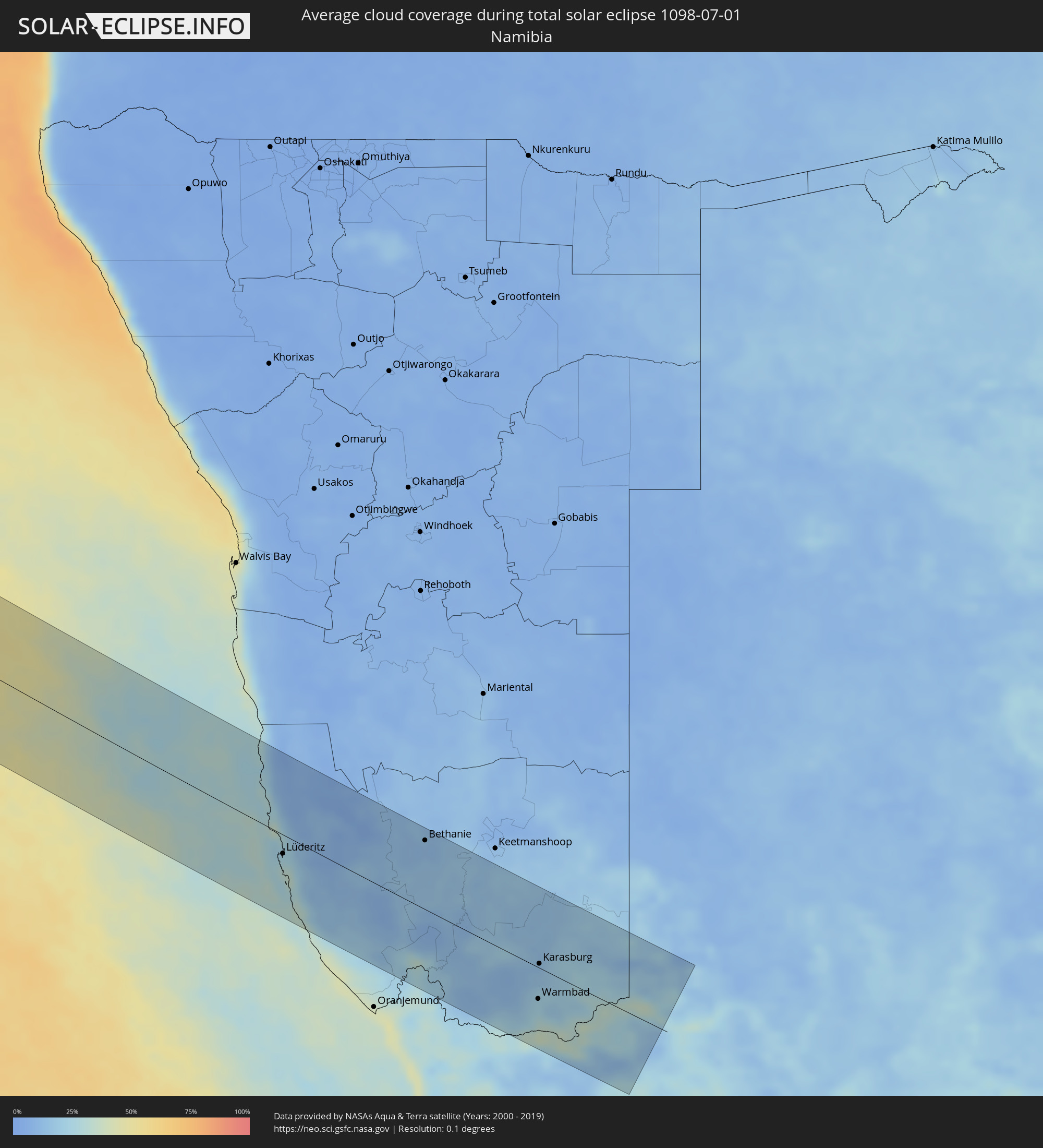 Namibia
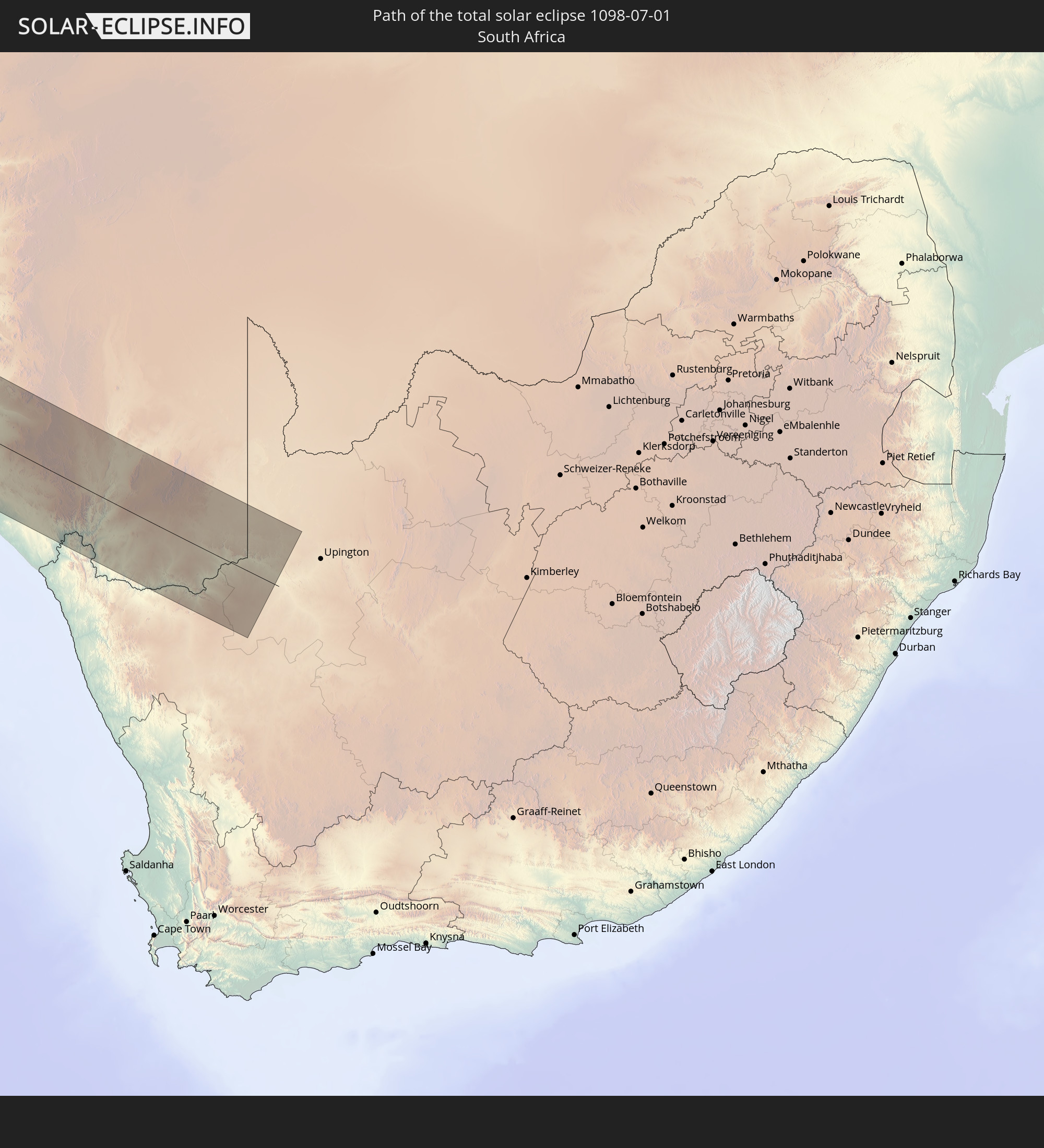
 Südafrika
Orte im Finsternispfad
Die nachfolgene Tabelle zeigt Städte und Orte mit mehr als 5.000 Einwohnern, die sich im Finsternispfad befinden. Städte mit mehr als 100.000 Einwohnern sind dick gekennzeichnet. Mit einem Klick auf den Ort öffnet sich eine Detailkarte die die Lage des jeweiligen Ortes zusammen mit dem Verlauf der zentralen Finsternis präsentiert.
| Ort | Typ | Dauer der Verfinsterung | Ortszeit bei maximaler Verfinsterung | Entfernung zur Zentrallinie | Ø Bewölkung |
|
La Libertad, Guayas
|
total | - | 07:23:21 UTC-05:14 | 100 km | 86% |
|
Manta, Manabí
|
total | - | 07:23:18 UTC-05:14 | 24 km | 90% |
|
Jipijapa, Manabí
|
total | - | 07:23:27 UTC-05:14 | 22 km | 87% |
|
Portoviejo, Manabí
|
total | - | 07:23:29 UTC-05:14 | 4 km | 92% |
|
Bahía de Caráquez, Manabí
|
total | - | 07:23:27 UTC-05:14 | 50 km | 90% |
|
Pedro Carbo, Guayas
|
total | - | 07:23:46 UTC-05:14 | 84 km | 83% |
|
Chone, Manabí
|
total | - | 07:23:42 UTC-05:14 | 26 km | 94% |
|
El Triunfo, Guayas
|
total | - | 07:23:58 UTC-05:14 | 107 km | 85% |
|
Balzar, Guayas
|
total | - | 07:23:56 UTC-05:14 | 51 km | 91% |
|
Vinces, Los Ríos
|
total | - | 07:24:04 UTC-05:14 | 77 km | 92% |
|
Velasco Ibarra, Guayas
|
total | - | 07:24:05 UTC-05:14 | 28 km | 93% |
|
Quevedo, Los Ríos
|
total | - | 07:24:13 UTC-05:14 | 33 km | 94% |
|
Ventanas, Los Ríos
|
total | - | 07:24:17 UTC-05:14 | 76 km | 94% |
|
Santo Domingo de los Colorados, Santo Domingo de los Tsáchilas
|
total | - | 07:24:20 UTC-05:14 | 36 km | 96% |
|
Ambato, Tungurahua
|
total | - | 07:24:54 UTC-05:14 | 90 km | 83% |
|
Latacunga, Cotopaxi
|
total | - | 07:24:52 UTC-05:14 | 57 km | 82% |
|
Machachi, Pichincha
|
total | - | 07:24:51 UTC-05:14 | 15 km | 77% |
|
Quito, Pichincha
|
total | - | 07:24:51 UTC-05:14 | 13 km | 64% |
|
Otavalo, Imbabura
|
total | - | 07:25:01 UTC-05:14 | 51 km | 84% |
|
Cayambe, Pichincha
|
total | - | 07:25:08 UTC-05:14 | 26 km | 79% |
|
Ibarra, Imbabura
|
total | - | 07:25:07 UTC-05:14 | 58 km | 78% |
|
Cumbal, Nariño
|
total | - | 07:43:04 UTC-04:56 | 103 km | 91% |
|
Tulcán, Carchi
|
total | - | 07:25:25 UTC-05:14 | 90 km | 90% |
|
Ipiales, Nariño
|
total | - | 07:43:12 UTC-04:56 | 90 km | 93% |
|
Pupiales, Nariño
|
total | - | 07:43:12 UTC-04:56 | 94 km | 92% |
|
Boca Suno, Orellana
|
total | - | 07:26:05 UTC-05:14 | 90 km | 87% |
|
Puerto Francisco de Orellana, Orellana
|
total | - | 07:26:11 UTC-05:14 | 71 km | 88% |
|
Sibundoy, Putumayo
|
total | - | 07:43:48 UTC-04:56 | 101 km | 96% |
|
Valle del Guamuez, Putumayo
|
total | - | 07:43:52 UTC-04:56 | 22 km | 91% |
|
San Miguel, Putumayo
|
total | - | 07:43:53 UTC-04:56 | 10 km | 90% |
|
Nueva Loja, Sucumbios
|
total | - | 07:26:12 UTC-05:14 | 17 km | 90% |
|
Orito, Putumayo
|
total | - | 07:43:53 UTC-04:56 | 43 km | 91% |
|
Mocoa, Putumayo
|
total | - | 07:44:03 UTC-04:56 | 85 km | 96% |
|
Villagarzón, Putumayo
|
total | - | 07:44:05 UTC-04:56 | 72 km | 90% |
|
Puerto Asís, Putumayo
|
total | - | 07:44:14 UTC-04:56 | 13 km | 87% |
|
Curillo, Caquetá
|
total | - | 07:44:44 UTC-04:56 | 45 km | 88% |
|
Florencia, Caquetá
|
total | - | 07:44:59 UTC-04:56 | 94 km | 88% |
|
El Paujil, Caquetá
|
total | - | 07:45:15 UTC-04:56 | 79 km | 92% |
|
El Doncello, Caquetá
|
total | - | 07:45:17 UTC-04:56 | 89 km | 94% |
|
Puerto Rico, Caquetá
|
total | - | 07:45:25 UTC-04:56 | 109 km | 86% |
|
Cartagena del Chairá, Caquetá
|
total | - | 07:45:45 UTC-04:56 | 37 km | 88% |
|
San José del Guaviare, Guaviare
|
total | - | 07:48:01 UTC-04:56 | 88 km | 93% |
|
Inírida, Guainía
|
total | - | 07:53:58 UTC-04:56 | 68 km | 87% |
|
Santa Elena de Uairén, Bolívar
|
total | - | 08:33:51 UTC-04:27 | 37 km | 87% |
|
Mahdia, Potaro-Siparuni
|
total | - | 09:12:37 UTC-03:52 | 6 km | 82% |
|
Bartica, Cuyuni-Mazaruni
|
total | - | 09:13:32 UTC-03:52 | 109 km | 86% |
|
Linden, Upper Demerara-Berbice
|
total | - | 09:14:15 UTC-03:52 | 60 km | 88% |
|
Fort Wellington, Mahaica-Berbice
|
total | - | 09:15:40 UTC-03:52 | 89 km | 74% |
|
Rosignol, Mahaica-Berbice
|
total | - | 09:15:50 UTC-03:52 | 75 km | 79% |
|
New Amsterdam, East Berbice-Corentyne
|
total | - | 09:15:52 UTC-03:52 | 72 km | 80% |
|
Skeldon, East Berbice-Corentyne
|
total | - | 09:16:46 UTC-03:52 | 26 km | 79% |
|
Nieuw Nickerie, Nickerie
|
total | - | 09:29:07 UTC-03:40 | 28 km | 80% |
|
Totness, Coronie
|
total | - | 09:30:34 UTC-03:40 | 13 km | 74% |
|
Groningen, Saramacca
|
total | - | 09:32:32 UTC-03:40 | 7 km | 82% |
|
Lelydorp, Wanica
|
total | - | 09:33:06 UTC-03:40 | 21 km | 81% |
|
Onverwacht, Para
|
total | - | 09:33:13 UTC-03:40 | 34 km | 80% |
|
Paramaribo, Paramaribo
|
total | - | 09:33:13 UTC-03:40 | 3 km | 85% |
|
Nieuw Amsterdam, Commewijne
|
total | - | 09:33:24 UTC-03:40 | 2 km | 82% |
|
Brokopondo, Brokopondo
|
total | - | 09:33:53 UTC-03:40 | 95 km | 71% |
|
Moengo, Marowijne
|
total | - | 09:35:04 UTC-03:40 | 40 km | 80% |
|
Albina, Marowijne
|
total | - | 09:35:58 UTC-03:40 | 56 km | 74% |
|
Saint-Laurent-du-Maroni, Guyane
|
total | - | 09:47:21 UTC-03:29 | 56 km | 79% |
|
Mana, Guyane
|
total | - | 09:47:55 UTC-03:29 | 40 km | 68% |
|
Kourou, Guyane
|
total | - | 09:50:54 UTC-03:29 | 105 km | 63% |
|
Georgetown, Ascension
|
total | - | 14:58:29 UTC-00:16 | 66 km | 58% |
|
Lüderitz, Karas
|
total | - | 17:16:45 UTC+01:30 | 23 km | 25% |
|
Bethanie, Karas
|
total | - | 17:17:16 UTC+01:30 | 85 km | 11% |
|
Warmbad, Karas
|
total | - | 17:17:08 UTC+01:30 | 39 km | 24% |
|
Karasburg, Karas
|
total | - | 17:17:15 UTC+01:30 | 5 km | 18% |