Totale Sonnenfinsternis vom 10.03.1122
| Wochentag: | Freitag |
| Maximale Dauer der Verfinsterung: | 04m47s |
| Maximale Breite des Finsternispfades: | 235 km |
| Saroszyklus: | 96 |
| Bedeckungsgrad: | 100% |
| Magnitude: | 1.0588 |
| Gamma: | 0.5736 |
Wo kann man die Sonnenfinsternis vom 10.03.1122 sehen?
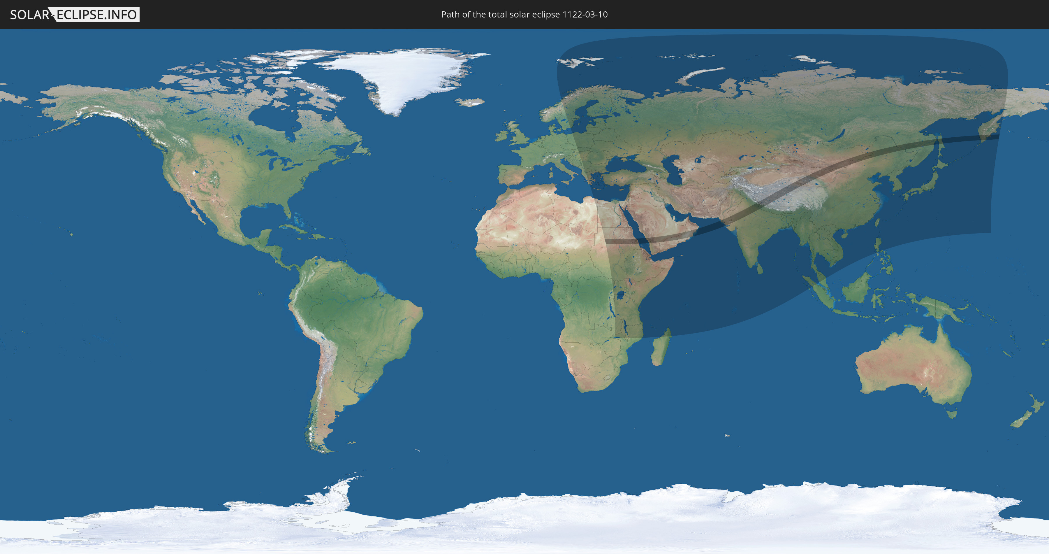
Die Sonnenfinsternis am 10.03.1122 kann man in 93 Ländern als partielle Sonnenfinsternis beobachten.
Der Finsternispfad verläuft durch 11 Länder. Nur in diesen Ländern ist sie als totale Sonnenfinsternis zu sehen.
In den folgenden Ländern ist die Sonnenfinsternis total zu sehen
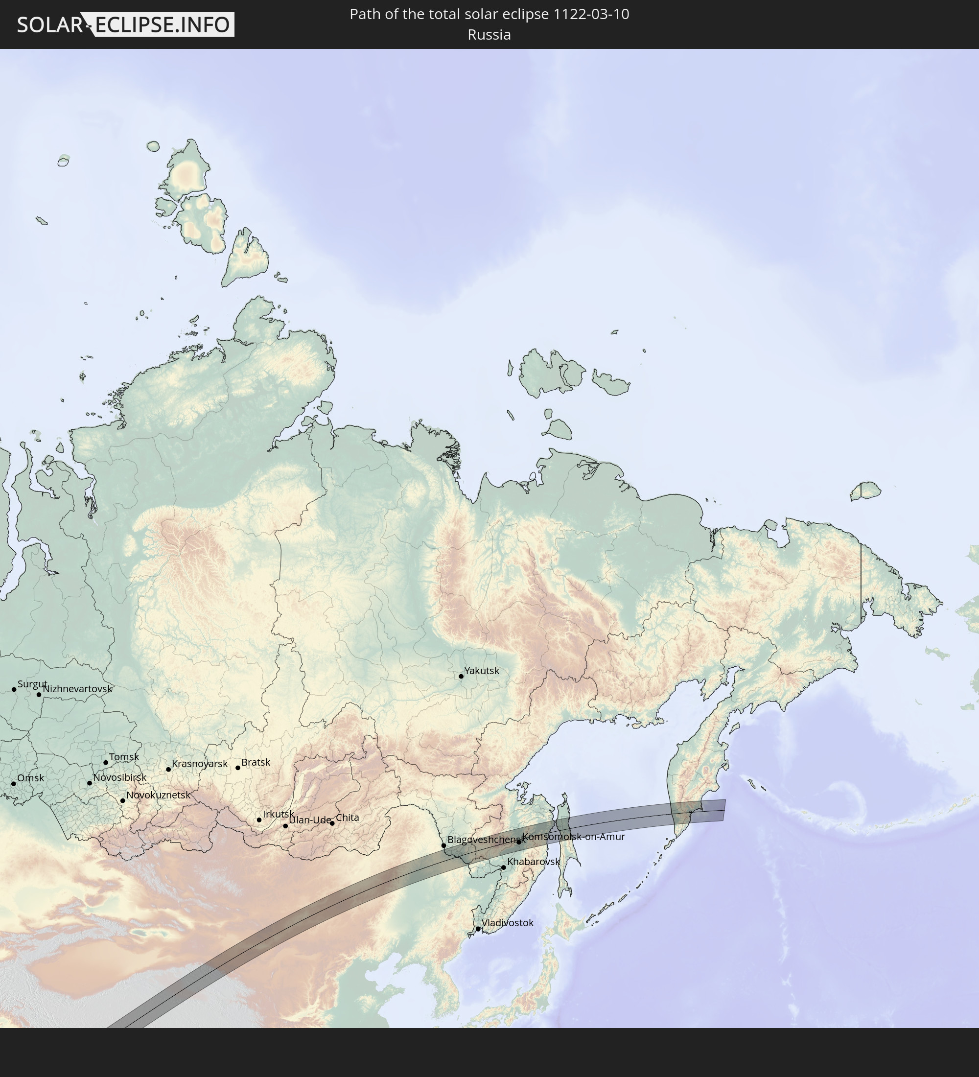 Russland
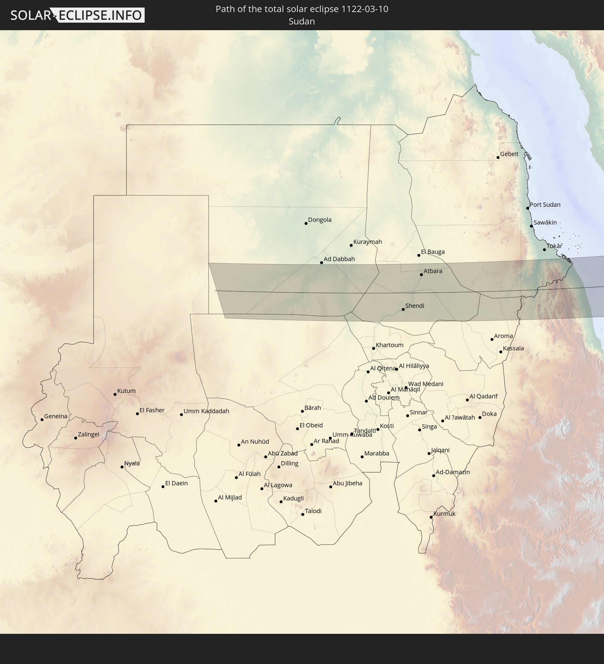 Sudan
Sudan
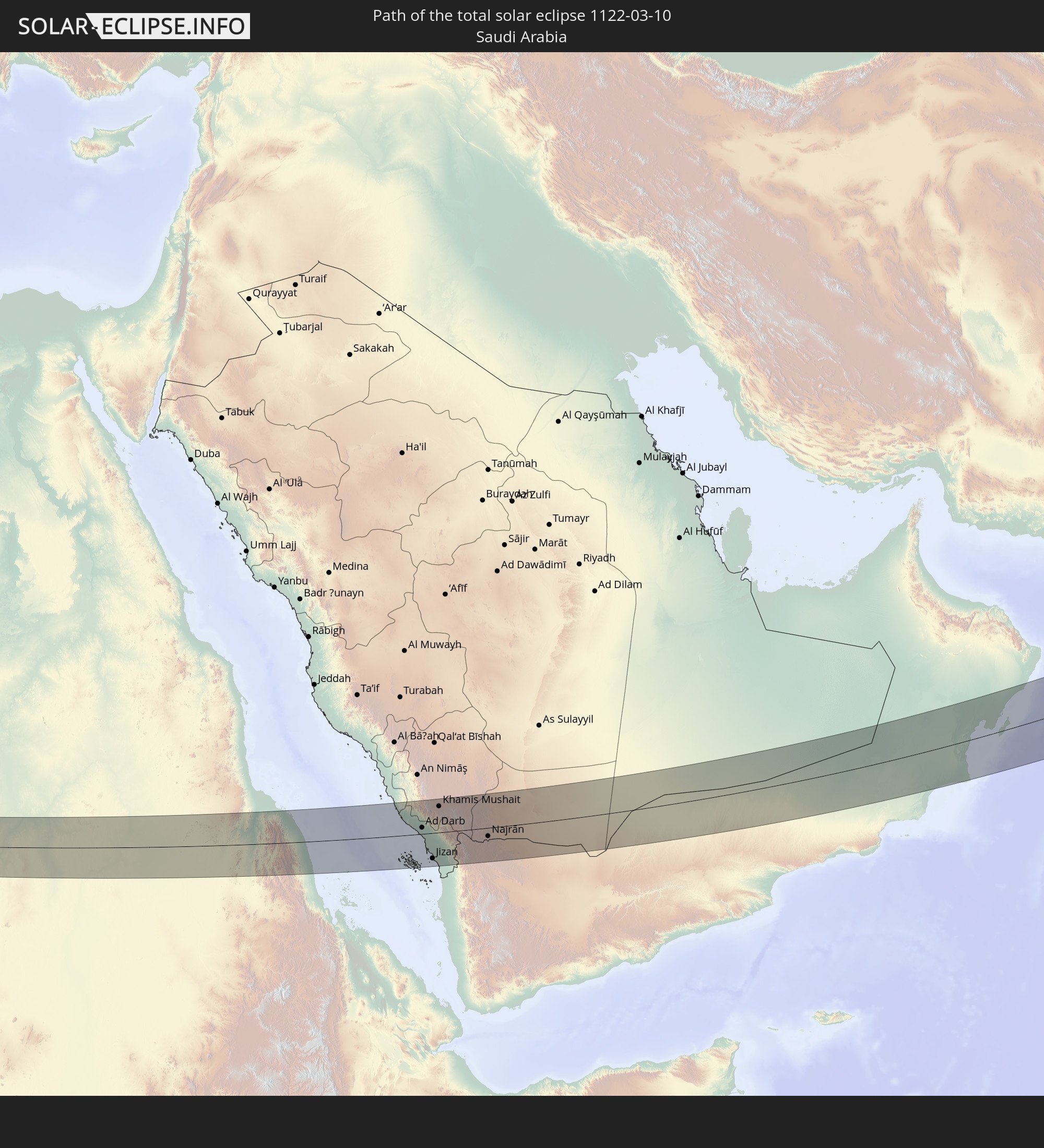 Saudi-Arabien
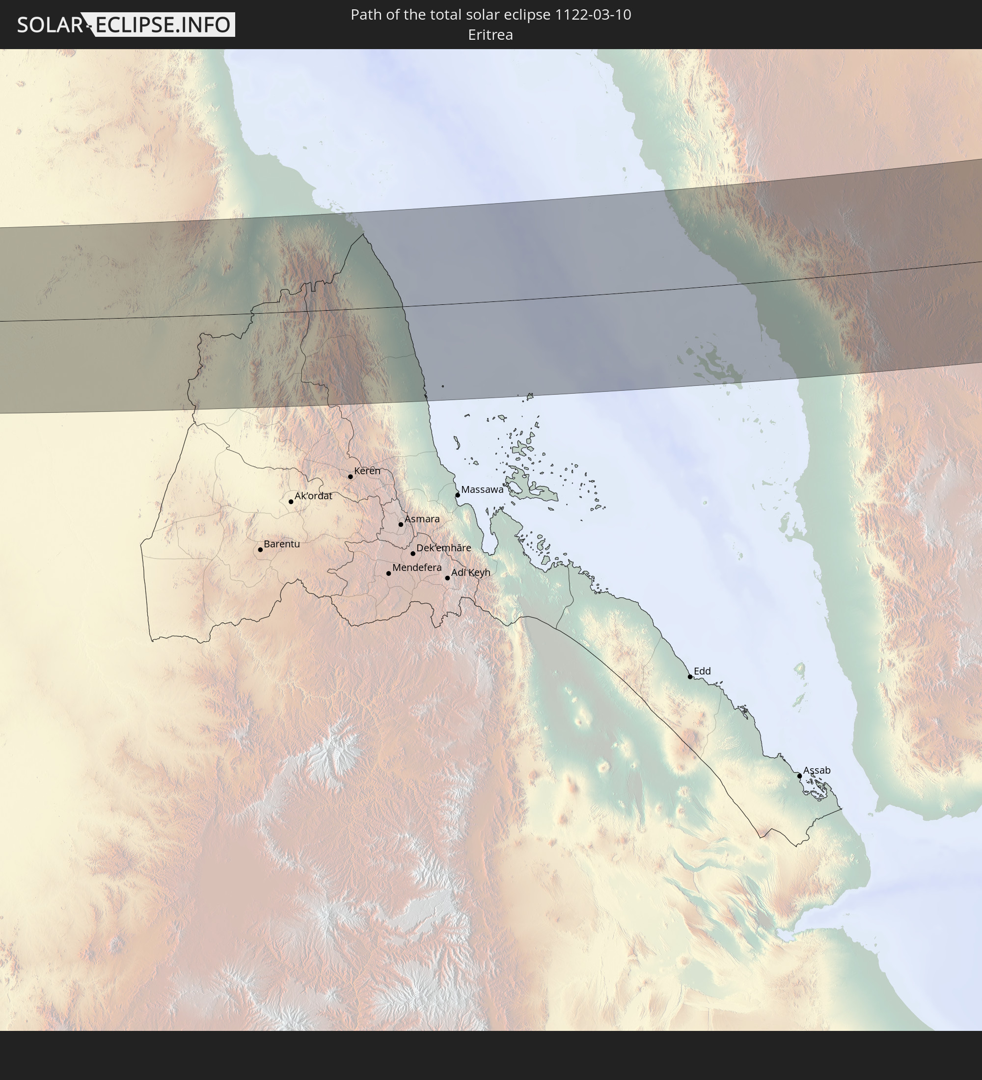 Eritrea
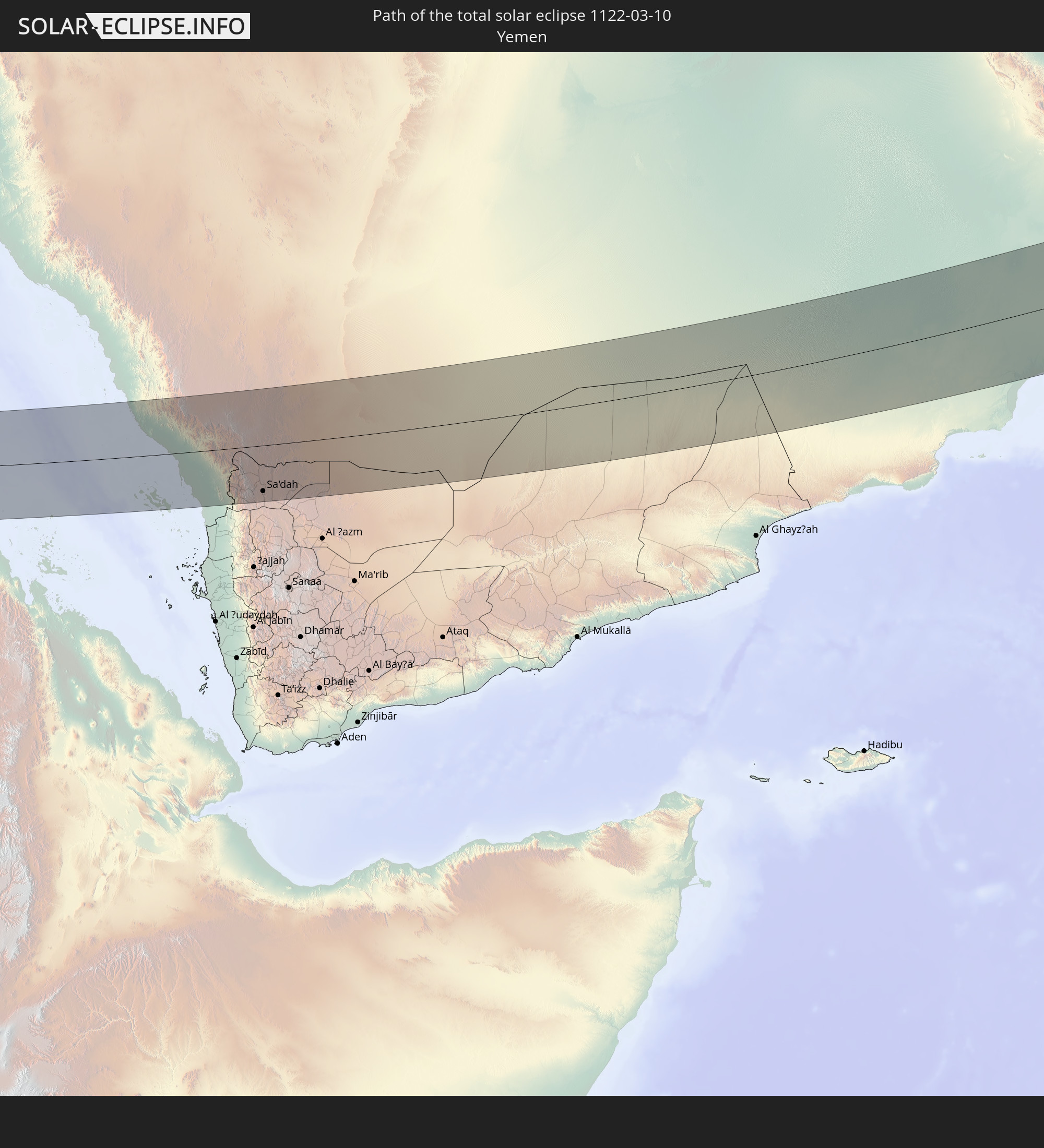 Jemen
Jemen
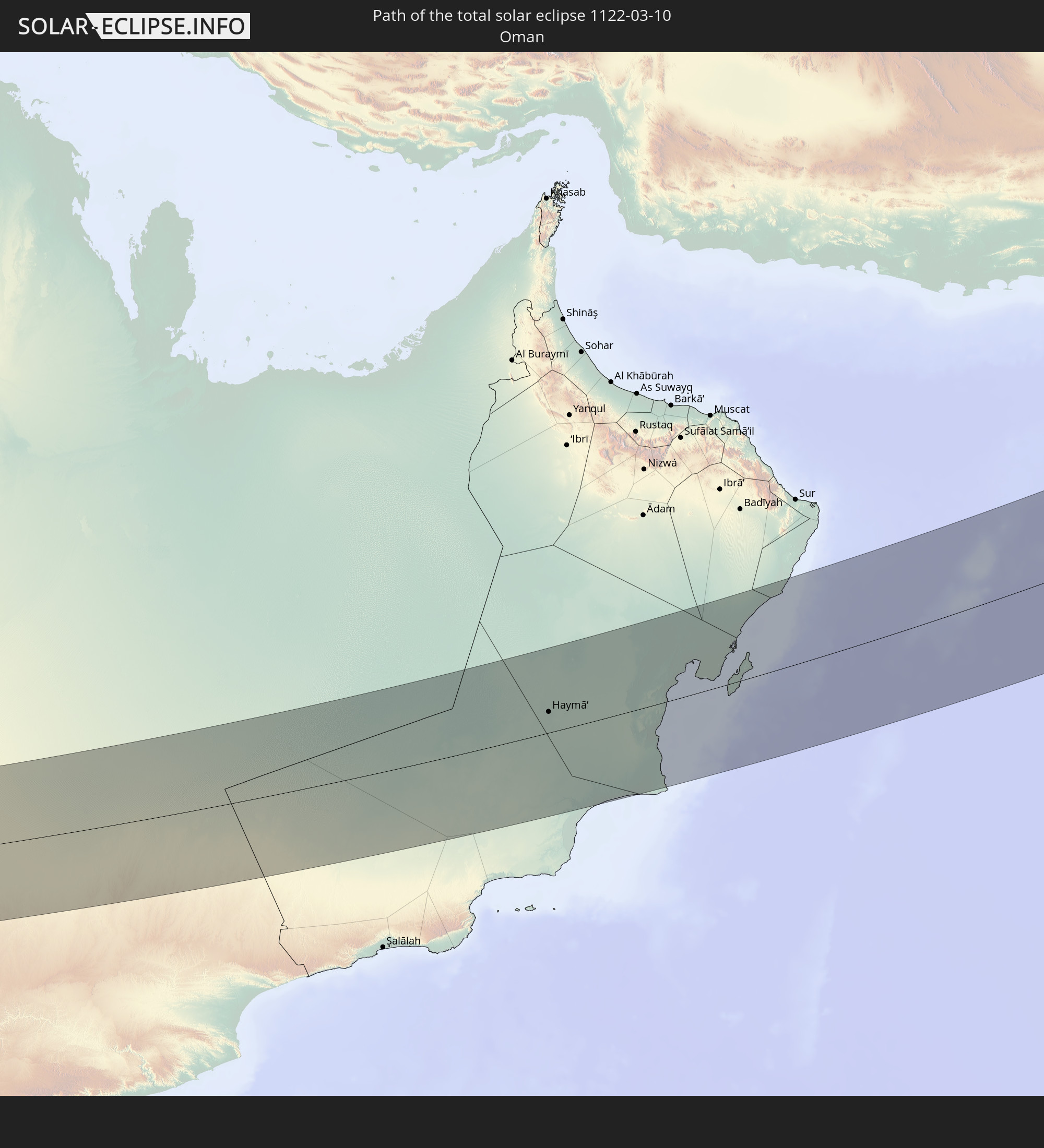 Oman
Oman
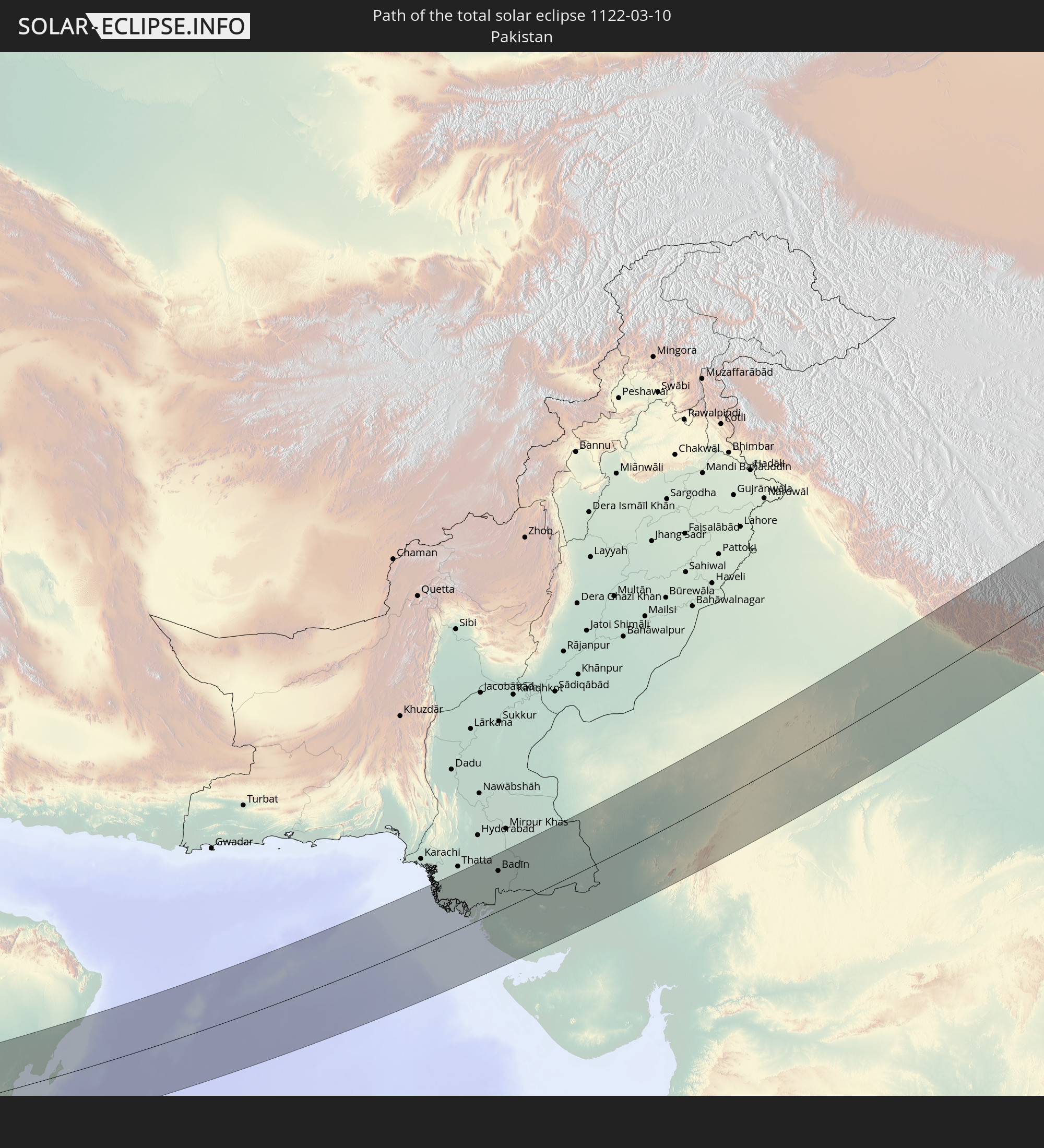 Pakistan
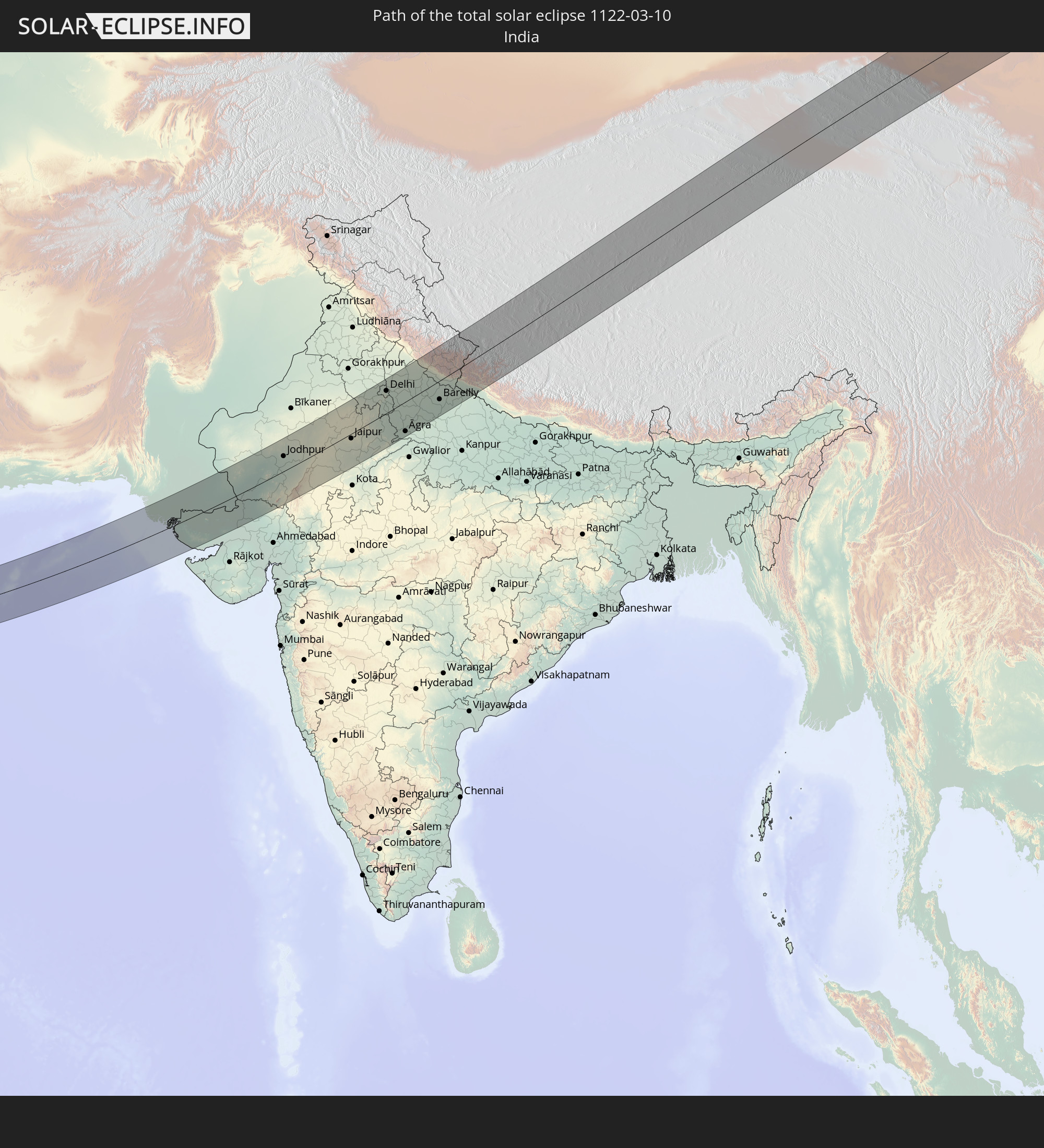 Indien
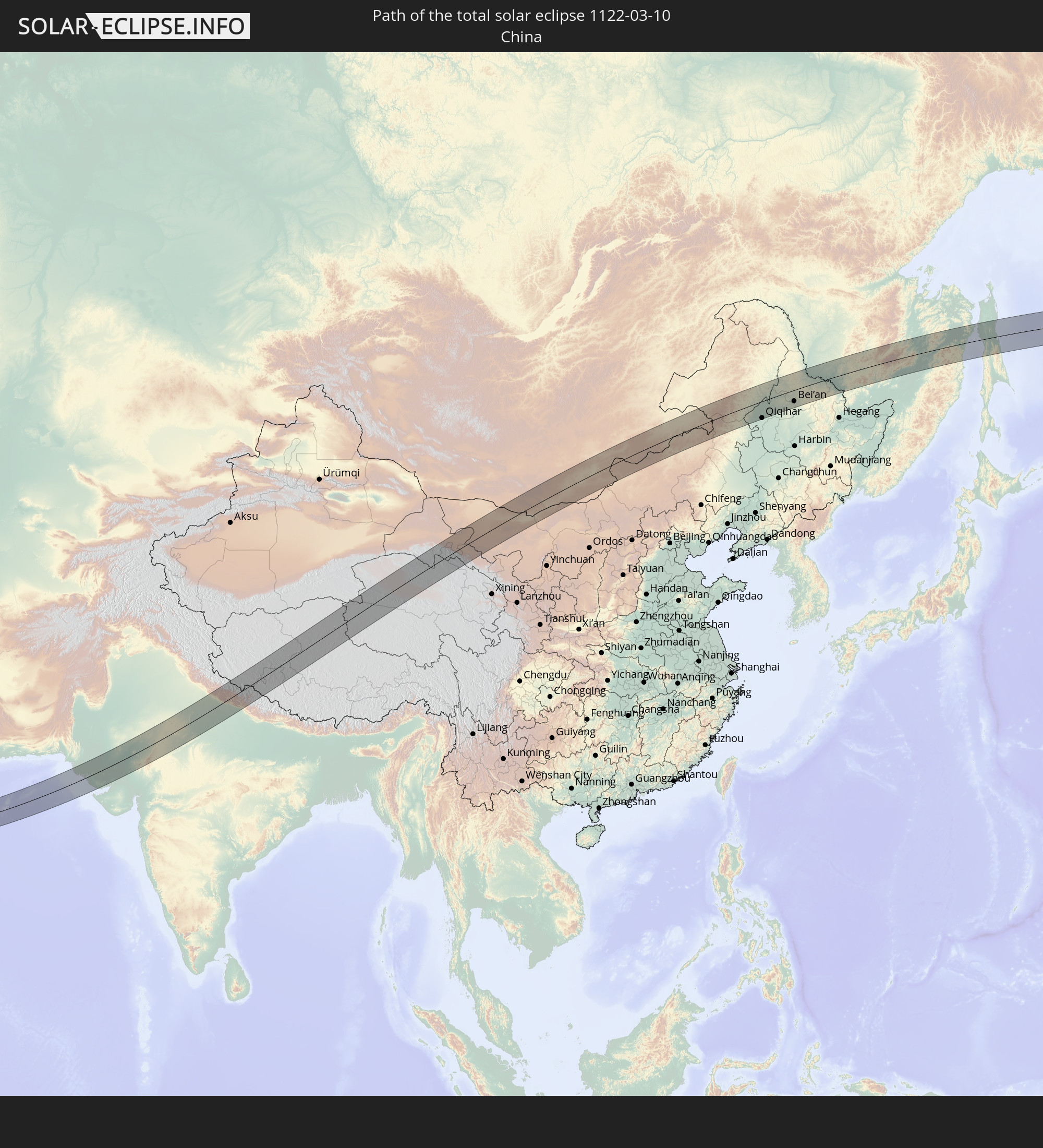 Volksrepublik China
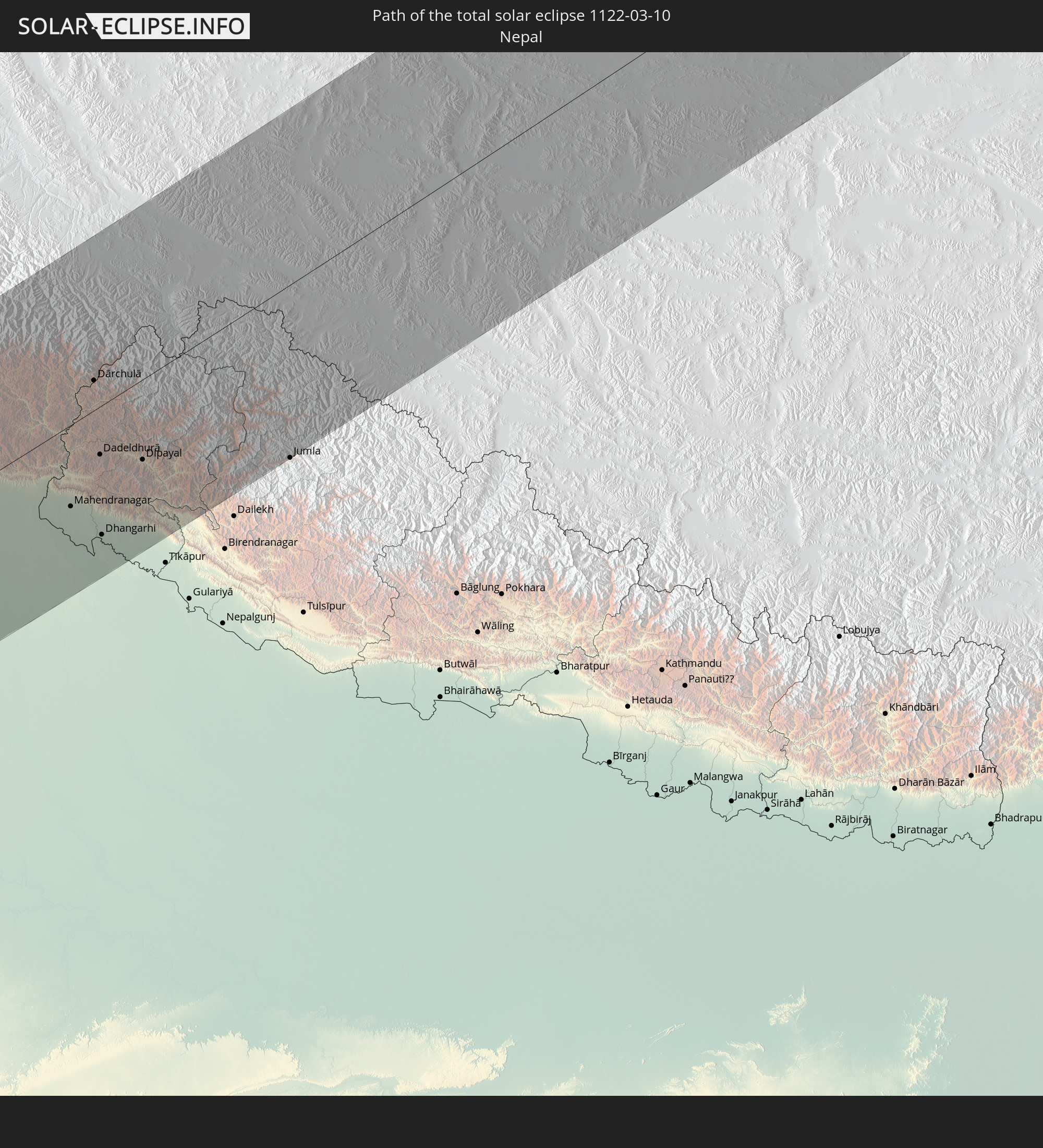 Nepal
Nepal
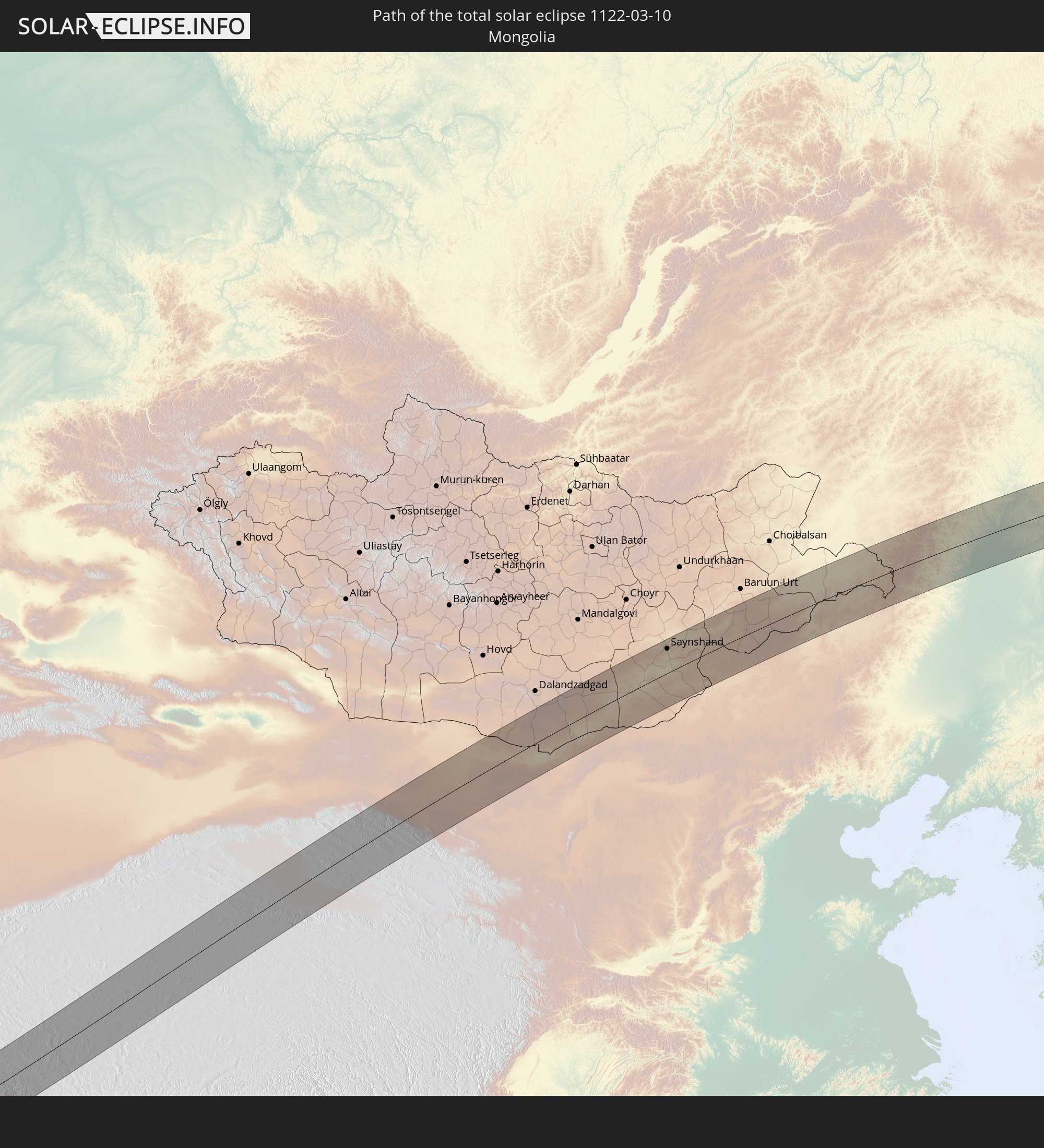 Mongolei
In den folgenden Ländern ist die Sonnenfinsternis partiell zu sehen
 Russland
 Spitzbergen
 Norwegen
 Libyen
 Schweden
 Tschechien
 Demokratische Republik Kongo
 Polen
Polen
 Ungarn
 Slowakei
 Serbien
 Åland Islands
 Griechenland
 Rumänien
 Mazedonien
 Finnland
 Litauen
 Lettland
 Estland
 Sudan
Sudan
 Sambia
 Ukraine
 Bulgarien
 Weißrussland
 Ägypten
 Türkei
 Moldawien
 Ruanda
 Burundi
 Tansania
 Uganda
 Mosambik
 Republik Zypern
 Malawi
 Äthiopien
 Kenia
Kenia
 Staat Palästina
 Israel
 Saudi-Arabien
 Jordanien
 Libanon
 Syrien
 Eritrea
 Irak
Irak
 Georgien
 Französische Süd- und Antarktisgebiete
 Somalia
 Dschibuti
 Jemen
Jemen
 Madagaskar
 Komoren
 Armenien
 Iran
Iran
 Aserbaidschan
 Mayotte
 Seychellen
 Kasachstan
 Kuwait
 Bahrain
 Katar
Katar
 Vereinigte Arabische Emirate
 Oman
Oman
 Turkmenistan
 Usbekistan
 Mauritius
 Afghanistan
 Pakistan
 Tadschikistan
 Indien
 Kirgisistan
 Britisches Territorium im Indischen Ozean
 Malediven
 Volksrepublik China
 Sri Lanka
 Nepal
Nepal
 Mongolei
 Bangladesch
 Bhutan
 Myanmar
 Indonesien
 Thailand
 Malaysia
 Laos
Laos
 Vietnam
 Kambodscha
 Macau
Macau
 Hongkong
 Taiwan
 Philippinen
 Japan
Japan
 Nordkorea
 Südkorea
 Nördliche Marianen
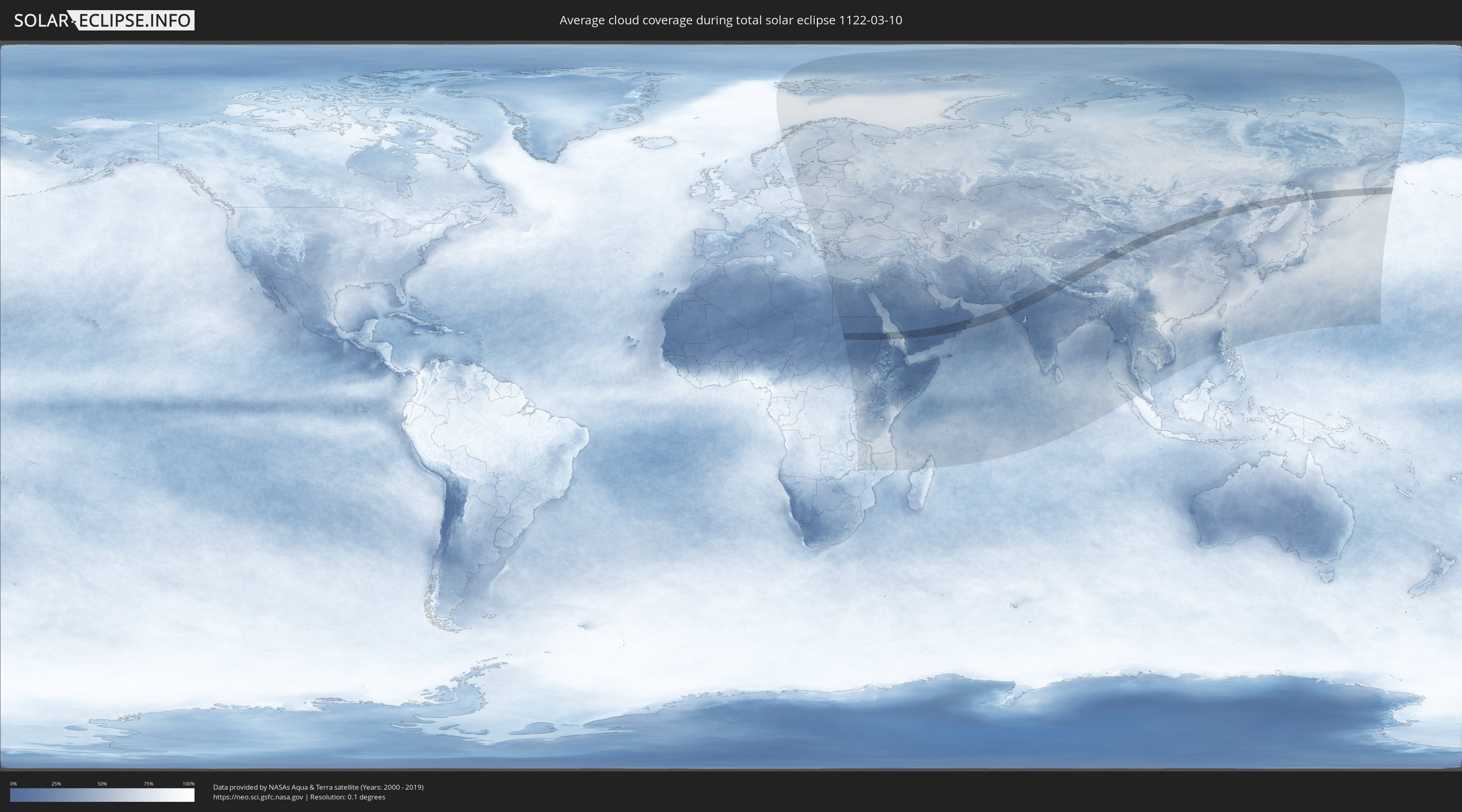
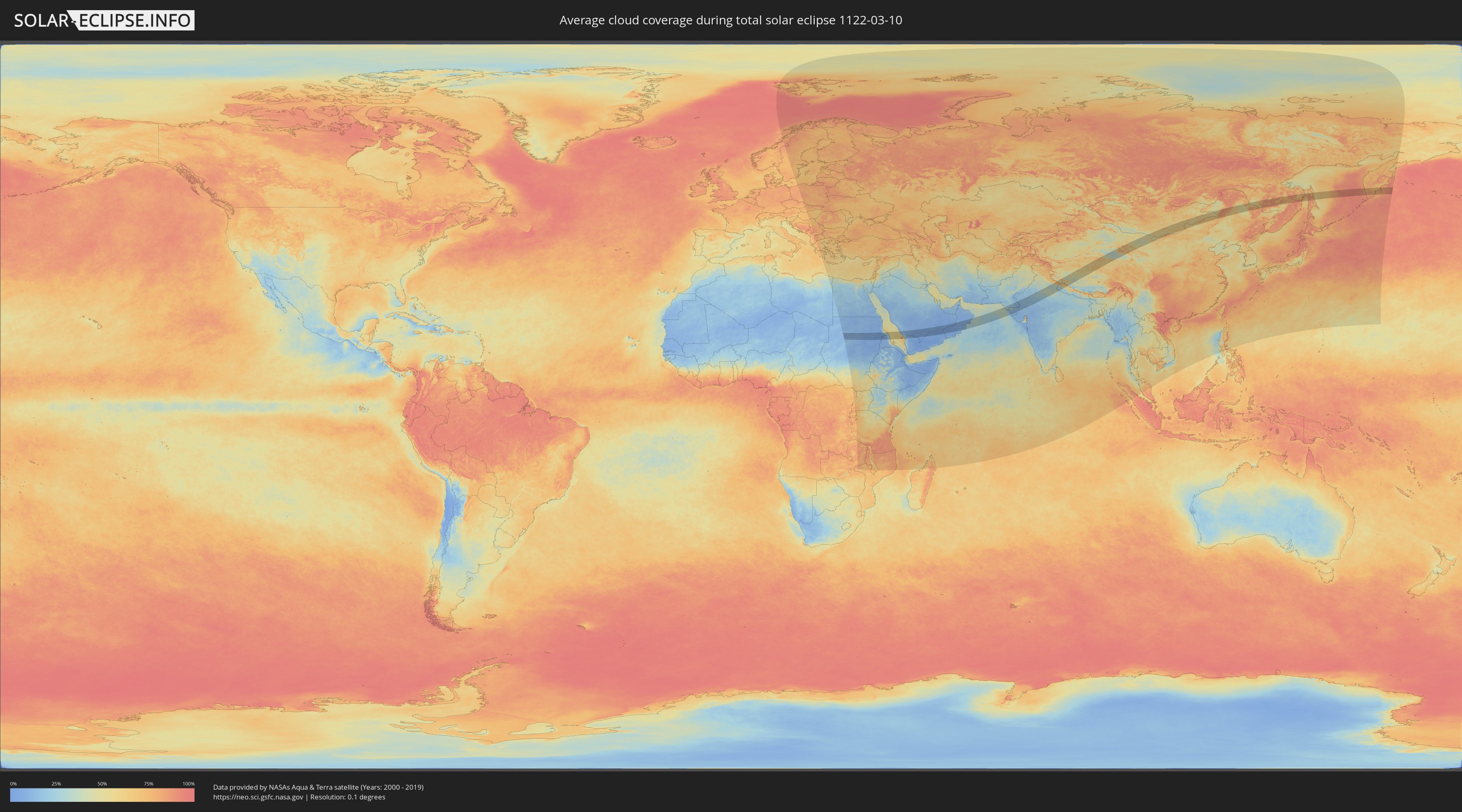
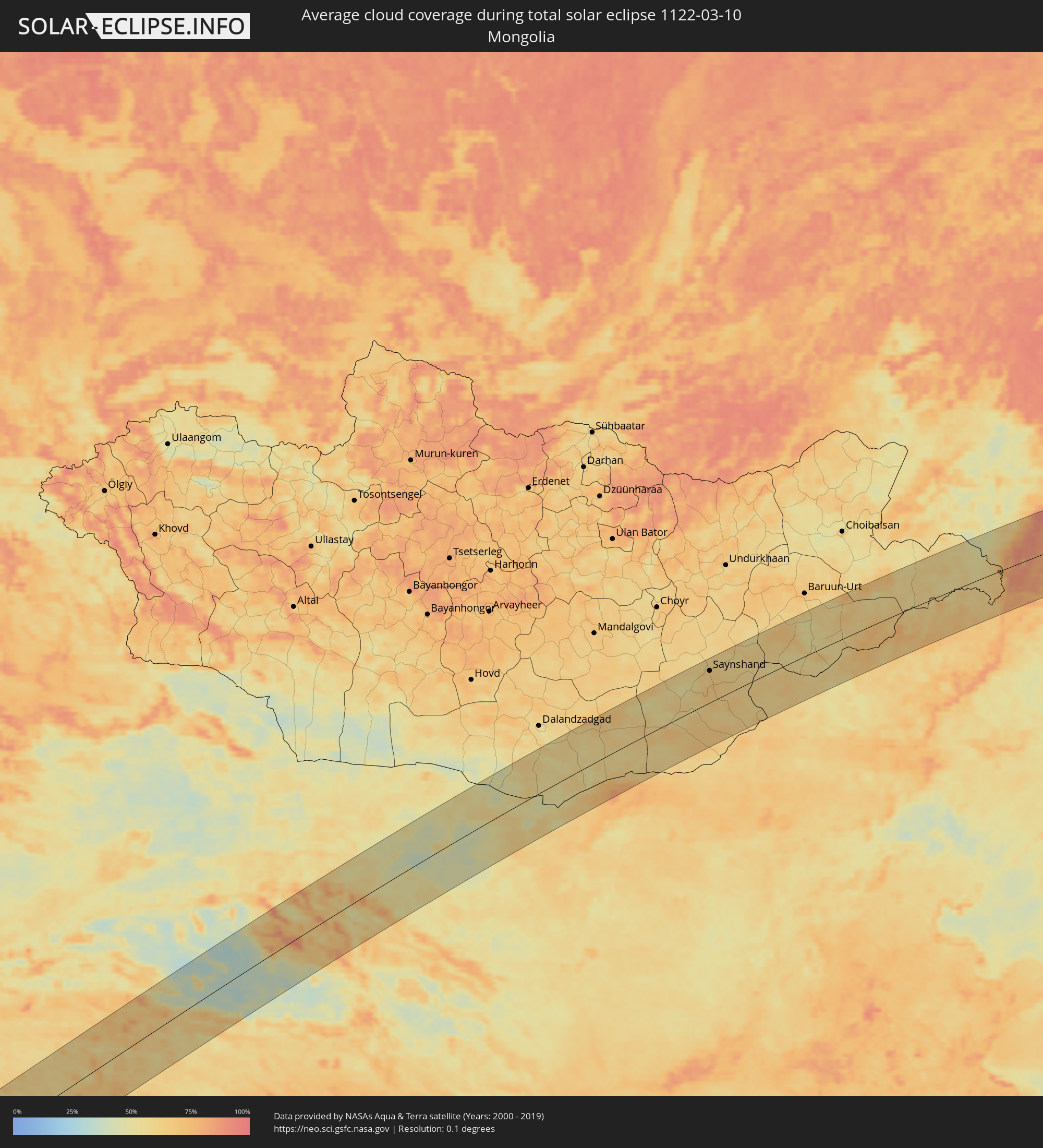
Wie wird das Wetter während der totalen Sonnenfinsternis am 10.03.1122?
Wo ist der beste Ort, um die totale Sonnenfinsternis vom 10.03.1122 zu beobachten?
Die folgenden Karten zeigen die durchschnittliche Bewölkung für den Tag, an dem die totale Sonnenfinsternis
stattfindet. Mit Hilfe der Karten lässt sich der Ort entlang des Finsternispfades eingrenzen,
der die besten Aussichen auf einen klaren wolkenfreien Himmel bietet.
Trotzdem muss man immer lokale Gegenenheiten beachten und sollte sich genau über das Wetter an seinem
gewählten Beobachtungsort informieren.
Die Daten stammen von den beiden NASA-Satelliten
AQUA und TERRA
und wurden über einen Zeitraum von 19 Jahren (2000 - 2019) gemittelt.
Detaillierte Länderkarten
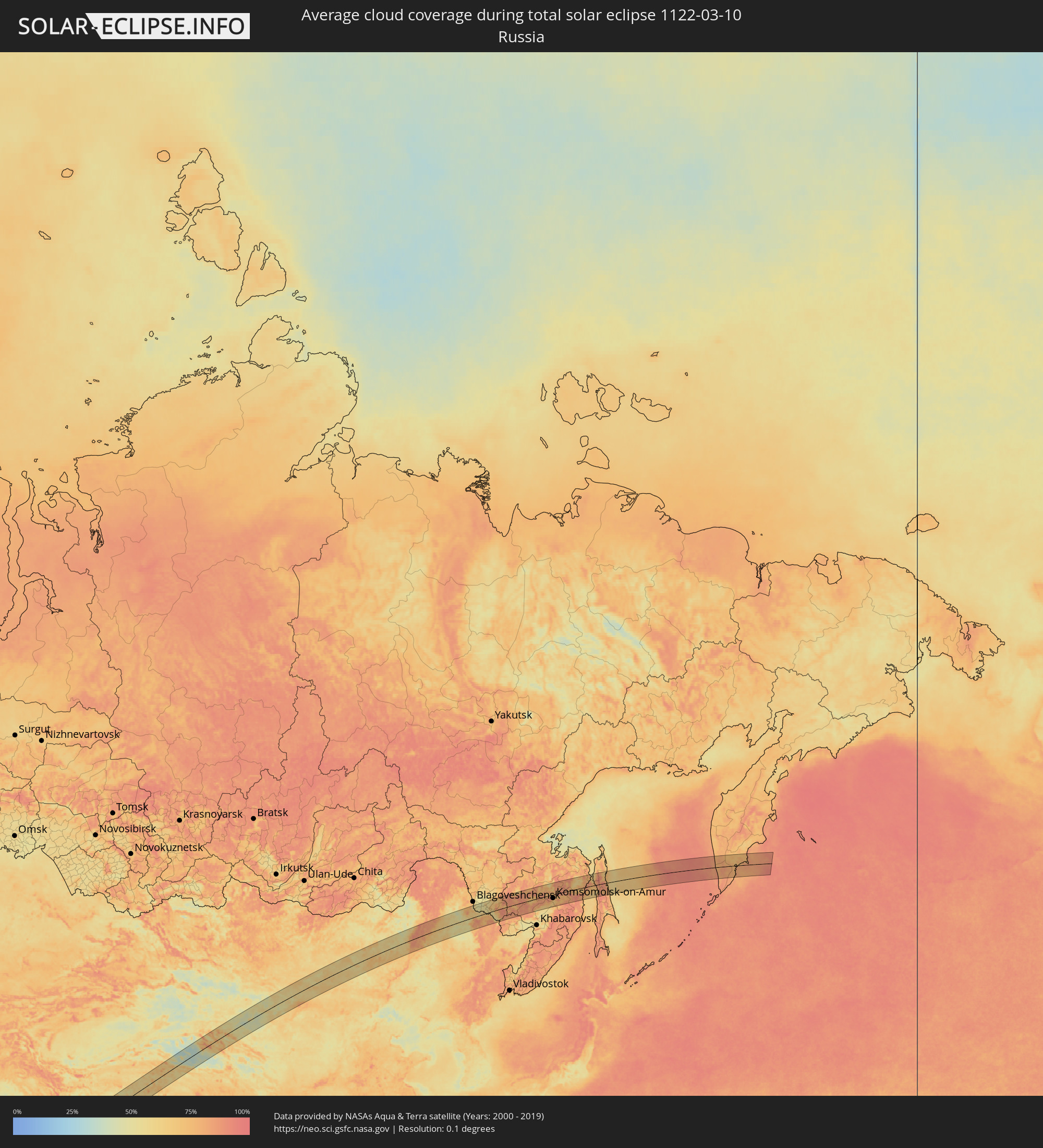 Russland
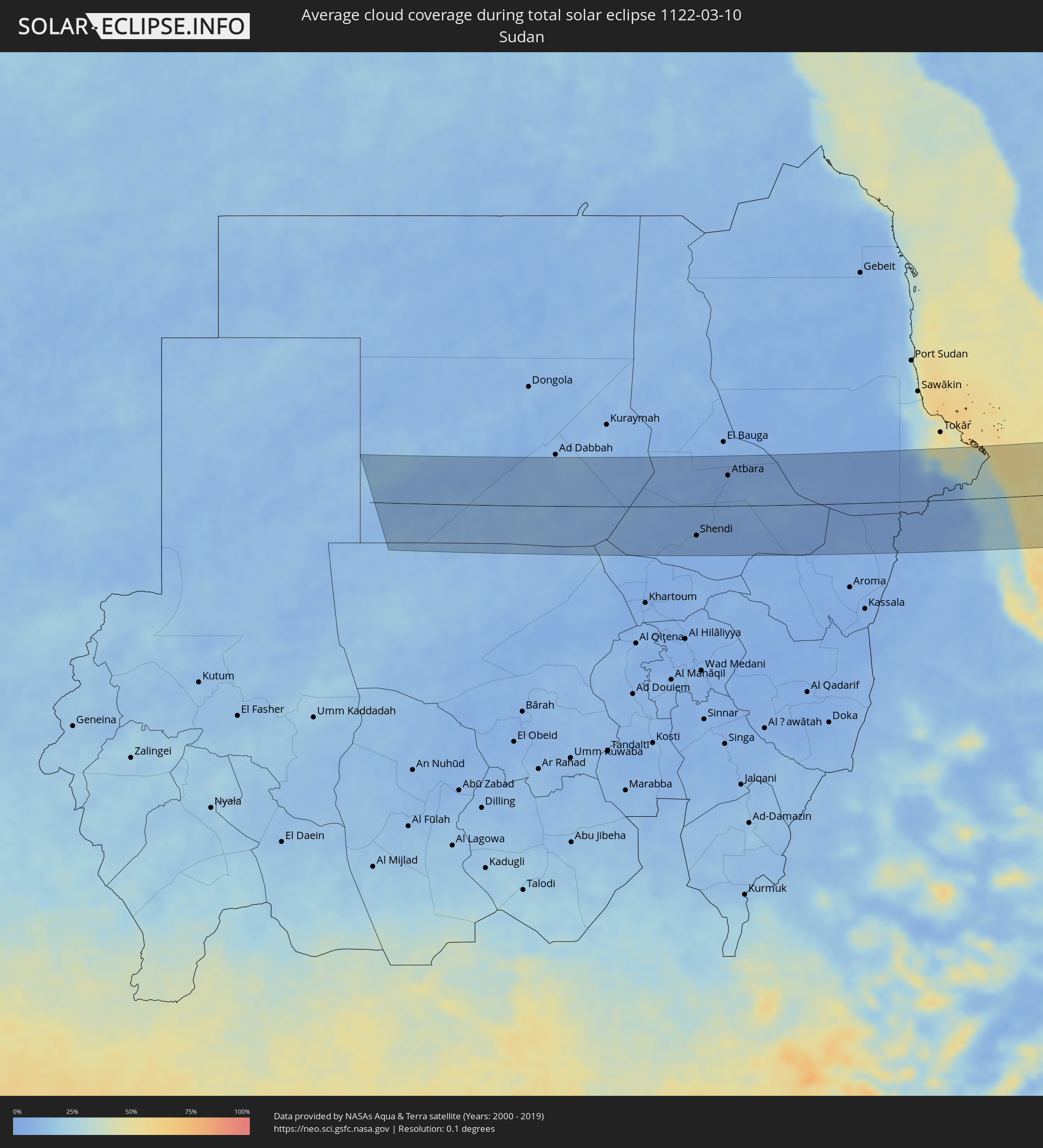 Sudan
Sudan
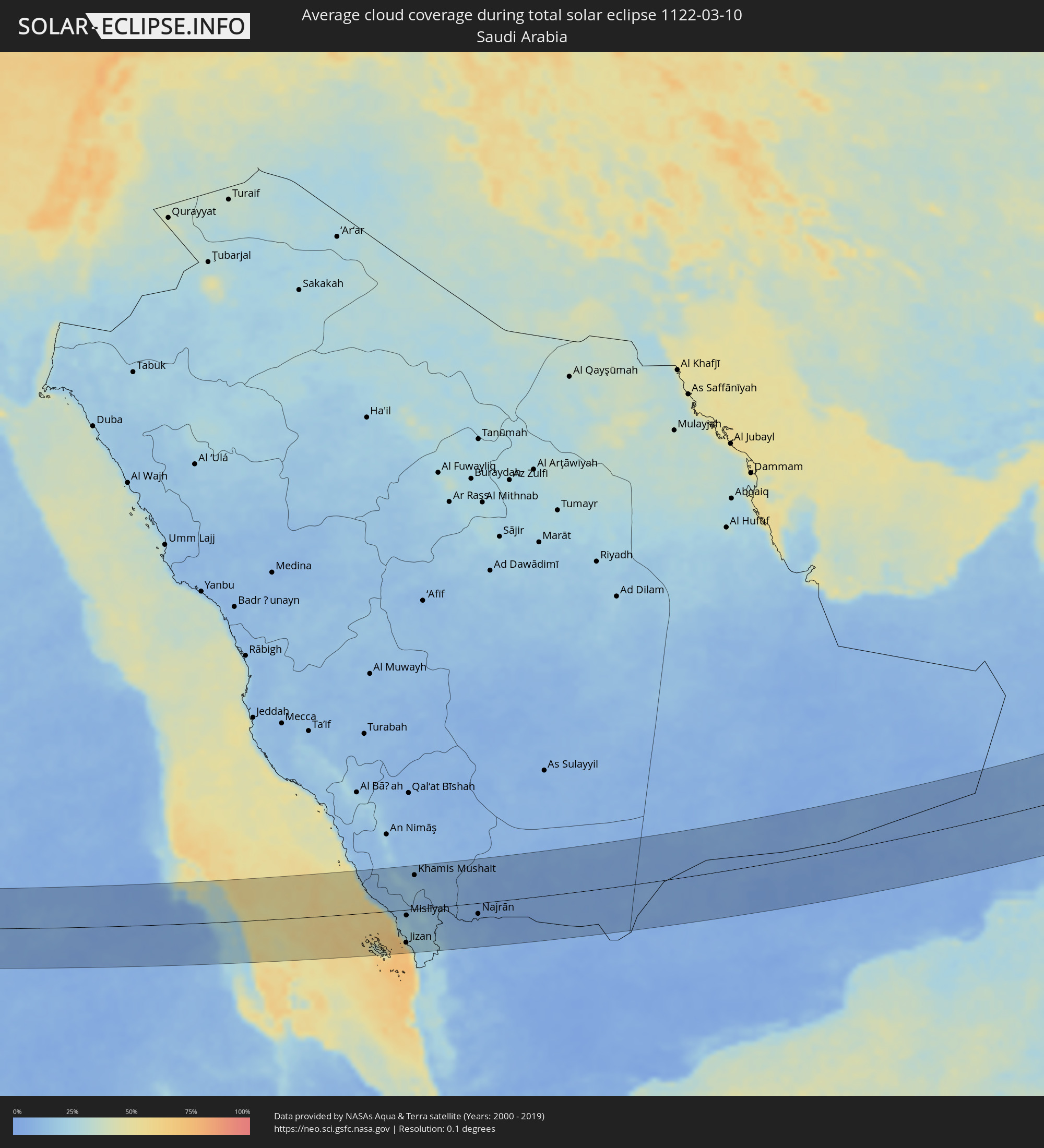 Saudi-Arabien
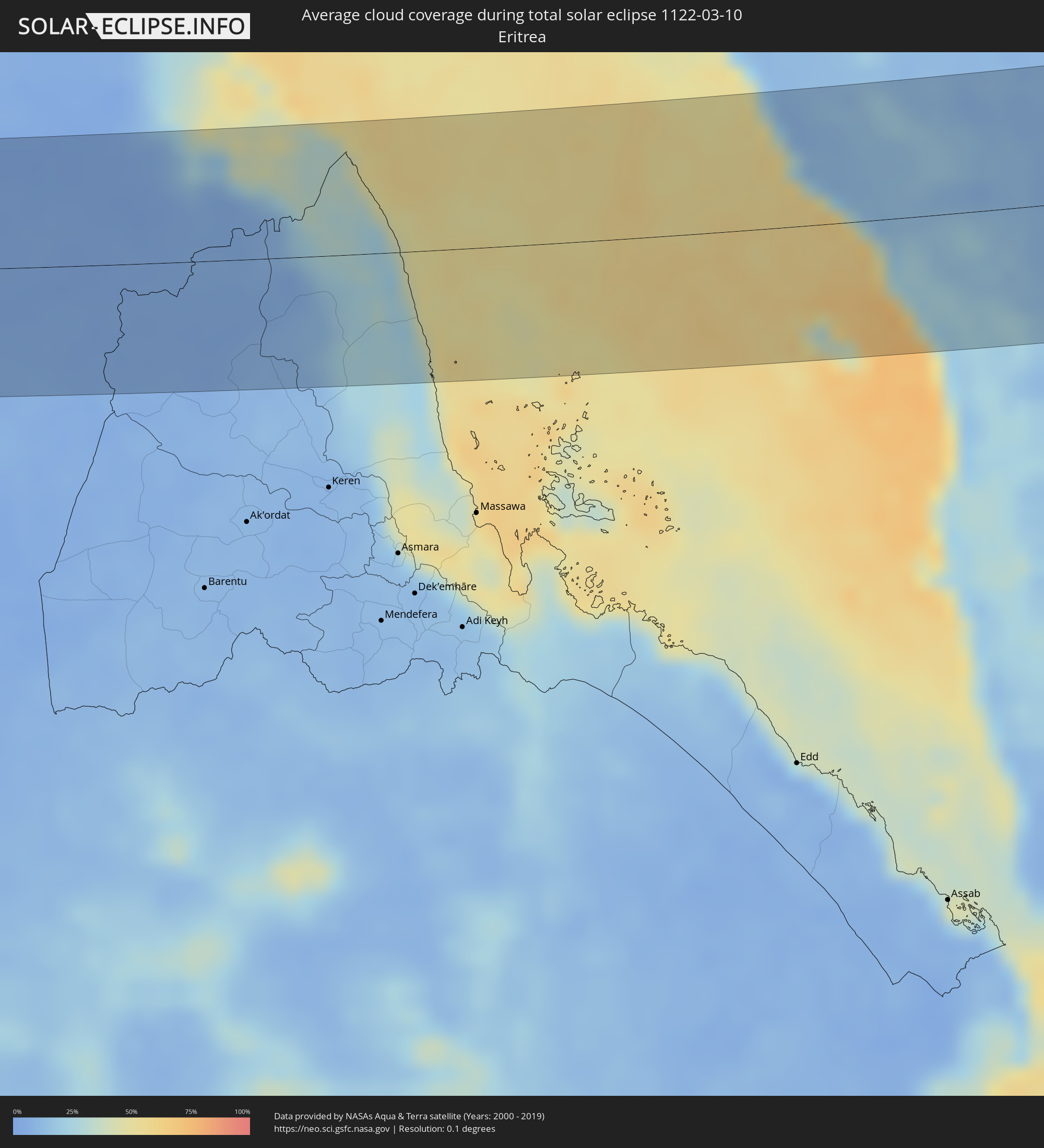 Eritrea
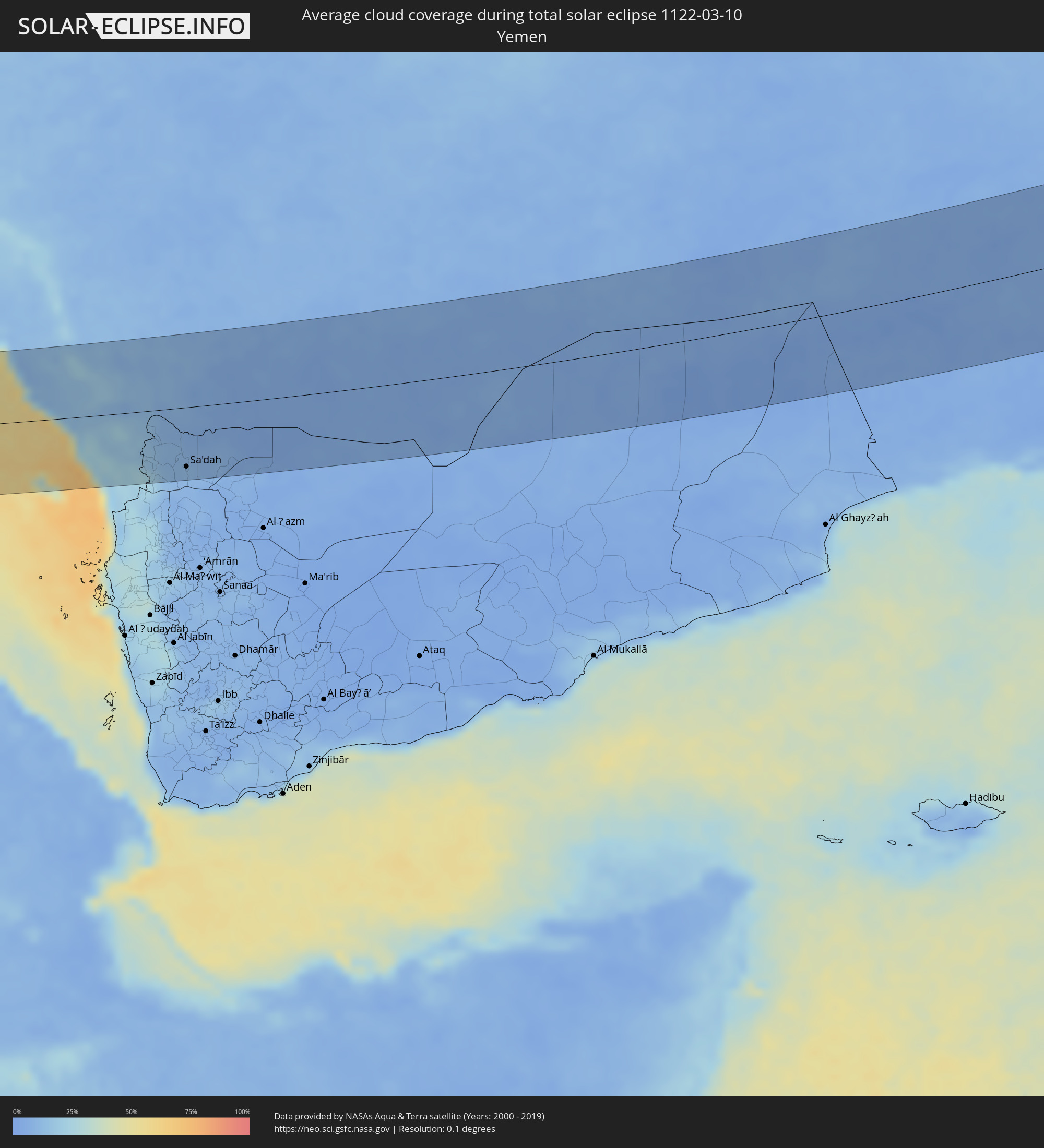 Jemen
Jemen
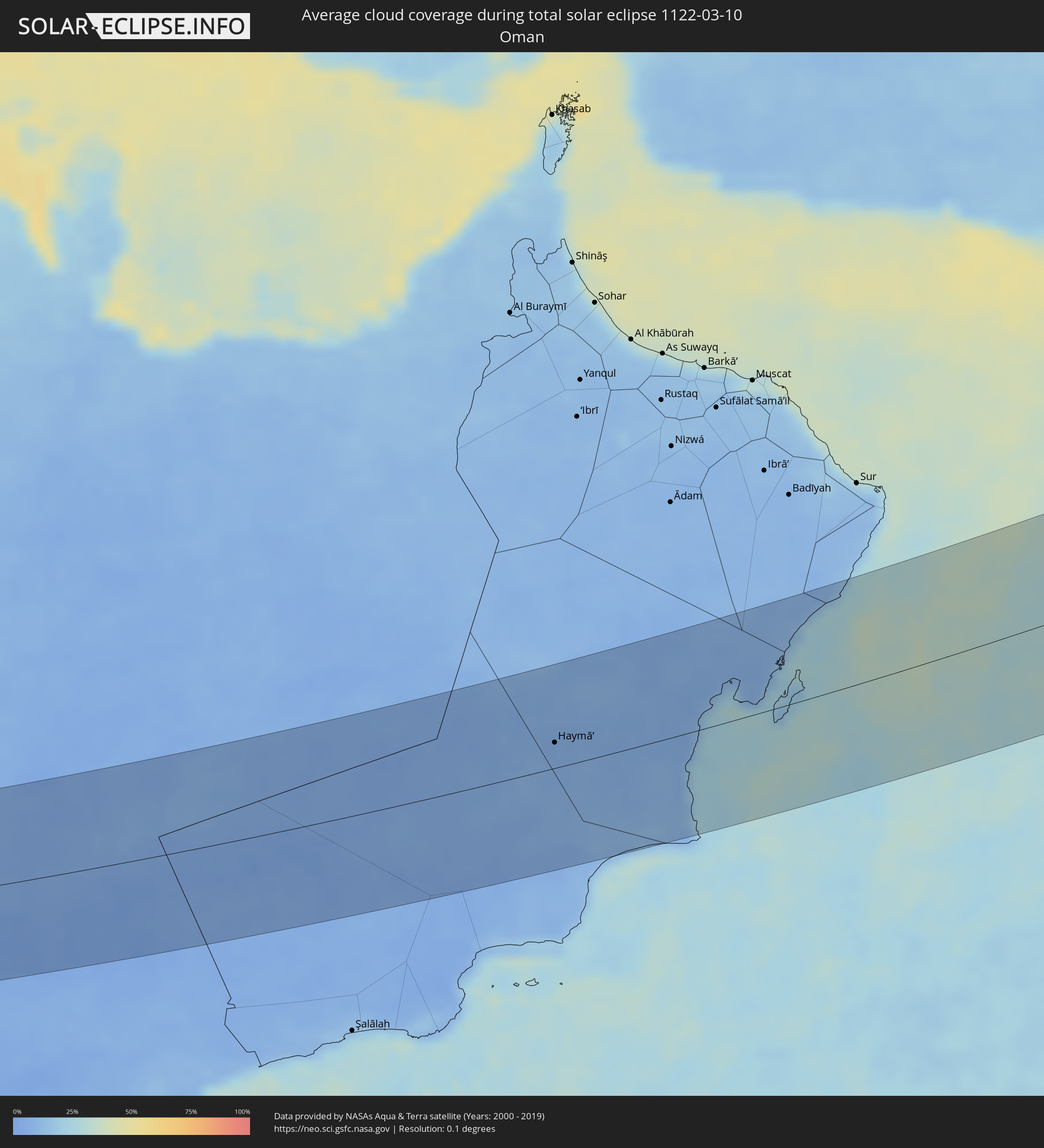 Oman
Oman
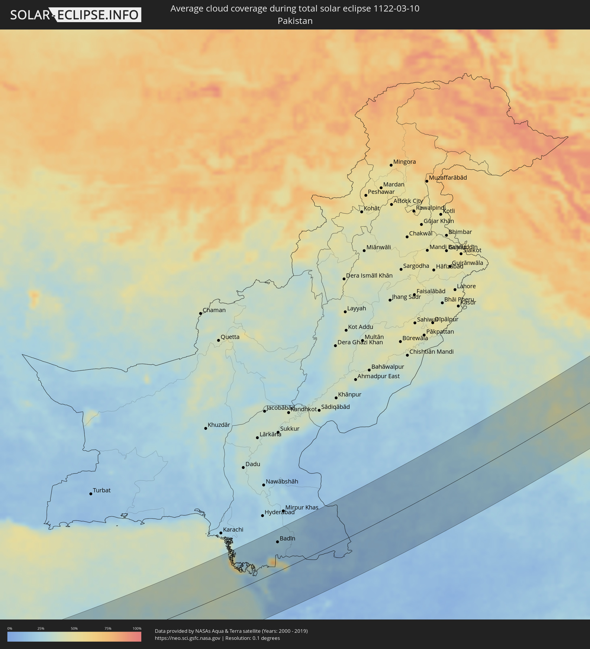 Pakistan
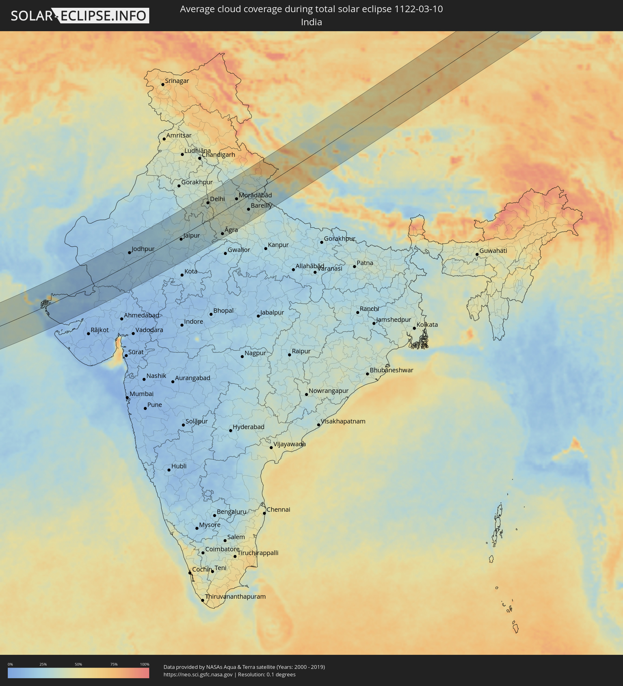 Indien
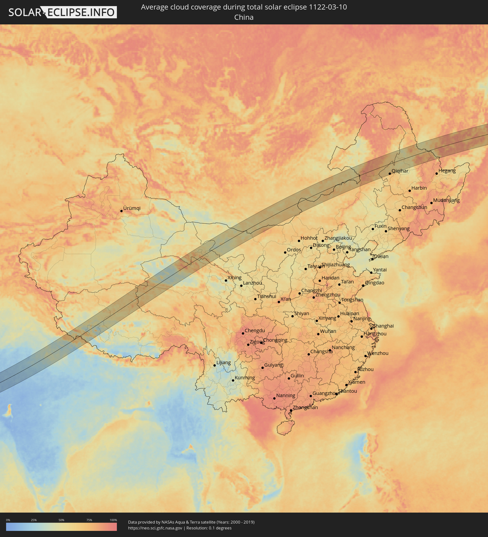 Volksrepublik China
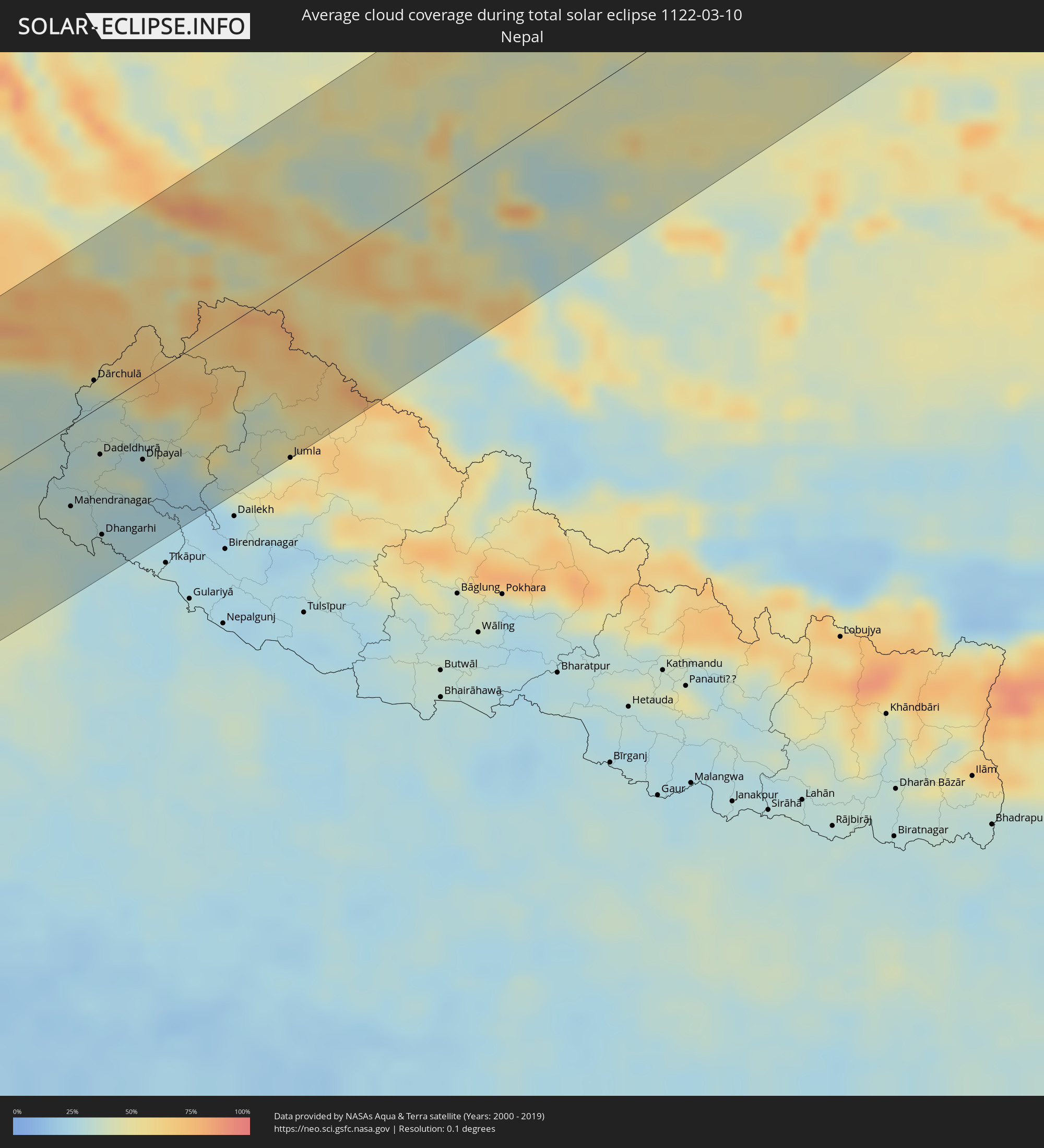 Nepal
Nepal
 Mongolei
Orte im Finsternispfad
Die nachfolgene Tabelle zeigt Städte und Orte mit mehr als 5.000 Einwohnern, die sich im Finsternispfad befinden. Städte mit mehr als 100.000 Einwohnern sind dick gekennzeichnet. Mit einem Klick auf den Ort öffnet sich eine Detailkarte die die Lage des jeweiligen Ortes zusammen mit dem Verlauf der zentralen Finsternis präsentiert.
| Ort | Typ | Dauer der Verfinsterung | Ortszeit bei maximaler Verfinsterung | Entfernung zur Zentrallinie | Ø Bewölkung |
|
El Matama, River Nile
|
total | - | 06:30:54 UTC+02:10 | 53 km | 6% |
|
Shendi, River Nile
|
total | - | 06:30:54 UTC+02:10 | 55 km | 6% |
|
Ed Damer, River Nile
|
total | - | 06:32:00 UTC+02:10 | 45 km | 6% |
|
Berber, River Nile
|
total | - | 06:32:28 UTC+02:10 | 93 km | 5% |
|
Atbara, River Nile
|
total | - | 06:32:07 UTC+02:10 | 57 km | 5% |
|
Farasān, Jizan
|
total | - | 07:30:43 UTC+03:06 | 93 km | 44% |
|
Ad Darb, Jizan
|
total | - | 07:32:00 UTC+03:06 | 19 km | 13% |
|
Abha, 'Asir
|
total | - | 07:32:44 UTC+03:06 | 71 km | 19% |
|
Jizan, Jizan
|
total | - | 07:31:10 UTC+03:06 | 76 km | 40% |
|
Mislīyah, Jizan
|
total | - | 07:31:51 UTC+03:06 | 13 km | 20% |
|
Şabyā, Jizan
|
total | - | 07:31:31 UTC+03:06 | 48 km | 24% |
|
Mizhirah, Jizan
|
total | - | 07:31:12 UTC+03:06 | 85 km | 35% |
|
Khamis Mushait, 'Asir
|
total | - | 07:32:58 UTC+03:06 | 78 km | 14% |
|
Abū ‘Arīsh, Jizan
|
total | - | 07:31:25 UTC+03:06 | 70 km | 24% |
|
Sa'dah, Şa‘dah
|
total | - | 07:31:54 UTC+03:06 | 82 km | 10% |
|
Najrān, Najran
|
total | - | 07:32:47 UTC+03:06 | 25 km | 6% |
|
Haymā’, Al Wusţá
|
total | - | 08:20:55 UTC+03:41 | 28 km | 6% |
|
Chuhar Jamāli, Sindh
|
total | - | 09:31:18 UTC+04:28 | 93 km | 21% |
|
Mīrpur Batoro, Sindh
|
total | - | 09:32:18 UTC+04:28 | 116 km | 22% |
|
Jāti, Sindh
|
total | - | 09:31:43 UTC+04:28 | 78 km | 18% |
|
Kario, Sindh
|
total | - | 09:33:00 UTC+04:28 | 109 km | 22% |
|
Talhār, Sindh
|
total | - | 09:33:29 UTC+04:28 | 108 km | 23% |
|
Badīn, Sindh
|
total | - | 09:33:10 UTC+04:28 | 84 km | 23% |
|
Rājo Khanāni, Sindh
|
total | - | 09:33:43 UTC+04:28 | 116 km | 22% |
|
Tando Bāgo, Sindh
|
total | - | 09:33:36 UTC+04:28 | 92 km | 23% |
|
Kadhan, Sindh
|
total | - | 09:33:08 UTC+04:28 | 60 km | 19% |
|
Naukot, Sindh
|
total | - | 09:34:27 UTC+04:28 | 80 km | 20% |
|
Kunri, Sindh
|
total | - | 09:35:15 UTC+04:28 | 104 km | 19% |
|
Diplo, Sindh
|
total | - | 09:34:09 UTC+04:28 | 32 km | 16% |
|
Nabīsar, Sindh
|
total | - | 09:35:12 UTC+04:28 | 90 km | 18% |
|
Umarkot, Sindh
|
total | - | 09:35:50 UTC+04:28 | 115 km | 19% |
|
Mithi, Sindh
|
total | - | 09:34:57 UTC+04:28 | 50 km | 15% |
|
Islāmkot, Sindh
|
total | - | 09:35:34 UTC+04:28 | 29 km | 12% |
|
Jodhpur, Rajasthan
|
total | - | 10:36:08 UTC+05:21 | 55 km | 20% |
|
Pāli, Rajasthan
|
total | - | 10:35:57 UTC+05:21 | 9 km | 18% |
|
Ajmer, Rajasthan
|
total | - | 10:39:30 UTC+05:21 | 6 km | 23% |
|
Bhīlwāra, Rajasthan
|
total | - | 10:37:47 UTC+05:21 | 113 km | 15% |
|
Jaipur, Rajasthan
|
total | - | 10:42:27 UTC+05:21 | 17 km | 26% |
|
Alwar, Rajasthan
|
total | - | 10:45:05 UTC+05:21 | 4 km | 28% |
|
Sonīpat, Haryana
|
total | - | 10:48:02 UTC+05:21 | 121 km | 39% |
|
Delhi, NCT
|
total | - | 10:47:56 UTC+05:21 | 77 km | 34% |
|
Farīdābād, Haryana
|
total | - | 10:47:43 UTC+05:21 | 50 km | 41% |
|
Ghāziābād, Uttar Pradesh
|
total | - | 10:48:22 UTC+05:21 | 68 km | 39% |
|
Bharatpur, Rajasthan
|
total | - | 10:46:15 UTC+05:21 | 73 km | 28% |
|
Greater Noida, Uttar Pradesh
|
total | - | 10:48:18 UTC+05:21 | 47 km | 45% |
|
Mathura, Uttar Pradesh
|
total | - | 10:47:03 UTC+05:21 | 55 km | 36% |
|
Meerut, Uttar Pradesh
|
total | - | 10:49:22 UTC+05:21 | 84 km | 37% |
|
Hāpur, Uttar Pradesh
|
total | - | 10:49:08 UTC+05:21 | 57 km | 36% |
|
Āgra, Uttar Pradesh
|
total | - | 10:47:15 UTC+05:21 | 103 km | 34% |
|
Alīgarh, Uttar Pradesh
|
total | - | 10:48:26 UTC+05:21 | 39 km | 39% |
|
Morādābād, Uttar Pradesh
|
total | - | 10:51:16 UTC+05:21 | 16 km | 36% |
|
Rāmpur, Uttar Pradesh
|
total | - | 10:51:44 UTC+05:21 | 1 km | 36% |
|
Bareilly, Uttar Pradesh
|
total | - | 10:51:50 UTC+05:21 | 63 km | 33% |
|
Mahendranagar, Far Western
|
total | - | 11:14:37 UTC+05:41 | 56 km | 36% |
|
Dārchulā, Western Region
|
total | - | 10:56:16 UTC+05:21 | 21 km | 34% |
|
Dadeldhurā, Far Western
|
total | - | 11:15:41 UTC+05:41 | 33 km | 37% |
|
Dhangarhi, Far Western
|
total | - | 11:14:51 UTC+05:41 | 90 km | 32% |
|
Dipayal, Far Western
|
total | - | 11:16:21 UTC+05:41 | 55 km | 31% |
|
Burang, Tibet Autonomous Region
|
total | - | 13:37:03 UTC+08:00 | 30 km | 51% |
|
Jumla, Mid Western
|
total | - | 11:18:55 UTC+05:41 | 119 km | 44% |
|
Laojunmiao, Gansu
|
total | - | 14:19:24 UTC+08:00 | 89 km | 55% |
|
Jiayuguan, Gansu
|
total | - | 14:20:21 UTC+08:00 | 61 km | 54% |
|
Jiuquan, Gansu
|
total | - | 14:20:43 UTC+08:00 | 45 km | 57% |
|
Saynshand, East Gobi Aymag
|
total | - | 13:47:54 UTC+07:07 | 75 km | 64% |
|
Zhalantun, Inner Mongolia
|
total | - | 14:54:23 UTC+08:00 | 5 km | 72% |
|
Nianzishan, Heilongjiang
|
total | - | 14:54:46 UTC+08:00 | 50 km | 65% |
|
Longjiang, Heilongjiang
|
total | - | 14:55:09 UTC+08:00 | 77 km | 65% |
|
Gannan, Heilongjiang
|
total | - | 14:55:11 UTC+08:00 | 25 km | 61% |
|
Qiqihar, Heilongjiang
|
total | - | 14:55:55 UTC+08:00 | 97 km | 70% |
|
Fuyu, Heilongjiang
|
total | - | 14:56:09 UTC+08:00 | 61 km | 66% |
|
Nehe, Heilongjiang
|
total | - | 14:56:08 UTC+08:00 | 1 km | 63% |
|
Nenjiang, Heilongjiang
|
total | - | 14:56:06 UTC+08:00 | 64 km | 60% |
|
Bei’an, Heilongjiang
|
total | - | 14:57:51 UTC+08:00 | 64 km | 55% |
|
Konstantinovka, Amur
|
total | - | 15:37:10 UTC+08:38 | 47 km | 60% |
|
Tambovka, Amur
|
total | - | 15:36:54 UTC+08:38 | 96 km | 48% |
|
Poyarkovo, Amur
|
total | - | 15:37:42 UTC+08:38 | 33 km | 56% |
|
Raychikhinsk, Amur
|
total | - | 15:38:11 UTC+08:38 | 34 km | 64% |
|
Zavitinsk, Amur
|
total | - | 15:37:59 UTC+08:38 | 67 km | 61% |
|
Bureya, Amur
|
total | - | 15:38:29 UTC+08:38 | 28 km | 63% |
|
Novobureyskiy, Amur
|
total | - | 15:38:33 UTC+08:38 | 25 km | 64% |
|
Arkhara, Amur
|
total | - | 15:38:58 UTC+08:38 | 19 km | 57% |
|
Talakan, Amur
|
total | - | 15:38:31 UTC+08:38 | 66 km | 72% |
|
Solnechnyy, Khabarovsk Krai
|
total | - | 15:51:00 UTC+08:47 | 5 km | 86% |
|
Amursk, Khabarovsk Krai
|
total | - | 15:51:33 UTC+08:47 | 61 km | 64% |
|
Khurba, Khabarovsk Krai
|
total | - | 15:51:25 UTC+08:47 | 43 km | 68% |
|
Komsomolsk-on-Amur, Khabarovsk Krai
|
total | - | 15:51:22 UTC+08:47 | 30 km | 73% |
|
Solnechnyy, Khabarovsk Krai
|
total | - | 15:51:21 UTC+08:47 | 27 km | 73% |
|
Aleksandrovsk-Sakhalinskiy, Sakhalin
|
total | - | 17:21:08 UTC+10:14 | 70 km | 79% |
|
Tymovskoye, Sakhalin
|
total | - | 17:21:25 UTC+10:14 | 83 km | 86% |
|
Nogliki, Sakhalin
|
total | - | 17:20:45 UTC+10:14 | 15 km | 83% |
|
Yelizovo, Kamtsjatka
|
total | - | 17:43:12 UTC+10:34 | 29 km | 70% |
|
Vilyuchinsk, Kamtsjatka
|
total | - | 17:43:28 UTC+10:34 | 1 km | 76% |
|
Petropavlovsk-Kamchatsky, Kamtsjatka
|
total | - | 17:43:23 UTC+10:34 | 12 km | 76% |