Totale Sonnenfinsternis vom 30.03.1131
| Wochentag: | Montag |
| Maximale Dauer der Verfinsterung: | 04m22s |
| Maximale Breite des Finsternispfades: | 289 km |
| Saroszyklus: | 115 |
| Bedeckungsgrad: | 100% |
| Magnitude: | 1.0639 |
| Gamma: | 0.7012 |
Wo kann man die Sonnenfinsternis vom 30.03.1131 sehen?
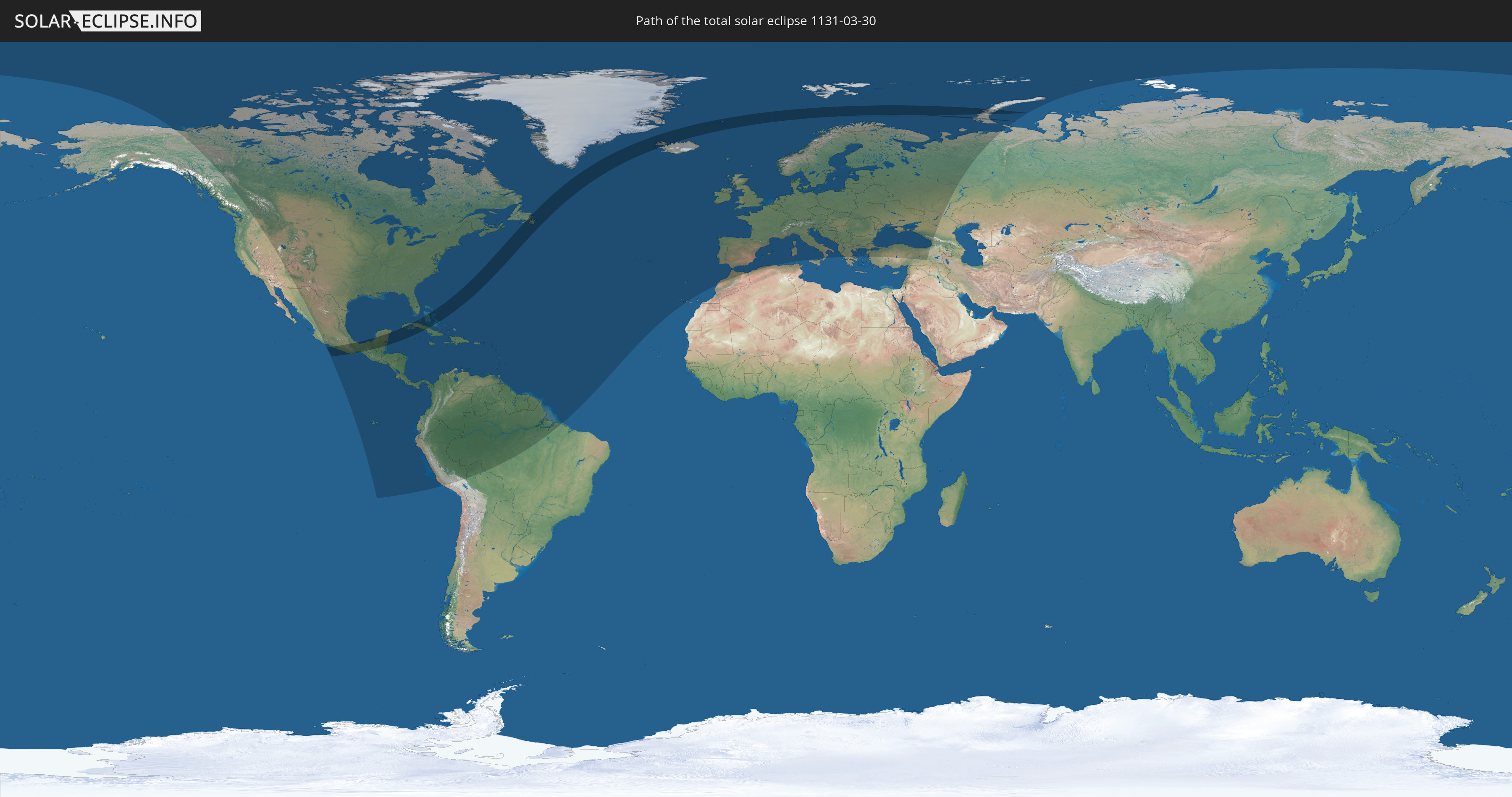
Die Sonnenfinsternis am 30.03.1131 kann man in 102 Ländern als partielle Sonnenfinsternis beobachten.
Der Finsternispfad verläuft durch 10 Länder. Nur in diesen Ländern ist sie als totale Sonnenfinsternis zu sehen.
In den folgenden Ländern ist die Sonnenfinsternis total zu sehen
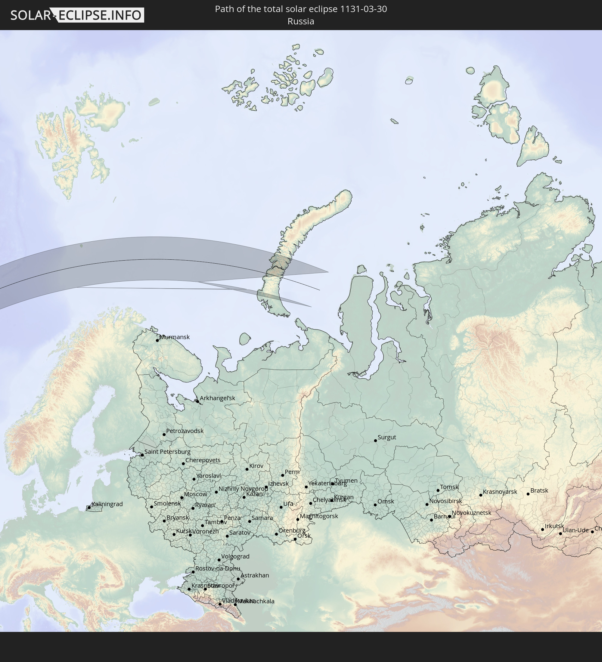 Russland
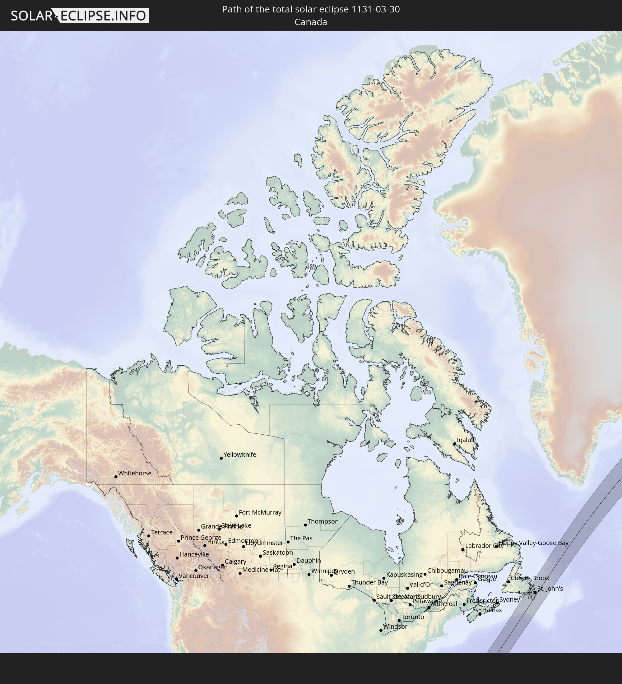 Kanada
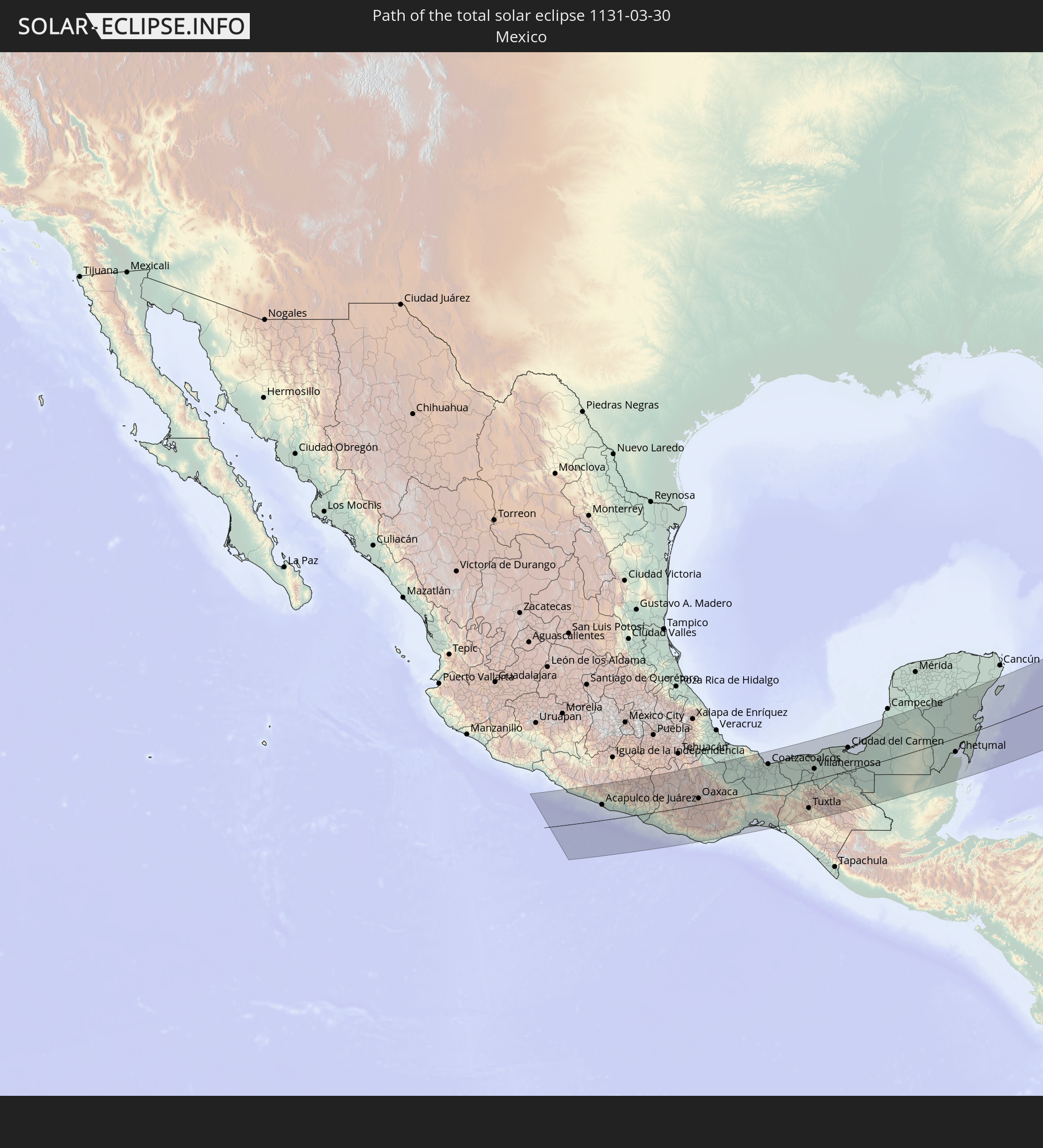 Mexiko
 Guatemala
 Belize
 Kuba
Kuba
 Bahamas
 Bermuda
 Island
 Spitzbergen
In den folgenden Ländern ist die Sonnenfinsternis partiell zu sehen
 Russland
 Vereinigte Staaten
 United States Minor Outlying Islands
 Kanada
 Mexiko
 Grönland
 Guatemala
 Ecuador
 El Salvador
 Honduras
 Belize
 Nicaragua
 Costa Rica
 Kuba
Kuba
 Panama
 Kolumbien
 Kaimaninseln
 Peru
Peru
 Bahamas
 Jamaika
 Haiti
Haiti
 Brasilien
 Venezuela
 Turks- und Caicosinseln
 Dominikanische Republik
 Aruba
Aruba
 Bolivien
 Puerto Rico
 Amerikanische Jungferninseln
 Bermuda
 Britische Jungferninseln
 Anguilla
 Saint-Martin
 Saint-Barthélemy
 St. Kitts und Nevis
 Antigua und Barbuda
 Montserrat
 Trinidad und Tobago
 Guadeloupe
 Grenada
 Dominica
 St. Vincent und die Grenadinen
 Guyana
 Martinique
 St. Lucia
 Barbados
 Suriname
 Saint-Pierre und Miquelon
 Französisch-Guayana
 Portugal
 Island
 Spanien
 Marokko
 Irland
 Spitzbergen
 Algerien
 Vereinigtes Königreich
 Färöer
 Gibraltar
 Frankreich
 Isle of Man
 Guernsey
 Jersey
 Andorra
 Belgien
 Niederlande
 Norwegen
 Luxemburg
 Deutschland
 Schweiz
 Italien
 Monaco
 Dänemark
 Liechtenstein
 Österreich
 Schweden
 Tschechien
 San Marino
 Vatikanstadt
 Slowenien
 Kroatien
 Polen
Polen
 Bosnien und Herzegowina
 Ungarn
 Slowakei
 Montenegro
 Serbien
 Albanien
 Åland Islands
 Griechenland
 Rumänien
 Mazedonien
 Finnland
 Litauen
 Lettland
 Estland
 Ukraine
 Bulgarien
 Weißrussland
 Türkei
 Moldawien
 Georgien
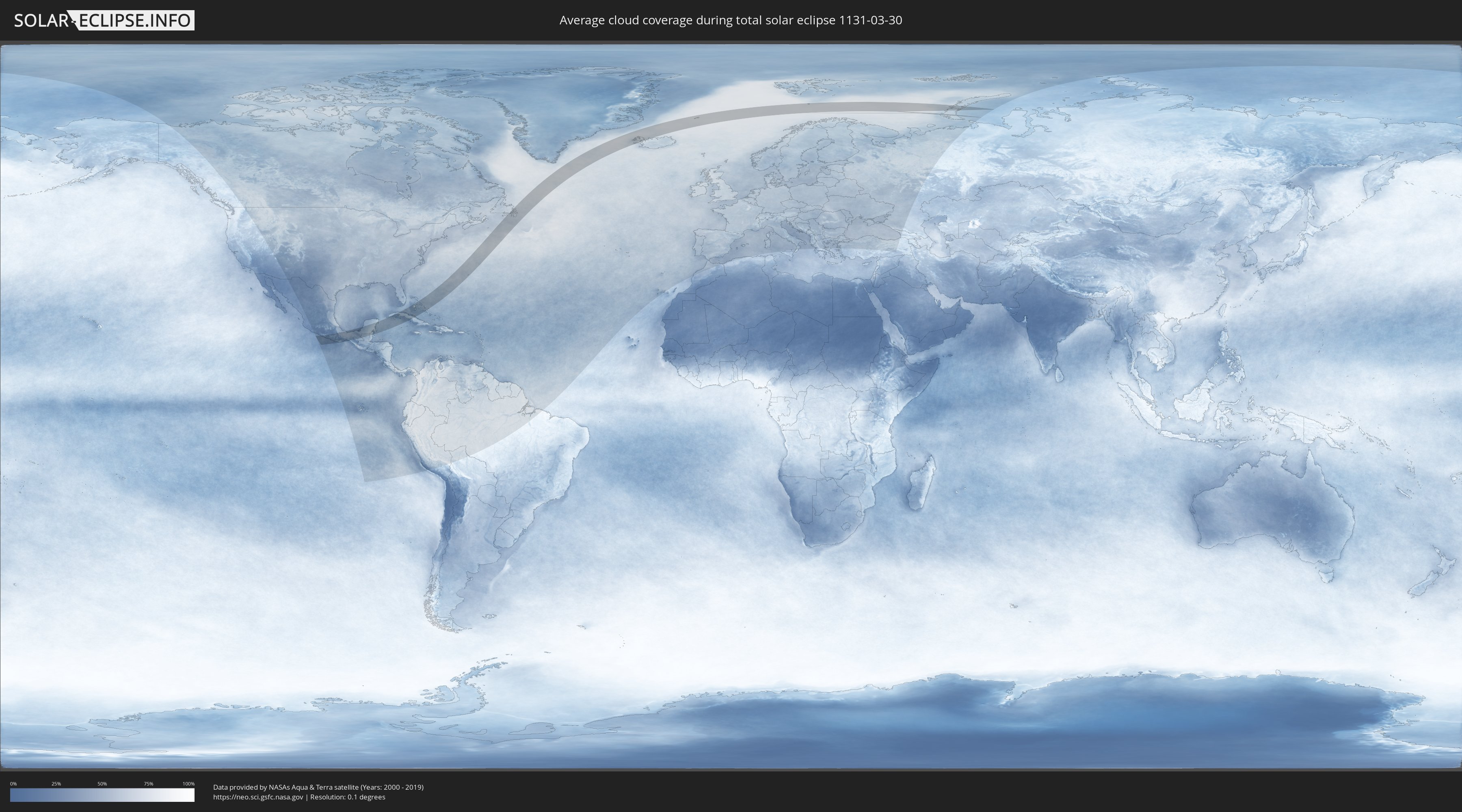
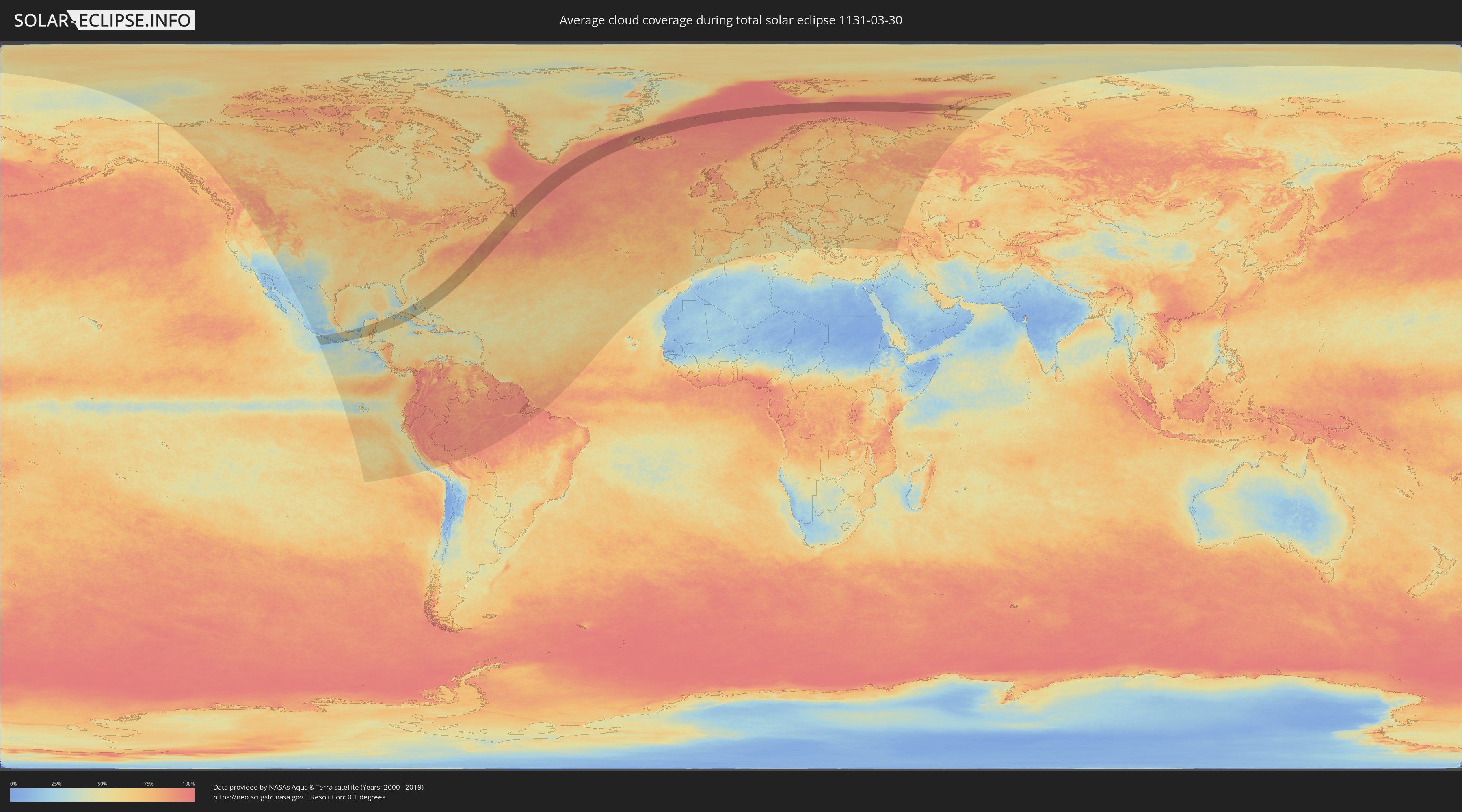
Wie wird das Wetter während der totalen Sonnenfinsternis am 30.03.1131?
Wo ist der beste Ort, um die totale Sonnenfinsternis vom 30.03.1131 zu beobachten?
Die folgenden Karten zeigen die durchschnittliche Bewölkung für den Tag, an dem die totale Sonnenfinsternis
stattfindet. Mit Hilfe der Karten lässt sich der Ort entlang des Finsternispfades eingrenzen,
der die besten Aussichen auf einen klaren wolkenfreien Himmel bietet.
Trotzdem muss man immer lokale Gegenenheiten beachten und sollte sich genau über das Wetter an seinem
gewählten Beobachtungsort informieren.
Die Daten stammen von den beiden NASA-Satelliten
AQUA und TERRA
und wurden über einen Zeitraum von 19 Jahren (2000 - 2019) gemittelt.
Detaillierte Länderkarten
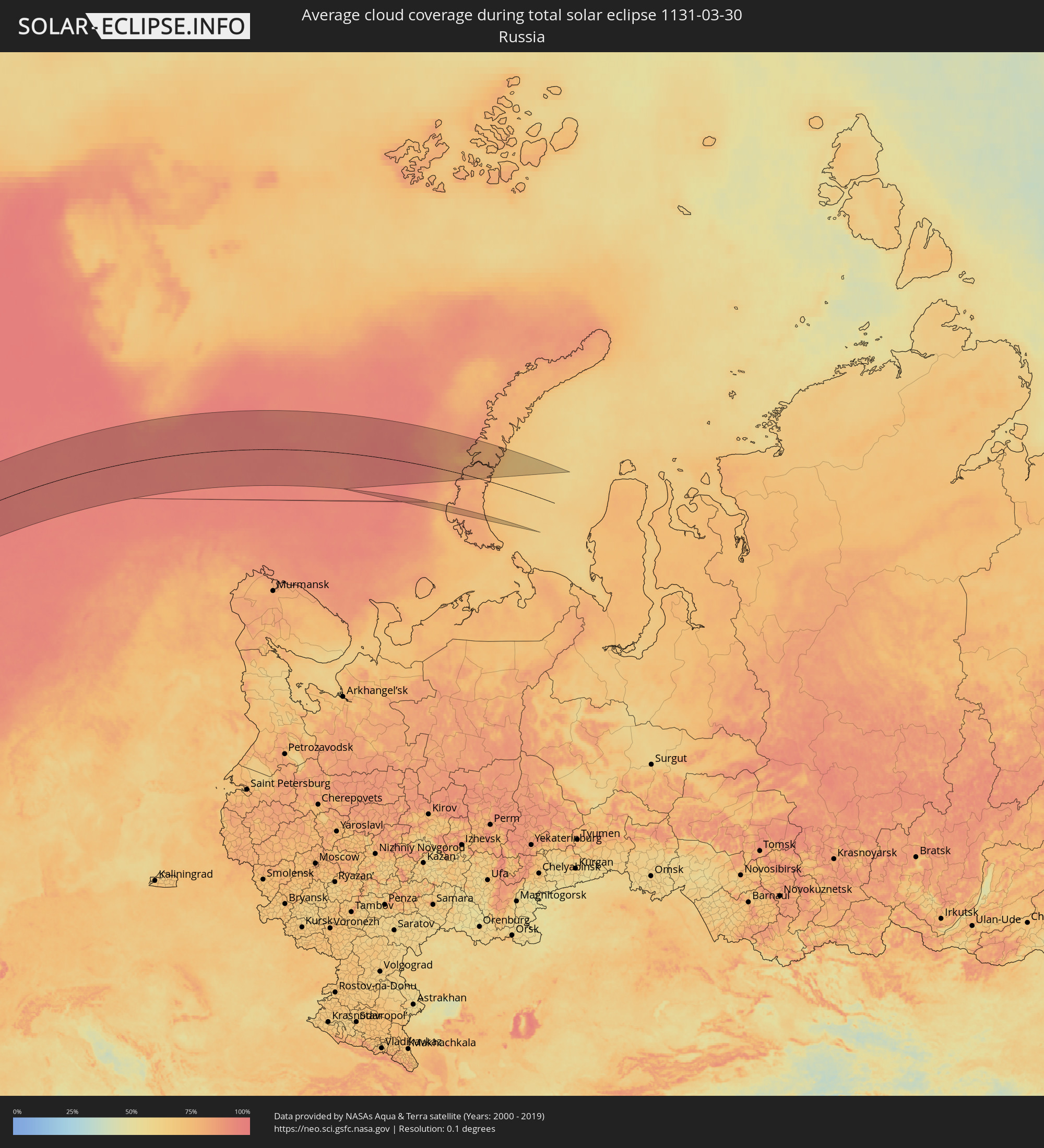 Russland
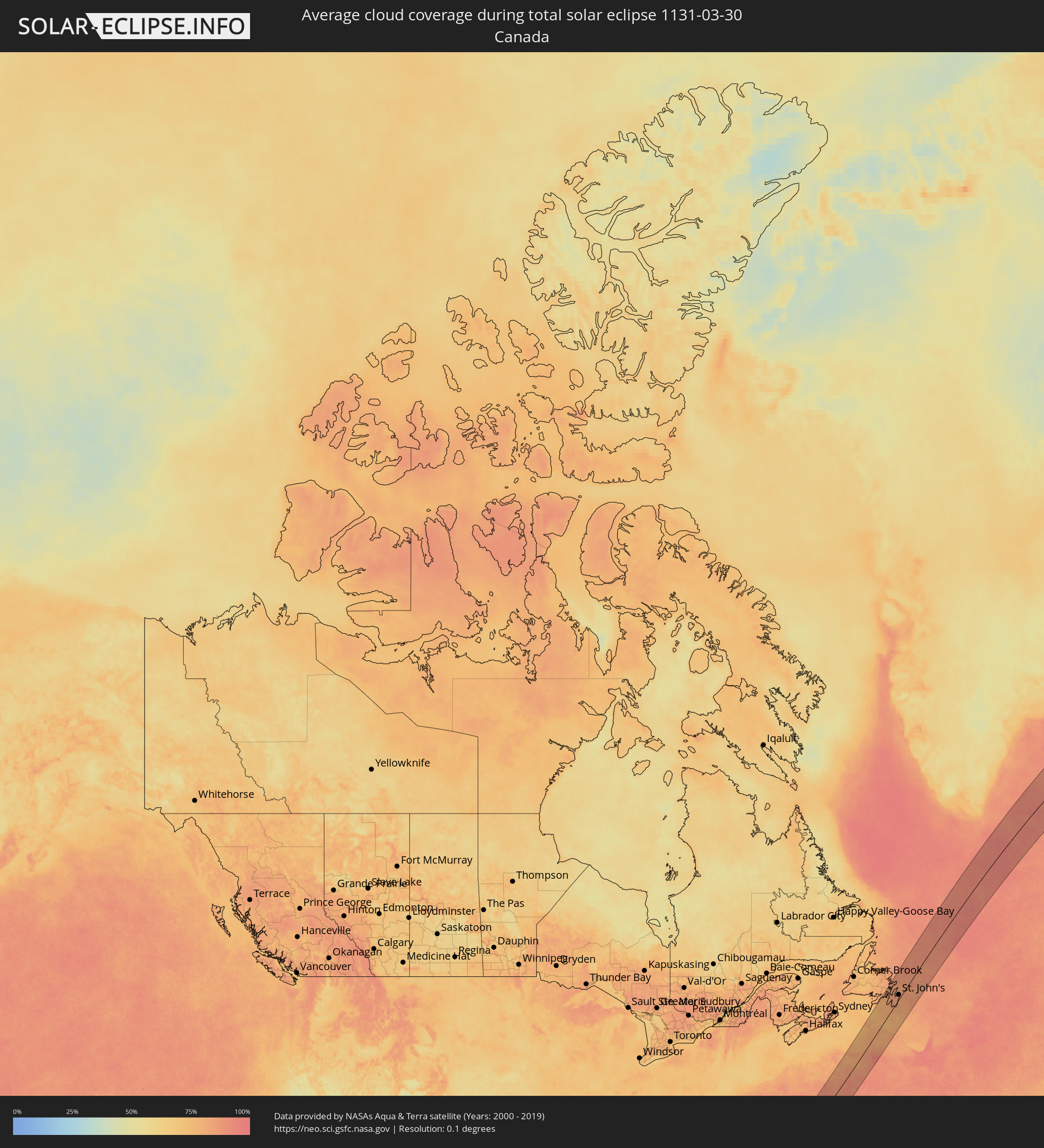 Kanada
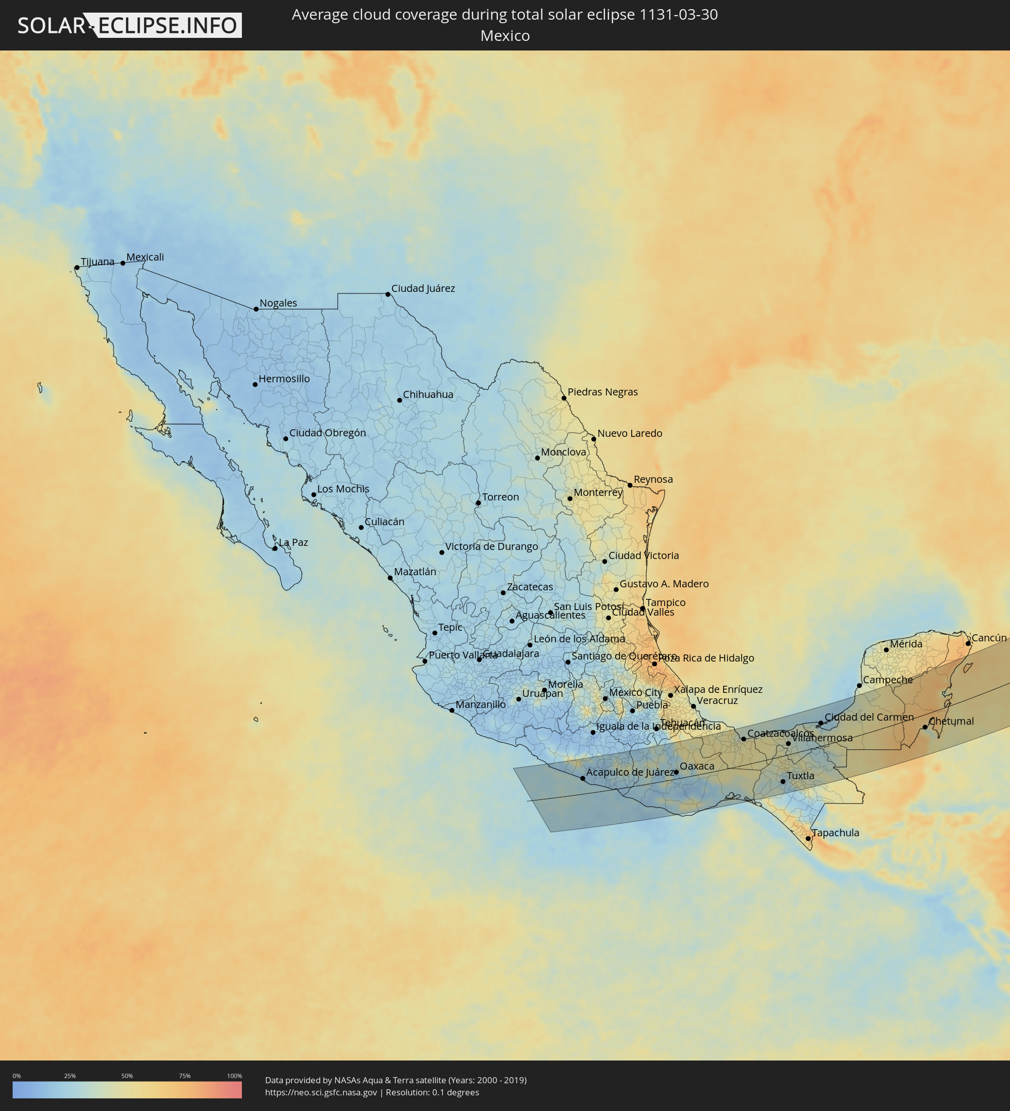 Mexiko
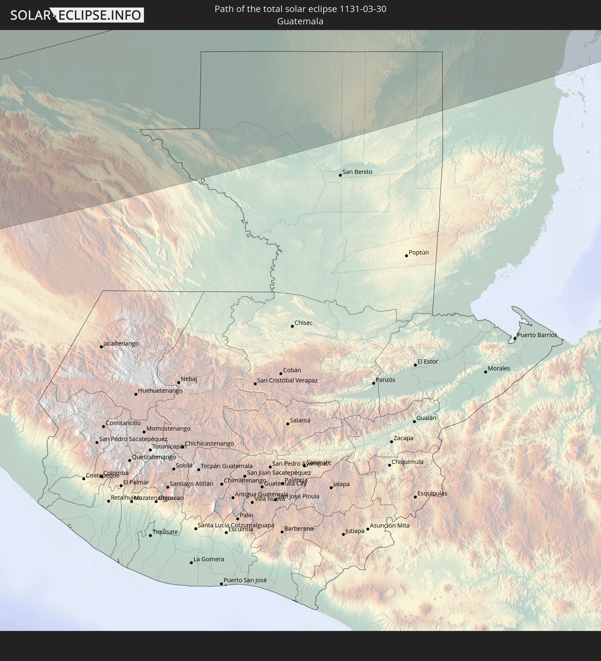
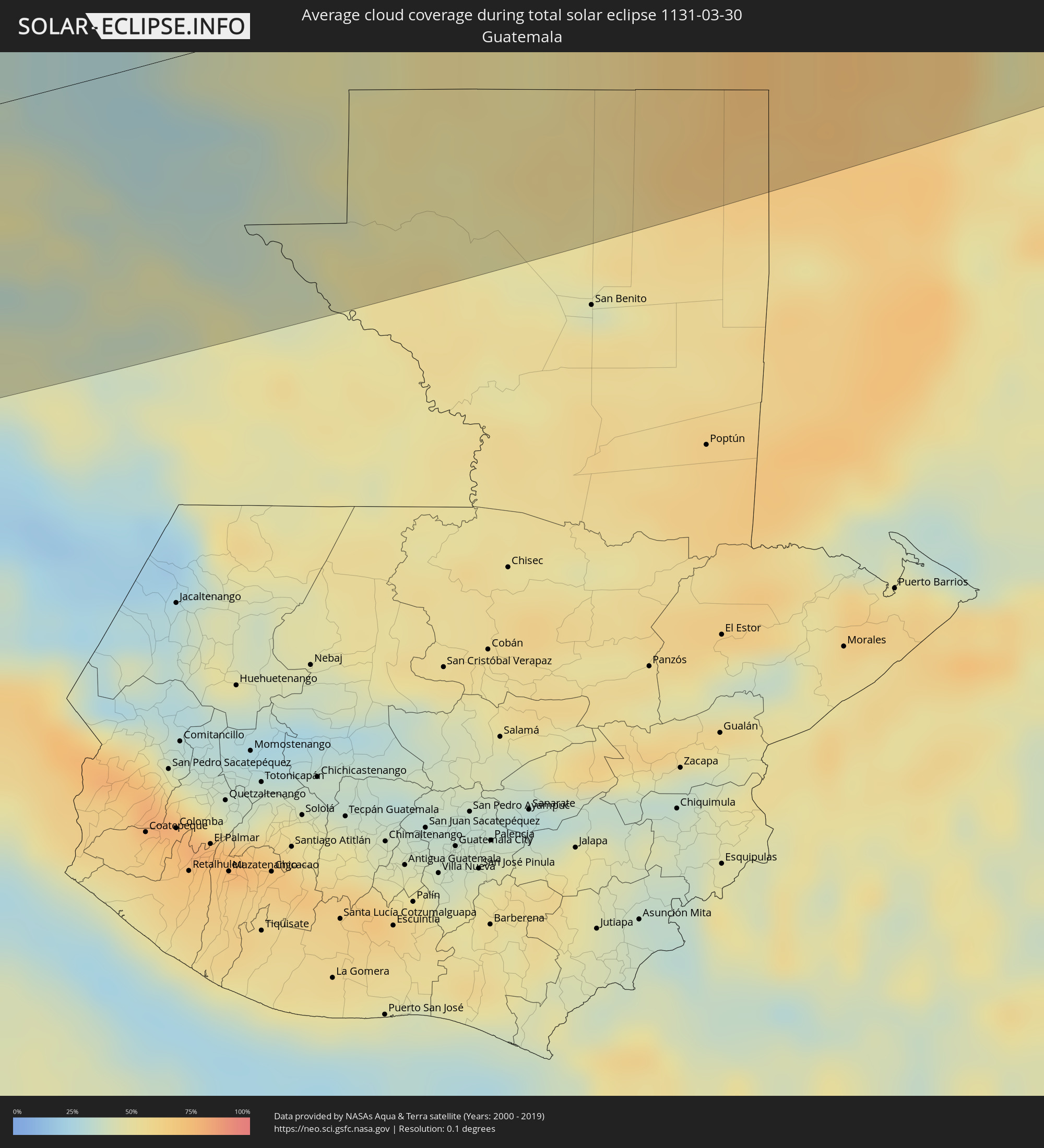 Guatemala
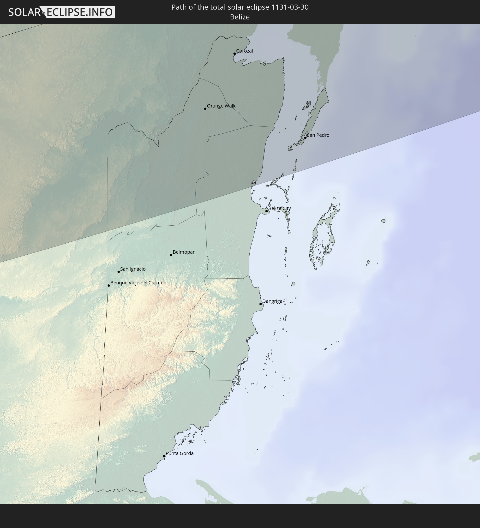
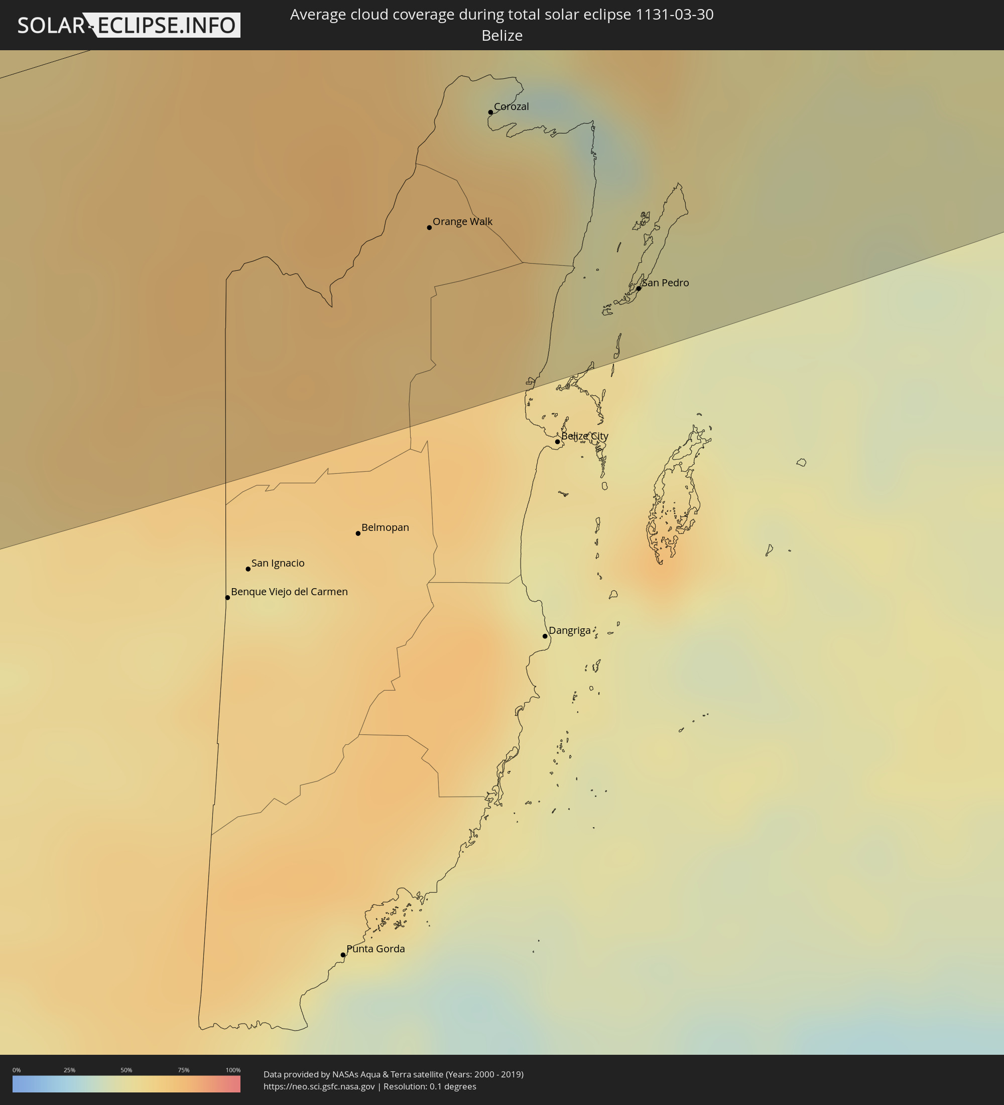 Belize
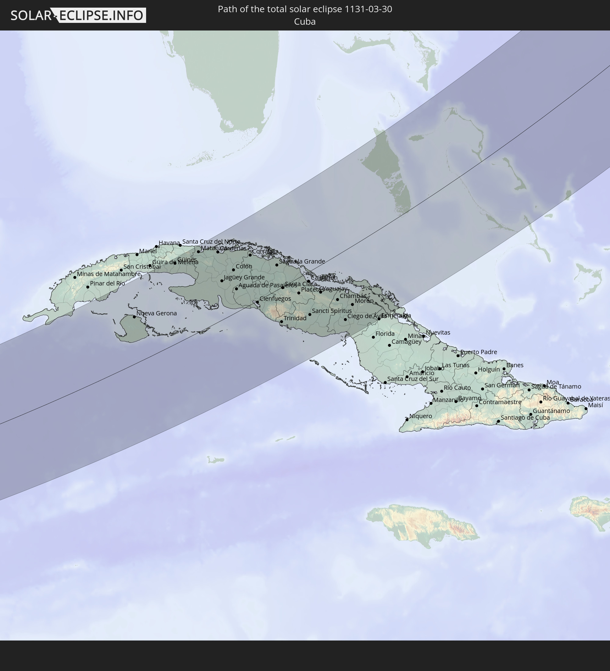
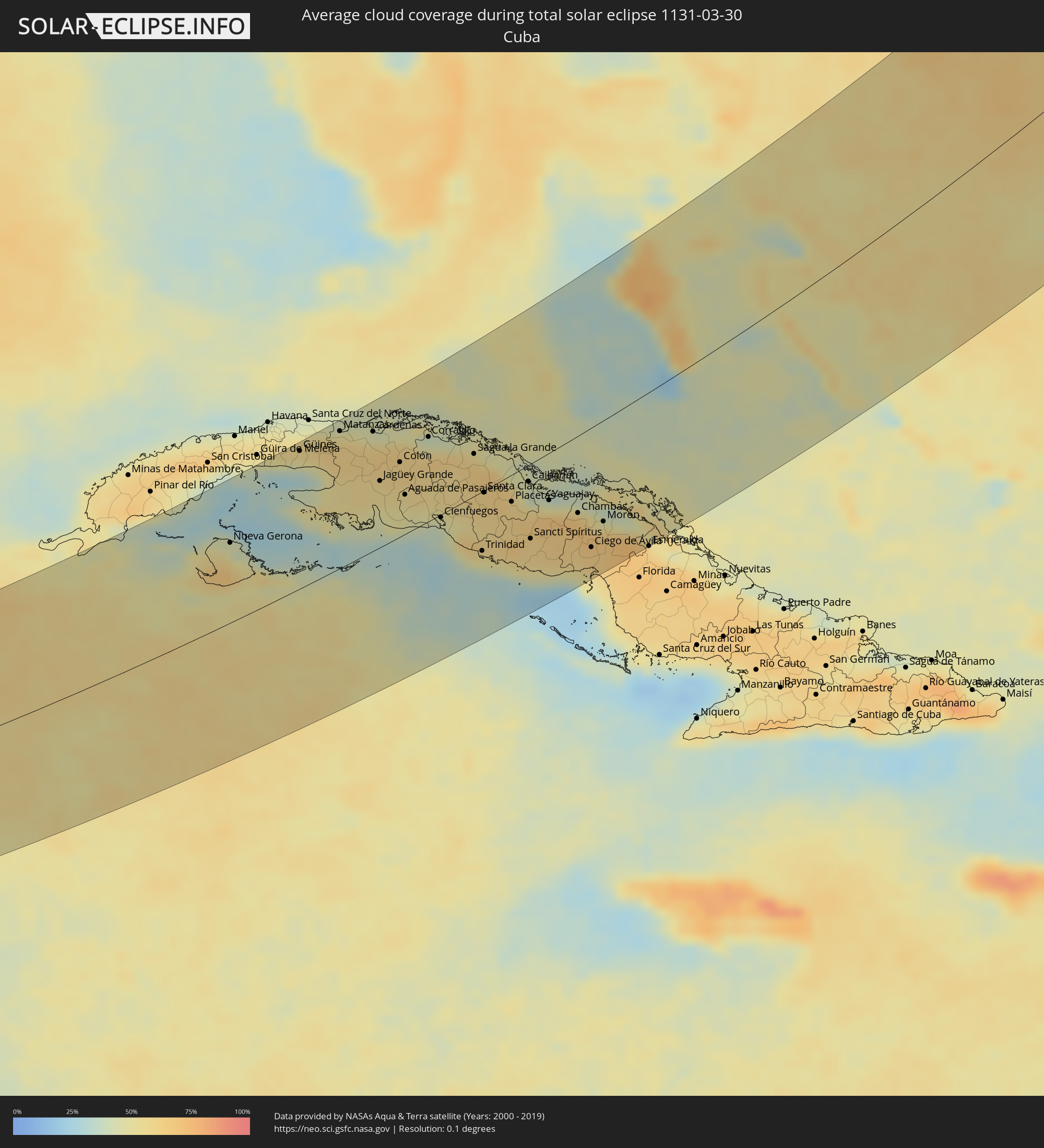 Kuba
Kuba
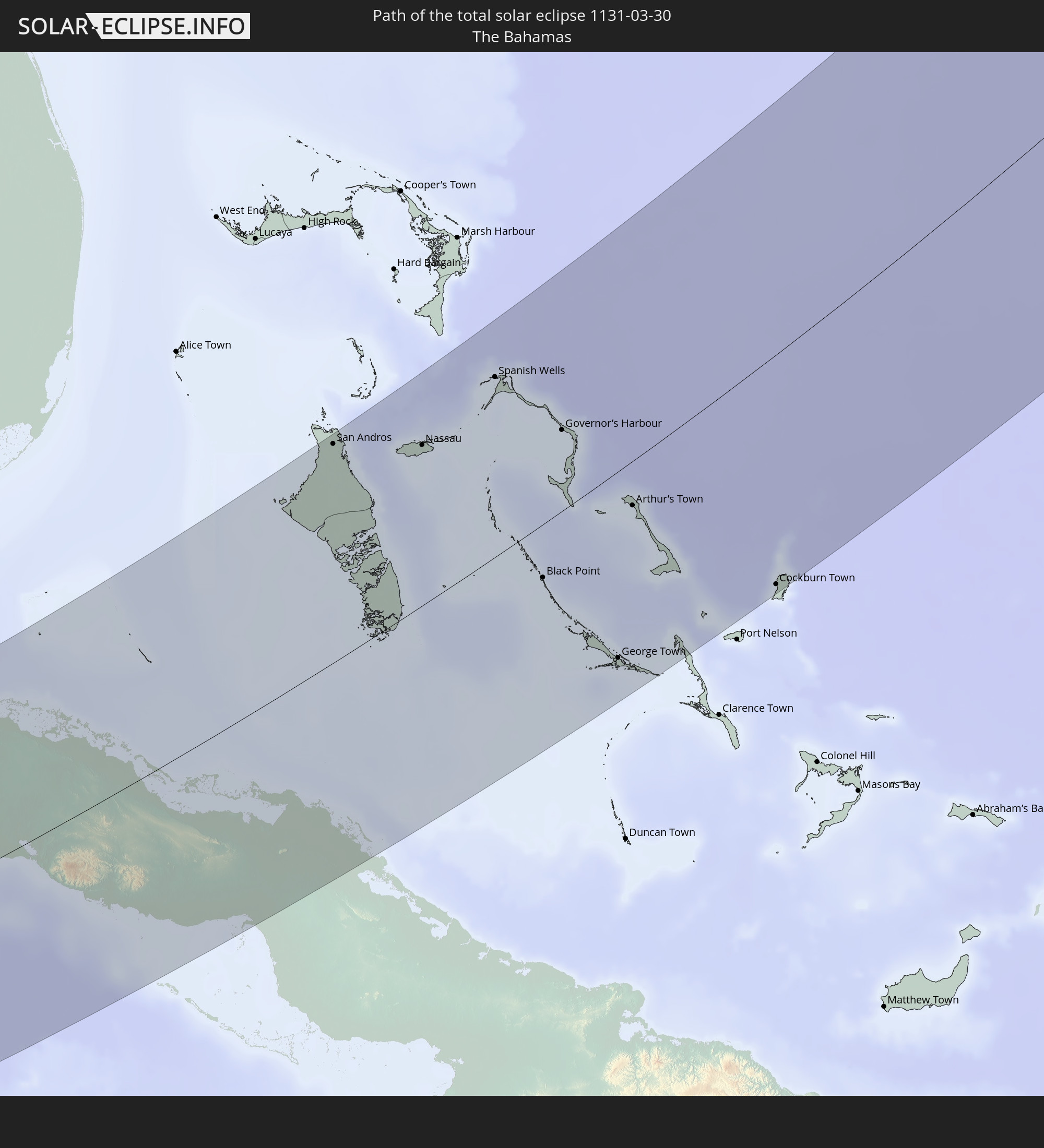
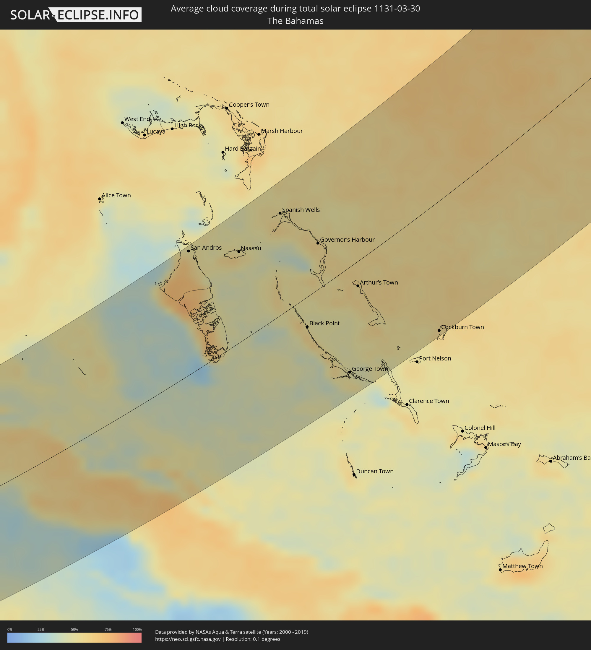 Bahamas
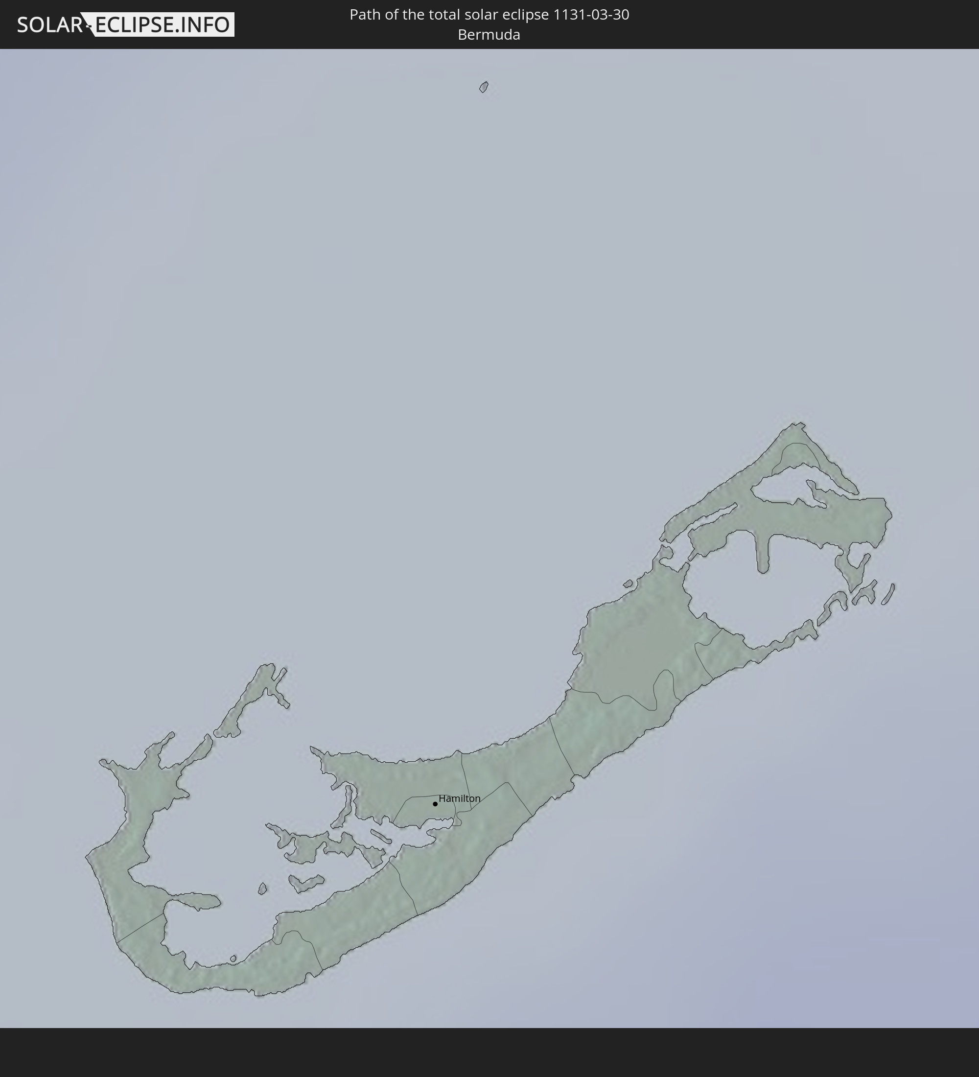
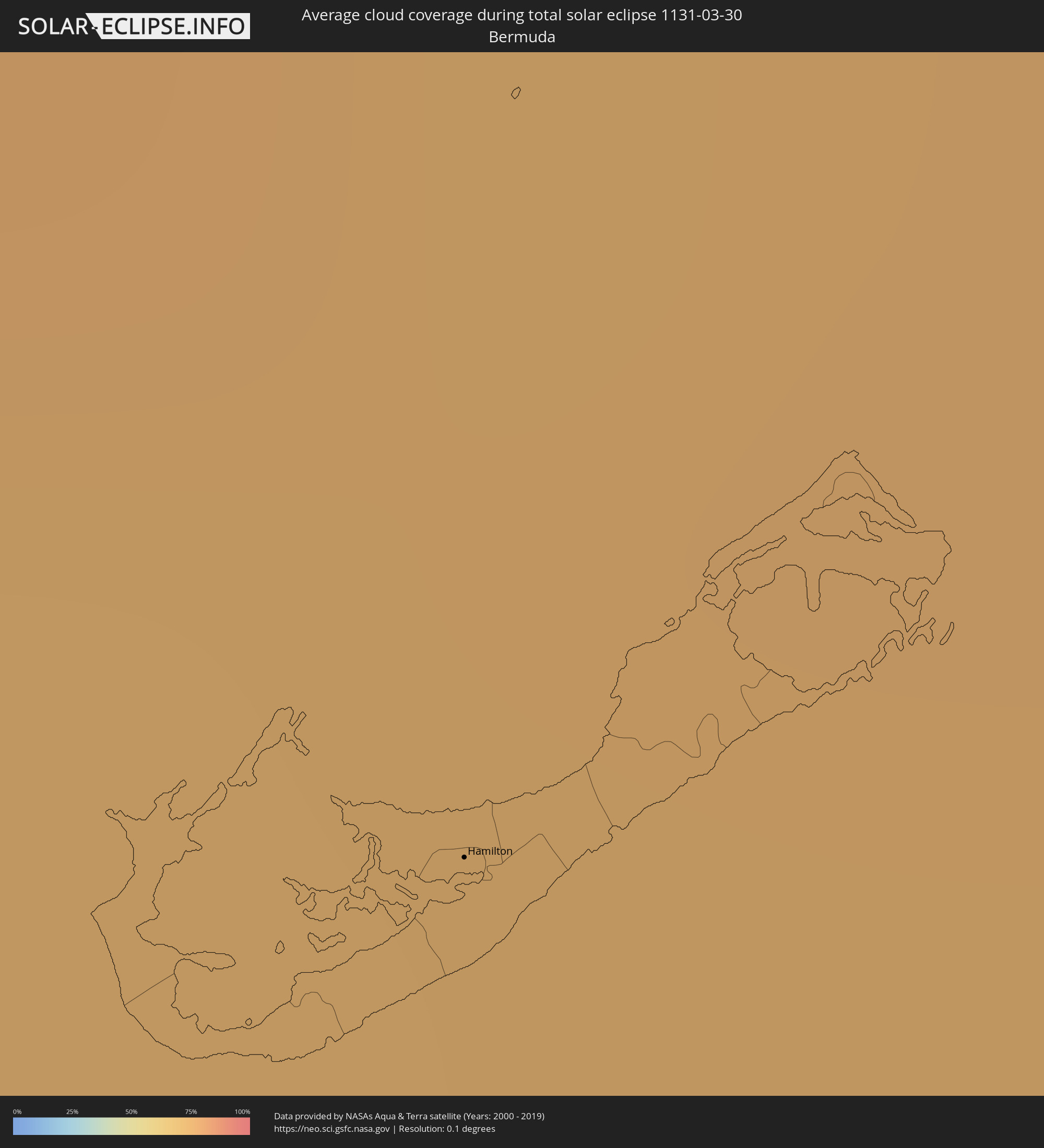 Bermuda
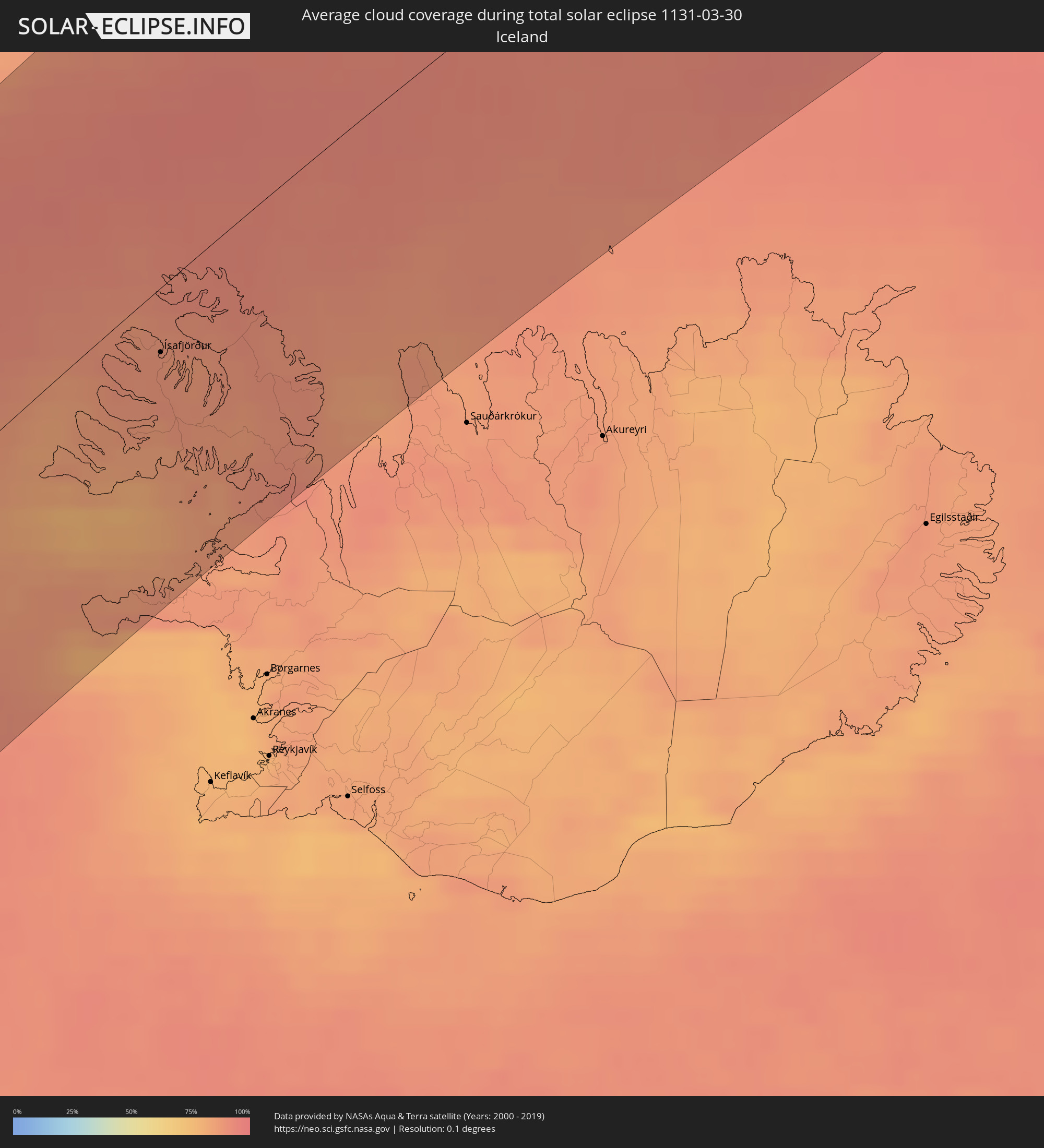 Island
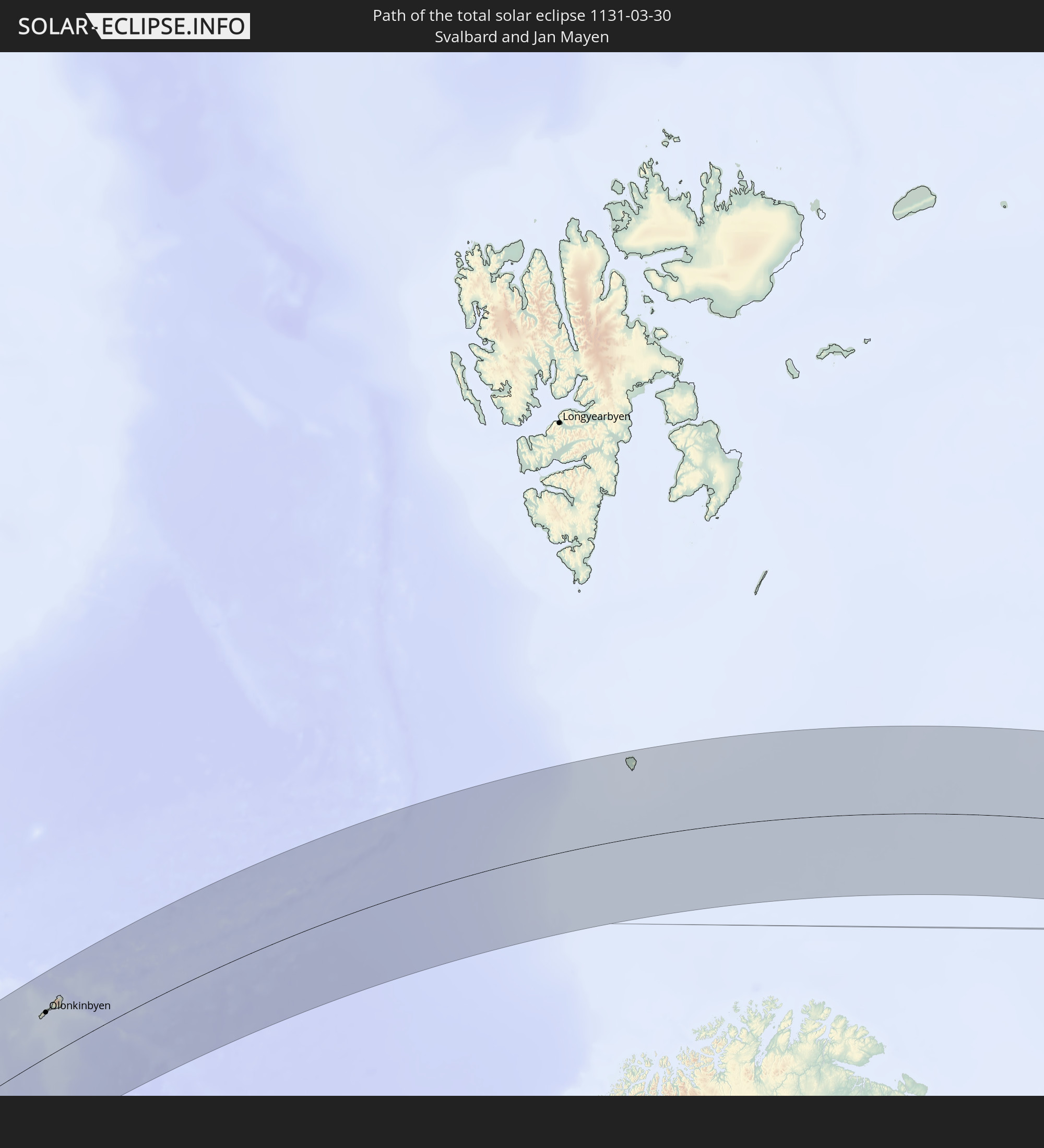
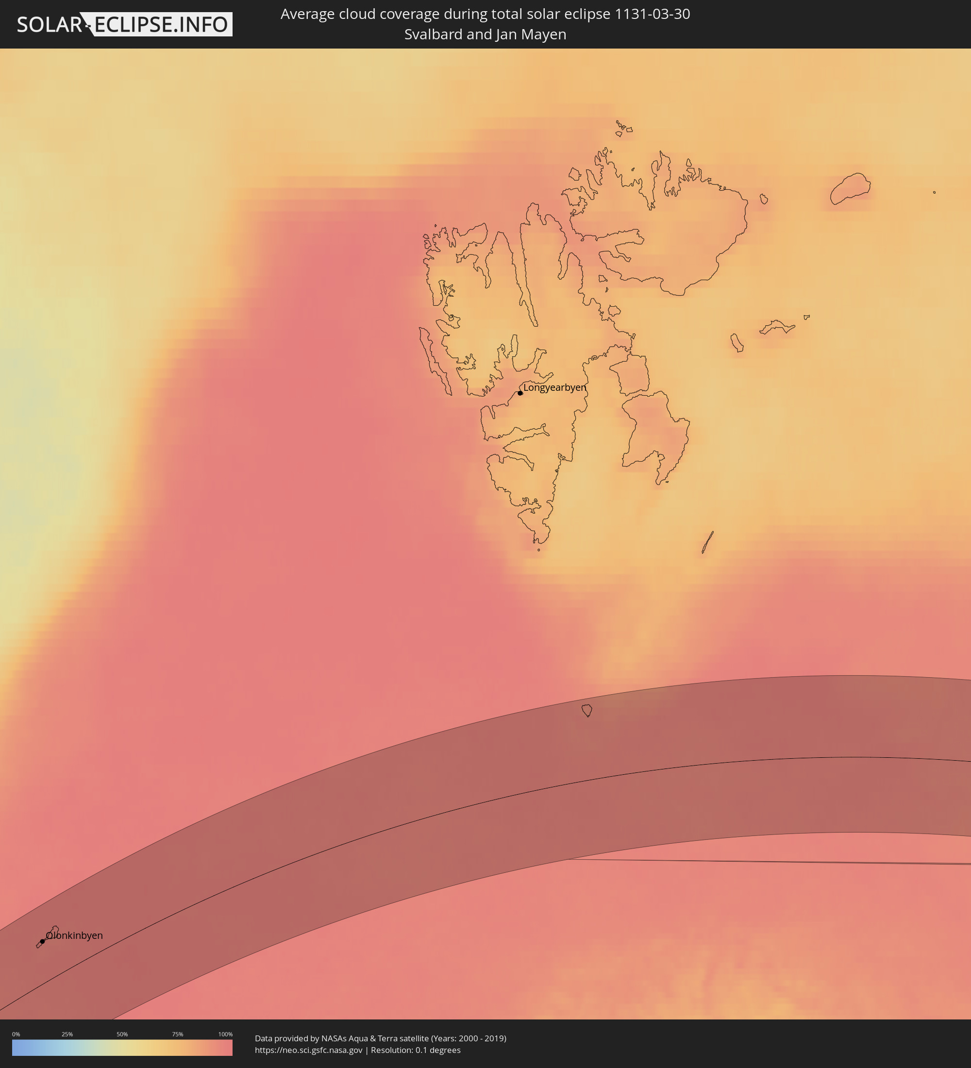 Spitzbergen
Orte im Finsternispfad
Die nachfolgene Tabelle zeigt Städte und Orte mit mehr als 5.000 Einwohnern, die sich im Finsternispfad befinden. Städte mit mehr als 100.000 Einwohnern sind dick gekennzeichnet. Mit einem Klick auf den Ort öffnet sich eine Detailkarte die die Lage des jeweiligen Ortes zusammen mit dem Verlauf der zentralen Finsternis präsentiert.
| Ort | Typ | Dauer der Verfinsterung | Ortszeit bei maximaler Verfinsterung | Entfernung zur Zentrallinie | Ø Bewölkung |
|
Acapulco de Juárez, Guerrero
|
total | - | 06:06:43 UTC-06:36 | 53 km | 28% |
|
Chilpancingo, Guerrero
|
total | - | 06:07:35 UTC-06:36 | 123 km | 23% |
|
Tlapa de Comonfort, Guerrero
|
total | - | 06:07:32 UTC-06:36 | 108 km | 30% |
|
Ciudad de Huajuapan de León, Oaxaca
|
total | - | 06:07:51 UTC-06:36 | 123 km | 23% |
|
Oaxaca, Oaxaca
|
total | - | 06:06:51 UTC-06:36 | 21 km | 21% |
|
Tuxtepec, Oaxaca
|
total | - | 06:08:14 UTC-06:36 | 121 km | 47% |
|
Santo Domingo Tehuantepec, Oaxaca
|
total | - | 06:05:53 UTC-06:36 | 90 km | 28% |
|
Salina Cruz, Oaxaca
|
total | - | 06:05:41 UTC-06:36 | 106 km | 32% |
|
Juchitán de Zaragoza, Oaxaca
|
total | - | 06:06:02 UTC-06:36 | 83 km | 29% |
|
Acayucan, Veracruz
|
total | - | 06:08:05 UTC-06:36 | 80 km | 50% |
|
Minatitlan, Veracruz
|
total | - | 06:08:11 UTC-06:36 | 77 km | 48% |
|
Coatzacoalcos, Veracruz
|
total | - | 06:08:22 UTC-06:36 | 89 km | 48% |
|
Agua Dulce, Veracruz
|
total | - | 06:08:24 UTC-06:36 | 83 km | 52% |
|
Las Choapas, Veracruz
|
total | - | 06:08:05 UTC-06:36 | 57 km | 51% |
|
Cintalapa de Figueroa, Chiapas
|
total | - | 06:06:25 UTC-06:36 | 86 km | 34% |
|
Cárdenas, Tabasco
|
total | - | 06:08:16 UTC-06:36 | 49 km | 46% |
|
Comalcalco, Tabasco
|
total | - | 06:08:39 UTC-06:36 | 73 km | 46% |
|
Tuxtla, Chiapas
|
total | - | 06:06:34 UTC-06:36 | 92 km | 26% |
|
Villahermosa, Tabasco
|
total | - | 06:08:17 UTC-06:36 | 36 km | 38% |
|
San Cristóbal de las Casas, Chiapas
|
total | - | 06:06:34 UTC-06:36 | 107 km | 43% |
|
Palenque, Chiapas
|
total | - | 06:07:43 UTC-06:36 | 41 km | 34% |
|
Ciudad del Carmen, Campeche
|
total | - | 06:09:21 UTC-06:36 | 77 km | 24% |
|
Orange Walk, Orange Walk
|
total | - | 06:52:54 UTC-05:52 | 83 km | 69% |
|
Corozal, Corozal
|
total | - | 06:53:24 UTC-05:52 | 55 km | 56% |
|
Chetumal, Quintana Roo
|
total | - | 06:59:20 UTC-05:47 | 46 km | 37% |
|
San Pedro, Belize
|
total | - | 06:52:47 UTC-05:52 | 120 km | 54% |
|
Playa del Carmen, Quintana Roo
|
total | - | 07:02:50 UTC-05:47 | 132 km | 59% |
|
San Miguel de Cozumel, Quintana Roo
|
total | - | 07:02:41 UTC-05:47 | 114 km | 70% |
|
Güines, Mayabeque
|
total | - | 07:25:41 UTC-05:29 | 142 km | 48% |
|
Matanzas, Matanzas
|
total | - | 07:26:14 UTC-05:29 | 140 km | 60% |
|
Cárdenas, Matanzas
|
total | - | 07:26:24 UTC-05:29 | 121 km | 56% |
|
Jovellanos, Matanzas
|
total | - | 07:26:01 UTC-05:29 | 98 km | 60% |
|
Jagüey Grande, Matanzas
|
total | - | 07:25:35 UTC-05:29 | 68 km | 56% |
|
Colón, Matanzas
|
total | - | 07:26:01 UTC-05:29 | 76 km | 60% |
|
Corralillo, Villa Clara
|
total | - | 07:26:36 UTC-05:29 | 85 km | 46% |
|
Cienfuegos, Cienfuegos
|
total | - | 07:25:17 UTC-05:29 | 3 km | 38% |
|
Santo Domingo, Villa Clara
|
total | - | 07:26:06 UTC-05:29 | 29 km | 58% |
|
Cumanayagua, Cienfuegos
|
total | - | 07:25:24 UTC-05:29 | 15 km | 51% |
|
Ranchuelo, Villa Clara
|
total | - | 07:25:47 UTC-05:29 | 4 km | 56% |
|
Sagua la Grande, Villa Clara
|
total | - | 07:26:34 UTC-05:29 | 42 km | 61% |
|
Cifuentes, Villa Clara
|
total | - | 07:26:18 UTC-05:29 | 26 km | 63% |
|
Trinidad, Sancti Spíritus
|
total | - | 07:24:55 UTC-05:29 | 60 km | 49% |
|
Manicaragua, Villa Clara
|
total | - | 07:25:30 UTC-05:29 | 26 km | 57% |
|
Santa Clara, Villa Clara
|
total | - | 07:25:56 UTC-05:29 | 2 km | 61% |
|
Condado, Sancti Spíritus
|
total | - | 07:25:07 UTC-05:29 | 60 km | 59% |
|
Camajuaní, Villa Clara
|
total | - | 07:26:11 UTC-05:29 | 6 km | 63% |
|
Placetas, Villa Clara
|
total | - | 07:25:56 UTC-05:29 | 27 km | 60% |
|
Cabaiguán, Sancti Spíritus
|
total | - | 07:25:37 UTC-05:29 | 58 km | 62% |
|
Caibarién, Villa Clara
|
total | - | 07:26:23 UTC-05:29 | 16 km | 49% |
|
Sancti Spíritus, Sancti Spíritus
|
total | - | 07:25:24 UTC-05:29 | 75 km | 59% |
|
Yaguajay, Sancti Spíritus
|
total | - | 07:26:10 UTC-05:29 | 47 km | 67% |
|
Ciego de Ávila, Ciego de Ávila
|
total | - | 07:25:36 UTC-05:29 | 118 km | 62% |
|
Morón, Ciego de Ávila
|
total | - | 07:26:07 UTC-05:29 | 100 km | 65% |
|
San Andros, North Andros
|
total | - | 07:51:38 UTC-05:09 | 148 km | 63% |
|
Nassau, New Providence
|
total | - | 07:52:02 UTC-05:09 | 107 km | 55% |
|
Spanish Wells, Spanish Wells
|
total | - | 07:53:15 UTC-05:09 | 119 km | 59% |
|
Black Point, Black Point
|
total | - | 13:00:26 UTC+00:00 | 35 km | 59% |
|
Governor’s Harbour, Central Eleuthera
|
total | - | 13:02:24 UTC+00:00 | 53 km | 56% |
|
George Town, Exuma
|
total | - | 07:50:16 UTC-05:09 | 123 km | 52% |
|
Arthur’s Town, Cat Island
|
total | - | 07:52:17 UTC-05:09 | 29 km | 59% |
|
Cockburn Town, San Salvador
|
total | - | 07:52:01 UTC-05:09 | 148 km | 59% |
|
Hamilton, Hamilton city
|
total | - | 09:05:36 UTC-04:19 | 128 km | 73% |
|
Bay Roberts, Newfoundland and Labrador
|
total | - | 10:34:00 UTC-03:30 | 59 km | 87% |
|
Carbonear, Newfoundland and Labrador
|
total | - | 10:34:16 UTC-03:30 | 64 km | 86% |
|
Conception Bay South, Newfoundland and Labrador
|
total | - | 10:34:07 UTC-03:30 | 37 km | 84% |
|
Mount Pearl, Newfoundland and Labrador
|
total | - | 10:34:23 UTC-03:30 | 24 km | 85% |
|
St. John's, Newfoundland and Labrador
|
total | - | 10:34:33 UTC-03:30 | 22 km | 87% |
|
Ísafjörður, Westfjords
|
total | - | 13:21:48 UTC-01:28 | 25 km | 88% |
|
Olonkinbyen, Jan Mayen
|
total | - | 15:57:12 UTC+01:00 | 68 km | 95% |