Totale Sonnenfinsternis vom 23.07.1134
| Wochentag: | Montag |
| Maximale Dauer der Verfinsterung: | 06m21s |
| Maximale Breite des Finsternispfades: | 238 km |
| Saroszyklus: | 112 |
| Bedeckungsgrad: | 100% |
| Magnitude: | 1.072 |
| Gamma: | -0.191 |
Wo kann man die Sonnenfinsternis vom 23.07.1134 sehen?
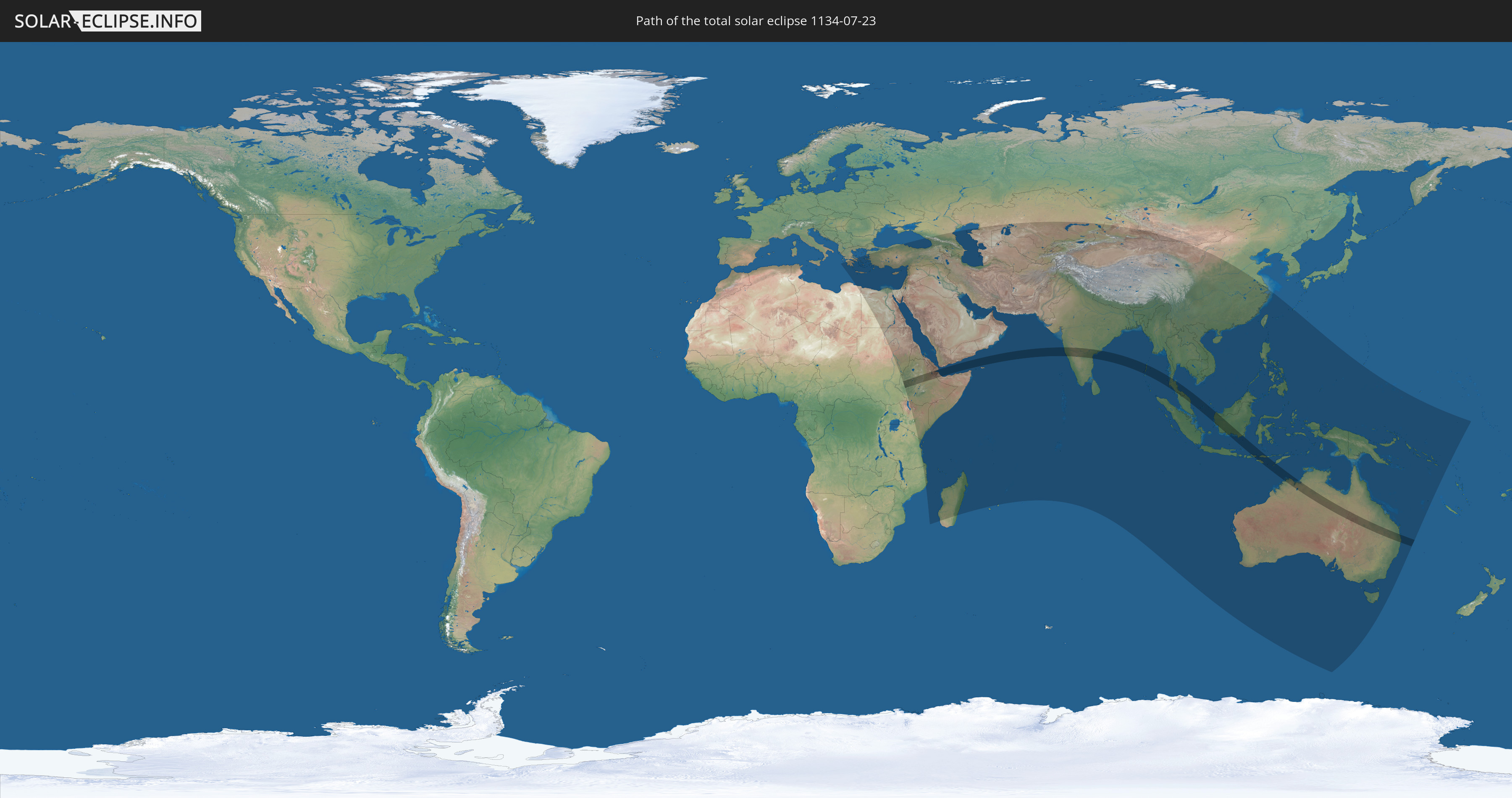
Die Sonnenfinsternis am 23.07.1134 kann man in 78 Ländern als partielle Sonnenfinsternis beobachten.
Der Finsternispfad verläuft durch 9 Länder. Nur in diesen Ländern ist sie als totale Sonnenfinsternis zu sehen.
In den folgenden Ländern ist die Sonnenfinsternis total zu sehen
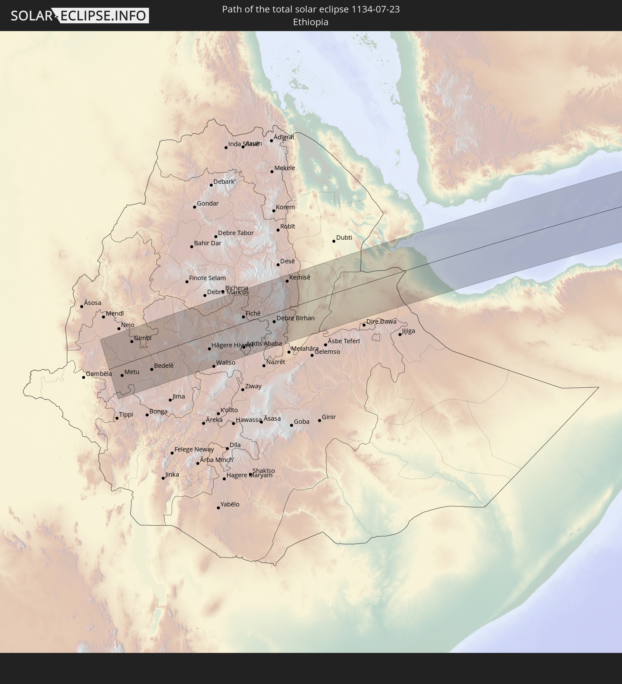 Äthiopien
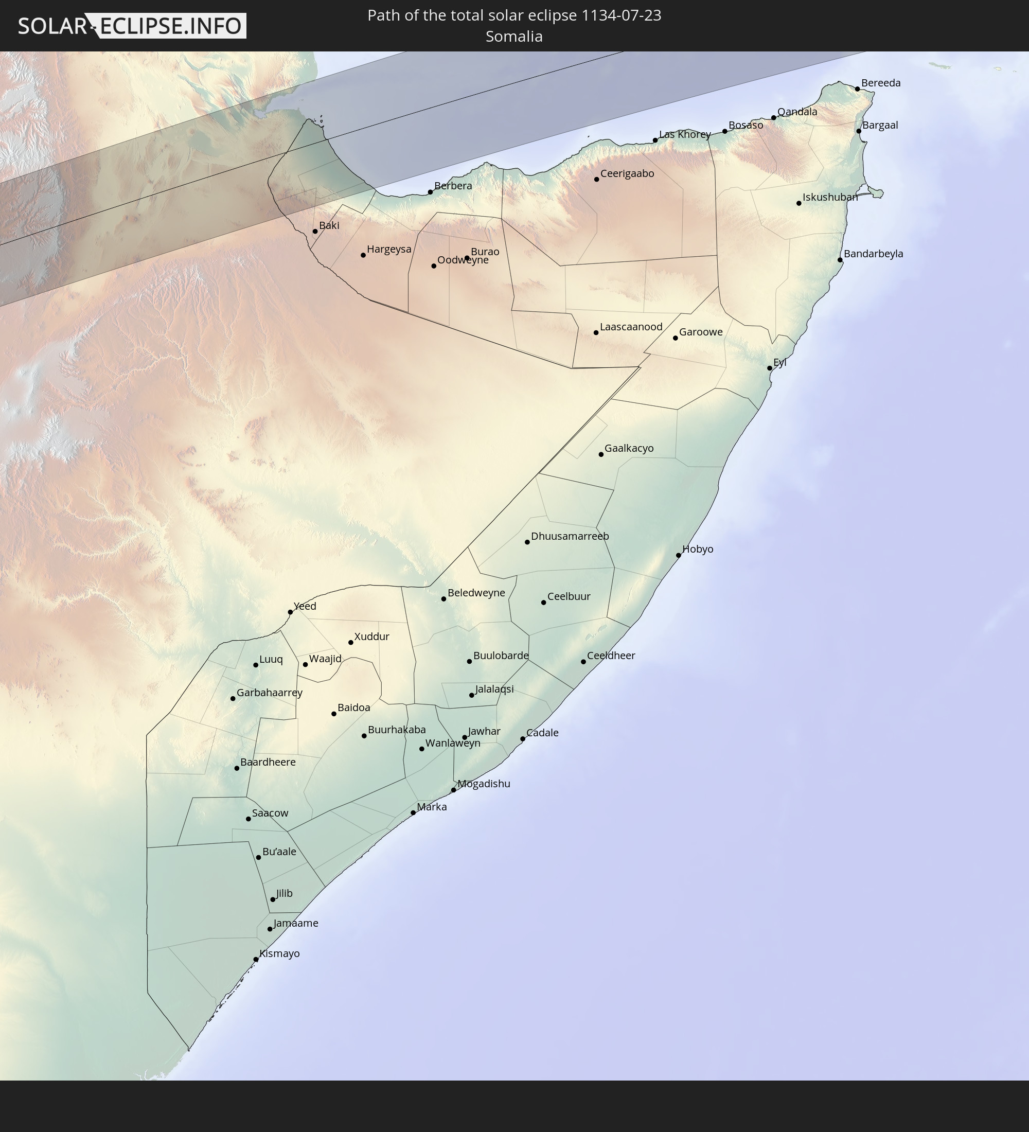 Somalia
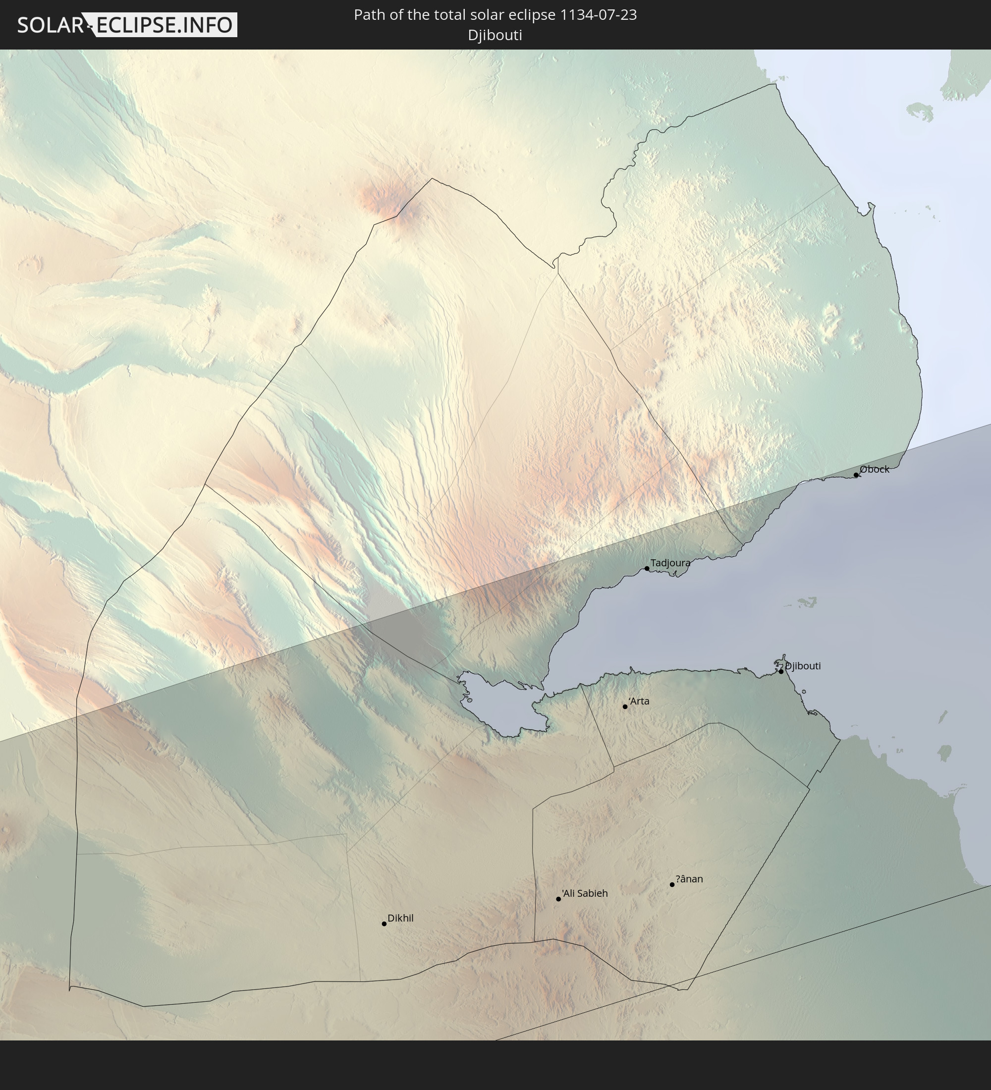 Dschibuti
 Indien
 Myanmar
 Indonesien
 Thailand
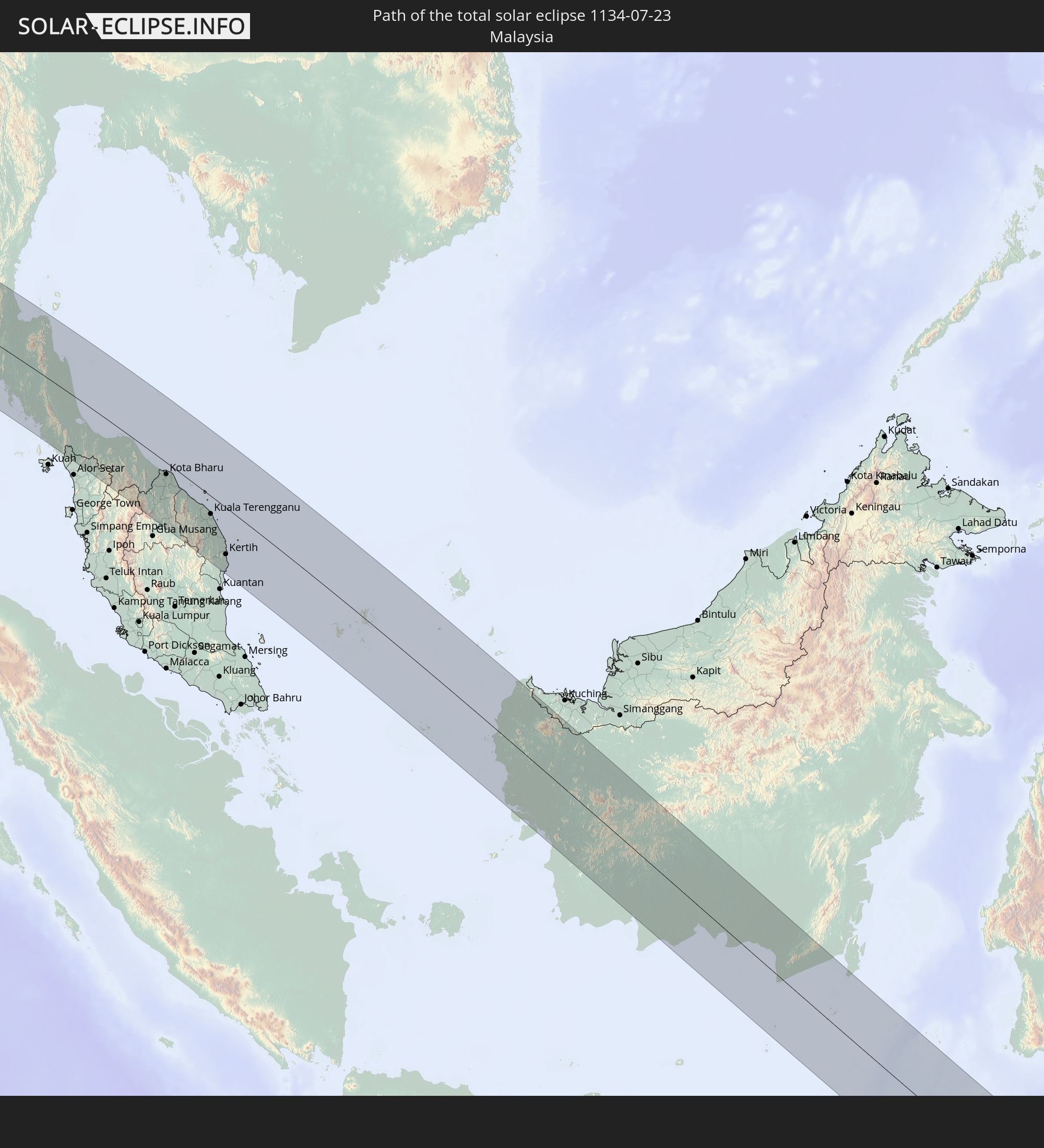 Malaysia
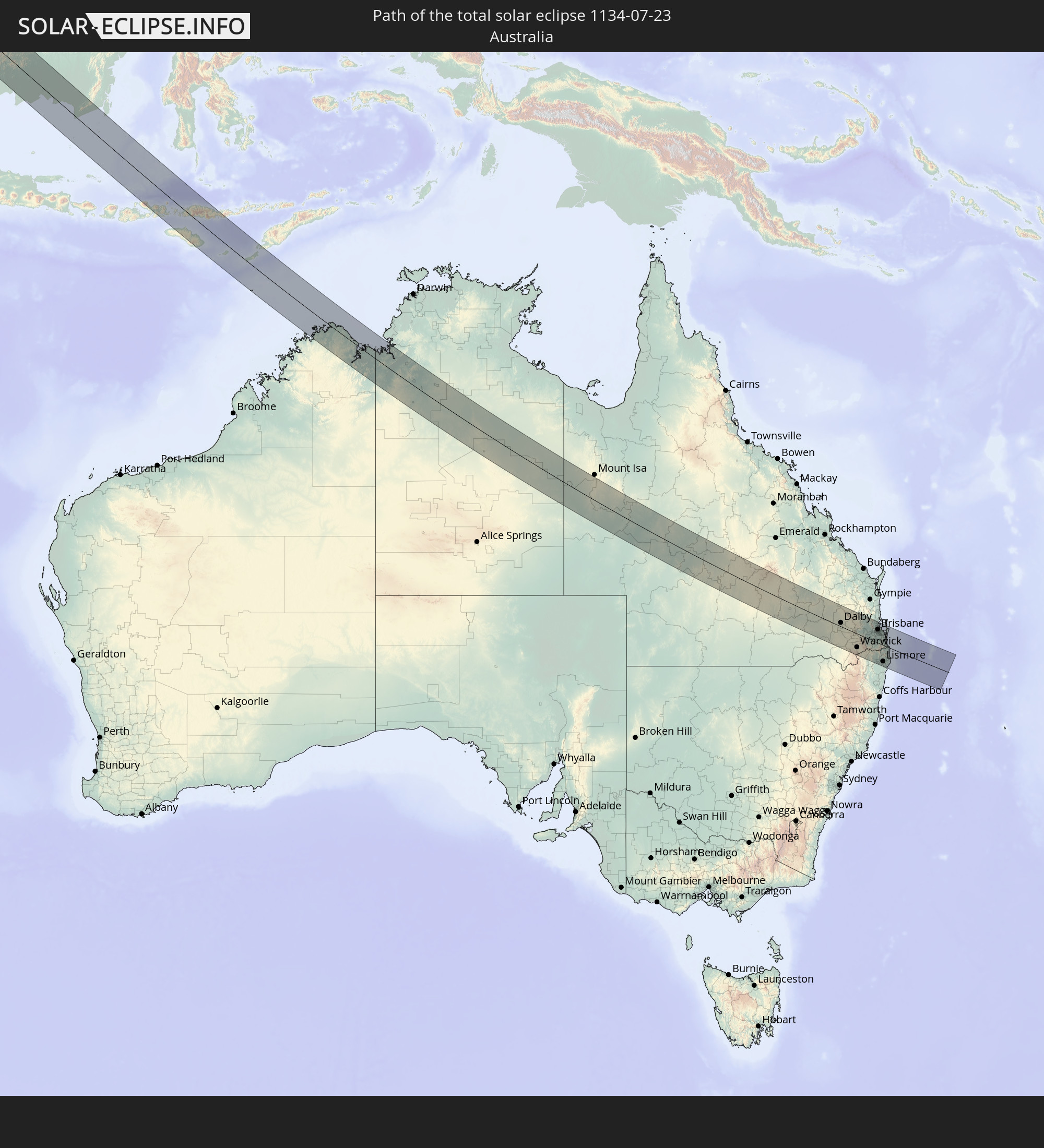 Australien
In den folgenden Ländern ist die Sonnenfinsternis partiell zu sehen
 Russland
 Kiribati
 Libyen
 Griechenland
 Sudan
Sudan
 Ägypten
 Türkei
 Tansania
 Mosambik
 Republik Zypern
 Äthiopien
 Kenia
Kenia
 Staat Palästina
 Israel
 Saudi-Arabien
 Jordanien
 Libanon
 Syrien
 Eritrea
 Irak
Irak
 Georgien
 Französische Süd- und Antarktisgebiete
 Somalia
 Dschibuti
 Jemen
Jemen
 Madagaskar
 Komoren
 Armenien
 Iran
Iran
 Aserbaidschan
 Mayotte
 Seychellen
 Kasachstan
 Kuwait
 Bahrain
 Katar
Katar
 Vereinigte Arabische Emirate
 Oman
Oman
 Turkmenistan
 Usbekistan
 Mauritius
 Afghanistan
 Pakistan
 Tadschikistan
 Indien
 Kirgisistan
 Britisches Territorium im Indischen Ozean
 Malediven
 Volksrepublik China
 Sri Lanka
 Nepal
Nepal
 Mongolei
 Bangladesch
 Bhutan
 Myanmar
 Indonesien
 Kokosinseln
 Thailand
 Malaysia
 Laos
Laos
 Vietnam
 Kambodscha
 Singapur
 Weihnachtsinsel
 Australien
 Macau
Macau
 Hongkong
 Brunei
 Taiwan
 Philippinen
 Japan
Japan
 Osttimor
 Palau
Palau
 Föderierte Staaten von Mikronesien
 Papua-Neuguinea
 Salomonen
 Neukaledonien
 Nauru
Nauru
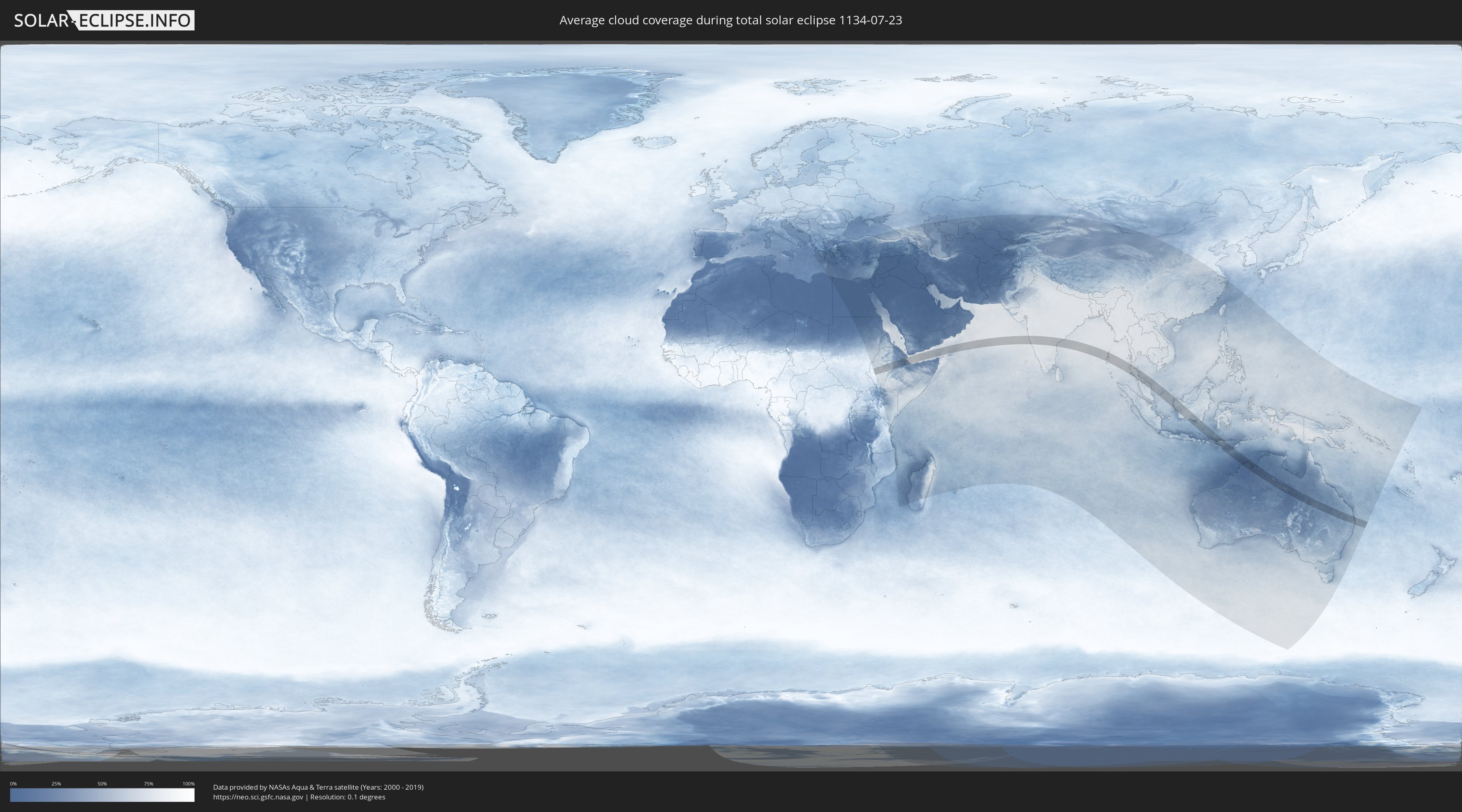
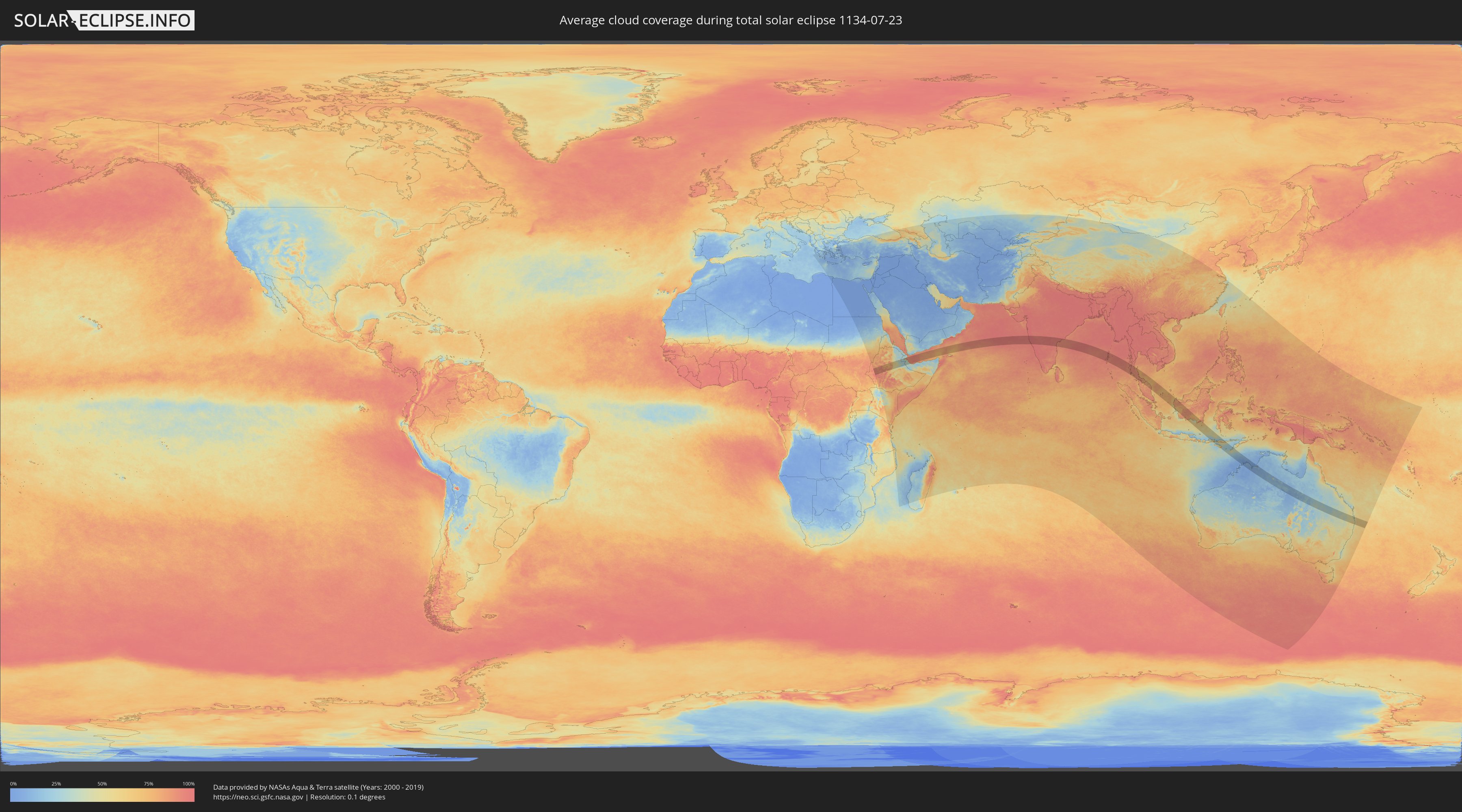
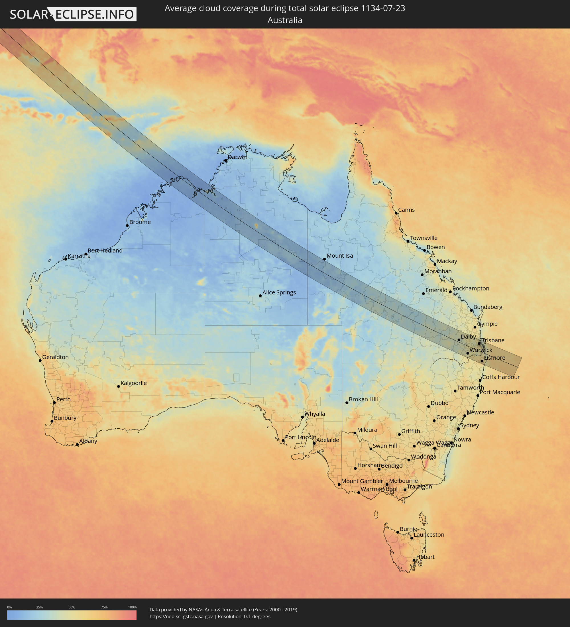
Wie wird das Wetter während der totalen Sonnenfinsternis am 23.07.1134?
Wo ist der beste Ort, um die totale Sonnenfinsternis vom 23.07.1134 zu beobachten?
Die folgenden Karten zeigen die durchschnittliche Bewölkung für den Tag, an dem die totale Sonnenfinsternis
stattfindet. Mit Hilfe der Karten lässt sich der Ort entlang des Finsternispfades eingrenzen,
der die besten Aussichen auf einen klaren wolkenfreien Himmel bietet.
Trotzdem muss man immer lokale Gegenenheiten beachten und sollte sich genau über das Wetter an seinem
gewählten Beobachtungsort informieren.
Die Daten stammen von den beiden NASA-Satelliten
AQUA und TERRA
und wurden über einen Zeitraum von 19 Jahren (2000 - 2019) gemittelt.
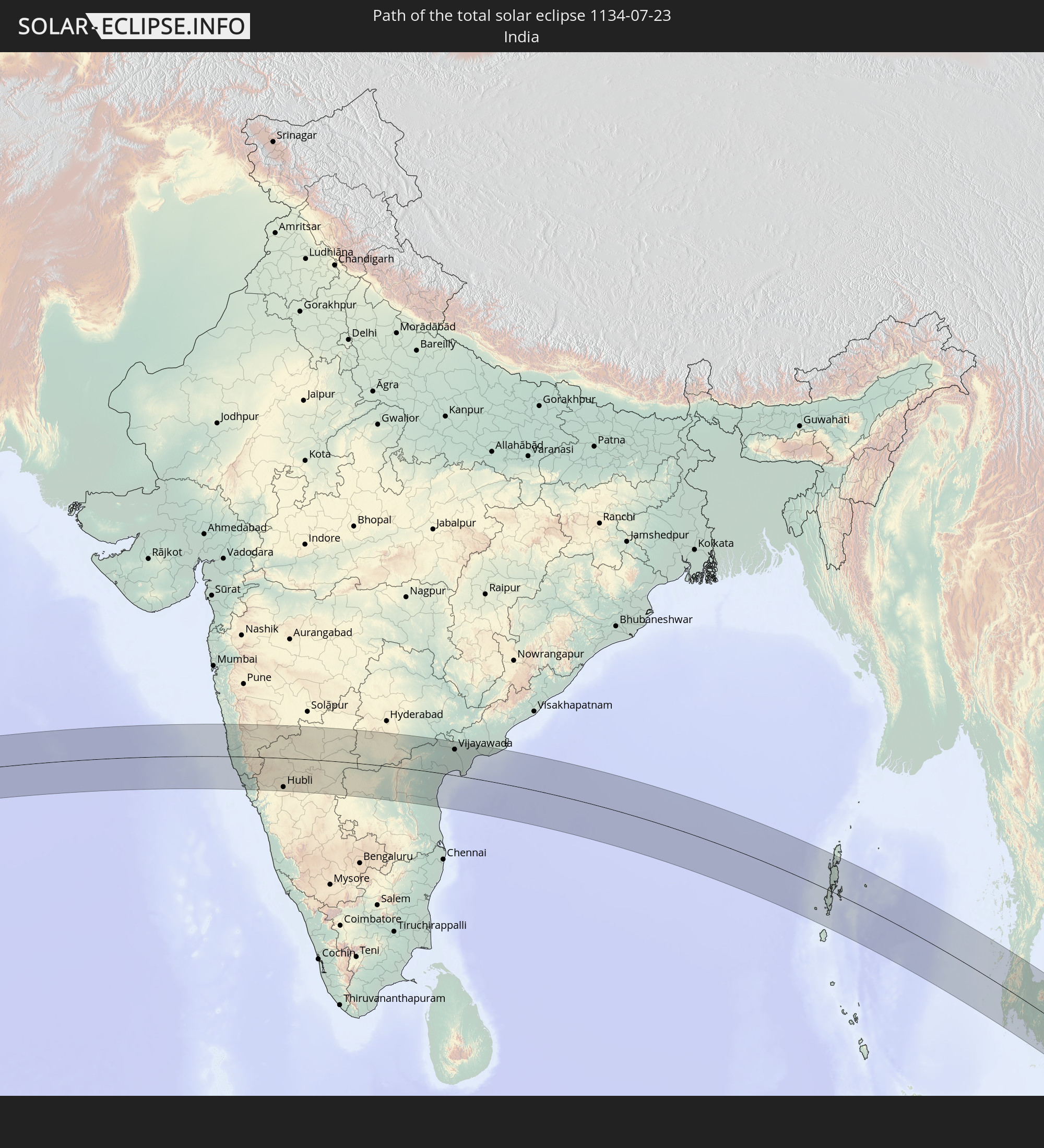
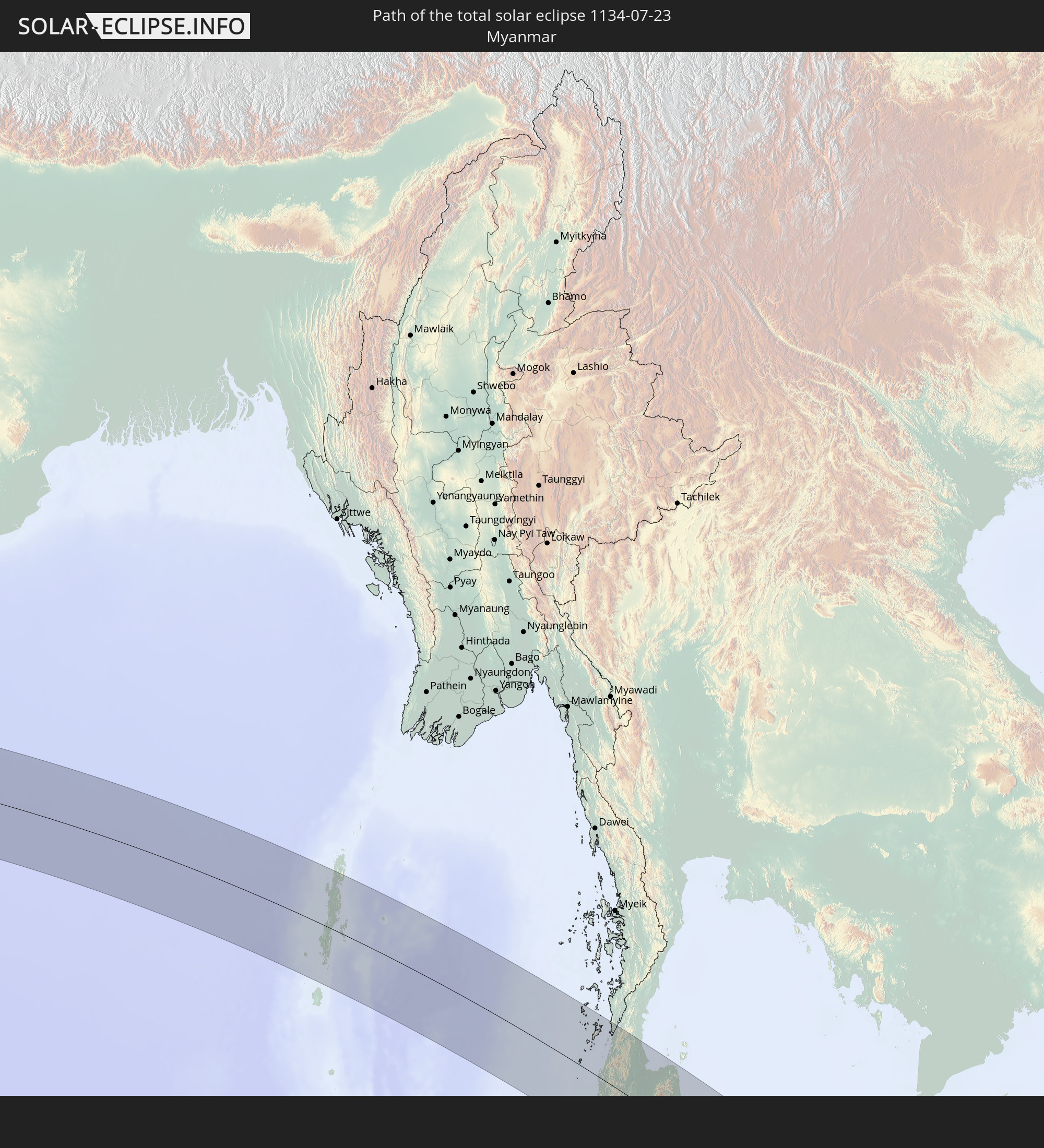
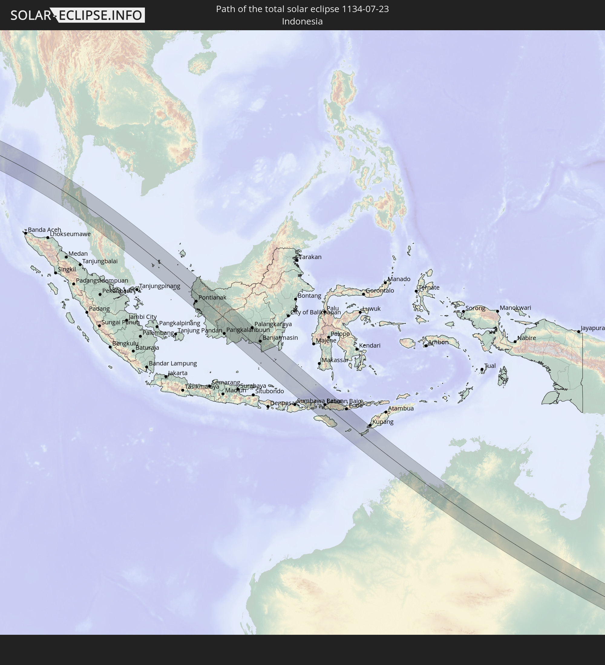
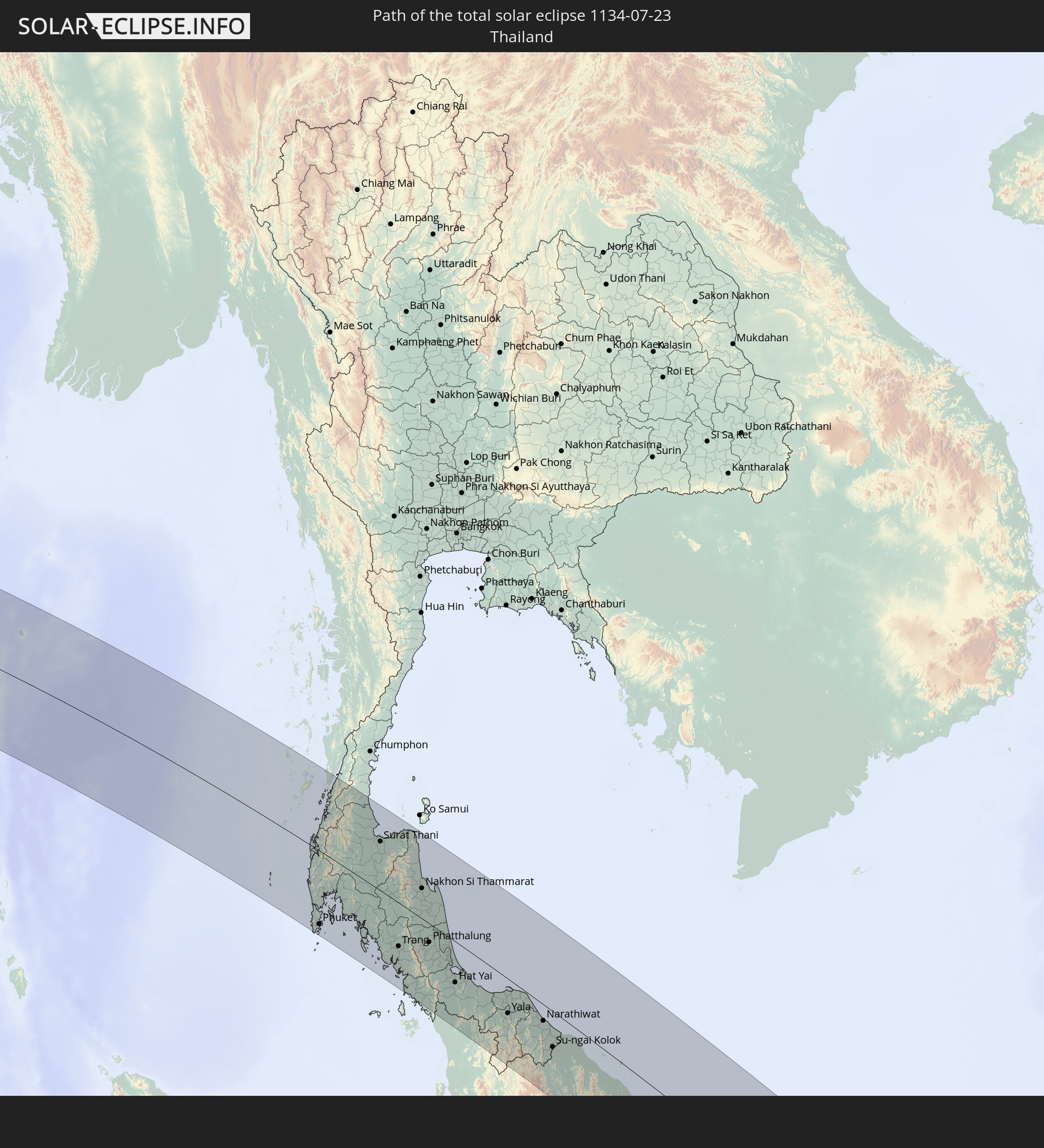
Detaillierte Länderkarten
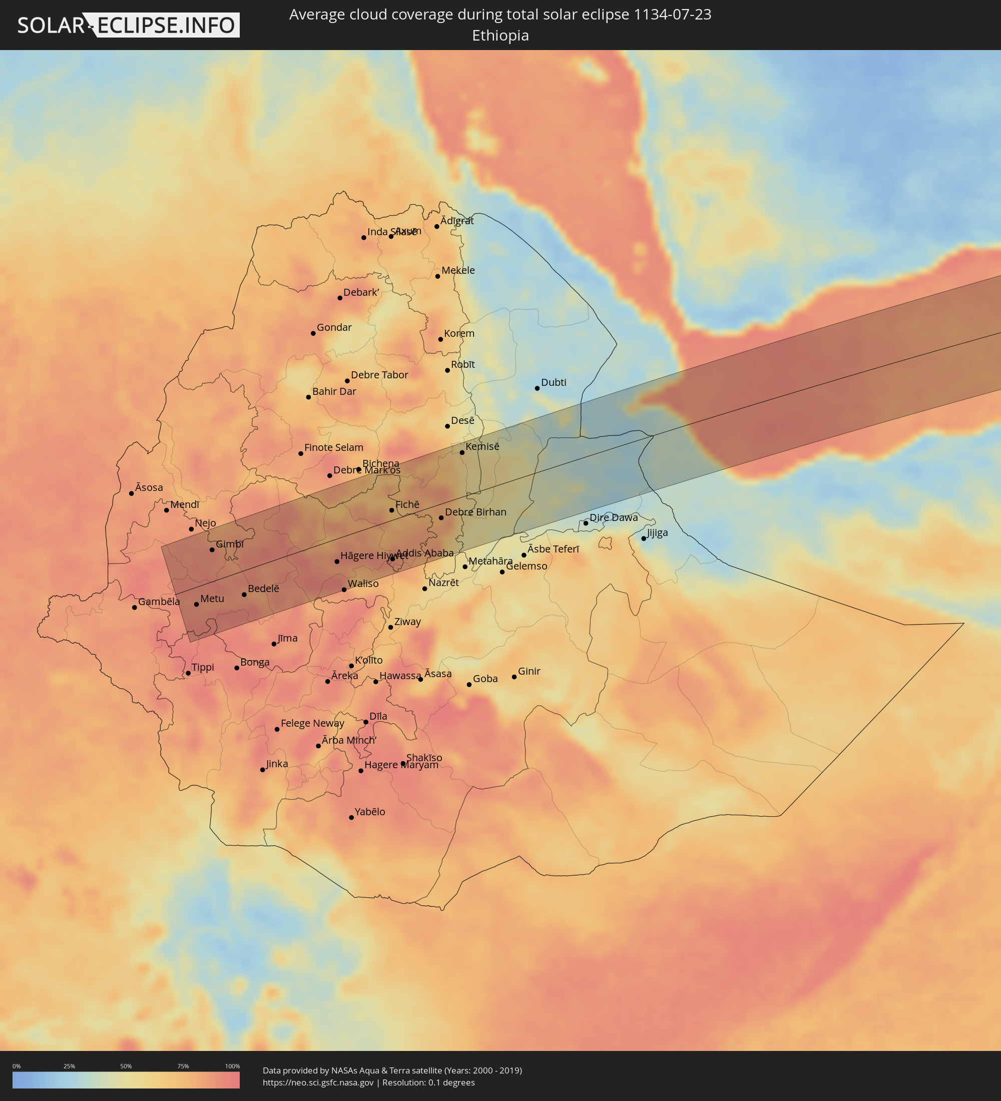 Äthiopien
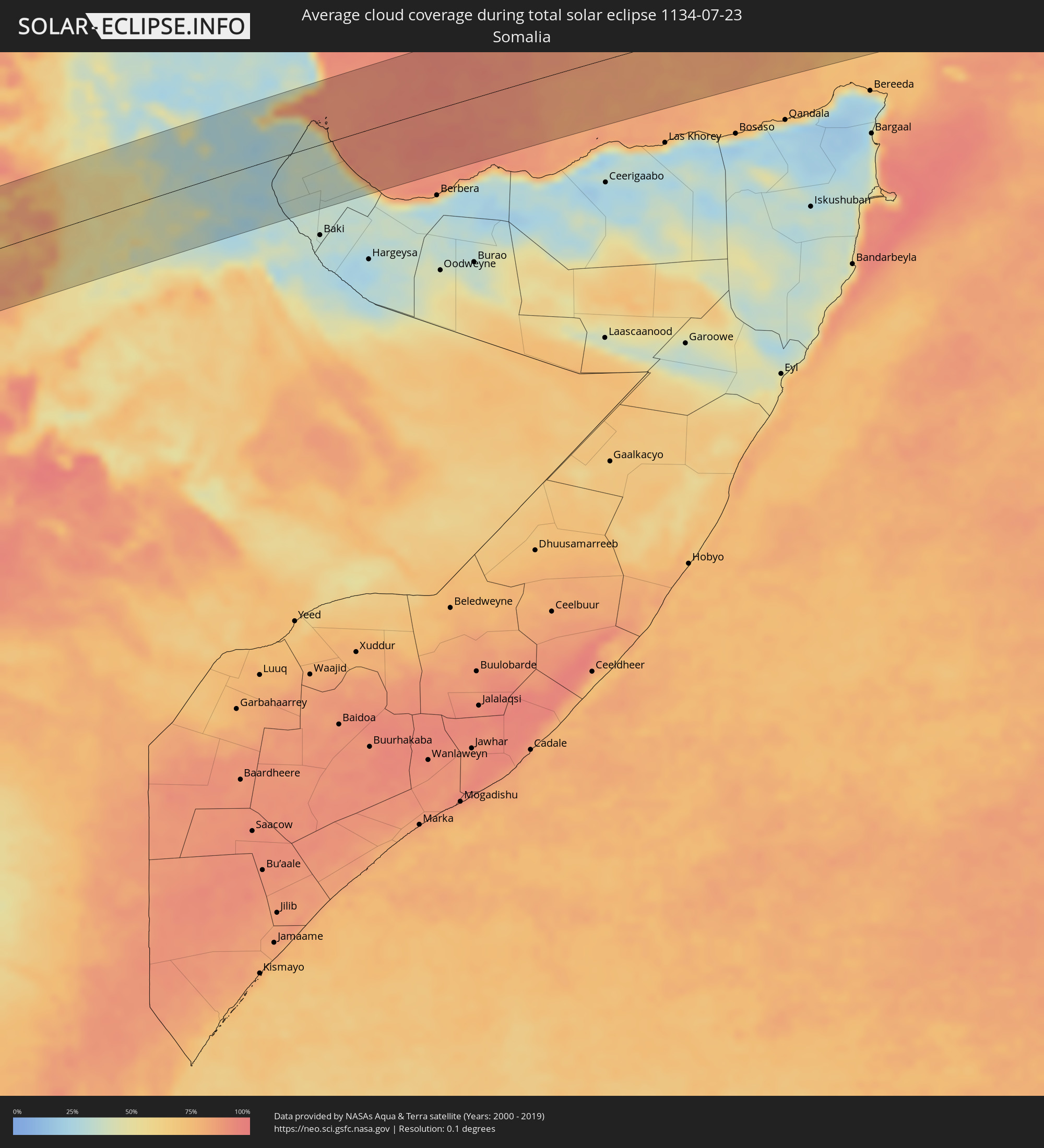 Somalia
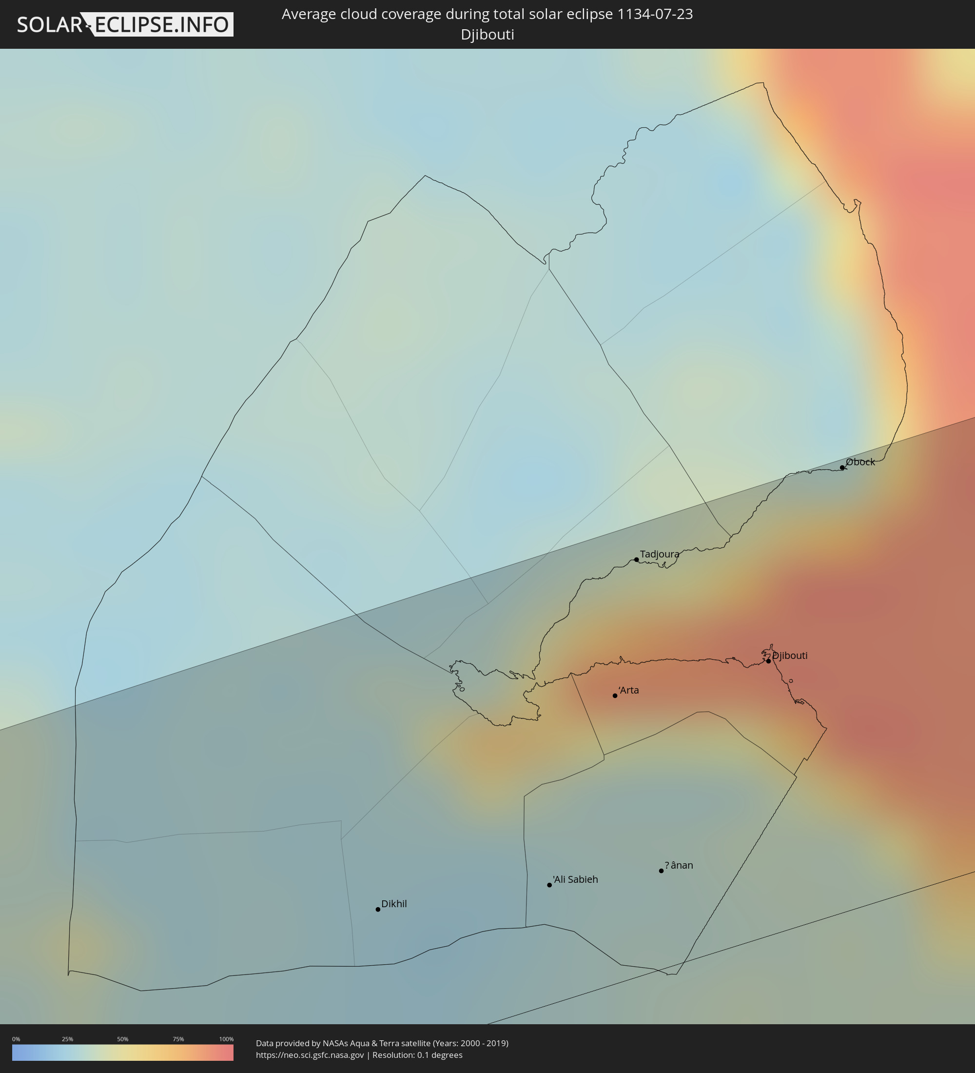 Dschibuti
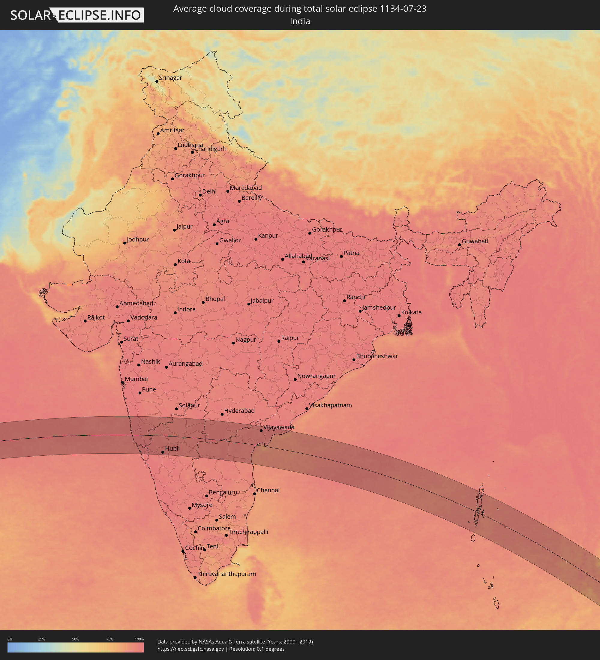 Indien
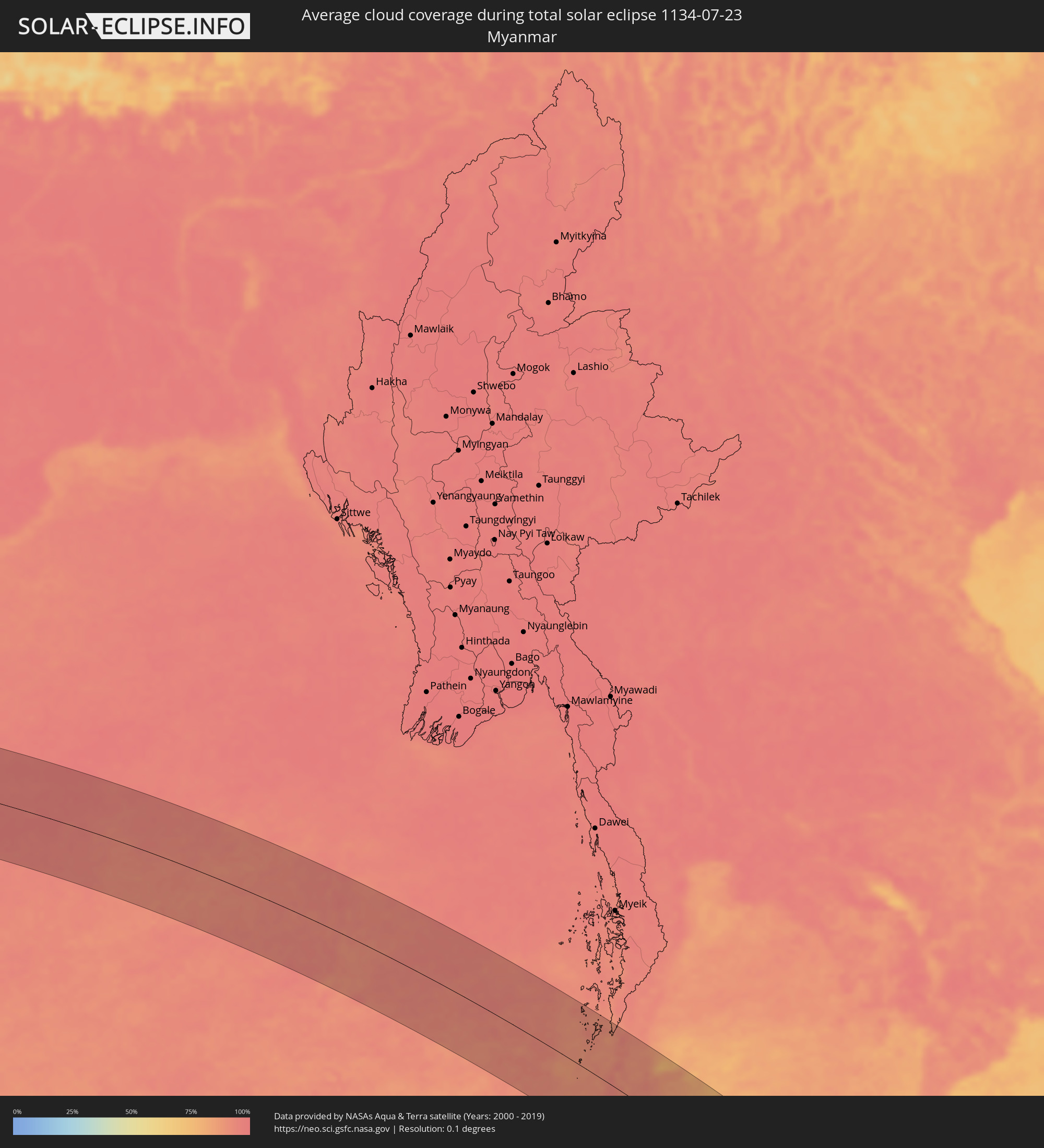 Myanmar
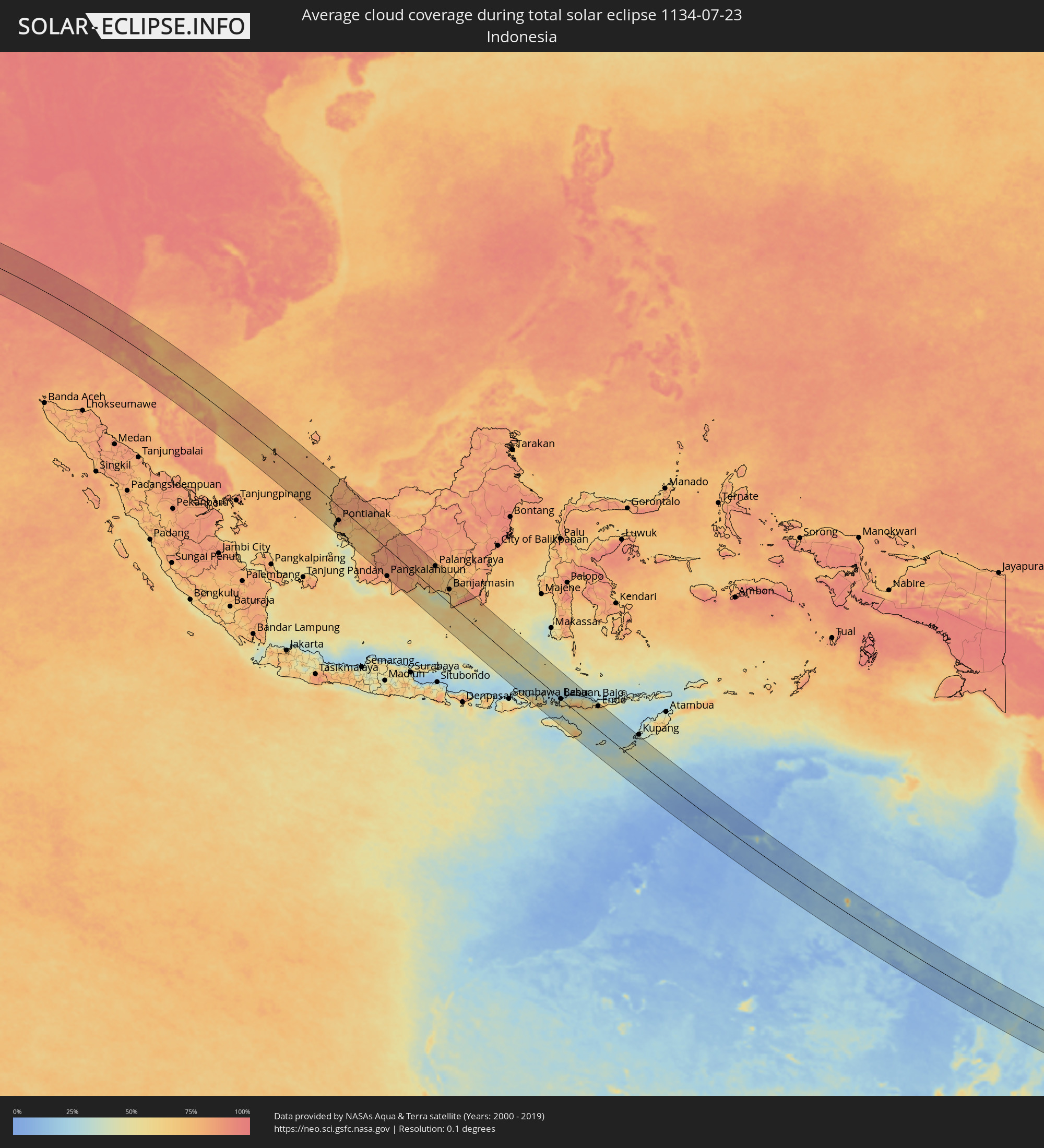 Indonesien
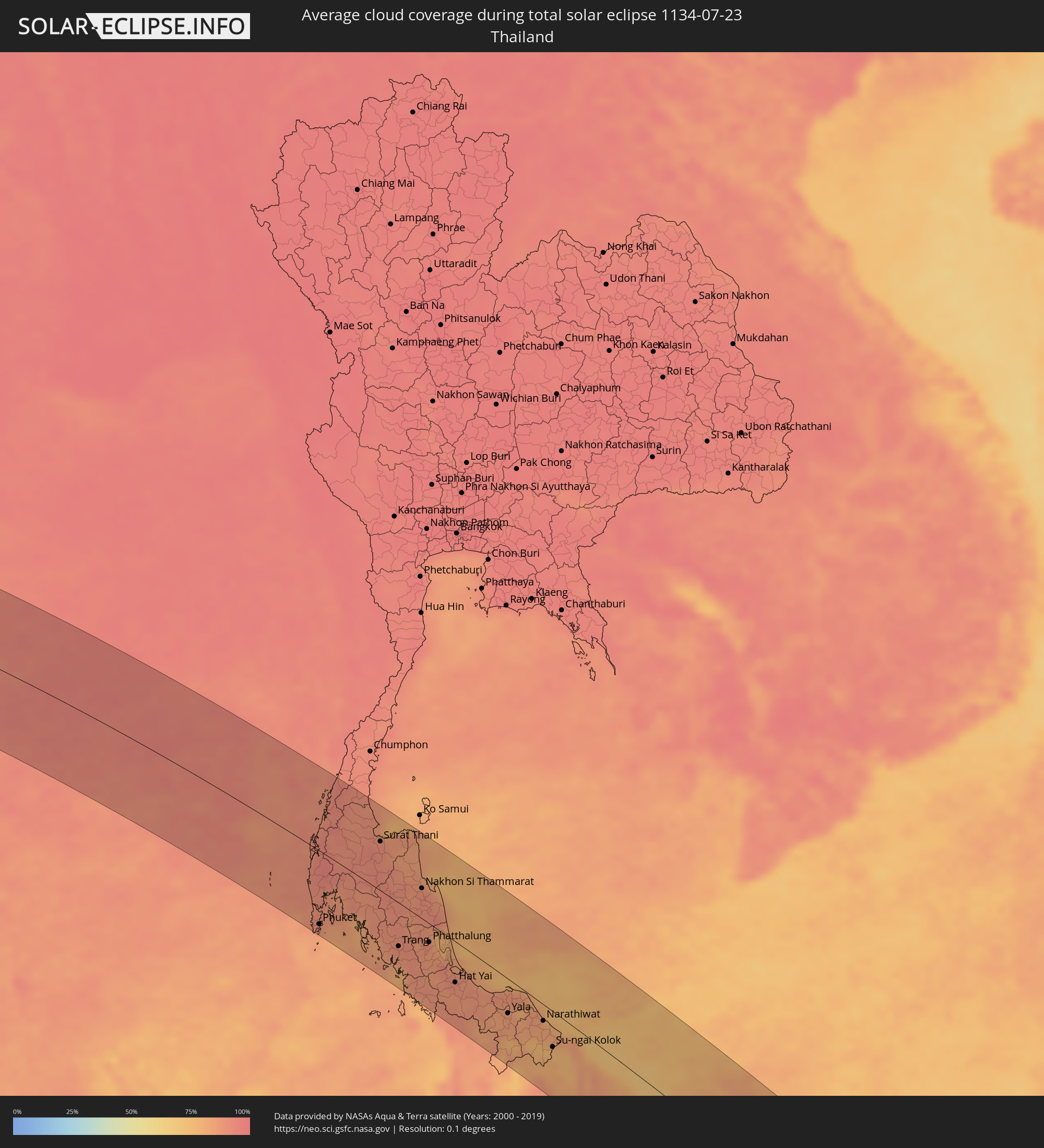 Thailand
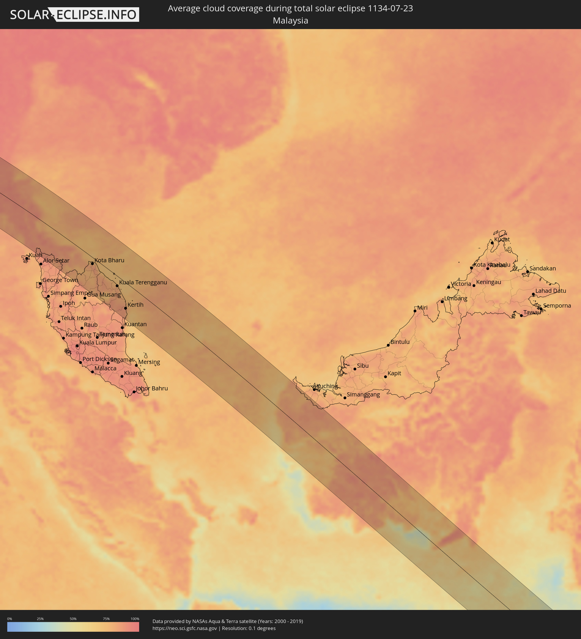 Malaysia
 Australien
Orte im Finsternispfad
Die nachfolgene Tabelle zeigt Städte und Orte mit mehr als 5.000 Einwohnern, die sich im Finsternispfad befinden. Städte mit mehr als 100.000 Einwohnern sind dick gekennzeichnet. Mit einem Klick auf den Ort öffnet sich eine Detailkarte die die Lage des jeweiligen Ortes zusammen mit dem Verlauf der zentralen Finsternis präsentiert.
| Ort | Typ | Dauer der Verfinsterung | Ortszeit bei maximaler Verfinsterung | Entfernung zur Zentrallinie | Ø Bewölkung |
|
Gorē, Oromiya
|
total | - | 05:59:30 UTC+02:27 | 44 km | 91% |
|
Metu, Oromiya
|
total | - | 05:59:30 UTC+02:27 | 30 km | 90% |
|
Gimbi, Oromiya
|
total | - | 05:59:27 UTC+02:27 | 52 km | 91% |
|
Bedelē, Oromiya
|
total | - | 05:59:31 UTC+02:27 | 42 km | 87% |
|
Shambu, Oromiya
|
total | - | 05:59:31 UTC+02:27 | 48 km | 87% |
|
Gēdo, Oromiya
|
total | - | 05:59:34 UTC+02:27 | 22 km | 89% |
|
Guder, Oromiya
|
total | - | 05:59:37 UTC+02:27 | 38 km | 84% |
|
Hāgere Hiywet, Oromiya
|
total | - | 05:59:37 UTC+02:27 | 40 km | 85% |
|
Dejen, Amhara
|
total | - | 05:59:35 UTC+02:27 | 75 km | 78% |
|
Tulu Bolo, Oromiya
|
total | - | 05:59:41 UTC+02:27 | 86 km | 75% |
|
Gebre Guracha, Oromiya
|
total | - | 05:59:38 UTC+02:27 | 27 km | 85% |
|
Ādīs ‘Alem, Oromiya
|
total | - | 05:59:41 UTC+02:27 | 54 km | 82% |
|
Genet, Oromiya
|
total | - | 05:59:42 UTC+02:27 | 54 km | 91% |
|
Sebeta, Oromiya
|
total | - | 05:59:43 UTC+02:27 | 74 km | 80% |
|
Fichē, Oromiya
|
total | - | 05:59:41 UTC+02:27 | 16 km | 75% |
|
Addis Ababa, Addis Ababa
|
total | - | 05:59:44 UTC+02:27 | 67 km | 85% |
|
Sendafa, Oromiya
|
total | - | 05:59:46 UTC+02:27 | 63 km | 88% |
|
Were Īlu, Amhara
|
total | - | 05:59:46 UTC+02:27 | 75 km | 75% |
|
Debre Birhan, Amhara
|
total | - | 05:59:49 UTC+02:27 | 25 km | 79% |
|
Debre Sīna, Amhara
|
total | - | 05:59:51 UTC+02:27 | 15 km | 67% |
|
Kemisē, Amhara
|
total | - | 05:59:50 UTC+02:27 | 73 km | 62% |
|
Abomsa, Amhara
|
total | - | 05:59:53 UTC+02:27 | 8 km | 57% |
|
Gewanē, Āfar
|
total | - | 06:00:01 UTC+02:27 | 12 km | 53% |
|
Dikhil, Dikhil
|
total | - | 06:00:24 UTC+02:27 | 31 km | 26% |
|
'Ali Sabieh, Ali Sabieh
|
total | - | 06:00:30 UTC+02:27 | 24 km | 28% |
|
‘Arta, Arta
|
total | - | 06:00:32 UTC+02:27 | 59 km | 34% |
|
Tadjoura, Tadjourah
|
total | - | 06:00:32 UTC+02:27 | 86 km | 77% |
|
Ḏânan, Ali Sabieh
|
total | - | 06:00:34 UTC+02:27 | 20 km | 33% |
|
Djibouti, Djibouti
|
total | - | 06:00:37 UTC+02:27 | 56 km | 49% |
|
Obock, Obock
|
total | - | 06:00:40 UTC+02:27 | 91 km | 72% |
|
Marmagao, Goa
|
total | - | 09:26:01 UTC+05:21 | 98 km | 95% |
|
Kolhāpur, Maharashtra
|
total | - | 09:26:19 UTC+05:21 | 46 km | 97% |
|
Ichalkaranji, Maharashtra
|
total | - | 09:26:45 UTC+05:21 | 47 km | 97% |
|
Belgaum, Karnataka
|
total | - | 09:27:11 UTC+05:21 | 47 km | 97% |
|
Sāngli, Maharashtra
|
total | - | 09:26:52 UTC+05:21 | 65 km | 97% |
|
Hubli, Karnataka
|
total | - | 09:28:37 UTC+05:21 | 100 km | 96% |
|
Gadag, Karnataka
|
total | - | 09:29:33 UTC+05:21 | 88 km | 95% |
|
Bagalkot, Karnataka
|
total | - | 09:29:19 UTC+05:21 | 3 km | 97% |
|
Bijapur, Karnataka
|
total | - | 09:29:04 UTC+05:21 | 68 km | 95% |
|
Hospet, Karnataka
|
total | - | 09:31:09 UTC+05:21 | 101 km | 91% |
|
Gangāwati, Karnataka
|
total | - | 09:31:21 UTC+05:21 | 82 km | 93% |
|
Bellary, Karnataka
|
total | - | 09:32:19 UTC+05:21 | 110 km | 94% |
|
Ādoni, Andhra Pradesh
|
total | - | 09:32:46 UTC+05:21 | 53 km | 94% |
|
Rāichūr, Karnataka
|
total | - | 09:32:37 UTC+05:21 | 12 km | 97% |
|
Guntakal Junction, Andhra Pradesh
|
total | - | 09:33:12 UTC+05:21 | 103 km | 96% |
|
Mahbūbnagar, Telangana
|
total | - | 09:33:37 UTC+05:21 | 78 km | 97% |
|
Nandyāl, Andhra Pradesh
|
total | - | 09:35:23 UTC+05:21 | 56 km | 97% |
|
Miriālgūda, Telangana
|
total | - | 09:36:49 UTC+05:21 | 111 km | 97% |
|
Kāvali, Andhra Pradesh
|
total | - | 09:39:02 UTC+05:21 | 98 km | 95% |
|
Ongole, Andhra Pradesh
|
total | - | 09:38:44 UTC+05:21 | 33 km | 95% |
|
Narasaraopet, Andhra Pradesh
|
total | - | 09:38:16 UTC+05:21 | 48 km | 96% |
|
Chilakalūrupet, Andhra Pradesh
|
total | - | 09:38:37 UTC+05:21 | 34 km | 95% |
|
Chīrāla, Andhra Pradesh
|
total | - | 09:39:12 UTC+05:21 | 8 km | 93% |
|
Guntur, Andhra Pradesh
|
total | - | 09:39:06 UTC+05:21 | 62 km | 96% |
|
Vijayawada, Andhra Pradesh
|
total | - | 09:39:23 UTC+05:21 | 88 km | 96% |
|
Gudivāda, Andhra Pradesh
|
total | - | 09:40:11 UTC+05:21 | 86 km | 97% |
|
Machilīpatnam, Andhra Pradesh
|
total | - | 09:40:41 UTC+05:21 | 61 km | 96% |
|
Bhīmavaram, Andhra Pradesh
|
total | - | 09:41:17 UTC+05:21 | 107 km | 93% |
|
Port Blair, Andaman and Nicobar Islands
|
total | - | 10:13:56 UTC+05:21 | 43 km | 95% |
|
Patong, Phuket
|
total | - | 11:54:54 UTC+06:42 | 110 km | 88% |
|
Rawai, Phuket
|
total | - | 11:55:10 UTC+06:42 | 119 km | 85% |
|
Ban Chalong, Phuket
|
total | - | 11:55:06 UTC+06:42 | 112 km | 85% |
|
Phuket, Phuket
|
total | - | 11:55:11 UTC+06:42 | 104 km | 90% |
|
Ranong, Ranong
|
total | - | 11:52:27 UTC+06:42 | 104 km | 90% |
|
Krabi, Krabi
|
total | - | 11:56:11 UTC+06:42 | 56 km | 85% |
|
Surat Thani, Surat Thani
|
total | - | 11:55:31 UTC+06:42 | 69 km | 90% |
|
Ban Na San, Surat Thani
|
total | - | 11:56:08 UTC+06:42 | 39 km | 90% |
|
Kantang, Trang
|
total | - | 11:58:48 UTC+06:42 | 81 km | 85% |
|
Trang, Trang
|
total | - | 11:58:47 UTC+06:42 | 61 km | 92% |
|
Huai Yot, Trang
|
total | - | 11:58:28 UTC+06:42 | 38 km | 89% |
|
Thung Song, Nakhon Si Thammarat
|
total | - | 11:57:58 UTC+06:42 | 0 km | 90% |
|
Ron Phibun, Nakhon Si Thammarat
|
total | - | 11:58:23 UTC+06:42 | 12 km | 90% |
|
Nakhon Si Thammarat, Nakhon Si Thammarat
|
total | - | 11:58:14 UTC+06:42 | 42 km | 91% |
|
Satun, Satun
|
total | - | 12:01:28 UTC+06:42 | 118 km | 82% |
|
Phatthalung, Phatthalung
|
total | - | 11:59:51 UTC+06:42 | 26 km | 88% |
|
Pak Phanang, Nakhon Si Thammarat
|
total | - | 11:58:57 UTC+06:42 | 49 km | 84% |
|
Ranot, Songkhla
|
total | - | 12:00:12 UTC+06:42 | 4 km | 80% |
|
Sadao, Songkhla
|
total | - | 12:02:20 UTC+06:42 | 93 km | 88% |
|
Hat Yai, Songkhla
|
total | - | 12:01:51 UTC+06:42 | 56 km | 90% |
|
Ban Mai, Songkhla
|
total | - | 12:01:42 UTC+06:42 | 34 km | 86% |
|
Pattani, Pattani
|
total | - | 12:04:00 UTC+06:42 | 20 km | 86% |
|
Yala, Yala
|
total | - | 12:04:37 UTC+06:42 | 47 km | 86% |
|
Sai Buri, Pattani
|
total | - | 12:05:10 UTC+06:42 | 11 km | 80% |
|
Ra-ngae, Narathiwat
|
total | - | 12:06:07 UTC+06:42 | 40 km | 82% |
|
Narathiwat, Narathiwat
|
total | - | 12:06:08 UTC+06:42 | 22 km | 83% |
|
Ban Su-ngai Pa Di, Narathiwat
|
total | - | 12:06:50 UTC+06:42 | 51 km | 78% |
|
Su-ngai Kolok, Narathiwat
|
total | - | 12:07:08 UTC+06:42 | 48 km | 77% |
|
Tak Bai, Narathiwat
|
total | - | 12:06:58 UTC+06:42 | 22 km | 76% |
|
Pasir Mas, Kelantan
|
total | - | 12:20:53 UTC+06:55 | 35 km | 78% |
|
Tanah Merah, Kelantan
|
total | - | 12:21:19 UTC+06:55 | 57 km | 77% |
|
Tumpat, Kelantan
|
total | - | 12:20:42 UTC+06:55 | 20 km | 82% |
|
Kampong Pangkal Kalong, Kelantan
|
total | - | 12:21:17 UTC+06:55 | 42 km | 77% |
|
Kota Bharu, Kelantan
|
total | - | 12:20:58 UTC+06:55 | 21 km | 82% |
|
Kampong Kadok, Kelantan
|
total | - | 12:21:13 UTC+06:55 | 32 km | 85% |
|
Peringat, Kelantan
|
total | - | 12:21:15 UTC+06:55 | 27 km | 85% |
|
Jertih, Terengganu
|
total | - | 12:22:15 UTC+06:55 | 40 km | 82% |
|
Kuala Terengganu, Terengganu
|
total | - | 12:24:29 UTC+06:55 | 32 km | 82% |
|
Marang, Terengganu
|
total | - | 12:24:51 UTC+06:55 | 39 km | 79% |
|
Cukai, Terengganu
|
total | - | 12:26:57 UTC+06:55 | 108 km | 84% |
|
Paka, Terengganu
|
total | - | 12:26:21 UTC+06:55 | 73 km | 86% |
|
Kertih, Terengganu
|
total | - | 12:26:35 UTC+06:55 | 83 km | 85% |
|
Sungai Raya, West Kalimantan
|
total | - | 12:56:47 UTC+07:07 | 25 km | 70% |
|
Pemangkat, West Kalimantan
|
total | - | 12:56:10 UTC+07:07 | 20 km | 77% |
|
Singkawang, West Kalimantan
|
total | - | 12:56:37 UTC+07:07 | 1 km | 80% |
|
Pontianak, West Kalimantan
|
total | - | 12:58:50 UTC+07:07 | 55 km | 83% |
|
Pangkalanbuun, Central Kalimantan
|
total | - | 13:07:28 UTC+07:07 | 109 km | 84% |
|
Sampit, Central Kalimantan
|
total | - | 13:09:41 UTC+07:07 | 1 km | 84% |
|
Palangkaraya, Central Kalimantan
|
total | - | 13:10:56 UTC+07:07 | 99 km | 80% |
|
Kualakapuas, Central Kalimantan
|
total | - | 13:12:57 UTC+07:07 | 66 km | 69% |
|
Banjarmasin, South Kalimantan
|
total | - | 14:04:09 UTC+07:57 | 55 km | 70% |
|
Martapura, South Kalimantan
|
total | - | 14:04:45 UTC+07:57 | 68 km | 67% |
|
Dompu, West Nusa Tenggara
|
total | - | 14:17:15 UTC+07:57 | 104 km | 63% |
|
Bima, West Nusa Tenggara
|
total | - | 14:17:32 UTC+07:57 | 79 km | 49% |
|
Labuan Bajo, East Nusa Tenggara
|
total | - | 14:19:14 UTC+07:57 | 1 km | 47% |
|
Waingapu, East Nusa Tenggara
|
total | - | 14:21:05 UTC+07:57 | 73 km | 54% |
|
Ruteng, East Nusa Tenggara
|
total | - | 14:20:10 UTC+07:57 | 31 km | 73% |
|
Ende, East Nusa Tenggara
|
total | - | 14:22:03 UTC+07:57 | 95 km | 66% |
|
Dalby, Queensland
|
total | - | 16:54:26 UTC+10:00 | 16 km | 39% |
|
Toowoomba, Queensland
|
total | - | 16:54:33 UTC+10:00 | 5 km | 47% |
|
Warwick, Queensland
|
total | - | 16:54:33 UTC+10:00 | 58 km | 48% |
|
Gatton, Queensland
|
total | - | 16:54:35 UTC+10:00 | 18 km | 51% |
|
Booval, Queensland
|
total | - | 16:54:39 UTC+10:00 | 33 km | 53% |
|
Samford Valley, Queensland
|
total | - | 16:54:40 UTC+10:00 | 61 km | 52% |
|
Springfield, Queensland
|
total | - | 16:54:40 UTC+10:00 | 34 km | 51% |
|
Morayfield, Queensland
|
total | - | 16:54:40 UTC+10:00 | 91 km | 50% |
|
Stafford Heights, Queensland
|
total | - | 16:54:41 UTC+10:00 | 64 km | 55% |
|
Stafford, Queensland
|
total | - | 16:54:41 UTC+10:00 | 63 km | 55% |
|
Chermside West, Queensland
|
total | - | 16:54:41 UTC+10:00 | 66 km | 55% |
|
Brisbane, Queensland
|
total | - | 16:54:41 UTC+10:00 | 57 km | 55% |
|
Windsor, Queensland
|
total | - | 16:54:41 UTC+10:00 | 61 km | 55% |
|
Bracken Ridge, Queensland
|
total | - | 16:54:41 UTC+10:00 | 73 km | 53% |
|
Casino, New South Wales
|
total | - | 16:54:39 UTC+10:00 | 84 km | 54% |
|
Margate, Queensland
|
total | - | 16:54:41 UTC+10:00 | 83 km | 41% |
|
Scarborough, Queensland
|
total | - | 16:54:41 UTC+10:00 | 88 km | 41% |
|
Logan City, Queensland
|
total | - | 16:54:41 UTC+10:00 | 43 km | 55% |
|
Waterford West, Queensland
|
total | - | 16:54:42 UTC+10:00 | 39 km | 53% |
|
Tamborine Mountain, Queensland
|
total | - | 16:54:42 UTC+10:00 | 13 km | 49% |
|
Cleveland, Queensland
|
total | - | 16:54:42 UTC+10:00 | 61 km | 43% |
|
Lismore, New South Wales
|
total | - | 16:54:40 UTC+10:00 | 70 km | 60% |
|
Upper Coomera, Queensland
|
total | - | 16:54:42 UTC+10:00 | 24 km | 49% |
|
Oxenford, Queensland
|
total | - | 16:54:43 UTC+10:00 | 25 km | 49% |
|
Murwillumbah, New South Wales
|
total | - | 16:54:42 UTC+10:00 | 16 km | 54% |
|
Gold Coast, Queensland
|
total | - | 16:54:43 UTC+10:00 | 19 km | 45% |
|
Banora Point, New South Wales
|
total | - | 16:54:43 UTC+10:00 | 1 km | 47% |
|
Ballina, New South Wales
|
total | - | 16:54:42 UTC+10:00 | 64 km | 46% |
|
Byron Bay, New South Wales
|
total | - | 16:54:43 UTC+10:00 | 40 km | 49% |