Totale Sonnenfinsternis vom 21.03.1159
| Wochentag: | Samstag |
| Maximale Dauer der Verfinsterung: | 02m32s |
| Maximale Breite des Finsternispfades: | 87 km |
| Saroszyklus: | 106 |
| Bedeckungsgrad: | 100% |
| Magnitude: | 1.0254 |
| Gamma: | -0.0557 |
Wo kann man die Sonnenfinsternis vom 21.03.1159 sehen?
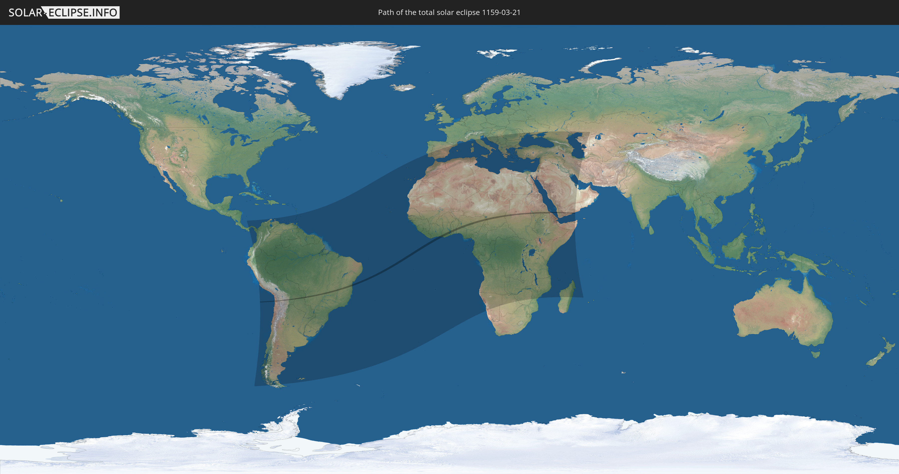
Die Sonnenfinsternis am 21.03.1159 kann man in 112 Ländern als partielle Sonnenfinsternis beobachten.
Der Finsternispfad verläuft durch 15 Länder. Nur in diesen Ländern ist sie als totale Sonnenfinsternis zu sehen.
In den folgenden Ländern ist die Sonnenfinsternis total zu sehen
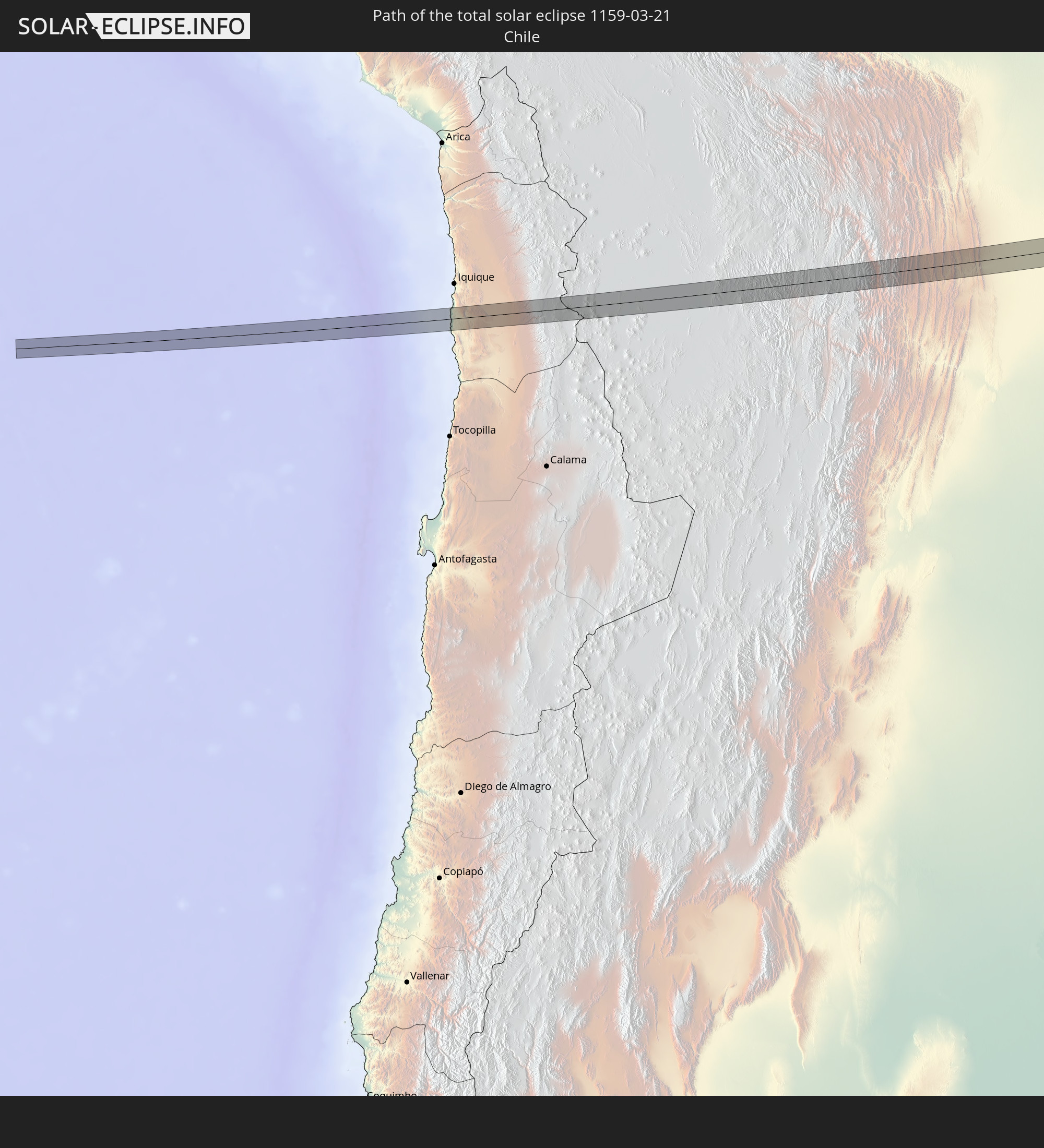 Chile
Chile
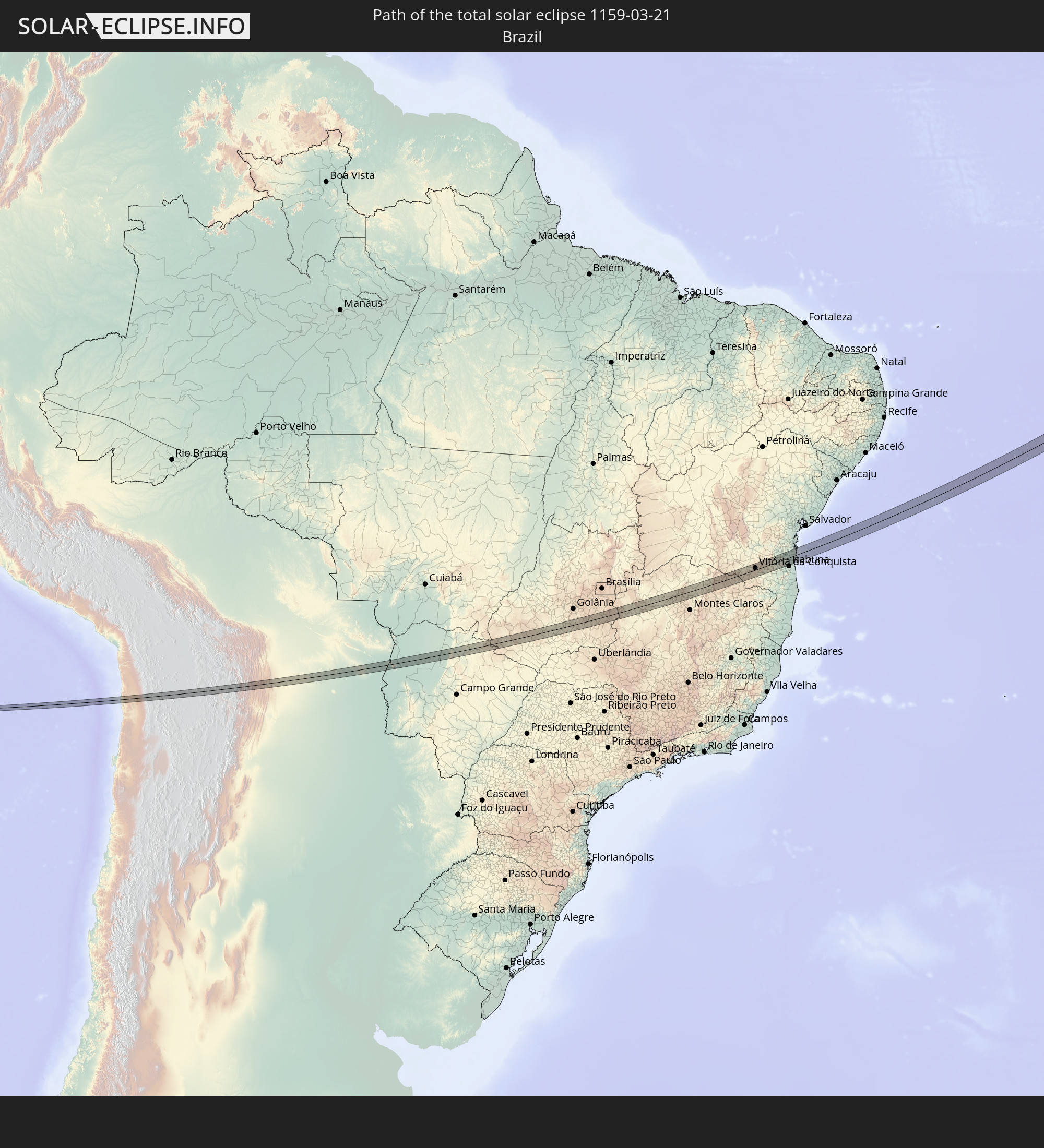 Brasilien
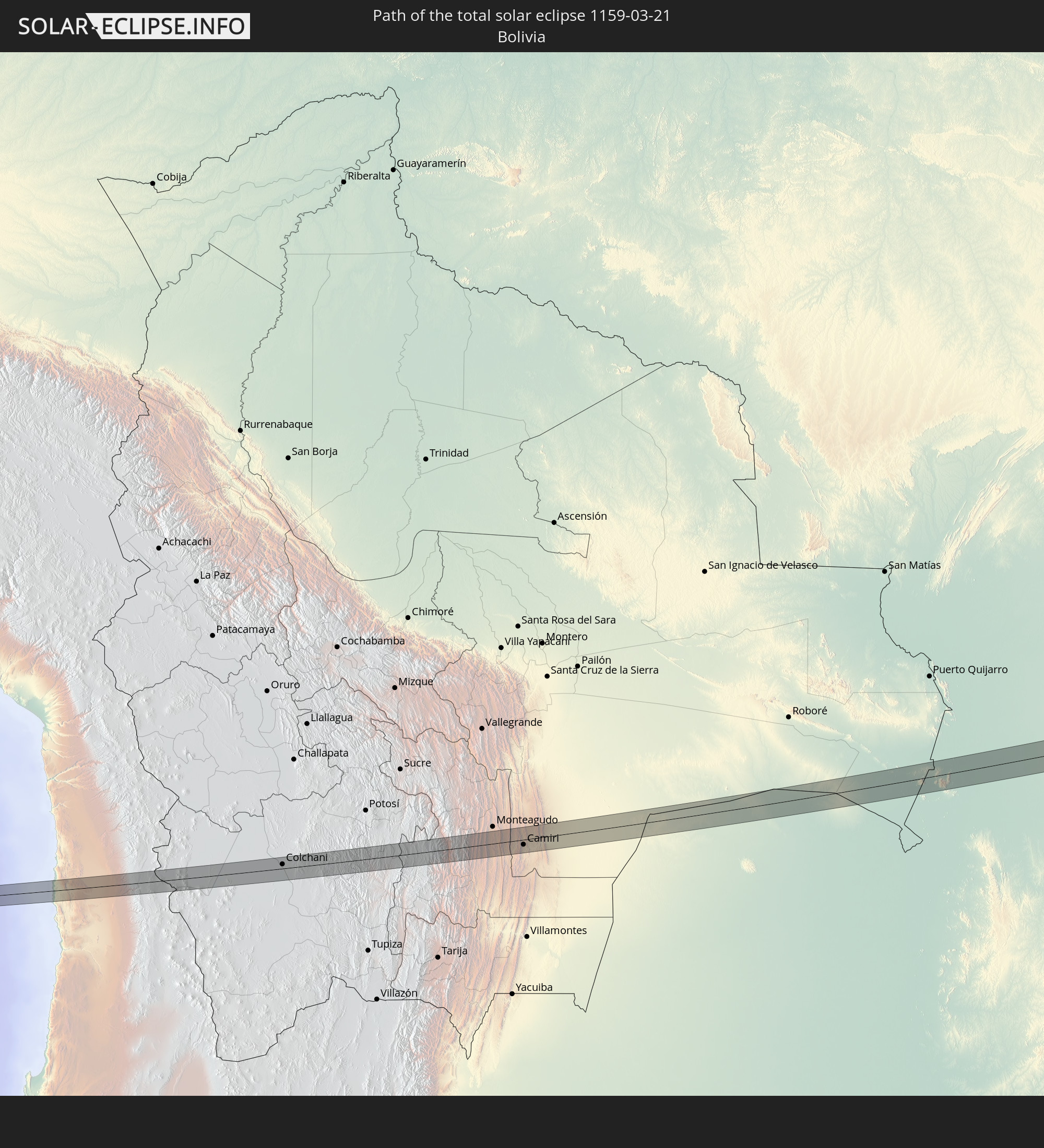 Bolivien
 Paraguay
 Elfenbeinküste
 Ghana
Ghana
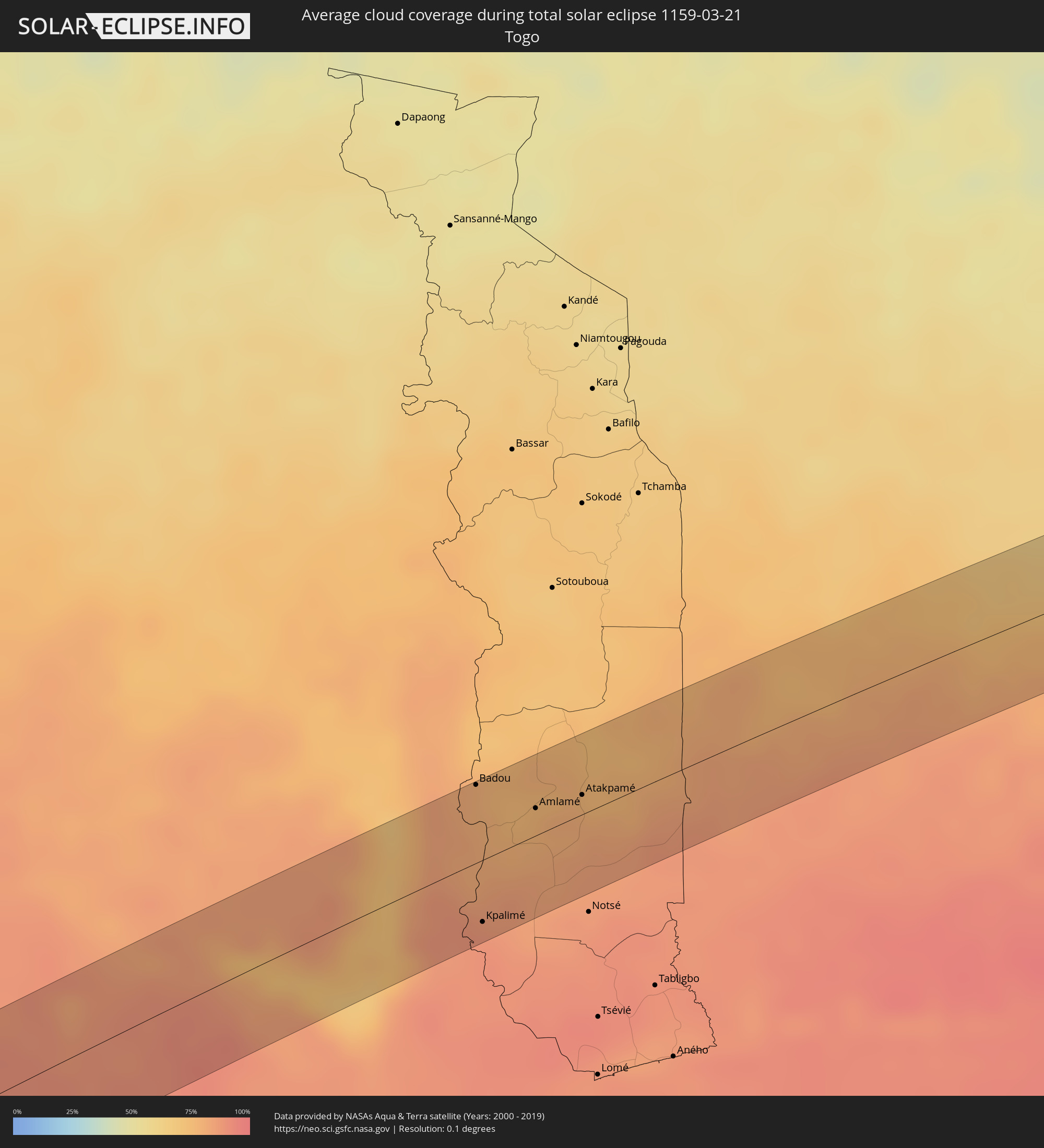
 Togo
Togo
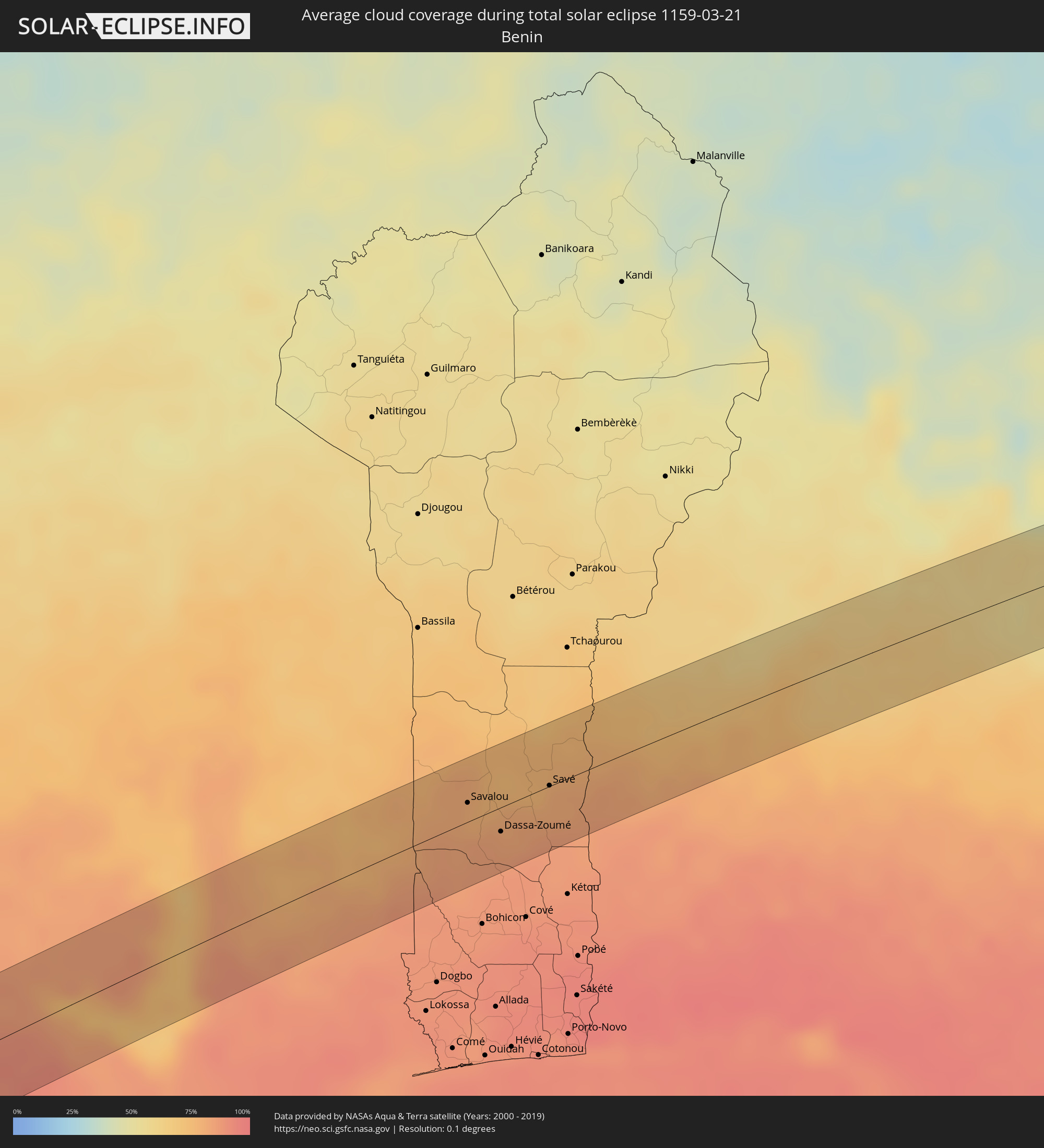
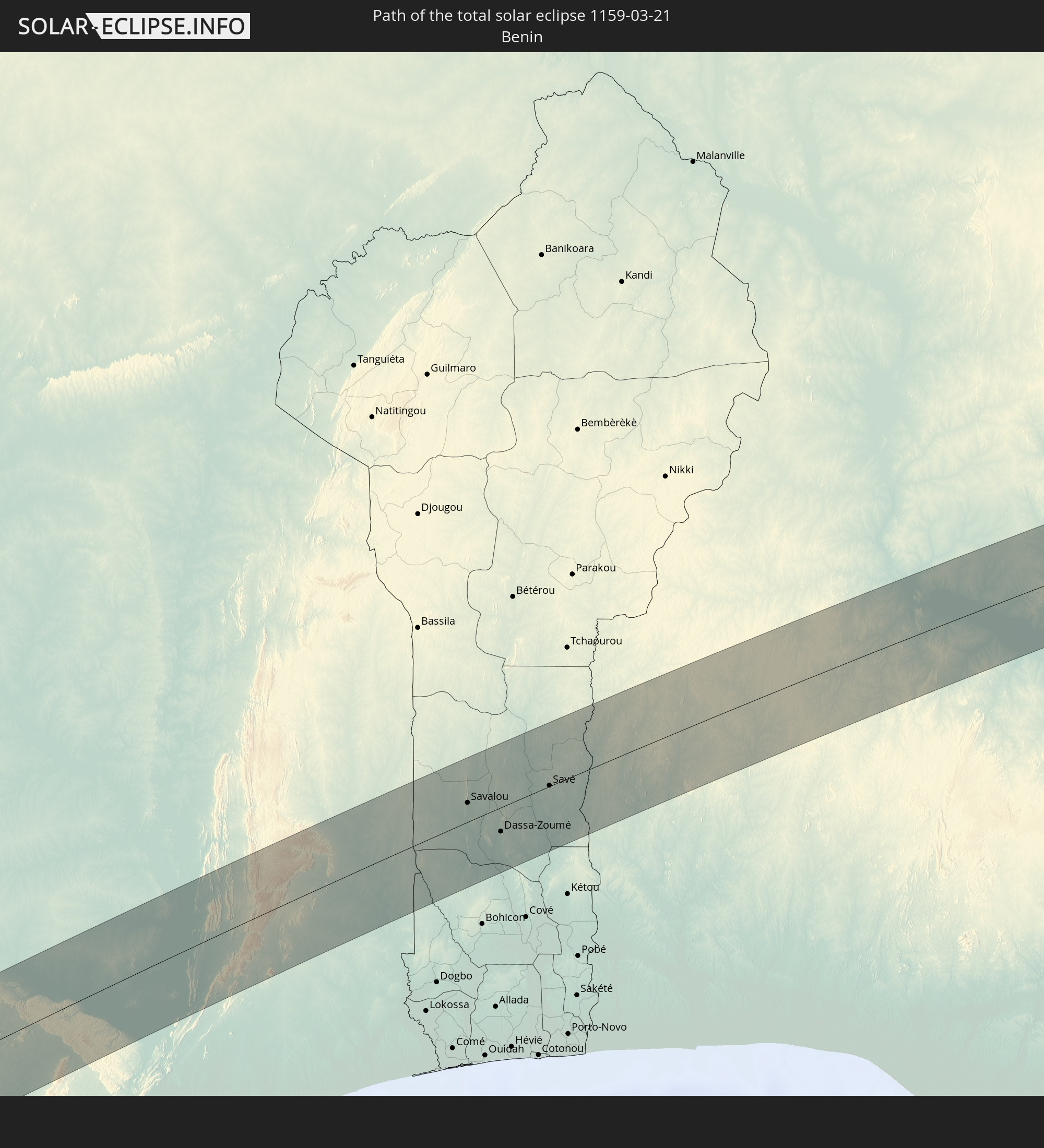 Benin
Benin
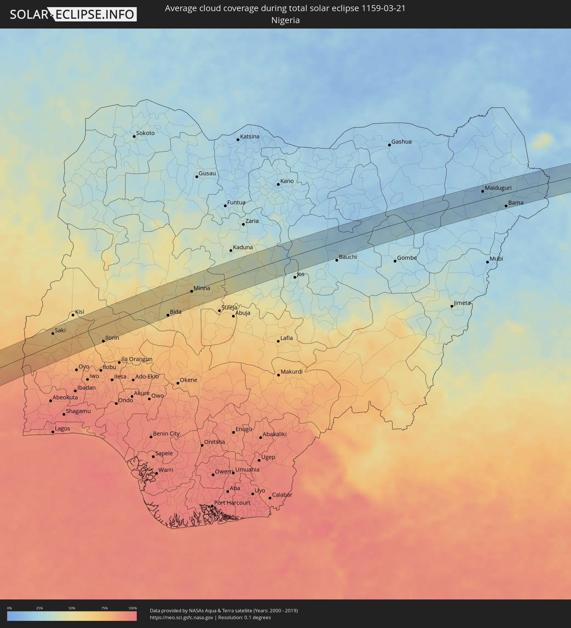
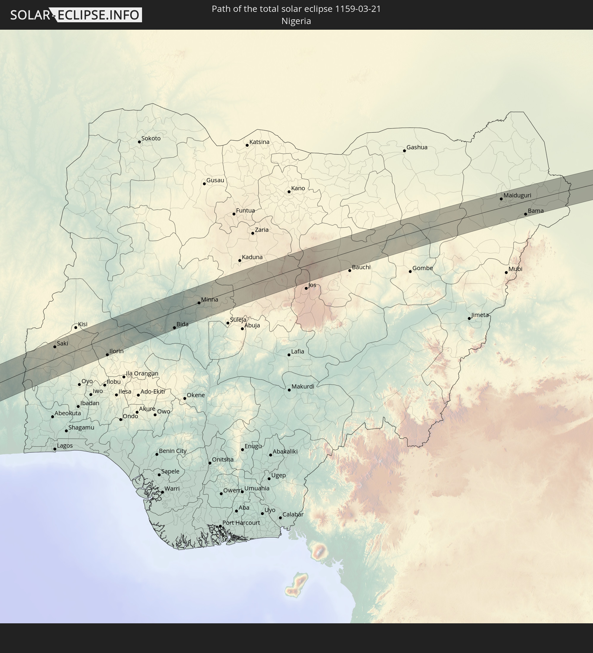 Nigeria
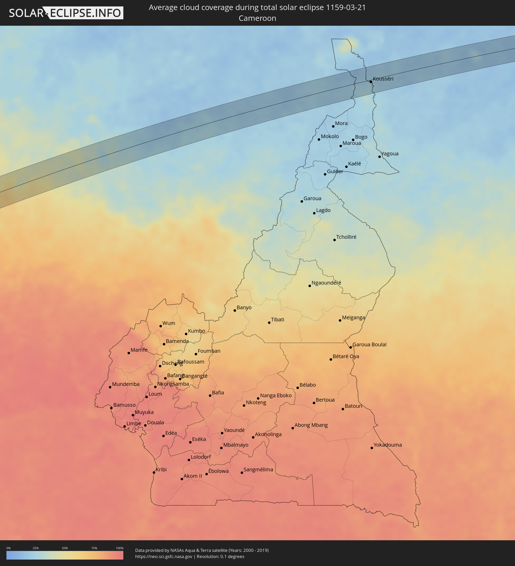
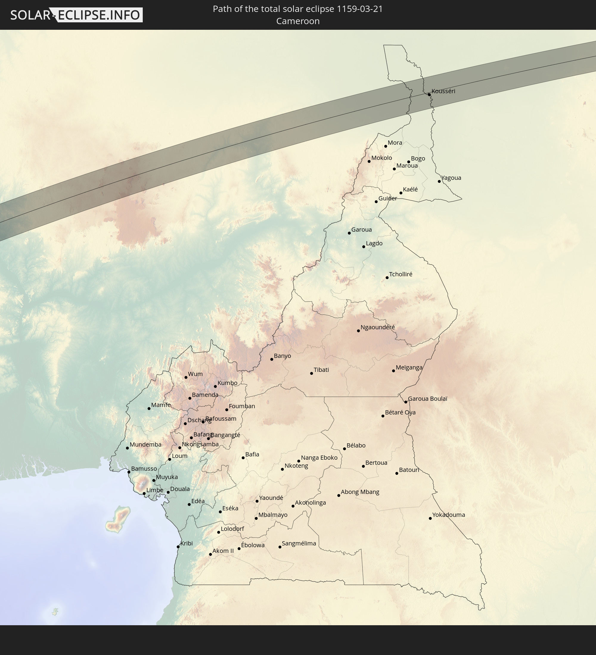 Kamerun
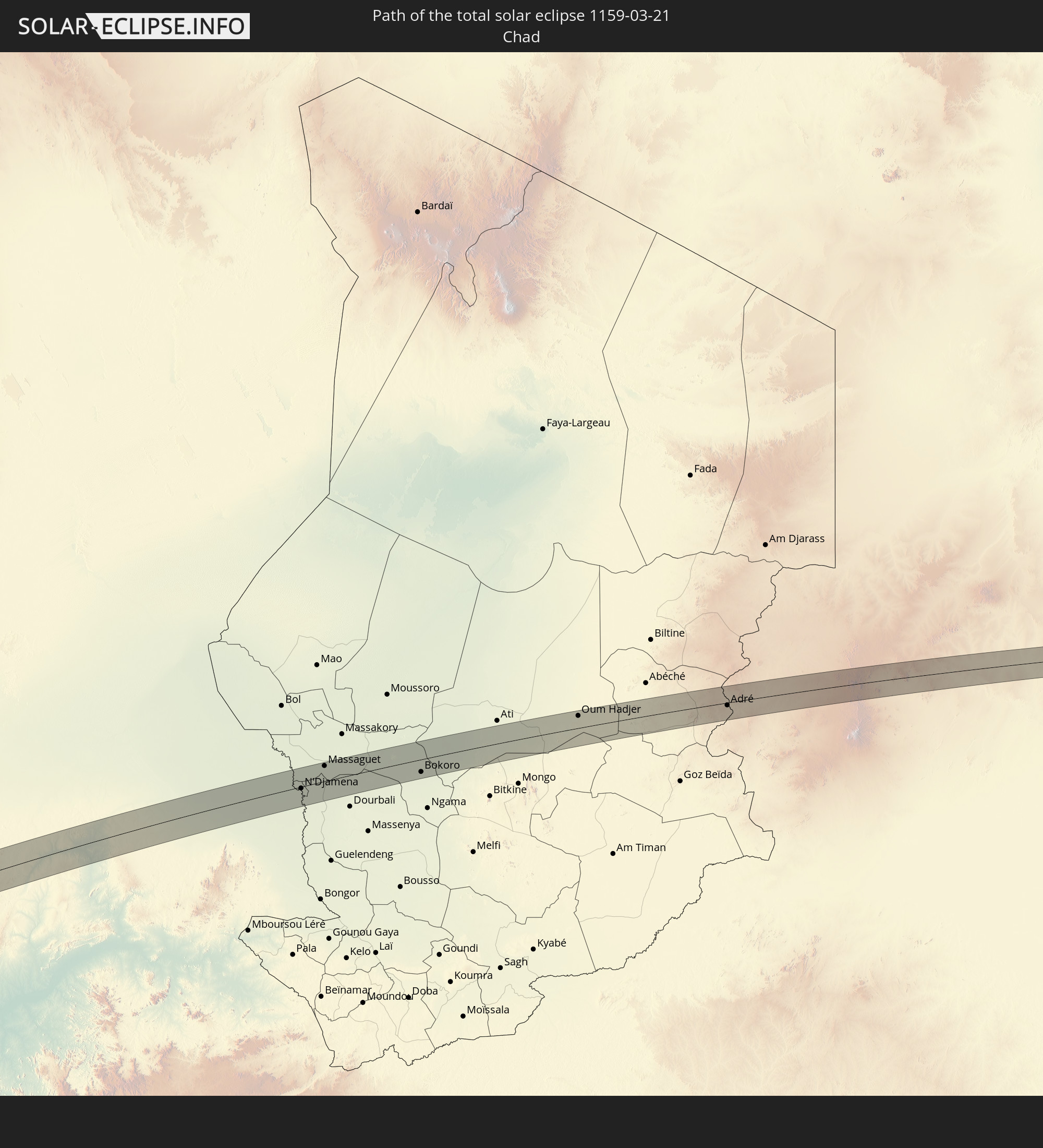 Tschad
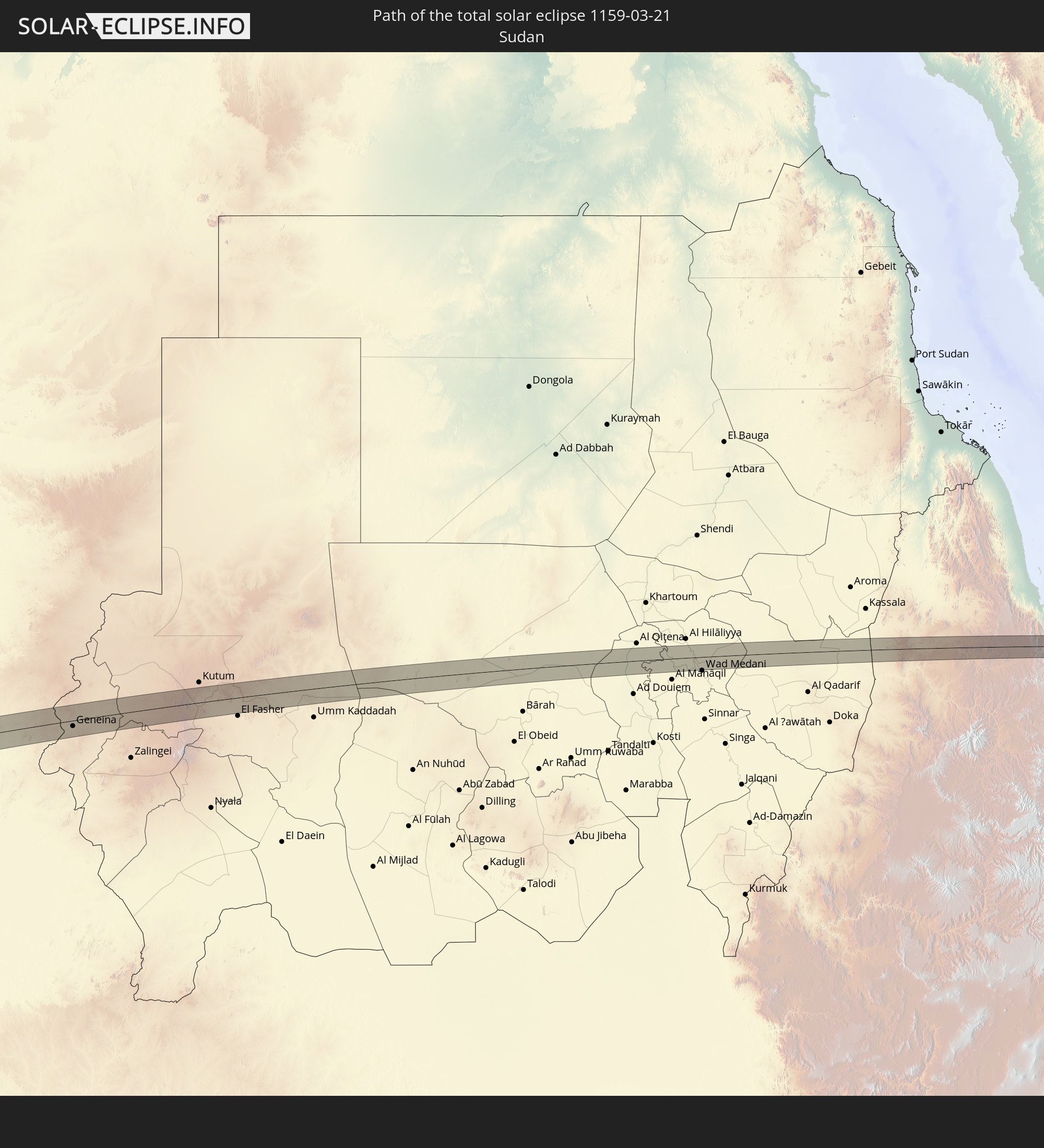 Sudan
Sudan
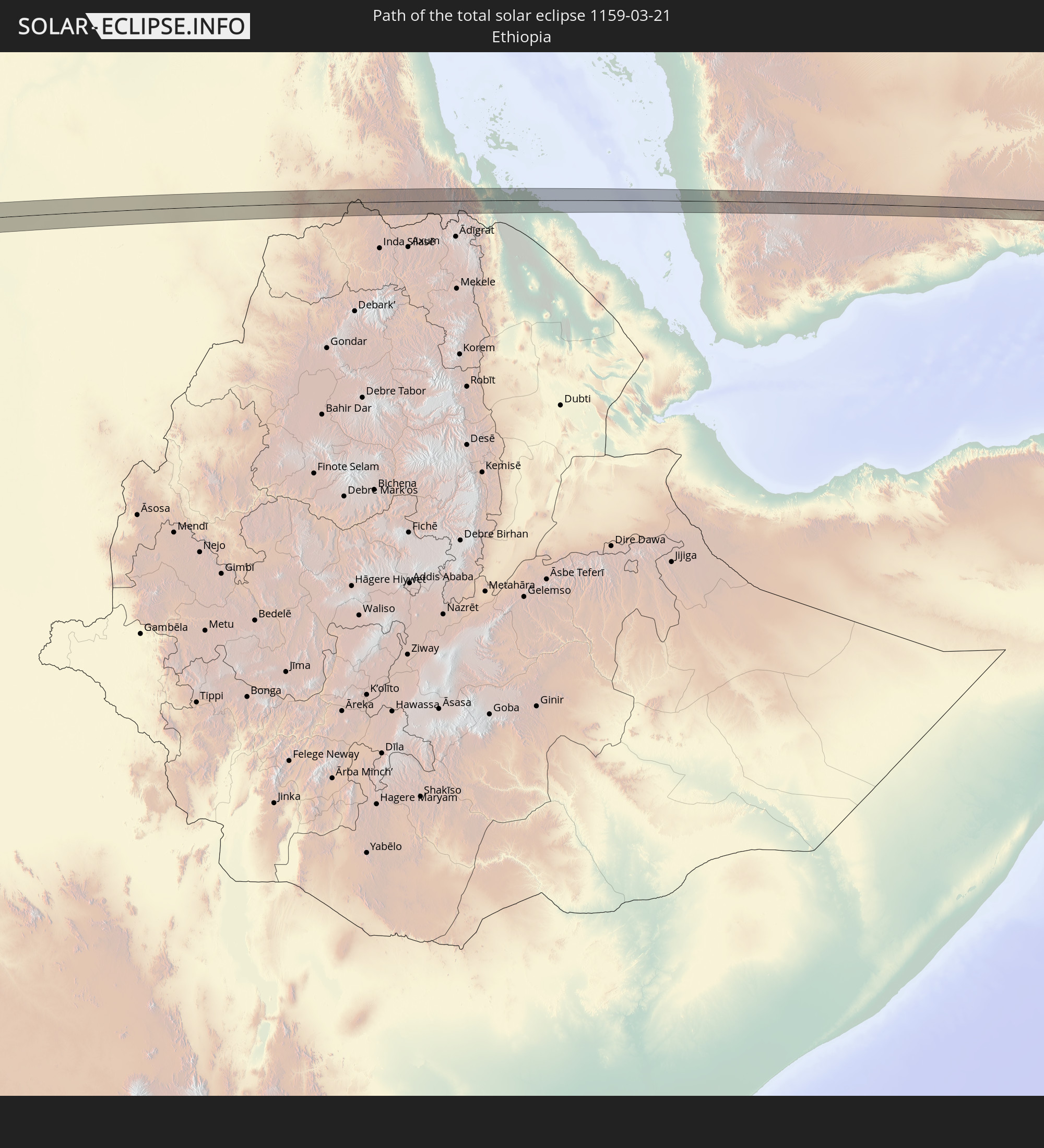 Äthiopien
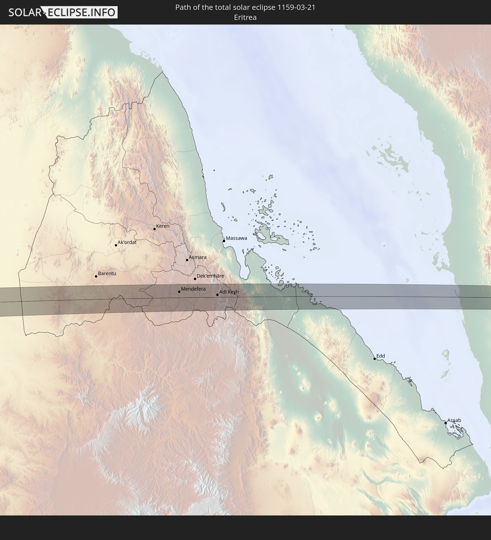 Eritrea
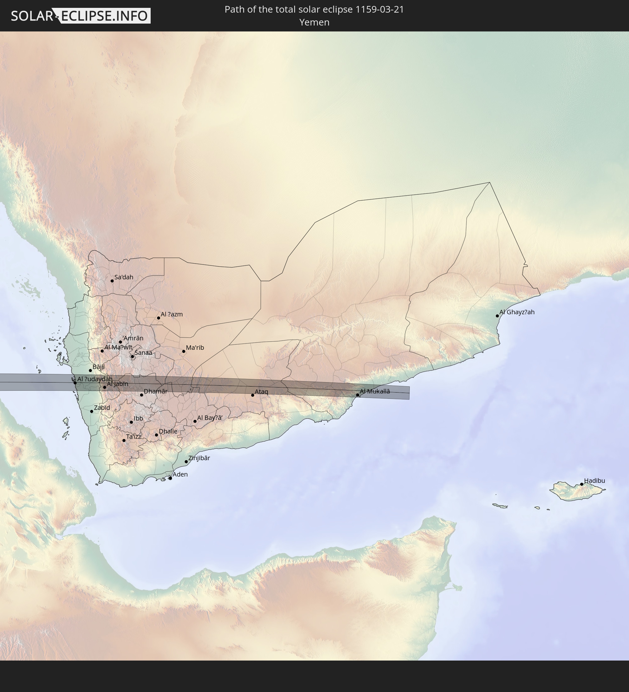 Jemen
Jemen
In den folgenden Ländern ist die Sonnenfinsternis partiell zu sehen
 Russland
 Chile
Chile
 Ecuador
 Panama
 Kolumbien
 Peru
Peru
 Brasilien
 Argentinien
 Venezuela
 Aruba
Aruba
 Bolivien
 Paraguay
 Trinidad und Tobago
 Grenada
 St. Vincent und die Grenadinen
 Falklandinseln
 Guyana
 St. Lucia
 Barbados
 Uruguay
 Suriname
 Französisch-Guayana
 Portugal
 Kap Verde
 Spanien
 Senegal
 Mauretanien
 Gambia
 Guinea-Bissau
 Guinea
 St. Helena
 Sierra Leone
 Marokko
 Mali
Mali
 Liberia
 Algerien
 Elfenbeinküste
 Burkina Faso
 Gibraltar
 Frankreich
 Ghana
Ghana
 Togo
Togo
 Niger
Niger
 Benin
Benin
 Nigeria
 Äquatorialguinea
 São Tomé und Príncipe
 Italien
 Tunesien
 Kamerun
 Gabun
Gabun
 Libyen
 Republik Kongo
 Angola
 Namibia
 Demokratische Republik Kongo
 San Marino
 Vatikanstadt
 Tschad
 Kroatien
 Malta
Malta
 Zentralafrikanische Republik
 Bosnien und Herzegowina
 Montenegro
 Serbien
 Albanien
 Griechenland
 Botswana
 Rumänien
 Mazedonien
 Sudan
Sudan
 Sambia
 Ukraine
 Bulgarien
 Ägypten
 Simbabwe
 Türkei
 Moldawien
 Ruanda
 Burundi
 Tansania
 Uganda
 Mosambik
 Republik Zypern
 Malawi
 Äthiopien
 Kenia
Kenia
 Staat Palästina
 Israel
 Saudi-Arabien
 Jordanien
 Libanon
 Syrien
 Eritrea
 Irak
Irak
 Georgien
 Französische Süd- und Antarktisgebiete
 Somalia
 Dschibuti
 Jemen
Jemen
 Madagaskar
 Komoren
 Armenien
 Iran
Iran
 Aserbaidschan
 Mayotte
 Seychellen
 Kasachstan
 Kuwait
 Bahrain
 Katar
Katar
 Turkmenistan
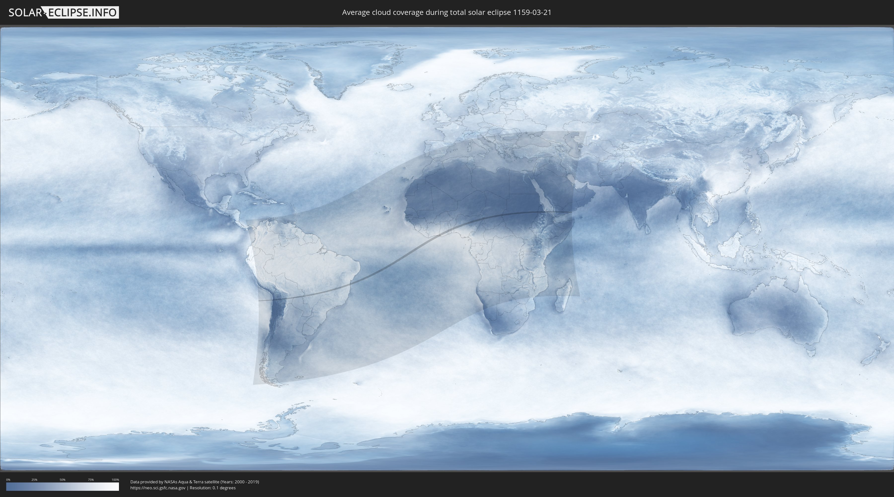
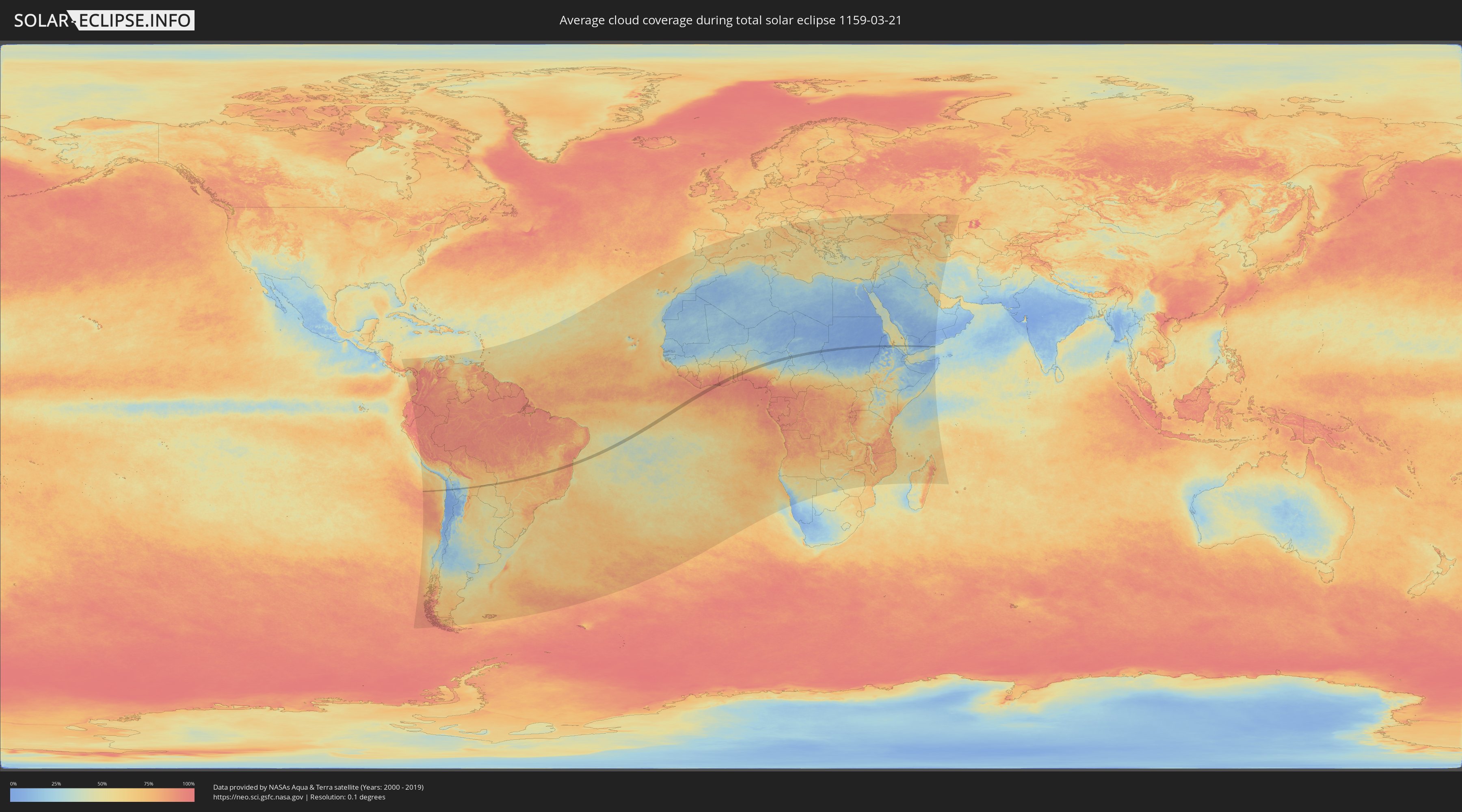
Wie wird das Wetter während der totalen Sonnenfinsternis am 21.03.1159?
Wo ist der beste Ort, um die totale Sonnenfinsternis vom 21.03.1159 zu beobachten?
Die folgenden Karten zeigen die durchschnittliche Bewölkung für den Tag, an dem die totale Sonnenfinsternis
stattfindet. Mit Hilfe der Karten lässt sich der Ort entlang des Finsternispfades eingrenzen,
der die besten Aussichen auf einen klaren wolkenfreien Himmel bietet.
Trotzdem muss man immer lokale Gegenenheiten beachten und sollte sich genau über das Wetter an seinem
gewählten Beobachtungsort informieren.
Die Daten stammen von den beiden NASA-Satelliten
AQUA und TERRA
und wurden über einen Zeitraum von 19 Jahren (2000 - 2019) gemittelt.
Detaillierte Länderkarten
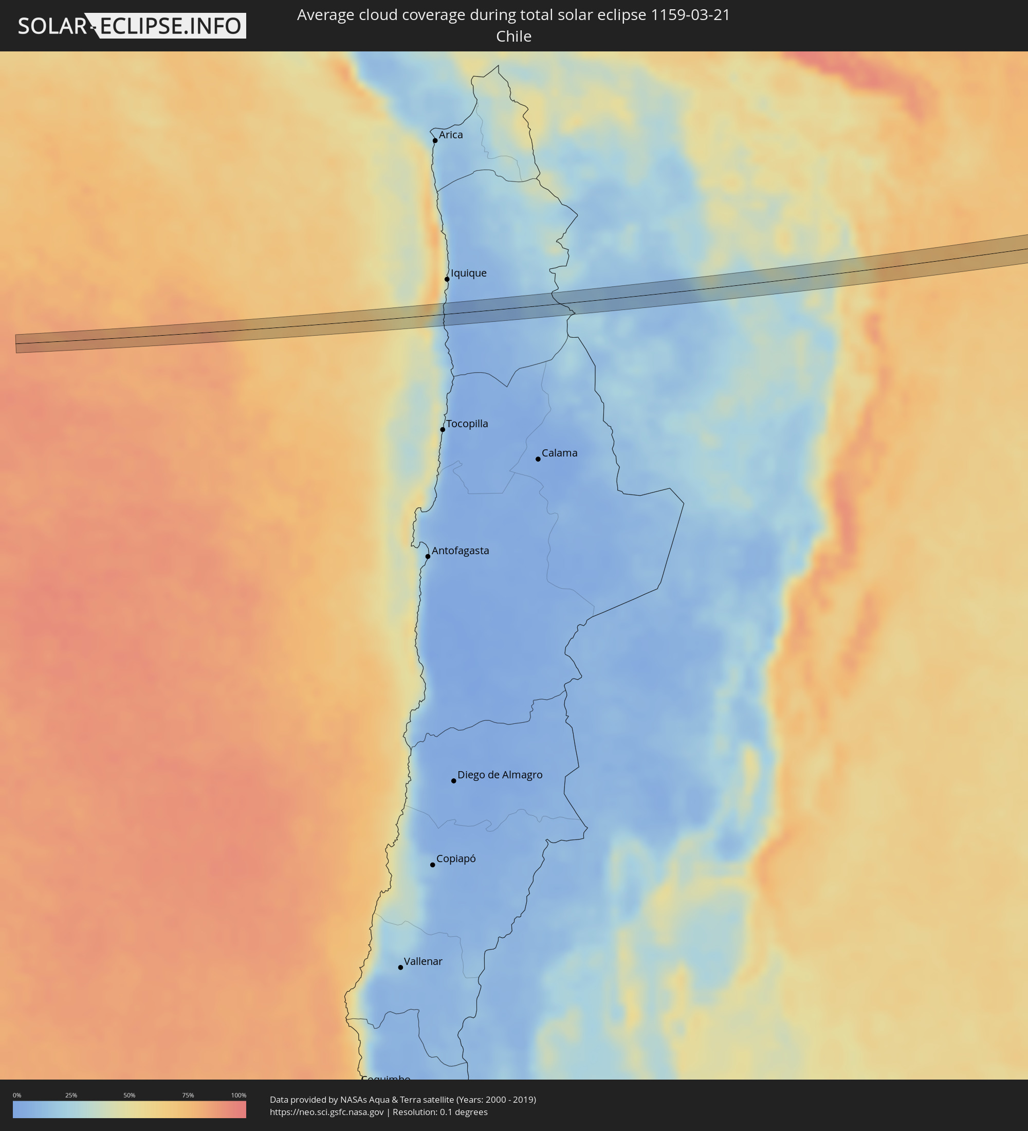 Chile
Chile
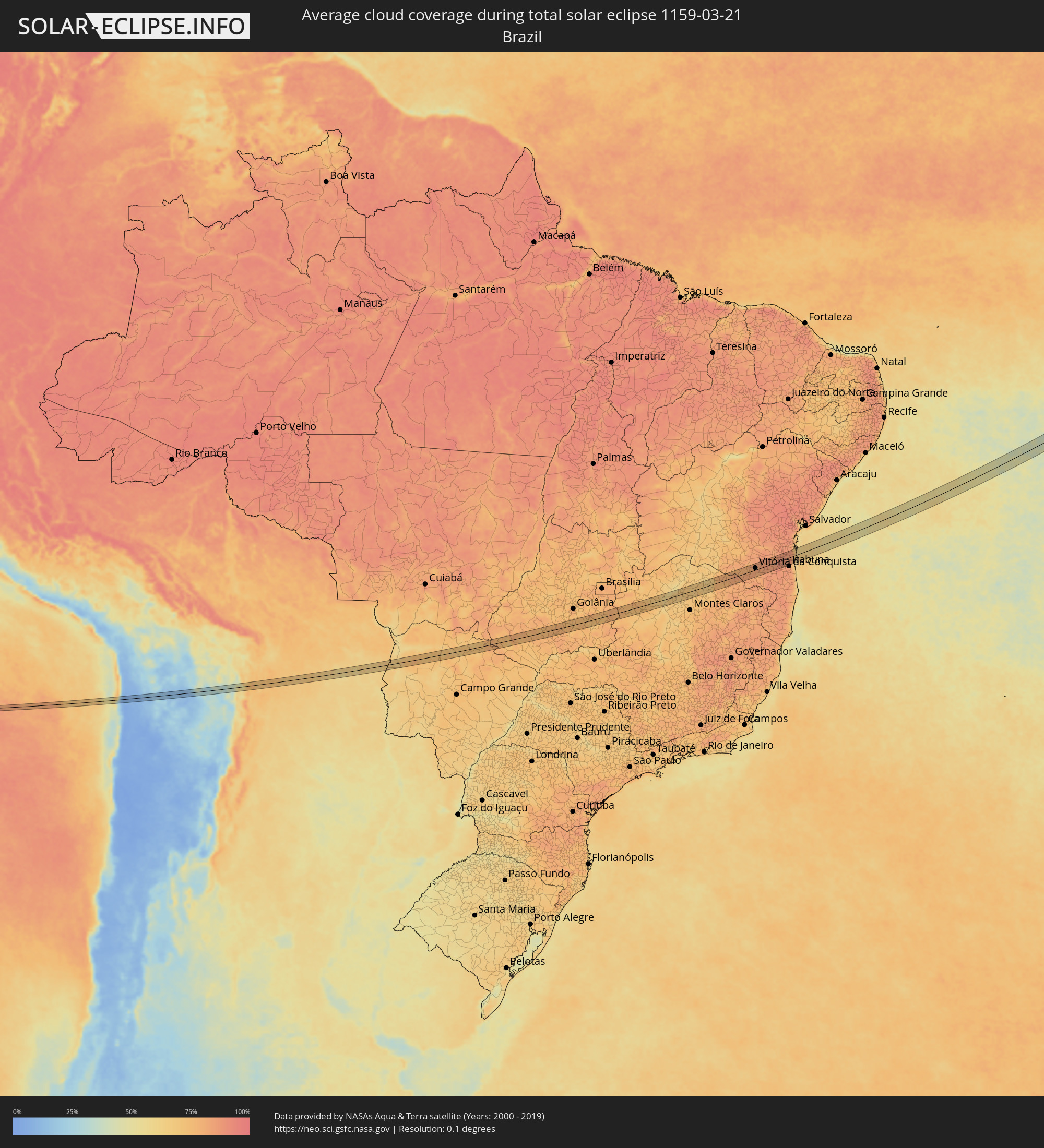 Brasilien
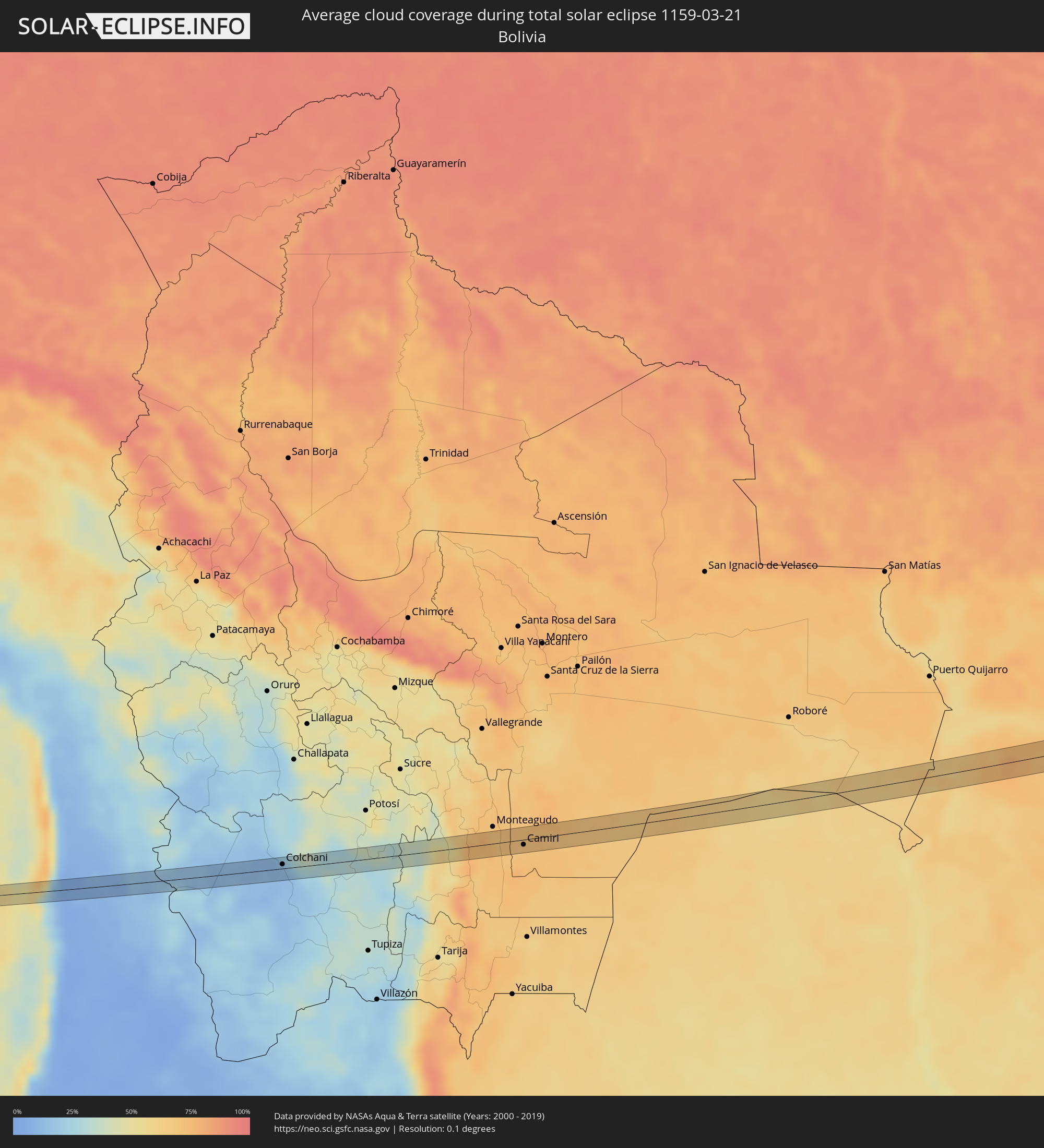 Bolivien
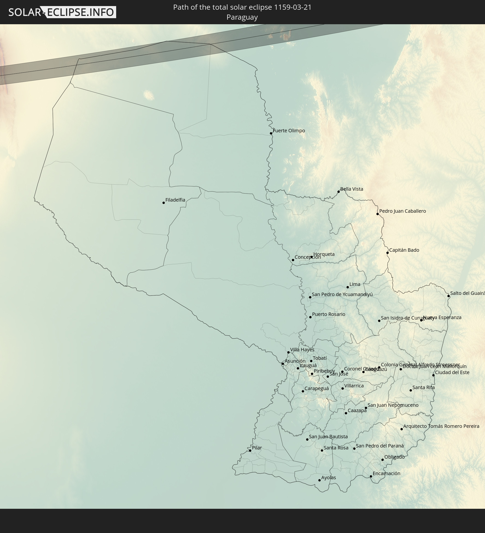
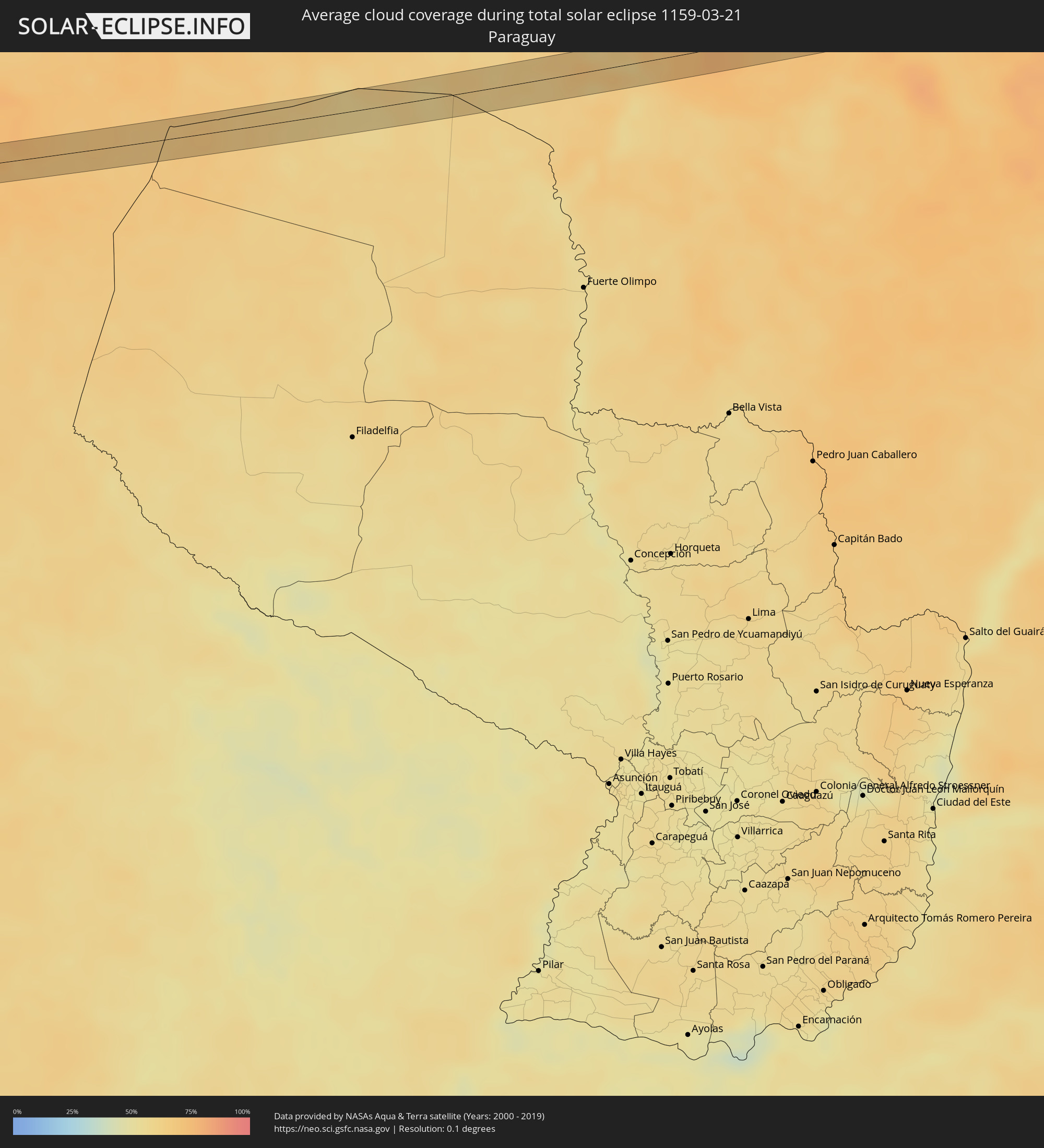 Paraguay
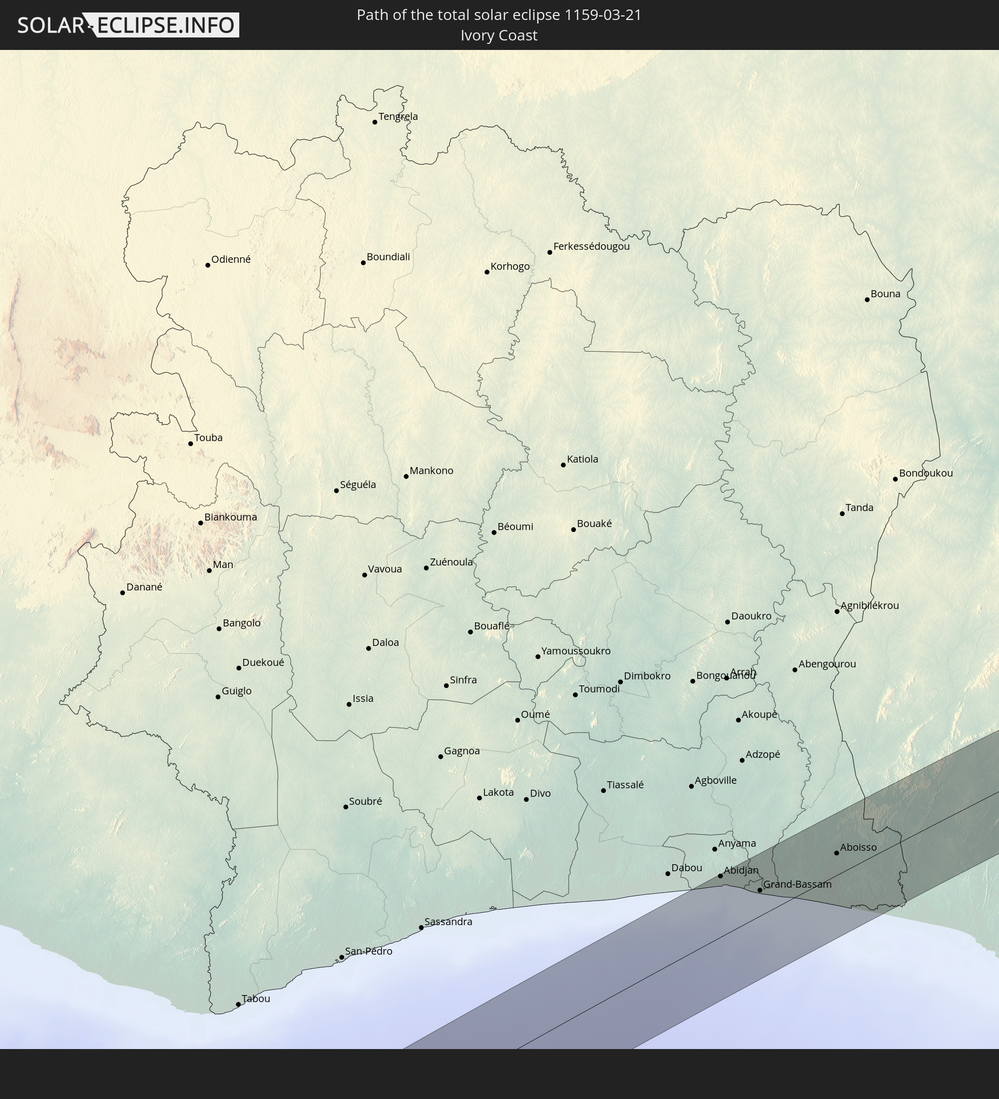
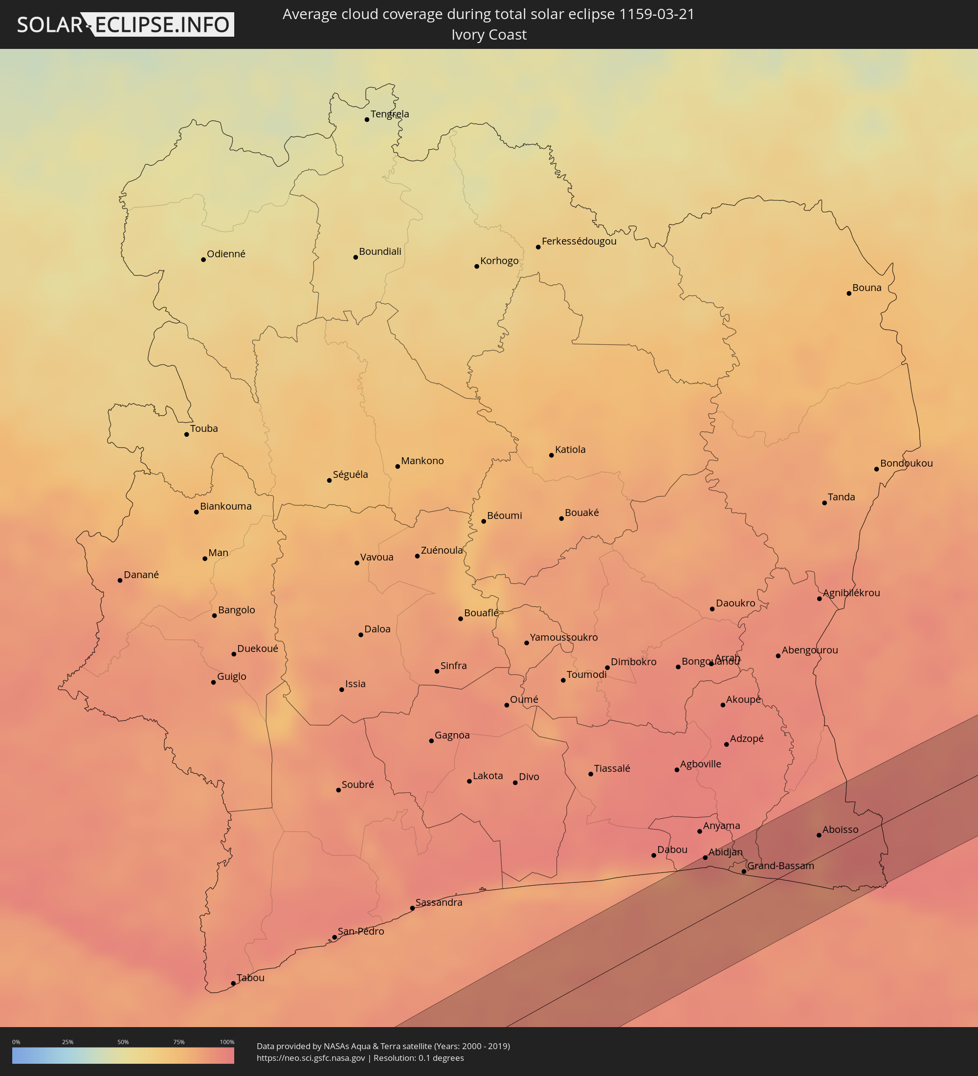 Elfenbeinküste
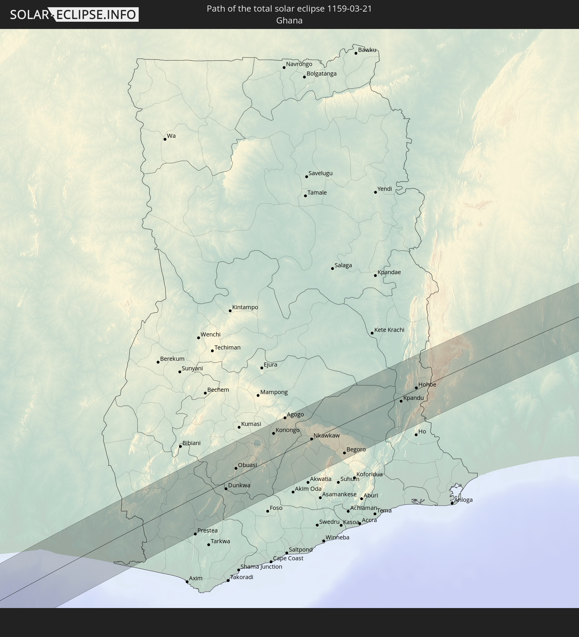
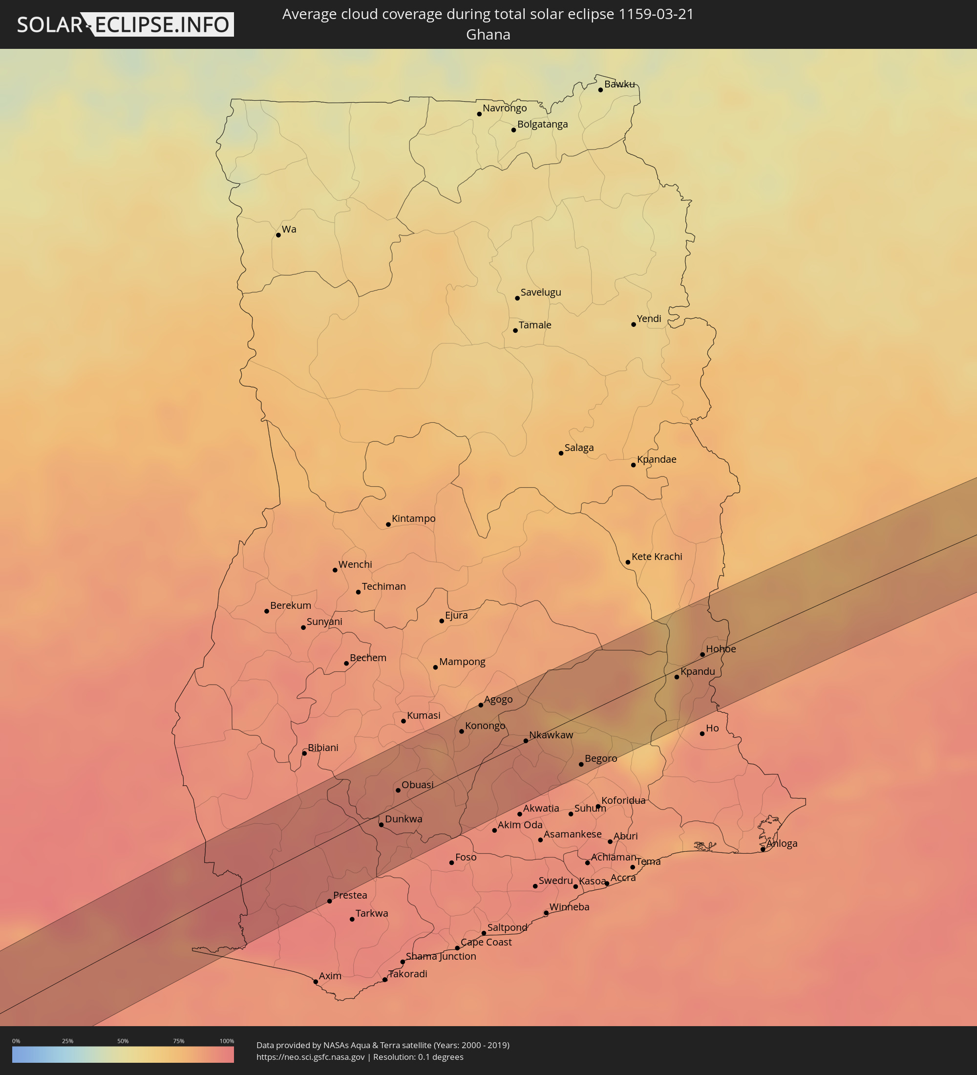 Ghana
Ghana
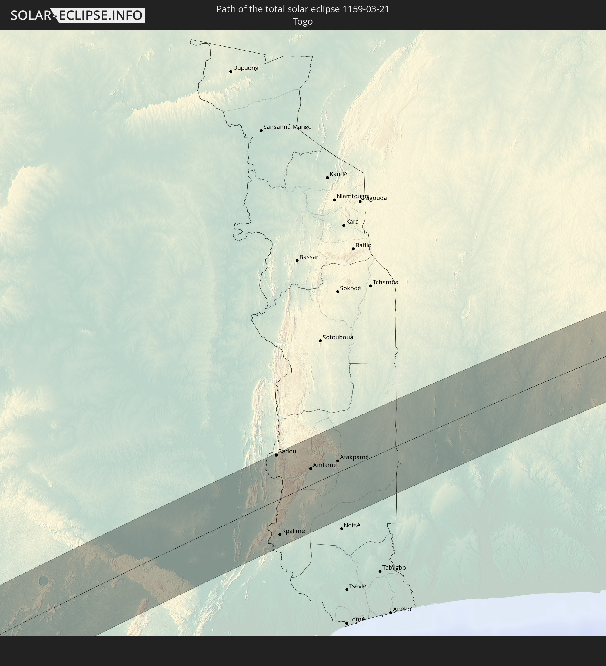
 Togo
Togo
 Benin
Benin
 Nigeria
 Kamerun
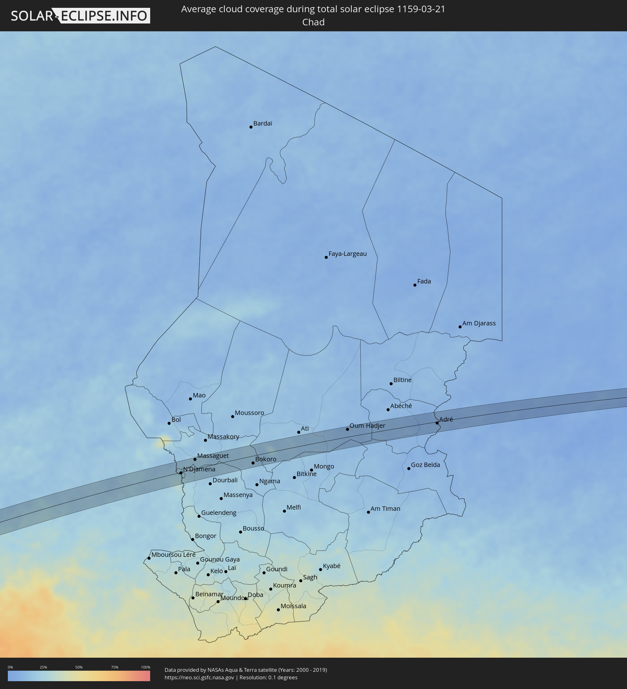 Tschad
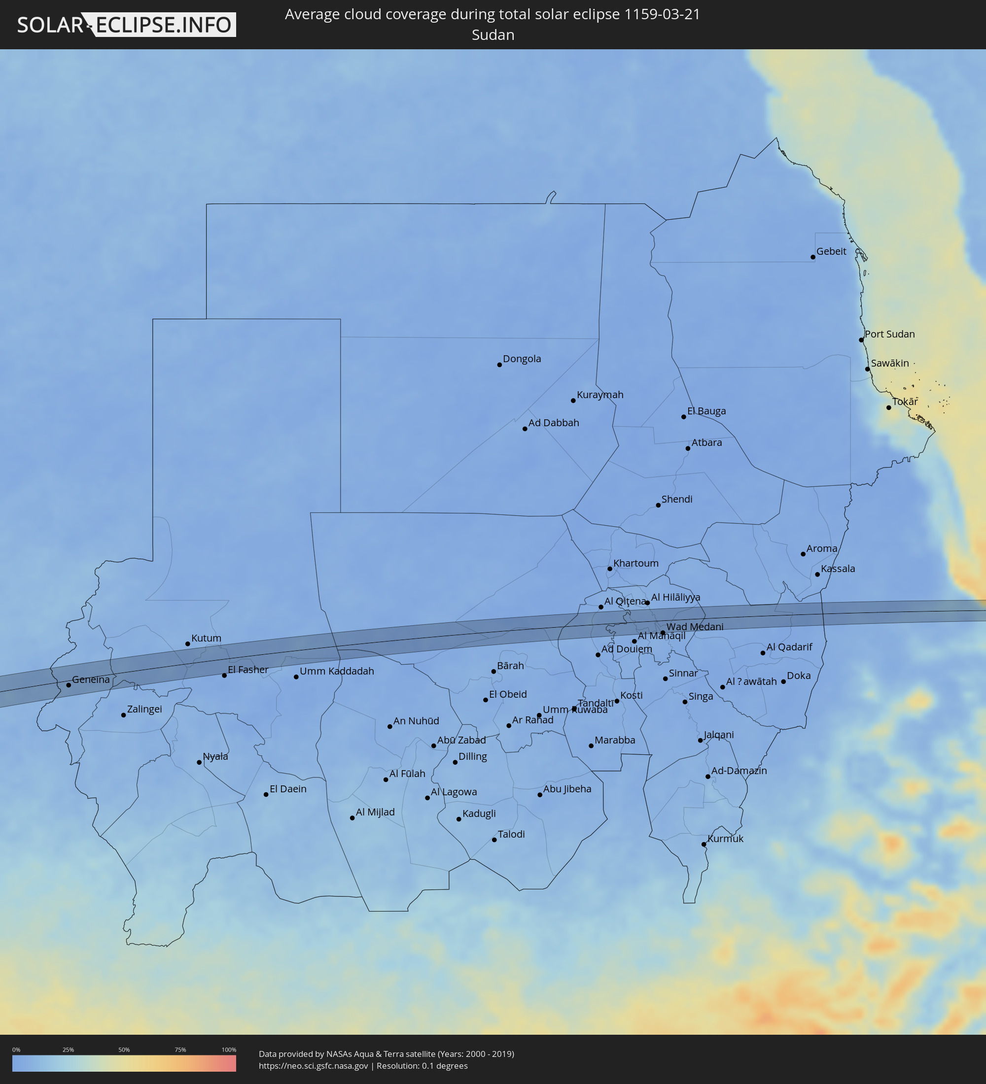 Sudan
Sudan
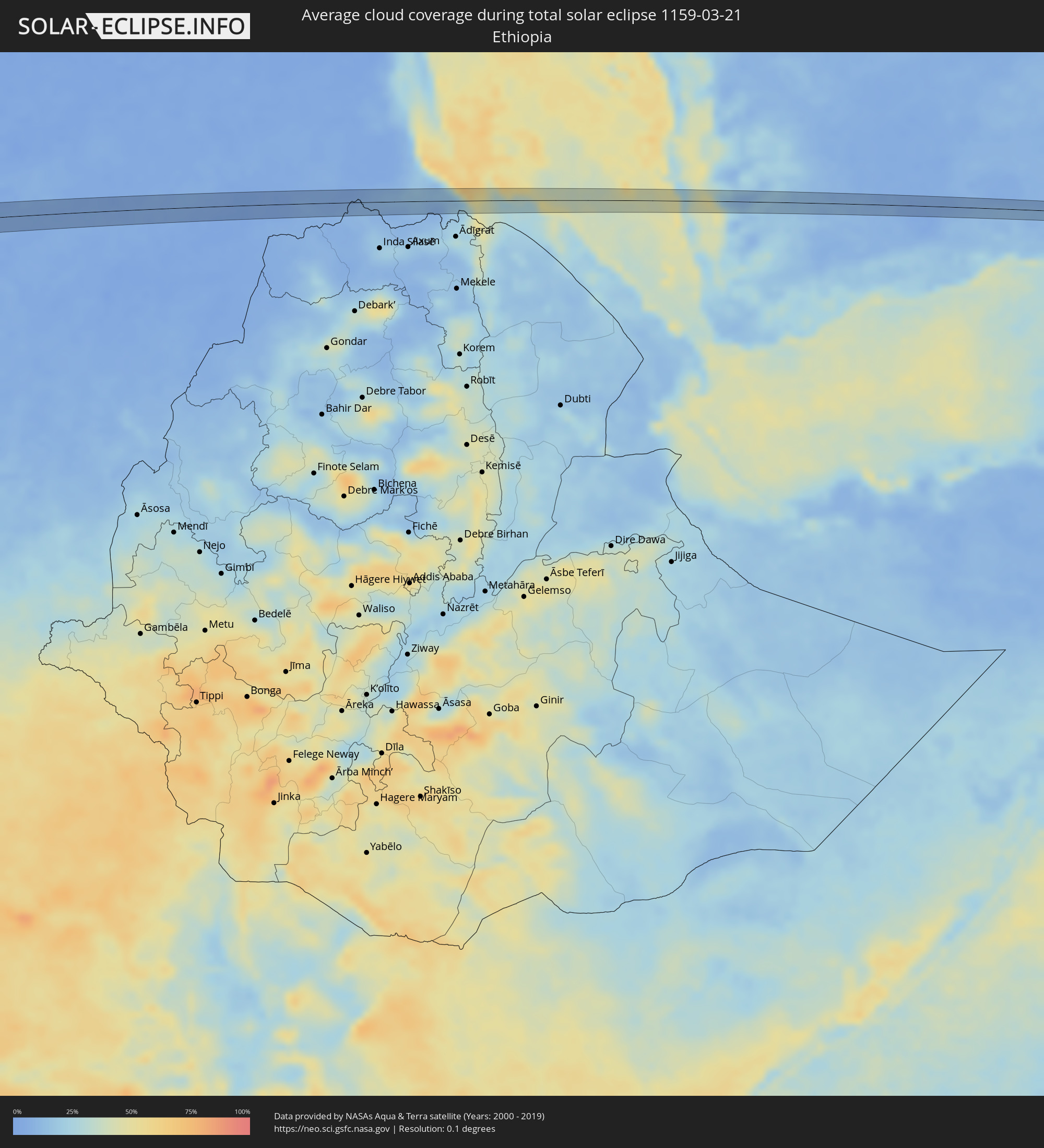 Äthiopien
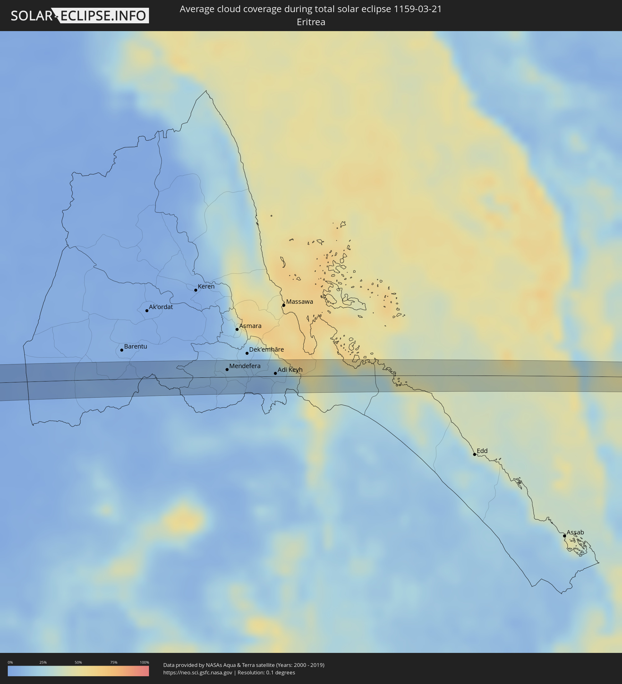 Eritrea
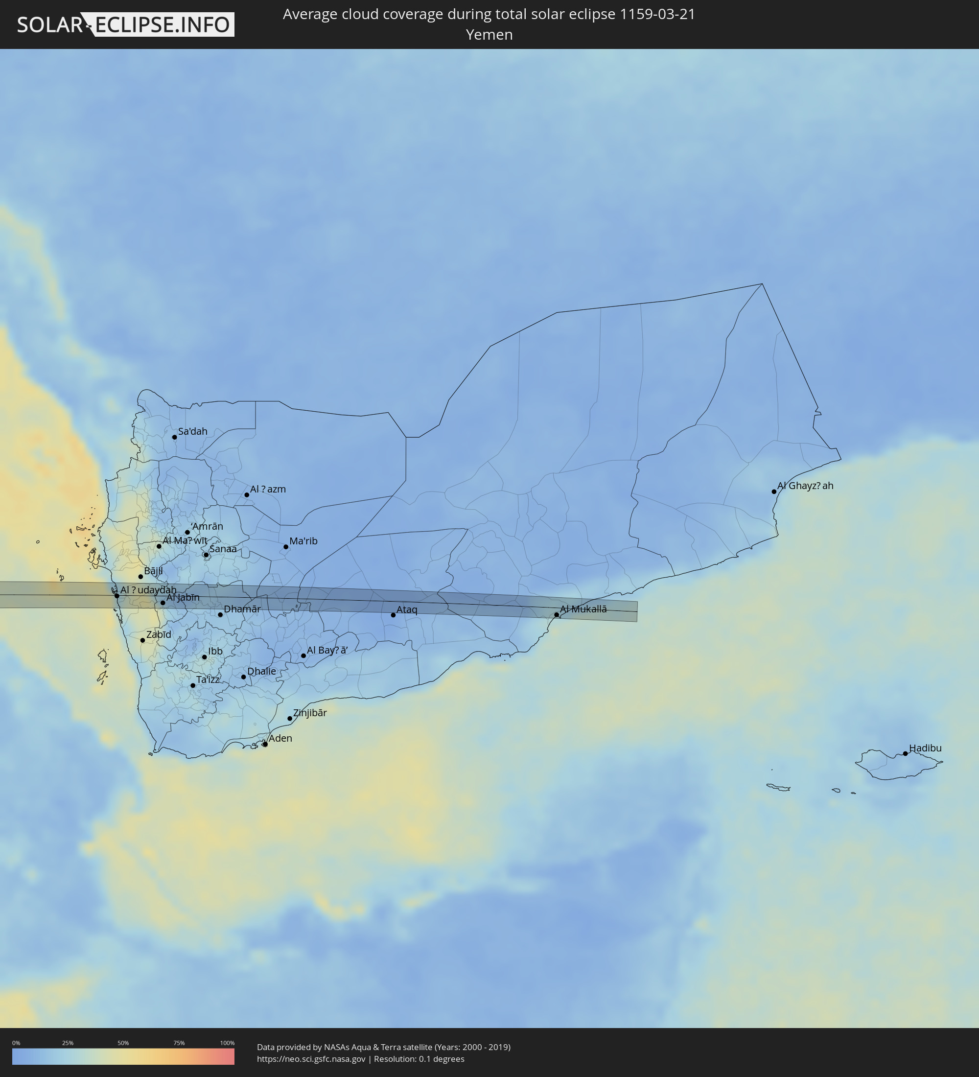 Jemen
Jemen
Orte im Finsternispfad
Die nachfolgene Tabelle zeigt Städte und Orte mit mehr als 5.000 Einwohnern, die sich im Finsternispfad befinden. Städte mit mehr als 100.000 Einwohnern sind dick gekennzeichnet. Mit einem Klick auf den Ort öffnet sich eine Detailkarte die die Lage des jeweiligen Ortes zusammen mit dem Verlauf der zentralen Finsternis präsentiert.
| Ort | Typ | Dauer der Verfinsterung | Ortszeit bei maximaler Verfinsterung | Entfernung zur Zentrallinie | Ø Bewölkung |
|
Colchani, Potosí
|
total | - | 06:41:59 UTC-04:32 | 6 km | 13% |
|
Uyuni, Potosí
|
total | - | 06:42:01 UTC-04:32 | 13 km | 13% |
|
Camiri, Santa Cruz
|
total | - | 06:43:11 UTC-04:32 | 7 km | 69% |
|
Corumbá, Mato Grosso do Sul
|
total | - | 07:40:29 UTC-03:38 | 12 km | 65% |
|
Coxim, Mato Grosso do Sul
|
total | - | 07:42:36 UTC-03:38 | 9 km | 67% |
|
Jataí, Goiás
|
total | - | 08:17:18 UTC-03:06 | 9 km | 74% |
|
Santa Helena de Goiás, Goiás
|
total | - | 08:18:22 UTC-03:06 | 11 km | 76% |
|
Piracanjuba, Goiás
|
total | - | 08:20:06 UTC-03:06 | 3 km | 77% |
|
Pires do Rio, Goiás
|
total | - | 08:20:53 UTC-03:06 | 16 km | 70% |
|
Cristalina, Goiás
|
total | - | 08:21:49 UTC-03:06 | 22 km | 79% |
|
São Francisco, Minas Gerais
|
total | - | 08:25:26 UTC-03:06 | 28 km | 58% |
|
Brasília de Minas, Minas Gerais
|
total | - | 08:25:51 UTC-03:06 | 13 km | 67% |
|
Barreiro do Jaíba, Minas Gerais
|
total | - | 08:27:15 UTC-03:06 | 23 km | 69% |
|
Janaúba, Minas Gerais
|
total | - | 08:27:32 UTC-03:06 | 6 km | 66% |
|
Vitória da Conquista, Bahia
|
total | - | 09:04:01 UTC-02:34 | 8 km | 83% |
|
Poções, Bahia
|
total | - | 09:04:57 UTC-02:34 | 26 km | 86% |
|
Coaraci, Bahia
|
total | - | 09:06:06 UTC-02:34 | 15 km | 88% |
|
Ubatã, Bahia
|
total | - | 09:06:27 UTC-02:34 | 29 km | 86% |
|
Ubaitaba, Bahia
|
total | - | 09:06:41 UTC-02:34 | 10 km | 87% |
|
Uruçuca, Bahia
|
total | - | 09:06:33 UTC-02:34 | 20 km | 83% |
|
Abidjan, Abidjan
|
total | - | 13:17:14 UTC-00:16 | 41 km | 94% |
|
Bingerville, Abidjan
|
total | - | 13:17:38 UTC-00:16 | 39 km | 94% |
|
Grand-Bassam, Comoé
|
total | - | 13:17:48 UTC-00:16 | 17 km | 89% |
|
Bonoua
|
total | - | 13:18:15 UTC-00:16 | 15 km | 92% |
|
Adiaké, Comoé
|
total | - | 13:19:02 UTC-00:16 | 2 km | 92% |
|
Aboisso, Comoé
|
total | - | 13:19:33 UTC-00:16 | 15 km | 93% |
|
Ayamé, Comoé
|
total | - | 13:19:53 UTC-00:16 | 25 km | 93% |
|
Dunkwa, Central
|
total | - | 13:39:12 UTC-00:00 | 9 km | 93% |
|
Obuasi, Ashanti
|
total | - | 13:39:51 UTC-00:00 | 10 km | 90% |
|
Konongo, Ashanti
|
total | - | 13:41:32 UTC-00:00 | 29 km | 87% |
|
Agogo, Ashanti
|
total | - | 13:42:08 UTC-00:00 | 40 km | 83% |
|
Nkawkaw, Eastern
|
total | - | 13:42:34 UTC-00:00 | 1 km | 90% |
|
Mpraeso
|
total | - | 13:42:42 UTC-00:00 | 3 km | 88% |
|
Begoro, Eastern
|
total | - | 13:43:19 UTC-00:00 | 35 km | 85% |
|
Kpandu, Volta
|
total | - | 13:45:47 UTC-00:00 | 6 km | 83% |
|
Hohoe, Volta
|
total | - | 13:46:25 UTC-00:00 | 2 km | 83% |
|
Badou, Plateaux
|
total | - | 13:32:02 UTC-00:16 | 39 km | 79% |
|
Kpalimé, Plateaux
|
total | - | 13:31:13 UTC-00:16 | 31 km | 88% |
|
Amlamé, Plateaux
|
total | - | 13:32:36 UTC-00:16 | 14 km | 76% |
|
Atakpamé, Plateaux
|
total | - | 13:33:14 UTC-00:16 | 10 km | 80% |
|
Savalou, Collines
|
total | - | 14:05:27 UTC+00:13 | 12 km | 79% |
|
Dassa-Zoumé, Collines
|
total | - | 14:05:43 UTC+00:13 | 15 km | 82% |
|
Savé, Collines
|
total | - | 14:06:46 UTC+00:13 | 0 km | 80% |
|
Saki, Oyo
|
total | - | 14:09:36 UTC+00:13 | 26 km | 66% |
|
Igboho, Oyo
|
total | - | 14:10:37 UTC+00:13 | 29 km | 67% |
|
Igbeti, Oyo
|
total | - | 14:11:21 UTC+00:13 | 4 km | 67% |
|
Ilorin, Kwara
|
total | - | 14:11:59 UTC+00:13 | 39 km | 68% |
|
Jebba, Kwara
|
total | - | 14:13:20 UTC+00:13 | 15 km | 64% |
|
Mokwa, Niger
|
total | - | 14:13:59 UTC+00:13 | 23 km | 58% |
|
Lafiagi, Kwara
|
total | - | 14:14:17 UTC+00:13 | 37 km | 62% |
|
Bida, Niger
|
total | - | 14:15:49 UTC+00:13 | 37 km | 62% |
|
Zungeru, Niger
|
total | - | 14:16:52 UTC+00:13 | 34 km | 50% |
|
Minna, Niger
|
total | - | 14:17:30 UTC+00:13 | 1 km | 61% |
|
Kachia, Kaduna
|
total | - | 14:20:38 UTC+00:13 | 26 km | 40% |
|
Lere, Kaduna
|
total | - | 14:22:21 UTC+00:13 | 7 km | 31% |
|
Kari, Bauchi
|
total | - | 14:26:53 UTC+00:13 | 32 km | 22% |
|
Nafada, Gombe
|
total | - | 14:28:10 UTC+00:13 | 8 km | 26% |
|
Maiduguri, Borno
|
total | - | 14:31:55 UTC+00:13 | 19 km | 18% |
|
Bama, Borno
|
total | - | 14:32:34 UTC+00:13 | 30 km | 22% |
|
Dikwa, Borno
|
total | - | 14:33:18 UTC+00:13 | 19 km | 20% |
|
Kousséri, Far North
|
total | - | 14:35:07 UTC+00:13 | 6 km | 26% |
|
N'Djamena, Chari-Baguirmi
|
total | - | 15:21:47 UTC+01:00 | 3 km | 26% |
|
Massaguet, Hadjer-Lamis
|
total | - | 15:22:38 UTC+01:00 | 27 km | 19% |
|
Bokoro, Hadjer-Lamis
|
total | - | 15:25:00 UTC+01:00 | 22 km | 18% |
|
Oum Hadjer, Batha
|
total | - | 15:29:09 UTC+01:00 | 22 km | 10% |
|
Adré, Ouadaï
|
total | - | 15:32:19 UTC+01:00 | 5 km | 8% |
|
Geneina, Western Darfur
|
total | - | 16:42:32 UTC+02:10 | 10 km | 9% |
|
Wad az Zāki, White Nile
|
total | - | 16:51:44 UTC+02:10 | 11 km | 4% |
|
Al Hasaheisa, Al Jazīrah
|
total | - | 16:52:30 UTC+02:10 | 15 km | 4% |
|
Al Masallamiyya, Al Jazīrah
|
total | - | 16:52:29 UTC+02:10 | 5 km | 4% |
|
Mendefera, Debub
|
total | - | 17:12:28 UTC+02:27 | 9 km | 12% |
|
Adi Keyh, Debub
|
total | - | 17:12:40 UTC+02:27 | 3 km | 16% |
|
Al Ḩudaydah, Muḩāfaz̧at al Ḩudaydah
|
total | - | 17:53:22 UTC+03:06 | 2 km | 29% |
|
Al Jabīn, Raymah
|
total | - | 17:53:31 UTC+03:06 | 12 km | 40% |
|
Al Mukallā, Muḩāfaz̧at Ḩaḑramawt
|
total | - | 17:54:13 UTC+03:06 | 12 km | 37% |