Totale Sonnenfinsternis vom 01.05.1166
| Wochentag: | Sonntag |
| Maximale Dauer der Verfinsterung: | 05m06s |
| Maximale Breite des Finsternispfades: | 189 km |
| Saroszyklus: | 105 |
| Bedeckungsgrad: | 100% |
| Magnitude: | 1.0567 |
| Gamma: | -0.1406 |
Wo kann man die Sonnenfinsternis vom 01.05.1166 sehen?
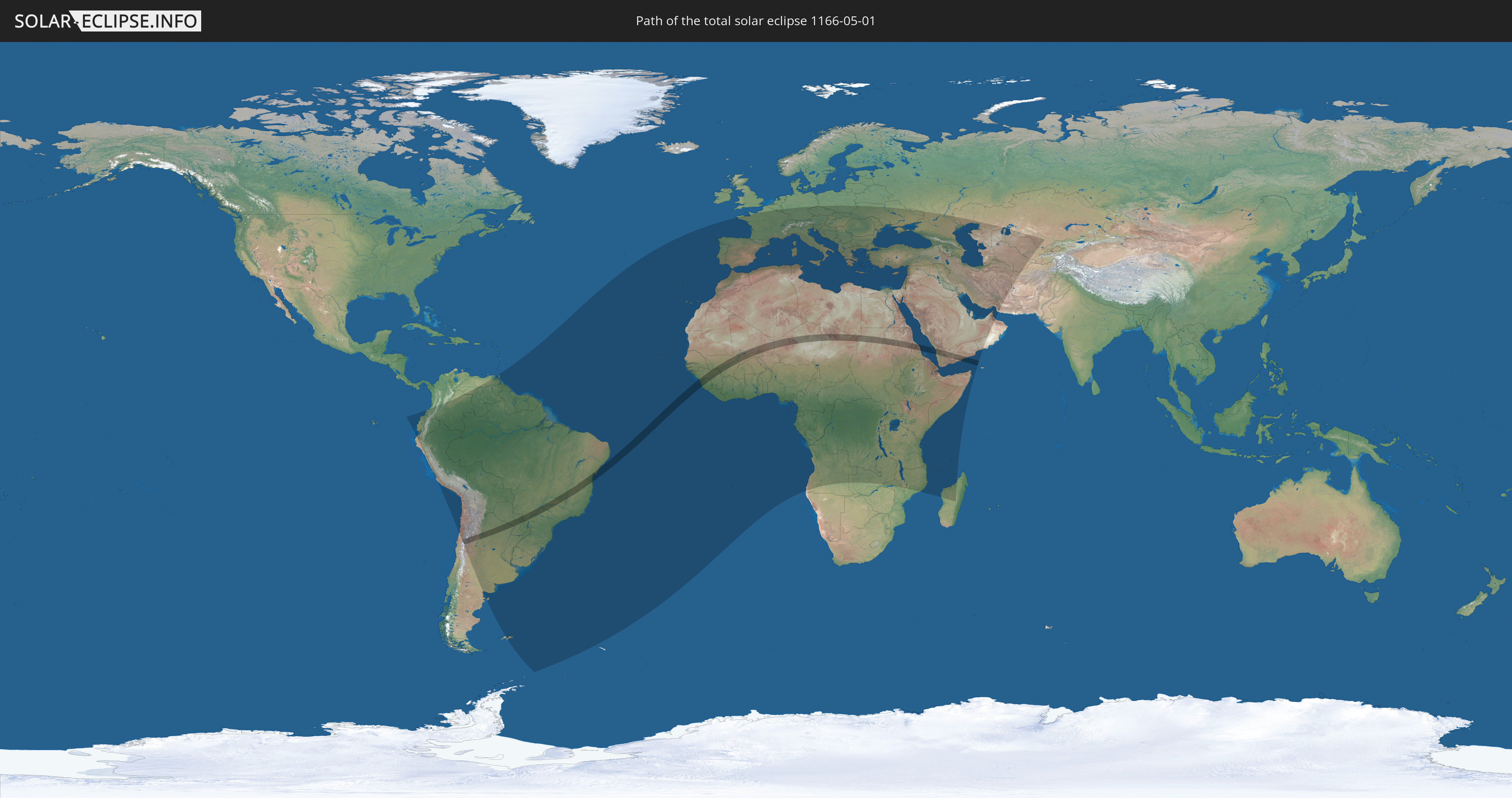
Die Sonnenfinsternis am 01.05.1166 kann man in 121 Ländern als partielle Sonnenfinsternis beobachten.
Der Finsternispfad verläuft durch 14 Länder. Nur in diesen Ländern ist sie als totale Sonnenfinsternis zu sehen.
In den folgenden Ländern ist die Sonnenfinsternis total zu sehen
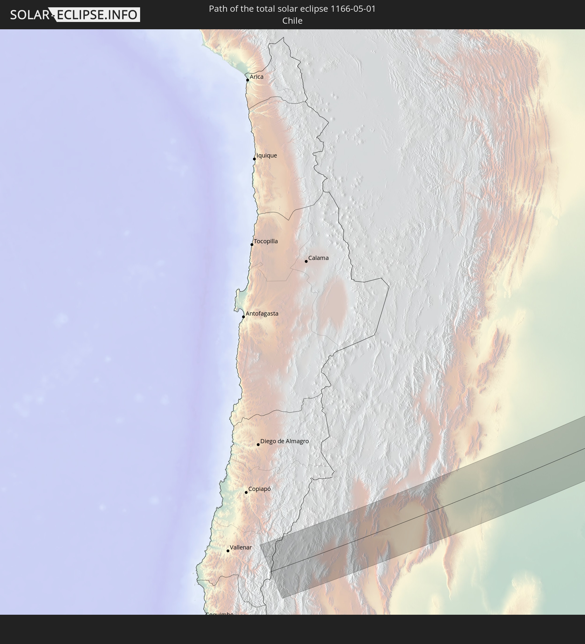 Chile
Chile
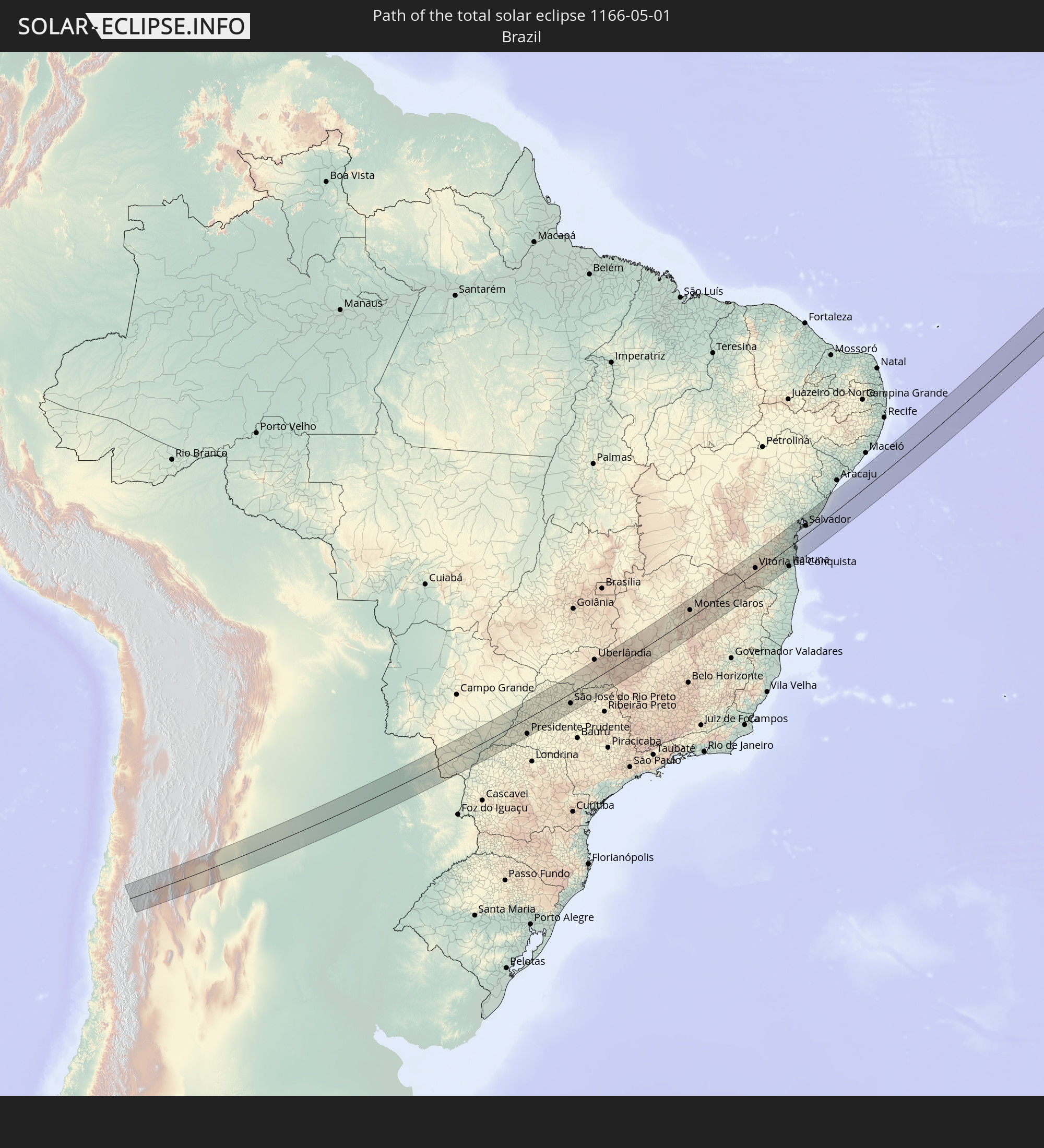 Brasilien
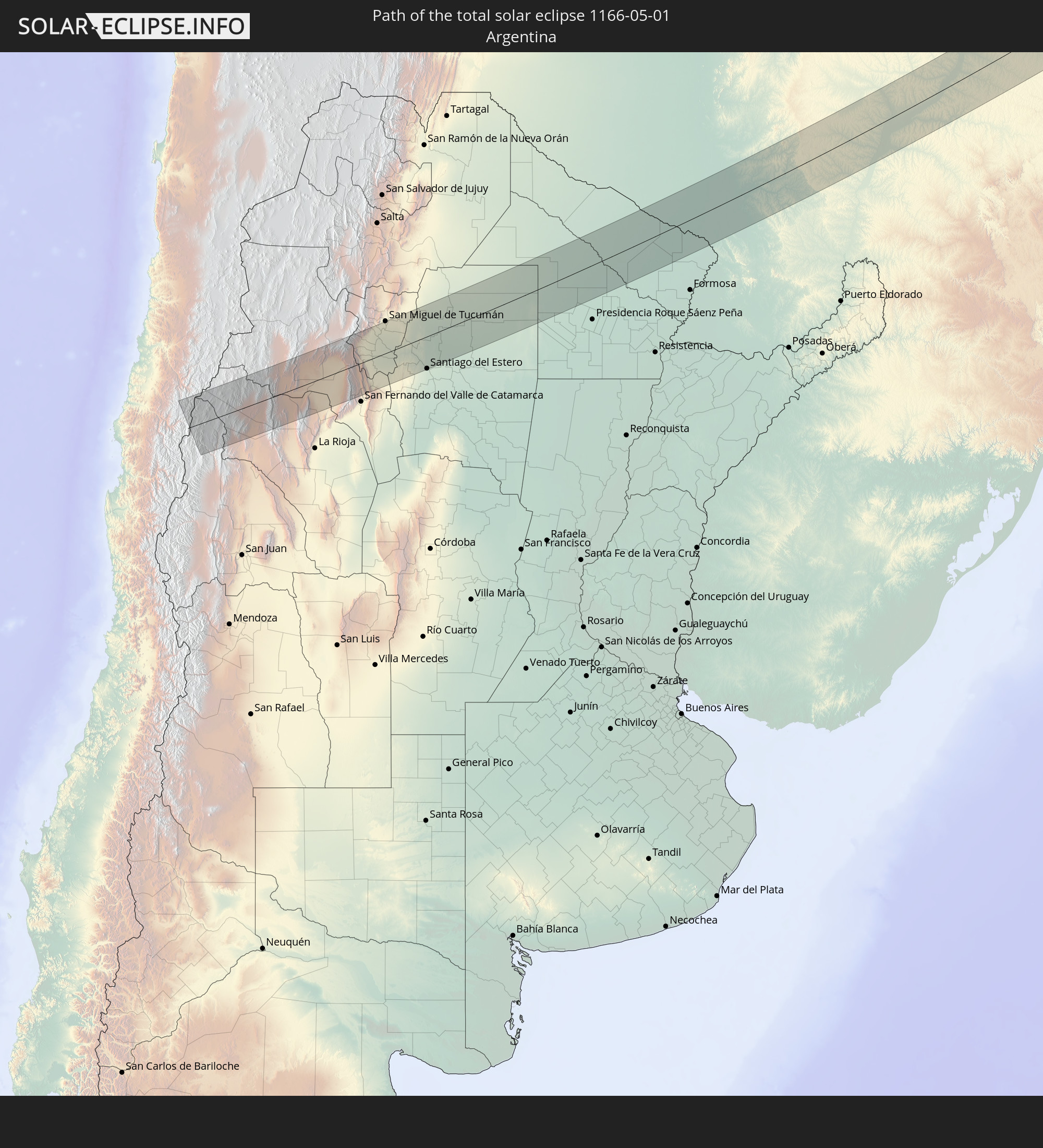 Argentinien
 Paraguay
 Guinea
 Sierra Leone
 Mali
Mali
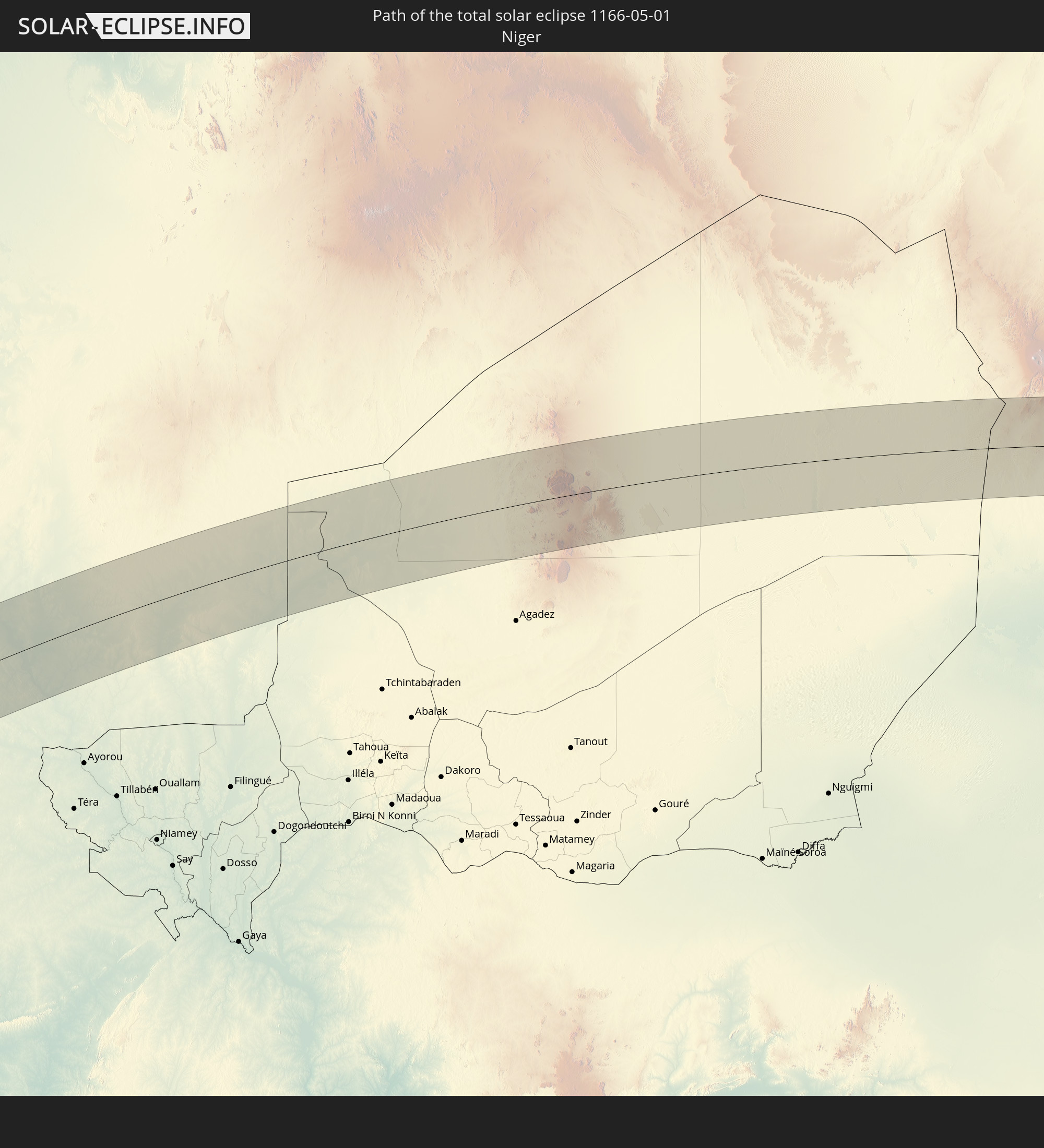 Niger
Niger
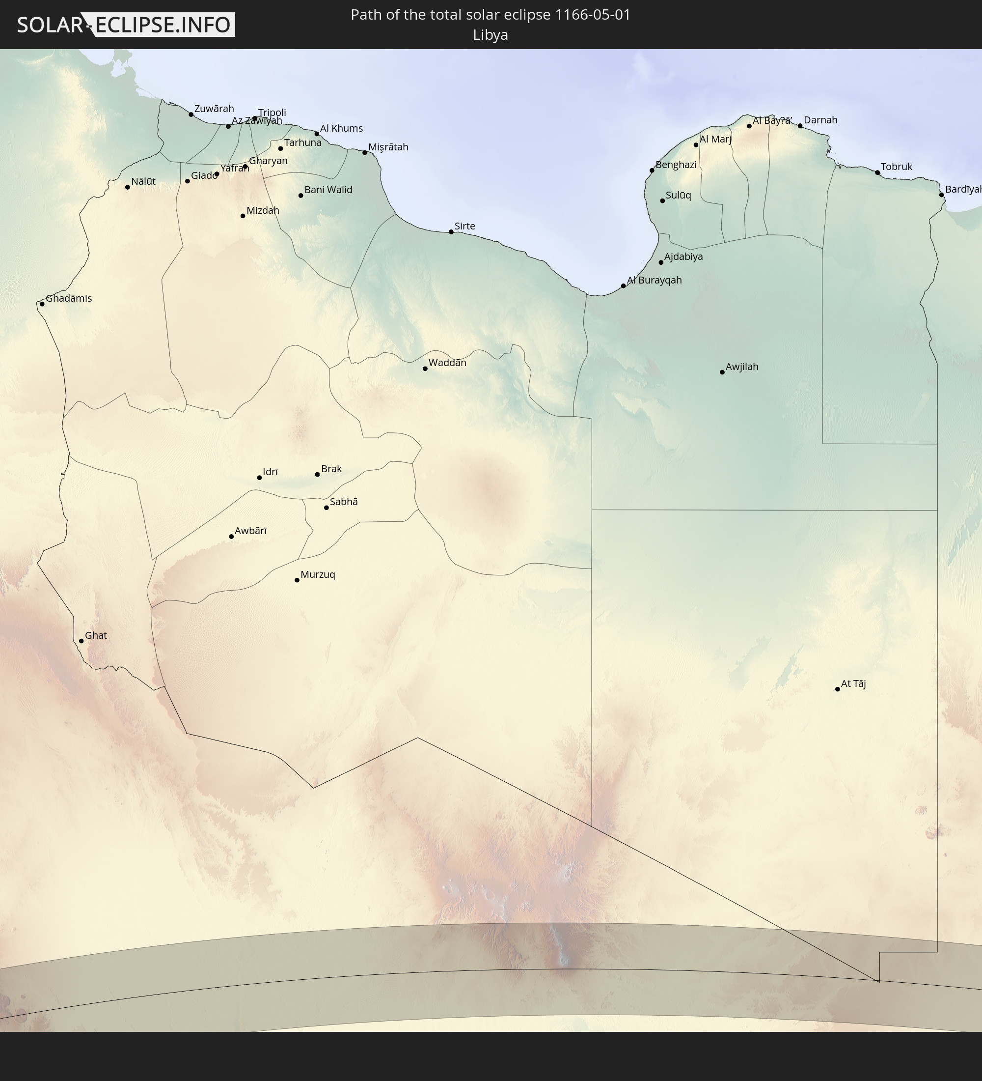 Libyen
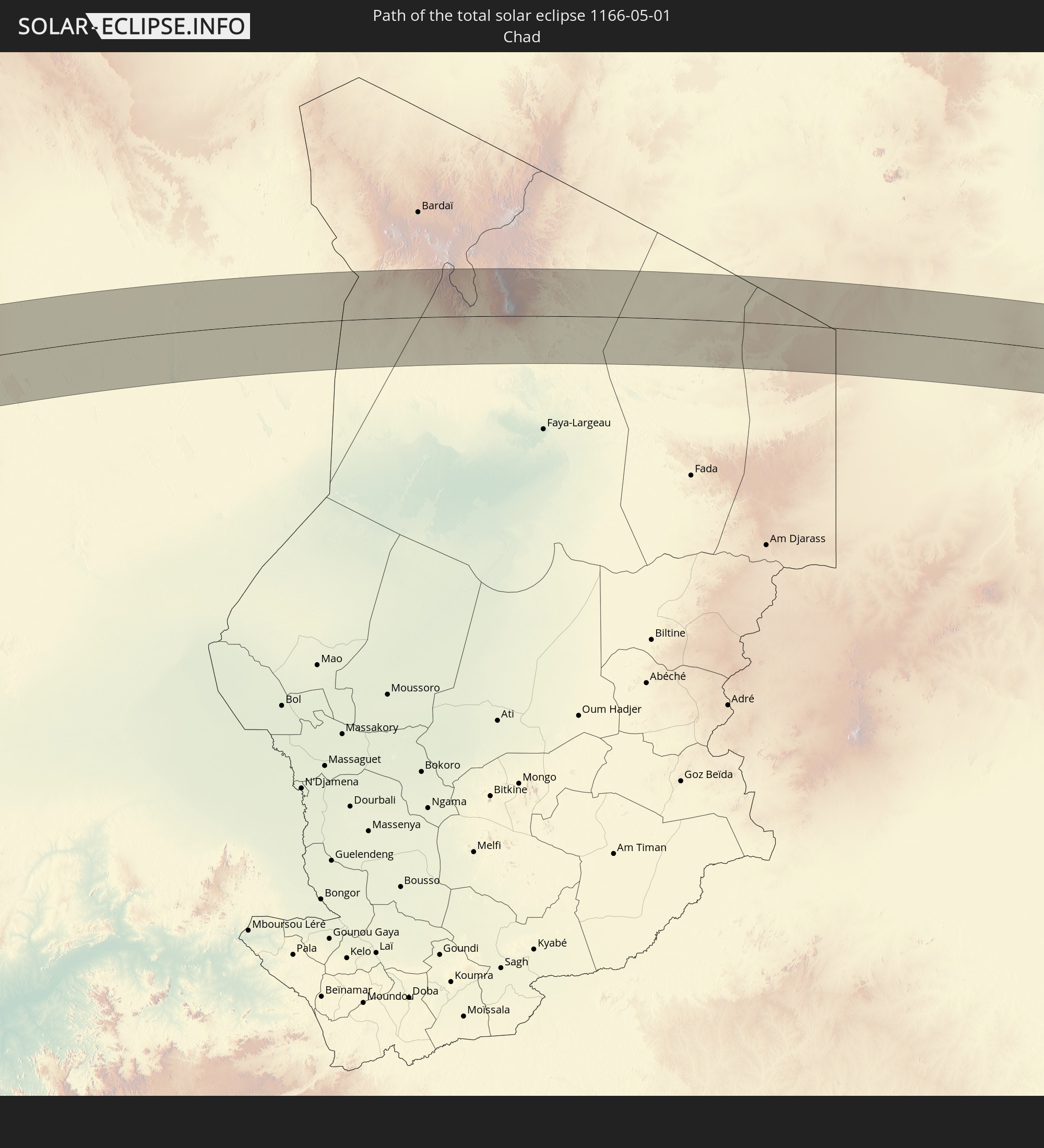 Tschad
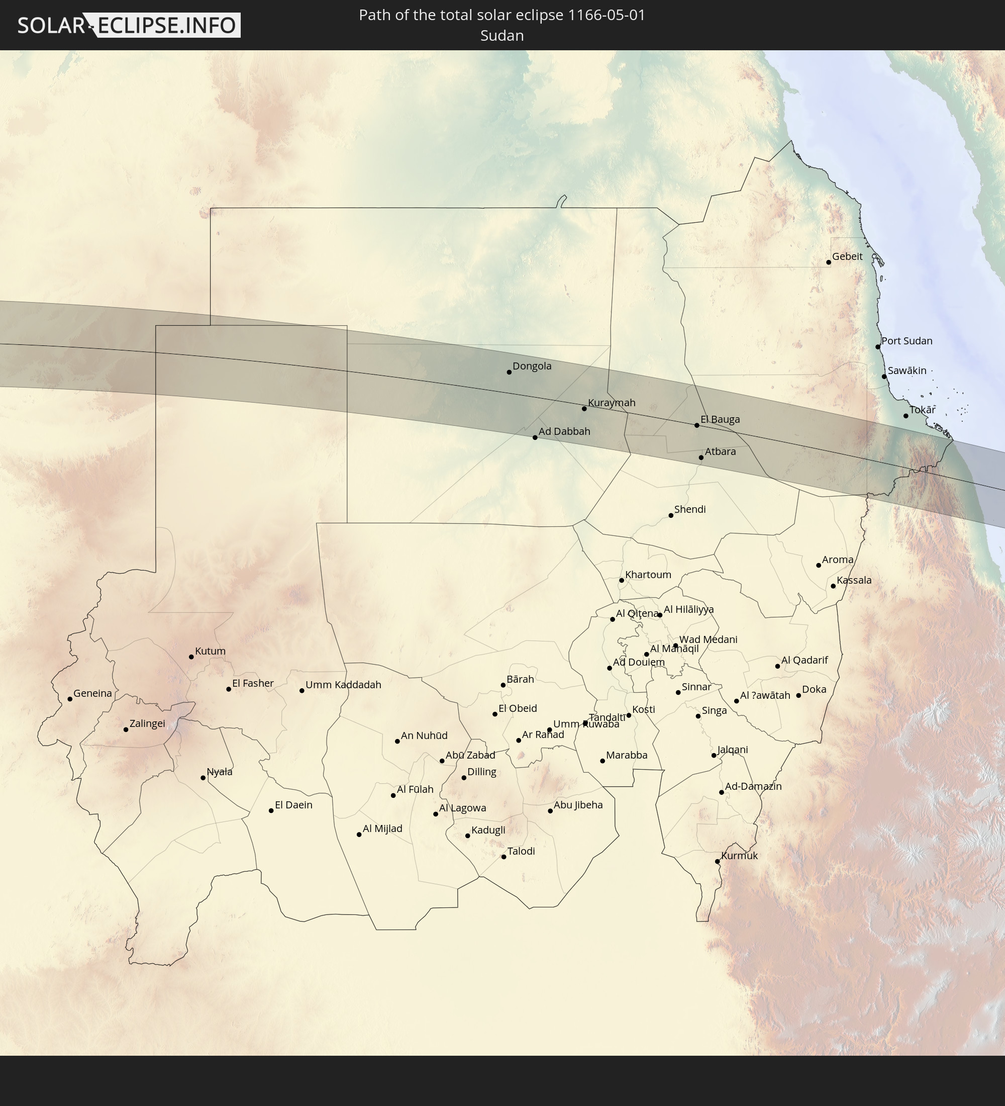 Sudan
Sudan
 Saudi-Arabien
 Eritrea
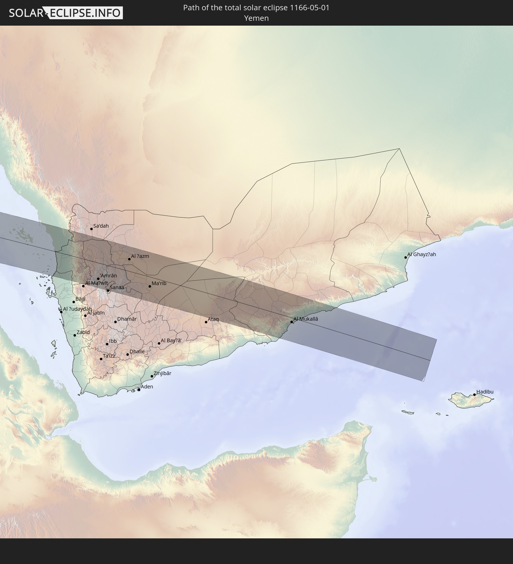 Jemen
Jemen
In den folgenden Ländern ist die Sonnenfinsternis partiell zu sehen
 Russland
 Chile
Chile
 Ecuador
 Kolumbien
 Peru
Peru
 Brasilien
 Argentinien
 Venezuela
 Bolivien
 Paraguay
 Trinidad und Tobago
 Falklandinseln
 Guyana
 Uruguay
 Suriname
 Französisch-Guayana
 Südgeorgien und die Südlichen Sandwichinseln
 Portugal
 Kap Verde
 Spanien
 Senegal
 Mauretanien
 Gambia
 Guinea-Bissau
 Guinea
 St. Helena
 Sierra Leone
 Marokko
 Mali
Mali
 Liberia
 Algerien
 Elfenbeinküste
 Burkina Faso
 Gibraltar
 Frankreich
 Ghana
Ghana
 Togo
Togo
 Niger
Niger
 Benin
Benin
 Andorra
 Belgien
 Nigeria
 Äquatorialguinea
 Luxemburg
 Deutschland
 Schweiz
 São Tomé und Príncipe
 Italien
 Monaco
 Tunesien
 Kamerun
 Gabun
Gabun
 Libyen
 Liechtenstein
 Österreich
 Republik Kongo
 Angola
 Tschechien
 Demokratische Republik Kongo
 San Marino
 Vatikanstadt
 Slowenien
 Tschad
 Kroatien
 Polen
Polen
 Malta
Malta
 Zentralafrikanische Republik
 Bosnien und Herzegowina
 Ungarn
 Slowakei
 Montenegro
 Serbien
 Albanien
 Griechenland
 Rumänien
 Mazedonien
 Sudan
Sudan
 Sambia
 Ukraine
 Bulgarien
 Ägypten
 Türkei
 Moldawien
 Ruanda
 Burundi
 Tansania
 Uganda
 Mosambik
 Republik Zypern
 Malawi
 Äthiopien
 Kenia
Kenia
 Staat Palästina
 Israel
 Saudi-Arabien
 Jordanien
 Libanon
 Syrien
 Eritrea
 Irak
Irak
 Georgien
 Französische Süd- und Antarktisgebiete
 Somalia
 Dschibuti
 Jemen
Jemen
 Madagaskar
 Komoren
 Armenien
 Iran
Iran
 Aserbaidschan
 Mayotte
 Seychellen
 Kasachstan
 Kuwait
 Bahrain
 Katar
Katar
 Vereinigte Arabische Emirate
 Oman
Oman
 Turkmenistan
 Usbekistan
 Afghanistan
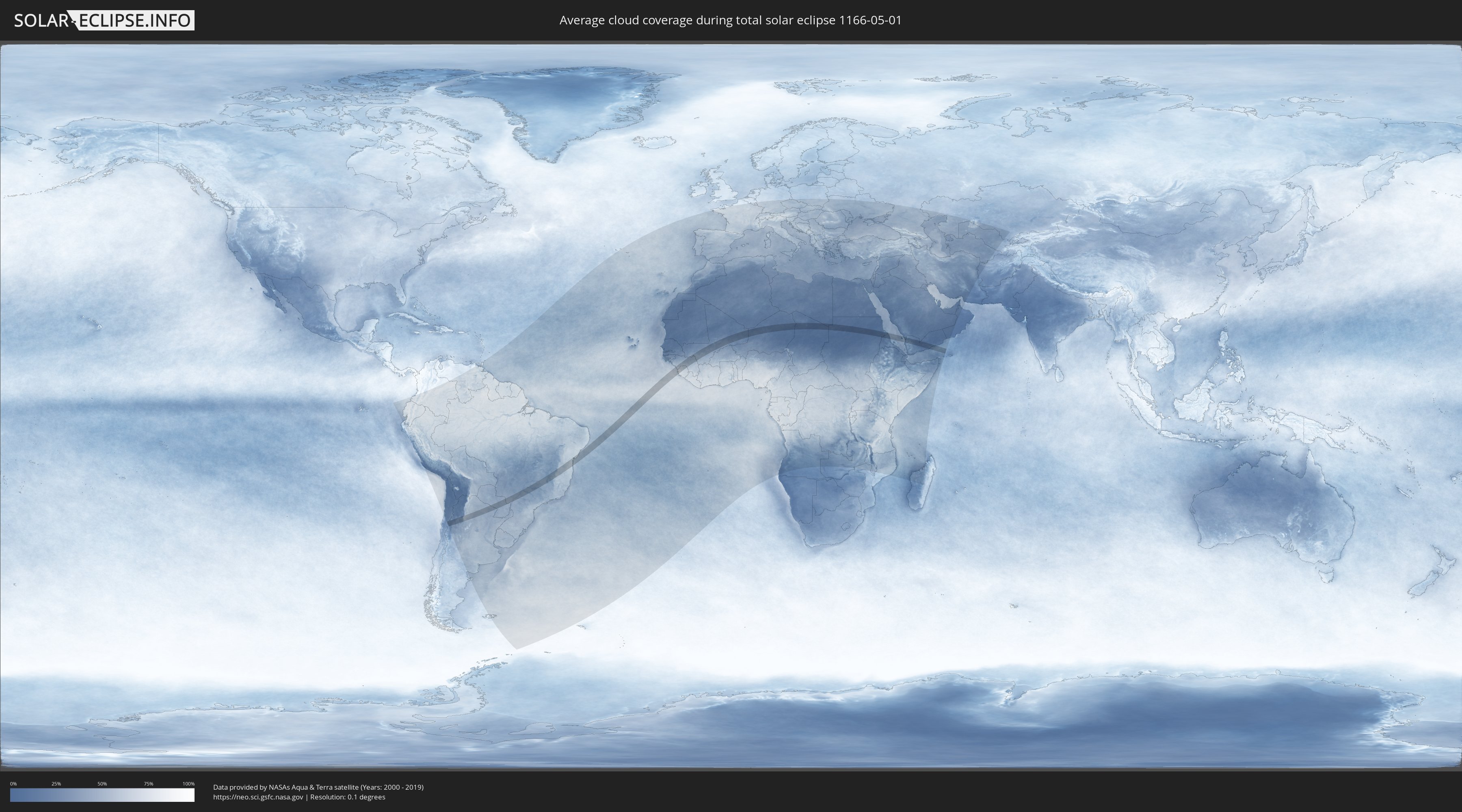
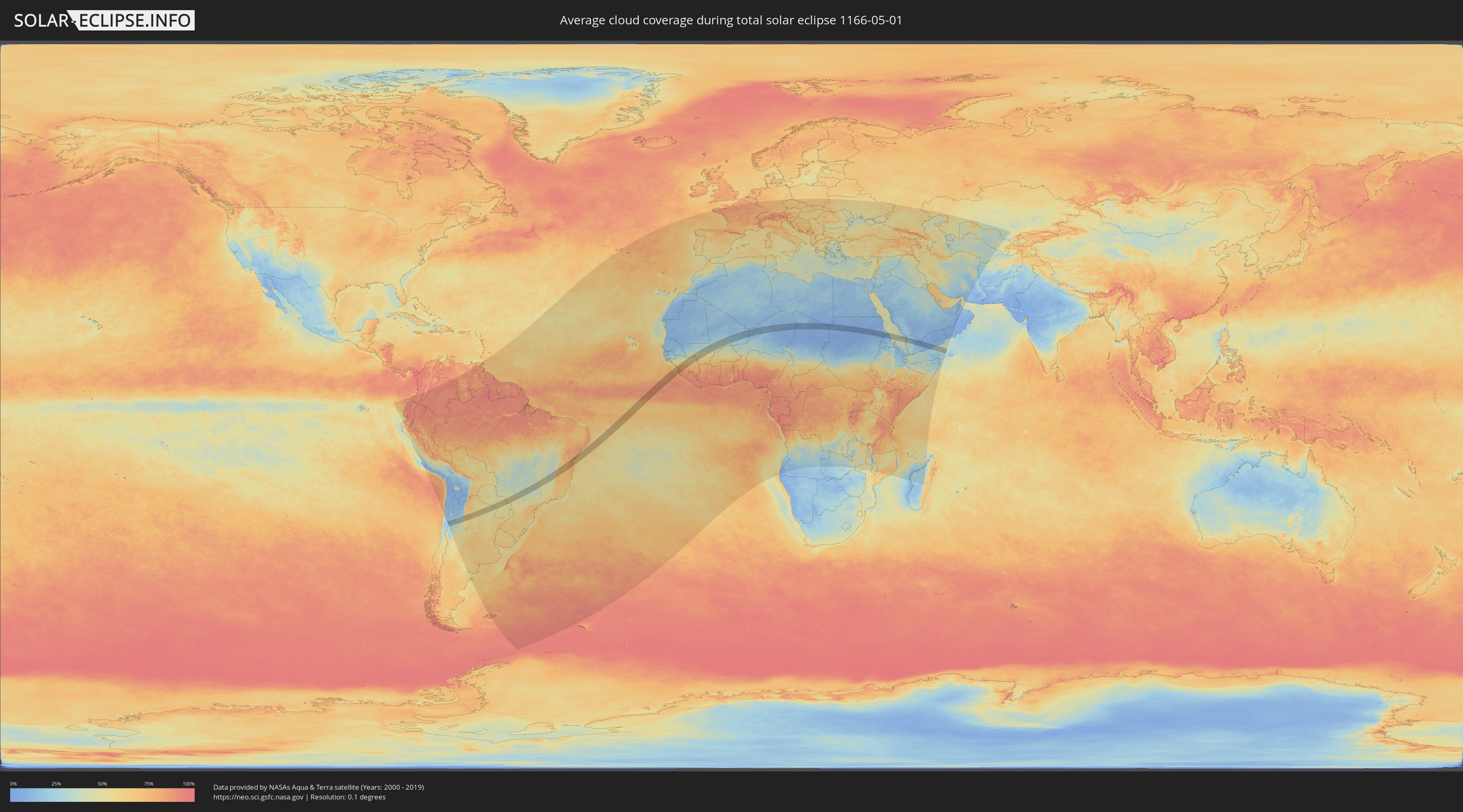
Wie wird das Wetter während der totalen Sonnenfinsternis am 01.05.1166?
Wo ist der beste Ort, um die totale Sonnenfinsternis vom 01.05.1166 zu beobachten?
Die folgenden Karten zeigen die durchschnittliche Bewölkung für den Tag, an dem die totale Sonnenfinsternis
stattfindet. Mit Hilfe der Karten lässt sich der Ort entlang des Finsternispfades eingrenzen,
der die besten Aussichen auf einen klaren wolkenfreien Himmel bietet.
Trotzdem muss man immer lokale Gegenenheiten beachten und sollte sich genau über das Wetter an seinem
gewählten Beobachtungsort informieren.
Die Daten stammen von den beiden NASA-Satelliten
AQUA und TERRA
und wurden über einen Zeitraum von 19 Jahren (2000 - 2019) gemittelt.
Detaillierte Länderkarten
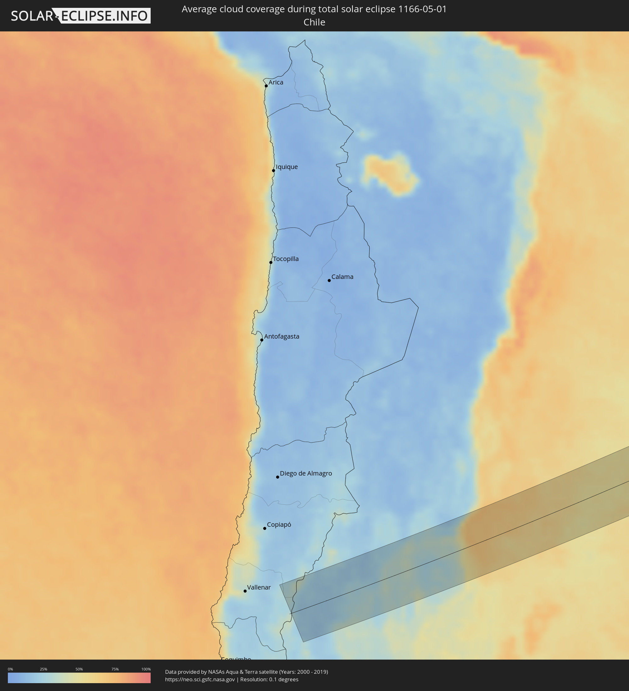 Chile
Chile
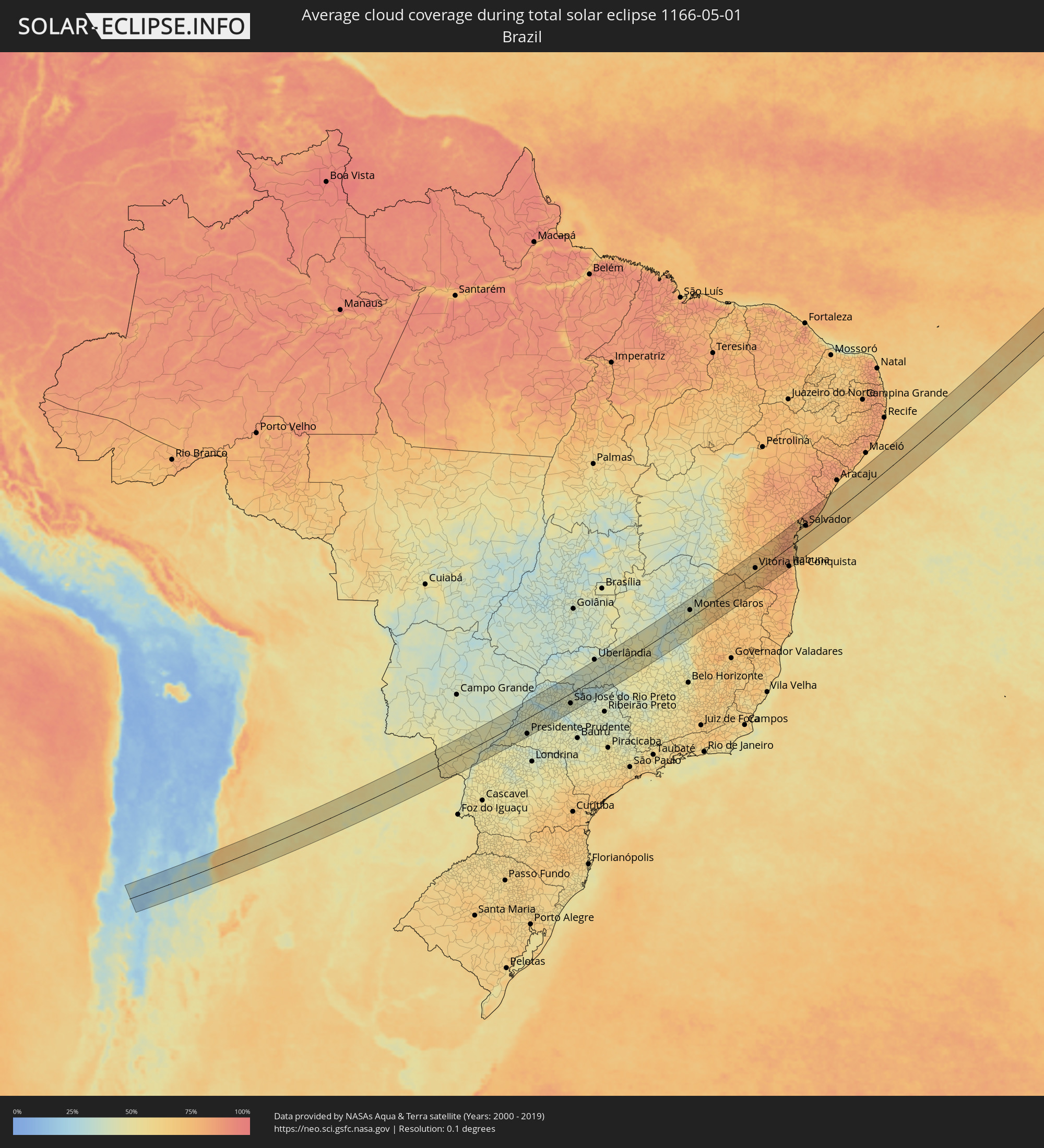 Brasilien
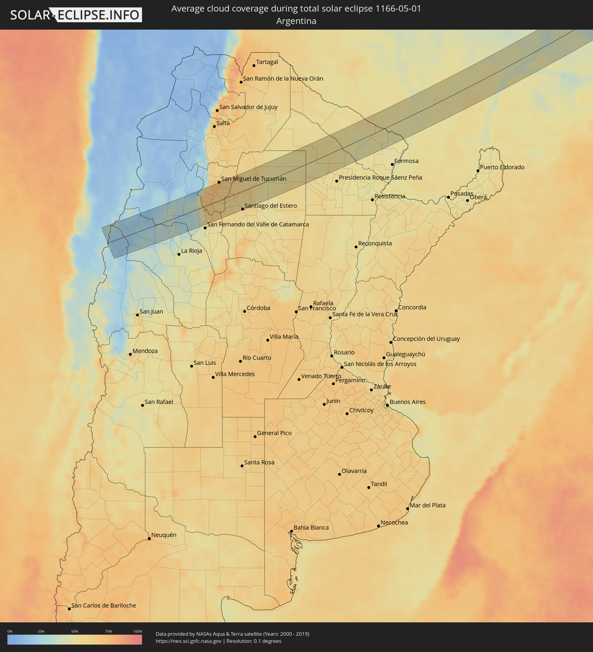 Argentinien
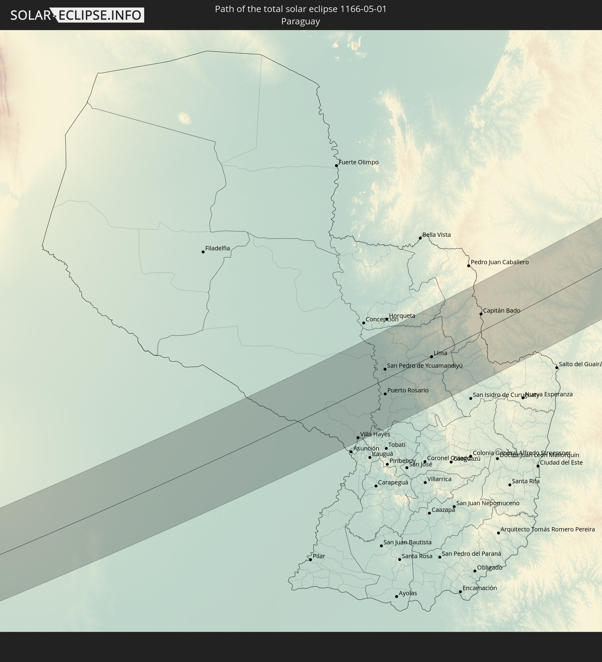
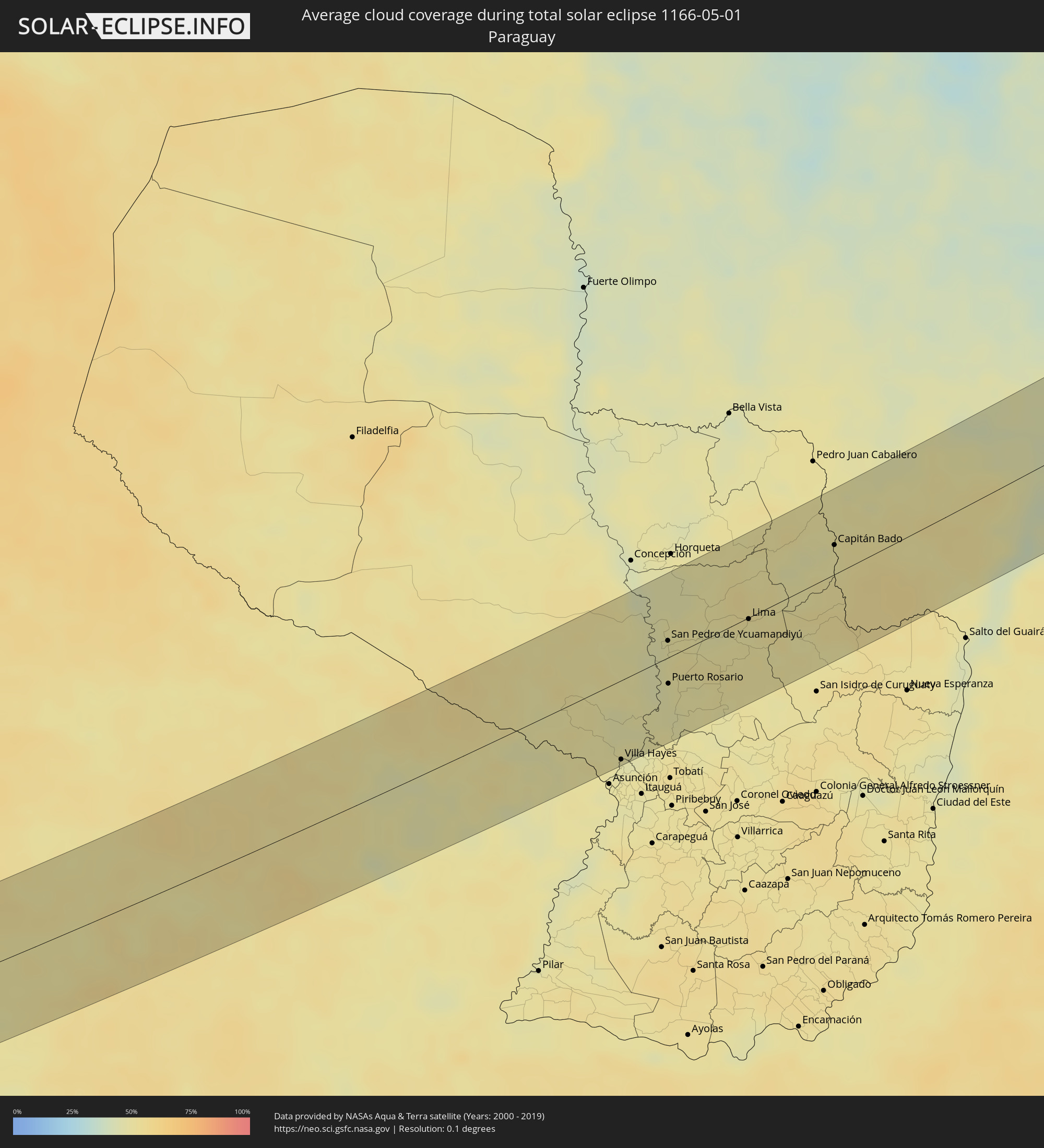 Paraguay
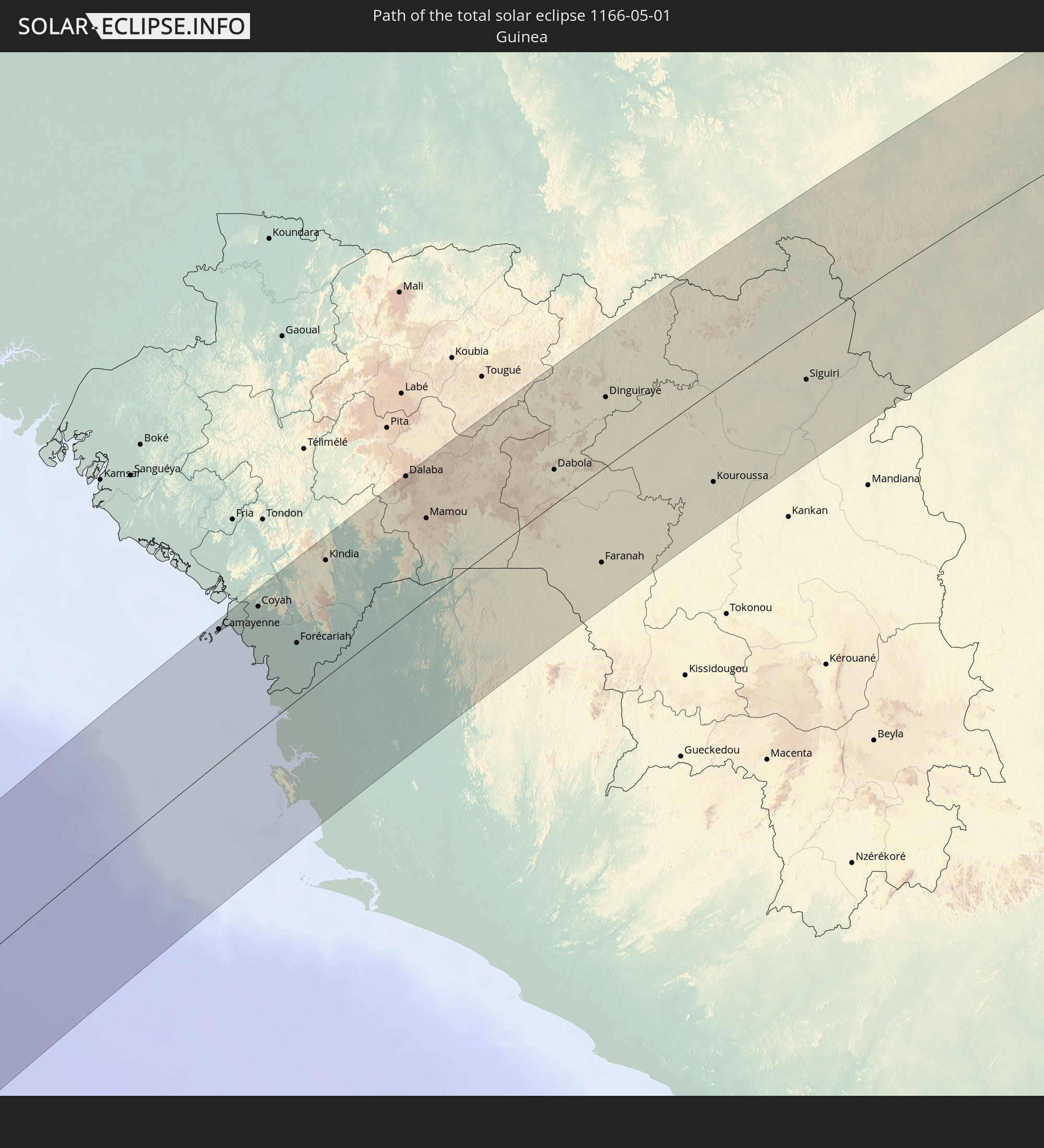
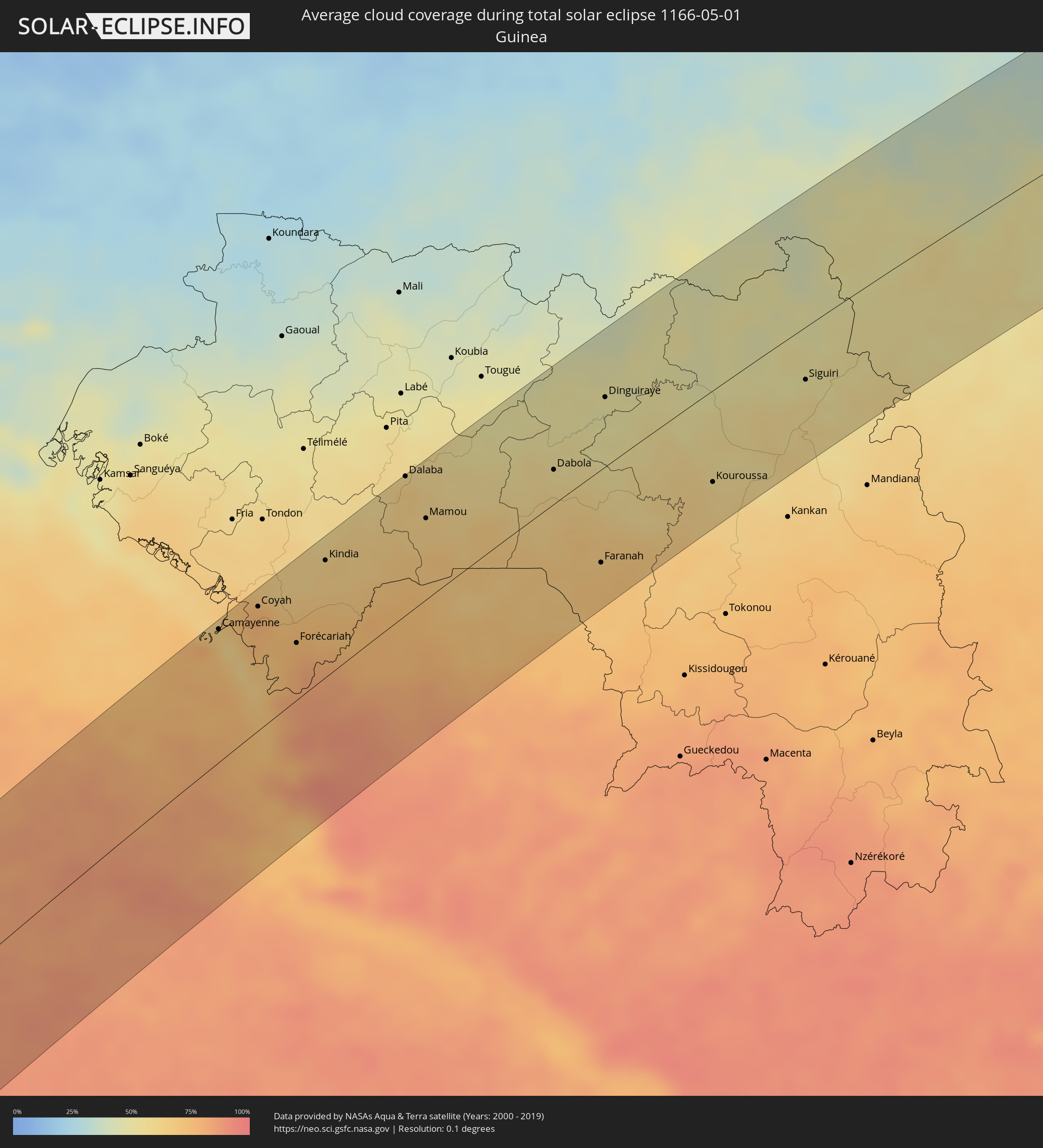 Guinea
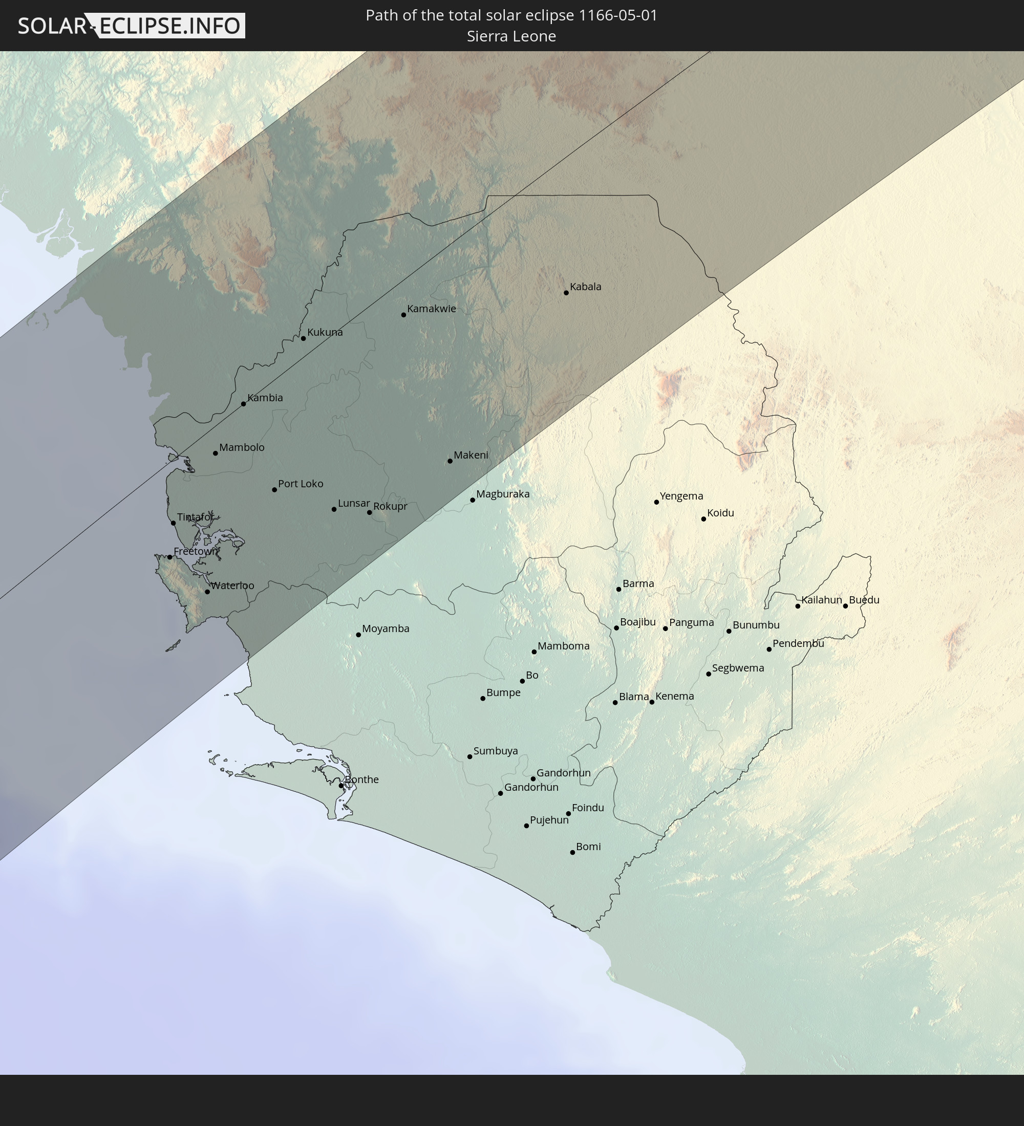
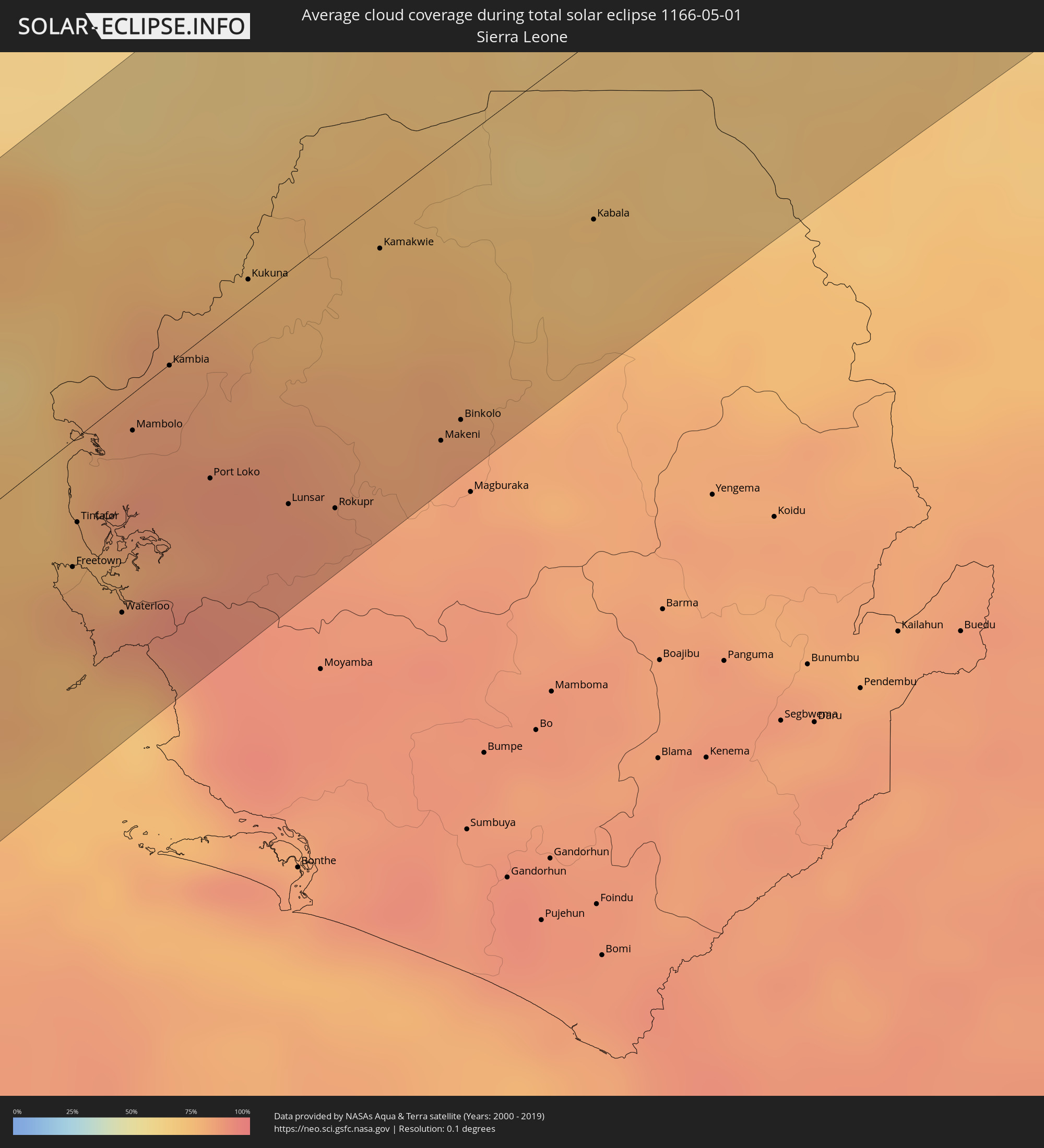 Sierra Leone
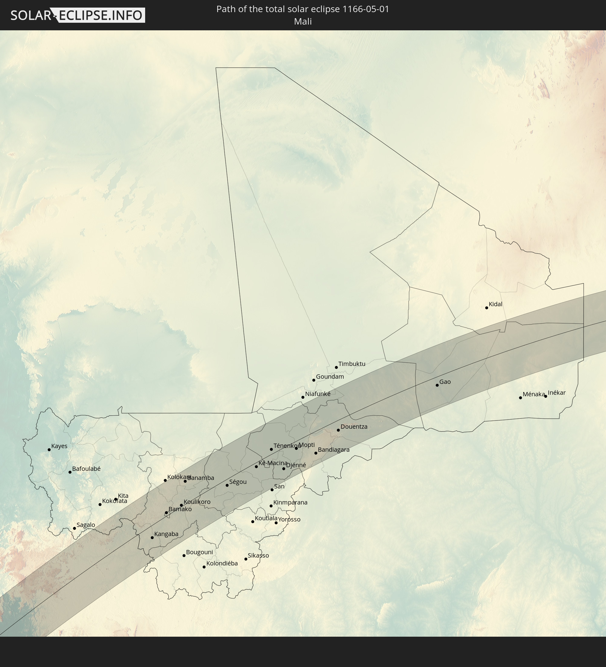
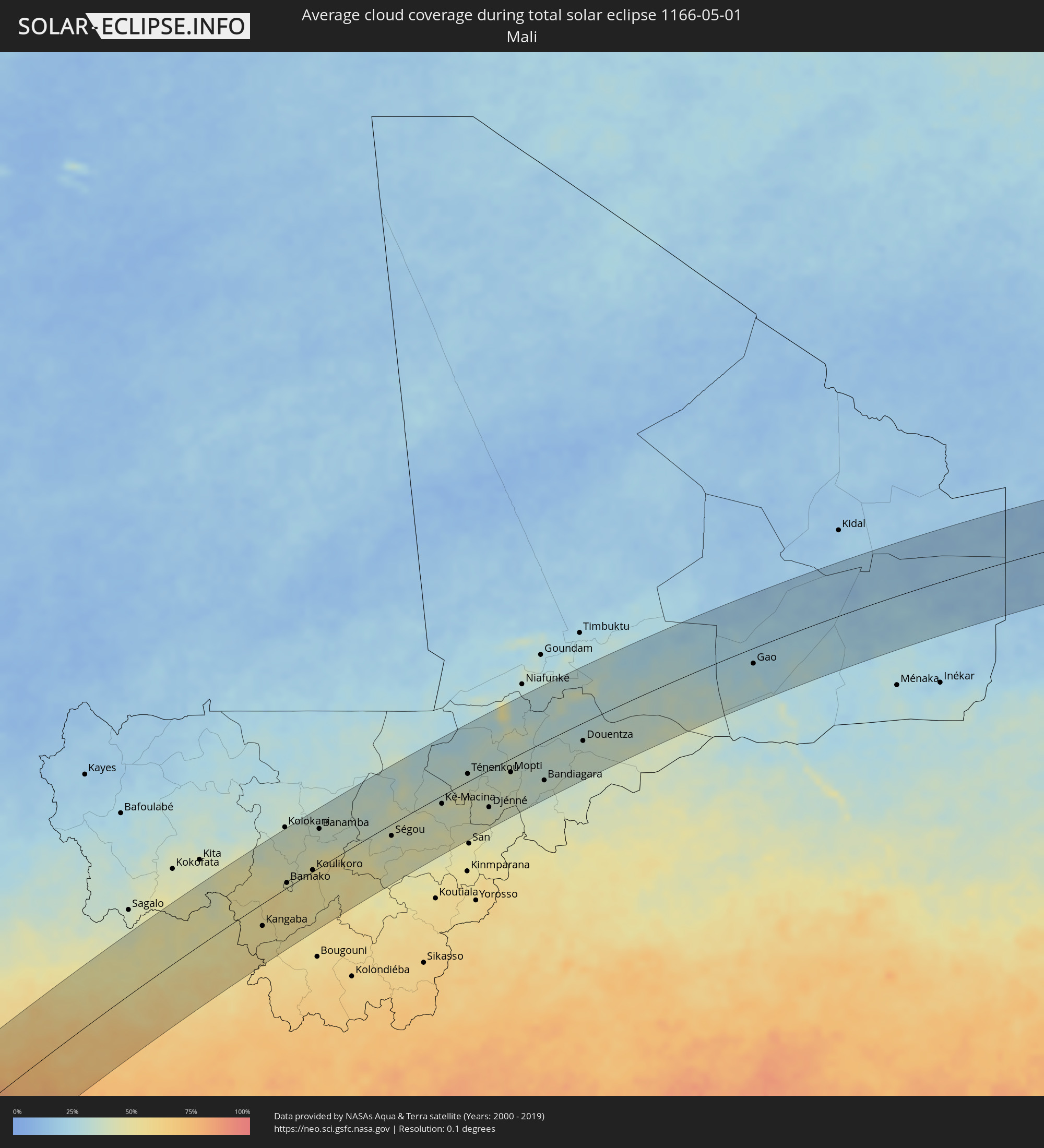 Mali
Mali
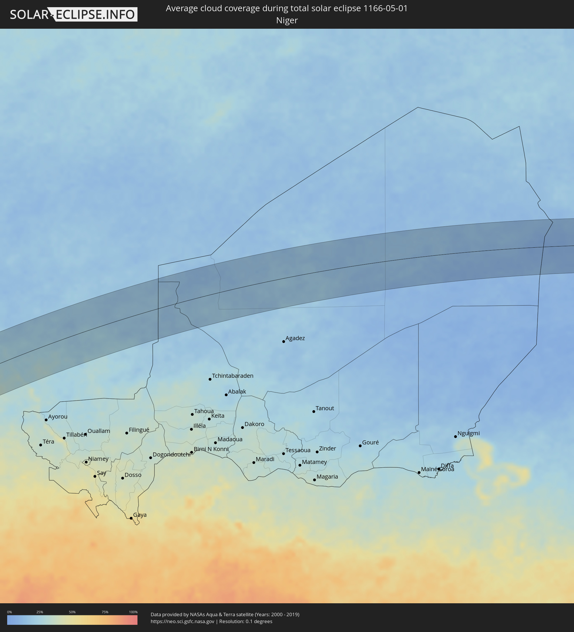 Niger
Niger
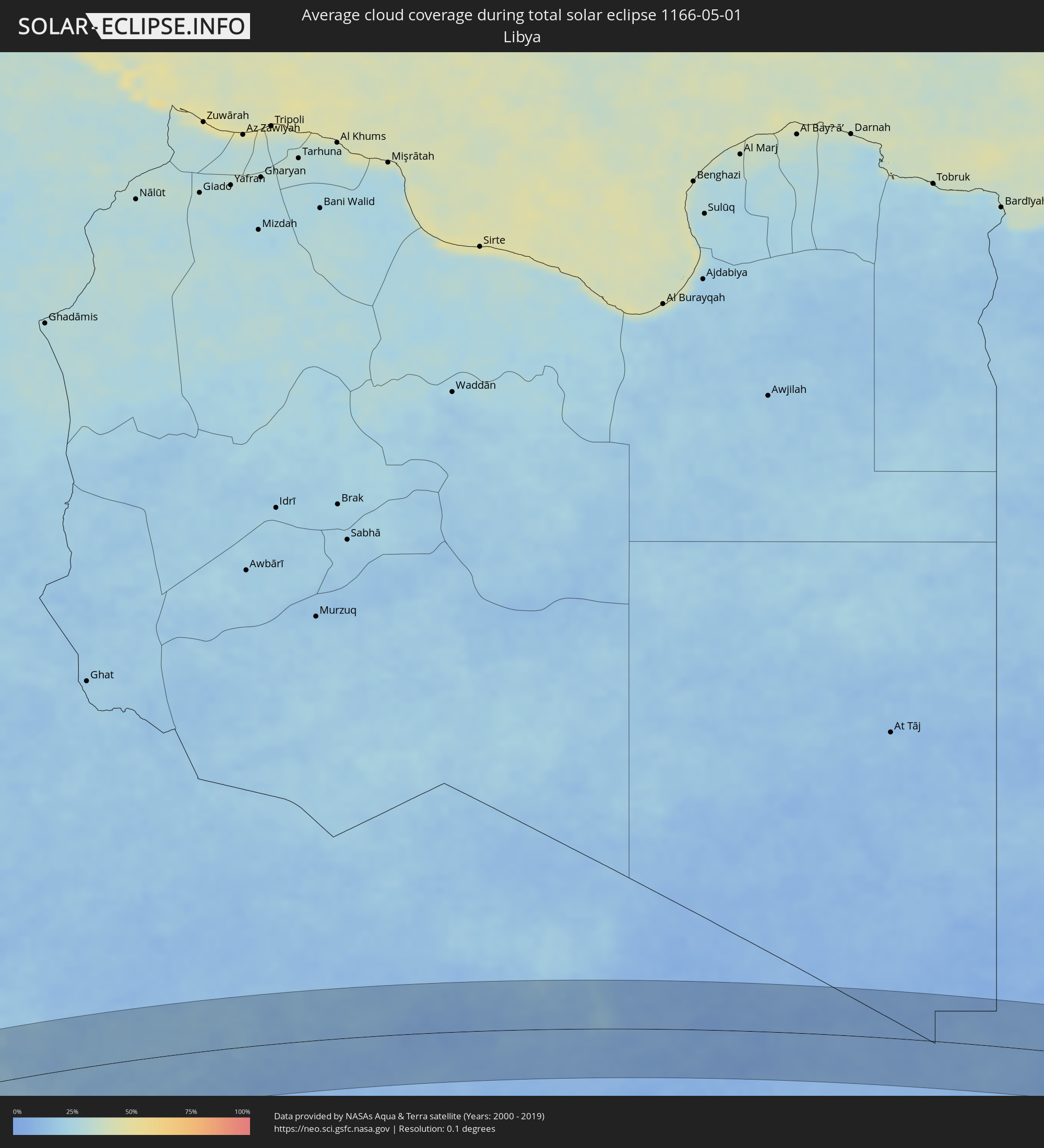 Libyen
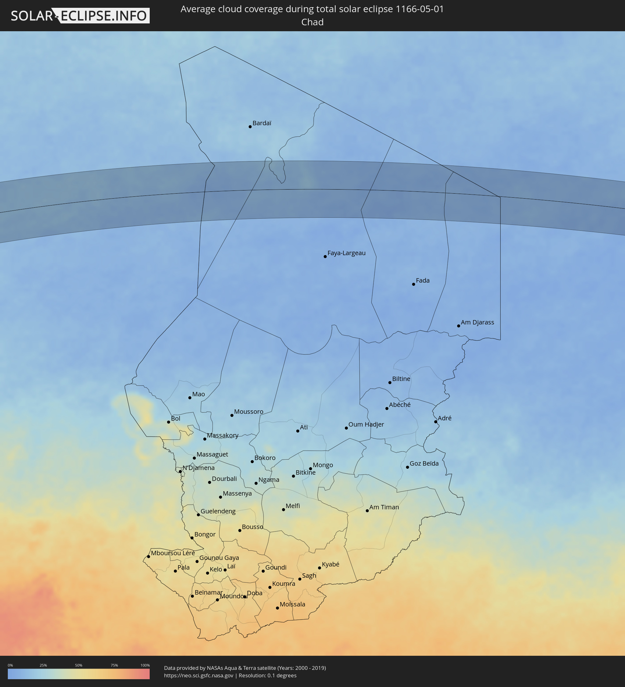 Tschad
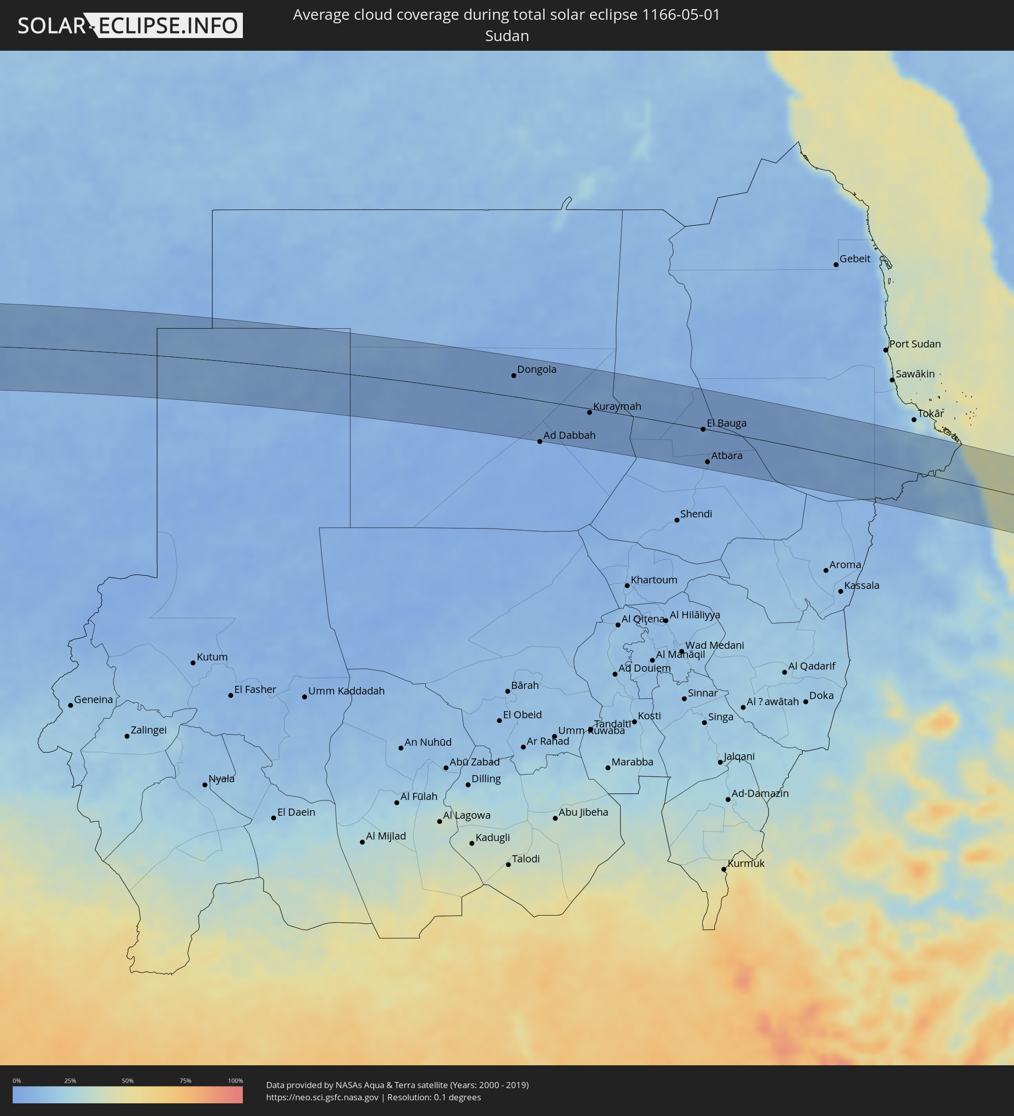 Sudan
Sudan
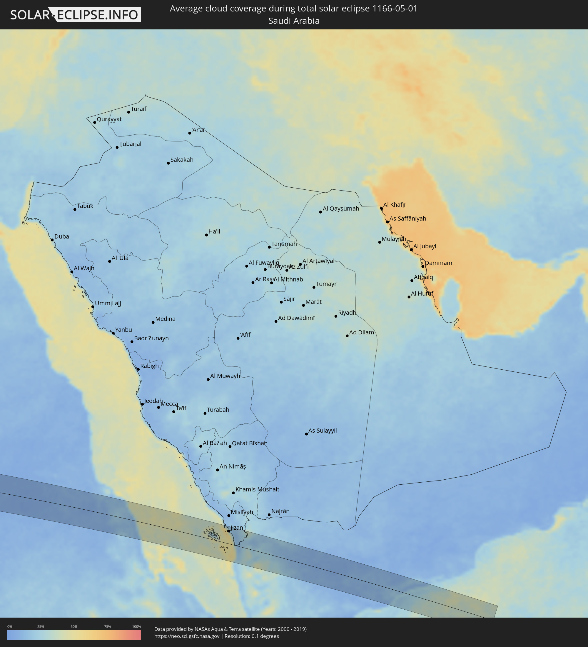 Saudi-Arabien
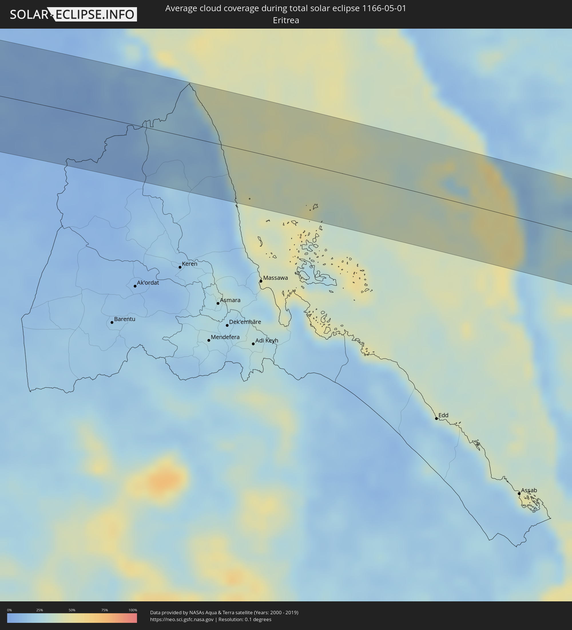 Eritrea
 Jemen
Jemen
Orte im Finsternispfad
Die nachfolgene Tabelle zeigt Städte und Orte mit mehr als 5.000 Einwohnern, die sich im Finsternispfad befinden. Städte mit mehr als 100.000 Einwohnern sind dick gekennzeichnet. Mit einem Klick auf den Ort öffnet sich eine Detailkarte die die Lage des jeweiligen Ortes zusammen mit dem Verlauf der zentralen Finsternis präsentiert.
| Ort | Typ | Dauer der Verfinsterung | Ortszeit bei maximaler Verfinsterung | Entfernung zur Zentrallinie | Ø Bewölkung |
|
Fiambalá, Catamarca Province
|
total | - | 06:56:46 UTC-04:16 | 64 km | 25% |
|
Tinogasta, Catamarca Province
|
total | - | 06:56:46 UTC-04:16 | 23 km | 31% |
|
Arauco, La Rioja Province
|
total | - | 06:56:48 UTC-04:16 | 57 km | 32% |
|
Andalgalá, Catamarca Province
|
total | - | 06:56:52 UTC-04:16 | 27 km | 32% |
|
Aguilares, Tucumán Province
|
total | - | 06:56:57 UTC-04:16 | 19 km | 66% |
|
La Cocha, Tucumán Province
|
total | - | 06:56:56 UTC-04:16 | 18 km | 67% |
|
Los Altos, Catamarca Province
|
total | - | 06:56:56 UTC-04:16 | 48 km | 64% |
|
Monteros, Tucumán Province
|
total | - | 06:56:59 UTC-04:16 | 43 km | 67% |
|
Famaillá, Tucumán Province
|
total | - | 06:57:00 UTC-04:16 | 51 km | 66% |
|
Simoca, Tucumán Province
|
total | - | 06:56:59 UTC-04:16 | 28 km | 66% |
|
Bella Vista, Tucumán Province
|
total | - | 06:57:01 UTC-04:16 | 49 km | 67% |
|
San Miguel de Tucumán, Tucumán Province
|
total | - | 06:57:02 UTC-04:16 | 68 km | 68% |
|
Termas de Río Hondo, Santiago del Estero Province
|
total | - | 06:57:02 UTC-04:16 | 15 km | 55% |
|
Santiago del Estero, Santiago del Estero Province
|
total | - | 06:57:05 UTC-04:16 | 68 km | 60% |
|
Clodomira, Santiago del Estero Province
|
total | - | 06:57:07 UTC-04:16 | 50 km | 59% |
|
Los Frentones, Chaco Province
|
total | - | 06:57:43 UTC-04:16 | 36 km | 53% |
|
Pampa del Infierno, Chaco Province
|
total | - | 06:57:45 UTC-04:16 | 56 km | 52% |
|
Castelli, Chaco Province
|
total | - | 06:57:58 UTC-04:16 | 22 km | 57% |
|
Tres Isletas, Chaco Province
|
total | - | 06:57:57 UTC-04:16 | 69 km | 53% |
|
Pampa del Indio, Chaco Province
|
total | - | 06:58:07 UTC-04:16 | 63 km | 52% |
|
Ibarreta, Formosa Province
|
total | - | 06:58:17 UTC-04:16 | 21 km | 49% |
|
Comandante Fontana, Formosa Province
|
total | - | 06:58:18 UTC-04:16 | 1 km | 47% |
|
Pirané, Formosa Province
|
total | - | 06:58:23 UTC-04:16 | 63 km | 49% |
|
Benjamín Aceval, Presidente Hayes
|
total | - | 07:25:08 UTC-03:50 | 53 km | 49% |
|
Villa Hayes, Presidente Hayes
|
total | - | 07:25:07 UTC-03:50 | 67 km | 48% |
|
San Pedro de Ycuamandiyú, San Pedro
|
total | - | 07:25:31 UTC-03:50 | 14 km | 48% |
|
Puerto Rosario, San Pedro
|
total | - | 07:25:25 UTC-03:50 | 22 km | 47% |
|
Lima, San Pedro
|
total | - | 07:25:50 UTC-03:50 | 1 km | 49% |
|
Capitán Bado, Amambay
|
total | - | 07:26:19 UTC-03:50 | 25 km | 49% |
|
Presidente Prudente, São Paulo
|
total | - | 08:12:48 UTC-03:06 | 64 km | 41% |
|
Andradina, São Paulo
|
total | - | 08:13:21 UTC-03:06 | 55 km | 40% |
|
Araçatuba, São Paulo
|
total | - | 08:13:43 UTC-03:06 | 24 km | 40% |
|
Fernandópolis, São Paulo
|
total | - | 08:14:16 UTC-03:06 | 55 km | 41% |
|
Penápolis, São Paulo
|
total | - | 08:13:49 UTC-03:06 | 63 km | 41% |
|
Votuporanga, São Paulo
|
total | - | 08:14:21 UTC-03:06 | 27 km | 43% |
|
São José do Rio Preto, São Paulo
|
total | - | 08:14:30 UTC-03:06 | 42 km | 43% |
|
Olímpia, São Paulo
|
total | - | 08:14:50 UTC-03:06 | 59 km | 39% |
|
Barretos, São Paulo
|
total | - | 08:15:08 UTC-03:06 | 60 km | 38% |
|
Uberaba, Minas Gerais
|
total | - | 08:15:58 UTC-03:06 | 18 km | 41% |
|
Patrocínio, Minas Gerais
|
total | - | 08:17:04 UTC-03:06 | 6 km | 42% |
|
Araxá, Minas Gerais
|
total | - | 08:16:43 UTC-03:06 | 58 km | 44% |
|
Patos de Minas, Minas Gerais
|
total | - | 08:17:37 UTC-03:06 | 14 km | 47% |
|
Pirapora, Minas Gerais
|
total | - | 08:19:36 UTC-03:06 | 39 km | 35% |
|
Montes Claros, Minas Gerais
|
total | - | 08:20:54 UTC-03:06 | 31 km | 44% |
|
Vitória da Conquista, Bahia
|
total | - | 08:57:33 UTC-02:34 | 16 km | 68% |
|
Itapetinga, Bahia
|
total | - | 08:57:47 UTC-02:34 | 56 km | 78% |
|
Jequié, Bahia
|
total | - | 08:59:12 UTC-02:34 | 58 km | 71% |
|
Itabuna, Bahia
|
total | - | 08:59:08 UTC-02:34 | 77 km | 81% |
|
Valença, Bahia
|
total | - | 09:00:41 UTC-02:34 | 36 km | 75% |
|
Salvador, Bahia
|
total | - | 09:01:40 UTC-02:34 | 34 km | 67% |
|
Lauro de Freitas, Bahia
|
total | - | 09:01:56 UTC-02:34 | 29 km | 67% |
|
Camaçari, Bahia
|
total | - | 09:02:09 UTC-02:34 | 46 km | 77% |
|
Camayenne, Conakry
|
total | - | 12:37:54 UTC-00:16 | 88 km | 71% |
|
Conakry, Conakry
|
total | - | 12:37:56 UTC-00:16 | 87 km | 71% |
|
Coyah, Kindia
|
total | - | 12:38:55 UTC-00:16 | 82 km | 78% |
|
Freetown, Western Area
|
total | - | 12:36:48 UTC-00:16 | 36 km | 79% |
|
Freetown, Western Area
|
total | - | 12:37:02 UTC-00:16 | 35 km | 81% |
|
Tintafor, Northern Province
|
total | - | 12:37:20 UTC-00:16 | 24 km | 76% |
|
Hastings, Western Area
|
total | - | 12:37:04 UTC-00:16 | 51 km | 86% |
|
Kassiri, Northern Province
|
total | - | 12:38:09 UTC-00:16 | 3 km | 81% |
|
Forécariah, Kindia
|
total | - | 12:39:07 UTC-00:16 | 38 km | 76% |
|
Waterloo, Western Area
|
total | - | 12:37:09 UTC-00:16 | 59 km | 82% |
|
Mambolo, Northern Province
|
total | - | 12:38:18 UTC-00:16 | 10 km | 85% |
|
Kambia, Northern Province
|
total | - | 12:38:57 UTC-00:16 | 0 km | 84% |
|
Kindia, Kindia
|
total | - | 12:40:47 UTC-00:16 | 78 km | 63% |
|
Port Loko, Northern Province
|
total | - | 12:38:36 UTC-00:16 | 41 km | 88% |
|
Kukuna, Northern Province
|
total | - | 12:40:03 UTC-00:16 | 6 km | 77% |
|
Lunsar, Northern Province
|
total | - | 12:39:03 UTC-00:16 | 65 km | 88% |
|
Rokupr, Northern Province
|
total | - | 12:39:24 UTC-00:16 | 76 km | 87% |
|
Dalaba, Mamou
|
total | - | 12:43:23 UTC-00:16 | 93 km | 64% |
|
Kamakwie, Northern Province
|
total | - | 12:41:15 UTC-00:16 | 13 km | 75% |
|
Mamou, Mamou
|
total | - | 12:43:11 UTC-00:16 | 55 km | 63% |
|
Makeni, Northern Province
|
total | - | 12:40:36 UTC-00:16 | 80 km | 84% |
|
Binkolo, Northern Province
|
total | - | 12:40:53 UTC-00:16 | 79 km | 82% |
|
Kabala, Northern Province
|
total | - | 12:43:04 UTC-00:16 | 51 km | 70% |
|
Dabola, Faranah
|
total | - | 12:46:12 UTC-00:16 | 23 km | 58% |
|
Faranah, Faranah
|
total | - | 12:45:50 UTC-00:16 | 63 km | 70% |
|
Dinguiraye, Faranah
|
total | - | 12:48:07 UTC-00:16 | 47 km | 48% |
|
Kouroussa, Kankan
|
total | - | 12:49:01 UTC-00:16 | 63 km | 60% |
|
Siguiri, Kankan
|
total | - | 12:52:06 UTC-00:16 | 37 km | 56% |
|
Kangaba, Koulikoro
|
total | - | 12:54:50 UTC-00:16 | 35 km | 54% |
|
Kati, Koulikoro
|
total | - | 12:57:01 UTC-00:16 | 21 km | 48% |
|
Bamako, Bamako
|
total | - | 12:57:03 UTC-00:16 | 8 km | 46% |
|
Koulikoro, Koulikoro
|
total | - | 12:58:29 UTC-00:16 | 2 km | 47% |
|
Banamba, Koulikoro
|
total | - | 12:59:52 UTC-00:16 | 61 km | 37% |
|
Ségou, Ségou
|
total | - | 13:02:42 UTC-00:16 | 19 km | 40% |
|
Markala, Ségou
|
total | - | 13:03:30 UTC-00:16 | 1 km | 43% |
|
Ké-Macina, Ségou
|
total | - | 13:05:38 UTC-00:16 | 13 km | 41% |
|
Ténenkou, Mopti
|
total | - | 13:07:28 UTC-00:16 | 12 km | 36% |
|
Djénné, Mopti
|
total | - | 13:07:32 UTC-00:16 | 60 km | 42% |
|
Mopti, Mopti
|
total | - | 13:09:18 UTC-00:16 | 22 km | 40% |
|
Bandiagara, Mopti
|
total | - | 13:10:31 UTC-00:16 | 63 km | 36% |
|
Douentza, Mopti
|
total | - | 13:13:04 UTC-00:16 | 30 km | 35% |
|
Gao, Gao
|
total | - | 13:21:43 UTC-00:16 | 26 km | 27% |
|
Argo, Northern State
|
total | - | 16:41:38 UTC+02:10 | 75 km | 5% |
|
Dongola, Northern State
|
total | - | 16:41:41 UTC+02:10 | 39 km | 7% |
|
Marawī, Northern State
|
total | - | 16:42:49 UTC+02:10 | 16 km | 5% |
|
Kuraymah, Northern State
|
total | - | 16:42:51 UTC+02:10 | 8 km | 4% |
|
El Bauga, River Nile
|
total | - | 16:44:27 UTC+02:10 | 2 km | 8% |
|
Ed Damer, River Nile
|
total | - | 16:44:29 UTC+02:10 | 73 km | 6% |
|
Berber, River Nile
|
total | - | 16:44:30 UTC+02:10 | 27 km | 5% |
|
Atbara, River Nile
|
total | - | 16:44:30 UTC+02:10 | 61 km | 6% |
|
Farasān, Jizan
|
total | - | 17:45:44 UTC+03:06 | 18 km | 36% |
|
Jizan, Jizan
|
total | - | 17:45:53 UTC+03:06 | 50 km | 35% |
|
Mizhirah, Jizan
|
total | - | 17:45:57 UTC+03:06 | 48 km | 28% |
|
Abū ‘Arīsh, Jizan
|
total | - | 17:45:59 UTC+03:06 | 66 km | 15% |
|
Al Jarādīyah, Jizan
|
total | - | 17:46:02 UTC+03:06 | 26 km | 13% |
|
Şāmitah, Jizan
|
total | - | 17:46:02 UTC+03:06 | 29 km | 13% |
|
Ḩajjah, Ḩajjah
|
total | - | 17:46:17 UTC+03:06 | 50 km | 41% |
|
‘Amrān, Omran
|
total | - | 17:46:24 UTC+03:06 | 45 km | 35% |
|
Al Ḩazm, Al Jawf
|
total | - | 17:46:38 UTC+03:06 | 33 km | 12% |
|
Ma'rib, Ma’rib
|
total | - | 17:46:48 UTC+03:06 | 27 km | 12% |
|
Al Mukallā, Muḩāfaz̧at Ḩaḑramawt
|
total | - | 17:47:32 UTC+03:06 | 12 km | 24% |