Totale Sonnenfinsternis vom 11.04.1176
| Wochentag: | Sonntag |
| Maximale Dauer der Verfinsterung: | 04m20s |
| Maximale Breite des Finsternispfades: | 295 km |
| Saroszyklus: | 96 |
| Bedeckungsgrad: | 100% |
| Magnitude: | 1.0629 |
| Gamma: | 0.7156 |
Wo kann man die Sonnenfinsternis vom 11.04.1176 sehen?
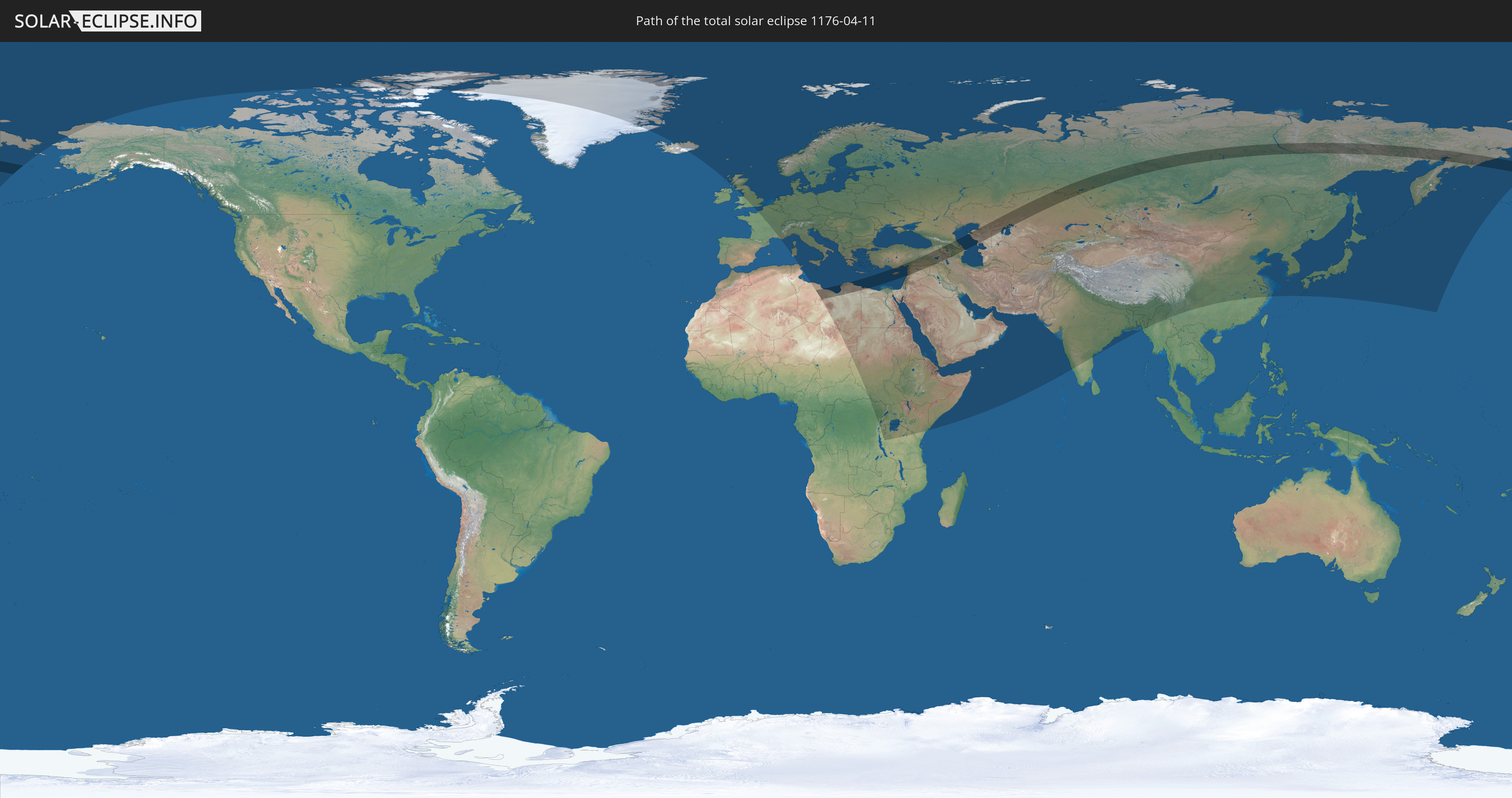
Die Sonnenfinsternis am 11.04.1176 kann man in 98 Ländern als partielle Sonnenfinsternis beobachten.
Der Finsternispfad verläuft durch 14 Länder. Nur in diesen Ländern ist sie als totale Sonnenfinsternis zu sehen.
In den folgenden Ländern ist die Sonnenfinsternis total zu sehen
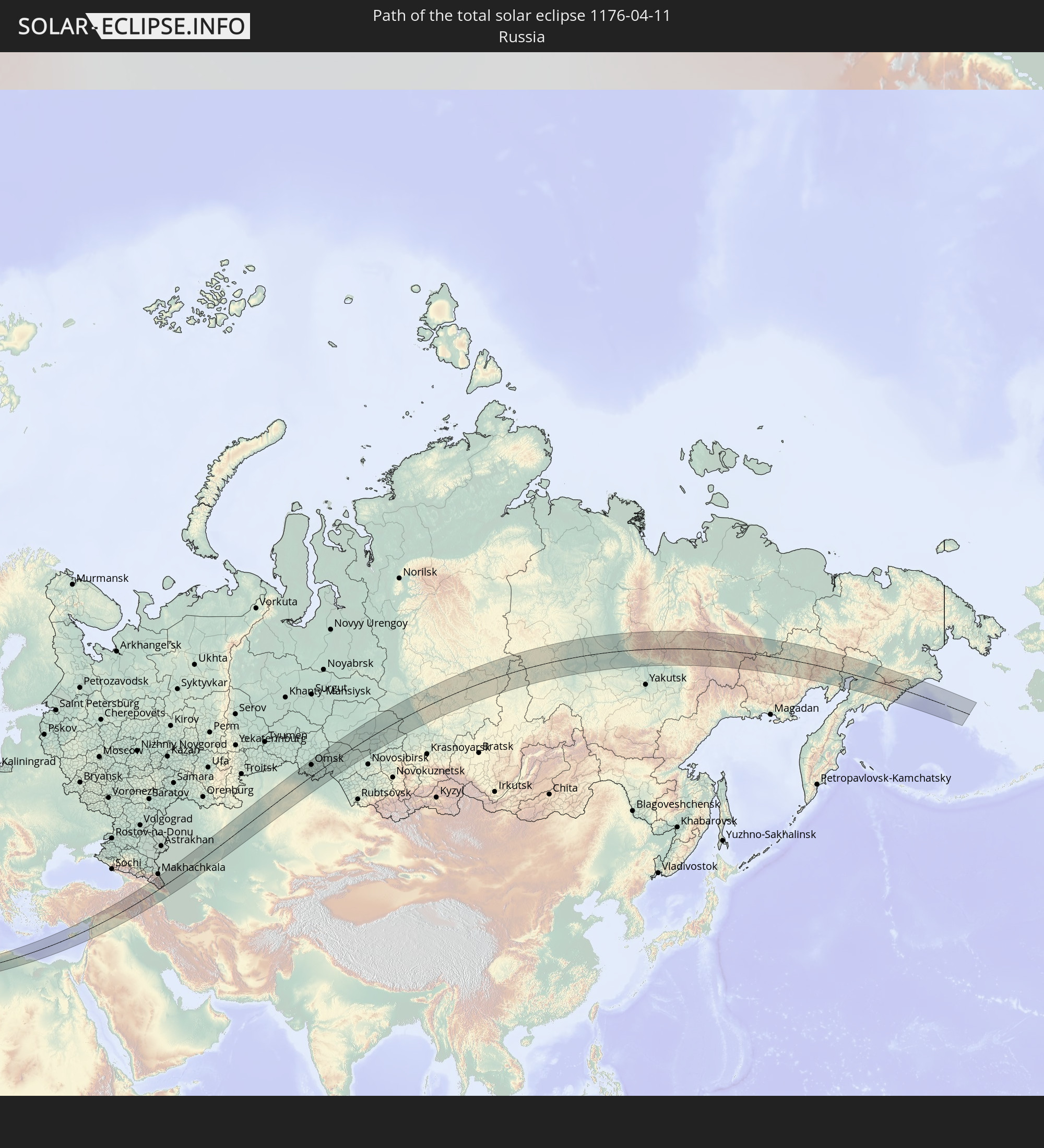 Russland
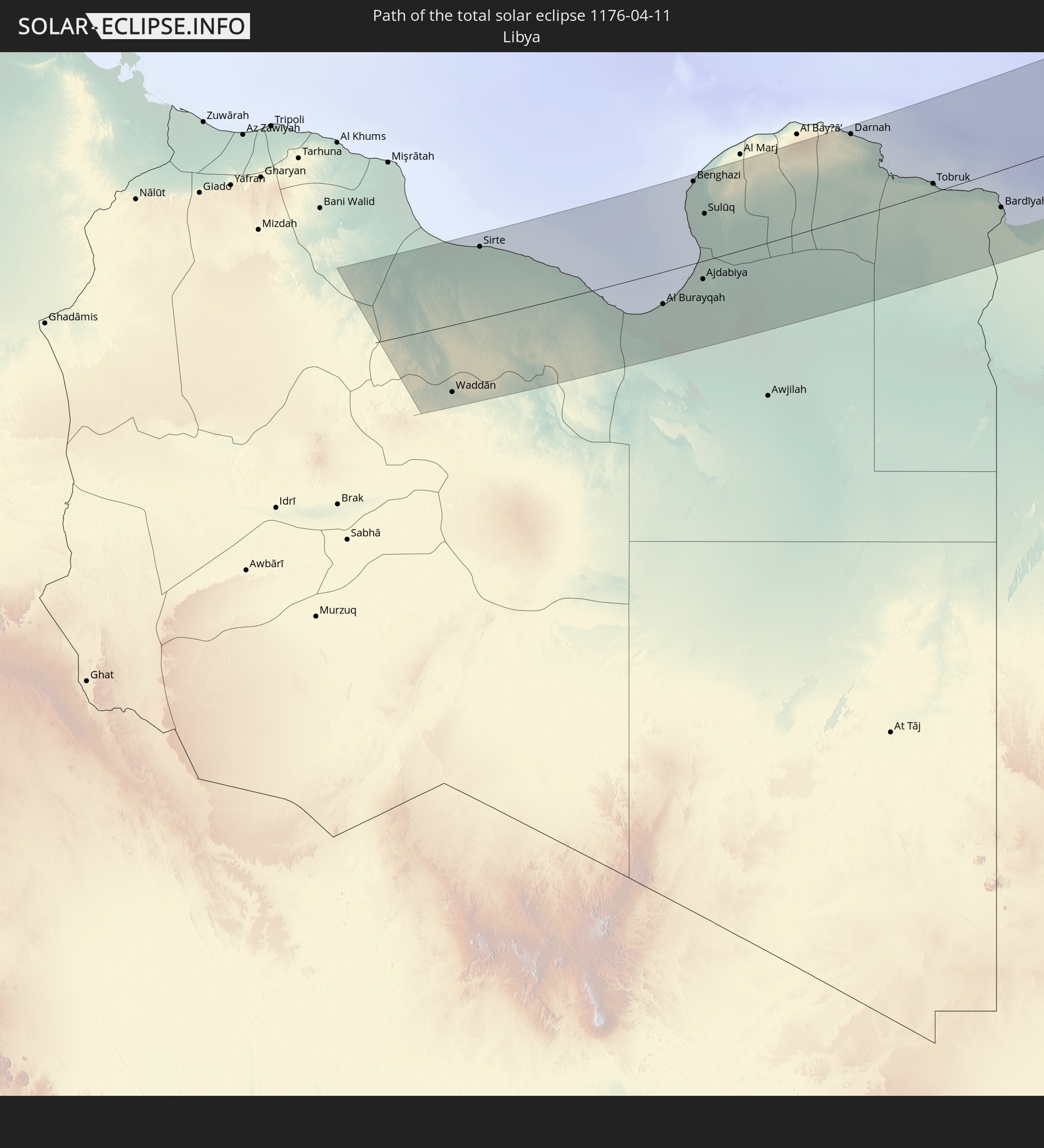 Libyen
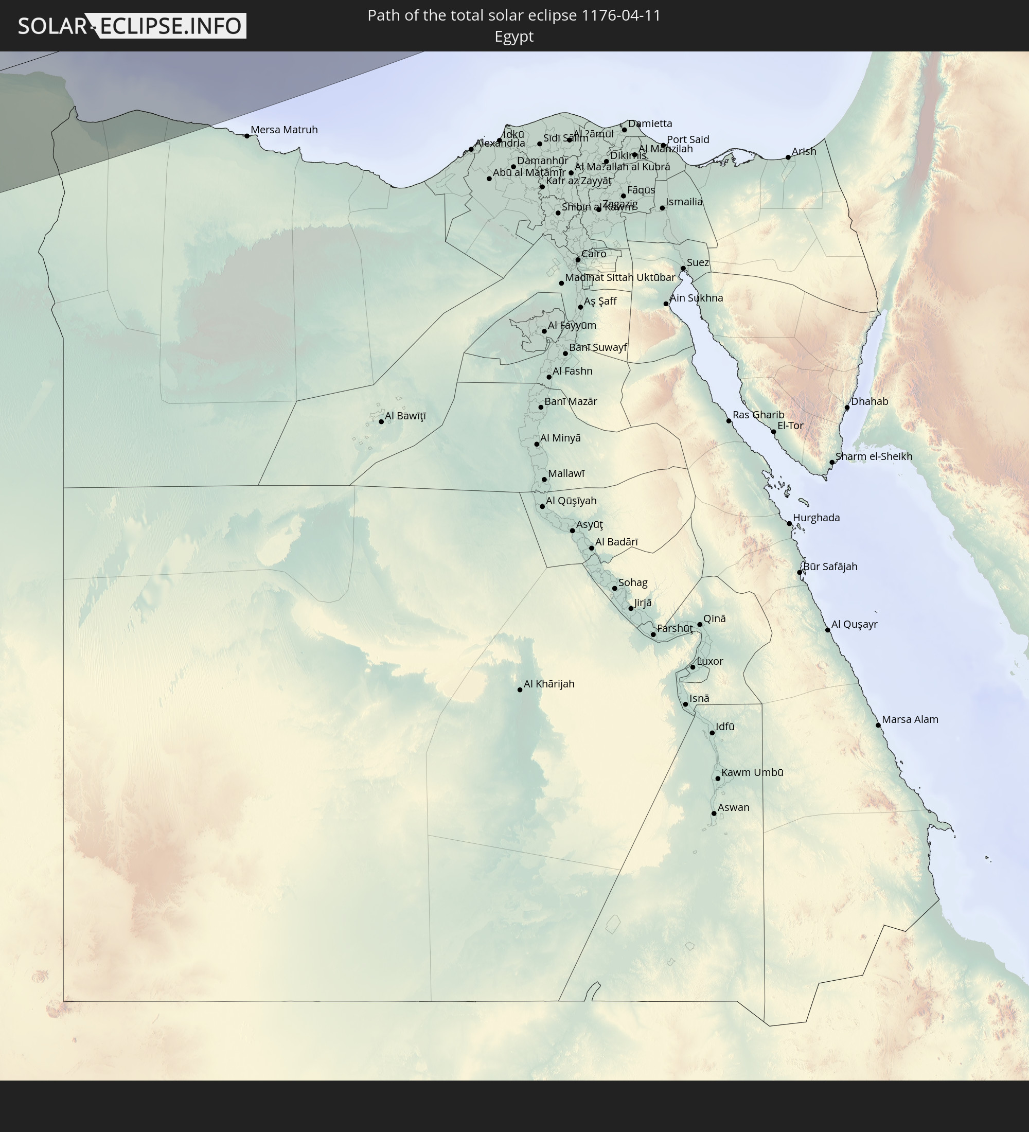 Ägypten
 Türkei
 Republik Zypern
 Libanon
 Syrien
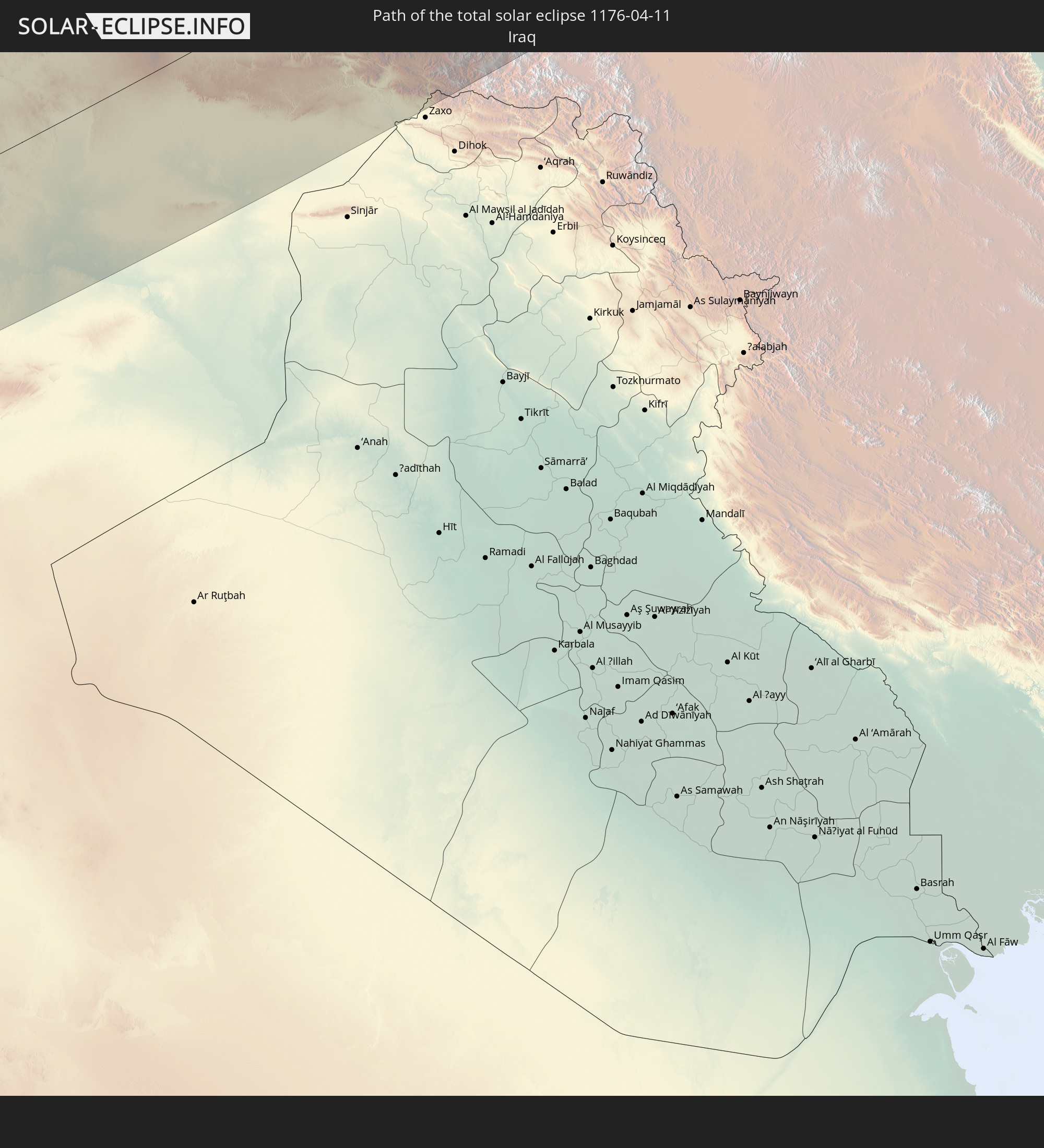 Irak
Irak
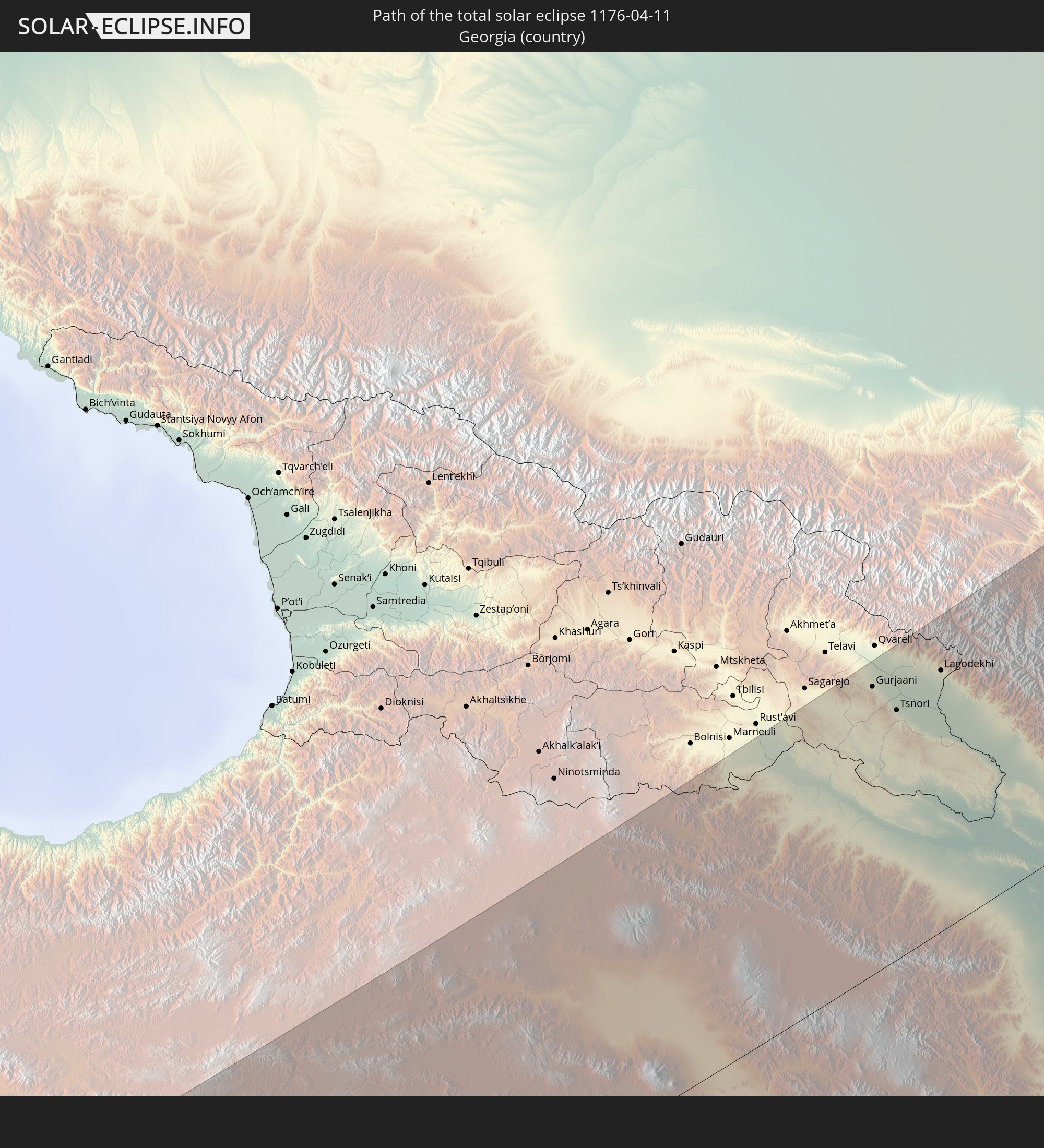 Georgien
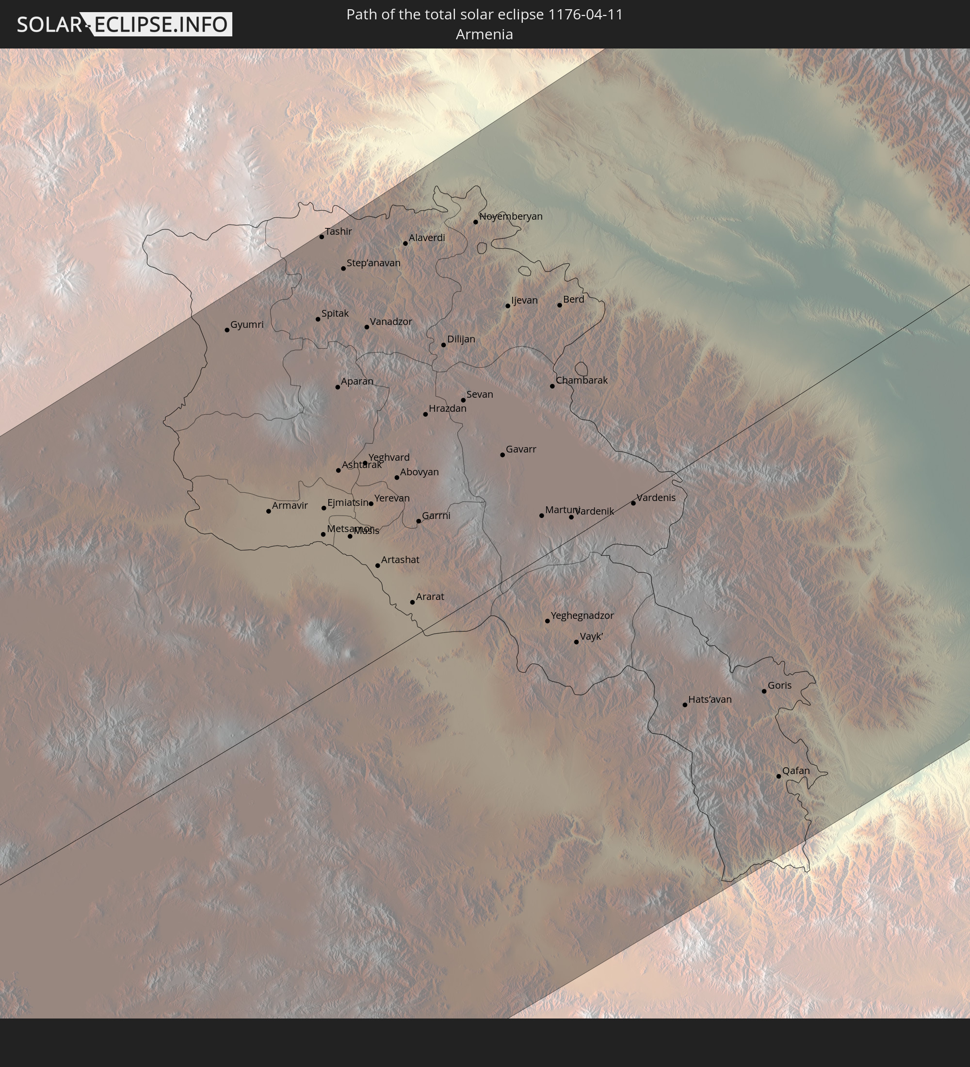 Armenien
 Iran
Iran
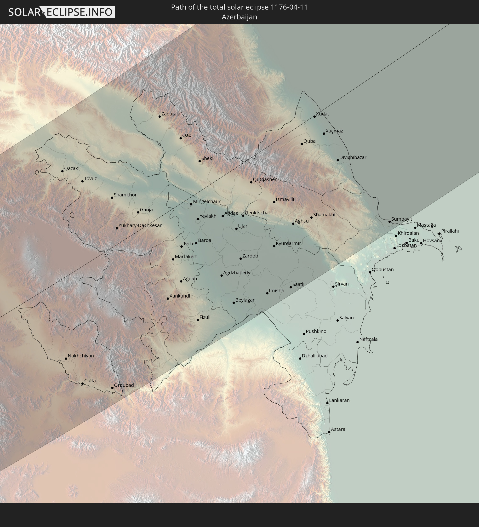 Aserbaidschan
 Kasachstan
 Usbekistan
In den folgenden Ländern ist die Sonnenfinsternis partiell zu sehen
 Russland
 Vereinigte Staaten
 Kanada
 Grönland
 Island
 Spitzbergen
 Vereinigtes Königreich
 Färöer
 Frankreich
 Belgien
 Niederlande
 Norwegen
 Luxemburg
 Deutschland
 Schweiz
 Italien
 Monaco
 Tunesien
 Dänemark
 Libyen
 Liechtenstein
 Österreich
 Schweden
 Tschechien
 Demokratische Republik Kongo
 San Marino
 Vatikanstadt
 Slowenien
 Tschad
 Kroatien
 Polen
Polen
 Malta
Malta
 Zentralafrikanische Republik
 Bosnien und Herzegowina
 Ungarn
 Slowakei
 Montenegro
 Serbien
 Albanien
 Åland Islands
 Griechenland
 Rumänien
 Mazedonien
 Finnland
 Litauen
 Lettland
 Estland
 Sudan
Sudan
 Ukraine
 Bulgarien
 Weißrussland
 Ägypten
 Türkei
 Moldawien
 Ruanda
 Burundi
 Tansania
 Uganda
 Republik Zypern
 Äthiopien
 Kenia
Kenia
 Staat Palästina
 Israel
 Saudi-Arabien
 Jordanien
 Libanon
 Syrien
 Eritrea
 Irak
Irak
 Georgien
 Somalia
 Dschibuti
 Jemen
Jemen
 Armenien
 Iran
Iran
 Aserbaidschan
 Kasachstan
 Kuwait
 Bahrain
 Katar
Katar
 Vereinigte Arabische Emirate
 Oman
Oman
 Turkmenistan
 Usbekistan
 Afghanistan
 Pakistan
 Tadschikistan
 Indien
 Kirgisistan
 Volksrepublik China
 Nepal
Nepal
 Mongolei
 Bangladesch
 Bhutan
 Myanmar
 Japan
Japan
 Nordkorea
 Südkorea
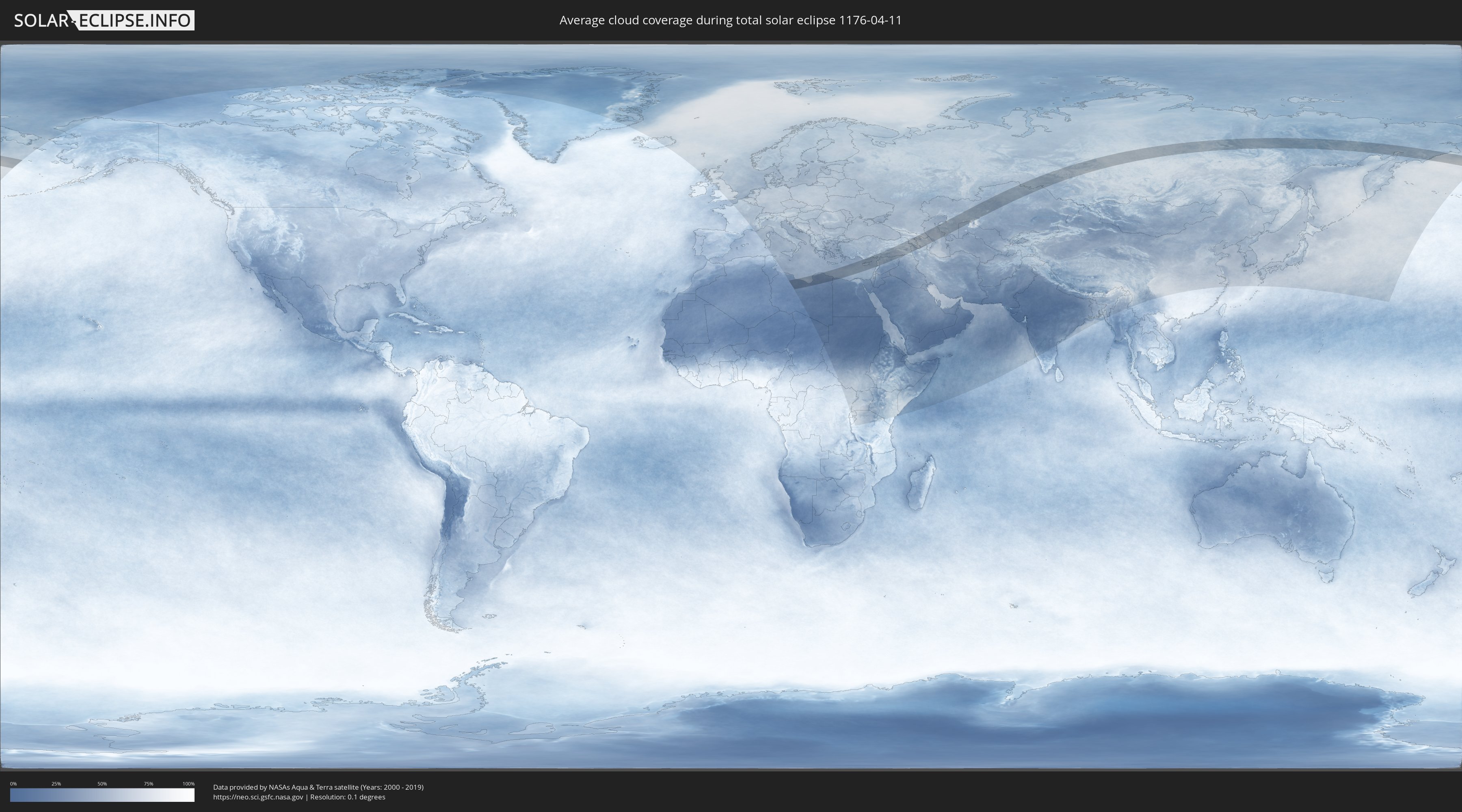
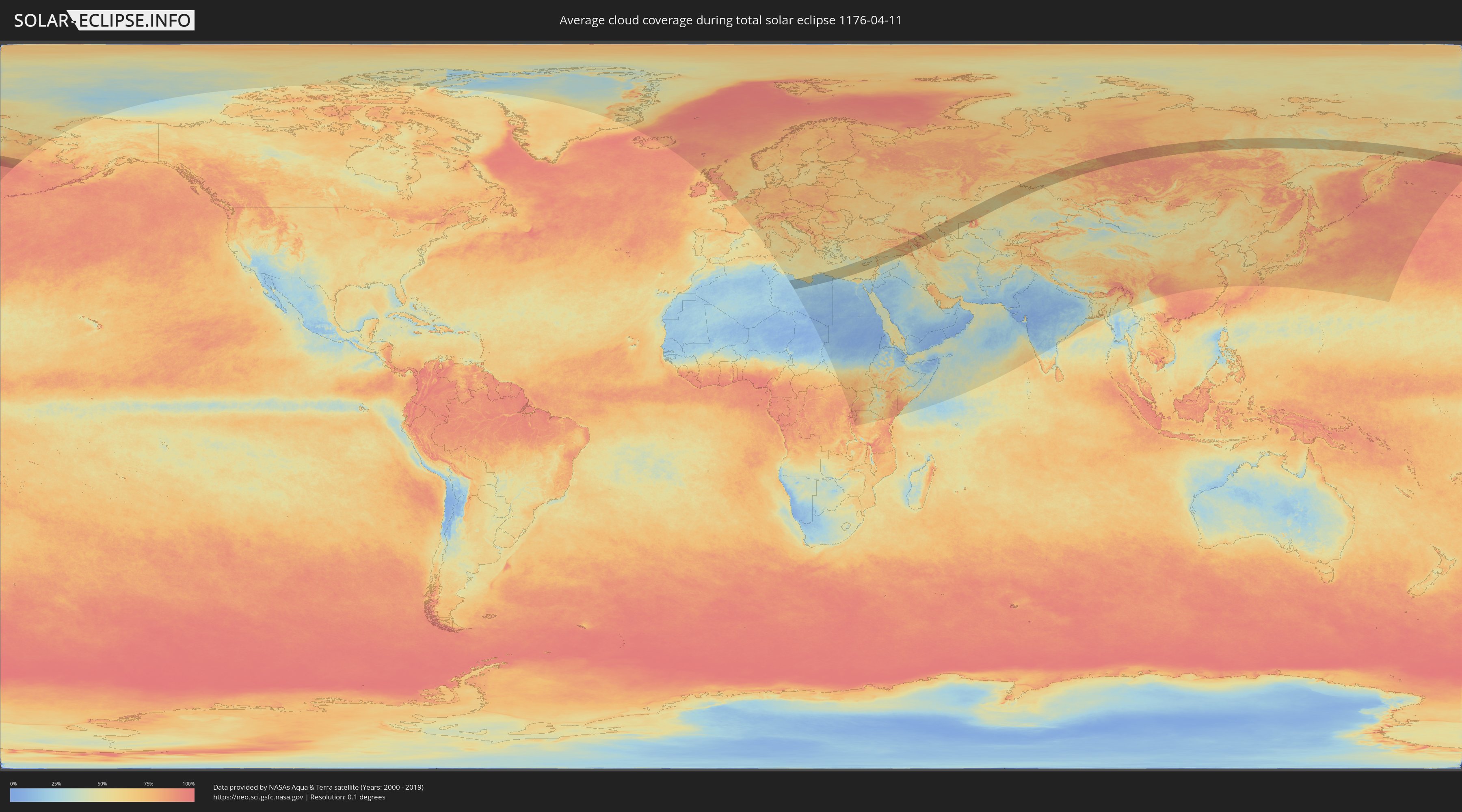
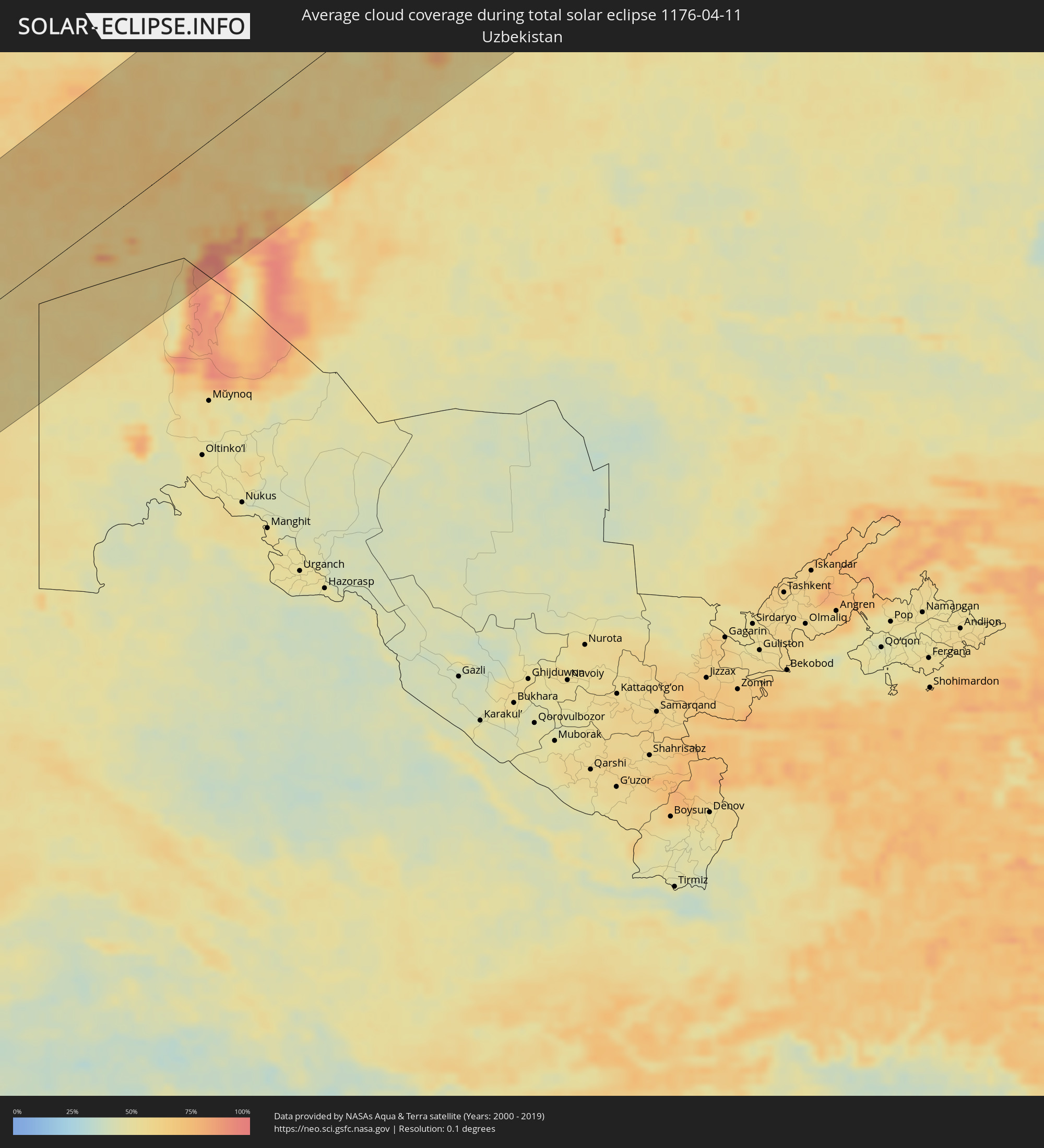
Wie wird das Wetter während der totalen Sonnenfinsternis am 11.04.1176?
Wo ist der beste Ort, um die totale Sonnenfinsternis vom 11.04.1176 zu beobachten?
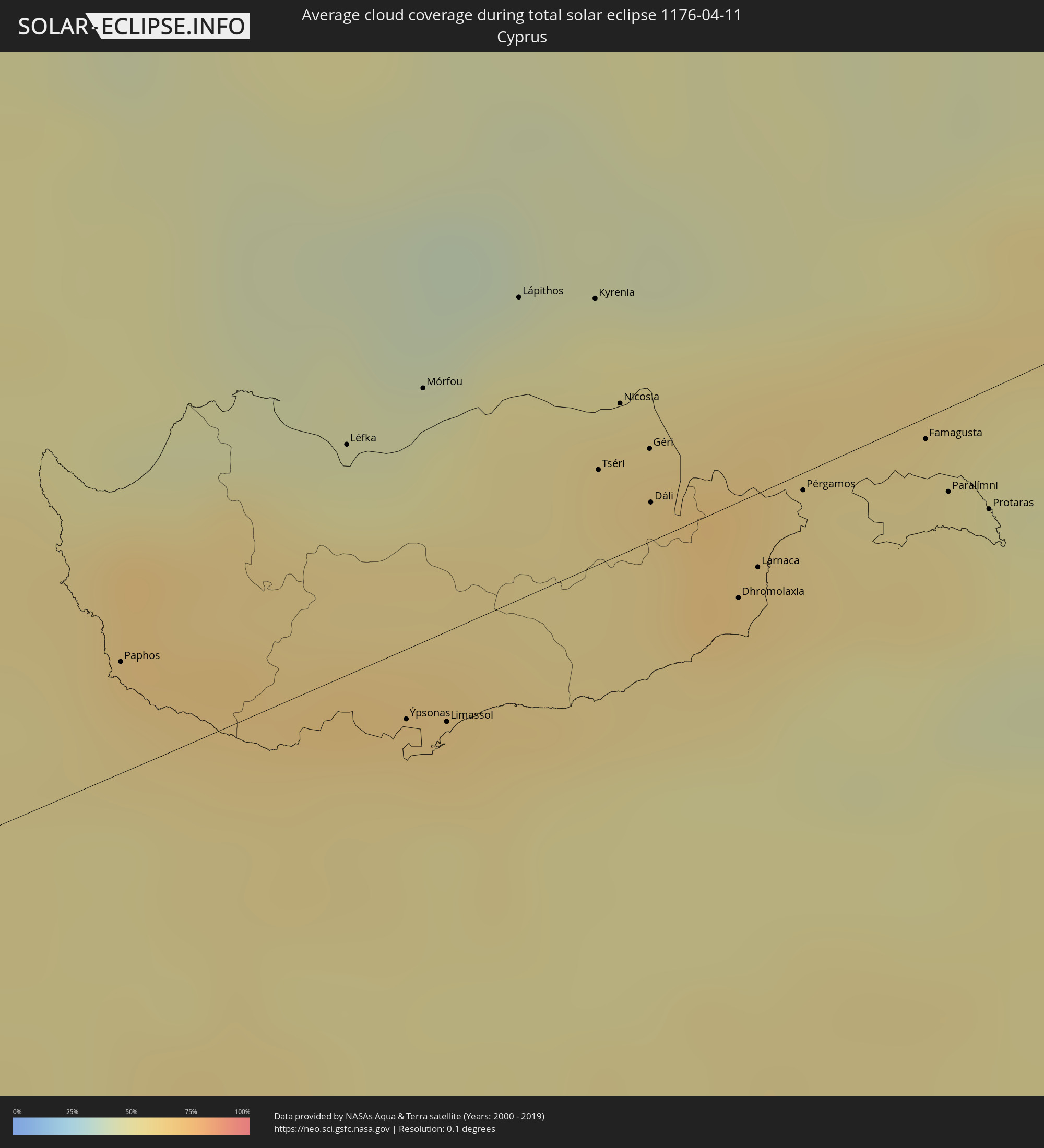
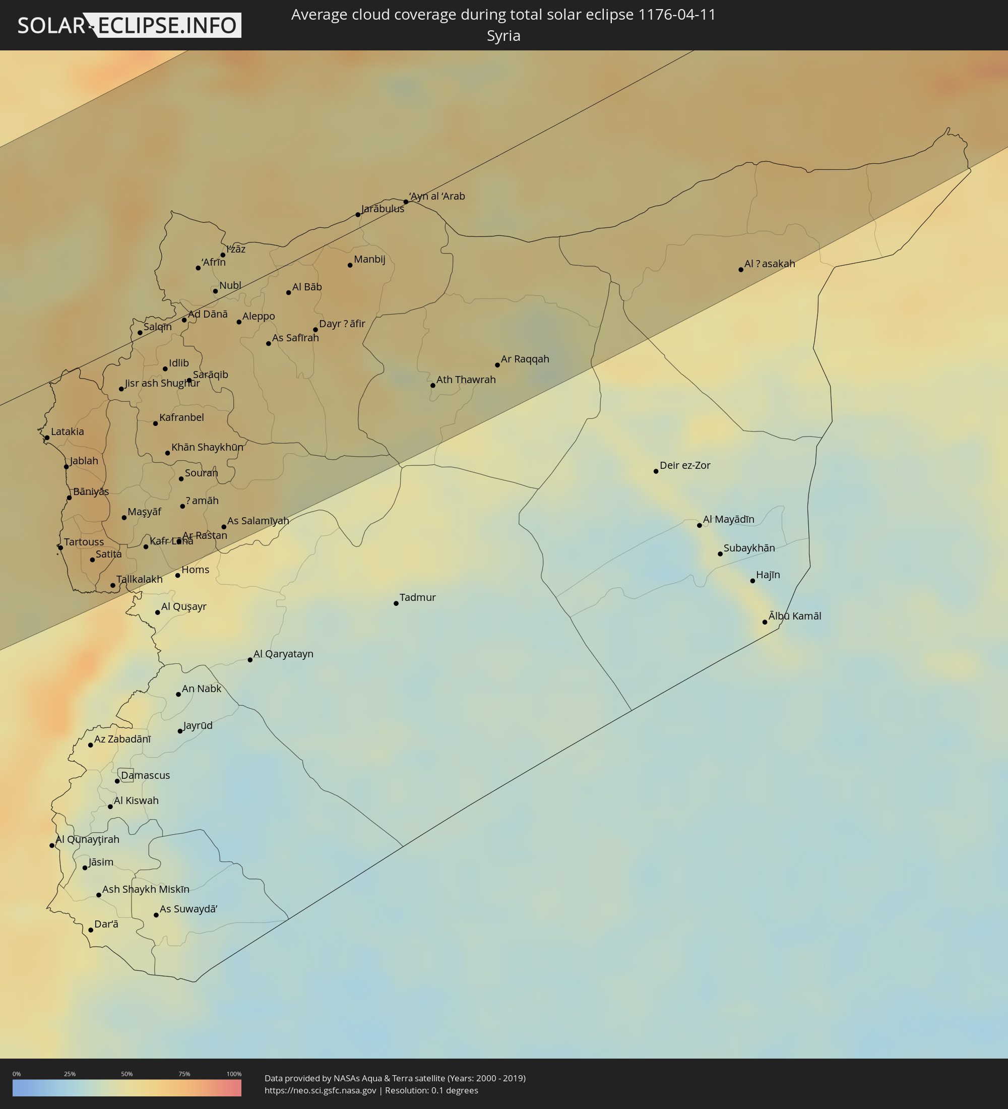
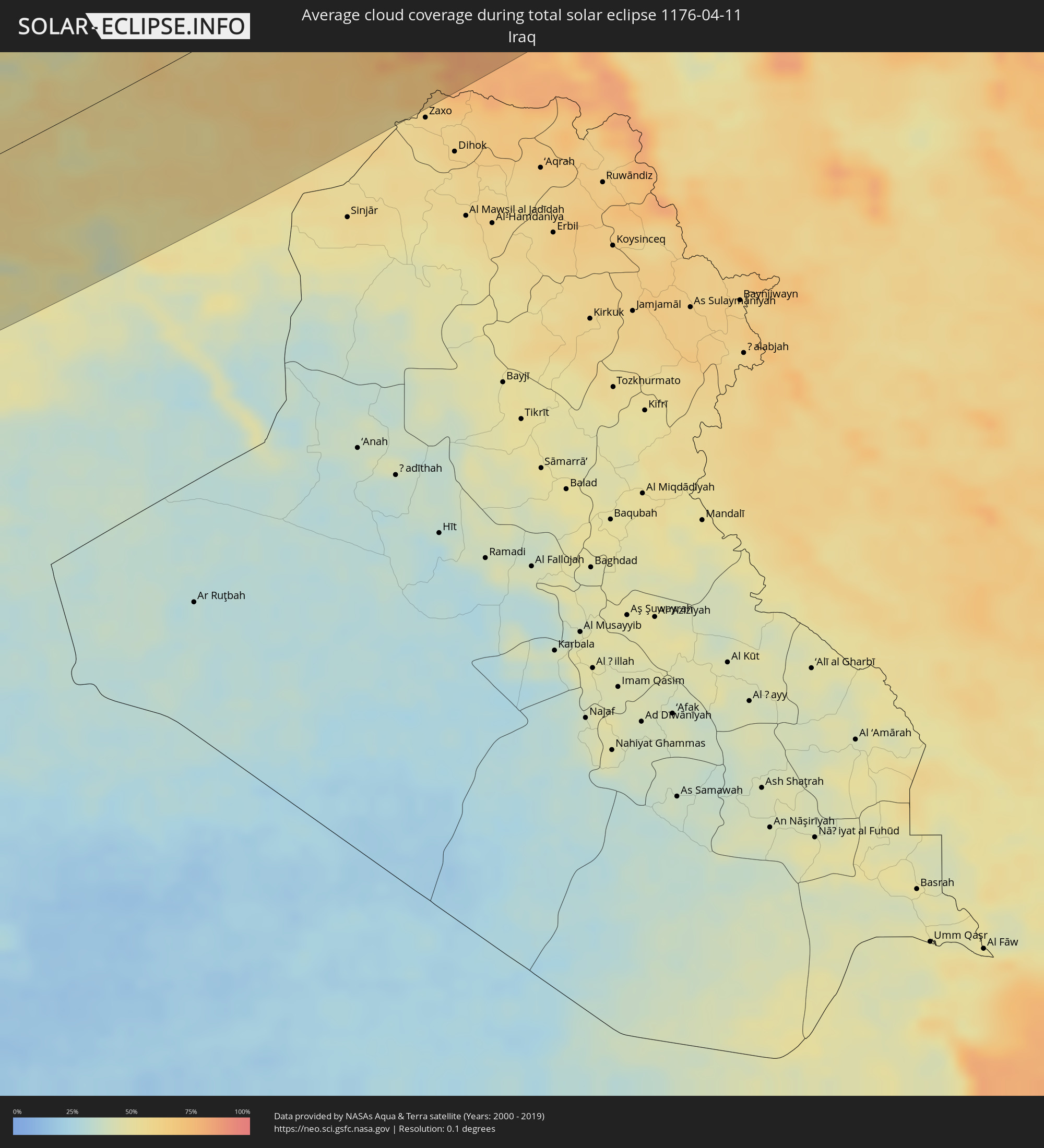
Die folgenden Karten zeigen die durchschnittliche Bewölkung für den Tag, an dem die totale Sonnenfinsternis
stattfindet. Mit Hilfe der Karten lässt sich der Ort entlang des Finsternispfades eingrenzen,
der die besten Aussichen auf einen klaren wolkenfreien Himmel bietet.
Trotzdem muss man immer lokale Gegenenheiten beachten und sollte sich genau über das Wetter an seinem
gewählten Beobachtungsort informieren.
Die Daten stammen von den beiden NASA-Satelliten
AQUA und TERRA
und wurden über einen Zeitraum von 19 Jahren (2000 - 2019) gemittelt.
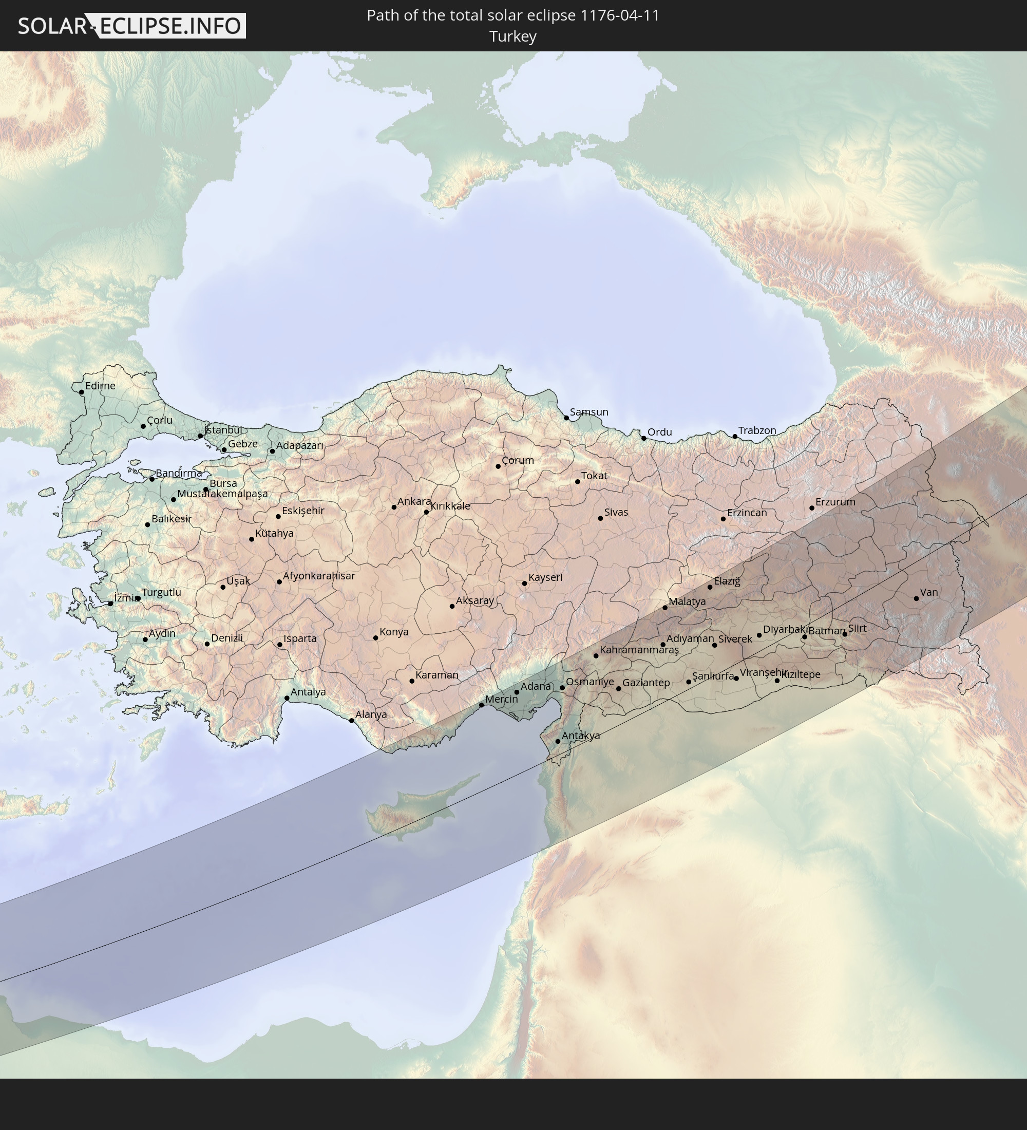
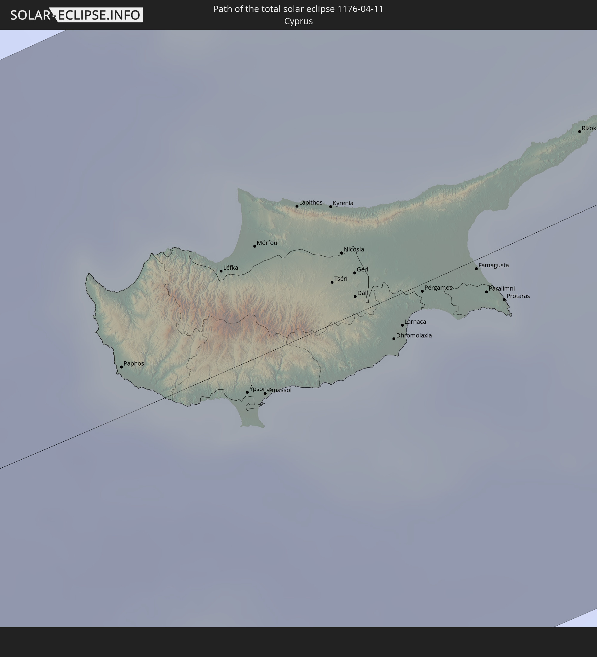
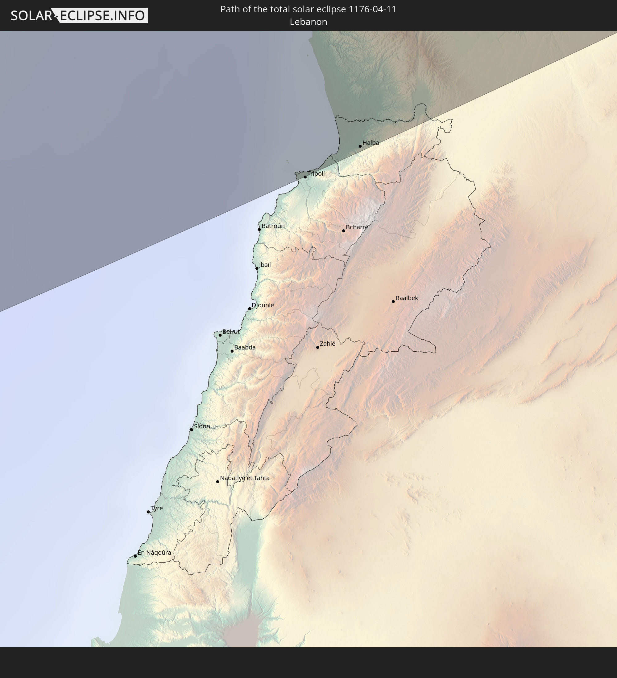
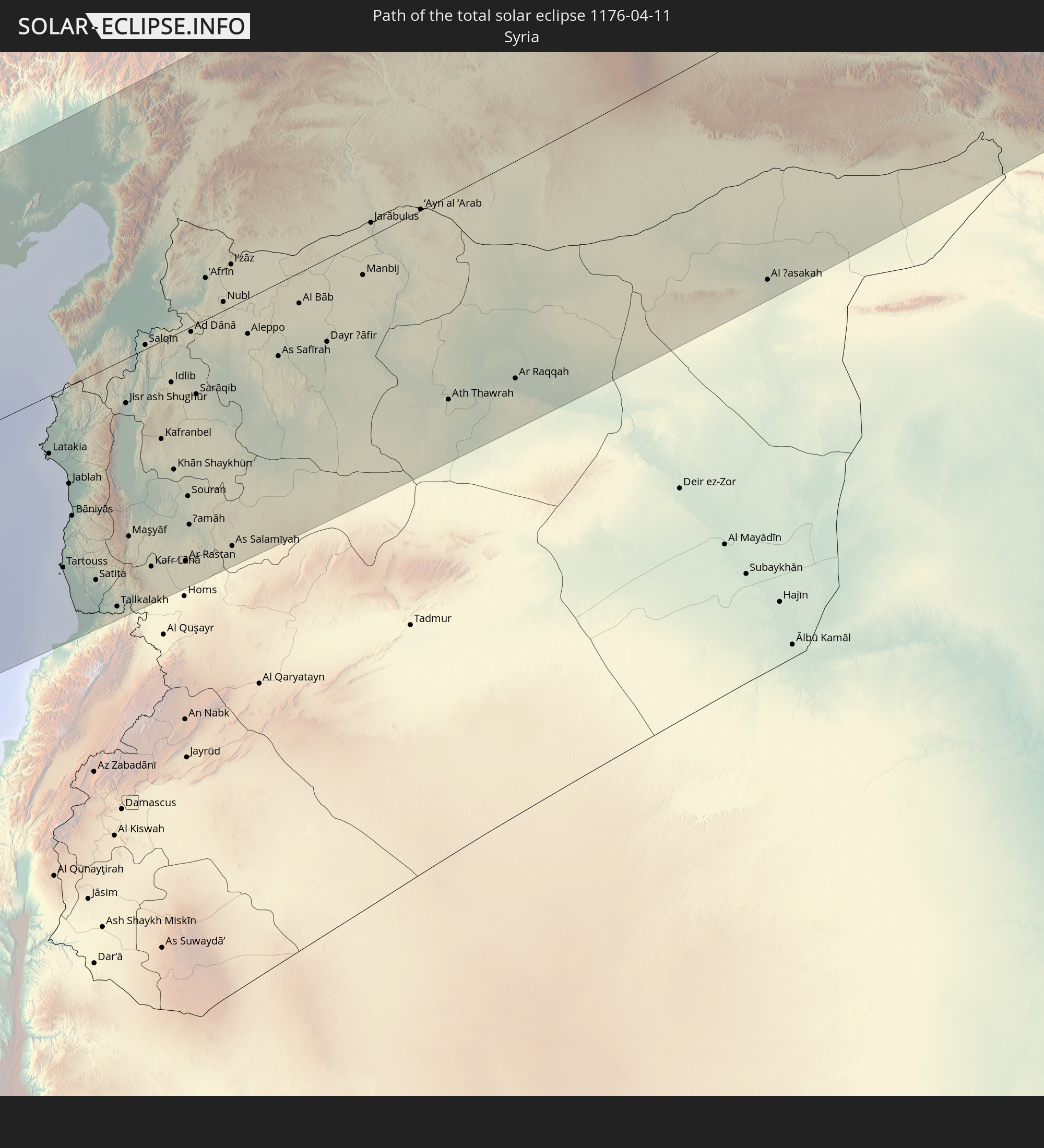
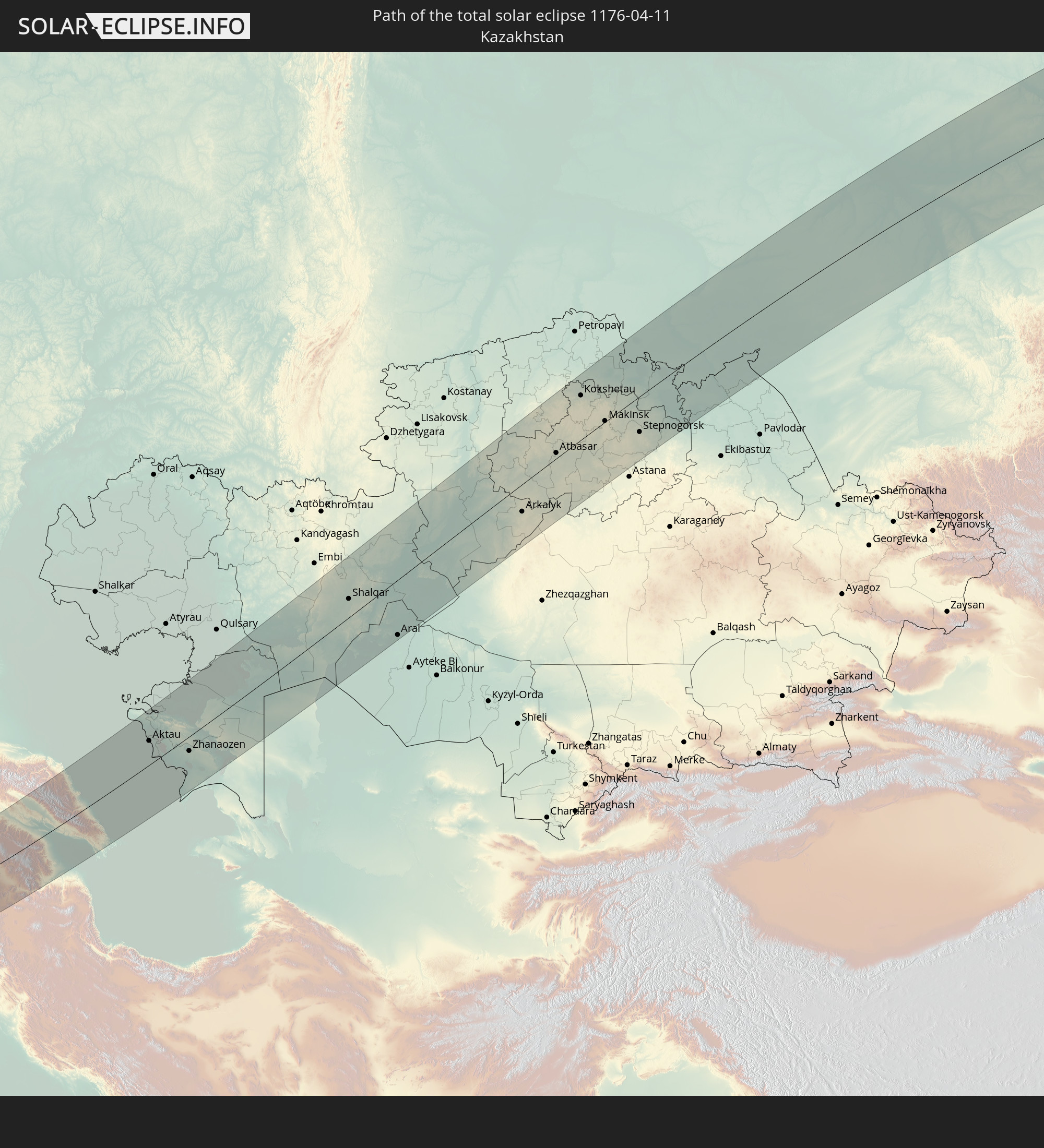
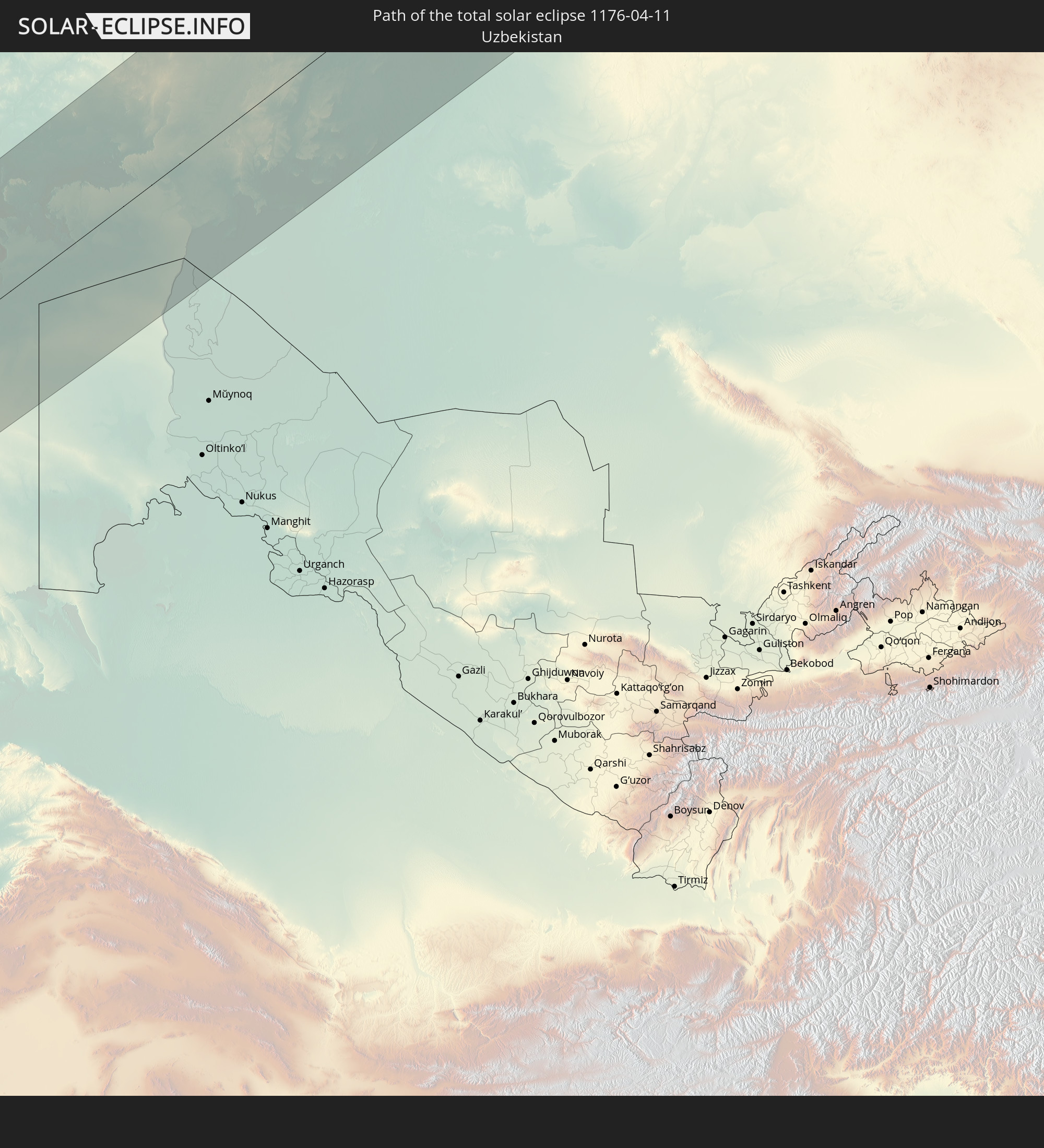
Detaillierte Länderkarten
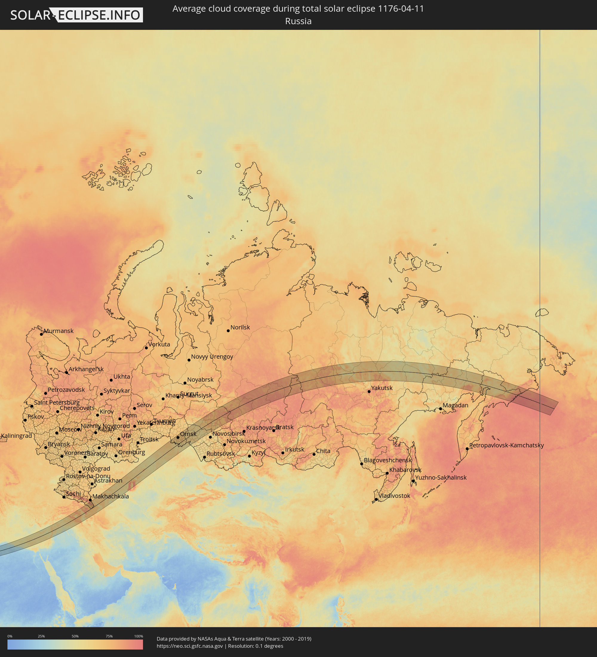 Russland
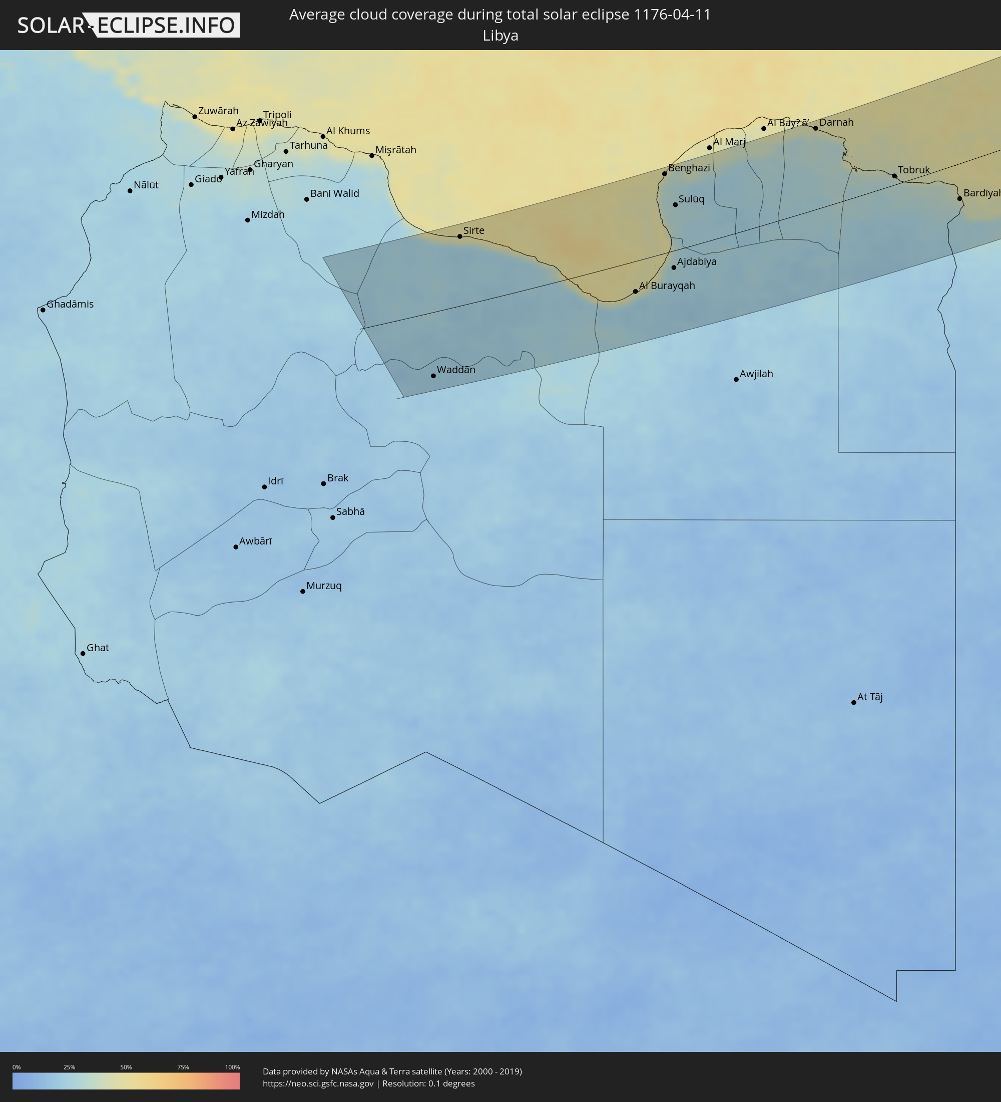 Libyen
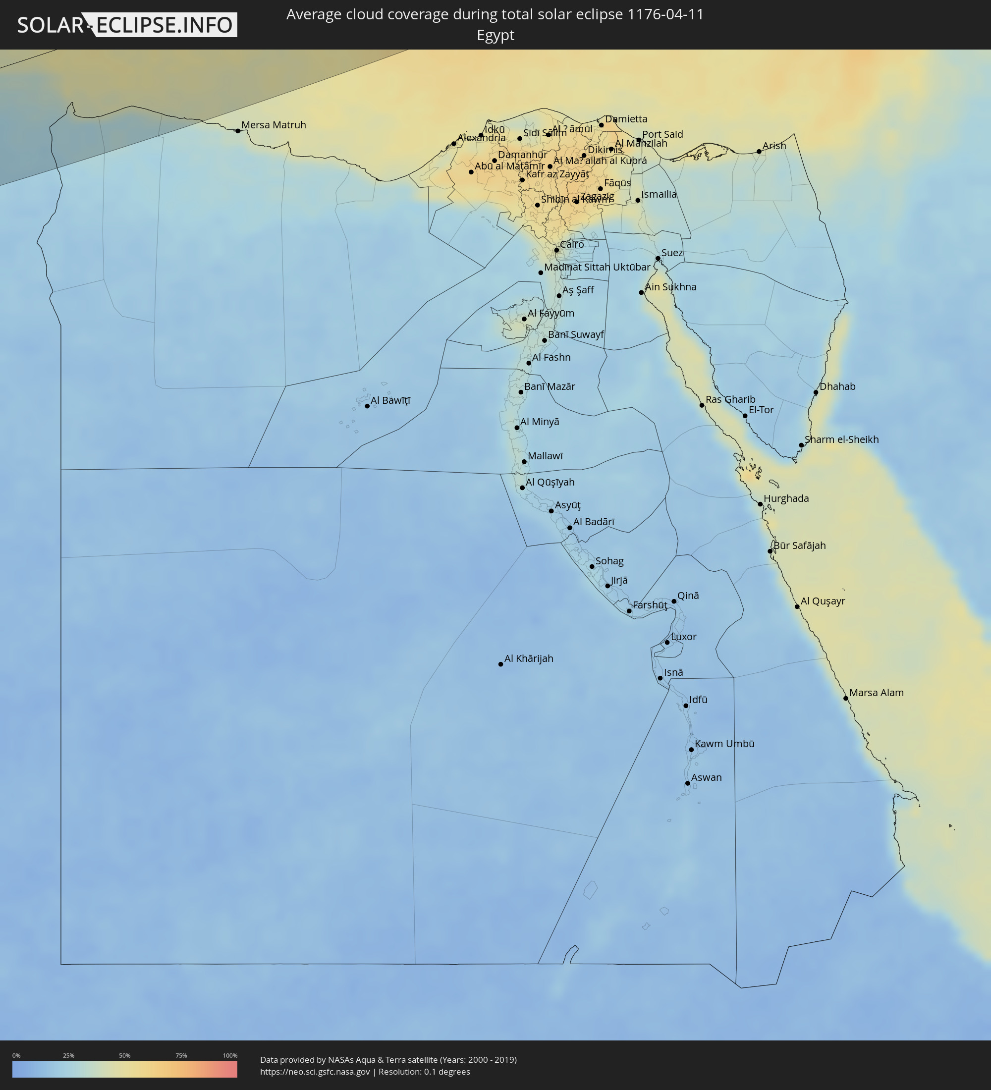 Ägypten
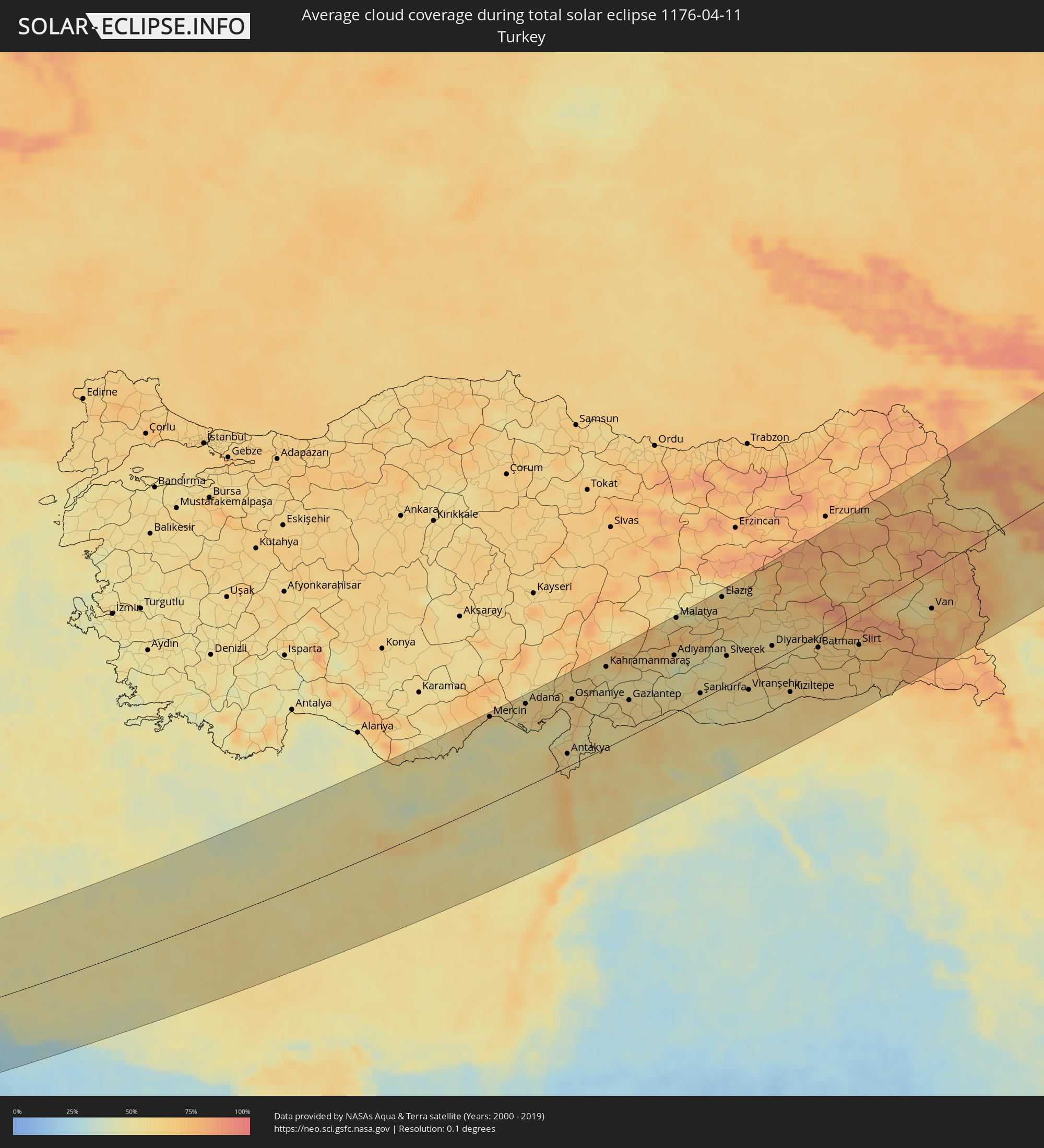 Türkei
 Republik Zypern
 Libanon
 Syrien
 Irak
Irak
 Georgien
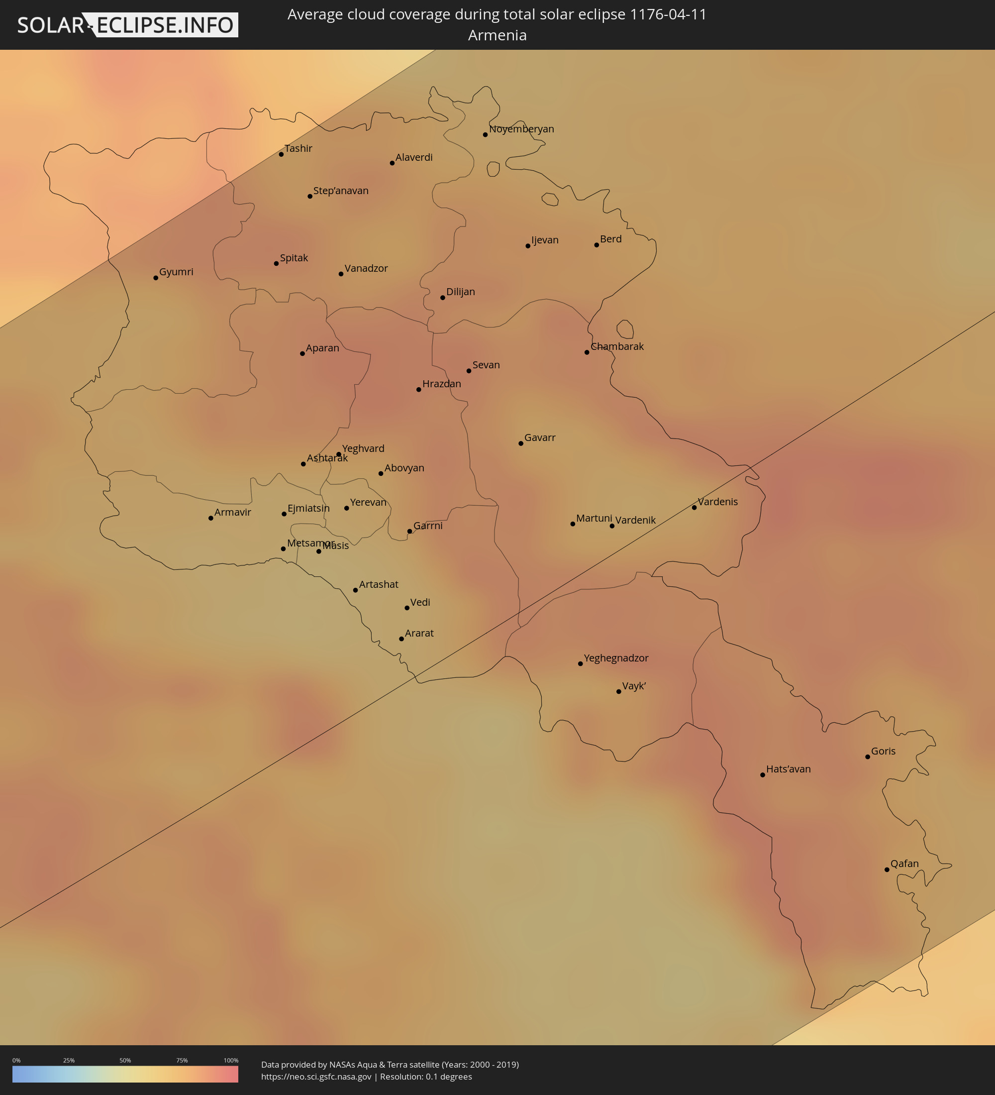 Armenien
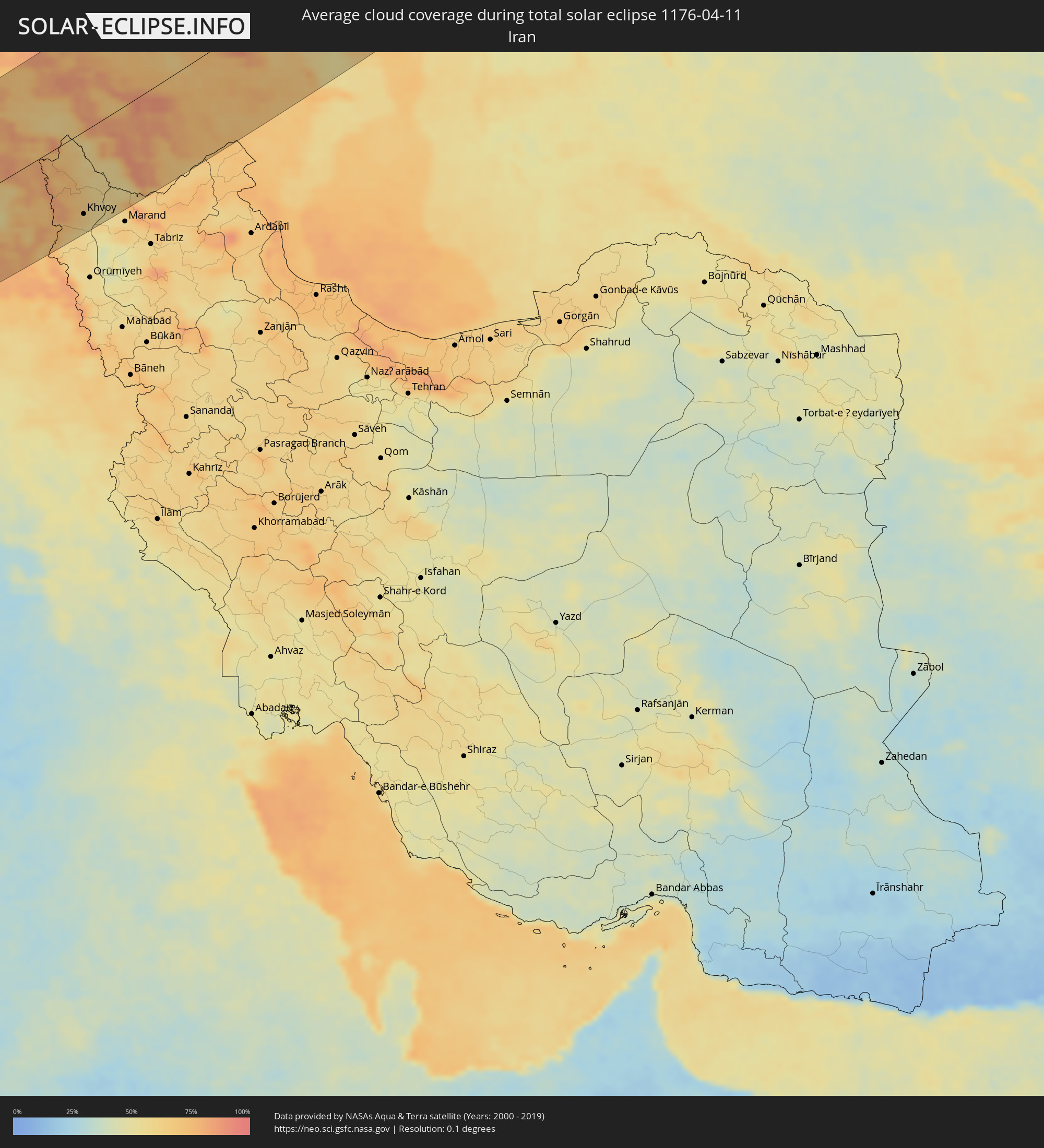 Iran
Iran
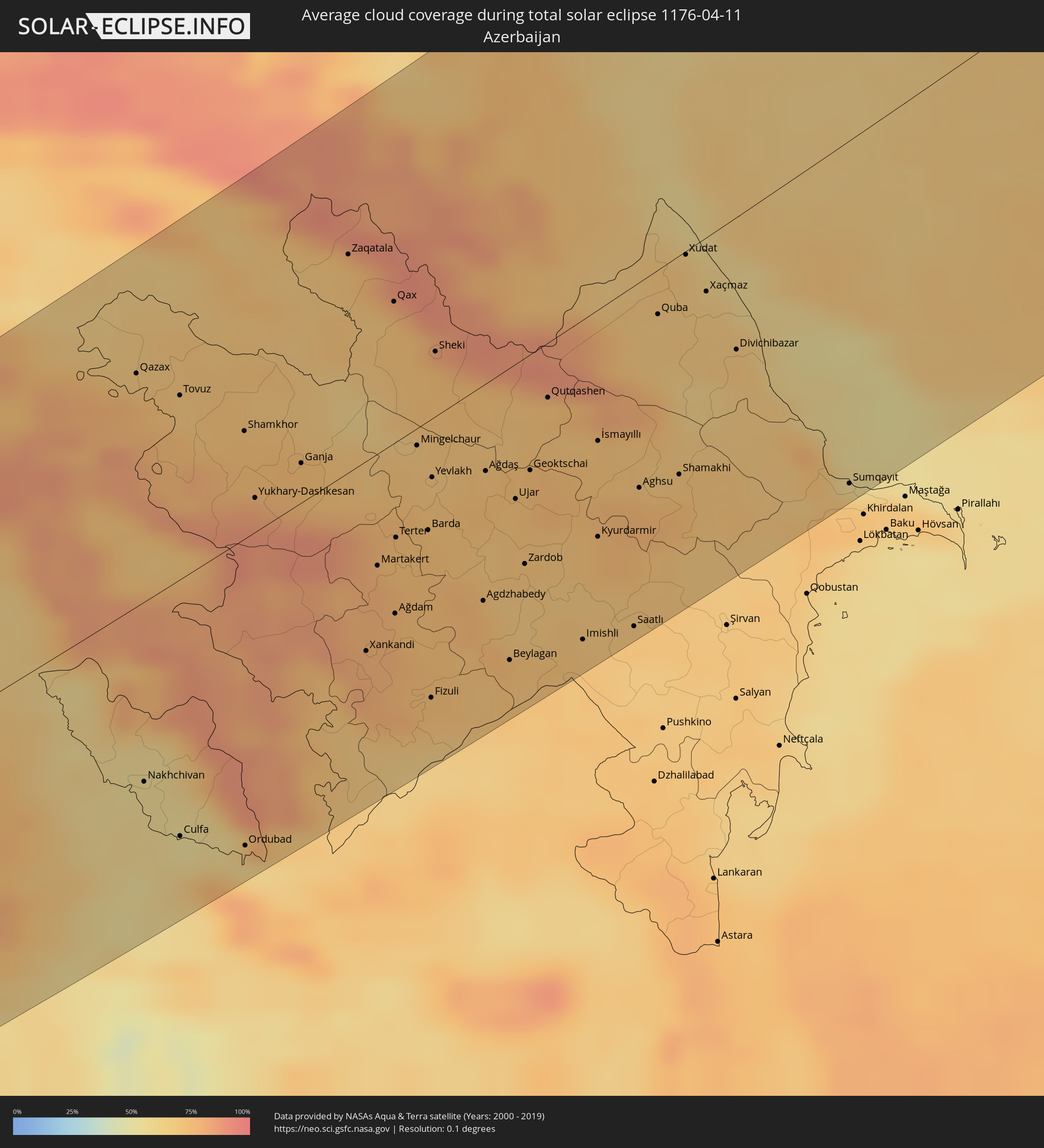 Aserbaidschan
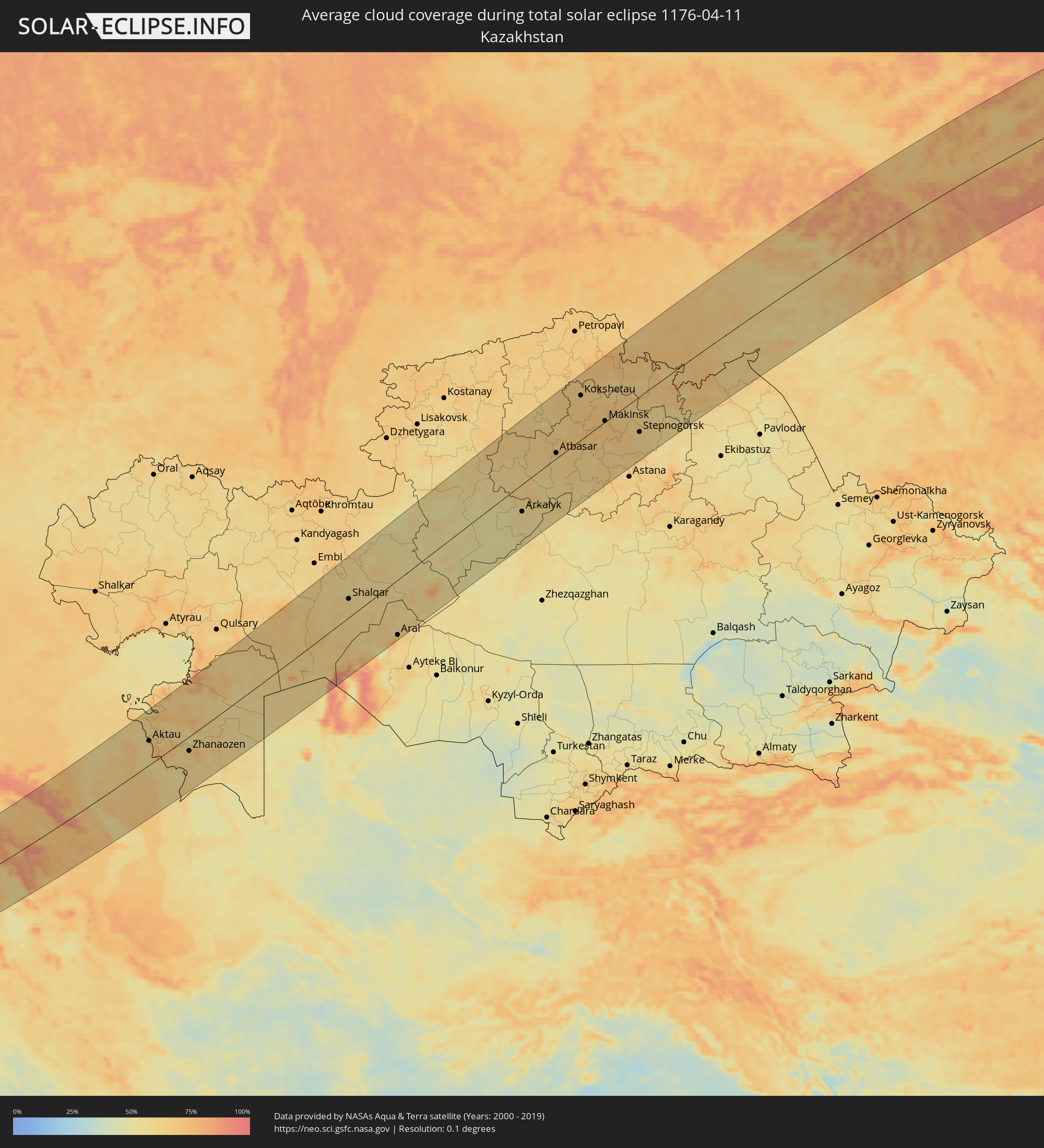 Kasachstan
 Usbekistan
Orte im Finsternispfad
Die nachfolgene Tabelle zeigt Städte und Orte mit mehr als 5.000 Einwohnern, die sich im Finsternispfad befinden. Städte mit mehr als 100.000 Einwohnern sind dick gekennzeichnet. Mit einem Klick auf den Ort öffnet sich eine Detailkarte die die Lage des jeweiligen Ortes zusammen mit dem Verlauf der zentralen Finsternis präsentiert.
| Ort | Typ | Dauer der Verfinsterung | Ortszeit bei maximaler Verfinsterung | Entfernung zur Zentrallinie | Ø Bewölkung |
|
Hūn, Al Jufrah
|
total | - | 05:25:48 UTC+00:52 | 105 km | 21% |
|
Waddān, Al Jufrah
|
total | - | 05:25:48 UTC+00:52 | 104 km | 21% |
|
Sirte, Surt
|
total | - | 05:28:18 UTC+00:52 | 110 km | 29% |
|
Al Burayqah, Sha‘bīyat al Wāḩāt
|
total | - | 05:26:46 UTC+00:52 | 48 km | 25% |
|
Benghazi, Banghāzī
|
total | - | 05:29:00 UTC+00:52 | 122 km | 34% |
|
Az Zuwaytīnah, Sha‘bīyat al Wāḩāt
|
total | - | 05:27:26 UTC+00:52 | 4 km | 40% |
|
Ajdabiya, Sha‘bīyat al Wāḩāt
|
total | - | 05:27:09 UTC+00:52 | 27 km | 28% |
|
Sulūq, Banghāzī
|
total | - | 05:28:22 UTC+00:52 | 70 km | 29% |
|
Al Abyār, Al Marj
|
total | - | 05:29:03 UTC+00:52 | 117 km | 35% |
|
Al Qubbah, Darnah
|
total | - | 05:29:43 UTC+00:52 | 134 km | 42% |
|
Darnah, Darnah
|
total | - | 05:29:43 UTC+00:52 | 123 km | 39% |
|
Tobruk, Sha‘bīyat al Buţnān
|
total | - | 05:28:43 UTC+00:52 | 13 km | 36% |
|
Bardīyah, Sha‘bīyat al Buţnān
|
total | - | 05:28:15 UTC+00:52 | 55 km | 39% |
|
Paphos, Pafos
|
total | - | 06:54:19 UTC+02:13 | 18 km | 58% |
|
Léfka, Nicosia
|
total | - | 06:54:56 UTC+02:13 | 36 km | 49% |
|
Ýpsonas, Limassol
|
total | - | 06:54:18 UTC+02:13 | 11 km | 58% |
|
Mórfou, Nicosia
|
total | - | 06:55:06 UTC+02:13 | 40 km | 49% |
|
Limassol, Limassol
|
total | - | 06:54:19 UTC+02:13 | 14 km | 58% |
|
Lápithos, Keryneia
|
total | - | 06:55:22 UTC+02:13 | 47 km | 52% |
|
Kyrenia, Keryneia
|
total | - | 06:55:24 UTC+02:13 | 42 km | 52% |
|
Tséri, Nicosia
|
total | - | 06:55:00 UTC+02:13 | 15 km | 58% |
|
Nicosia, Nicosia
|
total | - | 06:55:10 UTC+02:13 | 24 km | 58% |
|
Géri, Nicosia
|
total | - | 06:55:04 UTC+02:13 | 15 km | 61% |
|
Dáli, Nicosia
|
total | - | 06:54:56 UTC+02:13 | 6 km | 58% |
|
Dhromolaxia, Larnaka
|
total | - | 06:54:45 UTC+02:13 | 15 km | 56% |
|
Aradíppou, Larnaka
|
total | - | 06:54:52 UTC+02:13 | 8 km | 61% |
|
Larnaca, Larnaka
|
total | - | 06:54:50 UTC+02:13 | 12 km | 56% |
|
Livádia, Larnaka
|
total | - | 06:54:53 UTC+02:13 | 9 km | 61% |
|
Pérgamos, Larnaka
|
total | - | 06:55:03 UTC+02:13 | 3 km | 57% |
|
Famagusta, Ammochostos
|
total | - | 06:55:14 UTC+02:13 | 3 km | 54% |
|
Paralímni, Ammochostos
|
total | - | 06:55:07 UTC+02:13 | 13 km | 53% |
|
Protaras, Ammochostos
|
total | - | 06:55:06 UTC+02:13 | 19 km | 49% |
|
Mercin, Mersin
|
total | - | 06:41:33 UTC+01:56 | 141 km | 54% |
|
Tarsus, Mersin
|
total | - | 06:41:50 UTC+01:56 | 142 km | 54% |
|
Adana, Adana
|
total | - | 06:42:07 UTC+01:56 | 133 km | 58% |
|
Latakia, Latakia
|
total | - | 07:08:10 UTC+02:25 | 35 km | 57% |
|
Tartouss, Tartus
|
total | - | 07:07:11 UTC+02:25 | 101 km | 56% |
|
Jablah, Latakia
|
total | - | 07:07:57 UTC+02:25 | 57 km | 57% |
|
Halba, Aakkâr
|
total | - | 06:41:29 UTC+02:00 | 144 km | 67% |
|
Antakya, Hatay
|
total | - | 06:41:06 UTC+01:56 | 32 km | 59% |
|
İskenderun, Hatay
|
total | - | 06:41:44 UTC+01:56 | 58 km | 59% |
|
Osmaniye, Osmaniye
|
total | - | 06:42:33 UTC+01:56 | 106 km | 60% |
|
Kafranbel, Idlib
|
total | - | 07:08:34 UTC+02:25 | 58 km | 60% |
|
Idlib, Idlib
|
total | - | 07:09:06 UTC+02:25 | 26 km | 56% |
|
Khān Shaykhūn, Idlib
|
total | - | 07:08:19 UTC+02:25 | 78 km | 53% |
|
Ar Rastan, Homs
|
total | - | 07:07:31 UTC+02:25 | 131 km | 51% |
|
Ḩamāh, Hama
|
total | - | 07:07:51 UTC+02:25 | 113 km | 59% |
|
‘Afrīn, Aleppo
|
total | - | 07:10:07 UTC+02:25 | 23 km | 56% |
|
Kahramanmaraş, Kahramanmaraş
|
total | - | 06:43:38 UTC+01:56 | 127 km | 53% |
|
I‘zāz, Aleppo
|
total | - | 07:10:18 UTC+02:25 | 28 km | 51% |
|
As Salamīyah, Hama
|
total | - | 07:07:46 UTC+02:25 | 135 km | 52% |
|
Aleppo, Aleppo
|
total | - | 07:09:43 UTC+02:25 | 21 km | 56% |
|
As Safīrah, Aleppo
|
total | - | 07:09:36 UTC+02:25 | 44 km | 53% |
|
Gaziantep, Gaziantep
|
total | - | 06:42:56 UTC+01:56 | 59 km | 60% |
|
Al Bāb, Aleppo
|
total | - | 07:10:08 UTC+02:25 | 18 km | 58% |
|
Manbij, Aleppo
|
total | - | 07:10:34 UTC+02:25 | 24 km | 65% |
|
Adıyaman, Adıyaman
|
total | - | 06:44:27 UTC+01:56 | 93 km | 50% |
|
Malatya, Malatya
|
total | - | 06:45:27 UTC+01:56 | 146 km | 58% |
|
‘Ayn al ‘Arab, Aleppo
|
total | - | 07:11:19 UTC+02:25 | 14 km | 55% |
|
Ath Thawrah, Ar-Raqqah
|
total | - | 07:09:40 UTC+02:25 | 112 km | 49% |
|
Şanlıurfa, Şanlıurfa
|
total | - | 06:43:41 UTC+01:56 | 18 km | 55% |
|
Ar Raqqah, Ar-Raqqah
|
total | - | 07:10:03 UTC+02:25 | 120 km | 50% |
|
Elazığ, Elazığ
|
total | - | 06:46:23 UTC+01:56 | 139 km | 62% |
|
Siverek, Şanlıurfa
|
total | - | 06:44:53 UTC+01:56 | 46 km | 55% |
|
Viranşehir, Şanlıurfa
|
total | - | 06:44:12 UTC+01:56 | 28 km | 54% |
|
Diyarbakır, Diyarbakır
|
total | - | 06:45:34 UTC+01:56 | 28 km | 57% |
|
Kızıltepe, Mardin
|
total | - | 06:44:31 UTC+01:56 | 63 km | 59% |
|
Al Ḩasakah, Al-Hasakah
|
total | - | 07:11:44 UTC+02:25 | 137 km | 54% |
|
Batman, Batman
|
total | - | 06:45:58 UTC+01:56 | 18 km | 63% |
|
Siirt, Siirt
|
total | - | 06:46:27 UTC+01:56 | 52 km | 67% |
|
Van, Van
|
total | - | 06:48:11 UTC+01:56 | 57 km | 64% |
|
Gyumri, Shirak Province
|
total | - | 07:53:28 UTC+02:58 | 143 km | 68% |
|
Armavir, Armavir Province
|
total | - | 07:52:29 UTC+02:58 | 72 km | 63% |
|
Spitak, Lori Province
|
total | - | 07:53:47 UTC+02:58 | 126 km | 83% |
|
Ejmiatsin, Armavir Province
|
total | - | 07:52:39 UTC+02:58 | 64 km | 61% |
|
Ashtarak, Aragatsotn Province
|
total | - | 07:52:55 UTC+02:58 | 74 km | 65% |
|
Step’anavan, Lori Province
|
total | - | 07:54:10 UTC+02:58 | 139 km | 79% |
|
Masis, Ararat Province
|
total | - | 07:52:33 UTC+02:58 | 51 km | 58% |
|
Vanadzor, Lori Province
|
total | - | 07:53:52 UTC+02:58 | 115 km | 83% |
|
Yerevan, Yerevan
|
total | - | 07:52:49 UTC+02:58 | 56 km | 62% |
|
Artashat, Ararat Province
|
total | - | 07:52:27 UTC+02:58 | 39 km | 61% |
|
Ararat, Ararat Province
|
total | - | 07:52:19 UTC+02:58 | 25 km | 63% |
|
Naghvarevi
|
total | - | 07:56:10 UTC+02:59 | 152 km | 65% |
|
Salmās, Āz̄ārbāyjān-e Gharbī
|
total | - | 08:17:18 UTC+03:25 | 147 km | 60% |
|
Hrazdan, Kotayk Province
|
total | - | 07:53:31 UTC+02:58 | 75 km | 83% |
|
Dilijan, Tavush Province
|
total | - | 07:53:59 UTC+02:58 | 91 km | 85% |
|
Sevan, Gegharkunik Province
|
total | - | 07:53:42 UTC+02:58 | 69 km | 81% |
|
Khvoy, Āz̄ārbāyjān-e Gharbī
|
total | - | 08:18:01 UTC+03:25 | 124 km | 61% |
|
Qarah Ẕīā’ od Dīn, Āz̄ārbāyjān-e Gharbī
|
total | - | 08:18:38 UTC+03:25 | 92 km | 64% |
|
Gardabani, Kvemo Kartli
|
total | - | 07:56:34 UTC+02:59 | 147 km | 63% |
|
Gavarr, Gegharkunik Province
|
total | - | 07:53:29 UTC+02:58 | 42 km | 75% |
|
Ijevan, Tavush Province
|
total | - | 07:54:25 UTC+02:58 | 90 km | 78% |
|
Nakhchivan, Nakhichevan
|
total | - | 08:13:06 UTC+03:19 | 79 km | 57% |
|
Gurjaani, Kakheti
|
total | - | 07:57:31 UTC+02:59 | 143 km | 72% |
|
Tsnori
|
total | - | 07:57:25 UTC+02:59 | 125 km | 72% |
|
Hats’avan, Syunik Province
|
total | - | 07:52:29 UTC+02:58 | 80 km | 80% |
|
Shamkhor, Şǝmkir
|
total | - | 08:16:17 UTC+03:19 | 50 km | 73% |
|
Lagodekhi, Kakheti
|
total | - | 07:57:58 UTC+02:59 | 128 km | 74% |
|
Goris, Syunik Province
|
total | - | 07:52:49 UTC+02:58 | 92 km | 77% |
|
Ganja, Gǝncǝ
|
total | - | 08:16:15 UTC+03:19 | 17 km | 74% |
|
Qafan, Syunik Province
|
total | - | 07:52:20 UTC+02:58 | 124 km | 76% |
|
Xankandi, Xankǝndi
|
total | - | 08:15:01 UTC+03:19 | 82 km | 78% |
|
Ağdam, Ağdam
|
total | - | 08:15:26 UTC+03:19 | 74 km | 77% |
|
Mingelchaur, Mingǝcevir
|
total | - | 08:16:52 UTC+03:19 | 7 km | 69% |
|
Barda, Bǝrdǝ
|
total | - | 08:16:14 UTC+03:19 | 50 km | 73% |
|
Fizuli, Füzuli
|
total | - | 08:14:55 UTC+03:19 | 121 km | 73% |
|
Yevlakh, Yevlax City
|
total | - | 08:16:41 UTC+03:19 | 25 km | 71% |
|
Sheki, Shaki City
|
total | - | 08:17:41 UTC+03:19 | 31 km | 75% |
|
Agdzhabedy, Ağcabǝdi
|
total | - | 08:15:54 UTC+03:19 | 93 km | 71% |
|
Ağdaş, Ağdaş
|
total | - | 08:16:57 UTC+03:19 | 44 km | 73% |
|
Karabudakhkent, Dagestan
|
total | - | 07:31:30 UTC+02:30 | 150 km | 72% |
|
Akhty, Dagestan
|
total | - | 07:29:26 UTC+02:30 | 28 km | 72% |
|
Geoktschai, Göyçay
|
total | - | 08:17:09 UTC+03:19 | 50 km | 73% |
|
Izberbash, Dagestan
|
total | - | 07:31:28 UTC+02:30 | 124 km | 69% |
|
Kayakent, Dagestan
|
total | - | 07:31:10 UTC+02:30 | 105 km | 72% |
|
Pārsābād, Ardabīl
|
total | - | 08:21:52 UTC+03:25 | 151 km | 70% |
|
Imishli, İmişli
|
total | - | 08:16:01 UTC+03:19 | 138 km | 70% |
|
Kasumkent, Dagestan
|
total | - | 07:30:06 UTC+02:30 | 32 km | 68% |
|
Derbent, Dagestan
|
total | - | 07:30:54 UTC+02:30 | 60 km | 66% |
|
Saatlı, Saatlı
|
total | - | 08:16:21 UTC+03:19 | 145 km | 70% |
|
Belidzhi, Dagestan
|
total | - | 07:30:40 UTC+02:30 | 38 km | 64% |
|
Shamakhi, Şamaxı
|
total | - | 08:17:46 UTC+03:19 | 93 km | 74% |
|
Xaçmaz, Xaçmaz
|
total | - | 08:19:20 UTC+03:19 | 27 km | 66% |
|
Divichibazar, Shabran
|
total | - | 08:19:00 UTC+03:19 | 57 km | 70% |
|
Sumqayıt, Sumqayit
|
total | - | 08:18:27 UTC+03:19 | 146 km | 68% |
|
Aktau, Mangghystaū
|
total | - | 08:30:59 UTC+03:25 | 69 km | 66% |
|
Yeraliyev, Mangghystaū
|
total | - | 08:30:35 UTC+03:25 | 19 km | 71% |
|
Zhetibay, Mangghystaū
|
total | - | 08:31:38 UTC+03:25 | 29 km | 70% |
|
Shetpe, Mangghystaū
|
total | - | 08:32:40 UTC+03:25 | 71 km | 59% |
|
Zhanaozen, Mangghystaū
|
total | - | 08:31:51 UTC+03:25 | 41 km | 63% |
|
Beyneu, Mangghystaū
|
total | - | 08:37:22 UTC+03:25 | 29 km | 55% |
|
Shalqar, Aqtöbe
|
total | - | 08:45:53 UTC+03:25 | 47 km | 63% |
|
Sekseūil, Qyzylorda
|
total | - | 09:42:44 UTC+04:21 | 90 km | 63% |
|
Aral, Qyzylorda
|
total | - | 09:42:48 UTC+04:21 | 139 km | 66% |
|
Derzhavīnsk, Aqmola
|
total | - | 09:54:42 UTC+04:21 | 38 km | 59% |
|
Esil, Aqmola
|
total | - | 09:56:04 UTC+04:21 | 108 km | 63% |
|
Arkalyk, Qostanay
|
total | - | 09:54:07 UTC+04:21 | 66 km | 60% |
|
Atbasar, Aqmola
|
total | - | 09:58:02 UTC+04:21 | 13 km | 66% |
|
Kokshetau, Aqmola
|
total | - | 10:01:16 UTC+04:21 | 102 km | 64% |
|
Taiynsha, Soltüstik Qazaqstan
|
total | - | 10:02:27 UTC+04:21 | 136 km | 64% |
|
Shchuchinsk, Aqmola
|
total | - | 10:01:42 UTC+04:21 | 38 km | 70% |
|
Makinsk, Aqmola
|
total | - | 10:01:33 UTC+04:21 | 6 km | 68% |
|
Stepnogorsk, Aqmola
|
total | - | 10:02:54 UTC+04:21 | 83 km | 60% |
|
Lyubinskiy, Omsk
|
total | - | 10:39:01 UTC+04:53 | 139 km | 66% |
|
Omsk, Omsk
|
total | - | 10:39:36 UTC+04:53 | 100 km | 73% |
|
Tavricheskoye, Omsk
|
total | - | 10:39:25 UTC+04:53 | 52 km | 68% |
|
Kormilovka, Omsk
|
total | - | 10:40:27 UTC+04:53 | 75 km | 69% |
|
Kalachinsk, Omsk
|
total | - | 10:41:03 UTC+04:53 | 60 km | 71% |
|
Cherlak, Omsk
|
total | - | 10:40:16 UTC+04:53 | 31 km | 69% |
|
Irtyshsk, Pavlodar
|
total | - | 10:08:27 UTC+04:21 | 132 km | 63% |
|
Tatarsk, Novosibirsk
|
total | - | 12:00:48 UTC+06:11 | 27 km | 65% |
|
Kupino, Novosibirsk
|
total | - | 12:01:26 UTC+06:11 | 104 km | 63% |
|
Kuybyshev, Novosibirsk
|
total | - | 12:03:48 UTC+06:11 | 40 km | 64% |
|
Kargat, Novosibirsk
|
total | - | 12:05:55 UTC+06:11 | 131 km | 60% |
|
Kolpashevo, Tomsk
|
total | - | 12:11:40 UTC+06:11 | 78 km | 69% |
|
Mirny, Sakha
|
total | - | 15:11:30 UTC+08:38 | 137 km | 77% |