Totale Sonnenfinsternis vom 03.05.1231
| Wochentag: | Samstag |
| Maximale Dauer der Verfinsterung: | 02m11s |
| Maximale Breite des Finsternispfades: | 78 km |
| Saroszyklus: | 106 |
| Bedeckungsgrad: | 100% |
| Magnitude: | 1.0224 |
| Gamma: | 0.1763 |
Wo kann man die Sonnenfinsternis vom 03.05.1231 sehen?
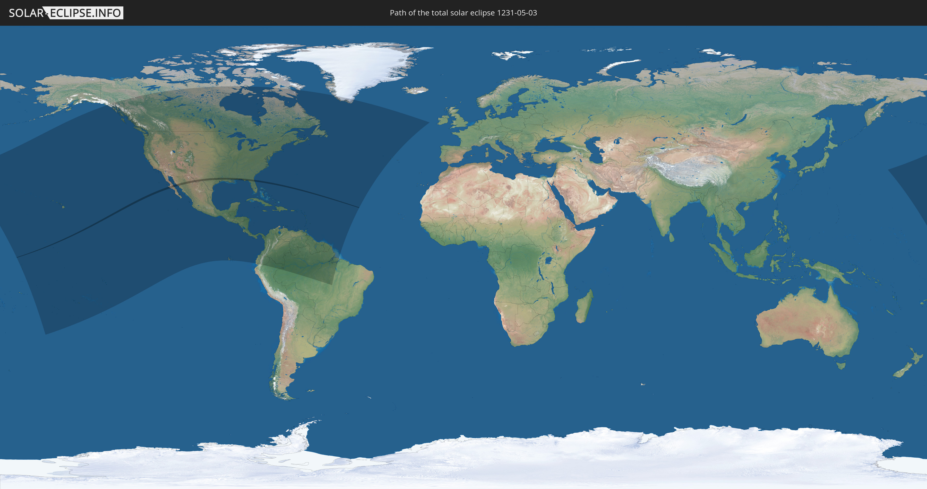
Die Sonnenfinsternis am 03.05.1231 kann man in 51 Ländern als partielle Sonnenfinsternis beobachten.
Der Finsternispfad verläuft durch 3 Länder. Nur in diesen Ländern ist sie als totale Sonnenfinsternis zu sehen.
In den folgenden Ländern ist die Sonnenfinsternis total zu sehen
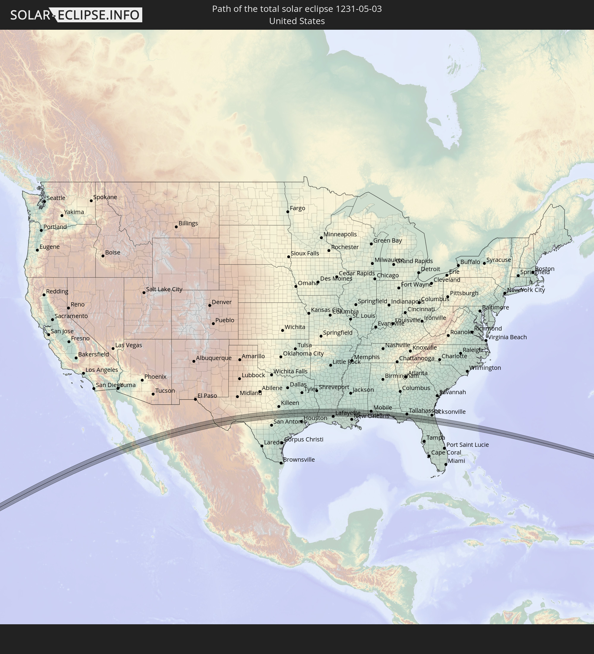 Vereinigte Staaten
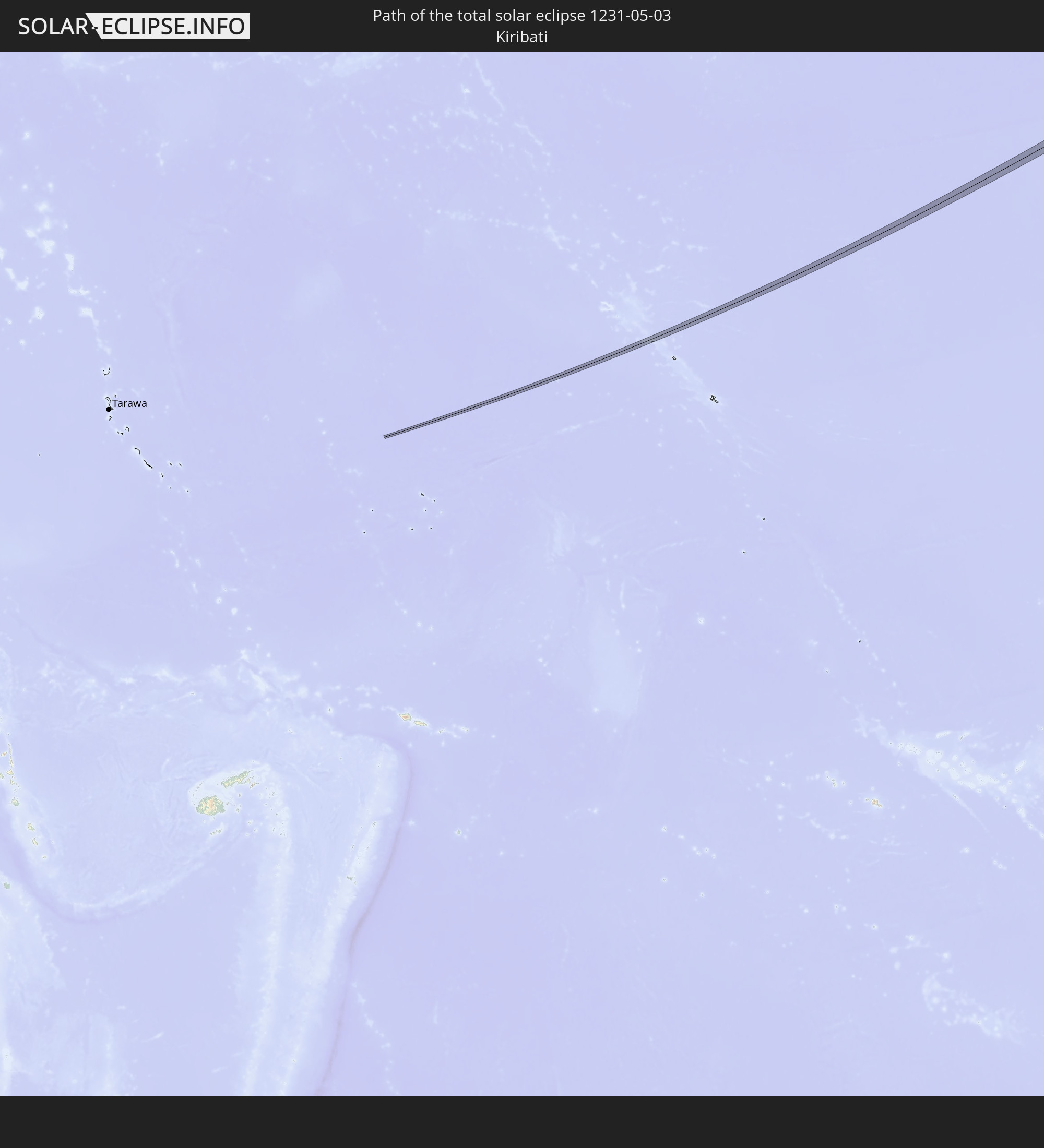 Kiribati
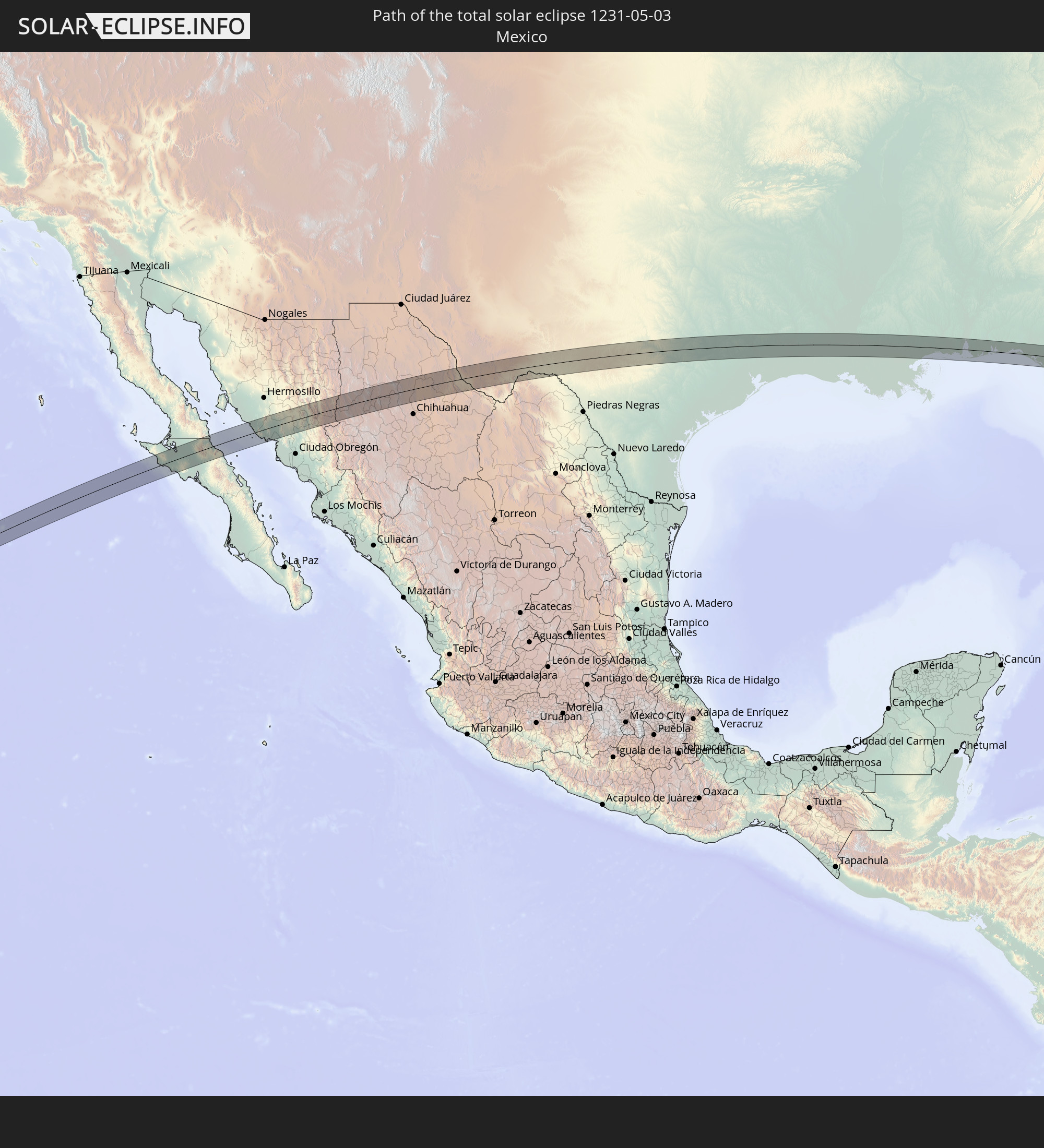 Mexiko
In den folgenden Ländern ist die Sonnenfinsternis partiell zu sehen
 Vereinigte Staaten
 United States Minor Outlying Islands
 Kiribati
 Cookinseln
 Französisch-Polynesien
 Kanada
 Mexiko
 Grönland
 Guatemala
 Ecuador
 El Salvador
 Honduras
 Belize
 Nicaragua
 Costa Rica
 Kuba
Kuba
 Panama
 Kolumbien
 Kaimaninseln
 Peru
Peru
 Bahamas
 Jamaika
 Haiti
Haiti
 Brasilien
 Venezuela
 Turks- und Caicosinseln
 Dominikanische Republik
 Aruba
Aruba
 Puerto Rico
 Amerikanische Jungferninseln
 Bermuda
 Britische Jungferninseln
 Anguilla
 Saint-Martin
 Saint-Barthélemy
 St. Kitts und Nevis
 Antigua und Barbuda
 Montserrat
 Trinidad und Tobago
 Guadeloupe
 Grenada
 Dominica
 St. Vincent und die Grenadinen
 Guyana
 Martinique
 St. Lucia
 Barbados
 Suriname
 Saint-Pierre und Miquelon
 Französisch-Guayana
 Portugal
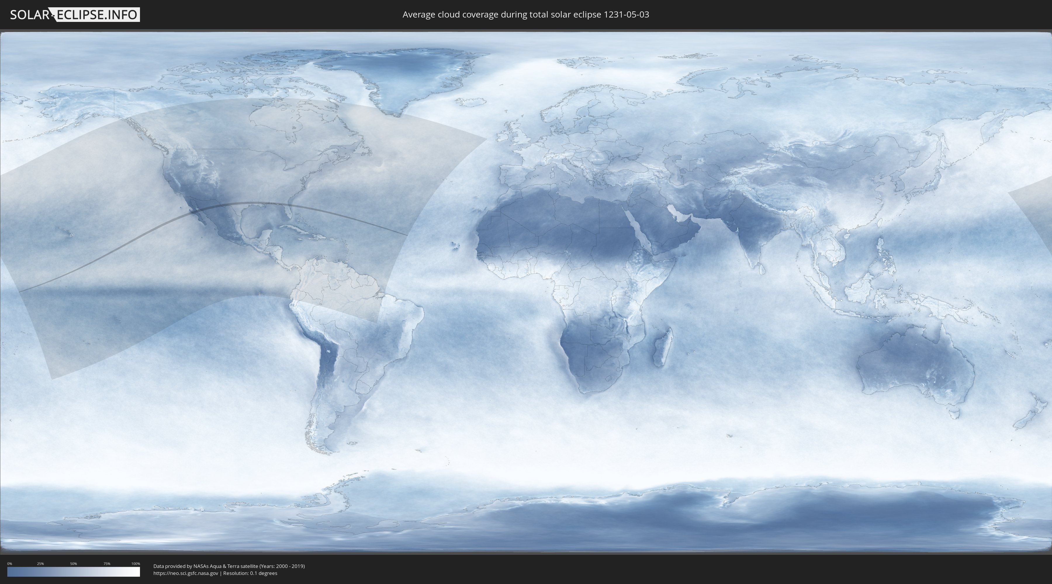
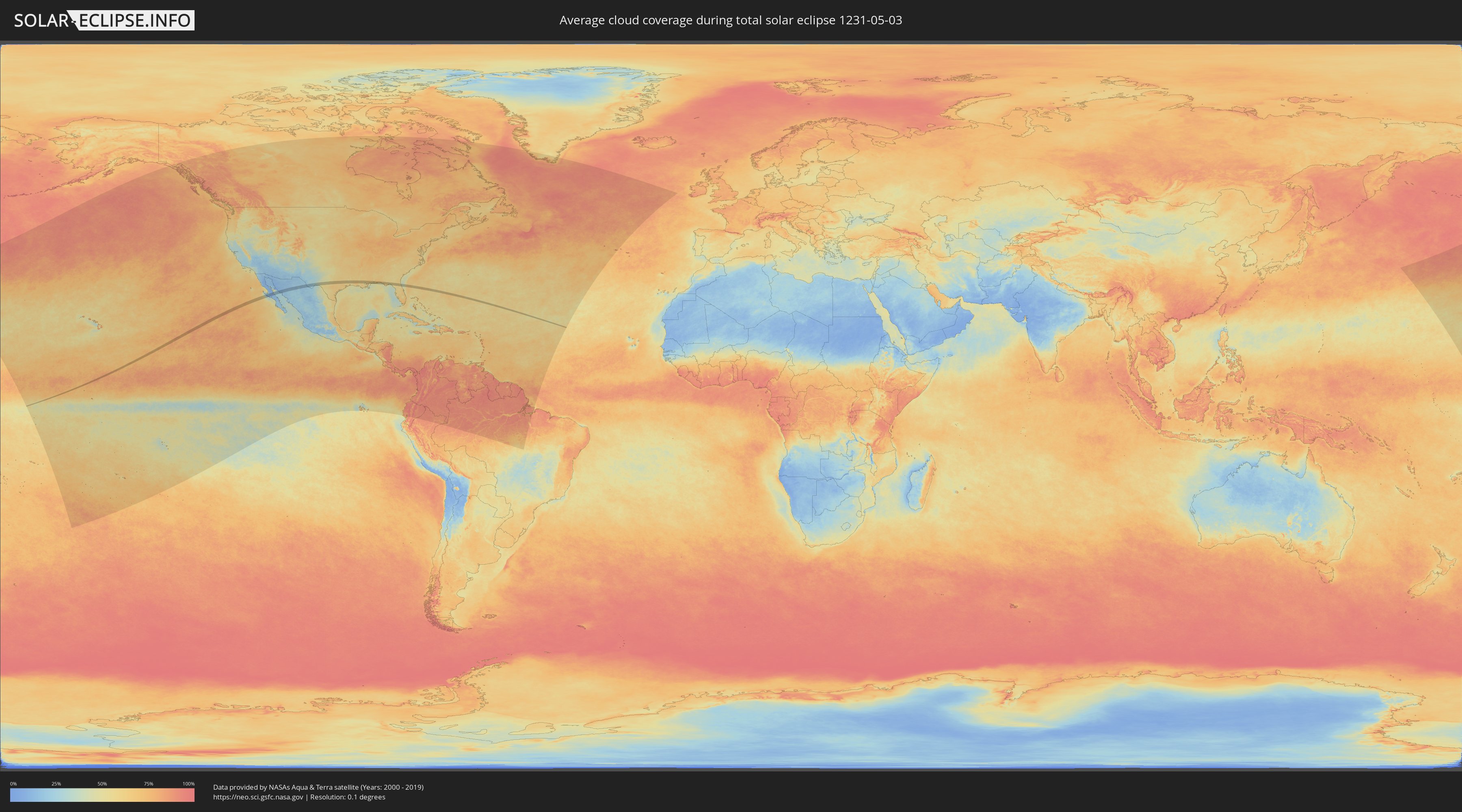
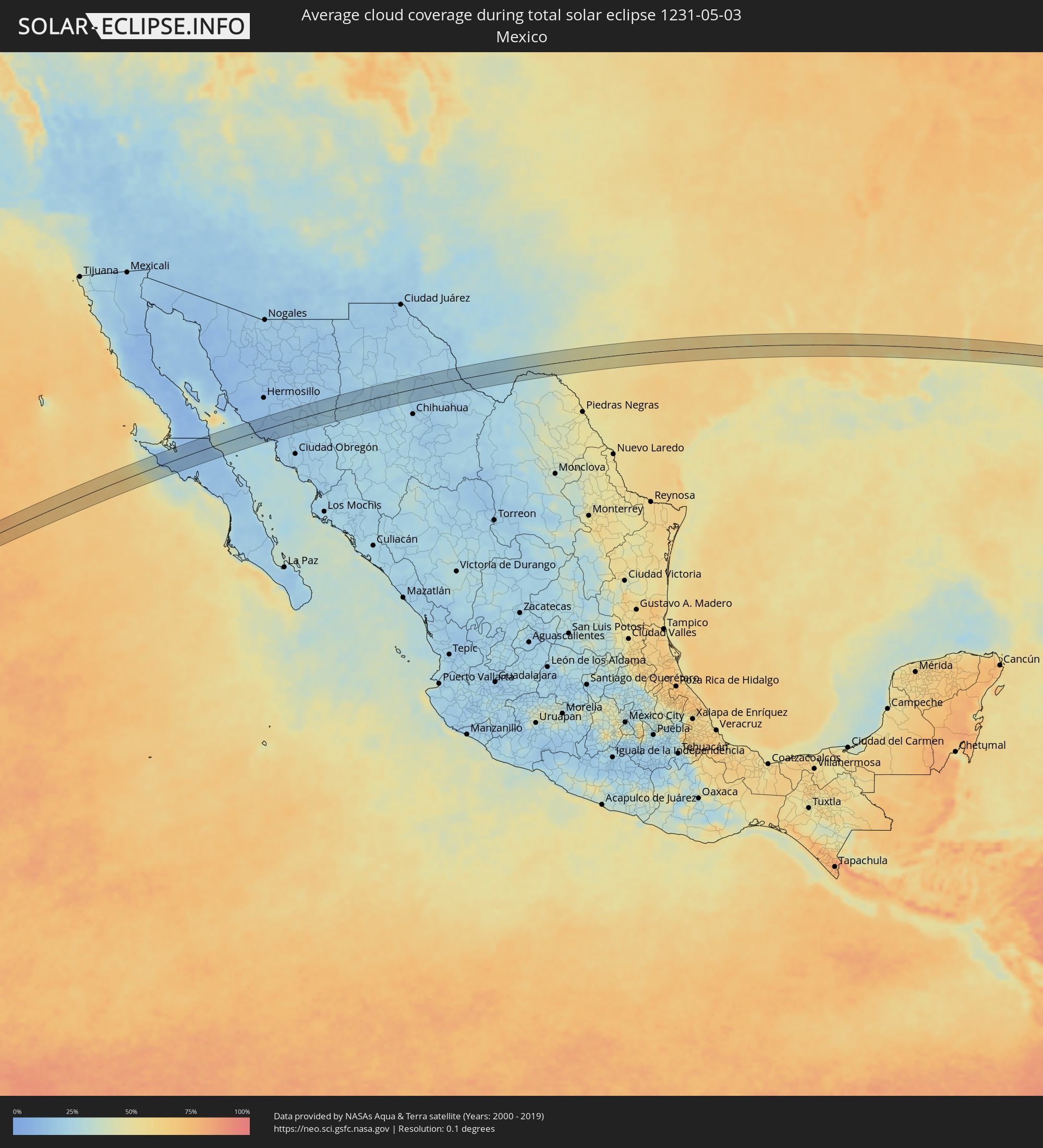
Wie wird das Wetter während der totalen Sonnenfinsternis am 03.05.1231?
Wo ist der beste Ort, um die totale Sonnenfinsternis vom 03.05.1231 zu beobachten?
Die folgenden Karten zeigen die durchschnittliche Bewölkung für den Tag, an dem die totale Sonnenfinsternis
stattfindet. Mit Hilfe der Karten lässt sich der Ort entlang des Finsternispfades eingrenzen,
der die besten Aussichen auf einen klaren wolkenfreien Himmel bietet.
Trotzdem muss man immer lokale Gegenenheiten beachten und sollte sich genau über das Wetter an seinem
gewählten Beobachtungsort informieren.
Die Daten stammen von den beiden NASA-Satelliten
AQUA und TERRA
und wurden über einen Zeitraum von 19 Jahren (2000 - 2019) gemittelt.
Detaillierte Länderkarten
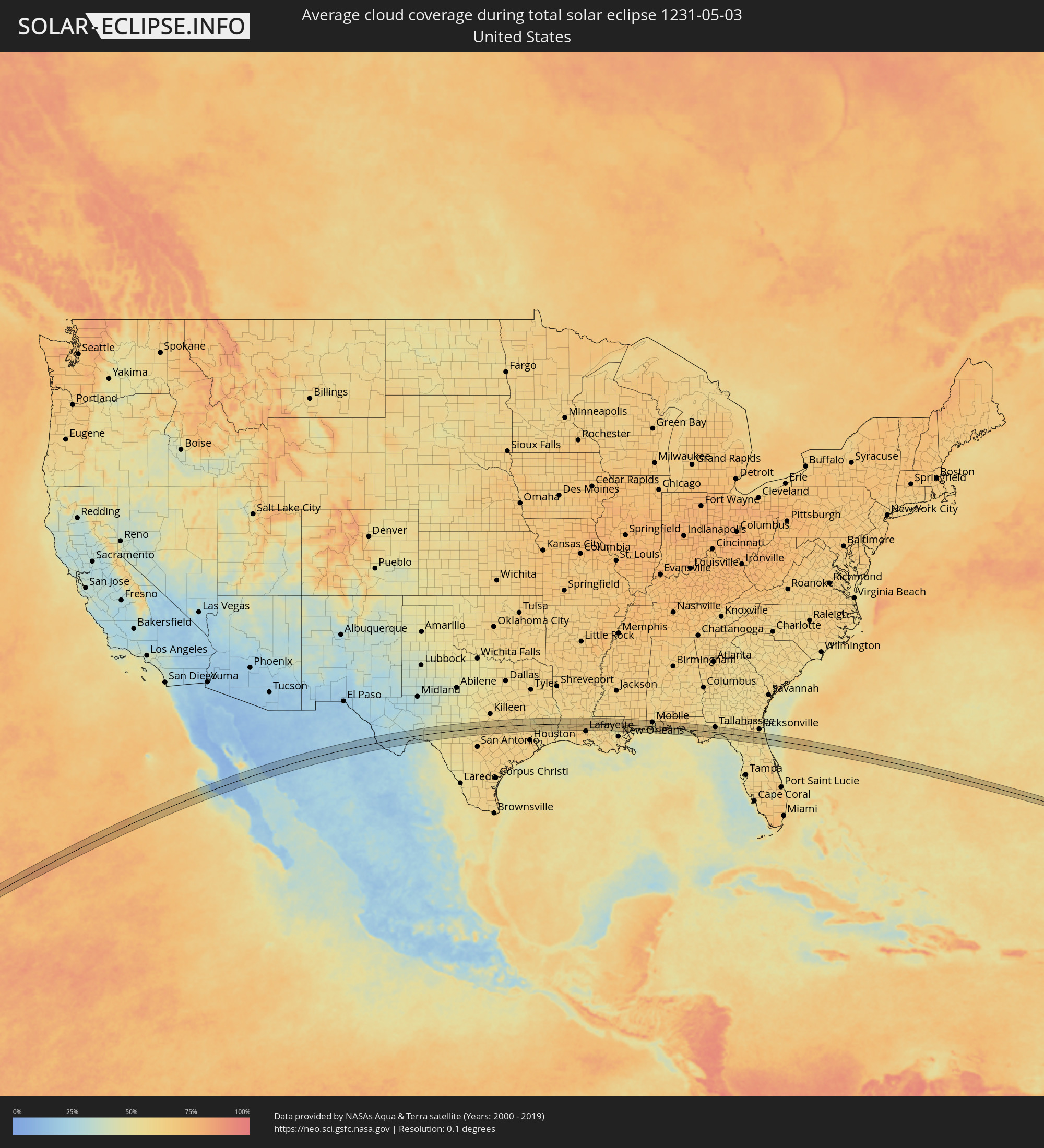 Vereinigte Staaten
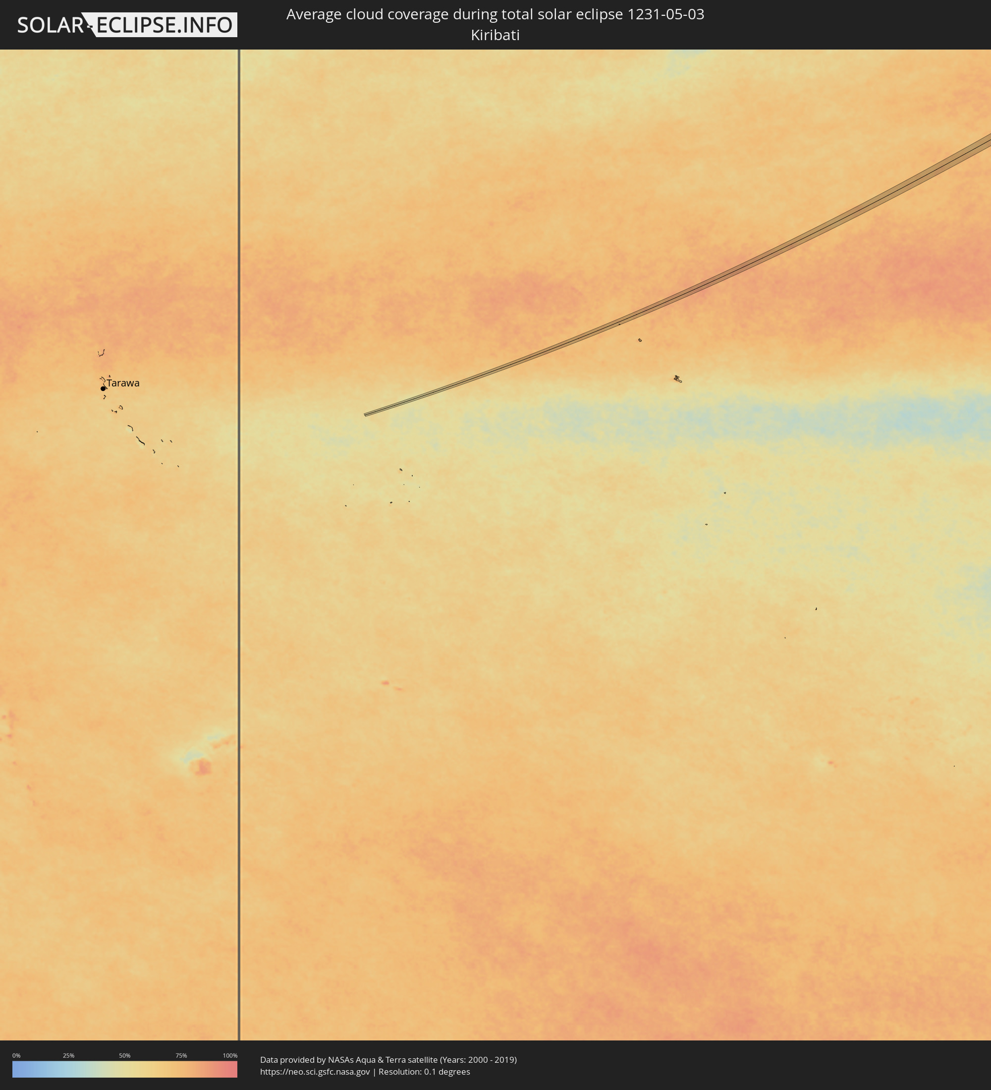 Kiribati
 Mexiko
Orte im Finsternispfad
Die nachfolgene Tabelle zeigt Städte und Orte mit mehr als 5.000 Einwohnern, die sich im Finsternispfad befinden. Städte mit mehr als 100.000 Einwohnern sind dick gekennzeichnet. Mit einem Klick auf den Ort öffnet sich eine Detailkarte die die Lage des jeweiligen Ortes zusammen mit dem Verlauf der zentralen Finsternis präsentiert.
| Ort | Typ | Dauer der Verfinsterung | Ortszeit bei maximaler Verfinsterung | Entfernung zur Zentrallinie | Ø Bewölkung |
|
Villa Alberto Andrés Alvarado Arámburo, Baja California Sur
|
total | - | 12:07:36 UTC-07:05 | 18 km | 13% |
|
Heroica Guaymas, Sonora
|
total | - | 11:56:21 UTC-07:23 | 31 km | 26% |
|
Empalme, Sonora
|
total | - | 11:56:37 UTC-07:23 | 29 km | 18% |
|
San Pedro Madera, Chihuahua
|
total | - | 12:23:01 UTC-07:05 | 30 km | 18% |
|
Ojinaga, Chihuahua
|
total | - | 12:32:52 UTC-07:05 | 8 km | 21% |
|
Manuel Ojinaga, Chihuahua
|
total | - | 12:33:13 UTC-07:05 | 10 km | 20% |
|
Kerrville, Texas
|
total | - | 13:52:43 UTC-06:00 | 32 km | 54% |
|
Fredericksburg, Texas
|
total | - | 13:53:25 UTC-06:00 | 9 km | 54% |
|
Lakeway, Texas
|
total | - | 13:55:38 UTC-06:00 | 7 km | 58% |
|
Leander, Texas
|
total | - | 13:55:57 UTC-06:00 | 16 km | 59% |
|
Anderson Mill, Texas
|
total | - | 13:56:04 UTC-06:00 | 2 km | 59% |
|
Austin, Texas
|
total | - | 13:56:13 UTC-06:00 | 20 km | 62% |
|
Wells Branch, Texas
|
total | - | 13:56:22 UTC-06:00 | 0 km | 62% |
|
Round Rock, Texas
|
total | - | 13:56:23 UTC-06:00 | 6 km | 62% |
|
Hornsby Bend, Texas
|
total | - | 13:56:36 UTC-06:00 | 23 km | 61% |
|
Hutto, Texas
|
total | - | 13:56:42 UTC-06:00 | 9 km | 62% |
|
Taylor, Texas
|
total | - | 13:57:02 UTC-06:00 | 11 km | 58% |
|
Elgin, Texas
|
total | - | 13:57:08 UTC-06:00 | 13 km | 63% |
|
Camp Swift, Texas
|
total | - | 13:57:19 UTC-06:00 | 32 km | 62% |
|
College Station, Texas
|
total | - | 13:59:37 UTC-06:00 | 11 km | 61% |
|
Navasota, Texas
|
total | - | 14:00:13 UTC-06:00 | 17 km | 63% |
|
Huntsville, Texas
|
total | - | 14:01:28 UTC-06:00 | 18 km | 56% |
|
Conroe, Texas
|
total | - | 14:01:44 UTC-06:00 | 28 km | 60% |
|
Cleveland, Texas
|
total | - | 14:02:36 UTC-06:00 | 26 km | 59% |
|
West Livingston, Texas
|
total | - | 14:02:45 UTC-06:00 | 13 km | 55% |
|
Silsbee, Texas
|
total | - | 14:04:43 UTC-06:00 | 28 km | 59% |
|
Jasper, Texas
|
total | - | 14:05:01 UTC-06:00 | 35 km | 57% |
|
DeRidder, Louisiana
|
total | - | 14:06:38 UTC-06:00 | 26 km | 59% |
|
Moss Bluff, Louisiana
|
total | - | 14:06:59 UTC-06:00 | 35 km | 59% |
|
Oakdale, Louisiana
|
total | - | 14:08:02 UTC-06:00 | 22 km | 61% |
|
Oakdale, Louisiana
|
total | - | 14:08:08 UTC-06:00 | 21 km | 61% |
|
Eunice, Louisiana
|
total | - | 14:08:40 UTC-06:00 | 13 km | 64% |
|
Ville Platte, Louisiana
|
total | - | 14:08:56 UTC-06:00 | 8 km | 65% |
|
Opelousas, Louisiana
|
total | - | 14:09:24 UTC-06:00 | 9 km | 64% |
|
Carencro, Louisiana
|
total | - | 14:09:32 UTC-06:00 | 33 km | 63% |
|
Plaquemine, Louisiana
|
total | - | 14:11:19 UTC-06:00 | 35 km | 62% |
|
Baker, Louisiana
|
total | - | 14:11:22 UTC-06:00 | 1 km | 60% |
|
Zachary, Louisiana
|
total | - | 14:11:22 UTC-06:00 | 6 km | 60% |
|
Baton Rouge, Louisiana
|
total | - | 14:11:26 UTC-06:00 | 16 km | 62% |
|
Gardere, Louisiana
|
total | - | 14:11:30 UTC-06:00 | 28 km | 61% |
|
Merrydale, Louisiana
|
total | - | 14:11:31 UTC-06:00 | 11 km | 62% |
|
Oak Hills Place, Louisiana
|
total | - | 14:11:37 UTC-06:00 | 26 km | 61% |
|
Village Saint George, Louisiana
|
total | - | 14:11:39 UTC-06:00 | 26 km | 61% |
|
Central, Louisiana
|
total | - | 14:11:39 UTC-06:00 | 5 km | 60% |
|
Old Jefferson, Louisiana
|
total | - | 14:11:45 UTC-06:00 | 24 km | 63% |
|
Prairieville, Louisiana
|
total | - | 14:11:53 UTC-06:00 | 33 km | 63% |
|
Denham Springs, Louisiana
|
total | - | 14:11:51 UTC-06:00 | 12 km | 62% |
|
Hammond, Louisiana
|
total | - | 14:12:54 UTC-06:00 | 9 km | 58% |
|
Ponchatoula, Louisiana
|
total | - | 14:12:58 UTC-06:00 | 16 km | 50% |
|
Covington, Louisiana
|
total | - | 14:13:40 UTC-06:00 | 11 km | 59% |
|
Mandeville, Louisiana
|
total | - | 14:13:47 UTC-06:00 | 24 km | 52% |
|
Lacombe, Louisiana
|
total | - | 14:14:04 UTC-06:00 | 28 km | 54% |
|
Bogalusa, Louisiana
|
total | - | 14:14:04 UTC-06:00 | 25 km | 60% |
|
Slidell, Louisiana
|
total | - | 14:14:25 UTC-06:00 | 32 km | 58% |
|
Picayune, Mississippi
|
total | - | 14:14:32 UTC-06:00 | 3 km | 60% |
|
Carriere, Mississippi
|
total | - | 14:14:33 UTC-06:00 | 7 km | 62% |
|
Waveland, Mississippi
|
total | - | 14:15:15 UTC-06:00 | 29 km | 52% |
|
Diamondhead, Mississippi
|
total | - | 14:15:14 UTC-06:00 | 17 km | 56% |
|
Bay Saint Louis, Mississippi
|
total | - | 14:15:20 UTC-06:00 | 26 km | 50% |
|
Long Beach, Mississippi
|
total | - | 14:15:41 UTC-06:00 | 20 km | 56% |
|
West Gulfport, Mississippi
|
total | - | 14:15:47 UTC-06:00 | 14 km | 55% |
|
D'Iberville, Mississippi
|
total | - | 14:16:11 UTC-06:00 | 11 km | 53% |
|
Biloxi, Mississippi
|
total | - | 14:16:13 UTC-06:00 | 14 km | 53% |
|
Saint Martin, Mississippi
|
total | - | 14:16:14 UTC-06:00 | 9 km | 53% |
|
Gulf Hills, Mississippi
|
total | - | 14:16:17 UTC-06:00 | 10 km | 55% |
|
Pascagoula, Mississippi
|
total | - | 14:16:53 UTC-06:00 | 16 km | 56% |
|
Moss Point, Mississippi
|
total | - | 14:16:55 UTC-06:00 | 10 km | 54% |
|
Tillmans Corner, Alabama
|
total | - | 14:17:34 UTC-06:00 | 12 km | 60% |
|
Mobile, Alabama
|
total | - | 14:17:46 UTC-06:00 | 24 km | 54% |
|
Spanish Fort, Alabama
|
total | - | 14:18:02 UTC-06:00 | 23 km | 55% |
|
Daphne, Alabama
|
total | - | 14:18:05 UTC-06:00 | 15 km | 56% |
|
Gulf Shores, Alabama
|
total | - | 14:18:39 UTC-06:00 | 23 km | 50% |
|
Foley, Alabama
|
total | - | 14:18:37 UTC-06:00 | 6 km | 62% |
|
Cantonment, Florida
|
total | - | 14:19:11 UTC-06:00 | 19 km | 65% |
|
Gonzalez, Florida
|
total | - | 14:19:17 UTC-06:00 | 17 km | 65% |
|
Warrington, Florida
|
total | - | 14:19:25 UTC-06:00 | 5 km | 62% |
|
East Pensacola Heights, Florida
|
total | - | 14:19:35 UTC-06:00 | 1 km | 62% |
|
Pace, Florida
|
total | - | 14:19:32 UTC-06:00 | 20 km | 60% |
|
Milton, Florida
|
total | - | 14:19:45 UTC-06:00 | 24 km | 59% |
|
East Milton, Florida
|
total | - | 14:19:48 UTC-06:00 | 22 km | 59% |
|
Navarre, Florida
|
total | - | 14:20:12 UTC-06:00 | 0 km | 58% |
|
Wright, Florida
|
total | - | 14:20:37 UTC-06:00 | 8 km | 59% |
|
Lake Lorraine, Florida
|
total | - | 14:20:45 UTC-06:00 | 7 km | 54% |
|
Eglin Village, Florida
|
total | - | 14:20:48 UTC-06:00 | 9 km | 57% |
|
Destin, Florida
|
total | - | 14:20:55 UTC-06:00 | 2 km | 52% |
|
Niceville, Florida
|
total | - | 14:20:52 UTC-06:00 | 16 km | 57% |
|
Panama City Beach, Florida
|
total | - | 14:22:20 UTC-06:00 | 16 km | 51% |
|
Upper Grand Lagoon, Florida
|
total | - | 14:22:27 UTC-06:00 | 17 km | 54% |
|
Panama City, Florida
|
total | - | 14:22:37 UTC-06:00 | 17 km | 54% |
|
Springfield, Florida
|
total | - | 14:22:42 UTC-06:00 | 17 km | 54% |
|
Callaway, Florida
|
total | - | 14:22:47 UTC-06:00 | 16 km | 54% |
|
Tallahassee, Florida
|
total | - | 15:24:57 UTC-05:00 | 28 km | 58% |
|
Perry, Florida
|
total | - | 15:26:22 UTC-05:00 | 1 km | 53% |
|
Live Oak, Florida
|
total | - | 15:27:18 UTC-05:00 | 28 km | 55% |
|
Lake City, Florida
|
total | - | 15:27:57 UTC-05:00 | 20 km | 55% |
|
Alachua, Florida
|
total | - | 15:28:35 UTC-05:00 | 25 km | 56% |
|
Middleburg, Florida
|
total | - | 15:29:19 UTC-05:00 | 17 km | 59% |
|
Asbury Lake, Florida
|
total | - | 15:29:24 UTC-05:00 | 16 km | 58% |
|
Lakeside, Florida
|
total | - | 15:29:26 UTC-05:00 | 25 km | 58% |
|
Bellair-Meadowbrook Terrace, Florida
|
total | - | 15:29:26 UTC-05:00 | 31 km | 53% |
|
Orange Park, Florida
|
total | - | 15:29:30 UTC-05:00 | 30 km | 53% |
|
Green Cove Springs, Florida
|
total | - | 15:29:40 UTC-05:00 | 11 km | 54% |
|
Palatka, Florida
|
total | - | 15:29:58 UTC-05:00 | 26 km | 55% |
|
Saint Augustine, Florida
|
total | - | 15:30:19 UTC-05:00 | 6 km | 51% |
|
Saint Augustine Shores, Florida
|
total | - | 15:30:23 UTC-05:00 | 4 km | 52% |
|
Palm Coast, Florida
|
total | - | 15:30:42 UTC-05:00 | 27 km | 50% |