Totale Sonnenfinsternis vom 25.05.1267
| Wochentag: | Mittwoch |
| Maximale Dauer der Verfinsterung: | 01m37s |
| Maximale Breite des Finsternispfades: | 64 km |
| Saroszyklus: | 106 |
| Bedeckungsgrad: | 100% |
| Magnitude: | 1.0177 |
| Gamma: | 0.3243 |
Wo kann man die Sonnenfinsternis vom 25.05.1267 sehen?
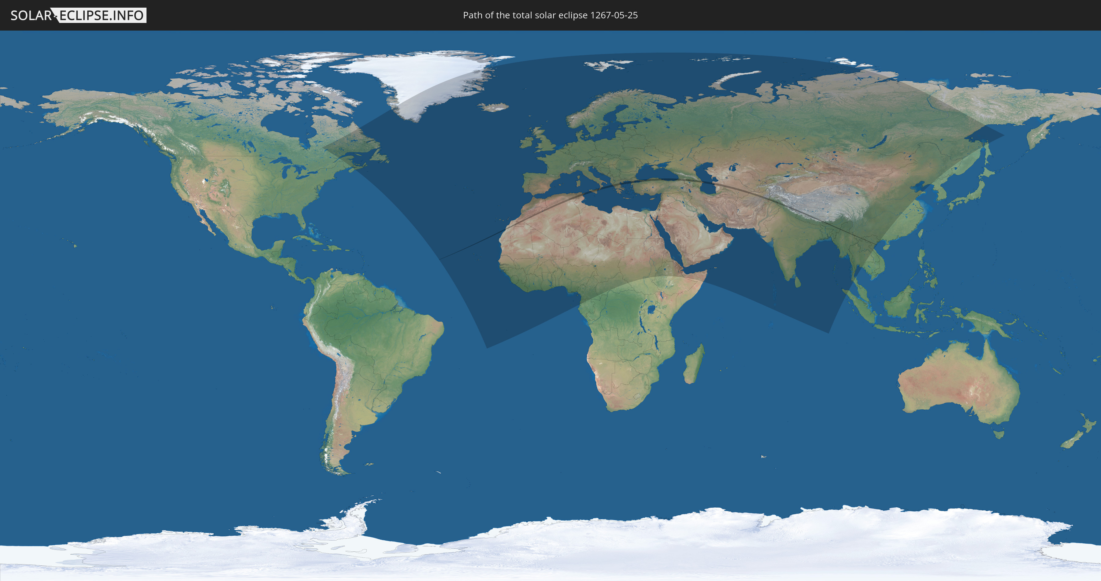
Die Sonnenfinsternis am 25.05.1267 kann man in 127 Ländern als partielle Sonnenfinsternis beobachten.
Der Finsternispfad verläuft durch 19 Länder. Nur in diesen Ländern ist sie als totale Sonnenfinsternis zu sehen.
In den folgenden Ländern ist die Sonnenfinsternis total zu sehen
 Marokko
 Algerien
 Italien
 Tunesien
 Griechenland
 Türkei
 Georgien
 Armenien
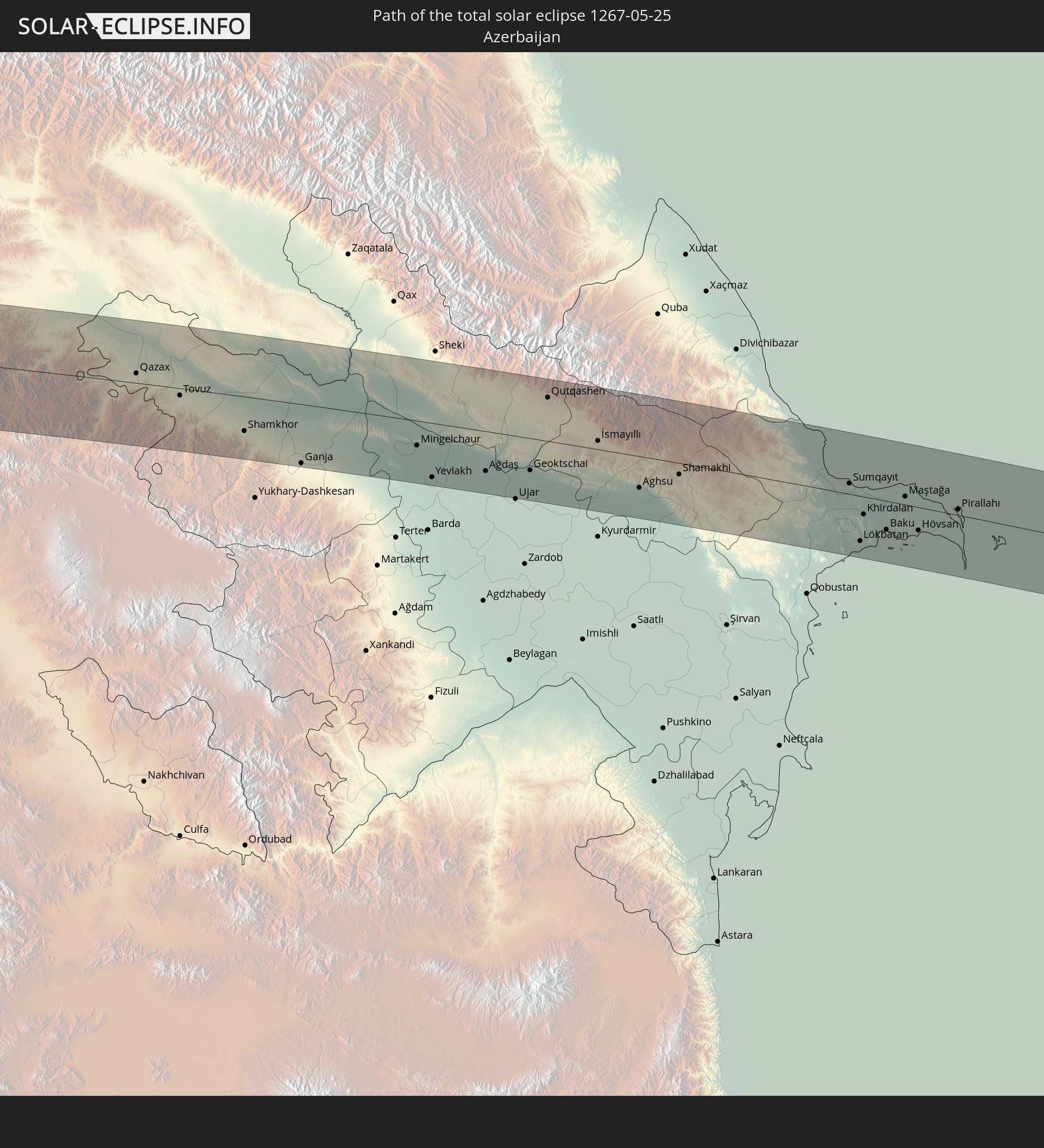 Aserbaidschan
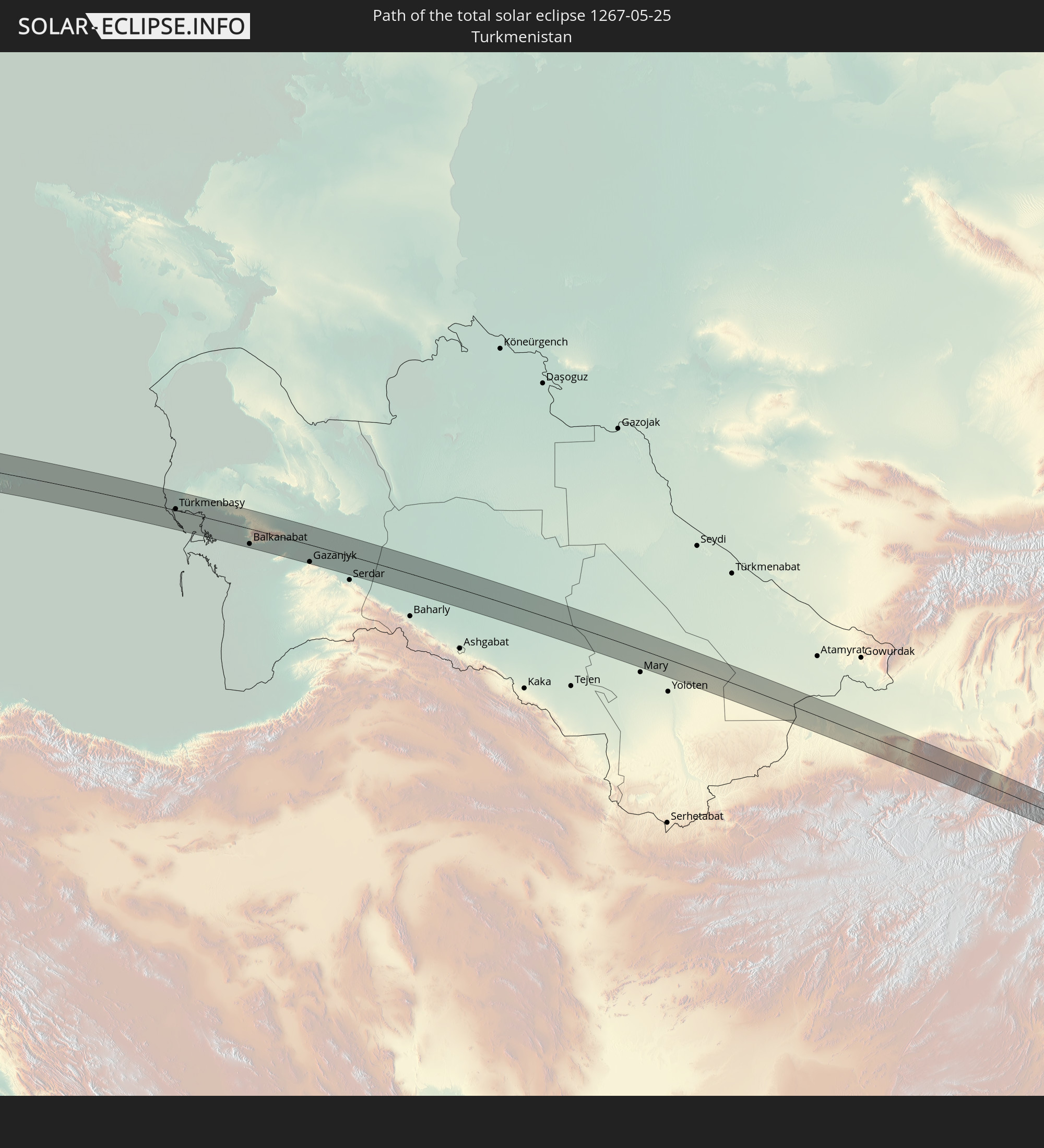 Turkmenistan
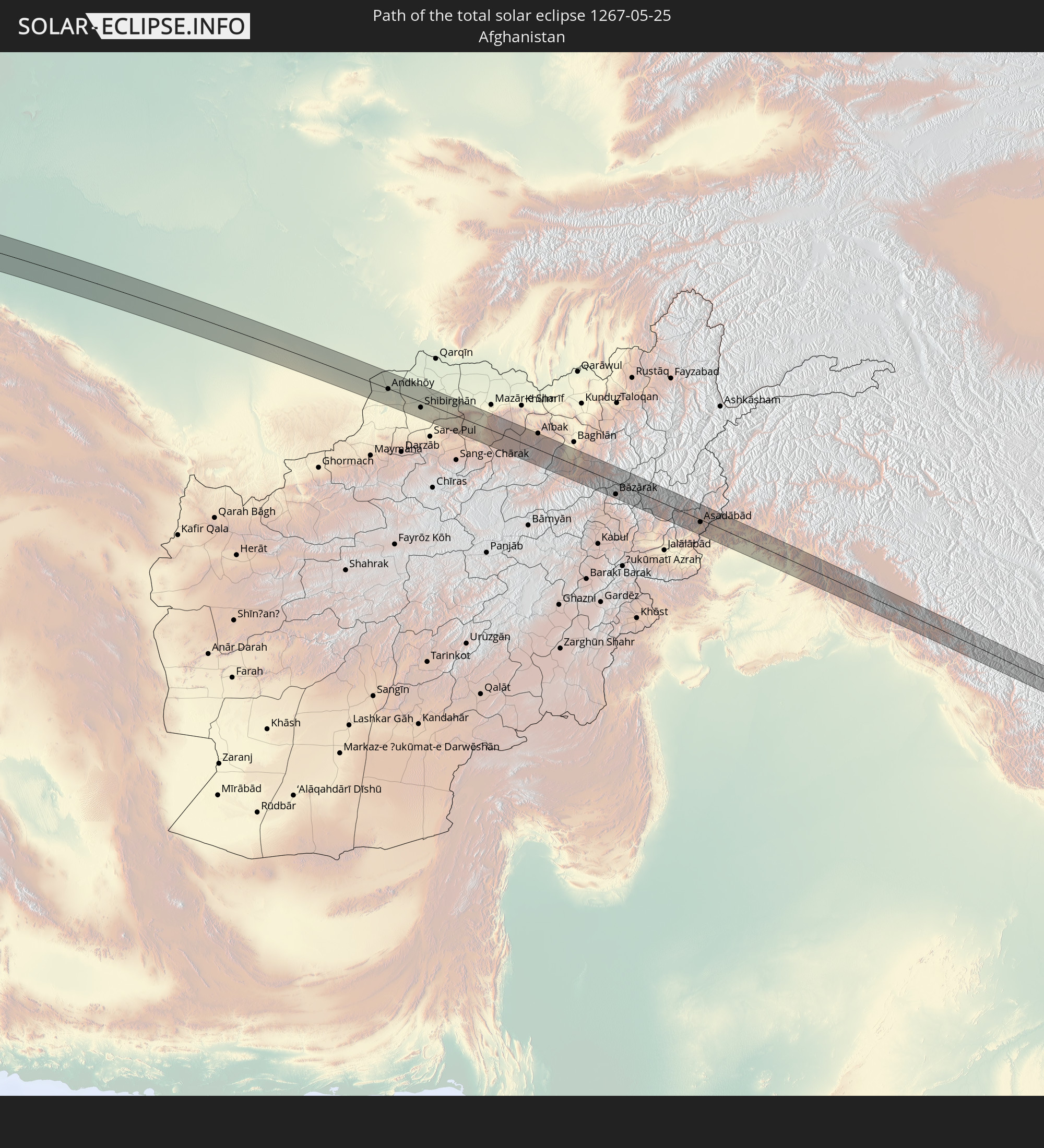 Afghanistan
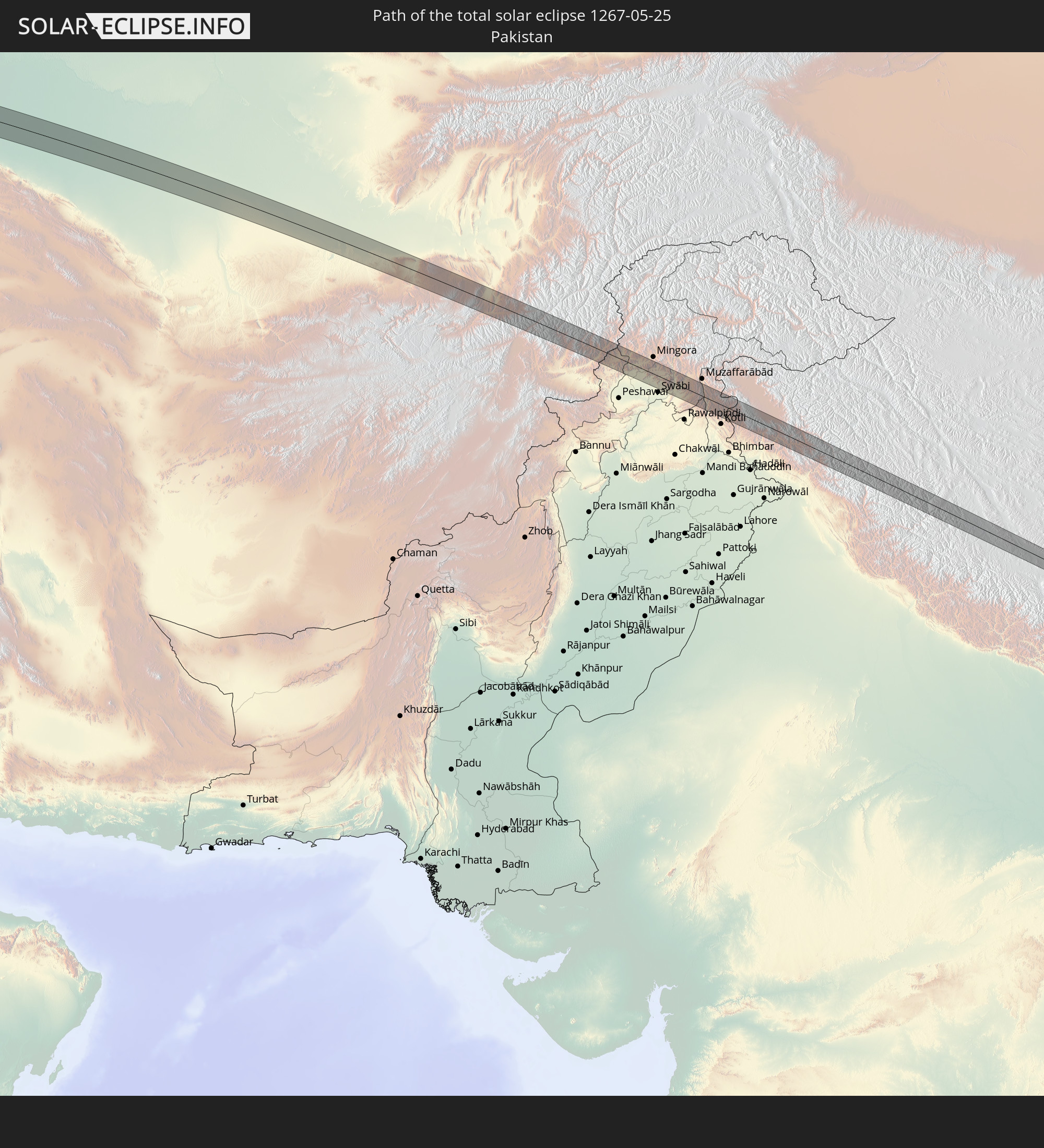 Pakistan
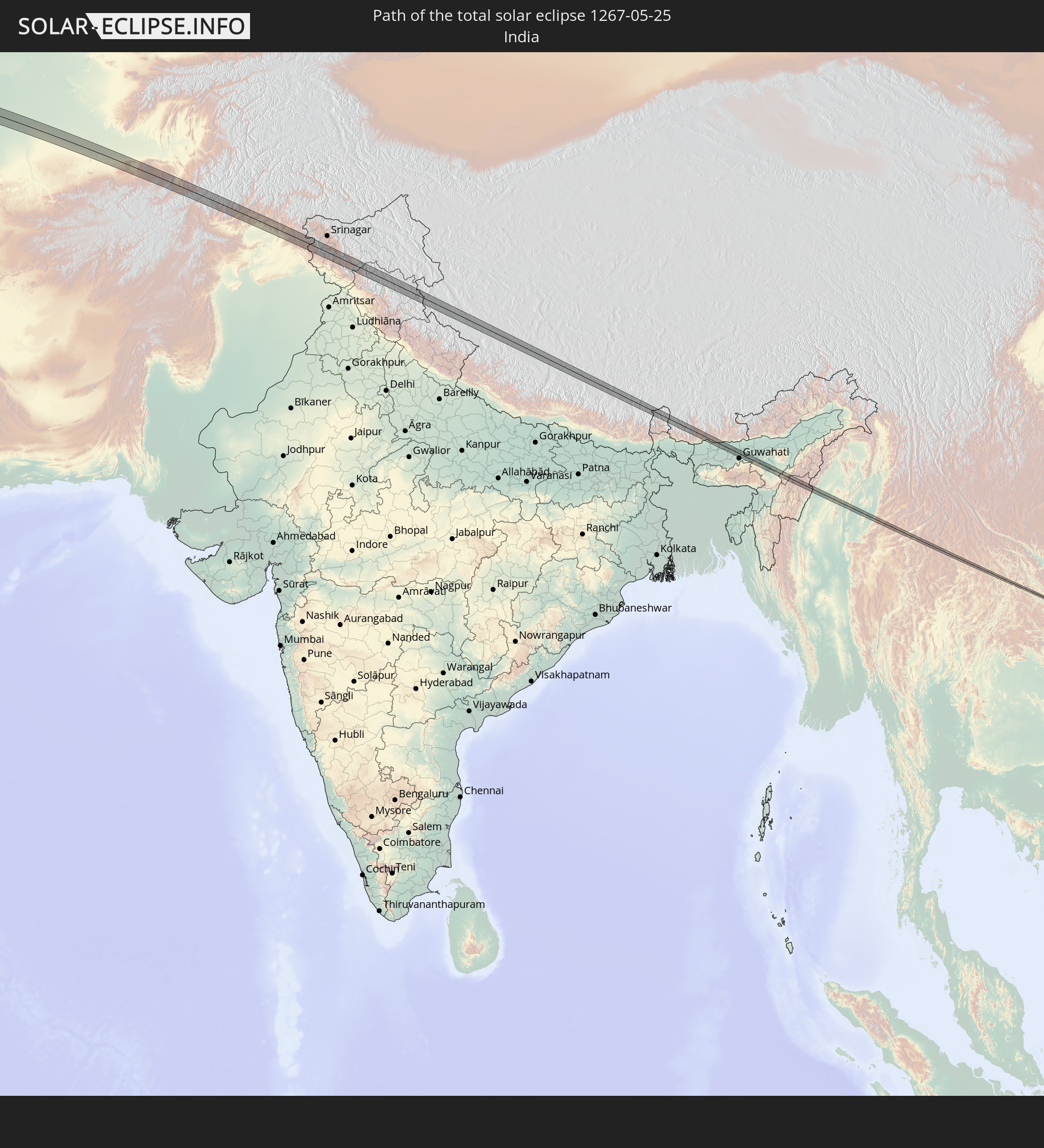 Indien
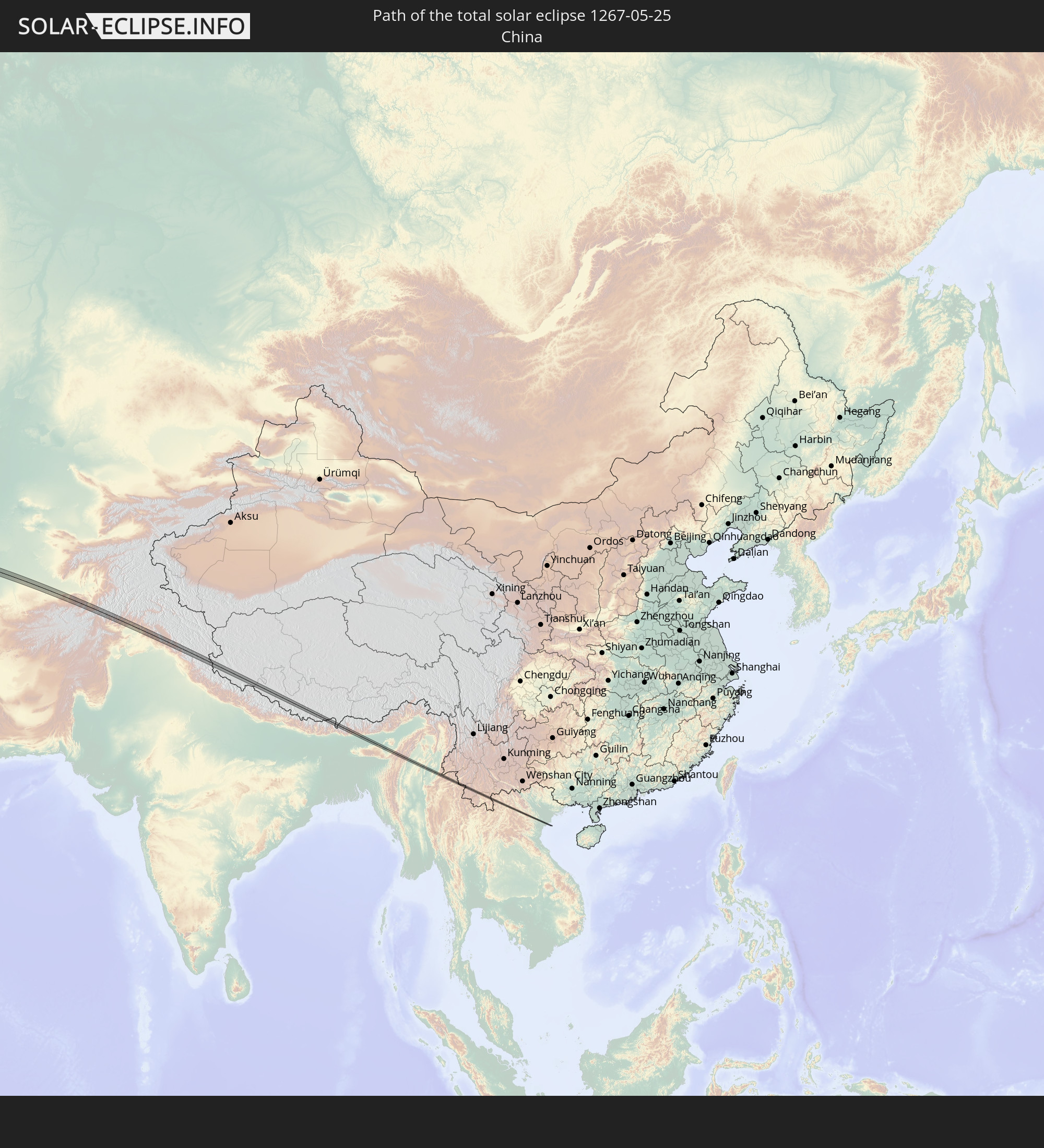 Volksrepublik China
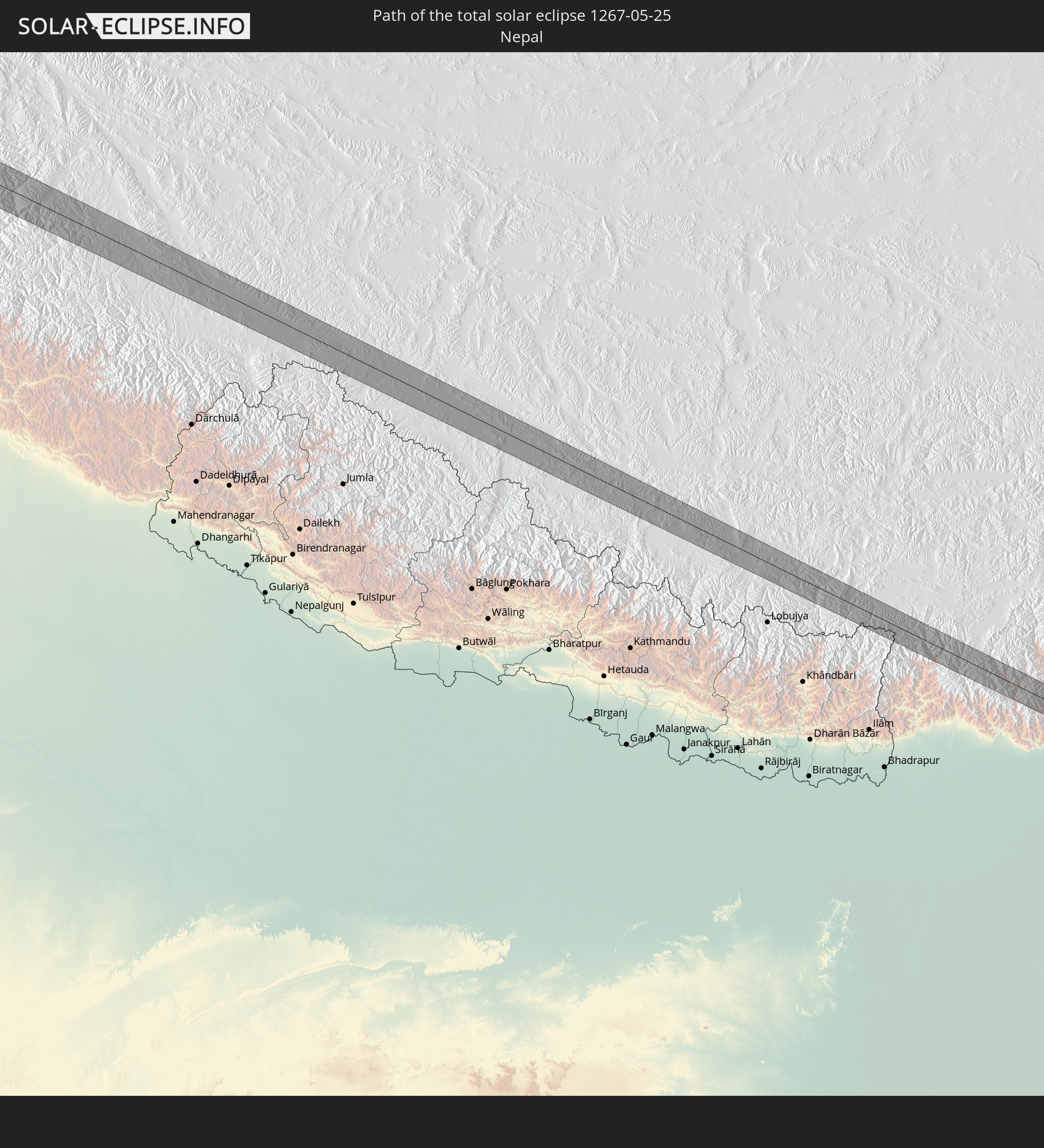 Nepal
Nepal
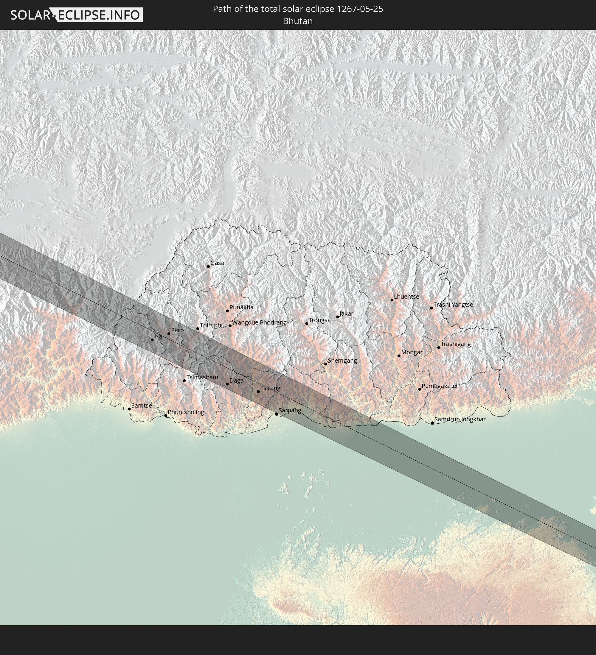 Bhutan
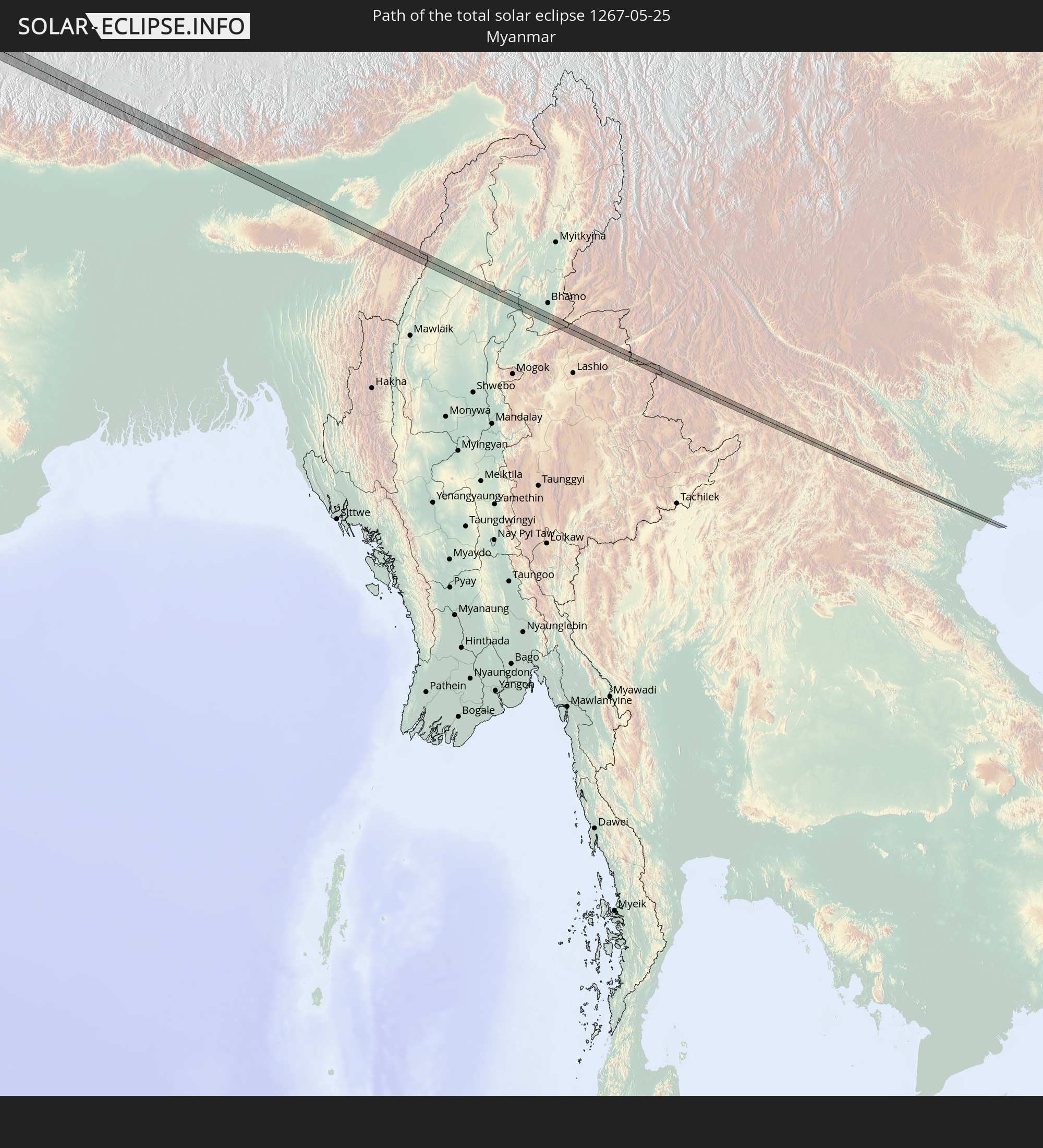 Myanmar
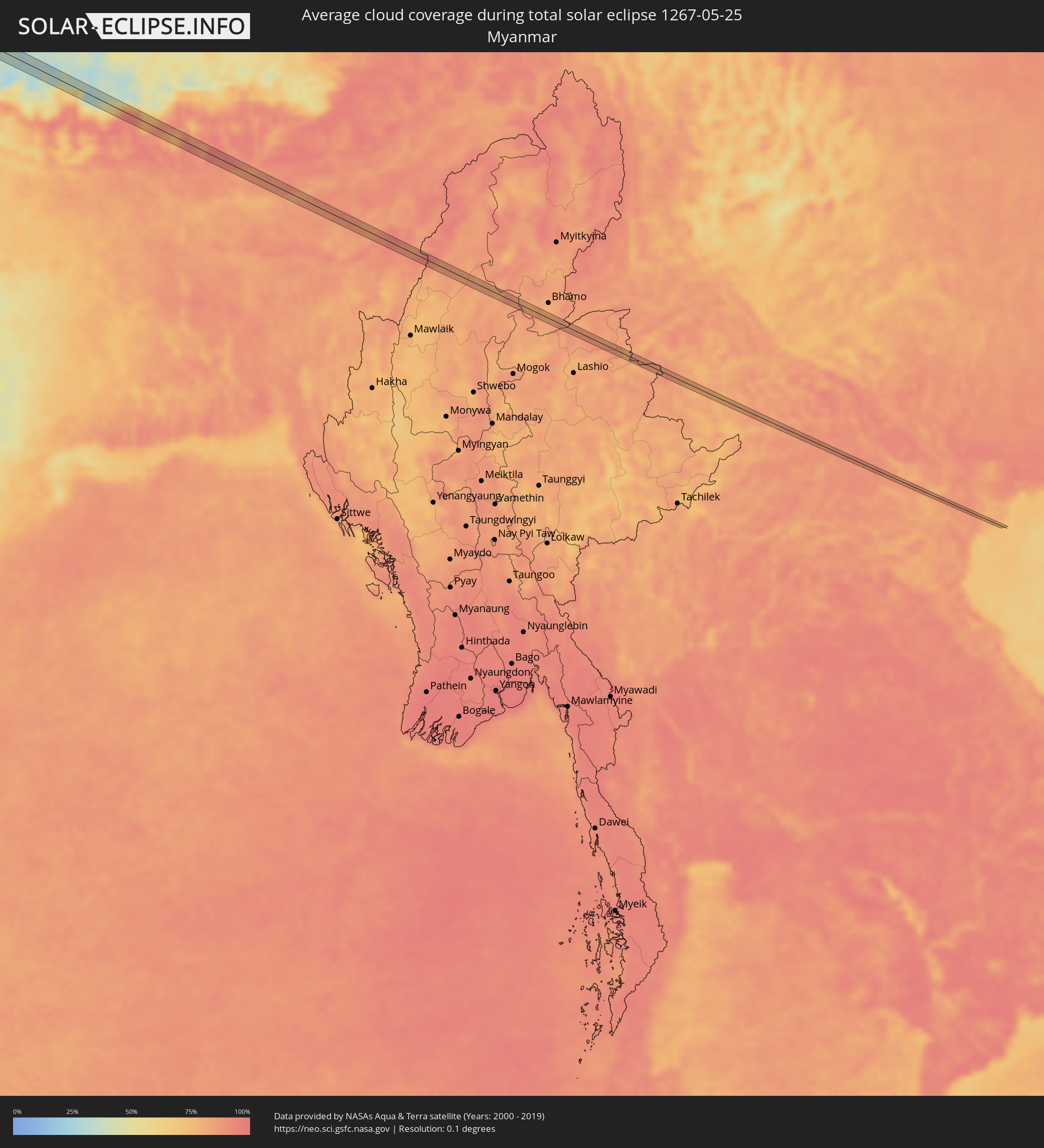
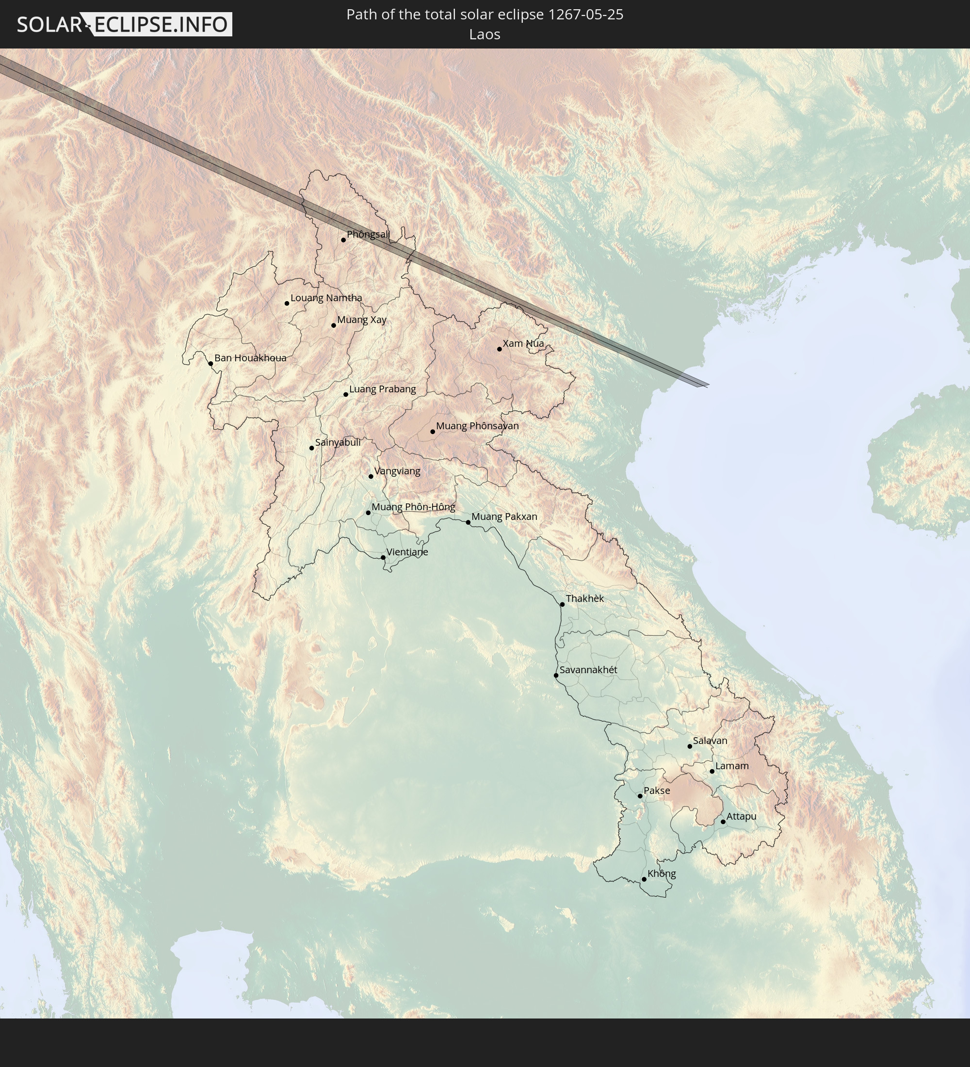 Laos
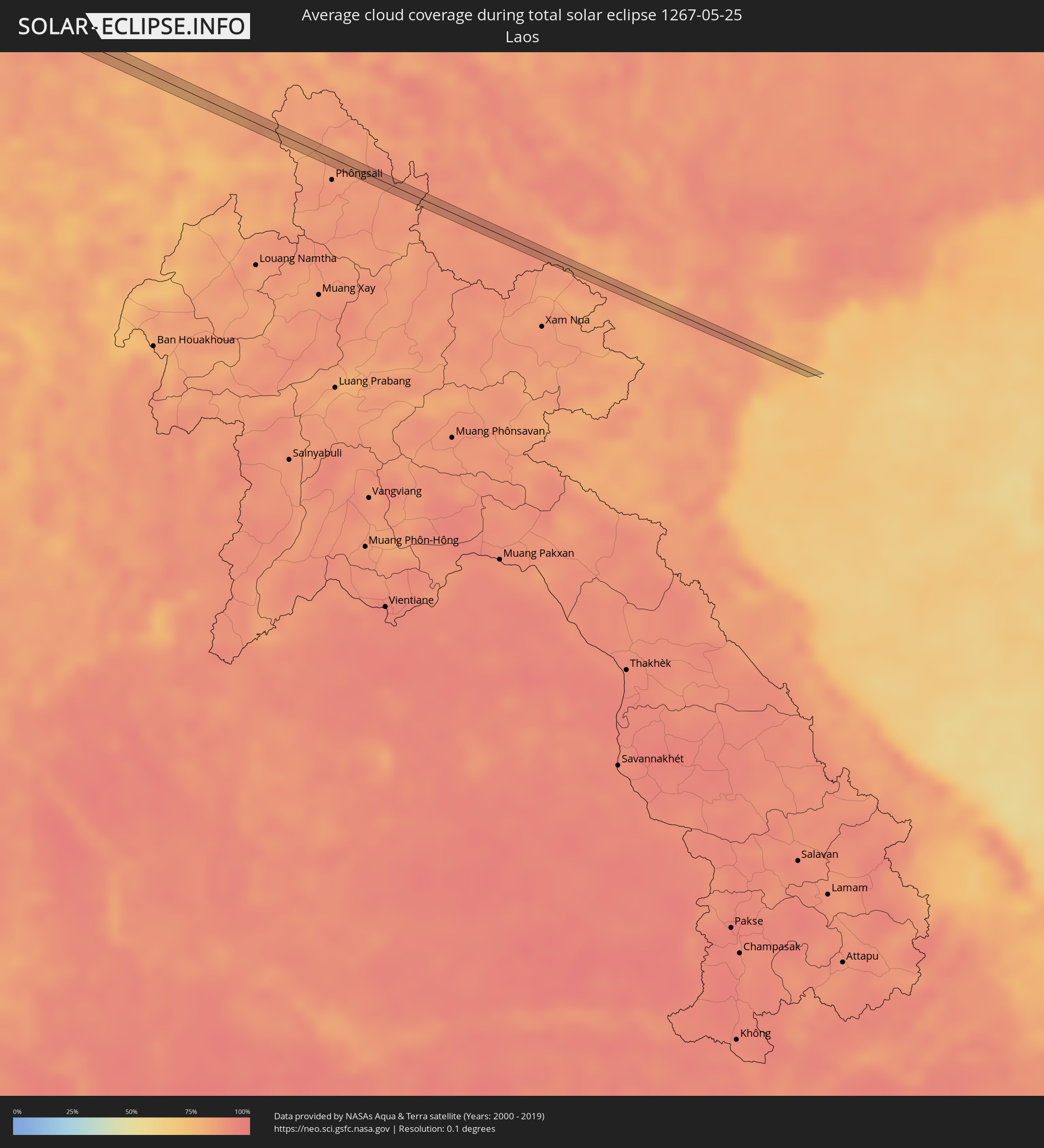
Laos
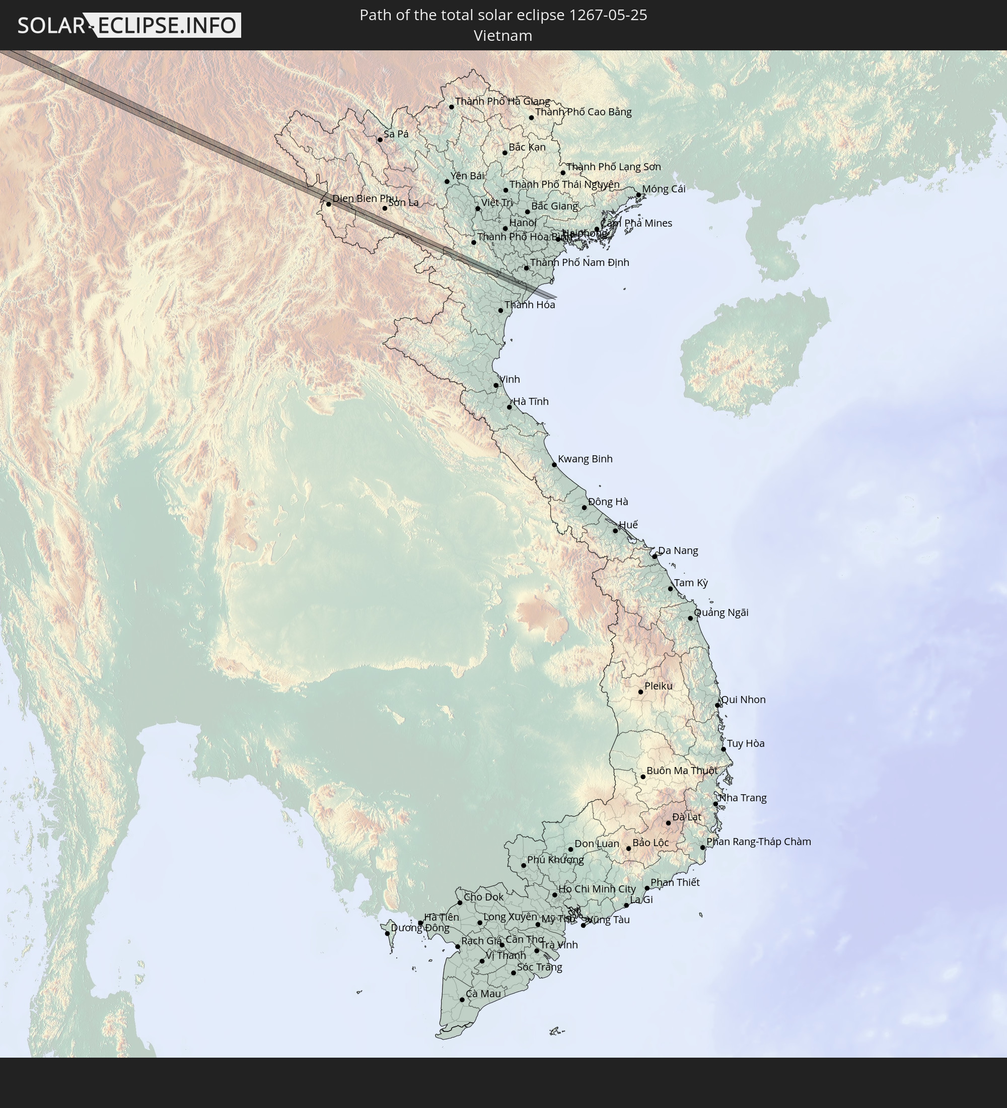 Vietnam
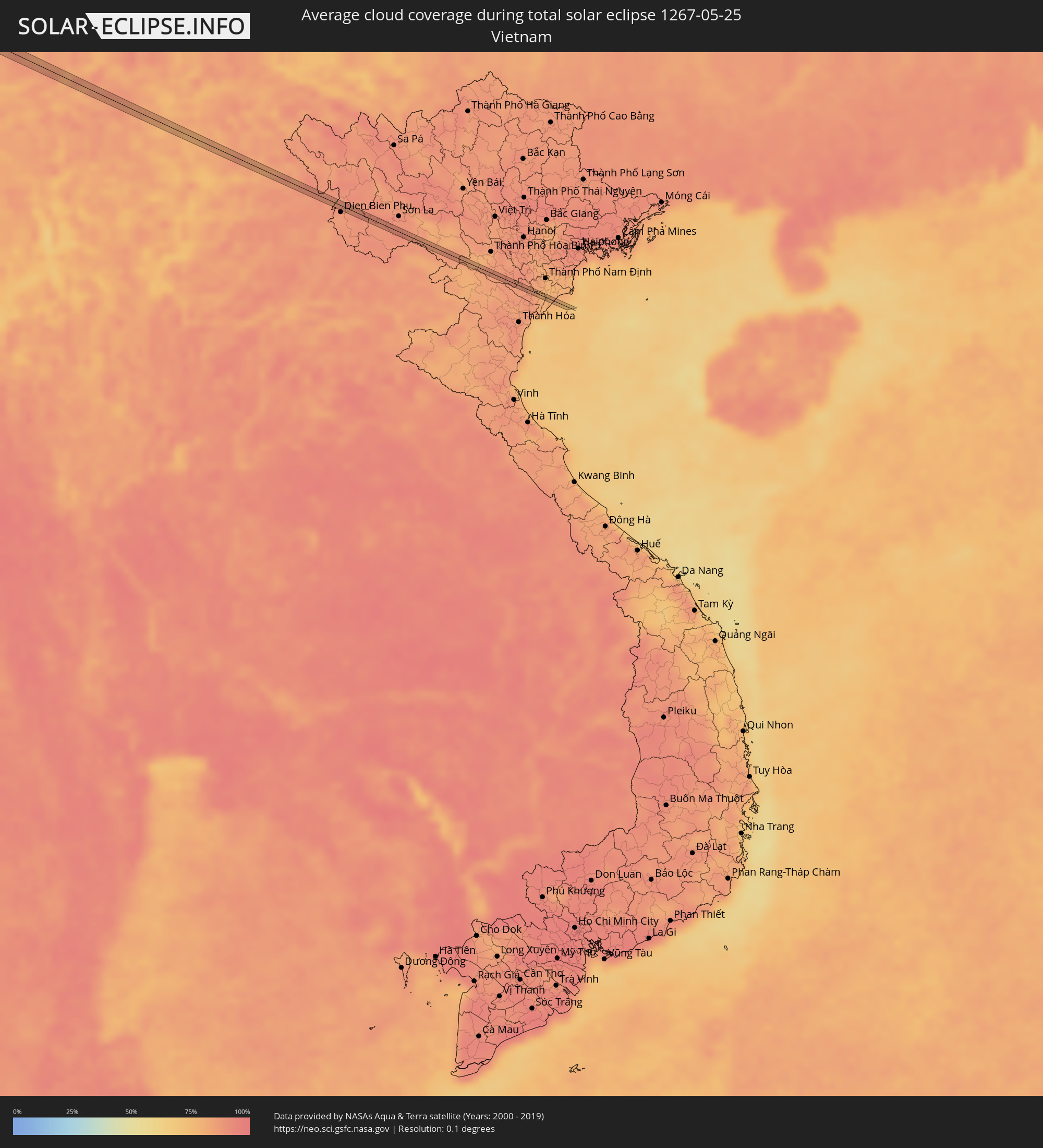
In den folgenden Ländern ist die Sonnenfinsternis partiell zu sehen
 Russland
 Kanada
 Grönland
 Saint-Pierre und Miquelon
 Portugal
 Kap Verde
 Island
 Spanien
 Senegal
 Mauretanien
 Gambia
 Guinea-Bissau
 Guinea
 St. Helena
 Sierra Leone
 Marokko
 Mali
Mali
 Liberia
 Irland
 Spitzbergen
 Algerien
 Vereinigtes Königreich
 Elfenbeinküste
 Färöer
 Burkina Faso
 Gibraltar
 Frankreich
 Isle of Man
 Ghana
Ghana
 Guernsey
 Jersey
 Togo
Togo
 Niger
Niger
 Benin
Benin
 Andorra
 Belgien
 Nigeria
 Niederlande
 Norwegen
 Äquatorialguinea
 Luxemburg
 Deutschland
 Schweiz
 São Tomé und Príncipe
 Italien
 Monaco
 Tunesien
 Dänemark
 Kamerun
 Gabun
Gabun
 Libyen
 Liechtenstein
 Österreich
 Schweden
 Tschechien
 San Marino
 Vatikanstadt
 Slowenien
 Tschad
 Kroatien
 Polen
Polen
 Malta
Malta
 Zentralafrikanische Republik
 Bosnien und Herzegowina
 Ungarn
 Slowakei
 Montenegro
 Serbien
 Albanien
 Åland Islands
 Griechenland
 Rumänien
 Mazedonien
 Finnland
 Litauen
 Lettland
 Estland
 Sudan
Sudan
 Ukraine
 Bulgarien
 Weißrussland
 Ägypten
 Türkei
 Moldawien
 Republik Zypern
 Äthiopien
 Staat Palästina
 Israel
 Saudi-Arabien
 Jordanien
 Libanon
 Syrien
 Eritrea
 Irak
Irak
 Georgien
 Somalia
 Dschibuti
 Jemen
Jemen
 Armenien
 Iran
Iran
 Aserbaidschan
 Kasachstan
 Kuwait
 Bahrain
 Katar
Katar
 Vereinigte Arabische Emirate
 Oman
Oman
 Turkmenistan
 Usbekistan
 Afghanistan
 Pakistan
 Tadschikistan
 Indien
 Kirgisistan
 Malediven
 Volksrepublik China
 Sri Lanka
 Nepal
Nepal
 Mongolei
 Bangladesch
 Bhutan
 Myanmar
 Indonesien
 Thailand
 Laos
Laos
 Vietnam
 Nordkorea
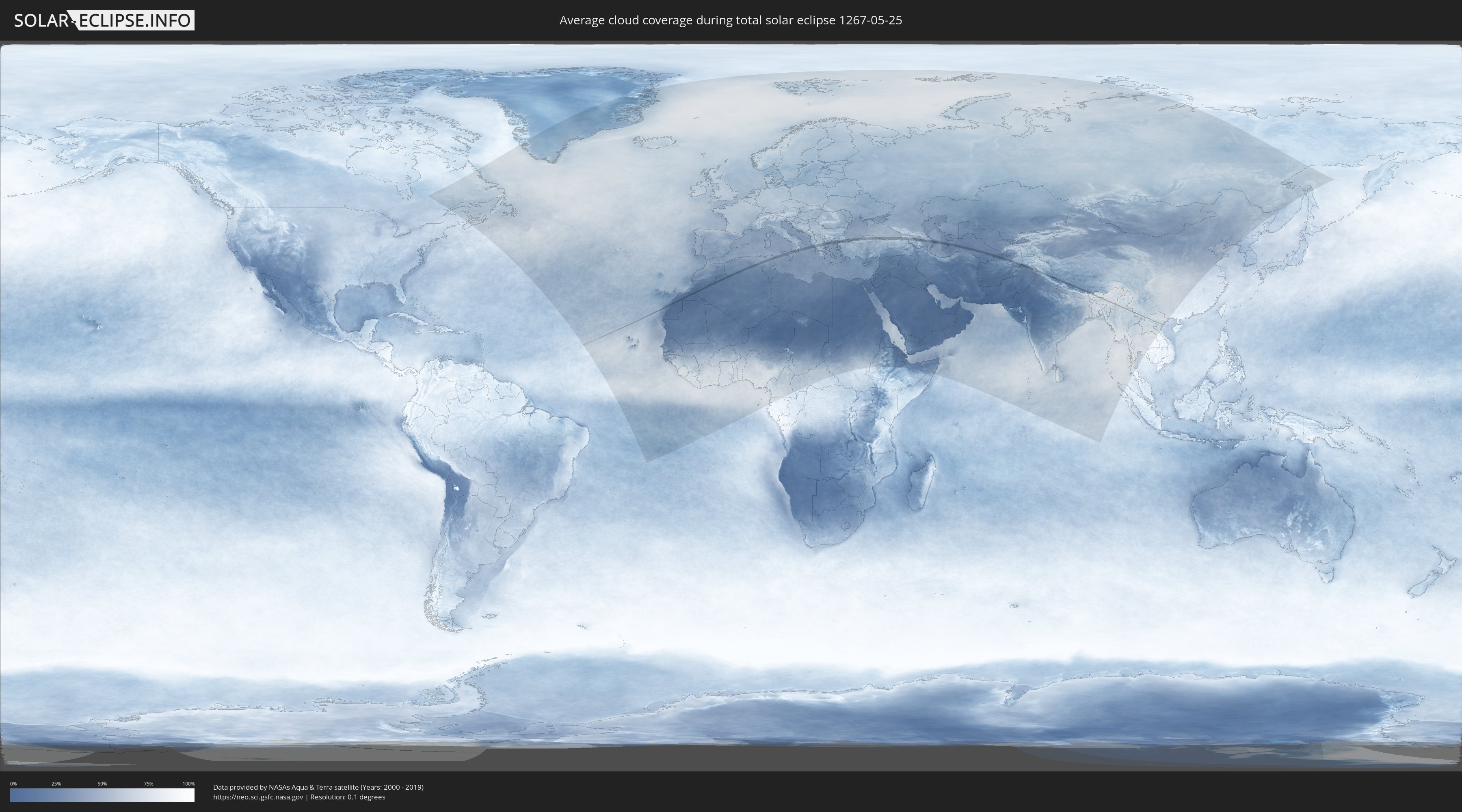
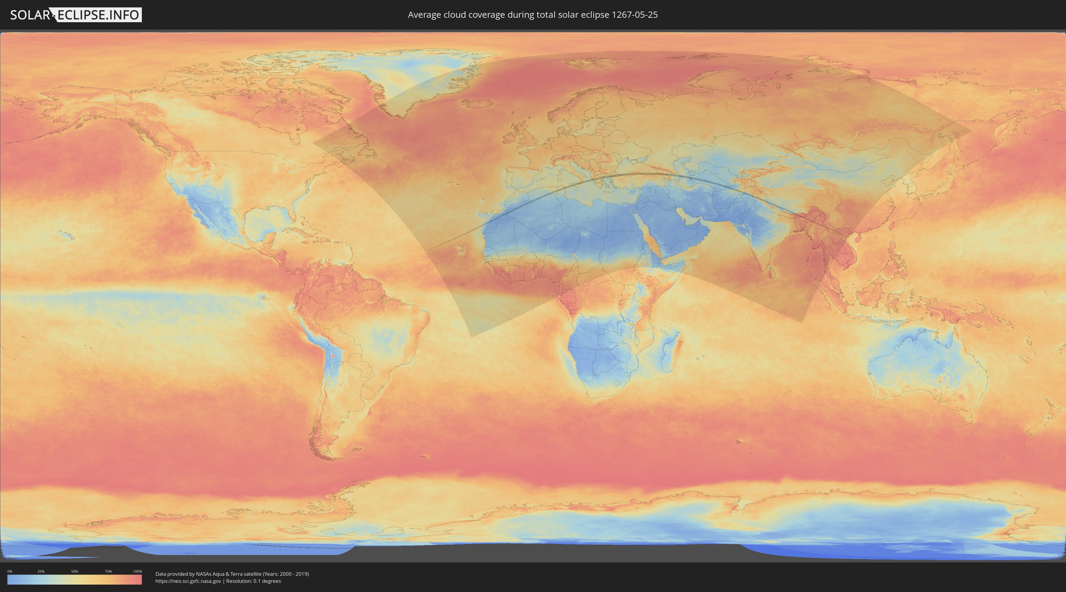
Wie wird das Wetter während der totalen Sonnenfinsternis am 25.05.1267?
Wo ist der beste Ort, um die totale Sonnenfinsternis vom 25.05.1267 zu beobachten?
Die folgenden Karten zeigen die durchschnittliche Bewölkung für den Tag, an dem die totale Sonnenfinsternis
stattfindet. Mit Hilfe der Karten lässt sich der Ort entlang des Finsternispfades eingrenzen,
der die besten Aussichen auf einen klaren wolkenfreien Himmel bietet.
Trotzdem muss man immer lokale Gegenenheiten beachten und sollte sich genau über das Wetter an seinem
gewählten Beobachtungsort informieren.
Die Daten stammen von den beiden NASA-Satelliten
AQUA und TERRA
und wurden über einen Zeitraum von 19 Jahren (2000 - 2019) gemittelt.
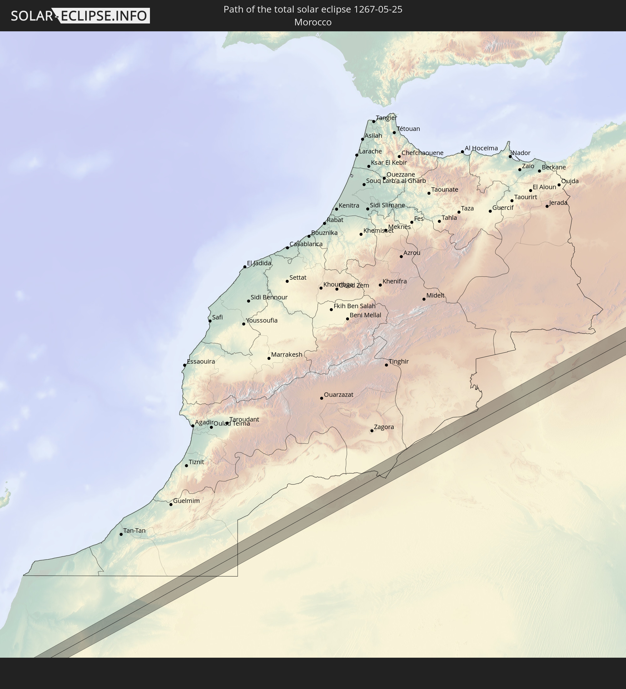
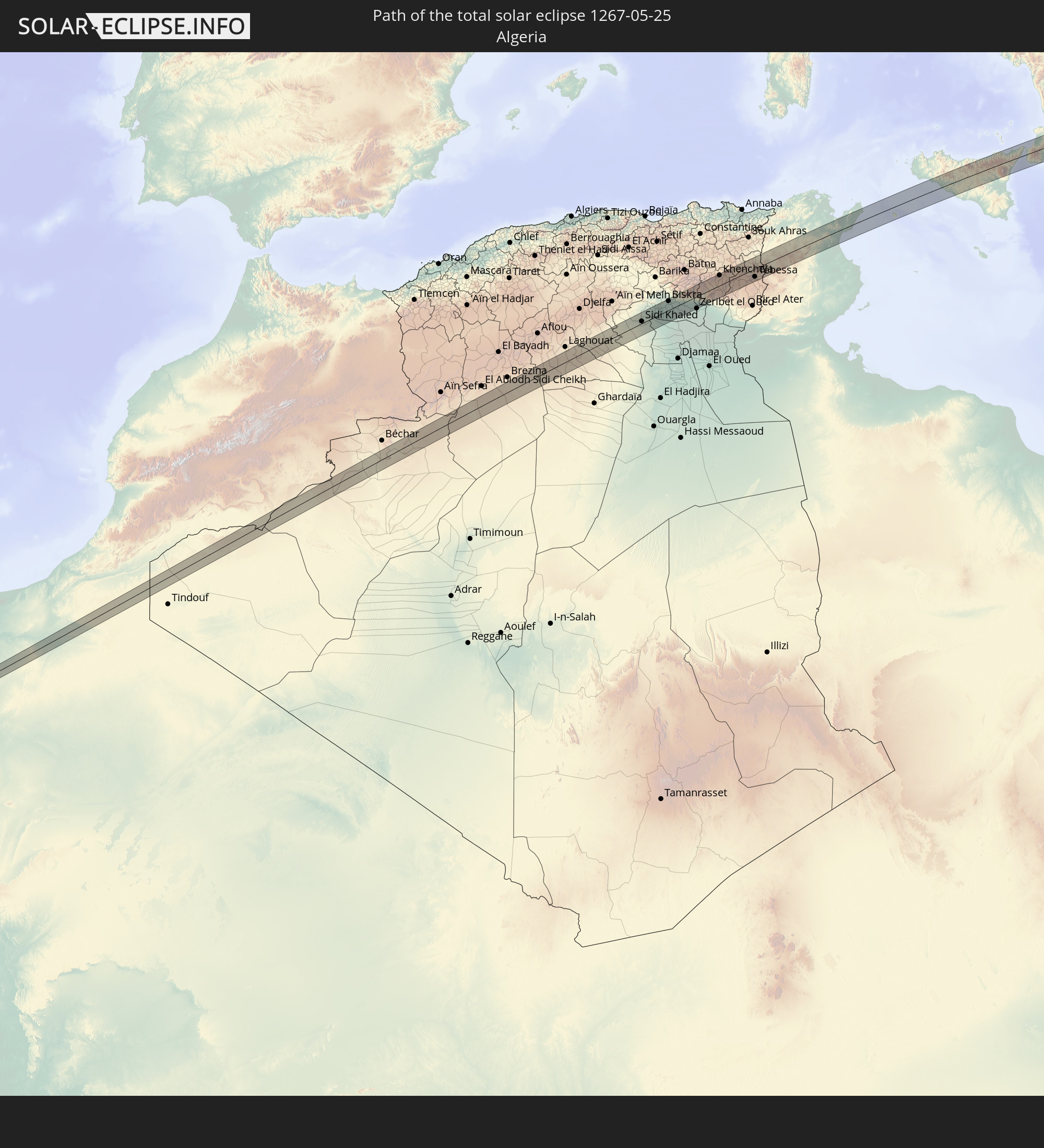
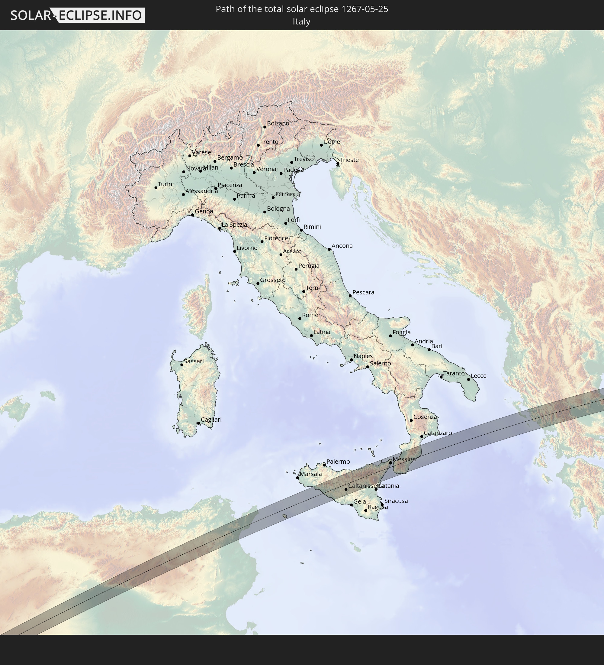
Detaillierte Länderkarten
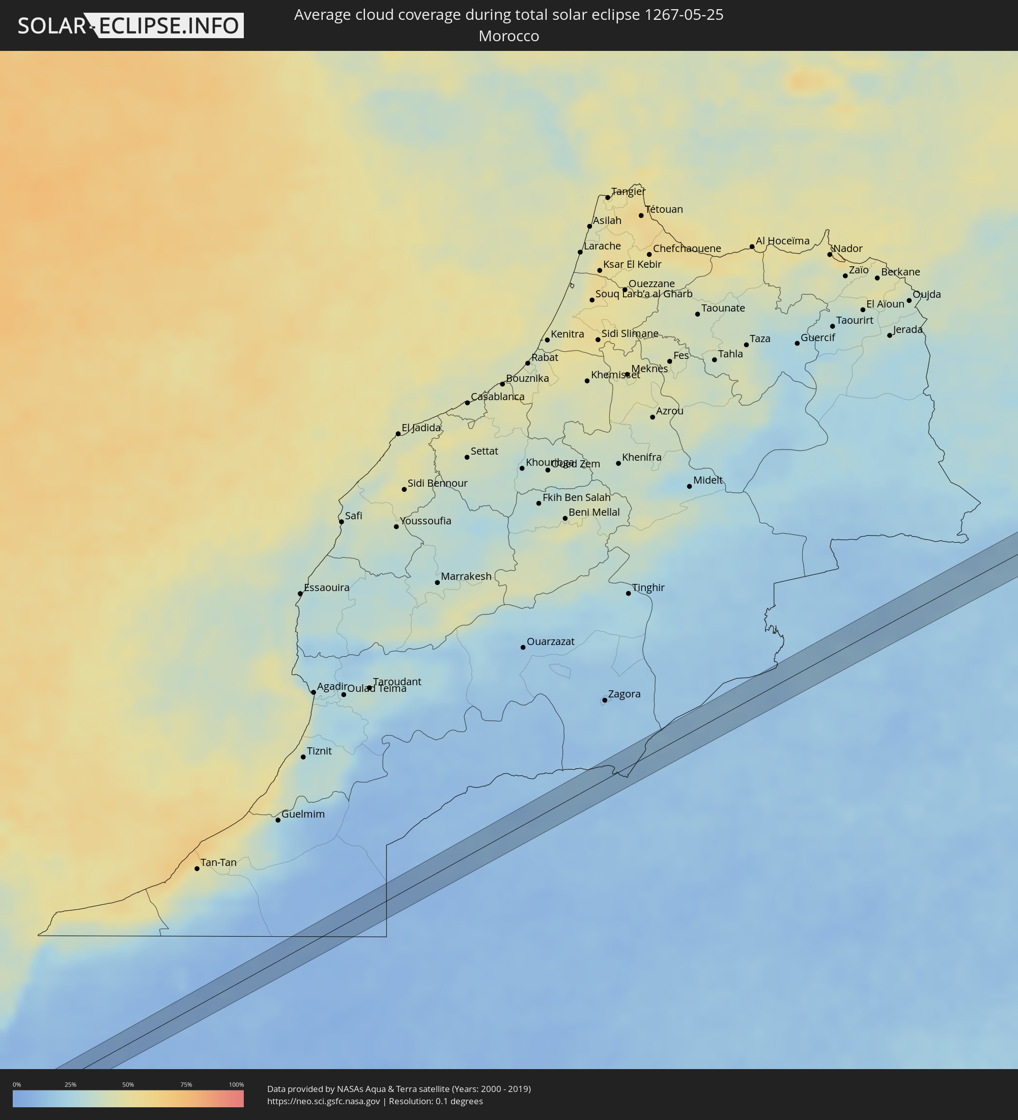 Marokko
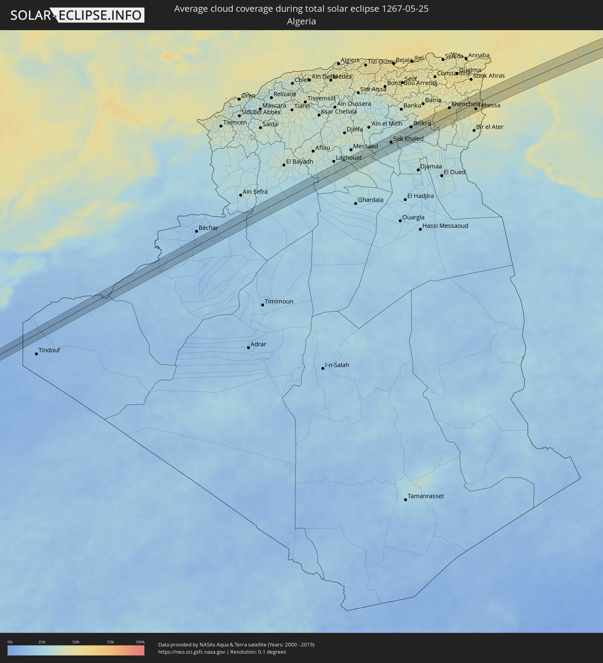 Algerien
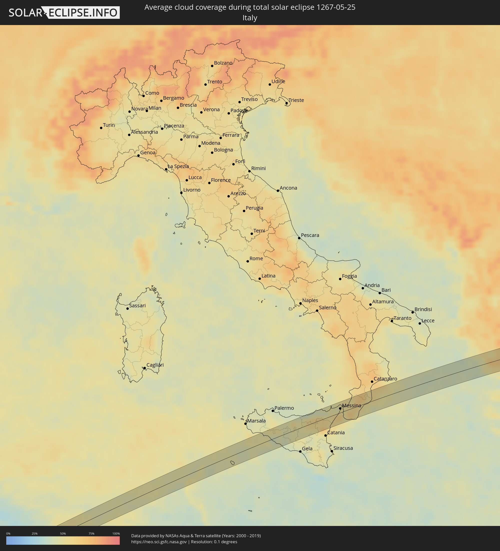 Italien
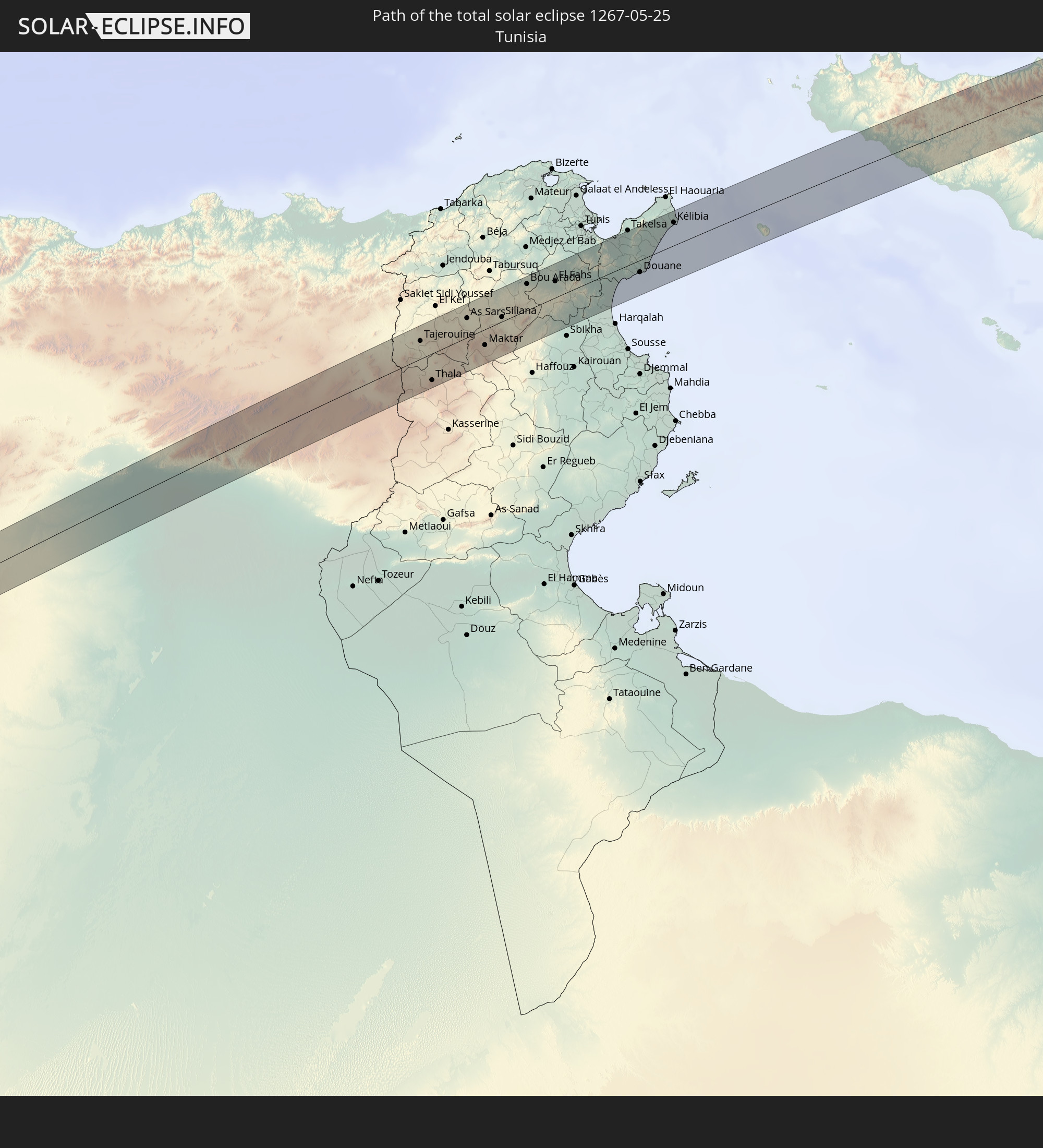
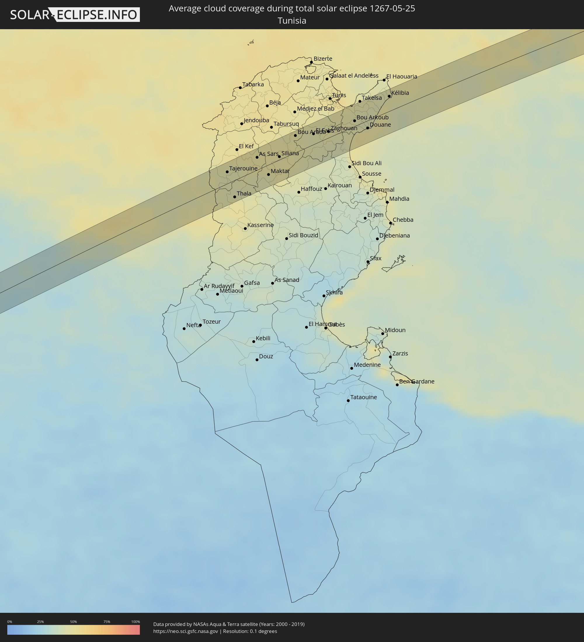 Tunesien
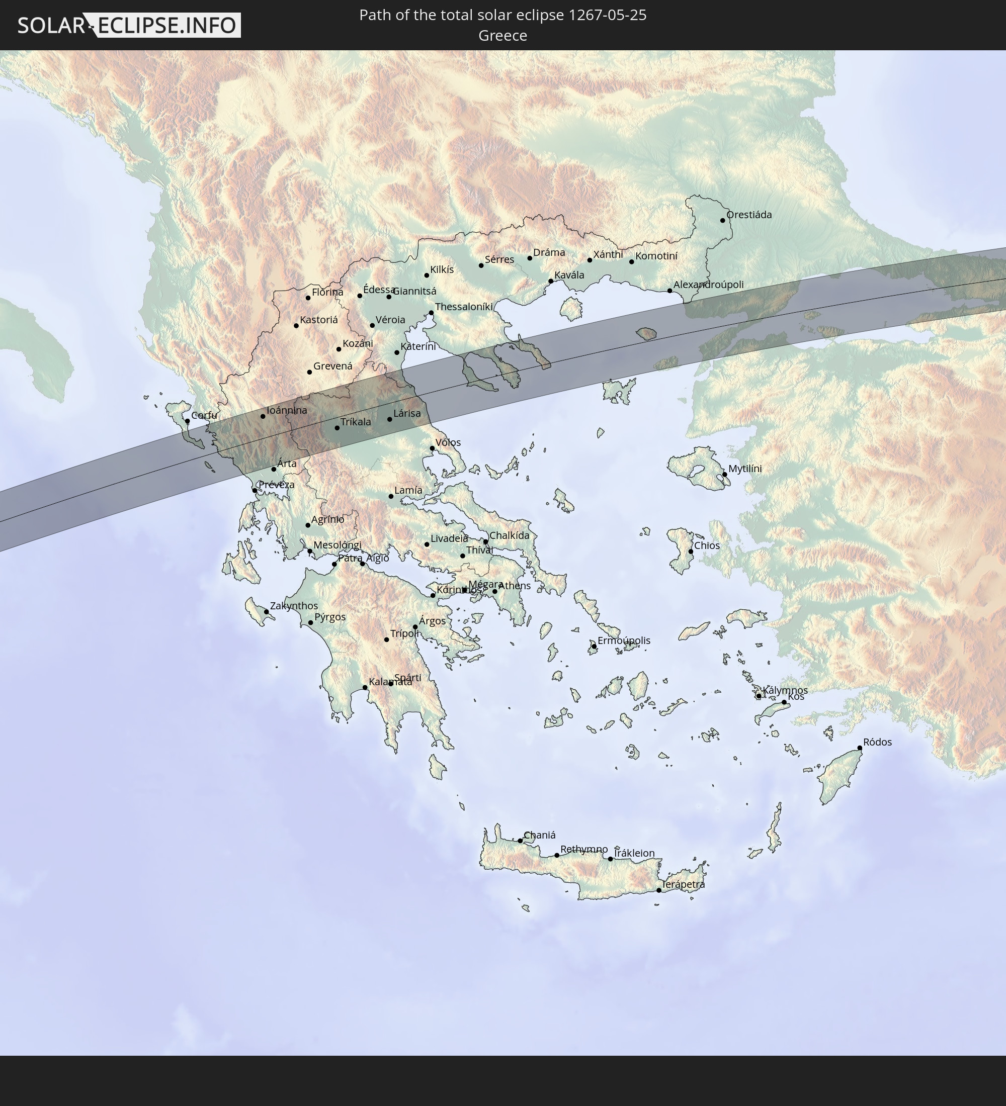
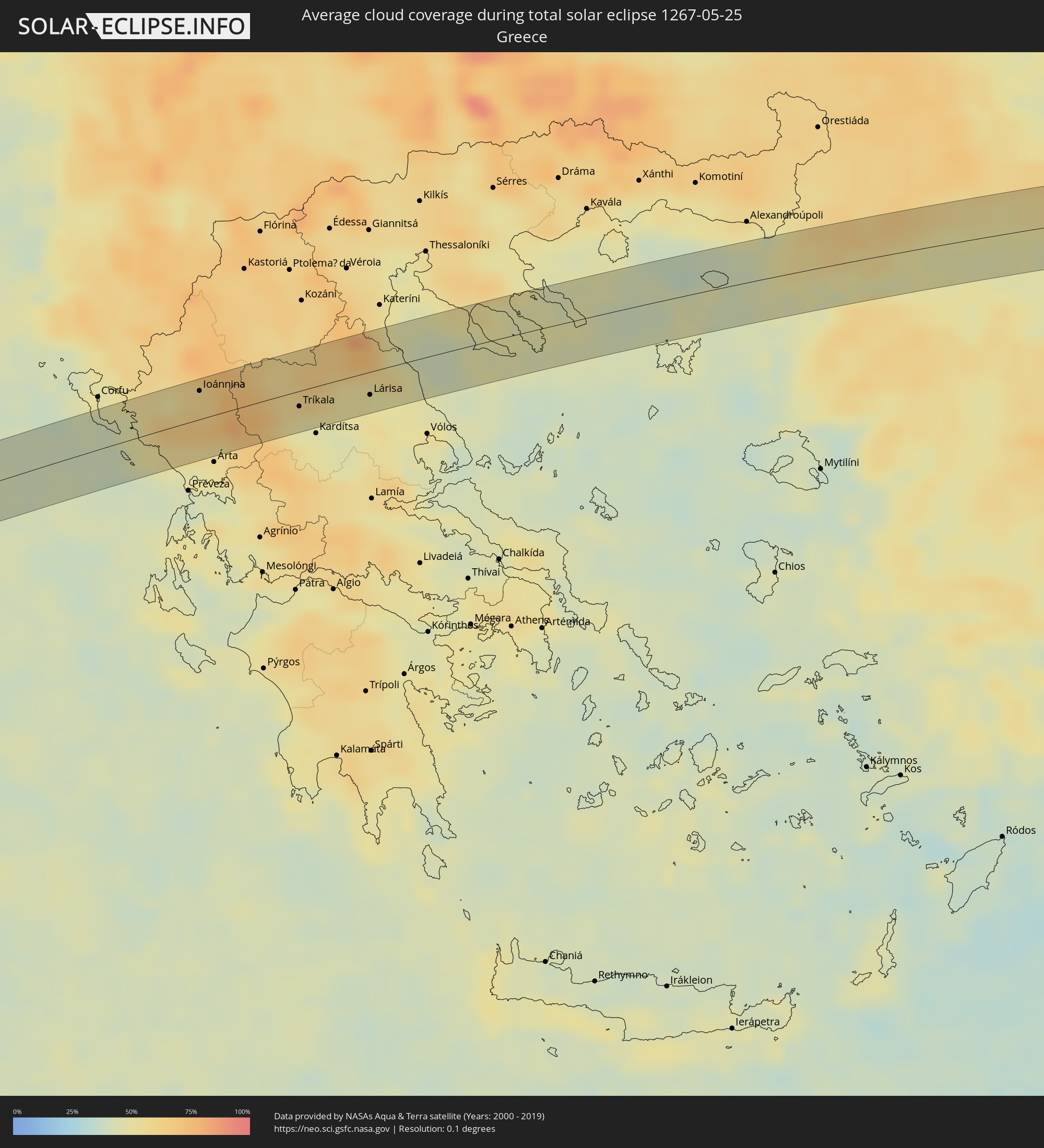 Griechenland
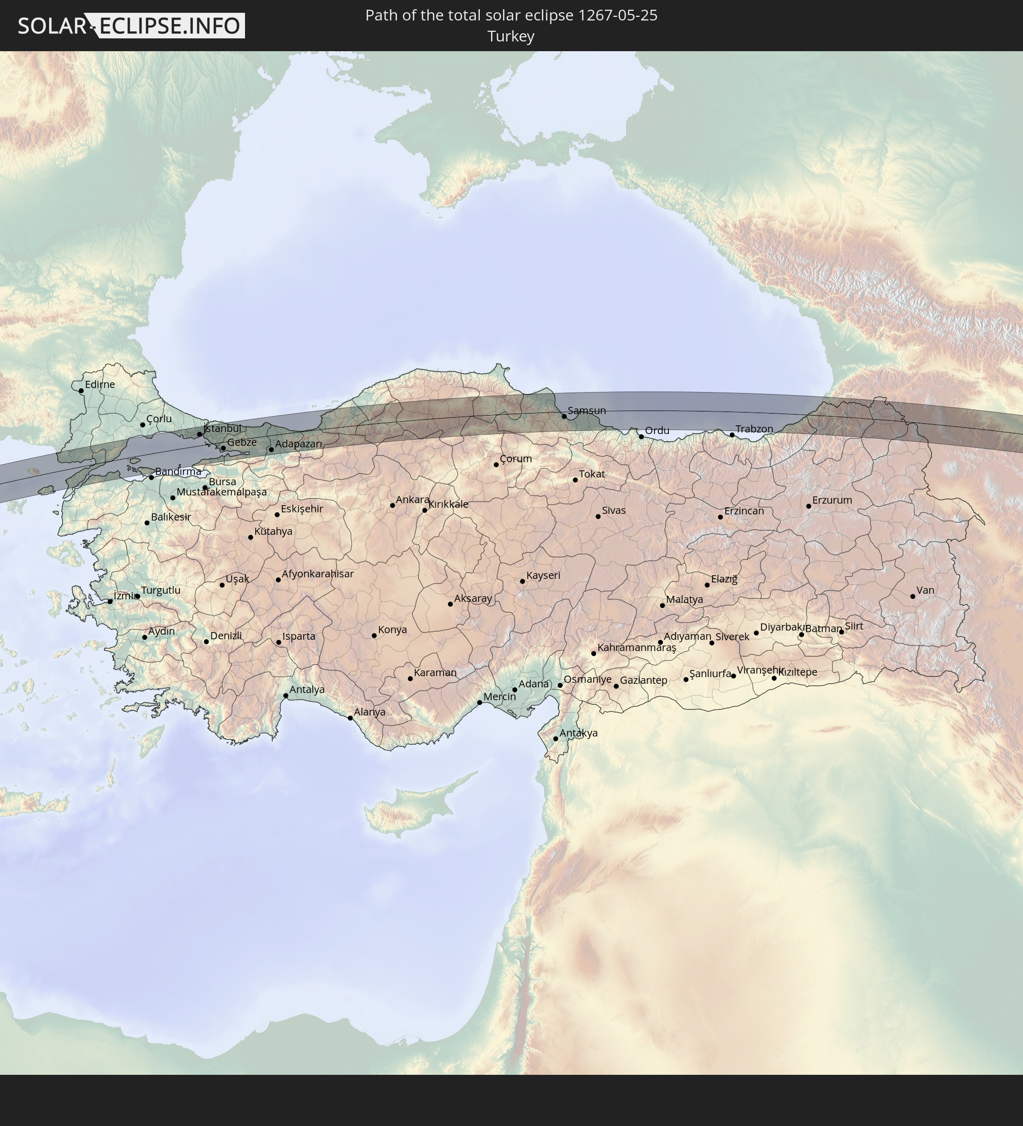
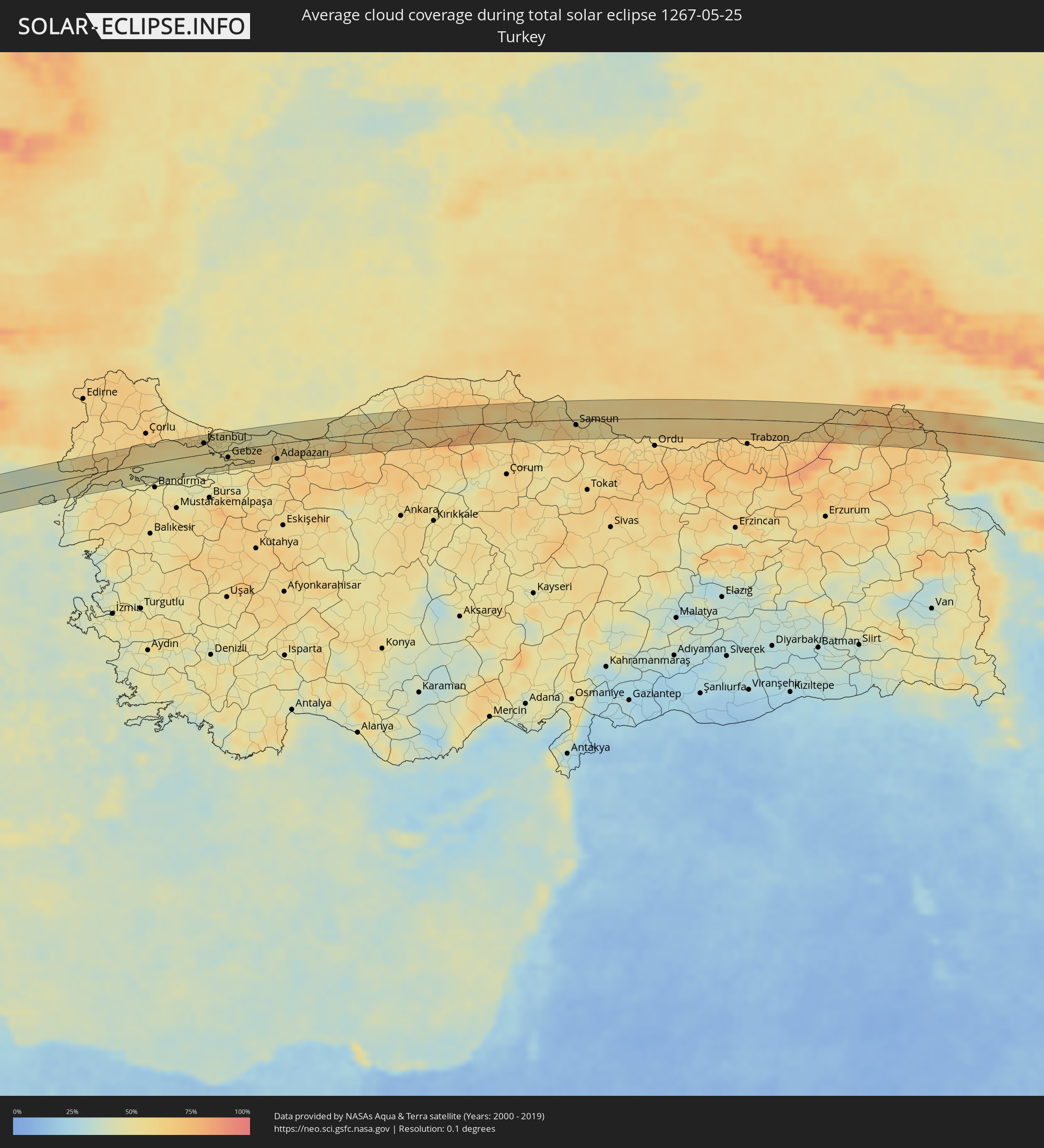 Türkei
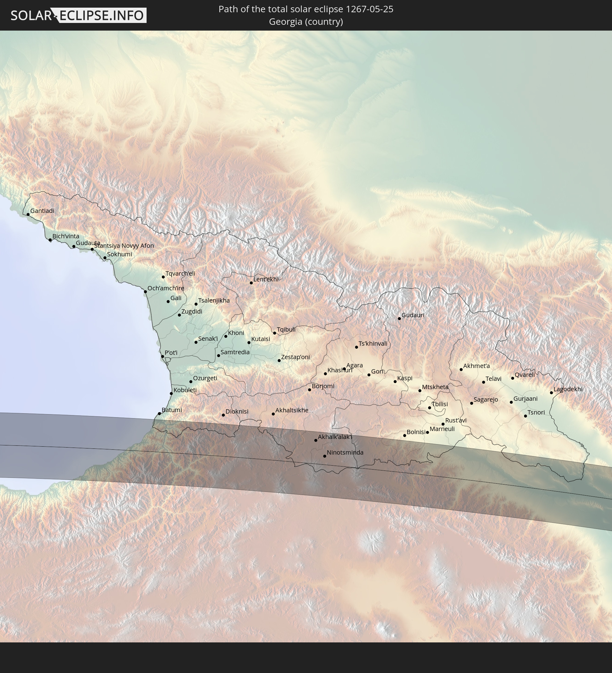
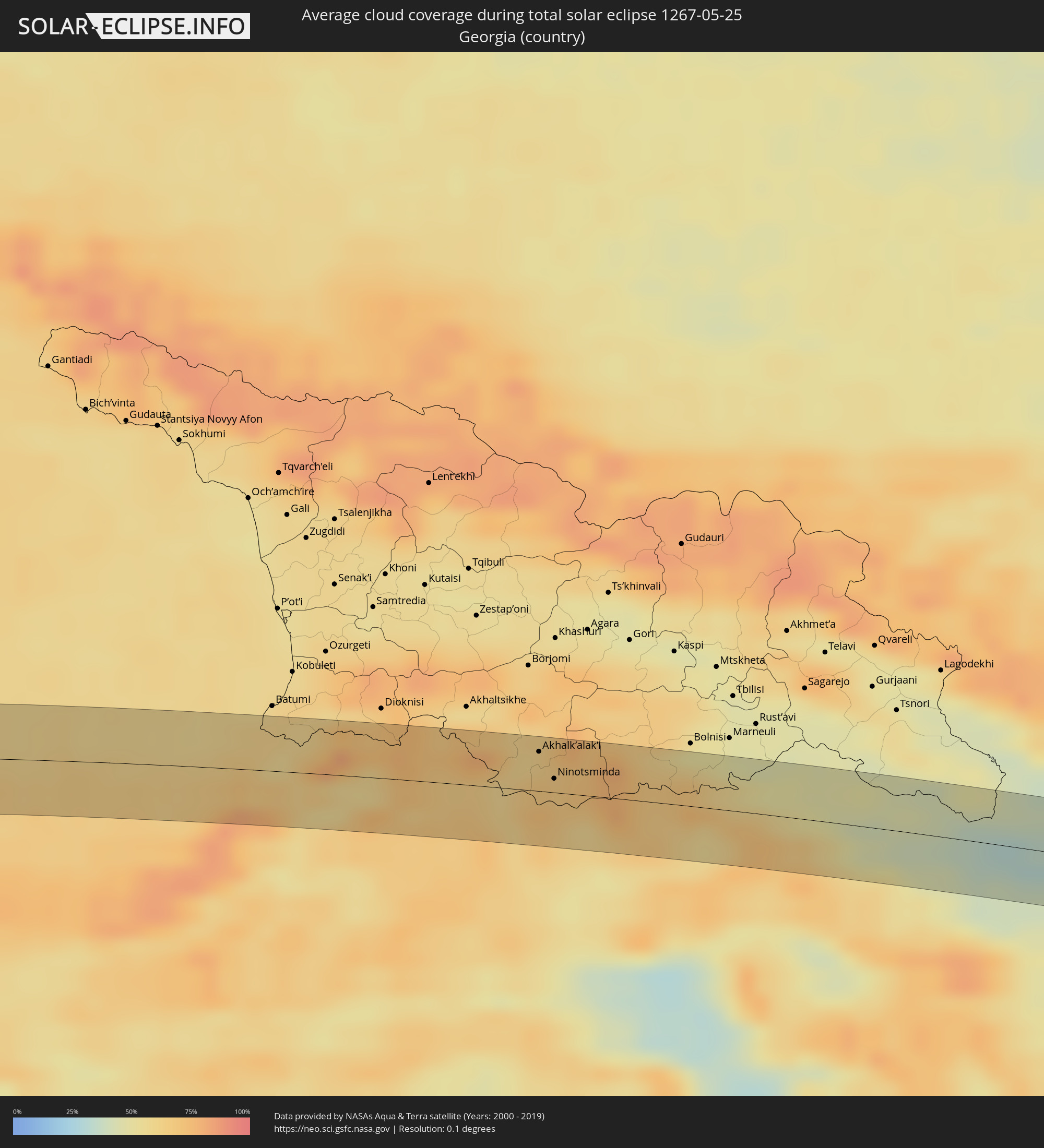 Georgien
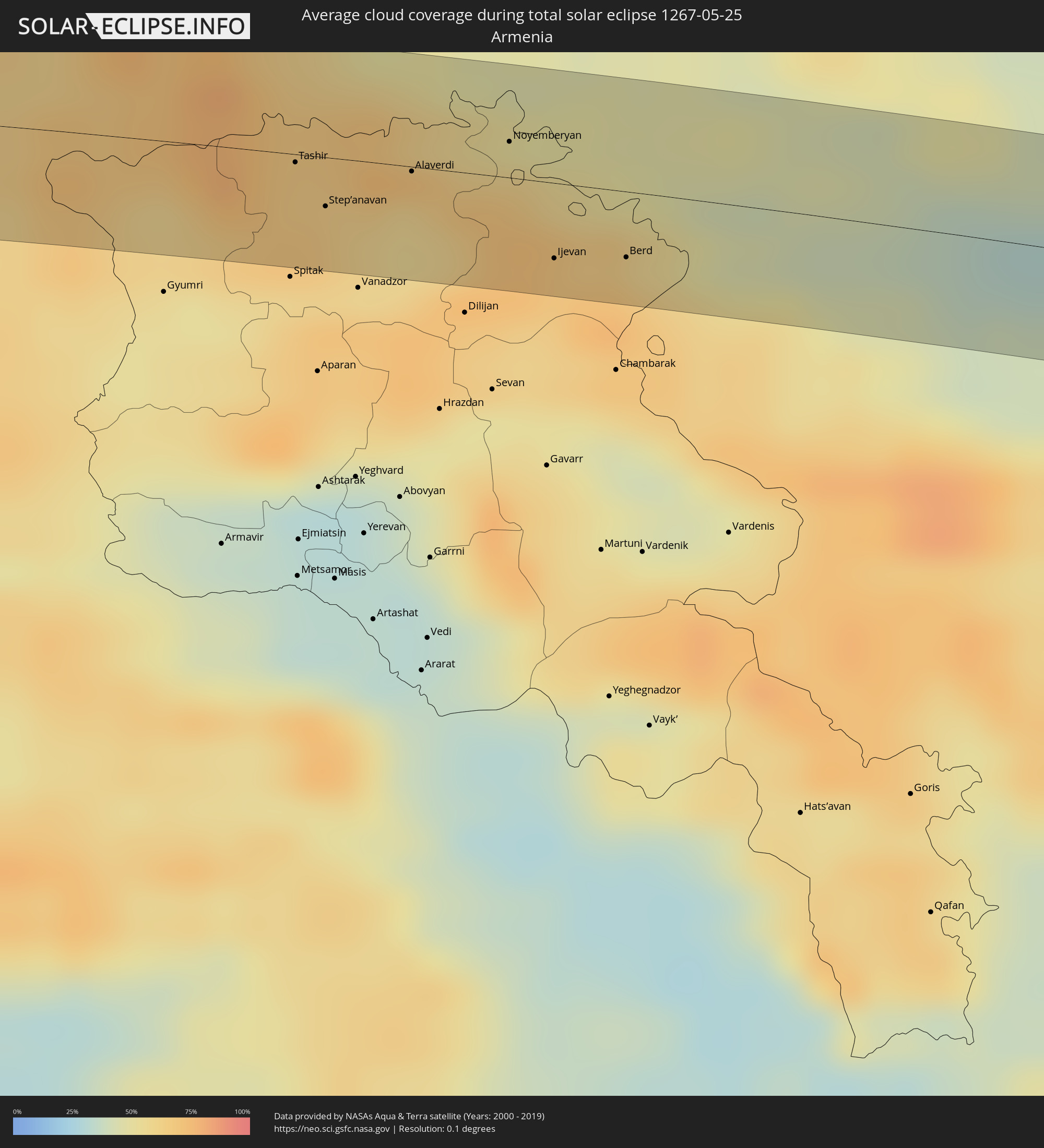 Armenien
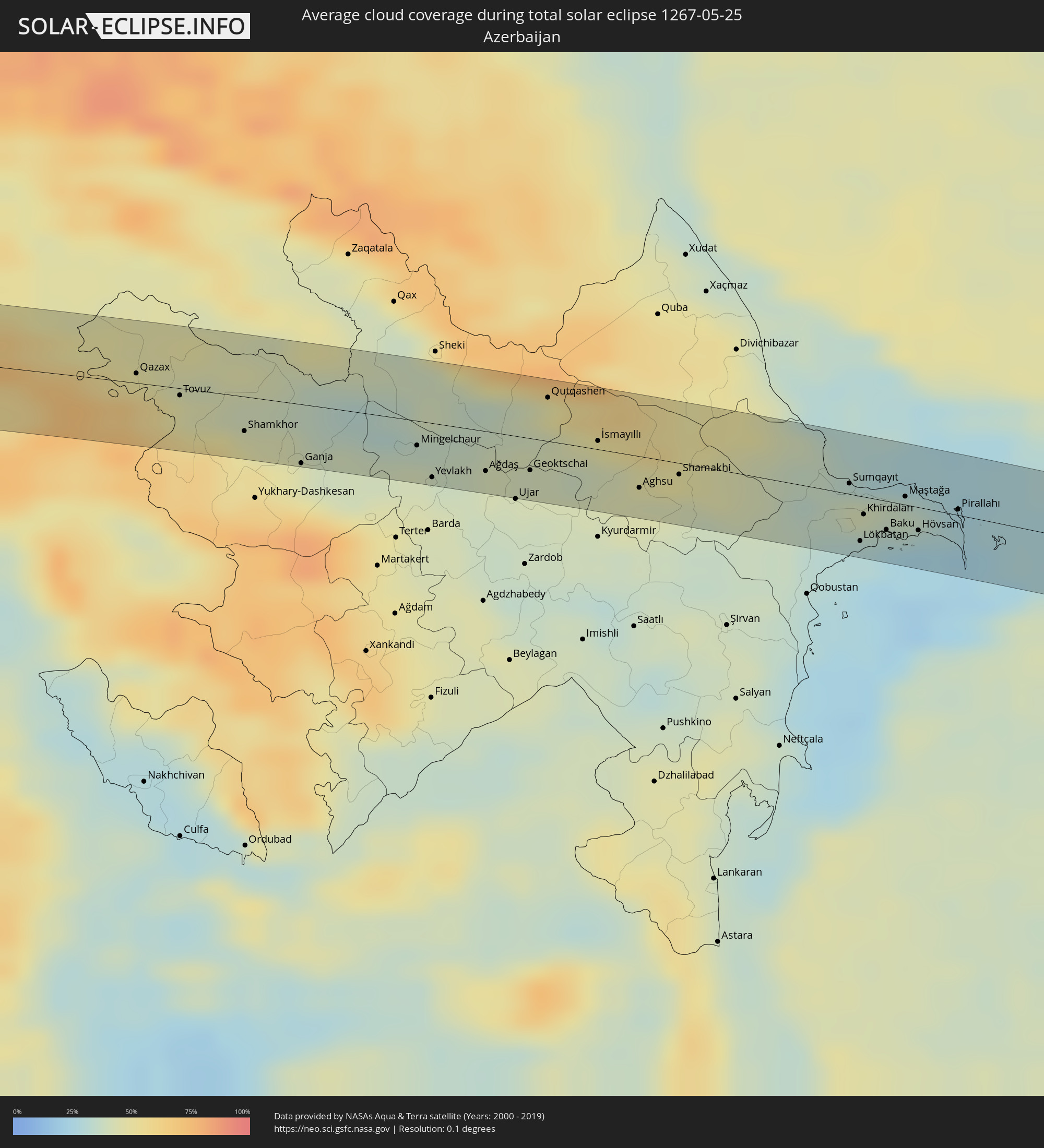 Aserbaidschan
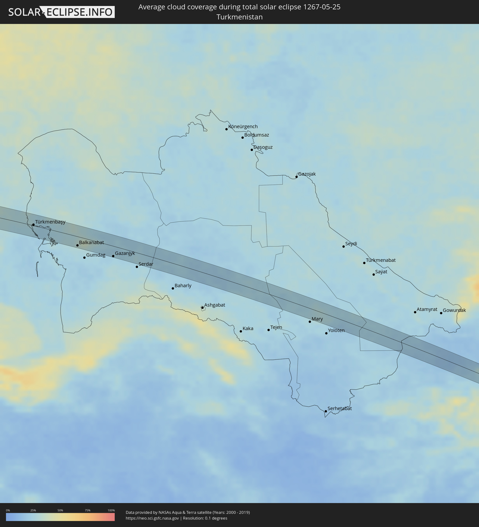 Turkmenistan
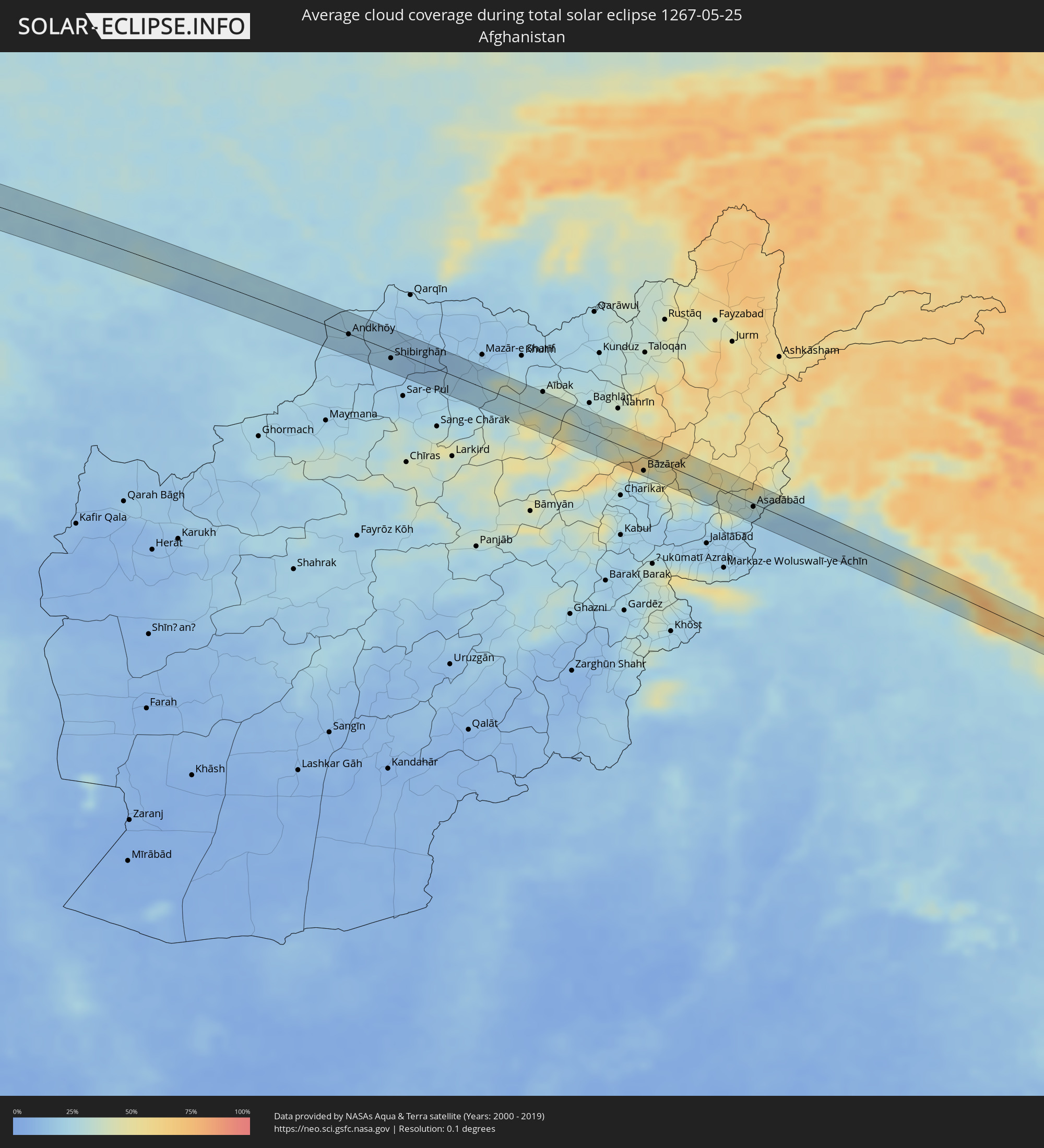 Afghanistan
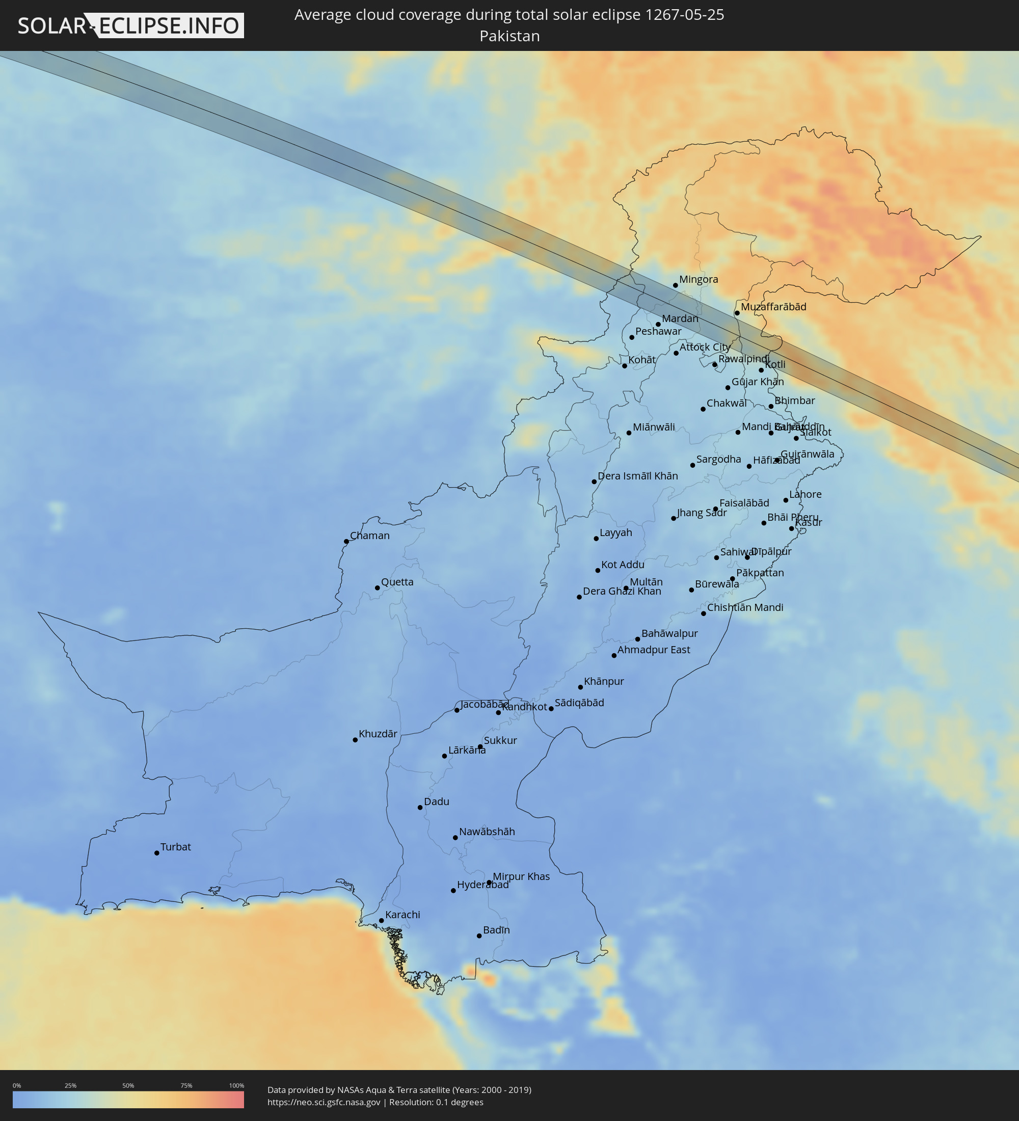 Pakistan
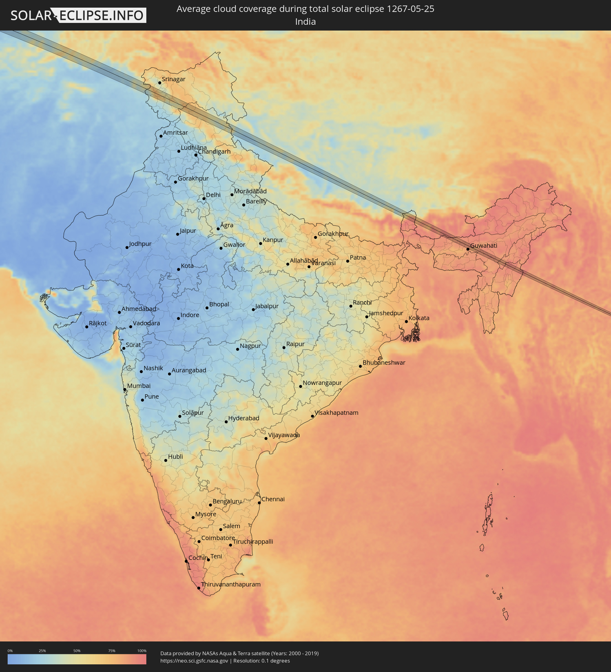 Indien
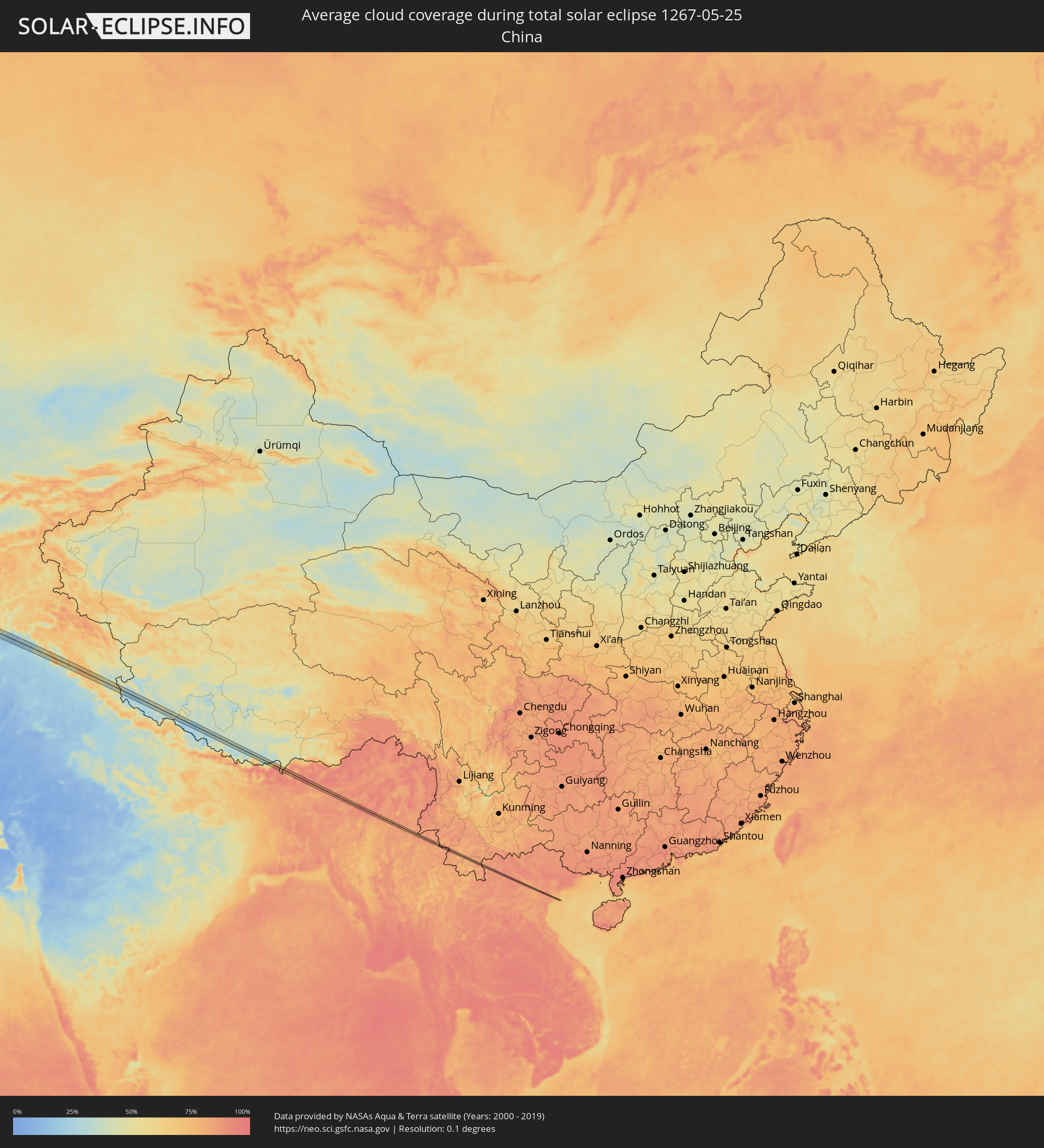 Volksrepublik China
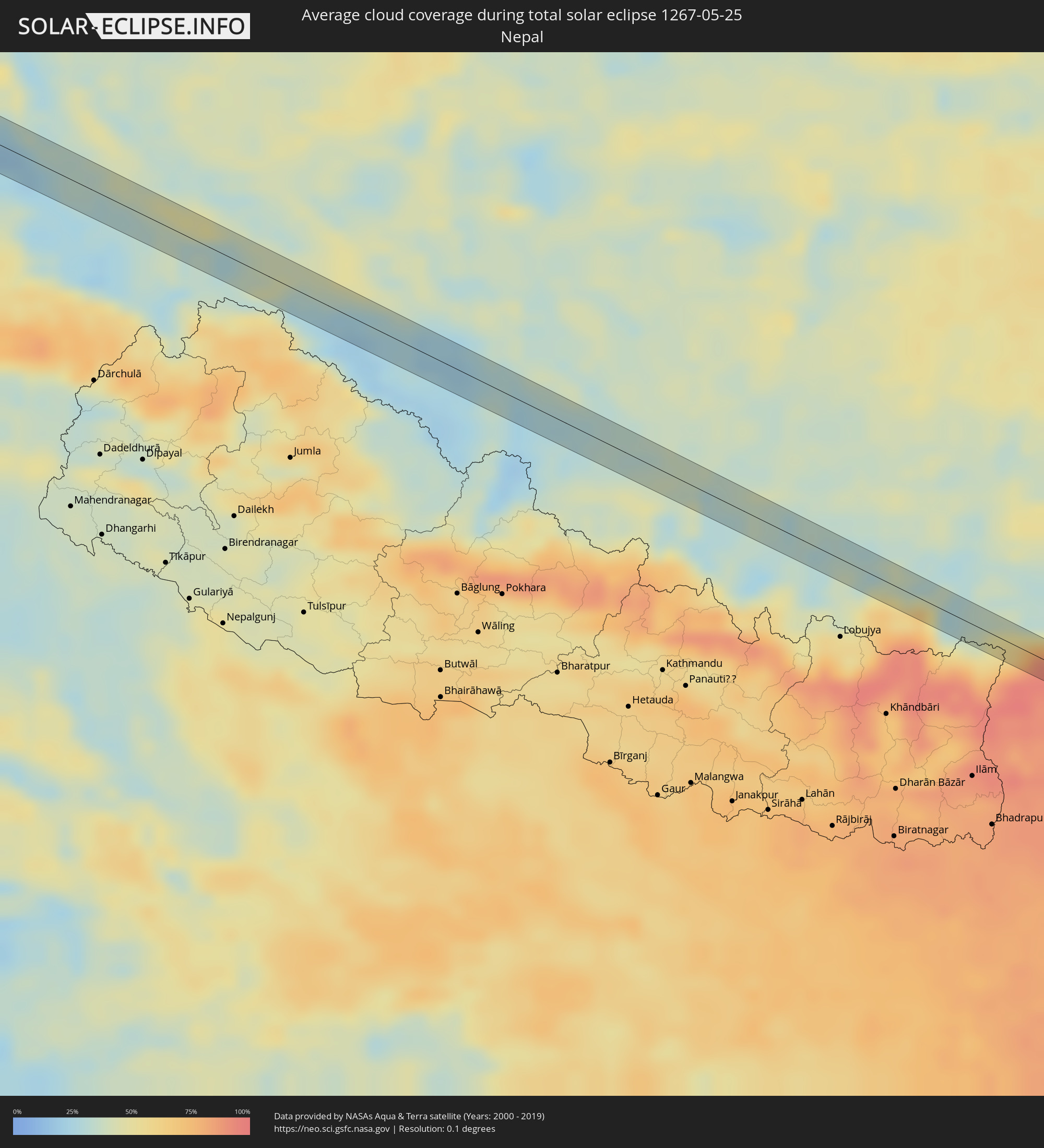 Nepal
Nepal
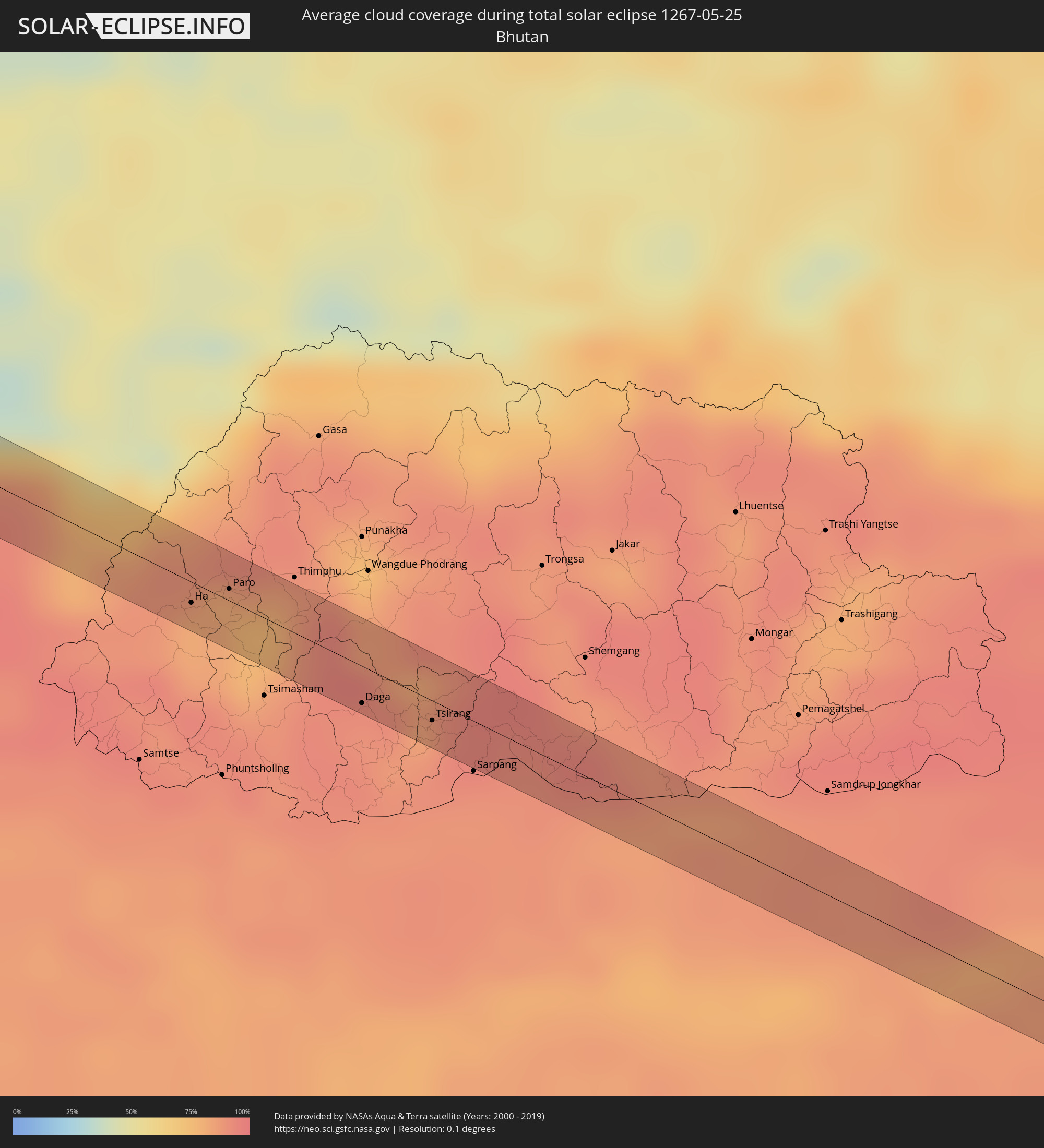 Bhutan
 Myanmar
 Laos
Laos
 Vietnam
Orte im Finsternispfad
Die nachfolgene Tabelle zeigt Städte und Orte mit mehr als 5.000 Einwohnern, die sich im Finsternispfad befinden. Städte mit mehr als 100.000 Einwohnern sind dick gekennzeichnet. Mit einem Klick auf den Ort öffnet sich eine Detailkarte die die Lage des jeweiligen Ortes zusammen mit dem Verlauf der zentralen Finsternis präsentiert.
| Ort | Typ | Dauer der Verfinsterung | Ortszeit bei maximaler Verfinsterung | Entfernung zur Zentrallinie | Ø Bewölkung |
 Smara, Oued Ed-Dahab-Lagouira
|
total | - | 07:18:21 UTC-00:52 | 14 km | 8% |
|
Sidi Khaled, Biskra
|
total | - | 08:47:50 UTC+00:09 | 4 km | 29% |
|
Tolga, Biskra
|
total | - | 08:48:53 UTC+00:09 | 22 km | 34% |
|
Oumache, Biskra
|
total | - | 08:49:16 UTC+00:09 | 7 km | 30% |
|
Biskra, Biskra
|
total | - | 08:49:34 UTC+00:09 | 21 km | 31% |
|
Sidi Okba, Biskra
|
total | - | 08:49:39 UTC+00:09 | 3 km | 31% |
|
Khenchela, Khenchela
|
total | - | 08:52:29 UTC+00:09 | 23 km | 50% |
|
Meskiana, Oum el Bouaghi
|
total | - | 08:53:34 UTC+00:09 | 22 km | 46% |
|
Cheria, Tébessa
|
total | - | 08:53:10 UTC+00:09 | 17 km | 45% |
|
Hammamet, Tébessa
|
total | - | 08:53:44 UTC+00:09 | 7 km | 51% |
|
Tébessa, Tébessa
|
total | - | 08:53:56 UTC+00:09 | 18 km | 51% |
|
Tajerouine, Kef
|
total | - | 08:55:18 UTC+00:09 | 15 km | 45% |
|
Thala, Al Qaşrayn
|
total | - | 08:55:01 UTC+00:09 | 22 km | 48% |
|
As Sars, Kef
|
total | - | 08:56:18 UTC+00:09 | 16 km | 48% |
|
Maktar, Silyānah
|
total | - | 08:56:16 UTC+00:09 | 13 km | 45% |
|
Siliana, Silyānah
|
total | - | 08:56:52 UTC+00:09 | 4 km | 48% |
|
Bou Arada, Silyānah
|
total | - | 08:57:39 UTC+00:09 | 22 km | 48% |
|
El Fahs, Zaghwān
|
total | - | 08:58:09 UTC+00:09 | 13 km | 45% |
|
Zaghouan, Zaghwān
|
total | - | 08:58:34 UTC+00:09 | 8 km | 47% |
|
Mennzel Bou Zelfa, Nābul
|
total | - | 08:59:41 UTC+00:09 | 20 km | 46% |
|
Beni Khalled, Nābul
|
total | - | 08:59:39 UTC+00:09 | 17 km | 46% |
|
Douane, Nābul
|
total | - | 08:59:39 UTC+00:09 | 10 km | 48% |
|
Beni Khiar, Nābul
|
total | - | 08:59:43 UTC+00:09 | 9 km | 50% |
|
Korba, Nābul
|
total | - | 09:00:00 UTC+00:09 | 0 km | 51% |
|
Kélibia, Nābul
|
total | - | 09:00:46 UTC+00:09 | 19 km | 47% |
|
Sciacca, Sicily
|
total | - | 09:55:44 UTC+01:00 | 18 km | 50% |
|
Ribera, Sicily
|
total | - | 09:56:02 UTC+01:00 | 11 km | 42% |
|
Agrigento, Sicily
|
total | - | 09:56:21 UTC+01:00 | 18 km | 42% |
|
Canicattì, Sicily
|
total | - | 09:56:54 UTC+01:00 | 22 km | 40% |
|
Caltanissetta, Sicily
|
total | - | 09:57:27 UTC+01:00 | 16 km | 48% |
|
Enna, Sicily
|
total | - | 09:57:56 UTC+01:00 | 15 km | 47% |
|
Nicosia, Sicily
|
total | - | 09:58:23 UTC+01:00 | 1 km | 48% |
|
Adrano, Sicily
|
total | - | 09:59:05 UTC+01:00 | 22 km | 52% |
|
Randazzo, Sicily
|
total | - | 09:59:34 UTC+01:00 | 4 km | 58% |
|
Giarre, Sicily
|
total | - | 09:59:48 UTC+01:00 | 27 km | 54% |
|
Barcellona Pozzo di Gotto, Sicily
|
total | - | 10:00:24 UTC+01:00 | 16 km | 53% |
|
Messina, Sicily
|
total | - | 10:01:05 UTC+01:00 | 11 km | 58% |
|
Gioia Tauro, Calabria
|
total | - | 10:02:01 UTC+01:00 | 24 km | 50% |
|
Siderno, Calabria
|
total | - | 10:02:35 UTC+01:00 | 4 km | 53% |
|
Igoumenítsa, Epirus
|
total | - | 10:46:37 UTC+01:34 | 19 km | 47% |
|
Ioánnina, Epirus
|
total | - | 10:47:58 UTC+01:34 | 22 km | 60% |
|
Anatolí, Epirus
|
total | - | 10:47:58 UTC+01:34 | 18 km | 63% |
|
Kalampáka, Thessaly
|
total | - | 10:49:36 UTC+01:34 | 8 km | 60% |
|
Tríkala, Thessaly
|
total | - | 10:49:45 UTC+01:34 | 12 km | 54% |
|
Palamás, Thessaly
|
total | - | 10:50:19 UTC+01:34 | 28 km | 44% |
|
Elassóna, Thessaly
|
total | - | 10:50:56 UTC+01:34 | 15 km | 62% |
|
Týrnavos, Thessaly
|
total | - | 10:51:00 UTC+01:34 | 4 km | 51% |
|
Ampelóna, Thessaly
|
total | - | 10:51:10 UTC+01:34 | 5 km | 52% |
|
Giánnouli, Thessaly
|
total | - | 10:51:09 UTC+01:34 | 14 km | 52% |
|
Lárisa, Thessaly
|
total | - | 10:51:10 UTC+01:34 | 17 km | 50% |
|
Litóchoro, Central Macedonia
|
total | - | 10:51:46 UTC+01:34 | 31 km | 65% |
|
Néa Moudhaniá, Central Macedonia
|
total | - | 10:53:32 UTC+01:34 | 29 km | 49% |
|
Karyes, Mount Athos
|
total | - | 10:55:34 UTC+01:34 | 12 km | 44% |
|
Esenyurt, Istanbul
|
total | - | 11:27:45 UTC+01:56 | 23 km | 55% |
|
İstanbul, Istanbul
|
total | - | 11:28:20 UTC+01:56 | 18 km | 53% |
|
Maltepe, Istanbul
|
total | - | 11:28:45 UTC+01:56 | 7 km | 51% |
|
Yalova, Yalova
|
total | - | 11:28:53 UTC+01:56 | 26 km | 47% |
|
Gebze, Kocaeli
|
total | - | 11:29:18 UTC+01:56 | 11 km | 50% |
|
İzmit, Kocaeli
|
total | - | 11:30:22 UTC+01:56 | 21 km | 56% |
|
Adapazarı, Sakarya
|
total | - | 11:31:27 UTC+01:56 | 25 km | 58% |
|
Ereğli, Zonguldak
|
total | - | 11:33:54 UTC+01:56 | 20 km | 50% |
|
Karabük, Karabük
|
total | - | 11:36:35 UTC+01:56 | 1 km | 56% |
|
Kastamonu, Kastamonu
|
total | - | 11:39:11 UTC+01:56 | 12 km | 62% |
|
Bafra, Samsun
|
total | - | 11:43:56 UTC+01:56 | 24 km | 58% |
|
Samsun, Samsun
|
total | - | 11:44:52 UTC+01:56 | 9 km | 59% |
|
Ünye, Ordu
|
total | - | 11:47:00 UTC+01:56 | 28 km | 58% |
|
Ardeşen, Rize
|
total | - | 11:55:12 UTC+01:56 | 16 km | 64% |
|
Akhalk’alak’i
|
total | - | 13:02:45 UTC+02:59 | 23 km | 64% |
|
Ninotsminda, Samtskhe-Javakheti
|
total | - | 13:03:03 UTC+02:59 | 8 km | 67% |
|
Tashir, Lori Province
|
total | - | 13:03:24 UTC+02:58 | 2 km | 65% |
|
Step’anavan, Lori Province
|
total | - | 13:03:40 UTC+02:58 | 14 km | 62% |
|
Alaverdi, Lori Province
|
total | - | 13:04:14 UTC+02:58 | 1 km | 63% |
|
Naghvarevi
|
total | - | 13:05:28 UTC+02:59 | 28 km | 48% |
|
Noyemberyan, Tavush Province
|
total | - | 13:04:52 UTC+02:58 | 10 km | 59% |
|
Ijevan, Tavush Province
|
total | - | 13:05:21 UTC+02:58 | 21 km | 68% |
|
Qazax, Qazax
|
total | - | 13:27:05 UTC+03:19 | 5 km | 51% |
|
Berd, Tavush Province
|
total | - | 13:05:51 UTC+02:58 | 18 km | 65% |
|
Shamkhor, Şǝmkir
|
total | - | 13:28:36 UTC+03:19 | 17 km | 49% |
|
Ganja, Gǝncǝ
|
total | - | 13:29:24 UTC+03:19 | 30 km | 42% |
|
Mingelchaur, Mingǝcevir
|
total | - | 13:30:48 UTC+03:19 | 12 km | 36% |
|
Yevlakh, Yevlax City
|
total | - | 13:31:05 UTC+03:19 | 27 km | 40% |
|
Ağdaş, Ağdaş
|
total | - | 13:31:43 UTC+03:19 | 20 km | 41% |
|
Geoktschai, Göyçay
|
total | - | 13:32:16 UTC+03:19 | 16 km | 40% |
|
İsmayıllı, İsmayıllı
|
total | - | 13:33:00 UTC+03:19 | 4 km | 48% |
|
Aghsu, Ağsu
|
total | - | 13:33:39 UTC+03:19 | 16 km | 43% |
|
Shamakhi, Şamaxı
|
total | - | 13:34:06 UTC+03:19 | 6 km | 43% |
|
Sumqayıt, Sumqayit
|
total | - | 13:36:10 UTC+03:19 | 5 km | 40% |
|
Baku, Baki
|
total | - | 13:36:46 UTC+03:19 | 14 km | 32% |
|
Maştağa, Baki
|
total | - | 13:36:52 UTC+03:19 | 4 km | 37% |
|
Hövsan, Baki
|
total | - | 13:37:09 UTC+03:19 | 12 km | 30% |
|
Türkmenbaşy, Balkan
|
total | - | 14:17:04 UTC+03:53 | 2 km | 24% |
|
Balkanabat, Balkan
|
total | - | 14:20:10 UTC+03:53 | 24 km | 27% |
|
Gazanjyk, Balkan
|
total | - | 14:22:30 UTC+03:53 | 27 km | 25% |
|
Bayramaly, Mary
|
total | - | 14:35:12 UTC+03:53 | 23 km | 24% |
|
Andkhōy, Faryab
|
total | - | 14:46:40 UTC+04:00 | 1 km | 19% |
|
Shibirghān, Jowzjan
|
total | - | 14:47:52 UTC+04:00 | 10 km | 17% |
|
Aībak, Samangan
|
total | - | 14:51:14 UTC+04:00 | 26 km | 30% |
|
Pul-e Khumrī, Baghlan
|
total | - | 14:52:29 UTC+04:00 | 17 km | 29% |
|
Bāzārak, Panjshir
|
total | - | 14:54:15 UTC+04:00 | 19 km | 32% |
|
Asadābād, Kunar
|
total | - | 14:56:37 UTC+04:00 | 4 km | 24% |
|
Āsmār, Kunar
|
total | - | 14:56:37 UTC+04:00 | 20 km | 29% |
|
Bat Khela, Khyber Pakhtunkhwa
|
total | - | 15:26:00 UTC+04:28 | 1 km | 19% |
|
Khalābat, Khyber Pakhtunkhwa
|
total | - | 15:27:39 UTC+04:28 | 21 km | 25% |
|
Haveliān, Khyber Pakhtunkhwa
|
total | - | 15:27:56 UTC+04:28 | 11 km | 27% |
|
Mānsehra, Khyber Pakhtunkhwa
|
total | - | 15:27:35 UTC+04:28 | 18 km | 30% |
|
Abbottābād, Khyber Pakhtunkhwa
|
total | - | 15:27:51 UTC+04:28 | 0 km | 27% |
|
Murree, Punjab
|
total | - | 15:28:20 UTC+04:28 | 17 km | 34% |
|
Rāwala Kot, Azad Kashmir
|
total | - | 15:28:45 UTC+04:28 | 8 km | 37% |
|
Pūnch, Kashmir
|
total | - | 16:22:08 UTC+05:21 | 4 km | 30% |
|
Shupīyan, Kashmir
|
total | - | 16:22:52 UTC+05:21 | 20 km | 60% |
|
Kulgam, Kashmir
|
total | - | 16:23:07 UTC+05:21 | 19 km | 56% |
|
Rāmban, Kashmir
|
total | - | 16:23:51 UTC+05:21 | 13 km | 37% |
|
Doda, Kashmir
|
total | - | 16:24:14 UTC+05:21 | 10 km | 48% |
|
Bhadarwāh, Kashmir
|
total | - | 16:24:36 UTC+05:21 | 20 km | 63% |
|
Kishtwār, Kashmir
|
total | - | 16:24:12 UTC+05:21 | 16 km | 53% |
|
Kyelang, Himachal Pradesh
|
total | - | 16:26:11 UTC+05:21 | 9 km | 56% |
|
Ha, Haa District
|
total | - | 17:16:08 UTC+05:58 | 6 km | 81% |
|
Paro, Paro
|
total | - | 17:16:07 UTC+05:58 | 4 km | 82% |
|
Daga, Dagana District
|
total | - | 17:16:38 UTC+05:58 | 12 km | 90% |
|
Tsirang, Chirang
|
total | - | 17:16:45 UTC+05:58 | 6 km | 88% |
|
Rangia, Assam
|
total | - | 16:40:13 UTC+05:21 | 2 km | 84% |
|
Hojāi, Assam
|
total | - | 16:40:52 UTC+05:21 | 12 km | 90% |
|
Lumding Railway Colony, Assam
|
total | - | 16:41:10 UTC+05:21 | 0 km | 87% |
|
Thành Phố Ninh Bình, Ninh Bình
|
total | - | 18:30:18 UTC+07:06 | 2 km | 85% |