Totale Sonnenfinsternis vom 13.04.1325
| Wochentag: | Freitag |
| Maximale Dauer der Verfinsterung: | 04m50s |
| Maximale Breite des Finsternispfades: | 188 km |
| Saroszyklus: | 108 |
| Bedeckungsgrad: | 100% |
| Magnitude: | 1.0551 |
| Gamma: | 0.2487 |
Wo kann man die Sonnenfinsternis vom 13.04.1325 sehen?
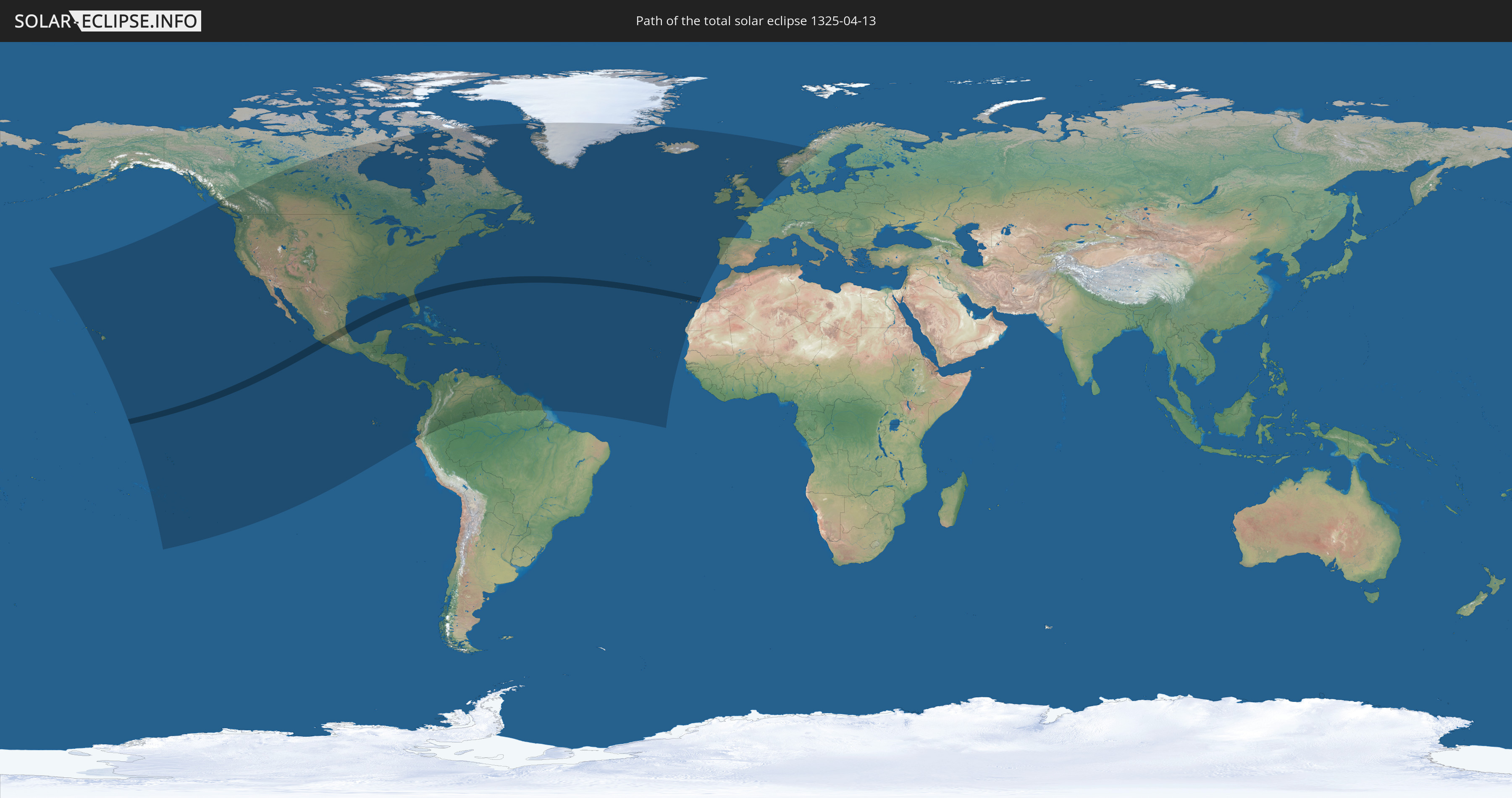
Die Sonnenfinsternis am 13.04.1325 kann man in 64 Ländern als partielle Sonnenfinsternis beobachten.
Der Finsternispfad verläuft durch 4 Länder. Nur in diesen Ländern ist sie als totale Sonnenfinsternis zu sehen.
In den folgenden Ländern ist die Sonnenfinsternis total zu sehen
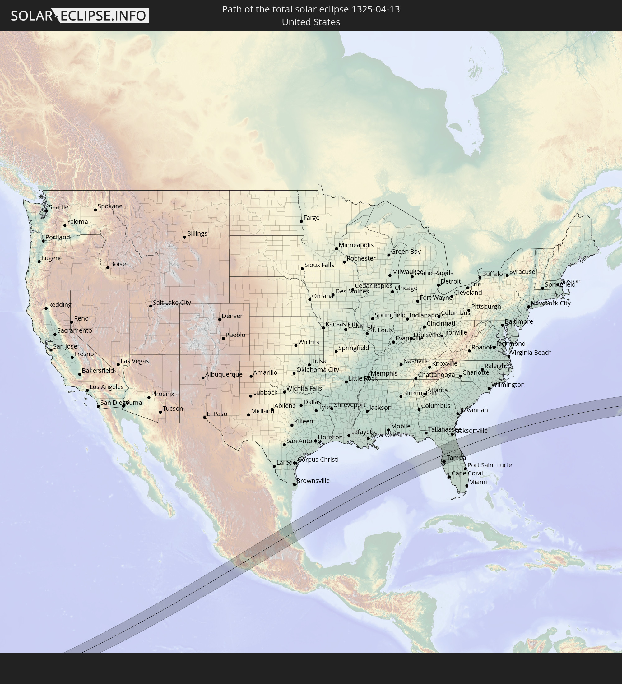 Vereinigte Staaten
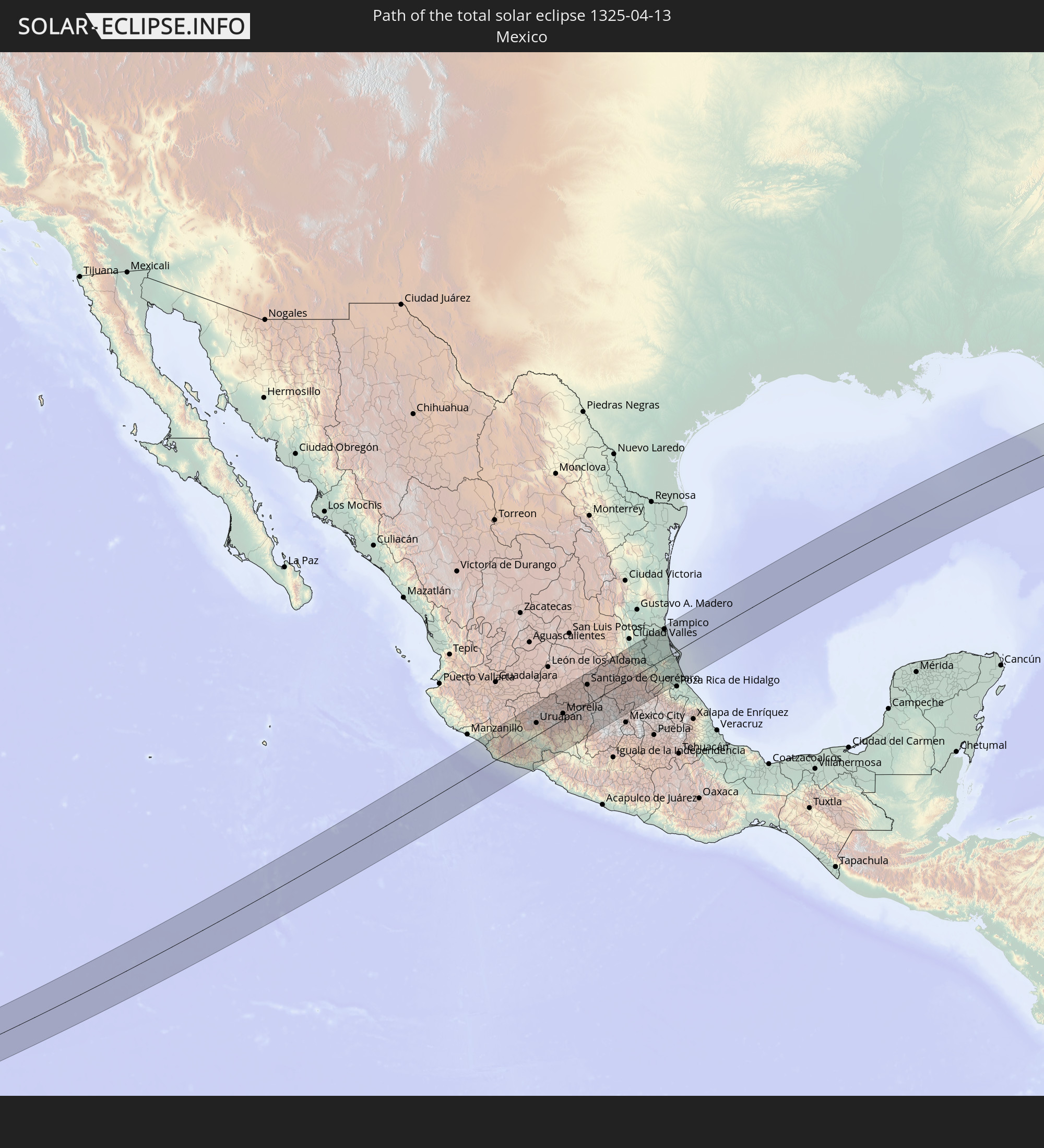 Mexiko
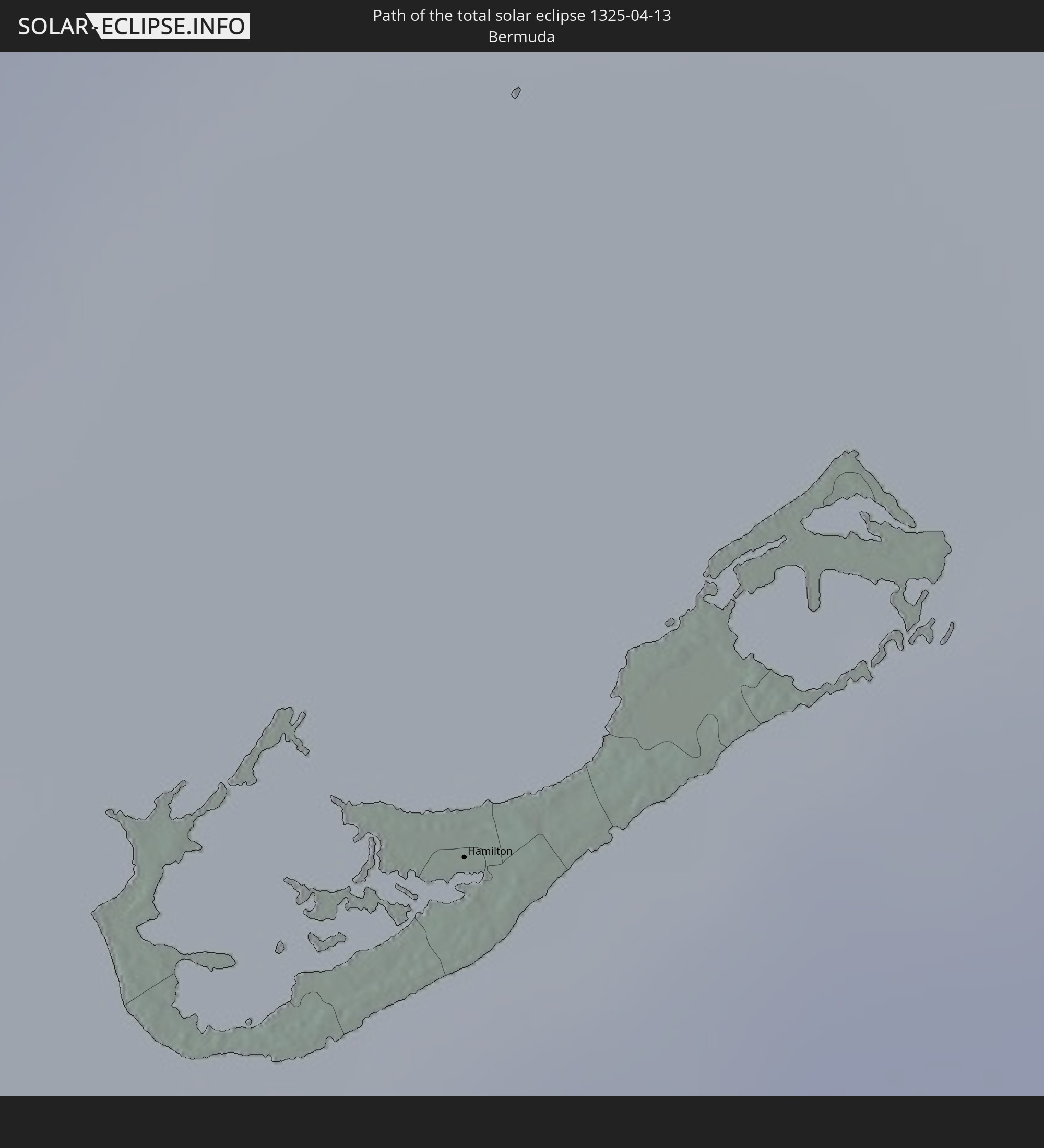 Bermuda
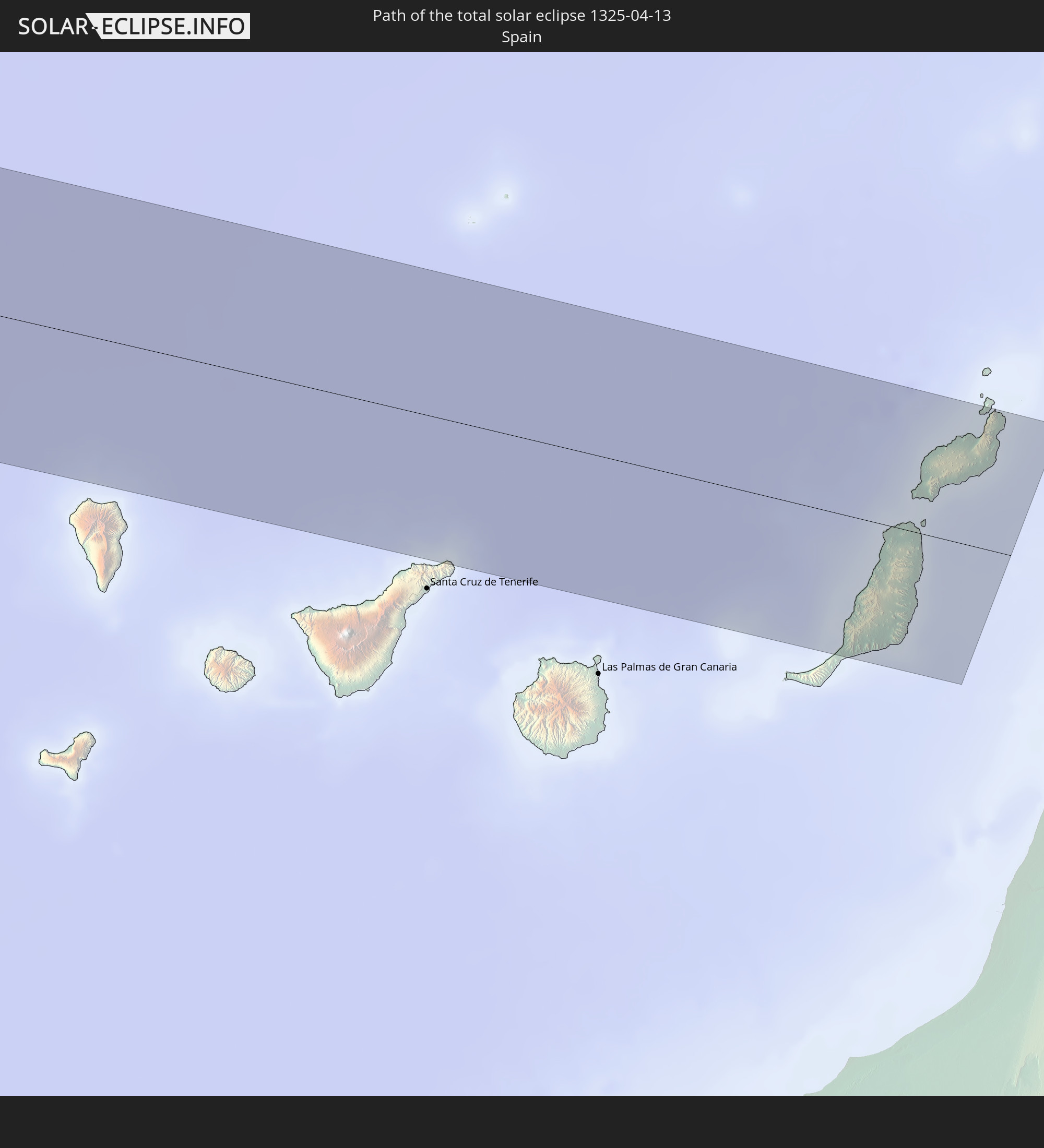 Spanien
In den folgenden Ländern ist die Sonnenfinsternis partiell zu sehen
 Vereinigte Staaten
 United States Minor Outlying Islands
 Kiribati
 Französisch-Polynesien
 Kanada
 Pitcairninseln
 Mexiko
 Grönland
 Guatemala
 Ecuador
 El Salvador
 Honduras
 Belize
 Nicaragua
 Costa Rica
 Kuba
Kuba
 Panama
 Kolumbien
 Kaimaninseln
 Peru
Peru
 Bahamas
 Jamaika
 Haiti
Haiti
 Brasilien
 Venezuela
 Turks- und Caicosinseln
 Dominikanische Republik
 Aruba
Aruba
 Puerto Rico
 Amerikanische Jungferninseln
 Bermuda
 Britische Jungferninseln
 Anguilla
 Saint-Martin
 Saint-Barthélemy
 St. Kitts und Nevis
 Antigua und Barbuda
 Montserrat
 Trinidad und Tobago
 Guadeloupe
 Grenada
 Dominica
 St. Vincent und die Grenadinen
 Guyana
 Martinique
 St. Lucia
 Barbados
 Suriname
 Saint-Pierre und Miquelon
 Französisch-Guayana
 Portugal
 Kap Verde
 Island
 Spanien
 Mauretanien
 Irland
 Vereinigtes Königreich
 Färöer
 Frankreich
 Isle of Man
 Guernsey
 Jersey
 Norwegen
 Schweden
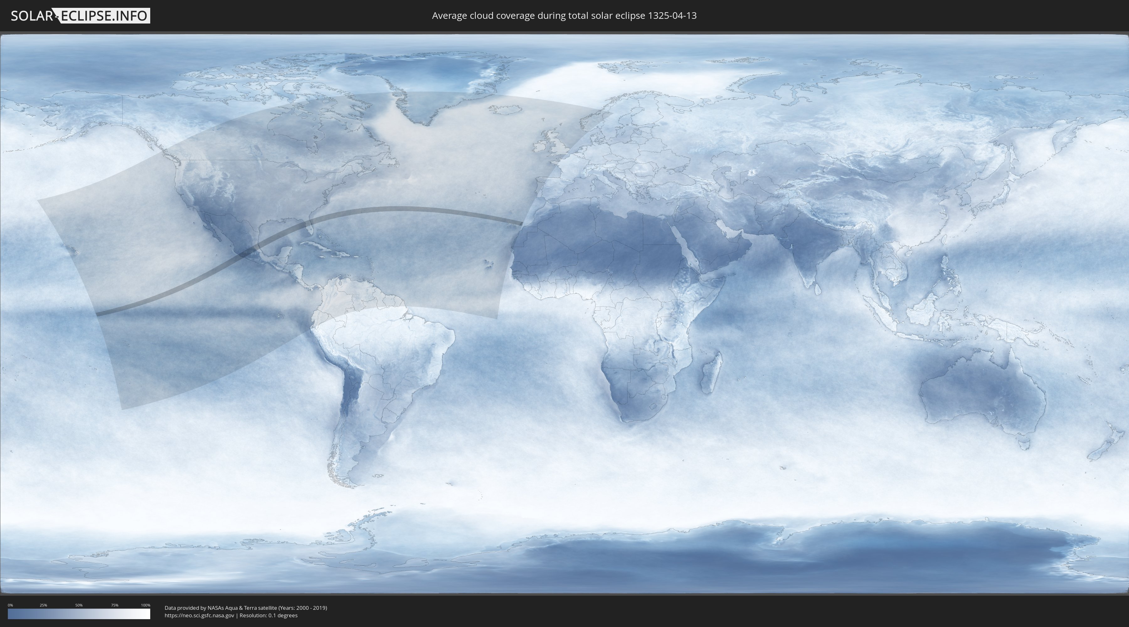
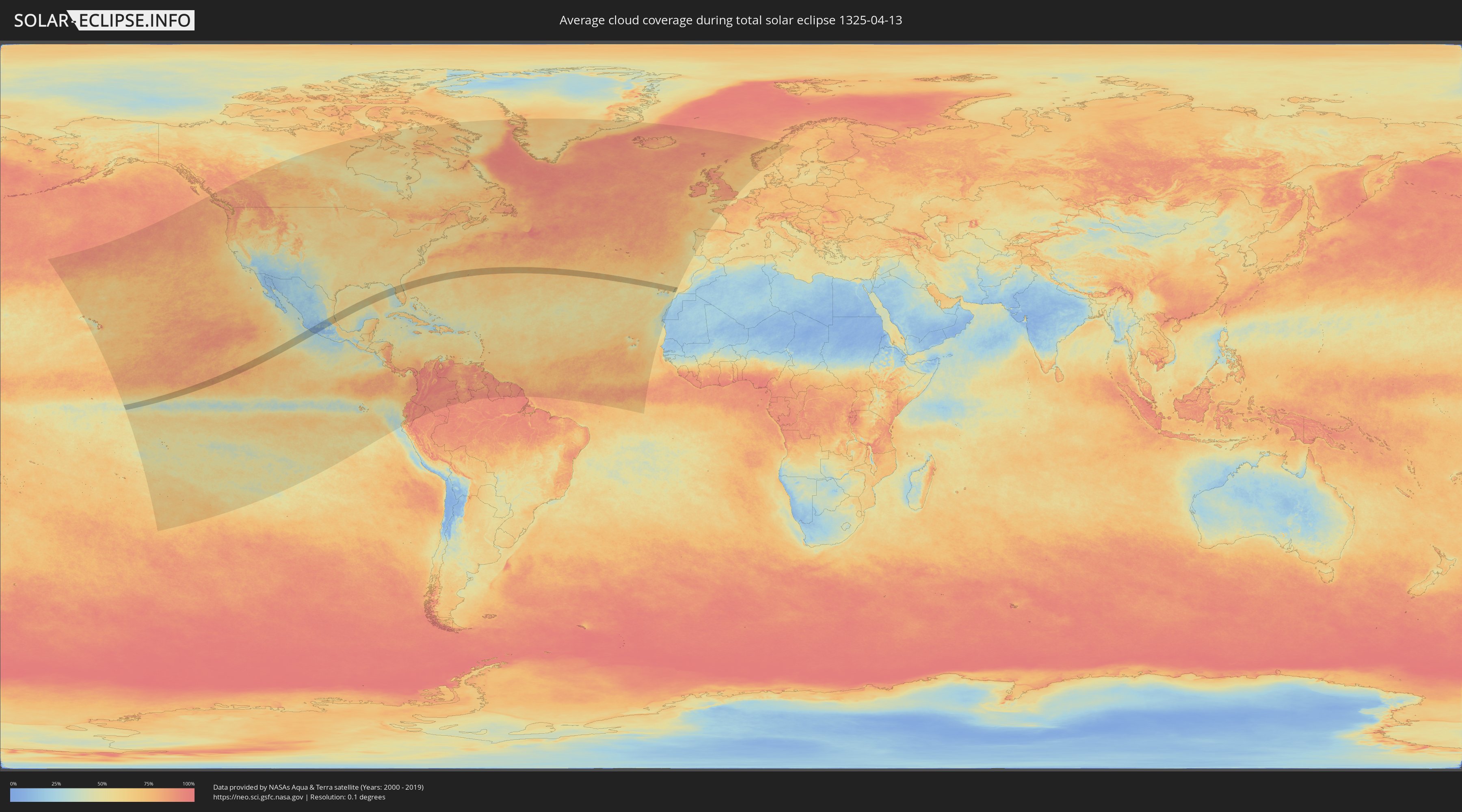
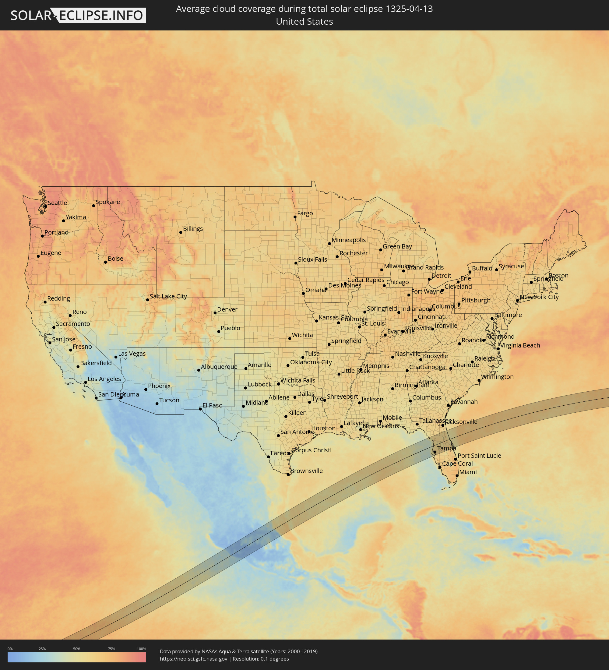
Wie wird das Wetter während der totalen Sonnenfinsternis am 13.04.1325?
Wo ist der beste Ort, um die totale Sonnenfinsternis vom 13.04.1325 zu beobachten?
Die folgenden Karten zeigen die durchschnittliche Bewölkung für den Tag, an dem die totale Sonnenfinsternis
stattfindet. Mit Hilfe der Karten lässt sich der Ort entlang des Finsternispfades eingrenzen,
der die besten Aussichen auf einen klaren wolkenfreien Himmel bietet.
Trotzdem muss man immer lokale Gegenenheiten beachten und sollte sich genau über das Wetter an seinem
gewählten Beobachtungsort informieren.
Die Daten stammen von den beiden NASA-Satelliten
AQUA und TERRA
und wurden über einen Zeitraum von 19 Jahren (2000 - 2019) gemittelt.
Detaillierte Länderkarten
 Vereinigte Staaten
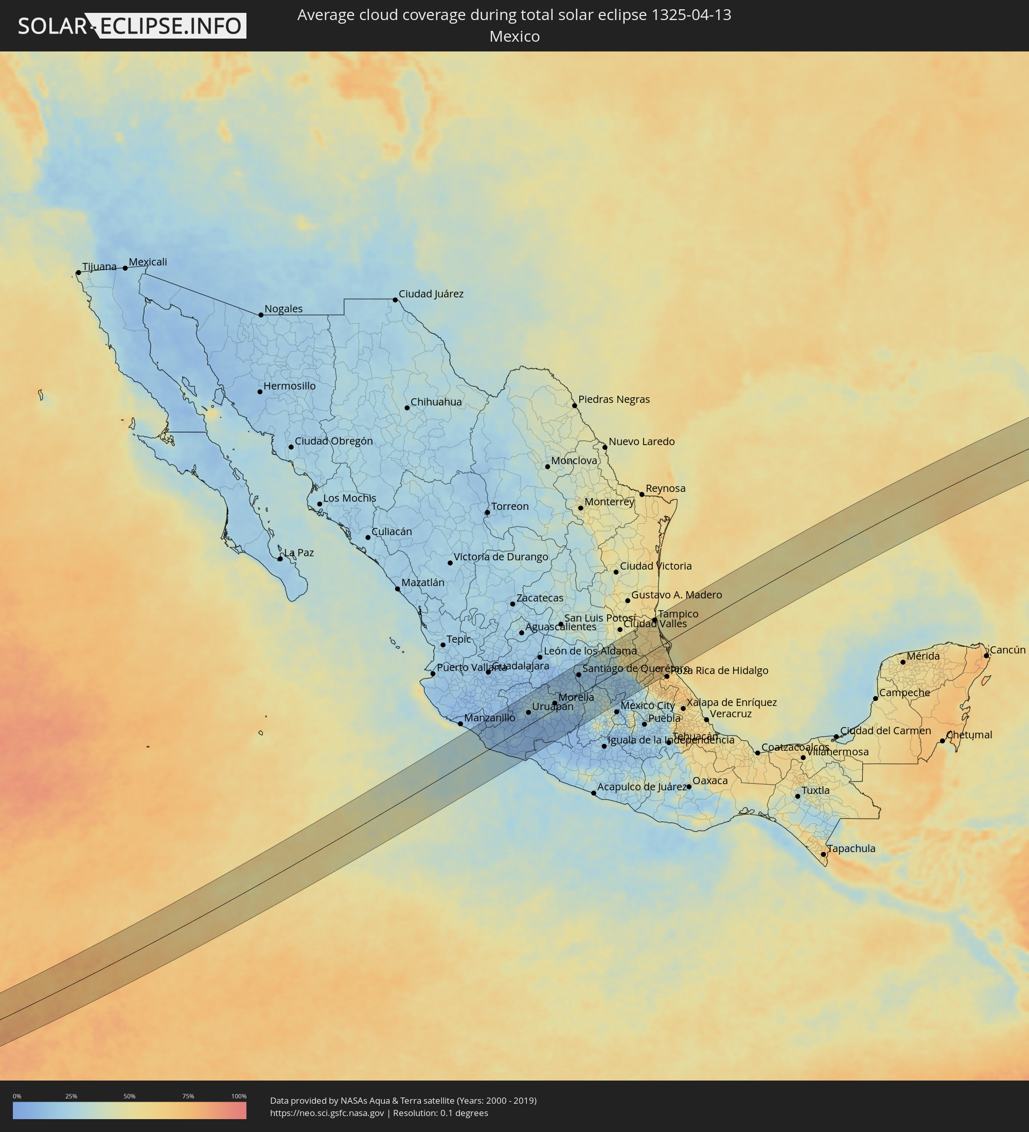 Mexiko
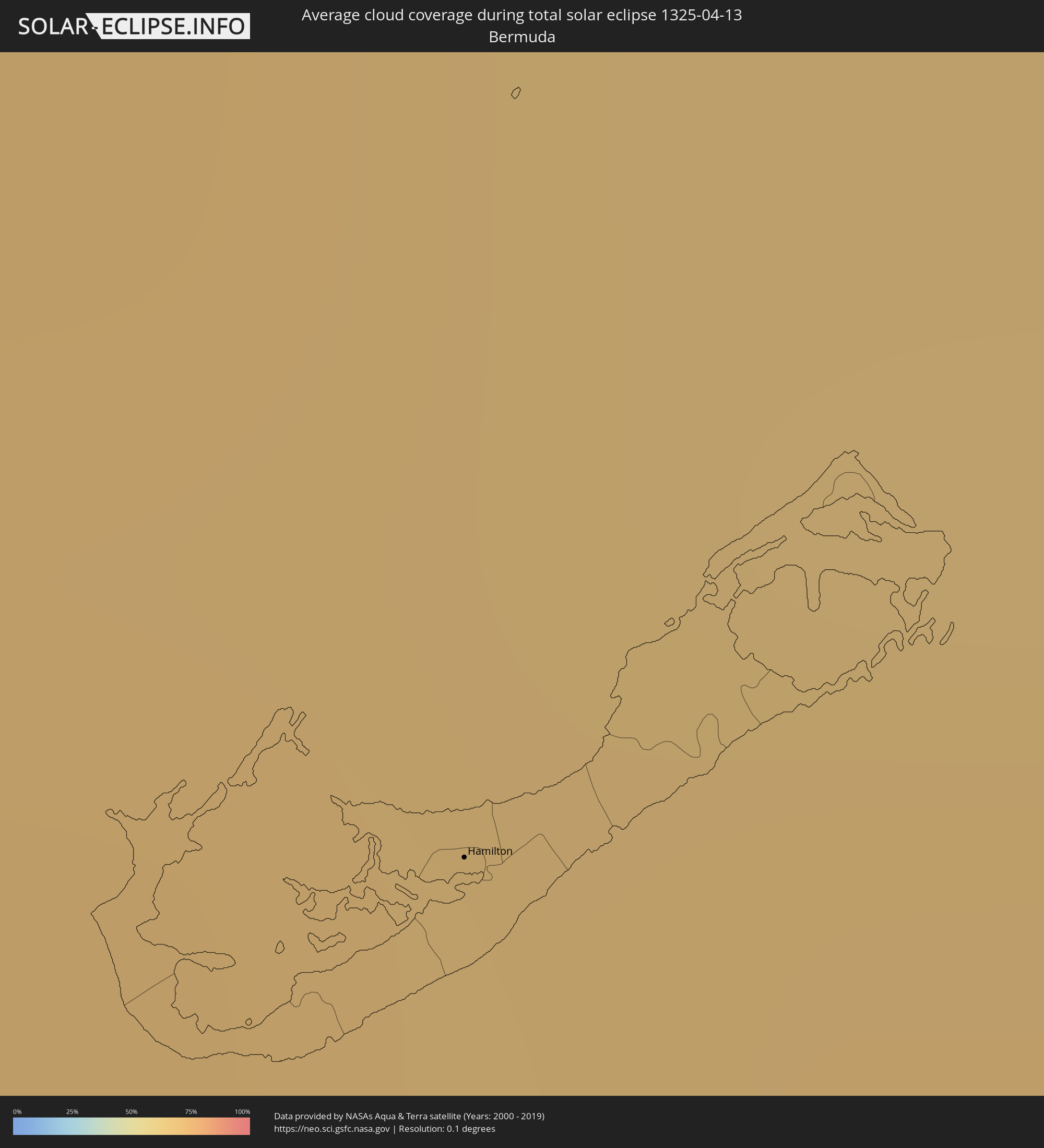 Bermuda
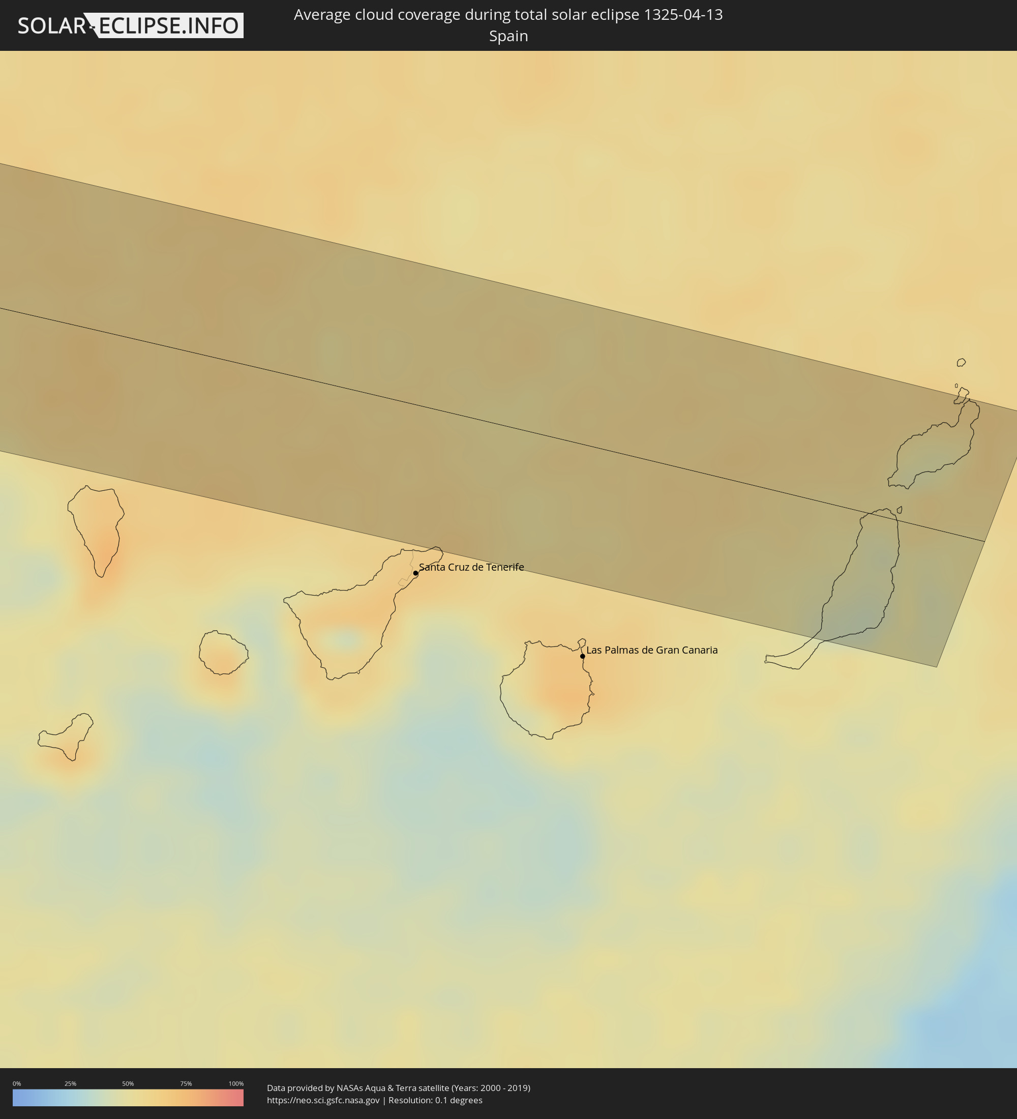 Spanien
Orte im Finsternispfad
Die nachfolgene Tabelle zeigt Städte und Orte mit mehr als 5.000 Einwohnern, die sich im Finsternispfad befinden. Städte mit mehr als 100.000 Einwohnern sind dick gekennzeichnet. Mit einem Klick auf den Ort öffnet sich eine Detailkarte die die Lage des jeweiligen Ortes zusammen mit dem Verlauf der zentralen Finsternis präsentiert.
| Ort | Typ | Dauer der Verfinsterung | Ortszeit bei maximaler Verfinsterung | Entfernung zur Zentrallinie | Ø Bewölkung |
|
Tecoman, Colima
|
total | - | 10:16:50 UTC-06:36 | 88 km | 24% |
|
Tepalcatepec, Michoacán
|
total | - | 10:19:13 UTC-06:36 | 58 km | 9% |
|
Apatzingán, Michoacán
|
total | - | 10:20:02 UTC-06:36 | 22 km | 10% |
|
Ciudad Lázaro Cárdenas, Michoacán
|
total | - | 10:18:30 UTC-06:36 | 92 km | 22% |
|
Nueva Italia de Ruiz, Michoacán
|
total | - | 10:20:27 UTC-06:36 | 1 km | 9% |
|
Uruapan, Michoacán
|
total | - | 10:21:08 UTC-06:36 | 36 km | 12% |
|
Paracho de Verduzco, Michoacán
|
total | - | 10:21:32 UTC-06:36 | 58 km | 21% |
|
Zacapú, Michoacán
|
total | - | 10:22:18 UTC-06:36 | 60 km | 30% |
|
Pátzcuaro, Michoacán
|
total | - | 10:22:11 UTC-06:36 | 22 km | 24% |
|
Puruándiro, Michoacán
|
total | - | 10:23:18 UTC-06:36 | 71 km | 21% |
|
Tacámbaro de Codallos, Michoacán
|
total | - | 10:22:02 UTC-06:36 | 13 km | 11% |
|
Valle de Santiago, Guanajuato
|
total | - | 10:24:26 UTC-06:36 | 83 km | 16% |
|
Morelia, Michoacán
|
total | - | 10:23:20 UTC-06:36 | 16 km | 20% |
|
Uriangato, Guanajuato
|
total | - | 10:24:03 UTC-06:36 | 58 km | 22% |
|
Cortazar, Guanajuato
|
total | - | 10:25:02 UTC-06:36 | 78 km | 13% |
|
Salvatierra, Guanajuato
|
total | - | 10:24:47 UTC-06:36 | 49 km | 18% |
|
Celaya, Guanajuato
|
total | - | 10:25:24 UTC-06:36 | 75 km | 16% |
|
Comonfort, Guanajuato
|
total | - | 10:25:50 UTC-06:36 | 91 km | 13% |
|
Acámbaro, Guanajuato
|
total | - | 10:24:48 UTC-06:36 | 23 km | 20% |
|
Apaseo el Alto, Guanajuato
|
total | - | 10:25:42 UTC-06:36 | 58 km | 15% |
|
Ciudad Hidalgo, Michoacán
|
total | - | 10:24:36 UTC-06:36 | 18 km | 26% |
|
Santa Rosa Jauregui, Querétaro
|
total | - | 10:26:30 UTC-06:36 | 76 km | 16% |
|
Maravatío de Ocampo, Michoacán
|
total | - | 10:25:09 UTC-06:36 | 6 km | 18% |
|
Santiago de Querétaro, Querétaro
|
total | - | 10:26:23 UTC-06:36 | 58 km | 13% |
|
Heróica Zitácuaro, Michoacán
|
total | - | 10:24:36 UTC-06:36 | 54 km | 12% |
|
Valle de Bravo, México
|
total | - | 10:24:41 UTC-06:36 | 89 km | 19% |
|
San Juan del Río, Querétaro
|
total | - | 10:26:52 UTC-06:36 | 18 km | 16% |
|
Tequisquiapan, Querétaro
|
total | - | 10:27:18 UTC-06:36 | 25 km | 15% |
|
Atlacomulco de Fabela, México
|
total | - | 10:26:10 UTC-06:36 | 45 km | 25% |
|
Tula de Allende, Hidalgo
|
total | - | 10:27:41 UTC-06:36 | 50 km | 21% |
|
Tepeji de Ocampo, Hidalgo
|
total | - | 10:27:27 UTC-06:36 | 63 km | 22% |
|
Nicolás Romero, México
|
total | - | 10:27:06 UTC-06:36 | 91 km | 32% |
|
Tezontepec de Aldama, Hidalgo
|
total | - | 10:28:03 UTC-06:36 | 40 km | 22% |
|
Ixmiquilpan, Hidalgo
|
total | - | 10:28:38 UTC-06:36 | 16 km | 16% |
|
Teoloyucan, México
|
total | - | 10:27:33 UTC-06:36 | 88 km | 23% |
|
Tequixquiac, México
|
total | - | 10:27:53 UTC-06:36 | 74 km | 19% |
|
Tizayuca, Hidalgo
|
total | - | 10:28:07 UTC-06:36 | 90 km | 20% |
|
Actopan, Hidalgo
|
total | - | 10:28:53 UTC-06:36 | 50 km | 17% |
|
Tamazunchale, San Luis Potosí
|
total | - | 10:30:47 UTC-06:36 | 36 km | 54% |
|
Pachuca de Soto, Hidalgo
|
total | - | 10:29:05 UTC-06:36 | 76 km | 18% |
|
Zacualtipán, Hidalgo
|
total | - | 10:30:06 UTC-06:36 | 29 km | 35% |
|
Huejutla de Reyes, Hidalgo
|
total | - | 10:31:23 UTC-06:36 | 5 km | 57% |
|
Tantoyuca, Veracruz
|
total | - | 10:32:08 UTC-06:36 | 15 km | 58% |
|
Pánuco, Veracruz
|
total | - | 10:33:19 UTC-06:36 | 80 km | 57% |
|
Tampico, Tamaulipas
|
total | - | 10:34:21 UTC-06:36 | 85 km | 54% |
|
Cerro Azul, Veracruz
|
total | - | 10:32:55 UTC-06:36 | 26 km | 65% |
|
Naranjos, Veracruz
|
total | - | 10:33:17 UTC-06:36 | 14 km | 63% |
|
Álamo, Veracruz
|
total | - | 10:32:37 UTC-06:36 | 57 km | 65% |
|
Temapache, Veracruz
|
total | - | 10:32:56 UTC-06:36 | 43 km | 66% |
|
Tuxpan de Rodríguez Cano, Veracruz
|
total | - | 10:33:17 UTC-06:36 | 66 km | 58% |
|
Clearwater, Florida
|
total | - | 12:53:52 UTC-05:00 | 54 km | 52% |
|
East Lake, Florida
|
total | - | 12:54:15 UTC-05:00 | 43 km | 51% |
|
Bayonet Point, Florida
|
total | - | 12:54:30 UTC-05:00 | 21 km | 52% |
|
St. Petersburg, Florida
|
total | - | 12:53:58 UTC-05:00 | 78 km | 47% |
|
Homosassa Springs, Florida
|
total | - | 12:55:13 UTC-05:00 | 24 km | 53% |
|
North Weeki Wachee, Florida
|
total | - | 12:55:01 UTC-05:00 | 3 km | 54% |
|
Greater Northdale, Florida
|
total | - | 12:54:40 UTC-05:00 | 50 km | 58% |
|
Spring Hill, Florida
|
total | - | 12:55:01 UTC-05:00 | 11 km | 58% |
|
Sugarmill Woods, Florida
|
total | - | 12:55:19 UTC-05:00 | 14 km | 58% |
|
Pine Ridge, Florida
|
total | - | 12:55:35 UTC-05:00 | 34 km | 59% |
|
Tampa, Florida
|
total | - | 12:54:40 UTC-05:00 | 68 km | 52% |
|
Beverly Hills, Florida
|
total | - | 12:55:36 UTC-05:00 | 31 km | 59% |
|
Ruskin, Florida
|
total | - | 12:54:30 UTC-05:00 | 93 km | 57% |
|
Citrus Hills, Florida
|
total | - | 12:55:38 UTC-05:00 | 27 km | 57% |
|
Brooksville, Florida
|
total | - | 12:55:25 UTC-05:00 | 8 km | 61% |
|
Pebble Creek, Florida
|
total | - | 12:55:08 UTC-05:00 | 52 km | 61% |
|
Wesley Chapel, Florida
|
total | - | 12:55:16 UTC-05:00 | 43 km | 62% |
|
Brandon, Florida
|
total | - | 12:55:04 UTC-05:00 | 76 km | 61% |
|
Seffner, Florida
|
total | - | 12:55:09 UTC-05:00 | 72 km | 62% |
|
Ocala, Florida
|
total | - | 12:56:36 UTC-05:00 | 47 km | 61% |
|
Plant City, Florida
|
total | - | 12:55:34 UTC-05:00 | 74 km | 62% |
|
Fuller Heights, Florida
|
total | - | 12:55:44 UTC-05:00 | 90 km | 59% |
|
The Villages, Florida
|
total | - | 12:56:48 UTC-05:00 | 15 km | 57% |
|
Lakeland, Florida
|
total | - | 12:55:59 UTC-05:00 | 78 km | 57% |
|
Leesburg, Florida
|
total | - | 12:56:53 UTC-05:00 | 1 km | 56% |
|
Clermont, Florida
|
total | - | 12:56:53 UTC-05:00 | 32 km | 59% |
|
Winter Haven, Florida
|
total | - | 12:56:29 UTC-05:00 | 88 km | 59% |
|
Eustis, Florida
|
total | - | 12:57:22 UTC-05:00 | 4 km | 55% |
|
Four Corners, Florida
|
total | - | 12:56:59 UTC-05:00 | 59 km | 62% |
|
Palatka, Florida
|
total | - | 12:58:12 UTC-05:00 | 77 km | 58% |
|
Haines City, Florida
|
total | - | 12:56:51 UTC-05:00 | 82 km | 60% |
|
Lake Butler, Florida
|
total | - | 12:57:24 UTC-05:00 | 45 km | 60% |
|
Celebration, Florida
|
total | - | 12:57:15 UTC-05:00 | 64 km | 59% |
|
Apopka, Florida
|
total | - | 12:57:38 UTC-05:00 | 28 km | 60% |
|
Poinciana, Florida
|
total | - | 12:57:16 UTC-05:00 | 86 km | 58% |
|
Williamsburg, Florida
|
total | - | 12:57:33 UTC-05:00 | 58 km | 58% |
|
Kissimmee, Florida
|
total | - | 12:57:31 UTC-05:00 | 70 km | 53% |
|
Orlando, Florida
|
total | - | 12:57:49 UTC-05:00 | 47 km | 62% |
|
Fern Park, Florida
|
total | - | 12:57:59 UTC-05:00 | 37 km | 61% |
|
Saint Augustine, Florida
|
total | - | 12:59:10 UTC-05:00 | 91 km | 51% |
|
Winter Springs, Florida
|
total | - | 12:58:08 UTC-05:00 | 33 km | 61% |
|
Deltona, Florida
|
total | - | 12:58:25 UTC-05:00 | 14 km | 58% |
|
Alafaya, Florida
|
total | - | 12:58:15 UTC-05:00 | 51 km | 64% |
|
Palm Coast, Florida
|
total | - | 12:59:09 UTC-05:00 | 55 km | 50% |
|
Bithlo, Florida
|
total | - | 12:58:29 UTC-05:00 | 55 km | 63% |
|
Daytona Beach, Florida
|
total | - | 12:59:16 UTC-05:00 | 10 km | 53% |
|
New Smyrna Beach, Florida
|
total | - | 12:59:20 UTC-05:00 | 13 km | 49% |
|
Titusville, Florida
|
total | - | 12:59:15 UTC-05:00 | 60 km | 60% |
|
Rockledge, Florida
|
total | - | 12:59:13 UTC-05:00 | 90 km | 57% |
|
Merritt Island, Florida
|
total | - | 12:59:31 UTC-05:00 | 72 km | 57% |
|
Hamilton, Hamilton city
|
total | - | 14:16:21 UTC-04:19 | 55 km | 70% |
|
Pájara, Canary Islands
|
total | - | 18:16:57 UTC-01:01 | 45 km | 41% |
|
Tuineje, Canary Islands
|
total | - | 18:16:57 UTC-01:01 | 46 km | 42% |
|
Antigua, Canary Islands
|
total | - | 18:16:53 UTC-01:01 | 35 km | 40% |
|
La Oliva, Canary Islands
|
total | - | 18:16:46 UTC-01:01 | 13 km | 46% |
|
Corralejo, Canary Islands
|
total | - | 18:16:42 UTC-01:01 | 2 km | 44% |
|
Puerto del Rosario, Canary Islands
|
total | - | 18:16:50 UTC-01:01 | 23 km | 44% |
|
Playa Blanca, Canary Islands
|
total | - | 18:16:37 UTC-01:01 | 17 km | 53% |
|
Yaiza, Canary Islands
|
total | - | 18:16:33 UTC-01:01 | 29 km | 46% |
|
Tinajo, Canary Islands
|
total | - | 18:16:29 UTC-01:01 | 42 km | 47% |
|
Puerto del Carmen, Canary Islands
|
total | - | 18:16:34 UTC-01:01 | 27 km | 56% |
|
Tías, Canary Islands
|
total | - | 18:16:32 UTC-01:01 | 32 km | 51% |
|
San Bartolomé, Canary Islands
|
total | - | 18:16:31 UTC-01:01 | 37 km | 51% |
|
Teguise, Canary Islands
|
total | - | 18:16:28 UTC-01:01 | 48 km | 47% |
|
Nazaret, Canary Islands
|
total | - | 18:16:29 UTC-01:01 | 45 km | 51% |
|
Arrecife, Canary Islands
|
total | - | 18:16:31 UTC-01:01 | 37 km | 57% |