Totale Sonnenfinsternis vom 16.07.1330
| Wochentag: | Sonntag |
| Maximale Dauer der Verfinsterung: | 01m00s |
| Maximale Breite des Finsternispfades: | 70 km |
| Saroszyklus: | 125 |
| Bedeckungsgrad: | 100% |
| Magnitude: | 1.0139 |
| Gamma: | 0.7307 |
Wo kann man die Sonnenfinsternis vom 16.07.1330 sehen?
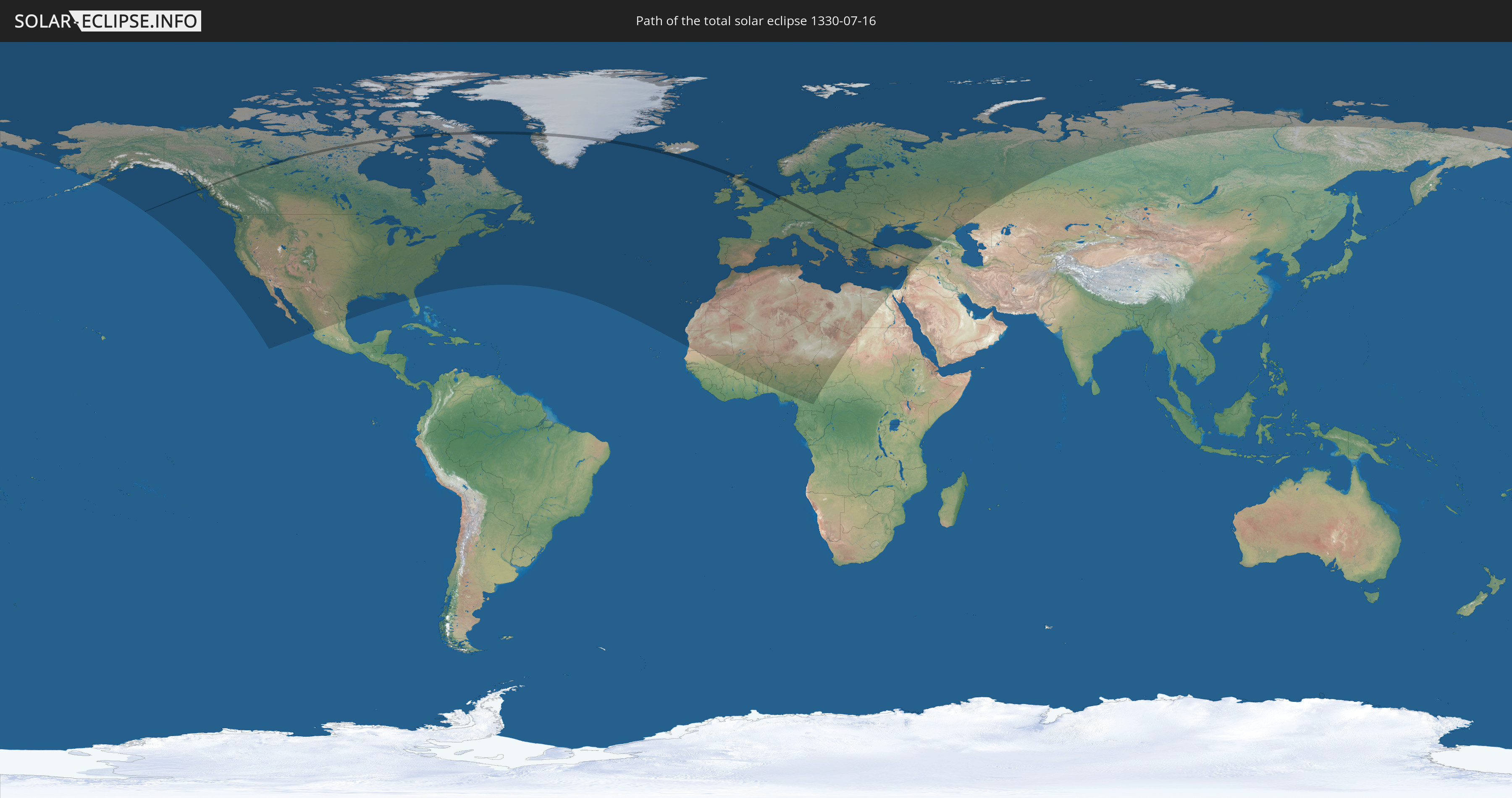
Die Sonnenfinsternis am 16.07.1330 kann man in 81 Ländern als partielle Sonnenfinsternis beobachten.
Der Finsternispfad verläuft durch 14 Länder. Nur in diesen Ländern ist sie als totale Sonnenfinsternis zu sehen.
In den folgenden Ländern ist die Sonnenfinsternis total zu sehen
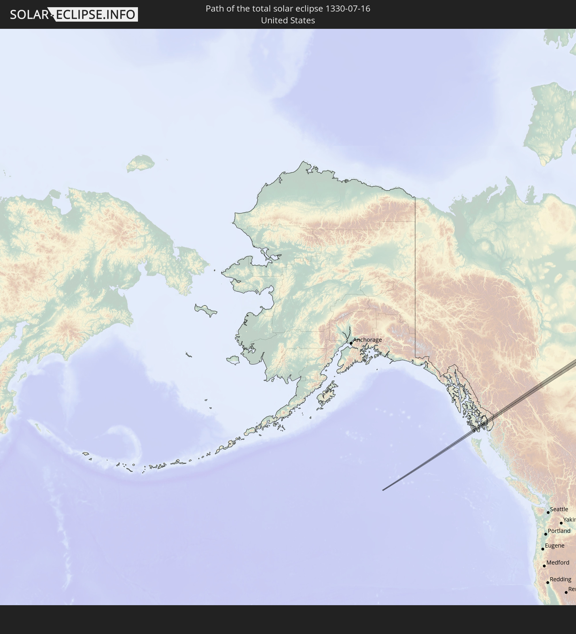 Vereinigte Staaten
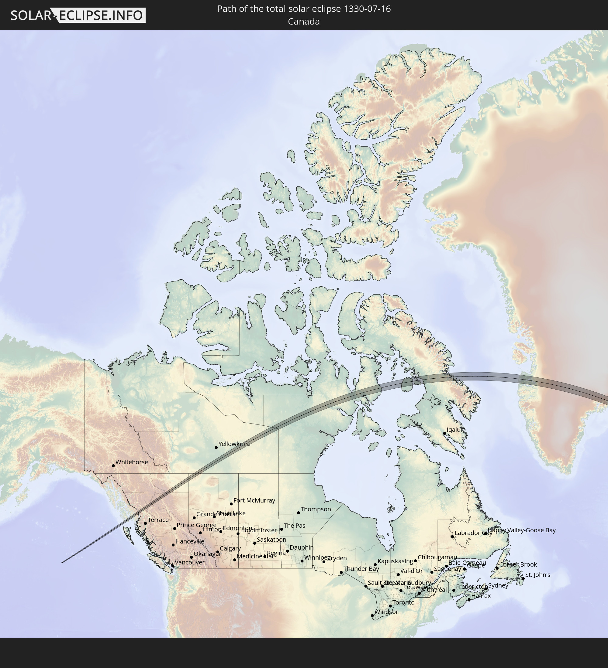 Kanada
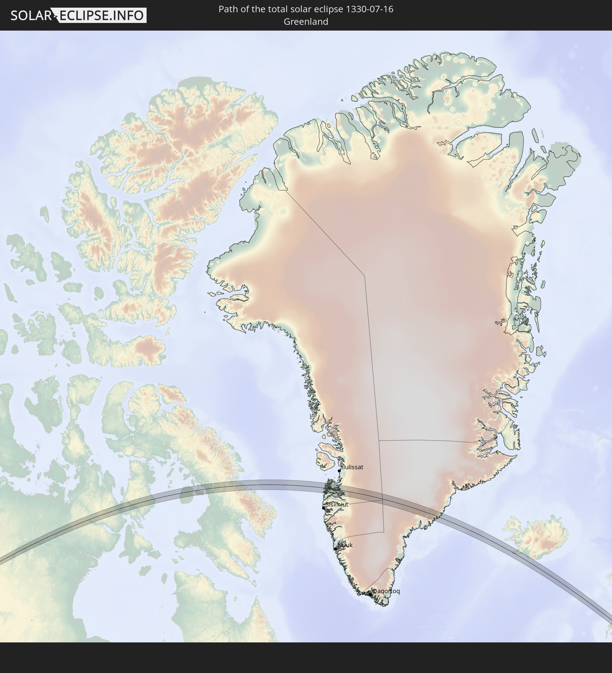 Grönland
 Island
 Vereinigtes Königreich
 Niederlande
 Deutschland
 Österreich
 Tschechien
 Ungarn
 Serbien
 Rumänien
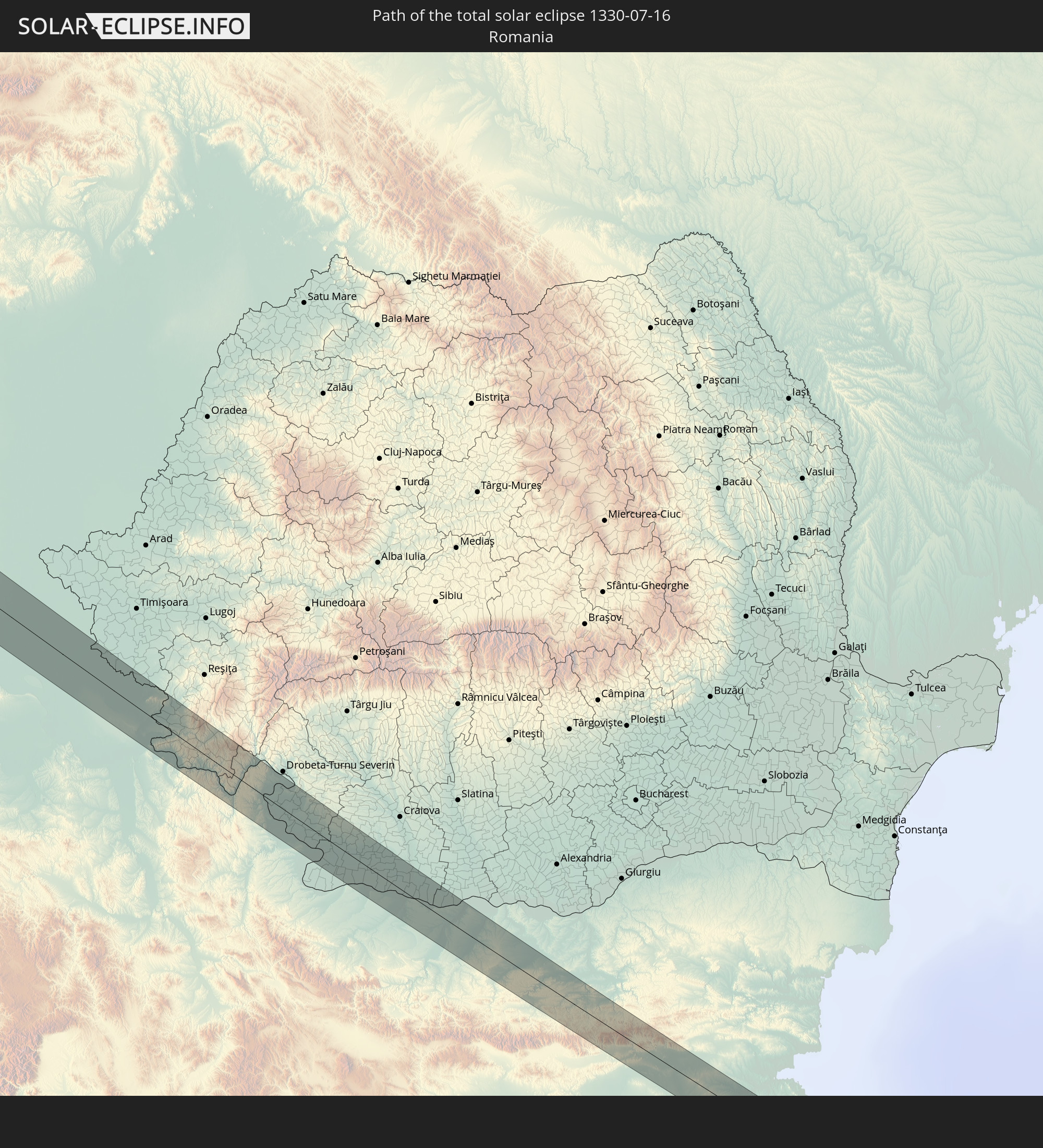
 Bulgarien
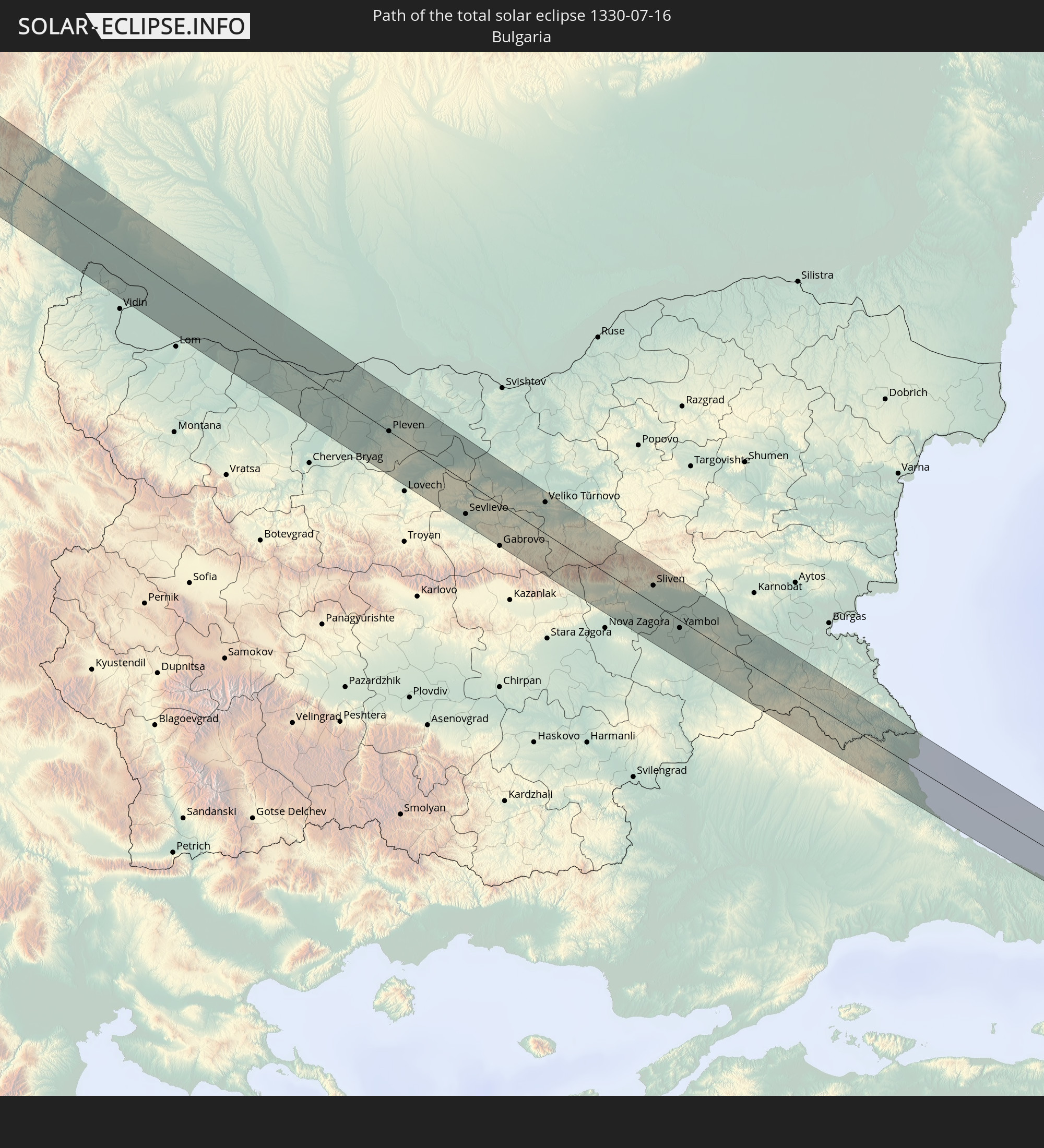
 Türkei
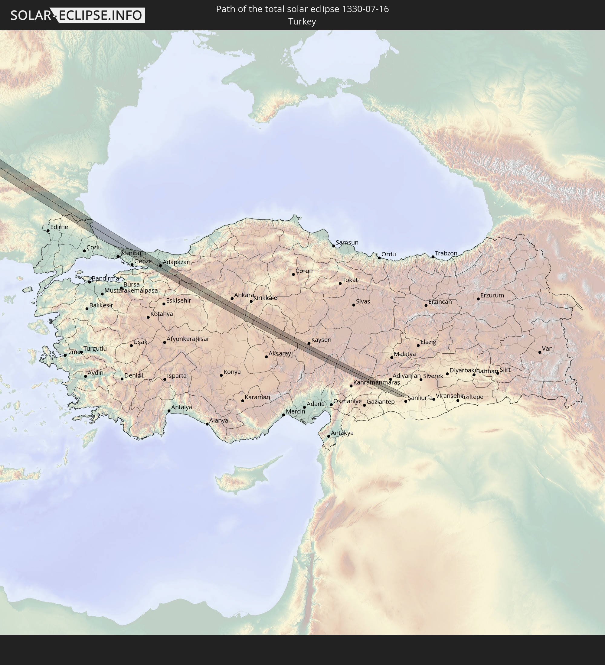
In den folgenden Ländern ist die Sonnenfinsternis partiell zu sehen
 Russland
 Vereinigte Staaten
 Kanada
 Mexiko
 Grönland
 Bermuda
 Saint-Pierre und Miquelon
 Portugal
 Island
 Spanien
 Senegal
 Mauretanien
 Marokko
 Mali
Mali
 Irland
 Spitzbergen
 Algerien
 Vereinigtes Königreich
 Färöer
 Burkina Faso
 Gibraltar
 Frankreich
 Isle of Man
 Ghana
Ghana
 Guernsey
 Jersey
 Togo
Togo
 Niger
Niger
 Benin
Benin
 Andorra
 Belgien
 Nigeria
 Niederlande
 Norwegen
 Luxemburg
 Deutschland
 Schweiz
 Italien
 Monaco
 Tunesien
 Dänemark
 Kamerun
 Libyen
 Liechtenstein
 Österreich
 Schweden
 Tschechien
 San Marino
 Vatikanstadt
 Slowenien
 Tschad
 Kroatien
 Polen
Polen
 Malta
Malta
 Zentralafrikanische Republik
 Bosnien und Herzegowina
 Ungarn
 Slowakei
 Montenegro
 Serbien
 Albanien
 Åland Islands
 Griechenland
 Rumänien
 Mazedonien
 Finnland
 Litauen
 Lettland
 Estland
 Sudan
Sudan
 Ukraine
 Bulgarien
 Weißrussland
 Ägypten
 Türkei
 Moldawien
 Republik Zypern
 Libanon
 Syrien
 Georgien
 Kasachstan
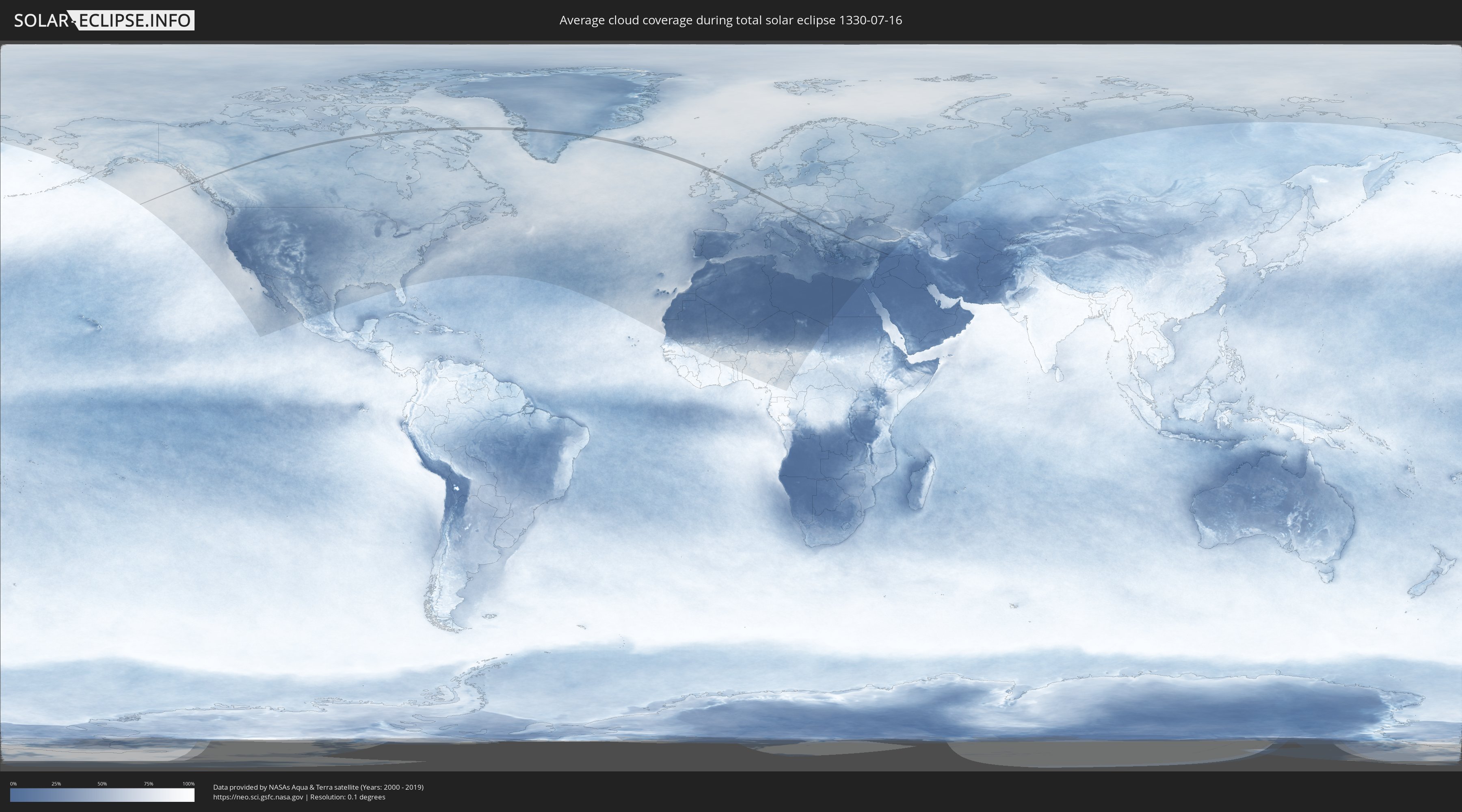
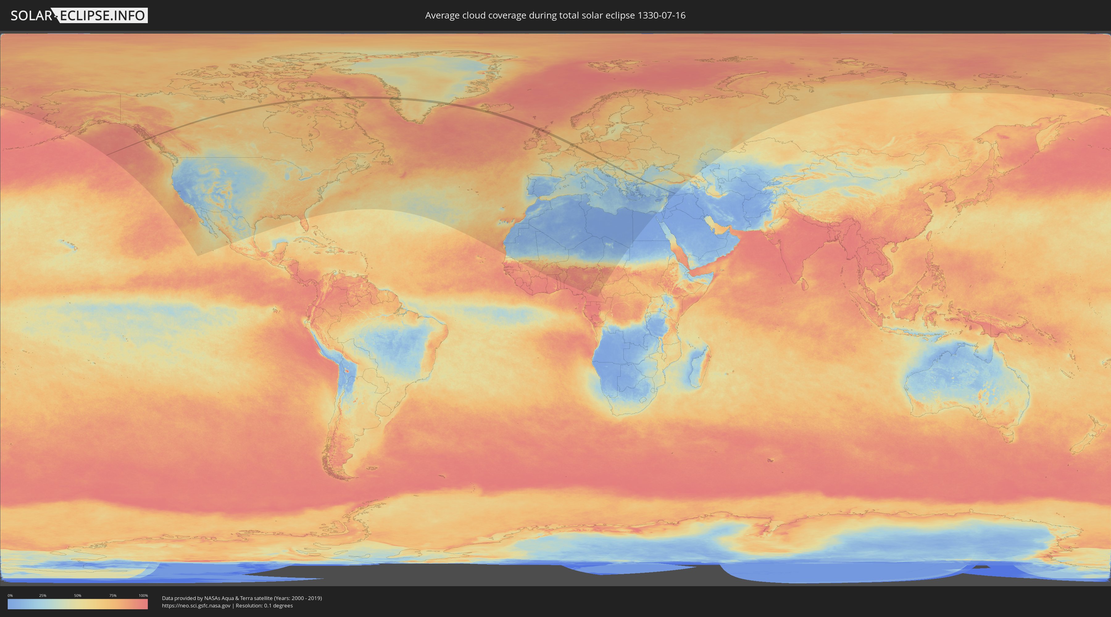
Wie wird das Wetter während der totalen Sonnenfinsternis am 16.07.1330?
Wo ist der beste Ort, um die totale Sonnenfinsternis vom 16.07.1330 zu beobachten?
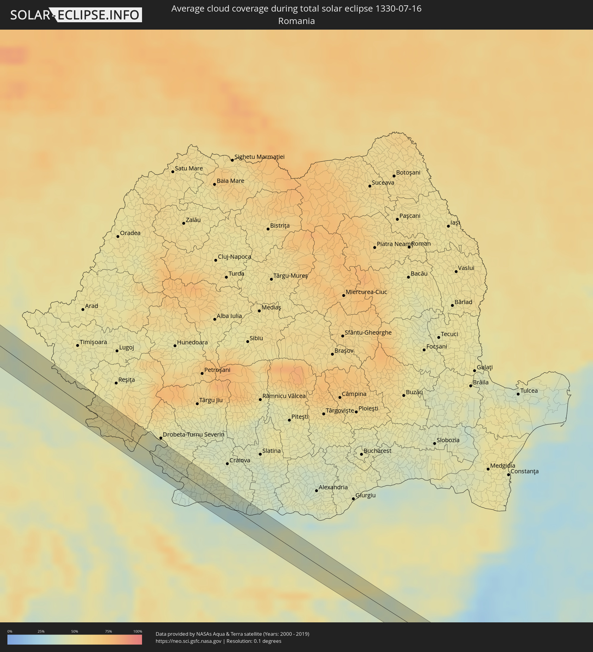
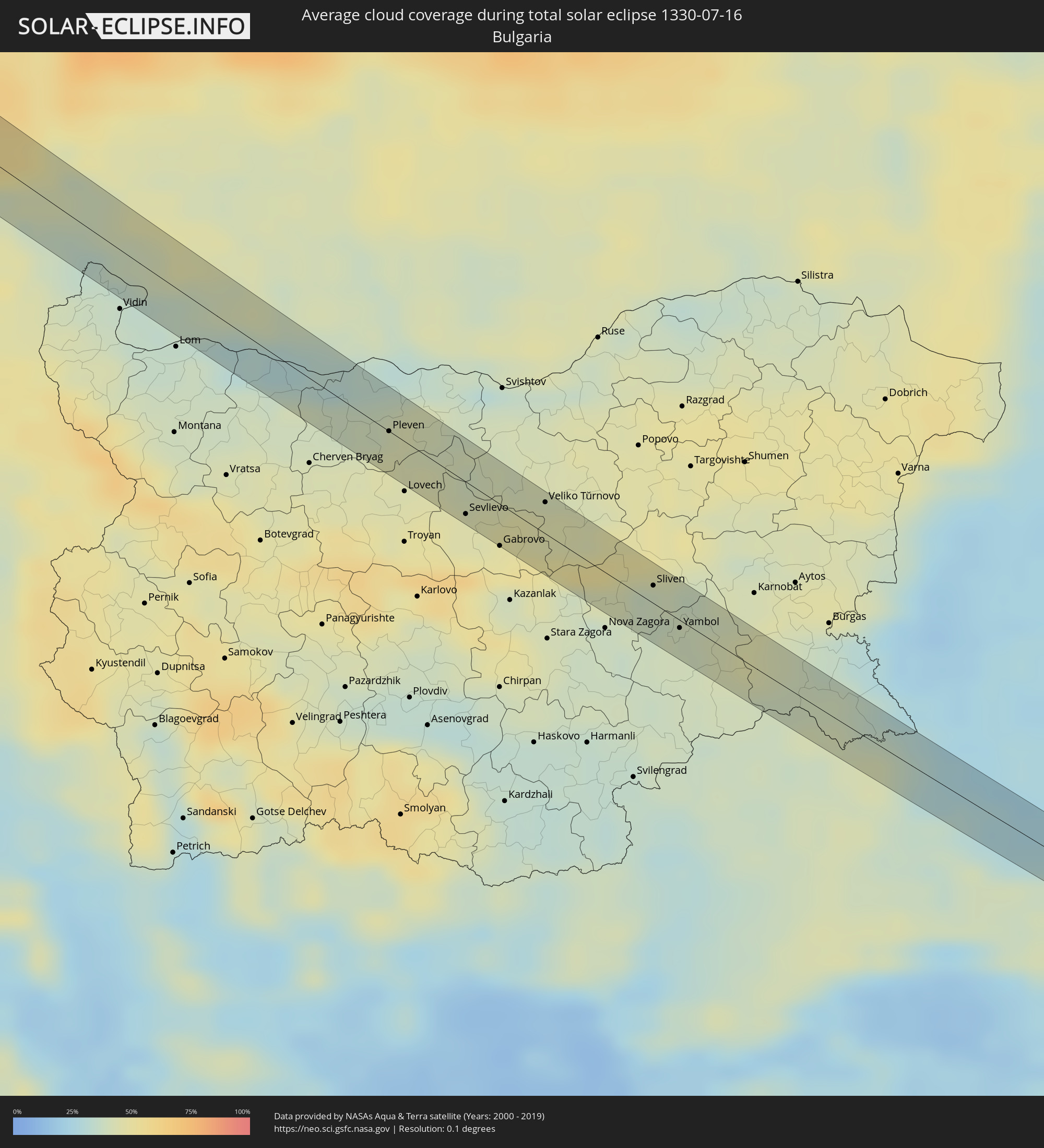
Die folgenden Karten zeigen die durchschnittliche Bewölkung für den Tag, an dem die totale Sonnenfinsternis
stattfindet. Mit Hilfe der Karten lässt sich der Ort entlang des Finsternispfades eingrenzen,
der die besten Aussichen auf einen klaren wolkenfreien Himmel bietet.
Trotzdem muss man immer lokale Gegenenheiten beachten und sollte sich genau über das Wetter an seinem
gewählten Beobachtungsort informieren.
Die Daten stammen von den beiden NASA-Satelliten
AQUA und TERRA
und wurden über einen Zeitraum von 19 Jahren (2000 - 2019) gemittelt.
Detaillierte Länderkarten
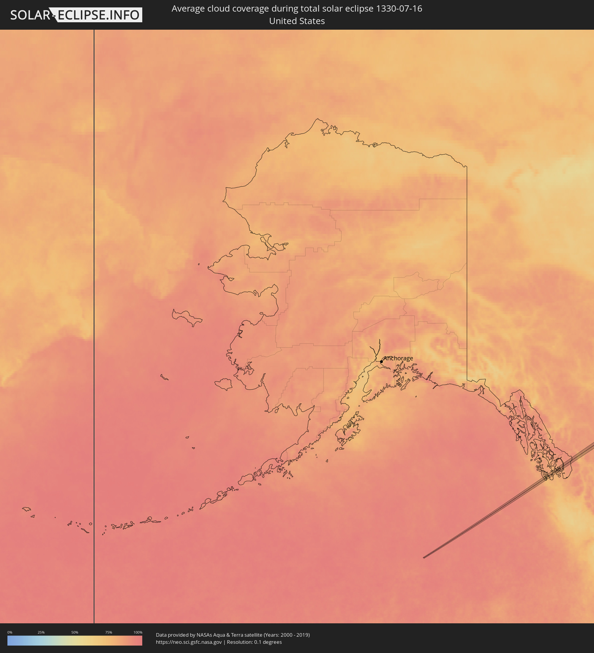 Vereinigte Staaten
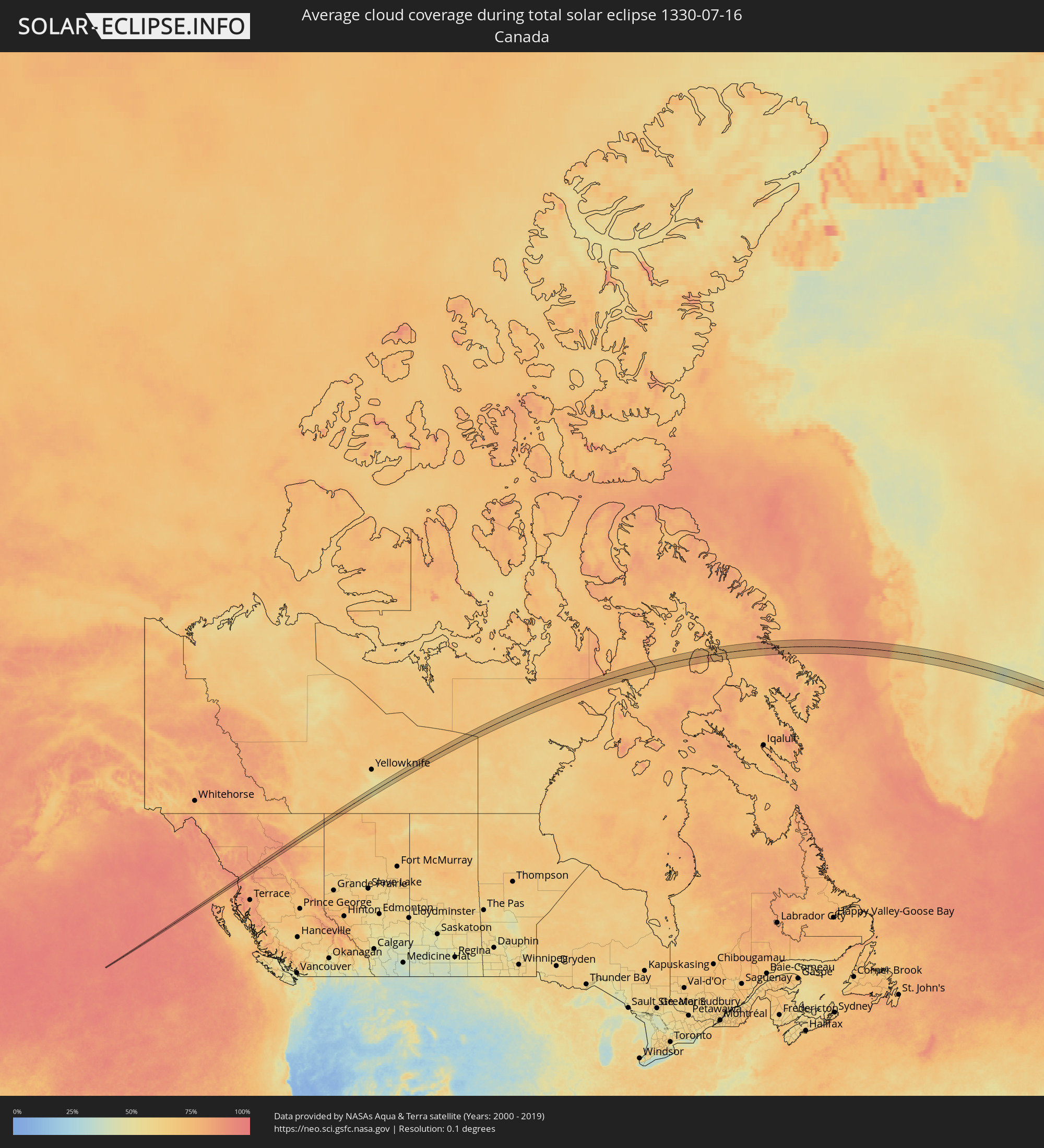 Kanada
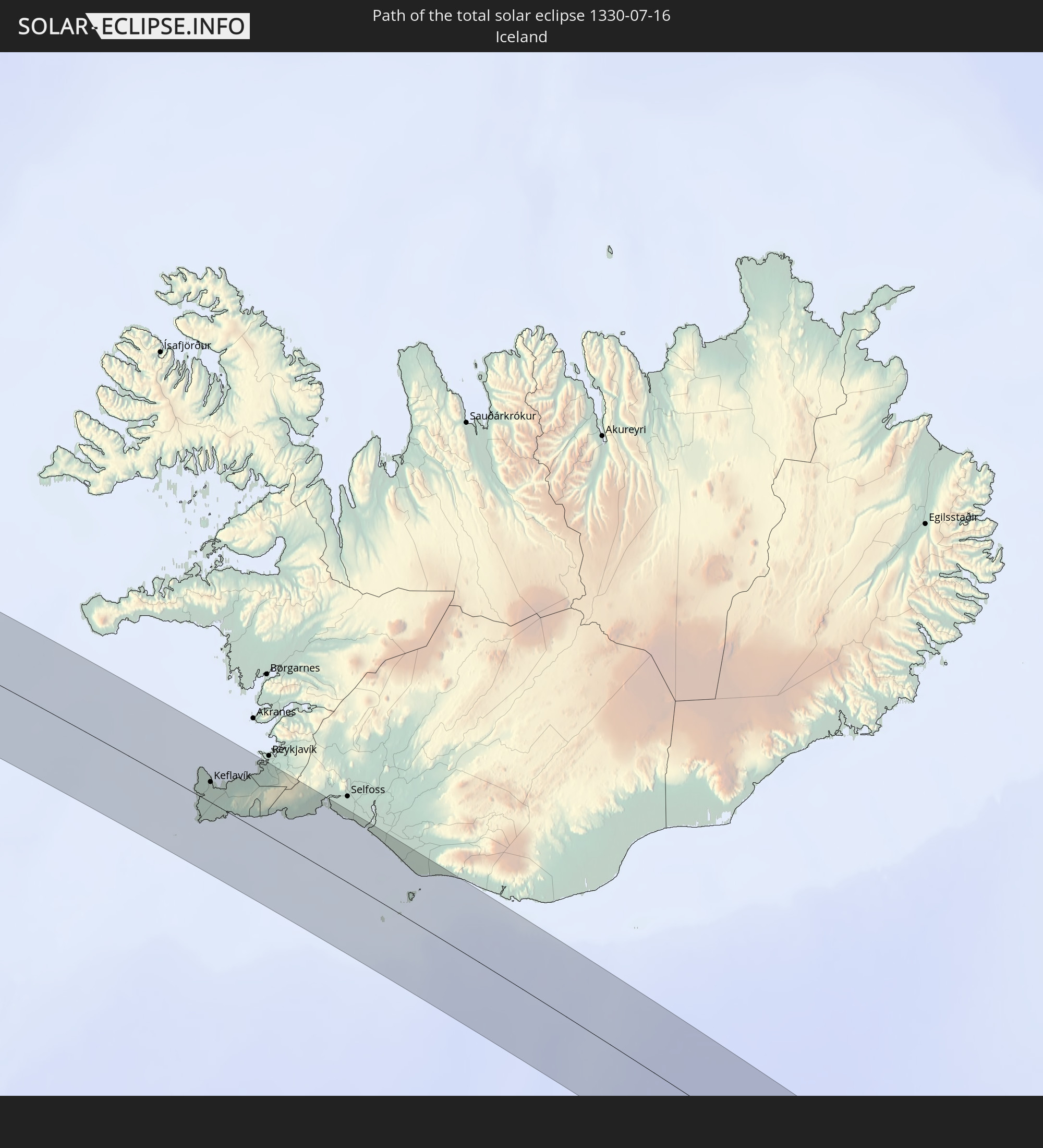
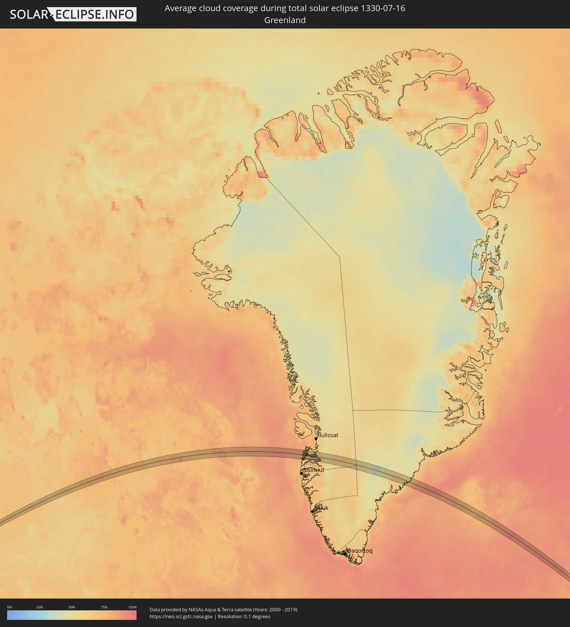 Grönland
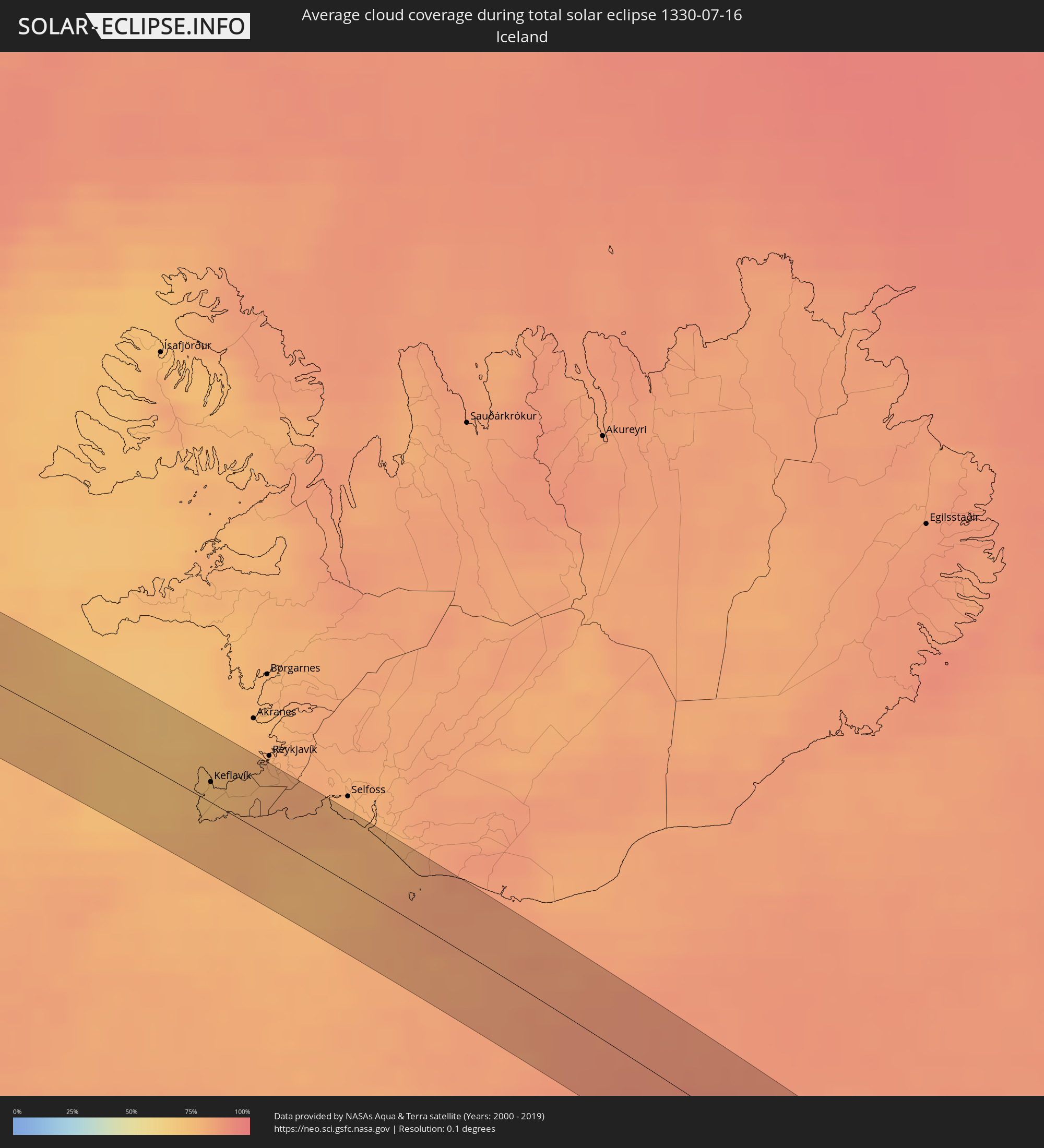 Island
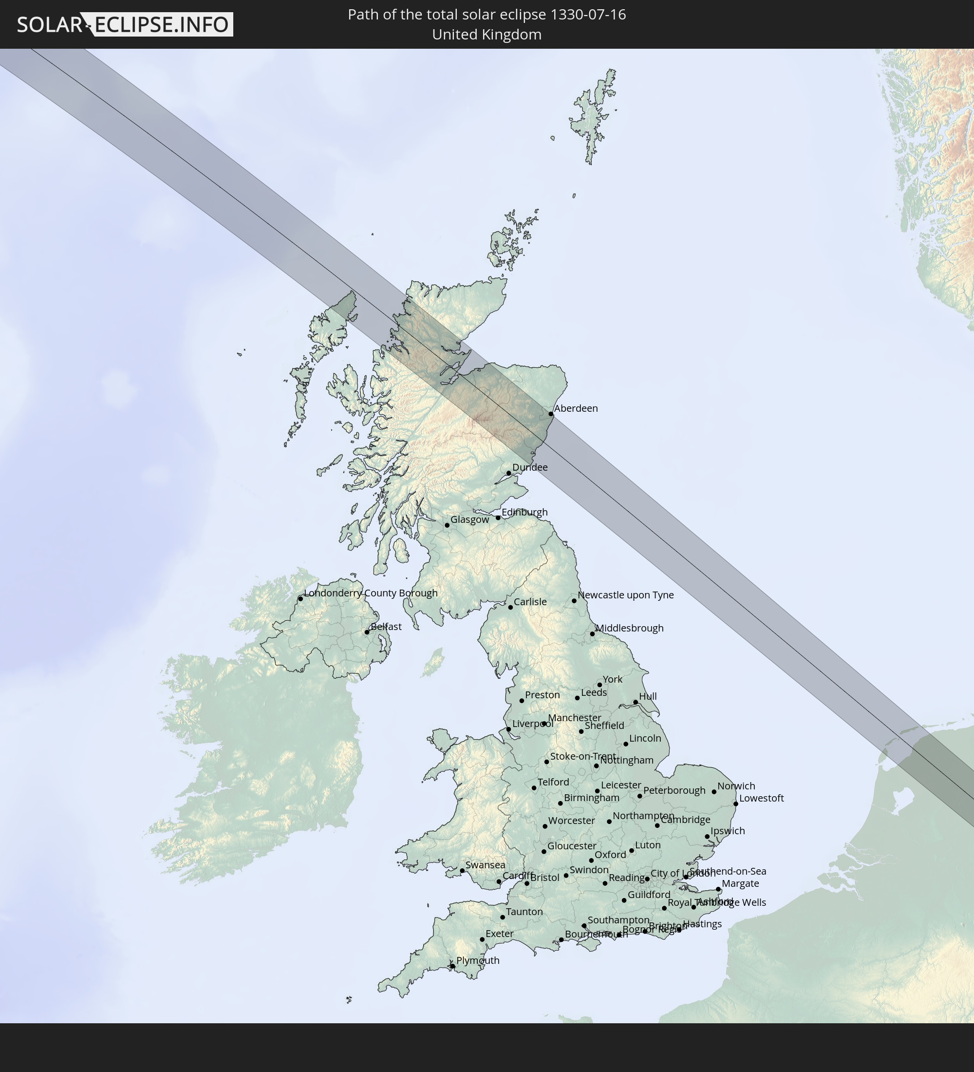
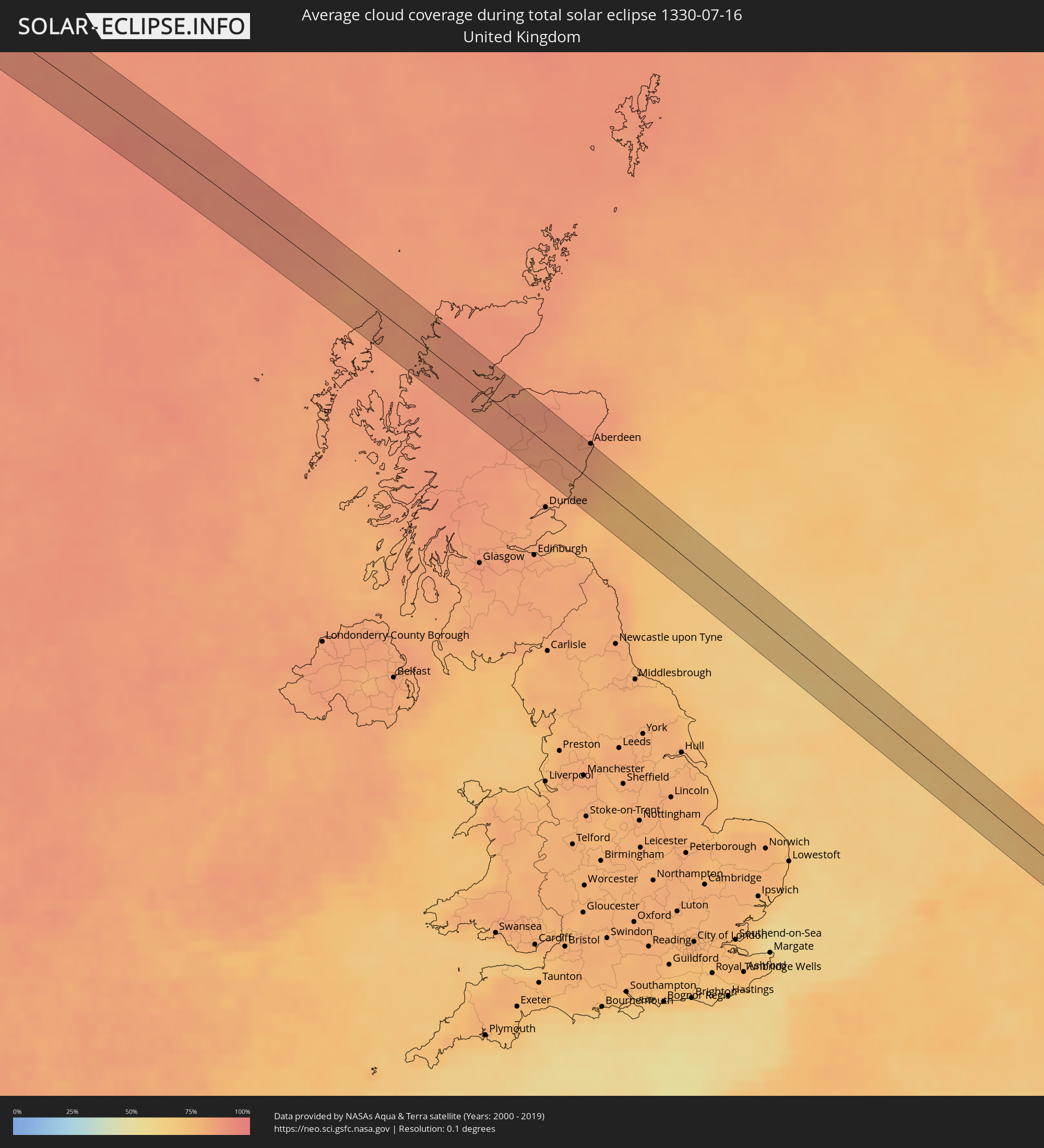 Vereinigtes Königreich
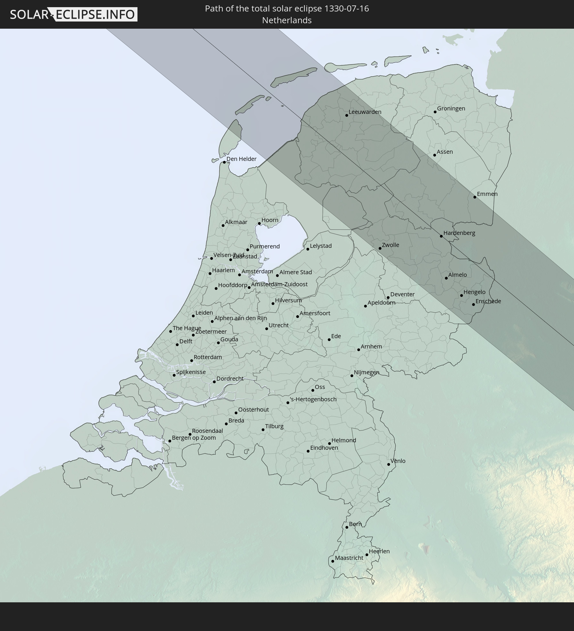
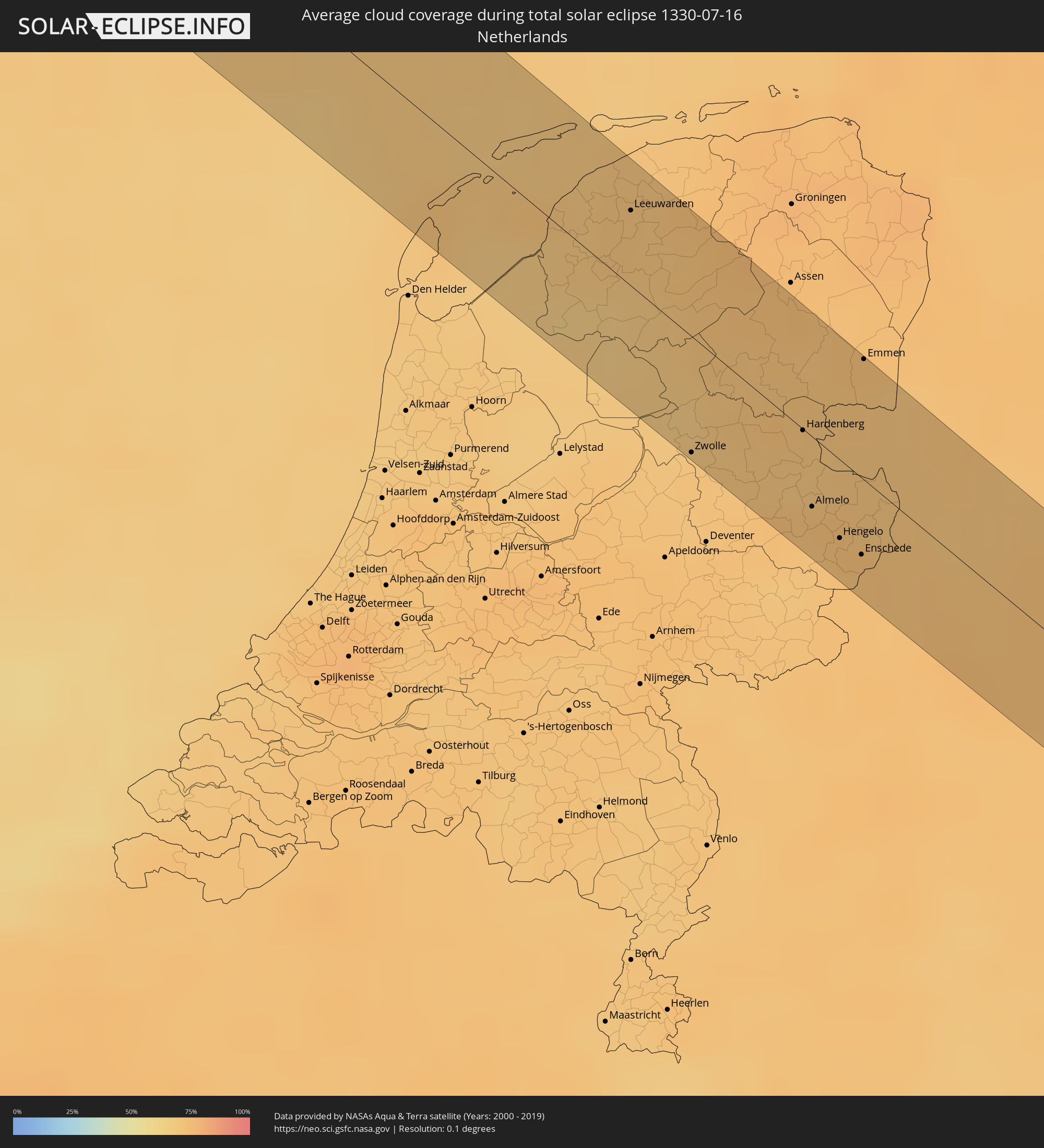 Niederlande
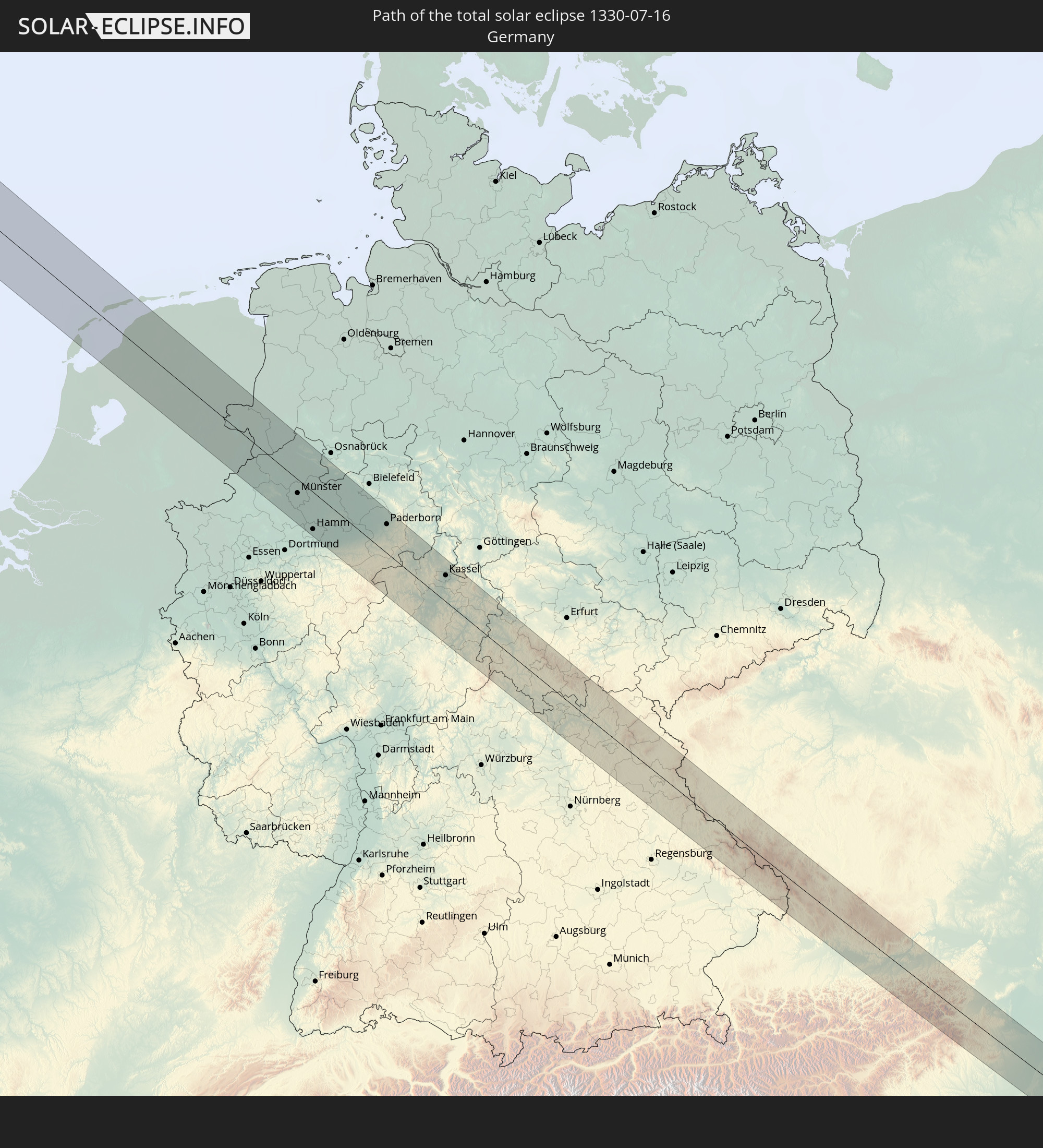
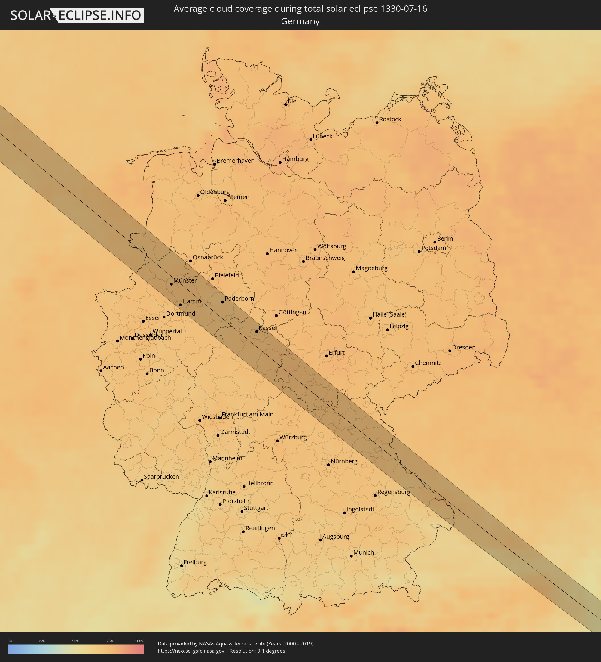 Deutschland
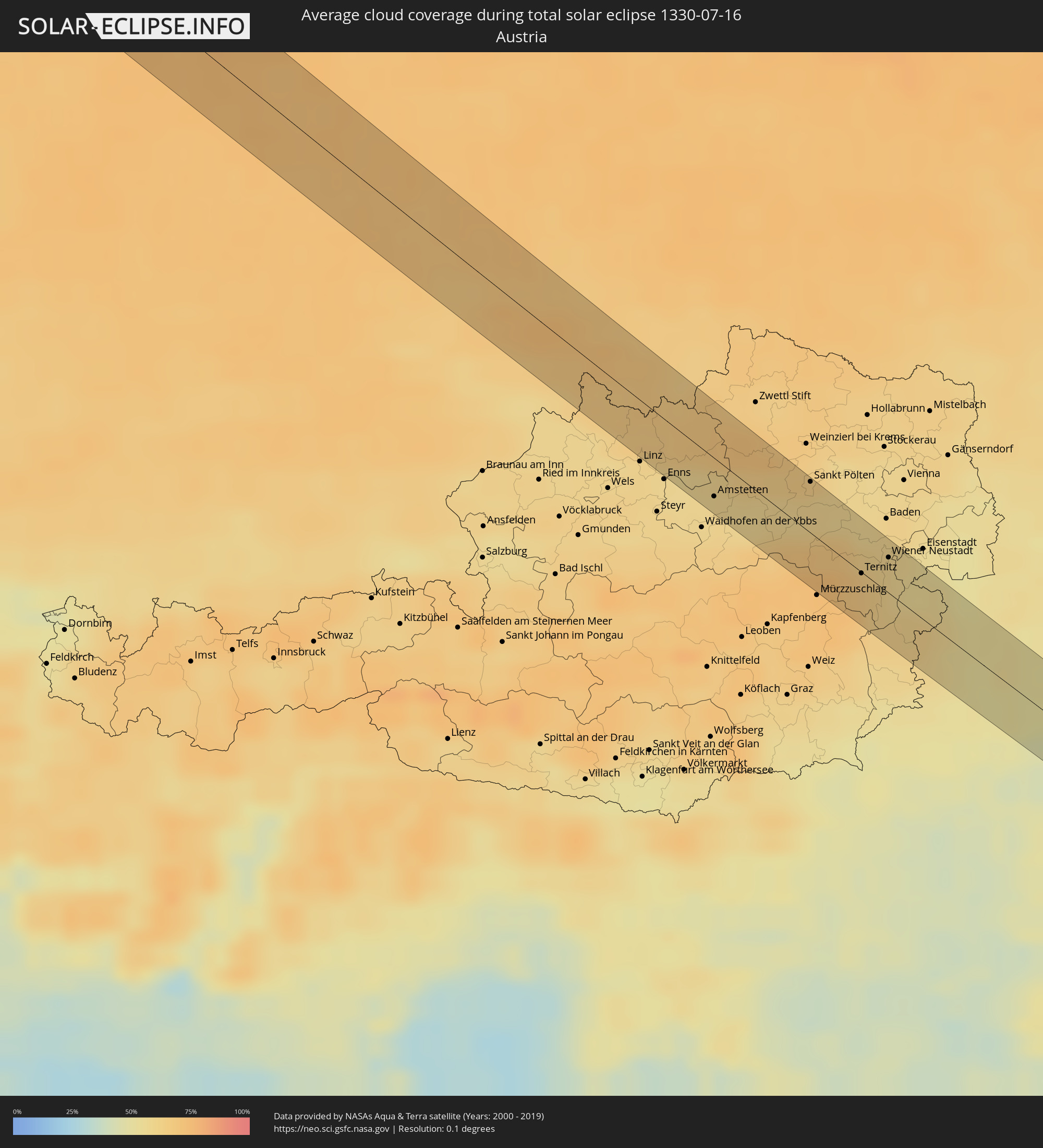 Österreich
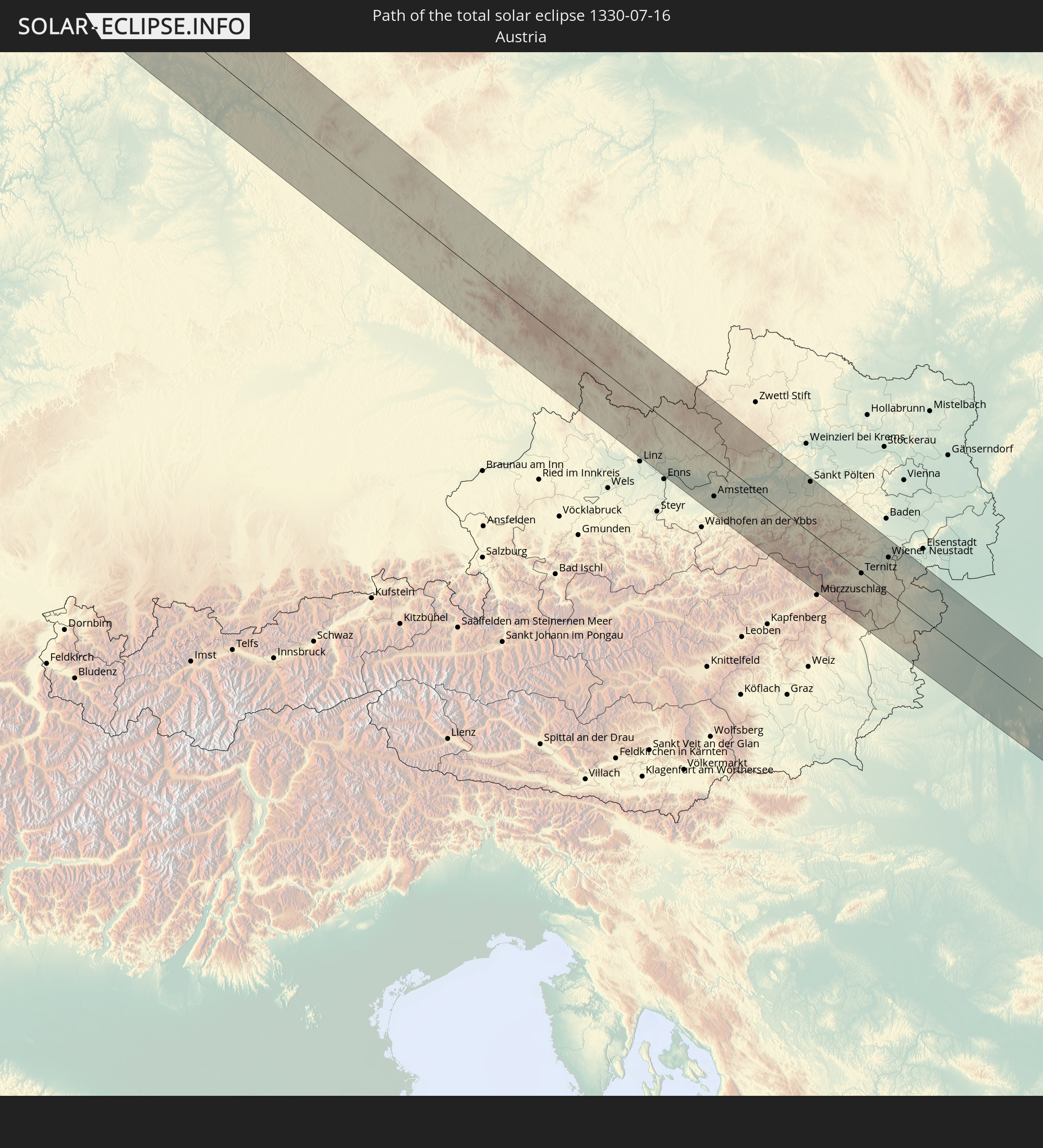
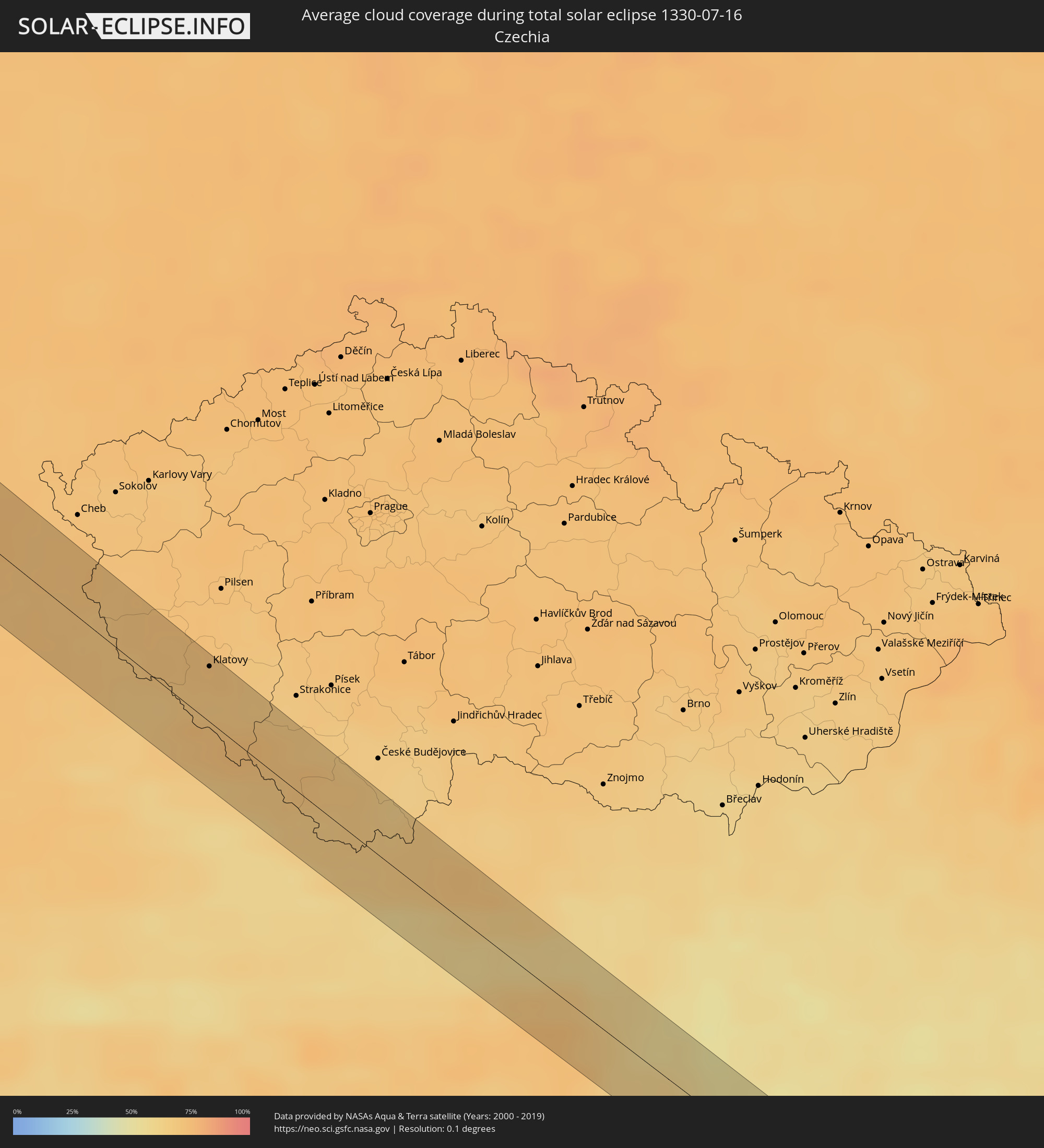 Tschechien
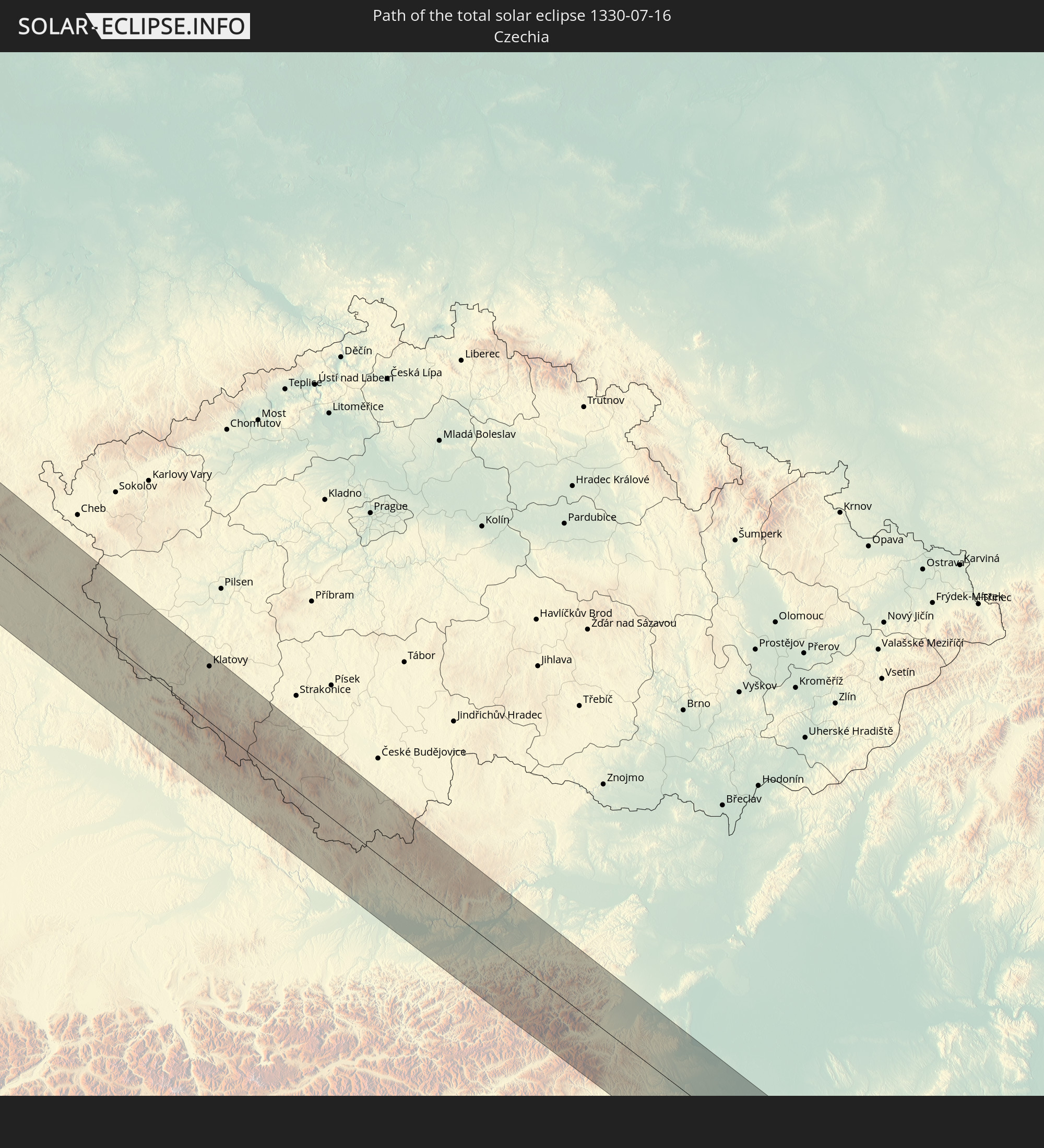
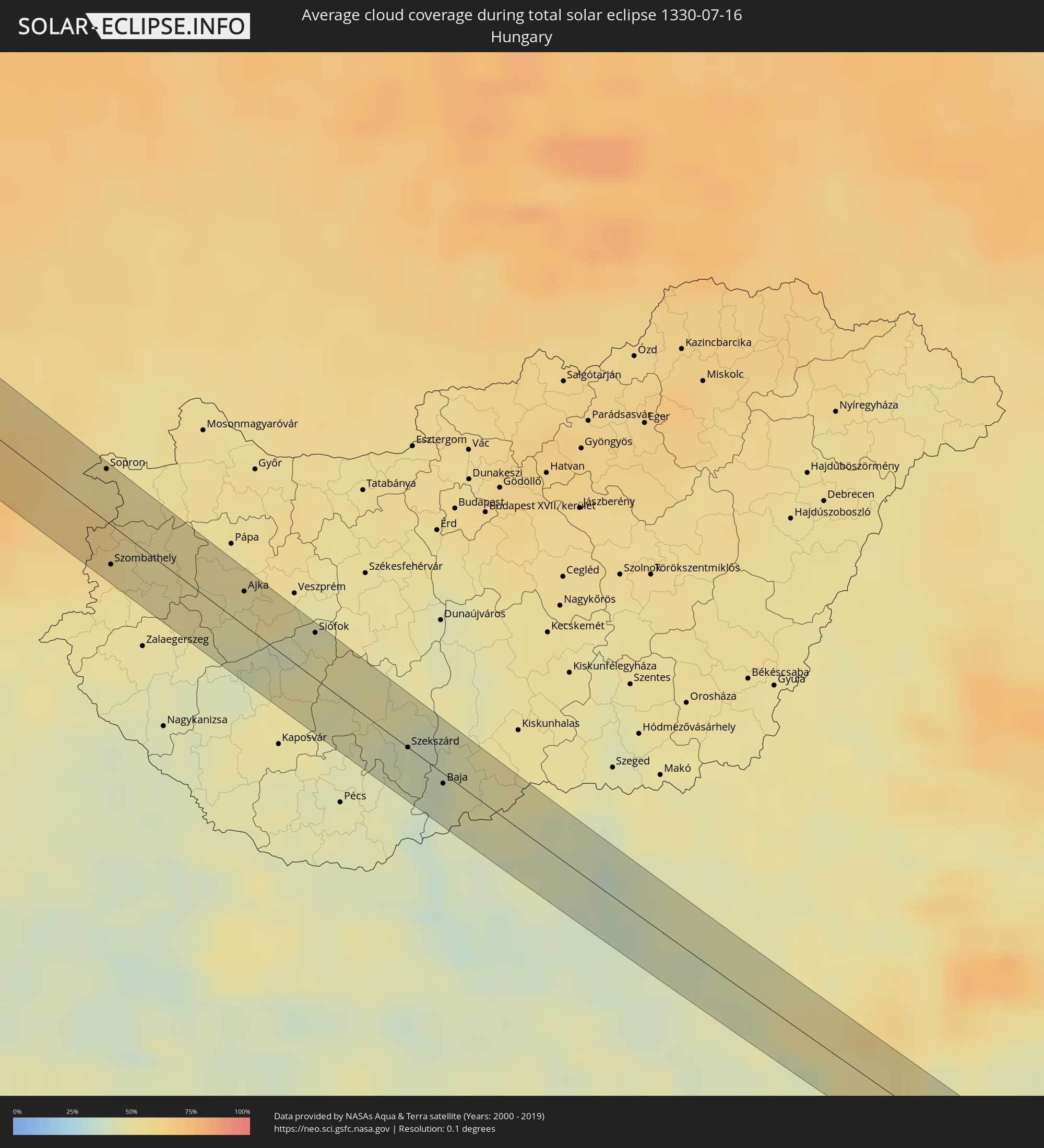 Ungarn
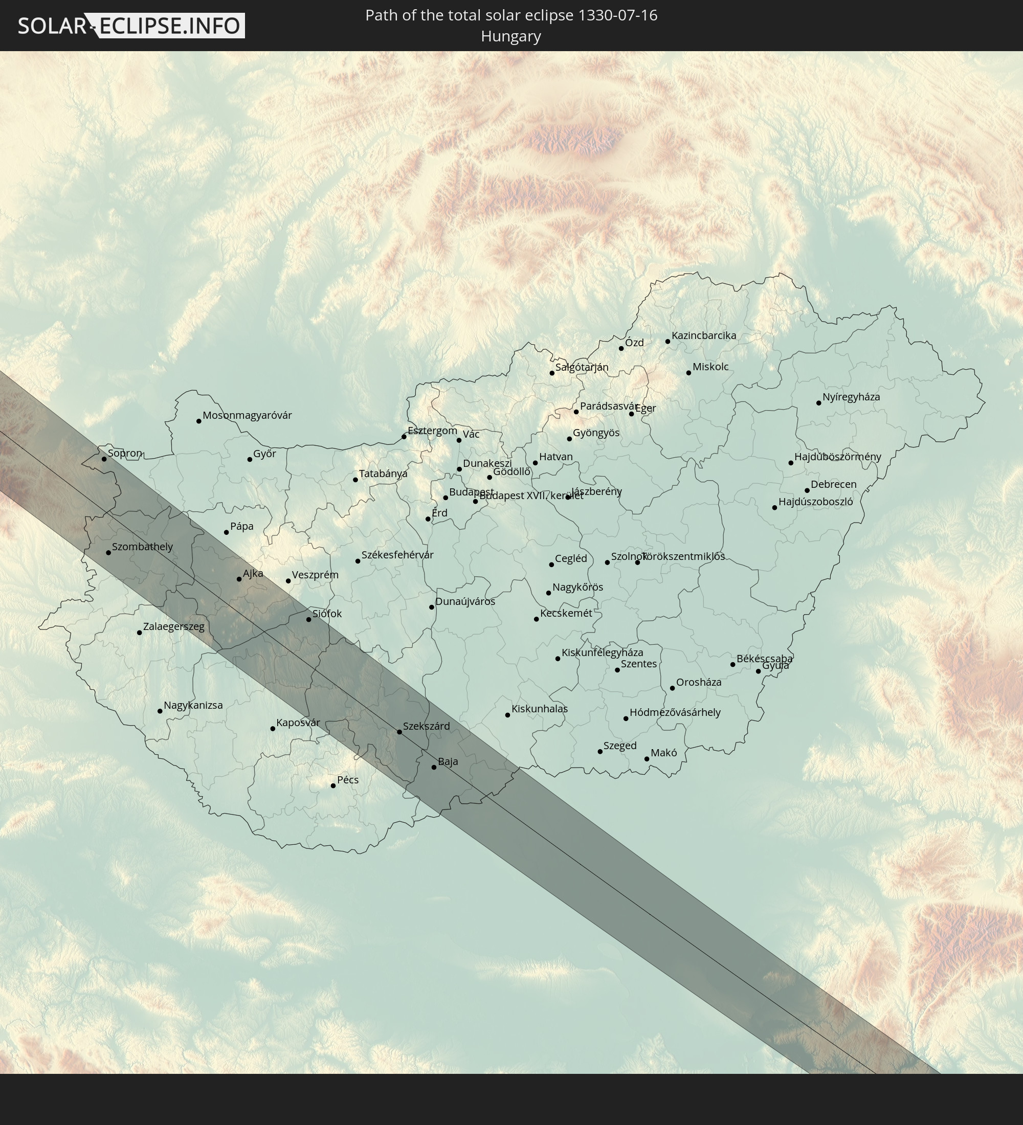
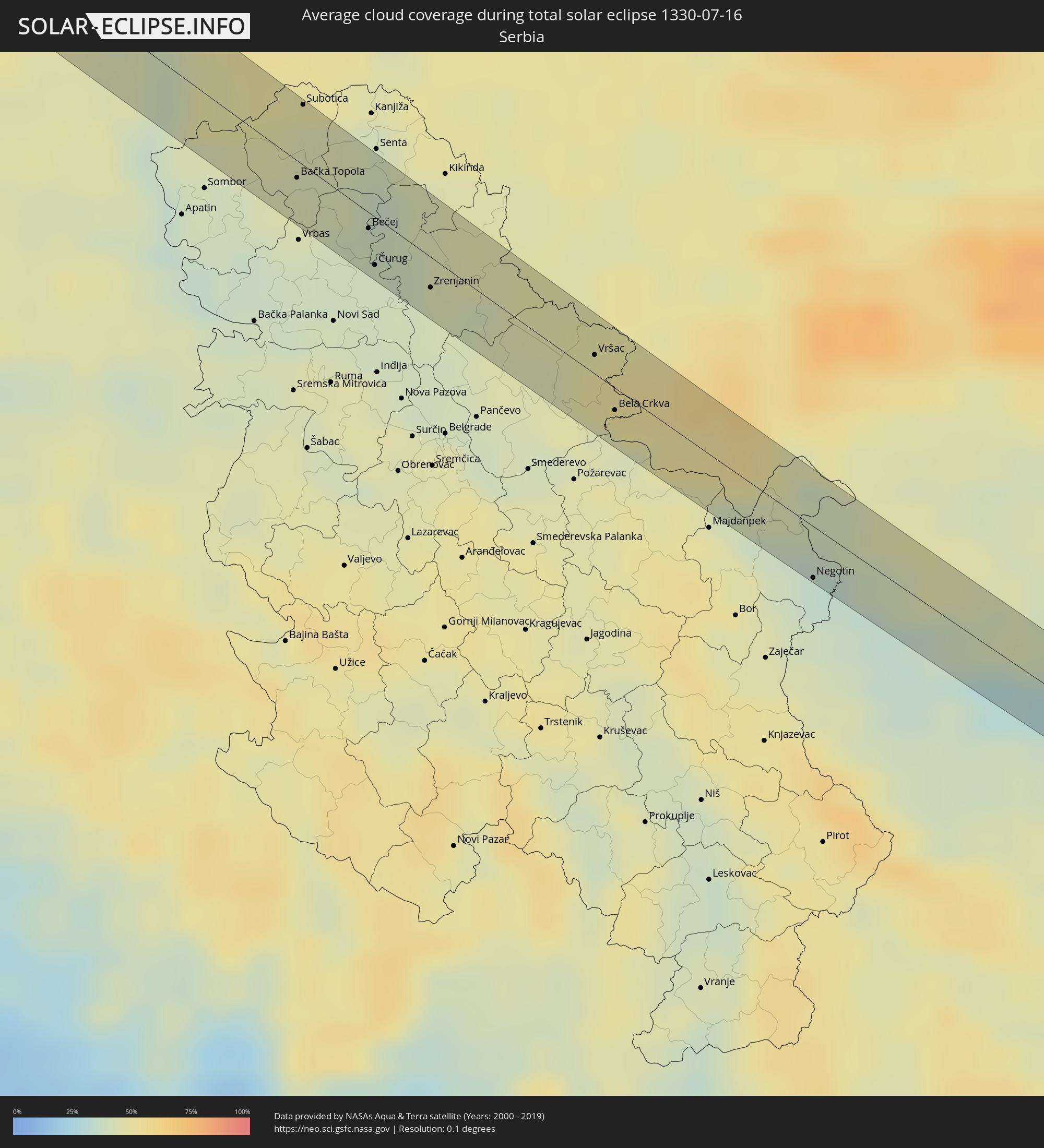 Serbien
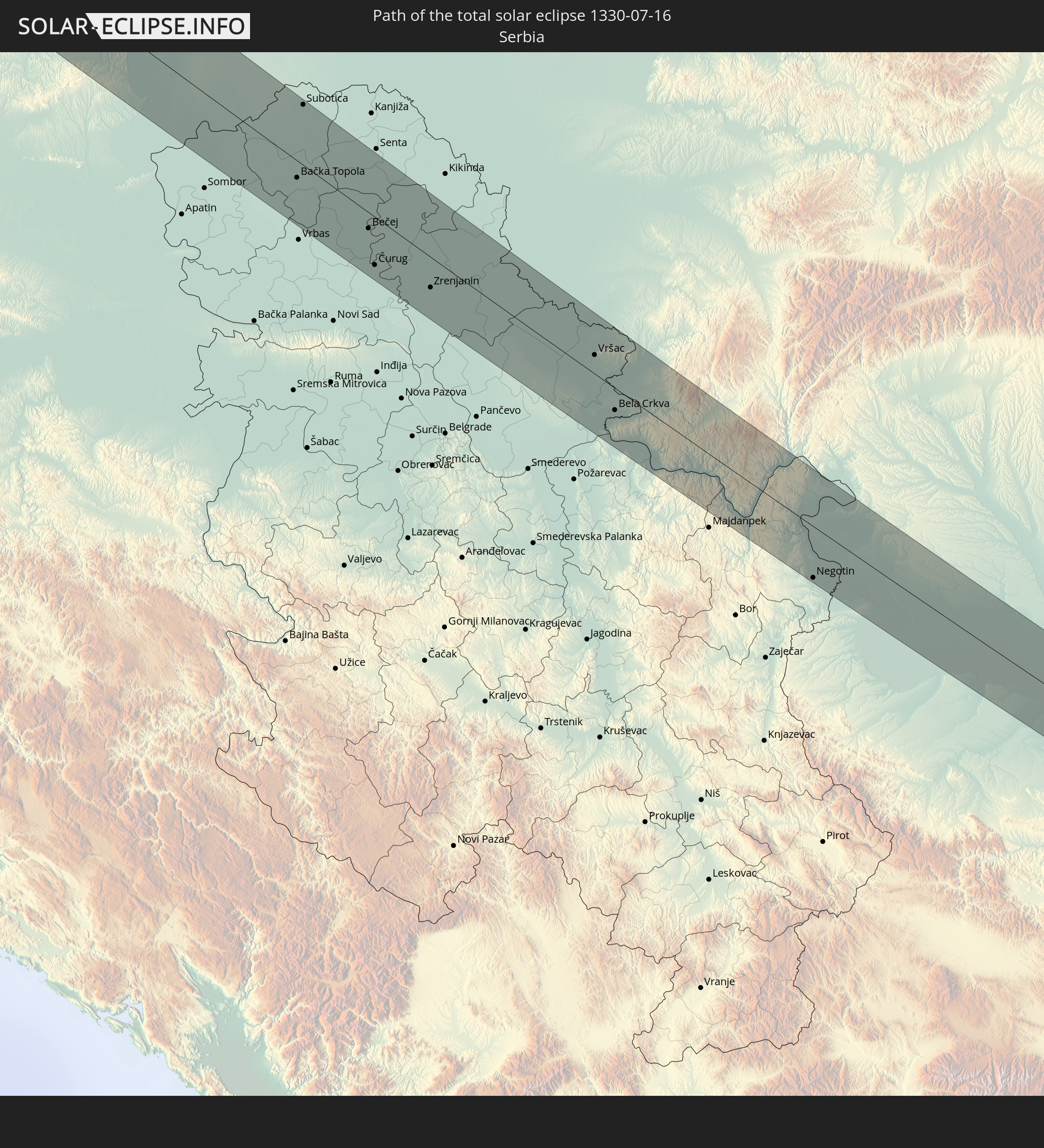
 Rumänien
 Bulgarien
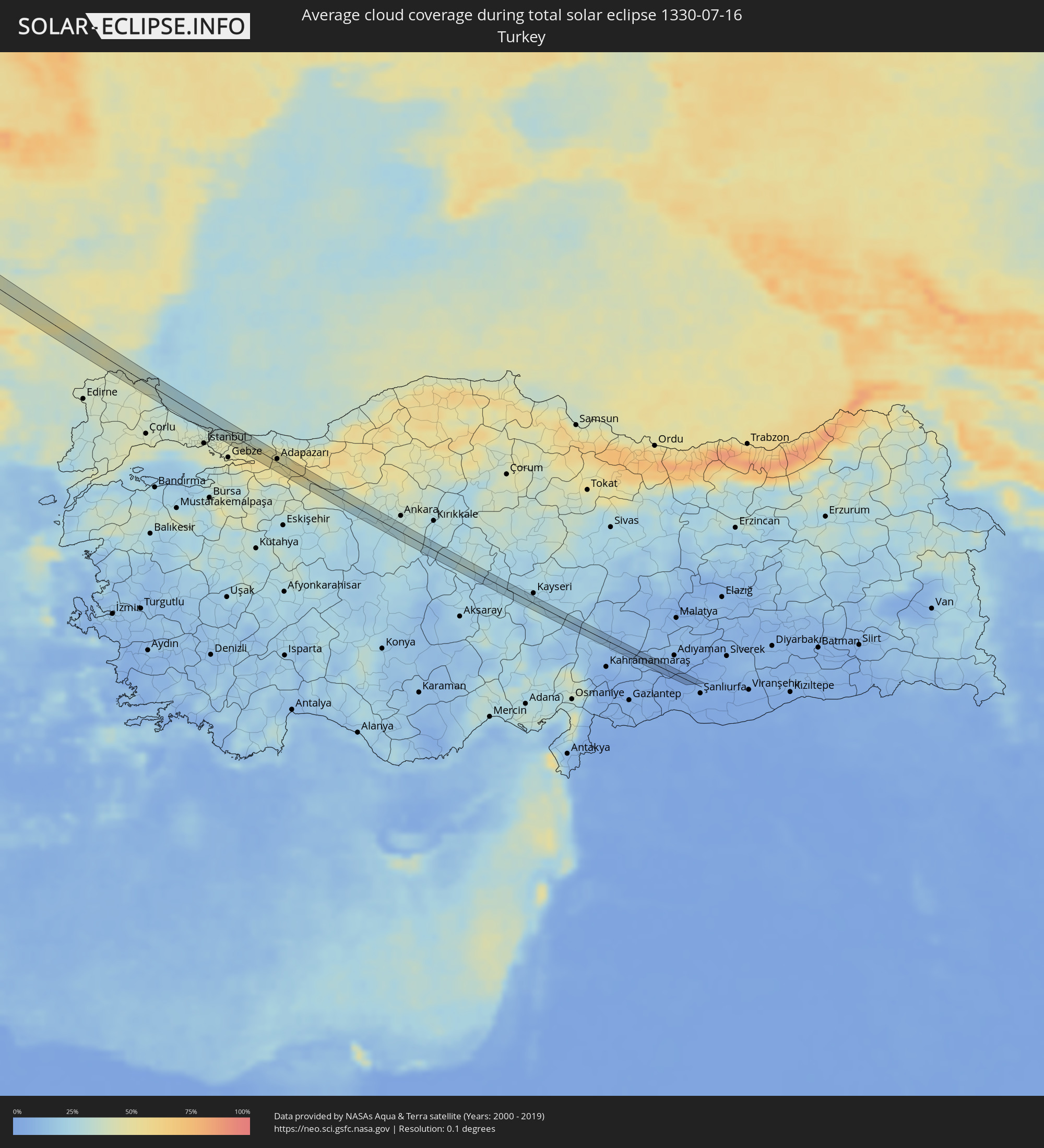 Türkei
Orte im Finsternispfad
Die nachfolgene Tabelle zeigt Städte und Orte mit mehr als 5.000 Einwohnern, die sich im Finsternispfad befinden. Städte mit mehr als 100.000 Einwohnern sind dick gekennzeichnet. Mit einem Klick auf den Ort öffnet sich eine Detailkarte die die Lage des jeweiligen Ortes zusammen mit dem Verlauf der zentralen Finsternis präsentiert.
| Ort | Typ | Dauer der Verfinsterung | Ortszeit bei maximaler Verfinsterung | Entfernung zur Zentrallinie | Ø Bewölkung |
|
Ketchikan, Alaska
|
total | - | 04:08:22 UTC-10:00 | 9 km | 80% |
|
Keflavík, Southern Peninsula
|
total | - | 14:05:50 UTC-01:28 | 10 km | 74% |
|
Hafnarfjörður, Capital Region
|
total | - | 14:06:16 UTC-01:28 | 31 km | 79% |
|
Garðabær, Capital Region
|
total | - | 14:06:15 UTC-01:28 | 34 km | 79% |
|
Isle of Lewis, Scotland
|
total | - | 15:55:16 UTC+00:00 | 33 km | 85% |
|
Stornoway, Scotland
|
total | - | 15:55:17 UTC+00:00 | 34 km | 85% |
|
Dingwall, Scotland
|
total | - | 15:57:37 UTC+00:00 | 24 km | 88% |
|
Inverness, Scotland
|
total | - | 15:57:57 UTC+00:00 | 18 km | 87% |
|
Nairn, Scotland
|
total | - | 15:57:58 UTC+00:00 | 7 km | 87% |
|
Forres, Scotland
|
total | - | 15:58:05 UTC+00:00 | 23 km | 89% |
|
Elgin, Scotland
|
total | - | 15:58:11 UTC+00:00 | 32 km | 89% |
|
Brechin, Scotland
|
total | - | 16:00:14 UTC+00:00 | 25 km | 83% |
|
Banchory, Scotland
|
total | - | 15:59:45 UTC+00:00 | 13 km | 85% |
|
Montrose, Scotland
|
total | - | 16:00:24 UTC+00:00 | 27 km | 81% |
|
Kemnay, Scotland
|
total | - | 15:59:26 UTC+00:00 | 33 km | 86% |
|
Westhill, Scotland
|
total | - | 15:59:41 UTC+00:00 | 27 km | 86% |
|
Stonehaven, Scotland
|
total | - | 16:00:04 UTC+00:00 | 18 km | 84% |
|
Portlethen, Scotland
|
total | - | 15:59:57 UTC+00:00 | 26 km | 84% |
|
Harlingen, Friesland
|
total | - | 16:30:14 UTC+00:19 | 6 km | 68% |
|
Sneek, Friesland
|
total | - | 16:30:35 UTC+00:19 | 16 km | 66% |
|
Emmeloord, Flevoland
|
total | - | 16:31:12 UTC+00:19 | 26 km | 68% |
|
Leeuwarden, Friesland
|
total | - | 16:30:20 UTC+00:19 | 22 km | 71% |
|
Camminghaburen, Friesland
|
total | - | 16:30:19 UTC+00:19 | 24 km | 71% |
|
Heerenveen, Friesland
|
total | - | 16:30:49 UTC+00:19 | 9 km | 68% |
|
Burgum, Friesland
|
total | - | 16:30:25 UTC+00:19 | 33 km | 70% |
|
Zwolle, Overijssel
|
total | - | 16:31:42 UTC+00:19 | 31 km | 70% |
|
Drachten, Friesland
|
total | - | 16:30:36 UTC+00:19 | 25 km | 72% |
|
Meppel, Drenthe
|
total | - | 16:31:24 UTC+00:19 | 22 km | 69% |
|
Hoogeveen, Drenthe
|
total | - | 16:31:27 UTC+00:19 | 9 km | 73% |
|
Hardenberg, Overijssel
|
total | - | 16:31:46 UTC+00:19 | 11 km | 71% |
|
Vriezenveen, Overijssel
|
total | - | 16:32:05 UTC+00:19 | 26 km | 72% |
|
Almelo, Overijssel
|
total | - | 16:32:11 UTC+00:19 | 23 km | 72% |
|
Enschede, Overijssel
|
total | - | 16:32:32 UTC+00:19 | 20 km | 72% |
|
Emmen, Drenthe
|
total | - | 16:31:30 UTC+00:19 | 32 km | 72% |
|
Klazienaveen, Drenthe
|
total | - | 16:31:38 UTC+00:19 | 34 km | 71% |
|
Gronau, North Rhine-Westphalia
|
total | - | 17:13:03 UTC+01:00 | 20 km | 72% |
|
Nordhorn, Lower Saxony
|
total | - | 17:12:40 UTC+01:00 | 7 km | 71% |
|
Lingen, Lower Saxony
|
total | - | 17:12:35 UTC+01:00 | 26 km | 72% |
|
Rheine, North Rhine-Westphalia
|
total | - | 17:13:04 UTC+01:00 | 10 km | 71% |
|
Münster, North Rhine-Westphalia
|
total | - | 17:13:43 UTC+01:00 | 9 km | 73% |
|
Ibbenbüren, North Rhine-Westphalia
|
total | - | 17:13:10 UTC+01:00 | 22 km | 73% |
|
Hamm, North Rhine-Westphalia
|
total | - | 17:14:17 UTC+01:00 | 25 km | 72% |
|
Soest, North Rhine-Westphalia
|
total | - | 17:14:34 UTC+01:00 | 21 km | 71% |
|
Lippstadt, North Rhine-Westphalia
|
total | - | 17:14:28 UTC+01:00 | 2 km | 71% |
|
Gütersloh, North Rhine-Westphalia
|
total | - | 17:14:03 UTC+01:00 | 19 km | 70% |
|
Paderborn, North Rhine-Westphalia
|
total | - | 17:14:31 UTC+01:00 | 20 km | 71% |
|
Kassel, Hesse
|
total | - | 17:15:28 UTC+01:00 | 18 km | 73% |
|
Eisenach, Thuringia
|
total | - | 17:16:17 UTC+01:00 | 25 km | 74% |
|
Suhl, Thuringia
|
total | - | 17:17:03 UTC+01:00 | 10 km | 74% |
|
Coburg, Bavaria
|
total | - | 17:17:45 UTC+01:00 | 9 km | 74% |
|
Bayreuth, Bavaria
|
total | - | 17:18:27 UTC+01:00 | 15 km | 70% |
|
Weiden, Bavaria
|
total | - | 17:19:03 UTC+01:00 | 19 km | 70% |
|
Tachov, Plzeňský
|
total | - | 17:18:57 UTC+01:00 | 28 km | 70% |
|
Domažlice, Plzeňský
|
total | - | 17:19:38 UTC+01:00 | 17 km | 68% |
|
Nýrsko, Plzeňský
|
total | - | 17:19:56 UTC+01:00 | 10 km | 69% |
|
Klatovy, Plzeňský
|
total | - | 17:19:47 UTC+01:00 | 24 km | 70% |
|
Sušice, Plzeňský
|
total | - | 17:20:06 UTC+01:00 | 22 km | 70% |
|
Vimperk, Jihočeský
|
total | - | 17:20:27 UTC+01:00 | 21 km | 70% |
|
Prachatice, Jihočeský
|
total | - | 17:20:34 UTC+01:00 | 21 km | 72% |
|
Český Krumlov, Jihočeský
|
total | - | 17:20:58 UTC+01:00 | 17 km | 68% |
|
Gallneukirchen, Upper Austria
|
total | - | 17:21:47 UTC+01:00 | 19 km | 62% |
|
Engerwitzdorf, Upper Austria
|
total | - | 17:21:48 UTC+01:00 | 20 km | 59% |
|
Kaplice, Jihočeský
|
total | - | 17:21:08 UTC+01:00 | 25 km | 66% |
|
Freistadt, Upper Austria
|
total | - | 17:21:31 UTC+01:00 | 1 km | 66% |
|
Perg, Upper Austria
|
total | - | 17:22:00 UTC+01:00 | 27 km | 57% |
|
Amstetten, Lower Austria
|
total | - | 17:22:15 UTC+01:00 | 18 km | 59% |
|
Ybbs an der Donau, Lower Austria
|
total | - | 17:22:12 UTC+01:00 | 12 km | 60% |
|
Purgstall, Lower Austria
|
total | - | 17:22:24 UTC+01:00 | 24 km | 57% |
|
Melk, Lower Austria
|
total | - | 17:22:08 UTC+01:00 | 25 km | 59% |
|
Wilhelmsburg, Lower Austria
|
total | - | 17:22:22 UTC+01:00 | 14 km | 60% |
|
Sankt Pölten, Lower Austria
|
total | - | 17:22:13 UTC+01:00 | 24 km | 61% |
|
Gloggnitz, Lower Austria
|
total | - | 17:23:09 UTC+01:00 | 9 km | 69% |
|
Ternitz, Lower Austria
|
total | - | 17:23:05 UTC+01:00 | 4 km | 66% |
|
Neunkirchen, Lower Austria
|
total | - | 17:23:05 UTC+01:00 | 6 km | 64% |
|
Berndorf, Lower Austria
|
total | - | 17:22:42 UTC+01:00 | 24 km | 61% |
|
Wiener Neustadt, Lower Austria
|
total | - | 17:22:58 UTC+01:00 | 20 km | 58% |
|
Mattersburg, Burgenland
|
total | - | 17:23:06 UTC+01:00 | 29 km | 55% |
|
Kőszeg, Vas
|
total | - | 17:23:42 UTC+01:00 | 11 km | 61% |
|
Sopron, Győr-Moson-Sopron
|
total | - | 17:23:12 UTC+01:00 | 24 km | 56% |
|
Szombathely, Vas
|
total | - | 17:23:58 UTC+01:00 | 29 km | 55% |
|
Sárvár, Vas
|
total | - | 17:23:57 UTC+01:00 | 6 km | 51% |
|
Zalaszentgrót, Zala
|
total | - | 17:24:29 UTC+01:00 | 32 km | 47% |
|
Celldömölk, Vas
|
total | - | 17:23:58 UTC+01:00 | 12 km | 54% |
|
Tapolca, Veszprém
|
total | - | 17:24:37 UTC+01:00 | 11 km | 45% |
|
Ajka, Veszprém
|
total | - | 17:24:15 UTC+01:00 | 16 km | 50% |
|
Balatonfüred, Veszprém
|
total | - | 17:24:31 UTC+01:00 | 28 km | 45% |
|
Siófok, Somogy
|
total | - | 17:24:37 UTC+01:00 | 22 km | 49% |
|
Dombóvár, Tolna
|
total | - | 17:25:30 UTC+01:00 | 24 km | 46% |
|
Tamási, Tolna
|
total | - | 17:25:05 UTC+01:00 | 23 km | 48% |
|
Bonyhád, Tolna
|
total | - | 17:25:39 UTC+01:00 | 13 km | 43% |
|
Szekszárd, Tolna
|
total | - | 17:25:34 UTC+01:00 | 0 km | 43% |
|
Tolna, Tolna
|
total | - | 17:25:27 UTC+01:00 | 10 km | 41% |
|
Baja, Bács-Kiskun
|
total | - | 17:25:52 UTC+01:00 | 4 km | 43% |
|
Stanišić
|
total | - | 17:26:16 UTC+01:00 | 26 km | 39% |
|
Bácsalmás, Bács-Kiskun
|
total | - | 17:25:57 UTC+01:00 | 24 km | 49% |
|
Bačka Topola, Vojvodina
|
total | - | 17:26:28 UTC+01:00 | 18 km | 44% |
|
Subotica, Vojvodina
|
total | - | 17:26:00 UTC+01:00 | 21 km | 43% |
|
Bačko Gradište
|
total | - | 17:26:56 UTC+01:00 | 18 km | 38% |
|
Bečej, Vojvodina
|
total | - | 17:26:48 UTC+01:00 | 9 km | 40% |
|
Čurug
|
total | - | 17:27:02 UTC+01:00 | 25 km | 38% |
|
Bačko Petrovo Selo
|
total | - | 17:26:39 UTC+01:00 | 6 km | 38% |
|
Mol
|
total | - | 17:26:33 UTC+01:00 | 13 km | 36% |
|
Novo Miloševo
|
total | - | 17:26:37 UTC+01:00 | 24 km | 43% |
|
Melenci
|
total | - | 17:26:57 UTC+01:00 | 16 km | 40% |
|
Zrenjanin, Vojvodina
|
total | - | 17:27:10 UTC+01:00 | 11 km | 42% |
|
Ečka
|
total | - | 17:27:16 UTC+01:00 | 14 km | 41% |
|
Padina
|
total | - | 17:27:35 UTC+01:00 | 23 km | 43% |
|
Banatski Karlovac
|
total | - | 17:27:42 UTC+01:00 | 16 km | 45% |
|
Vršac, Vojvodina
|
total | - | 17:27:34 UTC+01:00 | 25 km | 50% |
|
Bela Crkva, Vojvodina
|
total | - | 17:27:55 UTC+01:00 | 8 km | 45% |
|
Moldova Nouă, Caraş-Severin
|
total | - | 18:12:34 UTC+01:44 | 26 km | 44% |
|
Oraviţa, Caraş-Severin
|
total | - | 18:12:06 UTC+01:44 | 18 km | 53% |
|
Orşova, Mehedinţi
|
total | - | 18:12:33 UTC+01:44 | 21 km | 44% |
|
Negotin, Central Serbia
|
total | - | 17:28:55 UTC+01:00 | 25 km | 36% |
|
Gogoşu, Mehedinţi
|
total | - | 18:13:05 UTC+01:44 | 11 km | 37% |
|
Gârla-Mare, Mehedinţi
|
total | - | 18:13:20 UTC+01:44 | 18 km | 34% |
|
Vânju-Mare, Mehedinţi
|
total | - | 18:12:59 UTC+01:44 | 27 km | 41% |
|
Cetate, Dolj
|
total | - | 18:13:29 UTC+01:44 | 12 km | 35% |
|
Maglavit, Dolj
|
total | - | 18:13:35 UTC+01:44 | 20 km | 33% |
|
Pleniţa, Dolj
|
total | - | 18:13:17 UTC+01:44 | 15 km | 41% |
|
Moţăţei, Dolj
|
total | - | 18:13:29 UTC+01:44 | 21 km | 36% |
|
Băileşti, Dolj
|
total | - | 18:13:35 UTC+01:44 | 1 km | 36% |
|
Kozloduy, Vratsa
|
total | - | 18:29:30 UTC+02:00 | 6 km | 32% |
|
Valea Stanciului, Dolj
|
total | - | 18:13:35 UTC+01:44 | 19 km | 37% |
|
Ostroveni, Dolj
|
total | - | 18:13:52 UTC+01:44 | 3 km | 30% |
|
Sadova, Dolj
|
total | - | 18:13:42 UTC+01:44 | 15 km | 33% |
|
Oryahovo, Vratsa
|
total | - | 18:29:33 UTC+02:00 | 1 km | 34% |
|
Călăraşi, Dolj
|
total | - | 18:13:51 UTC+01:44 | 10 km | 32% |
|
Dăbuleni, Dolj
|
total | - | 18:13:50 UTC+01:44 | 12 km | 32% |
|
Knezha, Pleven
|
total | - | 18:29:54 UTC+02:00 | 16 km | 39% |
|
Pleven, Pleven
|
total | - | 18:29:58 UTC+02:00 | 0 km | 44% |
|
Sevlievo, Gabrovo
|
total | - | 18:30:30 UTC+02:00 | 25 km | 45% |
|
Levski, Pleven
|
total | - | 18:29:59 UTC+02:00 | 18 km | 42% |
|
Pavlikeni, Veliko Tŭrnovo
|
total | - | 18:30:08 UTC+02:00 | 26 km | 43% |
|
Gabrovo, Gabrovo
|
total | - | 18:30:42 UTC+02:00 | 19 km | 48% |
|
Dryanovo, Gabrovo
|
total | - | 18:30:31 UTC+02:00 | 2 km | 46% |
|
Tryavna, Gabrovo
|
total | - | 18:30:41 UTC+02:00 | 14 km | 50% |
|
Veliko Tŭrnovo, Veliko Tŭrnovo
|
total | - | 18:30:20 UTC+02:00 | 14 km | 44% |
|
Elena, Veliko Tŭrnovo
|
total | - | 18:30:31 UTC+02:00 | 11 km | 50% |
|
Tvarditsa, Sliven
|
total | - | 18:30:52 UTC+02:00 | 10 km | 42% |
|
Sliven, Sliven
|
total | - | 18:30:49 UTC+02:00 | 23 km | 39% |
|
Yambol, Yambol
|
total | - | 18:31:06 UTC+02:00 | 4 km | 39% |
|
Straldzha, Yambol
|
total | - | 18:30:53 UTC+02:00 | 17 km | 40% |
|
Sredets, Burgas
|
total | - | 18:31:10 UTC+02:00 | 16 km | 39% |
|
Şile, Istanbul
|
total | - | 18:29:16 UTC+01:56 | 10 km | 40% |
|
Sapanca, Sakarya
|
total | - | 18:29:46 UTC+01:56 | 20 km | 49% |
|
Adapazarı, Sakarya
|
total | - | 18:29:37 UTC+01:56 | 13 km | 51% |
|
Akyazı, Sakarya
|
total | - | 18:29:41 UTC+01:56 | 10 km | 51% |
|
Mudurnu, Bolu
|
total | - | 18:29:49 UTC+01:56 | 18 km | 41% |
|
Nallıhan, Ankara
|
total | - | 18:30:10 UTC+01:56 | 15 km | 31% |
|
Beypazarı, Ankara
|
total | - | 18:30:01 UTC+01:56 | 16 km | 29% |
|
Ayaş, Ankara
|
total | - | 18:30:05 UTC+01:56 | 12 km | 28% |
|
Kaman, Kırşehir
|
total | - | 18:30:31 UTC+01:56 | 20 km | 24% |
|
Kırşehir, Kırşehir
|
total | - | 18:30:38 UTC+01:56 | 15 km | 22% |
|
Mucur, Kırşehir
|
total | - | 18:30:40 UTC+01:56 | 13 km | 19% |
|
Hacıbektaş, Nevşehir
|
total | - | 18:30:46 UTC+01:56 | 7 km | 22% |
|
Hacılar, Kayseri
|
total | - | 18:30:48 UTC+01:56 | 9 km | 27% |
|
Tomarza, Kayseri
|
total | - | 18:30:55 UTC+01:56 | 19 km | 23% |
|
Gölbaşı, Adıyaman
|
total | - | 18:31:00 UTC+01:56 | 12 km | 7% |
|
Besni, Adıyaman
|
total | - | 18:31:00 UTC+01:56 | 6 km | 5% |
|
Bozova, Şanlıurfa
|
total | - | 18:31:07 UTC+01:56 | 2 km | 2% |