Totale Sonnenfinsternis vom 30.11.1331
| Wochentag: | Freitag |
| Maximale Dauer der Verfinsterung: | 03m09s |
| Maximale Breite des Finsternispfades: | 265 km |
| Saroszyklus: | 102 |
| Bedeckungsgrad: | 100% |
| Magnitude: | 1.038 |
| Gamma: | 0.8766 |
Wo kann man die Sonnenfinsternis vom 30.11.1331 sehen?
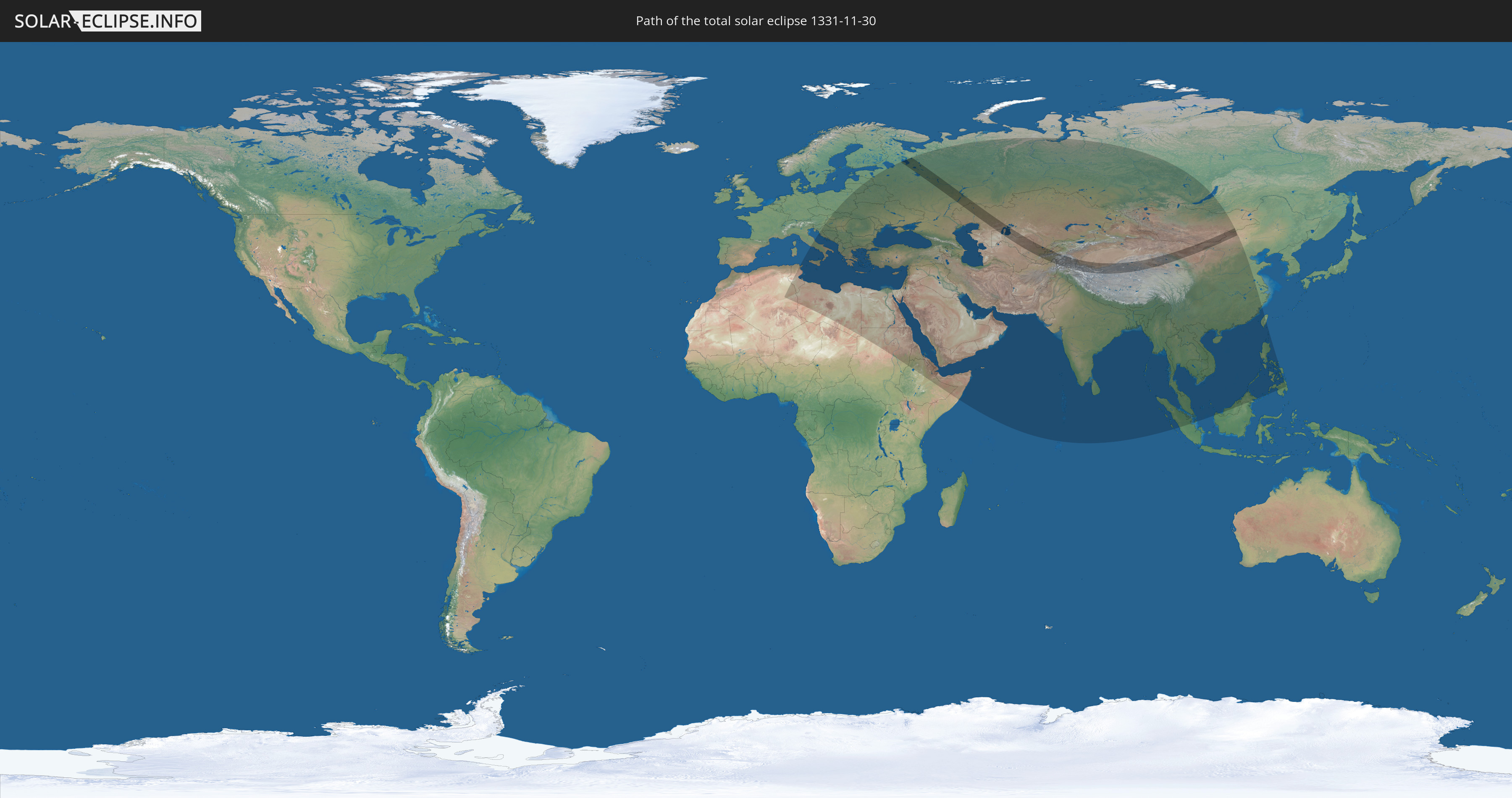
Die Sonnenfinsternis am 30.11.1331 kann man in 78 Ländern als partielle Sonnenfinsternis beobachten.
Der Finsternispfad verläuft durch 10 Länder. Nur in diesen Ländern ist sie als totale Sonnenfinsternis zu sehen.
In den folgenden Ländern ist die Sonnenfinsternis total zu sehen
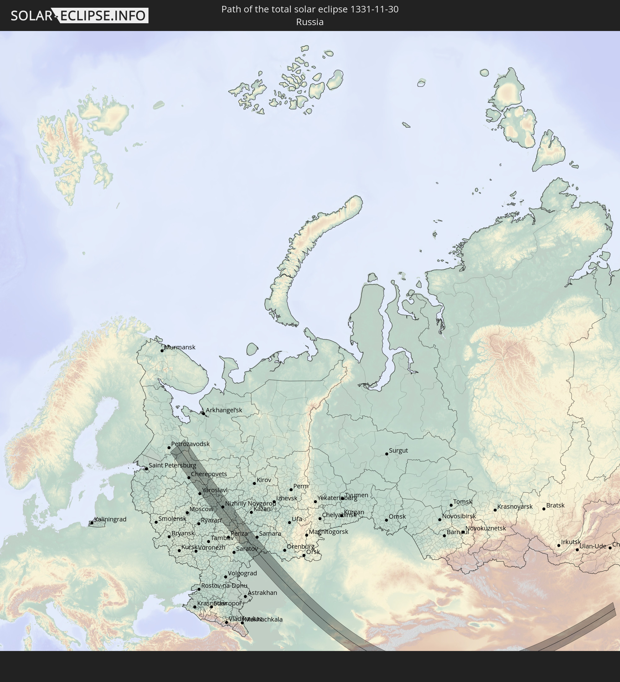 Russland
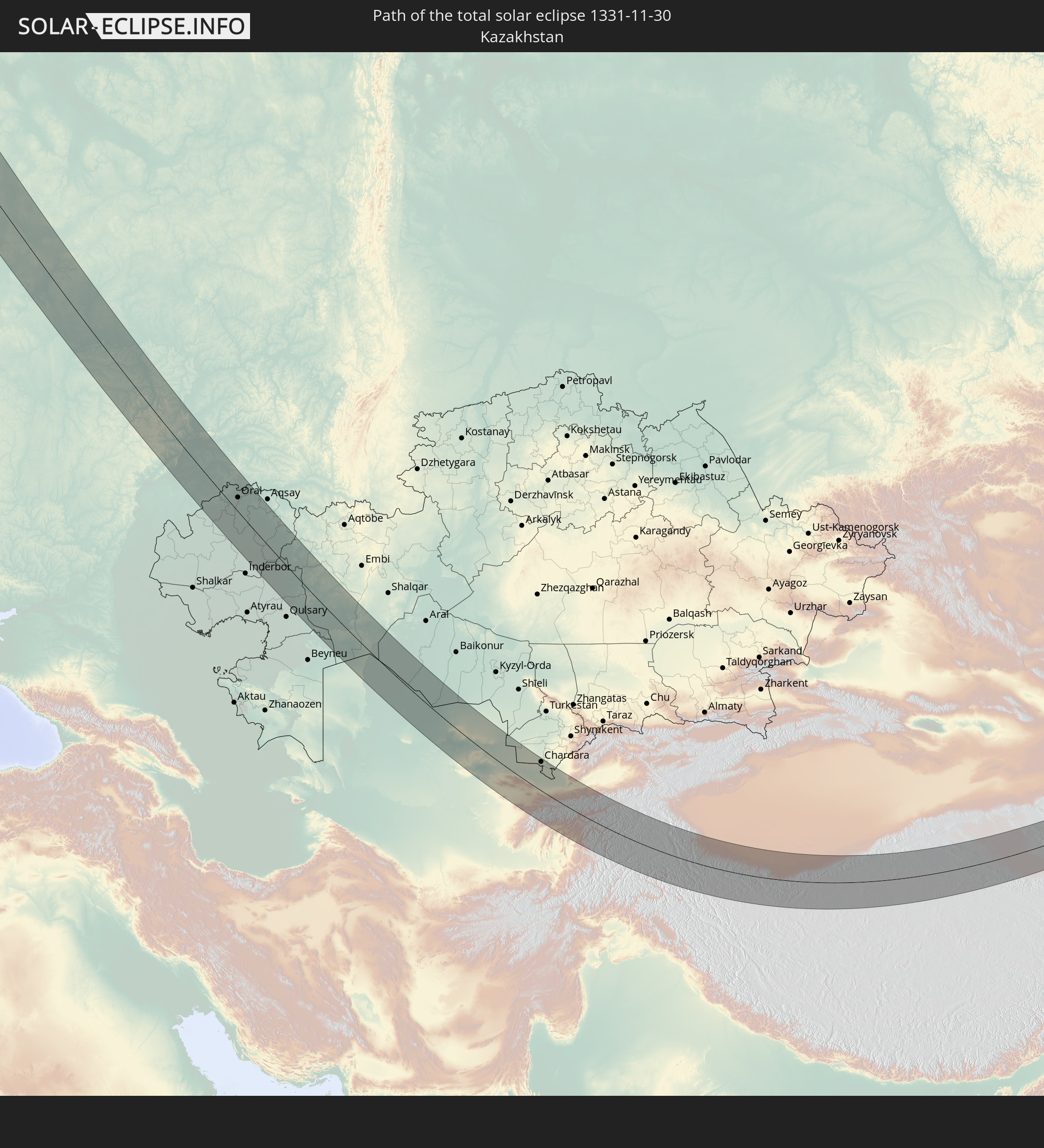 Kasachstan
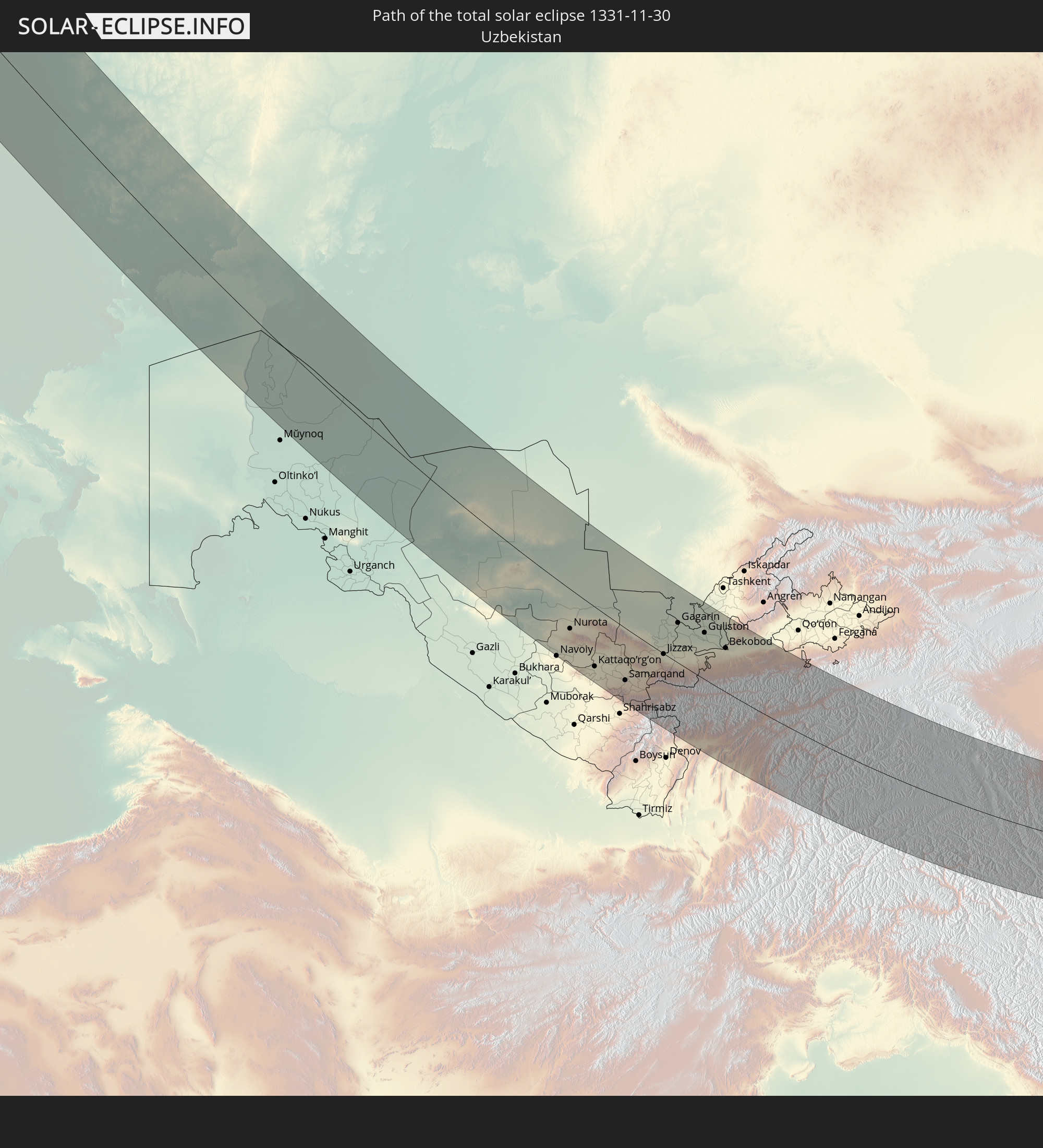 Usbekistan
 Afghanistan
 Pakistan
 Tadschikistan
 Indien
 Kirgisistan
 Volksrepublik China
 Mongolei
In den folgenden Ländern ist die Sonnenfinsternis partiell zu sehen
 Russland
 Algerien
 Italien
 Tunesien
 Libyen
 Tschechien
 Slowenien
 Kroatien
 Polen
Polen
 Malta
Malta
 Bosnien und Herzegowina
 Ungarn
 Slowakei
 Montenegro
 Serbien
 Albanien
 Griechenland
 Rumänien
 Mazedonien
 Litauen
 Lettland
 Sudan
Sudan
 Ukraine
 Bulgarien
 Weißrussland
 Ägypten
 Türkei
 Moldawien
 Republik Zypern
 Äthiopien
 Staat Palästina
 Israel
 Saudi-Arabien
 Jordanien
 Libanon
 Syrien
 Eritrea
 Irak
Irak
 Georgien
 Somalia
 Dschibuti
 Jemen
Jemen
 Armenien
 Iran
Iran
 Aserbaidschan
 Kasachstan
 Kuwait
 Bahrain
 Katar
Katar
 Vereinigte Arabische Emirate
 Oman
Oman
 Turkmenistan
 Usbekistan
 Afghanistan
 Pakistan
 Tadschikistan
 Indien
 Kirgisistan
 Malediven
 Volksrepublik China
 Sri Lanka
 Nepal
Nepal
 Mongolei
 Bangladesch
 Bhutan
 Myanmar
 Indonesien
 Thailand
 Malaysia
 Laos
Laos
 Vietnam
 Kambodscha
 Singapur
 Macau
Macau
 Hongkong
 Brunei
 Taiwan
 Philippinen
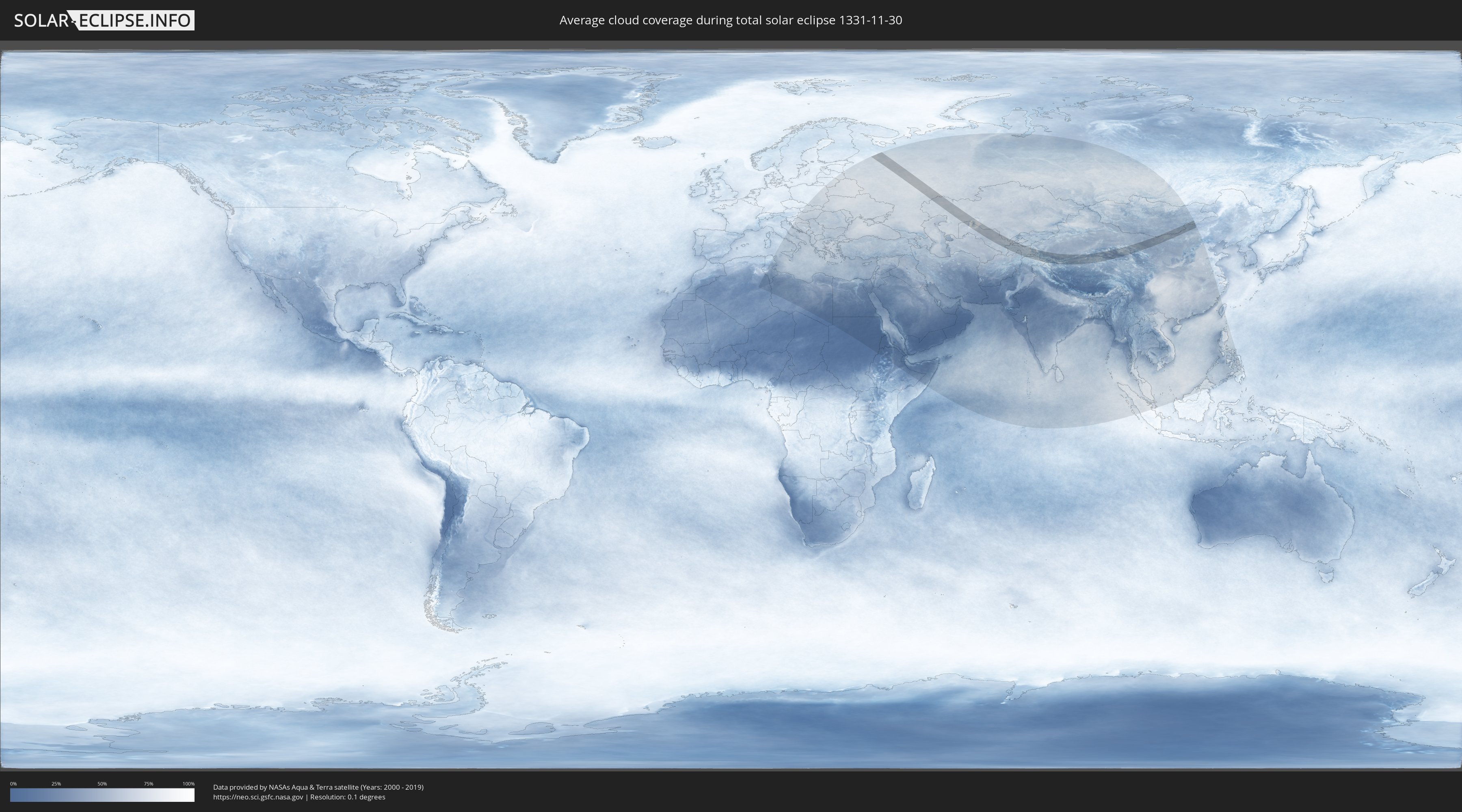
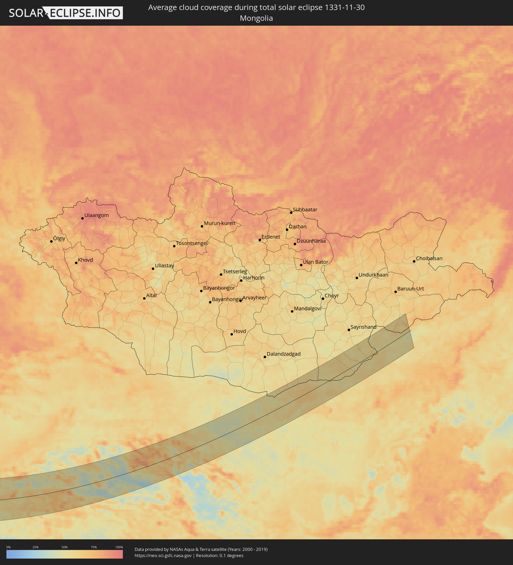
Wie wird das Wetter während der totalen Sonnenfinsternis am 30.11.1331?
Wo ist der beste Ort, um die totale Sonnenfinsternis vom 30.11.1331 zu beobachten?
Die folgenden Karten zeigen die durchschnittliche Bewölkung für den Tag, an dem die totale Sonnenfinsternis
stattfindet. Mit Hilfe der Karten lässt sich der Ort entlang des Finsternispfades eingrenzen,
der die besten Aussichen auf einen klaren wolkenfreien Himmel bietet.
Trotzdem muss man immer lokale Gegenenheiten beachten und sollte sich genau über das Wetter an seinem
gewählten Beobachtungsort informieren.
Die Daten stammen von den beiden NASA-Satelliten
AQUA und TERRA
und wurden über einen Zeitraum von 19 Jahren (2000 - 2019) gemittelt.

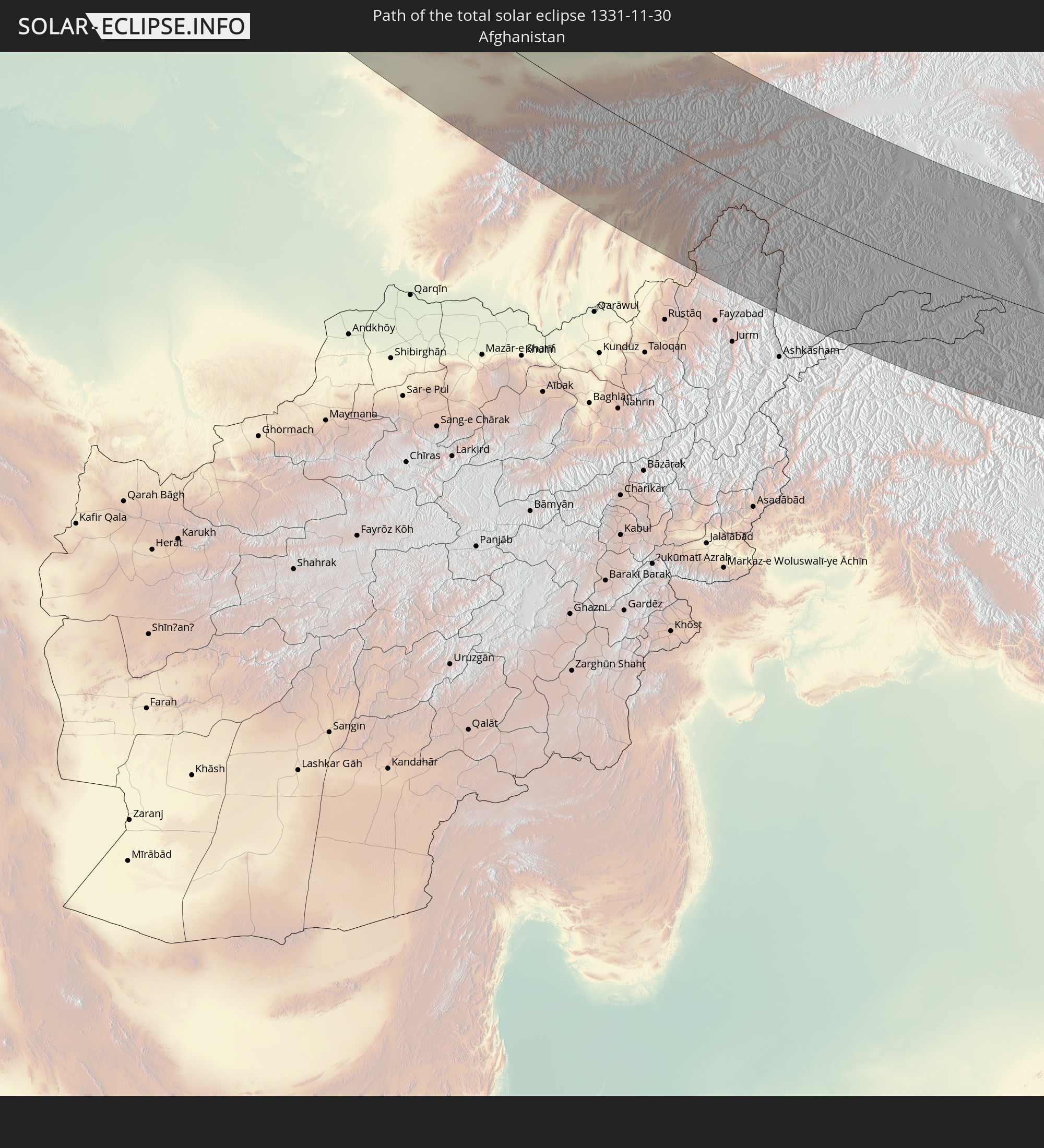
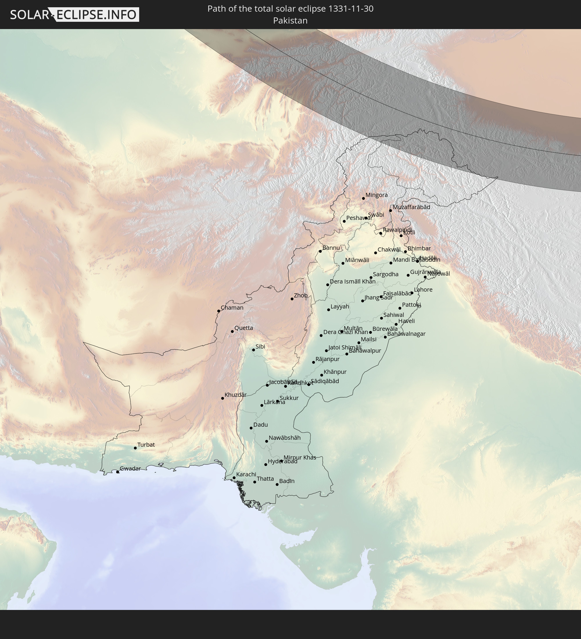
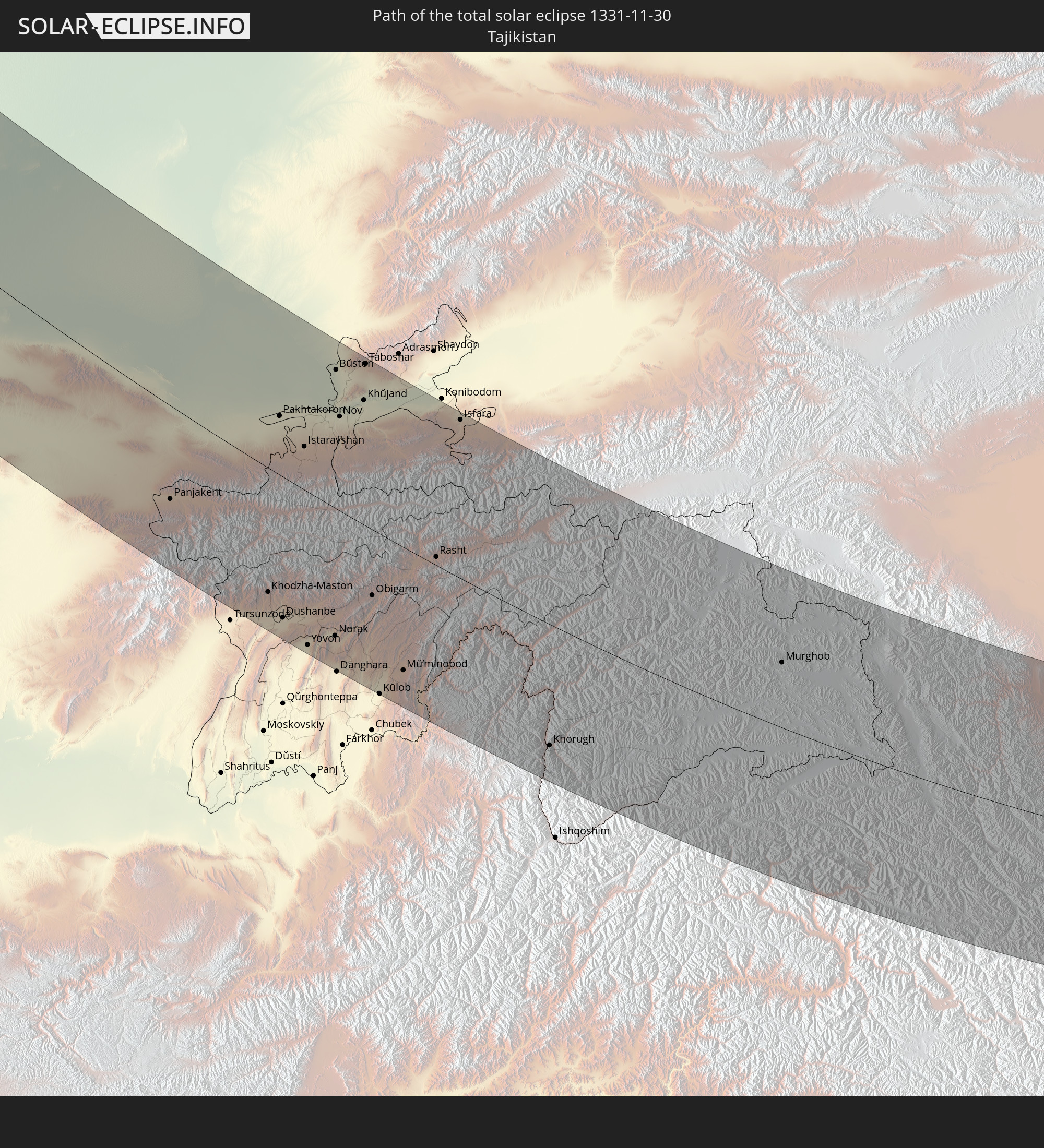
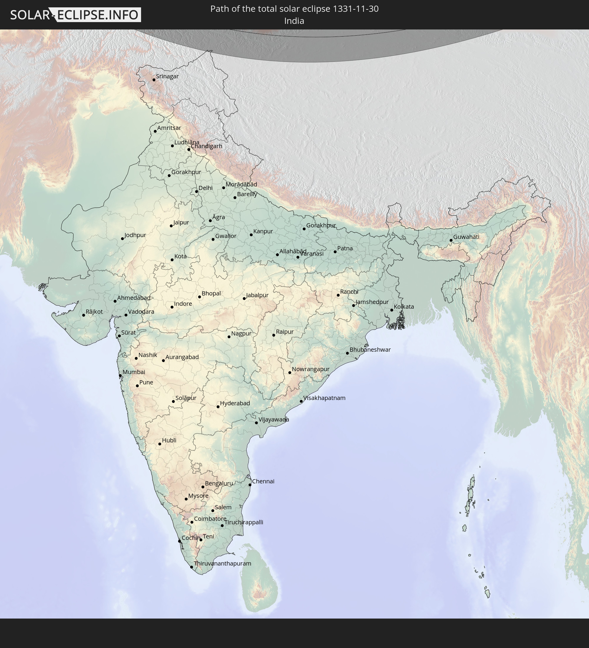
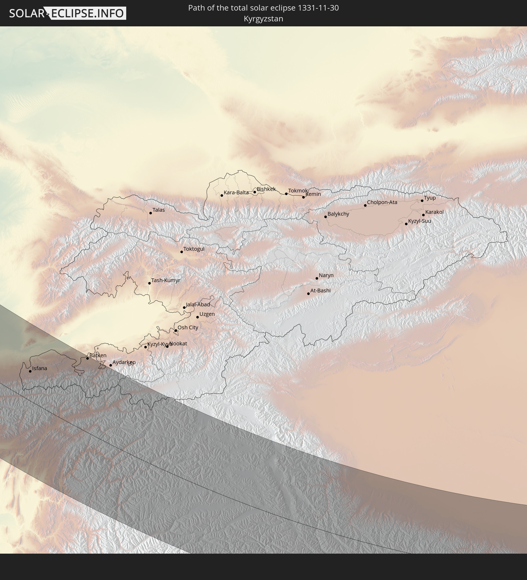
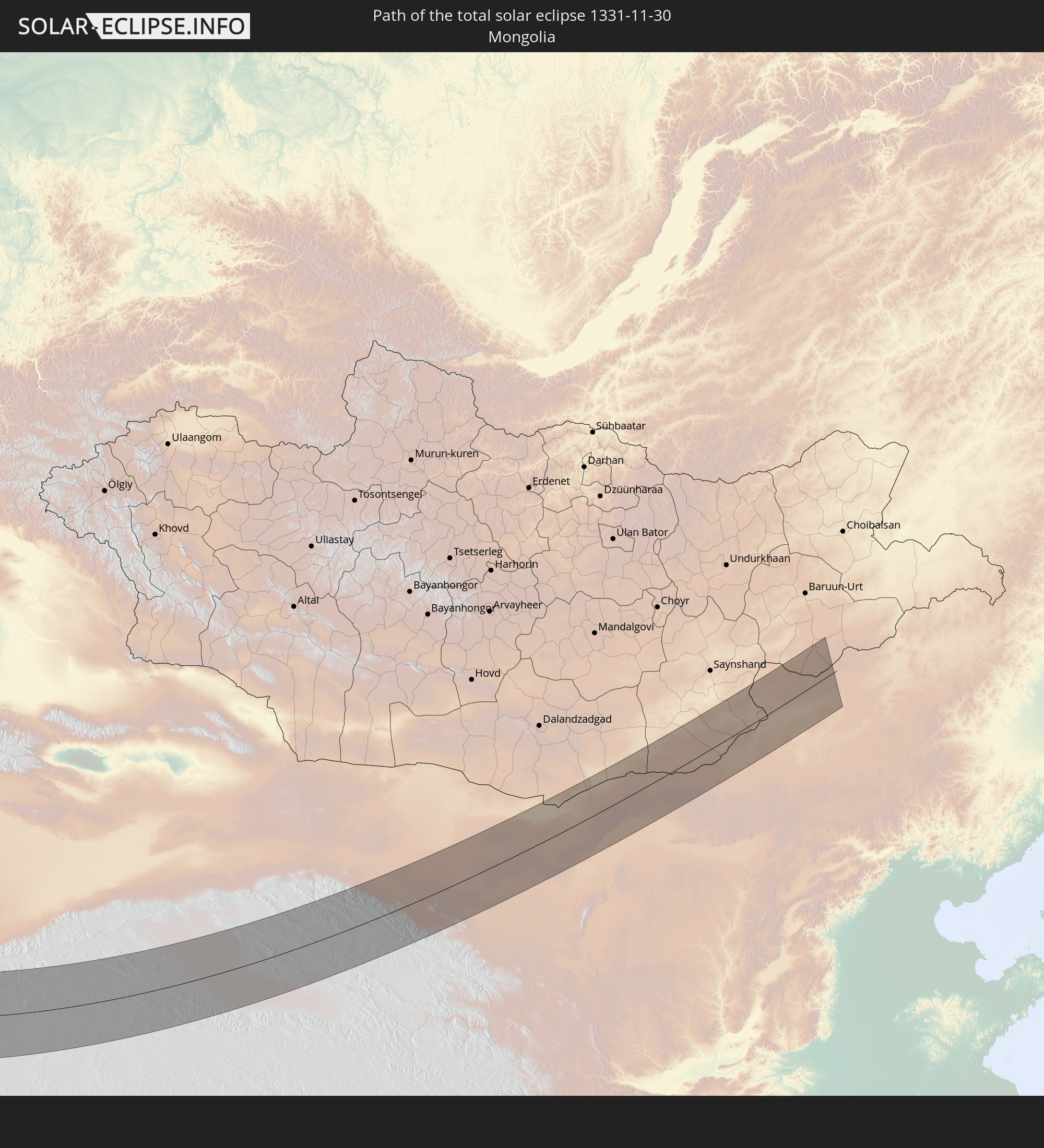
Detaillierte Länderkarten
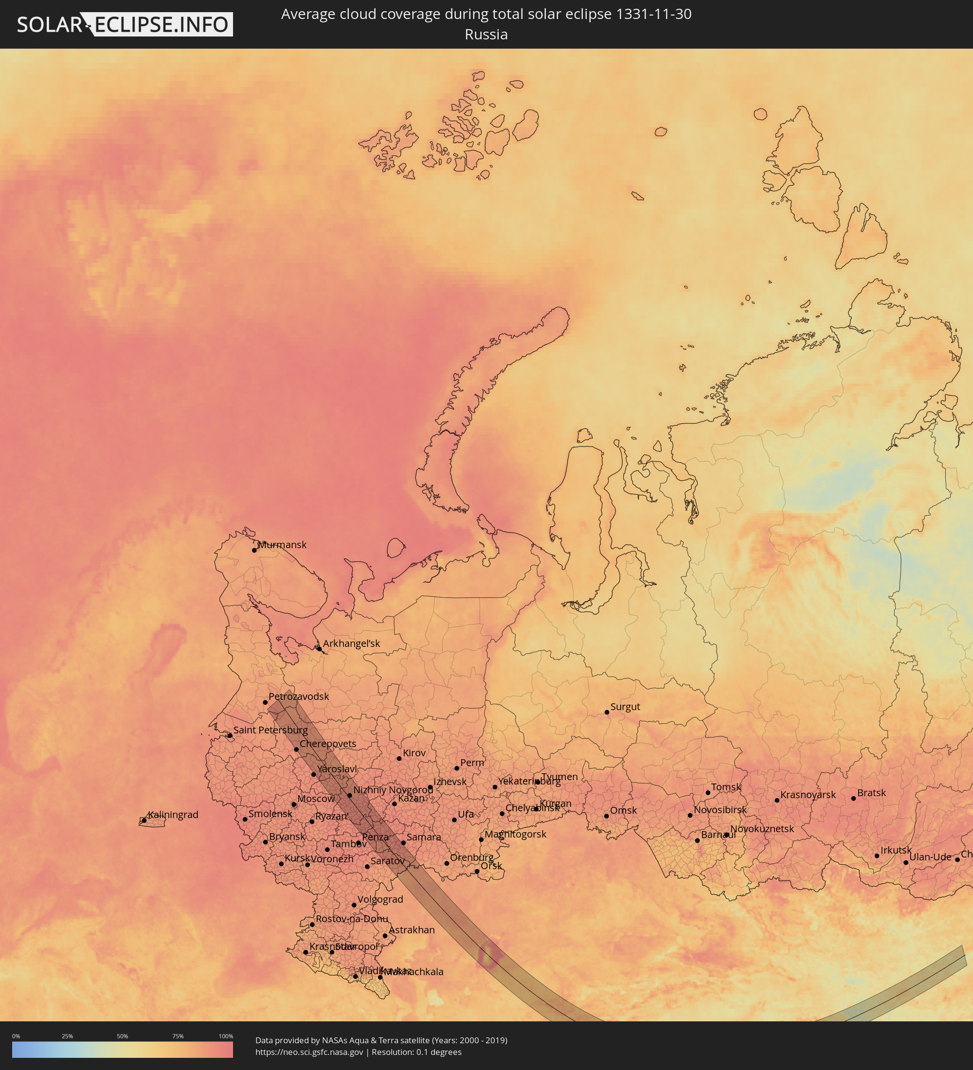 Russland
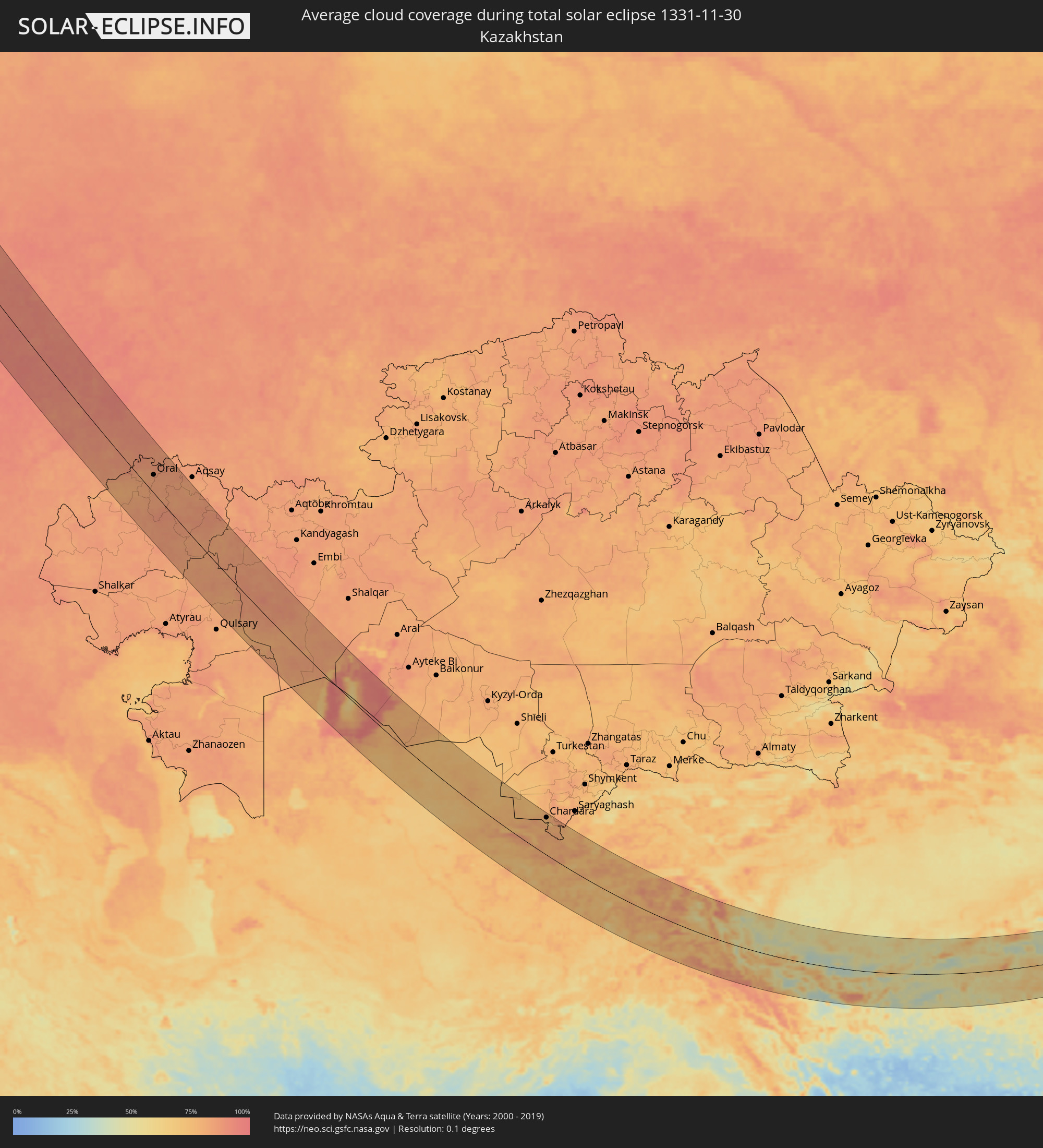 Kasachstan
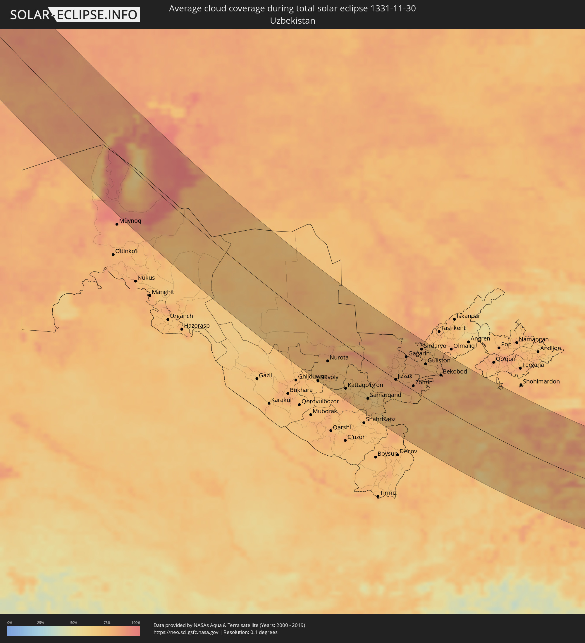 Usbekistan
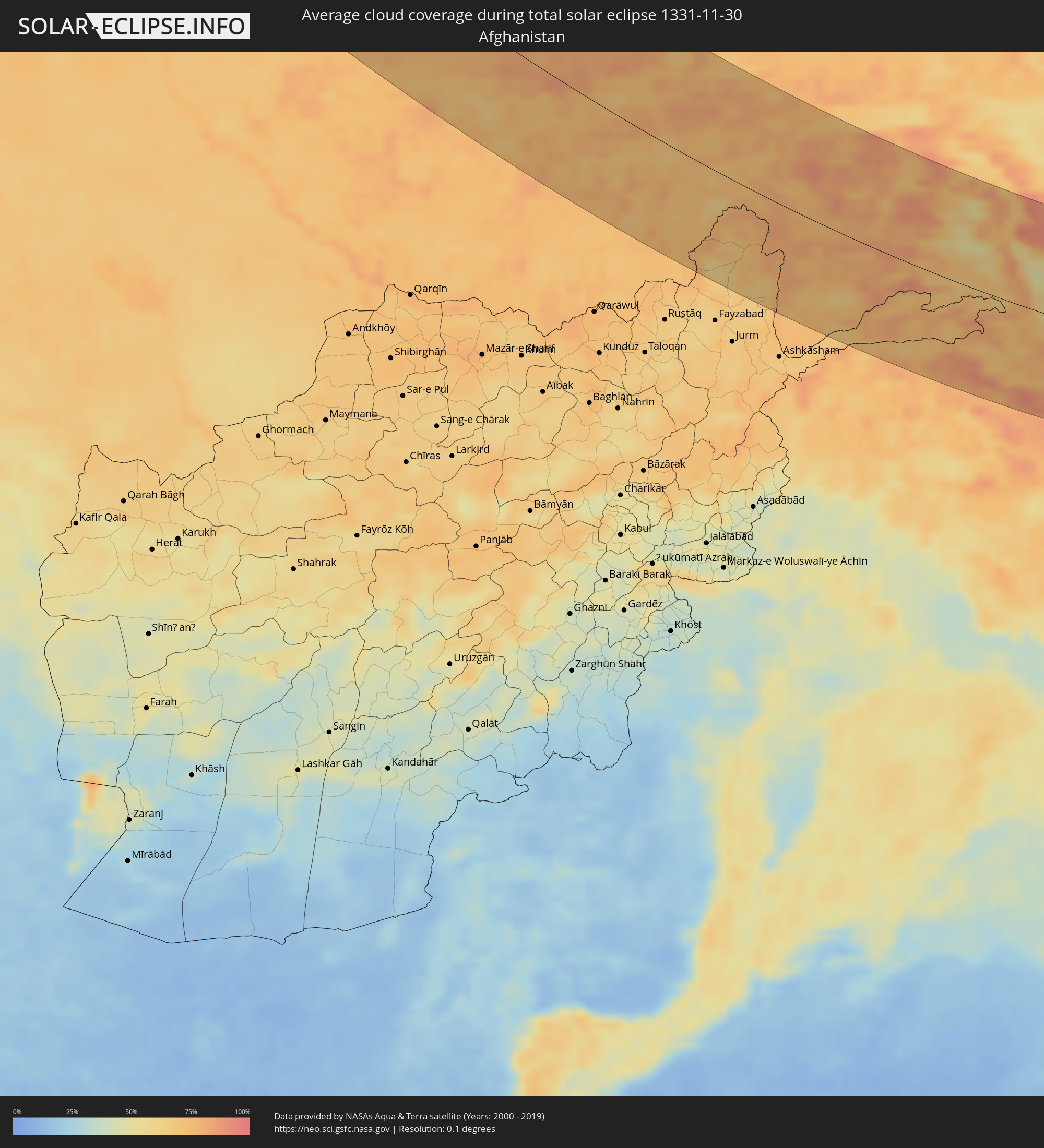 Afghanistan
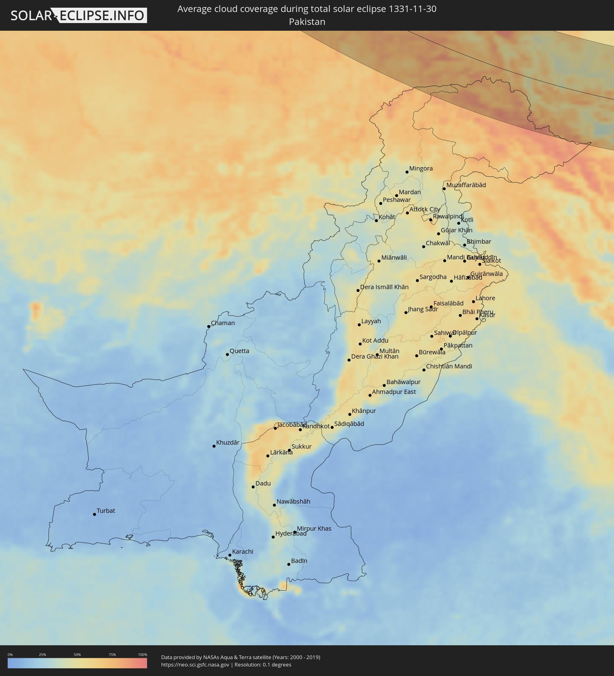 Pakistan
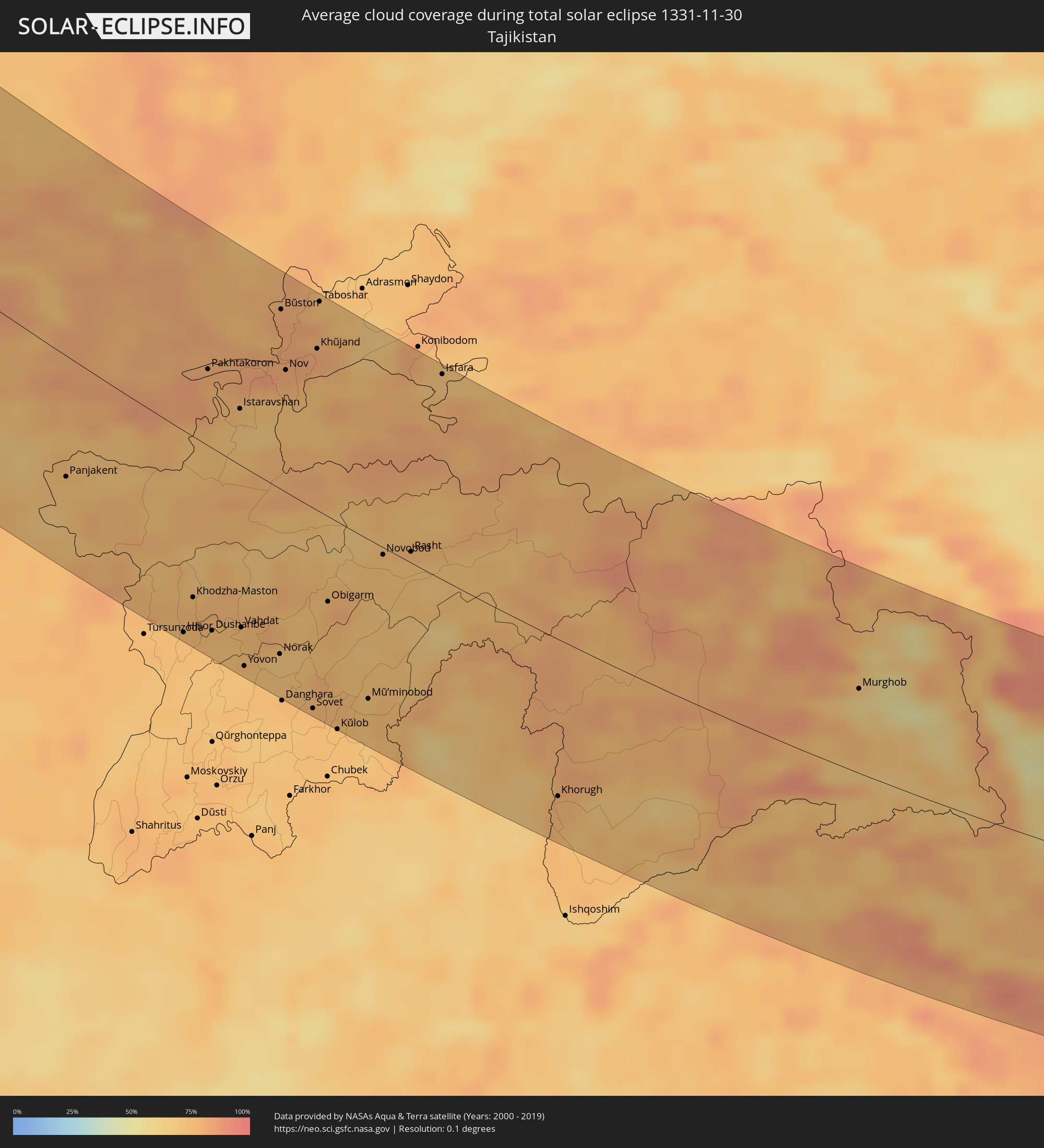 Tadschikistan
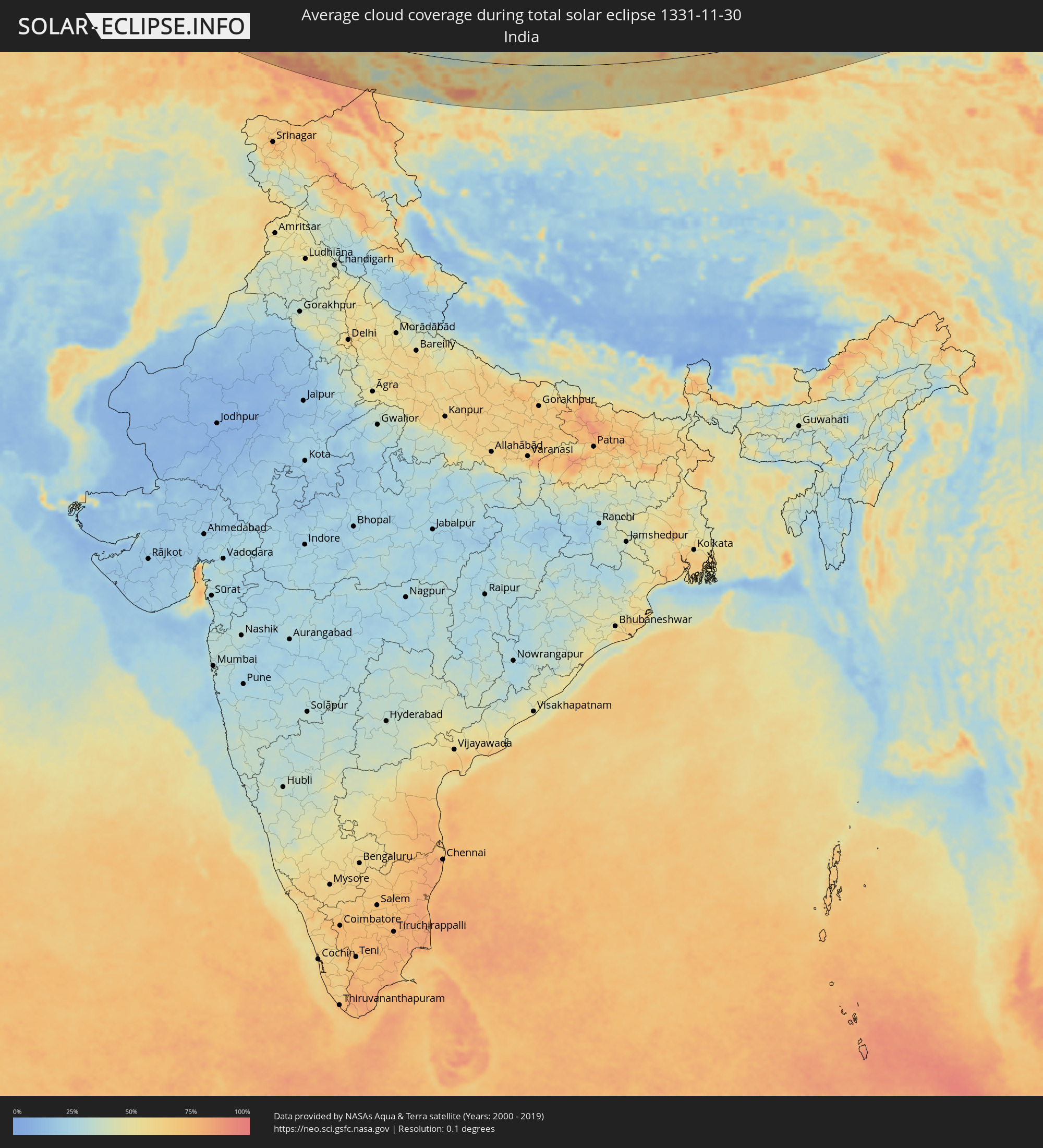 Indien
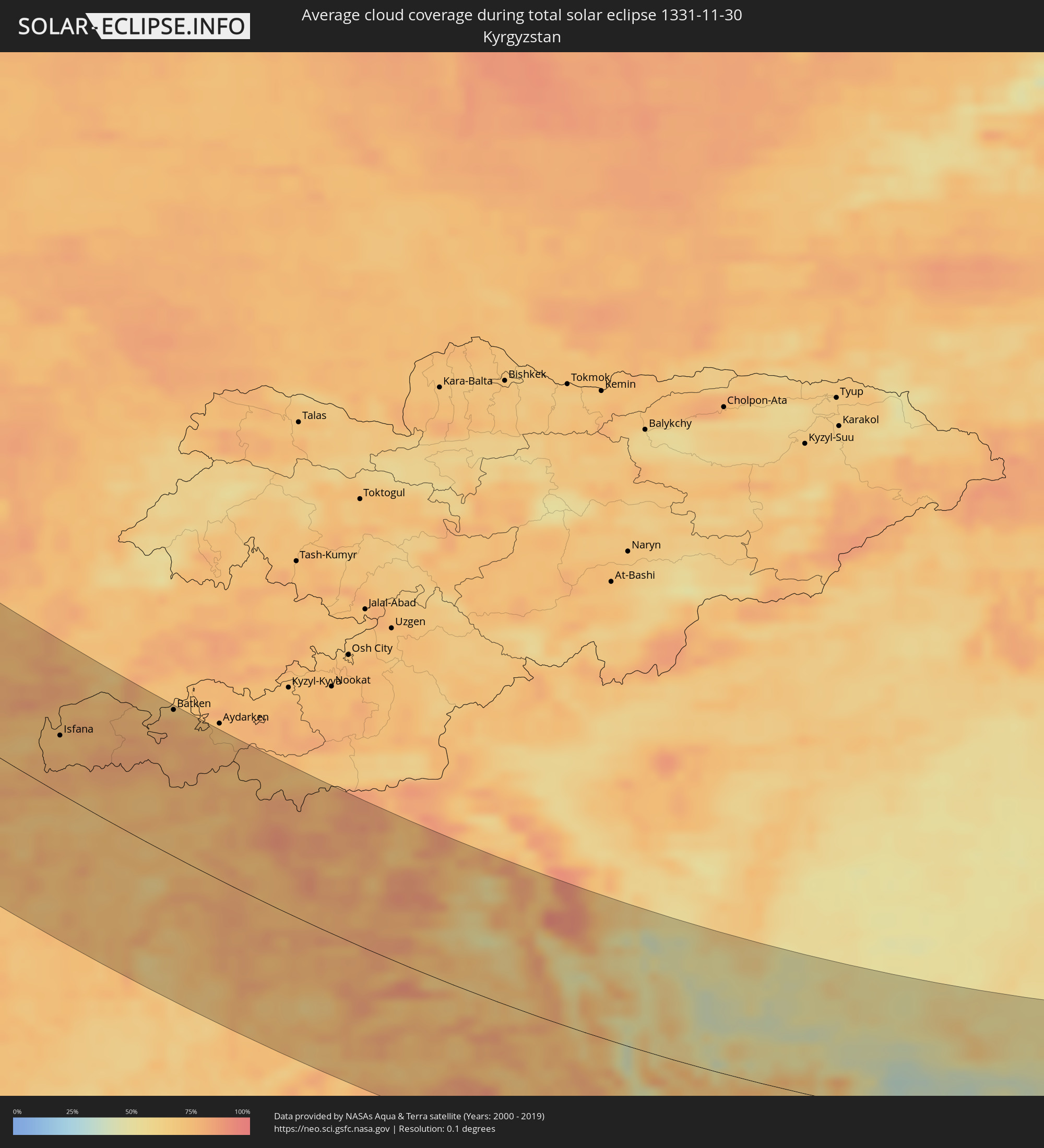 Kirgisistan
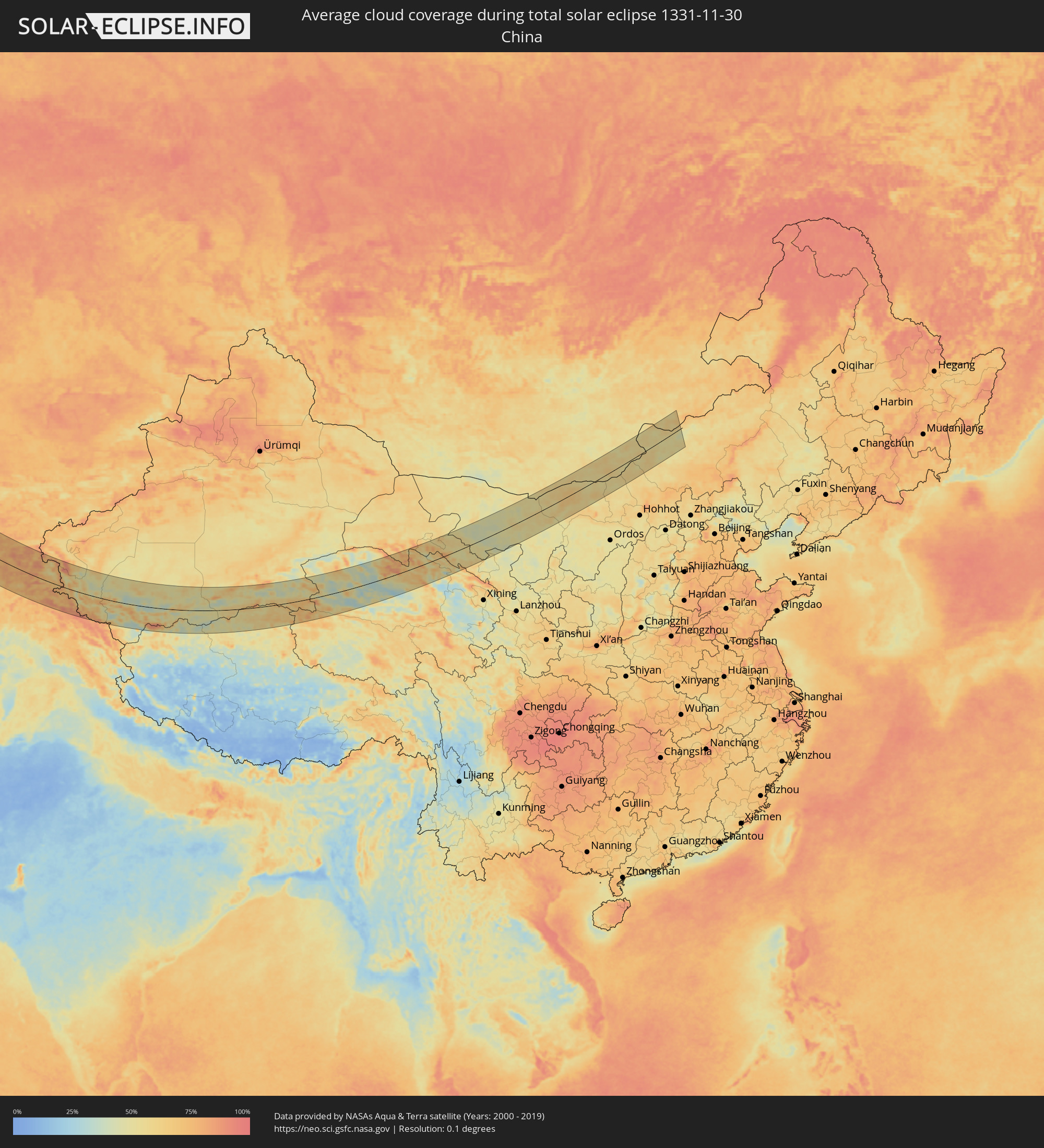 Volksrepublik China
 Mongolei
Orte im Finsternispfad
Die nachfolgene Tabelle zeigt Städte und Orte mit mehr als 5.000 Einwohnern, die sich im Finsternispfad befinden. Städte mit mehr als 100.000 Einwohnern sind dick gekennzeichnet. Mit einem Klick auf den Ort öffnet sich eine Detailkarte die die Lage des jeweiligen Ortes zusammen mit dem Verlauf der zentralen Finsternis präsentiert.
| Ort | Typ | Dauer der Verfinsterung | Ortszeit bei maximaler Verfinsterung | Entfernung zur Zentrallinie | Ø Bewölkung |
|
Cherepovets, Vologda
|
total | - | 09:27:57 UTC+02:30 | 88 km | 90% |
|
Vologda, Vologda
|
total | - | 09:29:36 UTC+02:30 | 9 km | 86% |
|
Sokol, Vologda
|
total | - | 09:30:00 UTC+02:30 | 36 km | 87% |
|
Kostroma, Kostroma
|
total | - | 09:29:16 UTC+02:30 | 38 km | 92% |
|
Ivanovo, Ivanovo
|
total | - | 09:28:42 UTC+02:30 | 88 km | 91% |
|
Furmanov, Ivanovo
|
total | - | 09:29:01 UTC+02:30 | 64 km | 89% |
|
Shuya, Ivanovo
|
total | - | 09:28:57 UTC+02:30 | 78 km | 90% |
|
Vichuga, Ivanovo
|
total | - | 09:29:43 UTC+02:30 | 27 km | 88% |
|
Kineshma, Ivanovo
|
total | - | 09:30:04 UTC+02:30 | 2 km | 89% |
|
Vyazniki, Vladimir
|
total | - | 09:29:11 UTC+02:30 | 82 km | 93% |
|
Pavlovo, Nizjnij Novgorod
|
total | - | 09:29:52 UTC+02:30 | 55 km | 92% |
|
Zavolzh’ye, Nizjnij Novgorod
|
total | - | 09:30:38 UTC+02:30 | 5 km | 93% |
|
Dzerzhinsk, Nizjnij Novgorod
|
total | - | 09:30:24 UTC+02:30 | 19 km | 92% |
|
Bogorodsk, Nizjnij Novgorod
|
total | - | 09:30:22 UTC+02:30 | 25 km | 92% |
|
Novaya Balakhna, Nizjnij Novgorod
|
total | - | 09:30:43 UTC+02:30 | 5 km | 92% |
|
Arzamas, Nizjnij Novgorod
|
total | - | 09:30:11 UTC+02:30 | 58 km | 92% |
|
Nizhniy Novgorod, Nizjnij Novgorod
|
total | - | 09:31:00 UTC+02:30 | 14 km | 94% |
|
Kstovo, Nizjnij Novgorod
|
total | - | 09:31:03 UTC+02:30 | 11 km | 94% |
|
Saransk, Mordoviya
|
total | - | 09:30:44 UTC+02:30 | 75 km | 93% |
|
Shumerlya, Chuvashia
|
total | - | 09:32:51 UTC+02:30 | 78 km | 94% |
|
Alatyr’, Chuvashia
|
total | - | 09:32:37 UTC+02:30 | 41 km | 90% |
|
Kuznetsk, Penza
|
total | - | 09:31:38 UTC+02:30 | 78 km | 92% |
|
Balakovo, Saratov
|
total | - | 10:22:27 UTC+03:20 | 94 km | 88% |
|
Syzran’, Samara
|
total | - | 10:23:48 UTC+03:20 | 21 km | 91% |
|
Pugachev, Saratov
|
total | - | 10:23:37 UTC+03:20 | 43 km | 89% |
|
Tol’yatti, Samara
|
total | - | 10:25:00 UTC+03:20 | 92 km | 93% |
|
Zhigulevsk, Samara
|
total | - | 10:25:06 UTC+03:20 | 91 km | 94% |
|
Chapayevsk, Samara
|
total | - | 10:25:09 UTC+03:20 | 72 km | 93% |
|
Novokuybyshevsk, Samara
|
total | - | 10:25:29 UTC+03:20 | 93 km | 93% |
|
Kamenka, Batys Qazaqstan
|
total | - | 10:30:05 UTC+03:25 | 30 km | 81% |
|
Chapaev, Batys Qazaqstan
|
total | - | 10:30:49 UTC+03:25 | 51 km | 86% |
|
Oral, Batys Qazaqstan
|
total | - | 10:31:29 UTC+03:25 | 35 km | 84% |
|
Fedorovka, Batys Qazaqstan
|
total | - | 10:32:13 UTC+03:25 | 66 km | 85% |
|
Dzhambeyty, Batys Qazaqstan
|
total | - | 10:32:43 UTC+03:25 | 30 km | 84% |
|
Miyaly, Atyraū
|
total | - | 10:33:56 UTC+03:25 | 8 km | 82% |
|
Bayganin, Aqtöbe
|
total | - | 10:36:51 UTC+03:25 | 90 km | 85% |
|
Navoiy, Navoiy
|
total | - | 11:56:12 UTC+04:27 | 120 km | 72% |
|
Nurota, Navoiy
|
total | - | 11:56:40 UTC+04:27 | 62 km | 72% |
|
Oqtosh, Samarqand
|
total | - | 11:57:22 UTC+04:27 | 109 km | 77% |
|
Yangirabot, Navoiy
|
total | - | 11:57:24 UTC+04:27 | 98 km | 71% |
|
Payshanba, Samarqand
|
total | - | 11:57:57 UTC+04:27 | 86 km | 70% |
|
Kattaqo’rg’on, Samarqand
|
total | - | 11:58:01 UTC+04:27 | 95 km | 74% |
|
Ishtixon, Samarqand
|
total | - | 11:58:27 UTC+04:27 | 78 km | 70% |
|
Juma, Samarqand
|
total | - | 11:58:54 UTC+04:27 | 93 km | 69% |
|
Charxin, Samarqand
|
total | - | 11:59:07 UTC+04:27 | 90 km | 71% |
|
Chelak, Samarqand
|
total | - | 11:59:13 UTC+04:27 | 65 km | 66% |
|
Daxbet, Samarqand
|
total | - | 11:59:23 UTC+04:27 | 77 km | 67% |
|
Samarqand, Samarqand
|
total | - | 11:59:31 UTC+04:27 | 85 km | 72% |
|
Jomboy, Samarqand
|
total | - | 11:59:46 UTC+04:27 | 74 km | 67% |
|
Urgut, Samarqand
|
total | - | 12:00:12 UTC+04:27 | 95 km | 75% |
|
Bulung’ur, Samarqand
|
total | - | 12:00:06 UTC+04:27 | 60 km | 69% |
|
Panjakent, Viloyati Sughd
|
total | - | 12:08:12 UTC+04:35 | 70 km | 72% |
|
Jizzax, Jizzax
|
total | - | 12:01:04 UTC+04:27 | 1 km | 83% |
|
Paxtakor, Jizzax
|
total | - | 12:01:13 UTC+04:27 | 23 km | 77% |
|
Chardara, Ongtüstik Qazaqstan
|
total | - | 11:54:49 UTC+04:21 | 111 km | 75% |
|
Dŭstlik, Jizzax
|
total | - | 12:01:17 UTC+04:27 | 46 km | 77% |
|
Gagarin, Jizzax
|
total | - | 12:01:29 UTC+04:27 | 65 km | 80% |
|
Shahrinav
|
total | - | 12:10:07 UTC+04:35 | 125 km | 73% |
|
Asyqata, Ongtüstik Qazaqstan
|
total | - | 11:55:45 UTC+04:21 | 96 km | 81% |
|
Zomin, Jizzax
|
total | - | 12:02:15 UTC+04:27 | 10 km | 81% |
|
Dashtobod, Jizzax
|
total | - | 12:02:22 UTC+04:27 | 30 km | 83% |
|
Atakent, Ongtüstik Qazaqstan
|
total | - | 11:56:03 UTC+04:21 | 98 km | 81% |
|
Slavyanka, Ongtüstik Qazaqstan
|
total | - | 11:56:12 UTC+04:21 | 83 km | 80% |
|
Hisor, Republican Subordination
|
total | - | 12:10:35 UTC+04:35 | 120 km | 73% |
|
Khodzha-Maston
|
total | - | 12:10:37 UTC+04:35 | 95 km | 77% |
|
Sirdaryo, Sirdaryo
|
total | - | 12:02:22 UTC+04:27 | 105 km | 75% |
|
Pakhtakoron, Viloyati Sughd
|
total | - | 12:10:10 UTC+04:35 | 45 km | 79% |
|
Chinoz, Toshkent
|
total | - | 12:02:31 UTC+04:27 | 118 km | 75% |
|
Dushanbe, Dushanbe
|
total | - | 12:11:02 UTC+04:35 | 109 km | 72% |
|
Guliston, Sirdaryo
|
total | - | 12:02:46 UTC+04:27 | 77 km | 78% |
|
Boshkengash, Dushanbe
|
total | - | 12:11:08 UTC+04:35 | 114 km | 72% |
|
Yangiyer, Sirdaryo
|
total | - | 12:02:57 UTC+04:27 | 59 km | 79% |
|
Istaravshan, Viloyati Sughd
|
total | - | 12:10:48 UTC+04:35 | 33 km | 70% |
|
Vahdat, Republican Subordination
|
total | - | 12:11:31 UTC+04:35 | 97 km | 75% |
|
Yovon, Khatlon
|
total | - | 12:11:41 UTC+04:35 | 119 km | 71% |
|
Bo‘ka, Toshkent
|
total | - | 12:03:26 UTC+04:27 | 126 km | 75% |
|
Bekobod, Toshkent
|
total | - | 12:03:52 UTC+04:27 | 74 km | 81% |
|
Norak, Khatlon
|
total | - | 12:12:14 UTC+04:35 | 100 km | 68% |
|
Bŭston, Viloyati Sughd
|
total | - | 12:11:10 UTC+04:35 | 105 km | 81% |
|
Nov, Viloyati Sughd
|
total | - | 12:11:25 UTC+04:35 | 72 km | 80% |
|
Proletar, Viloyati Sughd
|
total | - | 12:11:41 UTC+04:35 | 79 km | 79% |
|
Isfana, Batken
|
total | - | 12:35:06 UTC+04:58 | 49 km | 73% |
|
Suluktu, Batken
|
total | - | 12:35:08 UTC+04:58 | 60 km | 72% |
|
Sovet, Khatlon
|
total | - | 12:12:58 UTC+04:35 | 122 km | 74% |
|
Khŭjand, Viloyati Sughd
|
total | - | 12:11:52 UTC+04:35 | 95 km | 80% |
|
Taboshar, Viloyati Sughd
|
total | - | 12:11:45 UTC+04:35 | 124 km | 74% |
|
Chkalov, Viloyati Sughd
|
total | - | 12:12:02 UTC+04:35 | 94 km | 75% |
|
Konsoy, Viloyati Sughd
|
total | - | 12:11:55 UTC+04:35 | 119 km | 75% |
|
Obigarm
|
total | - | 12:12:51 UTC+04:35 | 51 km | 77% |
|
Kŭlob, Khatlon
|
total | - | 12:13:27 UTC+04:35 | 127 km | 73% |
|
Roghun
|
total | - | 12:13:09 UTC+04:35 | 38 km | 76% |
|
Mŭ’minobod, Khatlon
|
total | - | 12:13:52 UTC+04:35 | 98 km | 73% |
|
Novobod
|
total | - | 12:13:36 UTC+04:35 | 4 km | 71% |
|
Rasht
|
total | - | 12:14:03 UTC+04:35 | 7 km | 72% |
|
Isfara, Viloyati Sughd
|
total | - | 12:13:57 UTC+04:35 | 124 km | 71% |
|
Batken, Batken
|
total | - | 12:37:35 UTC+04:58 | 126 km | 69% |
|
Khorugh, Gorno-Badakhshan
|
total | - | 12:17:25 UTC+04:35 | 99 km | 77% |
|
Khandūd, Badakhshan
|
total | - | 11:44:11 UTC+04:00 | 126 km | 67% |
|
Murghob, Gorno-Badakhshan
|
total | - | 12:22:01 UTC+04:35 | 55 km | 59% |
|
Zangguy, Xinjiang Uyghur Autonomous Region
|
total | - | 15:57:28 UTC+08:00 | 85 km | 49% |
|
Hotan, Xinjiang Uyghur Autonomous Region
|
total | - | 16:00:00 UTC+08:00 | 84 km | 64% |
|
Zhangye, Gansu
|
total | - | 16:32:07 UTC+08:00 | 29 km | 47% |
|
Erenhot, Inner Mongolia
|
total | - | 16:37:03 UTC+08:00 | 17 km | 59% |