Totale Sonnenfinsternis vom 25.04.1343
| Wochentag: | Donnerstag |
| Maximale Dauer der Verfinsterung: | 05m02s |
| Maximale Breite des Finsternispfades: | 206 km |
| Saroszyklus: | 108 |
| Bedeckungsgrad: | 100% |
| Magnitude: | 1.0597 |
| Gamma: | 0.3077 |
Wo kann man die Sonnenfinsternis vom 25.04.1343 sehen?
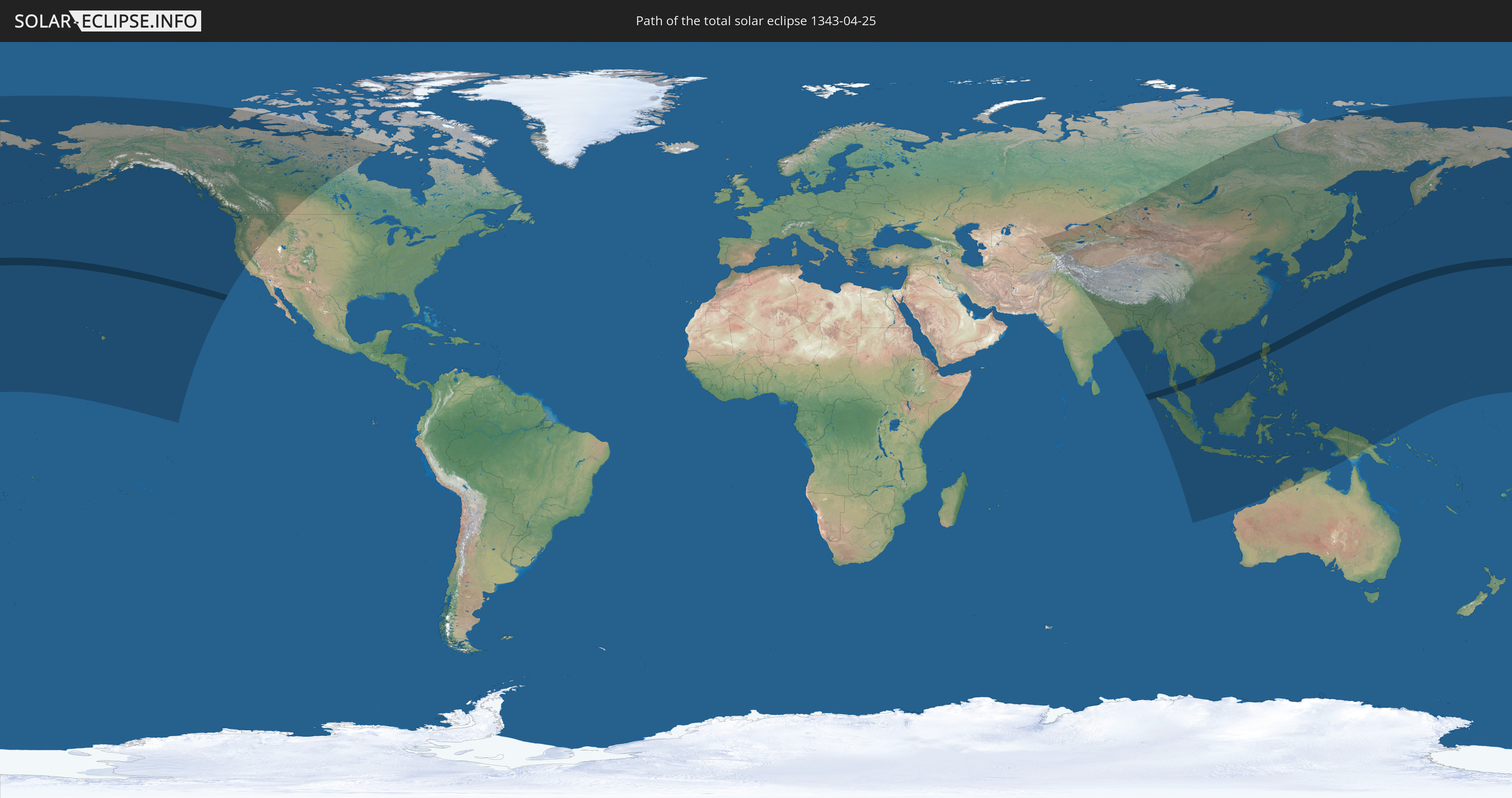
Die Sonnenfinsternis am 25.04.1343 kann man in 42 Ländern als partielle Sonnenfinsternis beobachten.
Der Finsternispfad verläuft durch 5 Länder. Nur in diesen Ländern ist sie als totale Sonnenfinsternis zu sehen.
In den folgenden Ländern ist die Sonnenfinsternis total zu sehen
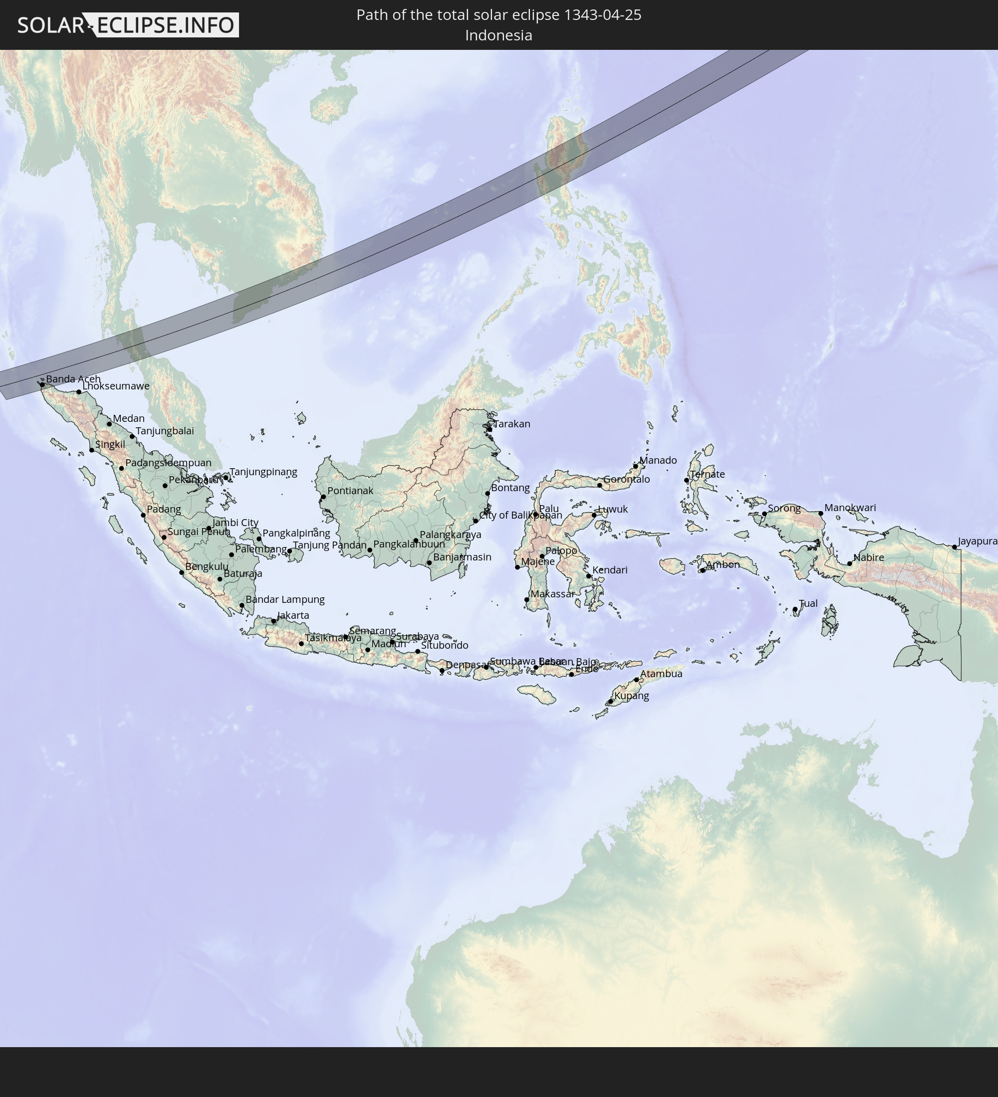 Indonesien
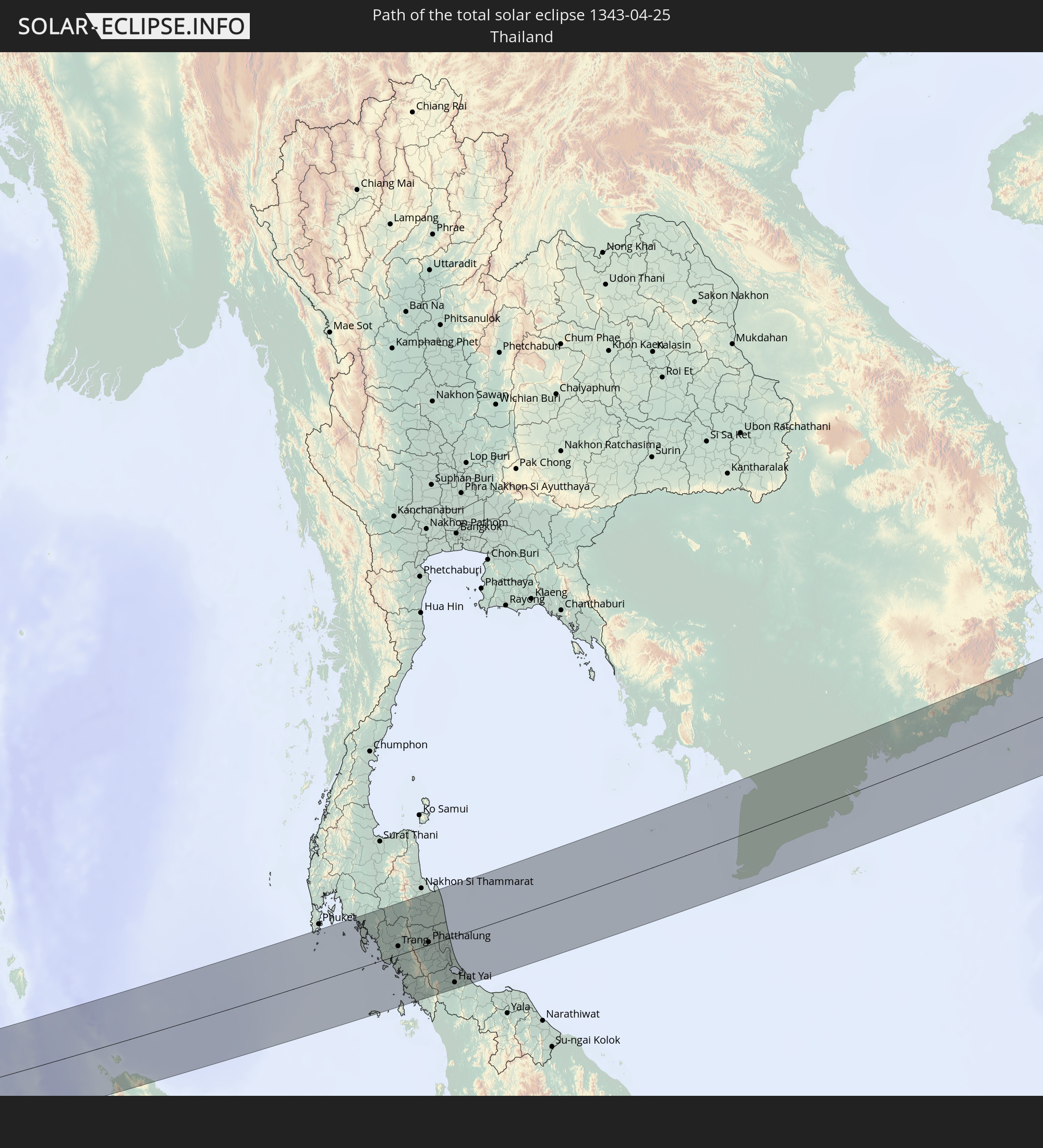 Thailand
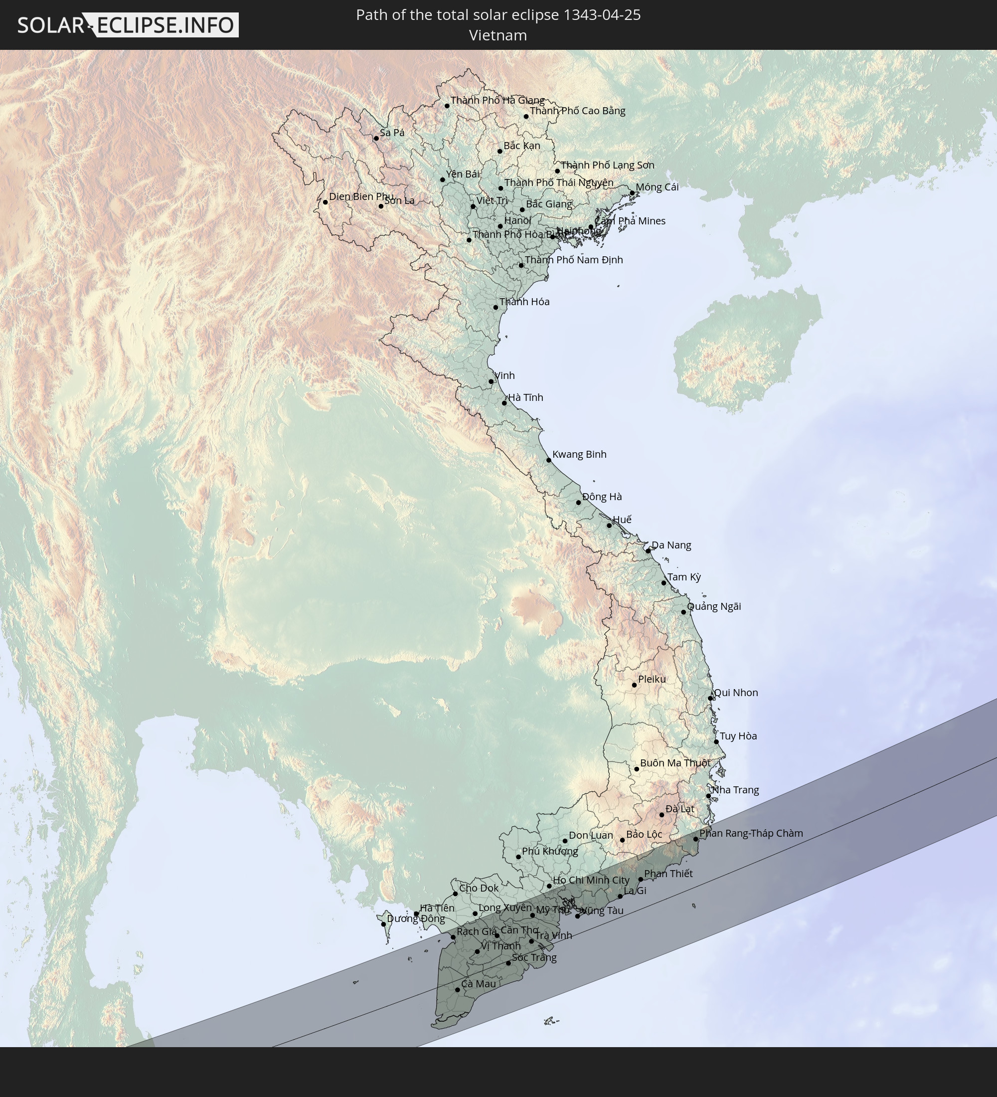 Vietnam
 Philippinen
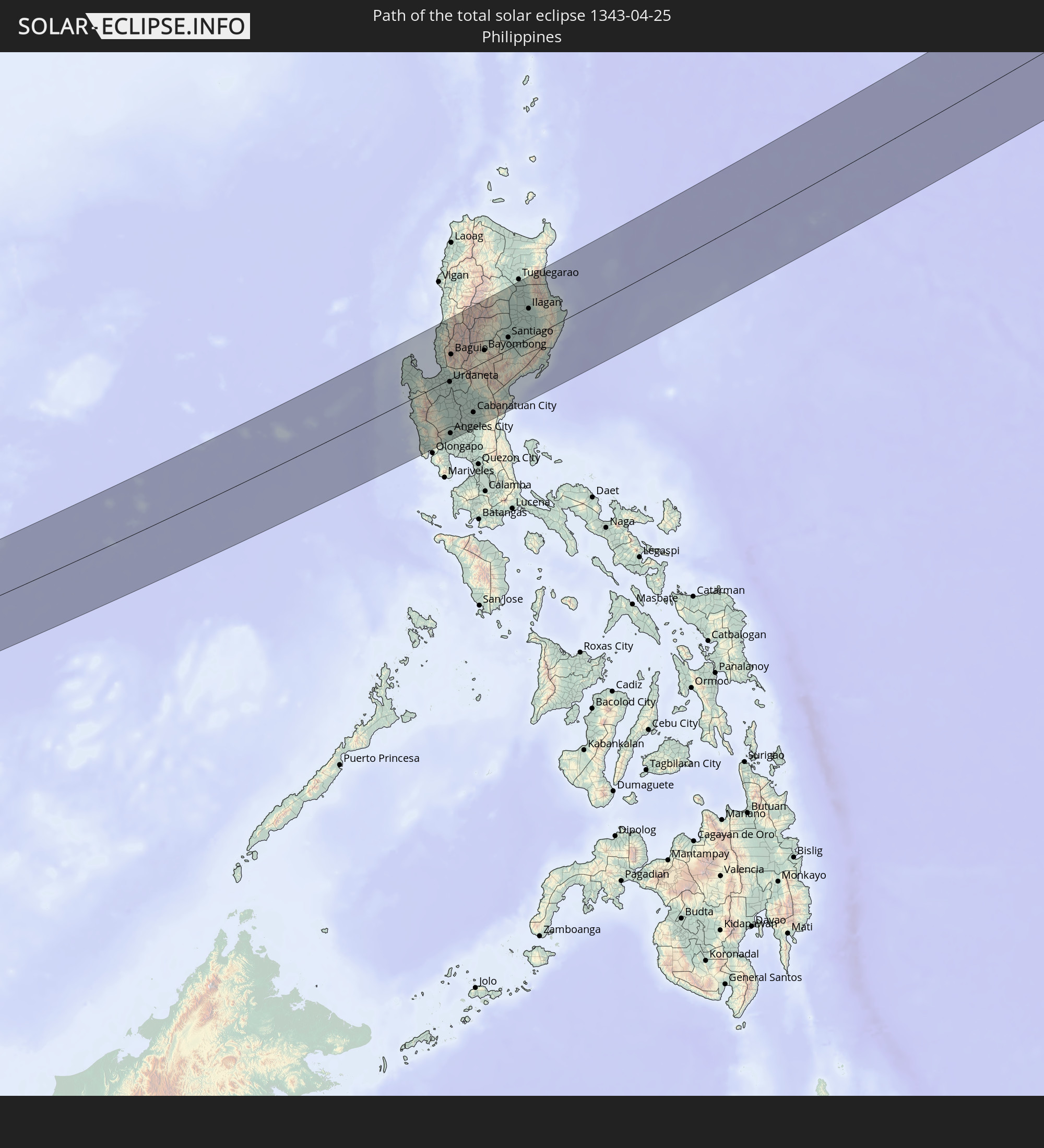
 Japan
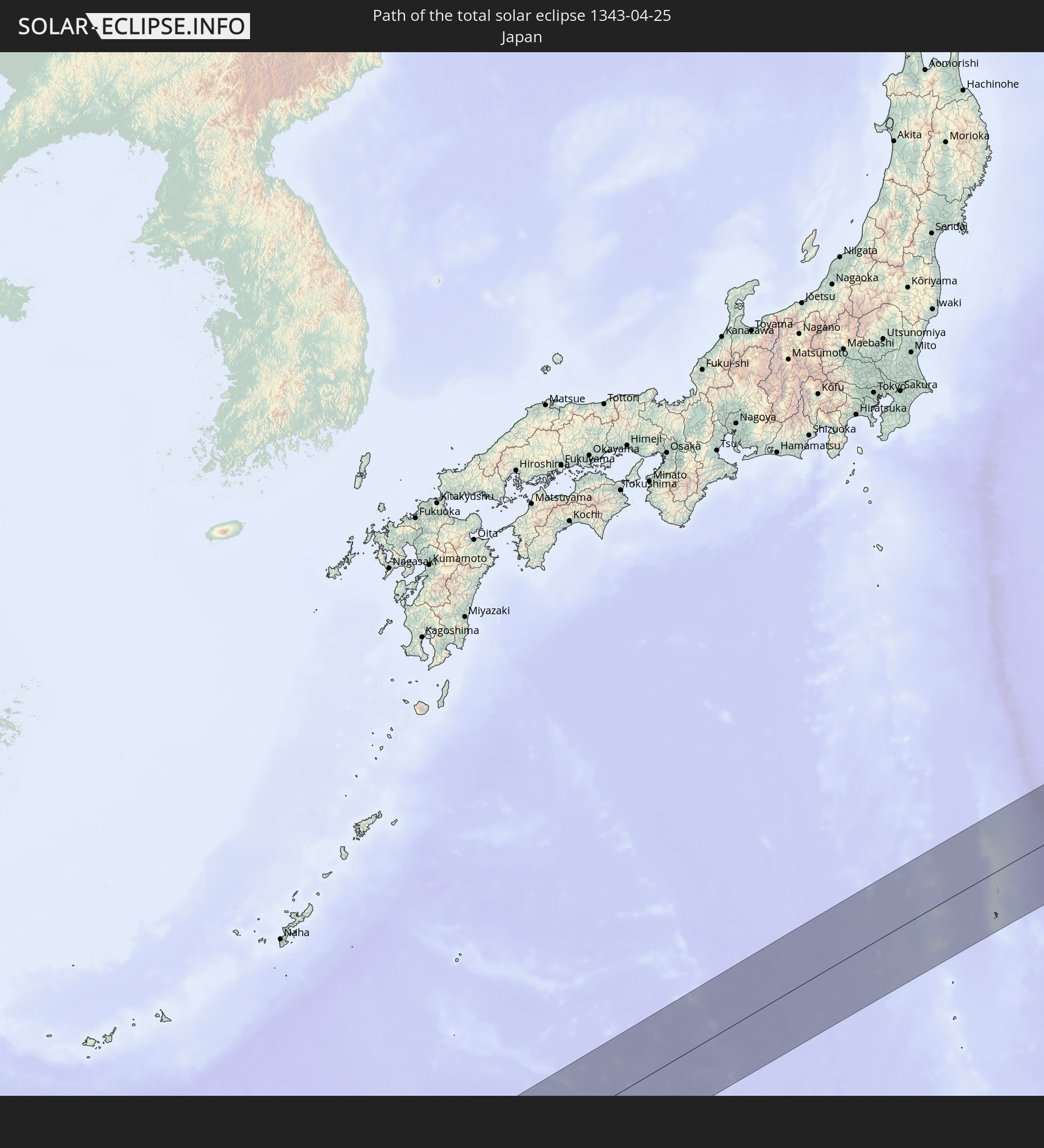
Japan
In den folgenden Ländern ist die Sonnenfinsternis partiell zu sehen
 Russland
 Vereinigte Staaten
 United States Minor Outlying Islands
 Kanada
 Grönland
 Kasachstan
 Usbekistan
 Afghanistan
 Pakistan
 Tadschikistan
 Indien
 Kirgisistan
 Volksrepublik China
 Nepal
Nepal
 Mongolei
 Bangladesch
 Bhutan
 Myanmar
 Indonesien
 Thailand
 Malaysia
 Laos
Laos
 Vietnam
 Kambodscha
 Singapur
 Weihnachtsinsel
 Australien
 Macau
Macau
 Hongkong
 Brunei
 Taiwan
 Philippinen
 Japan
Japan
 Osttimor
 Nordkorea
 Südkorea
 Palau
Palau
 Föderierte Staaten von Mikronesien
 Papua-Neuguinea
 Guam
Guam
 Nördliche Marianen
 Marshallinseln
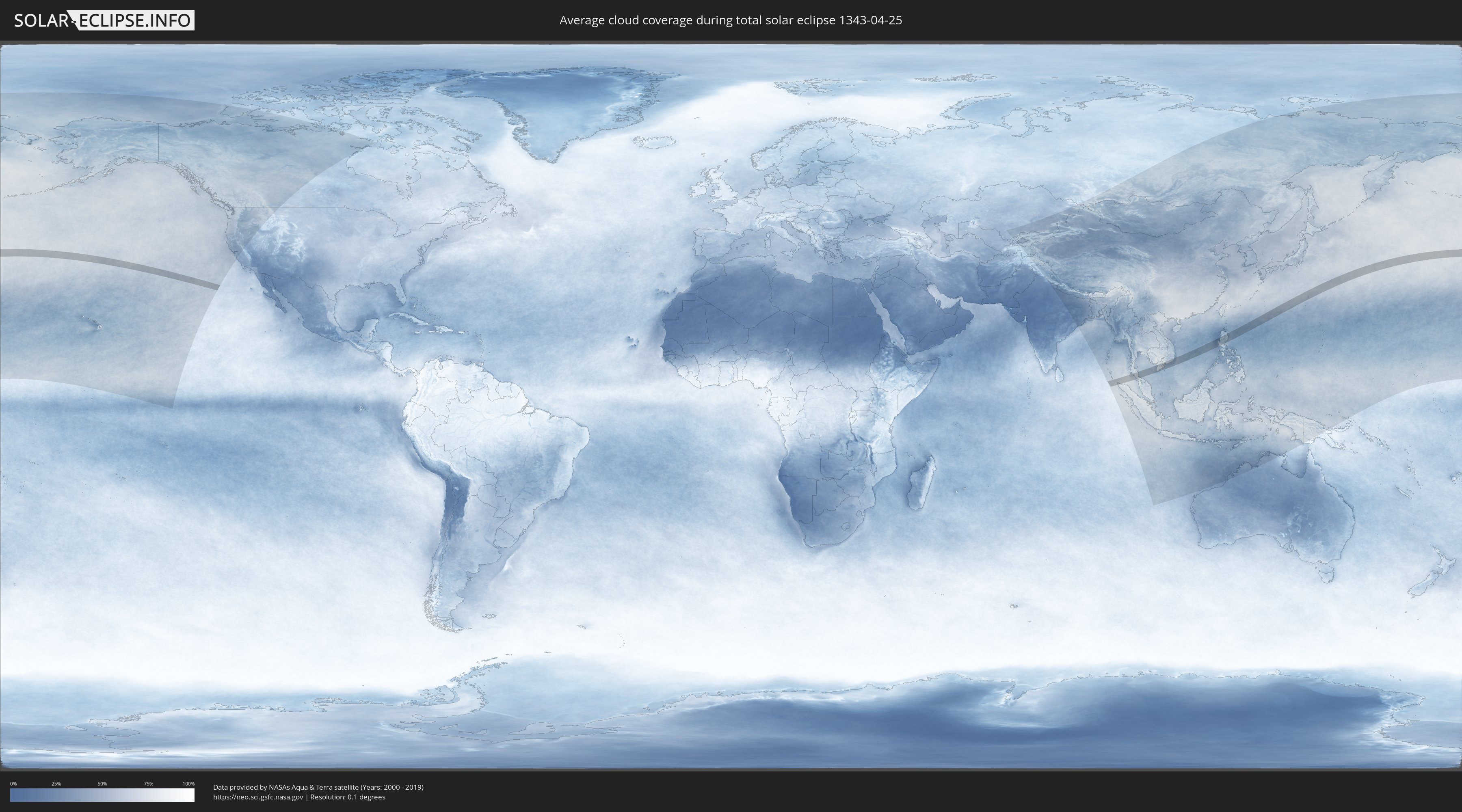
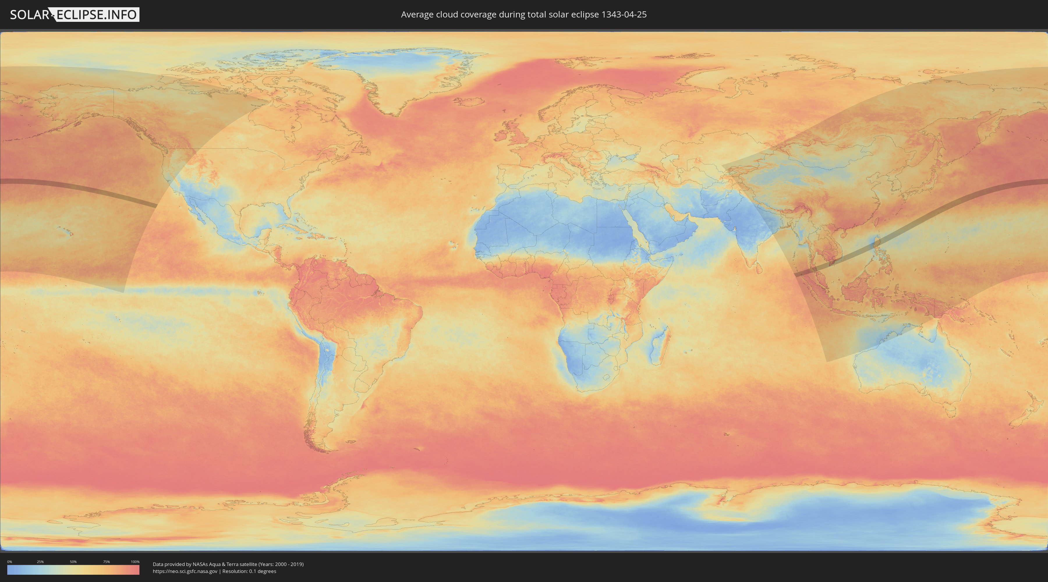
Wie wird das Wetter während der totalen Sonnenfinsternis am 25.04.1343?
Wo ist der beste Ort, um die totale Sonnenfinsternis vom 25.04.1343 zu beobachten?
Die folgenden Karten zeigen die durchschnittliche Bewölkung für den Tag, an dem die totale Sonnenfinsternis
stattfindet. Mit Hilfe der Karten lässt sich der Ort entlang des Finsternispfades eingrenzen,
der die besten Aussichen auf einen klaren wolkenfreien Himmel bietet.
Trotzdem muss man immer lokale Gegenenheiten beachten und sollte sich genau über das Wetter an seinem
gewählten Beobachtungsort informieren.
Die Daten stammen von den beiden NASA-Satelliten
AQUA und TERRA
und wurden über einen Zeitraum von 19 Jahren (2000 - 2019) gemittelt.
Detaillierte Länderkarten
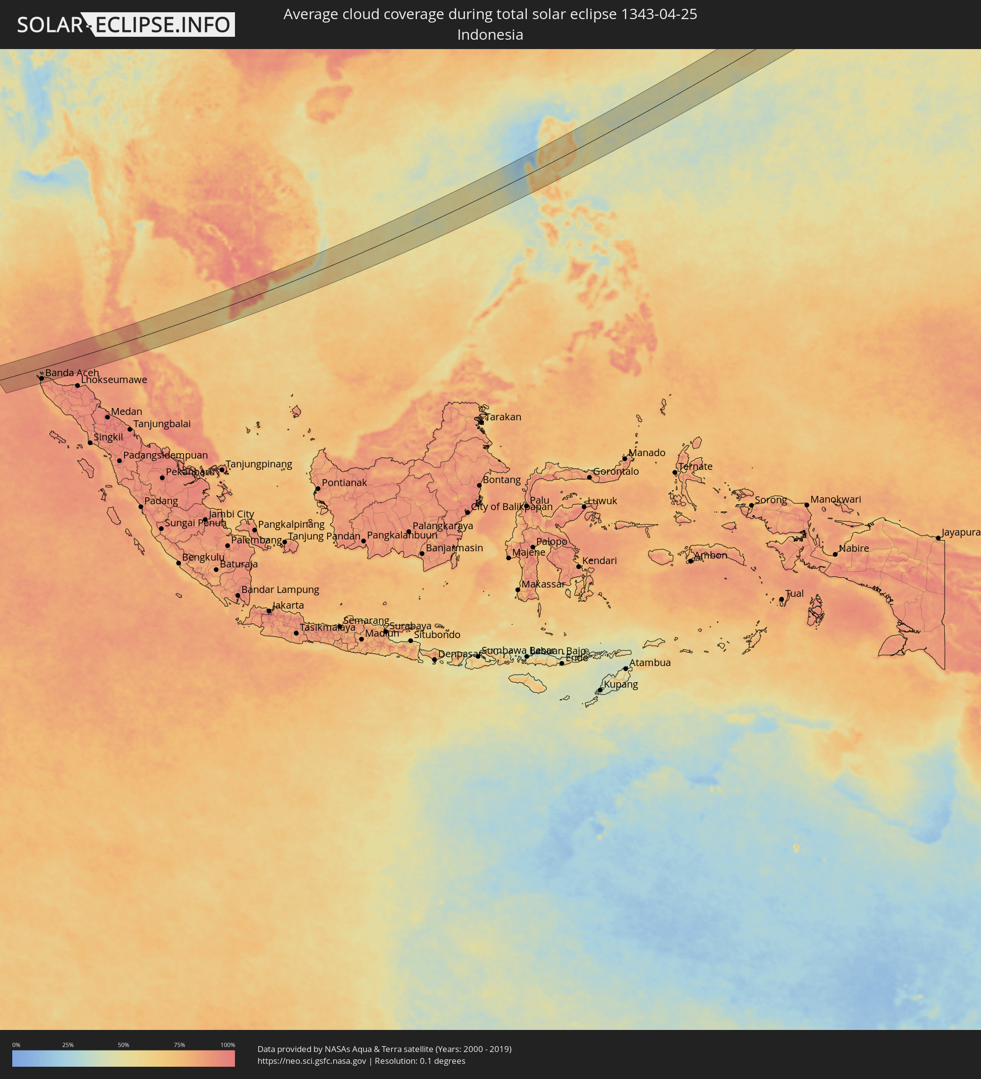 Indonesien
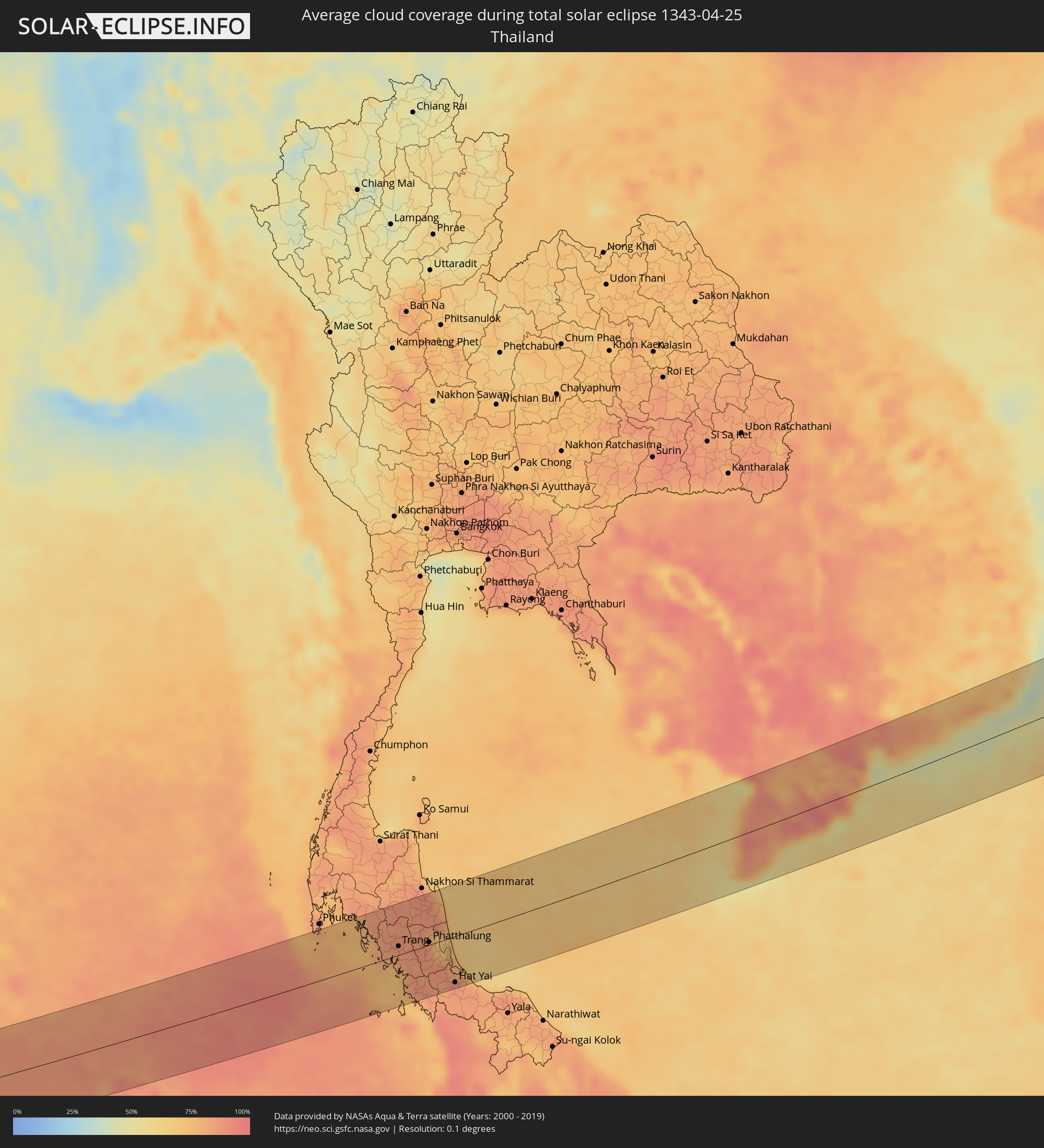 Thailand
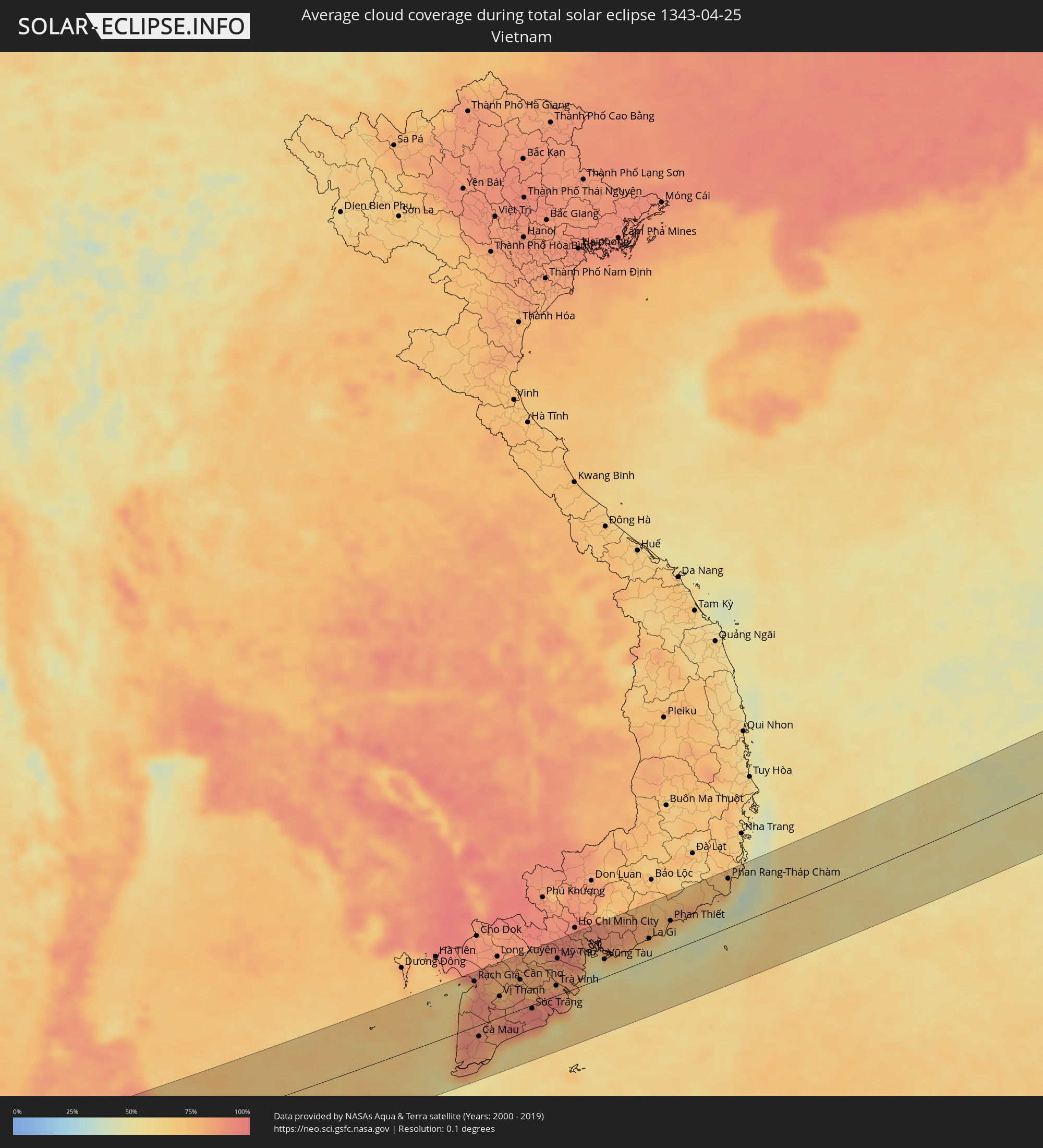 Vietnam
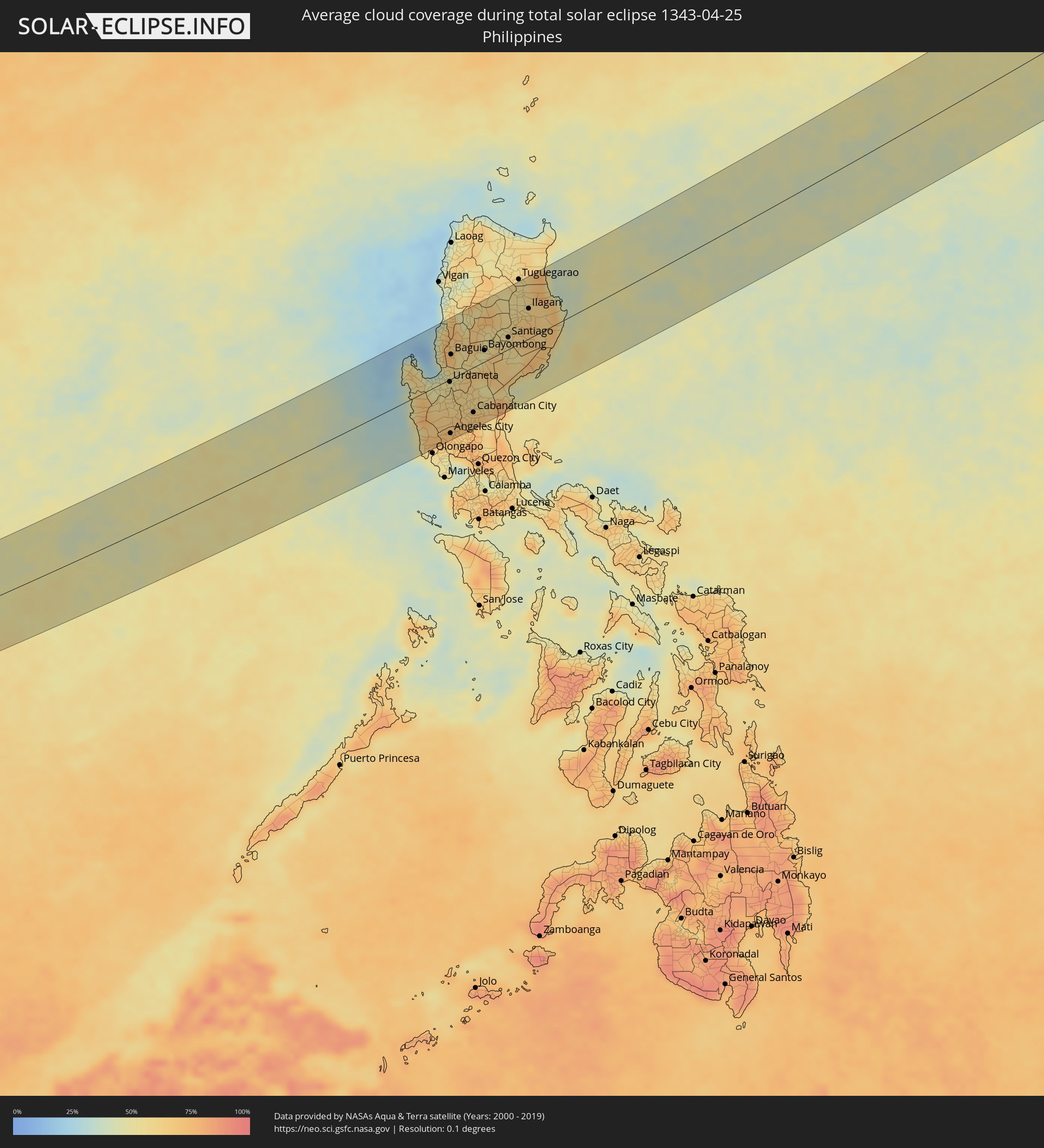 Philippinen
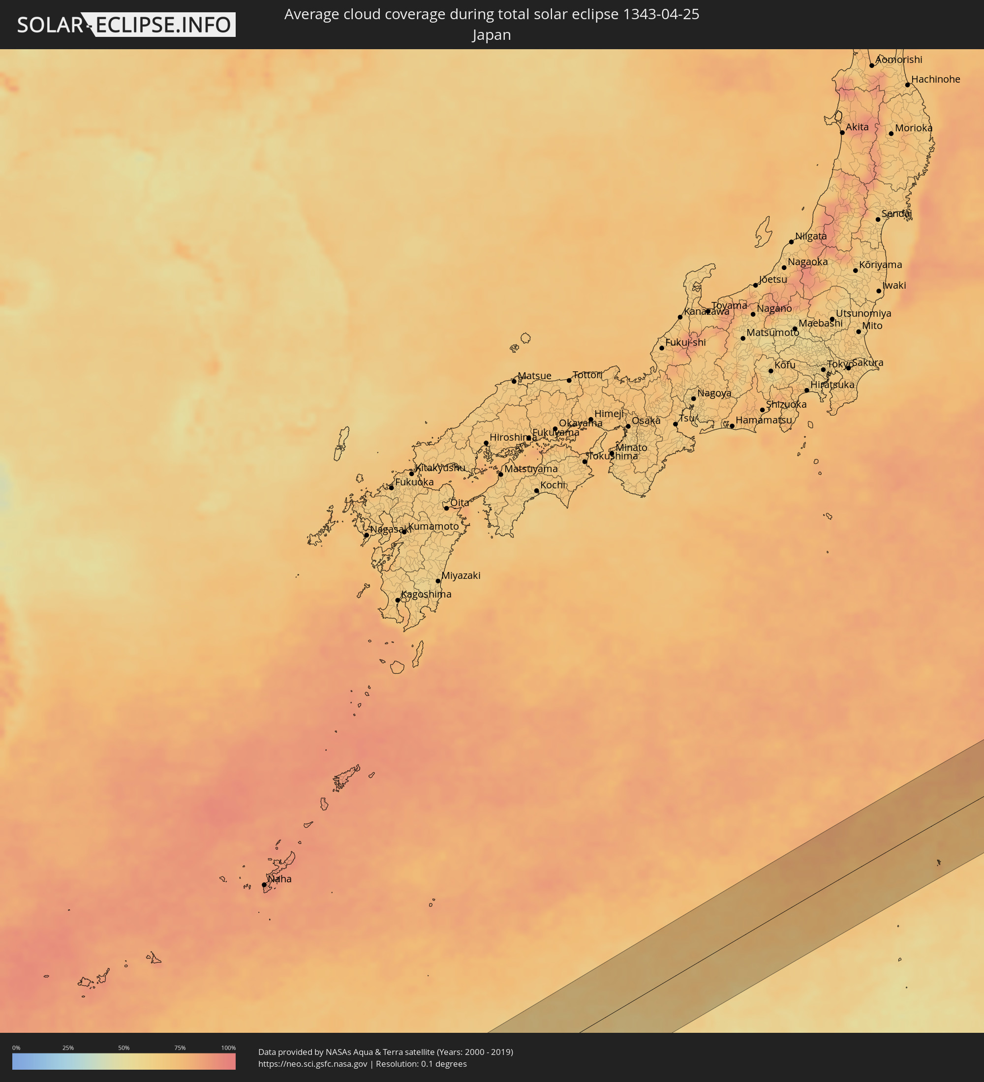 Japan
Japan
Orte im Finsternispfad
Die nachfolgene Tabelle zeigt Städte und Orte mit mehr als 5.000 Einwohnern, die sich im Finsternispfad befinden. Städte mit mehr als 100.000 Einwohnern sind dick gekennzeichnet. Mit einem Klick auf den Ort öffnet sich eine Detailkarte die die Lage des jeweiligen Ortes zusammen mit dem Verlauf der zentralen Finsternis präsentiert.
| Ort | Typ | Dauer der Verfinsterung | Ortszeit bei maximaler Verfinsterung | Entfernung zur Zentrallinie | Ø Bewölkung |
|
Sabang, Aceh
|
total | - | 06:45:28 UTC+07:07 | 22 km | 86% |
|
Banda Aceh, Aceh
|
total | - | 06:45:13 UTC+07:07 | 59 km | 89% |
|
Rawai, Phuket
|
total | - | 06:21:32 UTC+06:42 | 82 km | 80% |
|
Saladan, Krabi
|
total | - | 06:21:23 UTC+06:42 | 40 km | 74% |
|
Ko Lanta, Krabi
|
total | - | 06:21:19 UTC+06:42 | 30 km | 74% |
|
Kantang, Trang
|
total | - | 06:21:12 UTC+06:42 | 1 km | 80% |
|
Trang, Trang
|
total | - | 06:21:20 UTC+06:42 | 14 km | 89% |
|
Huai Yot, Trang
|
total | - | 06:21:31 UTC+06:42 | 38 km | 88% |
|
Thung Song, Nakhon Si Thammarat
|
total | - | 06:21:50 UTC+06:42 | 76 km | 89% |
|
Ron Phibun, Nakhon Si Thammarat
|
total | - | 06:21:50 UTC+06:42 | 71 km | 88% |
|
Phatthalung, Phatthalung
|
total | - | 06:21:23 UTC+06:42 | 4 km | 84% |
|
Pak Phanang, Nakhon Si Thammarat
|
total | - | 06:21:59 UTC+06:42 | 77 km | 77% |
|
Ranot, Songkhla
|
total | - | 06:21:31 UTC+06:42 | 13 km | 75% |
|
Hat Yai, Songkhla
|
total | - | 06:20:53 UTC+06:42 | 74 km | 89% |
|
Ban Mai, Songkhla
|
total | - | 06:21:03 UTC+06:42 | 56 km | 77% |
|
Na Mom, Songkhla
|
total | - | 06:20:51 UTC+06:42 | 82 km | 85% |
|
Songkhla, Songkhla
|
total | - | 06:21:03 UTC+06:42 | 58 km | 79% |
|
Rạch Giá, Kiến Giang
|
total | - | 06:48:34 UTC+07:06 | 72 km | 87% |
|
Cà Mau, Cà Mau
|
total | - | 06:47:48 UTC+07:06 | 18 km | 87% |
|
Vị Thanh, Hau Giang
|
total | - | 06:48:26 UTC+07:06 | 33 km | 84% |
|
Thành phố Bạc Liêu, Bạc Liêu
|
total | - | 06:48:01 UTC+07:06 | 28 km | 82% |
|
Sadek, Đồng Tháp
|
total | - | 06:48:58 UTC+07:06 | 75 km | 80% |
|
Cần Thơ, Cần Thơ
|
total | - | 06:48:44 UTC+07:06 | 47 km | 86% |
|
Sóc Trăng, Sóc Trăng
|
total | - | 06:48:21 UTC+07:06 | 6 km | 96% |
|
Vĩnh Long, Vĩnh Long
|
total | - | 06:48:59 UTC+07:06 | 62 km | 81% |
|
Ấp Tân Ngãi, Bến Tre
|
total | - | 06:49:02 UTC+07:06 | 48 km | 83% |
|
Trà Vinh, Trà Vinh
|
total | - | 06:48:46 UTC+07:06 | 16 km | 95% |
|
Mỹ Tho, Tiền Giang
|
total | - | 06:49:10 UTC+07:06 | 58 km | 86% |
|
Bến Tre, Bến Tre
|
total | - | 06:49:03 UTC+07:06 | 45 km | 81% |
|
Tân An, Long An
|
total | - | 06:49:21 UTC+07:06 | 74 km | 93% |
|
Cần Giuộc, Long An
|
total | - | 06:49:29 UTC+07:06 | 71 km | 85% |
|
Cần Giờ, Ho Chi Minh City
|
total | - | 06:49:21 UTC+07:06 | 40 km | 50% |
|
Vũng Tàu, Bà Rịa-Vũng Tàu
|
total | - | 06:49:20 UTC+07:06 | 28 km | 49% |
|
Thành Phố Bà Rịa, Bà Rịa-Vũng Tàu
|
total | - | 06:49:30 UTC+07:06 | 40 km | 71% |
|
La Gi, Bình Thuận
|
total | - | 06:49:49 UTC+07:06 | 33 km | 61% |
|
Phan Thiết, Bình Thuận
|
total | - | 06:50:11 UTC+07:06 | 47 km | 53% |
|
Phan Rang-Tháp Chàm, Ninh Thuận
|
total | - | 06:51:06 UTC+07:06 | 76 km | 62% |
|
Santa Cruz, Central Luzon
|
total | - | 07:55:19 UTC+08:00 | 8 km | 49% |
|
Masinloc, Central Luzon
|
total | - | 07:55:03 UTC+08:00 | 17 km | 65% |
|
Iba, Central Luzon
|
total | - | 07:54:49 UTC+08:00 | 39 km | 49% |
|
Alaminos, Ilocos
|
total | - | 07:55:53 UTC+08:00 | 43 km | 53% |
|
San Antonio, Central Luzon
|
total | - | 07:54:24 UTC+08:00 | 82 km | 57% |
|
Agoo, Ilocos
|
total | - | 07:55:53 UTC+08:00 | 30 km | 48% |
|
Lingayen, Ilocos
|
total | - | 07:55:54 UTC+08:00 | 17 km | 47% |
|
Subic, Central Luzon
|
total | - | 07:54:26 UTC+08:00 | 96 km | 57% |
|
San Fernando, Ilocos
|
total | - | 07:56:45 UTC+08:00 | 72 km | 37% |
|
Urbiztondo, Ilocos
|
total | - | 07:55:43 UTC+08:00 | 7 km | 49% |
|
Aringay, Ilocos
|
total | - | 07:56:29 UTC+08:00 | 48 km | 55% |
|
Mangaldan, Ilocos
|
total | - | 07:56:06 UTC+08:00 | 14 km | 43% |
|
Camiling, Central Luzon
|
total | - | 07:55:37 UTC+08:00 | 25 km | 61% |
|
Tagudin, Ilocos
|
total | - | 07:57:17 UTC+08:00 | 97 km | 47% |
|
Sison, Ilocos
|
total | - | 07:56:20 UTC+08:00 | 19 km | 54% |
|
Alcala, Ilocos
|
total | - | 07:55:55 UTC+08:00 | 14 km | 55% |
|
Urdaneta, Ilocos
|
total | - | 07:56:07 UTC+08:00 | 4 km | 52% |
|
Paniqui, Central Luzon
|
total | - | 07:55:44 UTC+08:00 | 35 km | 59% |
|
Angeles City, Central Luzon
|
total | - | 07:55:04 UTC+08:00 | 86 km | 71% |
|
Capas, Central Luzon
|
total | - | 07:55:18 UTC+08:00 | 69 km | 69% |
|
Baguio, Cordillera
|
total | - | 07:56:43 UTC+08:00 | 39 km | 69% |
|
Tarlac City, Central Luzon
|
total | - | 07:55:30 UTC+08:00 | 54 km | 66% |
|
Kibungan, Cordillera
|
total | - | 07:57:08 UTC+08:00 | 63 km | 67% |
|
Cuyapo, Central Luzon
|
total | - | 07:55:57 UTC+08:00 | 28 km | 63% |
|
Guiset East, Ilocos
|
total | - | 07:56:20 UTC+08:00 | 0 km | 53% |
|
Guimba, Central Luzon
|
total | - | 07:55:52 UTC+08:00 | 45 km | 61% |
|
Arayat, Central Luzon
|
total | - | 07:55:13 UTC+08:00 | 95 km | 65% |
|
Mankayan, Cordillera
|
total | - | 07:57:28 UTC+08:00 | 74 km | 53% |
|
Lupao, Central Luzon
|
total | - | 07:56:16 UTC+08:00 | 29 km | 64% |
|
Muñoz, Central Luzon
|
total | - | 07:56:03 UTC+08:00 | 46 km | 59% |
|
Gapan, Central Luzon
|
total | - | 07:55:34 UTC+08:00 | 88 km | 75% |
|
Cabanatuan City, Central Luzon
|
total | - | 07:55:48 UTC+08:00 | 72 km | 69% |
|
Bontoc, Cordillera
|
total | - | 07:57:56 UTC+08:00 | 86 km | 58% |
|
Aritao, Cagayan Valley
|
total | - | 07:56:56 UTC+08:00 | 5 km | 53% |
|
Carranglan, Central Luzon
|
total | - | 07:56:30 UTC+08:00 | 29 km | 55% |
|
Bongabon, Central Luzon
|
total | - | 07:56:09 UTC+08:00 | 66 km | 68% |
|
Bayombong, Cagayan Valley
|
total | - | 07:57:16 UTC+08:00 | 18 km | 49% |
|
Diadi, Cagayan Valley
|
total | - | 07:57:46 UTC+08:00 | 32 km | 57% |
|
Santiago, Cagayan Valley
|
total | - | 07:57:53 UTC+08:00 | 19 km | 57% |
|
Saguday, Cagayan Valley
|
total | - | 07:57:42 UTC+08:00 | 4 km | 57% |
|
San Mateo, Cagayan Valley
|
total | - | 07:58:10 UTC+08:00 | 36 km | 58% |
|
Quezon, Cagayan Valley
|
total | - | 07:58:46 UTC+08:00 | 77 km | 54% |
|
Roxas, Cagayan Valley
|
total | - | 07:58:31 UTC+08:00 | 58 km | 57% |
|
Maddela, Cagayan Valley
|
total | - | 07:57:32 UTC+08:00 | 22 km | 59% |
|
Alicia, Cagayan Valley
|
total | - | 07:58:08 UTC+08:00 | 20 km | 64% |
|
Enrile, Cagayan Valley
|
total | - | 07:59:11 UTC+08:00 | 97 km | 56% |
|
Cabagan, Cagayan Valley
|
total | - | 07:59:04 UTC+08:00 | 81 km | 58% |
|
Naguilian, Cagayan Valley
|
total | - | 07:58:35 UTC+08:00 | 37 km | 66% |
|
Ilagan, Cagayan Valley
|
total | - | 07:58:48 UTC+08:00 | 47 km | 65% |
|
San Mariano, Cagayan Valley
|
total | - | 07:58:41 UTC+08:00 | 25 km | 67% |