Total solar eclipse of 04/25/1343
| Day of week: | Thursday |
| Maximum duration of eclipse: | 05m02s |
| Maximum width of eclipse path: | 206 km |
| Saros cycle: | 108 |
| Coverage: | 100% |
| Magnitude: | 1.0597 |
| Gamma: | 0.3077 |
Wo kann man die Sonnenfinsternis vom 04/25/1343 sehen?
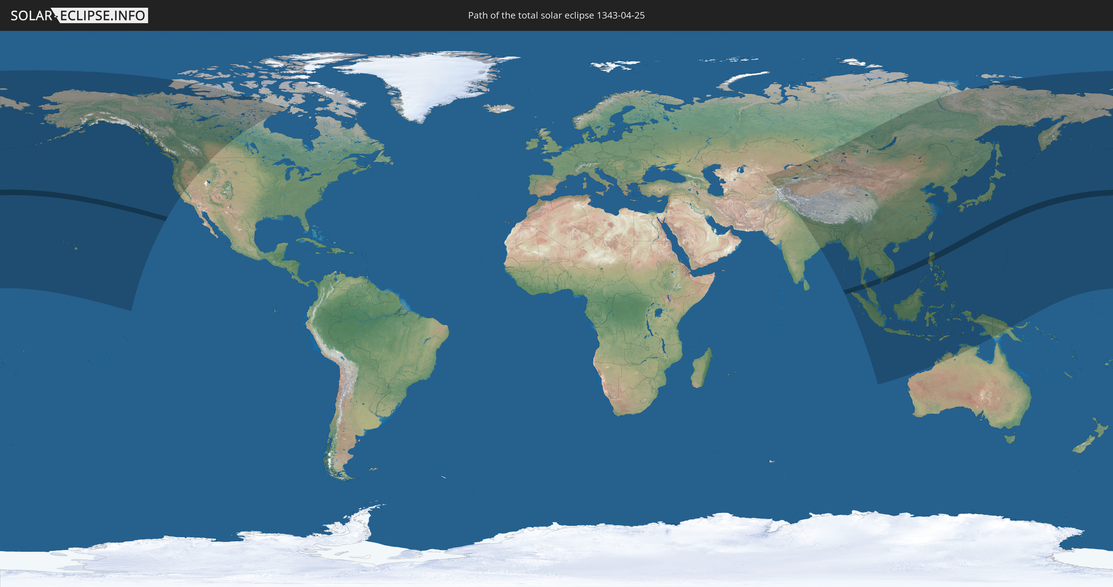
Die Sonnenfinsternis am 04/25/1343 kann man in 42 Ländern als partielle Sonnenfinsternis beobachten.
Der Finsternispfad verläuft durch 5 Länder. Nur in diesen Ländern ist sie als total Sonnenfinsternis zu sehen.
In den folgenden Ländern ist die Sonnenfinsternis total zu sehen
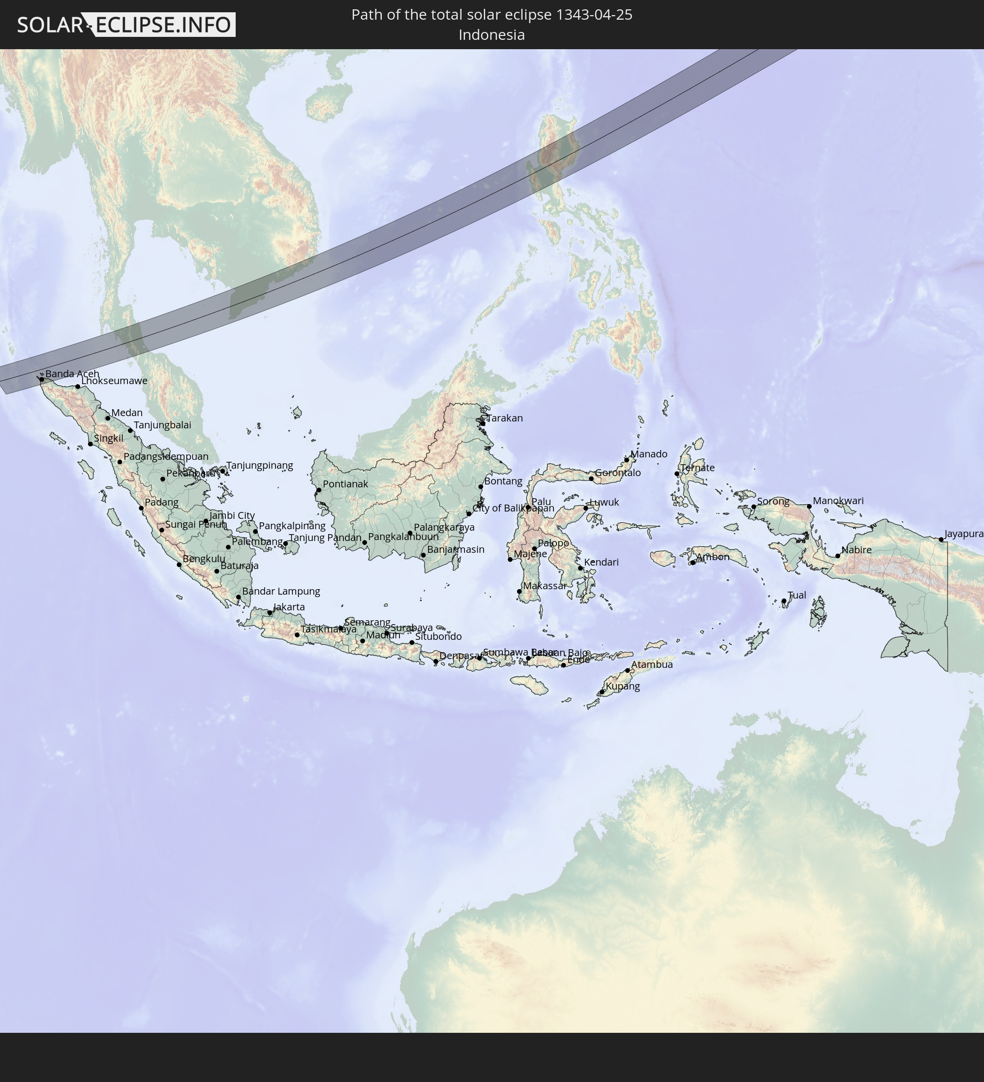 Indonesia
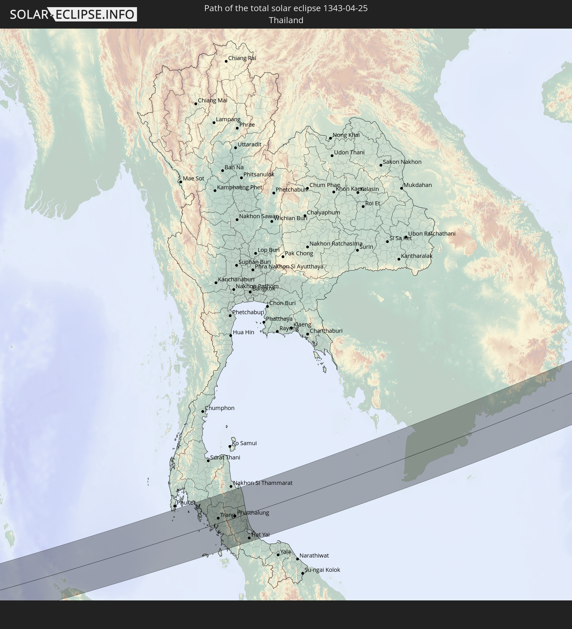 Thailand
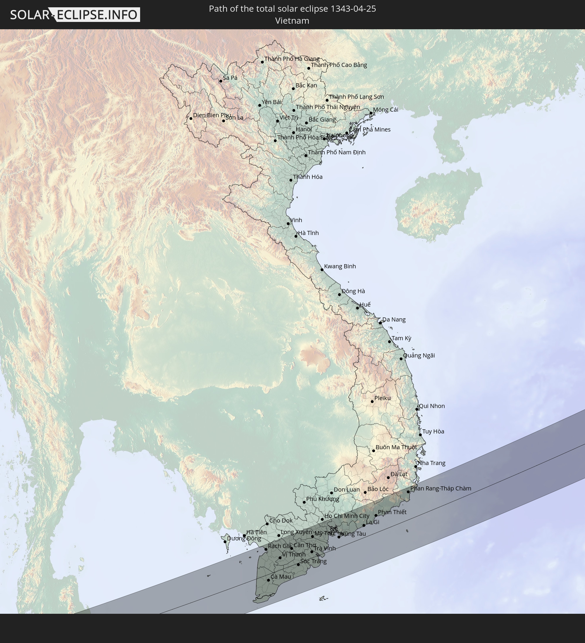 Vietnam
 Philippines
 Japan
Japan
In den folgenden Ländern ist die Sonnenfinsternis partiell zu sehen
 Russia
 United States
 United States Minor Outlying Islands
 Canada
 Greenland
 Kazakhstan
 Uzbekistan
 Afghanistan
 Pakistan
 Tajikistan
 India
India
 Kyrgyzstan
 China
China
 Nepal
Nepal
 Mongolia
 Bangladesh
 Bhutan
 Myanmar
 Indonesia
 Thailand
 Malaysia
 Laos
Laos
 Vietnam
 Cambodia
 Singapore
 Christmas Island
 Australia
 Macau
Macau
 Hong Kong
 Brunei
 Taiwan
 Philippines
 Japan
Japan
 East Timor
 North Korea
 South Korea
 Palau
Palau
 Federated States of Micronesia
 Papua New Guinea
 Guam
Guam
 Northern Mariana Islands
 Marshall Islands
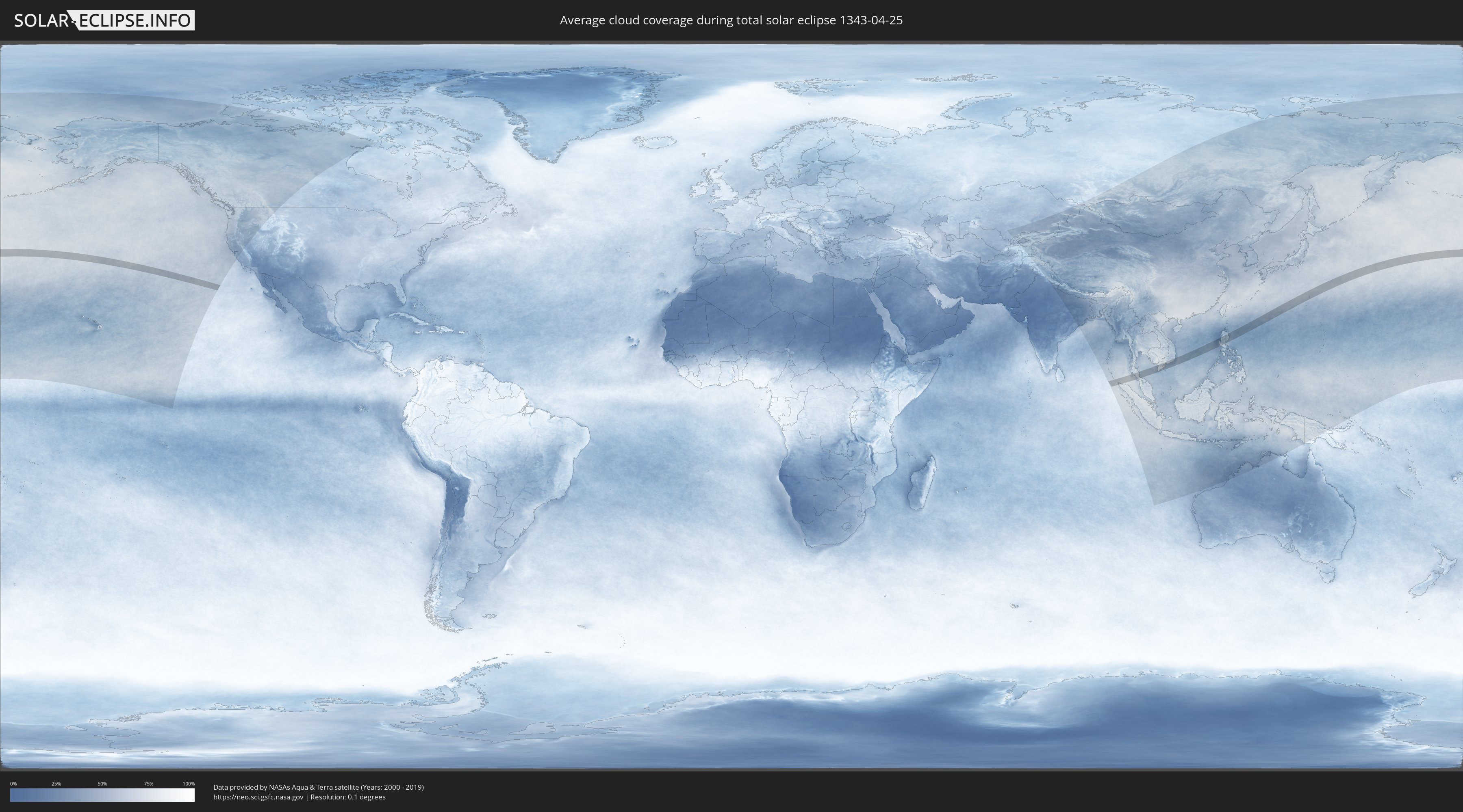
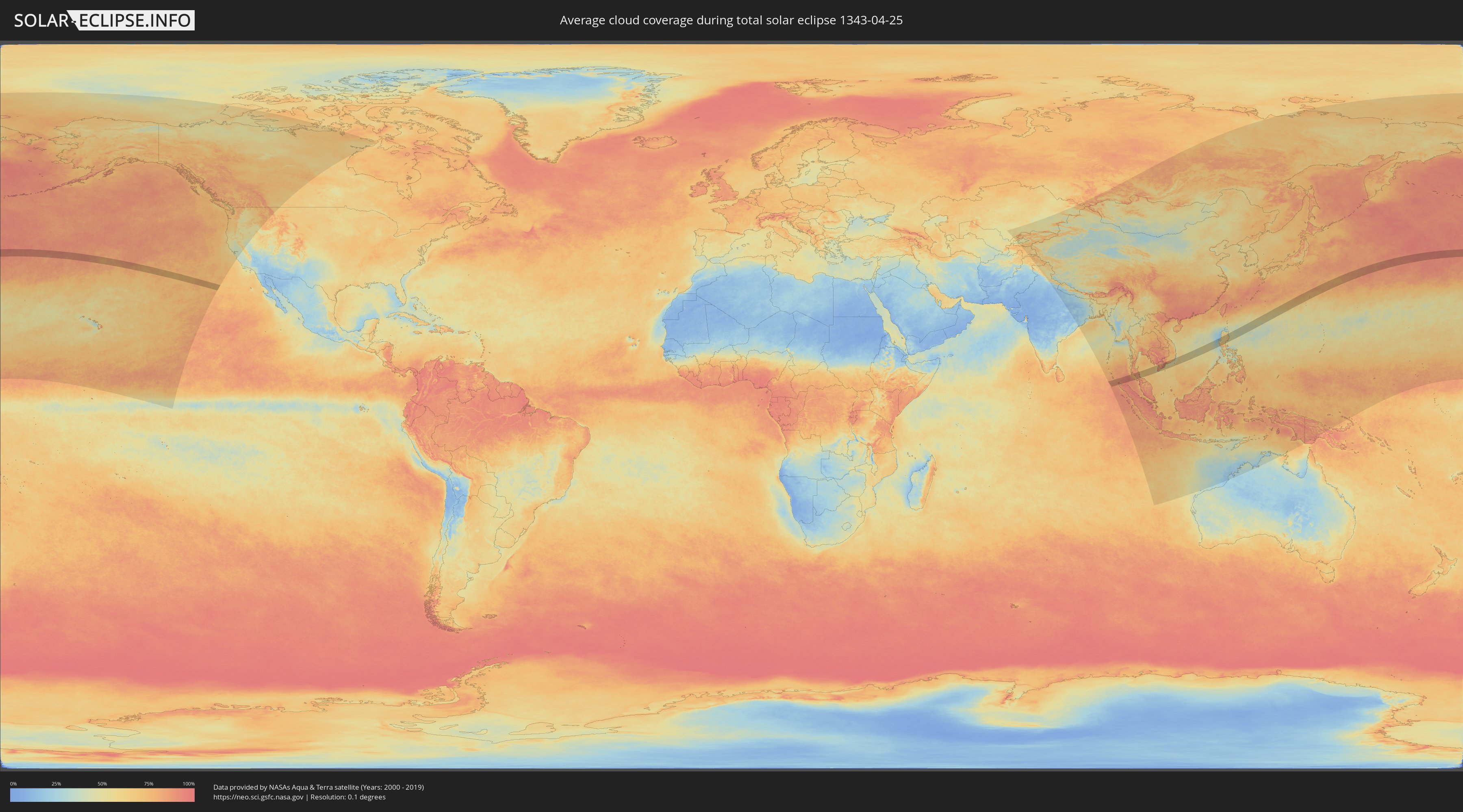
How will be the weather during the total solar eclipse on 04/25/1343?
Where is the best place to see the total solar eclipse of 04/25/1343?
The following maps show the average cloud coverage for the day of the total solar eclipse.
With the help of these maps, it is possible to find the place along the eclipse path, which has the best
chance of a cloudless sky.
Nevertheless, you should consider local circumstances and inform about the weather of your chosen
observation site.
The data is provided by NASAs satellites
AQUA and TERRA.
The cloud maps are averaged over a period of 19 years (2000 - 2019).
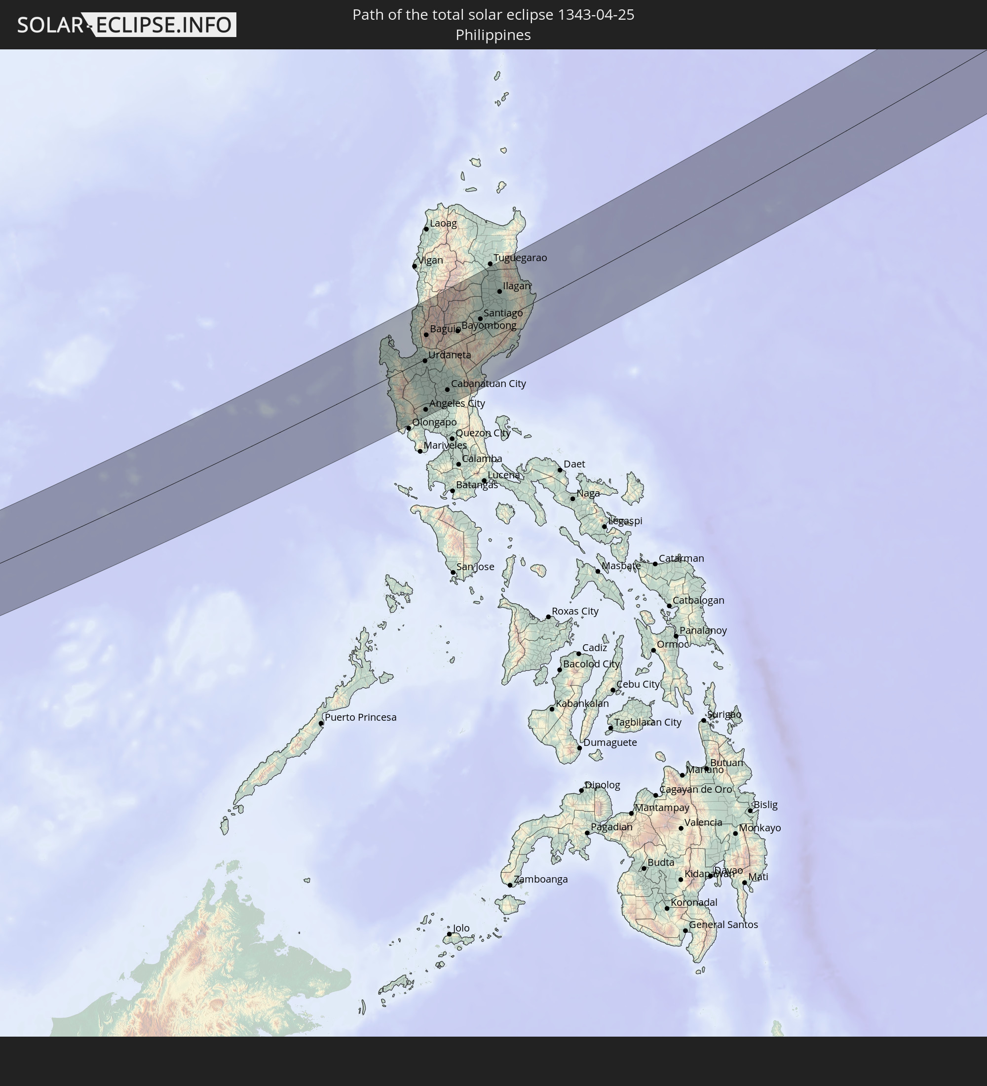
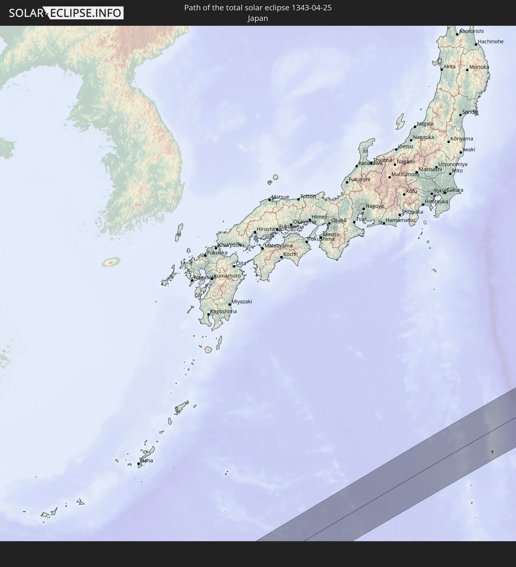
Detailed country maps
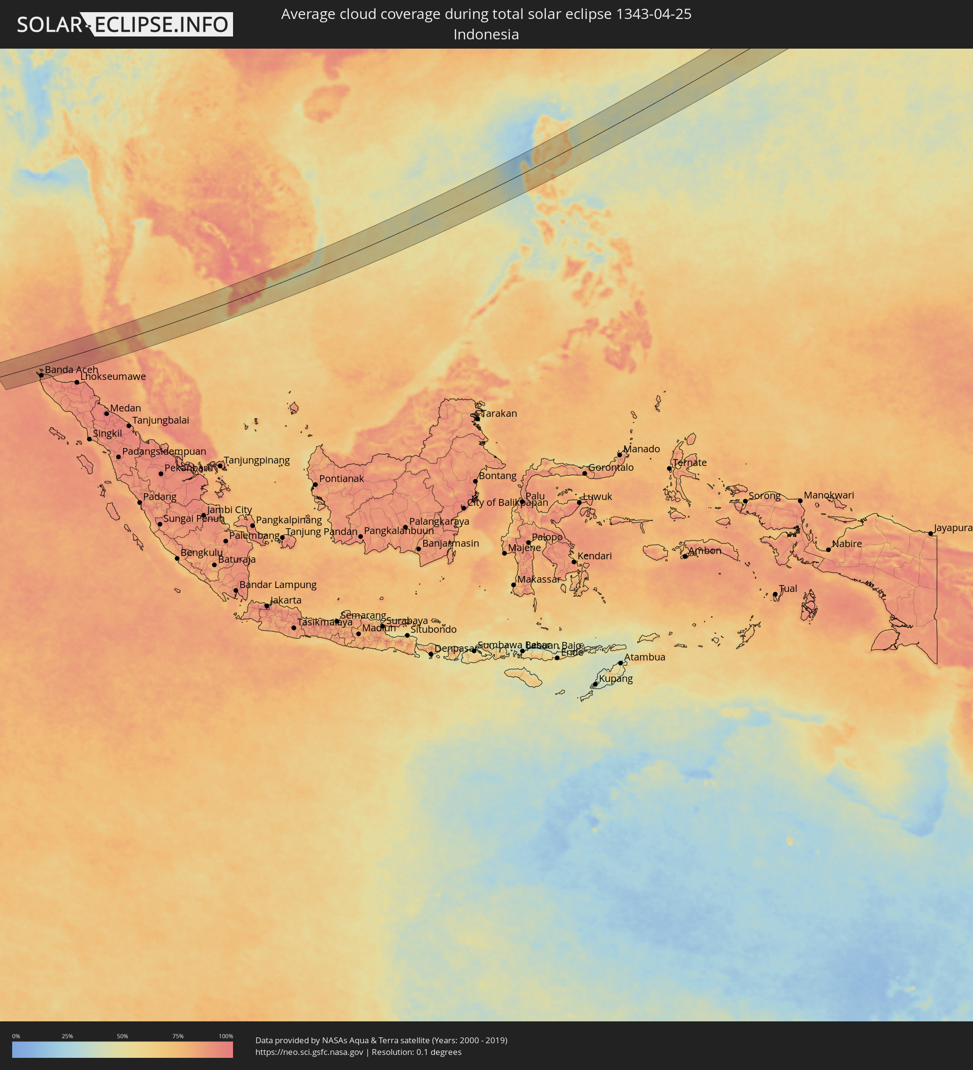 Indonesia
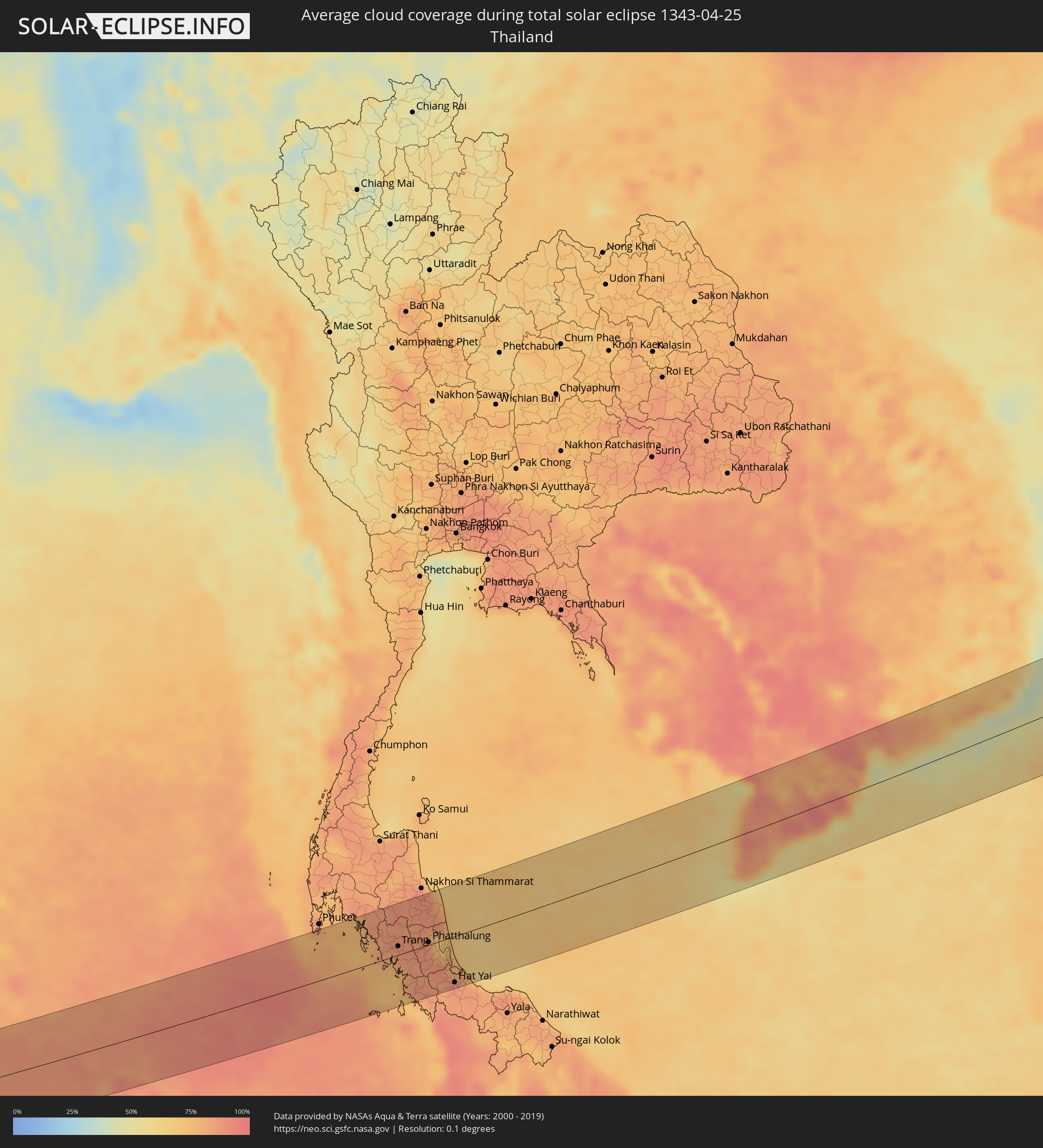 Thailand
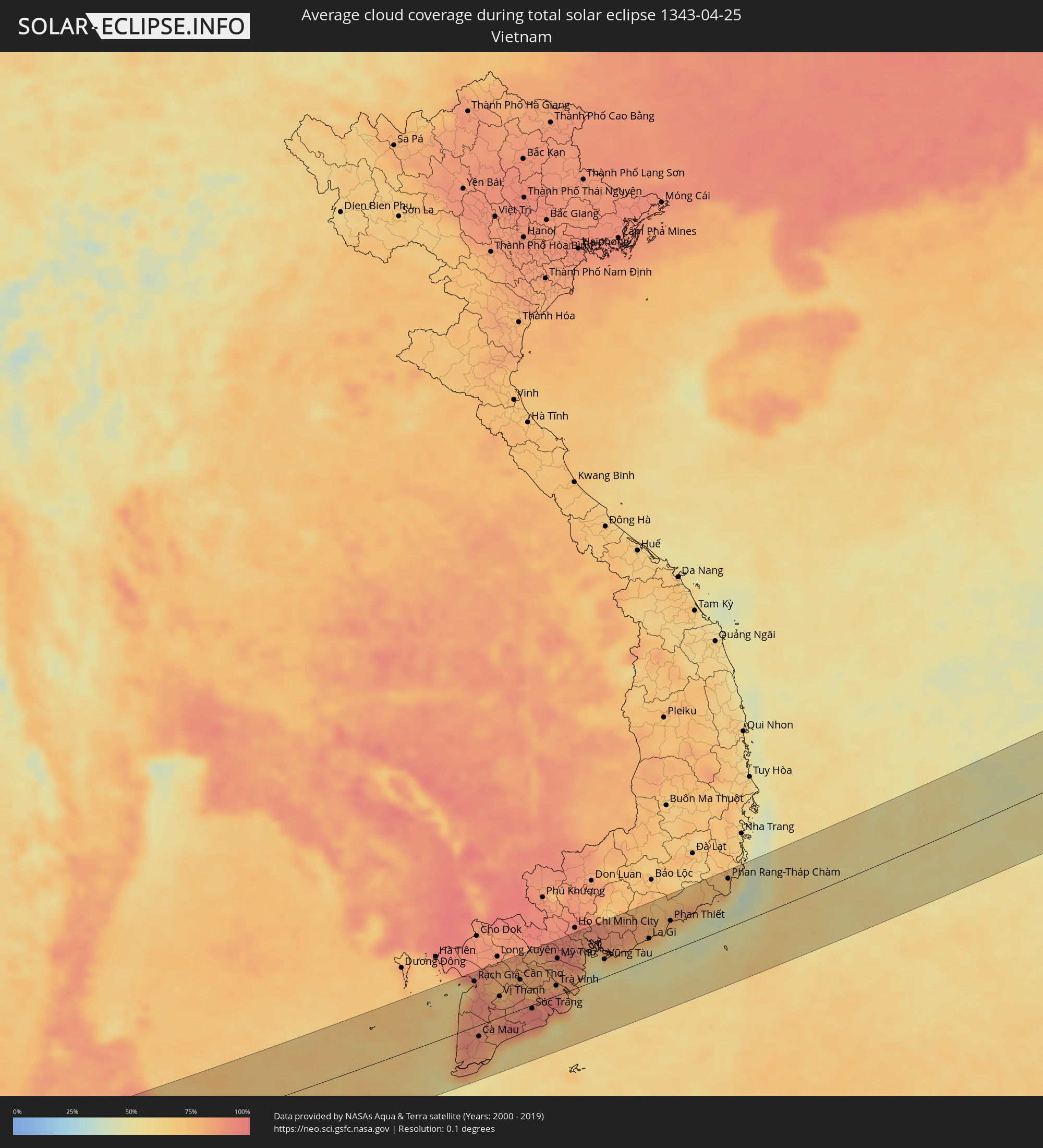 Vietnam
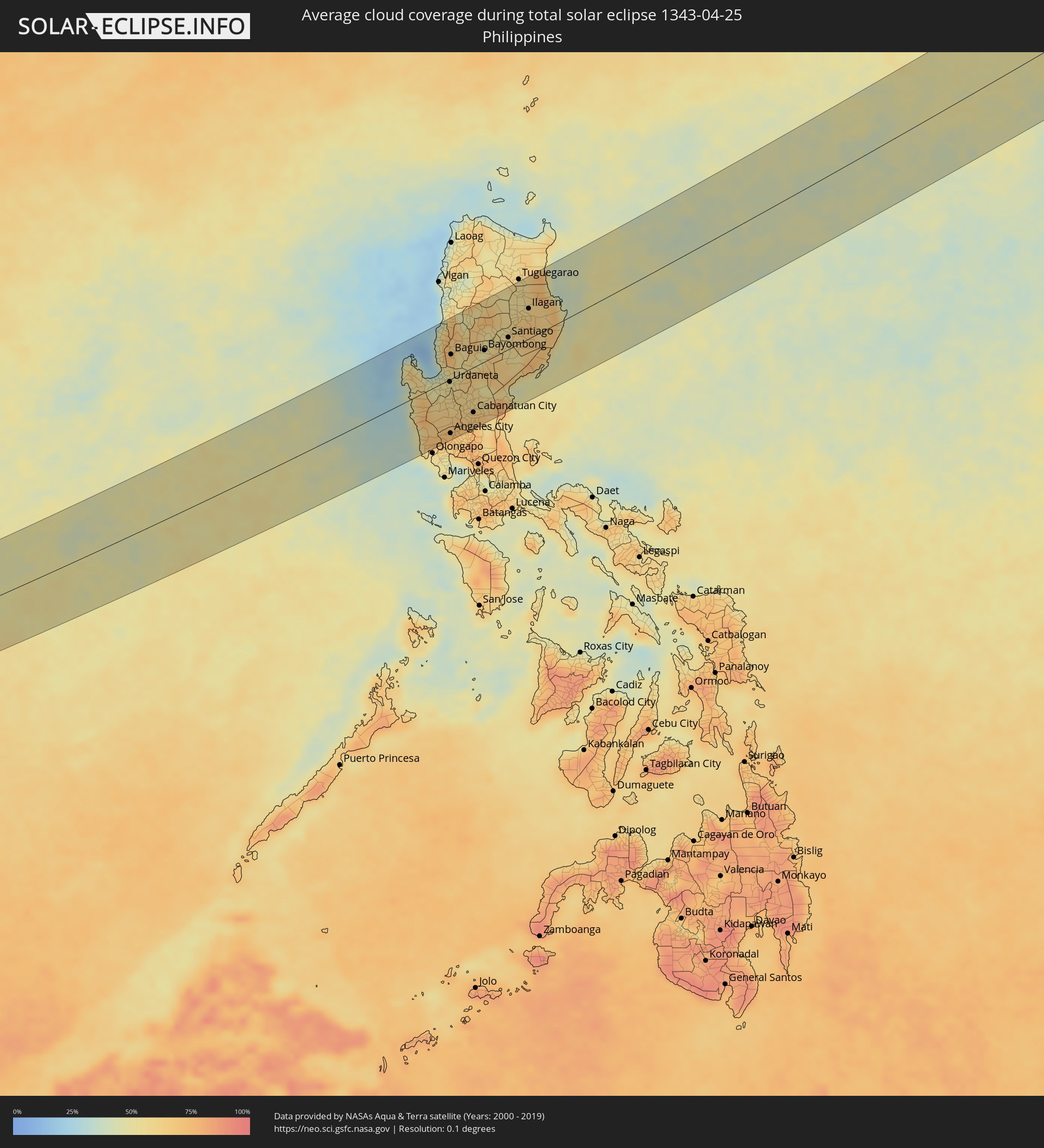 Philippines
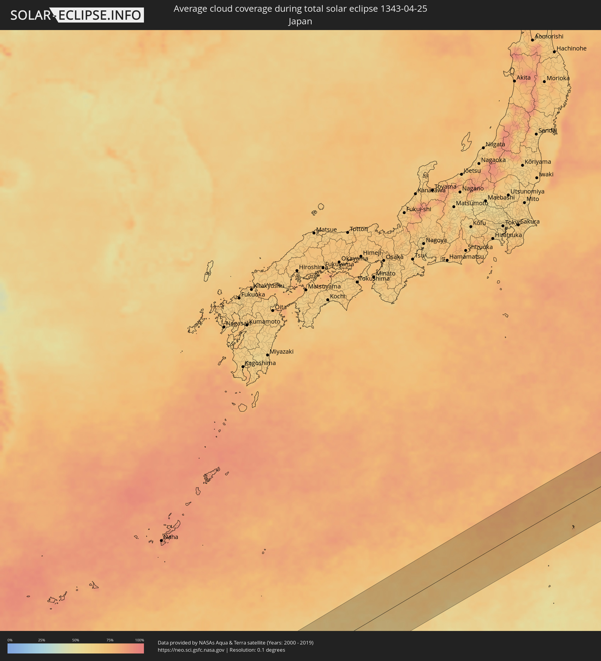 Japan
Japan
Cities inside the path of the eclipse
The following table shows all locations with a population of more than 5,000 inside the eclipse path. Cities which have more than 100,000 inhabitants are marked bold. A click at the locations opens a detailed map.
| City | Type | Eclipse duration | Local time of max. eclipse | Distance to central line | Ø Cloud coverage |
|
Sabang, Aceh
|
total | - | 06:45:28 UTC+07:07 | 22 km | 86% |
|
Banda Aceh, Aceh
|
total | - | 06:45:13 UTC+07:07 | 59 km | 89% |
|
Rawai, Phuket
|
total | - | 06:21:32 UTC+06:42 | 82 km | 80% |
|
Saladan, Krabi
|
total | - | 06:21:23 UTC+06:42 | 40 km | 74% |
|
Ko Lanta, Krabi
|
total | - | 06:21:19 UTC+06:42 | 30 km | 74% |
|
Kantang, Trang
|
total | - | 06:21:12 UTC+06:42 | 1 km | 80% |
|
Trang, Trang
|
total | - | 06:21:20 UTC+06:42 | 14 km | 89% |
|
Huai Yot, Trang
|
total | - | 06:21:31 UTC+06:42 | 38 km | 88% |
|
Thung Song, Nakhon Si Thammarat
|
total | - | 06:21:50 UTC+06:42 | 76 km | 89% |
|
Ron Phibun, Nakhon Si Thammarat
|
total | - | 06:21:50 UTC+06:42 | 71 km | 88% |
|
Phatthalung, Phatthalung
|
total | - | 06:21:23 UTC+06:42 | 4 km | 84% |
|
Pak Phanang, Nakhon Si Thammarat
|
total | - | 06:21:59 UTC+06:42 | 77 km | 77% |
|
Ranot, Songkhla
|
total | - | 06:21:31 UTC+06:42 | 13 km | 75% |
|
Hat Yai, Songkhla
|
total | - | 06:20:53 UTC+06:42 | 74 km | 89% |
|
Ban Mai, Songkhla
|
total | - | 06:21:03 UTC+06:42 | 56 km | 77% |
|
Na Mom, Songkhla
|
total | - | 06:20:51 UTC+06:42 | 82 km | 85% |
|
Songkhla, Songkhla
|
total | - | 06:21:03 UTC+06:42 | 58 km | 79% |
|
Rạch Giá, Kiến Giang
|
total | - | 06:48:34 UTC+07:06 | 72 km | 87% |
|
Cà Mau, Cà Mau
|
total | - | 06:47:48 UTC+07:06 | 18 km | 87% |
|
Vị Thanh, Hau Giang
|
total | - | 06:48:26 UTC+07:06 | 33 km | 84% |
|
Thành phố Bạc Liêu, Bạc Liêu
|
total | - | 06:48:01 UTC+07:06 | 28 km | 82% |
|
Sadek, Đồng Tháp
|
total | - | 06:48:58 UTC+07:06 | 75 km | 80% |
|
Cần Thơ, Cần Thơ
|
total | - | 06:48:44 UTC+07:06 | 47 km | 86% |
|
Sóc Trăng, Sóc Trăng
|
total | - | 06:48:21 UTC+07:06 | 6 km | 96% |
|
Vĩnh Long, Vĩnh Long
|
total | - | 06:48:59 UTC+07:06 | 62 km | 81% |
|
Ấp Tân Ngãi, Bến Tre
|
total | - | 06:49:02 UTC+07:06 | 48 km | 83% |
|
Trà Vinh, Trà Vinh
|
total | - | 06:48:46 UTC+07:06 | 16 km | 95% |
|
Mỹ Tho, Tiền Giang
|
total | - | 06:49:10 UTC+07:06 | 58 km | 86% |
|
Bến Tre, Bến Tre
|
total | - | 06:49:03 UTC+07:06 | 45 km | 81% |
|
Tân An, Long An
|
total | - | 06:49:21 UTC+07:06 | 74 km | 93% |
|
Cần Giuộc, Long An
|
total | - | 06:49:29 UTC+07:06 | 71 km | 85% |
|
Cần Giờ, Ho Chi Minh City
|
total | - | 06:49:21 UTC+07:06 | 40 km | 50% |
|
Vũng Tàu, Bà Rịa-Vũng Tàu
|
total | - | 06:49:20 UTC+07:06 | 28 km | 49% |
|
Thành Phố Bà Rịa, Bà Rịa-Vũng Tàu
|
total | - | 06:49:30 UTC+07:06 | 40 km | 71% |
|
La Gi, Bình Thuận
|
total | - | 06:49:49 UTC+07:06 | 33 km | 61% |
|
Phan Thiết, Bình Thuận
|
total | - | 06:50:11 UTC+07:06 | 47 km | 53% |
|
Phan Rang-Tháp Chàm, Ninh Thuận
|
total | - | 06:51:06 UTC+07:06 | 76 km | 62% |
|
Santa Cruz, Central Luzon
|
total | - | 07:55:19 UTC+08:00 | 8 km | 49% |
|
Masinloc, Central Luzon
|
total | - | 07:55:03 UTC+08:00 | 17 km | 65% |
|
Iba, Central Luzon
|
total | - | 07:54:49 UTC+08:00 | 39 km | 49% |
|
Alaminos, Ilocos
|
total | - | 07:55:53 UTC+08:00 | 43 km | 53% |
|
San Antonio, Central Luzon
|
total | - | 07:54:24 UTC+08:00 | 82 km | 57% |
|
Agoo, Ilocos
|
total | - | 07:55:53 UTC+08:00 | 30 km | 48% |
|
Lingayen, Ilocos
|
total | - | 07:55:54 UTC+08:00 | 17 km | 47% |
|
Subic, Central Luzon
|
total | - | 07:54:26 UTC+08:00 | 96 km | 57% |
|
San Fernando, Ilocos
|
total | - | 07:56:45 UTC+08:00 | 72 km | 37% |
|
Urbiztondo, Ilocos
|
total | - | 07:55:43 UTC+08:00 | 7 km | 49% |
|
Aringay, Ilocos
|
total | - | 07:56:29 UTC+08:00 | 48 km | 55% |
|
Mangaldan, Ilocos
|
total | - | 07:56:06 UTC+08:00 | 14 km | 43% |
|
Camiling, Central Luzon
|
total | - | 07:55:37 UTC+08:00 | 25 km | 61% |
|
Tagudin, Ilocos
|
total | - | 07:57:17 UTC+08:00 | 97 km | 47% |
|
Sison, Ilocos
|
total | - | 07:56:20 UTC+08:00 | 19 km | 54% |
|
Alcala, Ilocos
|
total | - | 07:55:55 UTC+08:00 | 14 km | 55% |
|
Urdaneta, Ilocos
|
total | - | 07:56:07 UTC+08:00 | 4 km | 52% |
|
Paniqui, Central Luzon
|
total | - | 07:55:44 UTC+08:00 | 35 km | 59% |
|
Angeles City, Central Luzon
|
total | - | 07:55:04 UTC+08:00 | 86 km | 71% |
|
Capas, Central Luzon
|
total | - | 07:55:18 UTC+08:00 | 69 km | 69% |
|
Baguio, Cordillera
|
total | - | 07:56:43 UTC+08:00 | 39 km | 69% |
|
Tarlac City, Central Luzon
|
total | - | 07:55:30 UTC+08:00 | 54 km | 66% |
|
Kibungan, Cordillera
|
total | - | 07:57:08 UTC+08:00 | 63 km | 67% |
|
Cuyapo, Central Luzon
|
total | - | 07:55:57 UTC+08:00 | 28 km | 63% |
|
Guiset East, Ilocos
|
total | - | 07:56:20 UTC+08:00 | 0 km | 53% |
|
Guimba, Central Luzon
|
total | - | 07:55:52 UTC+08:00 | 45 km | 61% |
|
Arayat, Central Luzon
|
total | - | 07:55:13 UTC+08:00 | 95 km | 65% |
|
Mankayan, Cordillera
|
total | - | 07:57:28 UTC+08:00 | 74 km | 53% |
|
Lupao, Central Luzon
|
total | - | 07:56:16 UTC+08:00 | 29 km | 64% |
|
Muñoz, Central Luzon
|
total | - | 07:56:03 UTC+08:00 | 46 km | 59% |
|
Gapan, Central Luzon
|
total | - | 07:55:34 UTC+08:00 | 88 km | 75% |
|
Cabanatuan City, Central Luzon
|
total | - | 07:55:48 UTC+08:00 | 72 km | 69% |
|
Bontoc, Cordillera
|
total | - | 07:57:56 UTC+08:00 | 86 km | 58% |
|
Aritao, Cagayan Valley
|
total | - | 07:56:56 UTC+08:00 | 5 km | 53% |
|
Carranglan, Central Luzon
|
total | - | 07:56:30 UTC+08:00 | 29 km | 55% |
|
Bongabon, Central Luzon
|
total | - | 07:56:09 UTC+08:00 | 66 km | 68% |
|
Bayombong, Cagayan Valley
|
total | - | 07:57:16 UTC+08:00 | 18 km | 49% |
|
Diadi, Cagayan Valley
|
total | - | 07:57:46 UTC+08:00 | 32 km | 57% |
|
Santiago, Cagayan Valley
|
total | - | 07:57:53 UTC+08:00 | 19 km | 57% |
|
Saguday, Cagayan Valley
|
total | - | 07:57:42 UTC+08:00 | 4 km | 57% |
|
San Mateo, Cagayan Valley
|
total | - | 07:58:10 UTC+08:00 | 36 km | 58% |
|
Quezon, Cagayan Valley
|
total | - | 07:58:46 UTC+08:00 | 77 km | 54% |
|
Roxas, Cagayan Valley
|
total | - | 07:58:31 UTC+08:00 | 58 km | 57% |
|
Maddela, Cagayan Valley
|
total | - | 07:57:32 UTC+08:00 | 22 km | 59% |
|
Alicia, Cagayan Valley
|
total | - | 07:58:08 UTC+08:00 | 20 km | 64% |
|
Enrile, Cagayan Valley
|
total | - | 07:59:11 UTC+08:00 | 97 km | 56% |
|
Cabagan, Cagayan Valley
|
total | - | 07:59:04 UTC+08:00 | 81 km | 58% |
|
Naguilian, Cagayan Valley
|
total | - | 07:58:35 UTC+08:00 | 37 km | 66% |
|
Ilagan, Cagayan Valley
|
total | - | 07:58:48 UTC+08:00 | 47 km | 65% |
|
San Mariano, Cagayan Valley
|
total | - | 07:58:41 UTC+08:00 | 25 km | 67% |