Totale Sonnenfinsternis vom 07.08.1347
| Wochentag: | Montag |
| Maximale Dauer der Verfinsterung: | 05m48s |
| Maximale Breite des Finsternispfades: | 204 km |
| Saroszyklus: | 115 |
| Bedeckungsgrad: | 100% |
| Magnitude: | 1.0618 |
| Gamma: | -0.1116 |
Wo kann man die Sonnenfinsternis vom 07.08.1347 sehen?
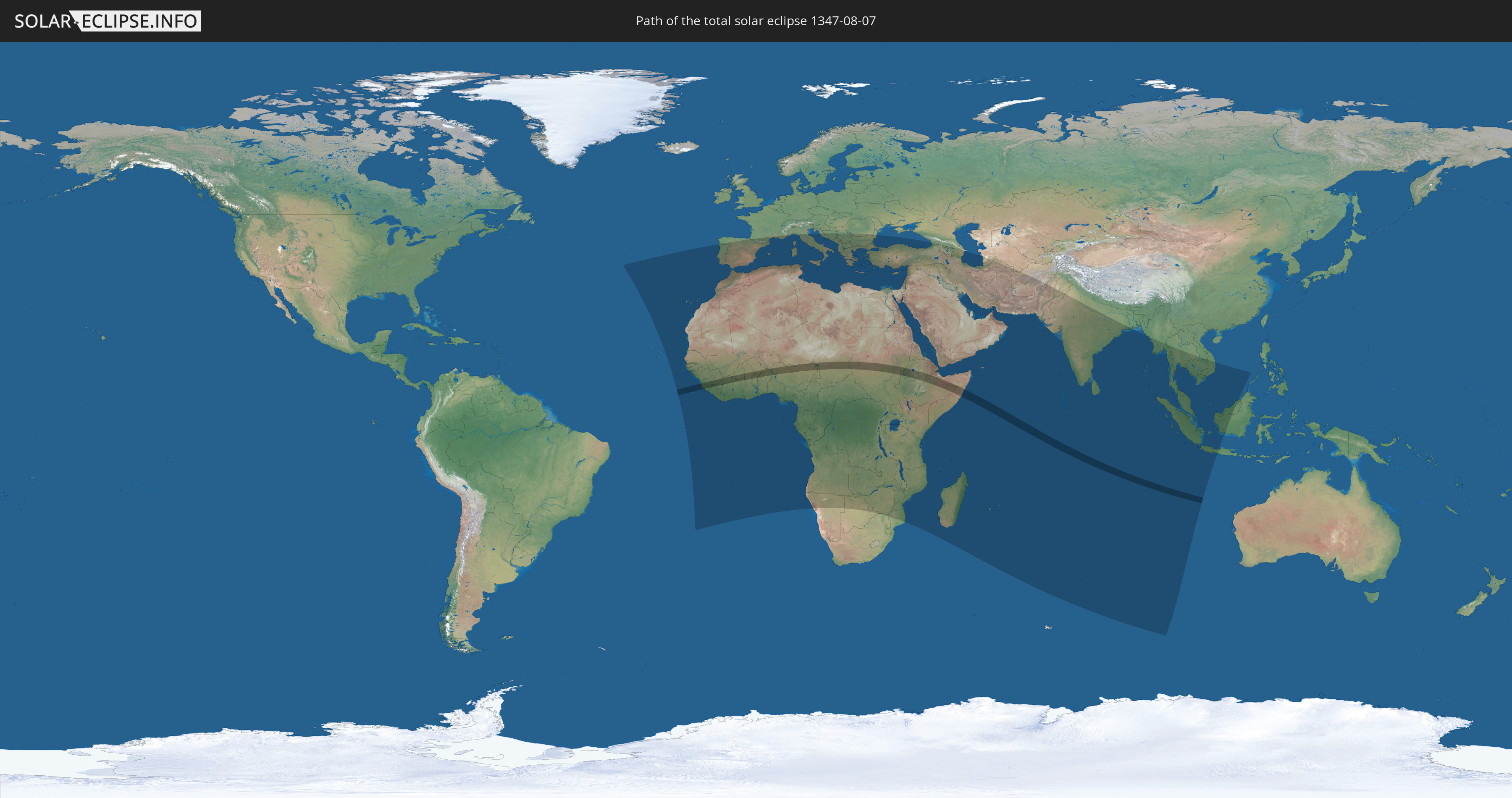
Die Sonnenfinsternis am 07.08.1347 kann man in 111 Ländern als partielle Sonnenfinsternis beobachten.
Der Finsternispfad verläuft durch 18 Länder. Nur in diesen Ländern ist sie als totale Sonnenfinsternis zu sehen.
In den folgenden Ländern ist die Sonnenfinsternis total zu sehen
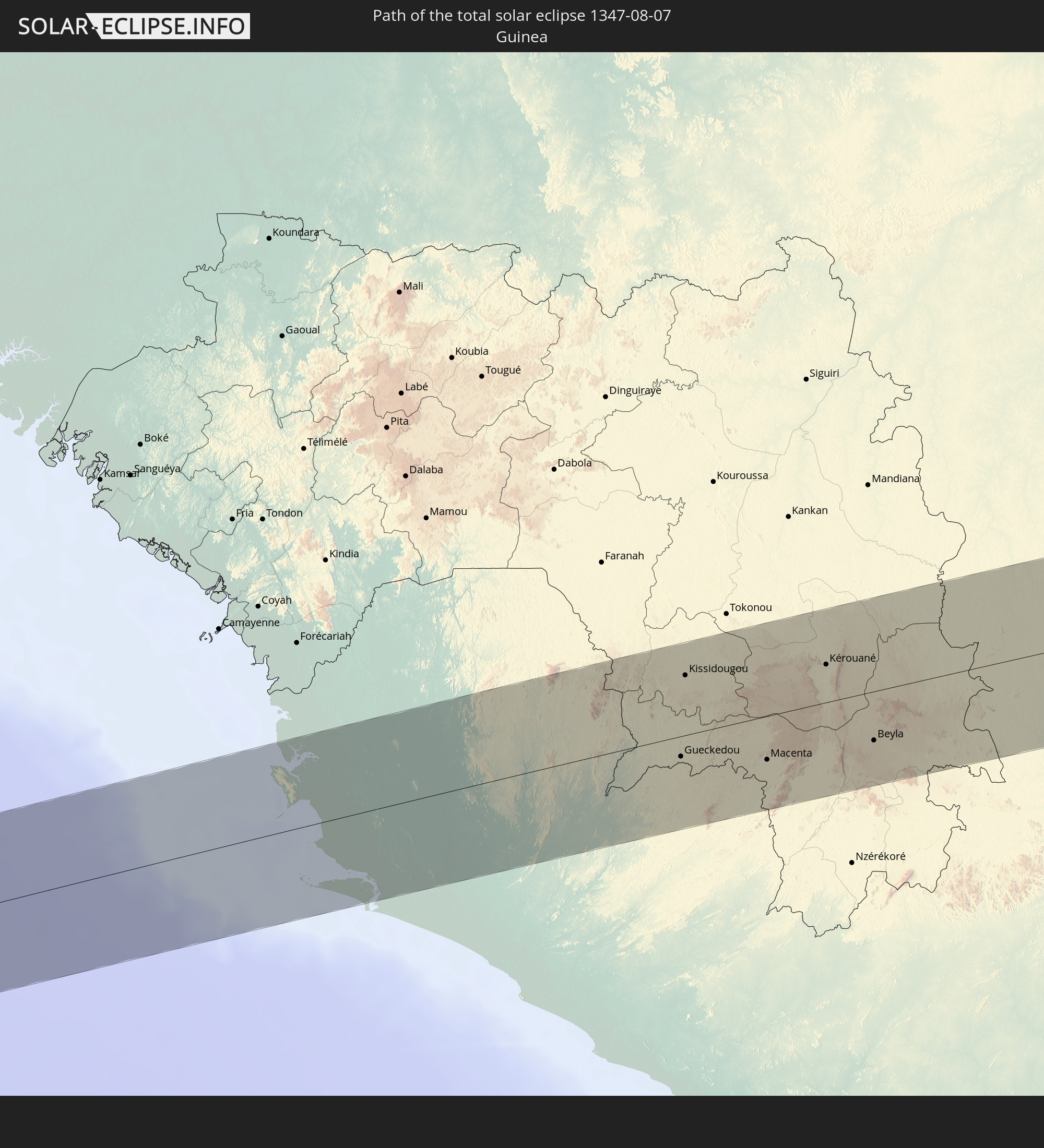 Guinea
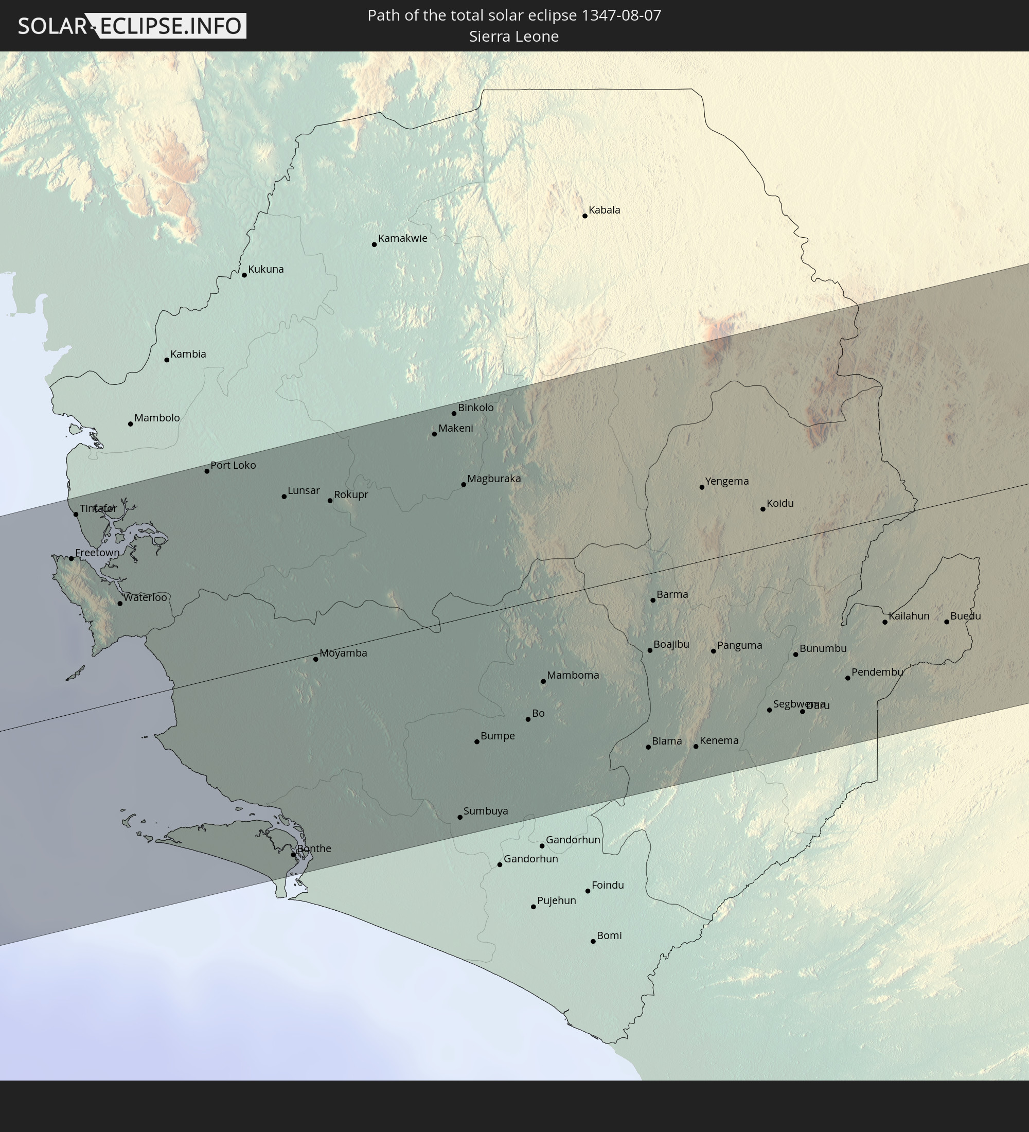 Sierra Leone
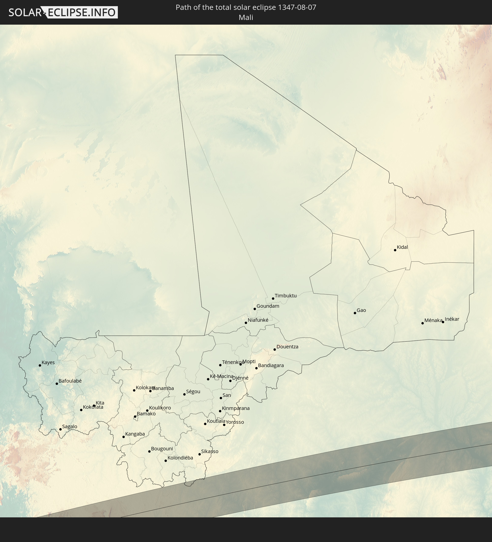 Mali
Mali
 Liberia
 Elfenbeinküste
 Burkina Faso
 Ghana
Ghana
 Togo
Togo
 Niger
Niger
 Benin
Benin
 Nigeria
 Kamerun
 Tschad
 Sudan
Sudan
 Südsudan
 Äthiopien
 Somalia
 Britisches Territorium im Indischen Ozean
In den folgenden Ländern ist die Sonnenfinsternis partiell zu sehen
 Portugal
 Spanien
 Senegal
 Mauretanien
 Gambia
 Guinea-Bissau
 Guinea
 St. Helena
 Sierra Leone
 Marokko
 Mali
Mali
 Liberia
 Algerien
 Elfenbeinküste
 Burkina Faso
 Gibraltar
 Frankreich
 Ghana
Ghana
 Togo
Togo
 Niger
Niger
 Benin
Benin
 Andorra
 Nigeria
 Äquatorialguinea
 São Tomé und Príncipe
 Italien
 Monaco
 Tunesien
 Kamerun
 Gabun
Gabun
 Libyen
 Republik Kongo
 Angola
 Namibia
 Demokratische Republik Kongo
 San Marino
 Vatikanstadt
 Tschad
 Kroatien
 Malta
Malta
 Zentralafrikanische Republik
 Bosnien und Herzegowina
 Südafrika
 Montenegro
 Serbien
 Albanien
 Griechenland
 Botswana
 Rumänien
 Mazedonien
 Sudan
Sudan
 Sambia
 Bulgarien
 Ägypten
 Simbabwe
 Türkei
 Ruanda
 Burundi
 Tansania
 Uganda
 Mosambik
 Republik Zypern
 Malawi
 Äthiopien
 Kenia
Kenia
 Staat Palästina
 Israel
 Saudi-Arabien
 Jordanien
 Libanon
 Syrien
 Eritrea
 Irak
Irak
 Georgien
 Französische Süd- und Antarktisgebiete
 Somalia
 Dschibuti
 Jemen
Jemen
 Madagaskar
 Komoren
 Armenien
 Iran
Iran
 Aserbaidschan
 Mayotte
 Seychellen
 Kuwait
 Bahrain
 Katar
Katar
 Vereinigte Arabische Emirate
 Oman
Oman
 Turkmenistan
 Réunion
 Mauritius
 Afghanistan
 Pakistan
 Indien
 Britisches Territorium im Indischen Ozean
 Malediven
 Sri Lanka
 Bangladesch
 Myanmar
 Indonesien
 Kokosinseln
 Thailand
 Malaysia
 Laos
Laos
 Vietnam
 Kambodscha
 Singapur
 Weihnachtsinsel
 Brunei
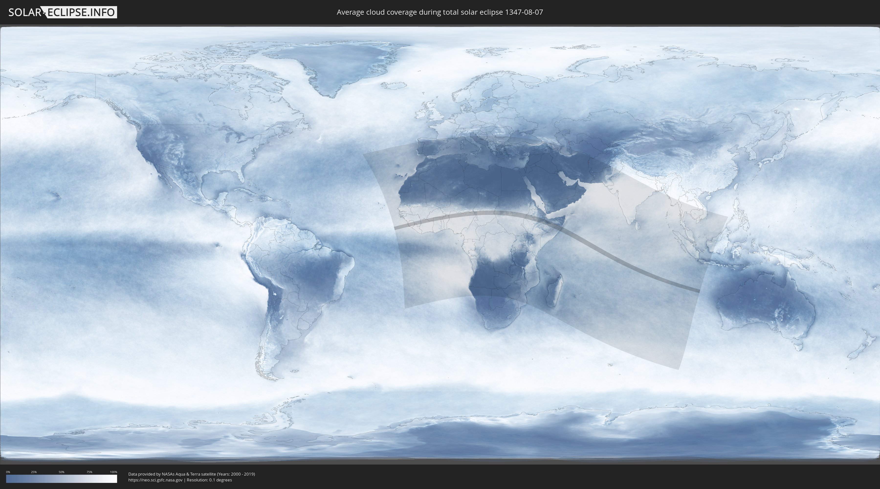
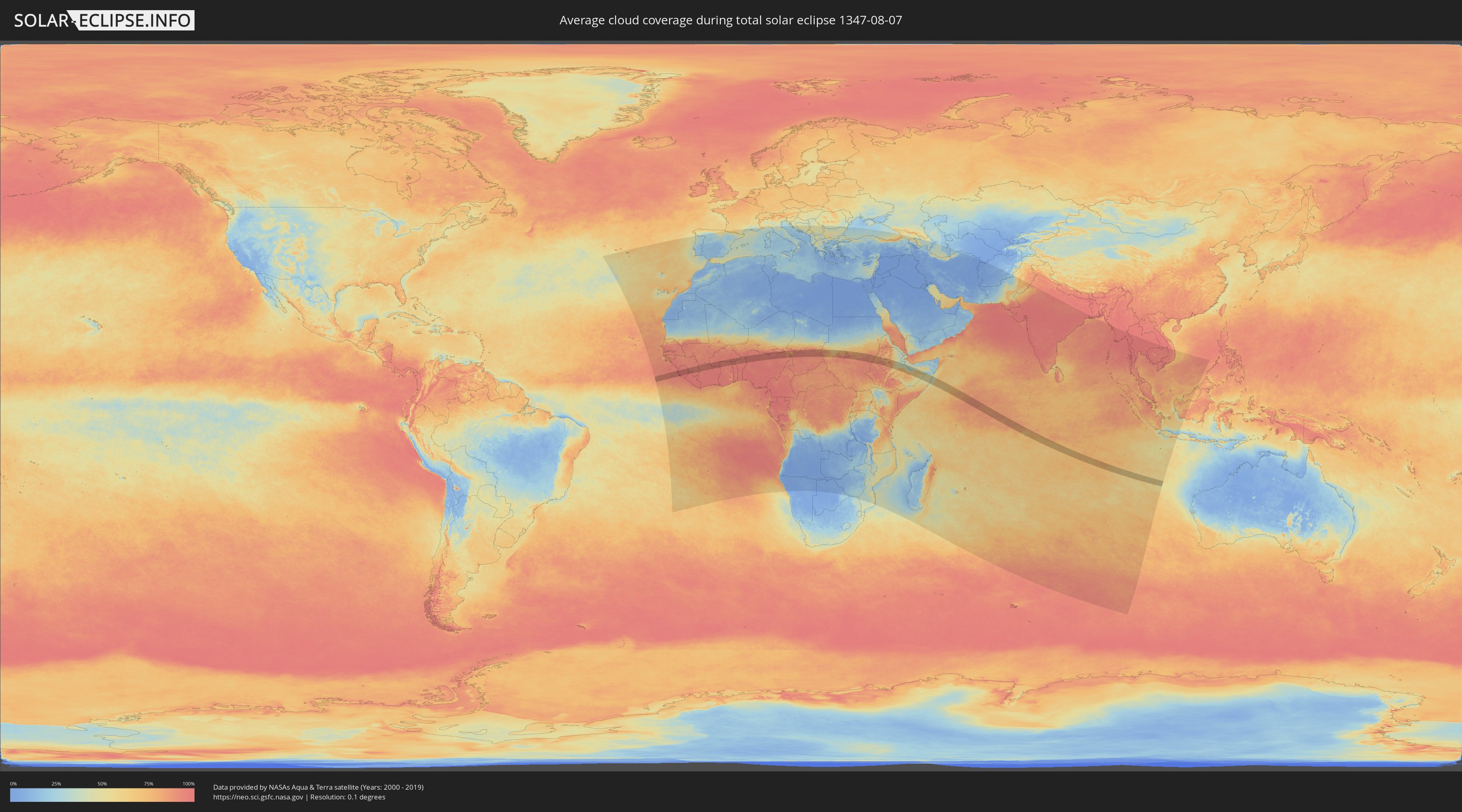
Wie wird das Wetter während der totalen Sonnenfinsternis am 07.08.1347?
Wo ist der beste Ort, um die totale Sonnenfinsternis vom 07.08.1347 zu beobachten?
Die folgenden Karten zeigen die durchschnittliche Bewölkung für den Tag, an dem die totale Sonnenfinsternis
stattfindet. Mit Hilfe der Karten lässt sich der Ort entlang des Finsternispfades eingrenzen,
der die besten Aussichen auf einen klaren wolkenfreien Himmel bietet.
Trotzdem muss man immer lokale Gegenenheiten beachten und sollte sich genau über das Wetter an seinem
gewählten Beobachtungsort informieren.
Die Daten stammen von den beiden NASA-Satelliten
AQUA und TERRA
und wurden über einen Zeitraum von 19 Jahren (2000 - 2019) gemittelt.
Detaillierte Länderkarten
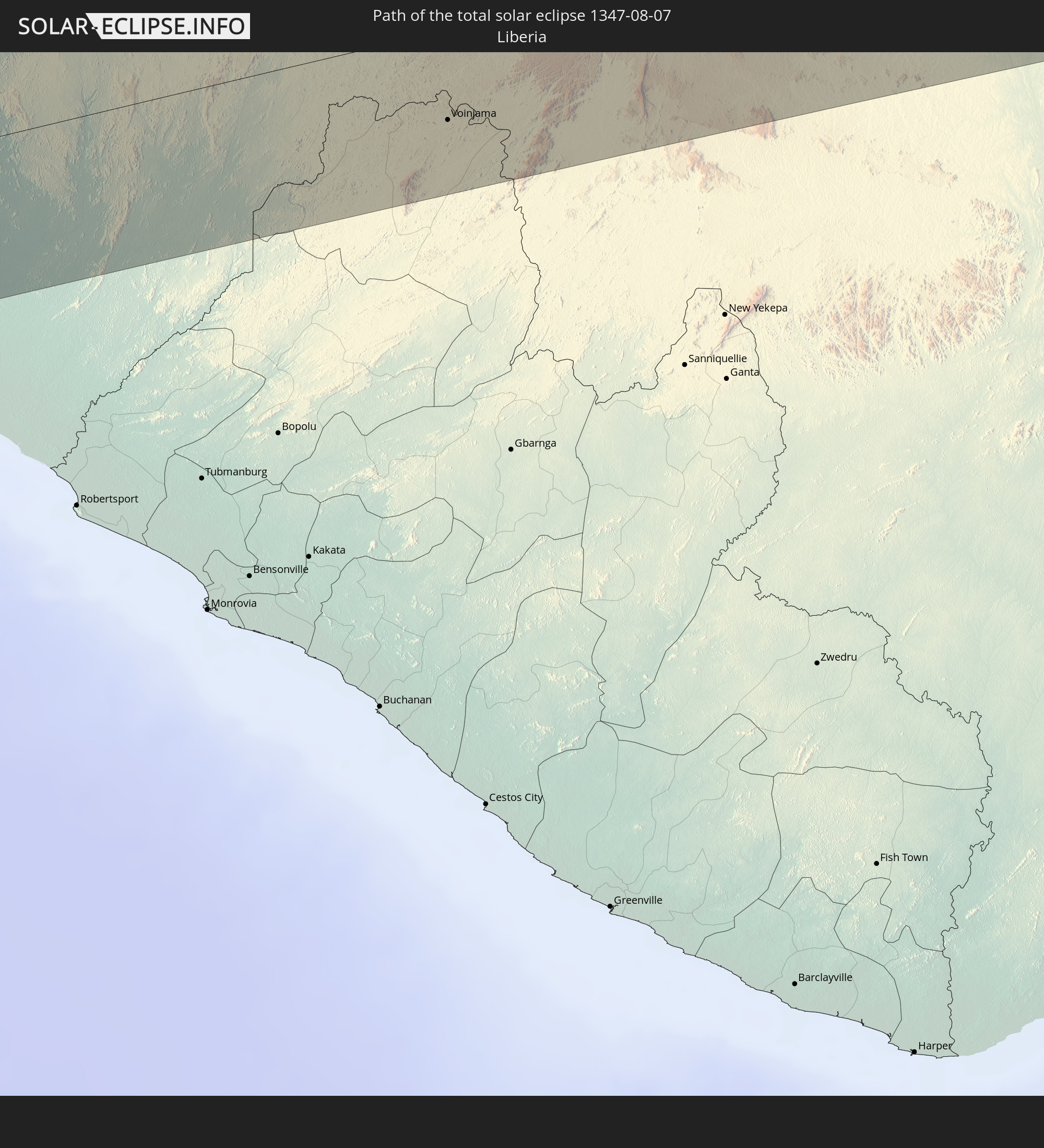
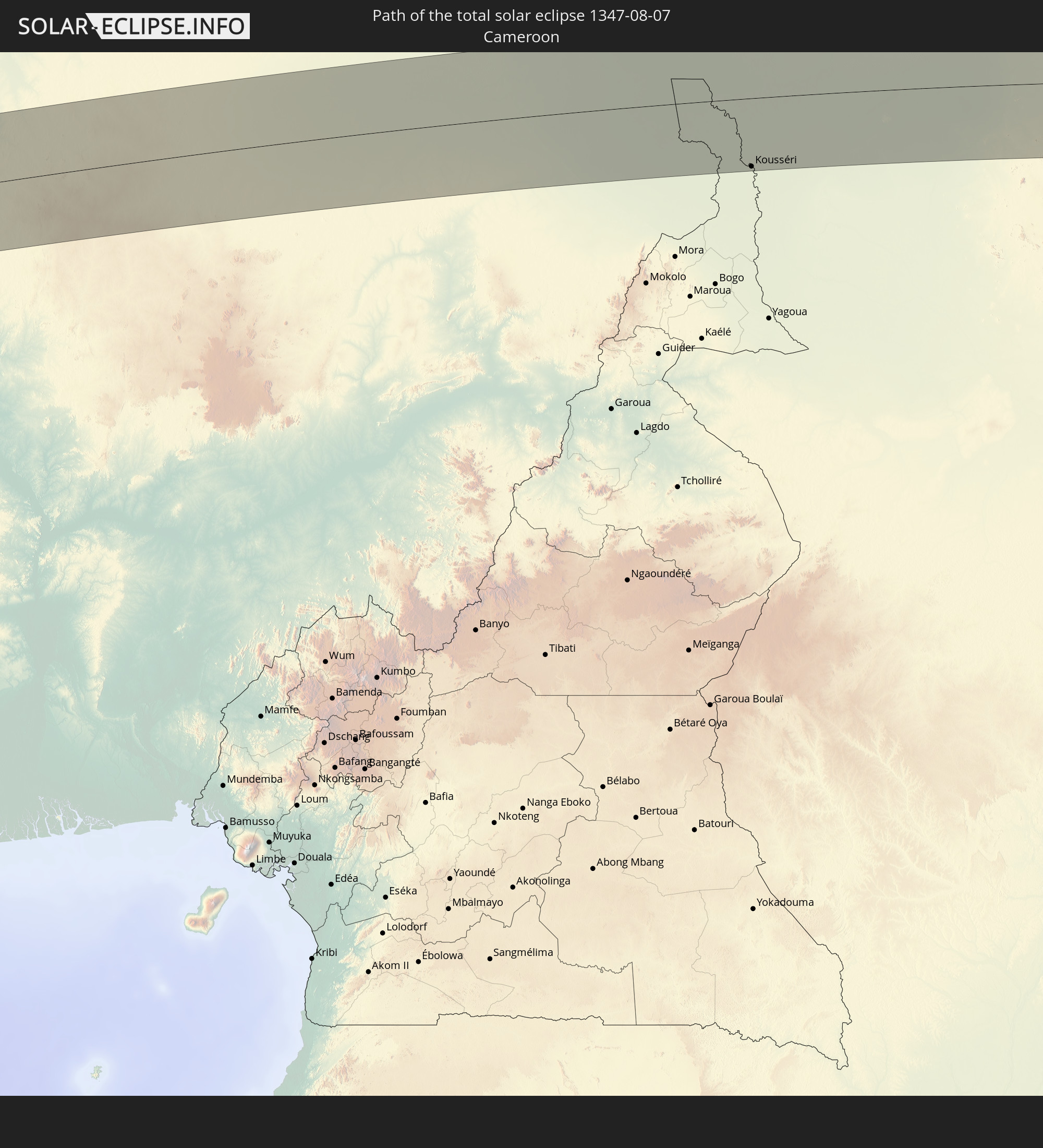
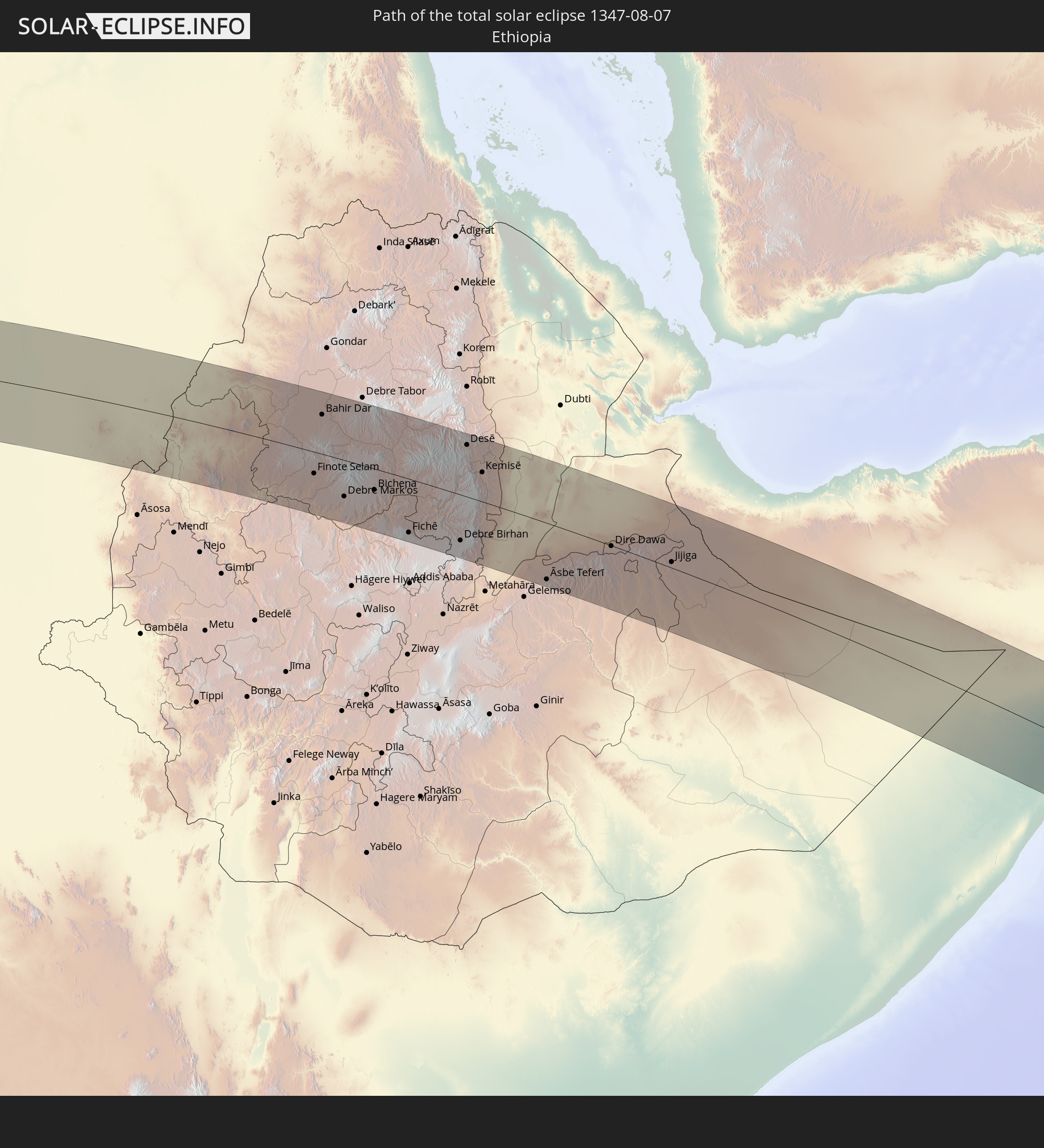
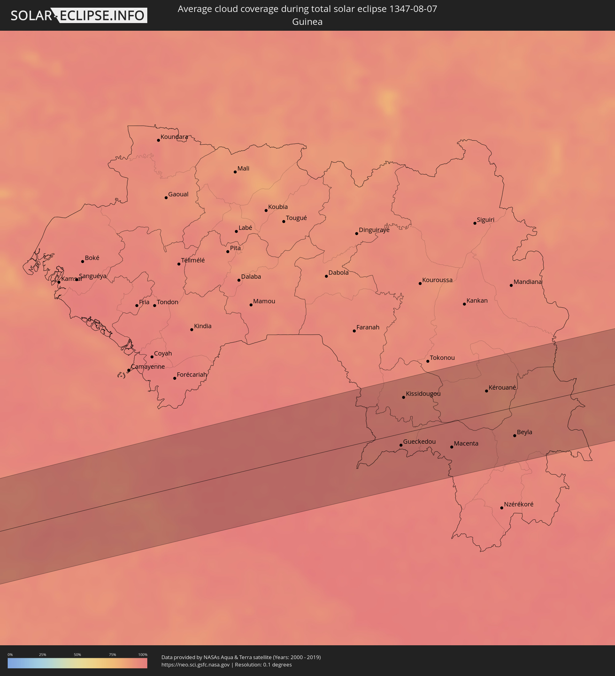 Guinea
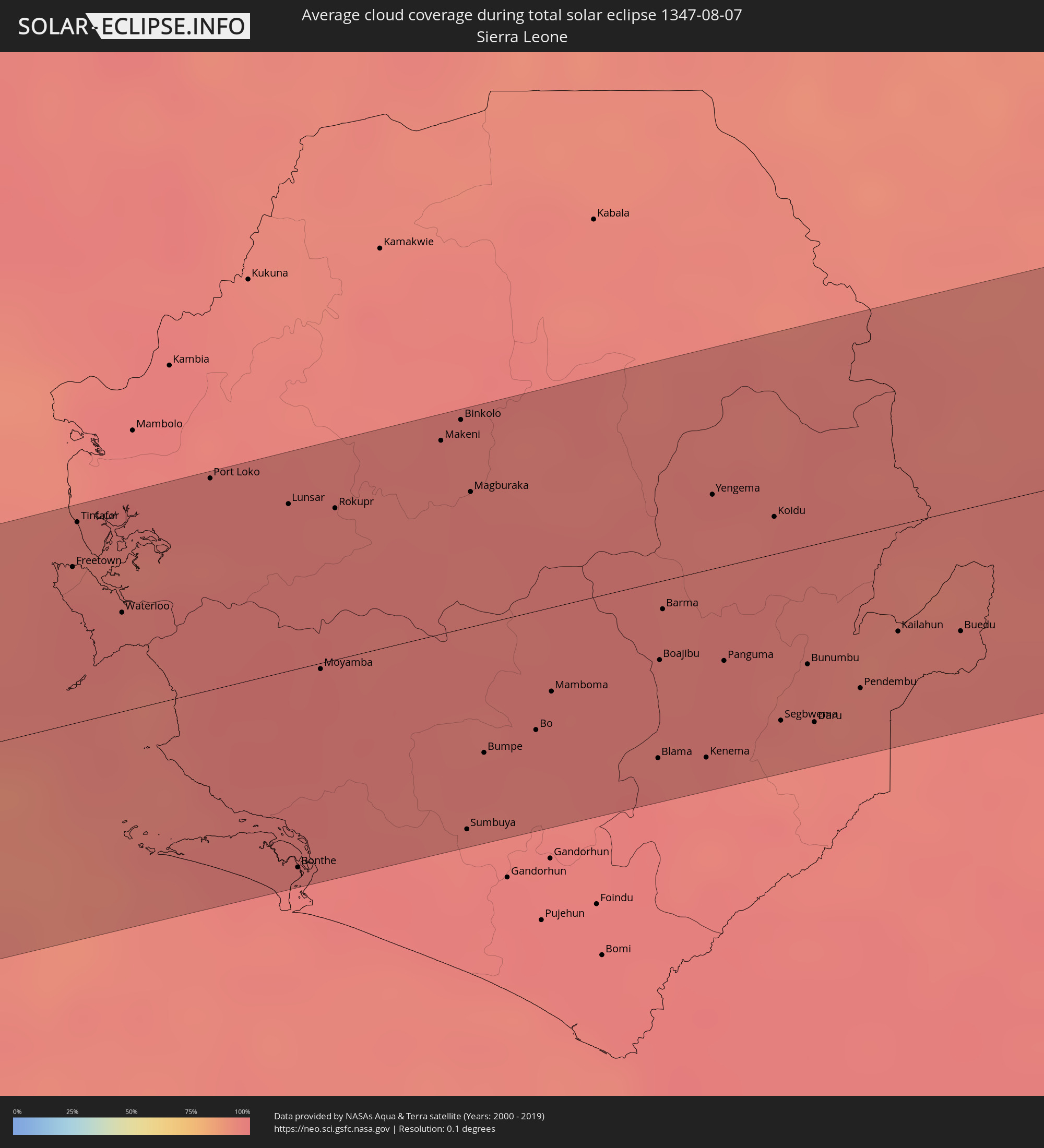 Sierra Leone
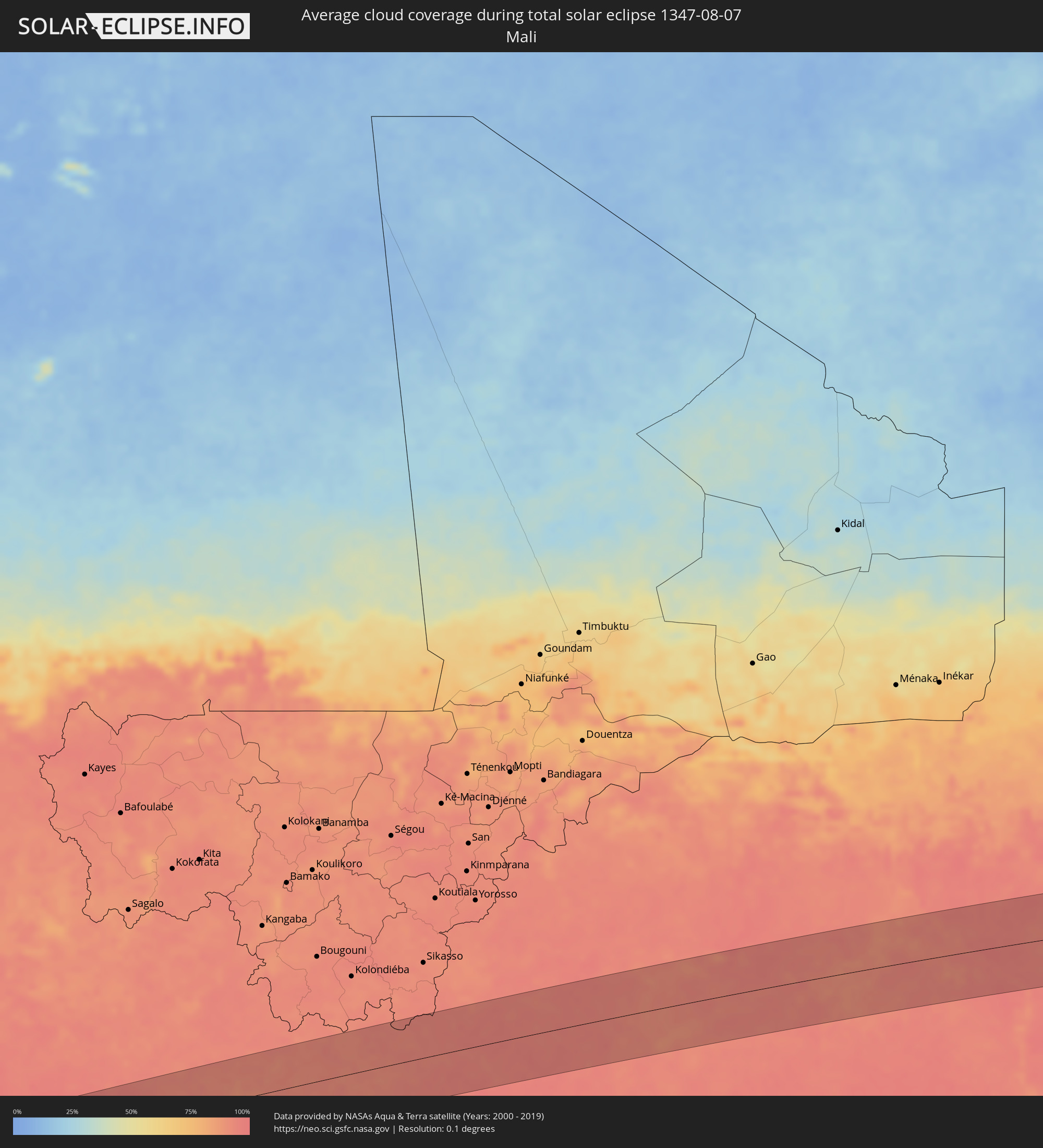 Mali
Mali
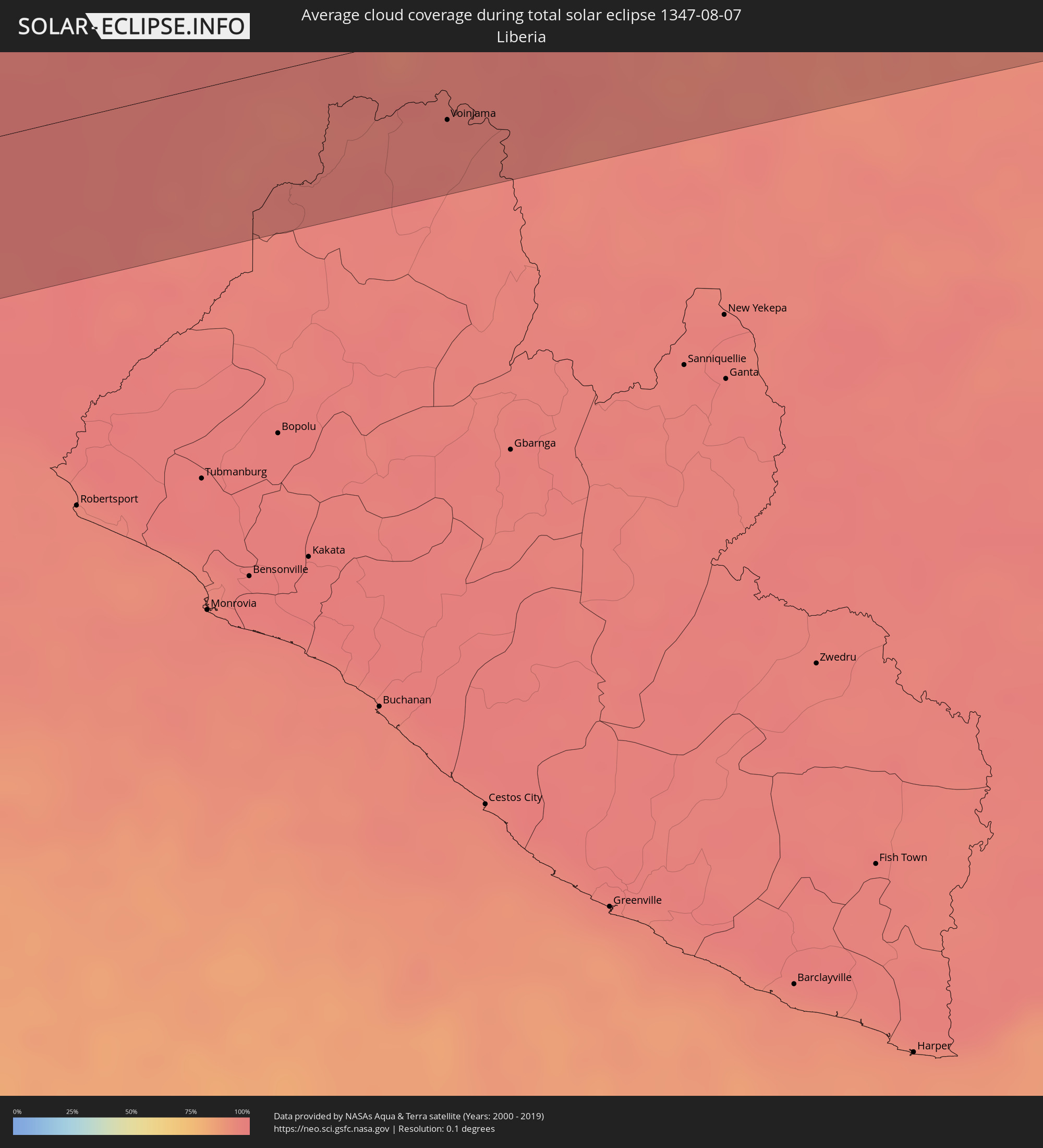 Liberia
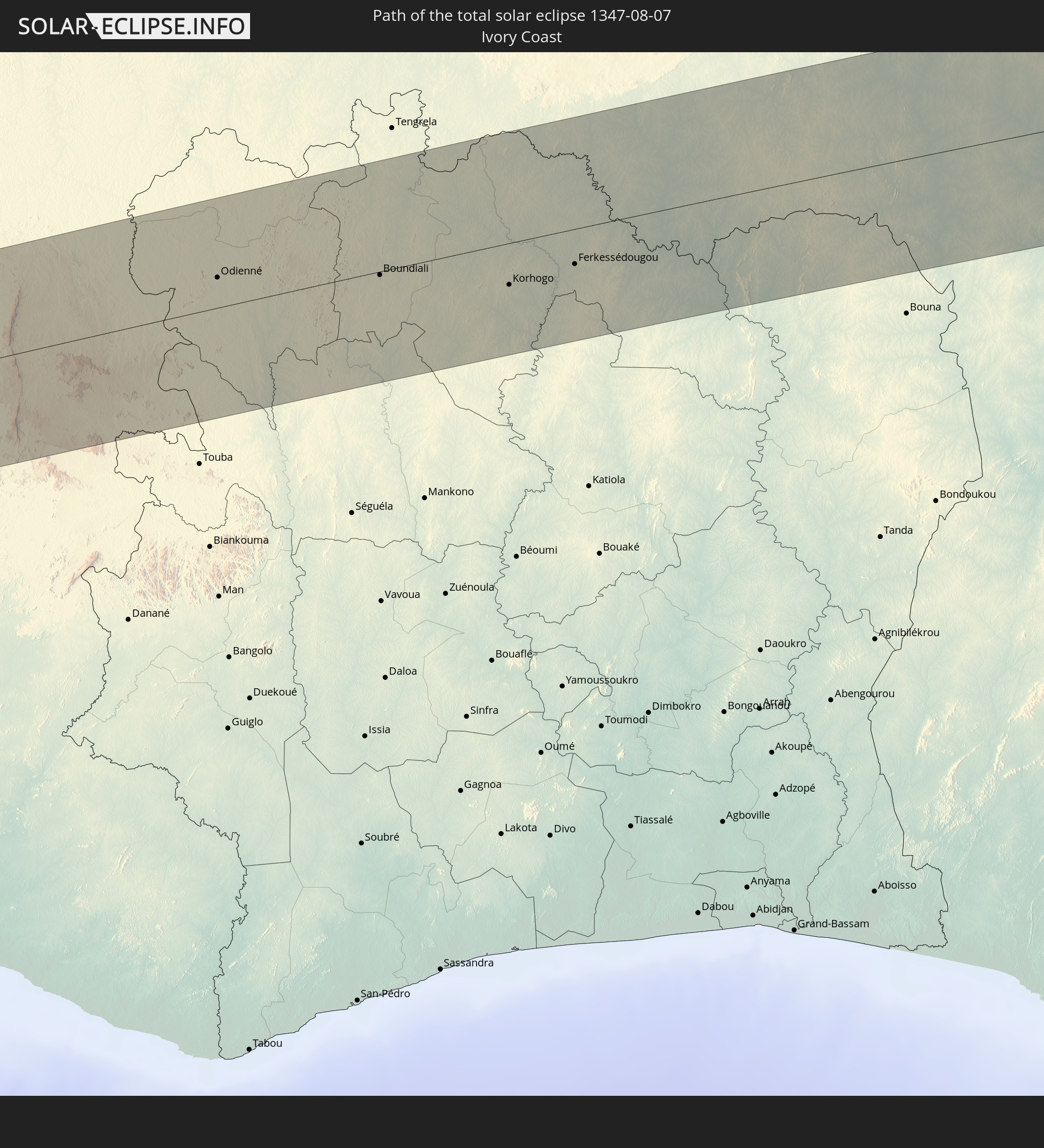
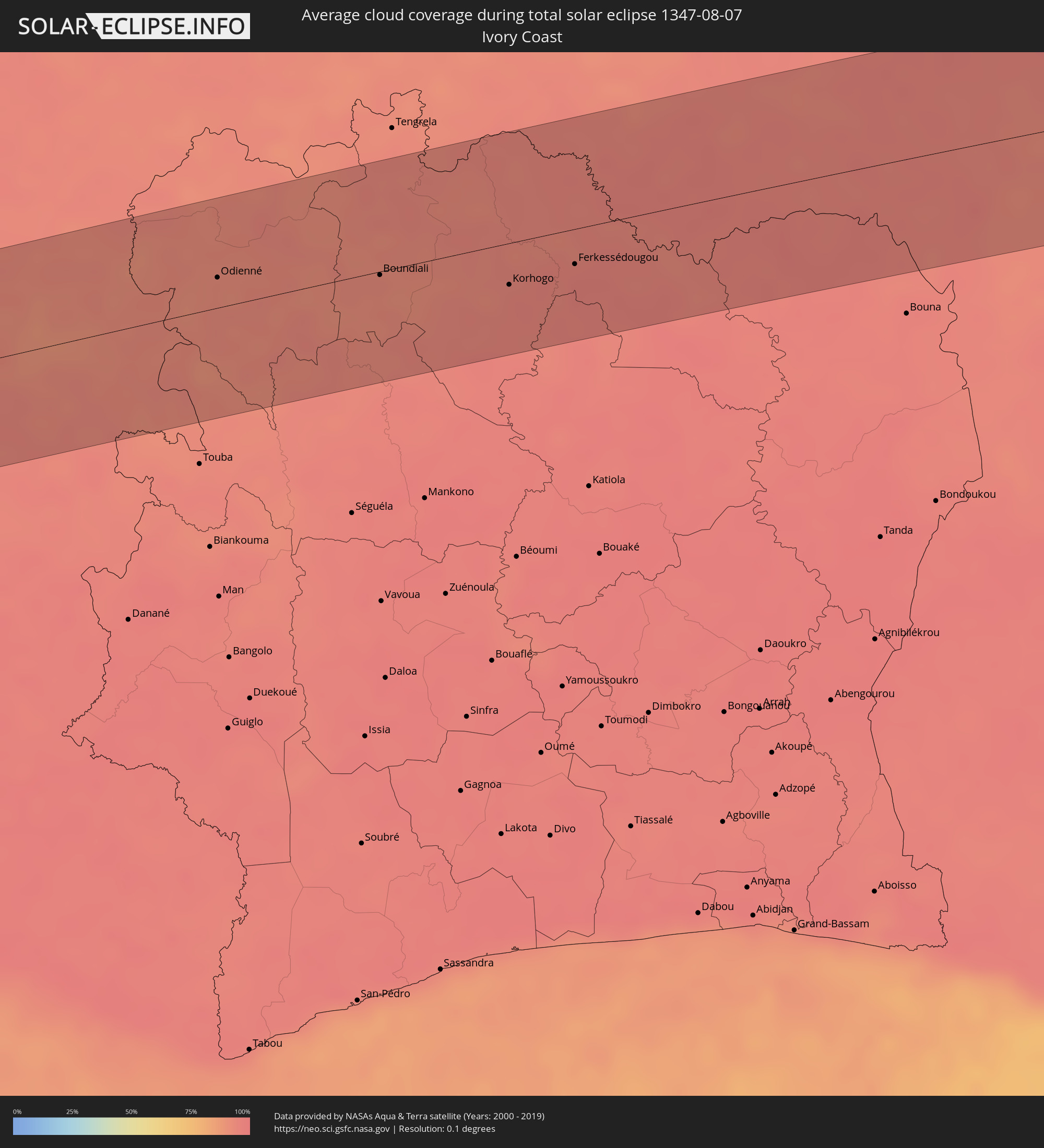 Elfenbeinküste
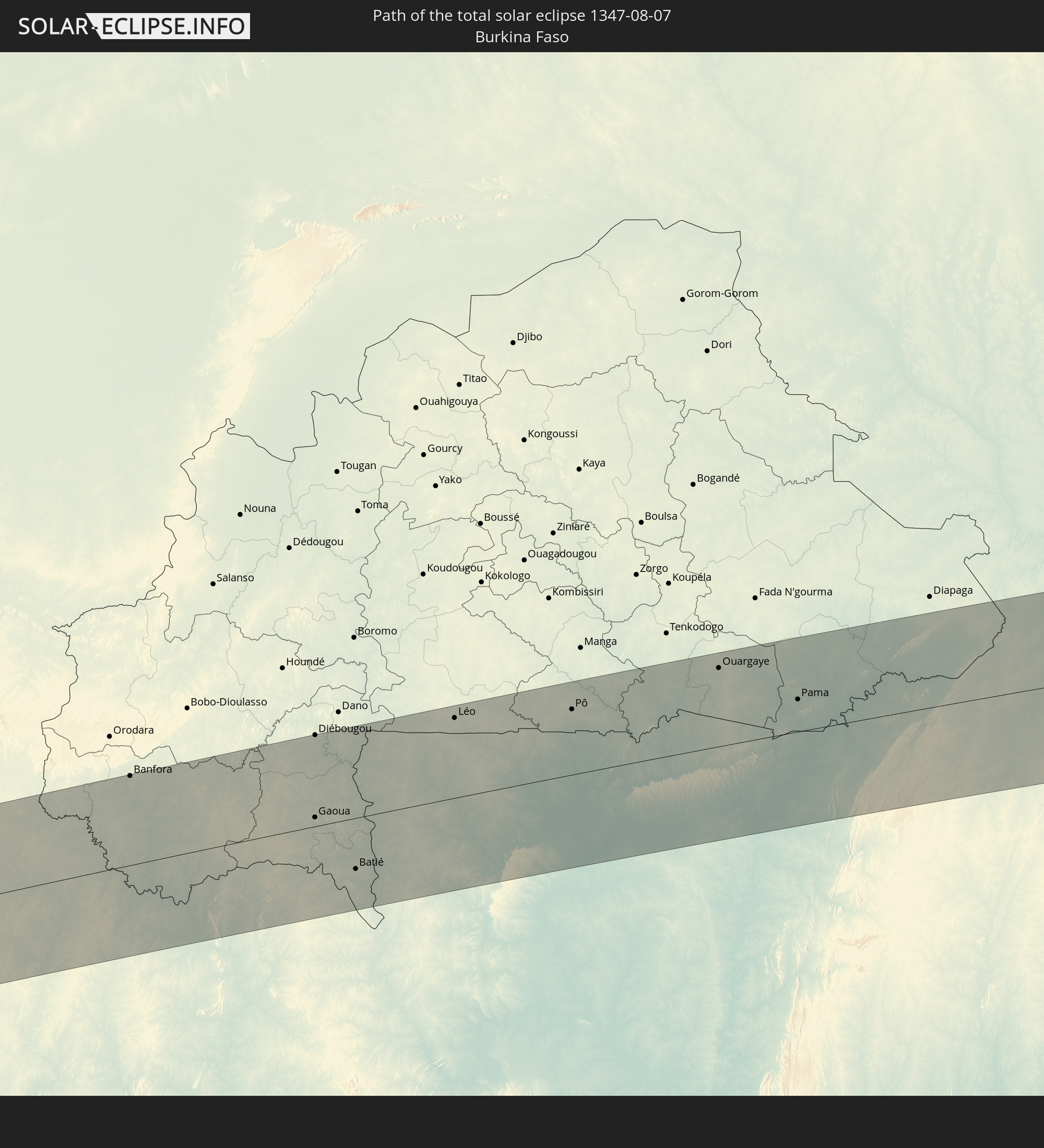
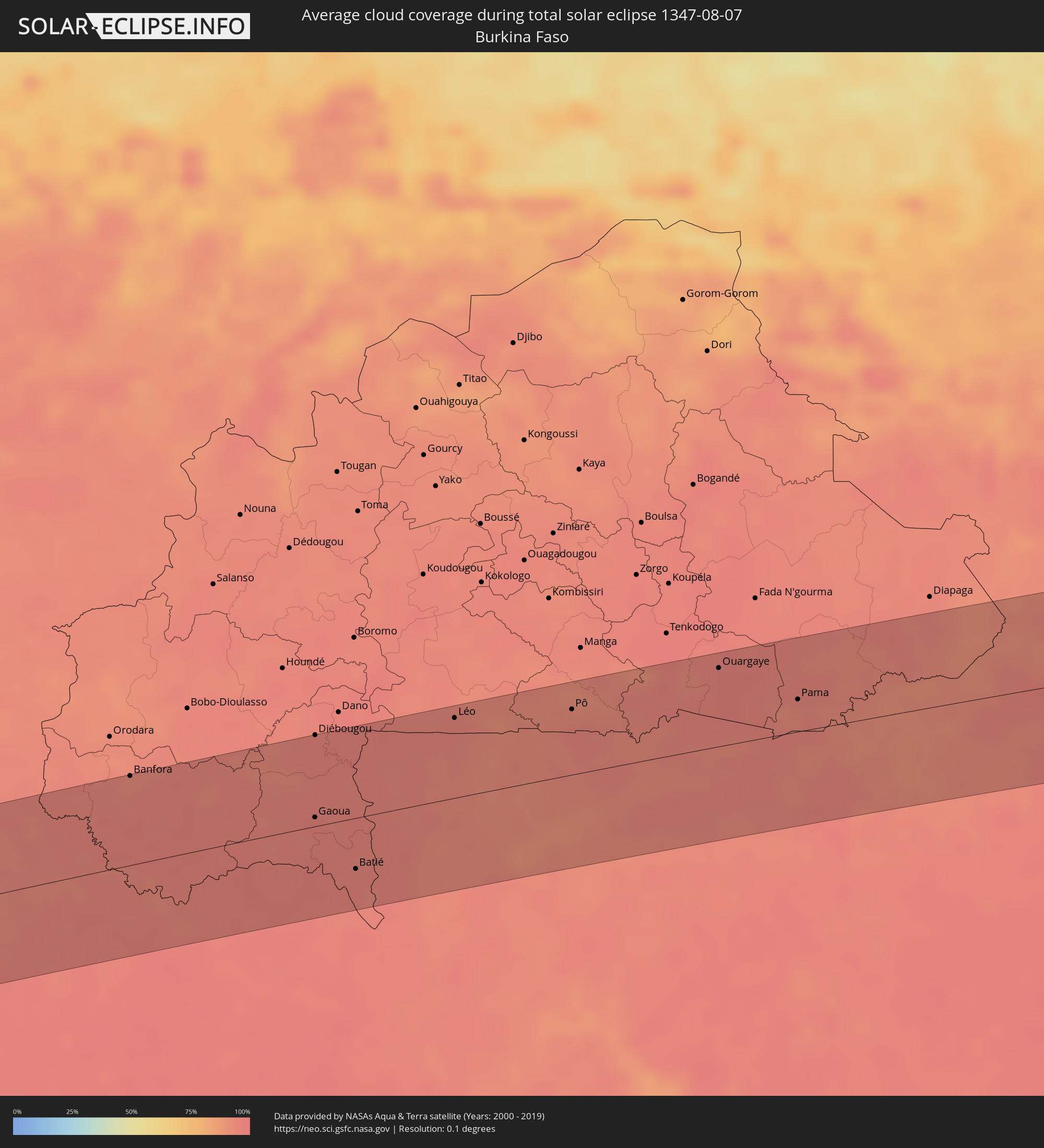 Burkina Faso
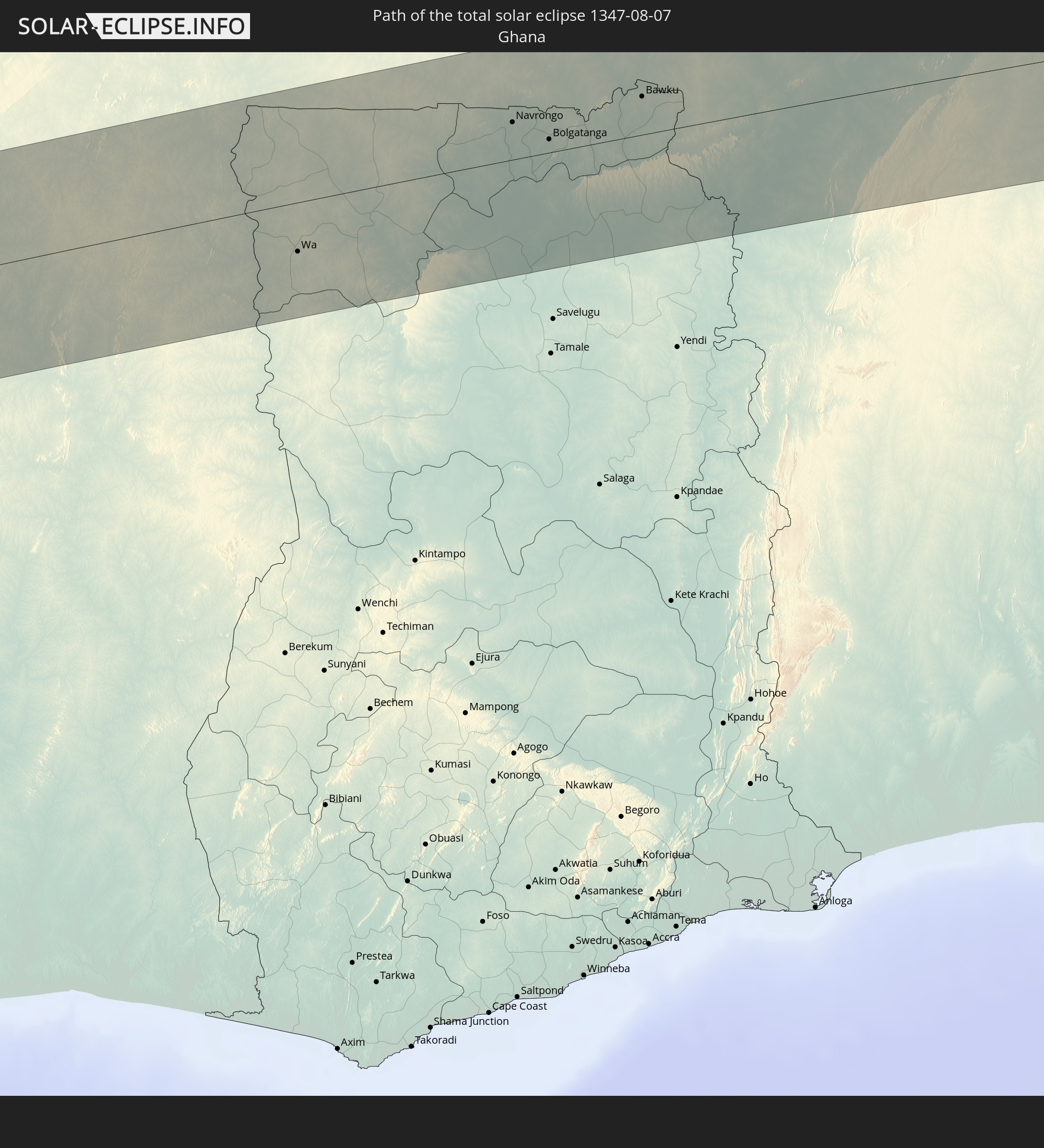
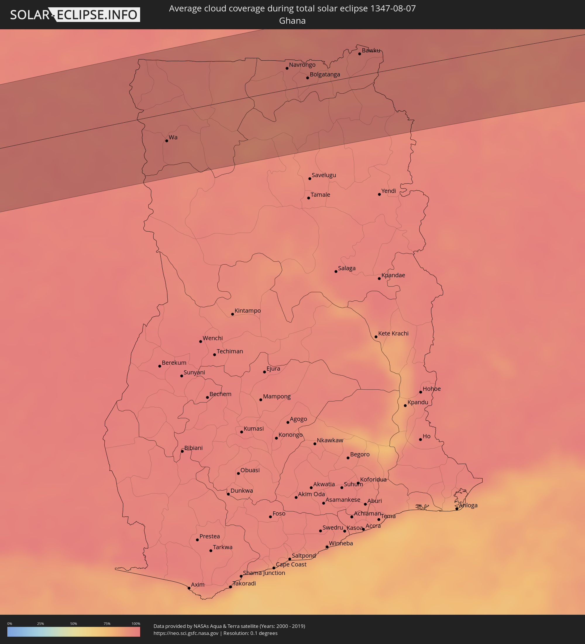 Ghana
Ghana
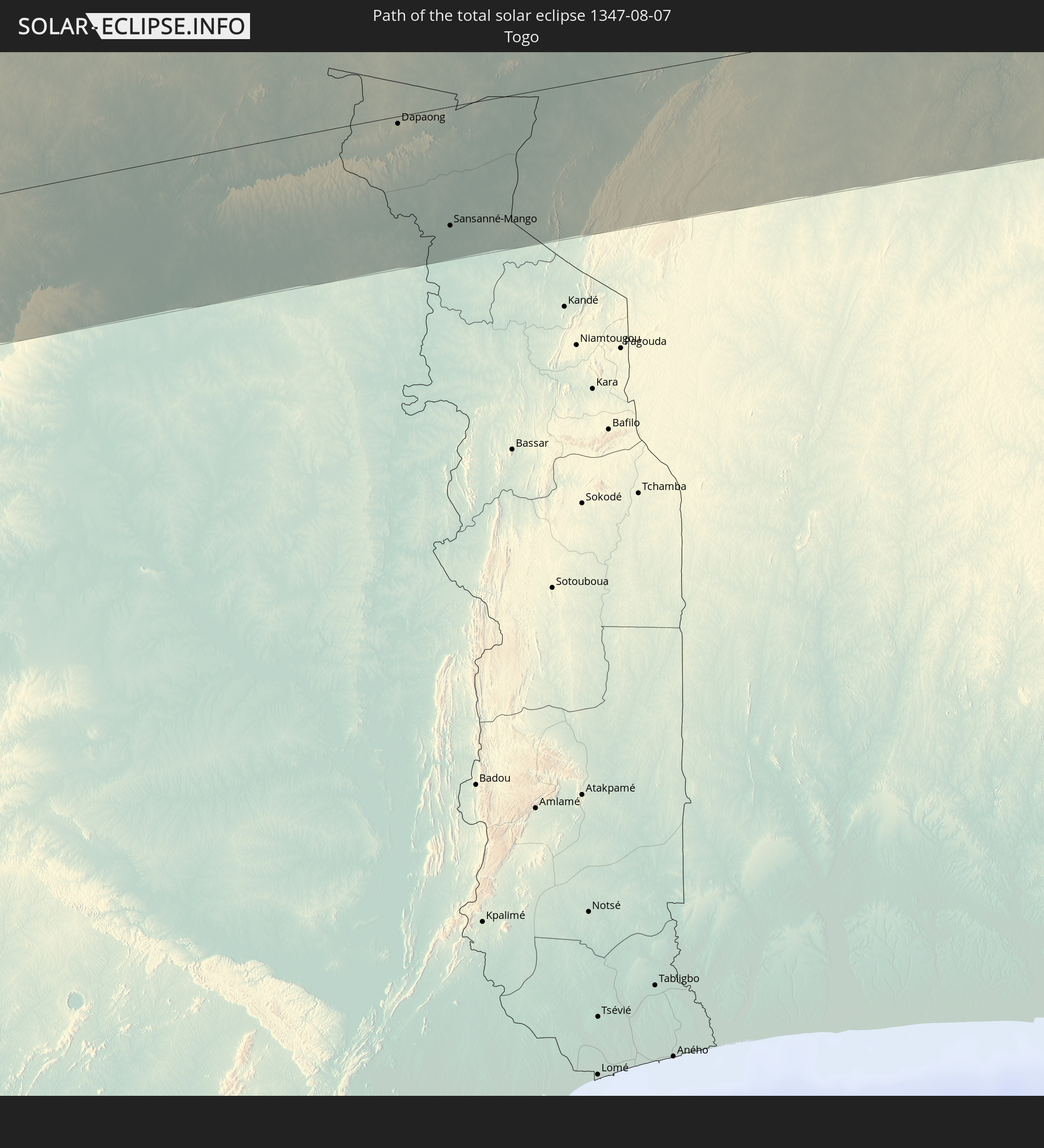
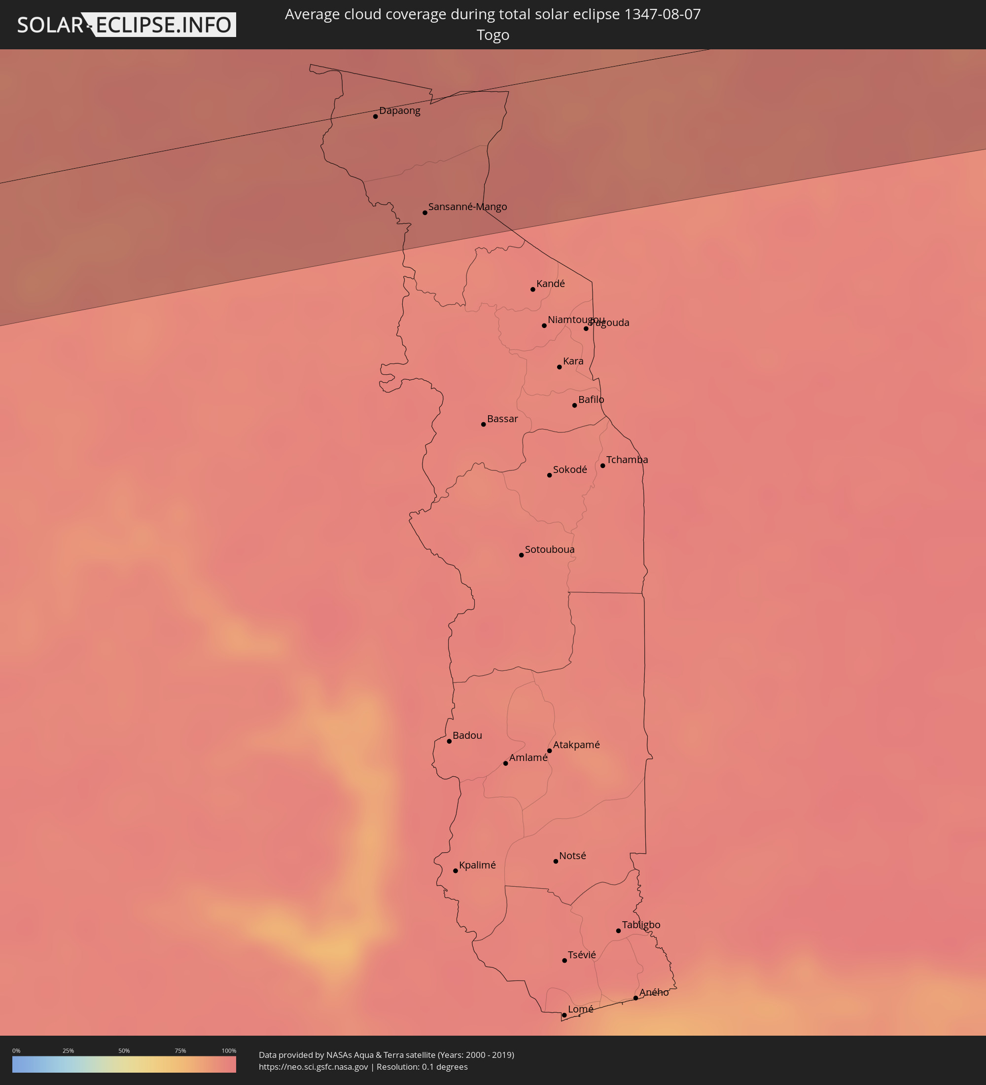 Togo
Togo
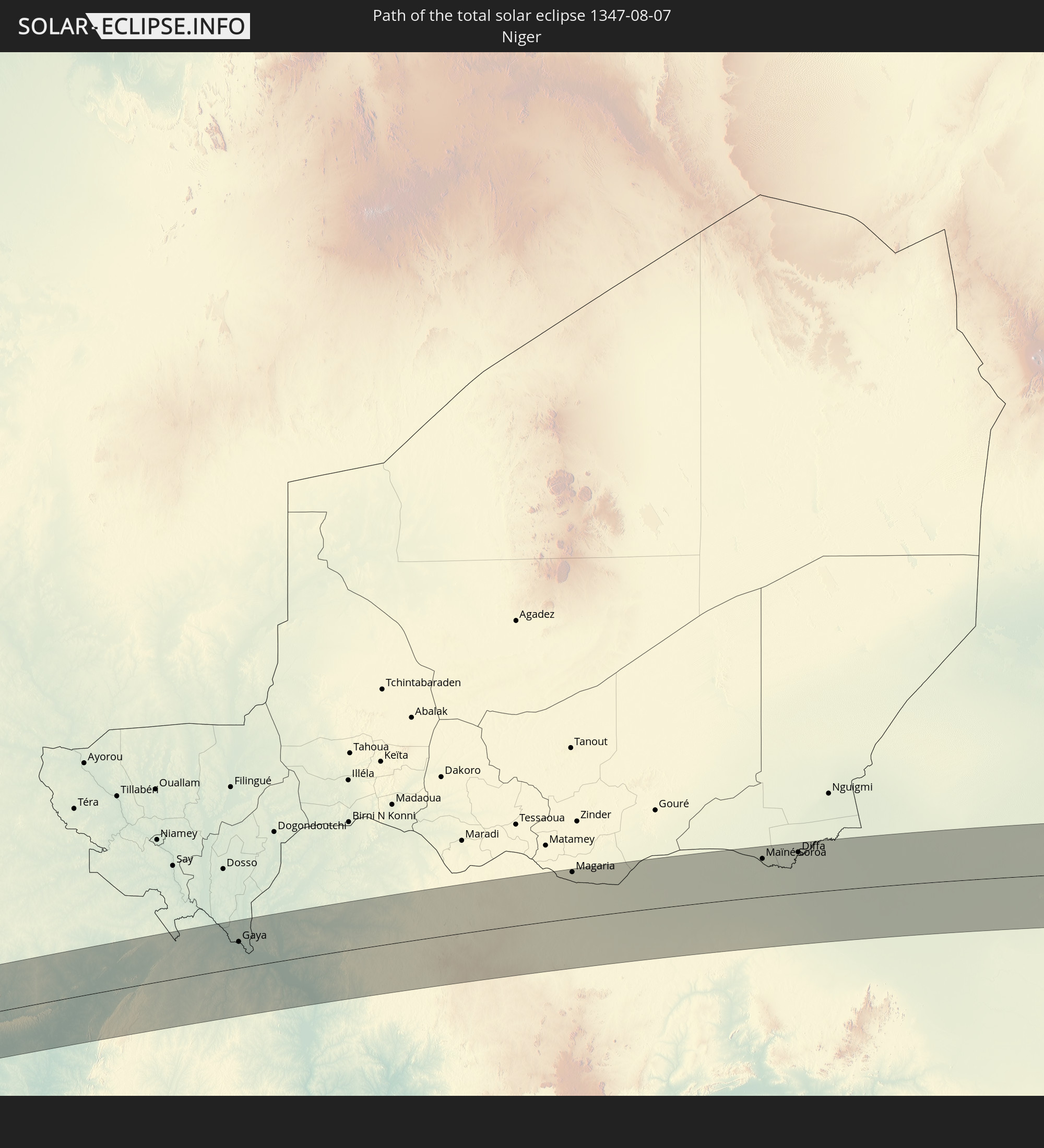
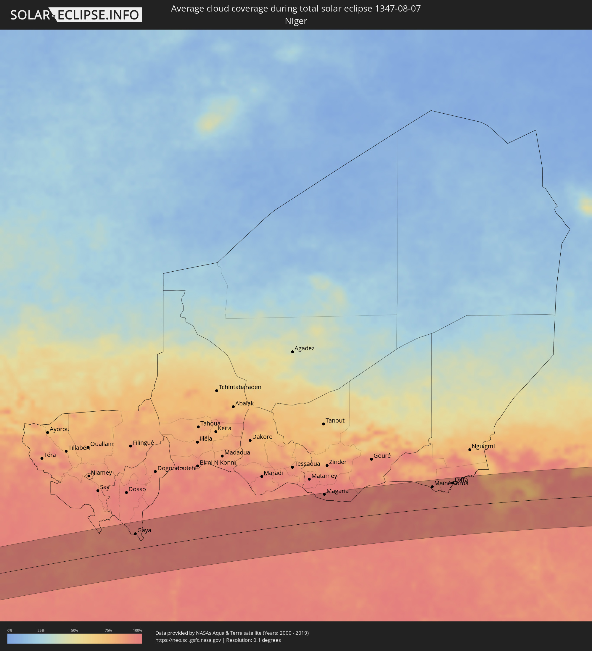 Niger
Niger
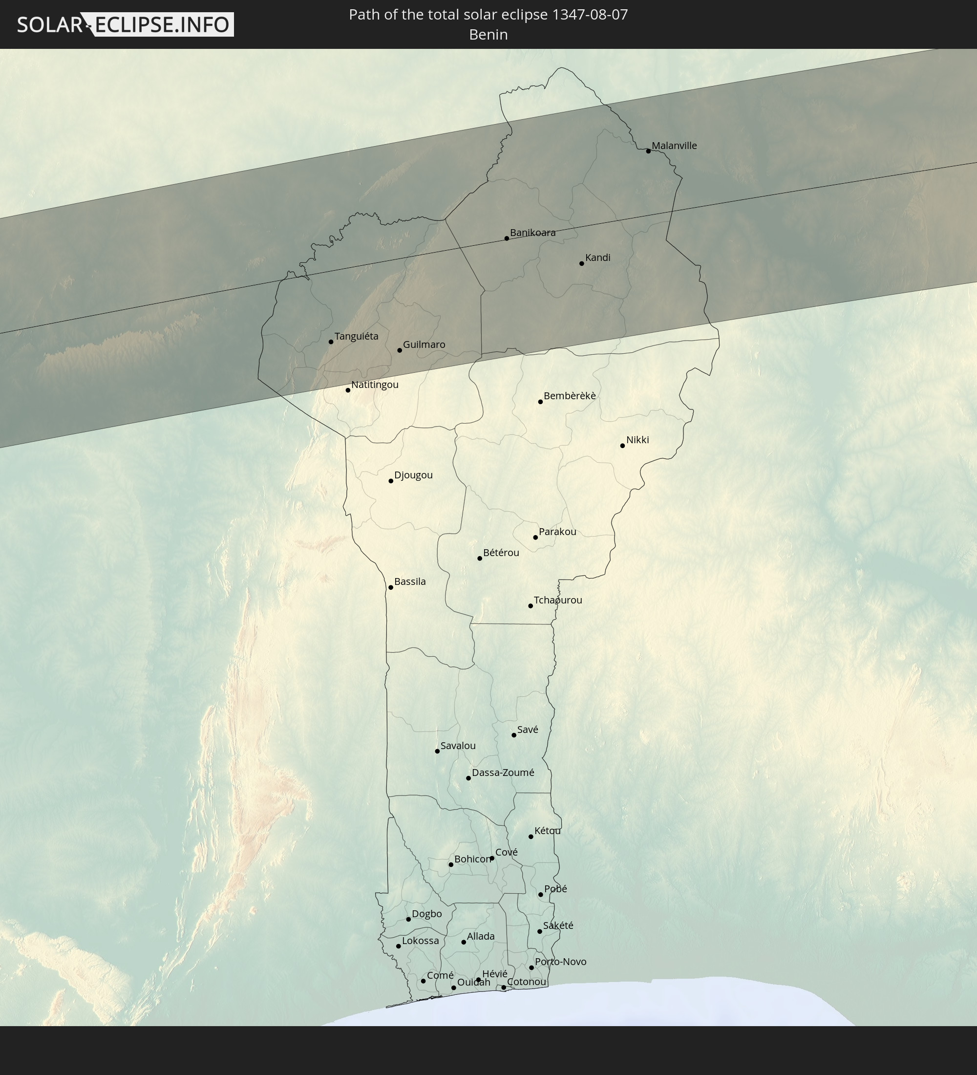
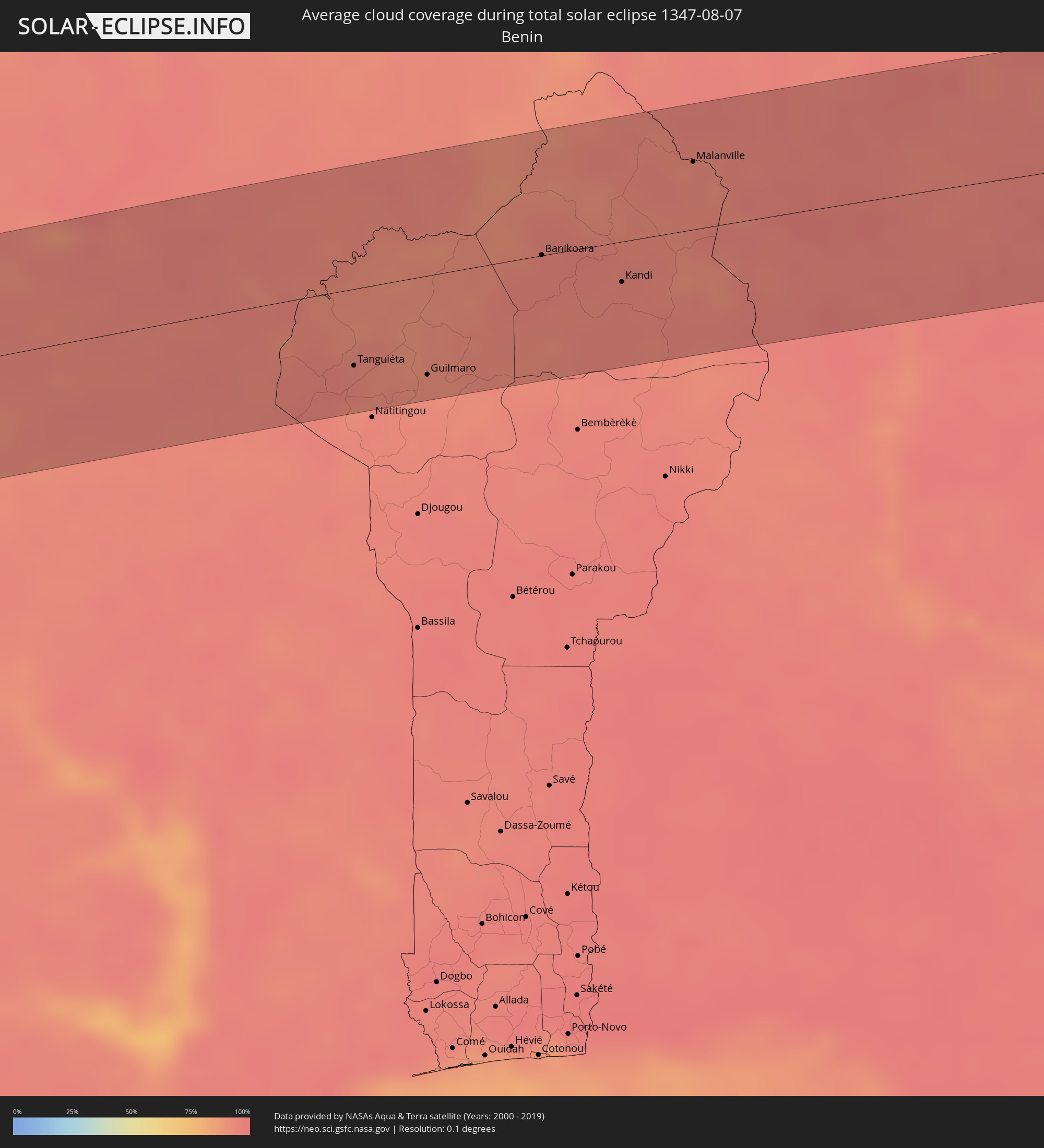 Benin
Benin
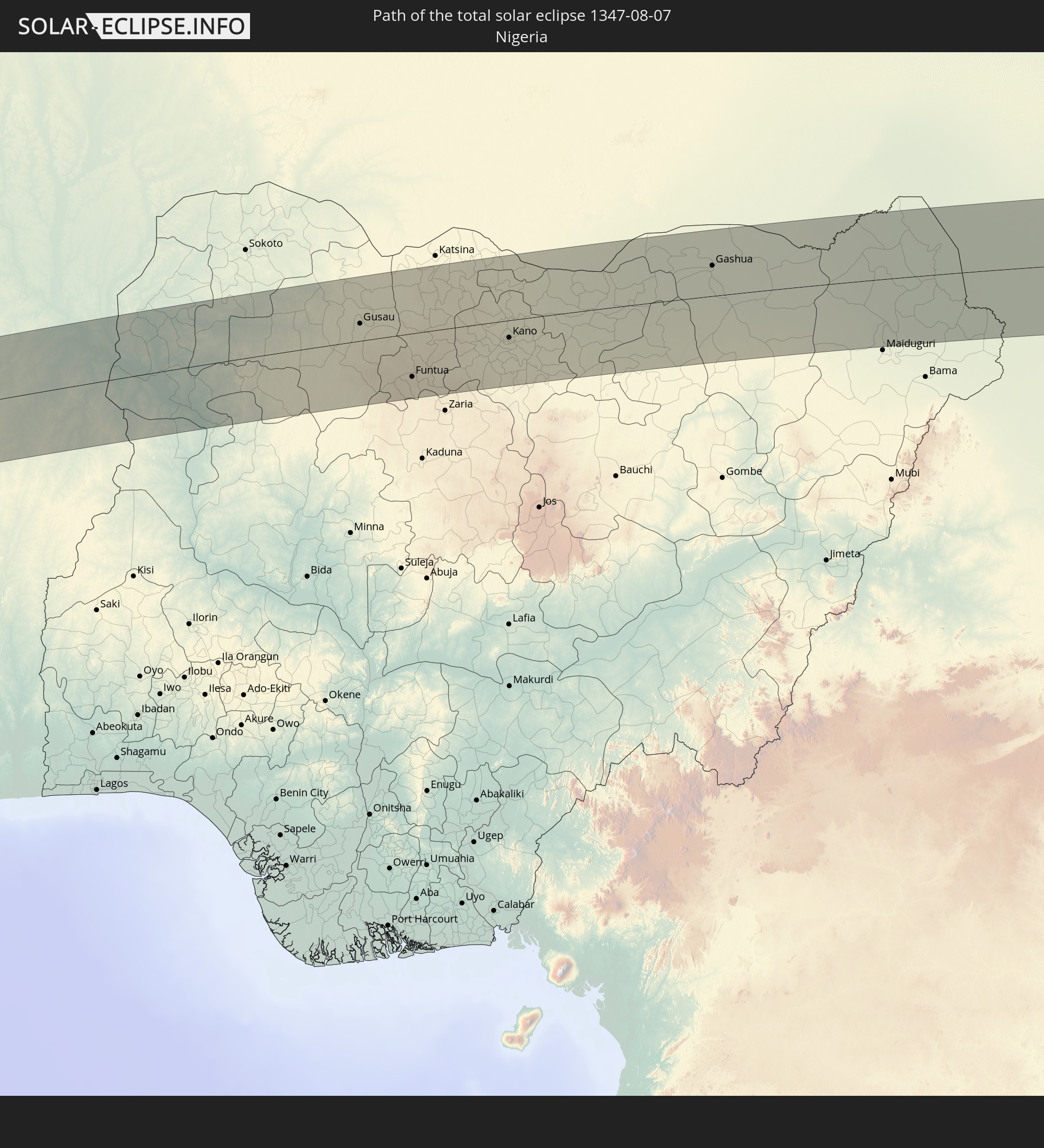
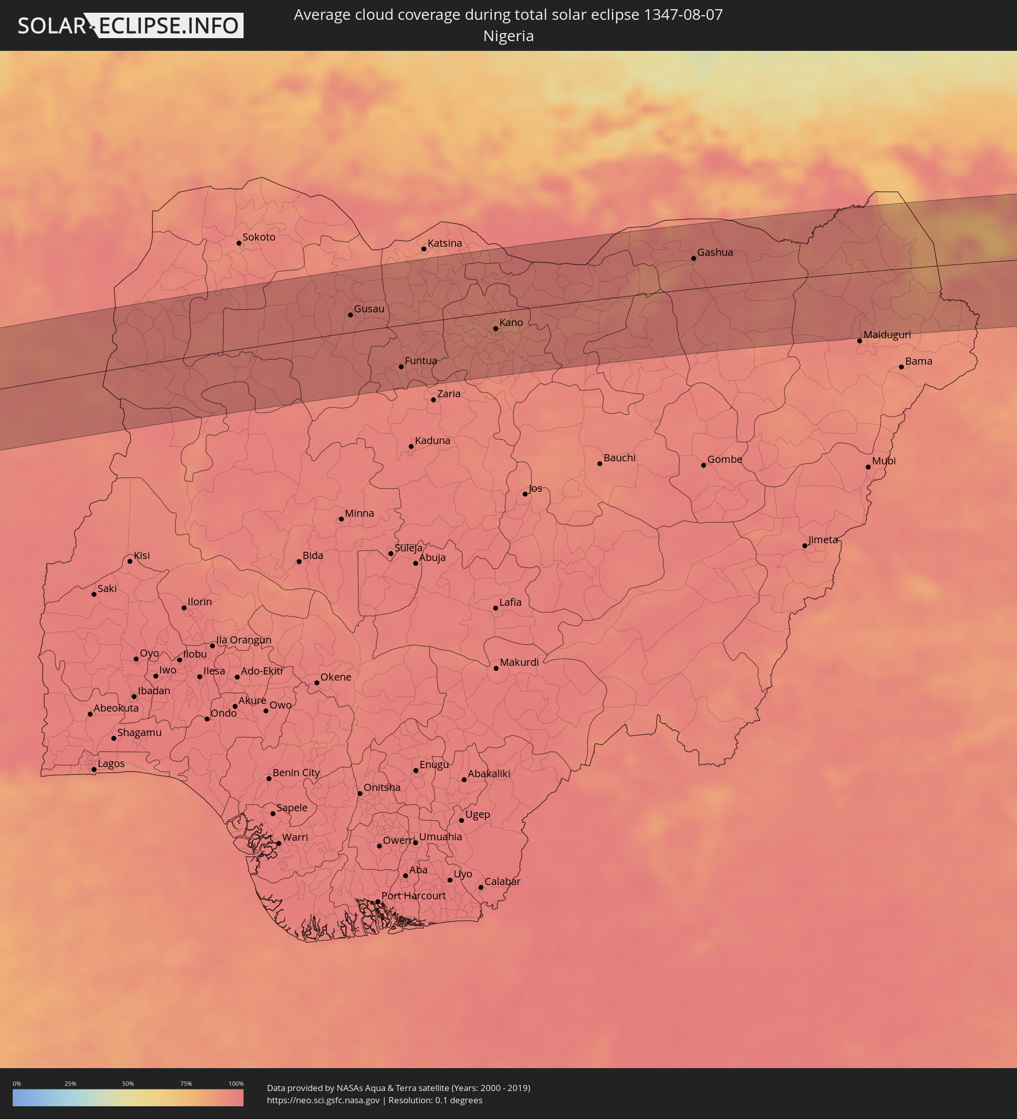 Nigeria
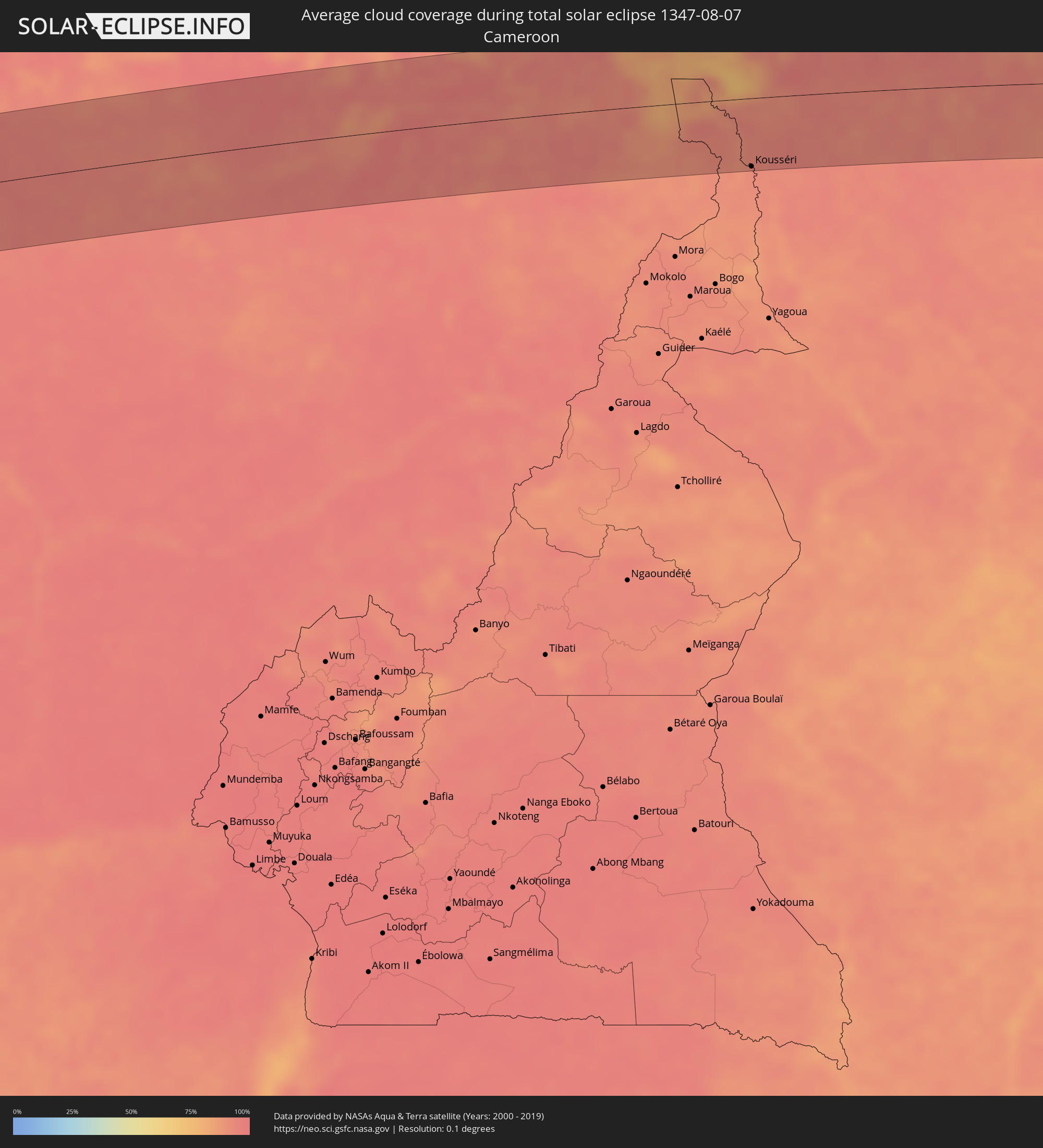 Kamerun
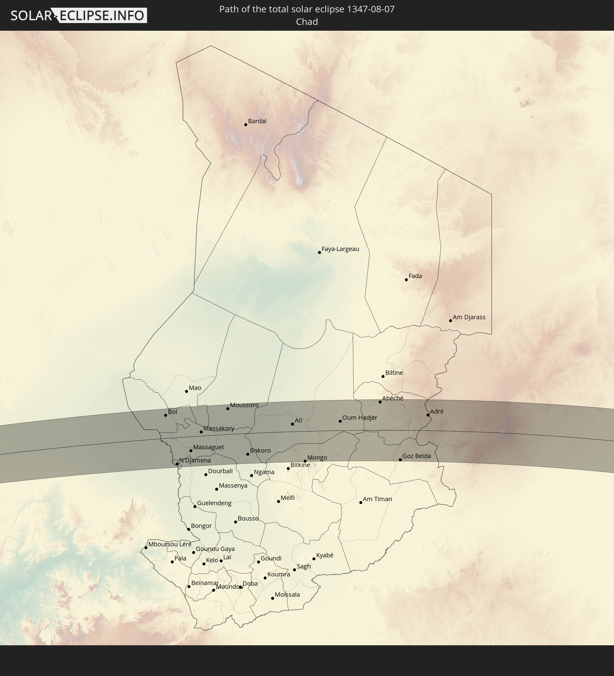
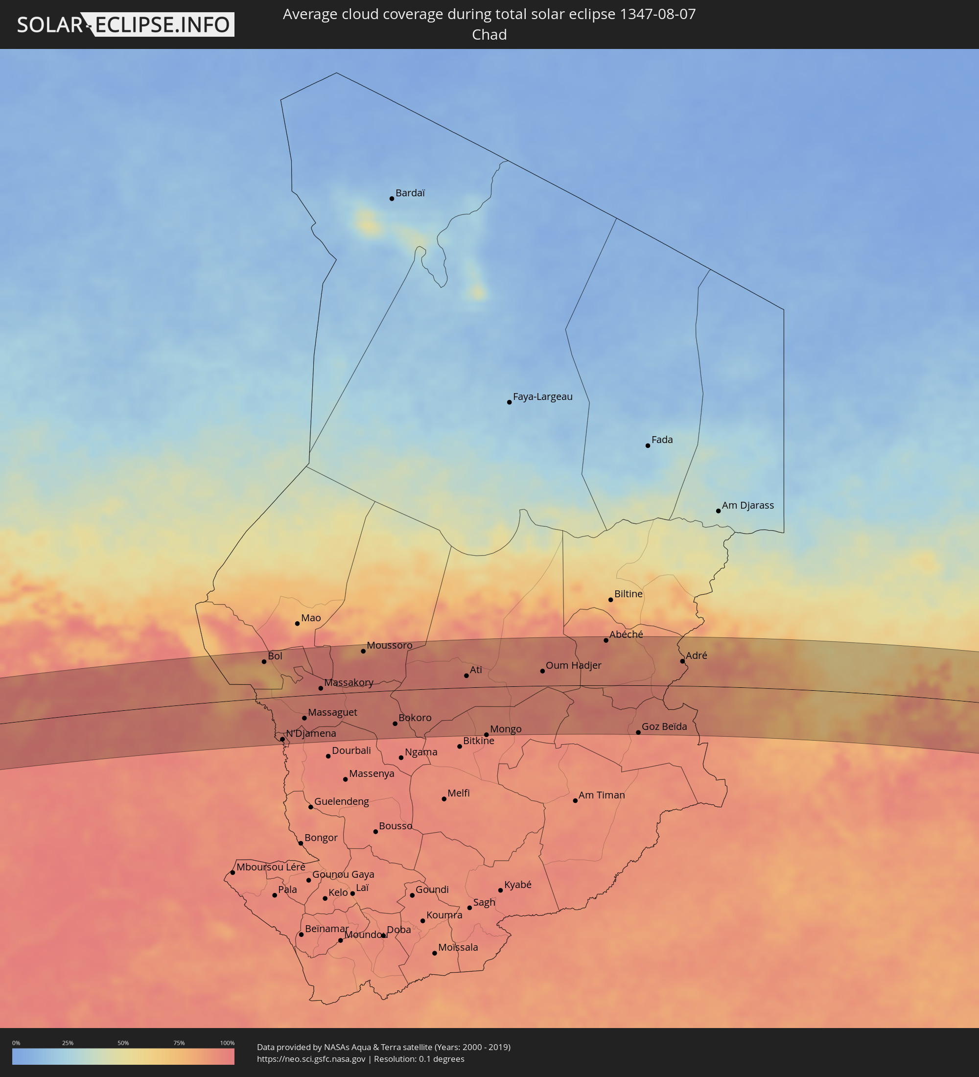 Tschad
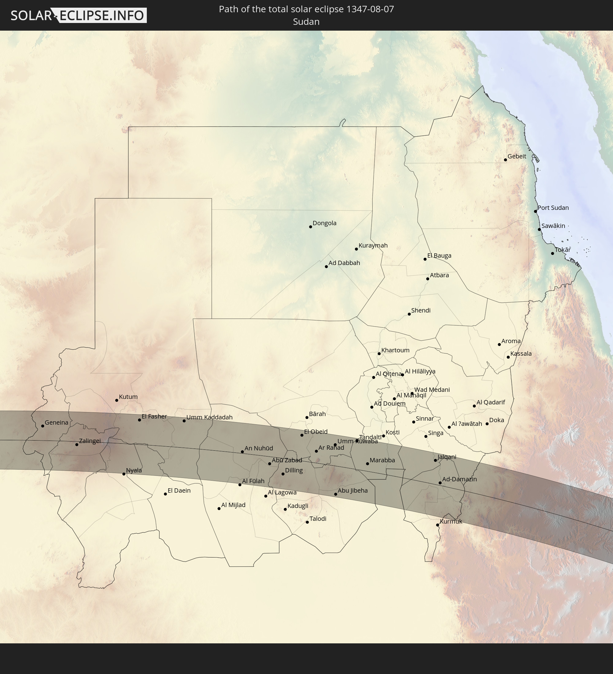
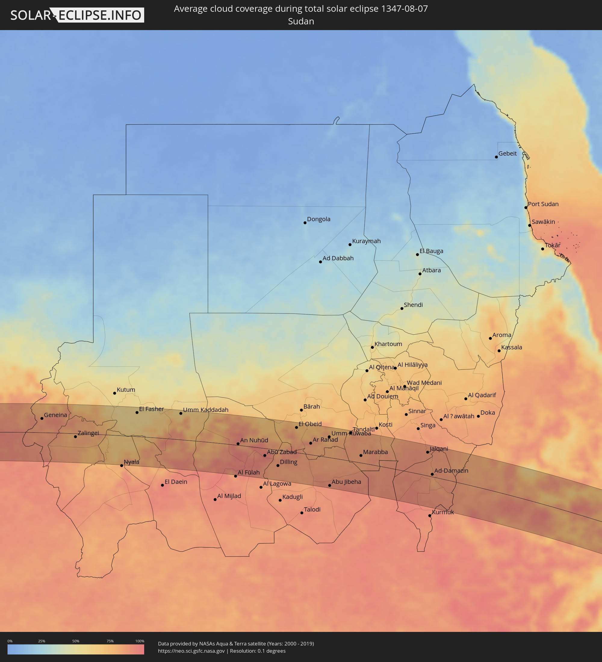 Sudan
Sudan
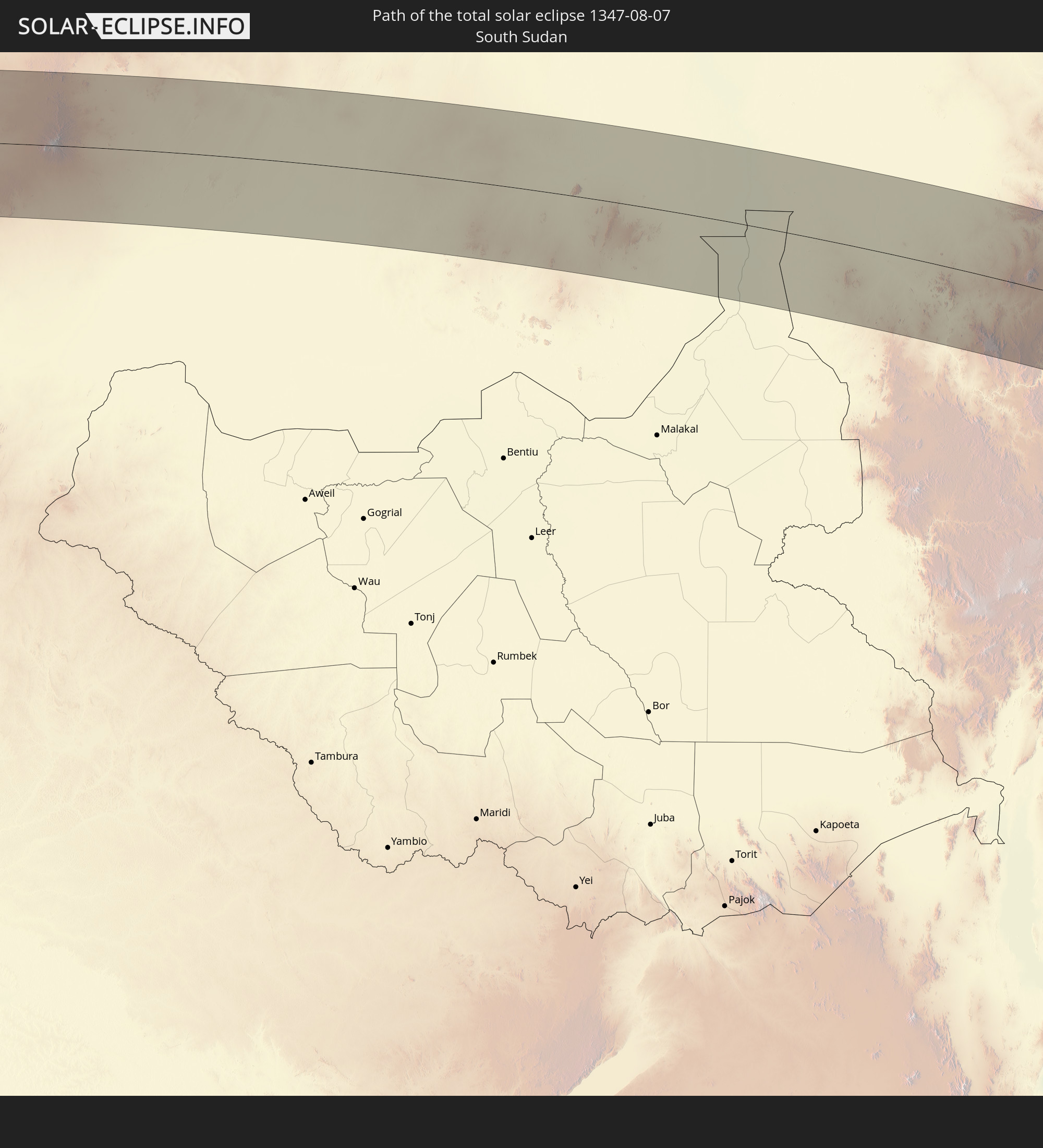
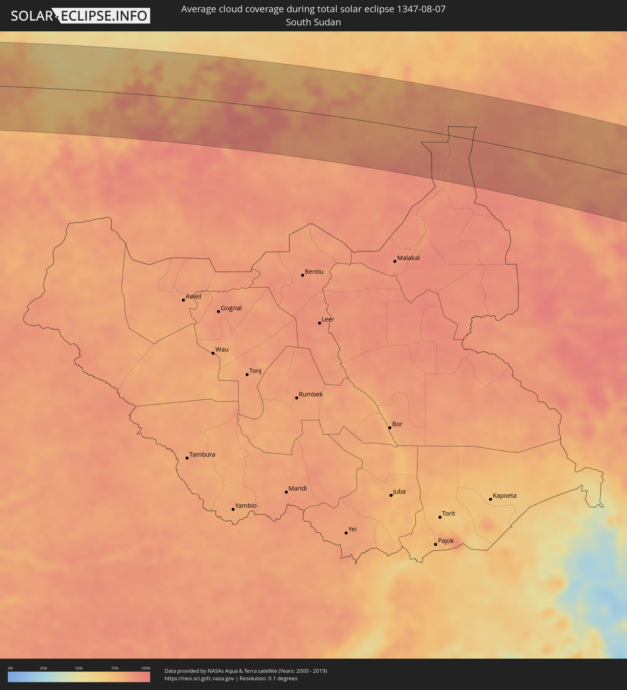 Südsudan
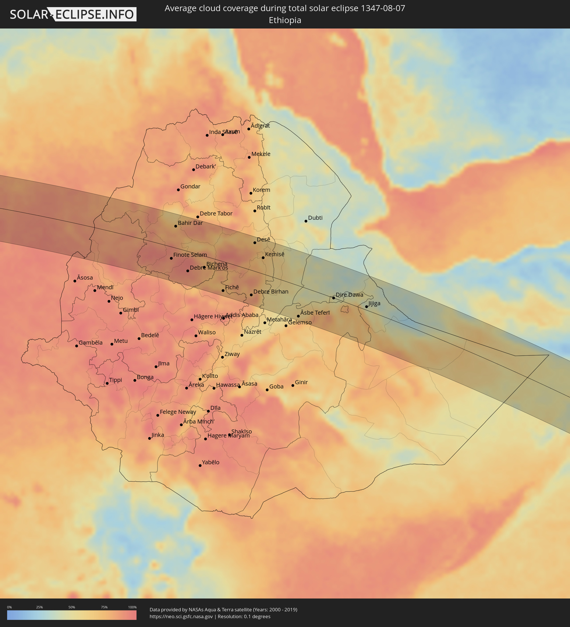 Äthiopien
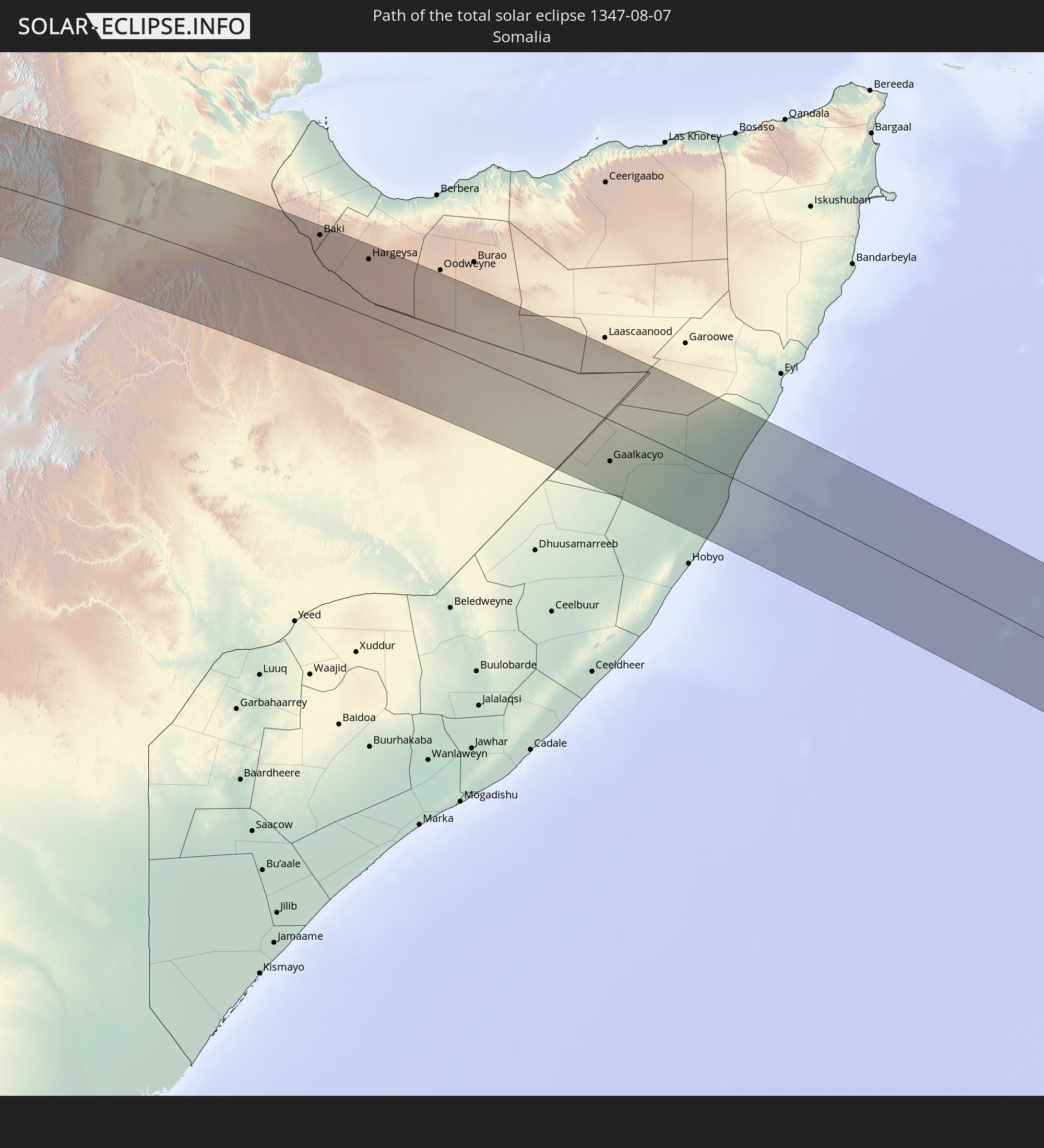
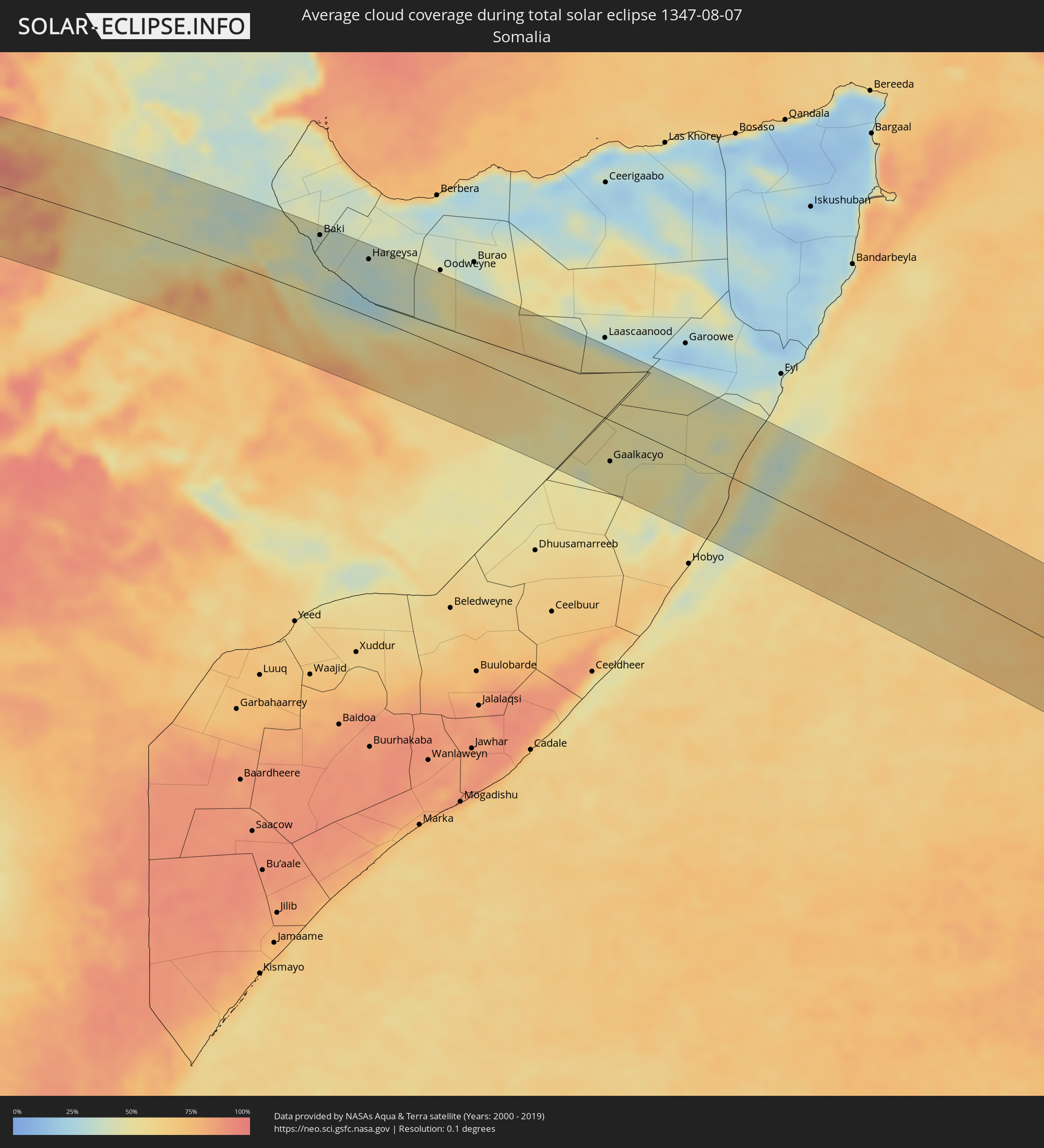 Somalia
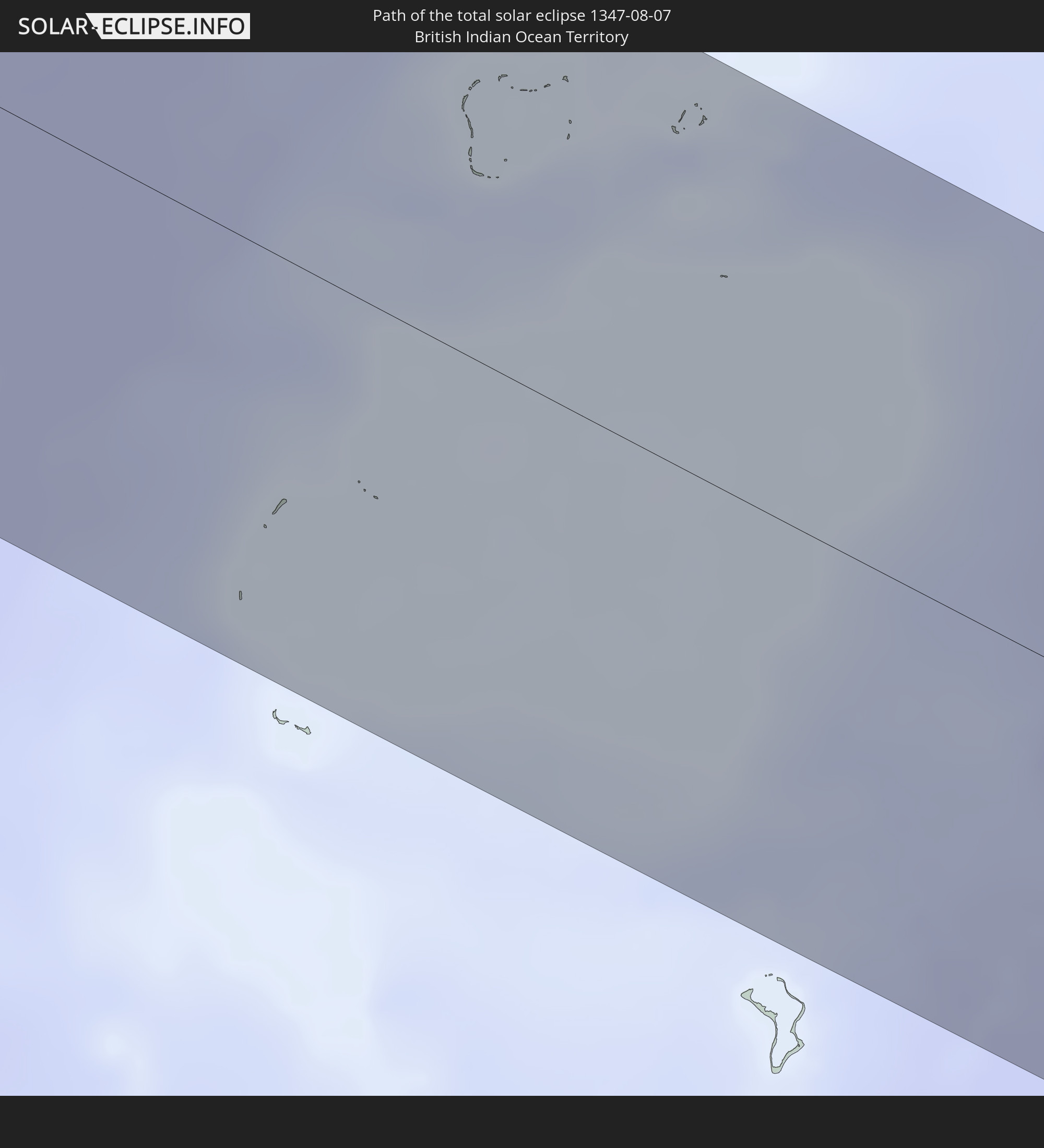
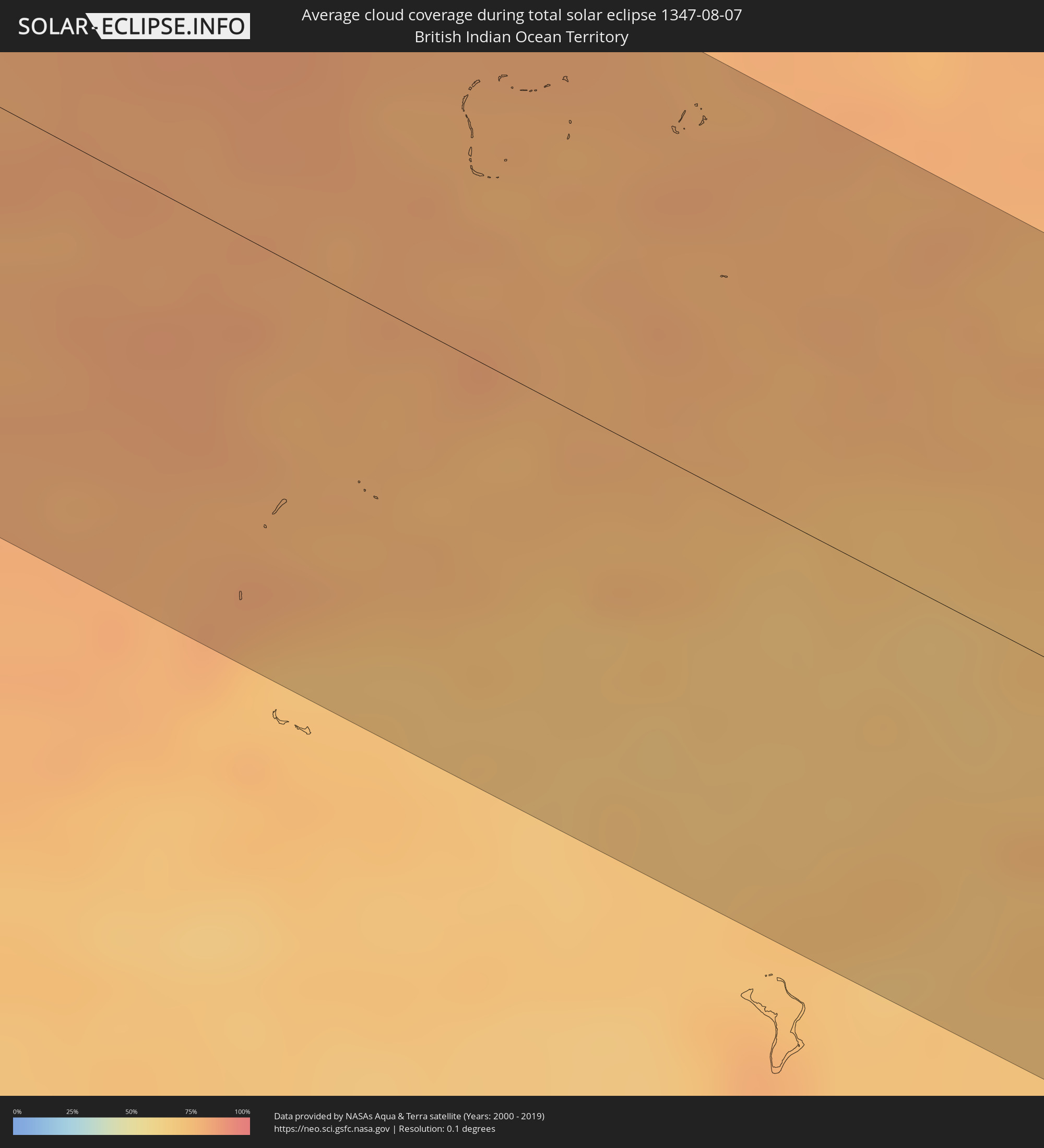 Britisches Territorium im Indischen Ozean
Orte im Finsternispfad
Die nachfolgene Tabelle zeigt Städte und Orte mit mehr als 5.000 Einwohnern, die sich im Finsternispfad befinden. Städte mit mehr als 100.000 Einwohnern sind dick gekennzeichnet. Mit einem Klick auf den Ort öffnet sich eine Detailkarte die die Lage des jeweiligen Ortes zusammen mit dem Verlauf der zentralen Finsternis präsentiert.
| Ort | Typ | Dauer der Verfinsterung | Ortszeit bei maximaler Verfinsterung | Entfernung zur Zentrallinie | Ø Bewölkung |
|
Freetown, Western Area
|
total | - | 06:55:58 UTC-00:16 | 54 km | 96% |
|
Waterloo, Western Area
|
total | - | 06:55:59 UTC-00:16 | 34 km | 97% |
|
Port Loko, Northern Province
|
total | - | 06:56:04 UTC-00:16 | 73 km | 97% |
|
Lunsar, Northern Province
|
total | - | 06:56:06 UTC-00:16 | 57 km | 96% |
|
Rokupr, Northern Province
|
total | - | 06:56:08 UTC-00:16 | 52 km | 96% |
|
Makeni, Northern Province
|
total | - | 06:56:14 UTC-00:16 | 67 km | 96% |
|
Magburaka, Northern Province
|
total | - | 06:56:14 UTC-00:16 | 46 km | 96% |
|
Bumpe, Southern Province
|
total | - | 06:56:13 UTC-00:16 | 45 km | 97% |
|
Bo, Southern Province
|
total | - | 06:56:15 UTC-00:16 | 41 km | 97% |
|
Kenema, Eastern Province
|
total | - | 06:56:23 UTC-00:16 | 65 km | 96% |
|
Yengema, Eastern Province
|
total | - | 06:56:26 UTC-00:16 | 26 km | 95% |
|
Koidu, Eastern Province
|
total | - | 06:56:29 UTC-00:16 | 13 km | 97% |
|
Segbwema, Eastern Province
|
total | - | 06:56:27 UTC-00:16 | 58 km | 95% |
|
Kailahun, Eastern Province
|
total | - | 06:56:34 UTC-00:16 | 37 km | 95% |
|
Gueckedou, Nzerekore
|
total | - | 06:56:43 UTC-00:16 | 17 km | 96% |
|
Kissidougou, Faranah
|
total | - | 06:56:45 UTC-00:16 | 49 km | 94% |
|
Voinjama, Lofa
|
total | - | 06:29:50 UTC-00:43 | 42 km | 95% |
|
Macenta, Nzerekore
|
total | - | 06:56:55 UTC-00:16 | 36 km | 95% |
|
Kérouané, Kankan
|
total | - | 06:57:07 UTC-00:16 | 31 km | 92% |
|
Beyla, Nzerekore
|
total | - | 06:57:13 UTC-00:16 | 40 km | 94% |
|
Odienné, Denguélé
|
total | - | 06:57:40 UTC-00:16 | 22 km | 92% |
|
Boundiali, Savanes
|
total | - | 06:58:08 UTC-00:16 | 2 km | 92% |
|
Korhogo, Savanes
|
total | - | 06:58:32 UTC-00:16 | 30 km | 95% |
|
Ferkessédougou, Savanes
|
total | - | 06:58:45 UTC-00:16 | 25 km | 96% |
|
Banfora, Cascades
|
total | - | 06:59:03 UTC-00:16 | 78 km | 94% |
|
Gaoua, Sud-Ouest
|
total | - | 06:59:52 UTC-00:16 | 8 km | 94% |
|
Diébougou, Sud-Ouest
|
total | - | 06:59:56 UTC-00:16 | 80 km | 95% |
|
Batié, Sud-Ouest
|
total | - | 07:00:03 UTC-00:16 | 45 km | 94% |
|
Wa, Upper West
|
total | - | 07:15:35 UTC-00:00 | 35 km | 96% |
|
Léo, Centre-Ouest
|
total | - | 07:00:39 UTC-00:16 | 70 km | 95% |
|
Pô, Centre-Sud
|
total | - | 07:01:17 UTC-00:16 | 57 km | 94% |
|
Navrongo, Upper East
|
total | - | 07:16:34 UTC-00:00 | 26 km | 94% |
|
Bolgatanga, Upper East
|
total | - | 07:16:44 UTC-00:00 | 9 km | 94% |
|
Bawku, Upper East
|
total | - | 07:17:11 UTC-00:00 | 27 km | 95% |
|
Ouargaye, Centre-Est
|
total | - | 07:02:11 UTC-00:16 | 69 km | 96% |
|
Dapaong, Savanes
|
total | - | 07:02:15 UTC-00:16 | 4 km | 94% |
|
Sansanné-Mango, Savanes
|
total | - | 07:02:25 UTC-00:16 | 64 km | 94% |
|
Pama, Est
|
total | - | 07:02:39 UTC-00:16 | 28 km | 91% |
|
Tanguiéta, Atakora
|
total | - | 07:32:46 UTC+00:13 | 51 km | 94% |
|
Guilmaro, Atakora
|
total | - | 07:33:09 UTC+00:13 | 66 km | 92% |
|
Banikoara, Alibori
|
total | - | 07:33:48 UTC+00:13 | 0 km | 94% |
|
Kandi, Alibori
|
total | - | 07:34:14 UTC+00:13 | 27 km | 94% |
|
Malanville, Atakora
|
total | - | 07:34:41 UTC+00:13 | 45 km | 93% |
|
Gaya, Dosso
|
total | - | 07:34:45 UTC+00:13 | 46 km | 93% |
|
Jega, Kebbi
|
total | - | 07:35:39 UTC+00:13 | 67 km | 96% |
|
Kaura Namoda, Zamfara
|
total | - | 07:37:56 UTC+00:13 | 71 km | 95% |
|
Gusau, Zamfara
|
total | - | 07:37:59 UTC+00:13 | 23 km | 95% |
|
Funtua, Katsina
|
total | - | 07:38:41 UTC+00:13 | 58 km | 92% |
|
Malumfashi, Katsina
|
total | - | 07:39:03 UTC+00:13 | 33 km | 93% |
|
Kano, Kano
|
total | - | 07:40:06 UTC+00:13 | 23 km | 94% |
|
Magaria, Zinder
|
total | - | 07:40:37 UTC+00:13 | 82 km | 97% |
|
Gumel, Jigawa
|
total | - | 07:41:12 UTC+00:13 | 34 km | 97% |
|
Hadejia, Jigawa
|
total | - | 07:42:01 UTC+00:13 | 7 km | 93% |
|
Azare, Bauchi
|
total | - | 07:42:12 UTC+00:13 | 81 km | 95% |
|
Nguru, Yobe
|
total | - | 07:42:34 UTC+00:13 | 48 km | 91% |
|
Gashua, Yobe
|
total | - | 07:43:20 UTC+00:13 | 41 km | 93% |
|
Potiskum, Yobe
|
total | - | 07:43:24 UTC+00:13 | 88 km | 94% |
|
Geidam, Yobe
|
total | - | 07:44:33 UTC+00:13 | 33 km | 93% |
|
Maïné Soroa, Diffa
|
total | - | 07:44:41 UTC+00:13 | 67 km | 97% |
|
Diffa, Diffa
|
total | - | 07:45:31 UTC+00:13 | 73 km | 94% |
|
Gamboru, Borno
|
total | - | 07:47:55 UTC+00:13 | 47 km | 91% |
|
Makary, Far North
|
total | - | 07:48:18 UTC+00:13 | 26 km | 95% |
|
Bol, Lac
|
total | - | 08:35:17 UTC+01:00 | 70 km | 77% |
|
Kousséri, Far North
|
total | - | 07:49:14 UTC+00:13 | 86 km | 92% |
|
N'Djamena, Chari-Baguirmi
|
total | - | 08:35:53 UTC+01:00 | 83 km | 92% |
|
Massaguet, Hadjer-Lamis
|
total | - | 08:36:29 UTC+01:00 | 45 km | 94% |
|
Massakory, Hadjer-Lamis
|
total | - | 08:36:55 UTC+01:00 | 11 km | 94% |
|
Moussoro, Barh el Gazel
|
total | - | 08:38:08 UTC+01:00 | 78 km | 95% |
|
Bokoro, Hadjer-Lamis
|
total | - | 08:39:13 UTC+01:00 | 66 km | 93% |
|
Ati, Batha
|
total | - | 08:41:22 UTC+01:00 | 22 km | 94% |
|
Oum Hadjer, Batha
|
total | - | 08:43:52 UTC+01:00 | 27 km | 92% |
|
Abéché, Ouadaï
|
total | - | 08:45:57 UTC+01:00 | 86 km | 91% |
|
Goz Beïda, Sila
|
total | - | 08:47:26 UTC+01:00 | 93 km | 92% |
|
Adré, Ouadaï
|
total | - | 08:48:45 UTC+01:00 | 47 km | 89% |
|
Geneina, Western Darfur
|
total | - | 09:59:11 UTC+02:10 | 46 km | 85% |
|
Zalingei, Central Darfur
|
total | - | 10:01:28 UTC+02:10 | 12 km | 83% |
|
El Fasher, Northern Darfur
|
total | - | 10:05:21 UTC+02:10 | 78 km | 61% |
|
An Nuhūd, West Kordofan State
|
total | - | 10:12:55 UTC+02:10 | 4 km | 87% |
|
Abū Zabad, West Kordofan State
|
total | - | 10:15:06 UTC+02:10 | 24 km | 94% |
|
Dilling, Southern Kordofan
|
total | - | 10:16:16 UTC+02:10 | 52 km | 83% |
|
El Obeid, North Kordofan
|
total | - | 10:17:05 UTC+02:10 | 82 km | 76% |
|
Ar Rahad, North Kordofan
|
total | - | 10:18:26 UTC+02:10 | 37 km | 83% |
|
Umm Ruwaba, North Kordofan
|
total | - | 10:19:46 UTC+02:10 | 67 km | 77% |
|
Abu Jibeha, Southern Kordofan
|
total | - | 10:20:40 UTC+02:10 | 92 km | 90% |
|
Tandaltī, White Nile
|
total | - | 10:21:23 UTC+02:10 | 90 km | 86% |
|
Marabba, White Nile
|
total | - | 10:22:37 UTC+02:10 | 23 km | 84% |
|
Ad-Damazin, Blue Nile
|
total | - | 10:28:51 UTC+02:10 | 7 km | 82% |
|
Ar Ruseris, Blue Nile
|
total | - | 10:28:52 UTC+02:10 | 16 km | 86% |
|
Burē, Amhara
|
total | - | 10:54:26 UTC+02:27 | 41 km | 88% |
|
Finote Selam, Amhara
|
total | - | 10:55:00 UTC+02:27 | 35 km | 86% |
|
Bahir Dar, Amhara
|
total | - | 10:54:34 UTC+02:27 | 64 km | 78% |
|
Addiet Canna, Amhara
|
total | - | 10:55:07 UTC+02:27 | 32 km | 81% |
|
Debre Mark’os, Amhara
|
total | - | 10:56:39 UTC+02:27 | 59 km | 92% |
|
Gebre Guracha, Oromiya
|
total | - | 10:59:06 UTC+02:27 | 98 km | 87% |
|
Fichē, Oromiya
|
total | - | 11:00:04 UTC+02:27 | 87 km | 81% |
|
Debre Birhan, Amhara
|
total | - | 11:02:31 UTC+02:27 | 74 km | 84% |
|
Desē, Amhara
|
total | - | 11:01:22 UTC+02:27 | 84 km | 78% |
|
Kemisē, Amhara
|
total | - | 11:02:27 UTC+02:27 | 47 km | 68% |
|
Āsbe Teferī, Oromiya
|
total | - | 11:07:03 UTC+02:27 | 91 km | 66% |
|
Dire Dawa, Dire Dawa
|
total | - | 11:09:26 UTC+02:27 | 1 km | 48% |
|
Harar, Harari
|
total | - | 11:10:29 UTC+02:27 | 21 km | 75% |
|
Jijiga, Somali
|
total | - | 11:12:26 UTC+02:27 | 9 km | 45% |
|
Baki, Awdal
|
total | - | 11:13:31 UTC+02:27 | 89 km | 38% |
|
Hargeysa, Woqooyi Galbeed
|
total | - | 11:15:52 UTC+02:27 | 81 km | 35% |
|
Gaalkacyo, Mudug
|
total | - | 11:29:03 UTC+02:27 | 58 km | 48% |