Totale Sonnenfinsternis vom 12.02.1431
| Wochentag: | Samstag |
| Maximale Dauer der Verfinsterung: | 04m30s |
| Maximale Breite des Finsternispfades: | 193 km |
| Saroszyklus: | 121 |
| Bedeckungsgrad: | 100% |
| Magnitude: | 1.0534 |
| Gamma: | 0.4245 |
Wo kann man die Sonnenfinsternis vom 12.02.1431 sehen?
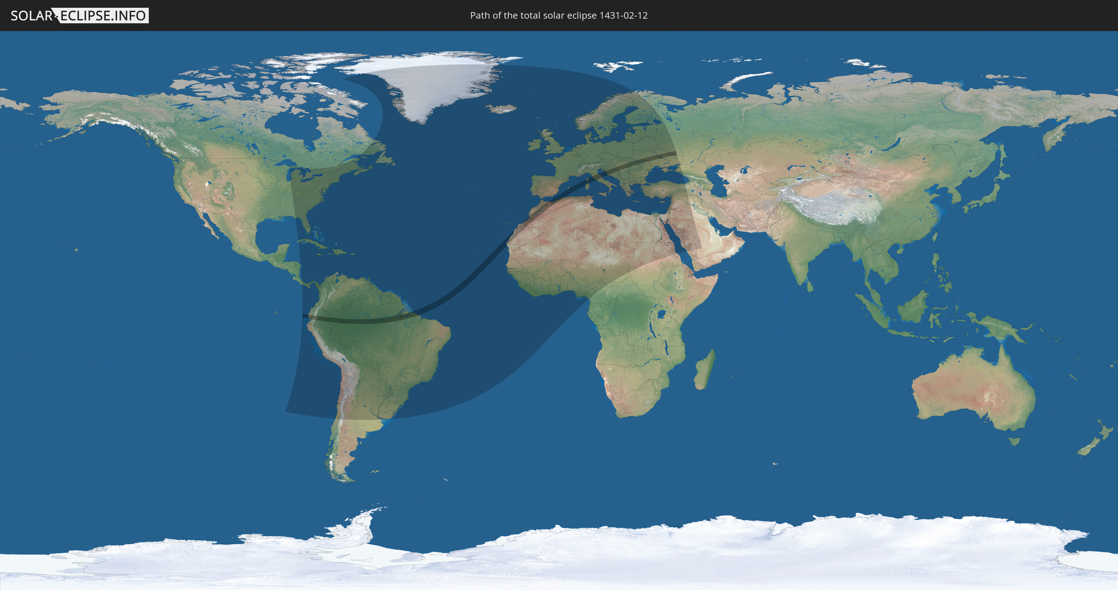
Die Sonnenfinsternis am 12.02.1431 kann man in 134 Ländern als partielle Sonnenfinsternis beobachten.
Der Finsternispfad verläuft durch 20 Länder. Nur in diesen Ländern ist sie als totale Sonnenfinsternis zu sehen.
In den folgenden Ländern ist die Sonnenfinsternis total zu sehen
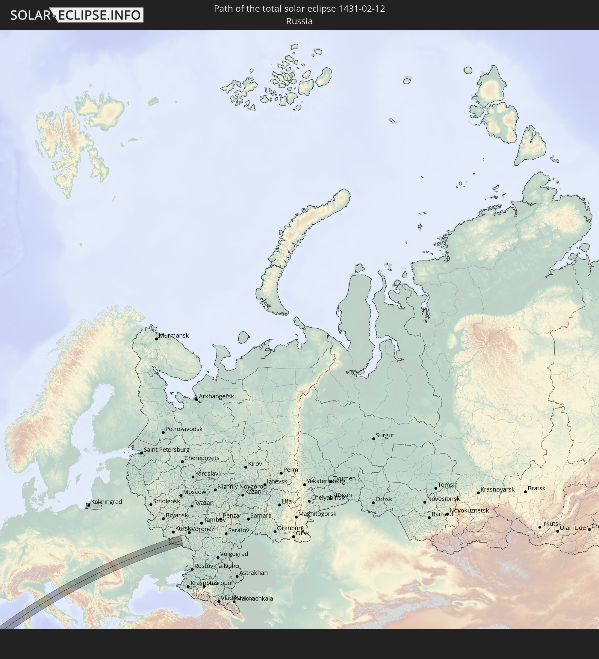 Russland
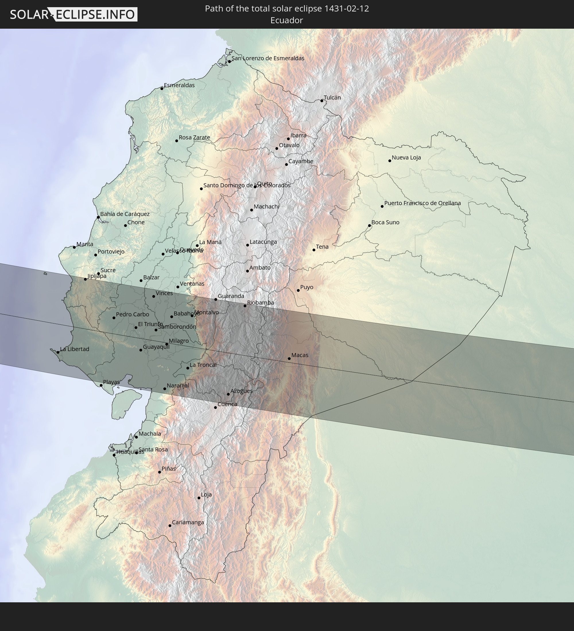 Ecuador
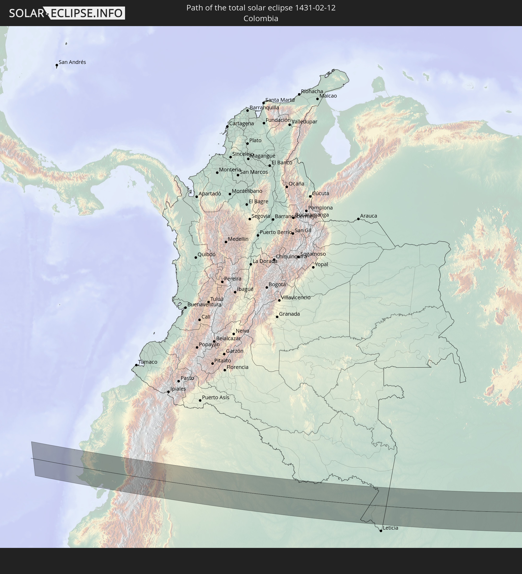 Kolumbien
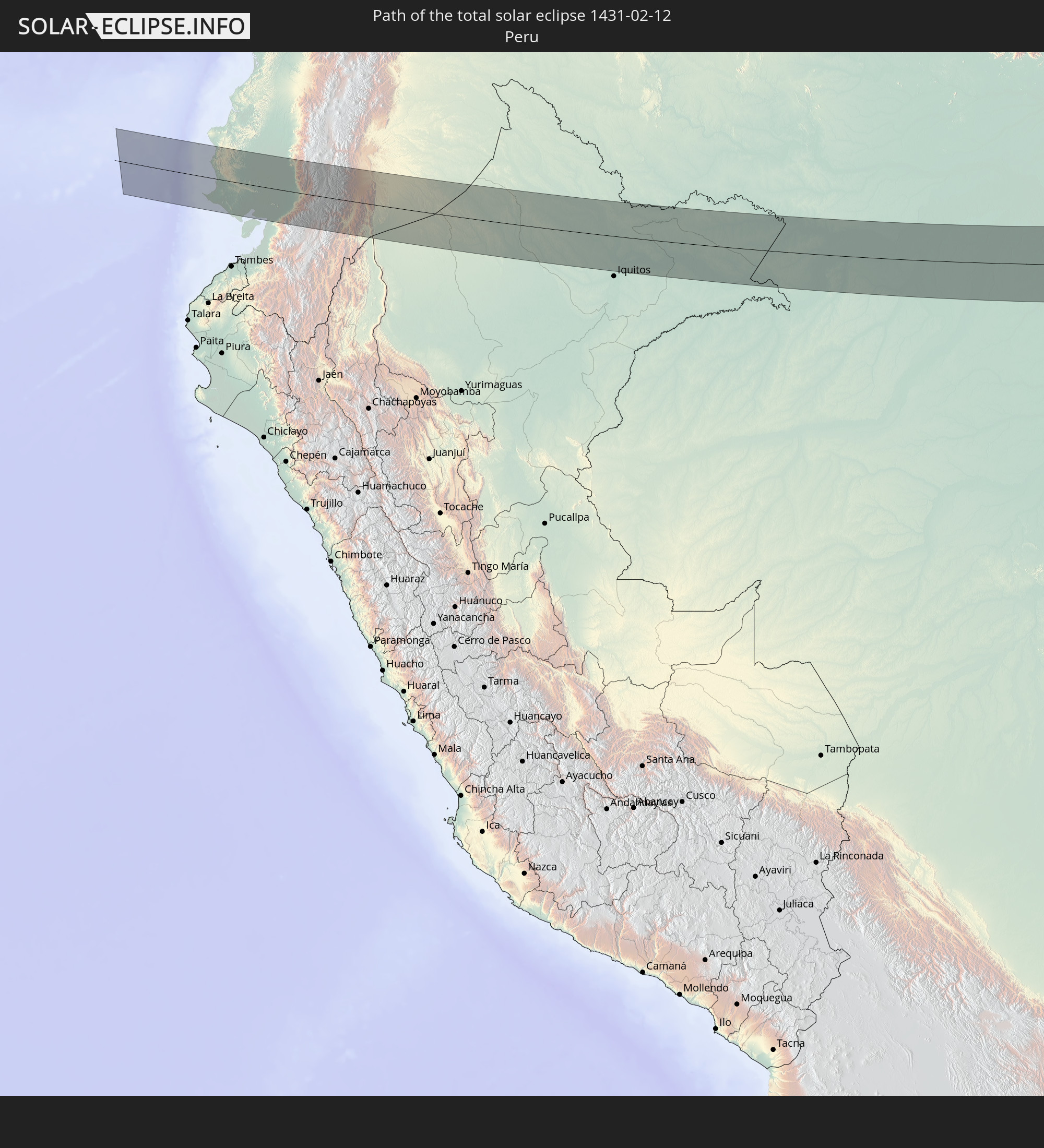 Peru
Peru
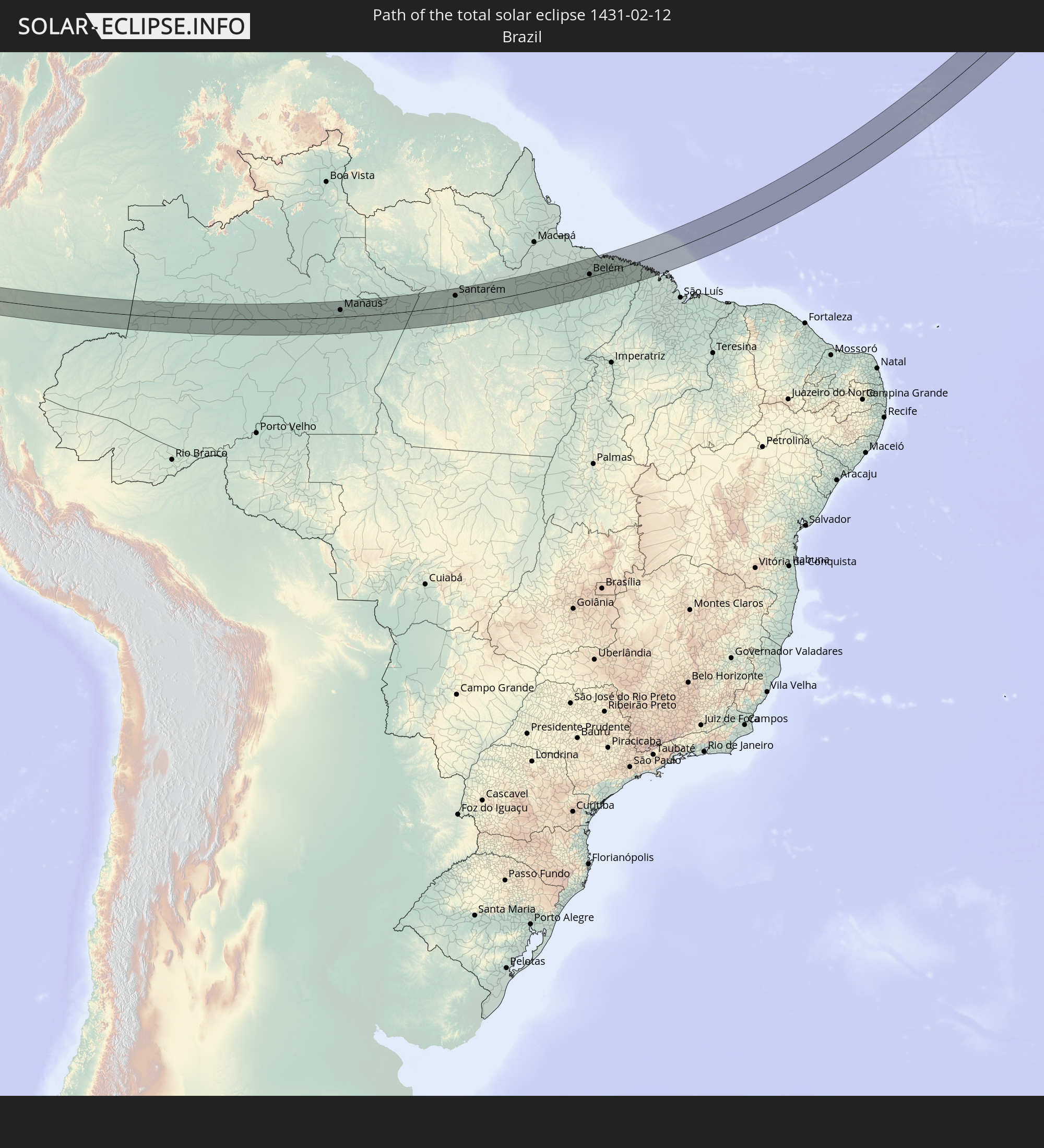 Brasilien
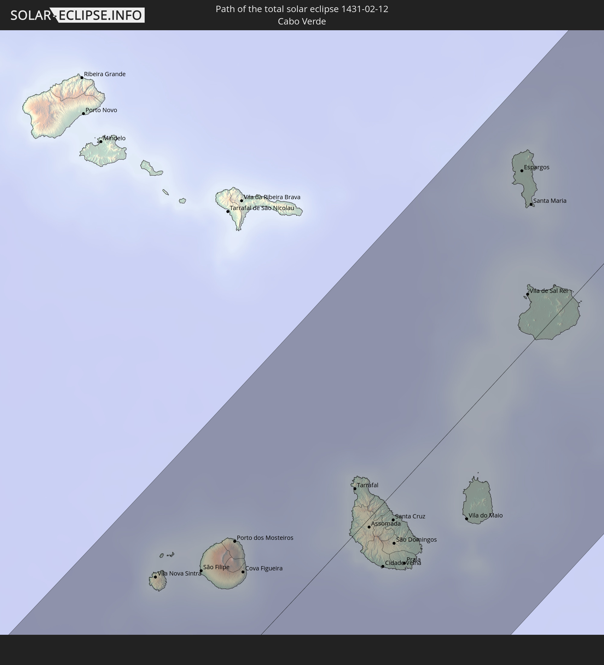 Kap Verde
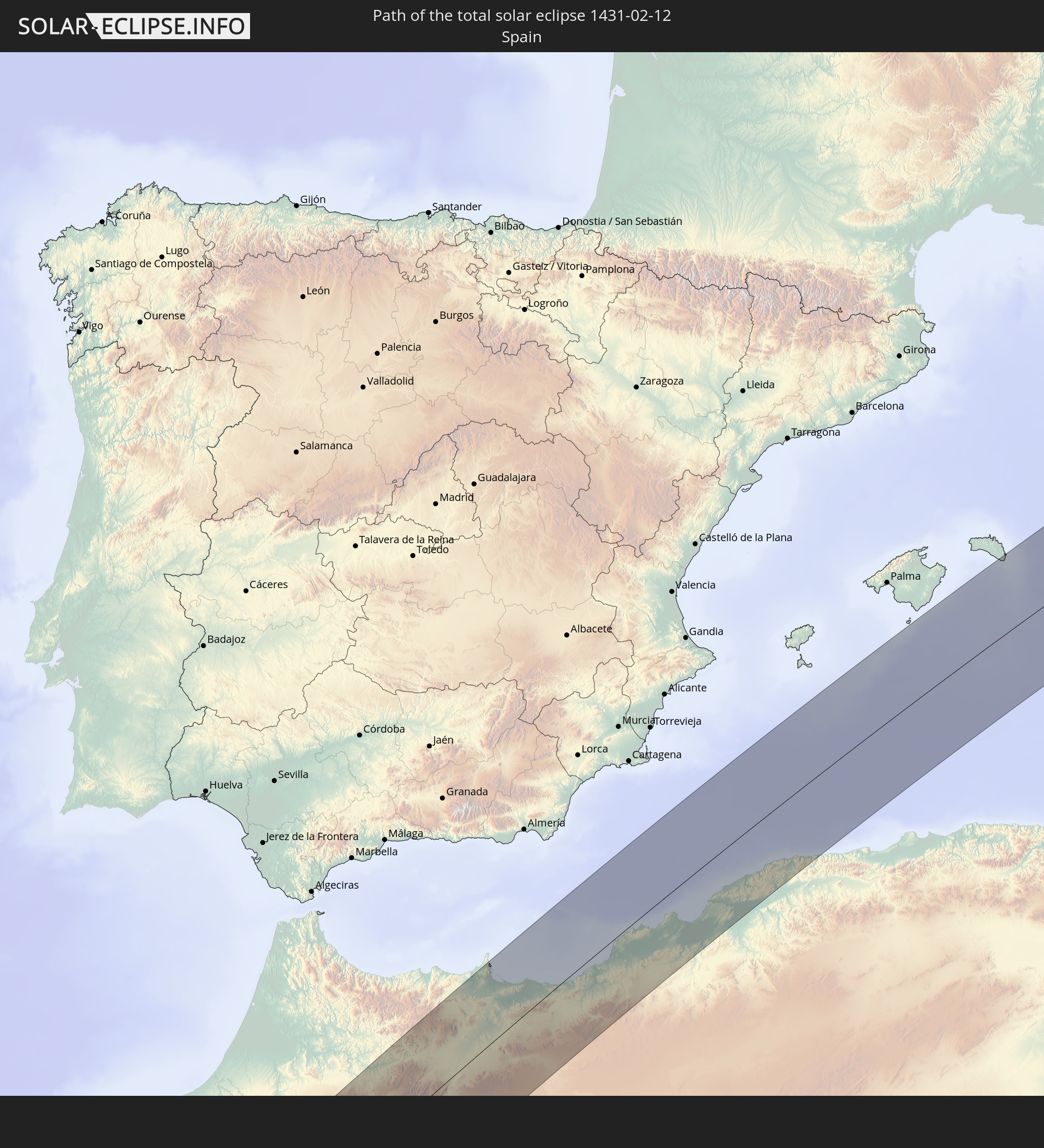 Spanien
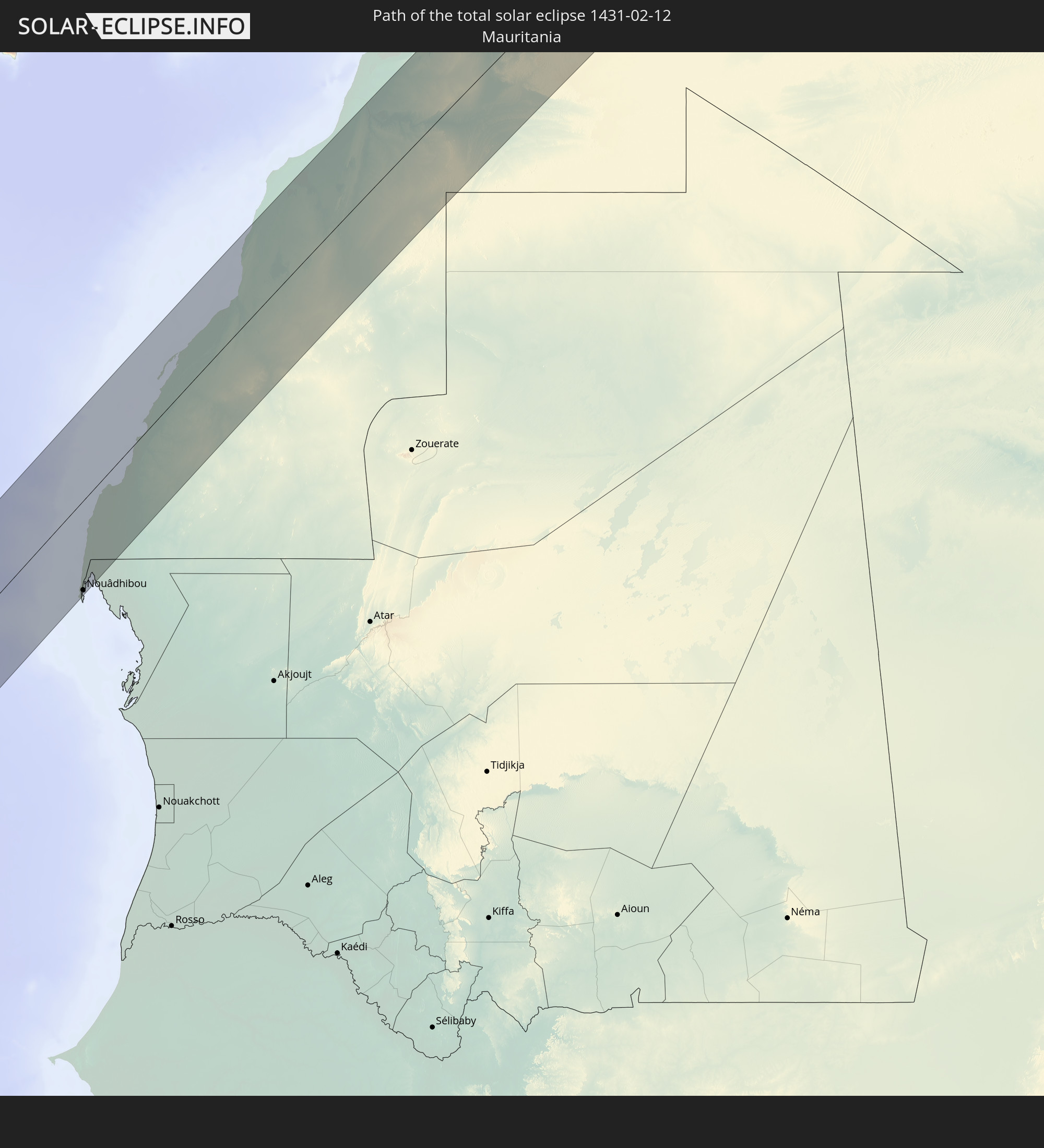 Mauretanien
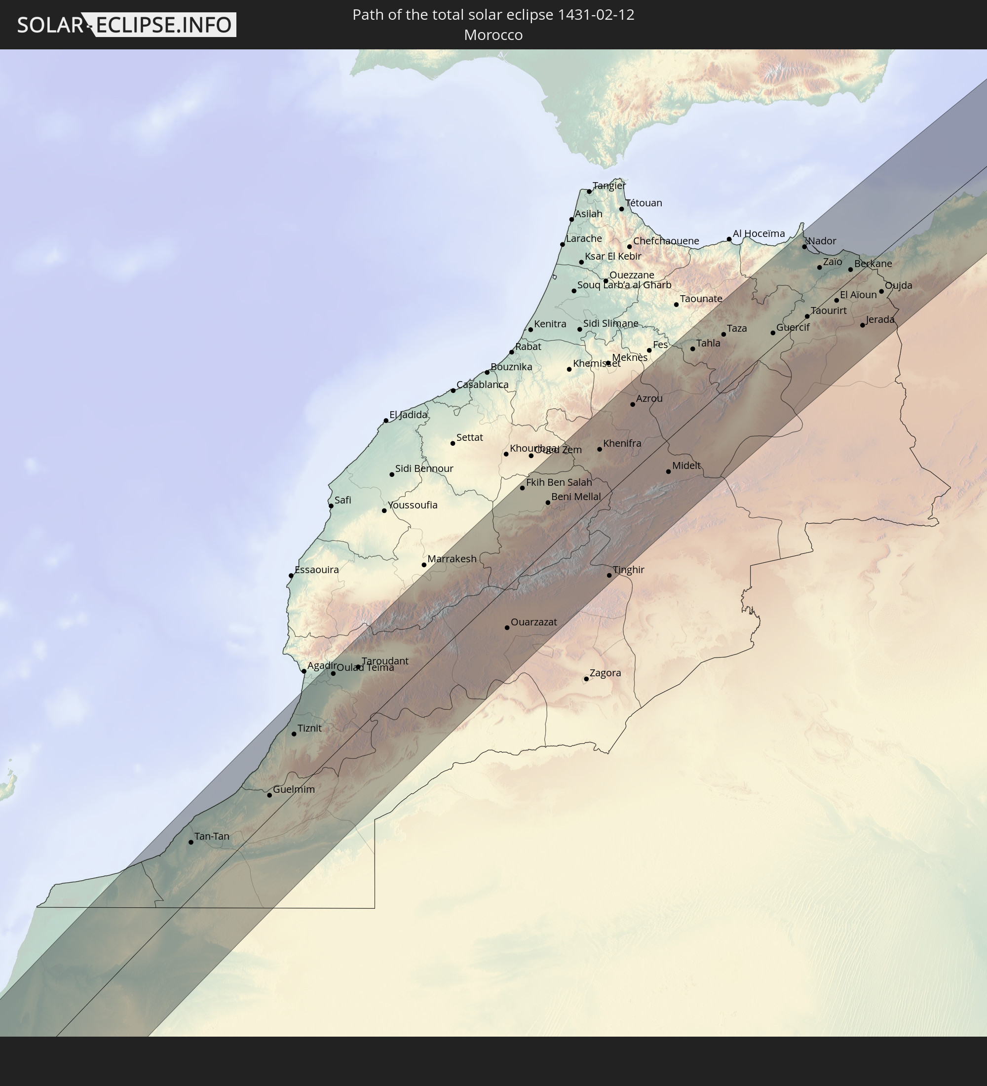 Marokko
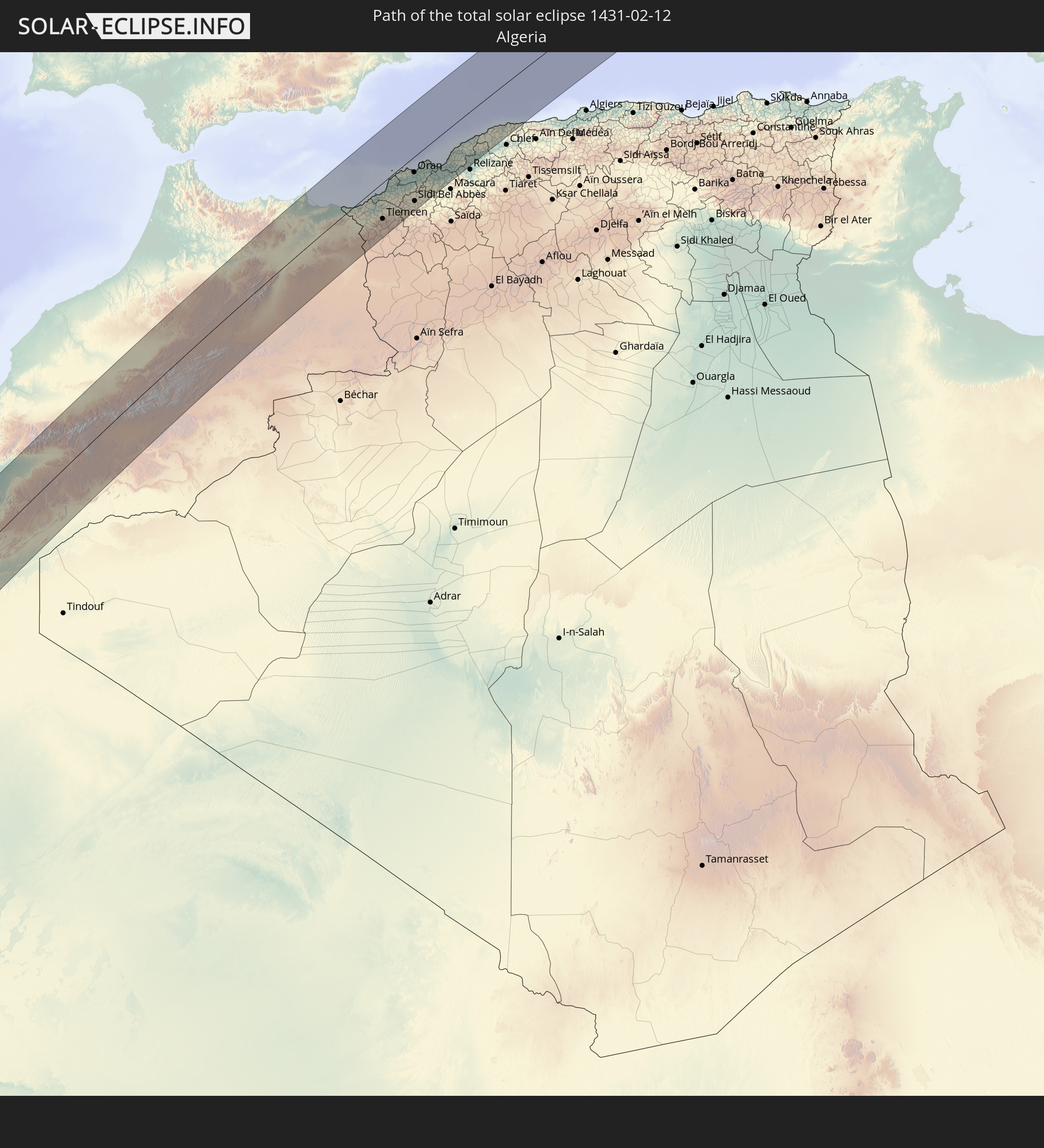 Algerien
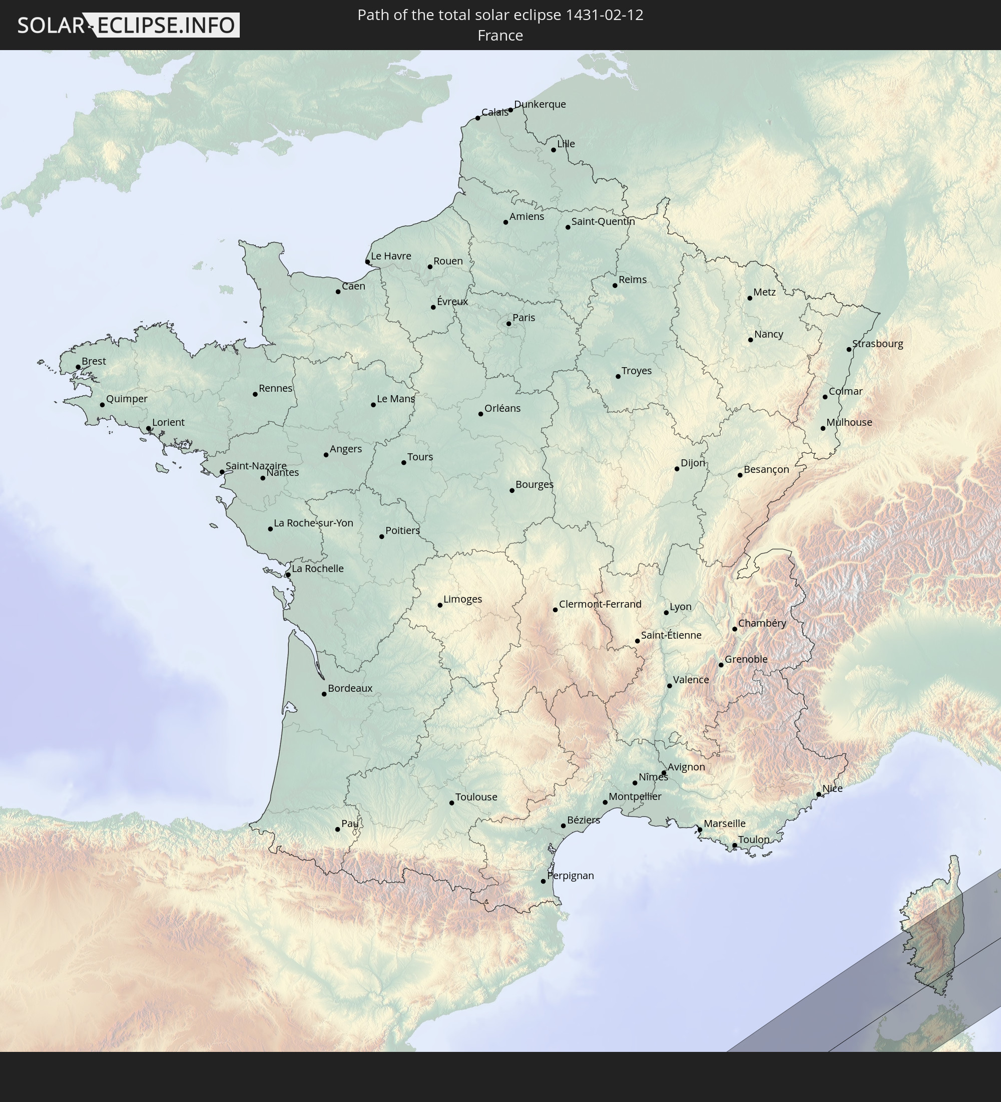 Frankreich
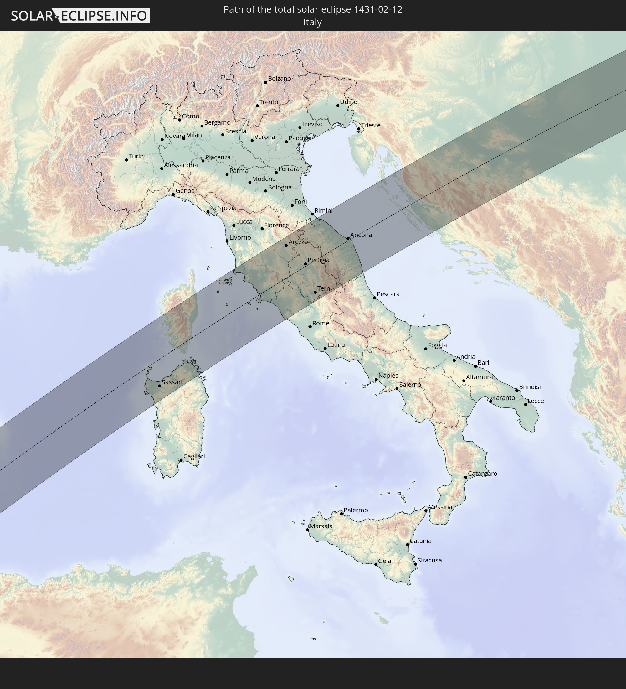 Italien
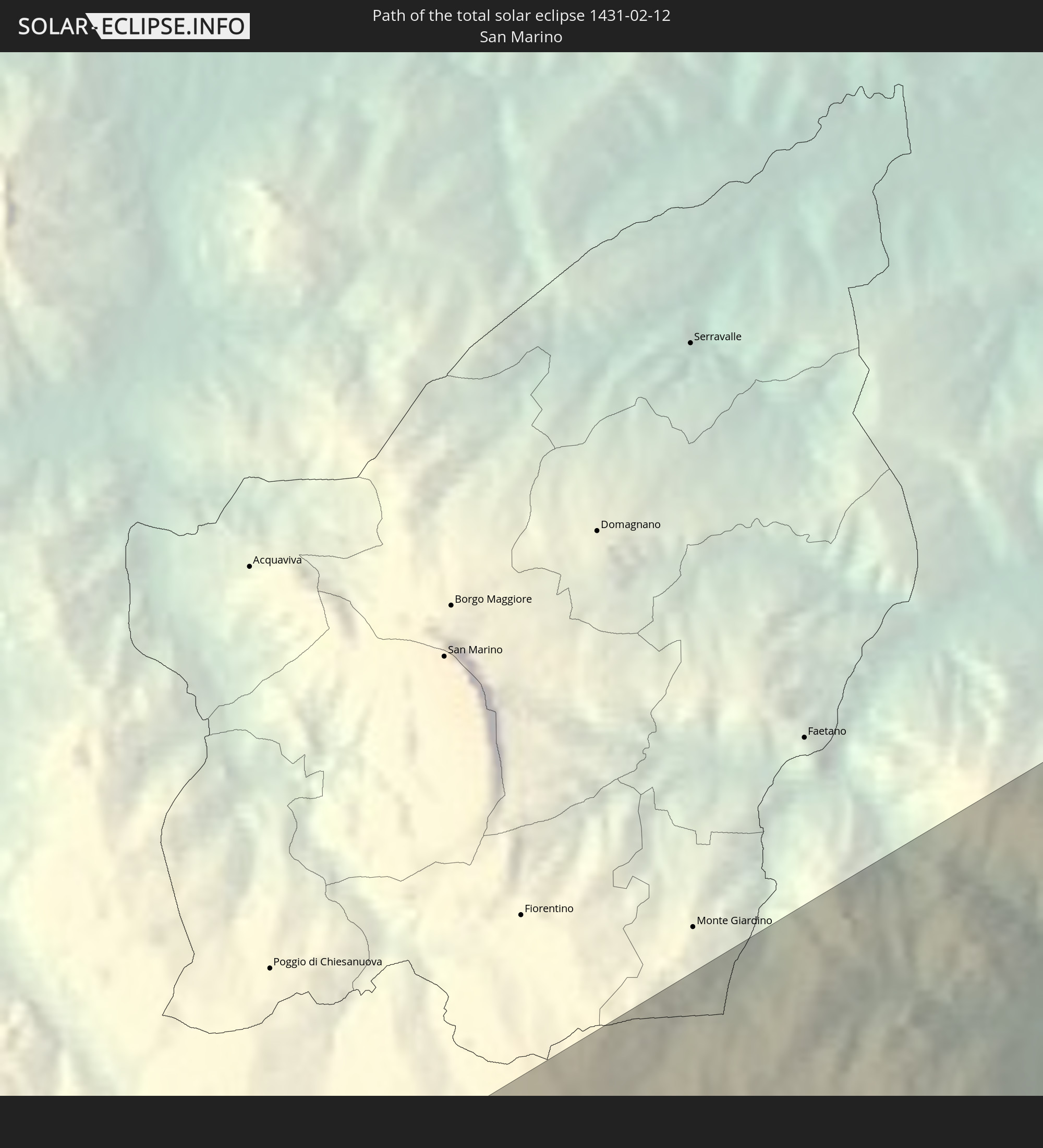 San Marino
 Kroatien
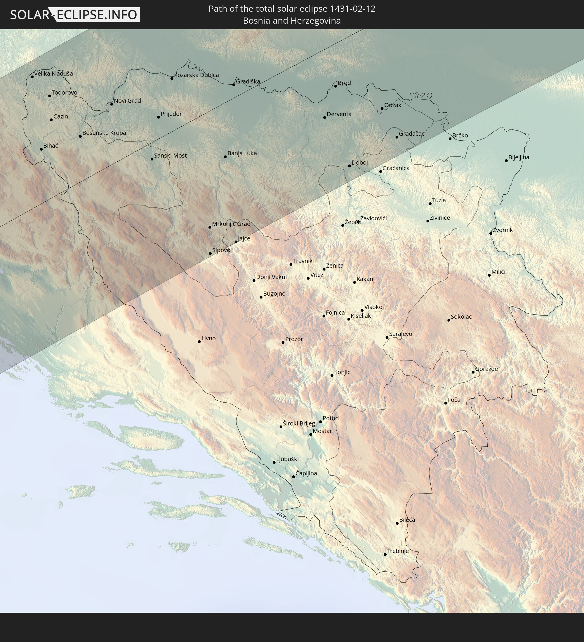 Bosnien und Herzegowina
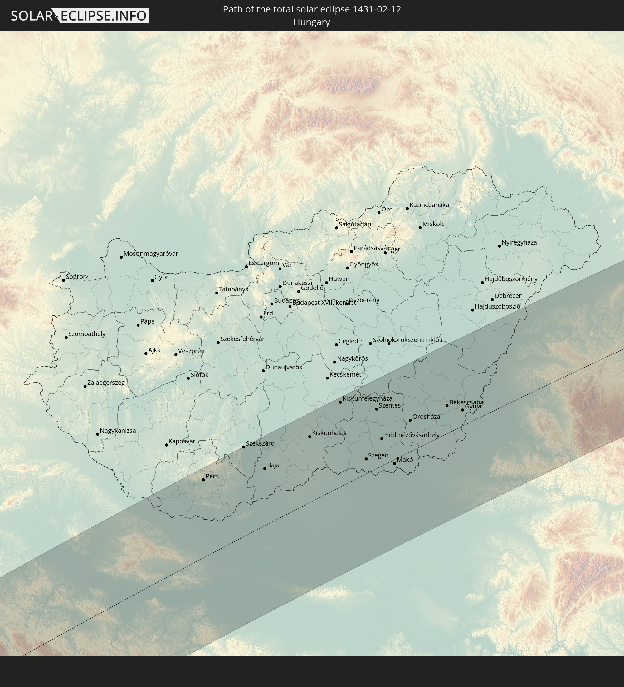 Ungarn
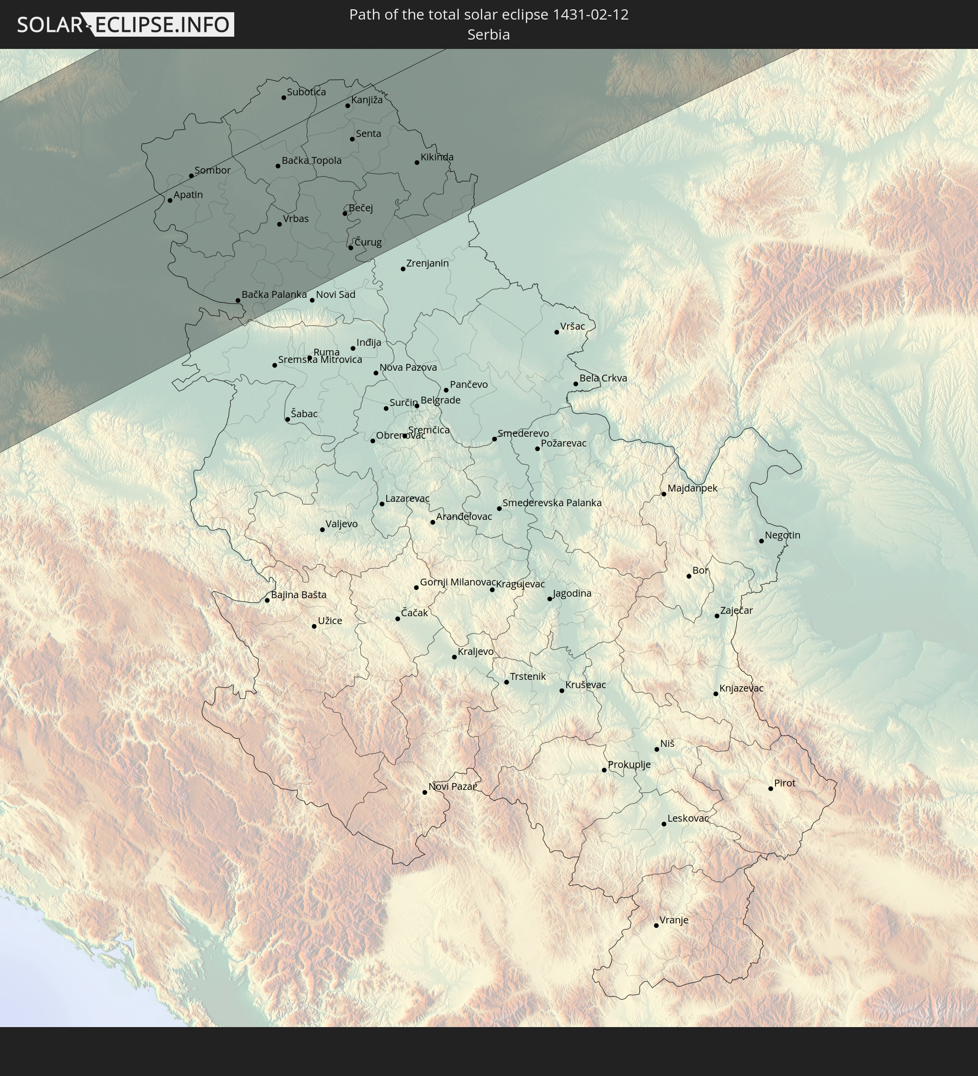 Serbien
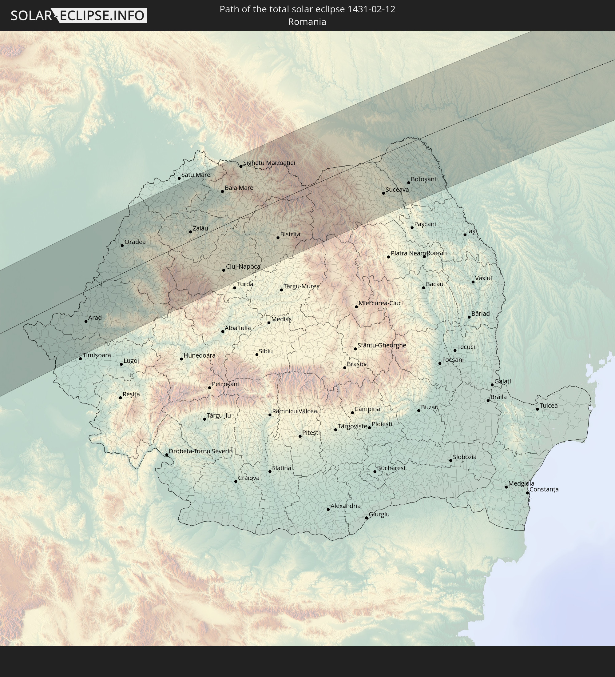 Rumänien
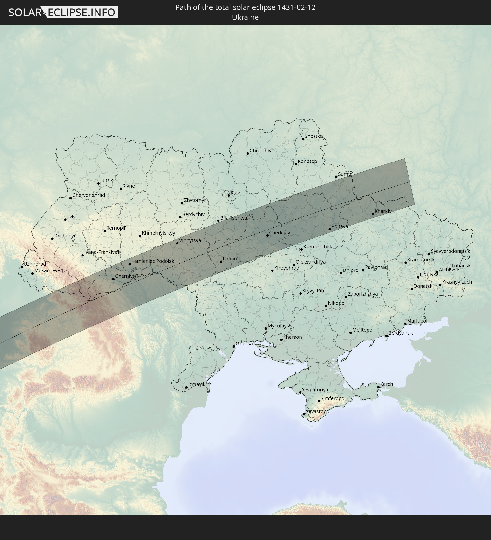 Ukraine
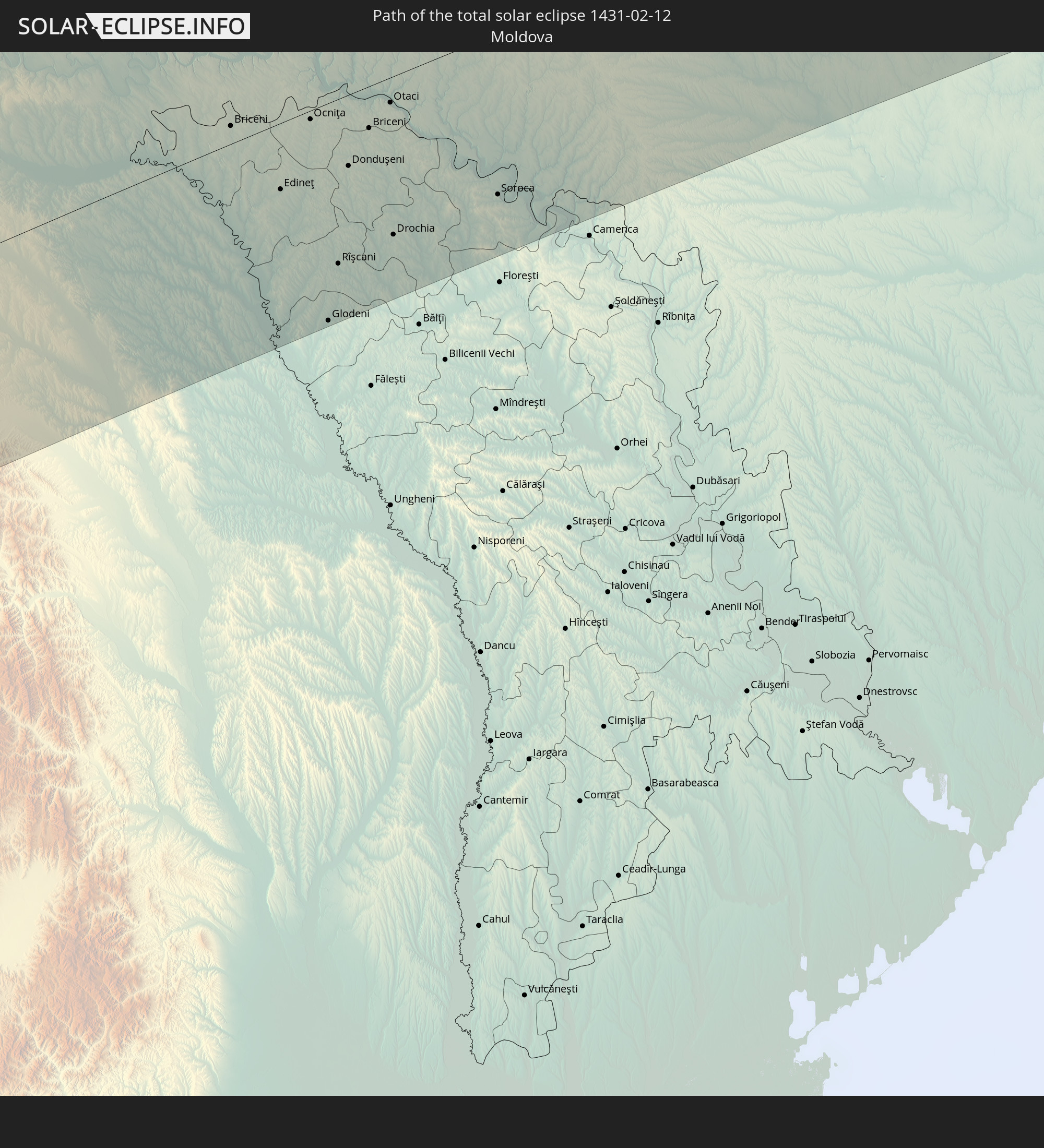 Moldawien
In den folgenden Ländern ist die Sonnenfinsternis partiell zu sehen
 Russland
 Vereinigte Staaten
 United States Minor Outlying Islands
 Kanada
 Chile
Chile
 Grönland
 Ecuador
 Honduras
 Nicaragua
 Costa Rica
 Kuba
Kuba
 Panama
 Kolumbien
 Kaimaninseln
 Peru
Peru
 Bahamas
 Jamaika
 Haiti
Haiti
 Brasilien
 Argentinien
 Venezuela
 Turks- und Caicosinseln
 Dominikanische Republik
 Aruba
Aruba
 Bolivien
 Puerto Rico
 Amerikanische Jungferninseln
 Bermuda
 Britische Jungferninseln
 Anguilla
 Saint-Martin
 Saint-Barthélemy
 St. Kitts und Nevis
 Paraguay
 Antigua und Barbuda
 Montserrat
 Trinidad und Tobago
 Guadeloupe
 Grenada
 Dominica
 St. Vincent und die Grenadinen
 Guyana
 Martinique
 St. Lucia
 Barbados
 Uruguay
 Suriname
 Saint-Pierre und Miquelon
 Französisch-Guayana
 Portugal
 Kap Verde
 Island
 Spanien
 Senegal
 Mauretanien
 Gambia
 Guinea-Bissau
 Guinea
 St. Helena
 Sierra Leone
 Marokko
 Mali
Mali
 Liberia
 Irland
 Spitzbergen
 Algerien
 Vereinigtes Königreich
 Elfenbeinküste
 Färöer
 Burkina Faso
 Gibraltar
 Frankreich
 Isle of Man
 Ghana
Ghana
 Guernsey
 Jersey
 Togo
Togo
 Niger
Niger
 Benin
Benin
 Andorra
 Belgien
 Nigeria
 Niederlande
 Norwegen
 Äquatorialguinea
 Luxemburg
 Deutschland
 Schweiz
 Italien
 Monaco
 Tunesien
 Dänemark
 Kamerun
 Libyen
 Liechtenstein
 Österreich
 Schweden
 Tschechien
 San Marino
 Vatikanstadt
 Slowenien
 Tschad
 Kroatien
 Polen
Polen
 Malta
Malta
 Bosnien und Herzegowina
 Ungarn
 Slowakei
 Montenegro
 Serbien
 Albanien
 Åland Islands
 Griechenland
 Rumänien
 Mazedonien
 Finnland
 Litauen
 Lettland
 Estland
 Sudan
Sudan
 Ukraine
 Bulgarien
 Weißrussland
 Ägypten
 Türkei
 Moldawien
 Republik Zypern
 Staat Palästina
 Israel
 Saudi-Arabien
 Jordanien
 Libanon
 Syrien
 Irak
Irak
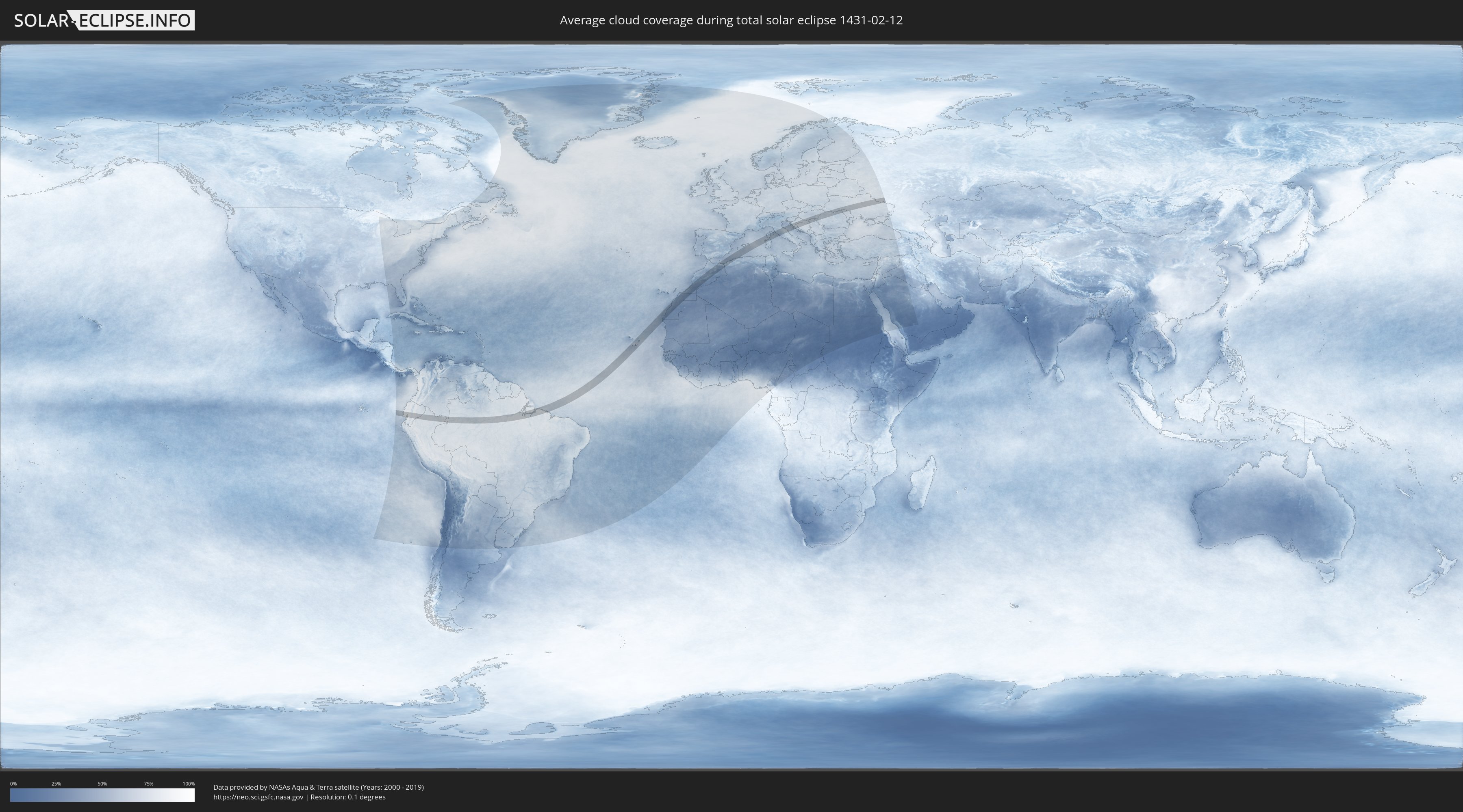
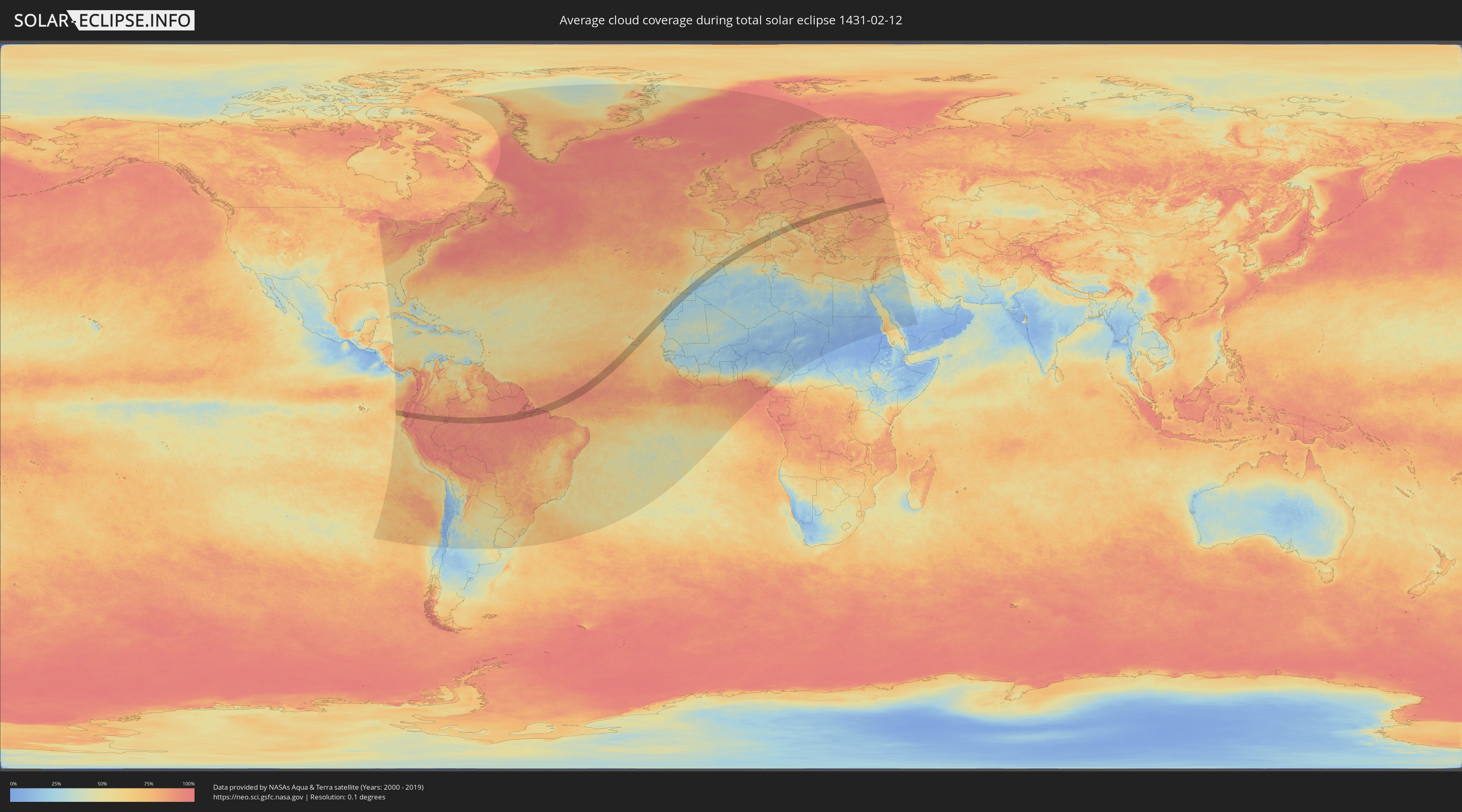
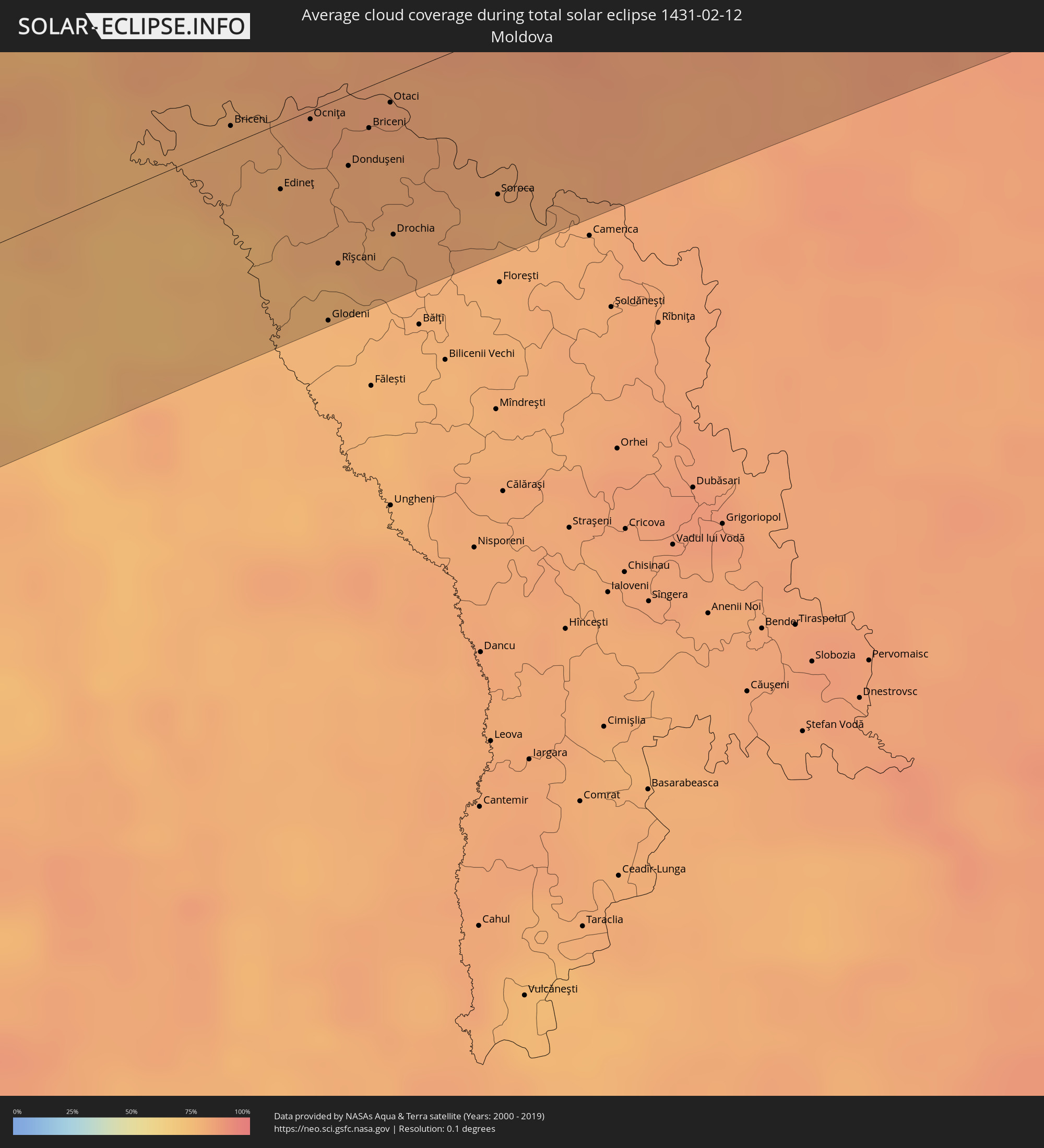
Wie wird das Wetter während der totalen Sonnenfinsternis am 12.02.1431?
Wo ist der beste Ort, um die totale Sonnenfinsternis vom 12.02.1431 zu beobachten?
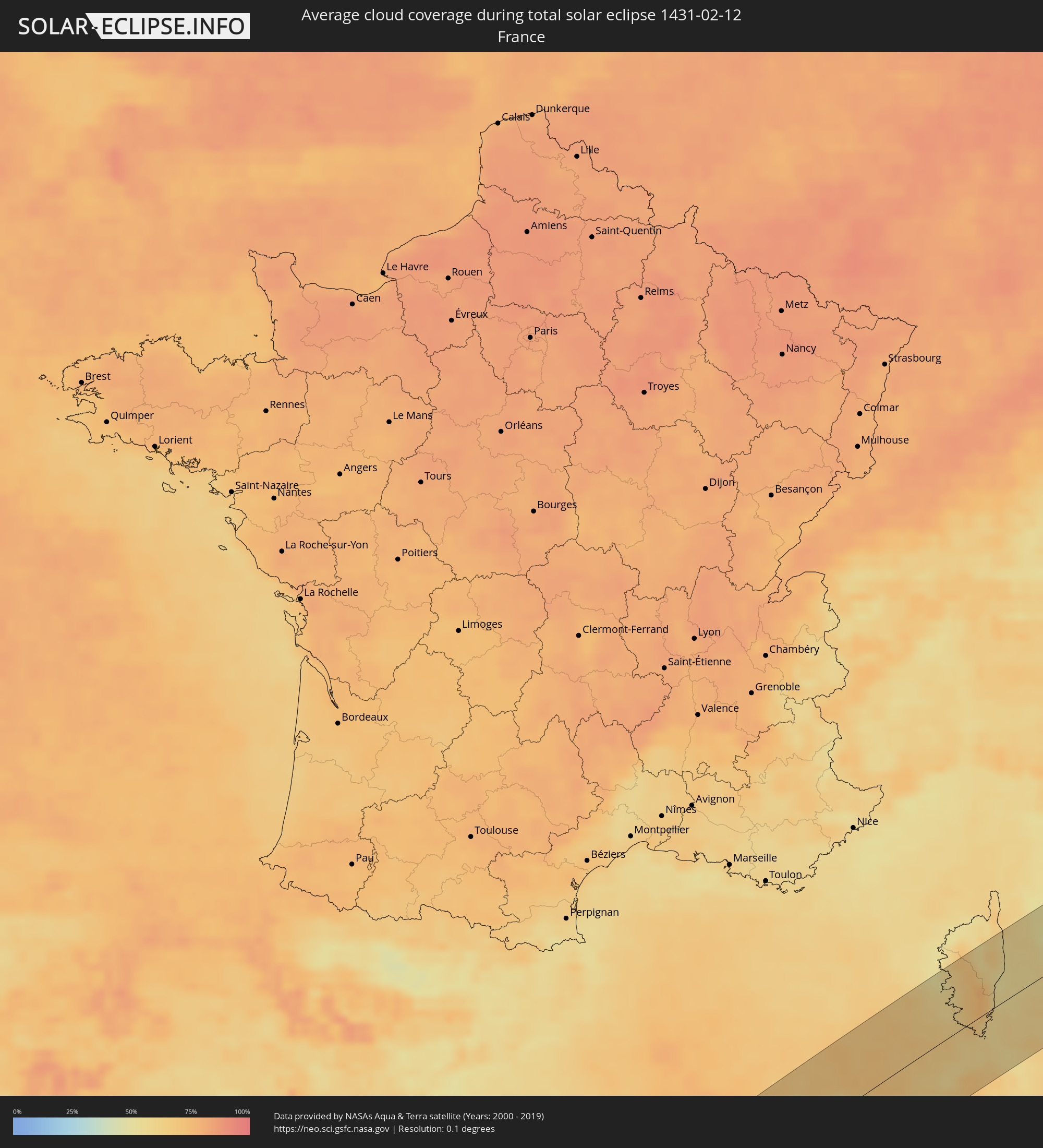
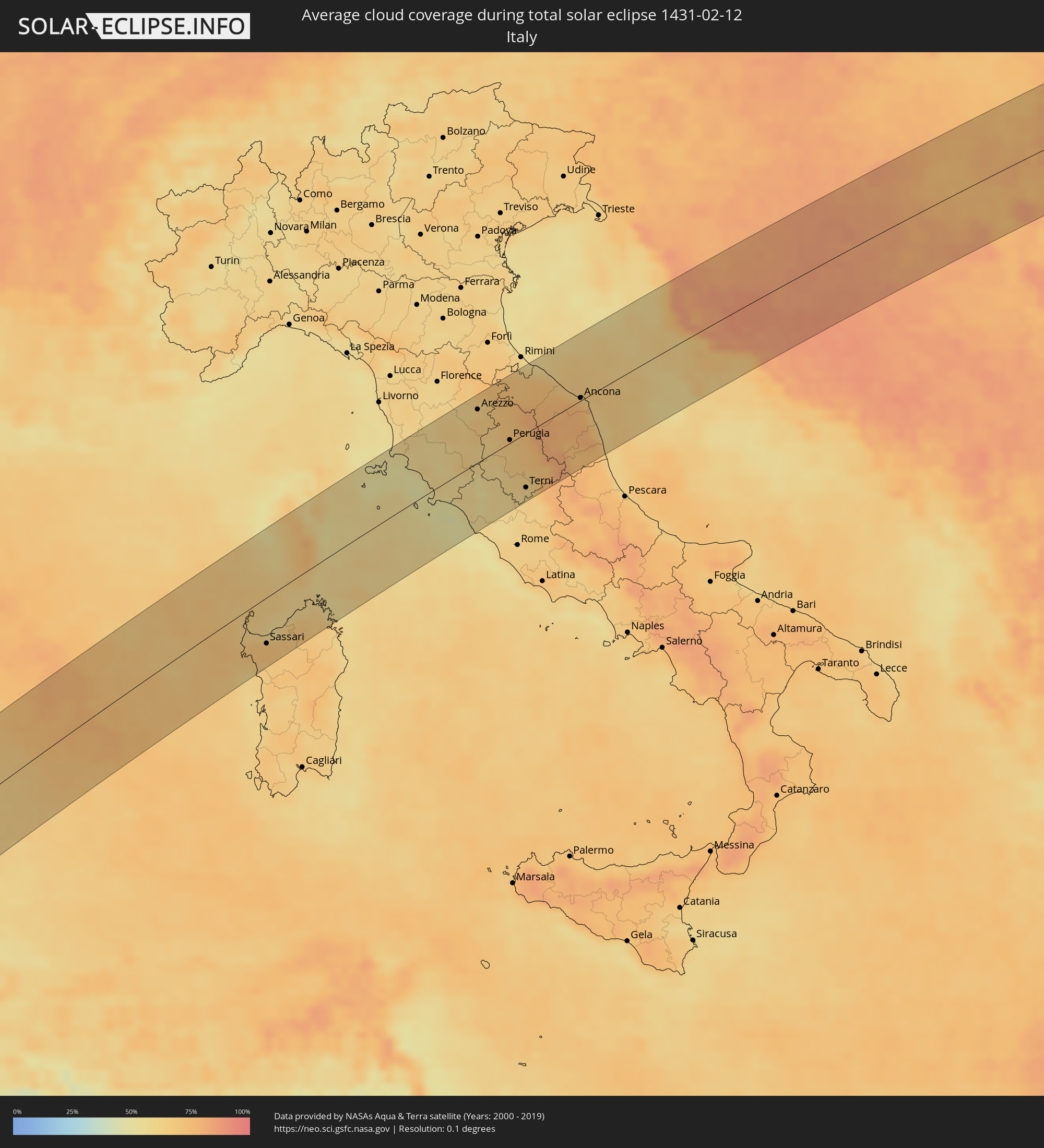
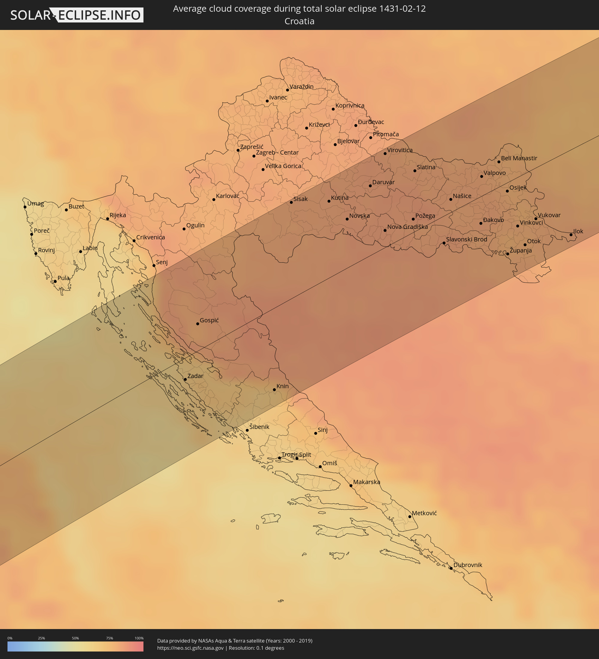
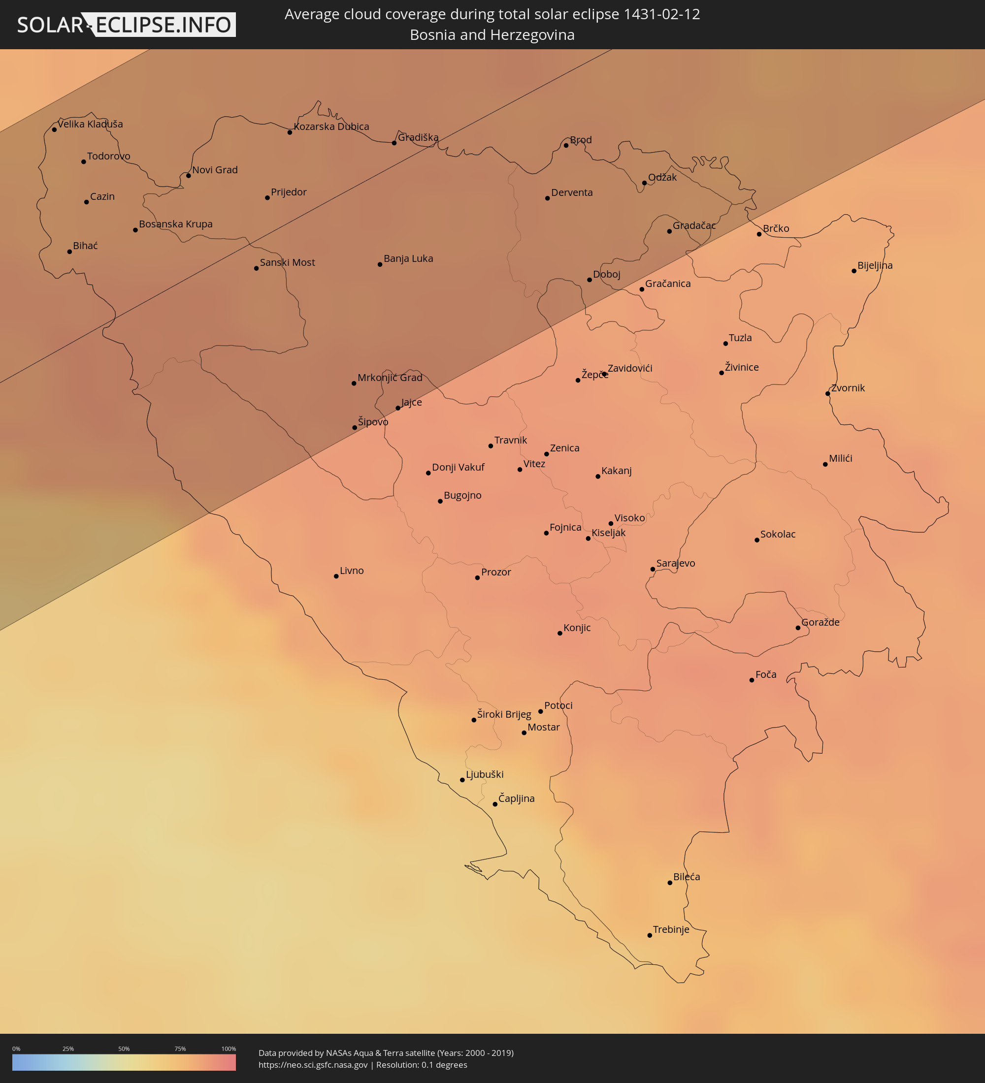
Die folgenden Karten zeigen die durchschnittliche Bewölkung für den Tag, an dem die totale Sonnenfinsternis
stattfindet. Mit Hilfe der Karten lässt sich der Ort entlang des Finsternispfades eingrenzen,
der die besten Aussichen auf einen klaren wolkenfreien Himmel bietet.
Trotzdem muss man immer lokale Gegenenheiten beachten und sollte sich genau über das Wetter an seinem
gewählten Beobachtungsort informieren.
Die Daten stammen von den beiden NASA-Satelliten
AQUA und TERRA
und wurden über einen Zeitraum von 19 Jahren (2000 - 2019) gemittelt.
Detaillierte Länderkarten
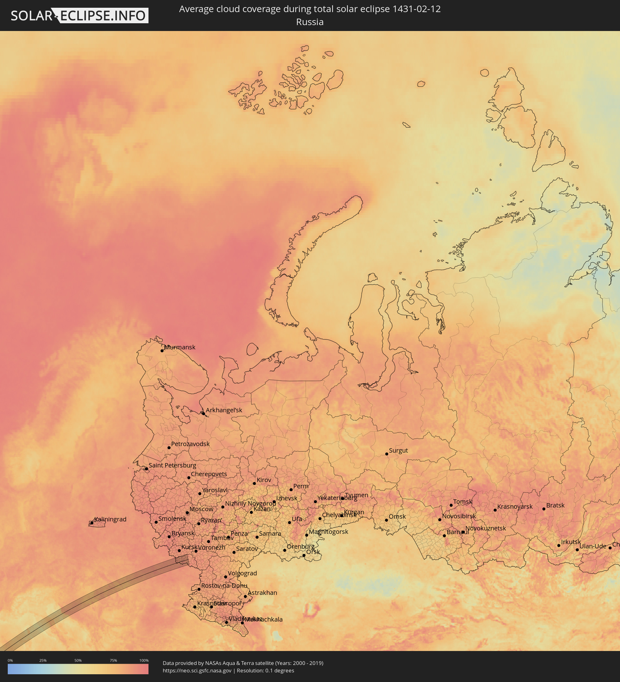 Russland
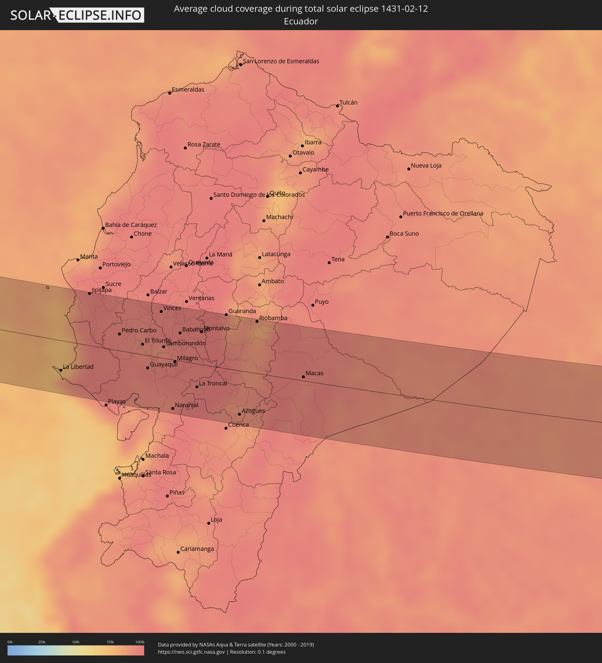 Ecuador
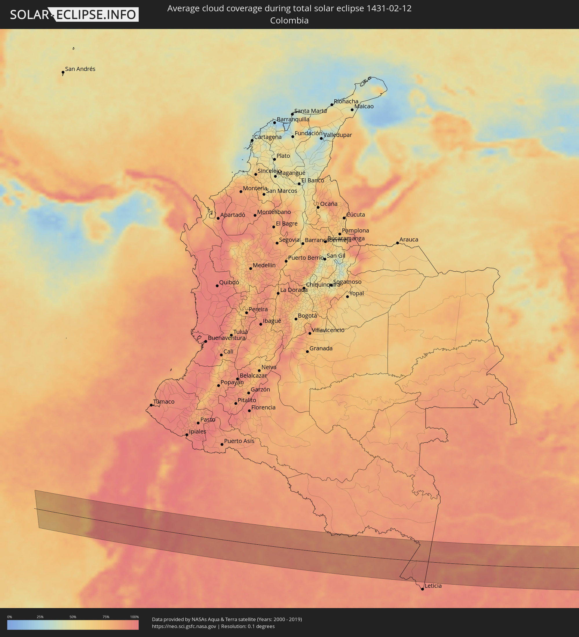 Kolumbien
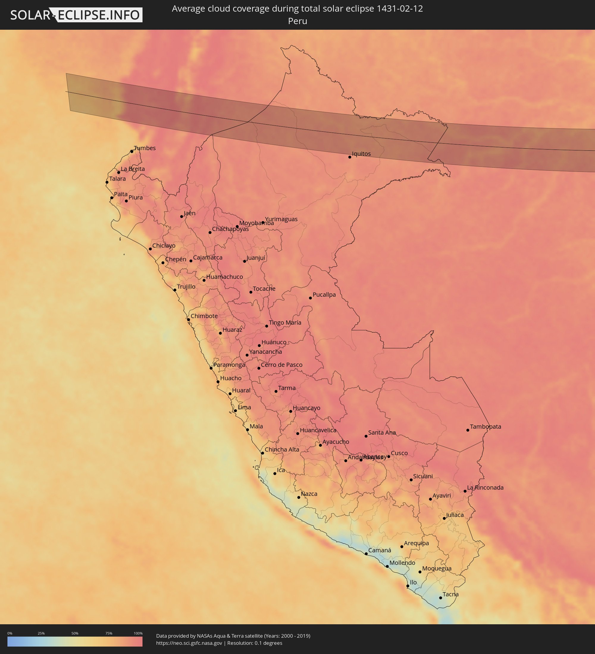 Peru
Peru
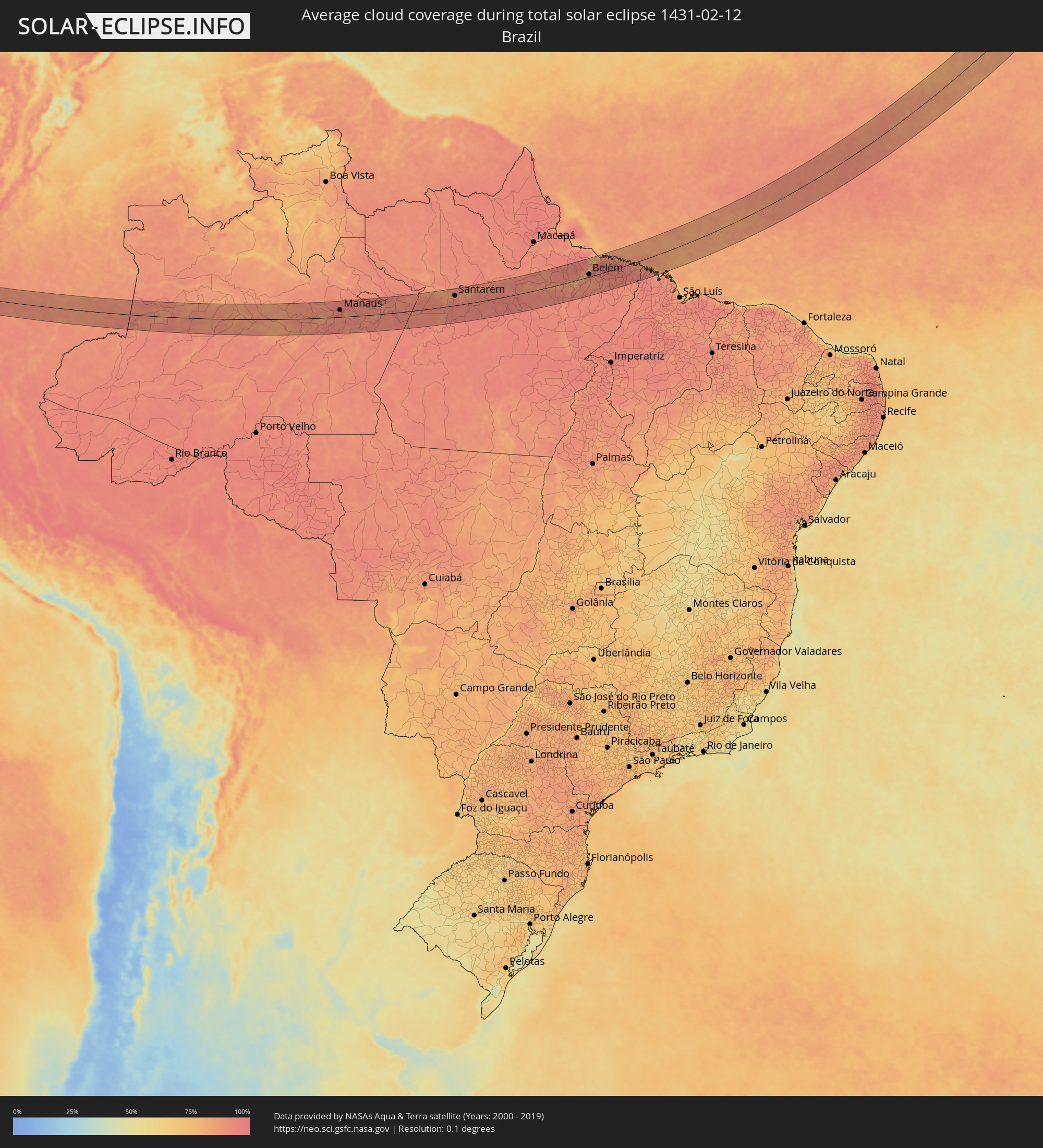 Brasilien
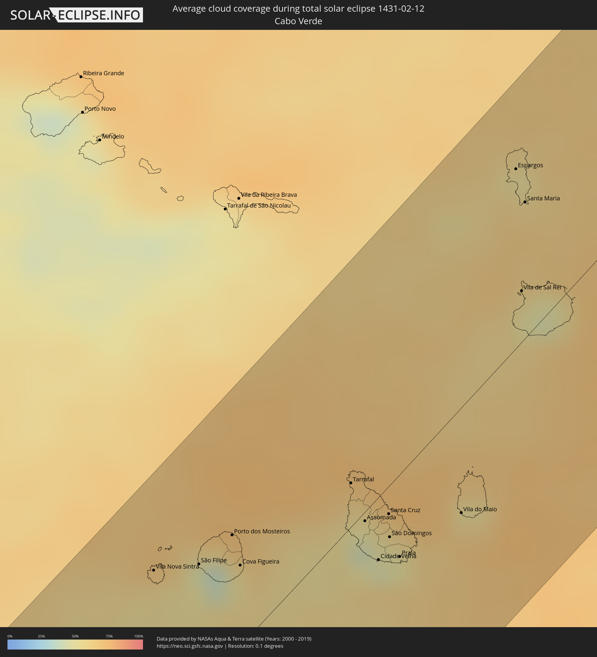 Kap Verde
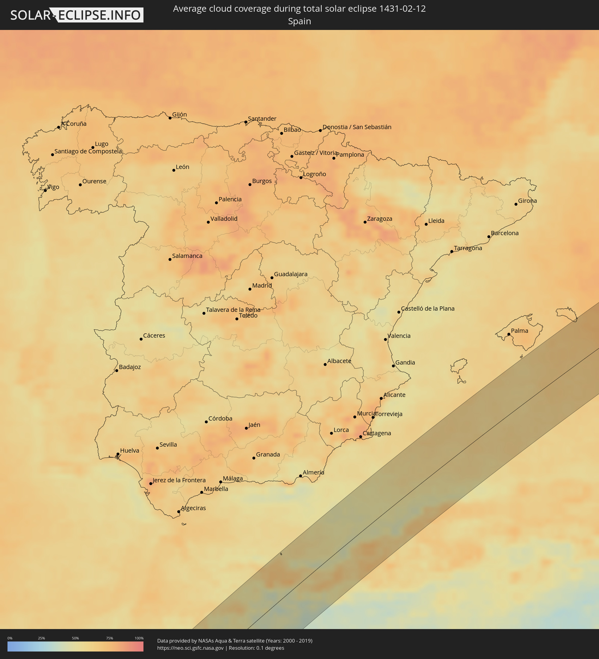 Spanien
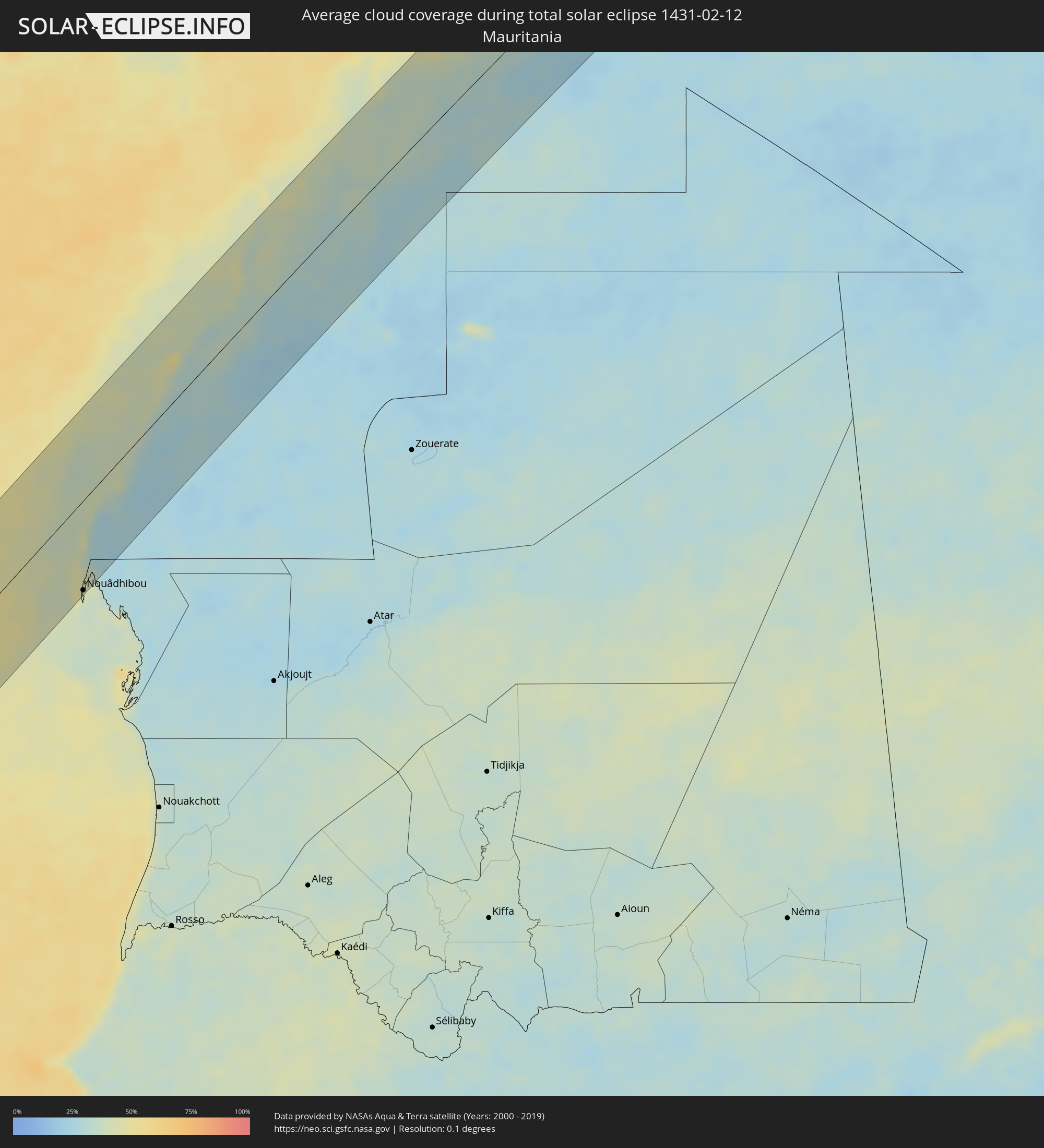 Mauretanien
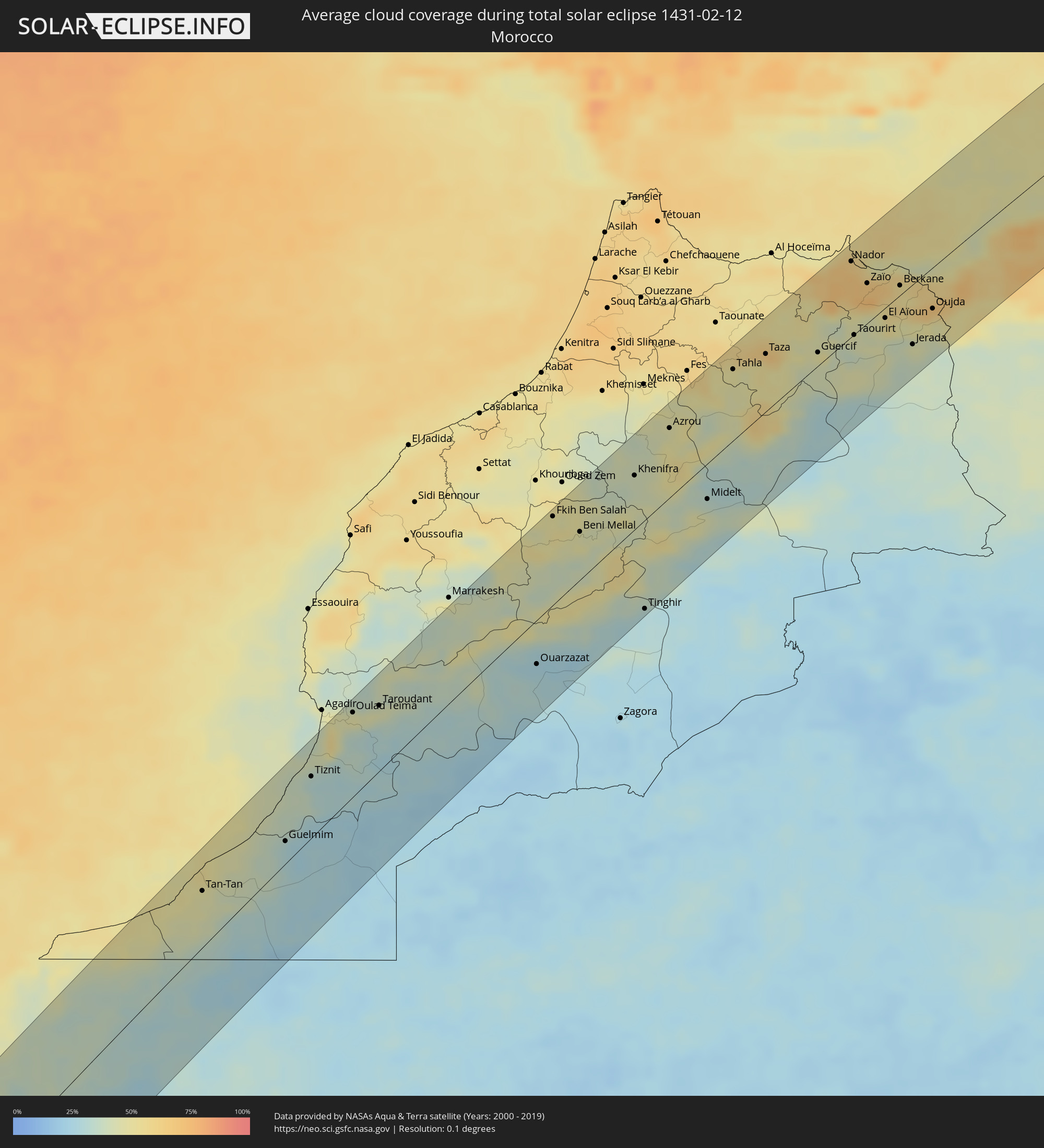 Marokko
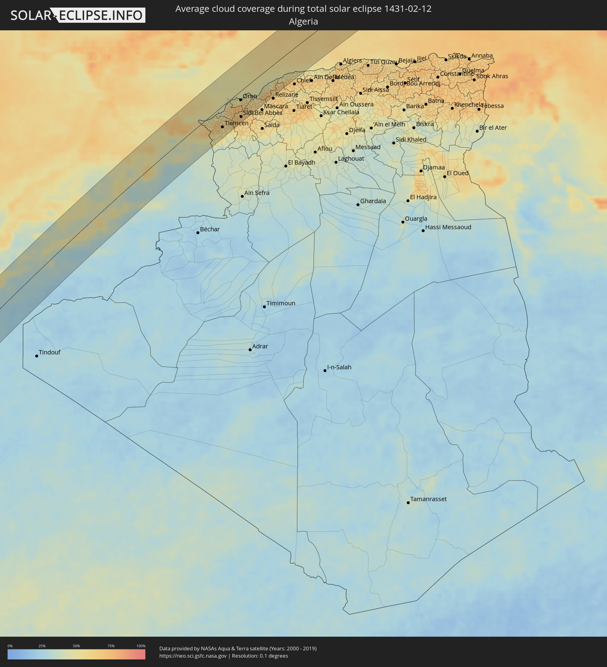 Algerien
 Frankreich
 Italien
 San Marino
 Kroatien
 Bosnien und Herzegowina
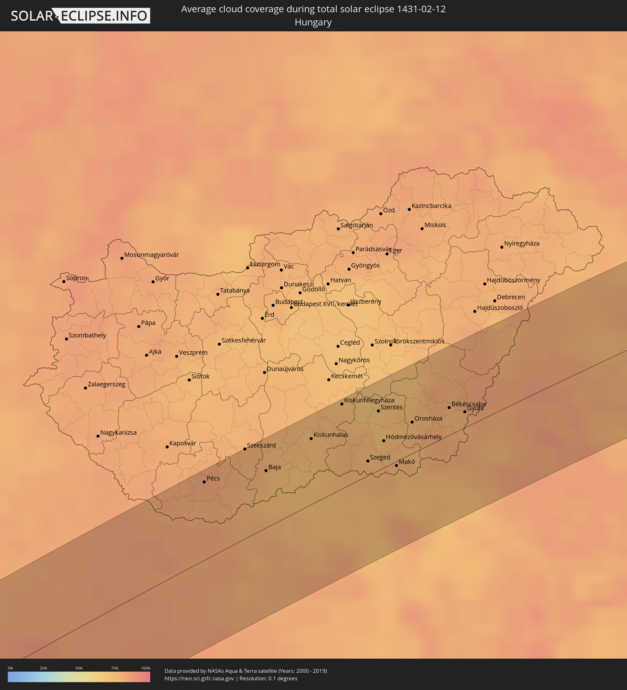 Ungarn
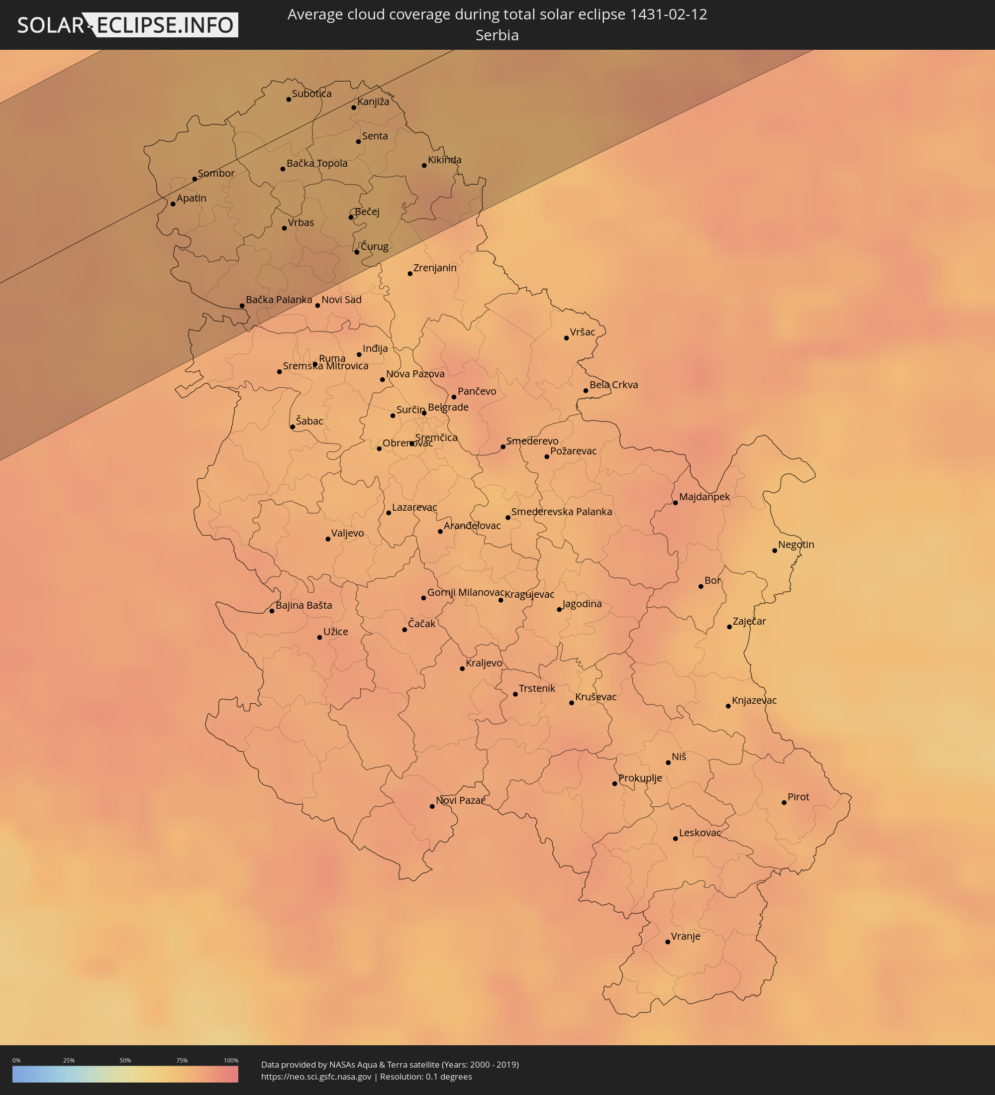 Serbien
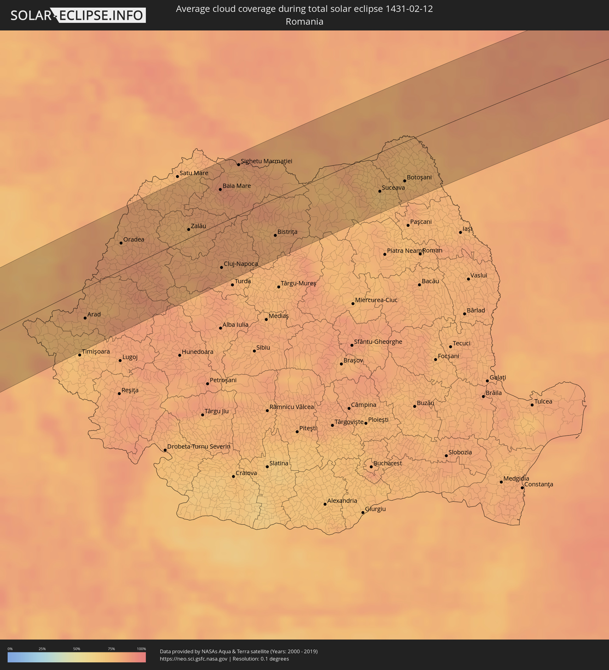 Rumänien
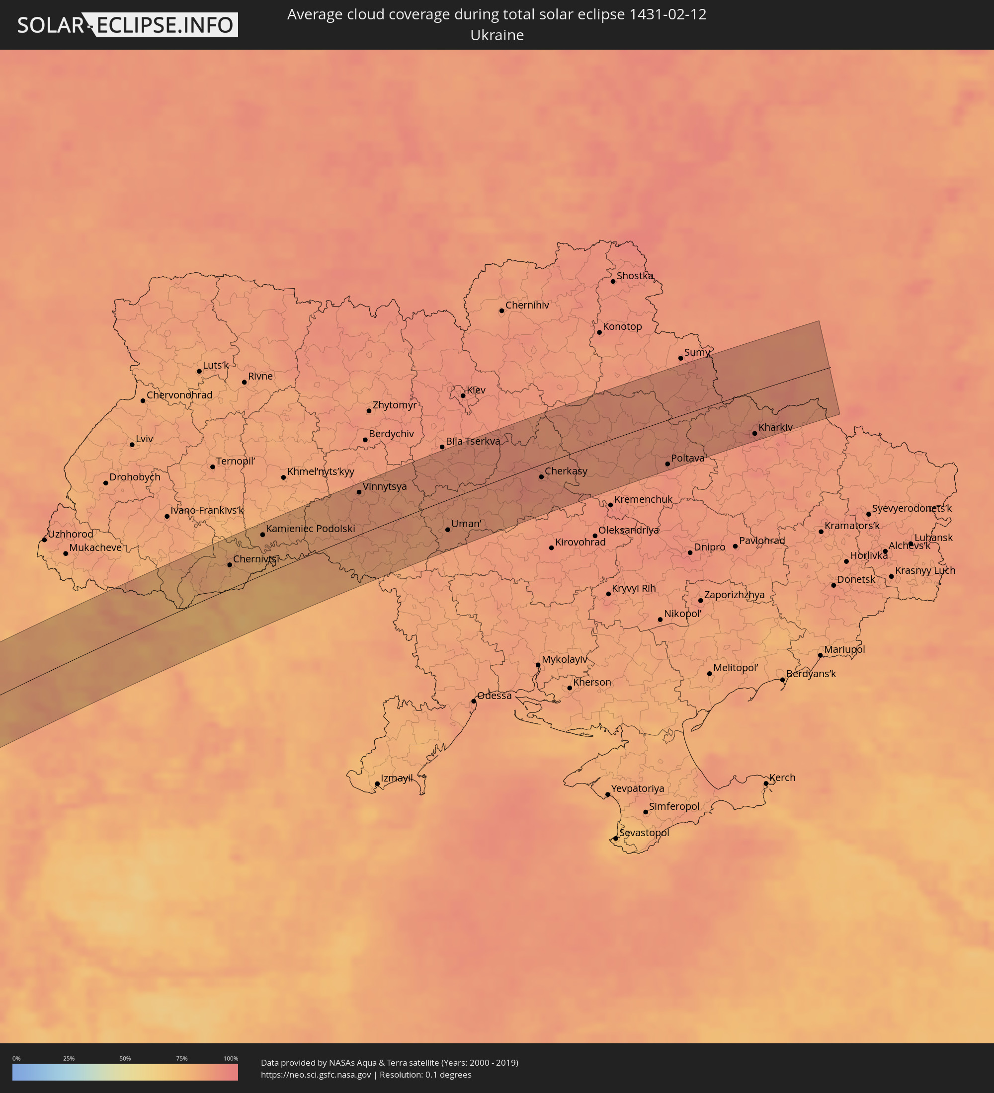 Ukraine
 Moldawien
Orte im Finsternispfad
Die nachfolgene Tabelle zeigt Städte und Orte mit mehr als 5.000 Einwohnern, die sich im Finsternispfad befinden. Städte mit mehr als 100.000 Einwohnern sind dick gekennzeichnet. Mit einem Klick auf den Ort öffnet sich eine Detailkarte die die Lage des jeweiligen Ortes zusammen mit dem Verlauf der zentralen Finsternis präsentiert.
| Ort | Typ | Dauer der Verfinsterung | Ortszeit bei maximaler Verfinsterung | Entfernung zur Zentrallinie | Ø Bewölkung |
|
La Libertad, Guayas
|
total | - | 06:29:54 UTC-05:14 | 38 km | 89% |
|
Jipijapa, Manabí
|
total | - | 06:30:32 UTC-05:14 | 65 km | 96% |
|
El Triunfo, Guayas
|
total | - | 06:30:17 UTC-05:14 | 13 km | 92% |
|
Guayaquil, Guayas
|
total | - | 06:30:07 UTC-05:14 | 16 km | 95% |
|
Vinces, Los Ríos
|
total | - | 06:30:34 UTC-05:14 | 58 km | 96% |
|
Samborondón, Guayas
|
total | - | 06:30:19 UTC-05:14 | 14 km | 95% |
|
Naranjal, Guayas
|
total | - | 06:29:52 UTC-05:14 | 62 km | 97% |
|
Milagro, Guayas
|
total | - | 06:30:14 UTC-05:14 | 2 km | 97% |
|
Babahoyo, Los Ríos
|
total | - | 06:30:28 UTC-05:14 | 35 km | 96% |
|
La Troncal, Cañar
|
total | - | 06:30:06 UTC-05:14 | 29 km | 98% |
|
Azogues, Cañar
|
total | - | 06:30:00 UTC-05:14 | 55 km | 87% |
|
Riobamba, Chimborazo
|
total | - | 06:30:46 UTC-05:14 | 66 km | 86% |
|
Coari, Amazonas
|
total | - | 07:48:53 UTC-04:02 | 62 km | 83% |
|
Manacapuru, Amazonas
|
total | - | 07:51:56 UTC-04:02 | 17 km | 89% |
|
Manaus, Amazonas
|
total | - | 07:52:43 UTC-04:02 | 36 km | 94% |
|
Itacoatiara, Amazonas
|
total | - | 07:54:21 UTC-04:02 | 19 km | 88% |
|
Parintins, Amazonas
|
total | - | 07:56:50 UTC-04:02 | 58 km | 91% |
|
Santarém, Pará
|
total | - | 08:48:16 UTC-03:13 | 49 km | 90% |
|
Altamira, Pará
|
total | - | 08:50:46 UTC-03:13 | 82 km | 93% |
|
Abaetetuba, Pará
|
total | - | 08:57:26 UTC-03:13 | 5 km | 90% |
|
Belém, Pará
|
total | - | 08:58:22 UTC-03:13 | 12 km | 90% |
|
Ananindeua, Pará
|
total | - | 08:58:41 UTC-03:13 | 17 km | 93% |
|
Castanhal, Pará
|
total | - | 08:59:30 UTC-03:13 | 11 km | 94% |
|
Bragança, Pará
|
total | - | 09:01:42 UTC-03:13 | 2 km | 94% |
|
São Filipe, São Filipe
|
total | - | 11:53:33 UTC-01:34 | 45 km | 50% |
|
Cova Figueira, Santa Catarina do Fogo
|
total | - | 11:53:57 UTC-01:34 | 29 km | 52% |
|
Tarrafal, Tarrafal
|
total | - | 11:55:43 UTC-01:34 | 16 km | 62% |
|
Picos, São Salvador do Mundo
|
total | - | 11:55:37 UTC-01:34 | 9 km | 48% |
|
Cidade Velha, Ribeira Grande de Santiago
|
total | - | 11:55:20 UTC-01:34 | 22 km | 59% |
|
Calheta, São Miguel
|
total | - | 11:55:52 UTC-01:34 | 4 km | 56% |
|
Santa Cruz, Santa Cruz
|
total | - | 11:55:50 UTC-01:34 | 10 km | 48% |
|
Praia, Praia
|
total | - | 11:55:34 UTC-01:34 | 29 km | 60% |
|
Vila do Maio, Maio
|
total | - | 11:56:32 UTC-01:34 | 37 km | 66% |
|
Espargos, Sal
|
total | - | 11:59:54 UTC-01:34 | 63 km | 53% |
|
Vila de Sal Rei, Boa Vista
|
total | - | 11:58:58 UTC-01:34 | 18 km | 54% |
|
Santa Maria, Sal
|
total | - | 11:59:43 UTC-01:34 | 48 km | 62% |
|
Nouâdhibou, Dakhlet Nouadhibou
|
total | - | 13:35:38 UTC-00:16 | 87 km | 39% |
 Dakhla, Oued Ed-Dahab-Lagouira
|
total | - | 13:04:49 UTC-00:52 | 38 km | 44% |
|
Smara, Oued Ed-Dahab-Lagouira
|
total | - | 13:15:38 UTC-00:52 | 43 km | 30% |
|
Guelmim, Guelmim-Es Smara
|
total | - | 13:42:57 UTC-00:30 | 20 km | 30% |
|
Oulad Teïma, Souss-Massa-Drâa
|
total | - | 13:45:32 UTC-00:30 | 73 km | 47% |
|
Taroudant, Souss-Massa-Drâa
|
total | - | 13:46:04 UTC-00:30 | 57 km | 44% |
|
Fkih Ben Salah, Tadla-Azilal
|
total | - | 13:50:45 UTC-00:30 | 77 km | 51% |
|
Beni Mellal, Tadla-Azilal
|
total | - | 13:51:04 UTC-00:30 | 42 km | 47% |
|
Khenifra, Meknès-Tafilalet
|
total | - | 13:52:24 UTC-00:30 | 47 km | 39% |
|
Sefrou, Fès-Boulemane
|
total | - | 13:54:04 UTC-00:30 | 69 km | 48% |
|
Taza, Taza-Al Hoceima-Taounate
|
total | - | 13:55:19 UTC-00:30 | 50 km | 57% |
|
Melilla, Melilla
|
total | - | 14:27:34 UTC+00:00 | 77 km | 59% |
|
Nador, Oriental
|
total | - | 13:57:10 UTC-00:30 | 66 km | 62% |
|
Taourirt, Oriental
|
total | - | 13:56:46 UTC-00:30 | 0 km | 43% |
|
Berkane, Oriental
|
total | - | 13:57:44 UTC-00:30 | 9 km | 52% |
|
Oujda, Oriental
|
total | - | 13:58:05 UTC-00:30 | 36 km | 57% |
|
Nedroma, Tlemcen
|
total | - | 14:38:08 UTC+00:09 | 17 km | 62% |
|
Remchi, Tlemcen
|
total | - | 14:38:31 UTC+00:09 | 31 km | 62% |
|
Beni Saf, Aïn Témouchent
|
total | - | 14:38:42 UTC+00:09 | 14 km | 55% |
|
Sebdou, Tlemcen
|
total | - | 14:38:24 UTC+00:09 | 74 km | 48% |
|
Tlemcen, Tlemcen
|
total | - | 14:38:33 UTC+00:09 | 54 km | 53% |
|
Aïn Temouchent, Aïn Témouchent
|
total | - | 14:38:58 UTC+00:09 | 28 km | 61% |
|
Hammam Bou Hadjar, Aïn Témouchent
|
total | - | 14:39:13 UTC+00:09 | 31 km | 60% |
|
Oran, Oran
|
total | - | 14:39:44 UTC+00:09 | 23 km | 64% |
|
Sidi Bel Abbès, Sidi Bel Abbès
|
total | - | 14:39:30 UTC+00:09 | 67 km | 67% |
|
Aïn el Bya, Oran
|
total | - | 14:40:09 UTC+00:09 | 33 km | 57% |
|
Sig, Mascara
|
total | - | 14:40:09 UTC+00:09 | 63 km | 60% |
|
Mostaganem, Mostaganem
|
total | - | 14:40:39 UTC+00:09 | 44 km | 62% |
|
Sant Lluís, Balearic Islands
|
total | - | 14:36:43 UTC+00:00 | 78 km | 68% |
|
Sassari, Sardinia
|
total | - | 15:40:32 UTC+01:00 | 51 km | 72% |
|
Ajaccio, Corsica
|
total | - | 14:50:05 UTC+00:09 | 53 km | 57% |
|
Corte, Corsica
|
total | - | 14:50:24 UTC+00:09 | 69 km | 64% |
|
Porto-Vecchio, Corsica
|
total | - | 14:50:30 UTC+00:09 | 4 km | 58% |
|
Olbia, Sardinia
|
total | - | 15:41:18 UTC+01:00 | 76 km | 66% |
|
Grosseto, Tuscany
|
total | - | 15:42:30 UTC+01:00 | 25 km | 60% |
|
Civitavecchia, Latium
|
total | - | 15:43:01 UTC+01:00 | 68 km | 51% |
|
Arezzo, Tuscany
|
total | - | 15:42:59 UTC+01:00 | 58 km | 63% |
|
Viterbo, Latium
|
total | - | 15:43:14 UTC+01:00 | 50 km | 57% |
|
Perugia, Umbria
|
total | - | 15:43:22 UTC+01:00 | 3 km | 66% |
|
Terni, Umbria
|
total | - | 15:43:35 UTC+01:00 | 60 km | 60% |
|
Foligno, Umbria
|
total | - | 15:43:36 UTC+01:00 | 25 km | 70% |
|
Pesaro, The Marches
|
total | - | 15:43:38 UTC+01:00 | 57 km | 68% |
|
Ancona, The Marches
|
total | - | 15:44:04 UTC+01:00 | 3 km | 74% |
|
San Benedetto del Tronto, The Marches
|
total | - | 15:44:23 UTC+01:00 | 74 km | 67% |
|
Zadar, Zadarska
|
total | - | 15:45:05 UTC+01:00 | 16 km | 64% |
|
Velika Kladuša, Federation of Bosnia and Herzegovina
|
total | - | 15:45:12 UTC+01:00 | 65 km | 79% |
|
Bihać, Federation of Bosnia and Herzegovina
|
total | - | 15:45:19 UTC+01:00 | 27 km | 84% |
|
Cazin, Federation of Bosnia and Herzegovina
|
total | - | 15:45:19 UTC+01:00 | 39 km | 82% |
|
Bosanska Krupa, Federation of Bosnia and Herzegovina
|
total | - | 15:45:28 UTC+01:00 | 22 km | 84% |
|
Sisak, Sisačko-Moslavačka
|
total | - | 15:45:27 UTC+01:00 | 71 km | 82% |
|
Sanski Most, Federation of Bosnia and Herzegovina
|
total | - | 15:45:47 UTC+01:00 | 9 km | 83% |
|
Prijedor, Republic of Srspka
|
total | - | 15:45:46 UTC+01:00 | 10 km | 82% |
|
Kutina, Sisačko-Moslavačka
|
total | - | 15:45:41 UTC+01:00 | 56 km | 82% |
|
Mrkonjić Grad, Republic of Srspka
|
total | - | 15:46:06 UTC+01:00 | 58 km | 86% |
|
Banja Luka, Republic of Srspka
|
total | - | 15:46:05 UTC+01:00 | 27 km | 84% |
|
Gradiška, Republic of Srspka
|
total | - | 15:46:02 UTC+01:00 | 6 km | 84% |
|
Nova Gradiška, Slavonski Brod-Posavina
|
total | - | 15:46:04 UTC+01:00 | 12 km | 84% |
|
Virovitica, Virovitičk-Podravska
|
total | - | 15:45:55 UTC+01:00 | 69 km | 83% |
|
Požega, Požeško-Slavonska
|
total | - | 15:46:13 UTC+01:00 | 9 km | 82% |
|
Slavonski Brod, Slavonski Brod-Posavina
|
total | - | 15:46:27 UTC+01:00 | 20 km | 82% |
|
Doboj, Republic of Srspka
|
total | - | 15:46:36 UTC+01:00 | 65 km | 84% |
|
Pécs, Baranya
|
total | - | 15:46:18 UTC+01:00 | 62 km | 83% |
|
Odžak, Federation of Bosnia and Herzegovina
|
total | - | 15:46:39 UTC+01:00 | 45 km | 83% |
|
Đakovo, Osječko-Baranjska
|
total | - | 15:46:37 UTC+01:00 | 20 km | 81% |
|
Gradačac, Federation of Bosnia and Herzegovina
|
total | - | 15:46:44 UTC+01:00 | 63 km | 84% |
|
Osijek, Osječko-Baranjska
|
total | - | 15:46:42 UTC+01:00 | 7 km | 79% |
|
Županja, Vukovar-Sirmium
|
total | - | 15:46:50 UTC+01:00 | 53 km | 80% |
|
Szekszárd, Tolna
|
total | - | 15:46:28 UTC+01:00 | 72 km | 79% |
|
Vinkovci, Vukovar-Sirmium
|
total | - | 15:46:50 UTC+01:00 | 37 km | 79% |
|
Baja, Bács-Kiskun
|
total | - | 15:46:39 UTC+01:00 | 46 km | 75% |
|
Apatin, Vojvodina
|
total | - | 15:46:49 UTC+01:00 | 5 km | 80% |
|
Vukovar, Vukovar-Sirmium
|
total | - | 15:46:55 UTC+01:00 | 38 km | 80% |
|
Sombor, Vojvodina
|
total | - | 15:46:51 UTC+01:00 | 1 km | 76% |
|
Bačka Palanka, Vojvodina
|
total | - | 15:47:09 UTC+01:00 | 61 km | 82% |
|
Kiskunhalas, Bács-Kiskun
|
total | - | 15:46:50 UTC+01:00 | 53 km | 75% |
|
Bačka Topola, Vojvodina
|
total | - | 15:47:06 UTC+01:00 | 14 km | 74% |
|
Vrbas, Vojvodina
|
total | - | 15:47:11 UTC+01:00 | 38 km | 77% |
|
Subotica, Vojvodina
|
total | - | 15:47:02 UTC+01:00 | 13 km | 73% |
|
Kiskunfélegyháza, Bács-Kiskun
|
total | - | 15:46:55 UTC+01:00 | 68 km | 75% |
|
Bečej, Vojvodina
|
total | - | 15:47:22 UTC+01:00 | 48 km | 78% |
|
Kanjiža, Vojvodina
|
total | - | 15:47:14 UTC+01:00 | 4 km | 76% |
|
Čurug
|
total | - | 15:47:25 UTC+01:00 | 63 km | 75% |
|
Senta, Vojvodina
|
total | - | 15:47:17 UTC+01:00 | 18 km | 75% |
|
Mol
|
total | - | 15:47:22 UTC+01:00 | 37 km | 75% |
|
Szeged, Csongrád
|
total | - | 15:47:13 UTC+01:00 | 12 km | 76% |
|
Szentes, Csongrád
|
total | - | 15:47:08 UTC+01:00 | 47 km | 73% |
|
Hódmezővásárhely, Csongrád
|
total | - | 15:47:15 UTC+01:00 | 21 km | 75% |
|
Kikinda, Vojvodina
|
total | - | 15:47:30 UTC+01:00 | 42 km | 83% |
|
Makó, Csongrád
|
total | - | 15:47:23 UTC+01:00 | 4 km | 75% |
|
Mezőtúr, Jász-Nagykun-Szolnok
|
total | - | 15:47:11 UTC+01:00 | 69 km | 70% |
|
Orosháza, Bekes
|
total | - | 15:47:21 UTC+01:00 | 25 km | 76% |
|
Békéscsaba, Bekes
|
total | - | 15:47:31 UTC+01:00 | 22 km | 77% |
|
Arad, Arad
|
total | - | 16:32:11 UTC+01:44 | 35 km | 77% |
|
Oradea, Bihor
|
total | - | 16:32:09 UTC+01:44 | 31 km | 83% |
|
Zalău, Sălaj
|
total | - | 16:32:34 UTC+01:44 | 10 km | 79% |
|
Baia Mare, Satu Mare
|
total | - | 16:32:36 UTC+01:44 | 39 km | 85% |
|
Cluj-Napoca, Cluj
|
total | - | 16:32:58 UTC+01:44 | 52 km | 83% |
|
Dej, Cluj
|
total | - | 16:32:56 UTC+01:44 | 21 km | 80% |
|
Sighetu Marmaţiei, Maramureş
|
total | - | 16:32:36 UTC+01:44 | 57 km | 79% |
|
Bistriţa, Bistriţa-Năsăud
|
total | - | 16:33:11 UTC+01:44 | 43 km | 79% |
|
Chernivtsi, Chernivtsi
|
total | - | 16:50:52 UTC+02:02 | 31 km | 79% |
|
Suceava, Suceava
|
total | - | 16:33:37 UTC+01:44 | 45 km | 73% |
|
Fălticeni, Suceava
|
total | - | 16:33:43 UTC+01:44 | 65 km | 74% |
|
Dorohoi, Botoşani
|
total | - | 16:33:31 UTC+01:44 | 17 km | 76% |
|
Kamieniec Podolski, Khmelnytskyi
|
total | - | 16:50:54 UTC+02:02 | 53 km | 81% |
|
Botoşani, Botoşani
|
total | - | 16:33:42 UTC+01:44 | 45 km | 74% |
|
Briceni, Briceni
|
total | - | 16:44:09 UTC+01:55 | 6 km | 79% |
|
Edineţ, Raionul Edineţ
|
total | - | 16:44:19 UTC+01:55 | 20 km | 79% |
|
Ocniţa, Raionul Ocniţa
|
total | - | 16:44:16 UTC+01:55 | 3 km | 82% |
|
Glodeni, Glodeni
|
total | - | 16:44:35 UTC+01:55 | 67 km | 77% |
|
Rîşcani, Rîşcani
|
total | - | 16:44:31 UTC+01:55 | 51 km | 77% |
|
Donduşeni, Donduşeni
|
total | - | 16:44:23 UTC+01:55 | 22 km | 80% |
|
Briceni, Donduşeni
|
total | - | 16:44:22 UTC+01:55 | 13 km | 82% |
|
Otaci, Raionul Ocniţa
|
total | - | 16:44:21 UTC+01:55 | 8 km | 81% |
|
Drochia, Drochia
|
total | - | 16:44:33 UTC+01:55 | 49 km | 80% |
|
Soroca, Raionul Soroca
|
total | - | 16:44:39 UTC+01:55 | 50 km | 79% |
|
Vinnytsya, Vinnyts'ka
|
total | - | 16:51:13 UTC+02:02 | 56 km | 85% |
|
Uman’, Cherkasy
|
total | - | 16:51:58 UTC+02:02 | 41 km | 85% |
|
Pereyaslav-Khmel’nyts’kyy, Kiev
|
total | - | 16:51:33 UTC+02:02 | 65 km | 89% |
|
Smila, Cherkasy
|
total | - | 16:52:08 UTC+02:02 | 35 km | 87% |
|
Cherkasy, Cherkasy
|
total | - | 16:52:03 UTC+02:02 | 17 km | 89% |
|
Lubny, Poltava
|
total | - | 16:51:56 UTC+02:02 | 21 km | 88% |
|
Myrhorod, Poltava
|
total | - | 16:52:05 UTC+02:02 | 2 km | 88% |
|
Poltava, Poltava
|
total | - | 16:52:29 UTC+02:02 | 60 km | 92% |
|
Okhtyrka, Sumy
|
total | - | 16:52:07 UTC+02:02 | 8 km | 87% |
|
Krasnaya Yaruga, Belgorod
|
total | - | 17:20:10 UTC+02:30 | 43 km | 89% |
|
Proletarskiy, Belgorod
|
total | - | 17:20:11 UTC+02:30 | 39 km | 88% |
|
Rakitnoye, Belgorod
|
total | - | 17:20:10 UTC+02:30 | 42 km | 89% |
|
Borisovka, Belgorod
|
total | - | 17:20:19 UTC+02:30 | 17 km | 86% |
|
Ivnya, Belgorod
|
total | - | 17:20:04 UTC+02:30 | 60 km | 87% |
|
Tomarovka, Belgorod
|
total | - | 17:20:19 UTC+02:30 | 18 km | 87% |
|
Kharkiv, Kharkiv
|
total | - | 16:52:32 UTC+02:02 | 57 km | 93% |
|
Mayskiy, Belgorod
|
total | - | 17:20:27 UTC+02:30 | 5 km | 86% |
|
Stroitel’, Belgorod
|
total | - | 17:20:18 UTC+02:30 | 23 km | 88% |
|
Severnyy, Belgorod
|
total | - | 17:20:22 UTC+02:30 | 10 km | 90% |
|
Belgorod, Belgorod
|
total | - | 17:20:25 UTC+02:30 | 2 km | 90% |
|
Prokhorovka, Belgorod
|
total | - | 17:20:10 UTC+02:30 | 44 km | 88% |
|
Shebekino, Belgorod
|
total | - | 17:20:35 UTC+02:30 | 26 km | 89% |