Totale Sonnenfinsternis vom 17.06.1452
| Wochentag: | Donnerstag |
| Maximale Dauer der Verfinsterung: | 06m26s |
| Maximale Breite des Finsternispfades: | 234 km |
| Saroszyklus: | 118 |
| Bedeckungsgrad: | 100% |
| Magnitude: | 1.0719 |
| Gamma: | -0.0102 |
Wo kann man die Sonnenfinsternis vom 17.06.1452 sehen?
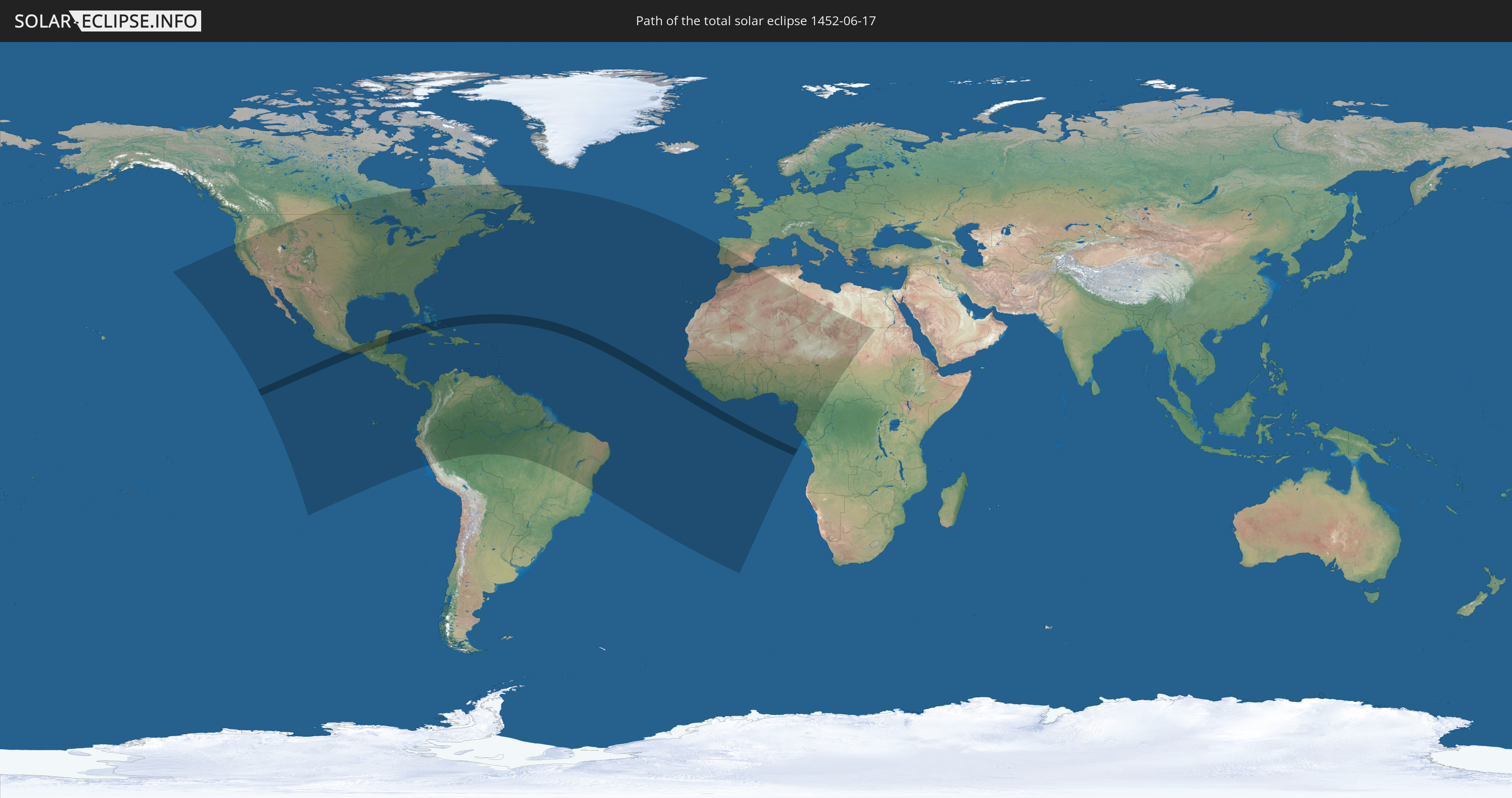
Die Sonnenfinsternis am 17.06.1452 kann man in 79 Ländern als partielle Sonnenfinsternis beobachten.
Der Finsternispfad verläuft durch 5 Länder. Nur in diesen Ländern ist sie als totale Sonnenfinsternis zu sehen.
In den folgenden Ländern ist die Sonnenfinsternis total zu sehen
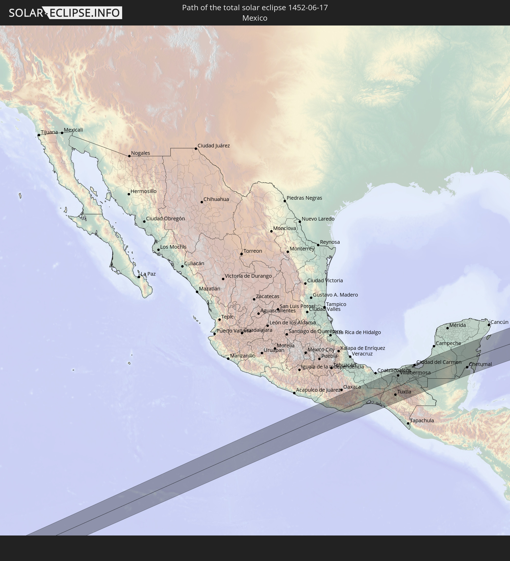 Mexiko
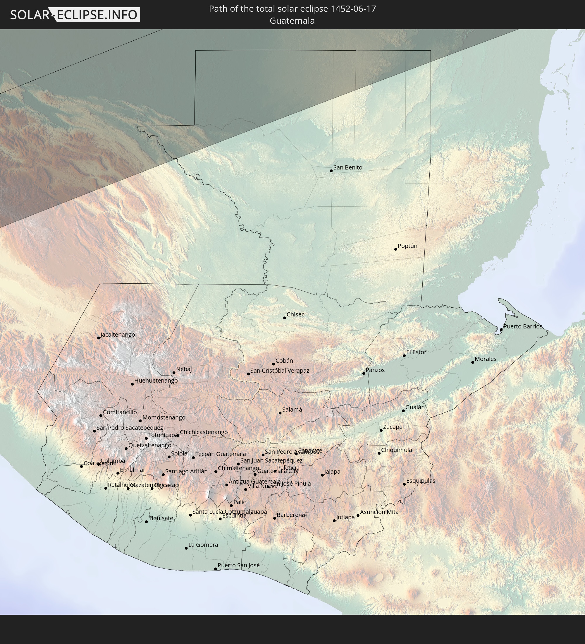 Guatemala
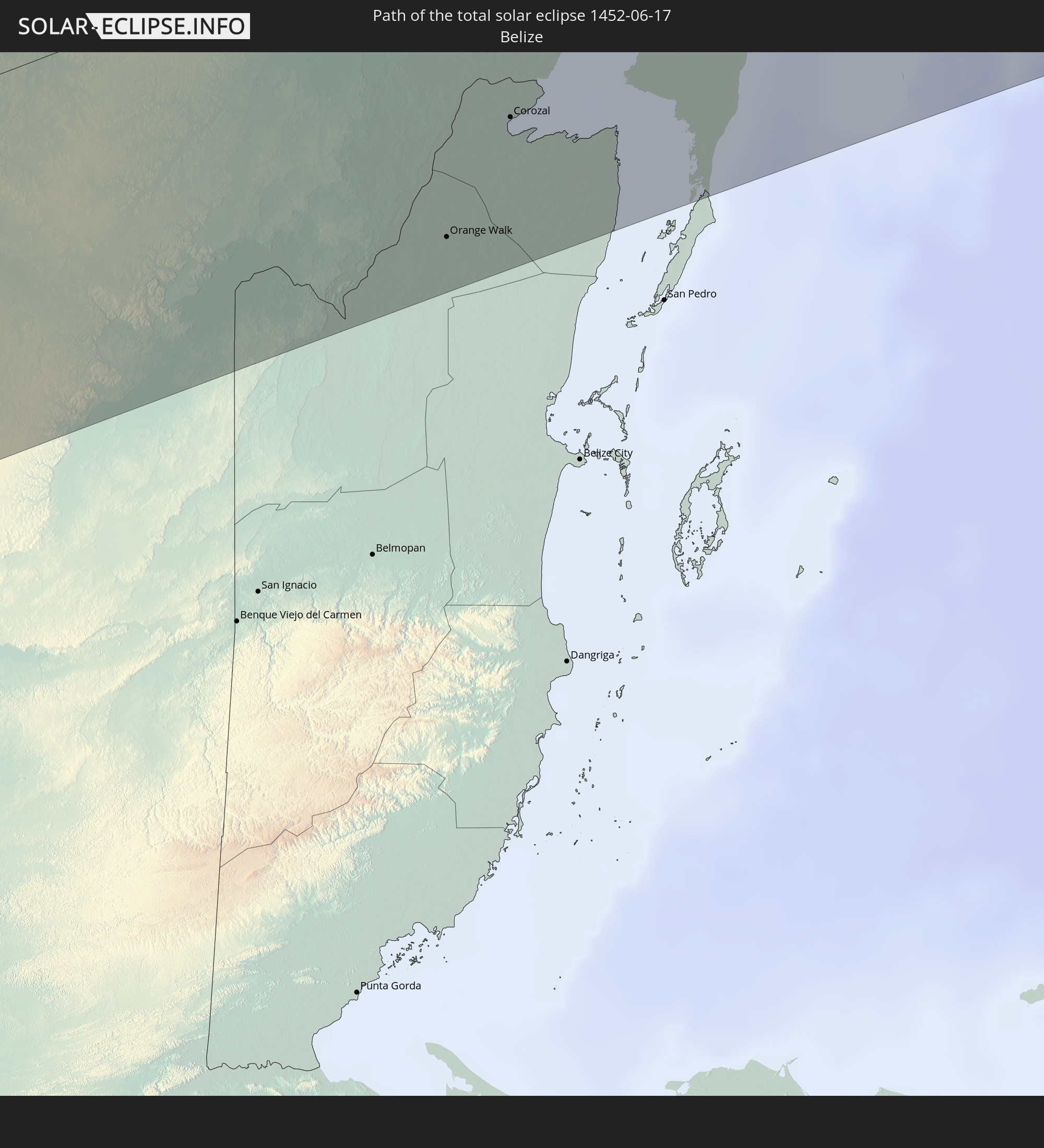 Belize
 Kuba
Kuba
 Bahamas
In den folgenden Ländern ist die Sonnenfinsternis partiell zu sehen
 Vereinigte Staaten
 United States Minor Outlying Islands
 Kanada
 Mexiko
 Guatemala
 Ecuador
 El Salvador
 Honduras
 Belize
 Nicaragua
 Costa Rica
 Kuba
Kuba
 Panama
 Kolumbien
 Kaimaninseln
 Peru
Peru
 Bahamas
 Jamaika
 Haiti
Haiti
 Brasilien
 Venezuela
 Turks- und Caicosinseln
 Dominikanische Republik
 Aruba
Aruba
 Puerto Rico
 Amerikanische Jungferninseln
 Bermuda
 Britische Jungferninseln
 Anguilla
 Saint-Martin
 Saint-Barthélemy
 St. Kitts und Nevis
 Antigua und Barbuda
 Montserrat
 Trinidad und Tobago
 Guadeloupe
 Grenada
 Dominica
 St. Vincent und die Grenadinen
 Guyana
 Martinique
 St. Lucia
 Barbados
 Suriname
 Saint-Pierre und Miquelon
 Französisch-Guayana
 Portugal
 Kap Verde
 Spanien
 Senegal
 Mauretanien
 Gambia
 Guinea-Bissau
 Guinea
 St. Helena
 Sierra Leone
 Marokko
 Mali
Mali
 Liberia
 Algerien
 Elfenbeinküste
 Burkina Faso
 Gibraltar
 Ghana
Ghana
 Togo
Togo
 Niger
Niger
 Benin
Benin
 Nigeria
 Äquatorialguinea
 São Tomé und Príncipe
 Tunesien
 Kamerun
 Gabun
Gabun
 Libyen
 Republik Kongo
 Tschad
 Zentralafrikanische Republik
 Sudan
Sudan
 Ägypten
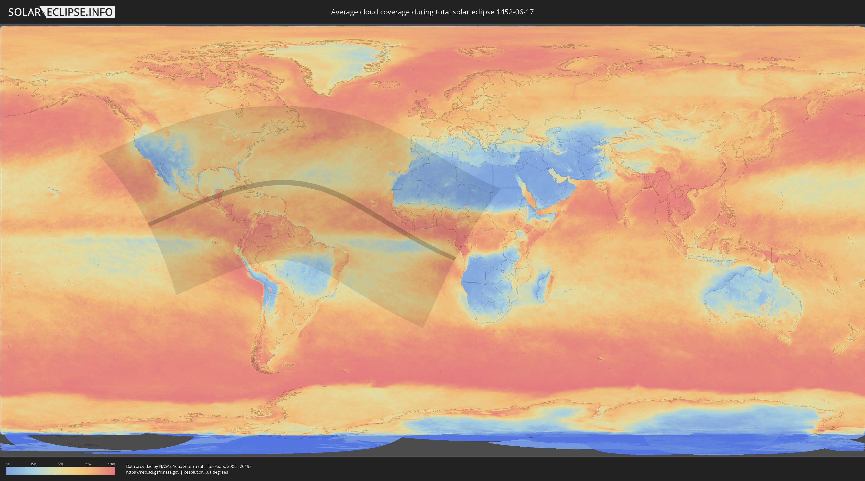
Wie wird das Wetter während der totalen Sonnenfinsternis am 17.06.1452?
Wo ist der beste Ort, um die totale Sonnenfinsternis vom 17.06.1452 zu beobachten?
Die folgenden Karten zeigen die durchschnittliche Bewölkung für den Tag, an dem die totale Sonnenfinsternis
stattfindet. Mit Hilfe der Karten lässt sich der Ort entlang des Finsternispfades eingrenzen,
der die besten Aussichen auf einen klaren wolkenfreien Himmel bietet.
Trotzdem muss man immer lokale Gegenenheiten beachten und sollte sich genau über das Wetter an seinem
gewählten Beobachtungsort informieren.
Die Daten stammen von den beiden NASA-Satelliten
AQUA und TERRA
und wurden über einen Zeitraum von 19 Jahren (2000 - 2019) gemittelt.

Detaillierte Länderkarten
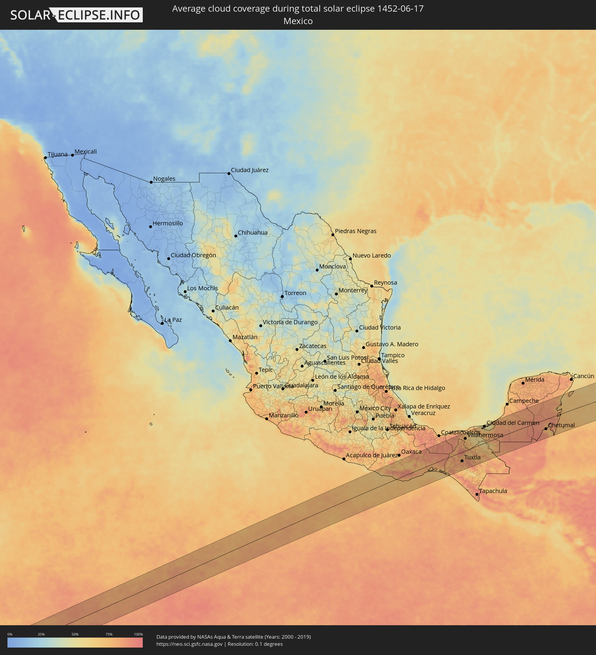 Mexiko
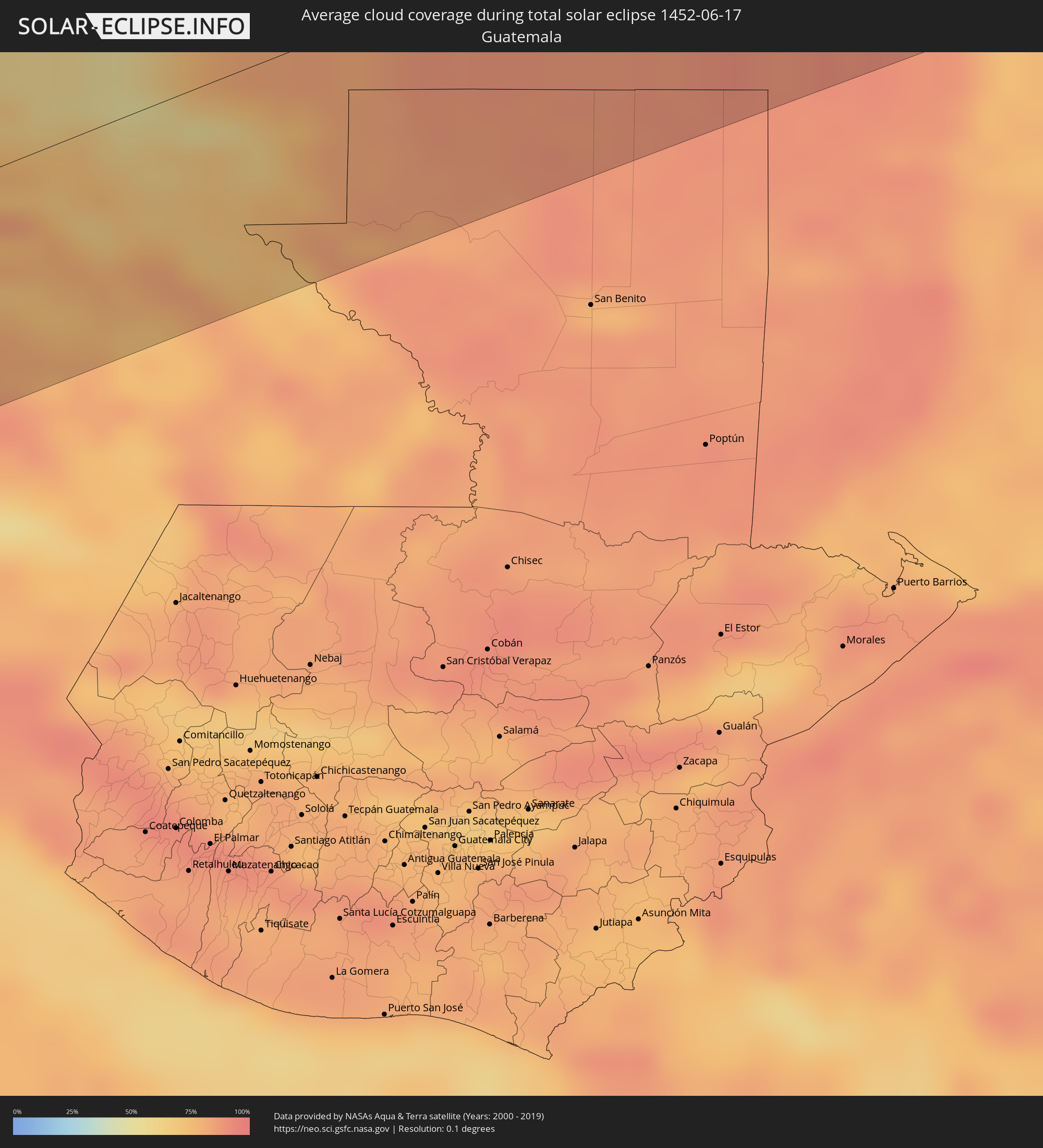 Guatemala
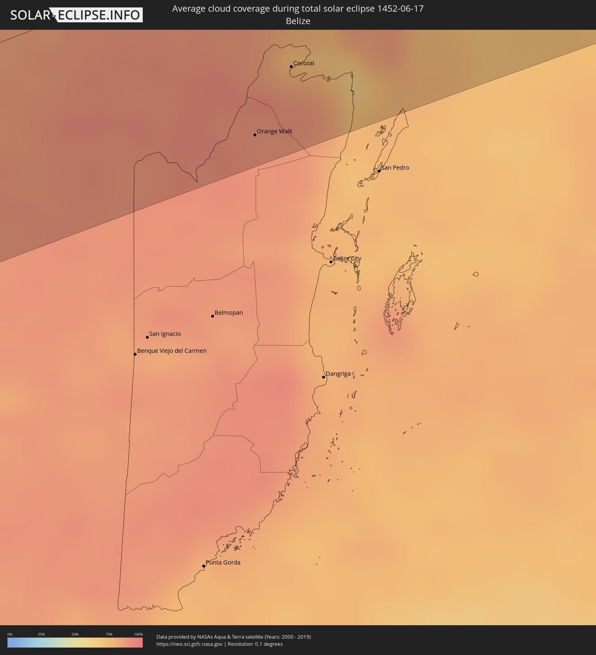 Belize
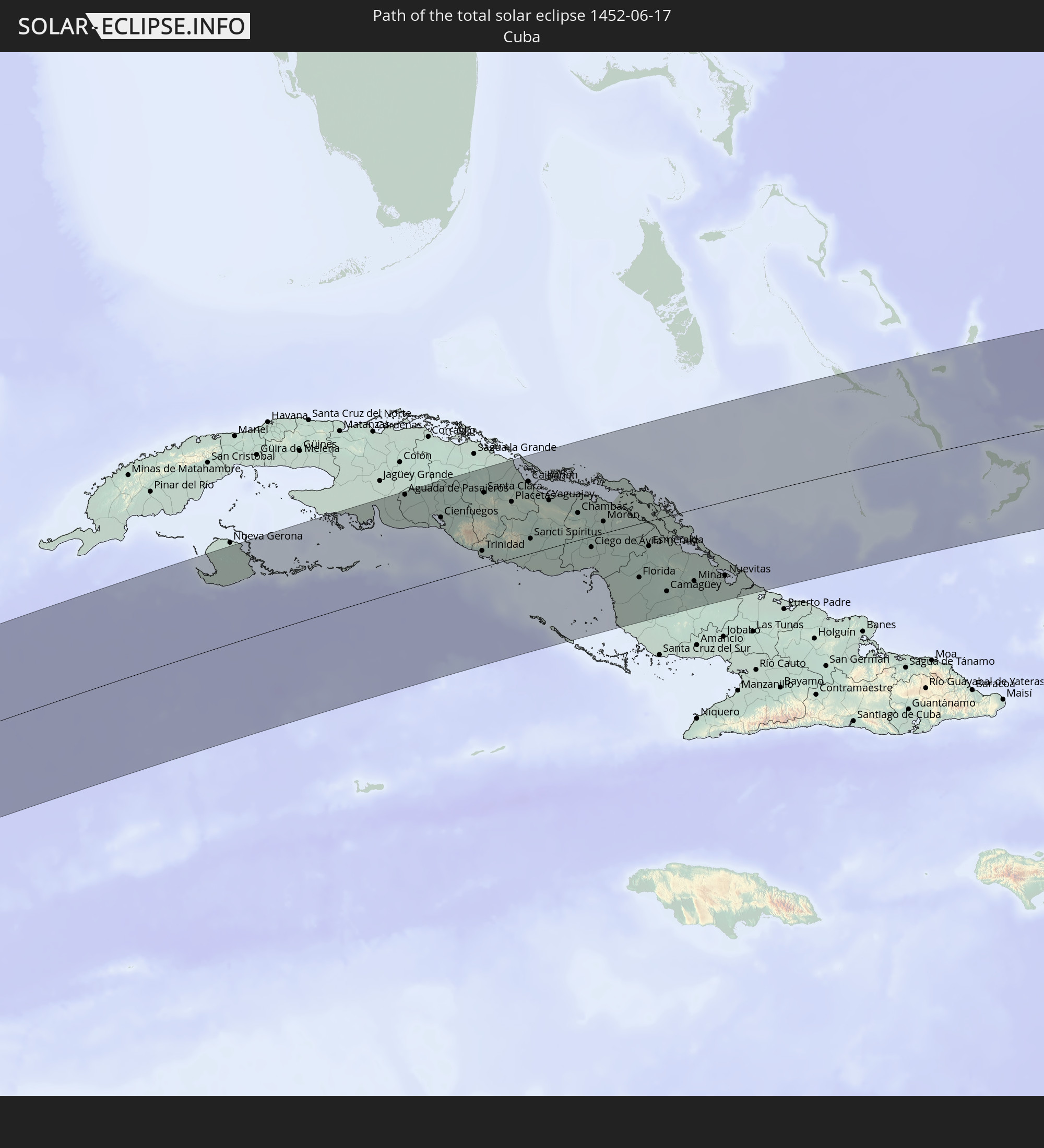
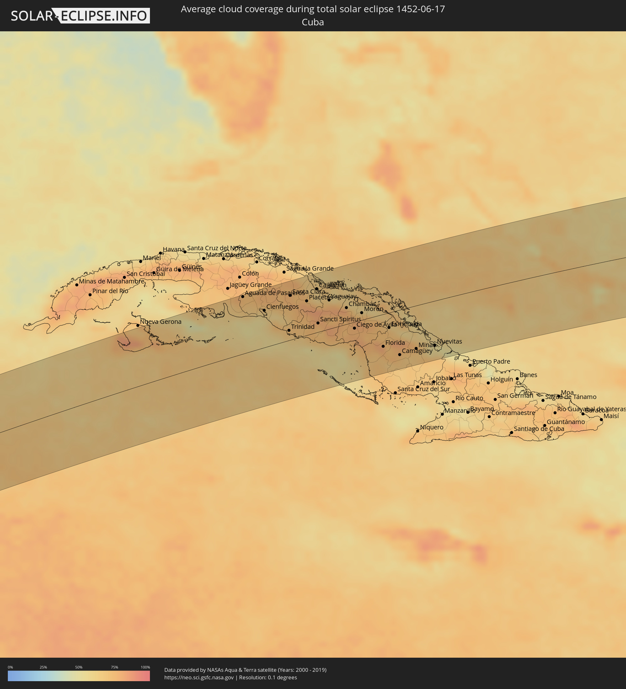 Kuba
Kuba
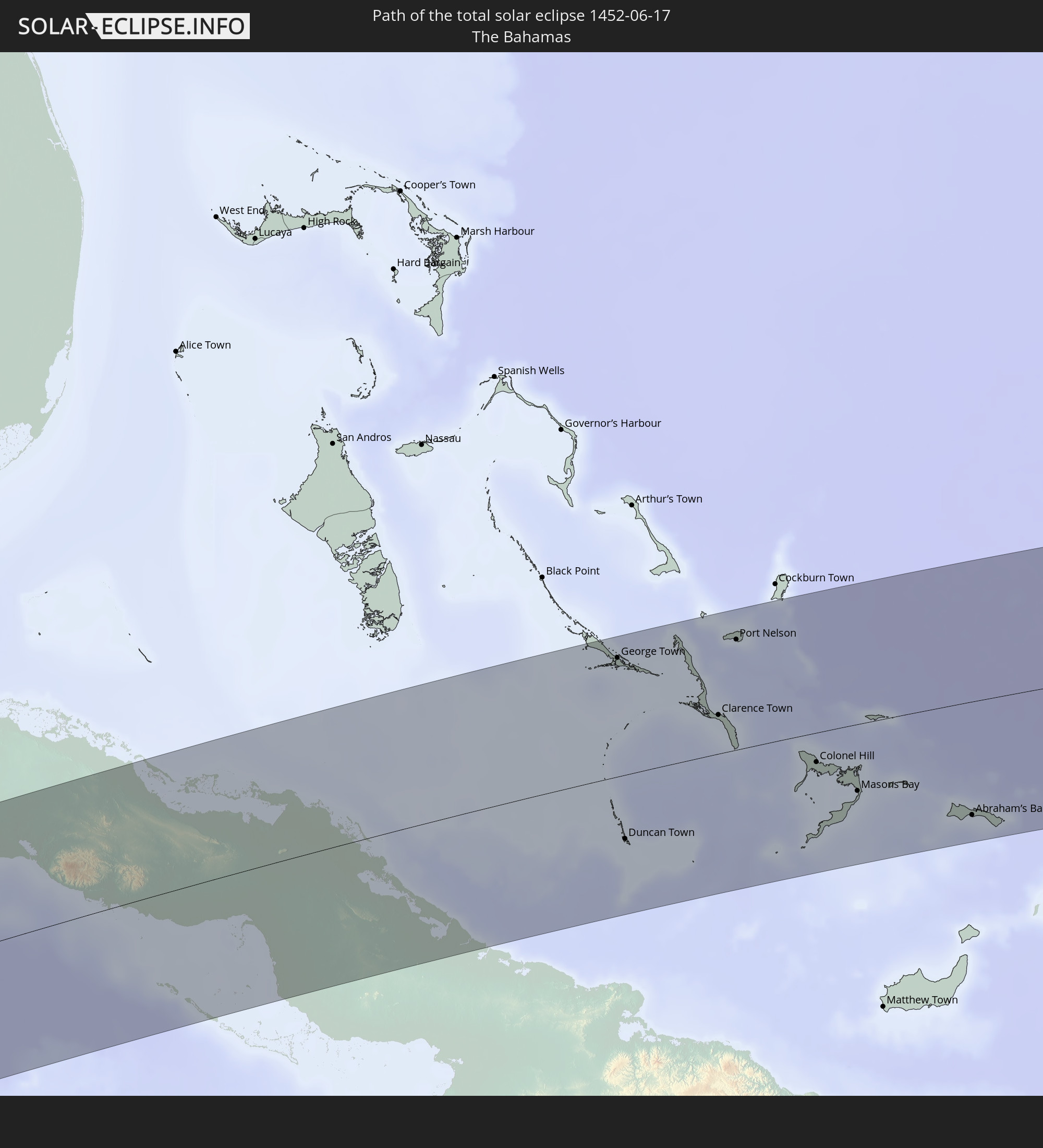
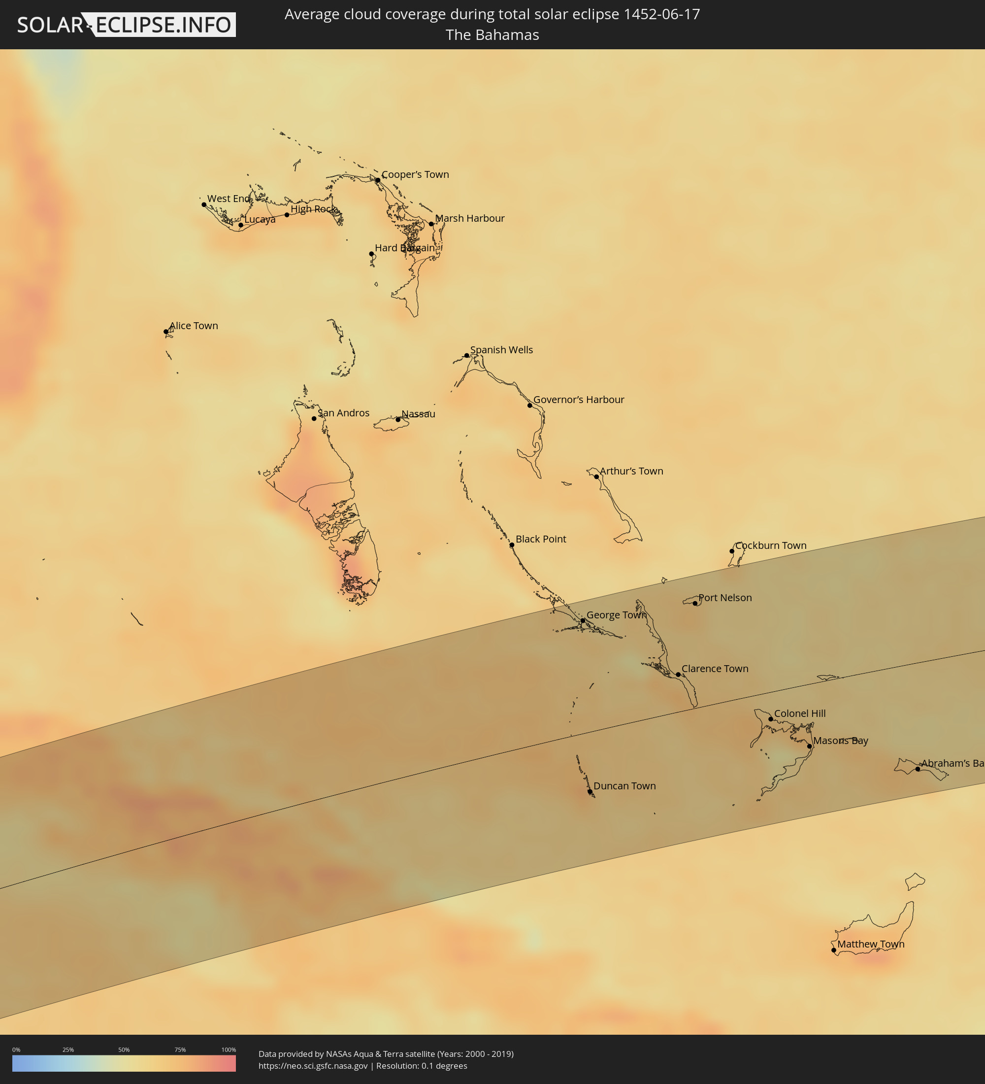 Bahamas
Orte im Finsternispfad
Die nachfolgene Tabelle zeigt Städte und Orte mit mehr als 5.000 Einwohnern, die sich im Finsternispfad befinden. Städte mit mehr als 100.000 Einwohnern sind dick gekennzeichnet. Mit einem Klick auf den Ort öffnet sich eine Detailkarte die die Lage des jeweiligen Ortes zusammen mit dem Verlauf der zentralen Finsternis präsentiert.
| Ort | Typ | Dauer der Verfinsterung | Ortszeit bei maximaler Verfinsterung | Entfernung zur Zentrallinie | Ø Bewölkung |
|
Jamiltepec, Oaxaca
|
total | - | 07:15:41 UTC-06:36 | 93 km | 75% |
|
Puerto Escondido, Oaxaca
|
total | - | 07:15:57 UTC-06:36 | 19 km | 71% |
|
Ejutla de Crespo, Oaxaca
|
total | - | 07:16:38 UTC-06:36 | 76 km | 75% |
|
Miahuatlán de Porfirio Díaz, Oaxaca
|
total | - | 07:16:35 UTC-06:36 | 46 km | 81% |
|
San Pedro Pochutla, Oaxaca
|
total | - | 07:16:19 UTC-06:36 | 19 km | 72% |
|
Crucecita, Oaxaca
|
total | - | 07:16:34 UTC-06:36 | 31 km | 72% |
|
Jalapa, Oaxaca
|
total | - | 07:17:33 UTC-06:36 | 17 km | 75% |
|
Santo Domingo Tehuantepec, Oaxaca
|
total | - | 07:17:37 UTC-06:36 | 10 km | 78% |
|
Salina Cruz, Oaxaca
|
total | - | 07:17:33 UTC-06:36 | 26 km | 75% |
|
San Jerónimo Ixtepec, Oaxaca
|
total | - | 07:17:53 UTC-06:36 | 10 km | 81% |
|
Matías Romero, Oaxaca
|
total | - | 07:18:08 UTC-06:36 | 38 km | 89% |
|
Juchitán de Zaragoza, Oaxaca
|
total | - | 07:17:52 UTC-06:36 | 8 km | 72% |
|
Unión Hidalgo, Oaxaca
|
total | - | 07:18:02 UTC-06:36 | 12 km | 77% |
|
Las Amilpas, Oaxaca
|
total | - | 07:18:09 UTC-06:36 | 31 km | 73% |
|
Chahuite, Oaxaca
|
total | - | 07:18:28 UTC-06:36 | 56 km | 69% |
|
Arriaga, Chiapas
|
total | - | 07:18:40 UTC-06:36 | 74 km | 75% |
|
Tonalá, Chiapas
|
total | - | 07:18:42 UTC-06:36 | 95 km | 75% |
|
Cintalapa de Figueroa, Chiapas
|
total | - | 07:19:07 UTC-06:36 | 35 km | 80% |
|
Huimanguillo, Tabasco
|
total | - | 07:20:09 UTC-06:36 | 70 km | 76% |
|
Cárdenas, Tabasco
|
total | - | 07:20:17 UTC-06:36 | 87 km | 83% |
|
Ocozocoautla de Espinosa, Chiapas
|
total | - | 07:19:28 UTC-06:36 | 41 km | 81% |
|
San Fernando, Chiapas
|
total | - | 07:19:41 UTC-06:36 | 36 km | 82% |
|
Cunduacán, Tabasco
|
total | - | 07:20:30 UTC-06:36 | 86 km | 77% |
|
Pichucalco, Chiapas
|
total | - | 07:20:11 UTC-06:36 | 26 km | 86% |
|
Tuxtla, Chiapas
|
total | - | 07:19:42 UTC-06:36 | 52 km | 83% |
|
Jalpa de Méndez, Tabasco
|
total | - | 07:20:41 UTC-06:36 | 93 km | 80% |
|
Teapa, Tabasco
|
total | - | 07:20:22 UTC-06:36 | 23 km | 86% |
|
Villahermosa, Tabasco
|
total | - | 07:20:41 UTC-06:36 | 68 km | 69% |
|
Río de Teapa, Tabasco
|
total | - | 07:20:34 UTC-06:36 | 46 km | 75% |
|
Bochil, Chiapas
|
total | - | 07:20:03 UTC-06:36 | 36 km | 79% |
|
Acala, Chiapas
|
total | - | 07:19:51 UTC-06:36 | 85 km | 83% |
|
Tamulte de las Sabanas, Tabasco
|
total | - | 07:20:56 UTC-06:36 | 80 km | 64% |
|
Simojovel de Allende, Chiapas
|
total | - | 07:20:19 UTC-06:36 | 28 km | 75% |
|
San Cristóbal de las Casas, Chiapas
|
total | - | 07:20:07 UTC-06:36 | 73 km | 86% |
|
Macuspana, Tabasco
|
total | - | 07:20:50 UTC-06:36 | 31 km | 69% |
|
Teopisca, Chiapas
|
total | - | 07:20:10 UTC-06:36 | 100 km | 89% |
|
Yajalón, Chiapas
|
total | - | 07:20:42 UTC-06:36 | 40 km | 79% |
|
Ocosingo, Chiapas
|
total | - | 07:20:45 UTC-06:36 | 77 km | 75% |
|
Palenque, Chiapas
|
total | - | 07:21:15 UTC-06:36 | 19 km | 70% |
|
Ciudad del Carmen, Campeche
|
total | - | 07:22:10 UTC-06:36 | 93 km | 51% |
|
Emiliano Zapata, Chiapas
|
total | - | 07:21:37 UTC-06:36 | 4 km | 65% |
|
Balancán de Domínguez, Tabasco
|
total | - | 07:21:53 UTC-06:36 | 6 km | 59% |
|
Tenosique de Pino Suárez, Tabasco
|
total | - | 07:21:47 UTC-06:36 | 45 km | 74% |
|
San Carlos, Tabasco
|
total | - | 07:22:06 UTC-06:36 | 47 km | 77% |
|
Escárcega, Campeche
|
total | - | 07:23:14 UTC-06:36 | 47 km | 83% |
|
Orange Walk, Orange Walk
|
total | - | 08:09:05 UTC-05:52 | 90 km | 90% |
|
Bacalar, Quintana Roo
|
total | - | 08:15:25 UTC-05:47 | 34 km | 83% |
|
Corozal, Corozal
|
total | - | 08:09:29 UTC-05:52 | 64 km | 82% |
|
Chetumal, Quintana Roo
|
total | - | 08:15:24 UTC-05:47 | 55 km | 73% |
|
Felipe Carrillo Puerto, Quintana Roo
|
total | - | 08:16:26 UTC-05:47 | 47 km | 86% |
|
Tulum, Quintana Roo
|
total | - | 08:17:35 UTC-05:47 | 92 km | 68% |
|
San Miguel de Cozumel, Quintana Roo
|
total | - | 08:18:25 UTC-05:47 | 104 km | 72% |
|
Aguada de Pasajeros, Cienfuegos
|
total | - | 08:45:53 UTC-05:29 | 105 km | 70% |
|
Abreus, Cienfuegos
|
total | - | 08:46:15 UTC-05:29 | 86 km | 66% |
|
Rodas, Cienfuegos
|
total | - | 08:46:19 UTC-05:29 | 92 km | 66% |
|
Cienfuegos, Cienfuegos
|
total | - | 08:46:22 UTC-05:29 | 68 km | 56% |
|
Palmira, Cienfuegos
|
total | - | 08:46:31 UTC-05:29 | 77 km | 61% |
|
Cruces, Cienfuegos
|
total | - | 08:46:47 UTC-05:29 | 84 km | 64% |
|
Santo Domingo, Villa Clara
|
total | - | 08:47:00 UTC-05:29 | 109 km | 78% |
|
Cumanayagua, Cienfuegos
|
total | - | 08:46:46 UTC-05:29 | 62 km | 59% |
|
Ranchuelo, Villa Clara
|
total | - | 08:47:00 UTC-05:29 | 84 km | 74% |
|
Esperanza, Villa Clara
|
total | - | 08:47:08 UTC-05:29 | 90 km | 70% |
|
Topes de Collantes, Sancti Spíritus
|
total | - | 08:46:55 UTC-05:29 | 31 km | 70% |
|
Trinidad, Sancti Spíritus
|
total | - | 08:46:54 UTC-05:29 | 18 km | 65% |
|
Manicaragua, Villa Clara
|
total | - | 08:47:09 UTC-05:29 | 55 km | 66% |
|
Santa Clara, Villa Clara
|
total | - | 08:47:20 UTC-05:29 | 82 km | 71% |
|
Calabazar de Sagua, Villa Clara
|
total | - | 08:47:36 UTC-05:29 | 106 km | 74% |
|
Encrucijada, Villa Clara
|
total | - | 08:47:38 UTC-05:29 | 102 km | 74% |
|
Condado, Sancti Spíritus
|
total | - | 08:47:12 UTC-05:29 | 22 km | 71% |
|
Camajuaní, Villa Clara
|
total | - | 08:47:44 UTC-05:29 | 84 km | 73% |
|
Fomento, Sancti Spíritus
|
total | - | 08:47:33 UTC-05:29 | 43 km | 72% |
|
Placetas, Villa Clara
|
total | - | 08:47:47 UTC-05:29 | 63 km | 77% |
|
Remedios, Villa Clara
|
total | - | 08:48:05 UTC-05:29 | 80 km | 64% |
|
Cabaiguán, Sancti Spíritus
|
total | - | 08:47:54 UTC-05:29 | 34 km | 79% |
|
Caibarién, Villa Clara
|
total | - | 08:48:14 UTC-05:29 | 80 km | 64% |
|
Guayos, Sancti Spíritus
|
total | - | 08:47:57 UTC-05:29 | 30 km | 75% |
|
Sancti Spíritus, Sancti Spíritus
|
total | - | 08:47:54 UTC-05:29 | 16 km | 69% |
|
Zaza del Medio, Sancti Spíritus
|
total | - | 08:48:04 UTC-05:29 | 22 km | 74% |
|
La Sierpe, Sancti Spíritus
|
total | - | 08:48:06 UTC-05:29 | 5 km | 72% |
|
Yaguajay, Sancti Spíritus
|
total | - | 08:48:31 UTC-05:29 | 53 km | 80% |
|
Jatibonico, Sancti Spíritus
|
total | - | 08:48:23 UTC-05:29 | 10 km | 80% |
|
Florencia, Ciego de Ávila
|
total | - | 08:48:51 UTC-05:29 | 27 km | 76% |
|
Chambas, Ciego de Ávila
|
total | - | 08:48:59 UTC-05:29 | 30 km | 76% |
|
Venezuela, Ciego de Ávila
|
total | - | 08:48:54 UTC-05:29 | 22 km | 74% |
|
Ciego de Ávila, Ciego de Ávila
|
total | - | 08:49:01 UTC-05:29 | 12 km | 77% |
|
Ciro Redondo, Ciego de Ávila
|
total | - | 08:49:14 UTC-05:29 | 6 km | 79% |
|
Morón, Ciego de Ávila
|
total | - | 08:49:25 UTC-05:29 | 13 km | 78% |
|
Baraguá, Ciego de Ávila
|
total | - | 08:49:10 UTC-05:29 | 33 km | 80% |
|
Primero de Enero, Ciego de Ávila
|
total | - | 08:49:40 UTC-05:29 | 10 km | 74% |
|
Florida, Camagüey
|
total | - | 08:49:47 UTC-05:29 | 60 km | 76% |
|
Vertientes, Camagüey
|
total | - | 08:49:45 UTC-05:29 | 91 km | 65% |
|
Esmeralda, Camagüey
|
total | - | 08:50:10 UTC-05:29 | 28 km | 72% |
|
Camagüey, Camagüey
|
total | - | 08:50:15 UTC-05:29 | 84 km | 72% |
|
Jimaguayú, Camagüey
|
total | - | 08:50:20 UTC-05:29 | 101 km | 66% |
|
Minas, Camagüey
|
total | - | 08:50:52 UTC-05:29 | 80 km | 70% |
|
Sibanicú, Camagüey
|
total | - | 08:50:53 UTC-05:29 | 110 km | 67% |
|
Nuevitas, Camagüey
|
total | - | 08:51:33 UTC-05:29 | 83 km | 57% |
|
George Town, Exuma
|
total | - | 09:15:34 UTC-05:09 | 94 km | 63% |
|
Duncan Town, Ragged Island
|
total | - | 09:14:56 UTC-05:09 | 51 km | 64% |
|
Clarence Town, Long Island
|
total | - | 09:16:53 UTC-05:09 | 31 km | 73% |
|
Port Nelson, Rum Cay
|
total | - | 09:17:28 UTC-05:09 | 88 km | 62% |
|
Colonel Hill, Crooked Island and Long Cay
|
total | - | 09:18:16 UTC-05:09 | 23 km | 68% |
|
Masons Bay, Acklins
|
total | - | 09:18:49 UTC-05:09 | 53 km | 64% |
|
Abraham’s Bay, Mayaguana
|
total | - | 09:20:38 UTC-05:09 | 91 km | 66% |