Totale Sonnenfinsternis vom 18.07.1460
| Wochentag: | Mittwoch |
| Maximale Dauer der Verfinsterung: | 05m00s |
| Maximale Breite des Finsternispfades: | 252 km |
| Saroszyklus: | 127 |
| Bedeckungsgrad: | 100% |
| Magnitude: | 1.0669 |
| Gamma: | 0.4954 |
Wo kann man die Sonnenfinsternis vom 18.07.1460 sehen?
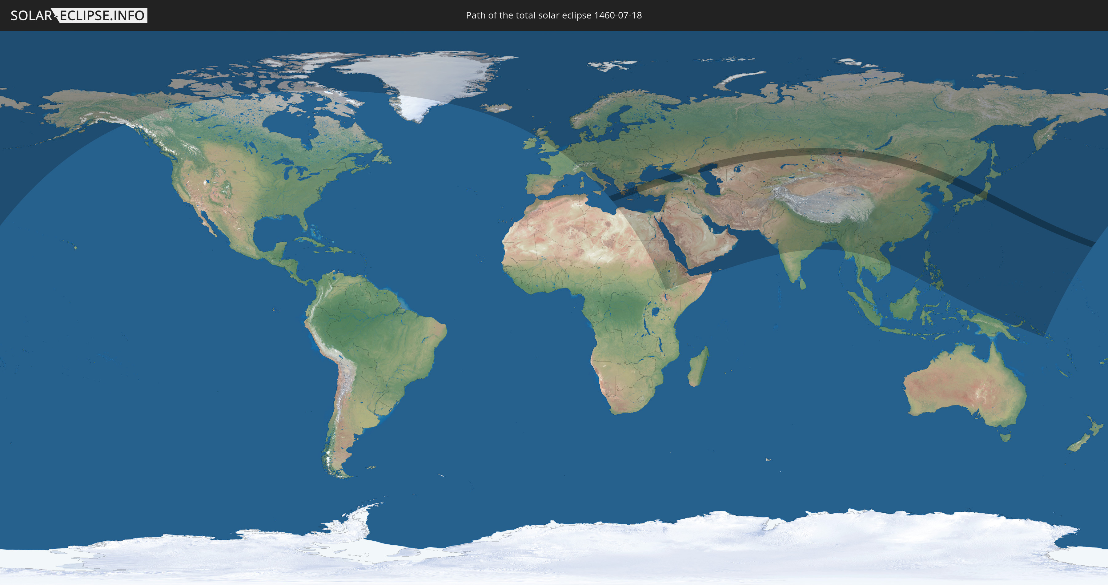
Die Sonnenfinsternis am 18.07.1460 kann man in 102 Ländern als partielle Sonnenfinsternis beobachten.
Der Finsternispfad verläuft durch 9 Länder. Nur in diesen Ländern ist sie als totale Sonnenfinsternis zu sehen.
In den folgenden Ländern ist die Sonnenfinsternis total zu sehen
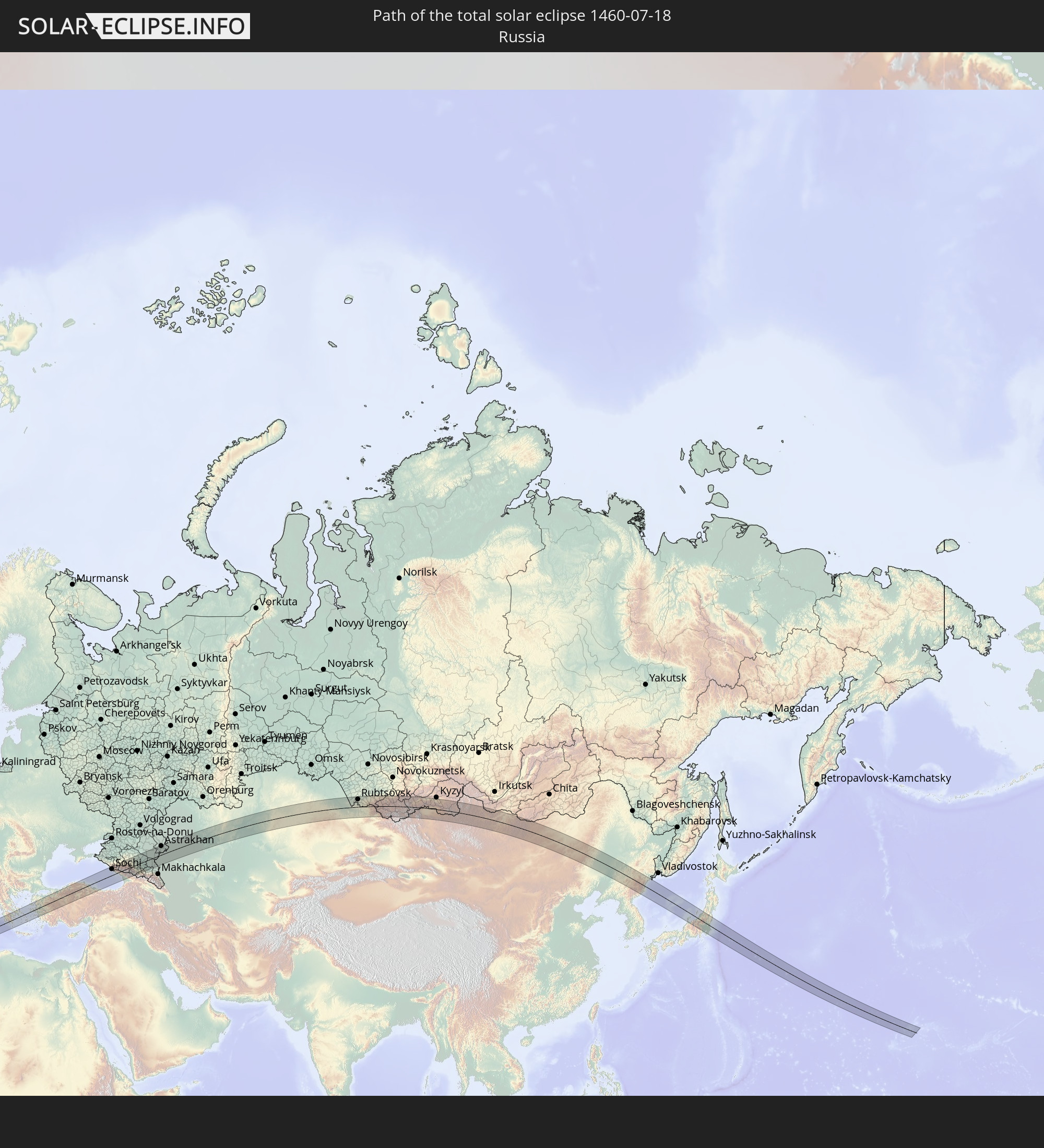 Russland
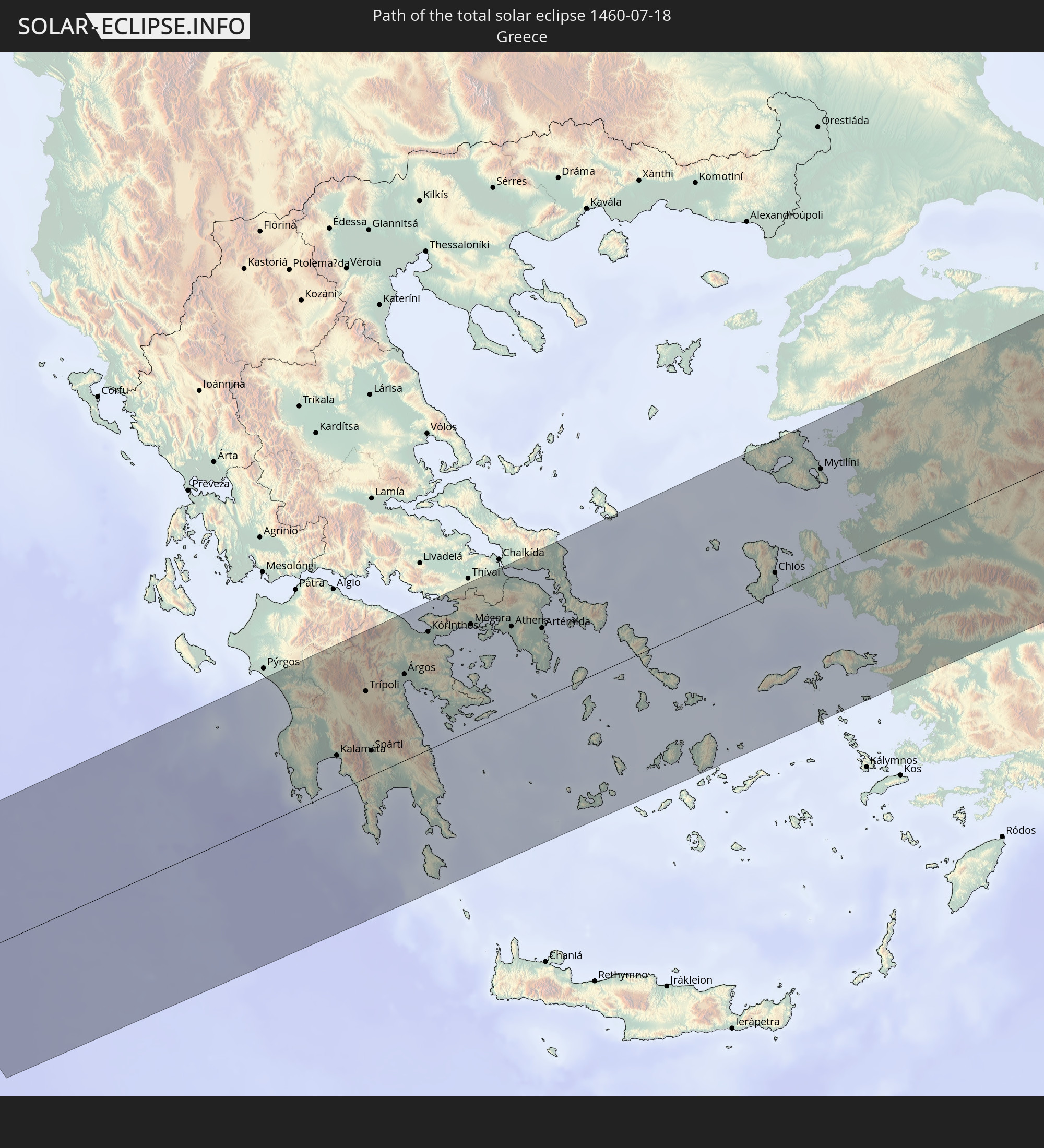 Griechenland
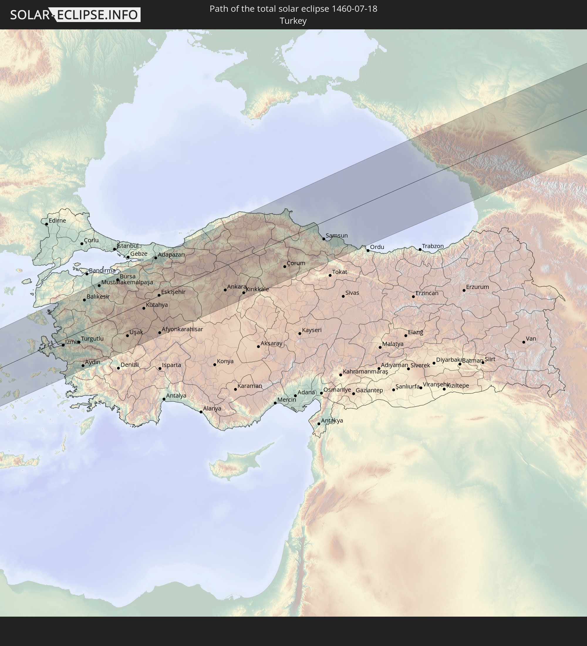 Türkei
 Georgien
 Kasachstan
 Volksrepublik China
 Mongolei
 Japan
Japan
 Nordkorea
In den folgenden Ländern ist die Sonnenfinsternis partiell zu sehen
 Russland
 Vereinigte Staaten
 United States Minor Outlying Islands
 Kanada
 Grönland
 Island
 Spitzbergen
 Vereinigtes Königreich
 Färöer
 Frankreich
 Belgien
 Niederlande
 Norwegen
 Luxemburg
 Deutschland
 Schweiz
 Italien
 Dänemark
 Libyen
 Liechtenstein
 Österreich
 Schweden
 Tschechien
 San Marino
 Vatikanstadt
 Slowenien
 Kroatien
 Polen
Polen
 Bosnien und Herzegowina
 Ungarn
 Slowakei
 Montenegro
 Serbien
 Albanien
 Åland Islands
 Griechenland
 Rumänien
 Mazedonien
 Finnland
 Litauen
 Lettland
 Estland
 Sudan
Sudan
 Ukraine
 Bulgarien
 Weißrussland
 Ägypten
 Türkei
 Moldawien
 Republik Zypern
 Äthiopien
 Staat Palästina
 Israel
 Saudi-Arabien
 Jordanien
 Libanon
 Syrien
 Eritrea
 Irak
Irak
 Georgien
 Somalia
 Dschibuti
 Jemen
Jemen
 Armenien
 Iran
Iran
 Aserbaidschan
 Kasachstan
 Kuwait
 Bahrain
 Katar
Katar
 Vereinigte Arabische Emirate
 Oman
Oman
 Turkmenistan
 Usbekistan
 Afghanistan
 Pakistan
 Tadschikistan
 Indien
 Kirgisistan
 Volksrepublik China
 Nepal
Nepal
 Mongolei
 Bangladesch
 Bhutan
 Myanmar
 Thailand
 Laos
Laos
 Vietnam
 Macau
Macau
 Hongkong
 Taiwan
 Philippinen
 Japan
Japan
 Nordkorea
 Südkorea
 Palau
Palau
 Föderierte Staaten von Mikronesien
 Papua-Neuguinea
 Guam
Guam
 Nördliche Marianen
 Salomonen
 Marshallinseln
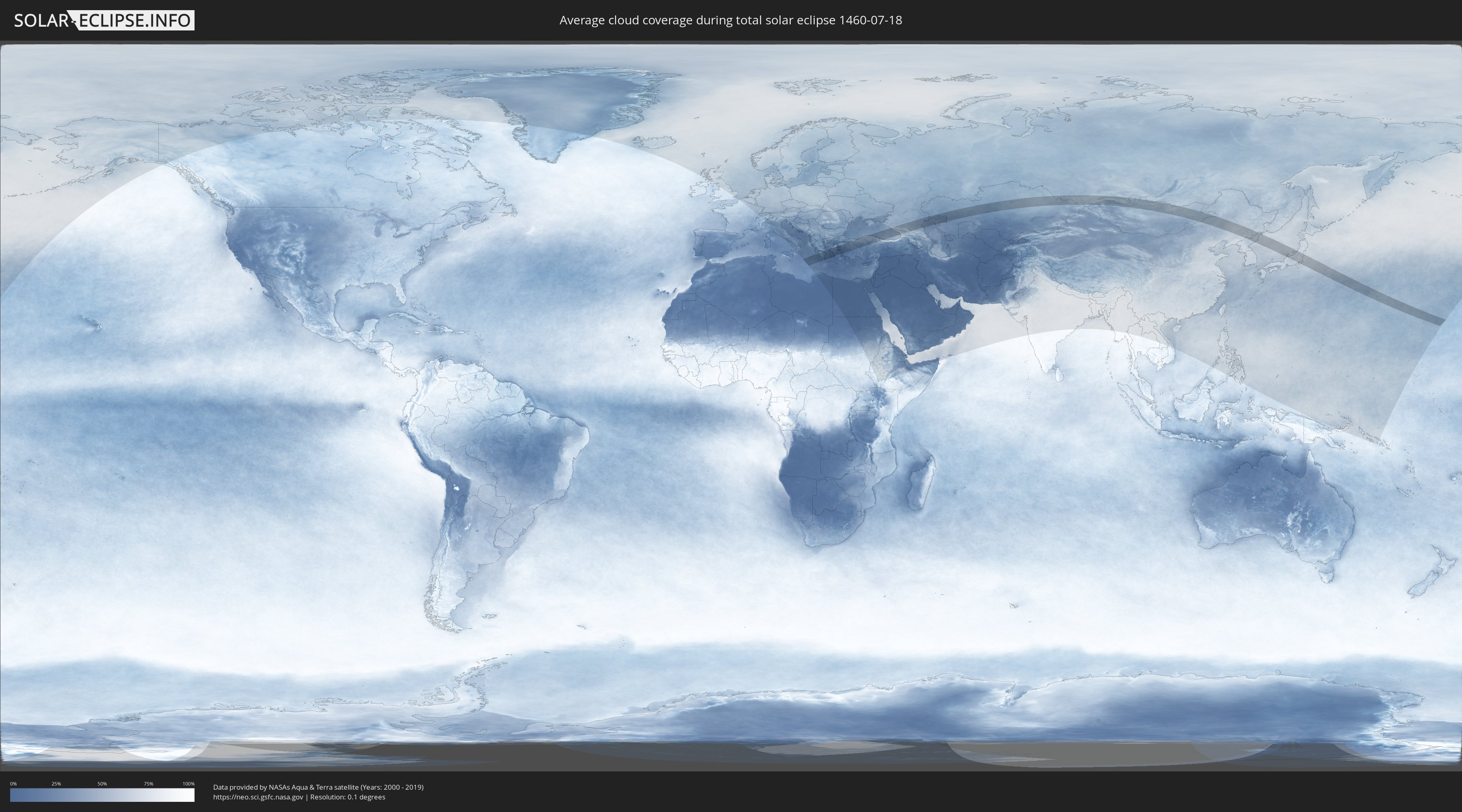
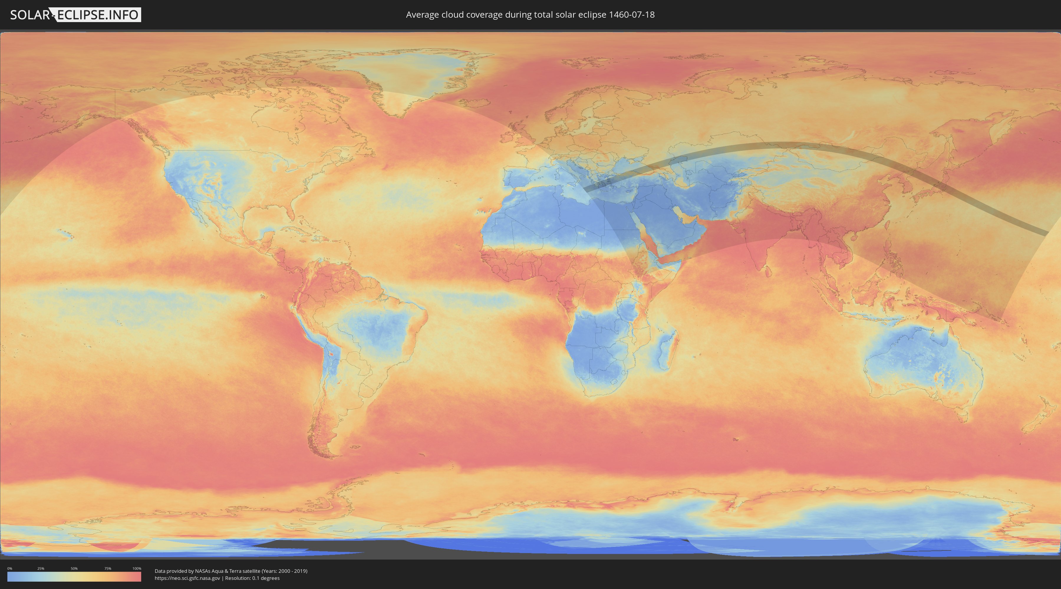
Wie wird das Wetter während der totalen Sonnenfinsternis am 18.07.1460?
Wo ist der beste Ort, um die totale Sonnenfinsternis vom 18.07.1460 zu beobachten?
Die folgenden Karten zeigen die durchschnittliche Bewölkung für den Tag, an dem die totale Sonnenfinsternis
stattfindet. Mit Hilfe der Karten lässt sich der Ort entlang des Finsternispfades eingrenzen,
der die besten Aussichen auf einen klaren wolkenfreien Himmel bietet.
Trotzdem muss man immer lokale Gegenenheiten beachten und sollte sich genau über das Wetter an seinem
gewählten Beobachtungsort informieren.
Die Daten stammen von den beiden NASA-Satelliten
AQUA und TERRA
und wurden über einen Zeitraum von 19 Jahren (2000 - 2019) gemittelt.
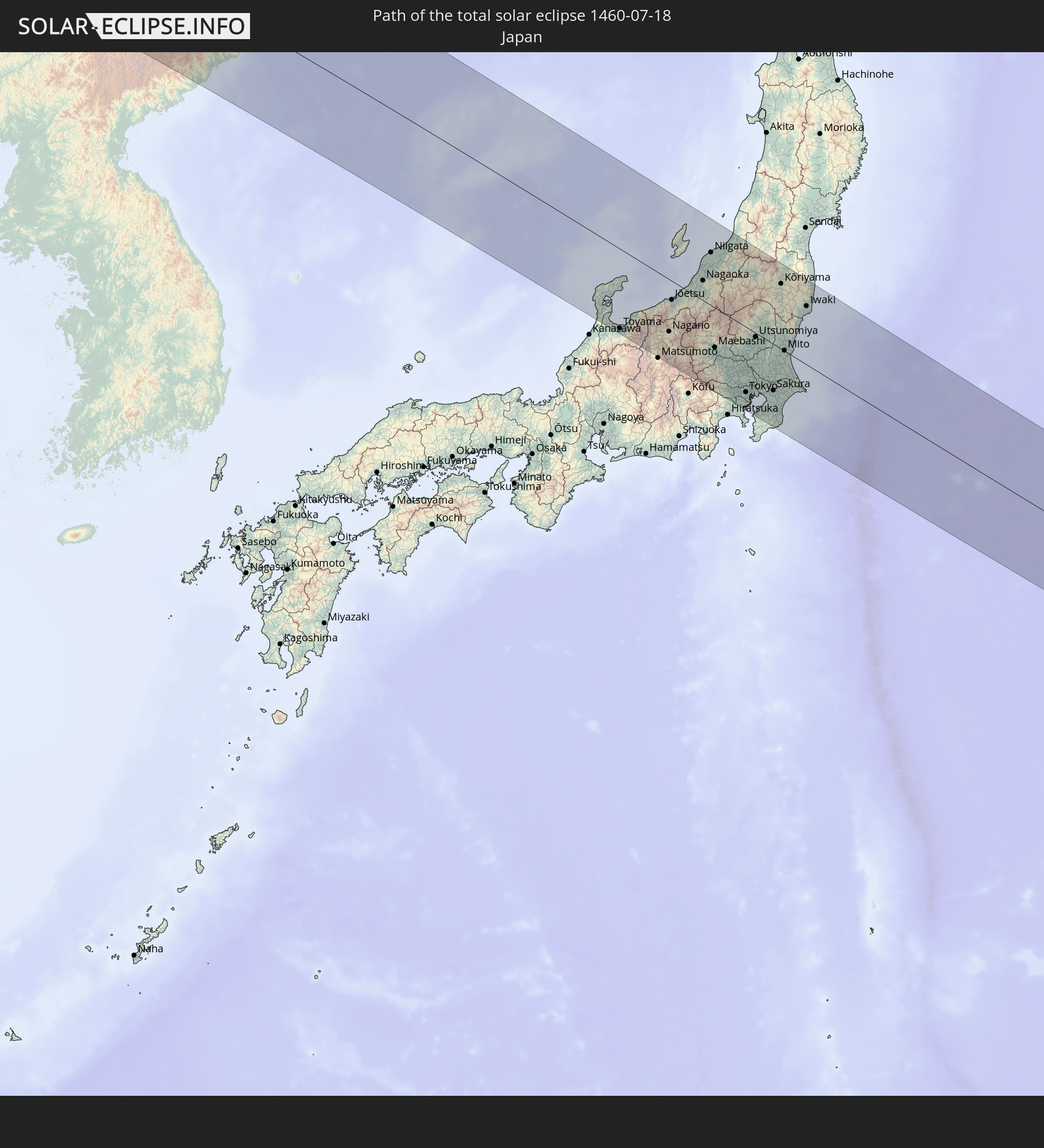
Detaillierte Länderkarten
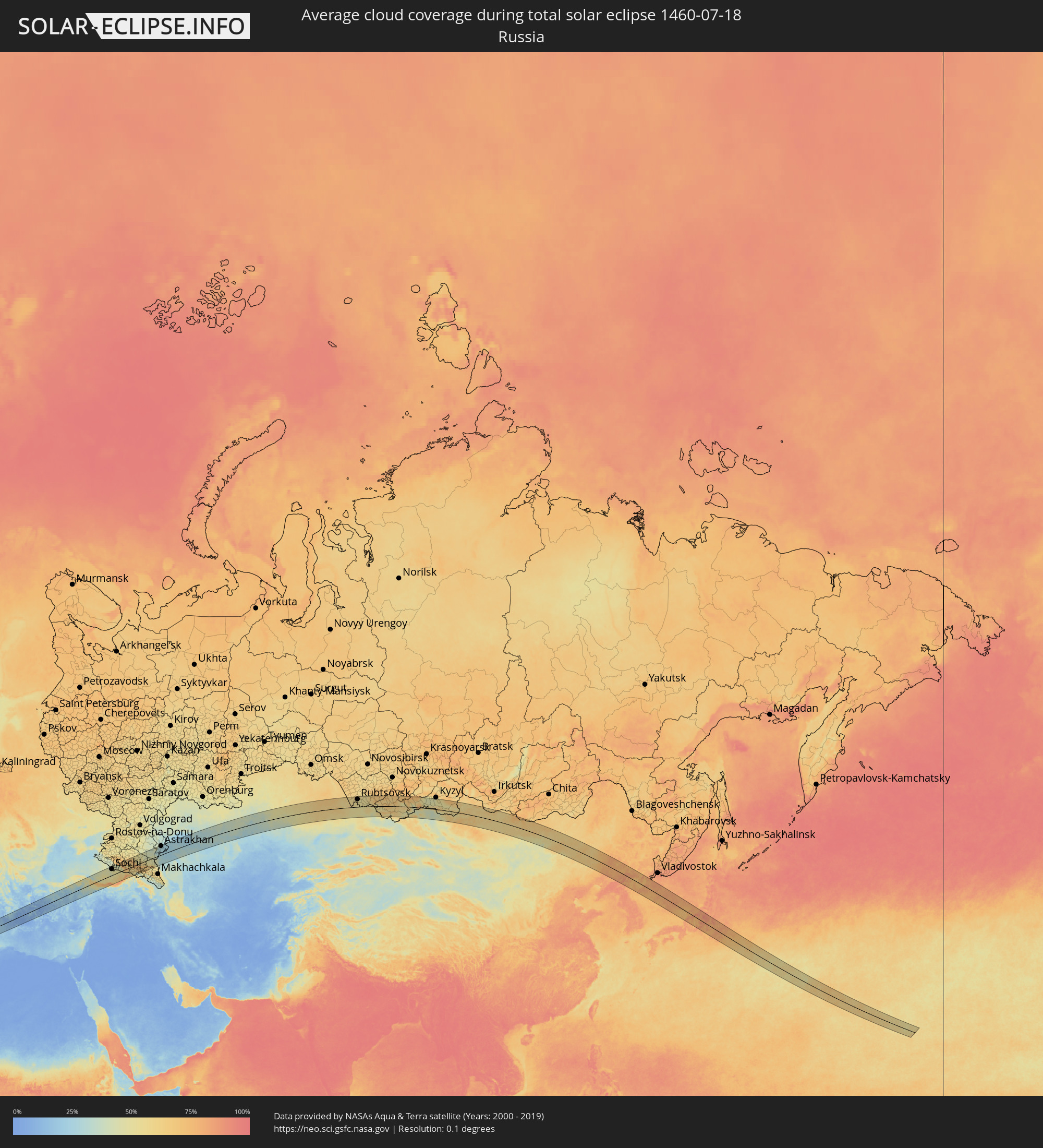 Russland
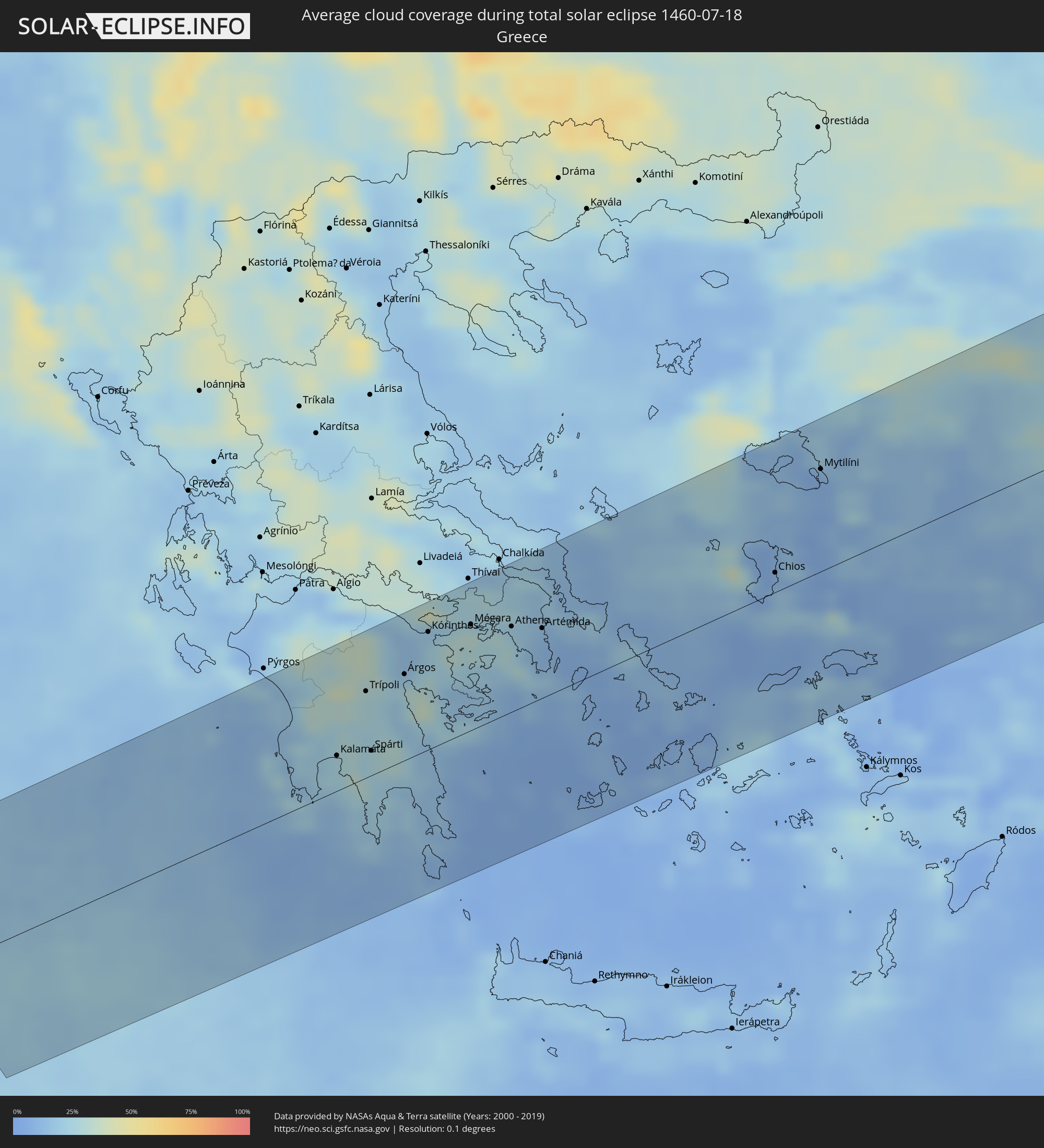 Griechenland
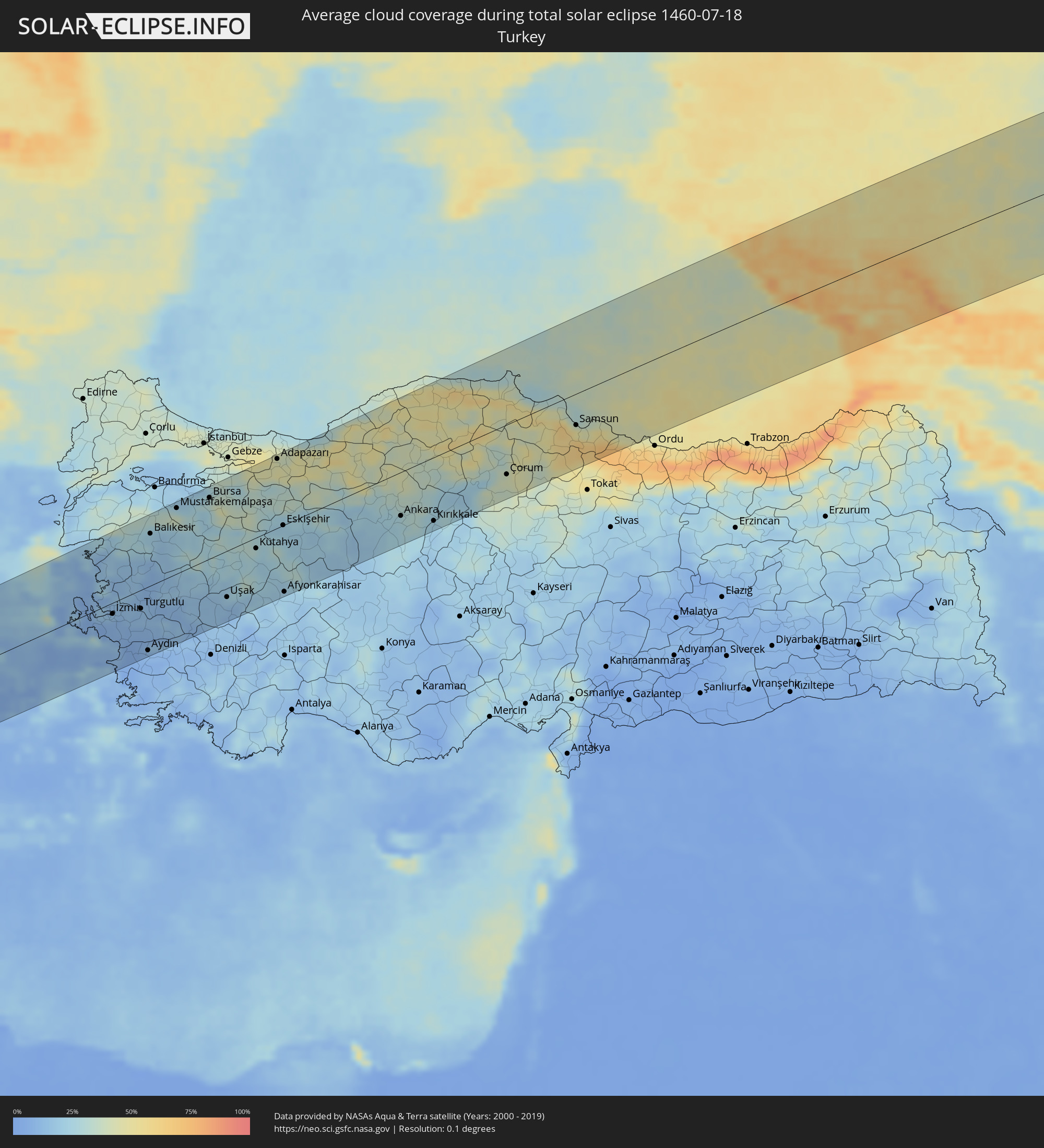 Türkei
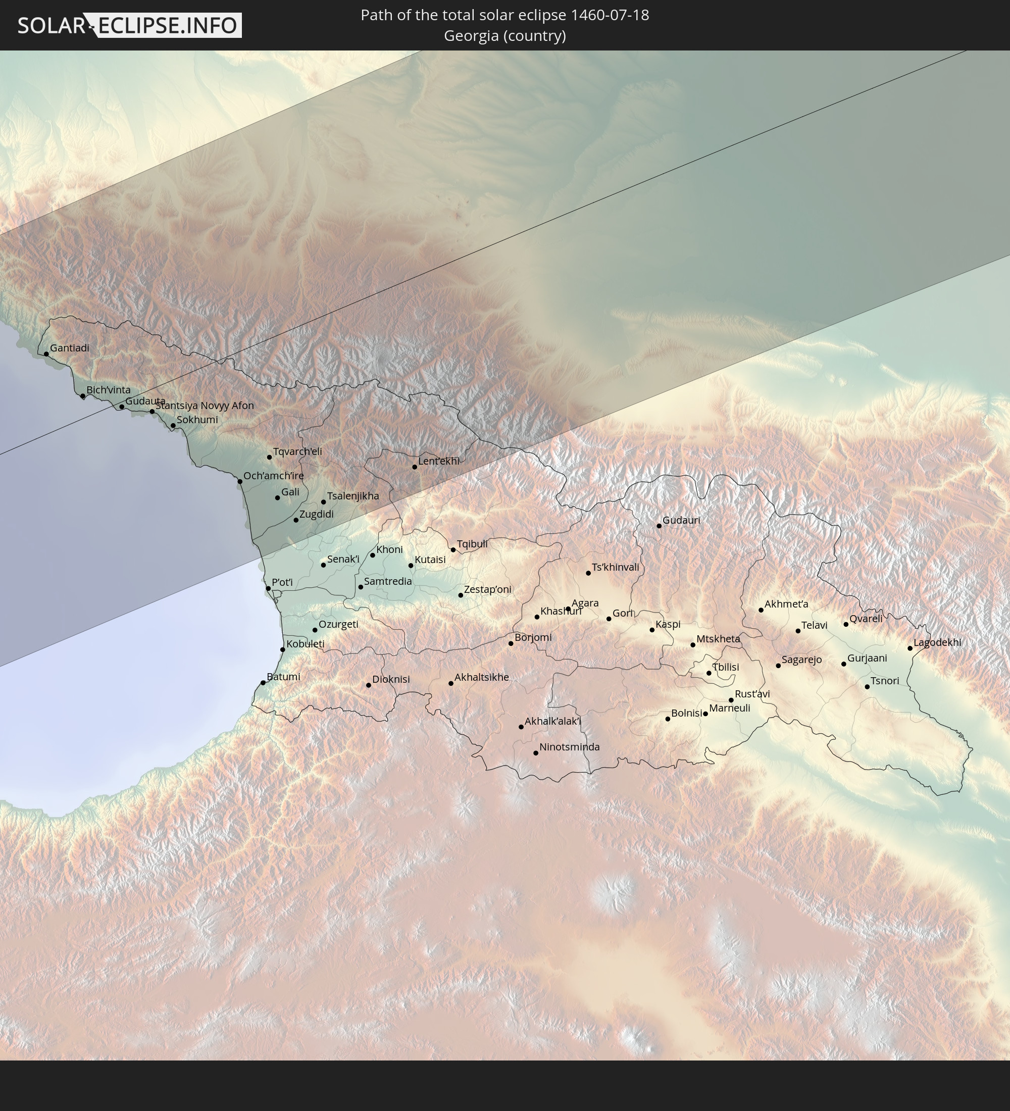
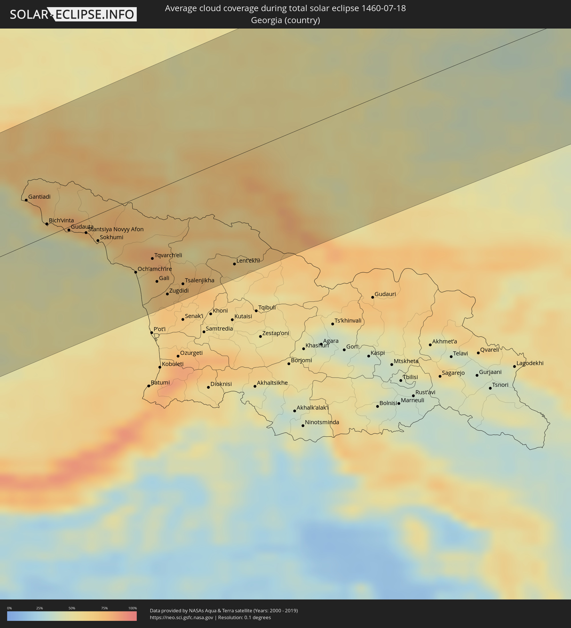 Georgien
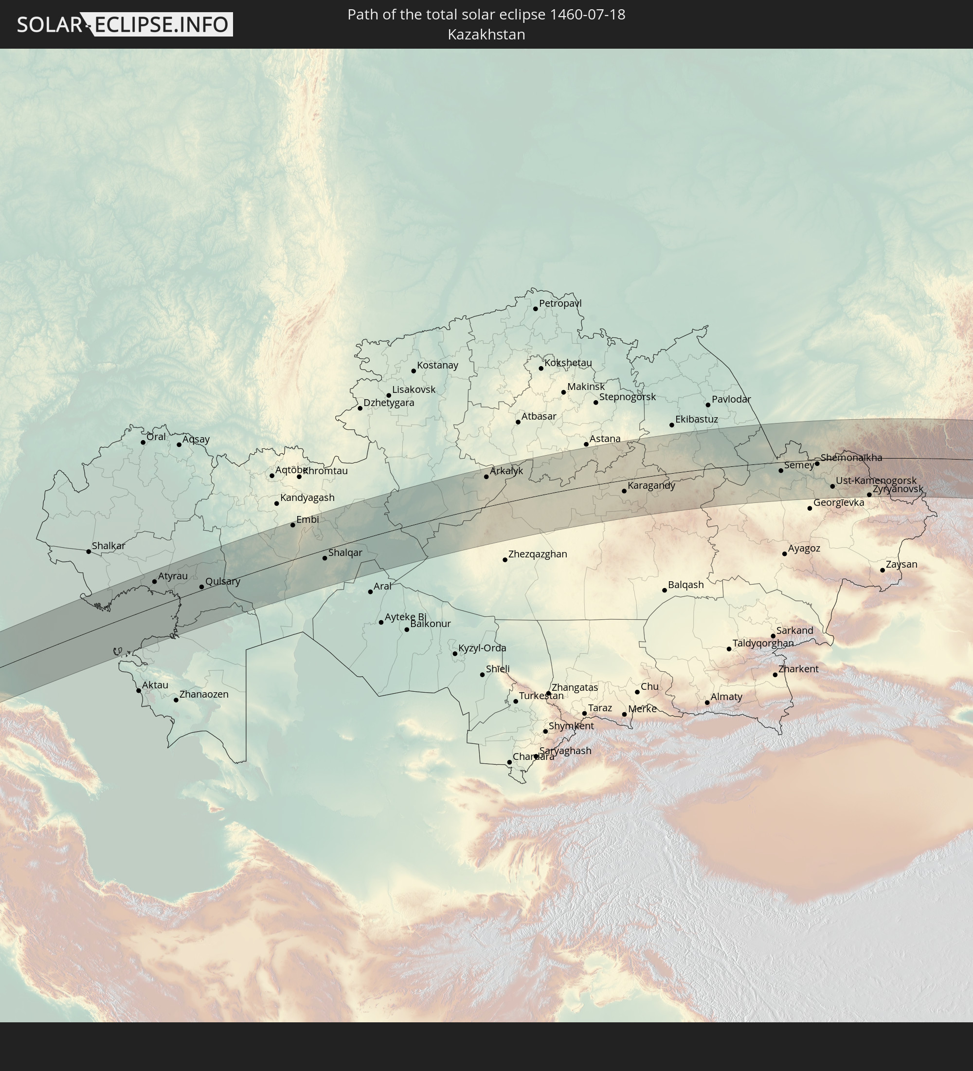
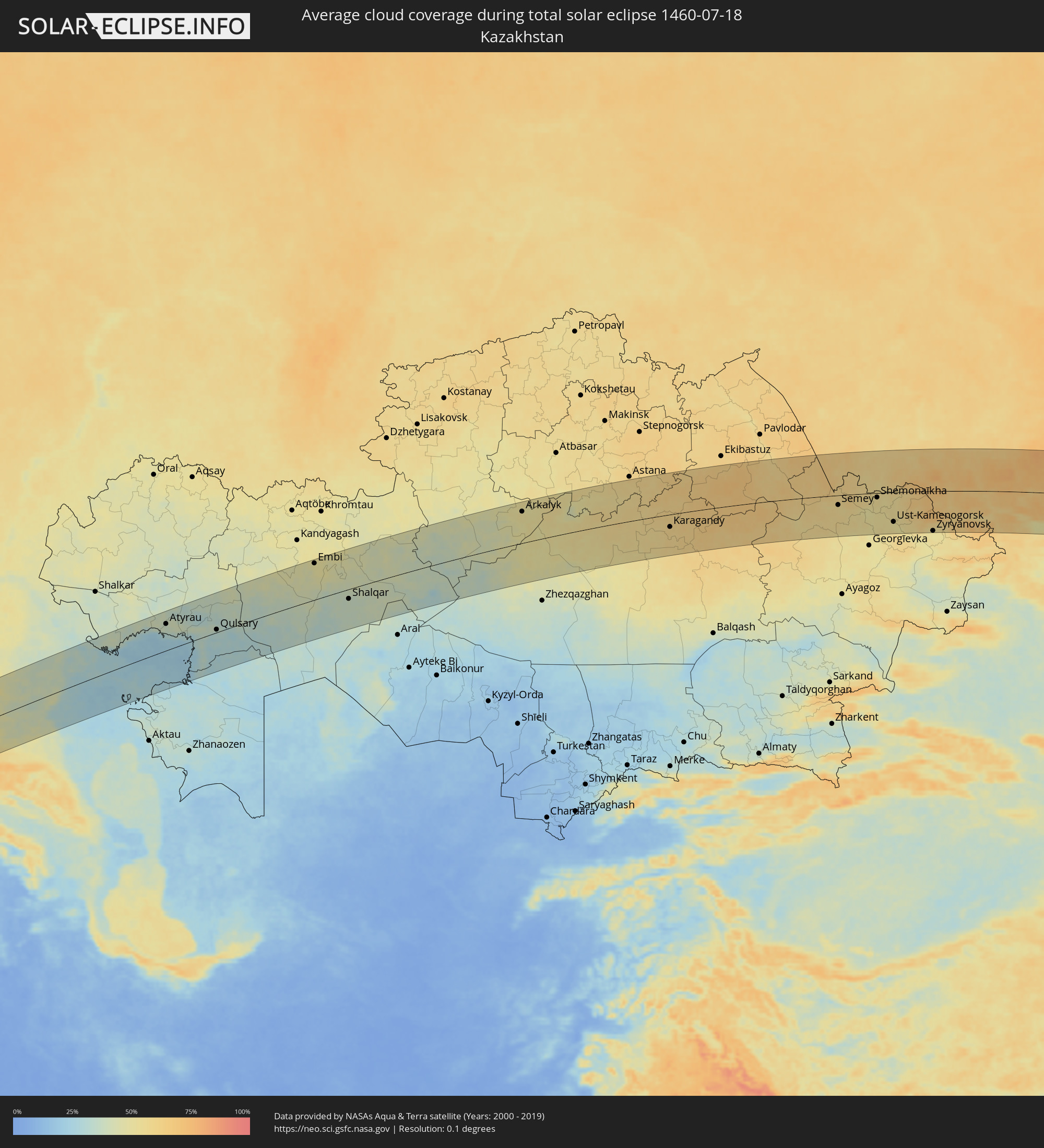 Kasachstan
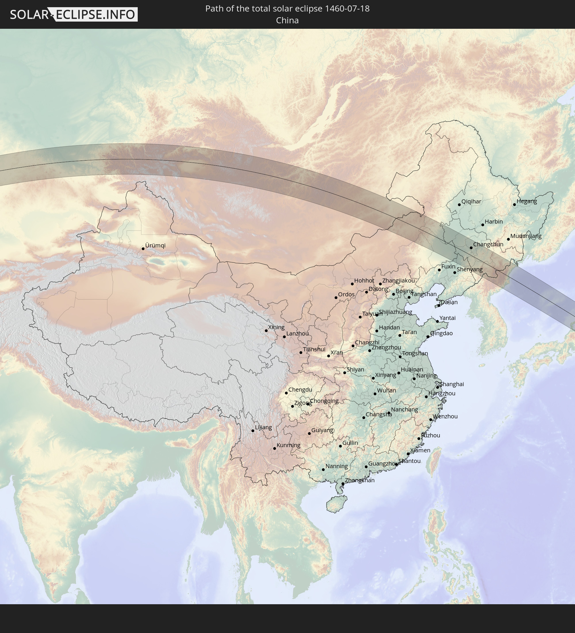
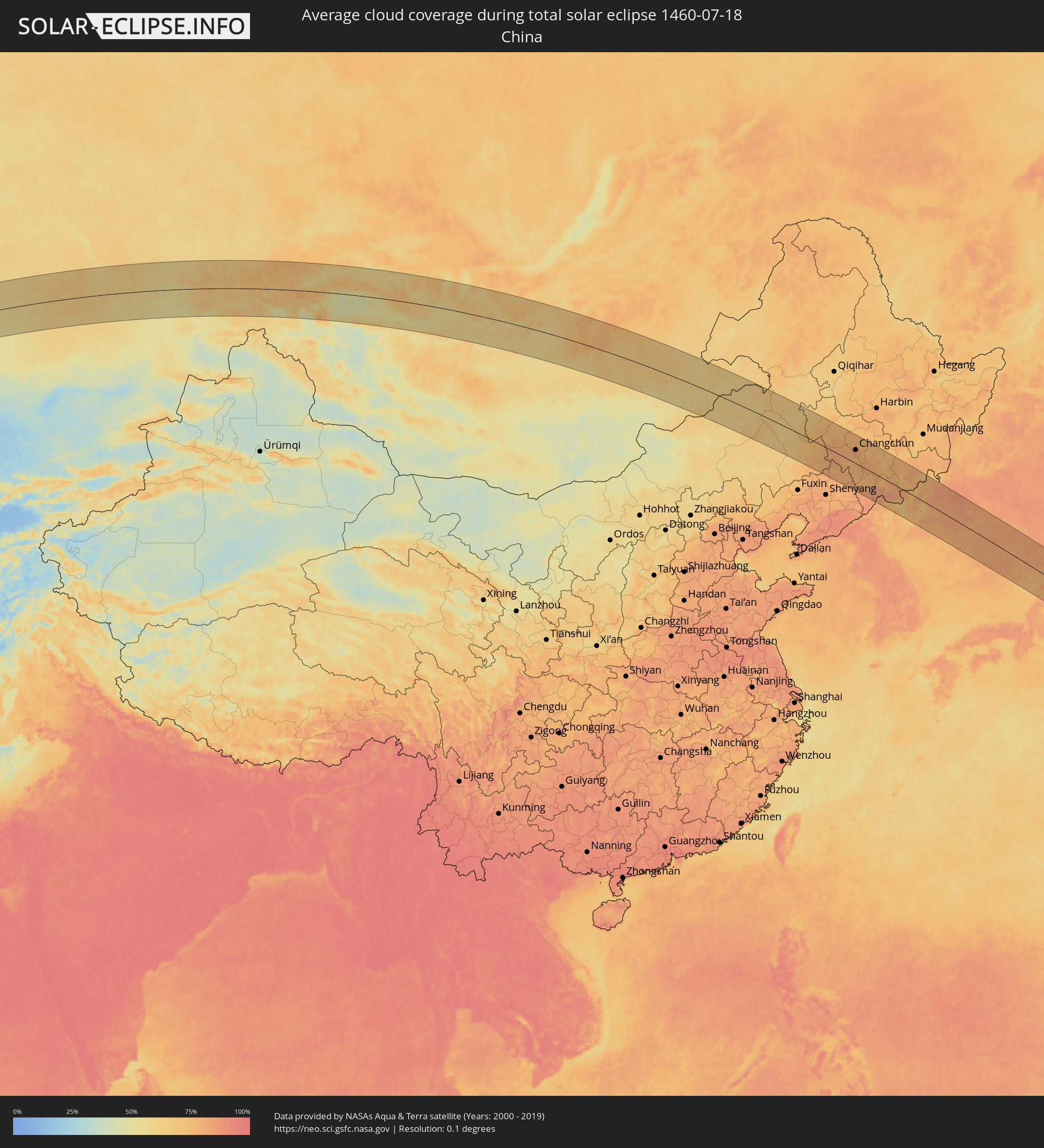 Volksrepublik China
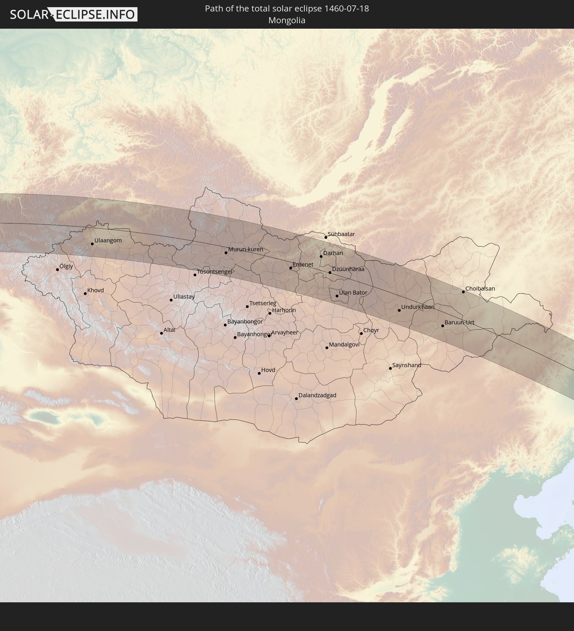
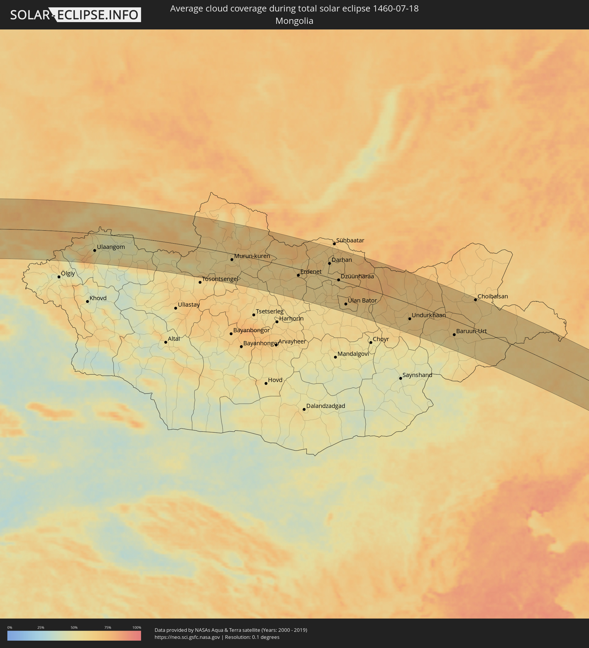 Mongolei
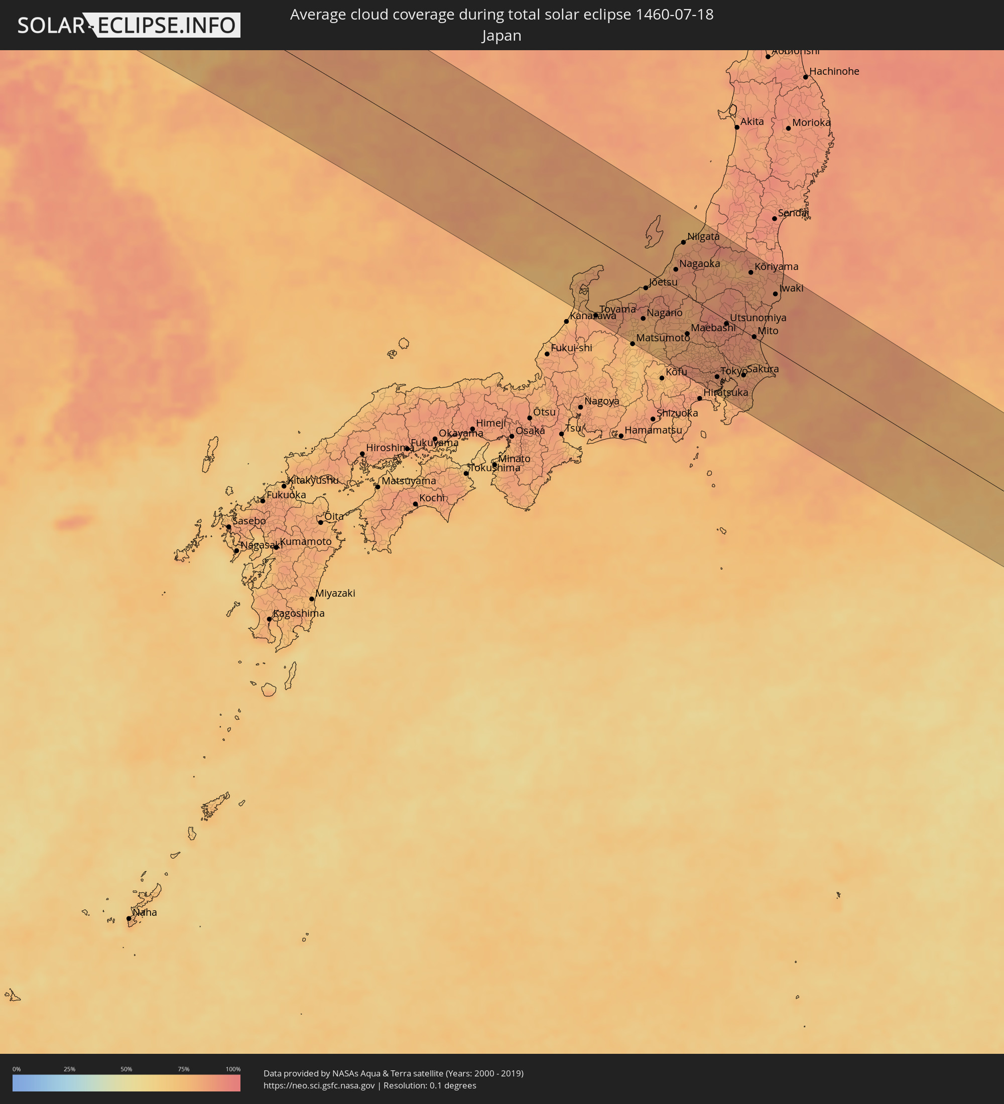 Japan
Japan
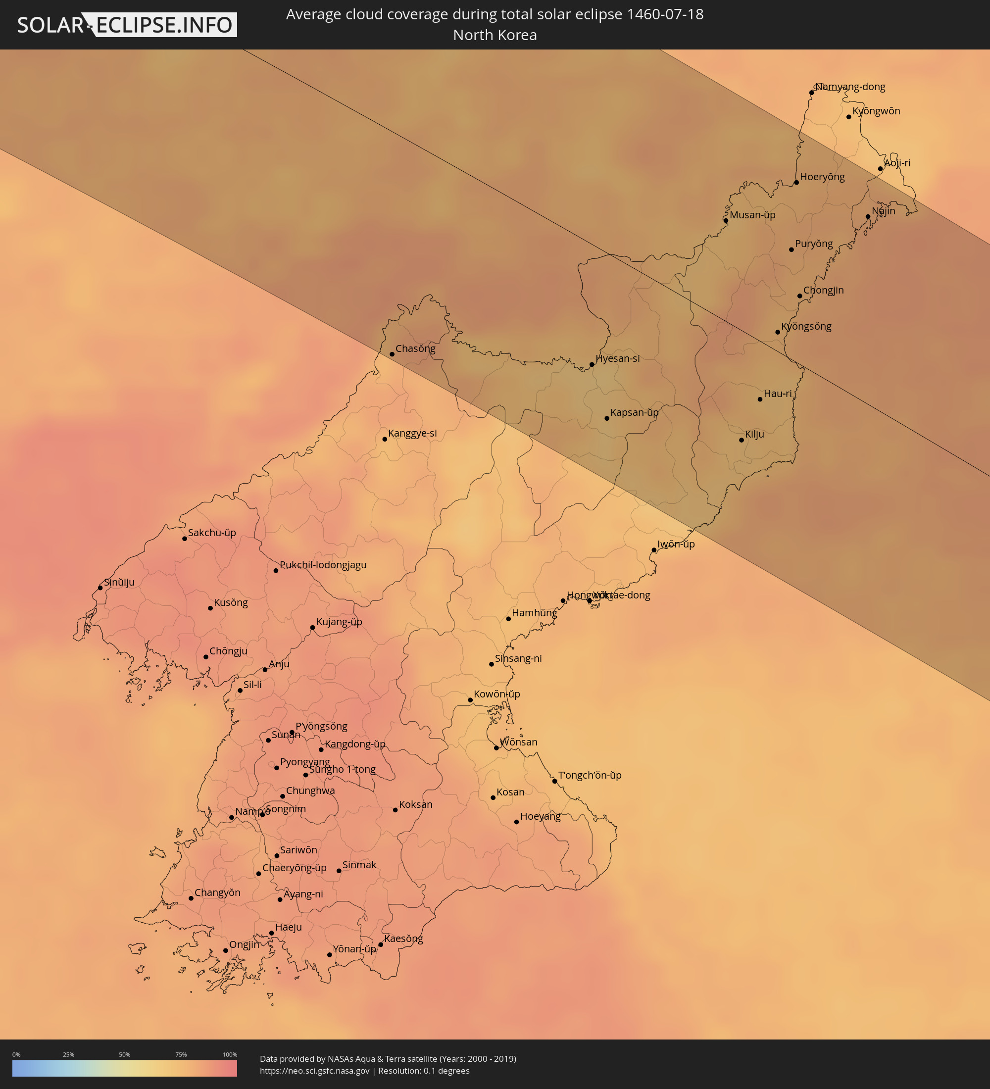 Nordkorea
Orte im Finsternispfad
Die nachfolgene Tabelle zeigt Städte und Orte mit mehr als 5.000 Einwohnern, die sich im Finsternispfad befinden. Städte mit mehr als 100.000 Einwohnern sind dick gekennzeichnet. Mit einem Klick auf den Ort öffnet sich eine Detailkarte die die Lage des jeweiligen Ortes zusammen mit dem Verlauf der zentralen Finsternis präsentiert.
| Ort | Typ | Dauer der Verfinsterung | Ortszeit bei maximaler Verfinsterung | Entfernung zur Zentrallinie | Ø Bewölkung |
|
Filiatrá, Peloponnese
|
total | - | 05:29:31 UTC+01:34 | 58 km | 13% |
|
Gargaliánoi, Peloponnese
|
total | - | 05:29:25 UTC+01:34 | 46 km | 19% |
|
Messíni, Peloponnese
|
total | - | 05:29:19 UTC+01:34 | 31 km | 21% |
|
Kalamáta, Peloponnese
|
total | - | 05:29:16 UTC+01:34 | 26 km | 25% |
|
Trípoli, Peloponnese
|
total | - | 05:29:40 UTC+01:34 | 64 km | 27% |
|
Spárti, Peloponnese
|
total | - | 05:29:14 UTC+01:34 | 18 km | 24% |
|
Árgos, Peloponnese
|
total | - | 05:29:43 UTC+01:34 | 64 km | 24% |
|
Kiáto, Peloponnese
|
total | - | 05:30:06 UTC+01:34 | 102 km | 14% |
|
Kórinthos, Peloponnese
|
total | - | 05:29:59 UTC+01:34 | 87 km | 23% |
|
Aegina, Attica
|
total | - | 05:29:41 UTC+01:34 | 50 km | 21% |
|
Salamína, Attica
|
total | - | 05:29:53 UTC+01:34 | 69 km | 26% |
|
Athens, Attica
|
total | - | 05:29:52 UTC+01:34 | 63 km | 25% |
|
Voúla, Attica
|
total | - | 05:29:42 UTC+01:34 | 47 km | 29% |
|
Néa Erythraía, Attica
|
total | - | 05:29:57 UTC+01:34 | 70 km | 21% |
|
Anoixi, Attica
|
total | - | 05:29:59 UTC+01:34 | 73 km | 18% |
|
Keratéa, Attica
|
total | - | 05:29:38 UTC+01:34 | 36 km | 13% |
|
Artémida, Attica
|
total | - | 05:29:47 UTC+01:34 | 51 km | 13% |
|
Lávrio, Attica
|
total | - | 05:29:31 UTC+01:34 | 24 km | 18% |
|
Ermoúpolis, South Aegean
|
total | - | 05:29:05 UTC+01:34 | 36 km | 10% |
|
Náxos, South Aegean
|
total | - | 05:28:39 UTC+01:34 | 86 km | 10% |
|
Chios, North Aegean
|
total | - | 05:29:51 UTC+01:34 | 14 km | 7% |
|
Mytilíni, North Aegean
|
total | - | 05:30:34 UTC+01:34 | 74 km | 8% |
|
Néon Karlovásion, North Aegean
|
total | - | 05:29:10 UTC+01:34 | 65 km | 9% |
|
İzmir, İzmir
|
total | - | 05:51:49 UTC+01:56 | 17 km | 9% |
|
Manisa, Manisa
|
total | - | 05:52:00 UTC+01:56 | 8 km | 13% |
|
Turgutlu, Manisa
|
total | - | 05:51:51 UTC+01:56 | 29 km | 13% |
|
Aydın, Aydın
|
total | - | 05:51:08 UTC+01:56 | 100 km | 5% |
|
Akhisar, Manisa
|
total | - | 05:52:17 UTC+01:56 | 9 km | 9% |
|
Balıkesir, Balıkesir
|
total | - | 05:53:05 UTC+01:56 | 81 km | 21% |
|
Salihli, Manisa
|
total | - | 05:51:47 UTC+01:56 | 47 km | 11% |
|
Mustafakemalpaşa, Bursa
|
total | - | 05:53:28 UTC+01:56 | 102 km | 36% |
|
Bursa, Bursa
|
total | - | 05:53:35 UTC+01:56 | 94 km | 37% |
|
Uşak, Uşak
|
total | - | 05:51:53 UTC+01:56 | 72 km | 18% |
|
İnegol, Bursa
|
total | - | 05:53:26 UTC+01:56 | 66 km | 37% |
|
Kütahya, Kütahya
|
total | - | 05:52:41 UTC+01:56 | 17 km | 25% |
|
Adapazarı, Sakarya
|
total | - | 05:54:11 UTC+01:56 | 106 km | 45% |
|
Eskişehir, Eskişehir
|
total | - | 05:53:03 UTC+01:56 | 0 km | 22% |
|
Afyonkarahisar, Afyonkarahisar
|
total | - | 05:51:55 UTC+01:56 | 104 km | 20% |
|
Bolu, Bolu
|
total | - | 05:54:07 UTC+01:56 | 59 km | 40% |
|
Polatlı, Ankara
|
total | - | 05:52:48 UTC+01:56 | 77 km | 17% |
|
Karabük, Karabük
|
total | - | 05:54:41 UTC+01:56 | 71 km | 37% |
|
Ankara, Ankara
|
total | - | 05:53:12 UTC+01:56 | 67 km | 26% |
|
Kırıkkale, Kırıkkale
|
total | - | 05:53:08 UTC+01:56 | 98 km | 19% |
|
Çorum, Çorum
|
total | - | 05:54:03 UTC+01:56 | 76 km | 40% |
|
Bafra, Samsun
|
total | - | 05:55:21 UTC+01:56 | 5 km | 45% |
|
Samsun, Samsun
|
total | - | 05:55:04 UTC+01:56 | 47 km | 51% |
|
Sochi, Krasnodarskiy
|
total | - | 06:31:51 UTC+02:30 | 76 km | 42% |
|
Adler, Krasnodarskiy
|
total | - | 06:31:41 UTC+02:30 | 52 km | 42% |
|
Gantiadi
|
total | - | 07:00:33 UTC+02:59 | 42 km | 51% |
|
Gagra, Abkhazia
|
total | - | 07:00:28 UTC+02:59 | 26 km | 58% |
|
Bich’vinta, Abkhazia
|
total | - | 07:00:20 UTC+02:59 | 12 km | 45% |
|
Gudauta, Abkhazia
|
total | - | 07:00:20 UTC+02:59 | 3 km | 43% |
|
Stantsiya Novyy Afon, Abkhazia
|
total | - | 07:00:22 UTC+02:59 | 13 km | 50% |
|
Sokhumi, Abkhazia
|
total | - | 07:00:19 UTC+02:59 | 25 km | 46% |
|
Och’amch’ire, Abkhazia
|
total | - | 07:00:04 UTC+02:59 | 71 km | 48% |
|
Tqvarch'eli, Abkhazia
|
total | - | 07:00:17 UTC+02:59 | 64 km | 73% |
|
Gali, Abkhazia
|
total | - | 07:00:02 UTC+02:59 | 88 km | 67% |
|
Zugdidi, Samegrelo and Zemo Svaneti
|
total | - | 06:59:56 UTC+02:59 | 104 km | 70% |
|
Nevinnomyssk, Stavropol'skiy
|
total | - | 06:33:44 UTC+02:30 | 111 km | 50% |
|
Ust’-Dzheguta, Karachayevo-Cherkesiya
|
total | - | 06:33:03 UTC+02:30 | 54 km | 55% |
|
Cherkessk, Karachayevo-Cherkesiya
|
total | - | 06:33:15 UTC+02:30 | 66 km | 51% |
|
Tsalenjikha, Samegrelo and Zemo Svaneti
|
total | - | 07:00:06 UTC+02:59 | 101 km | 71% |
|
Kislovodsk, Stavropol'skiy
|
total | - | 06:33:03 UTC+02:30 | 13 km | 64% |
|
Lent’ekhi, Racha-Lechkhumi and Kvemo Svaneti
|
total | - | 07:00:32 UTC+02:59 | 102 km | 59% |
|
Yessentuki, Stavropol'skiy
|
total | - | 06:33:16 UTC+02:30 | 22 km | 62% |
|
Pyatigorsk, Stavropol'skiy
|
total | - | 06:33:20 UTC+02:30 | 16 km | 59% |
|
Mineralnye Vody, Stavropol'skiy
|
total | - | 06:33:34 UTC+02:30 | 31 km | 54% |
|
Blagodarnyy, Stavropol'skiy
|
total | - | 06:34:48 UTC+02:30 | 112 km | 47% |
|
Georgiyevsk, Stavropol'skiy
|
total | - | 06:33:36 UTC+02:30 | 14 km | 54% |
|
Baksan, Kabardino-Balkariya
|
total | - | 06:33:02 UTC+02:30 | 35 km | 56% |
|
Nal’chik, Kabardino-Balkariya
|
total | - | 06:32:49 UTC+02:30 | 57 km | 58% |
|
Nartkala, Kabardino-Balkariya
|
total | - | 06:32:58 UTC+02:30 | 58 km | 47% |
|
Zelenokumsk, Stavropol'skiy
|
total | - | 06:34:04 UTC+02:30 | 28 km | 51% |
|
Prokhladnyy, Kabardino-Balkariya
|
total | - | 06:33:17 UTC+02:30 | 43 km | 51% |
|
Budënnovsk, Stavropol'skiy
|
total | - | 06:34:39 UTC+02:30 | 58 km | 47% |
|
Staryy Malgobek, Ingushetiya
|
total | - | 06:33:13 UTC+02:30 | 83 km | 55% |
|
Mozdok, North Ossetia
|
total | - | 06:33:29 UTC+02:30 | 64 km | 53% |
|
Karabulak, Ingushetiya
|
total | - | 06:33:01 UTC+02:30 | 117 km | 58% |
|
Kizlyar, Dagestan
|
total | - | 06:34:27 UTC+02:30 | 115 km | 43% |
|
Astrakhan, Astrakhan
|
total | - | 07:28:20 UTC+03:20 | 106 km | 34% |
|
Atyrau, Atyraū
|
total | - | 07:36:26 UTC+03:25 | 80 km | 36% |
|
Dossor, Atyraū
|
total | - | 07:37:38 UTC+03:25 | 95 km | 33% |
|
Maqat, Atyraū
|
total | - | 07:38:00 UTC+03:25 | 99 km | 36% |
|
Qaraton, Atyraū
|
total | - | 07:36:31 UTC+03:25 | 32 km | 32% |
|
Qulsary, Atyraū
|
total | - | 07:37:32 UTC+03:25 | 8 km | 32% |
|
Embi, Aqtöbe
|
total | - | 07:42:52 UTC+03:25 | 109 km | 48% |
|
Shalqar, Aqtöbe
|
total | - | 07:42:45 UTC+03:25 | 29 km | 38% |
|
Arkalyk, Qostanay
|
total | - | 08:48:47 UTC+04:21 | 93 km | 51% |
|
Shakhan, Qaraghandy
|
total | - | 08:54:35 UTC+04:21 | 33 km | 57% |
|
Sorang, Qaraghandy
|
total | - | 08:54:47 UTC+04:21 | 38 km | 58% |
|
Abay, Qaraghandy
|
total | - | 08:54:39 UTC+04:21 | 55 km | 57% |
|
Aqtas, Qaraghandy
|
total | - | 08:54:55 UTC+04:21 | 41 km | 60% |
|
Temirtau, Qaraghandy
|
total | - | 08:55:11 UTC+04:21 | 10 km | 60% |
|
Aqtaū, Qaraghandy
|
total | - | 08:55:29 UTC+04:21 | 8 km | 61% |
|
Karagandy, Qaraghandy
|
total | - | 08:55:13 UTC+04:21 | 37 km | 60% |
|
Kūrchatov, Pavlodar
|
total | - | 09:02:44 UTC+04:21 | 18 km | 61% |
|
Semey, East Kazakhstan
|
total | - | 09:04:47 UTC+04:21 | 29 km | 56% |
|
Rubtsovsk, Altai Krai
|
total | - | 10:56:21 UTC+06:11 | 88 km | 60% |
|
Shemonaīkha, East Kazakhstan
|
total | - | 09:07:11 UTC+04:21 | 13 km | 55% |
|
Glubokoye, East Kazakhstan
|
total | - | 09:07:27 UTC+04:21 | 69 km | 52% |
|
Belūsovka, East Kazakhstan
|
total | - | 09:07:44 UTC+04:21 | 70 km | 51% |
|
Ust-Kamenogorsk, East Kazakhstan
|
total | - | 09:07:46 UTC+04:21 | 88 km | 50% |
|
Ridder, East Kazakhstan
|
total | - | 09:09:16 UTC+04:21 | 49 km | 61% |
|
Zyryanovsk, East Kazakhstan
|
total | - | 09:10:03 UTC+04:21 | 119 km | 50% |
|
Ulaangom, Uvs
|
total | - | 11:06:50 UTC+06:06 | 71 km | 51% |
|
Murun-kuren, Hövsgöl
|
total | - | 12:20:52 UTC+07:07 | 25 km | 57% |
|
Bulgan, Bulgan
|
total | - | 12:26:45 UTC+07:07 | 60 km | 60% |
|
Erdenet, Orhon
|
total | - | 12:27:32 UTC+07:07 | 26 km | 63% |
|
Darhan, Darhan Uul
|
total | - | 12:30:14 UTC+07:07 | 58 km | 60% |
|
Dzüünharaa, Selenge
|
total | - | 12:31:30 UTC+07:07 | 1 km | 59% |
|
Ulan Bator, Ulaanbaatar
|
total | - | 12:32:51 UTC+07:07 | 91 km | 62% |
|
Зуунмод, Central Aimak
|
total | - | 12:33:07 UTC+07:07 | 111 km | 57% |
|
Dzuunmod, Central Aimak
|
total | - | 12:33:07 UTC+07:07 | 111 km | 57% |
|
Undurkhaan, Hentiy
|
total | - | 12:39:32 UTC+07:07 | 64 km | 63% |
|
Baruun-Urt, Sühbaatar
|
total | - | 12:44:23 UTC+07:07 | 61 km | 62% |
|
Choibalsan, East Aimak
|
total | - | 12:44:53 UTC+07:07 | 118 km | 64% |
|
Tongliao, Inner Mongolia
|
total | - | 13:54:19 UTC+08:00 | 81 km | 74% |
|
Guangming, Jilin
|
total | - | 13:52:40 UTC+08:00 | 108 km | 70% |
|
Zhengjiatun, Jilin
|
total | - | 13:56:13 UTC+08:00 | 45 km | 80% |
|
Kaiyuan, Liaoning
|
total | - | 13:58:22 UTC+08:00 | 121 km | 79% |
|
Changtu, Liaoning
|
total | - | 13:58:05 UTC+08:00 | 95 km | 79% |
|
Siping, Jilin
|
total | - | 13:57:55 UTC+08:00 | 46 km | 80% |
|
Gongzhuling, Jilin
|
total | - | 13:58:01 UTC+08:00 | 4 km | 79% |
|
Liaoyuan, Jilin
|
total | - | 13:59:19 UTC+08:00 | 43 km | 78% |
|
Changchun, Jilin
|
total | - | 13:58:09 UTC+08:00 | 60 km | 83% |
|
Dongfeng, Jilin
|
total | - | 14:00:13 UTC+08:00 | 54 km | 76% |
|
Meihekou, Jilin
|
total | - | 14:00:36 UTC+08:00 | 58 km | 75% |
|
Jiutai, Jilin
|
total | - | 13:58:25 UTC+08:00 | 106 km | 76% |
|
Chaoyang, Jilin
|
total | - | 14:00:52 UTC+08:00 | 31 km | 77% |
|
Panshi, Jilin
|
total | - | 14:00:29 UTC+08:00 | 3 km | 78% |
|
Baishan, Jilin
|
total | - | 14:02:28 UTC+08:00 | 86 km | 83% |
|
Jilin, Jilin
|
total | - | 13:59:48 UTC+08:00 | 105 km | 77% |
|
Chasŏng, Chagang-do
|
total | - | 14:26:28 UTC+08:23 | 124 km | 75% |
|
Huadian, Jilin
|
total | - | 14:01:21 UTC+08:00 | 27 km | 76% |
|
Linjiang, Jilin
|
total | - | 14:03:18 UTC+08:00 | 79 km | 79% |
|
Minzhu, Jilin
|
total | - | 14:00:58 UTC+08:00 | 123 km | 72% |
|
Songjianghe, Jilin
|
total | - | 14:03:28 UTC+08:00 | 19 km | 78% |
|
Hyesan-si, Yanggang-do
|
total | - | 14:28:33 UTC+08:23 | 67 km | 65% |
|
Hyesan-dong, Yanggang-do
|
total | - | 14:28:33 UTC+08:23 | 67 km | 65% |
|
Dunhua, Jilin
|
total | - | 14:02:37 UTC+08:00 | 126 km | 74% |
|
Kapsan-ŭp, Yanggang-do
|
total | - | 14:29:10 UTC+08:23 | 92 km | 66% |
|
Sŭngjibaegam, Yanggang-do
|
total | - | 14:29:34 UTC+08:23 | 56 km | 77% |
|
Helong, Jilin
|
total | - | 14:04:49 UTC+08:00 | 77 km | 75% |
|
Musan-ŭp, Hamgyŏng-bukto
|
total | - | 14:28:33 UTC+08:23 | 55 km | 72% |
|
Kilju, Hamgyŏng-bukto
|
total | - | 14:30:39 UTC+08:23 | 61 km | 71% |
|
Longjing, Jilin
|
total | - | 14:04:58 UTC+08:00 | 117 km | 73% |
|
Hau-ri, Hamgyŏng-bukto
|
total | - | 14:30:27 UTC+08:23 | 32 km | 74% |
|
Kyŏngsŏng, Hamgyŏng-bukto
|
total | - | 14:30:01 UTC+08:23 | 10 km | 75% |
|
Sŭngam-nodongjagu, Hamgyŏng-bukto
|
total | - | 14:29:58 UTC+08:23 | 21 km | 75% |
|
Hoemul-li, Hamgyŏng-bukto
|
total | - | 14:30:20 UTC+08:23 | 2 km | 71% |
|
Nanam, Hamgyŏng-bukto
|
total | - | 14:29:55 UTC+08:23 | 26 km | 75% |
|
Komusan 1-tong, Hamgyŏng-bukto
|
total | - | 14:29:19 UTC+08:23 | 65 km | 78% |
|
Puryŏng, Hamgyŏng-bukto
|
total | - | 14:29:25 UTC+08:23 | 60 km | 78% |
|
Hoeryŏng, Hamgyŏng-bukto
|
total | - | 14:28:52 UTC+08:23 | 99 km | 77% |
|
Chongjin, Hamgyŏng-bukto
|
total | - | 14:29:54 UTC+08:23 | 38 km | 78% |
|
Najin, Rason
|
total | - | 14:29:49 UTC+08:23 | 103 km | 83% |
|
Sŏnbong, Rason
|
total | - | 14:29:47 UTC+08:23 | 116 km | 81% |
|
Ungsang-nodongjagu, Rason
|
total | - | 14:29:50 UTC+08:23 | 120 km | 79% |
|
Toyama, Toyama
|
total | - | 15:22:58 UTC+09:00 | 118 km | 83% |
|
Nagano, Nagano
|
total | - | 15:23:57 UTC+09:00 | 78 km | 79% |
|
Jōetsu, Niigata
|
total | - | 15:23:12 UTC+09:00 | 28 km | 87% |
|
Nagaoka, Niigata
|
total | - | 15:23:15 UTC+09:00 | 29 km | 86% |
|
Niigata, Niigata
|
total | - | 15:22:42 UTC+09:00 | 78 km | 82% |
|
Maebashi, Gunma
|
total | - | 15:25:08 UTC+09:00 | 59 km | 81% |
|
Hachiōji, Tokyo
|
total | - | 15:26:32 UTC+09:00 | 118 km | 83% |
|
Machida, Tokyo
|
total | - | 15:26:49 UTC+09:00 | 123 km | 81% |
|
Tokorozawa, Saitama
|
total | - | 15:26:25 UTC+09:00 | 98 km | 85% |
|
Yokohama, Kanagawa
|
total | - | 15:27:09 UTC+09:00 | 124 km | 77% |
|
Saitama, Saitama
|
total | - | 15:26:25 UTC+09:00 | 79 km | 86% |
|
Tokyo, Tokyo
|
total | - | 15:26:47 UTC+09:00 | 98 km | 83% |
|
Sōka, Saitama
|
total | - | 15:26:39 UTC+09:00 | 79 km | 82% |
|
Utsunomiya, Tochigi
|
total | - | 15:25:33 UTC+09:00 | 6 km | 88% |
|
Kashiwa, Chiba
|
total | - | 15:26:45 UTC+09:00 | 68 km | 81% |
|
Honchō, Chiba
|
total | - | 15:27:01 UTC+09:00 | 83 km | 80% |
|
Tsukuba, Ibaraki
|
total | - | 15:26:19 UTC+09:00 | 30 km | 86% |
|
Chiba, Chiba
|
total | - | 15:27:17 UTC+09:00 | 86 km | 85% |
|
Sakura, Chiba
|
total | - | 15:27:12 UTC+09:00 | 70 km | 87% |
|
Kōriyama, Fukushima
|
total | - | 15:24:38 UTC+09:00 | 97 km | 85% |
|
Mito, Ibaraki
|
total | - | 15:26:22 UTC+09:00 | 1 km | 84% |
|
Hitachi, Ibaraki
|
total | - | 15:26:08 UTC+09:00 | 34 km | 83% |
|
Iwaki, Fukushima
|
total | - | 15:25:36 UTC+09:00 | 87 km | 83% |