Totale Sonnenfinsternis vom 09.07.1488
| Wochentag: | Montag |
| Maximale Dauer der Verfinsterung: | 05m36s |
| Maximale Breite des Finsternispfades: | 219 km |
| Saroszyklus: | 118 |
| Bedeckungsgrad: | 100% |
| Magnitude: | 1.0663 |
| Gamma: | 0.1384 |
Wo kann man die Sonnenfinsternis vom 09.07.1488 sehen?
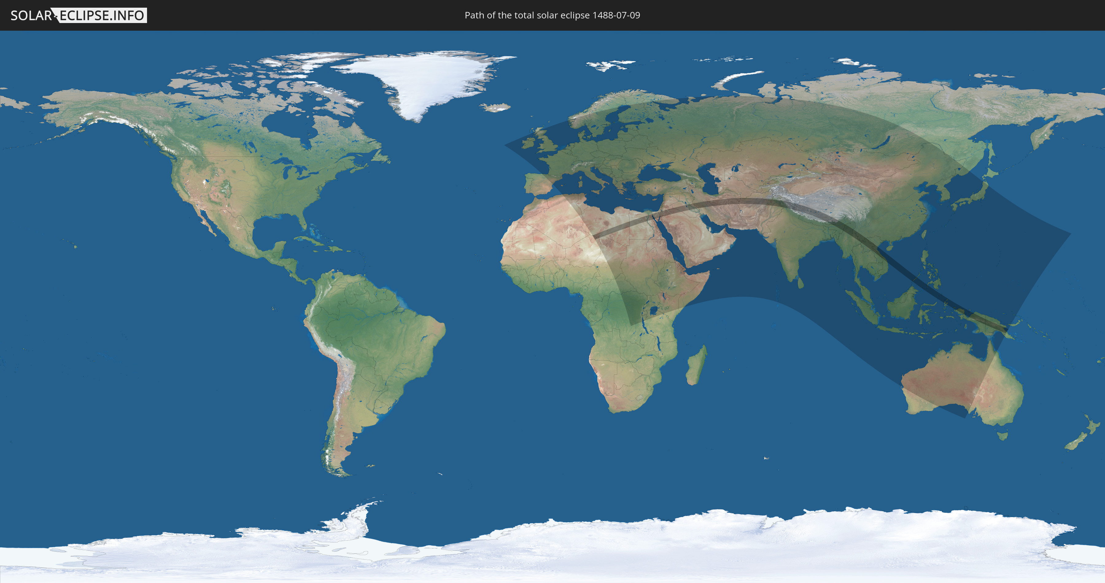
Die Sonnenfinsternis am 09.07.1488 kann man in 123 Ländern als partielle Sonnenfinsternis beobachten.
Der Finsternispfad verläuft durch 21 Länder. Nur in diesen Ländern ist sie als totale Sonnenfinsternis zu sehen.
In den folgenden Ländern ist die Sonnenfinsternis total zu sehen
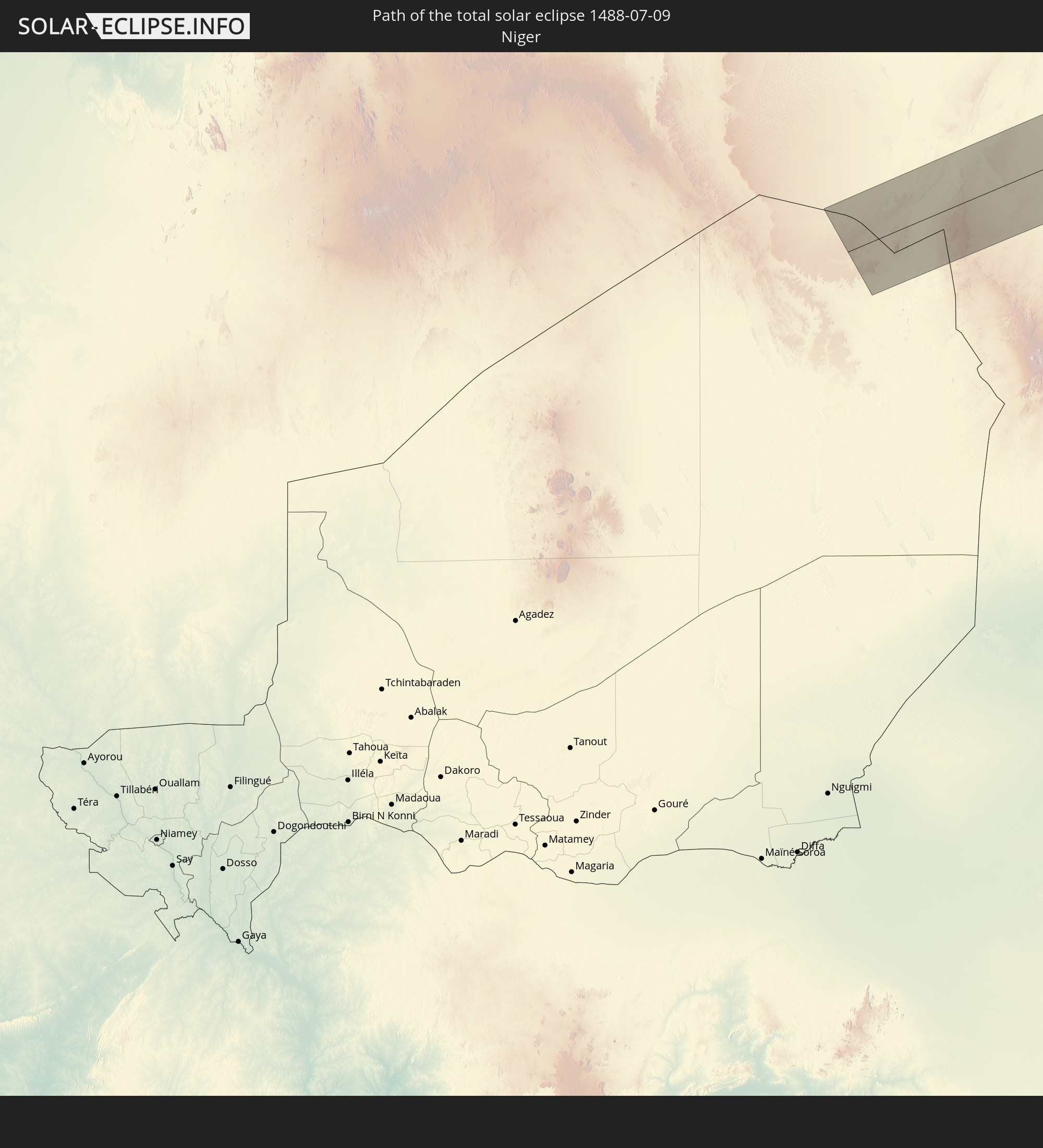 Niger
Niger
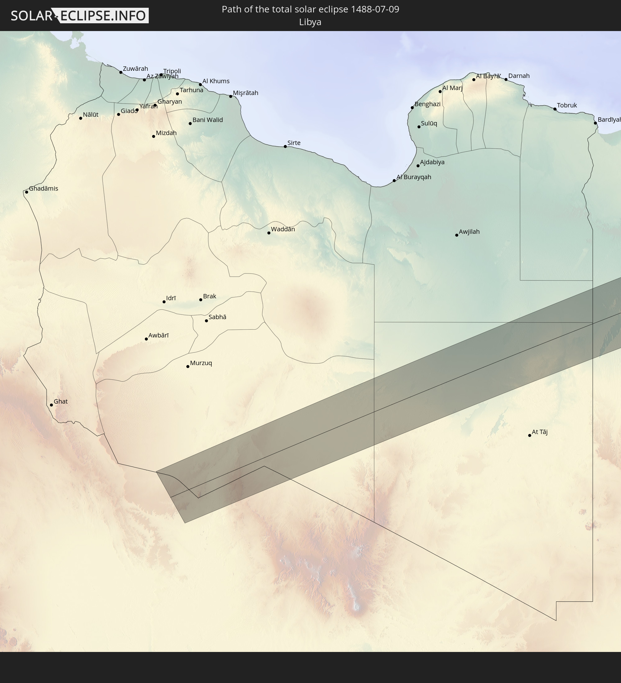 Libyen
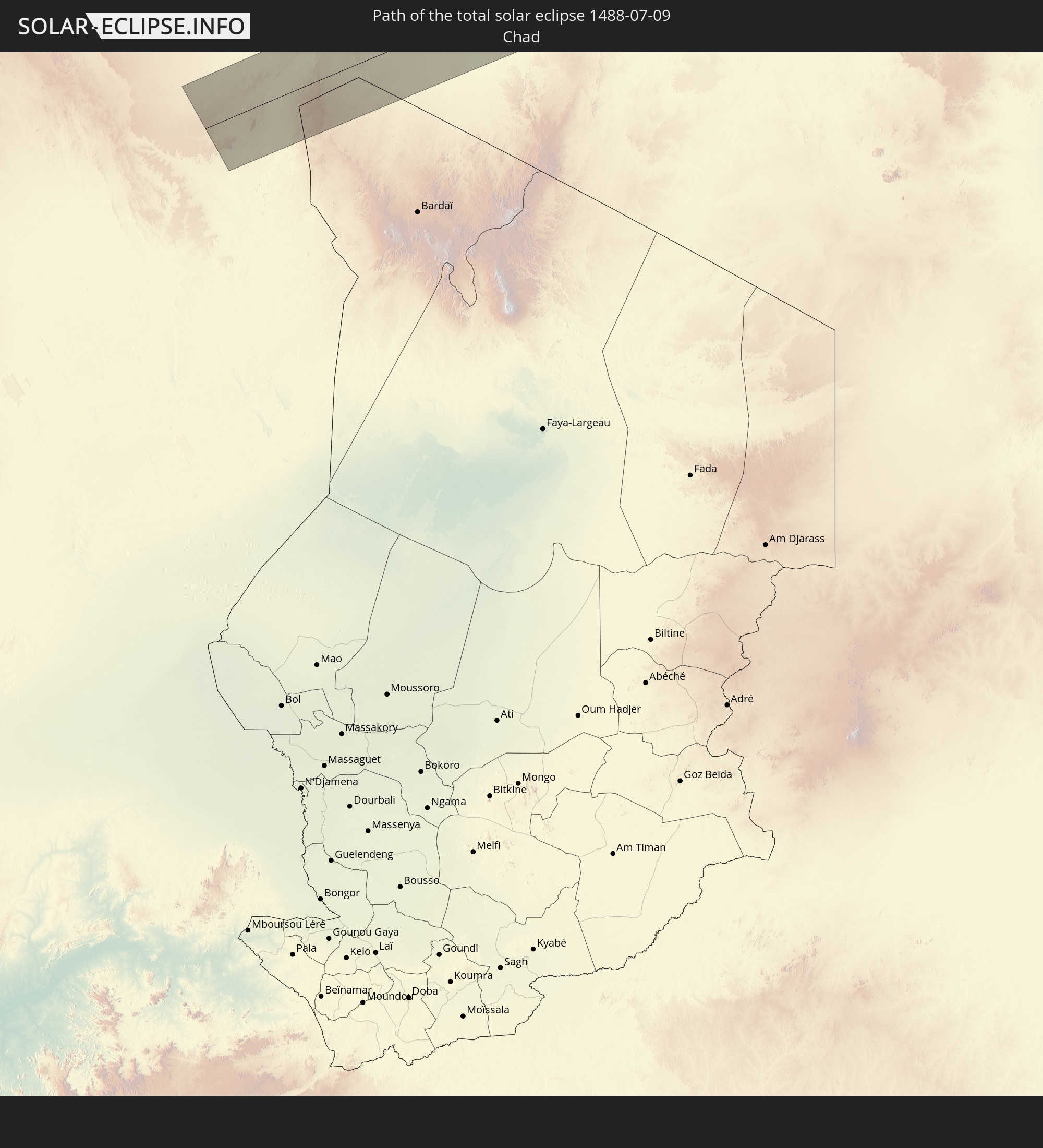 Tschad
 Ägypten
 Israel
 Saudi-Arabien
 Jordanien
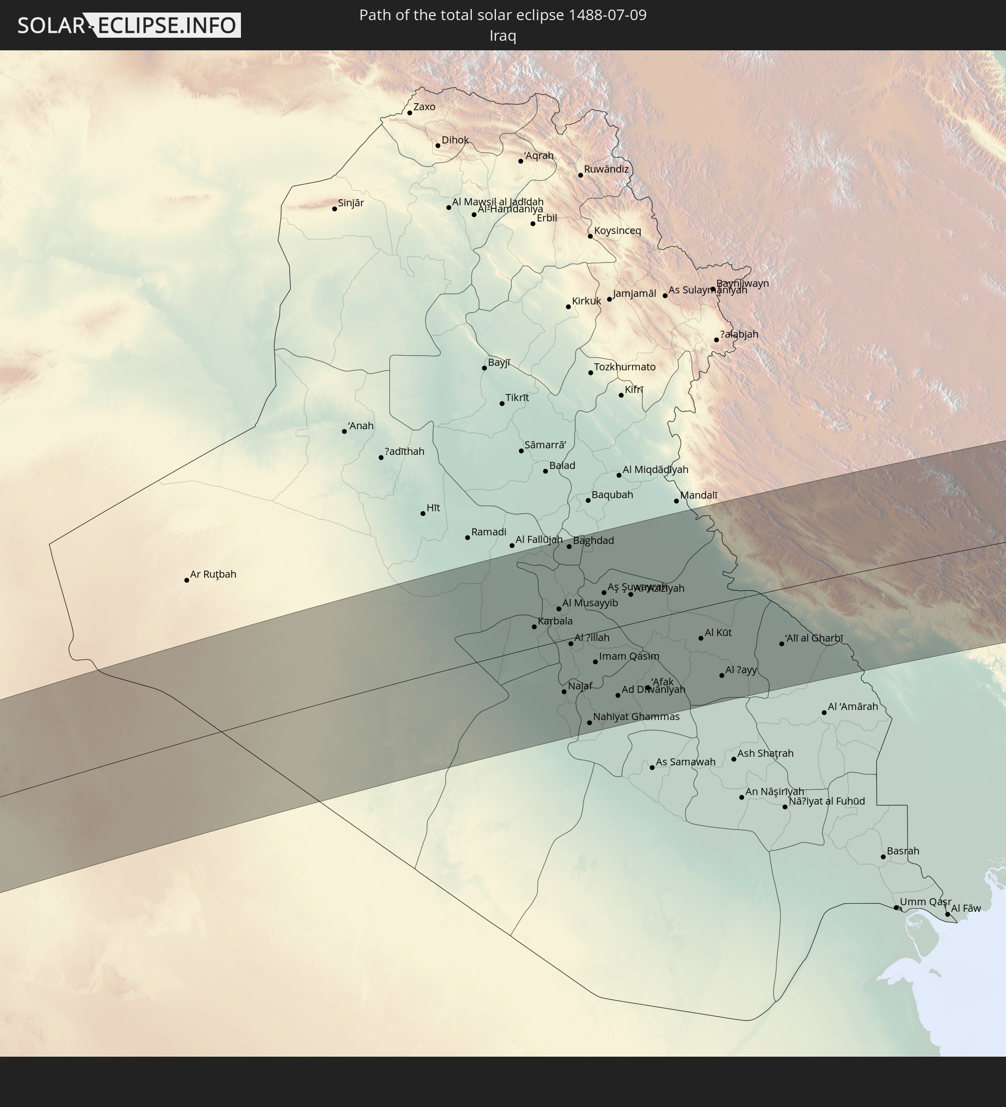 Irak
Irak
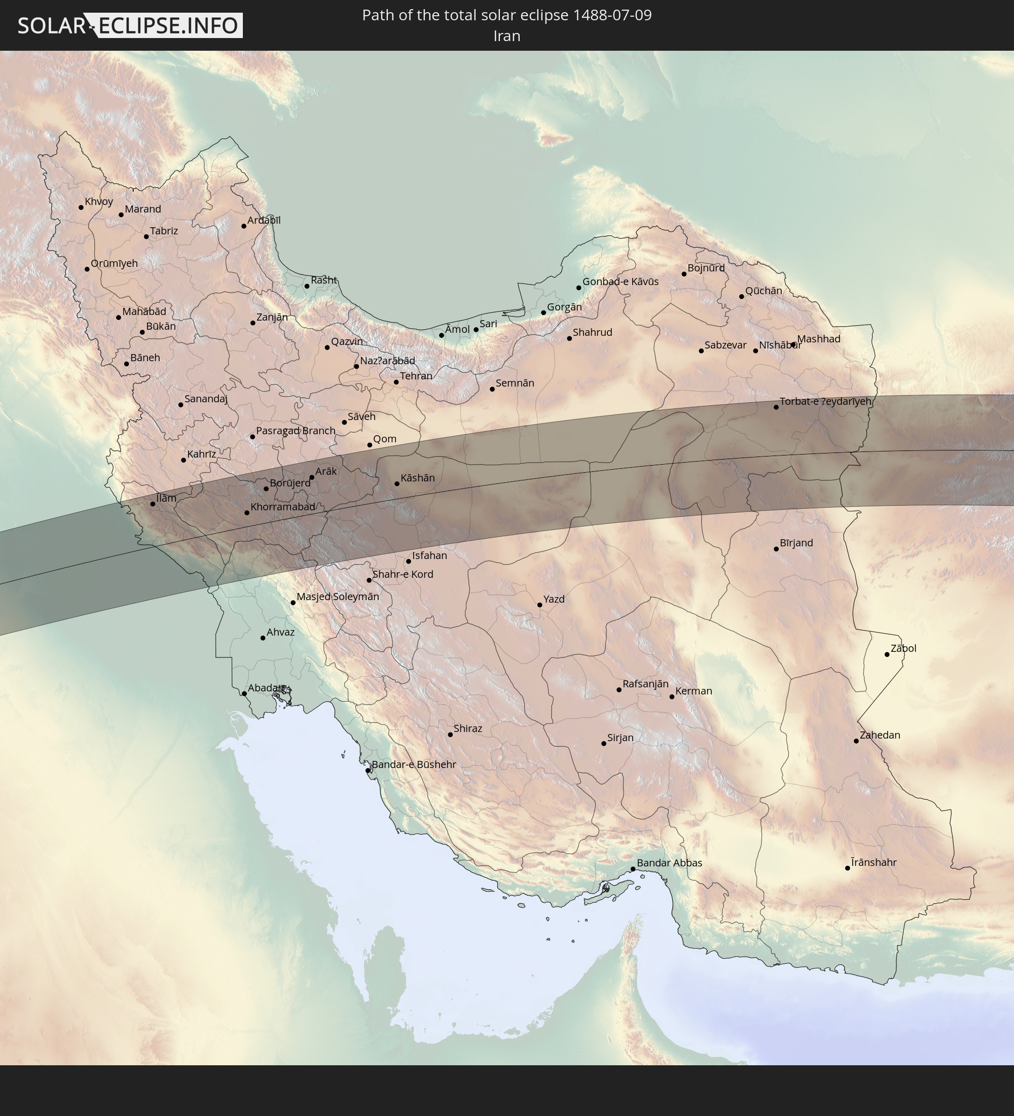 Iran
Iran
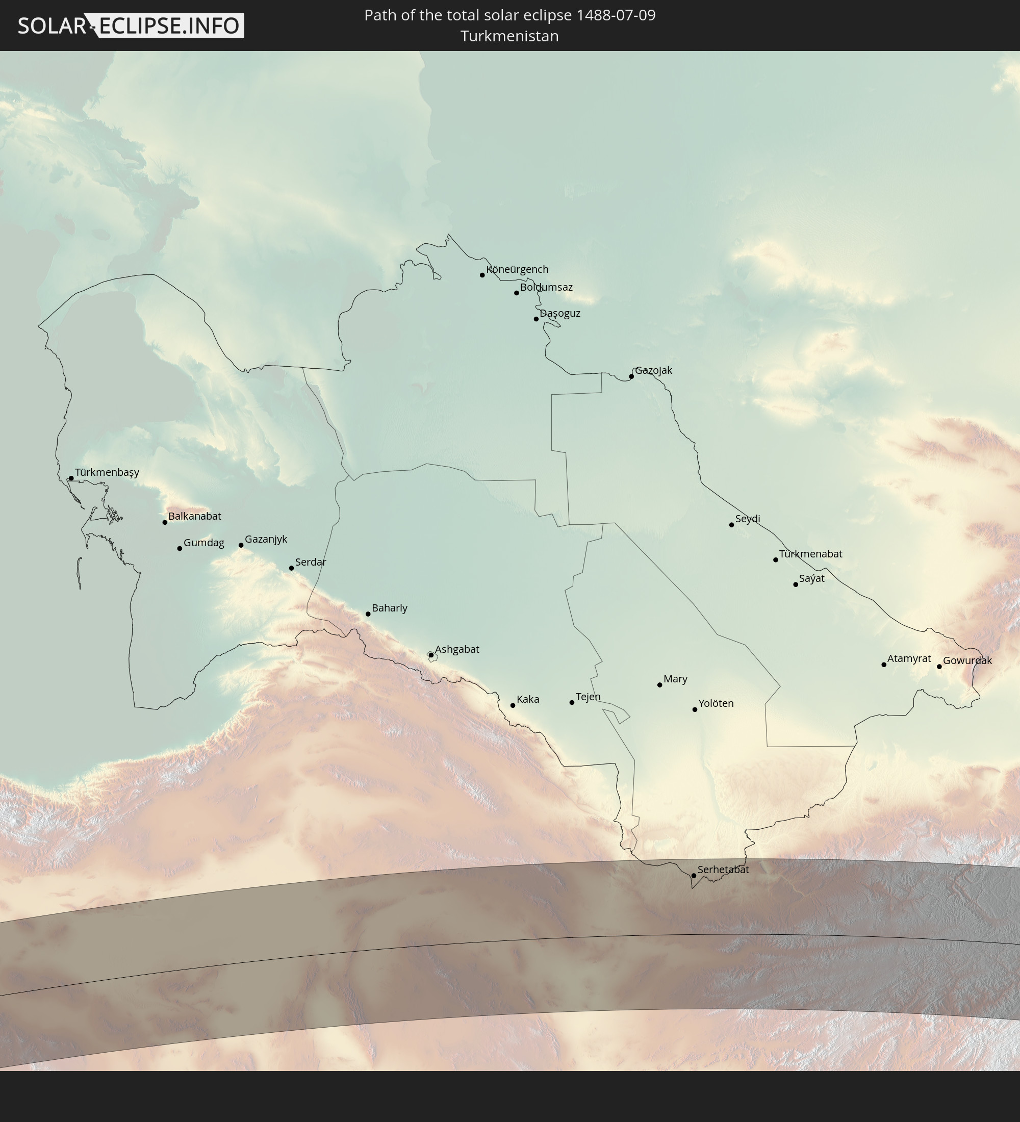 Turkmenistan
 Afghanistan
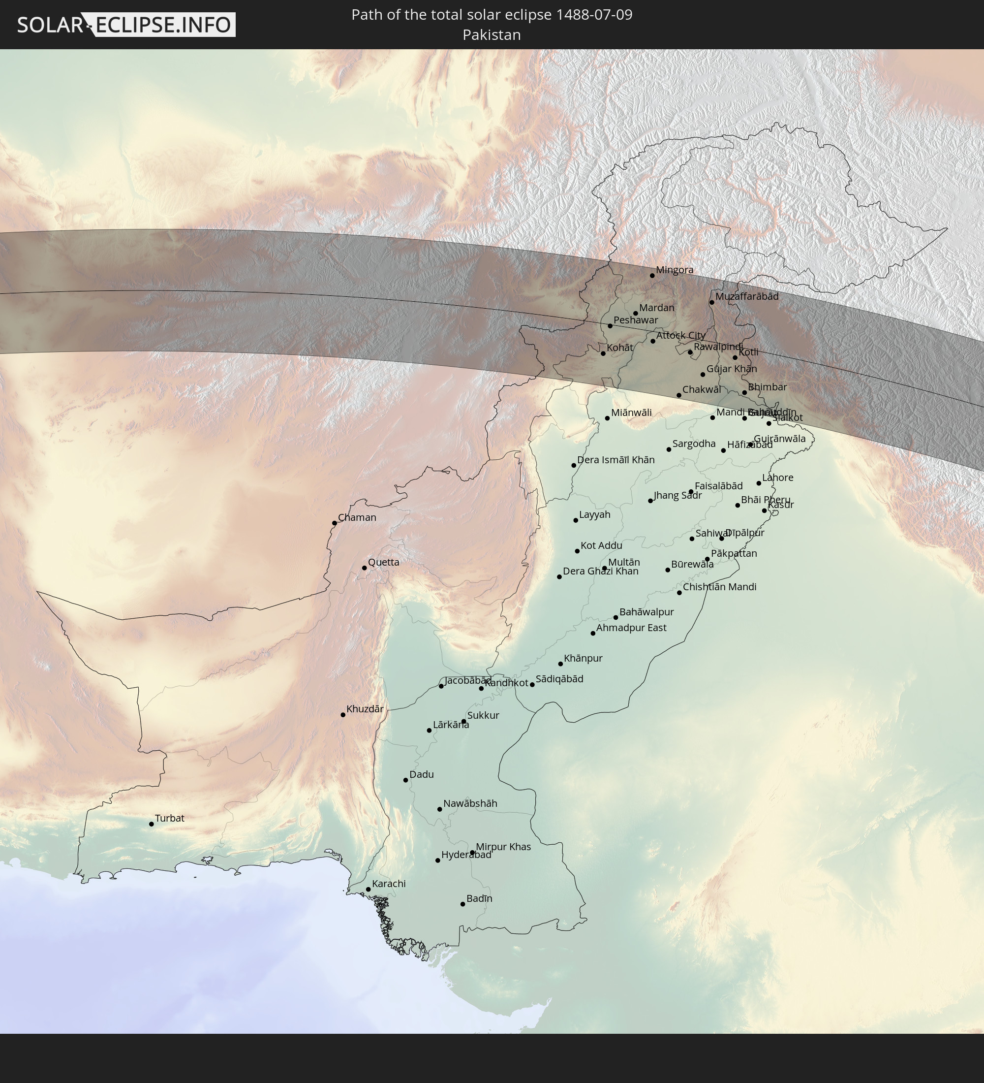 Pakistan
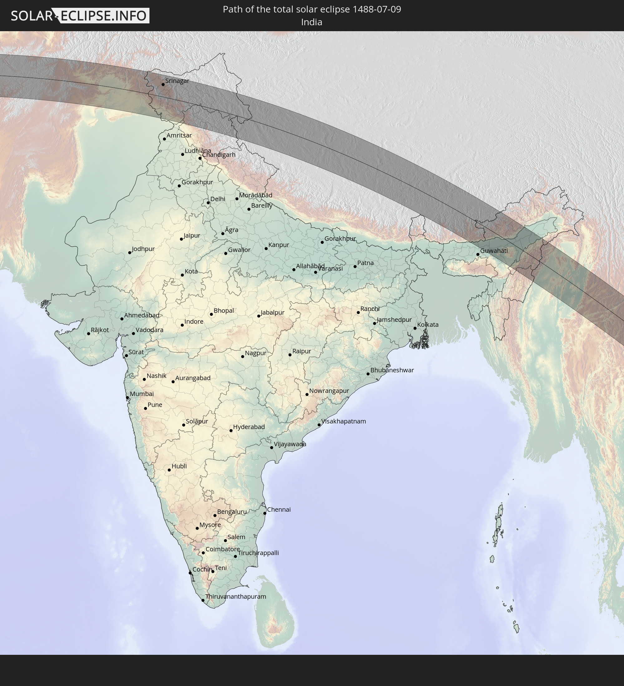 Indien
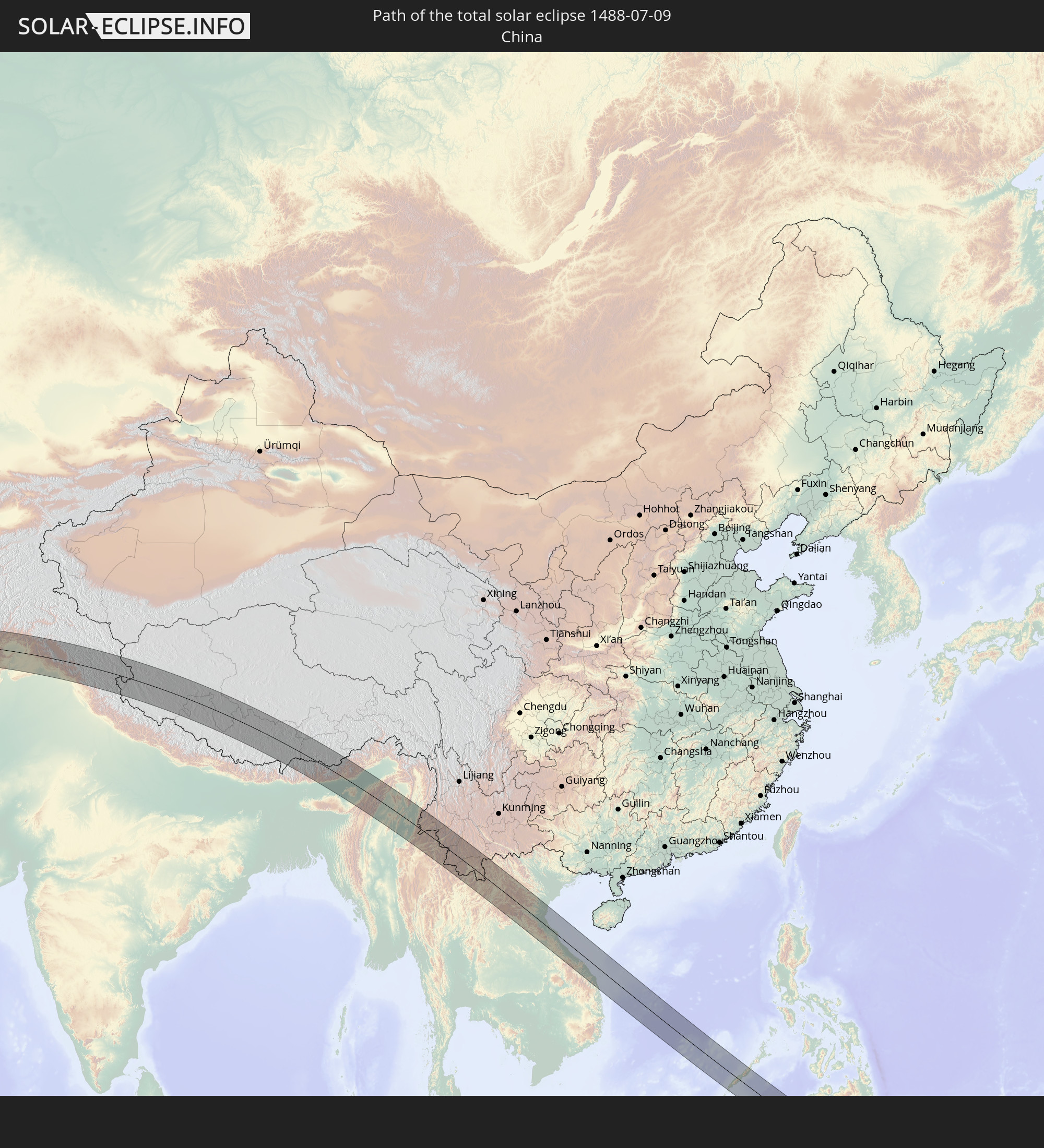 Volksrepublik China
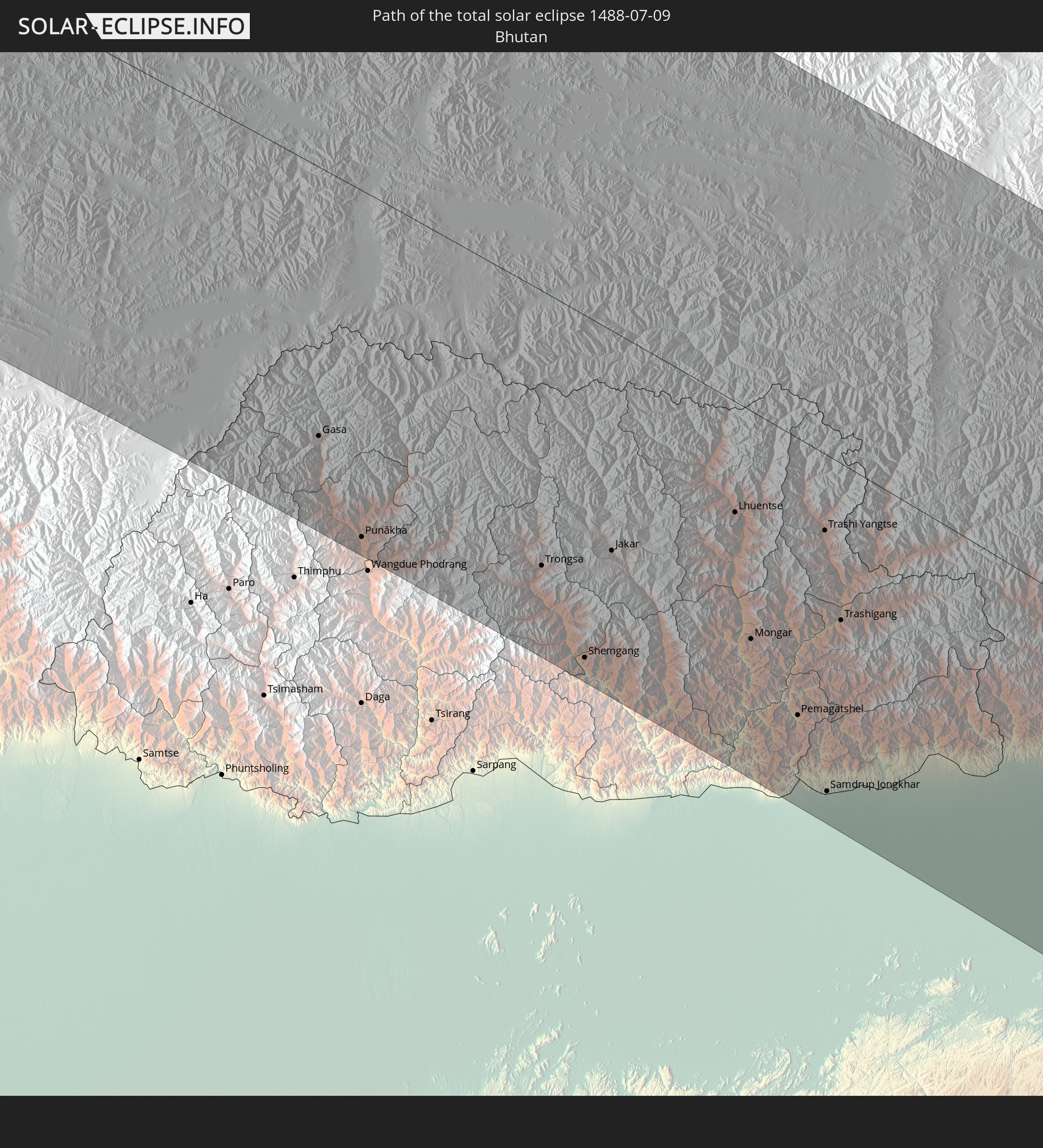 Bhutan
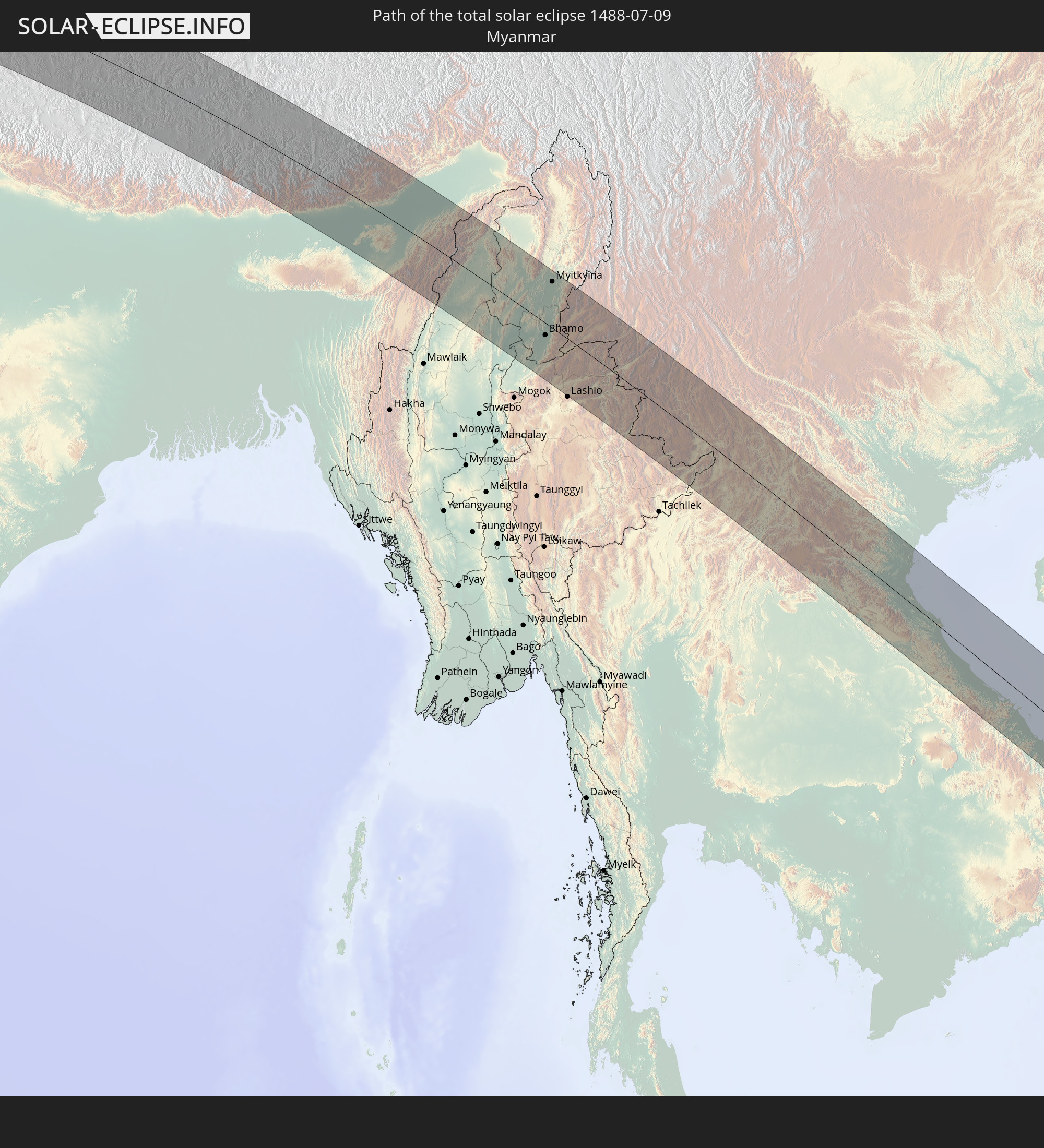 Myanmar
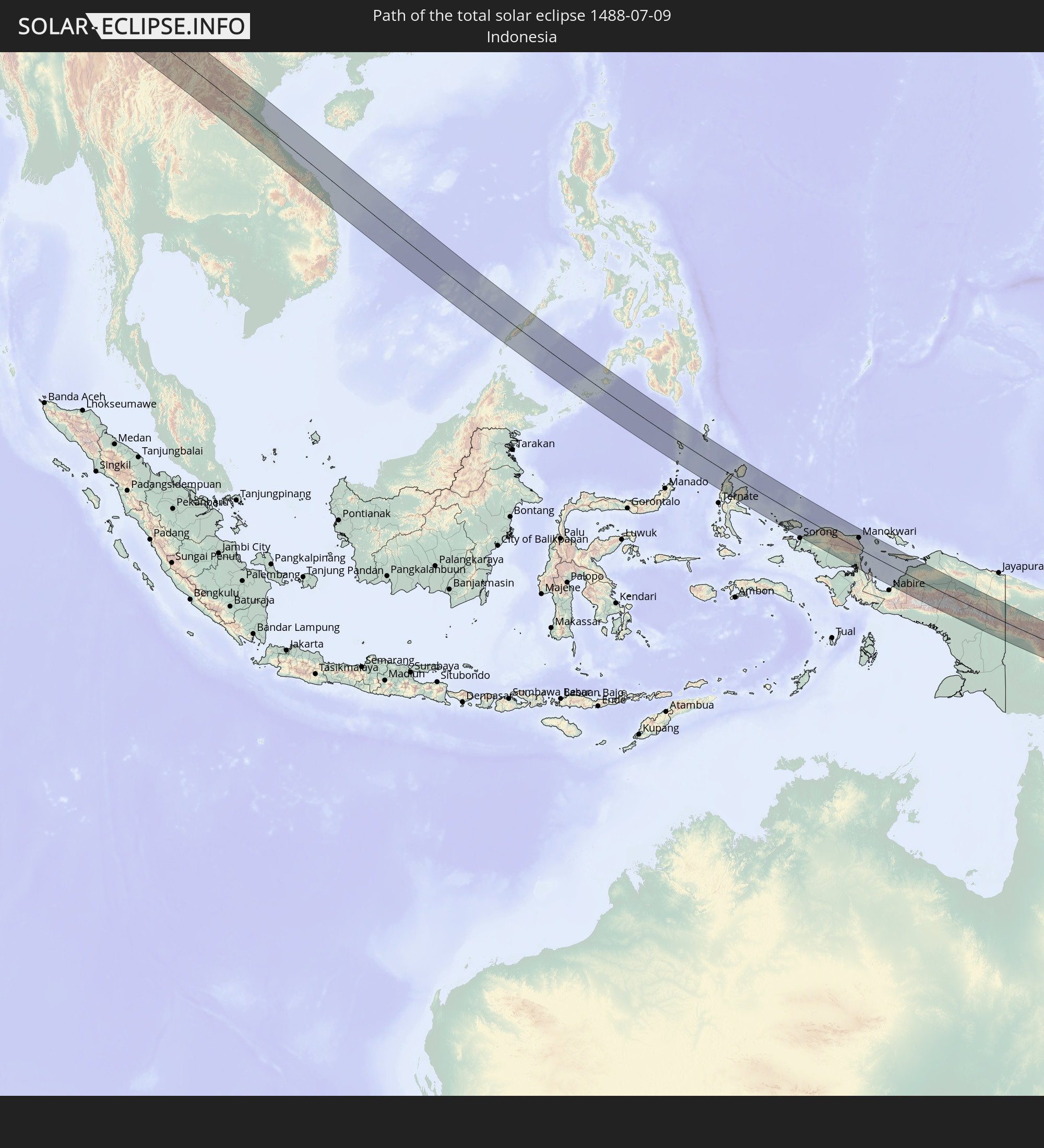 Indonesien
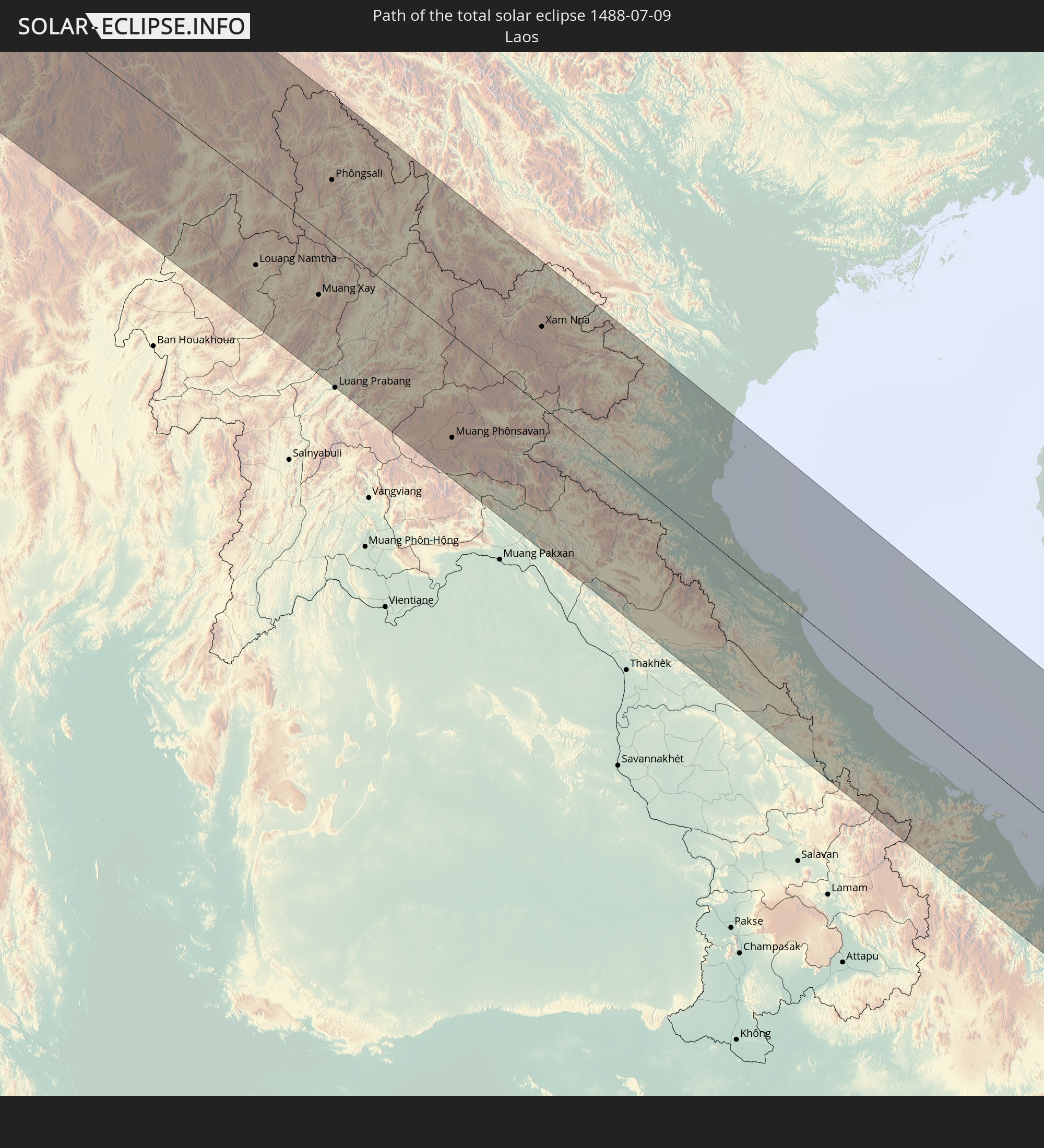 Laos
Laos
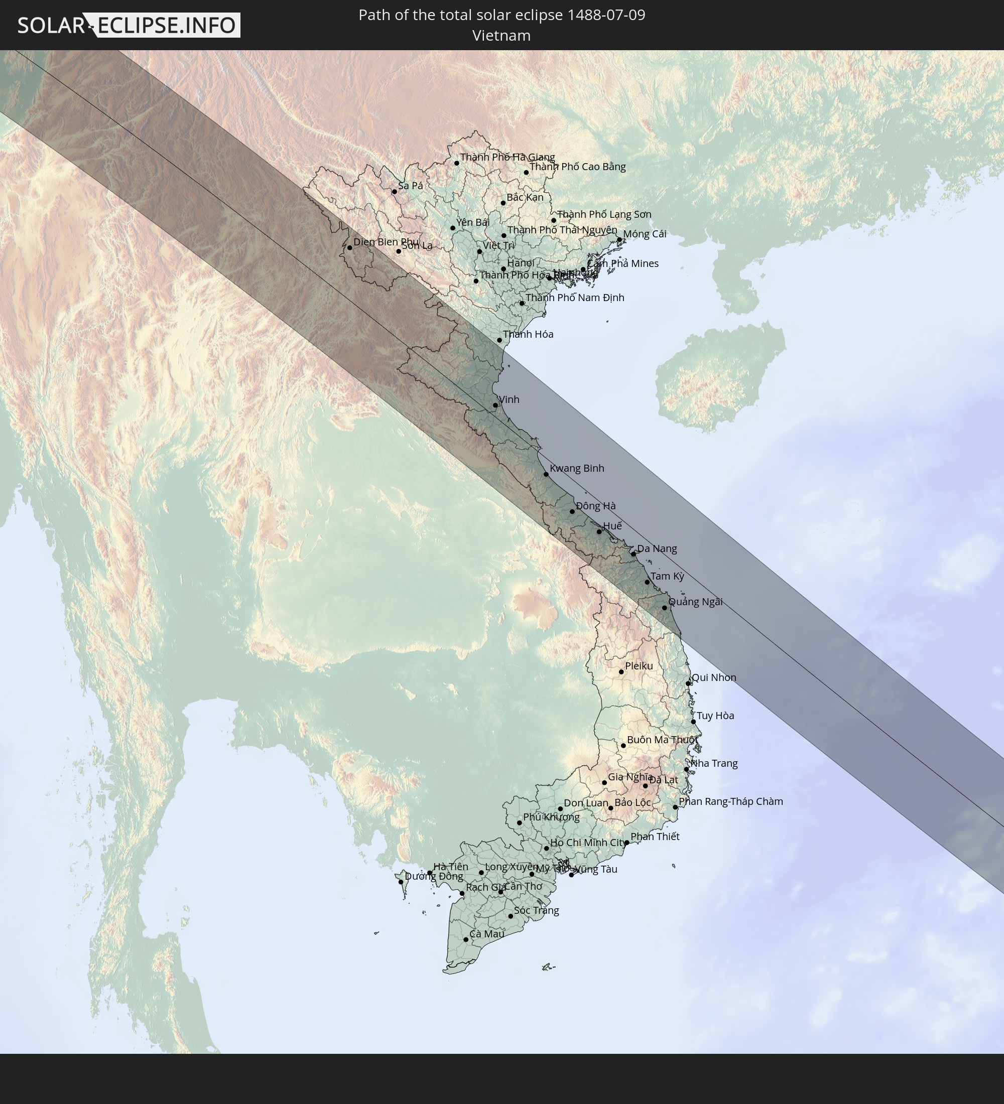 Vietnam
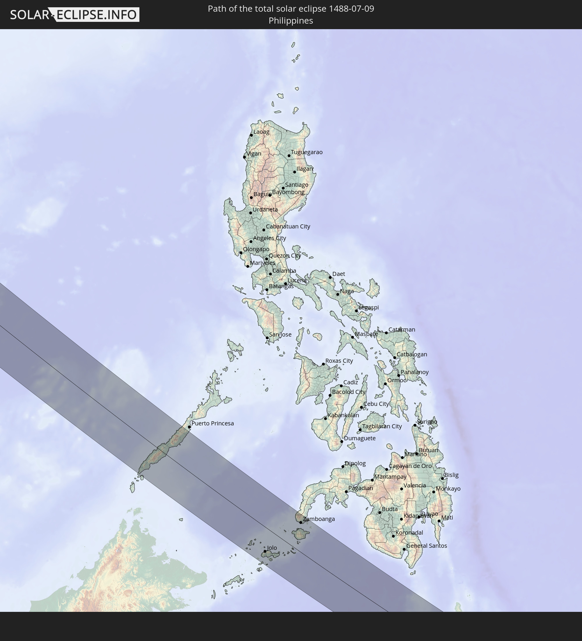 Philippinen
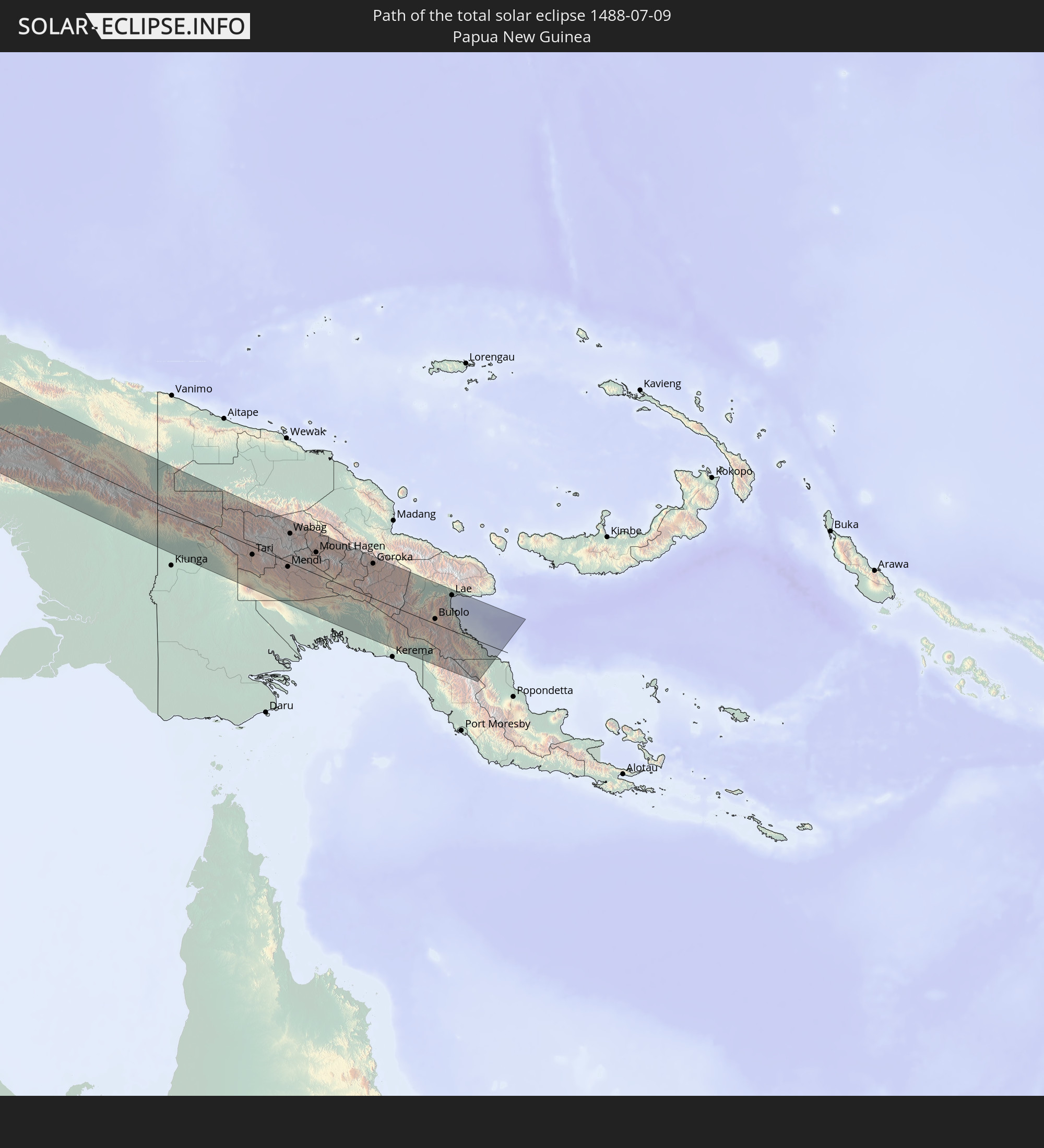 Papua-Neuguinea
In den folgenden Ländern ist die Sonnenfinsternis partiell zu sehen
 Russland
 Spanien
 Irland
 Algerien
 Vereinigtes Königreich
 Frankreich
 Isle of Man
 Guernsey
 Jersey
 Niger
Niger
 Andorra
 Belgien
 Niederlande
 Norwegen
 Luxemburg
 Deutschland
 Schweiz
 Italien
 Monaco
 Tunesien
 Dänemark
 Libyen
 Liechtenstein
 Österreich
 Schweden
 Tschechien
 Demokratische Republik Kongo
 San Marino
 Vatikanstadt
 Slowenien
 Tschad
 Kroatien
 Polen
Polen
 Malta
Malta
 Zentralafrikanische Republik
 Bosnien und Herzegowina
 Ungarn
 Slowakei
 Montenegro
 Serbien
 Albanien
 Åland Islands
 Griechenland
 Rumänien
 Mazedonien
 Finnland
 Litauen
 Lettland
 Estland
 Sudan
Sudan
 Ukraine
 Bulgarien
 Weißrussland
 Ägypten
 Türkei
 Moldawien
 Ruanda
 Burundi
 Tansania
 Uganda
 Republik Zypern
 Äthiopien
 Kenia
Kenia
 Staat Palästina
 Israel
 Saudi-Arabien
 Jordanien
 Libanon
 Syrien
 Eritrea
 Irak
Irak
 Georgien
 Somalia
 Dschibuti
 Jemen
Jemen
 Armenien
 Iran
Iran
 Aserbaidschan
 Kasachstan
 Kuwait
 Bahrain
 Katar
Katar
 Vereinigte Arabische Emirate
 Oman
Oman
 Turkmenistan
 Usbekistan
 Afghanistan
 Pakistan
 Tadschikistan
 Indien
 Kirgisistan
 Malediven
 Volksrepublik China
 Sri Lanka
 Nepal
Nepal
 Mongolei
 Bangladesch
 Bhutan
 Myanmar
 Indonesien
 Kokosinseln
 Thailand
 Malaysia
 Laos
Laos
 Vietnam
 Kambodscha
 Singapur
 Weihnachtsinsel
 Australien
 Macau
Macau
 Hongkong
 Brunei
 Taiwan
 Philippinen
 Japan
Japan
 Osttimor
 Nordkorea
 Südkorea
 Palau
Palau
 Föderierte Staaten von Mikronesien
 Papua-Neuguinea
 Guam
Guam
 Nördliche Marianen
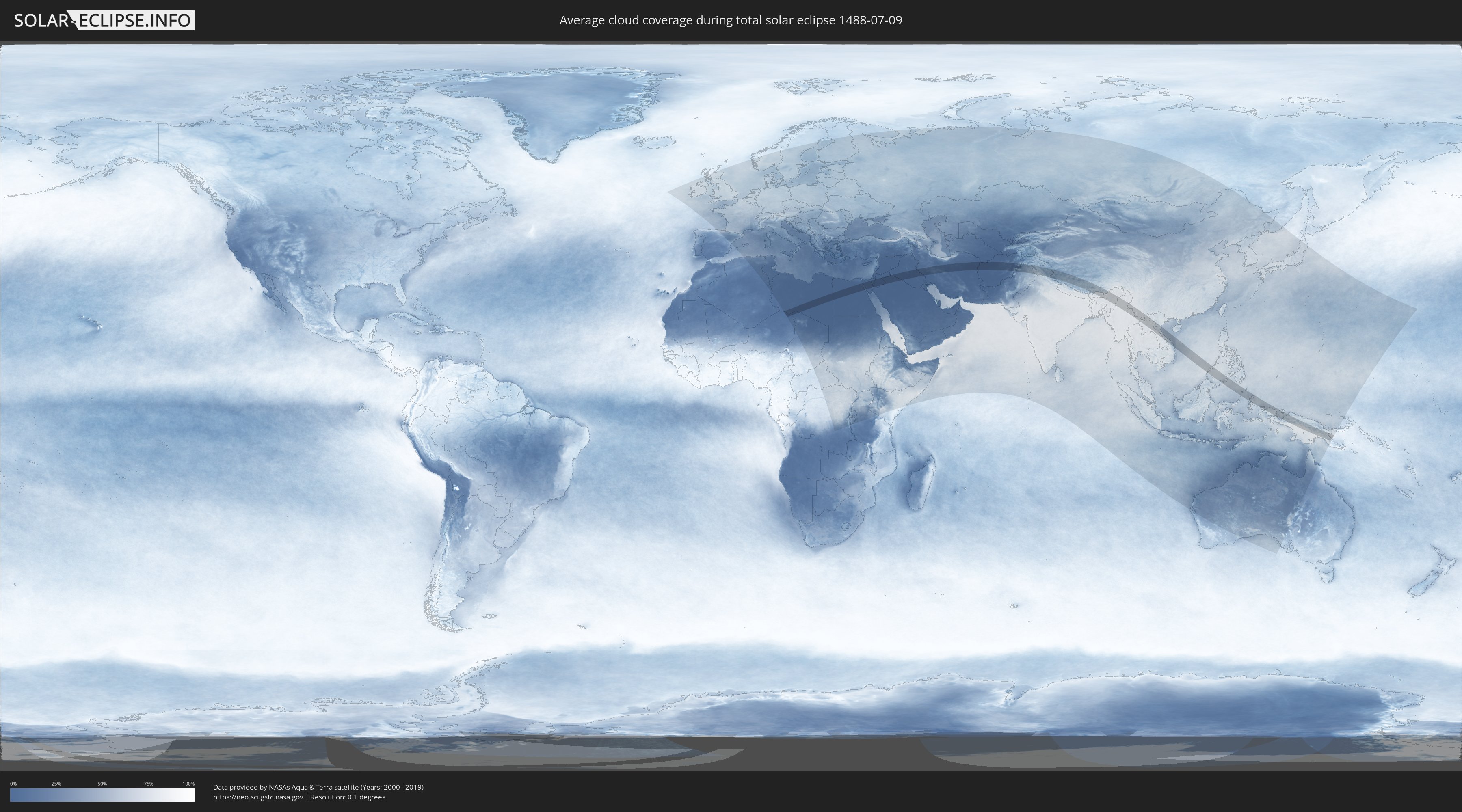
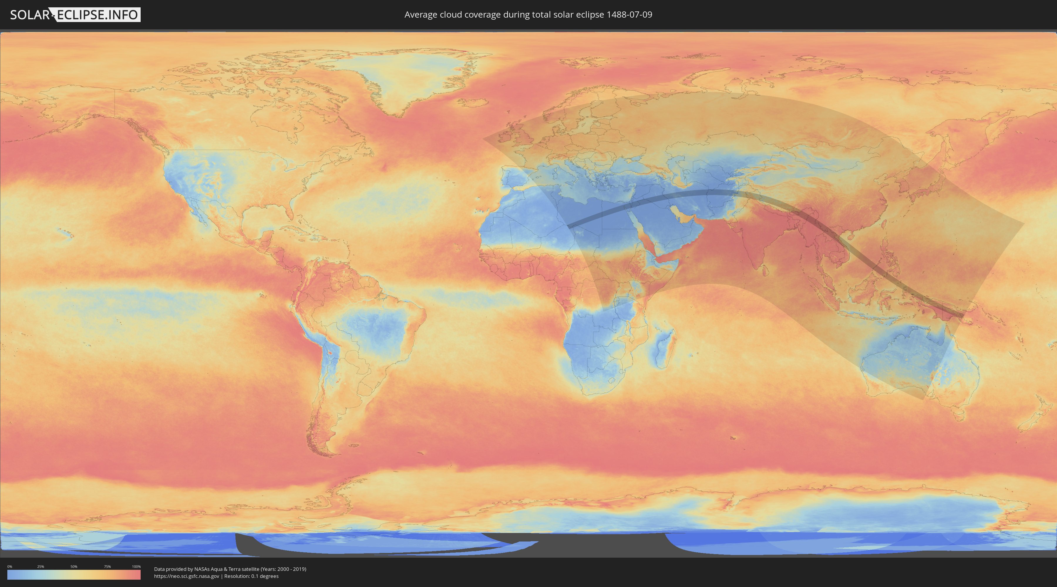
Wie wird das Wetter während der totalen Sonnenfinsternis am 09.07.1488?
Wo ist der beste Ort, um die totale Sonnenfinsternis vom 09.07.1488 zu beobachten?
Die folgenden Karten zeigen die durchschnittliche Bewölkung für den Tag, an dem die totale Sonnenfinsternis
stattfindet. Mit Hilfe der Karten lässt sich der Ort entlang des Finsternispfades eingrenzen,
der die besten Aussichen auf einen klaren wolkenfreien Himmel bietet.
Trotzdem muss man immer lokale Gegenenheiten beachten und sollte sich genau über das Wetter an seinem
gewählten Beobachtungsort informieren.
Die Daten stammen von den beiden NASA-Satelliten
AQUA und TERRA
und wurden über einen Zeitraum von 19 Jahren (2000 - 2019) gemittelt.
Detaillierte Länderkarten
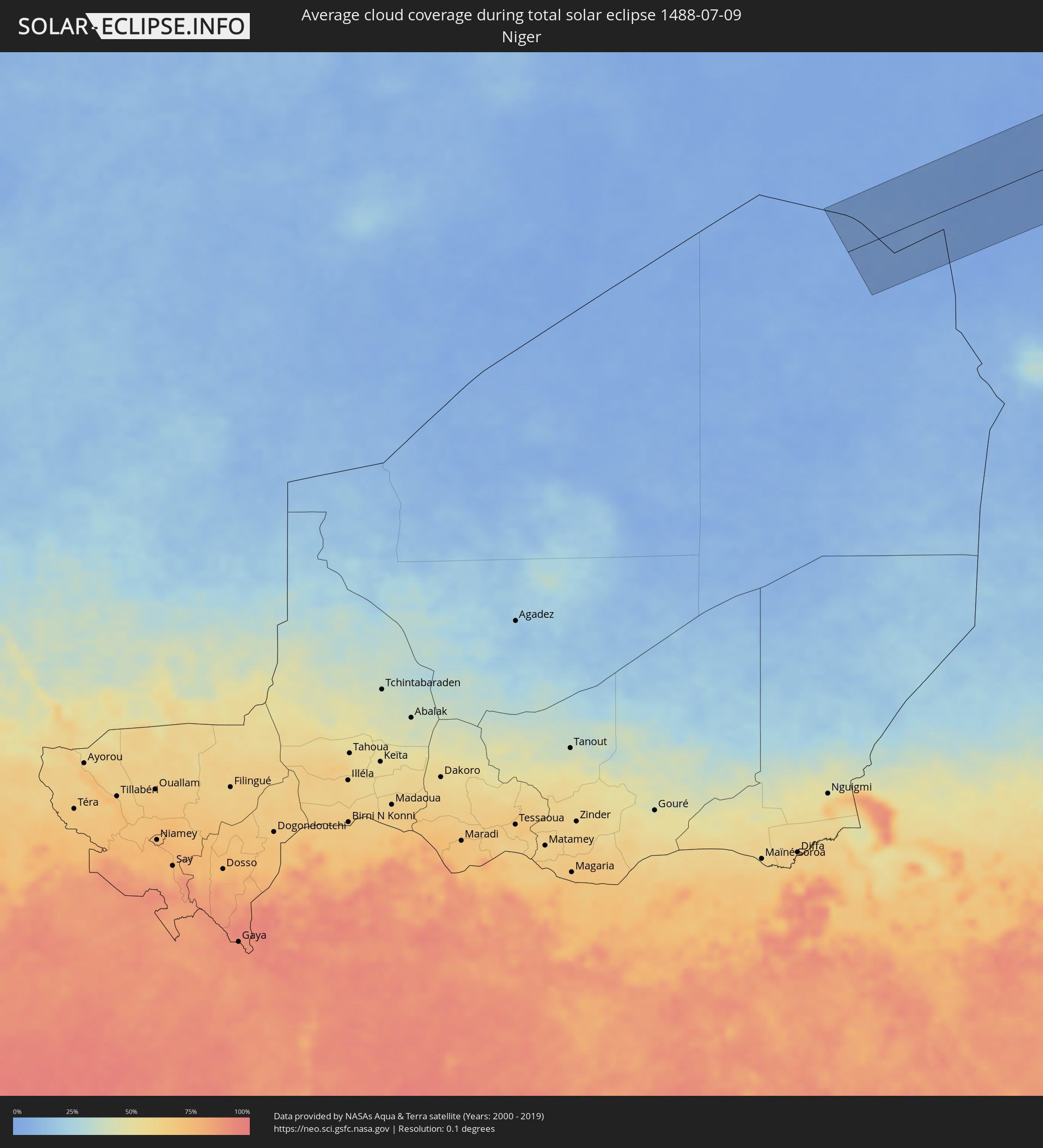 Niger
Niger
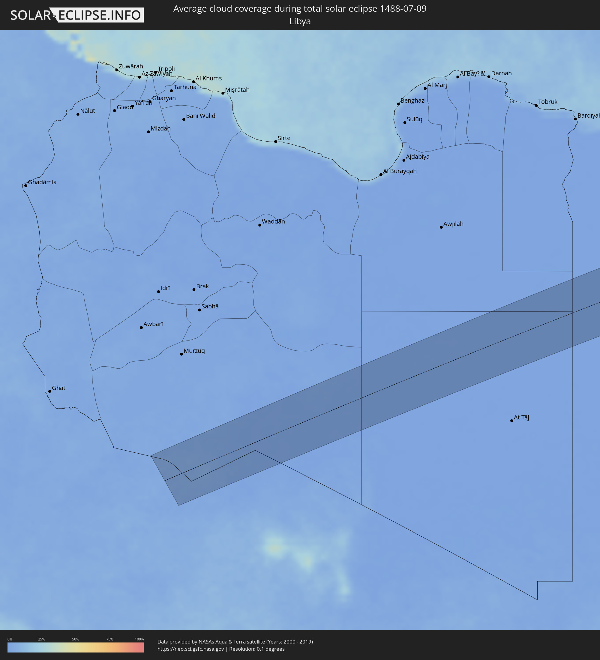 Libyen
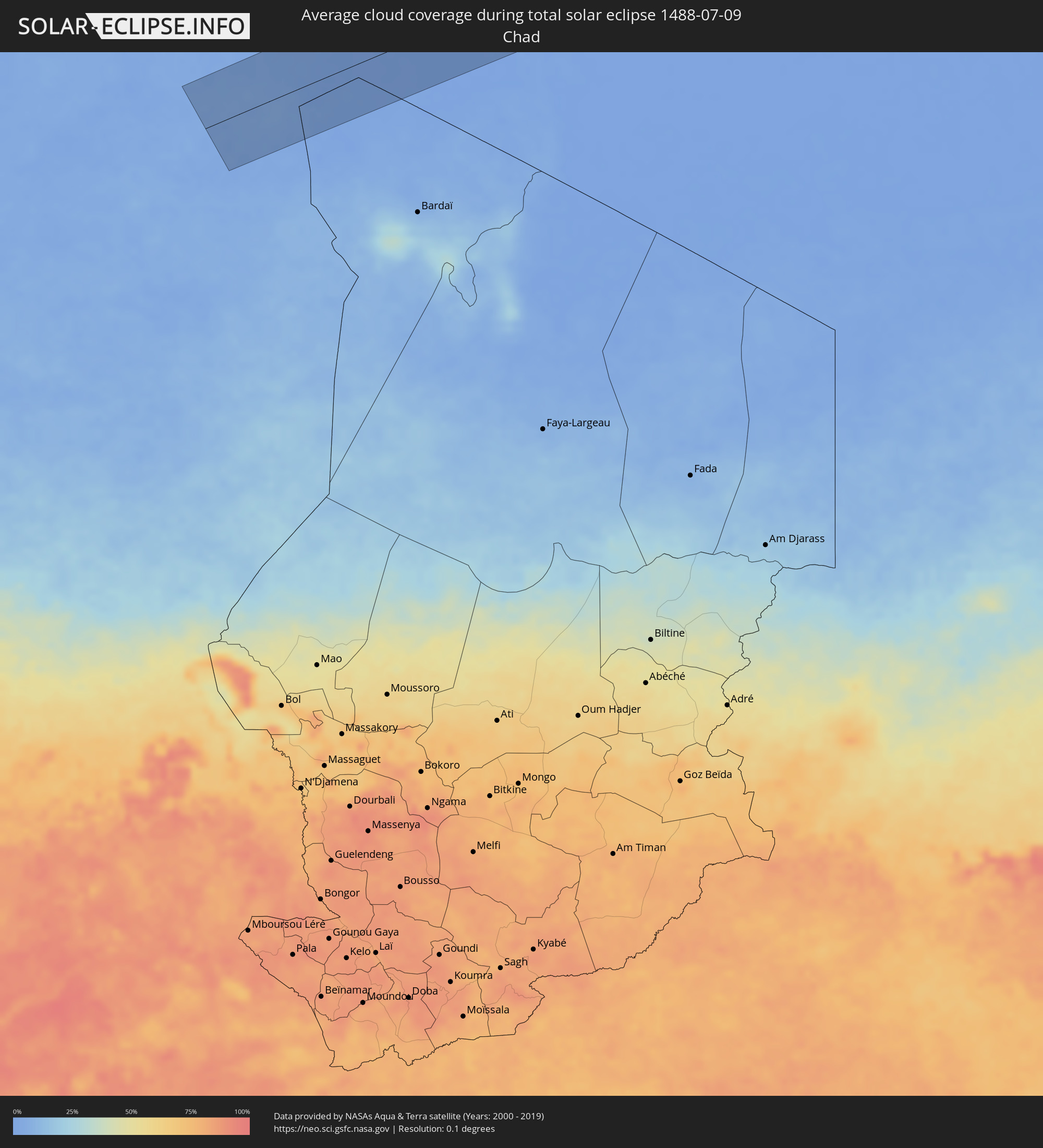 Tschad
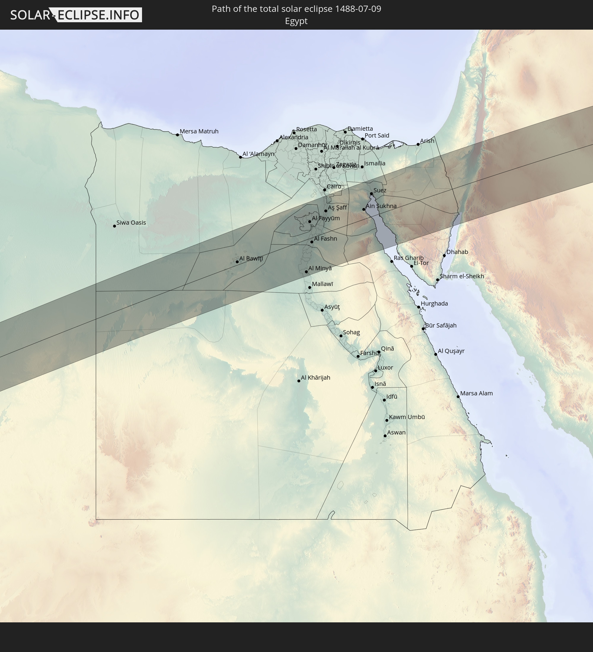
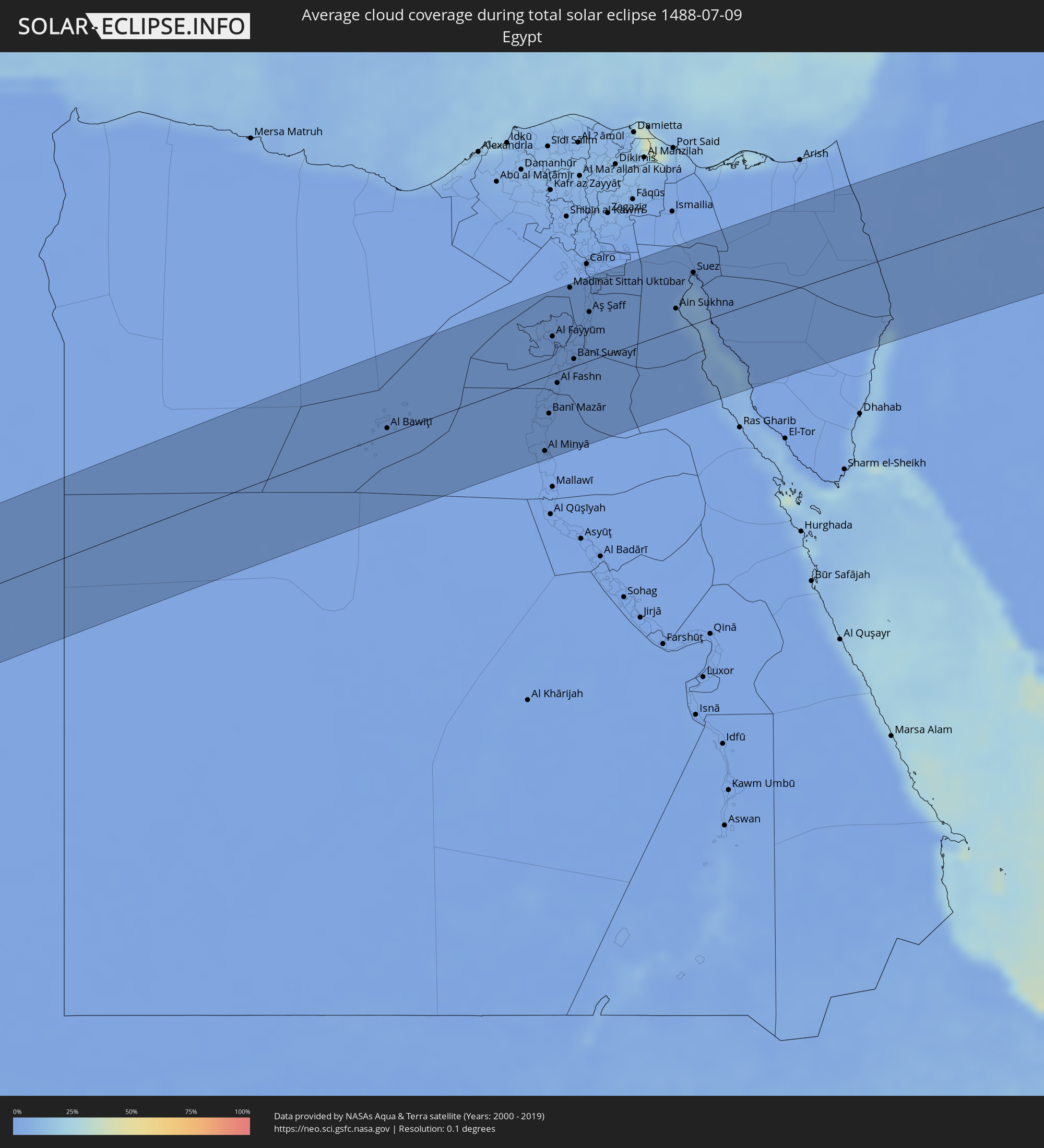 Ägypten
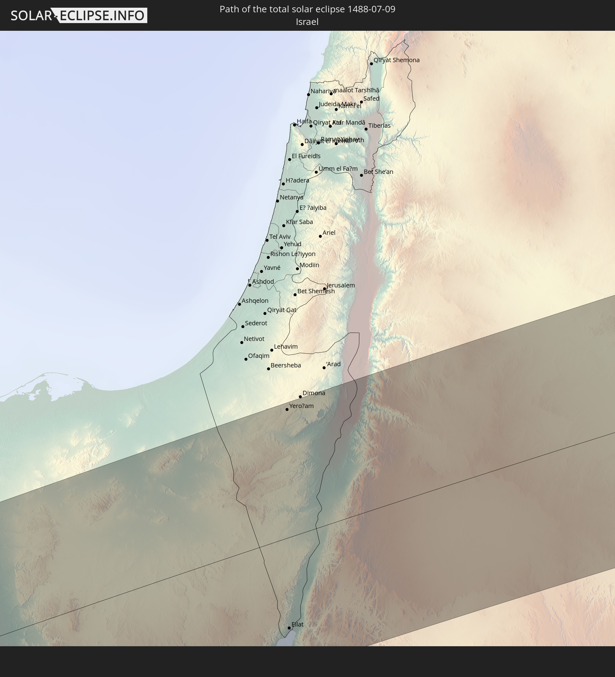
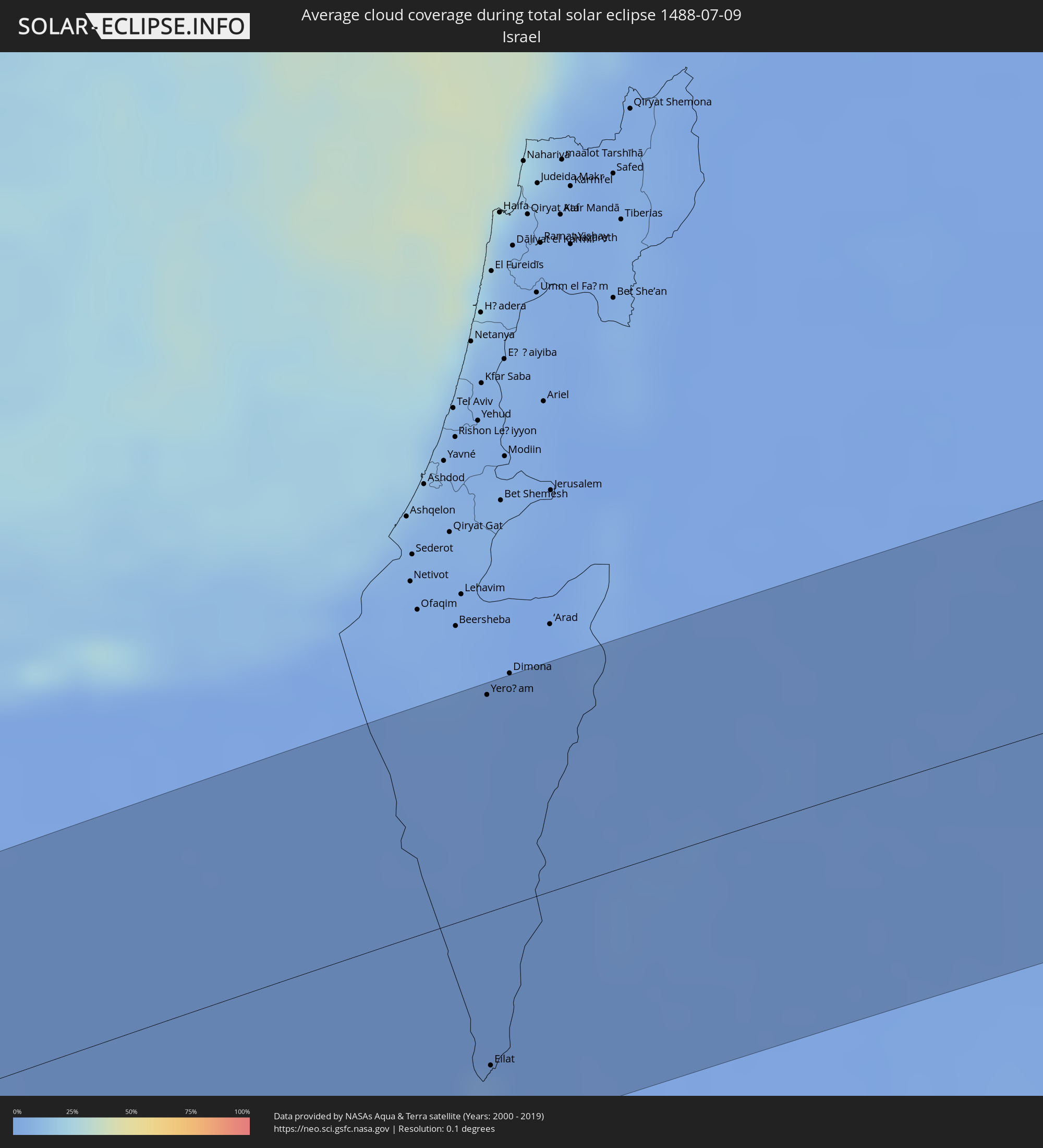 Israel
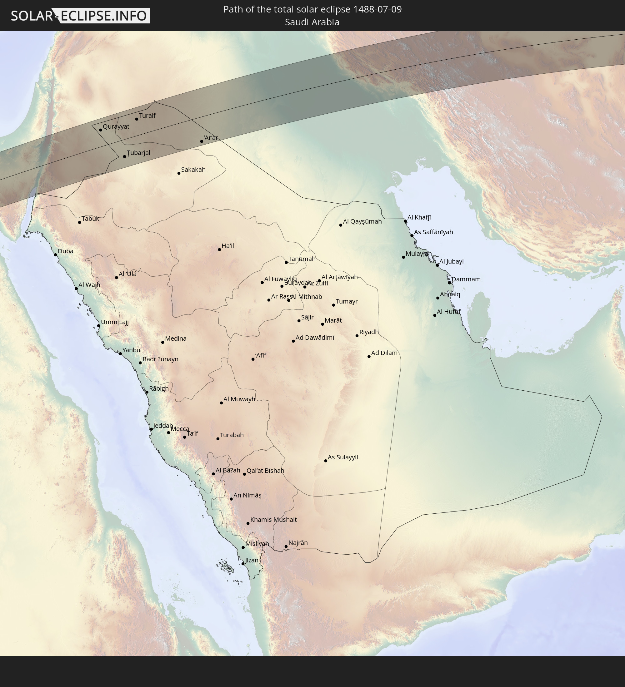
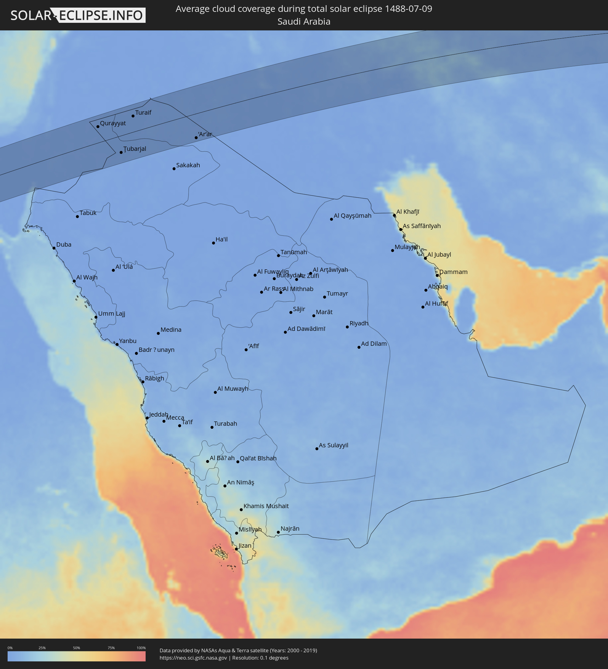 Saudi-Arabien
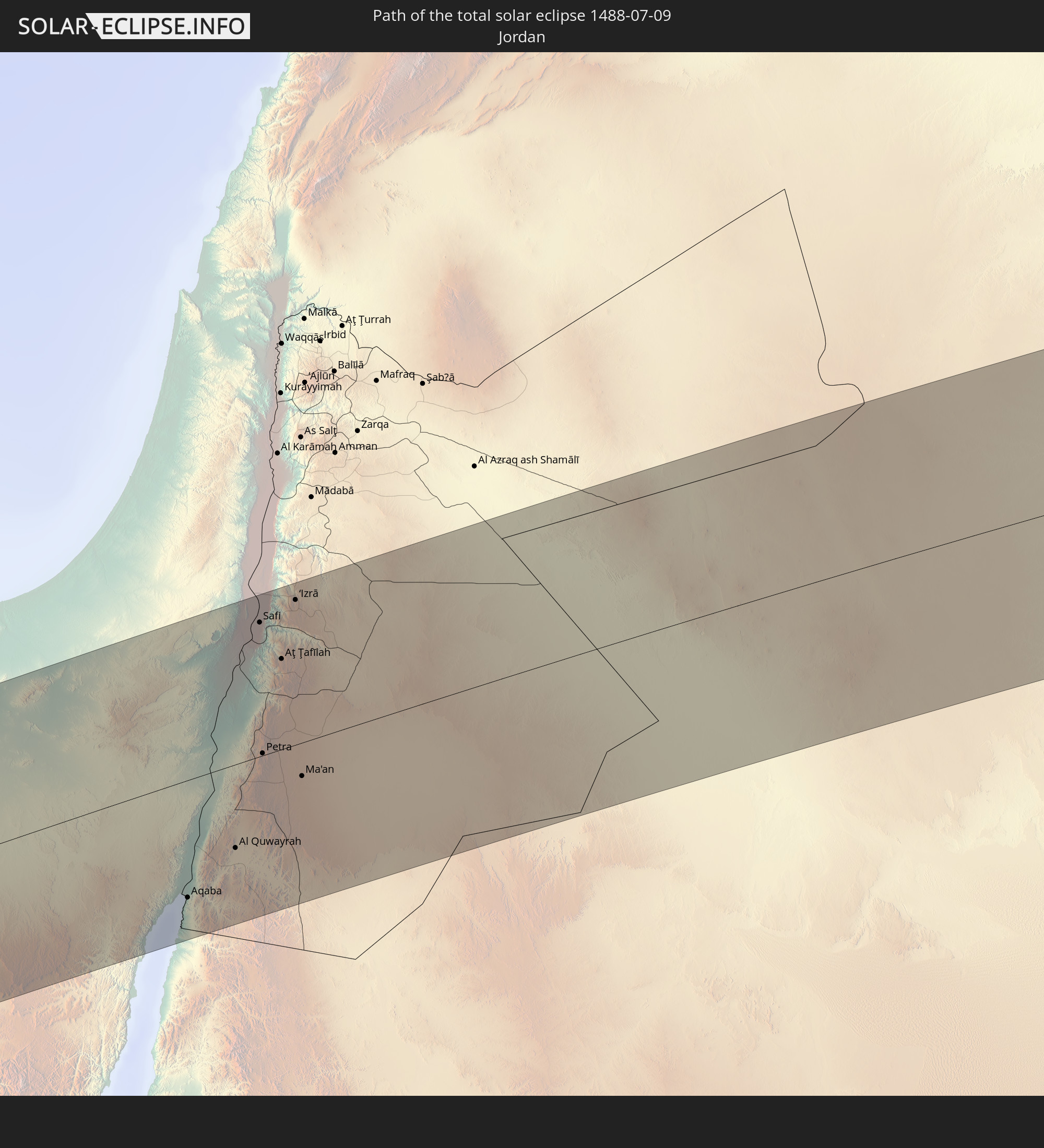
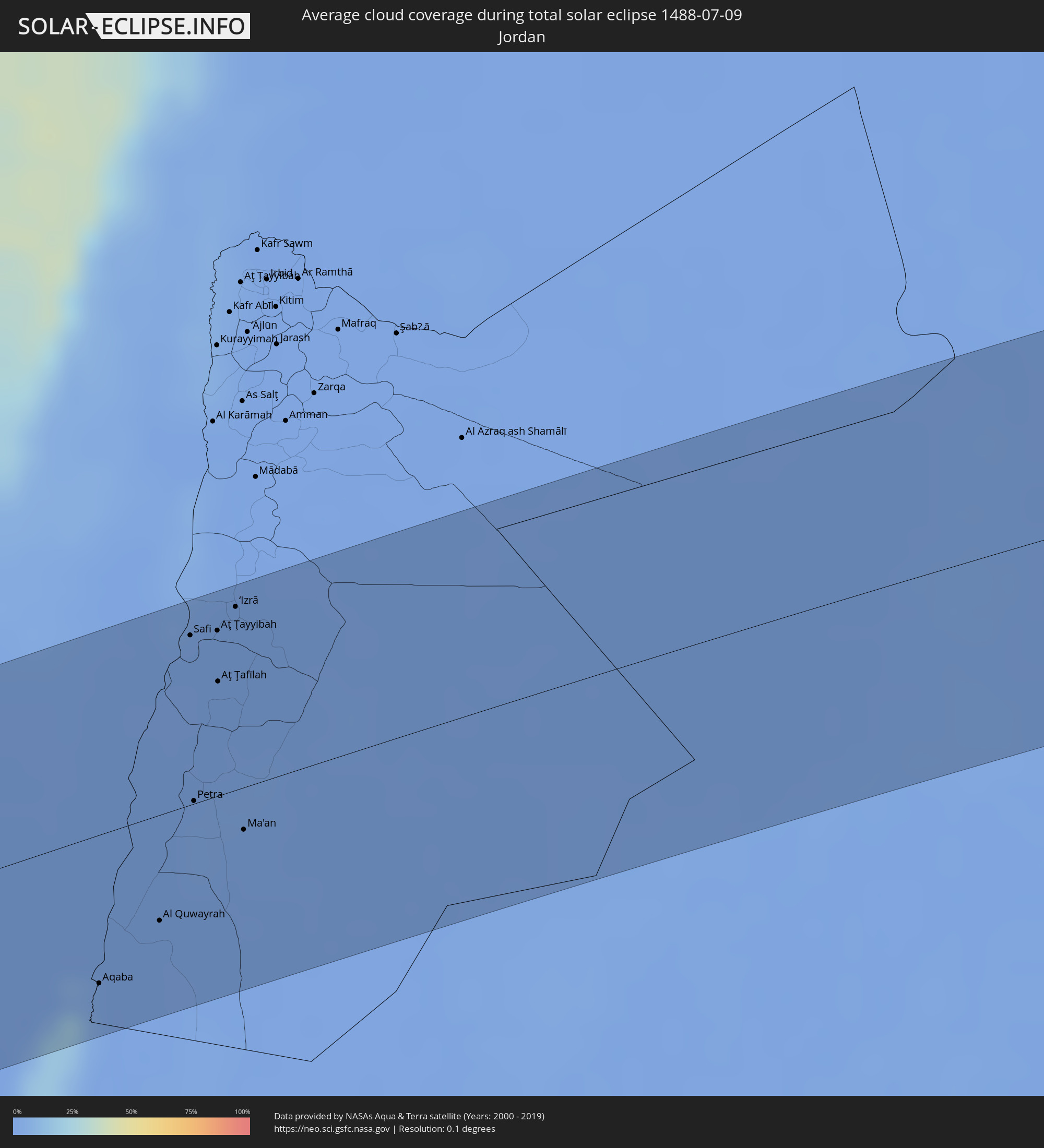 Jordanien
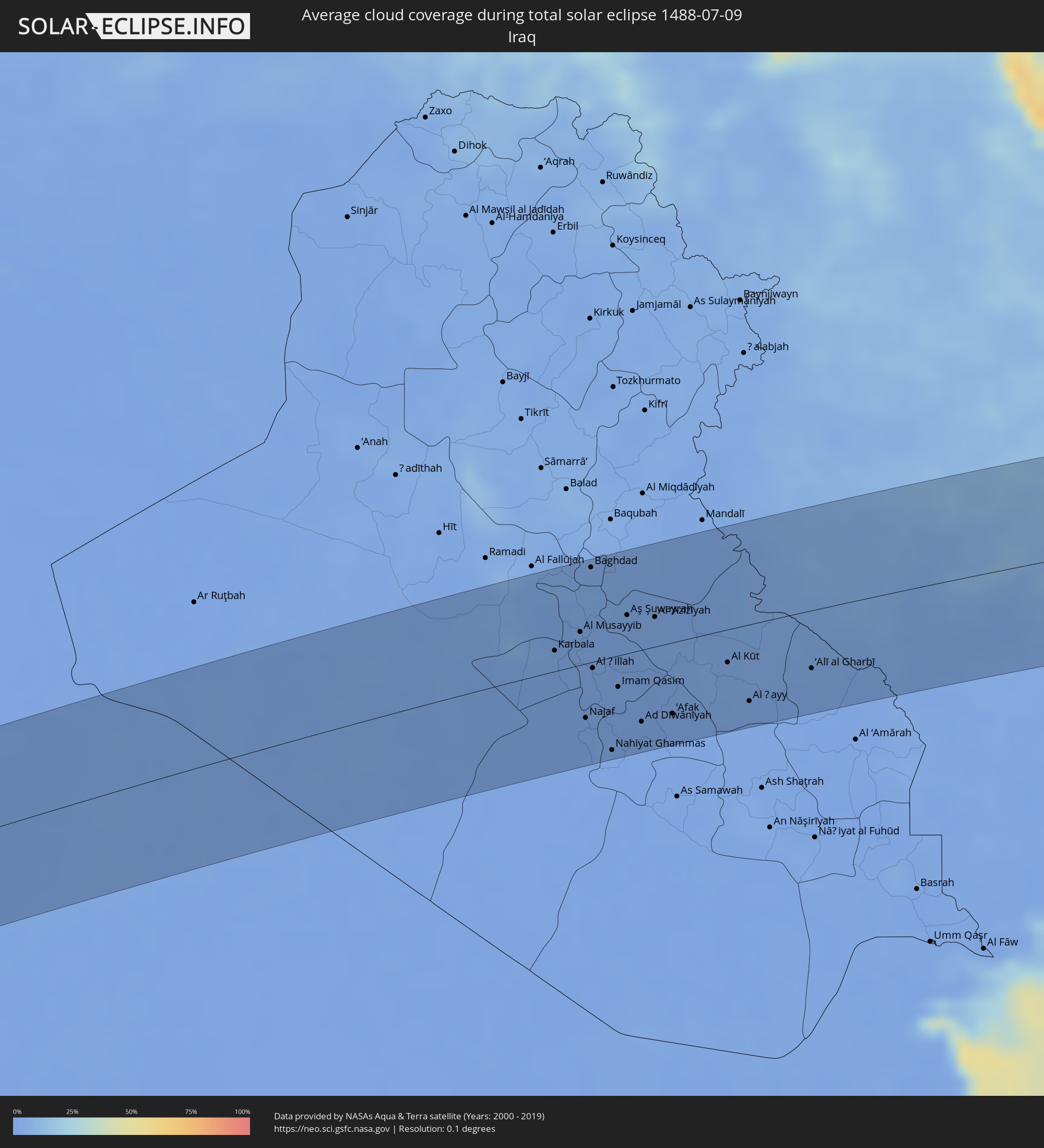 Irak
Irak
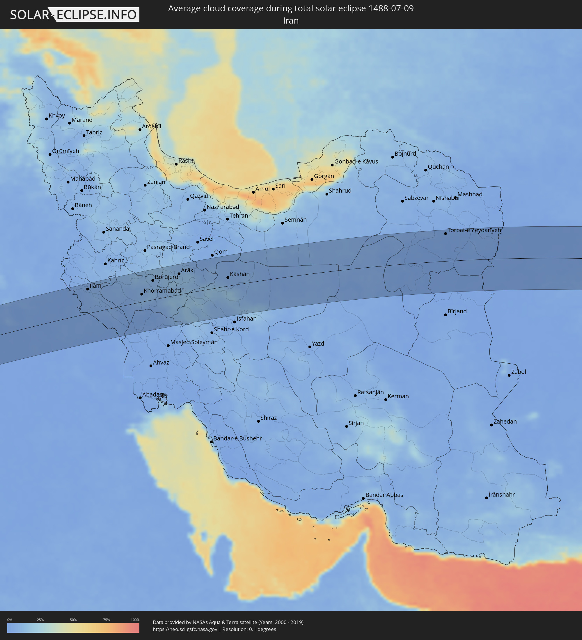 Iran
Iran
 Turkmenistan
 Afghanistan
 Pakistan
 Indien
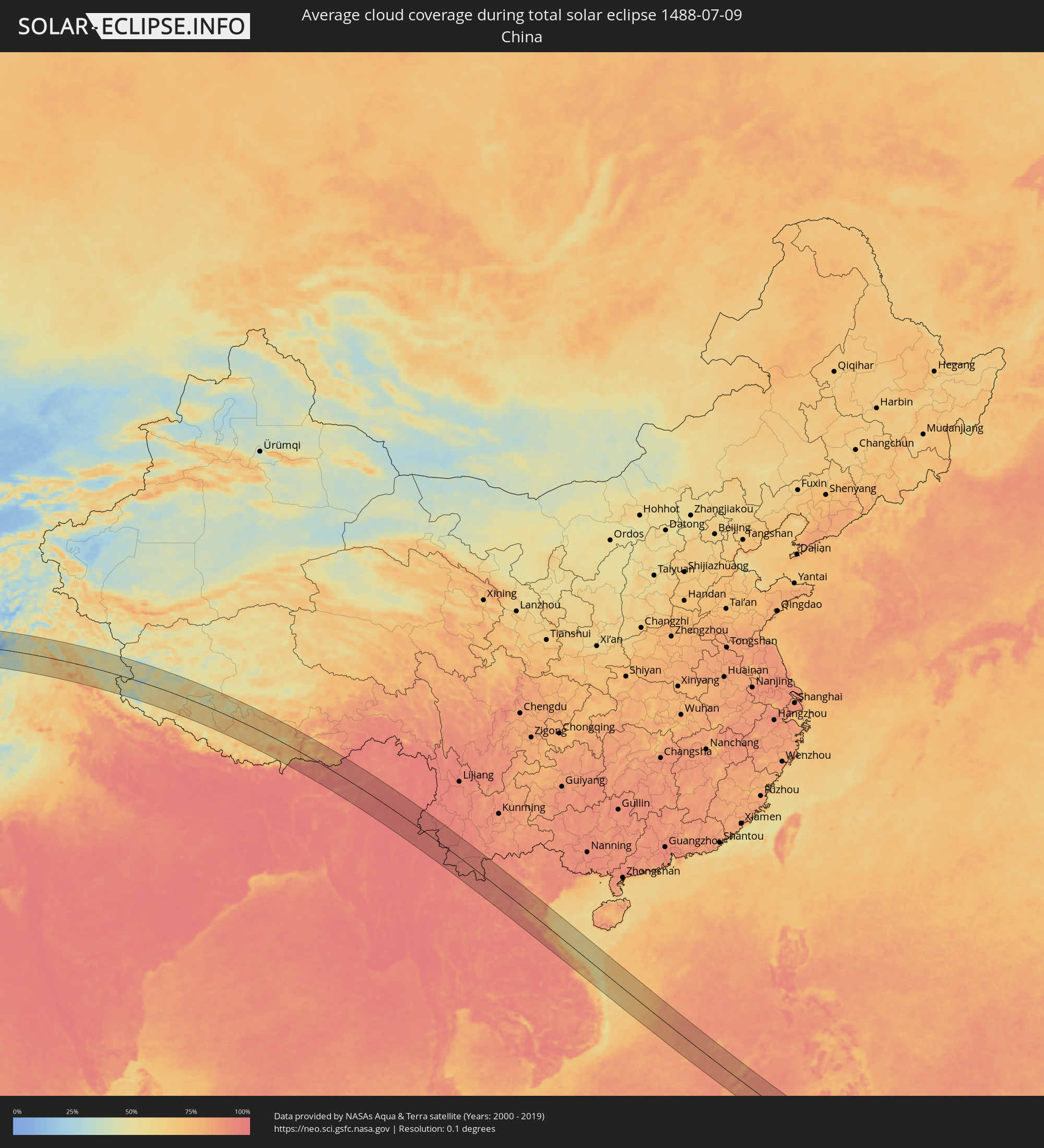 Volksrepublik China
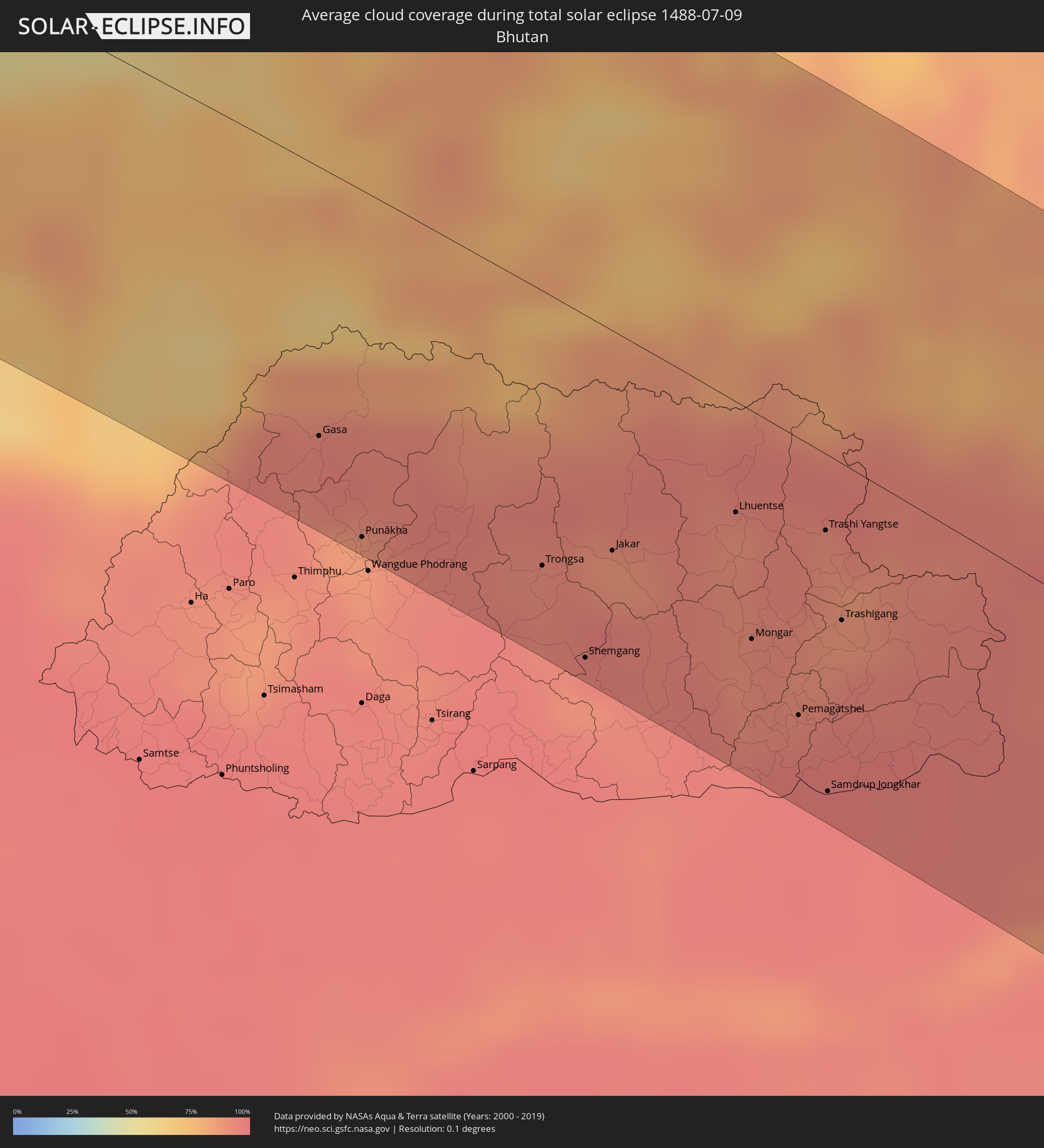 Bhutan
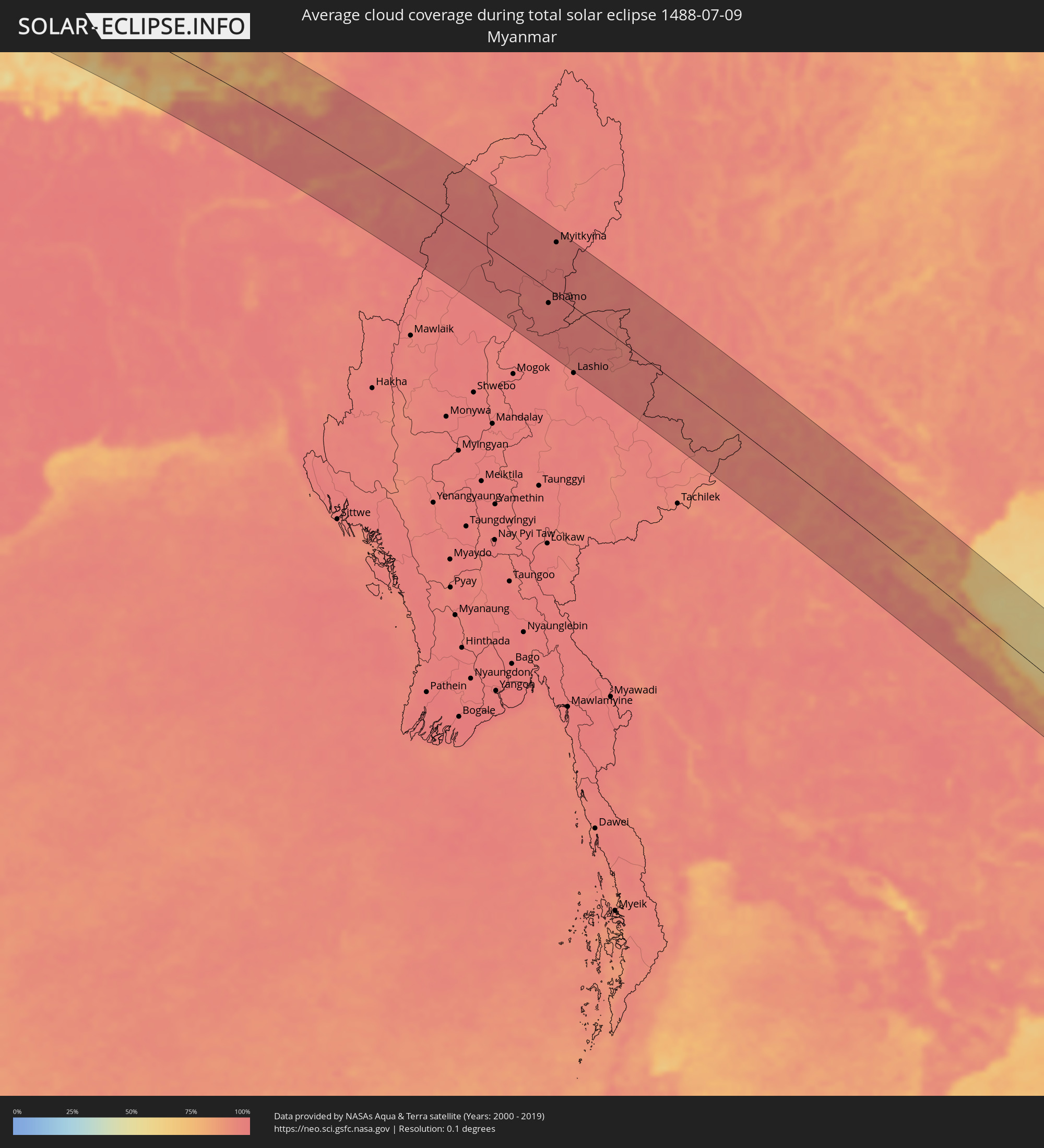 Myanmar
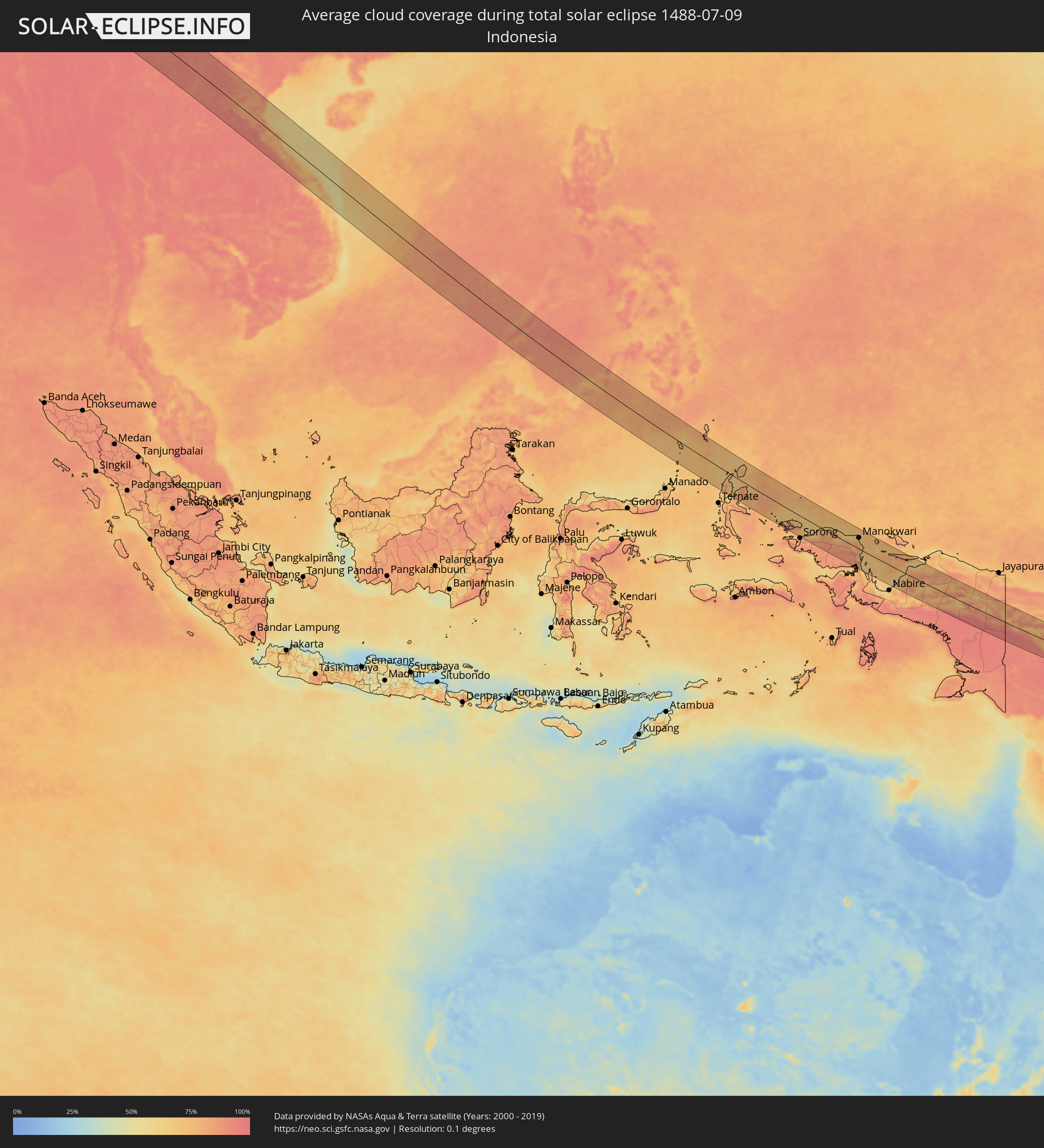 Indonesien
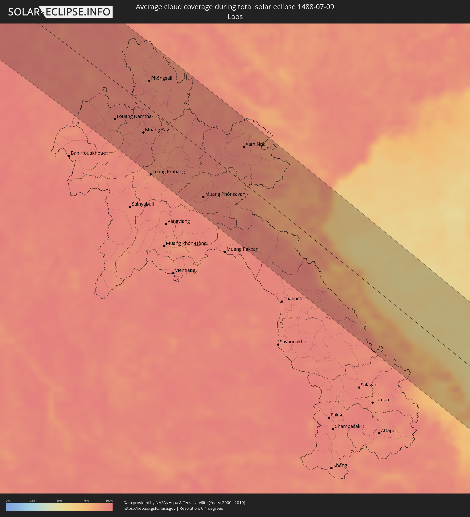 Laos
Laos
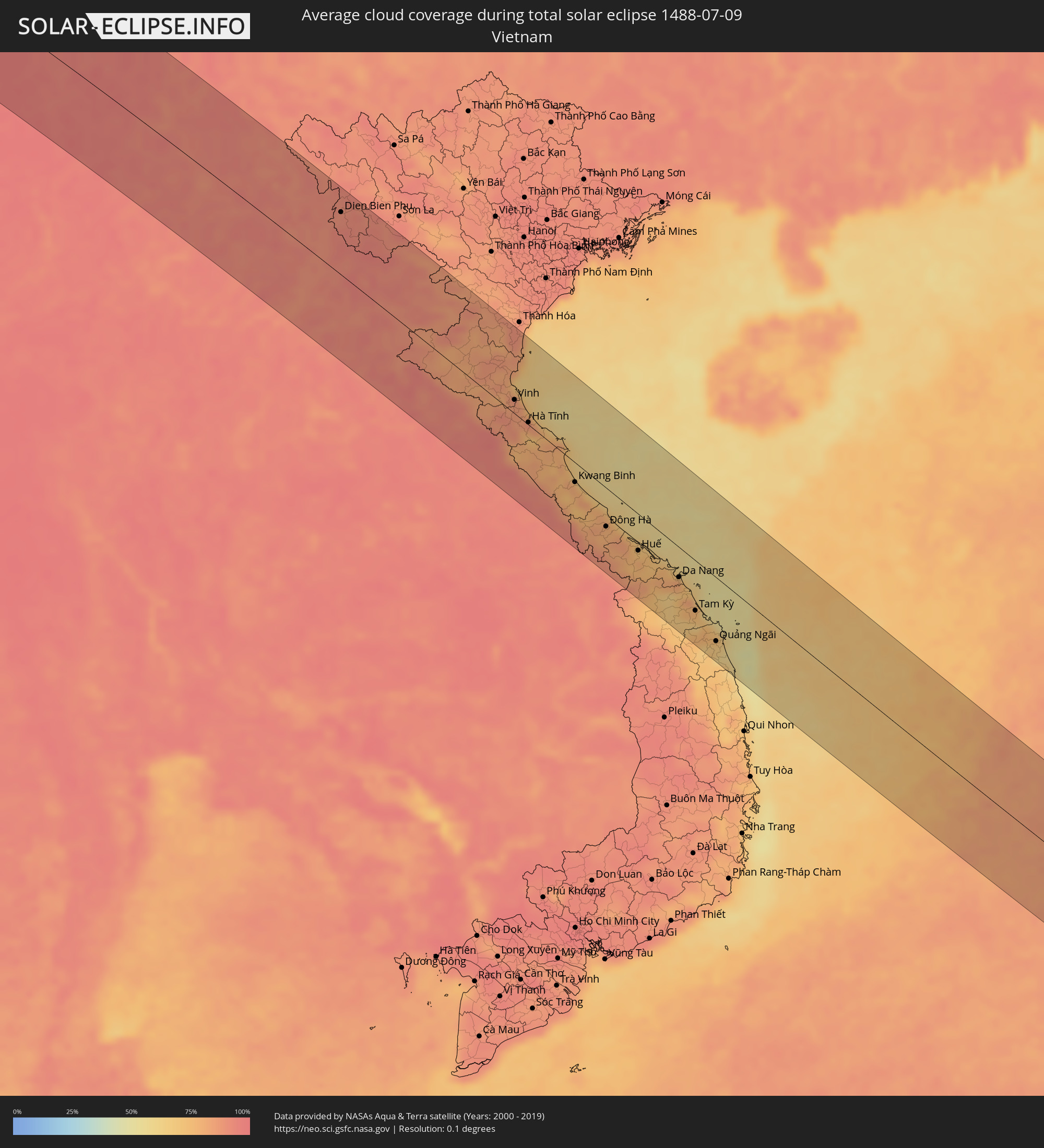 Vietnam
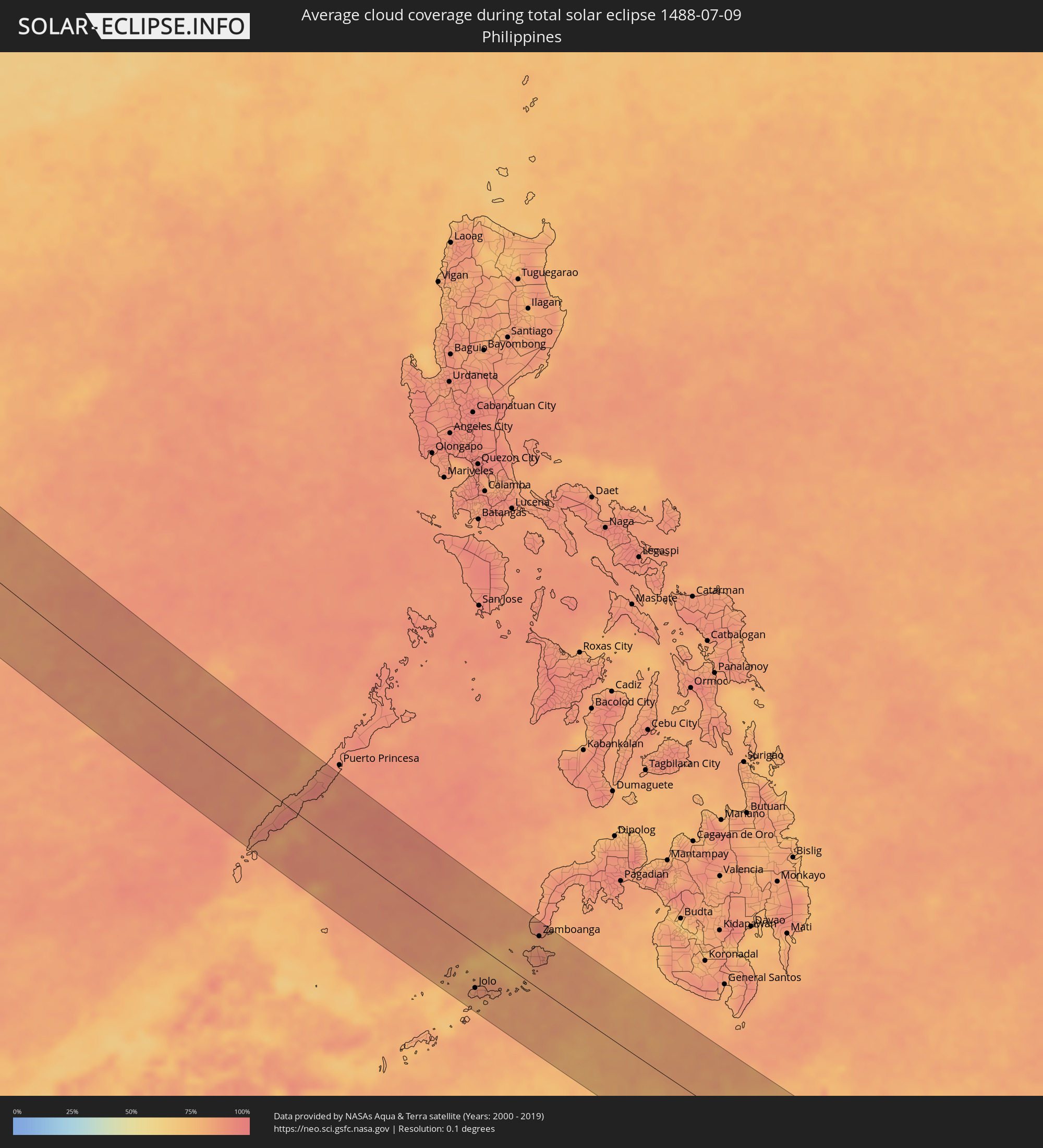 Philippinen
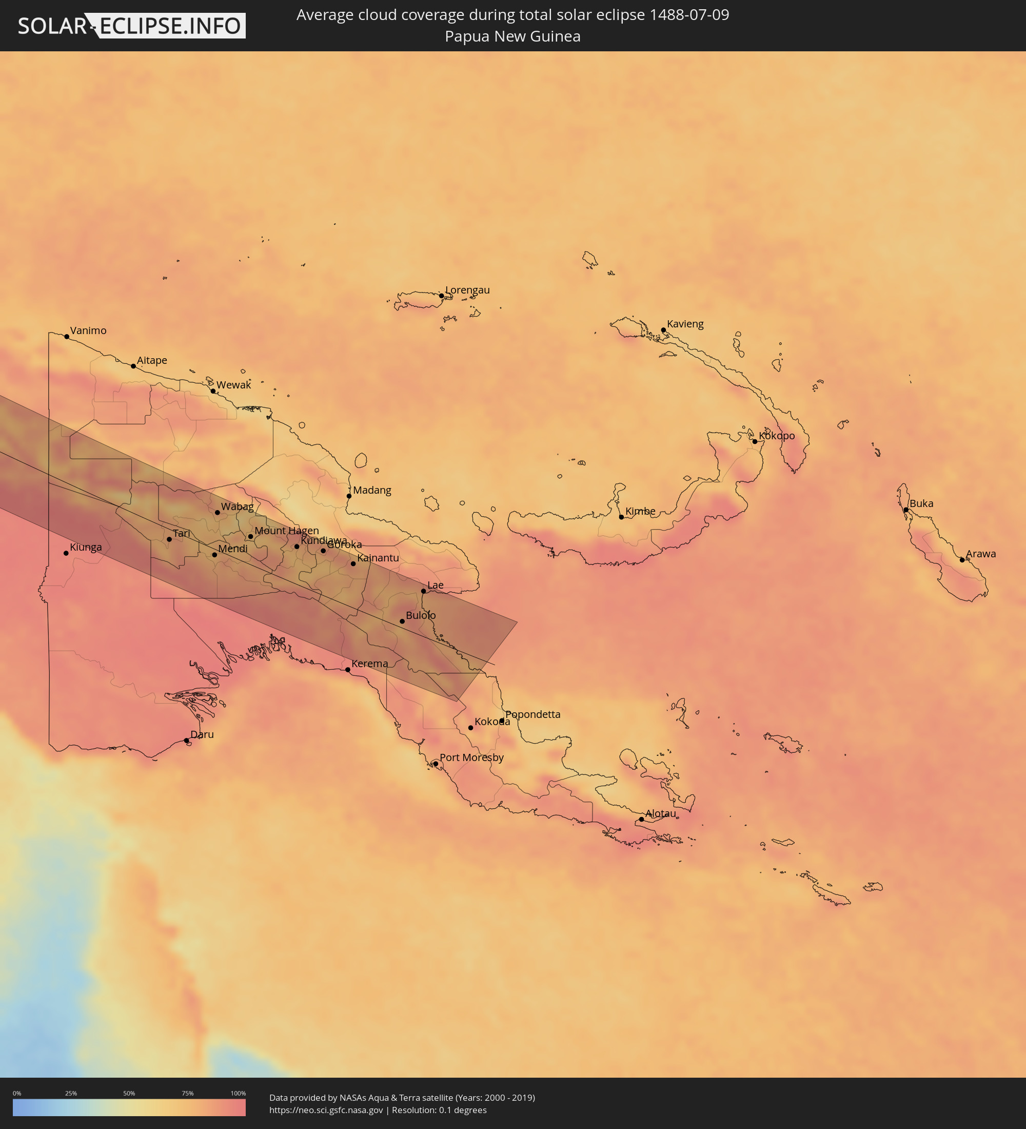 Papua-Neuguinea
Orte im Finsternispfad
Die nachfolgene Tabelle zeigt Städte und Orte mit mehr als 5.000 Einwohnern, die sich im Finsternispfad befinden. Städte mit mehr als 100.000 Einwohnern sind dick gekennzeichnet. Mit einem Klick auf den Ort öffnet sich eine Detailkarte die die Lage des jeweiligen Ortes zusammen mit dem Verlauf der zentralen Finsternis präsentiert.
| Ort | Typ | Dauer der Verfinsterung | Ortszeit bei maximaler Verfinsterung | Entfernung zur Zentrallinie | Ø Bewölkung |
|
Ibshawāy, Faiyum
|
total | - | 06:39:41 UTC+02:00 | 51 km | 0% |
|
Samālūţ, Minya
|
total | - | 06:38:59 UTC+02:00 | 59 km | 0% |
|
Al Minyā, Minya
|
total | - | 06:38:52 UTC+02:00 | 82 km | 0% |
|
Iţsā, Faiyum
|
total | - | 06:39:39 UTC+02:00 | 35 km | 0% |
|
Banī Mazār, Minya
|
total | - | 06:39:09 UTC+02:00 | 42 km | 0% |
|
Al Fayyūm, Faiyum
|
total | - | 06:39:43 UTC+02:00 | 41 km | 0% |
|
Al Fashn, Beni Suweif
|
total | - | 06:39:24 UTC+02:00 | 12 km | 0% |
|
Ţāmiyah, Faiyum
|
total | - | 06:39:52 UTC+02:00 | 55 km | 0% |
|
Banī Suwayf, Beni Suweif
|
total | - | 06:39:39 UTC+02:00 | 8 km | 1% |
|
Ḩalwān, Cairo
|
total | - | 06:40:16 UTC+02:00 | 82 km | 0% |
|
Ain Sukhna, Suez
|
total | - | 06:40:31 UTC+02:00 | 24 km | 1% |
|
Suez, Suez
|
total | - | 06:40:52 UTC+02:00 | 56 km | 6% |
|
Yeroẖam, Southern District
|
total | - | 07:03:26 UTC+02:20 | 88 km | 1% |
|
Eilat, Southern District
|
total | - | 07:02:26 UTC+02:20 | 63 km | 5% |
|
Aqaba, Aqaba
|
total | - | 07:05:31 UTC+02:23 | 68 km | 5% |
|
Al Quwayrah, Ma’an
|
total | - | 07:05:52 UTC+02:23 | 49 km | 0% |
|
Safi, Karak
|
total | - | 07:06:50 UTC+02:23 | 77 km | 0% |
|
Petra, Ma’an
|
total | - | 07:06:20 UTC+02:23 | 1 km | 2% |
|
Aţ Ţafīlah, Tafielah
|
total | - | 07:06:46 UTC+02:23 | 52 km | 0% |
|
Buşayrā, Tafielah
|
total | - | 07:06:42 UTC+02:23 | 41 km | 0% |
|
‘Ayy, Karak
|
total | - | 07:07:00 UTC+02:23 | 82 km | 0% |
|
‘Izrā, Karak
|
total | - | 07:07:03 UTC+02:23 | 84 km | 0% |
|
Al Mazār al Janūbī, Karak
|
total | - | 07:06:59 UTC+02:23 | 74 km | 0% |
|
Qīr Moāv, Ma’an
|
total | - | 07:07:04 UTC+02:23 | 86 km | 0% |
|
Ma'an, Ma’an
|
total | - | 07:06:23 UTC+02:23 | 19 km | 1% |
|
Karak City, Karak
|
total | - | 07:07:05 UTC+02:23 | 82 km | 0% |
|
Qurayyat, Al Jawf
|
total | - | 07:51:17 UTC+03:06 | 54 km | 0% |
|
Ţubarjal, Al Jawf
|
total | - | 07:51:16 UTC+03:06 | 59 km | 1% |
|
Turaif, Northern Borders
|
total | - | 07:52:24 UTC+03:06 | 53 km | 0% |
|
‘Ar‘ar, Northern Borders
|
total | - | 07:53:40 UTC+03:06 | 84 km | 2% |
|
Karbala, Karbalāʼ
|
total | - | 07:48:05 UTC+02:57 | 20 km | 0% |
|
Abū Ghurayb, Mayorality of Baghdad
|
total | - | 07:48:42 UTC+02:57 | 90 km | 3% |
|
Al Hindīyah, Karbalāʼ
|
total | - | 07:48:13 UTC+02:57 | 8 km | 1% |
|
Al Musayyib, Bābil
|
total | - | 07:48:26 UTC+02:57 | 31 km | 2% |
|
Najaf, An Najaf
|
total | - | 07:47:58 UTC+02:57 | 51 km | 1% |
|
Baghdad, Mayorality of Baghdad
|
total | - | 07:48:56 UTC+02:57 | 89 km | 2% |
|
Al Ḩillah, Bābil
|
total | - | 07:48:20 UTC+02:57 | 6 km | 1% |
|
Ash Shāmīyah, Al Qādisīyah
|
total | - | 07:48:10 UTC+02:57 | 64 km | 1% |
|
Ad Dīwānīyah, Al Qādisīyah
|
total | - | 07:48:30 UTC+02:57 | 68 km | 0% |
|
Al ‘Azīzīyah, Wāsiţ
|
total | - | 07:49:15 UTC+02:57 | 28 km | 1% |
|
Al Kūt, Wāsiţ
|
total | - | 07:49:43 UTC+02:57 | 31 km | 2% |
|
Al Ḩayy, Wāsiţ
|
total | - | 07:49:43 UTC+02:57 | 73 km | 1% |
|
Īlām, Īlām
|
total | - | 08:19:13 UTC+03:25 | 78 km | 4% |
|
Kūhdasht, Lorestān
|
total | - | 08:20:22 UTC+03:25 | 43 km | 5% |
|
Nūrābād, Lorestān
|
total | - | 08:21:07 UTC+03:25 | 95 km | 11% |
|
Khorramabad, Lorestān
|
total | - | 08:21:09 UTC+03:25 | 24 km | 8% |
|
Borūjerd, Lorestān
|
total | - | 08:21:51 UTC+03:25 | 62 km | 8% |
|
Arāk, Markazi
|
total | - | 08:23:02 UTC+03:25 | 67 km | 12% |
|
Alīgūdarz, Lorestān
|
total | - | 08:22:36 UTC+03:25 | 9 km | 15% |
|
Khomeyn, Markazi
|
total | - | 08:23:12 UTC+03:25 | 11 km | 13% |
|
Kāshān, Isfahan
|
total | - | 08:25:03 UTC+03:25 | 27 km | 4% |
|
Kāshmar, Razavi Khorasan
|
total | - | 08:35:22 UTC+03:25 | 89 km | 1% |
|
Torbat-e Ḩeydarīyeh, Razavi Khorasan
|
total | - | 08:36:32 UTC+03:25 | 89 km | 1% |
|
Torbat-e Jām, Razavi Khorasan
|
total | - | 08:38:45 UTC+03:25 | 80 km | 2% |
|
Kafir Qala, Herat
|
total | - | 09:13:33 UTC+04:00 | 14 km | 1% |
|
Herāt, Herat
|
total | - | 09:15:23 UTC+04:00 | 24 km | 0% |
|
Serhetabat, Mary
|
total | - | 09:09:23 UTC+03:53 | 80 km | 0% |
|
Bāmyān, Bamyan
|
total | - | 09:25:38 UTC+04:00 | 47 km | 9% |
|
Ghazni, Ghazni
|
total | - | 09:26:50 UTC+04:00 | 89 km | 7% |
|
Barakī Barak, Logar
|
total | - | 09:27:51 UTC+04:00 | 39 km | 3% |
|
Paghmān, Kabul
|
total | - | 09:27:49 UTC+04:00 | 30 km | 7% |
|
Charikar, Parwan
|
total | - | 09:28:12 UTC+04:00 | 79 km | 5% |
|
Kabul, Kabul
|
total | - | 09:28:15 UTC+04:00 | 26 km | 4% |
|
Gardēz, Paktia
|
total | - | 09:28:27 UTC+04:00 | 77 km | 8% |
|
Khōst, Khowst
|
total | - | 09:29:53 UTC+04:00 | 98 km | 22% |
|
Jalālābād, Nangarhar
|
total | - | 09:30:47 UTC+04:00 | 28 km | 6% |
|
Asadābād, Kunar
|
total | - | 09:32:06 UTC+04:00 | 86 km | 19% |
|
Kohāt, Khyber Pakhtunkhwa
|
total | - | 10:01:11 UTC+04:28 | 52 km | 35% |
|
Peshawar, Khyber Pakhtunkhwa
|
total | - | 10:01:21 UTC+04:28 | 3 km | 30% |
|
Mardan, Khyber Pakhtunkhwa
|
total | - | 10:02:17 UTC+04:28 | 25 km | 40% |
|
Mingora, Khyber Pakhtunkhwa
|
total | - | 10:02:46 UTC+04:28 | 93 km | 38% |
|
Swābi, Khyber Pakhtunkhwa
|
total | - | 10:03:09 UTC+04:28 | 22 km | 43% |
|
Chakwāl, Punjab
|
total | - | 10:04:20 UTC+04:28 | 102 km | 51% |
|
Rawalpindi, Punjab
|
total | - | 10:04:34 UTC+04:28 | 26 km | 55% |
|
Abbottābād, Khyber Pakhtunkhwa
|
total | - | 10:04:42 UTC+04:28 | 37 km | 49% |
|
Muzaffarābād, Azad Kashmir
|
total | - | 10:05:09 UTC+04:28 | 65 km | 42% |
|
Jhelum, Punjab
|
total | - | 10:06:12 UTC+04:28 | 87 km | 57% |
|
Kotli, Azad Kashmir
|
total | - | 10:06:21 UTC+04:28 | 20 km | 53% |
|
Bhimbar, Azad Kashmir
|
total | - | 10:06:57 UTC+04:28 | 76 km | 61% |
|
Bāramūla, Kashmir
|
total | - | 10:59:59 UTC+05:21 | 63 km | 48% |
|
Srinagar, Kashmir
|
total | - | 11:01:01 UTC+05:21 | 59 km | 43% |
|
Jammu, Kashmir
|
total | - | 11:01:44 UTC+05:21 | 87 km | 65% |
|
Udhampur, Kashmir
|
total | - | 11:02:14 UTC+05:21 | 61 km | 67% |
|
Anantnag, Kashmir
|
total | - | 11:01:54 UTC+05:21 | 27 km | 45% |
|
Rikaze, Tibet Autonomous Region
|
total | - | 14:15:32 UTC+08:00 | 12 km | 51% |
|
Jiangzi, Tibet Autonomous Region
|
total | - | 14:17:34 UTC+08:00 | 12 km | 70% |
|
Gasa, Gasa District
|
total | - | 12:17:51 UTC+05:58 | 81 km | 94% |
|
Punākha, Punakha
|
total | - | 12:18:37 UTC+05:58 | 104 km | 87% |
|
Trongsa, Tongsa
|
total | - | 12:20:10 UTC+05:58 | 82 km | 92% |
|
Shemgang, Shemgang
|
total | - | 12:20:54 UTC+05:58 | 102 km | 90% |
|
Jakar, Bumthang
|
total | - | 12:20:38 UTC+05:58 | 66 km | 89% |
|
Lhuentse, Lhuntse District
|
total | - | 12:21:25 UTC+05:58 | 33 km | 89% |
|
Mongar, Mongar District
|
total | - | 12:22:07 UTC+05:58 | 68 km | 90% |
|
Pemagatshel, Pemagatshel District
|
total | - | 12:22:50 UTC+05:58 | 82 km | 97% |
|
Trashi Yangtse, Trashi Yangste
|
total | - | 12:22:12 UTC+05:58 | 23 km | 90% |
|
Samdrup Jongkhar, Samdrup Jongkhar
|
total | - | 12:23:24 UTC+05:58 | 100 km | 97% |
|
Trashigang, Tashigang
|
total | - | 12:22:44 UTC+05:58 | 47 km | 94% |
|
Tezpur, Assam
|
total | - | 11:49:03 UTC+05:21 | 49 km | 91% |
|
Diphu, Assam
|
total | - | 11:51:38 UTC+05:21 | 90 km | 92% |
|
Dimāpur, Nagaland
|
total | - | 11:52:09 UTC+05:21 | 68 km | 97% |
|
North Lakhimpur, Assam
|
total | - | 11:50:55 UTC+05:21 | 76 km | 94% |
|
Kohima, Nagaland
|
total | - | 11:53:21 UTC+05:21 | 69 km | 97% |
|
Jorhāt, Assam
|
total | - | 11:51:52 UTC+05:21 | 37 km | 96% |
|
Sibsāgar, Assam
|
total | - | 11:52:25 UTC+05:21 | 82 km | 95% |
|
Bhamo, Kachin
|
total | - | 13:05:44 UTC+06:24 | 23 km | 96% |
|
Myitkyina, Kachin
|
total | - | 13:04:12 UTC+06:24 | 89 km | 96% |
|
Jinghong, Yunnan
|
total | - | 14:51:31 UTC+08:00 | 13 km | 93% |
|
Louang Namtha, Loungnamtha
|
total | - | 13:36:36 UTC+06:42 | 63 km | 92% |
|
Muang Xay, Oudômxai
|
total | - | 13:38:05 UTC+06:42 | 49 km | 93% |
|
Phôngsali, Phôngsali
|
total | - | 13:36:35 UTC+06:42 | 46 km | 93% |
|
Dien Bien Phu, Tỉnh Ðiện Biên
|
total | - | 14:03:18 UTC+07:06 | 79 km | 90% |
|
Muang Phônsavan, Xiangkhoang
|
total | - | 13:42:22 UTC+06:42 | 78 km | 92% |
|
Xam Nua, Houaphan
|
total | - | 13:42:07 UTC+06:42 | 60 km | 92% |
|
Yên Vinh, Nghệ An
|
total | - | 14:12:21 UTC+07:06 | 15 km | 86% |
|
Vinh, Nghệ An
|
total | - | 14:12:23 UTC+07:06 | 17 km | 86% |
|
Hà Tĩnh, Hà Tĩnh
|
total | - | 14:13:17 UTC+07:06 | 3 km | 80% |
|
Kwang Binh, Quảng Bình
|
total | - | 14:15:52 UTC+07:06 | 25 km | 80% |
|
Ðông Hà, Quảng Trị
|
total | - | 14:17:42 UTC+07:06 | 49 km | 79% |
|
Huế, Thừa Thiên-Huế
|
total | - | 14:19:01 UTC+07:06 | 46 km | 72% |
|
Da Nang, Đà Nẵng
|
total | - | 14:20:35 UTC+07:06 | 38 km | 81% |
|
Hội An, Quảng Nam
|
total | - | 14:21:04 UTC+07:06 | 47 km | 72% |
|
Tam Kỳ, Quảng Nam
|
total | - | 14:21:46 UTC+07:06 | 64 km | 72% |
|
Quảng Ngãi, Quảng Ngãi
|
total | - | 14:22:57 UTC+07:06 | 82 km | 66% |
|
Rio Tuba, Mimaropa
|
total | - | 15:36:15 UTC+08:00 | 78 km | 84% |
|
Quezon, Mimaropa
|
total | - | 15:35:48 UTC+08:00 | 27 km | 91% |
|
Narra, Mimaropa
|
total | - | 15:36:06 UTC+08:00 | 54 km | 89% |
|
Parang, Autonomous Region in Muslim Mindanao
|
total | - | 15:42:31 UTC+08:00 | 85 km | 79% |
|
Jolo, Autonomous Region in Muslim Mindanao
|
total | - | 15:42:25 UTC+08:00 | 66 km | 86% |
|
Kansipati, Autonomous Region in Muslim Mindanao
|
total | - | 15:42:39 UTC+08:00 | 56 km | 83% |
|
Maluso, Autonomous Region in Muslim Mindanao
|
total | - | 15:42:27 UTC+08:00 | 34 km | 81% |
|
Labuan, Zamboanga Peninsula
|
total | - | 15:41:47 UTC+08:00 | 86 km | 82% |
|
City of Isabela, Autonomous Region in Muslim Mindanao
|
total | - | 15:42:19 UTC+08:00 | 55 km | 89% |
|
Zamboanga, Zamboanga Peninsula
|
total | - | 15:42:08 UTC+08:00 | 80 km | 83% |
|
Sangali, Zamboanga Peninsula
|
total | - | 15:42:02 UTC+08:00 | 103 km | 83% |
|
Tuburan, Zamboanga Peninsula
|
total | - | 15:42:37 UTC+08:00 | 68 km | 82% |
|
Tobelo, North Maluku
|
total | - | 17:14:11 UTC+09:22 | 38 km | 68% |
|
Manokwari, West Papua
|
total | - | 17:18:34 UTC+09:22 | 51 km | 72% |
|
Tari, Hela
|
total | - | 18:00:03 UTC+10:00 | 17 km | 76% |
|
Mendi, Southern Highlands
|
total | - | 18:00:08 UTC+10:00 | 10 km | 79% |
|
Wabag, Enga
|
total | - | 17:59:45 UTC+10:00 | 60 km | 75% |
|
Ialibu, Southern Highlands
|
total | - | 18:00:11 UTC+10:00 | 9 km | 82% |
|
Mount Hagen, Western Highlands
|
total | - | 17:59:56 UTC+10:00 | 45 km | 75% |
|
Minj, Jiwaka
|
total | - | 17:59:55 UTC+10:00 | 60 km | 77% |
|
Kundiawa, Chimbu
|
total | - | 17:59:57 UTC+10:00 | 61 km | 75% |
|
Goroka, Eastern Highlands
|
total | - | 17:59:57 UTC+10:00 | 72 km | 72% |
|
Kainantu, Eastern Highlands
|
total | - | 18:00:00 UTC+10:00 | 71 km | 80% |
|
Bulolo, Morobe
|
total | - | 18:00:23 UTC+10:00 | 10 km | 75% |
|
Wau, Morobe
|
total | - | 18:00:26 UTC+10:00 | 1 km | 79% |
|
Lae, Morobe
|
total | - | 18:00:05 UTC+10:00 | 73 km | 79% |