Totale Sonnenfinsternis vom 19.05.1547
| Wochentag: | Montag |
| Maximale Dauer der Verfinsterung: | 05m22s |
| Maximale Breite des Finsternispfades: | 270 km |
| Saroszyklus: | 130 |
| Bedeckungsgrad: | 100% |
| Magnitude: | 1.0581 |
| Gamma: | -0.706 |
Wo kann man die Sonnenfinsternis vom 19.05.1547 sehen?
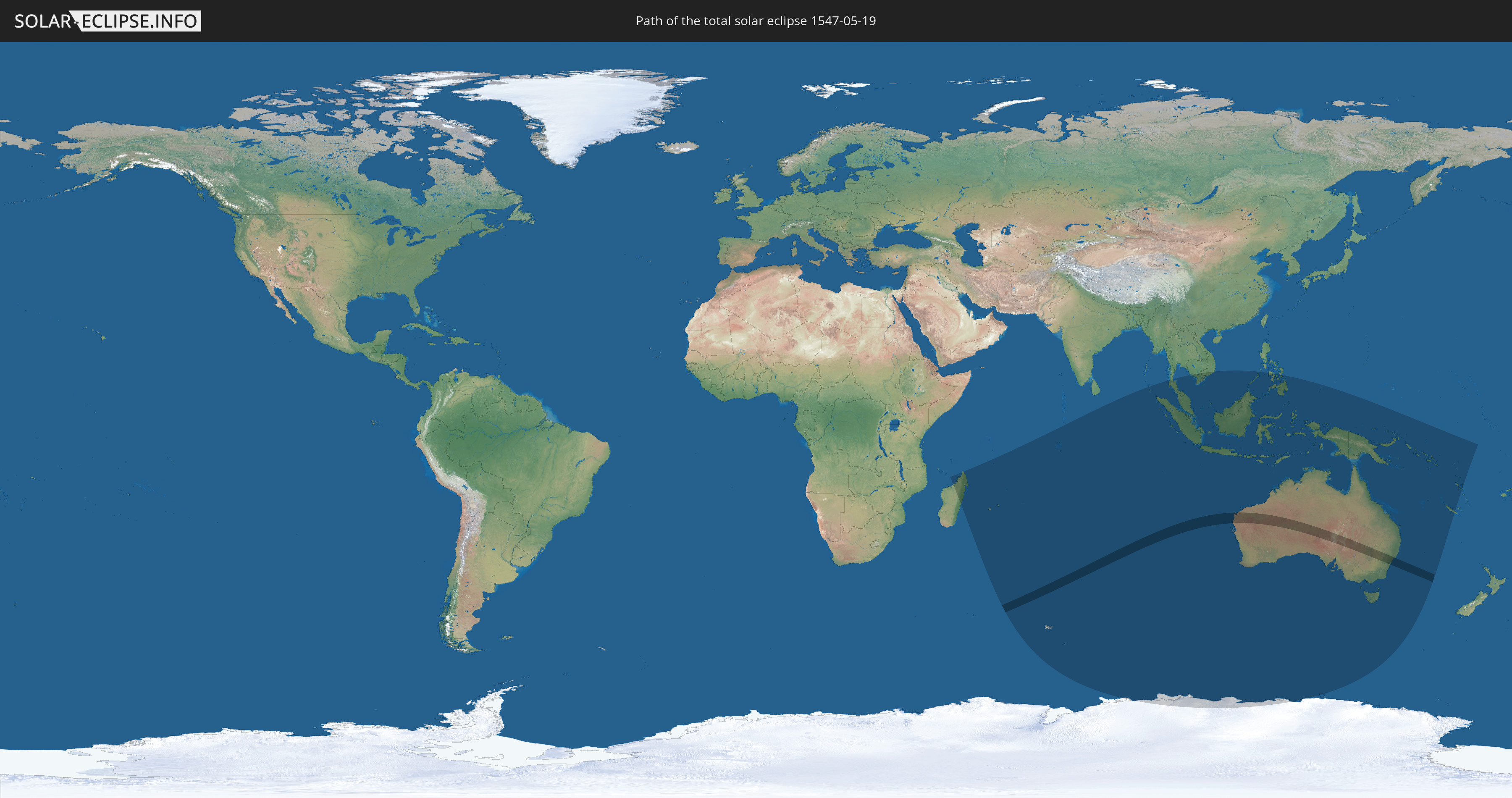
Die Sonnenfinsternis am 19.05.1547 kann man in 26 Ländern als partielle Sonnenfinsternis beobachten.
Der Finsternispfad verläuft durch ein Land. Nur in diesem Land ist sie als totale Sonnenfinsternis zu sehen.
In den folgenden Ländern ist die Sonnenfinsternis total zu sehen
 Australien
In den folgenden Ländern ist die Sonnenfinsternis partiell zu sehen
 Antarktika
 Französische Süd- und Antarktisgebiete
 Madagaskar
 Réunion
 Mauritius
 Indien
 Britisches Territorium im Indischen Ozean
 Heard und McDonaldinseln
 Myanmar
 Indonesien
 Kokosinseln
 Thailand
 Malaysia
 Vietnam
 Kambodscha
 Singapur
 Weihnachtsinsel
 Australien
 Brunei
 Philippinen
 Osttimor
 Palau
Palau
 Papua-Neuguinea
 Salomonen
 Neukaledonien
 Vanuatu
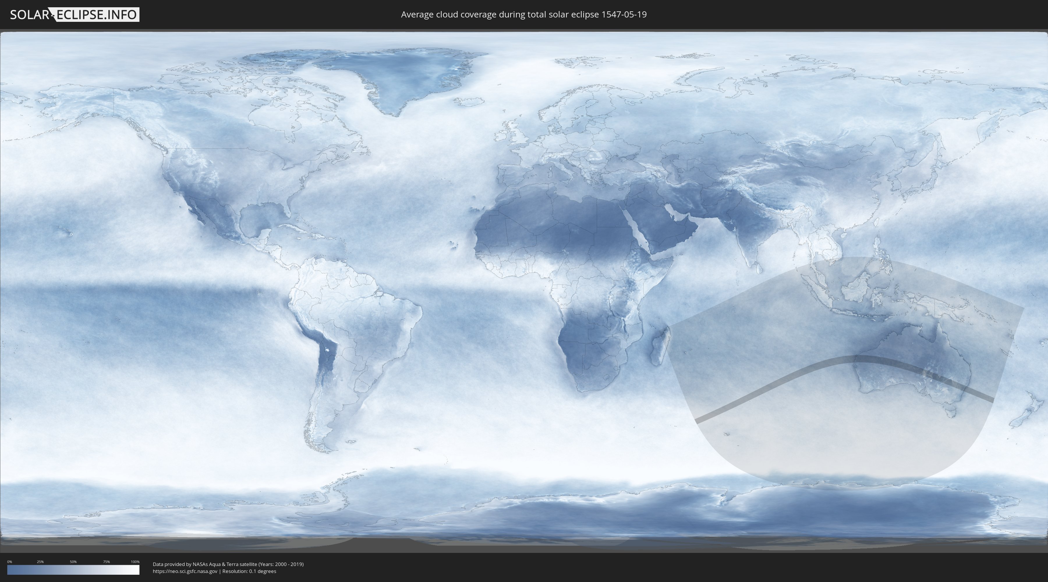
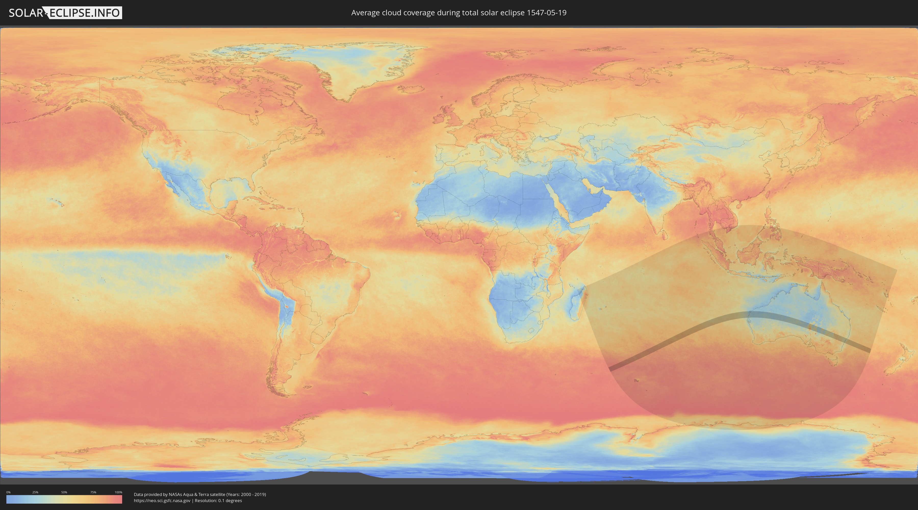
Wie wird das Wetter während der totalen Sonnenfinsternis am 19.05.1547?
Wo ist der beste Ort, um die totale Sonnenfinsternis vom 19.05.1547 zu beobachten?
Die folgenden Karten zeigen die durchschnittliche Bewölkung für den Tag, an dem die totale Sonnenfinsternis
stattfindet. Mit Hilfe der Karten lässt sich der Ort entlang des Finsternispfades eingrenzen,
der die besten Aussichen auf einen klaren wolkenfreien Himmel bietet.
Trotzdem muss man immer lokale Gegenenheiten beachten und sollte sich genau über das Wetter an seinem
gewählten Beobachtungsort informieren.
Die Daten stammen von den beiden NASA-Satelliten
AQUA und TERRA
und wurden über einen Zeitraum von 19 Jahren (2000 - 2019) gemittelt.
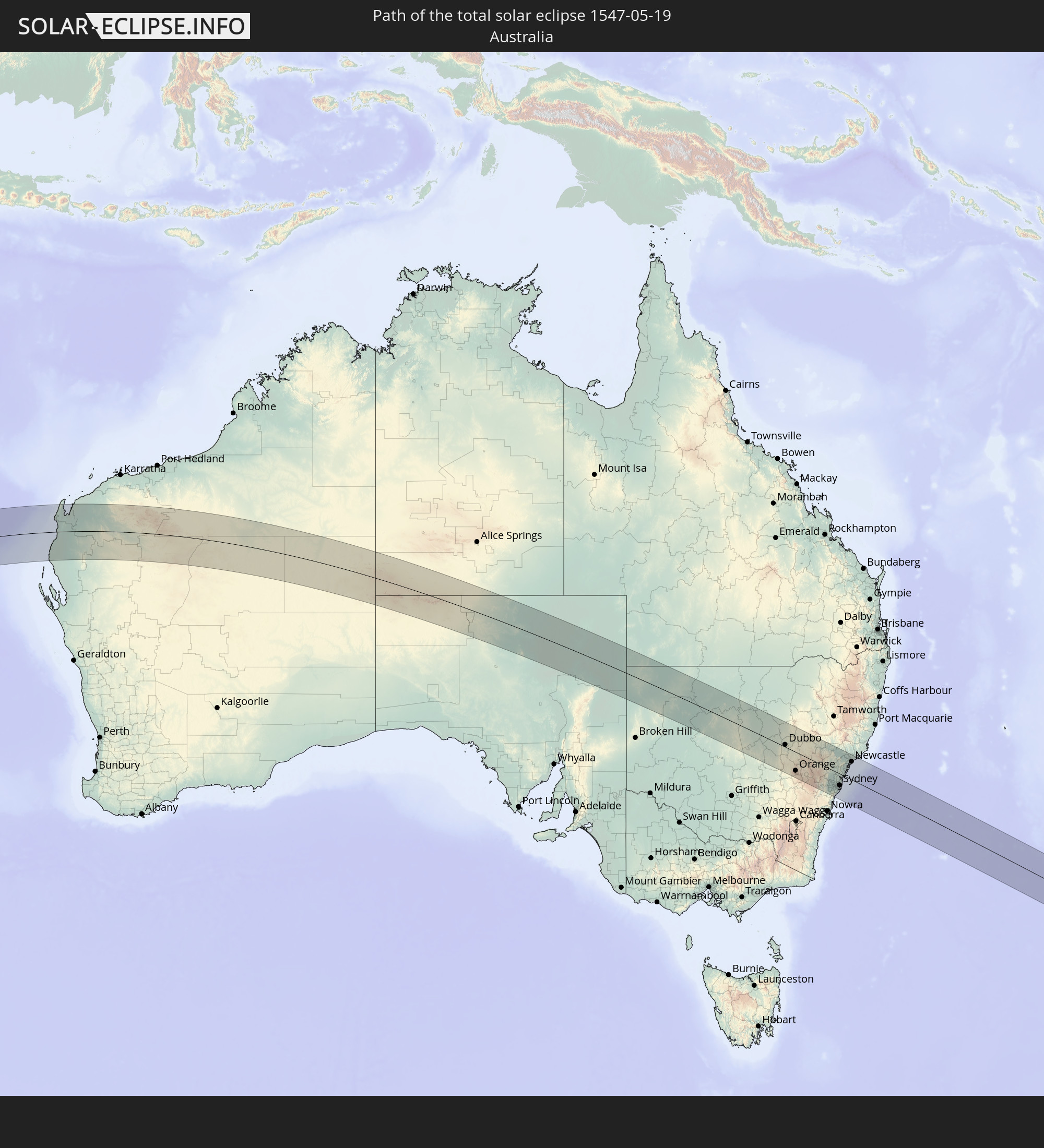
Detaillierte Länderkarten
 Australien
Orte im Finsternispfad
Die nachfolgene Tabelle zeigt Städte und Orte mit mehr als 5.000 Einwohnern, die sich im Finsternispfad befinden. Städte mit mehr als 100.000 Einwohnern sind dick gekennzeichnet. Mit einem Klick auf den Ort öffnet sich eine Detailkarte die die Lage des jeweiligen Ortes zusammen mit dem Verlauf der zentralen Finsternis präsentiert.
| Ort | Typ | Dauer der Verfinsterung | Ortszeit bei maximaler Verfinsterung | Entfernung zur Zentrallinie | Ø Bewölkung |
|
Newman, Western Australia
|
total | - | 13:11:45 UTC+08:00 | 11 km | 32% |
|
Parkes, New South Wales
|
total | - | 15:55:32 UTC+10:00 | 98 km | 67% |
|
Dubbo, New South Wales
|
total | - | 15:56:48 UTC+10:00 | 9 km | 66% |
|
Wellington, New South Wales
|
total | - | 15:56:49 UTC+10:00 | 8 km | 63% |
|
Orange, New South Wales
|
total | - | 15:56:16 UTC+10:00 | 75 km | 66% |
|
Bathurst, New South Wales
|
total | - | 15:56:35 UTC+10:00 | 68 km | 71% |
|
Mudgee, New South Wales
|
total | - | 15:57:23 UTC+10:00 | 14 km | 63% |
|
Kelso, New South Wales
|
total | - | 15:56:36 UTC+10:00 | 67 km | 71% |
|
Lithgow, New South Wales
|
total | - | 15:57:02 UTC+10:00 | 52 km | 56% |
|
Katoomba, New South Wales
|
total | - | 15:56:57 UTC+10:00 | 68 km | 49% |
|
Blaxland, New South Wales
|
total | - | 15:57:10 UTC+10:00 | 59 km | 49% |
|
Glenbrook, New South Wales
|
total | - | 15:57:10 UTC+10:00 | 60 km | 49% |
|
Glenmore Park, New South Wales
|
total | - | 15:57:11 UTC+10:00 | 60 km | 57% |
|
Penrith, New South Wales
|
total | - | 15:57:15 UTC+10:00 | 55 km | 57% |
|
Kingswood Park, New South Wales
|
total | - | 15:57:15 UTC+10:00 | 56 km | 57% |
|
Cambridge Park, New South Wales
|
total | - | 15:57:17 UTC+10:00 | 54 km | 55% |
|
Narellan, New South Wales
|
total | - | 15:57:00 UTC+10:00 | 82 km | 57% |
|
Narellan Vale, New South Wales
|
total | - | 15:57:00 UTC+10:00 | 83 km | 57% |
|
Richmond, New South Wales
|
total | - | 15:57:27 UTC+10:00 | 38 km | 53% |
|
South Windsor, New South Wales
|
total | - | 15:57:29 UTC+10:00 | 38 km | 53% |
|
Mount Druitt, New South Wales
|
total | - | 15:57:20 UTC+10:00 | 52 km | 60% |
|
Campbelltown, New South Wales
|
total | - | 15:57:03 UTC+10:00 | 82 km | 52% |
|
Leumeah, New South Wales
|
total | - | 15:57:04 UTC+10:00 | 79 km | 52% |
|
Glendenning, New South Wales
|
total | - | 15:57:24 UTC+10:00 | 48 km | 56% |
|
Ingleburn, New South Wales
|
total | - | 15:57:09 UTC+10:00 | 73 km | 51% |
|
Riverstone, New South Wales
|
total | - | 15:57:28 UTC+10:00 | 41 km | 56% |
|
Doonside, New South Wales
|
total | - | 15:57:23 UTC+10:00 | 50 km | 56% |
|
Quakers Hill, New South Wales
|
total | - | 15:57:26 UTC+10:00 | 46 km | 56% |
|
Glenfield, New South Wales
|
total | - | 15:57:13 UTC+10:00 | 68 km | 51% |
|
Cabramatta West, New South Wales
|
total | - | 15:57:18 UTC+10:00 | 61 km | 56% |
|
Rouse Hill, New South Wales
|
total | - | 15:57:31 UTC+10:00 | 39 km | 56% |
|
Blacktown, New South Wales
|
total | - | 15:57:26 UTC+10:00 | 48 km | 56% |
|
Stanhope Gardens, New South Wales
|
total | - | 15:57:29 UTC+10:00 | 43 km | 56% |
|
Liverpool, New South Wales
|
total | - | 15:57:19 UTC+10:00 | 60 km | 56% |
|
Fairfield Heights, New South Wales
|
total | - | 15:57:21 UTC+10:00 | 57 km | 56% |
|
Beaumont Hills, New South Wales
|
total | - | 15:57:31 UTC+10:00 | 40 km | 56% |
|
Chipping Norton, New South Wales
|
total | - | 15:57:19 UTC+10:00 | 60 km | 54% |
|
Fairfield East, New South Wales
|
total | - | 15:57:22 UTC+10:00 | 56 km | 54% |
|
Northmead, New South Wales
|
total | - | 15:57:28 UTC+10:00 | 47 km | 54% |
|
Merrylands, New South Wales
|
total | - | 15:57:25 UTC+10:00 | 52 km | 54% |
|
Baulkham Hills, New South Wales
|
total | - | 15:57:30 UTC+10:00 | 44 km | 54% |
|
Helensburgh, New South Wales
|
total | - | 15:57:05 UTC+10:00 | 85 km | 44% |
|
City of Parramatta, New South Wales
|
total | - | 15:57:27 UTC+10:00 | 49 km | 54% |
|
Castle Hill, New South Wales
|
total | - | 15:57:32 UTC+10:00 | 41 km | 53% |
|
Glenhaven, New South Wales
|
total | - | 15:57:34 UTC+10:00 | 38 km | 53% |
|
Paramatta, New South Wales
|
total | - | 15:57:27 UTC+10:00 | 49 km | 54% |
|
Kenthurst, New South Wales
|
total | - | 15:57:37 UTC+10:00 | 33 km | 53% |
|
Harris Park, New South Wales
|
total | - | 15:57:27 UTC+10:00 | 50 km | 54% |
|
Engadine, New South Wales
|
total | - | 15:57:13 UTC+10:00 | 74 km | 44% |
|
Heathcote, New South Wales
|
total | - | 15:57:12 UTC+10:00 | 75 km | 44% |
|
Menai, New South Wales
|
total | - | 15:57:16 UTC+10:00 | 68 km | 50% |
|
Granville, New South Wales
|
total | - | 15:57:27 UTC+10:00 | 50 km | 54% |
|
Bankstown, New South Wales
|
total | - | 15:57:23 UTC+10:00 | 58 km | 54% |
|
Auburn, New South Wales
|
total | - | 15:57:27 UTC+10:00 | 51 km | 54% |
|
Berala, New South Wales
|
total | - | 15:57:25 UTC+10:00 | 53 km | 54% |
|
Telopea, New South Wales
|
total | - | 15:57:30 UTC+10:00 | 45 km | 54% |
|
Lidcombe, New South Wales
|
total | - | 15:57:26 UTC+10:00 | 52 km | 54% |
|
Lugarno, New South Wales
|
total | - | 15:57:19 UTC+10:00 | 64 km | 50% |
|
West Pennant, New South Wales
|
total | - | 15:57:34 UTC+10:00 | 40 km | 53% |
|
Carlingford, New South Wales
|
total | - | 15:57:31 UTC+10:00 | 44 km | 54% |
|
Ermington, New South Wales
|
total | - | 15:57:30 UTC+10:00 | 47 km | 51% |
|
Jannali, New South Wales
|
total | - | 15:57:18 UTC+10:00 | 67 km | 48% |
|
Beecroft, New South Wales
|
total | - | 15:57:34 UTC+10:00 | 40 km | 49% |
|
Kirrawee, New South Wales
|
total | - | 15:57:17 UTC+10:00 | 68 km | 48% |
|
Oatley, New South Wales
|
total | - | 15:57:21 UTC+10:00 | 63 km | 48% |
|
Pennant Hills, New South Wales
|
total | - | 15:57:35 UTC+10:00 | 38 km | 49% |
|
West Ryde, New South Wales
|
total | - | 15:57:31 UTC+10:00 | 45 km | 51% |
|
Lakemba, New South Wales
|
total | - | 15:57:25 UTC+10:00 | 56 km | 51% |
|
Epping, New South Wales
|
total | - | 15:57:34 UTC+10:00 | 41 km | 51% |
|
Mortdale, New South Wales
|
total | - | 15:57:22 UTC+10:00 | 61 km | 48% |
|
Penshurst, New South Wales
|
total | - | 15:57:22 UTC+10:00 | 61 km | 48% |
|
Belfield, New South Wales
|
total | - | 15:57:26 UTC+10:00 | 54 km | 51% |
|
Gymea, New South Wales
|
total | - | 15:57:18 UTC+10:00 | 68 km | 48% |
|
Concord West, New South Wales
|
total | - | 15:57:29 UTC+10:00 | 49 km | 51% |
|
Gymea Bay, New South Wales
|
total | - | 15:57:17 UTC+10:00 | 69 km | 44% |
|
Hornsby Heights, New South Wales
|
total | - | 15:57:40 UTC+10:00 | 31 km | 49% |
|
Hornsby, New South Wales
|
total | - | 15:57:39 UTC+10:00 | 34 km | 49% |
|
Earlwood, New South Wales
|
total | - | 15:57:24 UTC+10:00 | 58 km | 48% |
|
Miranda, New South Wales
|
total | - | 15:57:19 UTC+10:00 | 67 km | 48% |
|
Concord, New South Wales
|
total | - | 15:57:30 UTC+10:00 | 48 km | 51% |
|
Marsfield, New South Wales
|
total | - | 15:57:35 UTC+10:00 | 41 km | 51% |
|
Blakehurst, New South Wales
|
total | - | 15:57:22 UTC+10:00 | 62 km | 48% |
|
Macquarie Park, New South Wales
|
total | - | 15:57:35 UTC+10:00 | 40 km | 51% |
|
Mount Colah, New South Wales
|
total | - | 15:57:41 UTC+10:00 | 31 km | 49% |
|
Croydon, New South Wales
|
total | - | 15:57:29 UTC+10:00 | 51 km | 51% |
|
Canterbury, New South Wales
|
total | - | 15:57:27 UTC+10:00 | 54 km | 51% |
|
Caringbah, New South Wales
|
total | - | 15:57:19 UTC+10:00 | 67 km | 48% |
|
Caringbah South, New South Wales
|
total | - | 15:57:19 UTC+10:00 | 68 km | 44% |
|
Ashfield, New South Wales
|
total | - | 15:57:29 UTC+10:00 | 51 km | 51% |
|
North Ryde, New South Wales
|
total | - | 15:57:34 UTC+10:00 | 42 km | 51% |
|
Gladesville, New South Wales
|
total | - | 15:57:33 UTC+10:00 | 45 km | 51% |
|
Berowra Heights, New South Wales
|
total | - | 15:57:46 UTC+10:00 | 23 km | 48% |
|
Summer Hill, New South Wales
|
total | - | 15:57:30 UTC+10:00 | 51 km | 51% |
|
Dulwich Hill, New South Wales
|
total | - | 15:57:29 UTC+10:00 | 52 km | 51% |
|
Pymble, New South Wales
|
total | - | 15:57:39 UTC+10:00 | 36 km | 49% |
|
Hunters Hill, New South Wales
|
total | - | 15:57:33 UTC+10:00 | 45 km | 51% |
|
Arncliffe, New South Wales
|
total | - | 15:57:27 UTC+10:00 | 55 km | 51% |
|
Cronulla, New South Wales
|
total | - | 15:57:20 UTC+10:00 | 68 km | 44% |
|
Brighton-Le-Sands, New South Wales
|
total | - | 15:57:26 UTC+10:00 | 57 km | 48% |
|
Marrickville, New South Wales
|
total | - | 15:57:30 UTC+10:00 | 52 km | 51% |
|
Drummoyne, New South Wales
|
total | - | 15:57:33 UTC+10:00 | 46 km | 51% |
|
Leichhardt, New South Wales
|
total | - | 15:57:31 UTC+10:00 | 49 km | 51% |
|
Killara, New South Wales
|
total | - | 15:57:38 UTC+10:00 | 38 km | 49% |
|
Lilyfield, New South Wales
|
total | - | 15:57:32 UTC+10:00 | 48 km | 51% |
|
Singleton, New South Wales
|
total | - | 15:58:48 UTC+10:00 | 82 km | 57% |
|
Lane Cove North, New South Wales
|
total | - | 15:57:36 UTC+10:00 | 41 km | 49% |
|
Lindfield, New South Wales
|
total | - | 15:57:37 UTC+10:00 | 39 km | 49% |
|
Camperdown, New South Wales
|
total | - | 15:57:32 UTC+10:00 | 49 km | 51% |
|
Newtown, New South Wales
|
total | - | 15:57:31 UTC+10:00 | 50 km | 51% |
|
Greenwich, New South Wales
|
total | - | 15:57:35 UTC+10:00 | 44 km | 49% |
|
Balmain, New South Wales
|
total | - | 15:57:34 UTC+10:00 | 45 km | 51% |
|
Artarmon, New South Wales
|
total | - | 15:57:36 UTC+10:00 | 42 km | 49% |
|
Chatswood, New South Wales
|
total | - | 15:57:37 UTC+10:00 | 40 km | 49% |
|
Wollstonecraft, New South Wales
|
total | - | 15:57:36 UTC+10:00 | 43 km | 49% |
|
Mascot, New South Wales
|
total | - | 15:57:30 UTC+10:00 | 52 km | 51% |
|
Botany, New South Wales
|
total | - | 15:57:29 UTC+10:00 | 54 km | 51% |
|
Haberfield, New South Wales
|
total | - | 15:57:33 UTC+10:00 | 48 km | 51% |
|
Alexandria, New South Wales
|
total | - | 15:57:32 UTC+10:00 | 49 km | 51% |
|
Redfern, New South Wales
|
total | - | 15:57:33 UTC+10:00 | 48 km | 51% |
|
North Sydney, New South Wales
|
total | - | 15:57:36 UTC+10:00 | 43 km | 49% |
|
Sydney, New South Wales
|
total | - | 15:57:34 UTC+10:00 | 46 km | 51% |
|
Forestville, New South Wales
|
total | - | 15:57:41 UTC+10:00 | 36 km | 49% |
|
Cammeray, New South Wales
|
total | - | 15:57:38 UTC+10:00 | 41 km | 49% |
|
Neutral Bay, New South Wales
|
total | - | 15:57:37 UTC+10:00 | 42 km | 49% |
|
Darlinghurst, New South Wales
|
total | - | 15:57:34 UTC+10:00 | 46 km | 51% |
|
Kensington, New South Wales
|
total | - | 15:57:32 UTC+10:00 | 50 km | 51% |
|
Kingsford, New South Wales
|
total | - | 15:57:32 UTC+10:00 | 51 km | 51% |
|
Paddington, New South Wales
|
total | - | 15:57:35 UTC+10:00 | 46 km | 51% |
|
Matraville, New South Wales
|
total | - | 15:57:31 UTC+10:00 | 53 km | 48% |
|
Maroubra, New South Wales
|
total | - | 15:57:31 UTC+10:00 | 53 km | 48% |
|
Woollahra, New South Wales
|
total | - | 15:57:35 UTC+10:00 | 47 km | 51% |
|
Mosman, New South Wales
|
total | - | 15:57:38 UTC+10:00 | 42 km | 49% |
|
Bondi Junction, New South Wales
|
total | - | 15:57:35 UTC+10:00 | 47 km | 51% |
|
Randwick, New South Wales
|
total | - | 15:57:34 UTC+10:00 | 49 km | 51% |
|
Allambie Heights, New South Wales
|
total | - | 15:57:43 UTC+10:00 | 34 km | 49% |
|
Bellevue Hill, New South Wales
|
total | - | 15:57:36 UTC+10:00 | 45 km | 47% |
|
Coogee, New South Wales
|
total | - | 15:57:34 UTC+10:00 | 49 km | 47% |
|
South Coogee, New South Wales
|
total | - | 15:57:33 UTC+10:00 | 50 km | 47% |
|
Balgowlah, New South Wales
|
total | - | 15:57:41 UTC+10:00 | 36 km | 46% |
|
Bondi, New South Wales
|
total | - | 15:57:36 UTC+10:00 | 46 km | 47% |
|
Bronte, New South Wales
|
total | - | 15:57:35 UTC+10:00 | 47 km | 47% |
|
Bondi Beach, New South Wales
|
total | - | 15:57:36 UTC+10:00 | 45 km | 47% |
|
Fairlight, New South Wales
|
total | - | 15:57:42 UTC+10:00 | 36 km | 46% |
|
North Bondi, New South Wales
|
total | - | 15:57:37 UTC+10:00 | 45 km | 47% |
|
Narraweena, New South Wales
|
total | - | 15:57:45 UTC+10:00 | 32 km | 46% |
|
Freshwater, New South Wales
|
total | - | 15:57:44 UTC+10:00 | 34 km | 46% |
|
Manly, New South Wales
|
total | - | 15:57:43 UTC+10:00 | 35 km | 46% |
|
North Narrabeen, New South Wales
|
total | - | 15:57:48 UTC+10:00 | 26 km | 44% |
|
Narrabeen, New South Wales
|
total | - | 15:57:48 UTC+10:00 | 27 km | 44% |
|
Dee Why, New South Wales
|
total | - | 15:57:46 UTC+10:00 | 30 km | 46% |
|
Umina, New South Wales
|
total | - | 15:58:00 UTC+10:00 | 7 km | 45% |
|
Newport, New South Wales
|
total | - | 15:57:53 UTC+10:00 | 20 km | 44% |
|
Narara, New South Wales
|
total | - | 15:58:09 UTC+10:00 | 7 km | 45% |
|
Cessnock, New South Wales
|
total | - | 15:58:43 UTC+10:00 | 64 km | 53% |
|
Lisarow, New South Wales
|
total | - | 15:58:11 UTC+10:00 | 9 km | 45% |
|
Berkeley Vale, New South Wales
|
total | - | 15:58:16 UTC+10:00 | 15 km | 45% |
|
Bateau Bay, New South Wales
|
total | - | 15:58:16 UTC+10:00 | 13 km | 43% |
|
Kurri Kurri, New South Wales
|
total | - | 15:58:50 UTC+10:00 | 70 km | 52% |
|
Long Jetty, New South Wales
|
total | - | 15:58:18 UTC+10:00 | 16 km | 43% |
|
Gorokan, New South Wales
|
total | - | 15:58:26 UTC+10:00 | 28 km | 44% |
|
Rutherford, New South Wales
|
total | - | 15:58:58 UTC+10:00 | 83 km | 53% |
|
Maitland, New South Wales
|
total | - | 15:58:58 UTC+10:00 | 82 km | 54% |
|
East Maitland, New South Wales
|
total | - | 15:58:59 UTC+10:00 | 81 km | 52% |
|
Rathmines, New South Wales
|
total | - | 15:58:42 UTC+10:00 | 53 km | 44% |
|
Toronto, New South Wales
|
total | - | 15:58:44 UTC+10:00 | 55 km | 44% |
|
Eleebana, New South Wales
|
total | - | 15:58:48 UTC+10:00 | 60 km | 44% |
|
Charlestown, New South Wales
|
total | - | 15:58:51 UTC+10:00 | 65 km | 45% |
|
Belmont North, New South Wales
|
total | - | 15:58:47 UTC+10:00 | 58 km | 45% |
|
Elermore Vale, New South Wales
|
total | - | 15:58:54 UTC+10:00 | 69 km | 48% |
|
Mayfield, New South Wales
|
total | - | 15:58:58 UTC+10:00 | 73 km | 48% |
|
Raymond Terrace, New South Wales
|
total | - | 15:59:07 UTC+10:00 | 88 km | 52% |
|
Newcastle, New South Wales
|
total | - | 15:58:58 UTC+10:00 | 72 km | 47% |
|
Medowie, New South Wales
|
total | - | 15:59:13 UTC+10:00 | 94 km | 48% |