Totale Sonnenfinsternis vom 28.04.1557
| Wochentag: | Sonntag |
| Maximale Dauer der Verfinsterung: | 05m42s |
| Maximale Breite des Finsternispfades: | 227 km |
| Saroszyklus: | 121 |
| Bedeckungsgrad: | 100% |
| Magnitude: | 1.0692 |
| Gamma: | 0.1251 |
Wo kann man die Sonnenfinsternis vom 28.04.1557 sehen?
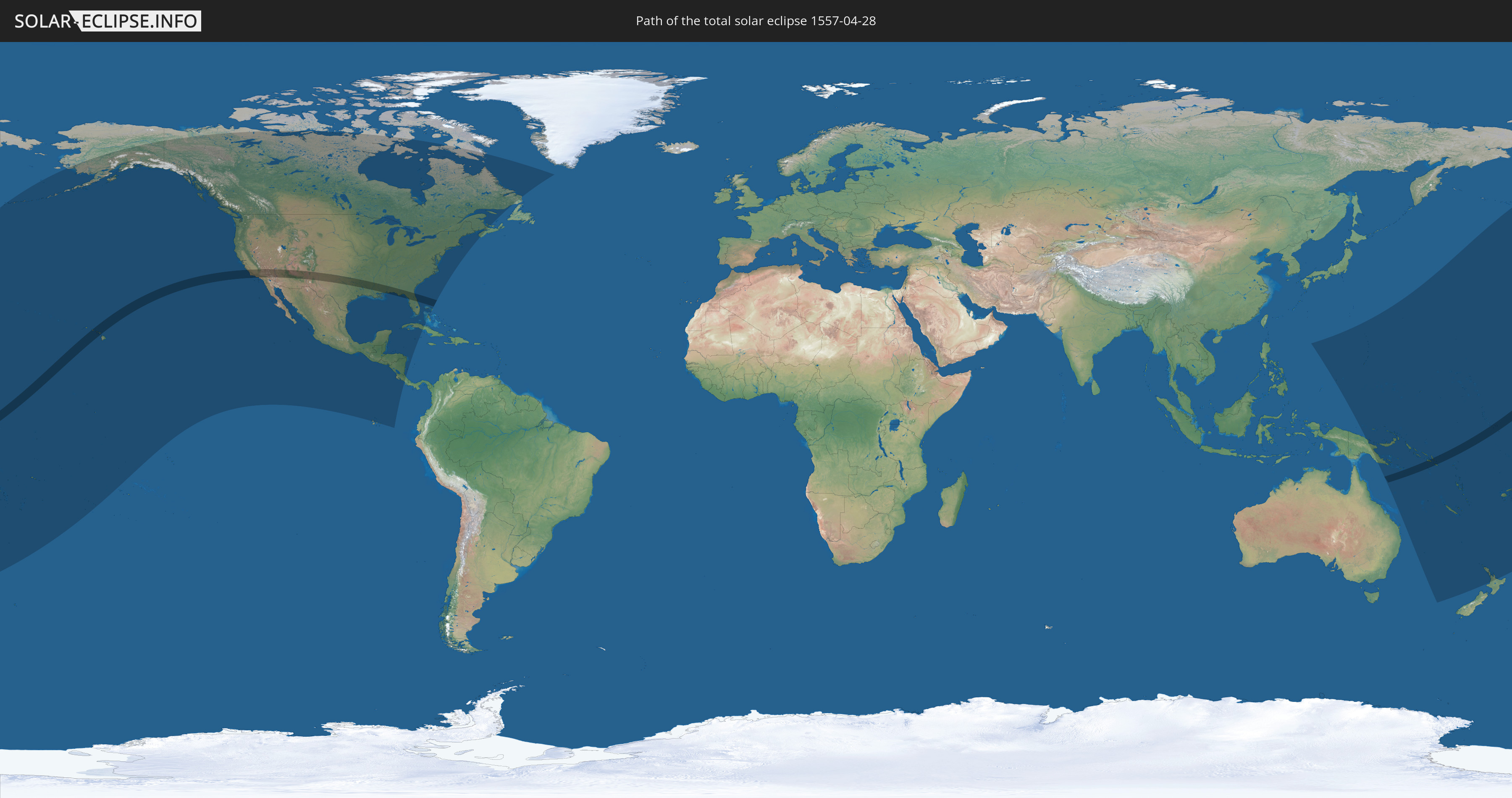
Die Sonnenfinsternis am 28.04.1557 kann man in 39 Ländern als partielle Sonnenfinsternis beobachten.
Der Finsternispfad verläuft durch 3 Länder. Nur in diesen Ländern ist sie als totale Sonnenfinsternis zu sehen.
In den folgenden Ländern ist die Sonnenfinsternis total zu sehen
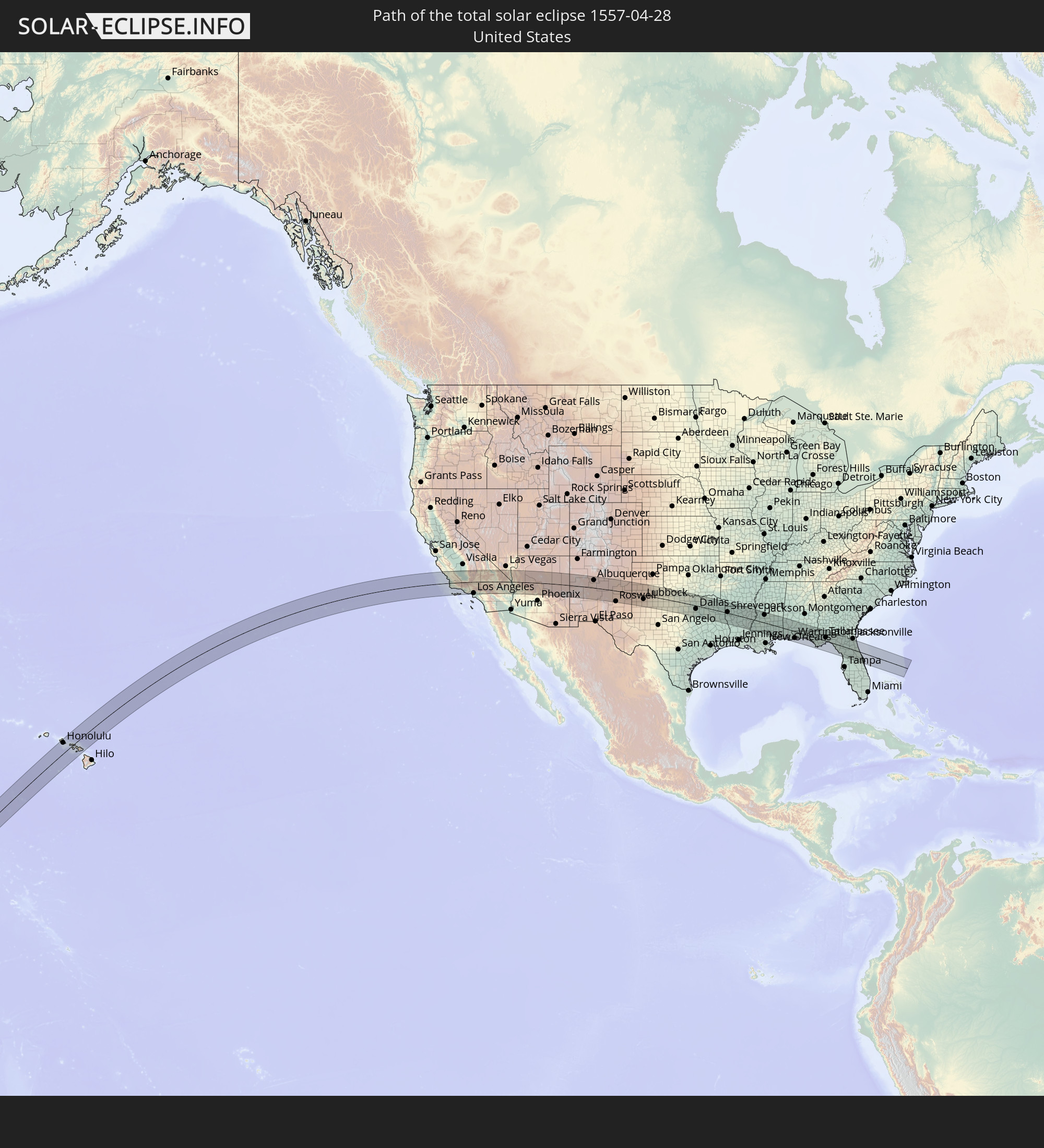 Vereinigte Staaten
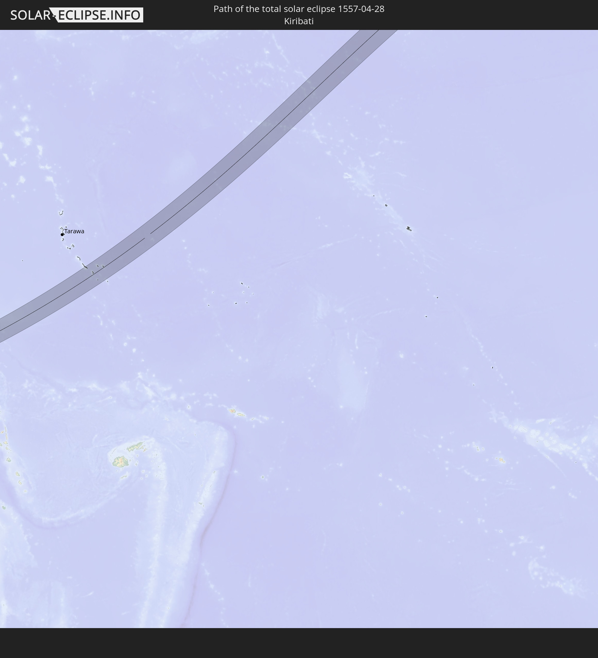 Kiribati
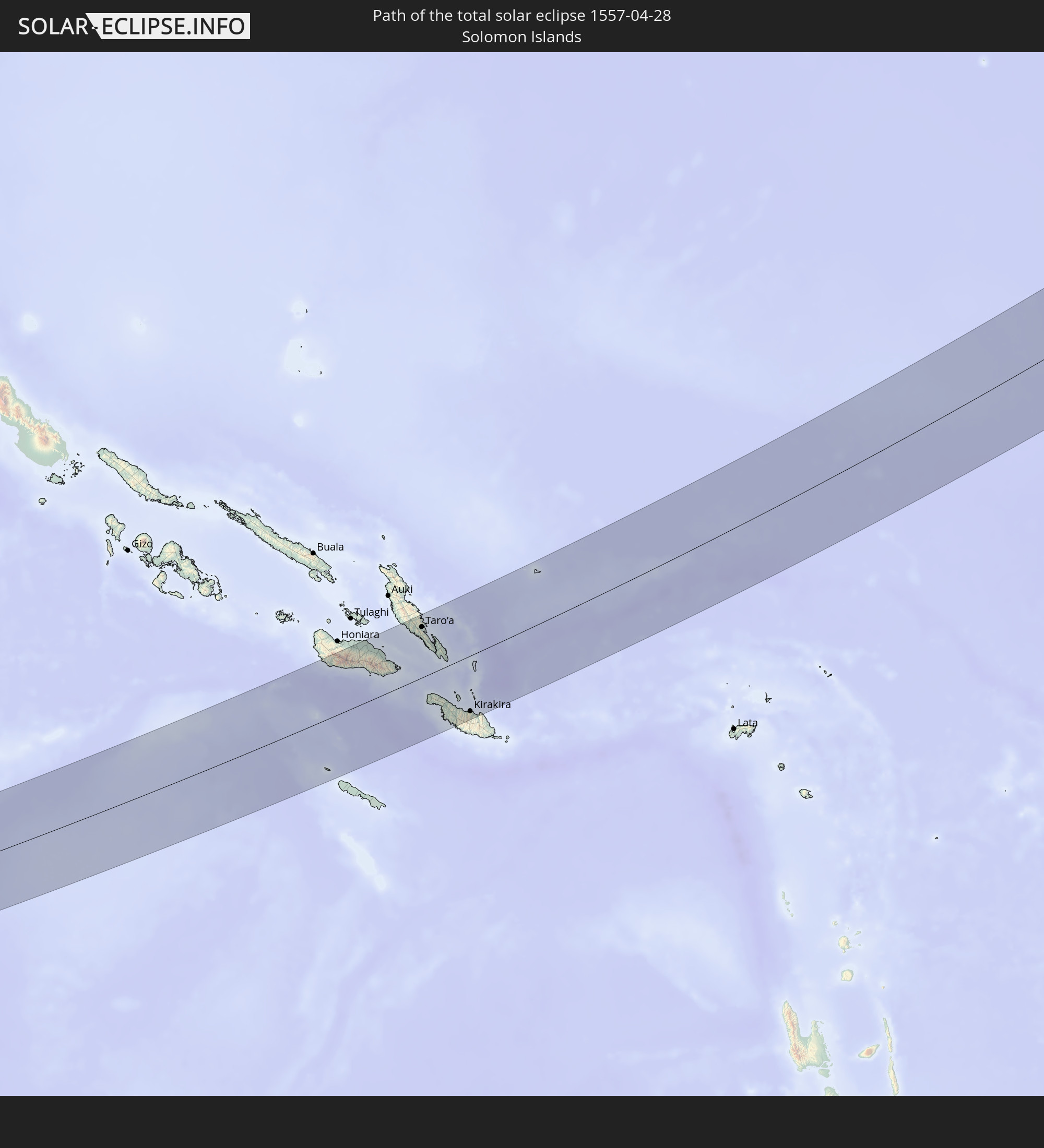 Salomonen
In den folgenden Ländern ist die Sonnenfinsternis partiell zu sehen
 Fidschi
 Vereinigte Staaten
 Neuseeland
 United States Minor Outlying Islands
 Wallis und Futuna
 Tonga
Tonga
 Kiribati
 Samoa
Samoa
 Tokelau
 Amerikanisch-Samoa
 Niue
Niue
 Cookinseln
 Französisch-Polynesien
 Kanada
 Mexiko
 Grönland
 Guatemala
 Ecuador
 El Salvador
 Honduras
 Belize
 Nicaragua
 Costa Rica
 Kuba
Kuba
 Kaimaninseln
 Bahamas
 Australien
 Japan
Japan
 Föderierte Staaten von Mikronesien
 Papua-Neuguinea
 Guam
Guam
 Nördliche Marianen
 Salomonen
 Neukaledonien
 Marshallinseln
 Vanuatu
 Nauru
Nauru
 Norfolkinsel
 Tuvalu
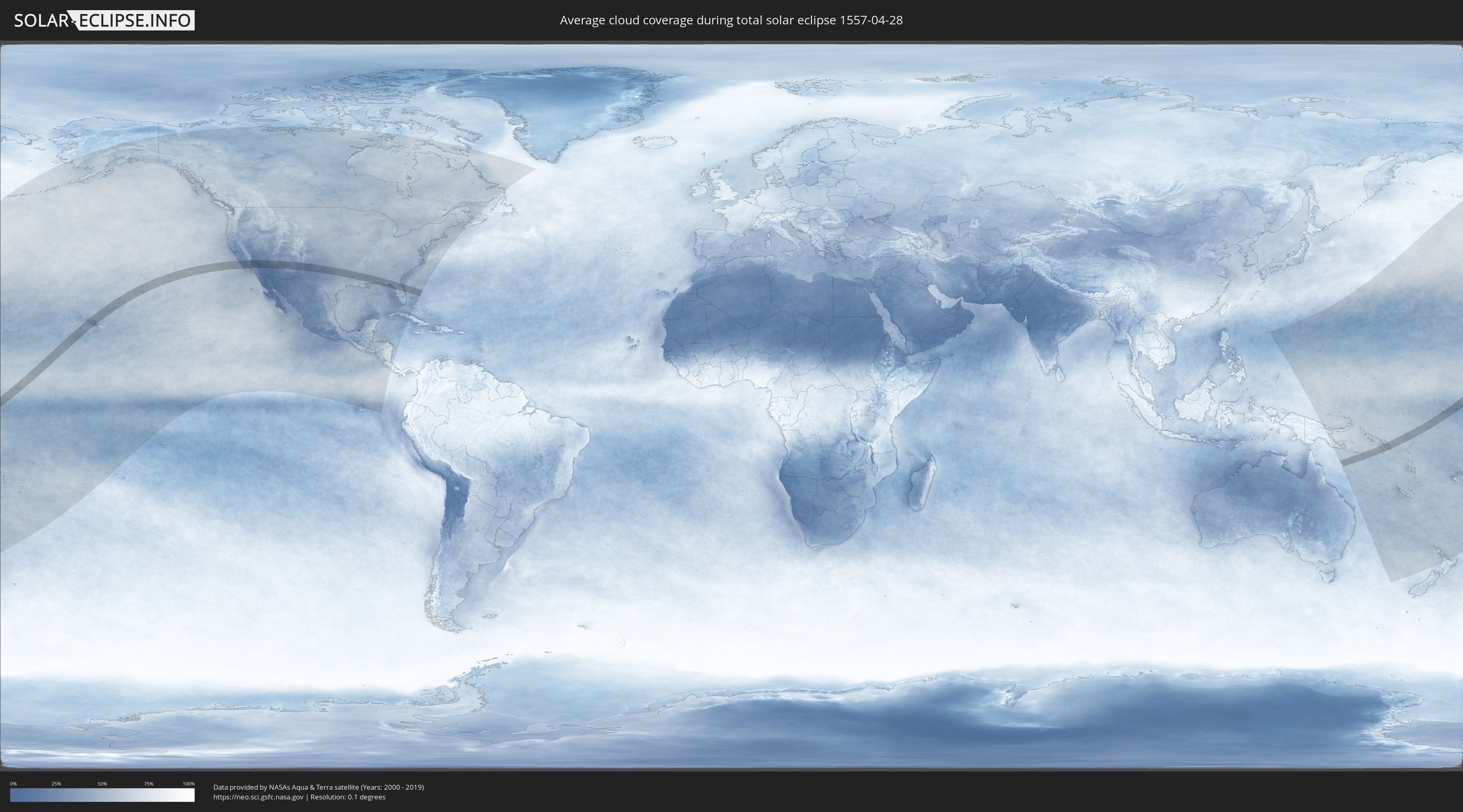
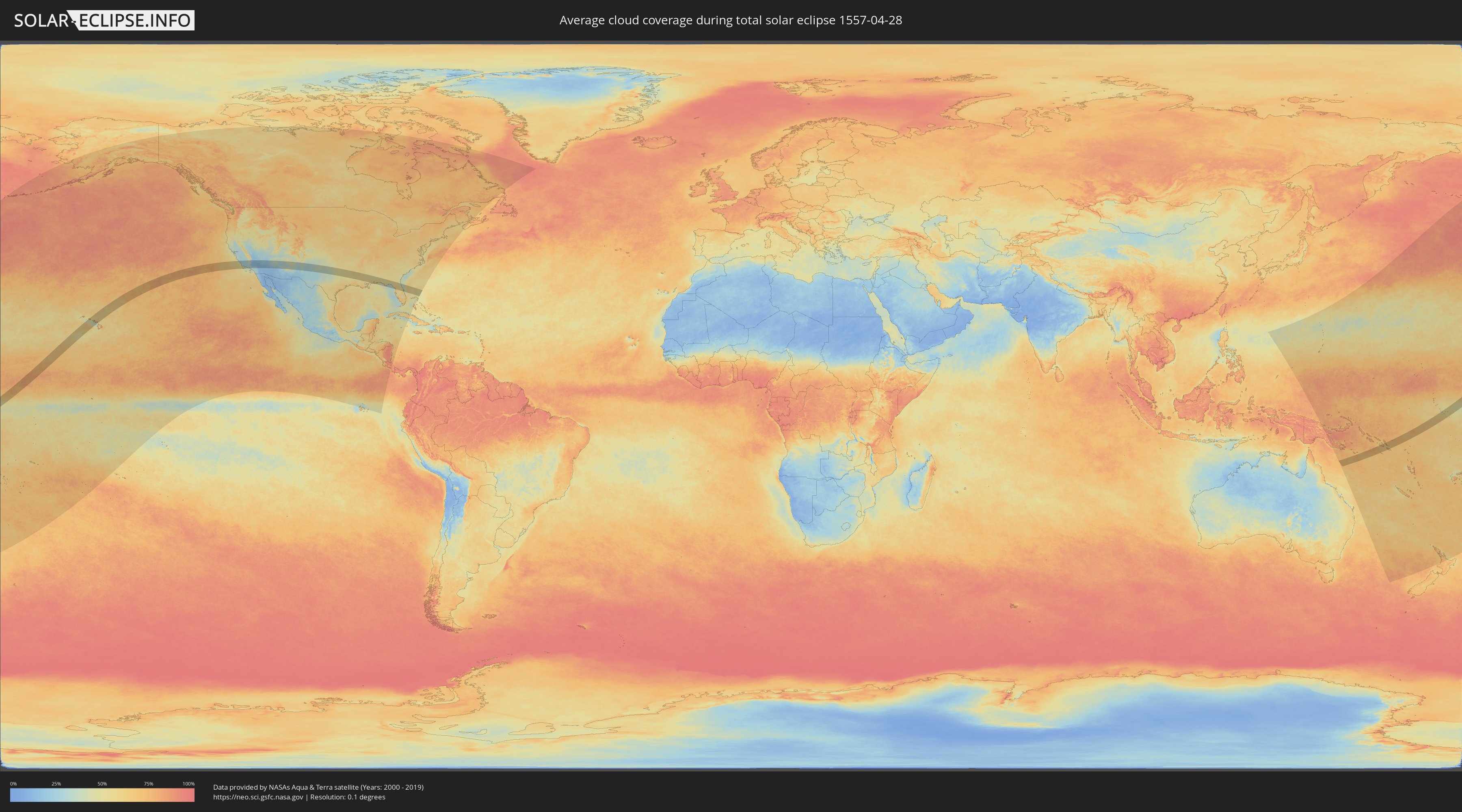
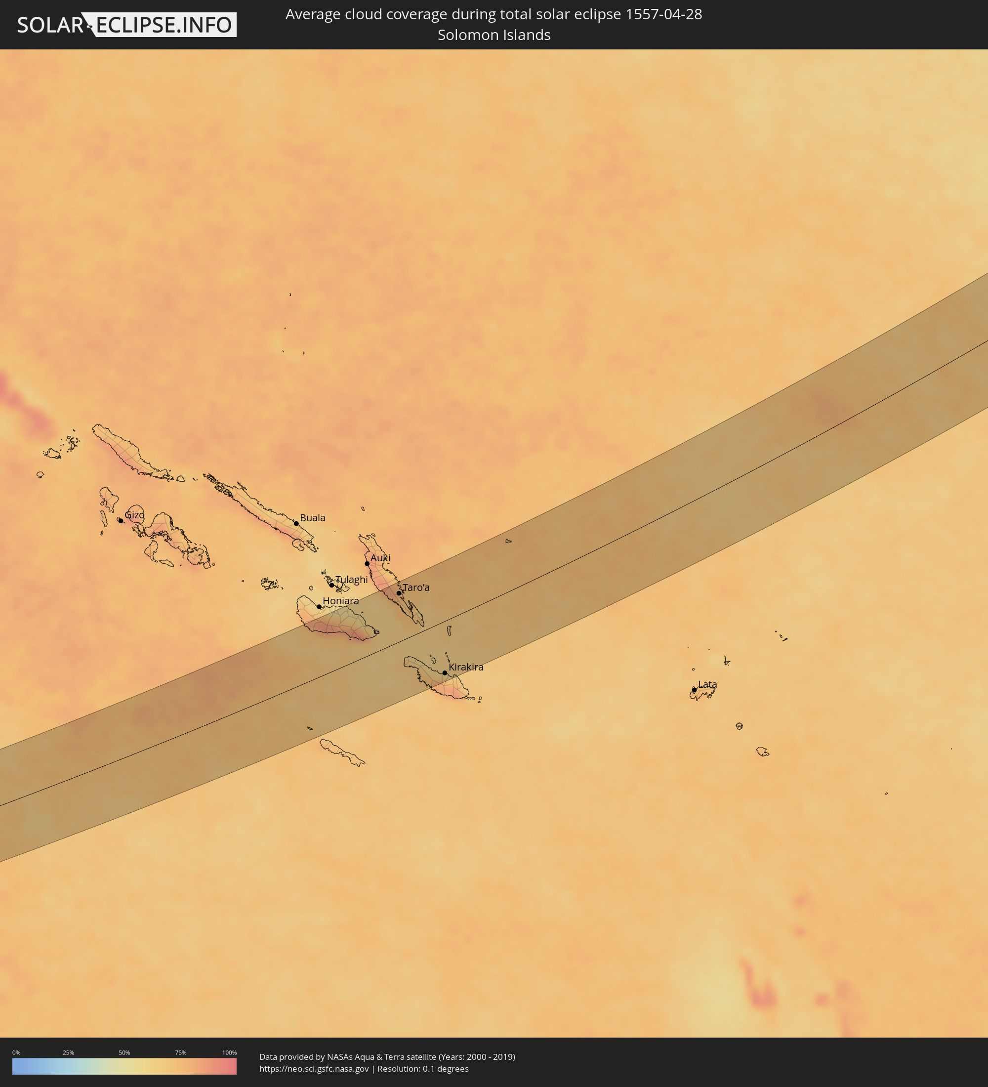
Wie wird das Wetter während der totalen Sonnenfinsternis am 28.04.1557?
Wo ist der beste Ort, um die totale Sonnenfinsternis vom 28.04.1557 zu beobachten?
Die folgenden Karten zeigen die durchschnittliche Bewölkung für den Tag, an dem die totale Sonnenfinsternis
stattfindet. Mit Hilfe der Karten lässt sich der Ort entlang des Finsternispfades eingrenzen,
der die besten Aussichen auf einen klaren wolkenfreien Himmel bietet.
Trotzdem muss man immer lokale Gegenenheiten beachten und sollte sich genau über das Wetter an seinem
gewählten Beobachtungsort informieren.
Die Daten stammen von den beiden NASA-Satelliten
AQUA und TERRA
und wurden über einen Zeitraum von 19 Jahren (2000 - 2019) gemittelt.
Detaillierte Länderkarten
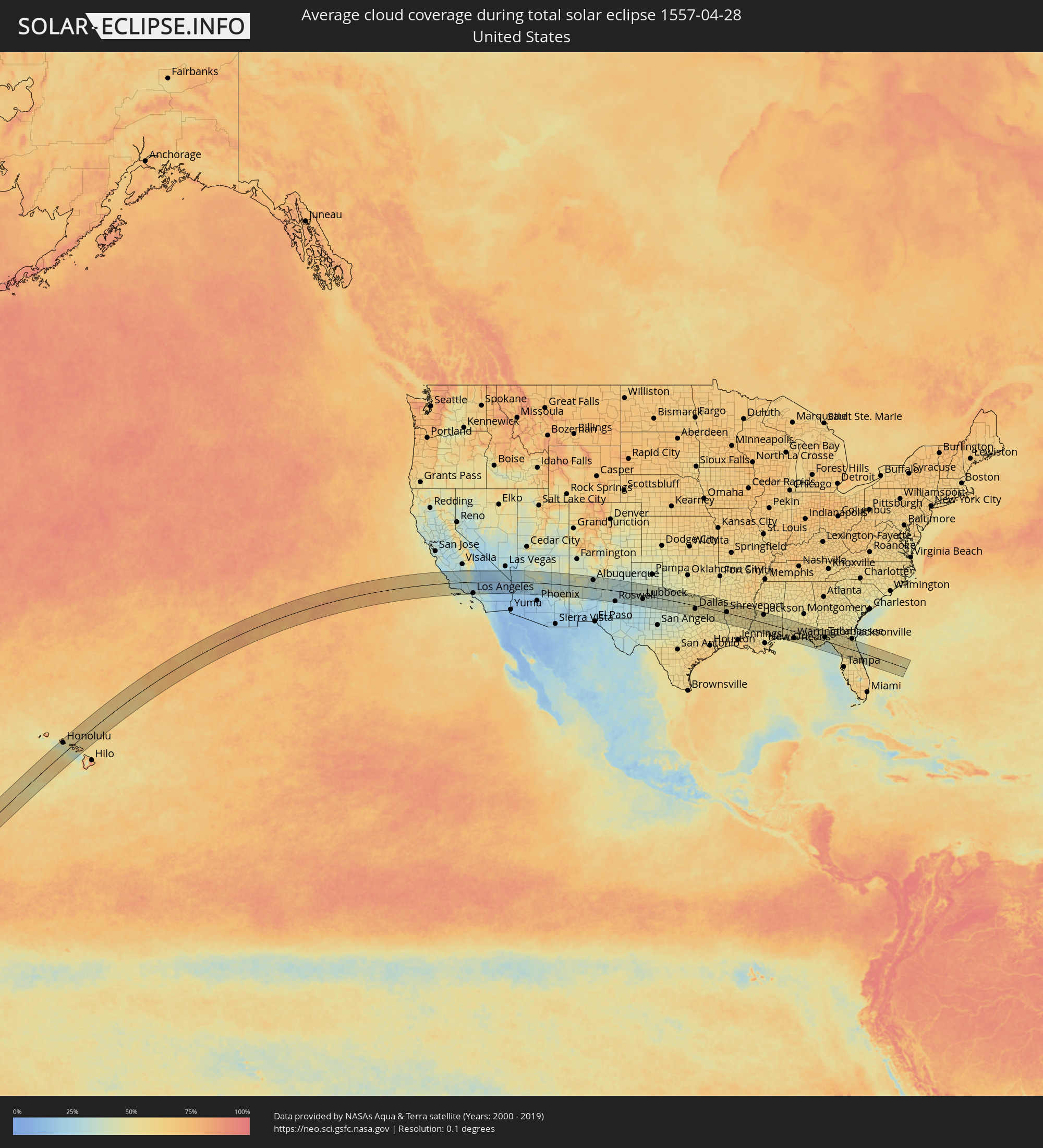 Vereinigte Staaten
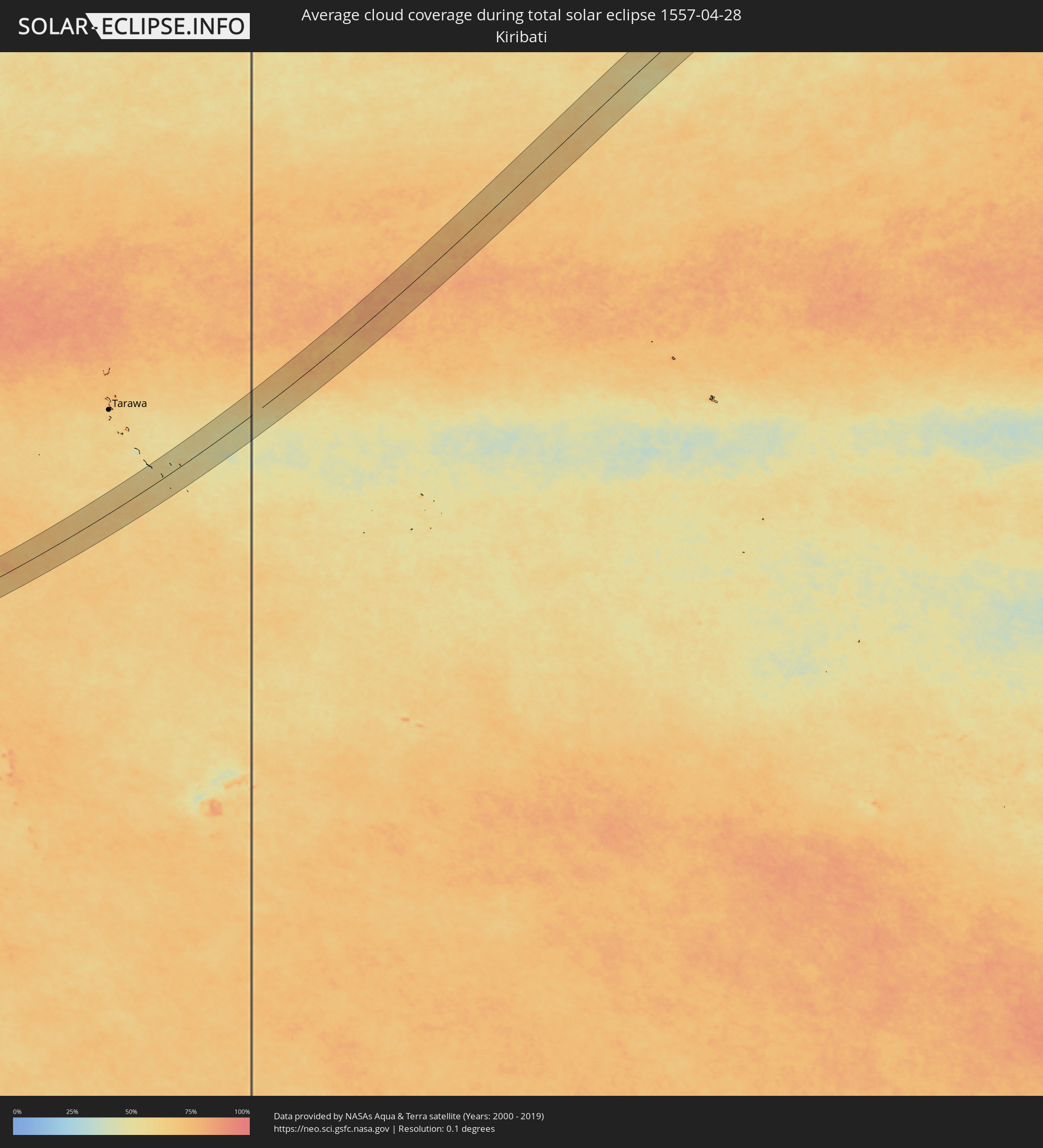 Kiribati
 Salomonen
Orte im Finsternispfad
Die nachfolgene Tabelle zeigt Städte und Orte mit mehr als 5.000 Einwohnern, die sich im Finsternispfad befinden. Städte mit mehr als 100.000 Einwohnern sind dick gekennzeichnet. Mit einem Klick auf den Ort öffnet sich eine Detailkarte die die Lage des jeweiligen Ortes zusammen mit dem Verlauf der zentralen Finsternis präsentiert.
| Ort | Typ | Dauer der Verfinsterung | Ortszeit bei maximaler Verfinsterung | Entfernung zur Zentrallinie | Ø Bewölkung |
|
Pearl City, Hawaii
|
total | - | 11:12:32 UTC-10:30 | 97 km | 66% |
|
Honolulu, Hawaii
|
total | - | 11:12:35 UTC-10:30 | 81 km | 58% |
|
Kailua, Hawaii
|
total | - | 11:12:59 UTC-10:30 | 81 km | 69% |
|
Kahului, Hawaii
|
total | - | 11:14:31 UTC-10:30 | 48 km | 73% |
|
Paso Robles, California
|
total | - | 15:09:34 UTC-08:00 | 87 km | 30% |
|
Atascadero, California
|
total | - | 15:09:36 UTC-08:00 | 71 km | 28% |
|
San Luis Obispo, California
|
total | - | 15:09:38 UTC-08:00 | 48 km | 29% |
|
Lompoc, California
|
total | - | 15:09:59 UTC-08:00 | 24 km | 38% |
|
Santa Maria, California
|
total | - | 15:09:59 UTC-08:00 | 10 km | 35% |
|
Santa Barbara, California
|
total | - | 15:11:04 UTC-08:00 | 53 km | 43% |
|
Wasco, California
|
total | - | 15:11:24 UTC-08:00 | 76 km | 30% |
|
Delano, California
|
total | - | 15:11:30 UTC-08:00 | 95 km | 33% |
|
Oxnard, California
|
total | - | 15:11:49 UTC-08:00 | 80 km | 40% |
|
Santa Paula, California
|
total | - | 15:11:57 UTC-08:00 | 63 km | 34% |
|
Bakersfield, California
|
total | - | 15:11:52 UTC-08:00 | 50 km | 32% |
|
Thousand Oaks, California
|
total | - | 15:12:17 UTC-08:00 | 84 km | 30% |
|
West Hills, California
|
total | - | 15:12:32 UTC-08:00 | 82 km | 31% |
|
Santa Clarita, California
|
total | - | 15:12:39 UTC-08:00 | 60 km | 31% |
|
Santa Monica, California
|
total | - | 15:12:46 UTC-08:00 | 102 km | 40% |
|
Van Nuys, California
|
total | - | 15:12:48 UTC-08:00 | 84 km | 31% |
|
Los Angeles, California
|
total | - | 15:13:06 UTC-08:00 | 99 km | 31% |
|
Lancaster, California
|
total | - | 15:13:09 UTC-08:00 | 27 km | 20% |
|
Altadena, California
|
total | - | 15:13:14 UTC-08:00 | 84 km | 35% |
|
El Monte, California
|
total | - | 15:13:23 UTC-08:00 | 98 km | 37% |
|
Pomona, California
|
total | - | 15:13:45 UTC-08:00 | 100 km | 35% |
|
Ridgecrest, California
|
total | - | 15:13:35 UTC-08:00 | 74 km | 15% |
|
Rancho Cucamonga, California
|
total | - | 15:13:58 UTC-08:00 | 94 km | 31% |
|
Victorville, California
|
total | - | 15:14:17 UTC-08:00 | 47 km | 17% |
|
San Bernardino, California
|
total | - | 15:14:21 UTC-08:00 | 95 km | 32% |
|
Barstow Heights, California
|
total | - | 15:14:31 UTC-08:00 | 10 km | 16% |
|
Yucaipa, California
|
total | - | 15:14:42 UTC-08:00 | 103 km | 32% |
|
Twentynine Palms, California
|
total | - | 15:15:56 UTC-08:00 | 92 km | 14% |
|
Bullhead City, Arizona
|
total | - | 16:17:29 UTC-07:00 | 22 km | 19% |
|
Lake Havasu City, Arizona
|
total | - | 16:17:57 UTC-07:00 | 51 km | 18% |
|
Kingman, Arizona
|
total | - | 16:18:04 UTC-07:00 | 28 km | 20% |
|
Prescott, Arizona
|
total | - | 16:20:02 UTC-07:00 | 39 km | 33% |
|
Prescott Valley, Arizona
|
total | - | 16:20:11 UTC-07:00 | 30 km | 27% |
|
Flagstaff, Arizona
|
total | - | 16:20:41 UTC-07:00 | 39 km | 38% |
|
Albuquerque, New Mexico
|
total | - | 16:25:29 UTC-07:00 | 68 km | 33% |
|
Enchanted Hills, New Mexico
|
total | - | 16:25:25 UTC-07:00 | 96 km | 34% |
|
Roswell, New Mexico
|
total | - | 16:28:00 UTC-07:00 | 93 km | 28% |
|
Clovis, New Mexico
|
total | - | 16:28:32 UTC-07:00 | 37 km | 32% |
|
Lubbock, Texas
|
total | - | 17:29:53 UTC-06:00 | 34 km | 36% |
|
Plainview, Texas
|
total | - | 17:29:41 UTC-06:00 | 35 km | 39% |
|
Wichita Falls, Texas
|
total | - | 17:31:48 UTC-06:00 | 61 km | 41% |
|
Weatherford, Texas
|
total | - | 17:32:47 UTC-06:00 | 51 km | 44% |
|
Cleburne, Texas
|
total | - | 17:33:13 UTC-06:00 | 88 km | 45% |
|
Burleson, Texas
|
total | - | 17:33:09 UTC-06:00 | 66 km | 49% |
|
Fort Worth, Texas
|
total | - | 17:33:03 UTC-06:00 | 46 km | 50% |
|
Keller, Texas
|
total | - | 17:32:59 UTC-06:00 | 21 km | 51% |
|
Mansfield, Texas
|
total | - | 17:33:14 UTC-06:00 | 60 km | 51% |
|
Denton, Texas
|
total | - | 17:32:54 UTC-06:00 | 11 km | 50% |
|
Arlington, Texas
|
total | - | 17:33:09 UTC-06:00 | 40 km | 49% |
|
Flower Mound, Texas
|
total | - | 17:33:01 UTC-06:00 | 10 km | 51% |
|
Carrollton, Texas
|
total | - | 17:33:09 UTC-06:00 | 12 km | 52% |
|
DeSoto, Texas
|
total | - | 17:33:22 UTC-06:00 | 51 km | 51% |
|
Waxahachie, Texas
|
total | - | 17:33:28 UTC-06:00 | 73 km | 49% |
|
Frisco, Texas
|
total | - | 17:33:05 UTC-06:00 | 11 km | 50% |
|
Dallas, Texas
|
total | - | 17:33:17 UTC-06:00 | 29 km | 52% |
|
Plano, Texas
|
total | - | 17:33:13 UTC-06:00 | 1 km | 50% |
|
McKinney, Texas
|
total | - | 17:33:10 UTC-06:00 | 20 km | 51% |
|
Sherman, Texas
|
total | - | 17:32:56 UTC-06:00 | 68 km | 49% |
|
Mesquite, Texas
|
total | - | 17:33:24 UTC-06:00 | 27 km | 52% |
|
Rowlett, Texas
|
total | - | 17:33:21 UTC-06:00 | 11 km | 50% |
|
Greenville, Texas
|
total | - | 17:33:26 UTC-06:00 | 24 km | 50% |
|
Paris, Texas
|
total | - | 17:33:25 UTC-06:00 | 92 km | 53% |
|
Tyler, Texas
|
total | - | 17:34:14 UTC-06:00 | 44 km | 53% |
|
Longview, Texas
|
total | - | 17:34:24 UTC-06:00 | 16 km | 51% |
|
Marshall, Texas
|
total | - | 17:34:32 UTC-06:00 | 3 km | 54% |
|
Shreveport, Louisiana
|
total | - | 17:34:47 UTC-06:00 | 9 km | 55% |
|
Alexandria, Louisiana
|
total | - | 17:35:54 UTC-06:00 | 92 km | 53% |
|
Monroe, Louisiana
|
total | - | 17:35:23 UTC-06:00 | 45 km | 55% |
|
Vicksburg, Mississippi
|
total | - | 17:35:52 UTC-06:00 | 58 km | 51% |
|
Jackson, Mississippi
|
total | - | 17:36:06 UTC-06:00 | 69 km | 53% |
|
Madison, Mississippi
|
total | - | 17:36:01 UTC-06:00 | 89 km | 51% |
|
Hattiesburg, Mississippi
|
total | - | 17:36:50 UTC-06:00 | 12 km | 53% |
|
Mobile, Alabama
|
total | - | 17:37:27 UTC-06:00 | 47 km | 52% |
|
Cantonment, Florida
|
total | - | 17:37:38 UTC-06:00 | 37 km | 56% |
|
East Pensacola Heights, Florida
|
total | - | 17:37:45 UTC-06:00 | 52 km | 63% |
|
Navarre, Florida
|
total | - | 17:37:49 UTC-06:00 | 46 km | 60% |
|
Wright, Florida
|
total | - | 17:37:49 UTC-06:00 | 34 km | 54% |
|
Enterprise, Alabama
|
total | - | 17:37:30 UTC-06:00 | 79 km | 55% |
|
Panama City, Florida
|
total | - | 17:38:07 UTC-06:00 | 38 km | 49% |
|
Dothan, Alabama
|
total | - | 17:37:37 UTC-06:00 | 82 km | 53% |
|
Tallahassee, Florida
|
total | - | 18:38:08 UTC-05:00 | 31 km | 51% |
|
Gainesville, Florida
|
total | - | 18:38:38 UTC-05:00 | 5 km | 55% |
|
Ocala, Florida
|
total | - | 18:38:52 UTC-05:00 | 39 km | 58% |
|
The Villages, Florida
|
total | - | 18:38:59 UTC-05:00 | 60 km | 51% |
|
Lakeside, Florida
|
total | - | 18:38:25 UTC-05:00 | 72 km | 52% |
|
Apopka, Florida
|
total | - | 18:39:06 UTC-05:00 | 73 km | 56% |
|
Orlando, Florida
|
total | - | 18:39:10 UTC-05:00 | 84 km | 58% |
|
Winter Springs, Florida
|
total | - | 18:39:06 UTC-05:00 | 65 km | 57% |
|
Deltona, Florida
|
total | - | 18:39:00 UTC-05:00 | 42 km | 54% |
|
Alafaya, Florida
|
total | - | 18:39:09 UTC-05:00 | 76 km | 59% |
|
Palm Coast, Florida
|
total | - | 18:38:41 UTC-05:00 | 32 km | 45% |
|
Daytona Beach, Florida
|
total | - | 18:38:52 UTC-05:00 | 2 km | 46% |
|
New Smyrna Beach, Florida
|
total | - | 18:38:57 UTC-05:00 | 19 km | 49% |
|
Titusville, Florida
|
total | - | 18:39:08 UTC-05:00 | 58 km | 57% |
|
Rockledge, Florida
|
total | - | 18:39:15 UTC-05:00 | 84 km | 55% |
|
Merritt Island, Florida
|
total | - | 18:39:10 UTC-05:00 | 62 km | 52% |
|
Taro’a, Choiseul
|
total | - | 06:56:50 UTC+10:39 | 75 km | 77% |
|
Kirakira, Makira
|
total | - | 06:56:08 UTC+10:39 | 82 km | 78% |