Totale Sonnenfinsternis vom 12.08.1654
| Wochentag: | Mittwoch |
| Maximale Dauer der Verfinsterung: | 02m16s |
| Maximale Breite des Finsternispfades: | 110 km |
| Saroszyklus: | 120 |
| Bedeckungsgrad: | 100% |
| Magnitude: | 1.0285 |
| Gamma: | 0.4962 |
Wo kann man die Sonnenfinsternis vom 12.08.1654 sehen?
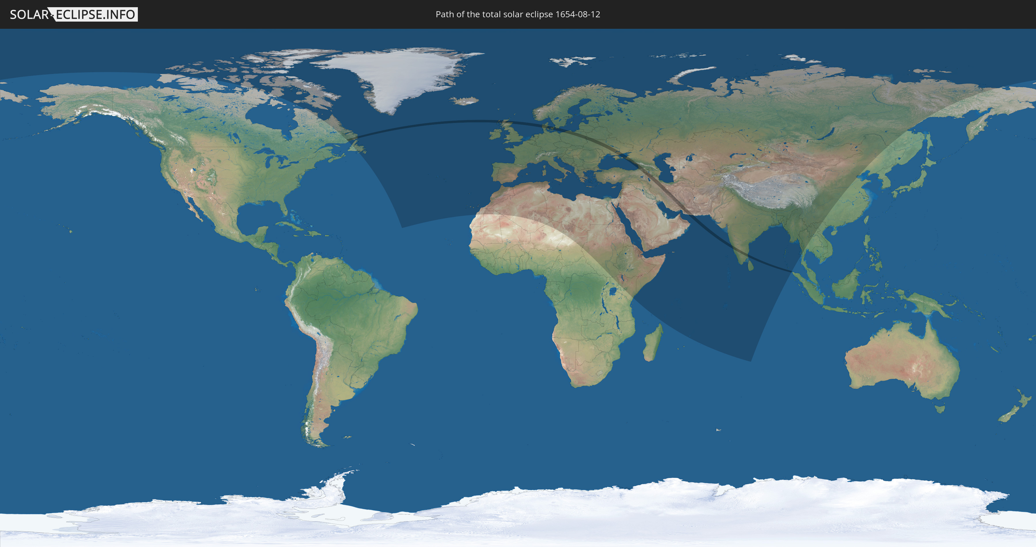
Die Sonnenfinsternis am 12.08.1654 kann man in 110 Ländern als partielle Sonnenfinsternis beobachten.
Der Finsternispfad verläuft durch 15 Länder. Nur in diesen Ländern ist sie als totale Sonnenfinsternis zu sehen.
In den folgenden Ländern ist die Sonnenfinsternis total zu sehen
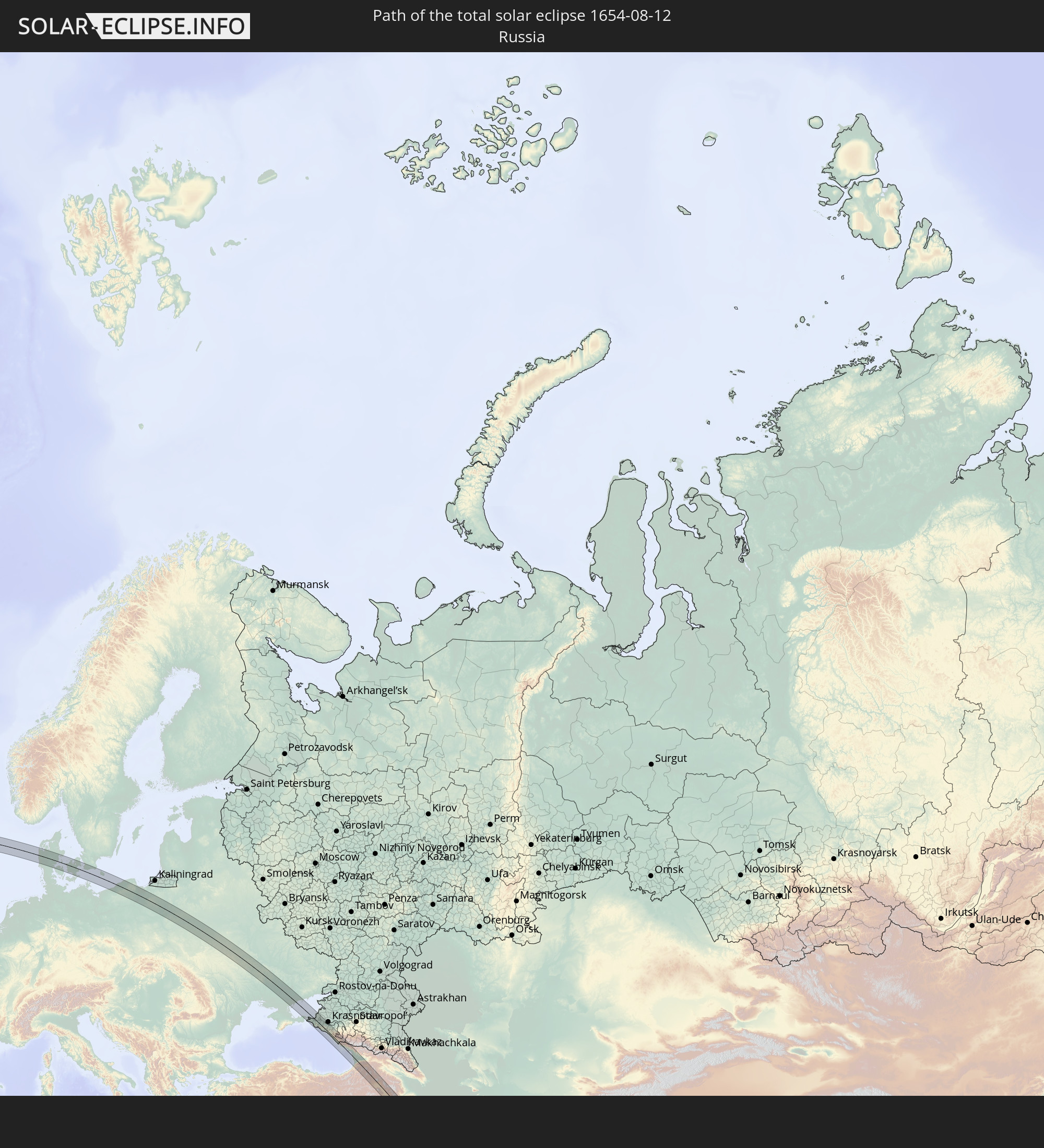 Russland
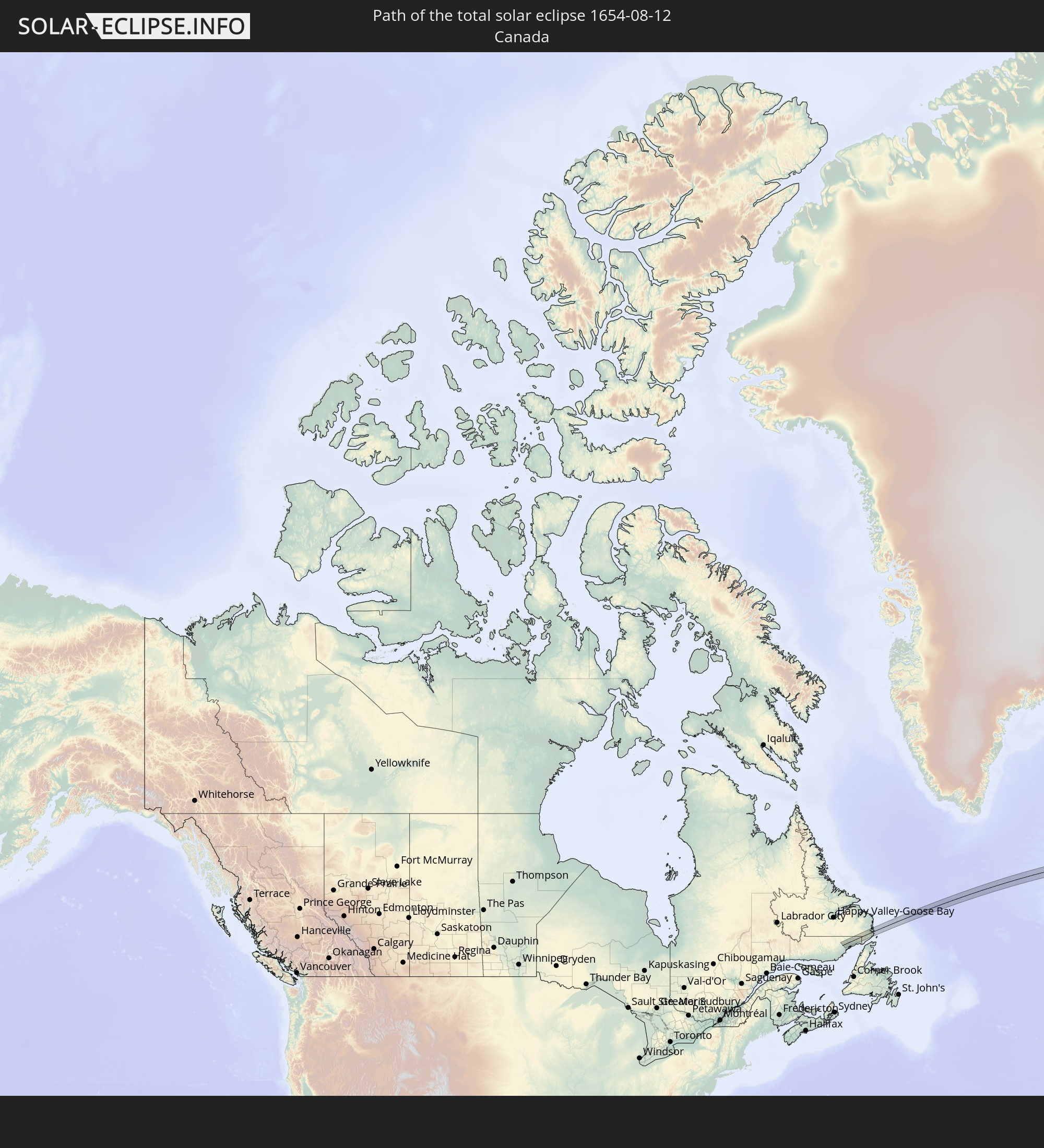 Kanada
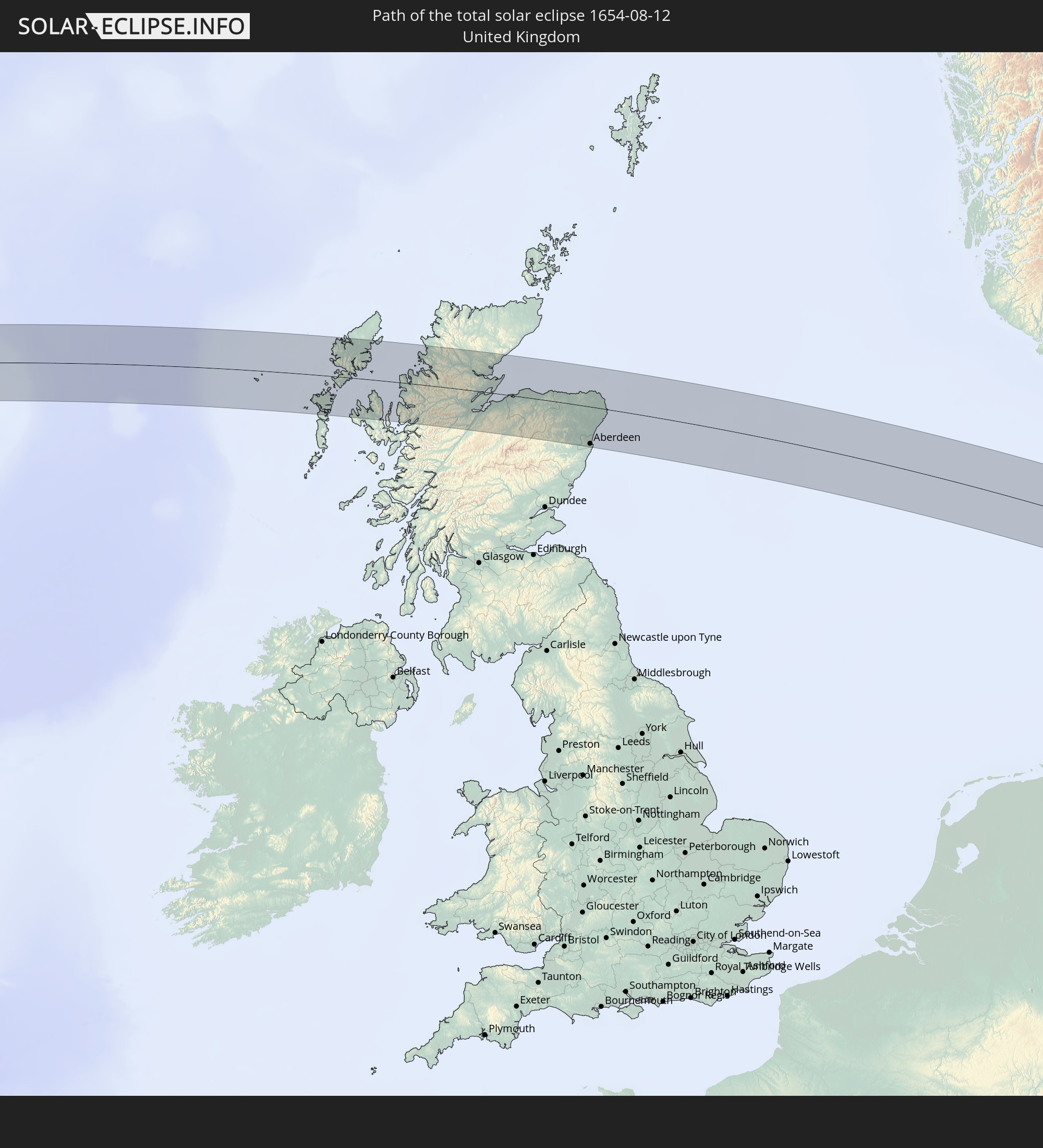 Vereinigtes Königreich
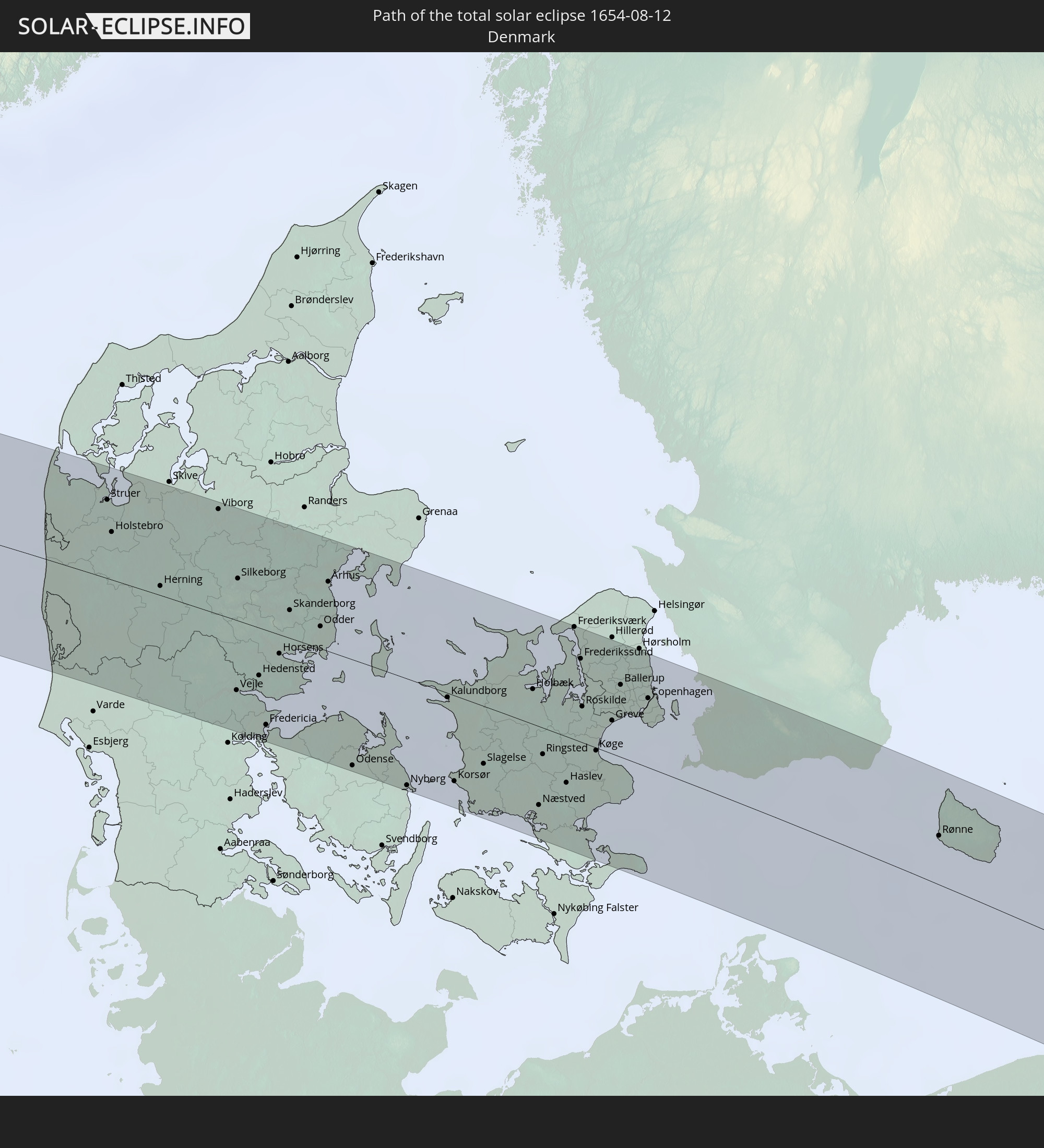 Dänemark
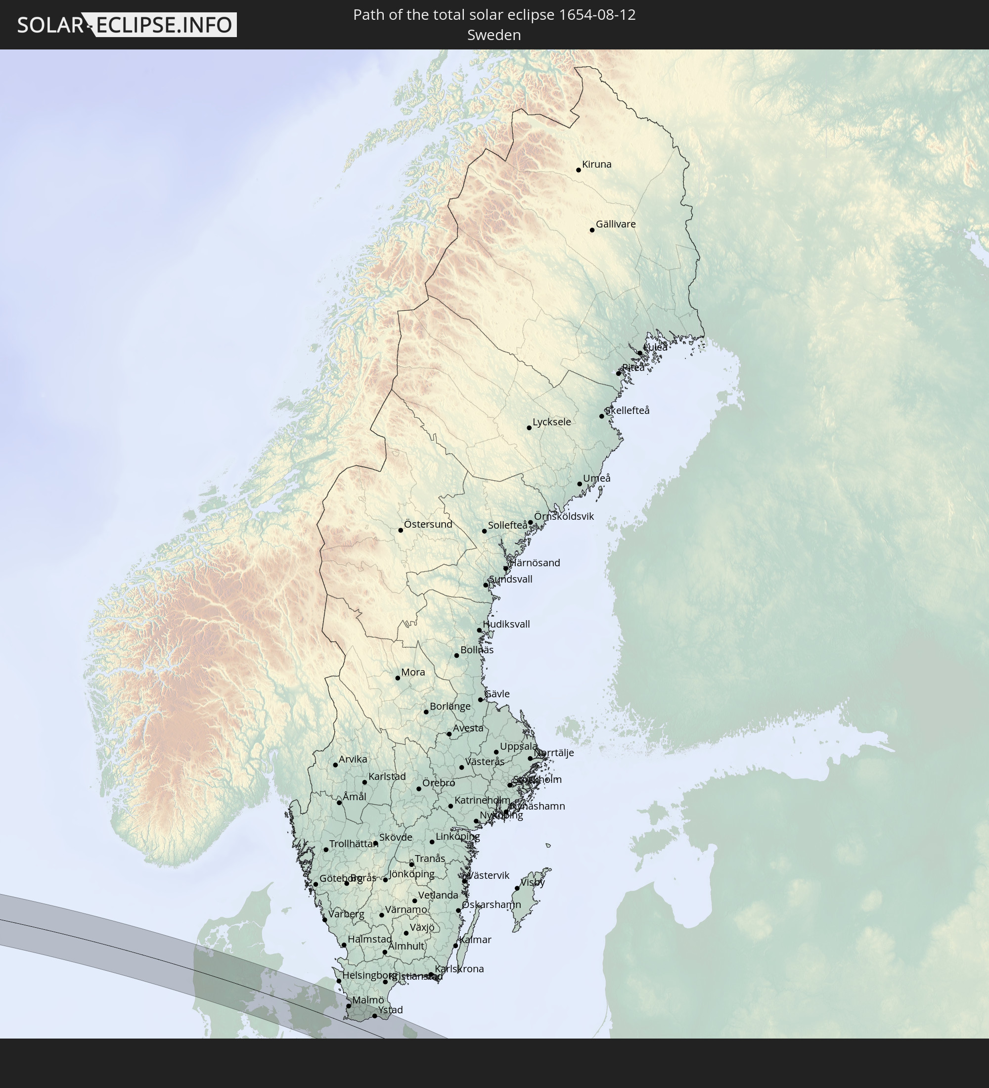 Schweden
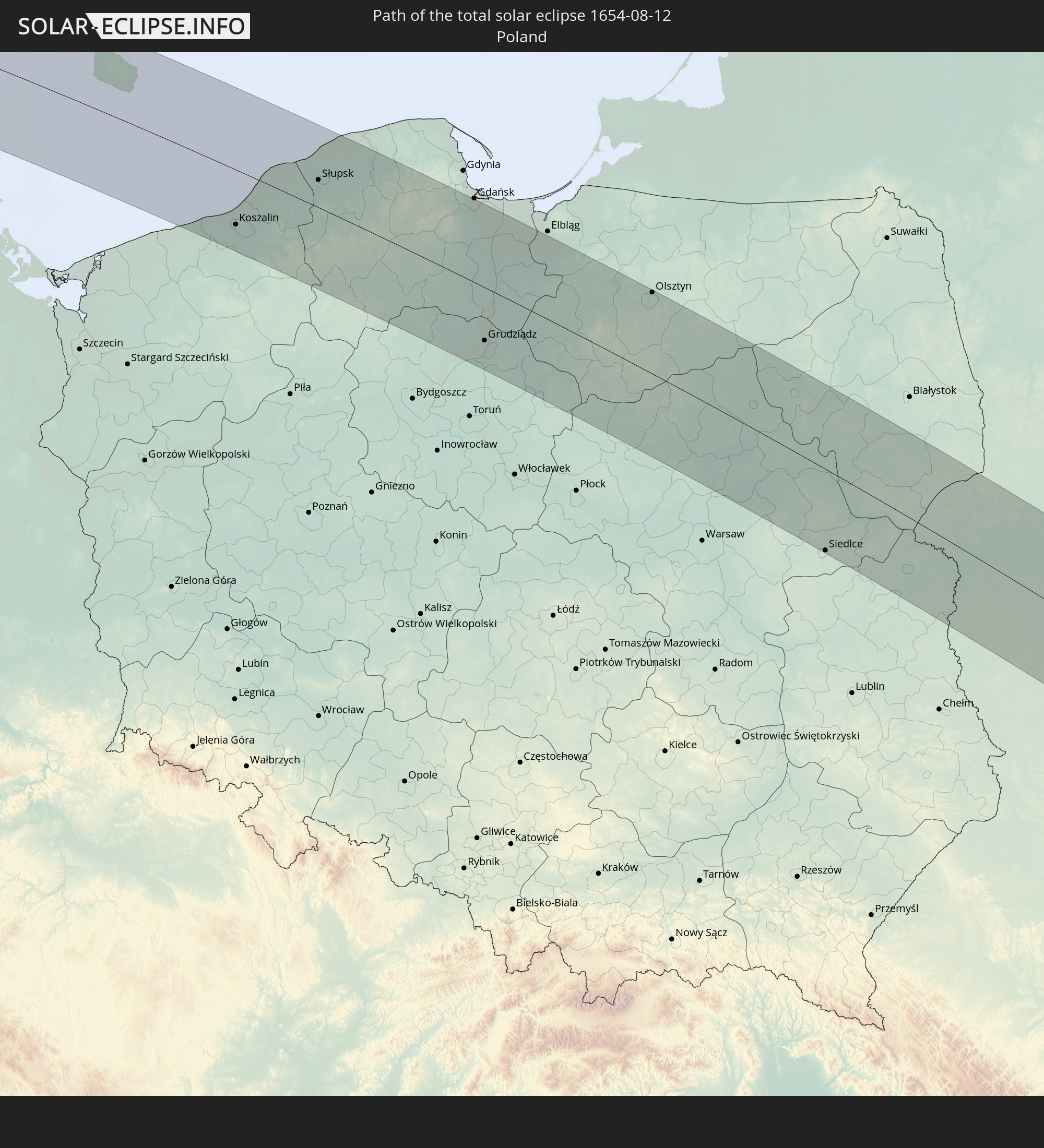 Polen
Polen
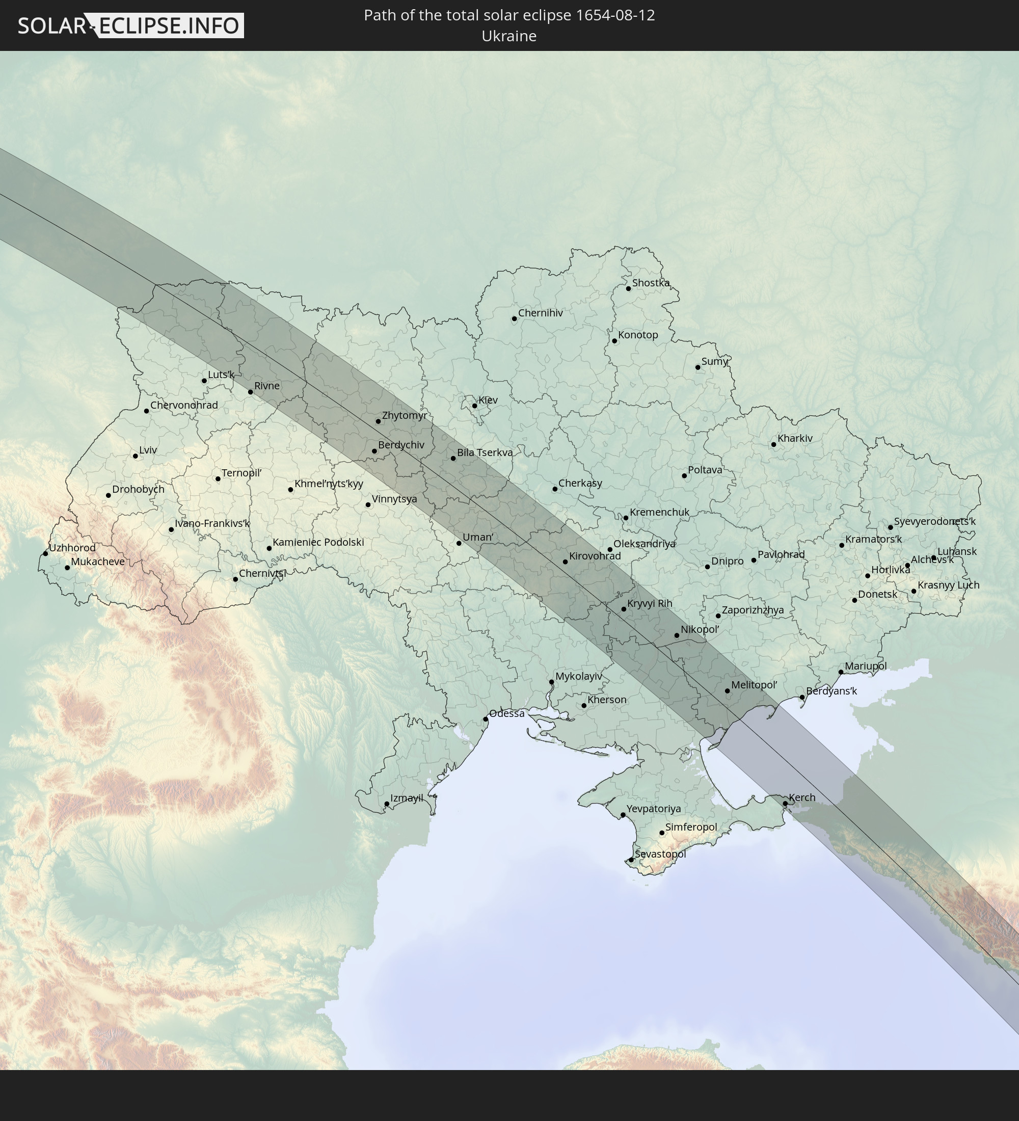 Ukraine
 Weißrussland
 Türkei
 Georgien
 Armenien
 Iran
Iran
 Aserbaidschan
 Indien
 Indonesien
In den folgenden Ländern ist die Sonnenfinsternis partiell zu sehen
 Russland
 Kanada
 Grönland
 Portugal
 Island
 Spanien
 Mauretanien
 Marokko
 Irland
 Spitzbergen
 Algerien
 Vereinigtes Königreich
 Färöer
 Gibraltar
 Frankreich
 Isle of Man
 Guernsey
 Jersey
 Niger
Niger
 Andorra
 Belgien
 Niederlande
 Norwegen
 Luxemburg
 Deutschland
 Schweiz
 Italien
 Monaco
 Tunesien
 Dänemark
 Libyen
 Liechtenstein
 Österreich
 Schweden
 Tschechien
 San Marino
 Vatikanstadt
 Slowenien
 Tschad
 Kroatien
 Polen
Polen
 Malta
Malta
 Bosnien und Herzegowina
 Ungarn
 Slowakei
 Montenegro
 Serbien
 Albanien
 Åland Islands
 Griechenland
 Rumänien
 Mazedonien
 Finnland
 Litauen
 Lettland
 Estland
 Sudan
Sudan
 Ukraine
 Bulgarien
 Weißrussland
 Ägypten
 Türkei
 Moldawien
 Uganda
 Republik Zypern
 Äthiopien
 Kenia
Kenia
 Staat Palästina
 Israel
 Saudi-Arabien
 Jordanien
 Libanon
 Syrien
 Eritrea
 Irak
Irak
 Georgien
 Somalia
 Dschibuti
 Jemen
Jemen
 Armenien
 Iran
Iran
 Aserbaidschan
 Seychellen
 Kasachstan
 Kuwait
 Bahrain
 Katar
Katar
 Vereinigte Arabische Emirate
 Oman
Oman
 Turkmenistan
 Usbekistan
 Mauritius
 Afghanistan
 Pakistan
 Tadschikistan
 Indien
 Kirgisistan
 Britisches Territorium im Indischen Ozean
 Malediven
 Volksrepublik China
 Sri Lanka
 Nepal
Nepal
 Mongolei
 Bangladesch
 Bhutan
 Myanmar
 Indonesien
 Thailand
 Laos
Laos
 Vietnam
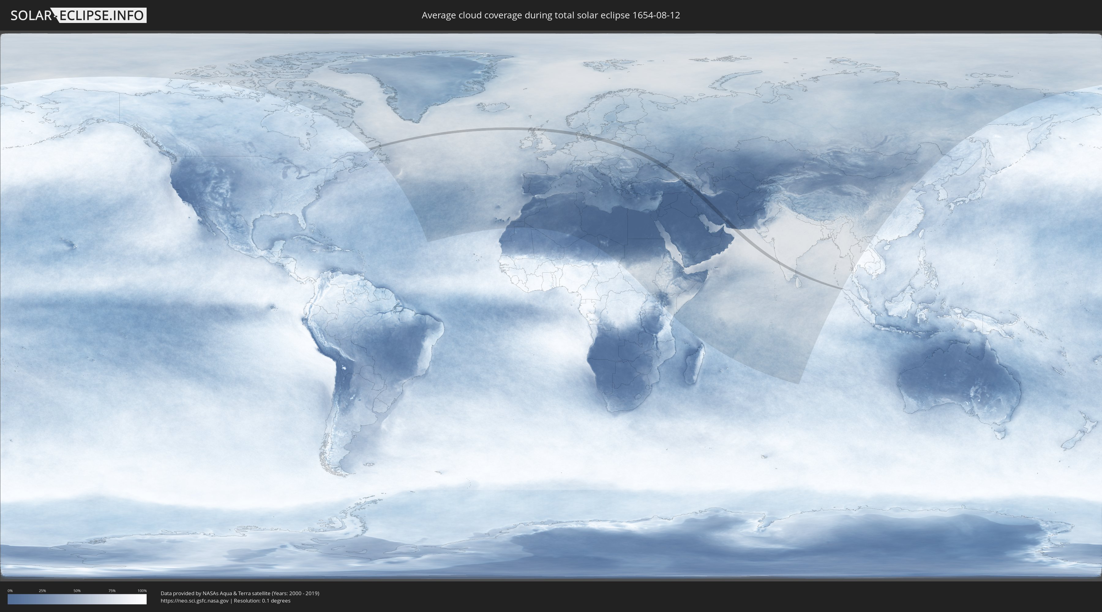
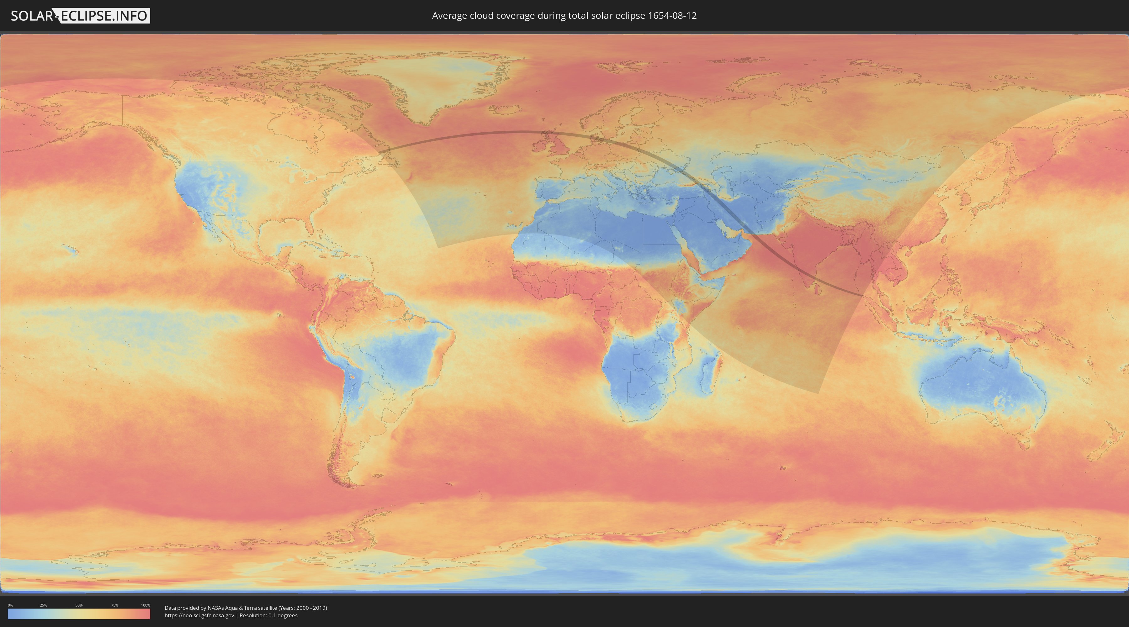
Wie wird das Wetter während der totalen Sonnenfinsternis am 12.08.1654?
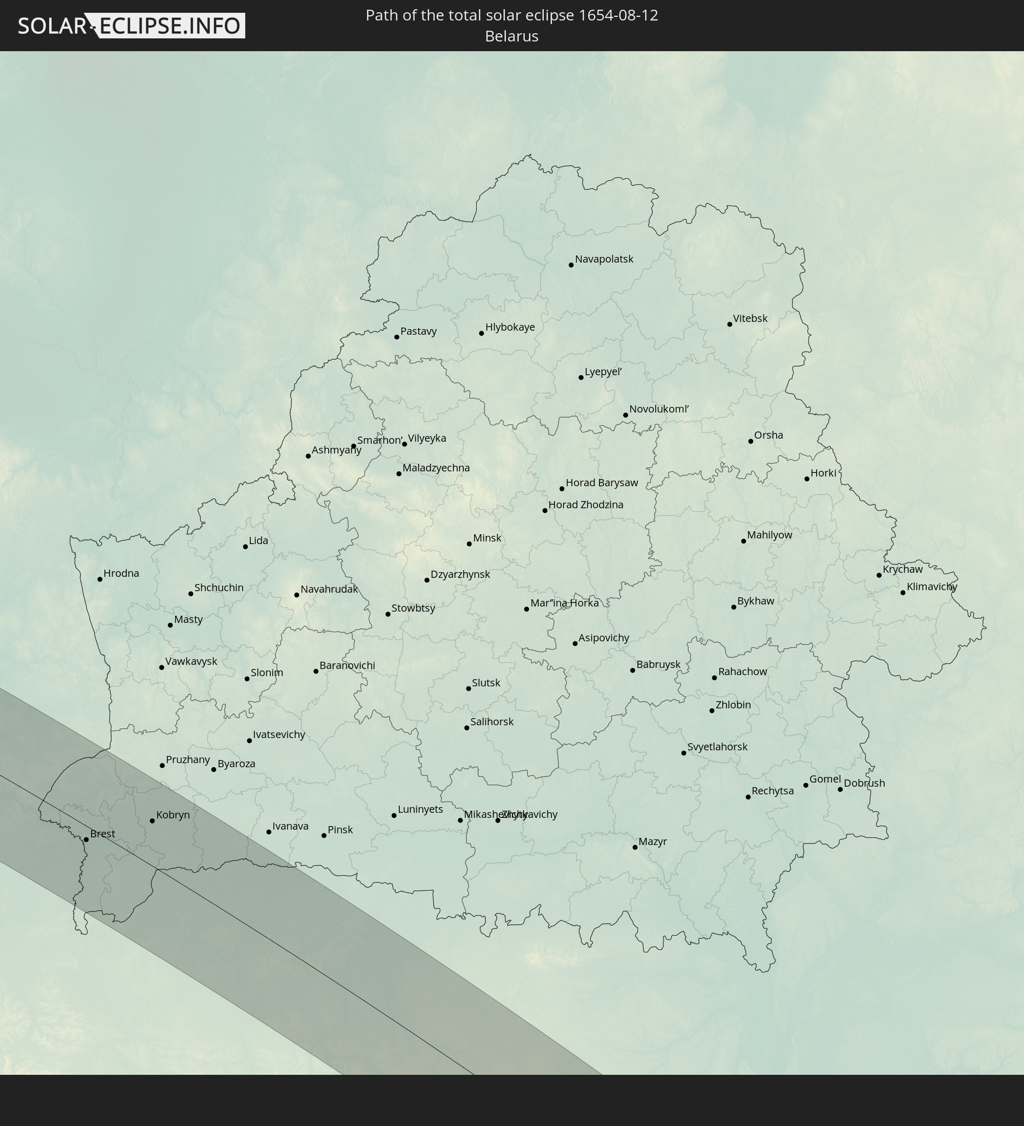
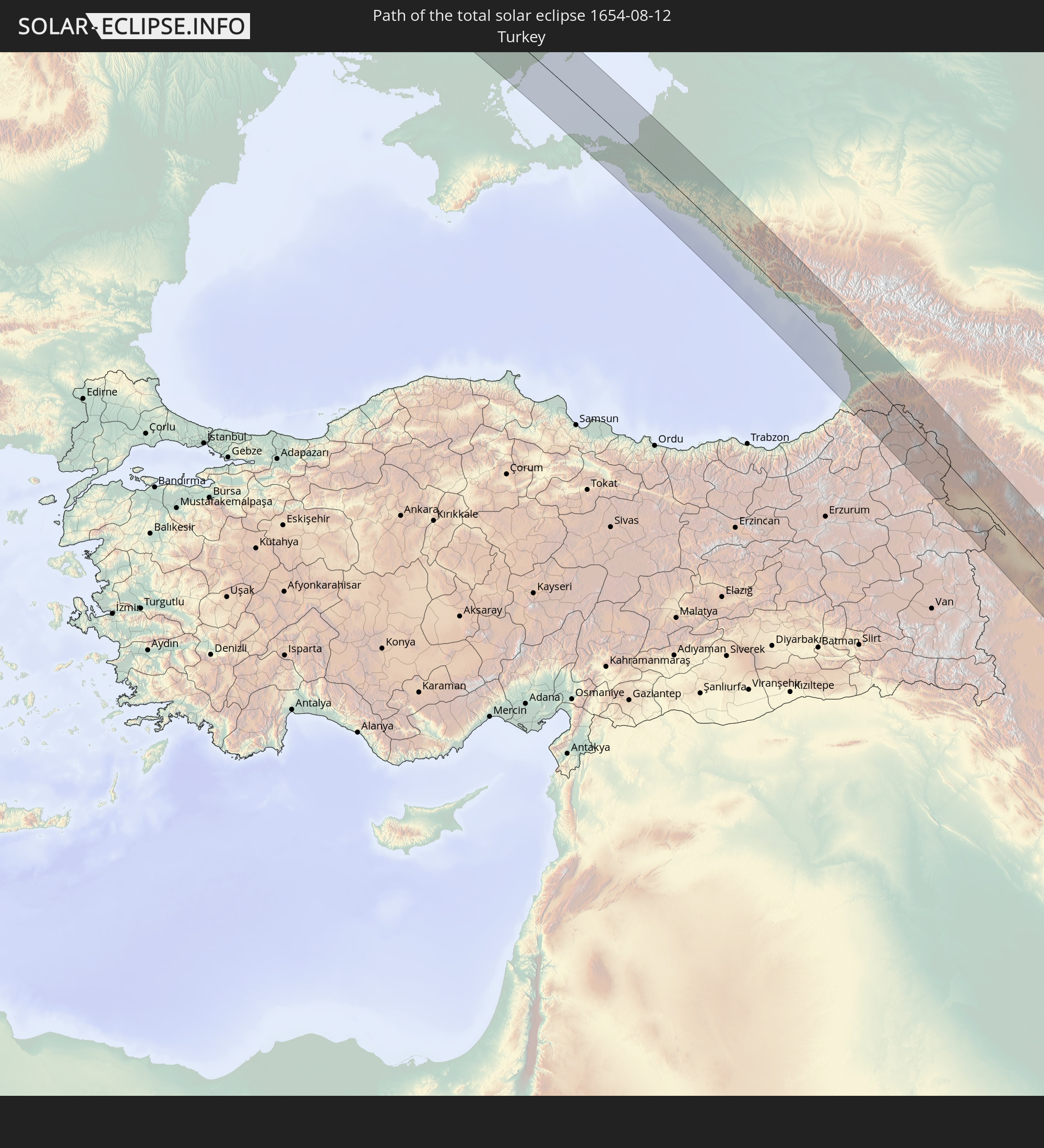
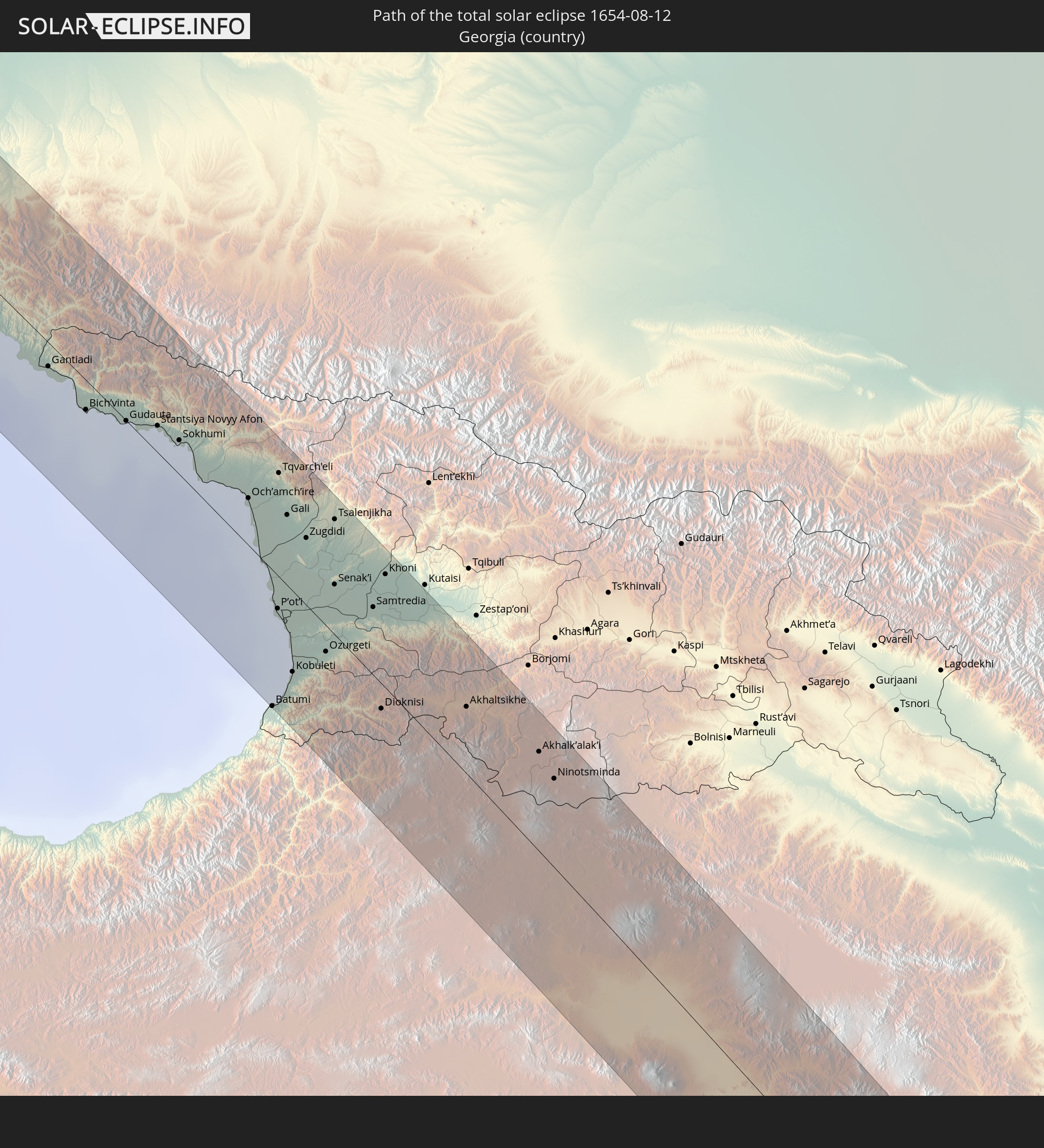
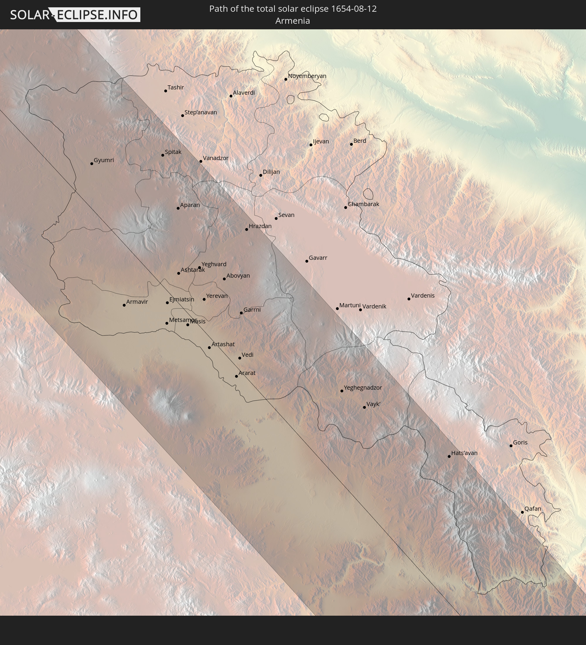
Wo ist der beste Ort, um die totale Sonnenfinsternis vom 12.08.1654 zu beobachten?
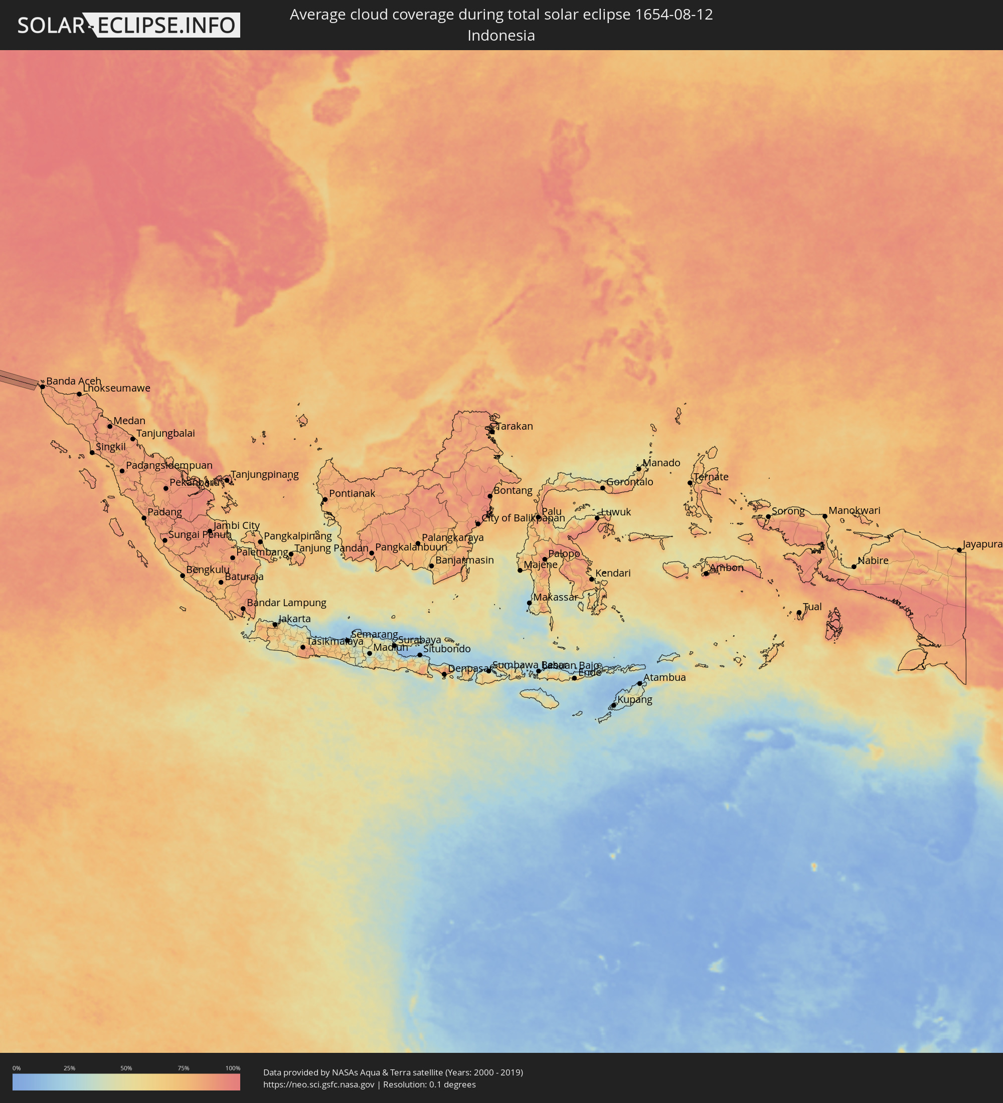
Die folgenden Karten zeigen die durchschnittliche Bewölkung für den Tag, an dem die totale Sonnenfinsternis
stattfindet. Mit Hilfe der Karten lässt sich der Ort entlang des Finsternispfades eingrenzen,
der die besten Aussichen auf einen klaren wolkenfreien Himmel bietet.
Trotzdem muss man immer lokale Gegenenheiten beachten und sollte sich genau über das Wetter an seinem
gewählten Beobachtungsort informieren.
Die Daten stammen von den beiden NASA-Satelliten
AQUA und TERRA
und wurden über einen Zeitraum von 19 Jahren (2000 - 2019) gemittelt.
Detaillierte Länderkarten
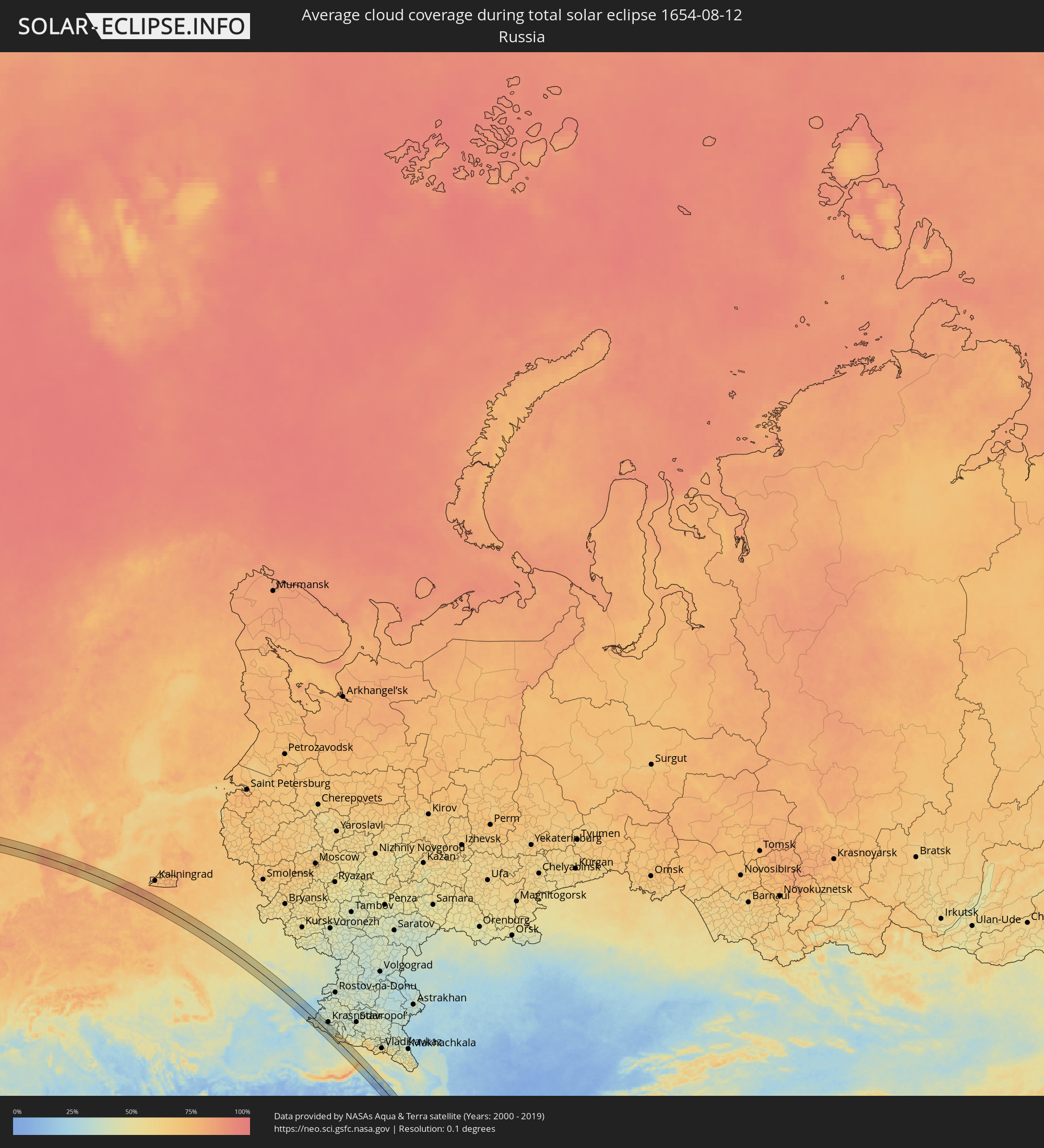 Russland
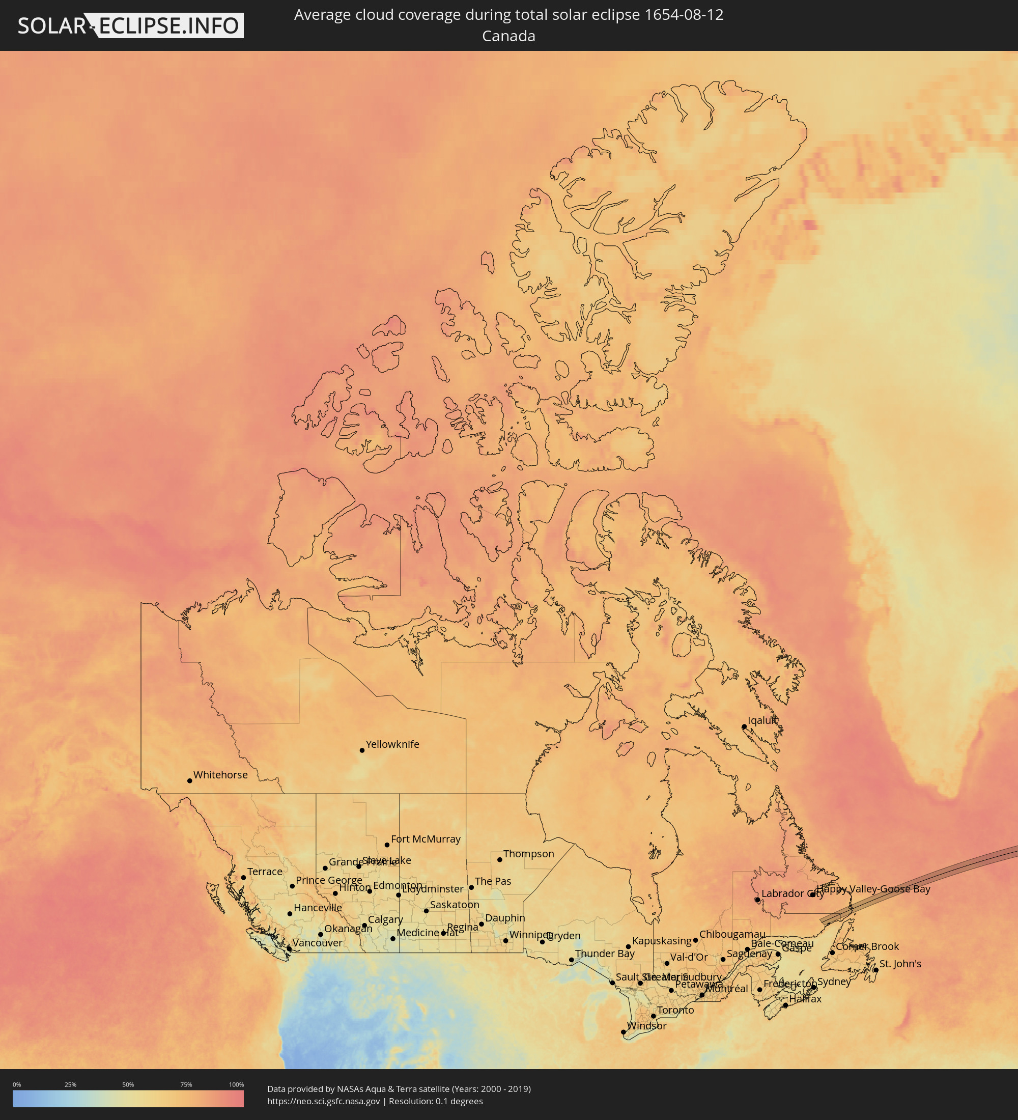 Kanada
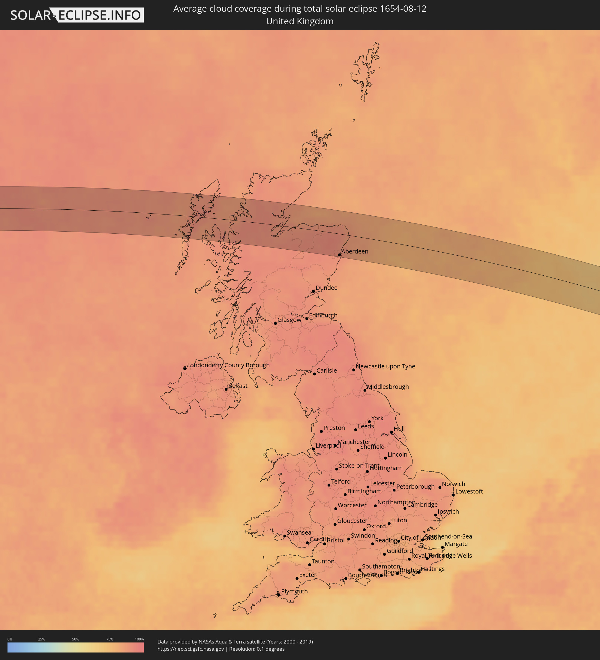 Vereinigtes Königreich
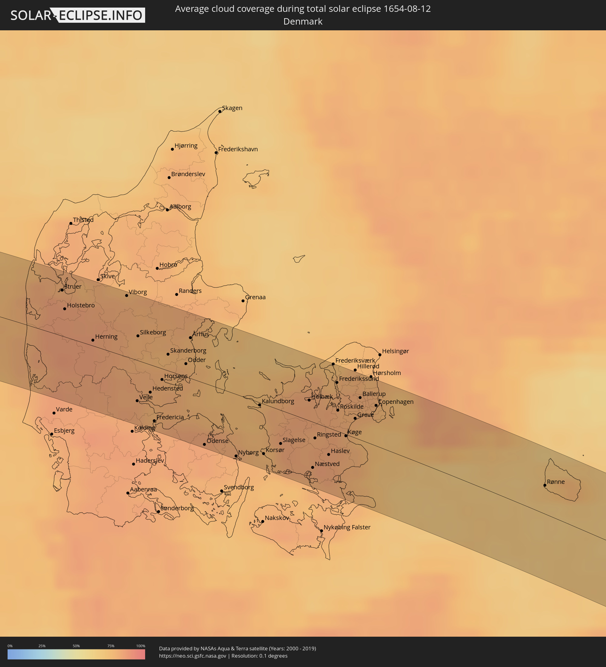 Dänemark
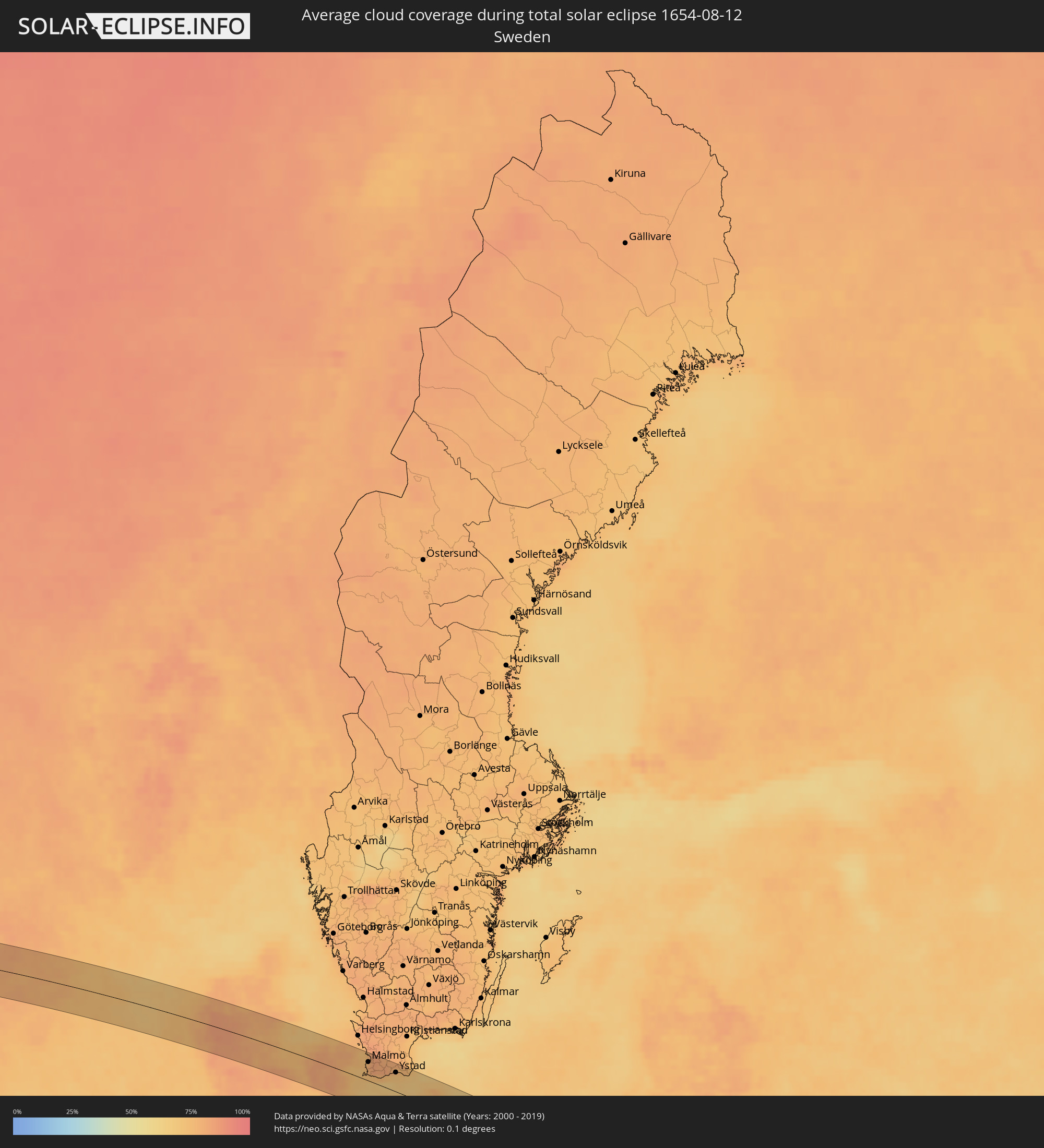 Schweden
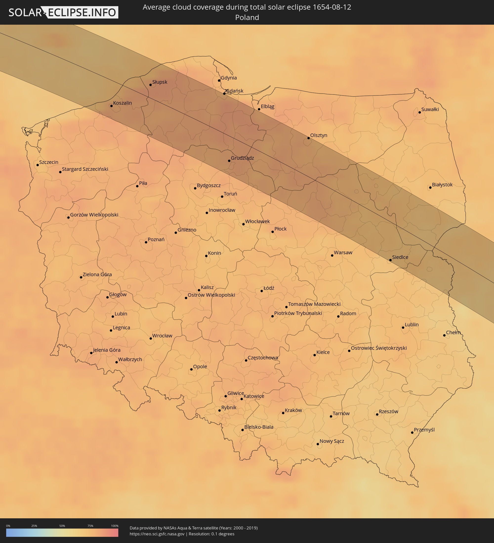 Polen
Polen
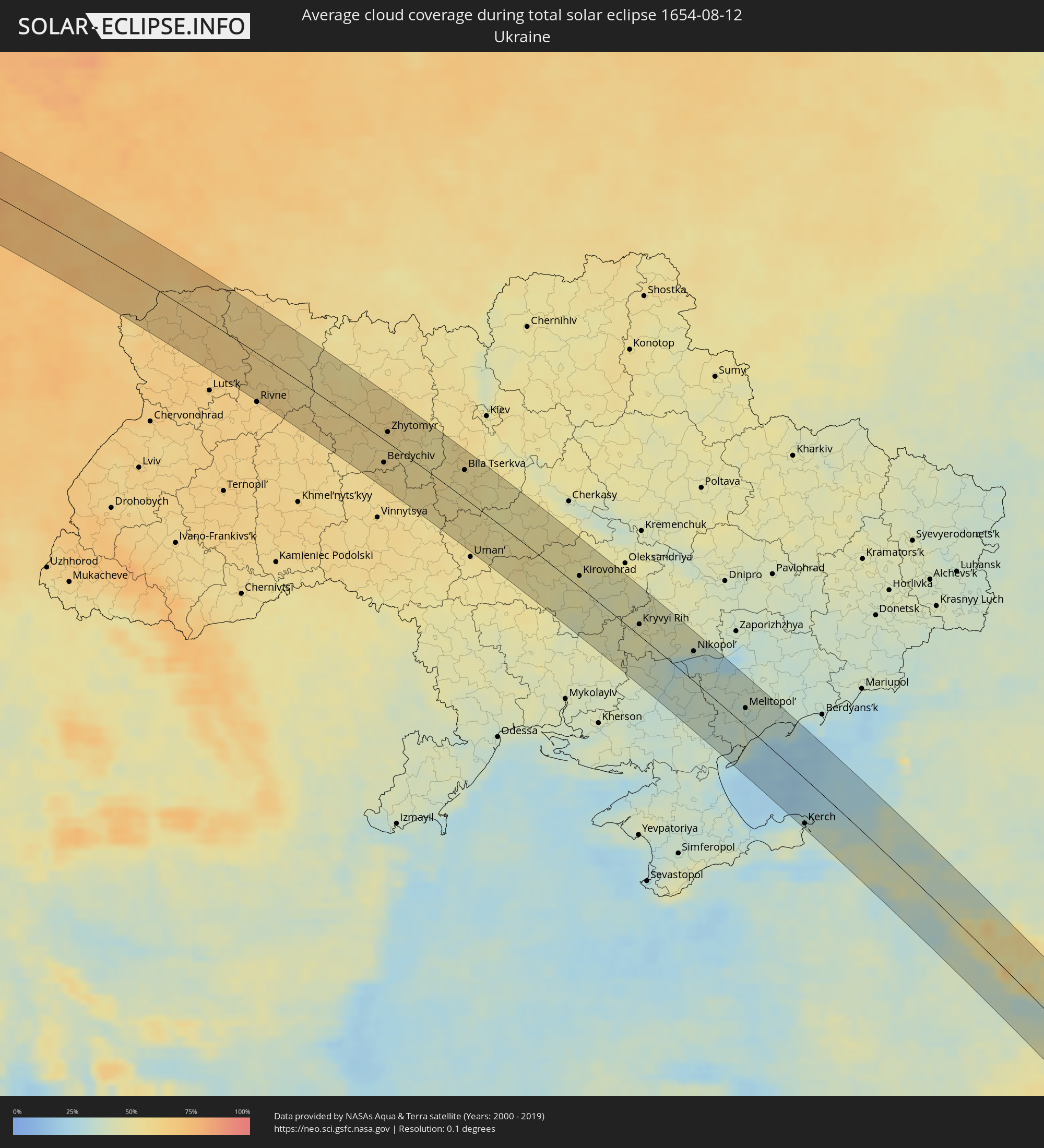 Ukraine
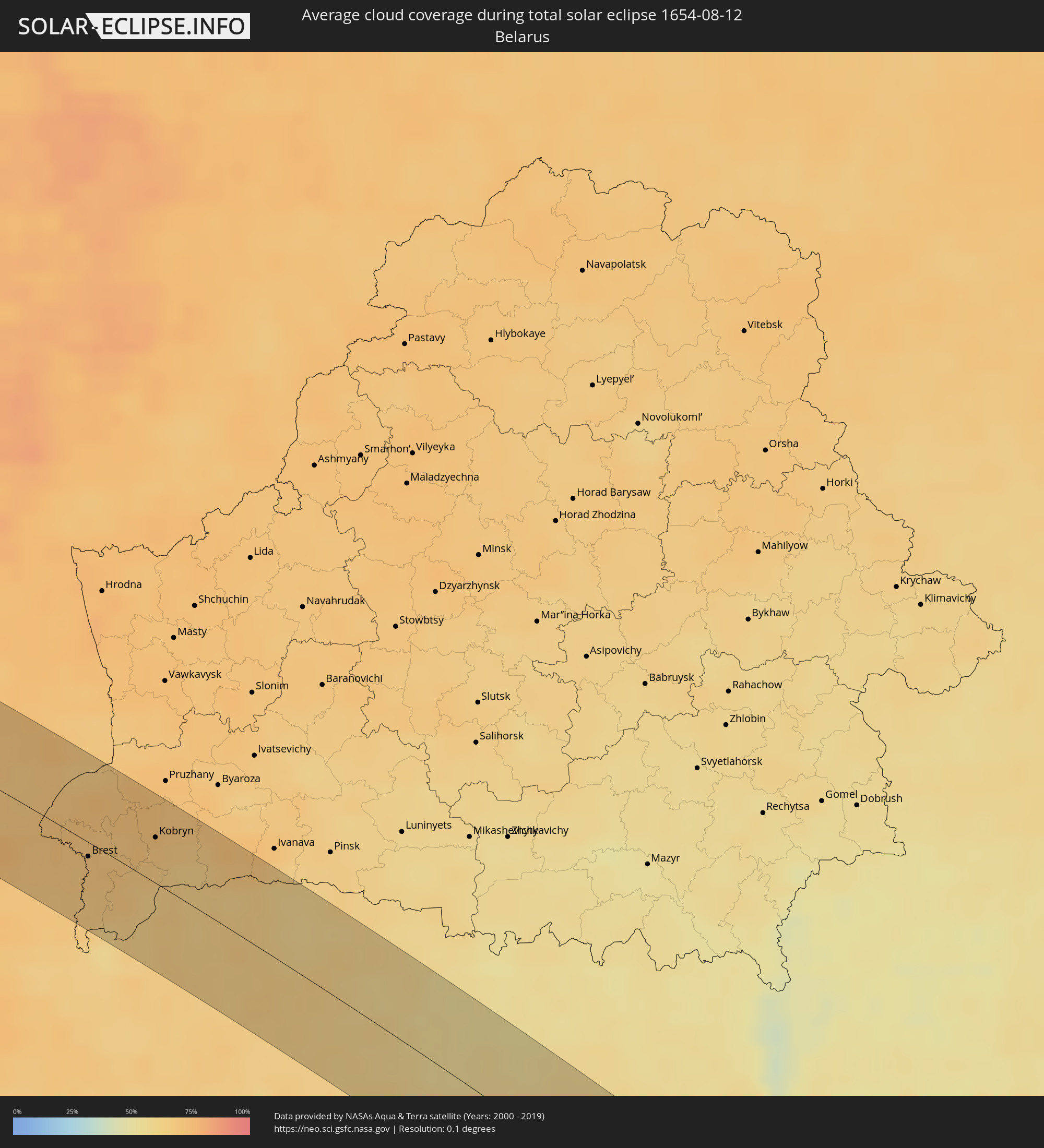 Weißrussland
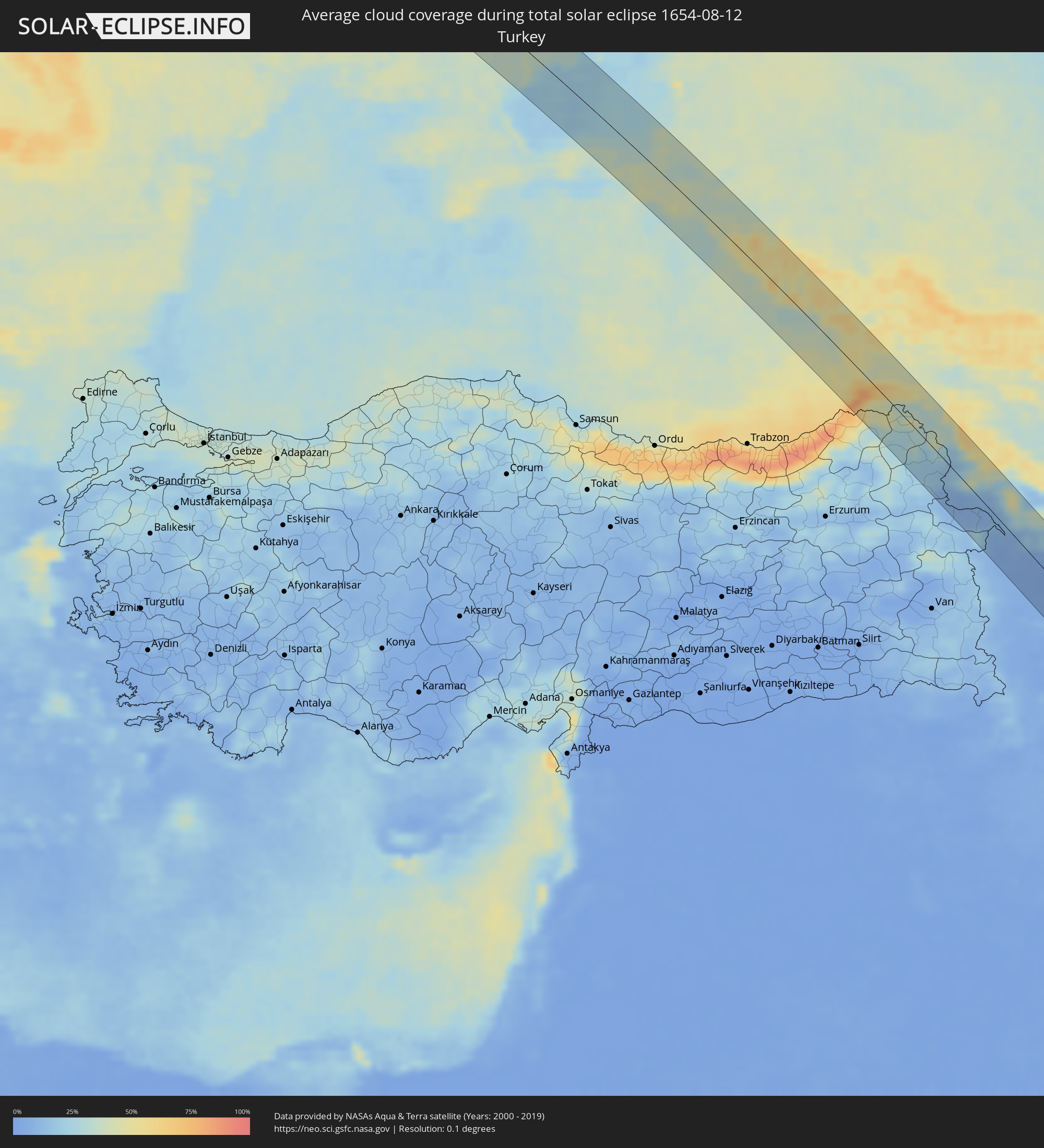 Türkei
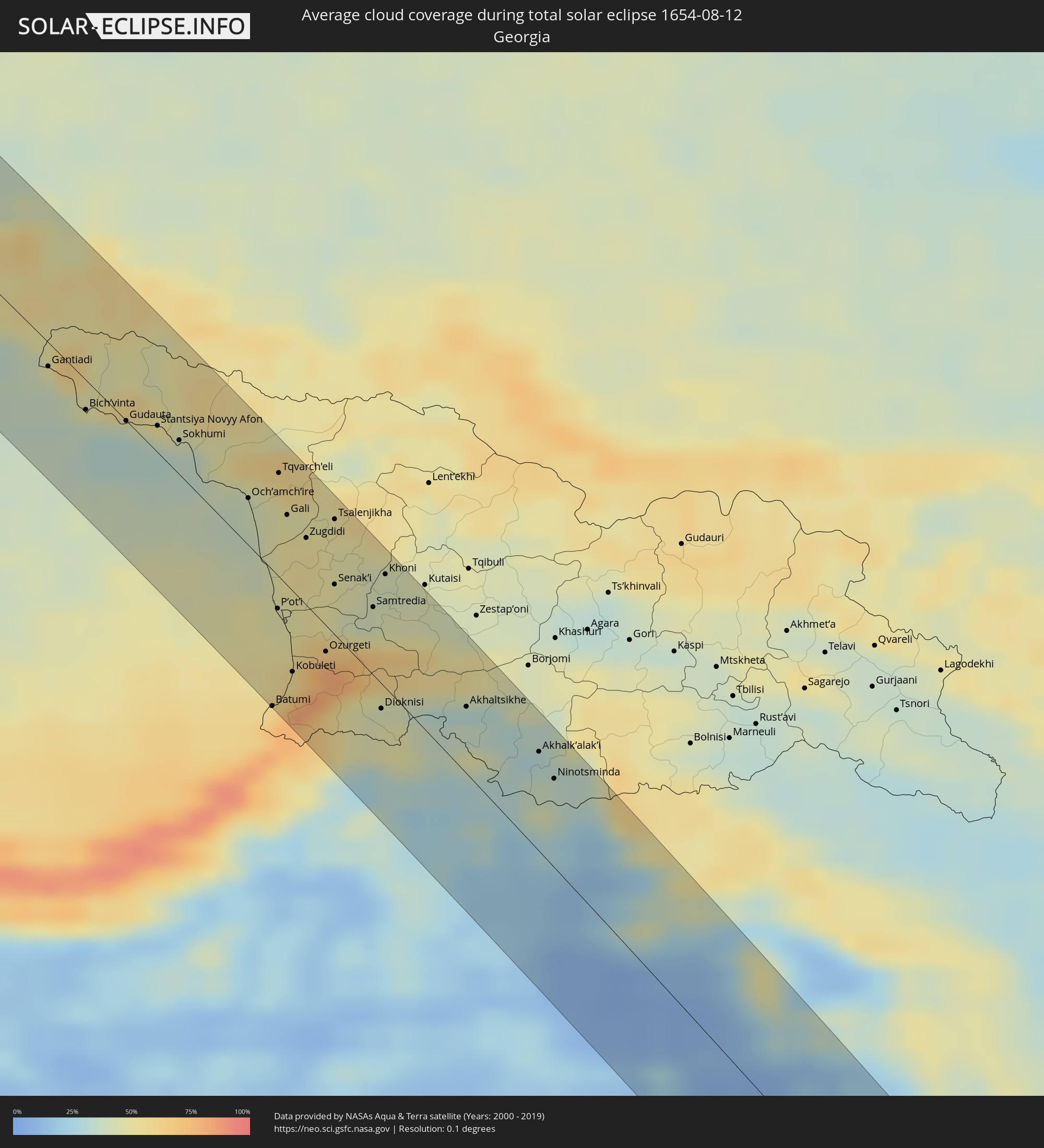 Georgien
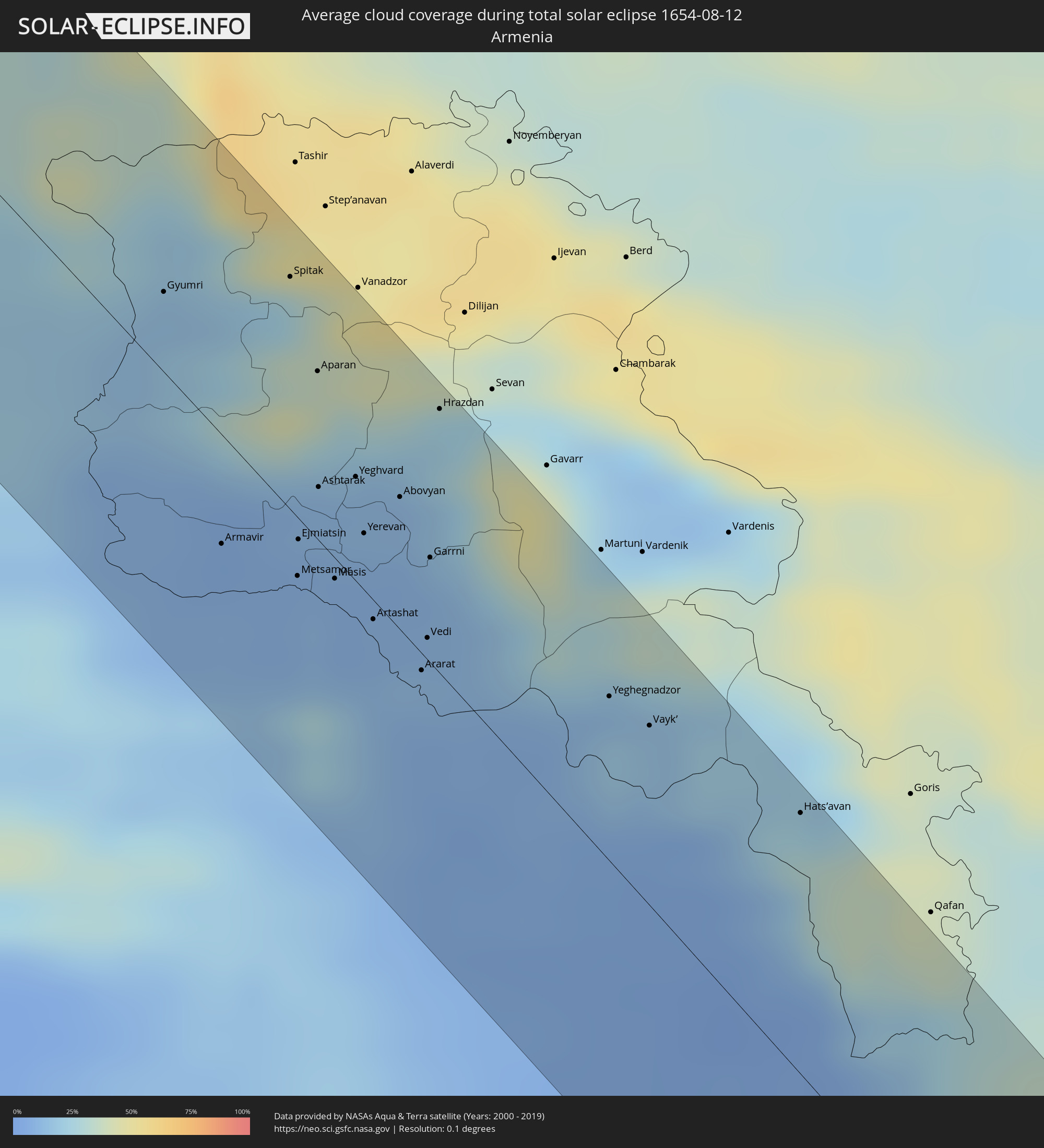 Armenien
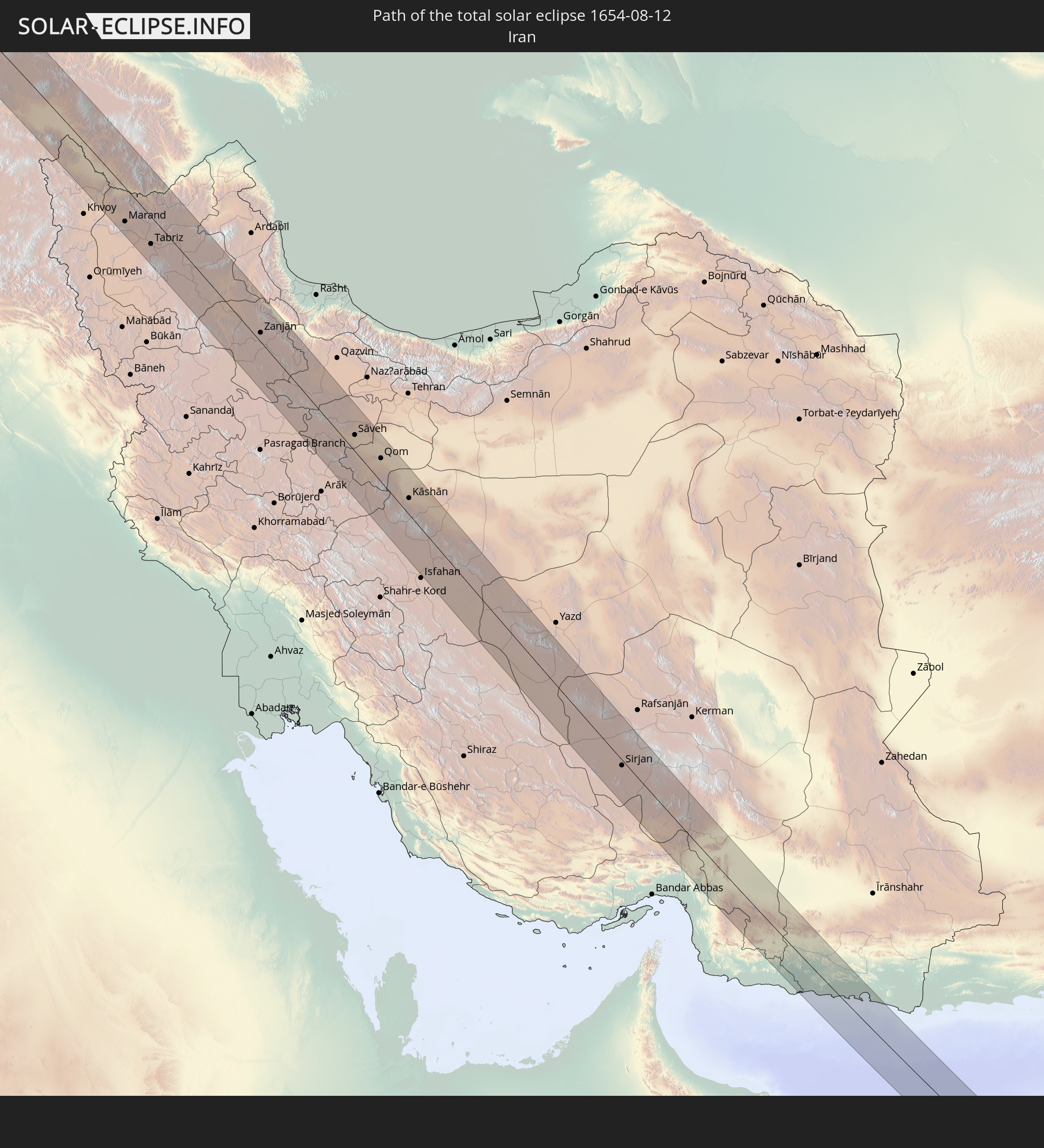
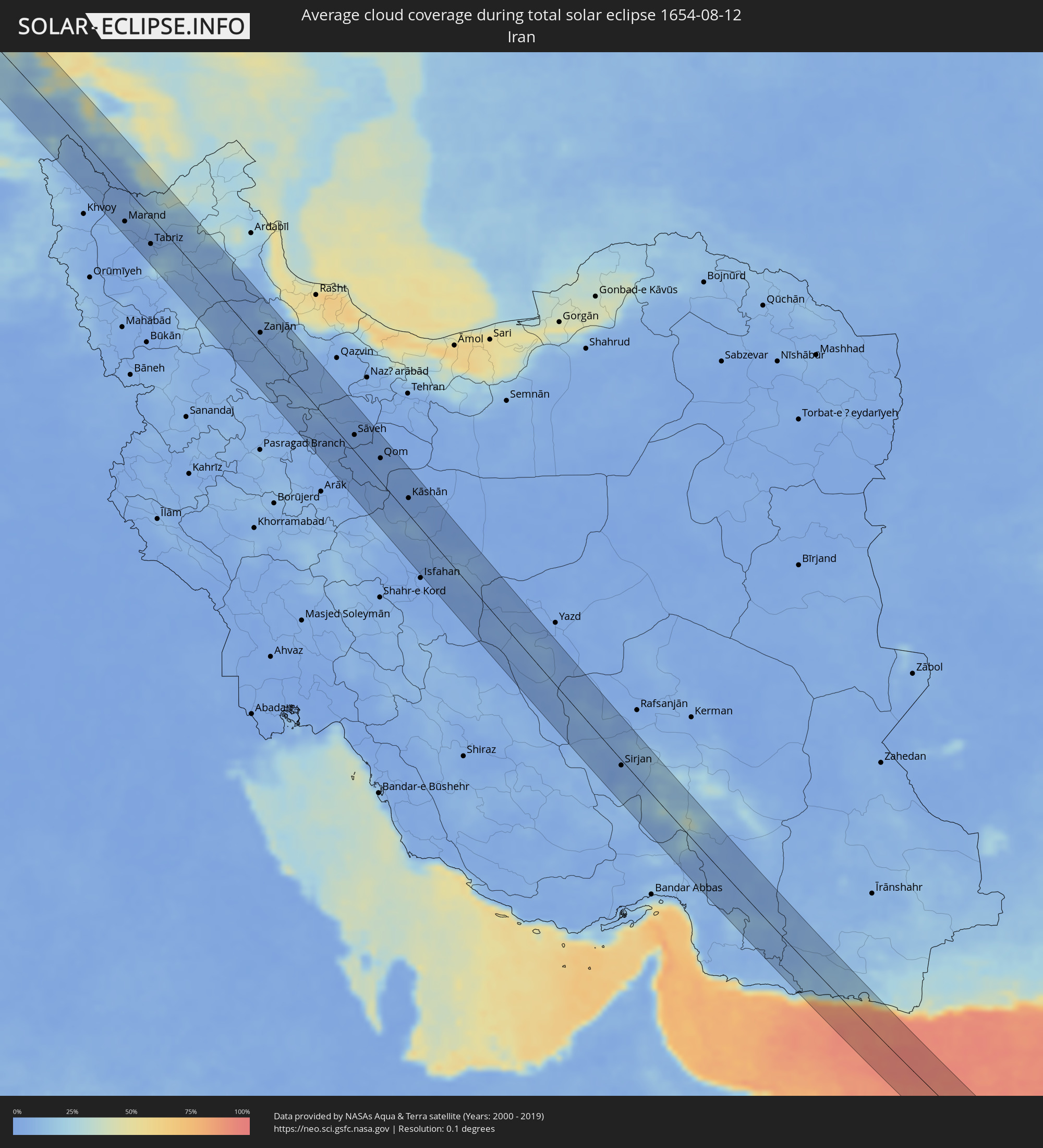 Iran
Iran
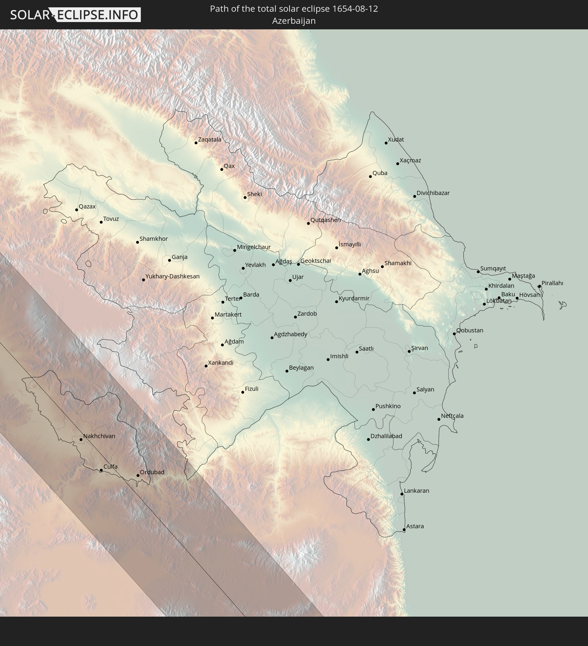
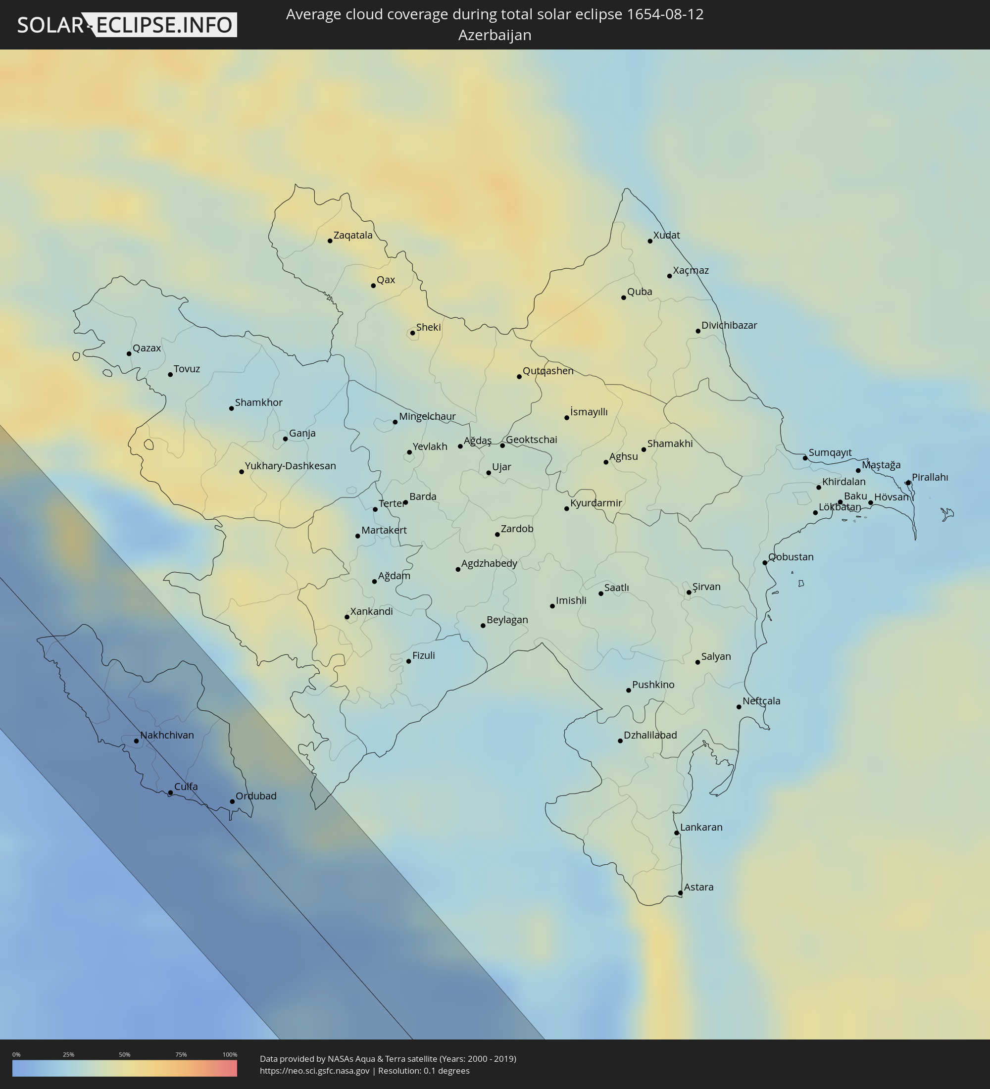 Aserbaidschan
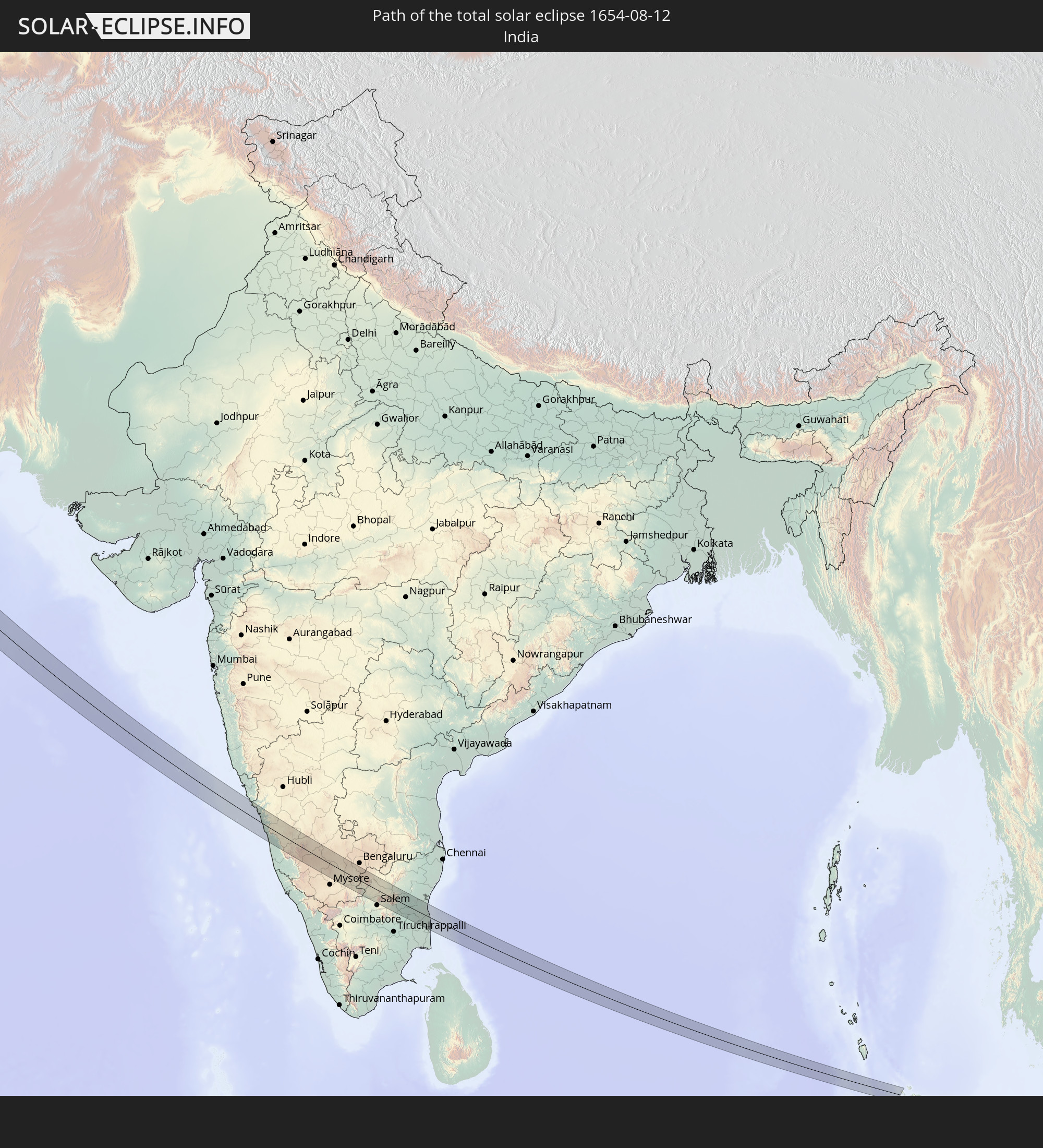
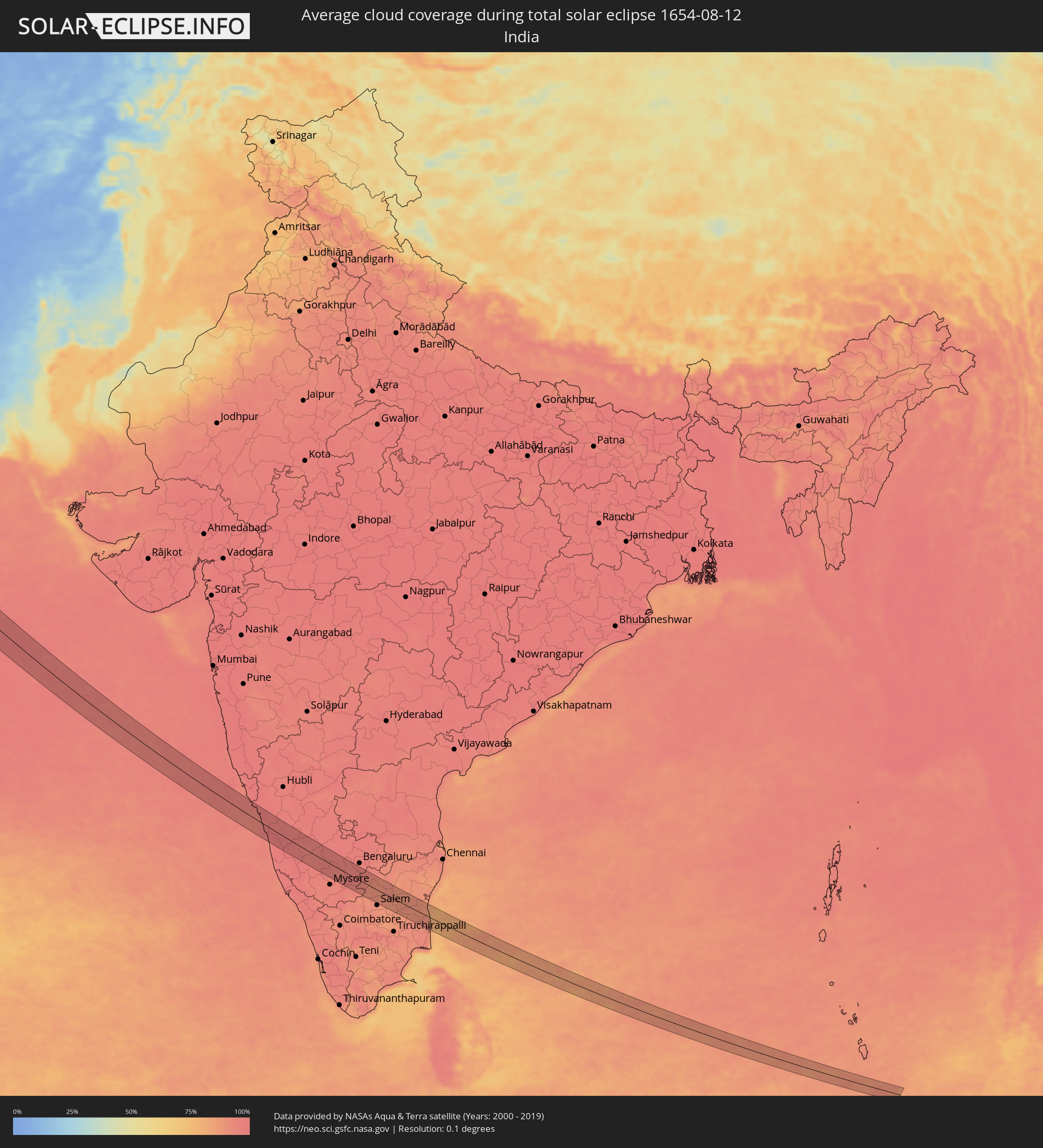 Indien
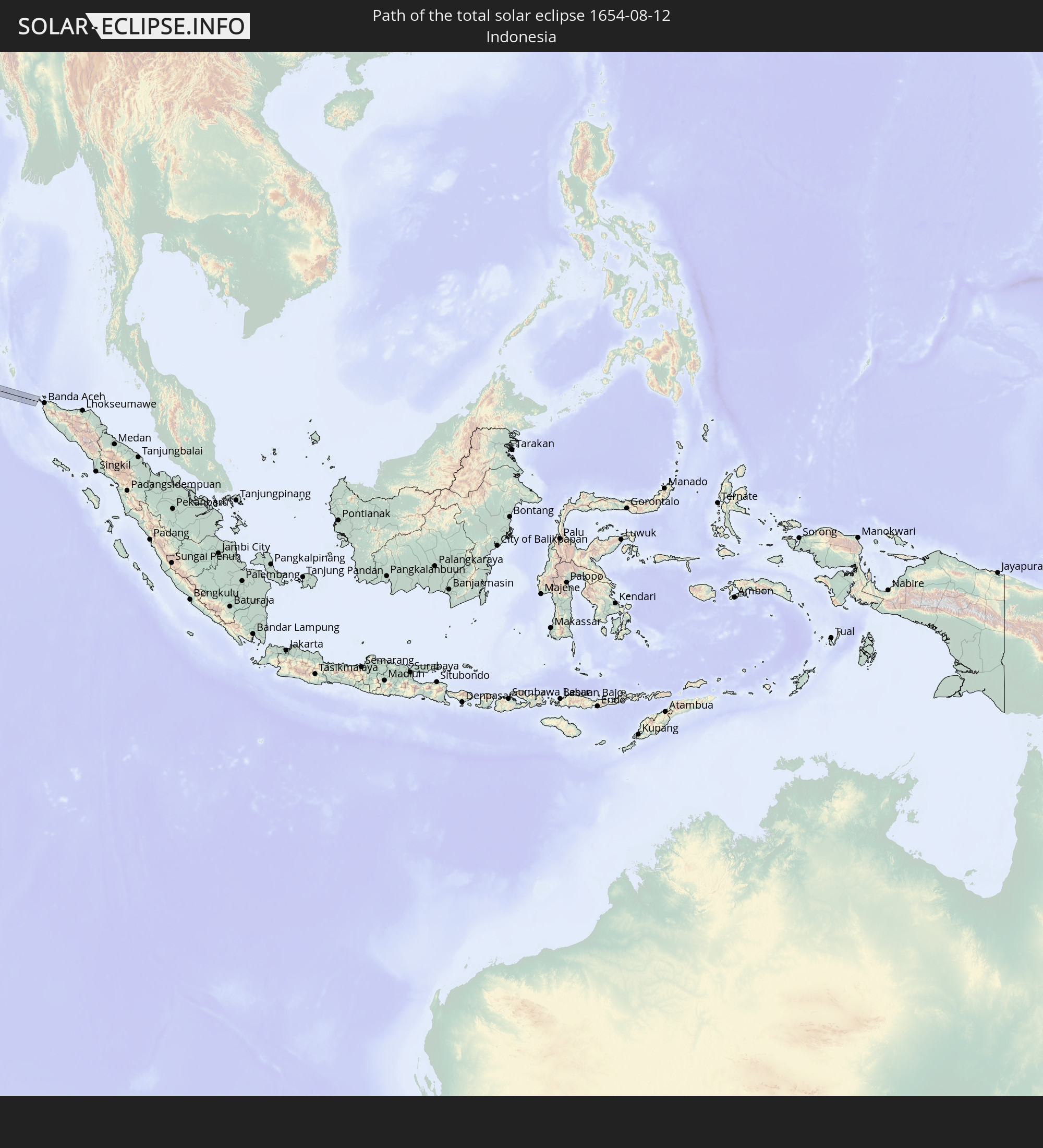
 Indonesien
Orte im Finsternispfad
Die nachfolgene Tabelle zeigt Städte und Orte mit mehr als 5.000 Einwohnern, die sich im Finsternispfad befinden. Städte mit mehr als 100.000 Einwohnern sind dick gekennzeichnet. Mit einem Klick auf den Ort öffnet sich eine Detailkarte die die Lage des jeweiligen Ortes zusammen mit dem Verlauf der zentralen Finsternis präsentiert.
| Ort | Typ | Dauer der Verfinsterung | Ortszeit bei maximaler Verfinsterung | Entfernung zur Zentrallinie | Ø Bewölkung |
|
Isle of Lewis, Scotland
|
total | - | 09:04:25 UTC+00:00 | 45 km | 89% |
|
Stornoway, Scotland
|
total | - | 09:04:25 UTC+00:00 | 44 km | 89% |
|
Inverness, Scotland
|
total | - | 09:05:38 UTC+00:00 | 23 km | 89% |
|
Nairn, Scotland
|
total | - | 09:05:59 UTC+00:00 | 9 km | 89% |
|
Forres, Scotland
|
total | - | 09:06:13 UTC+00:00 | 4 km | 90% |
|
Elgin, Scotland
|
total | - | 09:06:30 UTC+00:00 | 3 km | 90% |
|
Lossiemouth, Scotland
|
total | - | 09:06:35 UTC+00:00 | 11 km | 89% |
|
Buckie, Scotland
|
total | - | 09:06:49 UTC+00:00 | 8 km | 89% |
|
Kemnay, Scotland
|
total | - | 09:07:00 UTC+00:00 | 36 km | 90% |
|
Inverurie, Scotland
|
total | - | 09:07:05 UTC+00:00 | 30 km | 91% |
|
Westhill, Scotland
|
total | - | 09:07:05 UTC+00:00 | 43 km | 90% |
|
Dyce, Scotland
|
total | - | 09:07:13 UTC+00:00 | 37 km | 90% |
|
Aberdeen, Scotland
|
total | - | 09:07:14 UTC+00:00 | 43 km | 89% |
|
Ellon, Scotland
|
total | - | 09:07:24 UTC+00:00 | 18 km | 89% |
|
Fraserburgh, Scotland
|
total | - | 09:07:38 UTC+00:00 | 18 km | 88% |
|
Peterhead, Scotland
|
total | - | 09:07:43 UTC+00:00 | 0 km | 87% |
|
Holstebro, Central Jutland
|
total | - | 10:17:24 UTC+01:00 | 21 km | 84% |
|
Herning, Central Jutland
|
total | - | 10:17:45 UTC+01:00 | 4 km | 83% |
|
Viborg, Central Jutland
|
total | - | 10:18:15 UTC+01:00 | 45 km | 78% |
|
Vejle, South Denmark
|
total | - | 10:18:19 UTC+01:00 | 31 km | 81% |
|
Silkeborg, Central Jutland
|
total | - | 10:18:22 UTC+01:00 | 18 km | 78% |
|
Fredericia, South Denmark
|
total | - | 10:18:32 UTC+01:00 | 41 km | 79% |
|
Horsens, Central Jutland
|
total | - | 10:18:40 UTC+01:00 | 8 km | 78% |
|
Århus, Central Jutland
|
total | - | 10:19:06 UTC+01:00 | 30 km | 76% |
|
Odense, South Denmark
|
total | - | 10:19:14 UTC+01:00 | 46 km | 82% |
|
Slagelse, Zealand
|
total | - | 10:20:20 UTC+01:00 | 25 km | 83% |
|
Holbæk, Zealand
|
total | - | 10:20:45 UTC+01:00 | 15 km | 82% |
|
Næstved, Zealand
|
total | - | 10:20:48 UTC+01:00 | 34 km | 80% |
|
Roskilde, Zealand
|
total | - | 10:21:09 UTC+01:00 | 16 km | 80% |
|
Køge, Zealand
|
total | - | 10:21:16 UTC+01:00 | 1 km | 78% |
|
Greve, Zealand
|
total | - | 10:21:24 UTC+01:00 | 14 km | 77% |
|
Copenhagen, Capital Region
|
total | - | 10:21:42 UTC+01:00 | 30 km | 76% |
|
Skanör med Falsterbo, Skåne
|
total | - | 10:22:03 UTC+01:00 | 8 km | 72% |
|
Bunkeflostrand, Skåne
|
total | - | 10:22:09 UTC+01:00 | 24 km | 76% |
|
Höllviken, Skåne
|
total | - | 10:22:10 UTC+01:00 | 11 km | 73% |
|
Malmö, Skåne
|
total | - | 10:22:12 UTC+01:00 | 33 km | 78% |
|
Bjärred, Skåne
|
total | - | 10:22:13 UTC+01:00 | 44 km | 74% |
|
Vellinge, Skåne
|
total | - | 10:22:14 UTC+01:00 | 19 km | 76% |
|
Lomma, Skåne
|
total | - | 10:22:17 UTC+01:00 | 41 km | 80% |
|
Arlöv, Skåne
|
total | - | 10:22:17 UTC+01:00 | 37 km | 82% |
|
Oxie, Skåne
|
total | - | 10:22:19 UTC+01:00 | 28 km | 80% |
|
Trelleborg, Skåne
|
total | - | 10:22:24 UTC+01:00 | 12 km | 74% |
|
Lund, Skåne
|
total | - | 10:22:25 UTC+01:00 | 47 km | 83% |
|
Staffanstorp, Skåne
|
total | - | 10:22:26 UTC+01:00 | 41 km | 83% |
|
Svedala, Skåne
|
total | - | 10:22:29 UTC+01:00 | 28 km | 82% |
|
Skurup, Skåne
|
total | - | 10:22:47 UTC+01:00 | 31 km | 82% |
|
Ystad, Skåne
|
total | - | 10:23:10 UTC+01:00 | 34 km | 71% |
|
Tomelilla, Skåne
|
total | - | 10:23:18 UTC+01:00 | 48 km | 75% |
|
Koszalin, West Pomeranian Voivodeship
|
total | - | 10:50:10 UTC+01:24 | 34 km | 81% |
|
Słupsk, Pomeranian Voivodeship
|
total | - | 10:51:09 UTC+01:24 | 17 km | 84% |
|
Chojnice, Pomeranian Voivodeship
|
total | - | 10:52:02 UTC+01:24 | 46 km | 82% |
|
Lębork, Pomeranian Voivodeship
|
total | - | 10:52:00 UTC+01:24 | 44 km | 82% |
|
Starogard Gdański, Pomeranian Voivodeship
|
total | - | 10:53:09 UTC+01:24 | 9 km | 84% |
|
Grudziądz, Kujawsko-Pomorskie
|
total | - | 10:53:37 UTC+01:24 | 33 km | 80% |
|
Tczew, Pomeranian Voivodeship
|
total | - | 10:53:25 UTC+01:24 | 29 km | 83% |
|
Kwidzyn, Pomeranian Voivodeship
|
total | - | 10:53:45 UTC+01:24 | 3 km | 82% |
|
Malbork, Pomeranian Voivodeship
|
total | - | 10:53:45 UTC+01:24 | 30 km | 83% |
|
Ostróda, Warmian-Masurian Voivodeship
|
total | - | 10:55:04 UTC+01:24 | 25 km | 81% |
|
Olsztyn, Warmian-Masurian Voivodeship
|
total | - | 10:55:42 UTC+01:24 | 49 km | 78% |
|
Ciechanów, Masovian Voivodeship
|
total | - | 10:56:17 UTC+01:24 | 35 km | 80% |
|
Ostrołęka, Masovian Voivodeship
|
total | - | 10:57:25 UTC+01:24 | 16 km | 76% |
|
Łomża, Podlasie
|
total | - | 10:58:00 UTC+01:24 | 40 km | 73% |
|
Siedlce, Masovian Voivodeship
|
total | - | 10:58:53 UTC+01:24 | 50 km | 71% |
|
Biała Podlaska, Lublin Voivodeship
|
total | - | 11:00:04 UTC+01:24 | 34 km | 67% |
|
Brest, Brest
|
total | - | 11:26:48 UTC+01:50 | 8 km | 69% |
|
Kamyanyets, Brest
|
total | - | 11:26:46 UTC+01:50 | 25 km | 71% |
|
Zhabinka, Brest
|
total | - | 11:27:10 UTC+01:50 | 13 km | 69% |
|
Malaryta, Brest
|
total | - | 11:27:31 UTC+01:50 | 24 km | 66% |
|
Kobryn, Brest
|
total | - | 11:27:37 UTC+01:50 | 26 km | 69% |
|
Kuznetsovs’k, Rivne
|
total | - | 11:42:06 UTC+02:02 | 32 km | 60% |
|
Kostopil’, Rivne
|
total | - | 11:43:32 UTC+02:02 | 21 km | 61% |
|
Novohrad-Volyns’kyy, Zhytomyr
|
total | - | 11:45:24 UTC+02:02 | 2 km | 58% |
|
Berdychiv, Zhytomyr
|
total | - | 11:47:26 UTC+02:02 | 25 km | 57% |
|
Zhytomyr, Zhytomyr
|
total | - | 11:47:11 UTC+02:02 | 11 km | 59% |
|
Fastiv, Kiev
|
total | - | 11:49:06 UTC+02:02 | 46 km | 53% |
|
Bila Tserkva, Kiev
|
total | - | 11:49:39 UTC+02:02 | 31 km | 52% |
|
Kirovohrad, Kirovohrad
|
total | - | 11:54:07 UTC+02:02 | 12 km | 49% |
|
Znomenka, Kirovohrad
|
total | - | 11:54:28 UTC+02:02 | 48 km | 48% |
|
Dolyns'ka, Kirovohrad
|
total | - | 11:55:19 UTC+02:02 | 0 km | 45% |
|
Kryvyi Rih, Dnipropetrovsk
|
total | - | 11:56:27 UTC+02:02 | 12 km | 46% |
|
Nikopol’, Dnipropetrovsk
|
total | - | 11:58:21 UTC+02:02 | 32 km | 29% |
|
Marhanets’, Dnipropetrovsk
|
total | - | 11:58:35 UTC+02:02 | 49 km | 29% |
|
Energodar, Zaporizhia
|
total | - | 11:58:49 UTC+02:02 | 39 km | 32% |
|
Melitopol’, Zaporizhia
|
total | - | 12:00:42 UTC+02:02 | 19 km | 34% |
|
Kerch, Republic of Crimea
|
total | - | 12:18:21 UTC+02:16 | 48 km | 36% |
|
Anapa, Krasnodarskiy
|
total | - | 12:34:35 UTC+02:30 | 41 km | 34% |
|
Temryuk, Krasnodarskiy
|
total | - | 12:34:06 UTC+02:30 | 7 km | 32% |
|
Novorossiysk, Krasnodarskiy
|
total | - | 12:35:29 UTC+02:30 | 31 km | 38% |
|
Krymsk, Krasnodarskiy
|
total | - | 12:35:29 UTC+02:30 | 2 km | 42% |
|
Gelendzhik, Krasnodarskiy
|
total | - | 12:36:11 UTC+02:30 | 27 km | 40% |
|
Slavyansk-na-Kubani, Krasnodarskiy
|
total | - | 12:35:11 UTC+02:30 | 32 km | 38% |
|
Akhtyrskiy, Krasnodarskiy
|
total | - | 12:36:03 UTC+02:30 | 9 km | 40% |
|
Il’skiy, Krasnodarskiy
|
total | - | 12:36:27 UTC+02:30 | 22 km | 39% |
|
Yelizavetinskaya, Krasnodarskiy
|
total | - | 12:36:28 UTC+02:30 | 51 km | 34% |
|
Afipskiy, Krasnodarskiy
|
total | - | 12:36:46 UTC+02:30 | 42 km | 38% |
|
Tuapse, Krasnodarskiy
|
total | - | 12:38:21 UTC+02:30 | 8 km | 34% |
|
Goryachiy Klyuch, Krasnodarskiy
|
total | - | 12:37:36 UTC+02:30 | 36 km | 36% |
|
Lazarevskoye, Krasnodarskiy
|
total | - | 12:39:02 UTC+02:30 | 10 km | 38% |
|
Khadyzhensk, Krasnodarskiy
|
total | - | 12:38:30 UTC+02:30 | 43 km | 38% |
|
Sochi, Krasnodarskiy
|
total | - | 12:40:06 UTC+02:30 | 12 km | 37% |
|
Adler, Krasnodarskiy
|
total | - | 12:40:40 UTC+02:30 | 15 km | 38% |
|
Gantiadi
|
total | - | 13:09:53 UTC+02:59 | 9 km | 42% |
|
Sokhumi, Abkhazia
|
total | - | 13:11:48 UTC+02:59 | 14 km | 35% |
|
Och’amch’ire, Abkhazia
|
total | - | 13:13:00 UTC+02:59 | 19 km | 41% |
|
Batumi, Ajaria
|
total | - | 13:15:04 UTC+02:59 | 54 km | 70% |
|
P’ot’i, Samegrelo and Zemo Svaneti
|
total | - | 13:14:15 UTC+02:59 | 13 km | 48% |
|
Tqvarch'eli, Abkhazia
|
total | - | 13:13:05 UTC+02:59 | 41 km | 54% |
|
Gali, Abkhazia
|
total | - | 13:13:31 UTC+02:59 | 28 km | 50% |
|
Kobuleti, Ajaria
|
total | - | 13:14:58 UTC+02:59 | 32 km | 72% |
|
Zugdidi, Samegrelo and Zemo Svaneti
|
total | - | 13:13:55 UTC+02:59 | 27 km | 52% |
|
Ozurgeti, Guria
|
total | - | 13:15:07 UTC+02:59 | 10 km | 80% |
|
Senak’i, Samegrelo and Zemo Svaneti
|
total | - | 13:14:36 UTC+02:59 | 20 km | 47% |
|
Tsalenjikha, Samegrelo and Zemo Svaneti
|
total | - | 13:14:02 UTC+02:59 | 46 km | 49% |
|
Samtredia, Imereti
|
total | - | 13:15:11 UTC+02:59 | 27 km | 41% |
|
Şavşat, Artvin
|
total | - | 12:14:35 UTC+01:56 | 42 km | 33% |
|
Khoni, Imereti
|
total | - | 13:15:01 UTC+02:59 | 45 km | 40% |
|
Ardahan, Ardahan
|
total | - | 12:15:18 UTC+01:56 | 31 km | 25% |
|
Hanak, Ardahan
|
total | - | 12:15:17 UTC+01:56 | 13 km | 24% |
|
Akhaltsikhe, Samtskhe-Javakheti
|
total | - | 13:17:01 UTC+02:59 | 27 km | 36% |
|
Kars, Kars
|
total | - | 12:16:46 UTC+01:56 | 47 km | 22% |
|
Arpaçay, Kars
|
total | - | 12:16:40 UTC+01:56 | 13 km | 19% |
|
Akhalk’alak’i
|
total | - | 13:18:08 UTC+02:59 | 39 km | 32% |
|
Gyumri, Shirak Province
|
total | - | 13:18:33 UTC+02:58 | 15 km | 15% |
|
Akhuryan, Shirak Province
|
total | - | 13:18:39 UTC+02:58 | 18 km | 16% |
|
Armavir, Armavir Province
|
total | - | 13:20:00 UTC+02:58 | 21 km | 7% |
|
Iğdır, Iğdır
|
total | - | 12:19:22 UTC+01:56 | 38 km | 11% |
|
Spitak, Lori Province
|
total | - | 13:19:05 UTC+02:58 | 44 km | 35% |
|
Metsamor, Armavir Province
|
total | - | 13:20:30 UTC+02:58 | 11 km | 9% |
|
Ejmiatsin, Armavir Province
|
total | - | 13:20:20 UTC+02:58 | 4 km | 8% |
|
Ashtarak, Aragatsotn Province
|
total | - | 13:20:11 UTC+02:58 | 10 km | 11% |
|
Masis, Ararat Province
|
total | - | 13:20:41 UTC+02:58 | 4 km | 8% |
|
Yeghvard, Kotayk Province
|
total | - | 13:20:19 UTC+02:58 | 20 km | 11% |
|
Yerevan, Yerevan
|
total | - | 13:20:37 UTC+02:58 | 11 km | 9% |
|
Artashat, Ararat Province
|
total | - | 13:21:04 UTC+02:58 | 4 km | 9% |
|
Ararat, Ararat Province
|
total | - | 13:21:32 UTC+02:58 | 3 km | 10% |
|
Vedi, Ararat Province
|
total | - | 13:21:24 UTC+02:58 | 4 km | 11% |
|
Hrazdan, Kotayk Province
|
total | - | 13:20:23 UTC+02:58 | 50 km | 25% |
|
Sharur City, Nakhichevan
|
total | - | 13:43:50 UTC+03:19 | 7 km | 8% |
|
Yeghegnadzor, Vayots Dzor Province
|
total | - | 13:22:31 UTC+02:58 | 31 km | 13% |
|
Nakhchivan, Nakhichevan
|
total | - | 13:45:04 UTC+03:19 | 5 km | 5% |
|
Cahri, Nakhichevan
|
total | - | 13:44:49 UTC+03:19 | 6 km | 5% |
|
Culfa, Nakhichevan
|
total | - | 13:45:51 UTC+03:19 | 10 km | 3% |
|
Yaycı, Nakhichevan
|
total | - | 13:46:01 UTC+03:19 | 4 km | 4% |
|
Marand, East Azerbaijan
|
total | - | 13:53:23 UTC+03:25 | 39 km | 5% |
|
Hats’avan, Syunik Province
|
total | - | 13:23:58 UTC+02:58 | 50 km | 23% |
|
Ordubad, Nakhichevan
|
total | - | 13:46:29 UTC+03:19 | 12 km | 4% |
|
Tabriz, East Azerbaijan
|
total | - | 13:54:46 UTC+03:25 | 31 km | 5% |
|
Ahar, East Azerbaijan
|
total | - | 13:55:04 UTC+03:25 | 49 km | 18% |
|
Zanjān, Zanjan
|
total | - | 14:00:27 UTC+03:25 | 11 km | 4% |
|
Alvand, Zanjan
|
total | - | 14:02:04 UTC+03:25 | 32 km | 6% |
|
Khorramdarreh, Zanjan
|
total | - | 14:02:18 UTC+03:25 | 25 km | 5% |
|
Abhar, Zanjan
|
total | - | 14:02:28 UTC+03:25 | 23 km | 4% |
|
Tākestān, Qazvīn
|
total | - | 14:03:14 UTC+03:25 | 50 km | 5% |
|
Sāveh, Markazi
|
total | - | 14:06:11 UTC+03:25 | 19 km | 2% |
|
Delījān, Markazi
|
total | - | 14:08:40 UTC+03:25 | 32 km | 2% |
|
Qom, Qom
|
total | - | 14:07:36 UTC+03:25 | 28 km | 2% |
|
Kāshān, Isfahan
|
total | - | 14:09:38 UTC+03:25 | 20 km | 1% |
|
Dowlatābād, Isfahan
|
total | - | 14:12:21 UTC+03:25 | 48 km | 1% |
|
Shahr-e Bābak, Kerman
|
total | - | 14:21:50 UTC+03:25 | 1 km | 6% |
|
Sirjan, Kerman
|
total | - | 14:23:48 UTC+03:25 | 7 km | 5% |
|
Chabahar, Sistan and Baluchestan
|
total | - | 14:37:04 UTC+03:25 | 39 km | 80% |
|
Karwar, Karnataka
|
total | - | 16:59:26 UTC+05:21 | 37 km | 96% |
|
Shimoga, Karnataka
|
total | - | 17:01:15 UTC+05:21 | 35 km | 96% |
|
Bhadrāvati, Karnataka
|
total | - | 17:01:25 UTC+05:21 | 35 km | 97% |
|
Chikmagalūr, Karnataka
|
total | - | 17:02:13 UTC+05:21 | 12 km | 95% |
|
Hassan, Karnataka
|
total | - | 17:02:46 UTC+05:21 | 25 km | 96% |
|
Tiptūr, Karnataka
|
total | - | 17:02:30 UTC+05:21 | 20 km | 96% |
|
Mandya, Karnataka
|
total | - | 17:03:40 UTC+05:21 | 28 km | 94% |
|
Closepet, Karnataka
|
total | - | 17:03:29 UTC+05:21 | 11 km | 96% |
|
Dharmapuri, Tamil Nadu
|
total | - | 17:04:31 UTC+05:21 | 1 km | 91% |
|
Krishnagiri, Tamil Nadu
|
total | - | 17:03:59 UTC+05:21 | 41 km | 91% |
|
Attur, Tamil Nadu
|
total | - | 17:05:21 UTC+05:21 | 30 km | 89% |
|
Vriddhāchalam, Tamil Nadu
|
total | - | 17:05:35 UTC+05:21 | 2 km | 91% |
|
Panruti, Tamil Nadu
|
total | - | 17:05:16 UTC+05:21 | 36 km | 90% |
|
Mayiladuthurai, Tamil Nadu
|
total | - | 17:06:12 UTC+05:21 | 26 km | 91% |
|
Chidambaram, Tamil Nadu
|
total | - | 17:05:49 UTC+05:21 | 5 km | 90% |
|
Kāraikāl, Pondicherry
|
total | - | 17:06:29 UTC+05:21 | 36 km | 92% |