Totale Sonnenfinsternis vom 12.08.1673
| Wochentag: | Samstag |
| Maximale Dauer der Verfinsterung: | 06m15s |
| Maximale Breite des Finsternispfades: | 242 km |
| Saroszyklus: | 130 |
| Bedeckungsgrad: | 100% |
| Magnitude: | 1.0731 |
| Gamma: | -0.1946 |
Wo kann man die Sonnenfinsternis vom 12.08.1673 sehen?
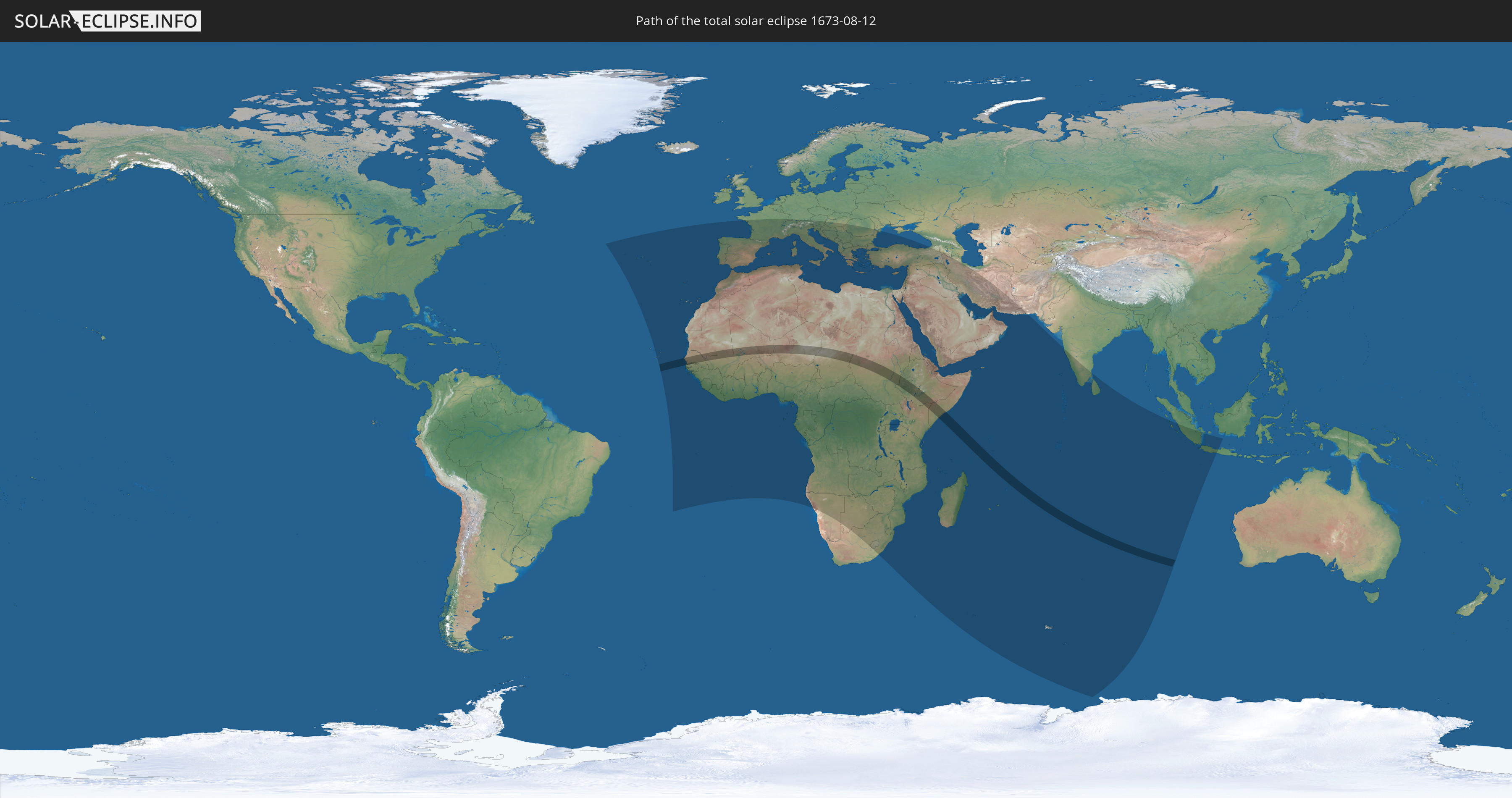
Die Sonnenfinsternis am 12.08.1673 kann man in 110 Ländern als partielle Sonnenfinsternis beobachten.
Der Finsternispfad verläuft durch 13 Länder. Nur in diesen Ländern ist sie als totale Sonnenfinsternis zu sehen.
In den folgenden Ländern ist die Sonnenfinsternis total zu sehen
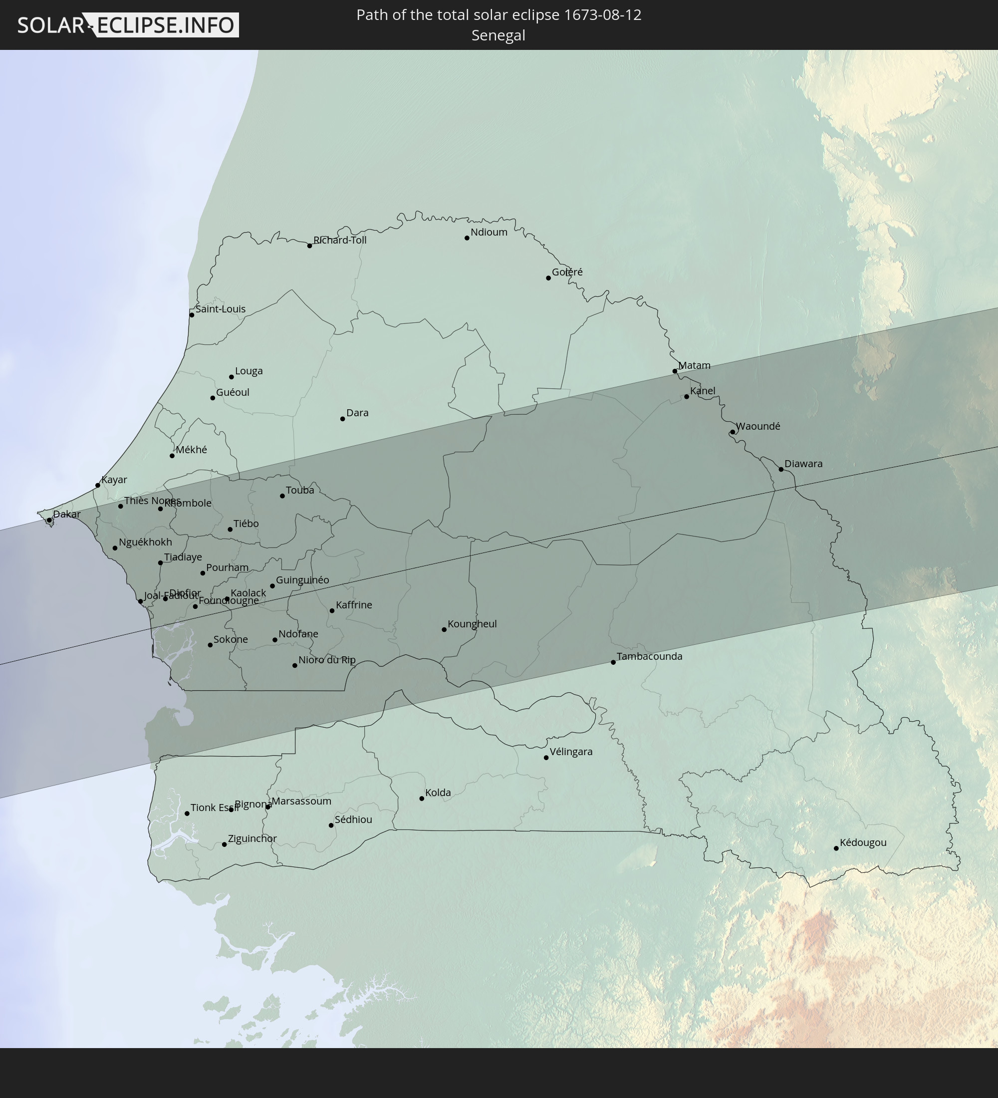 Senegal
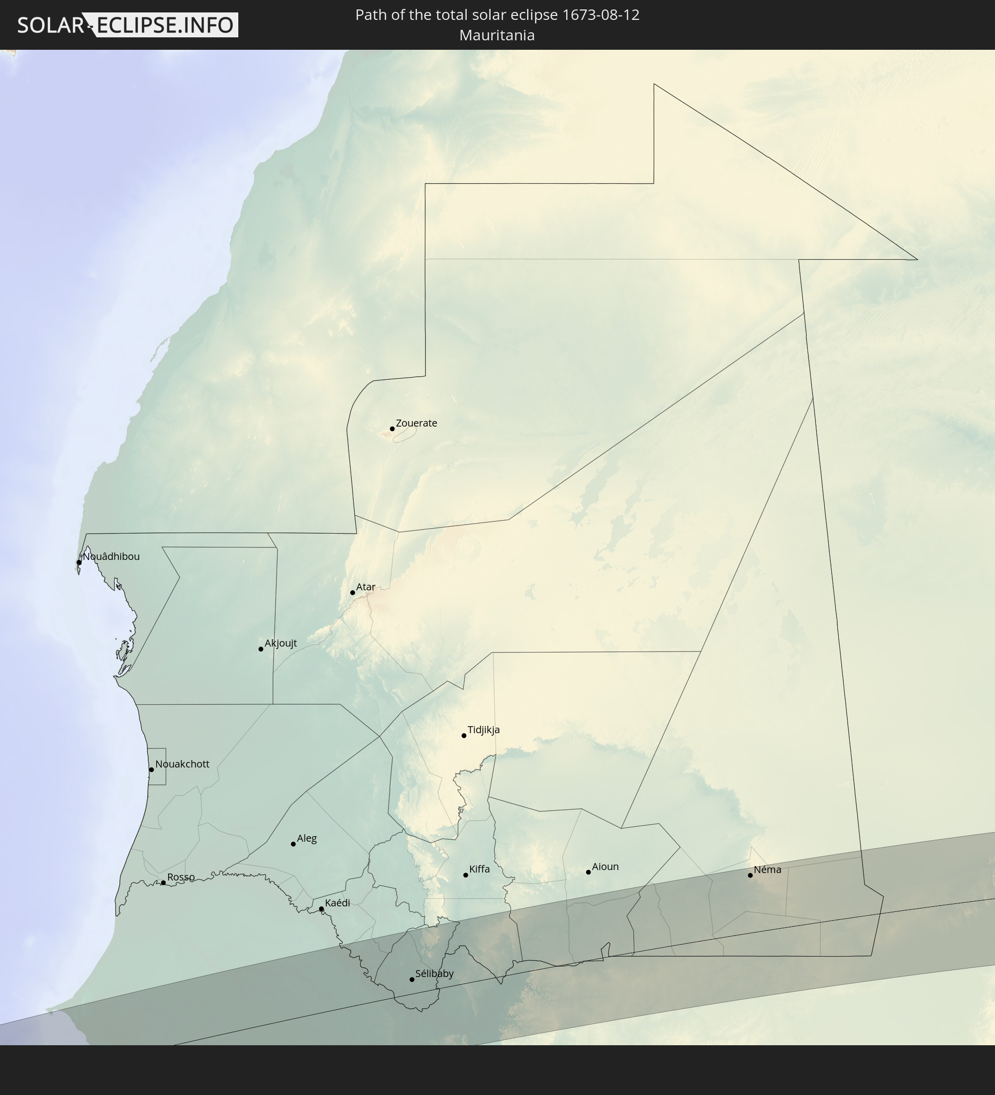 Mauretanien
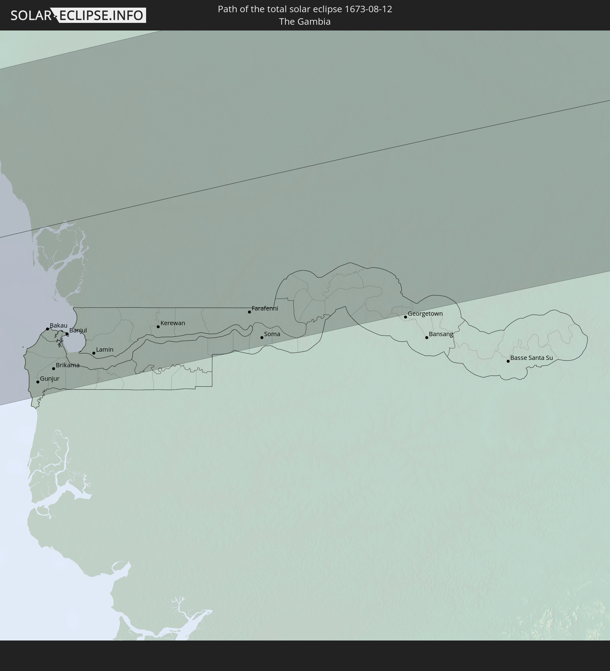 Gambia
 Mali
Mali
 Niger
Niger
 Tschad
 Sudan
Sudan
 Südsudan
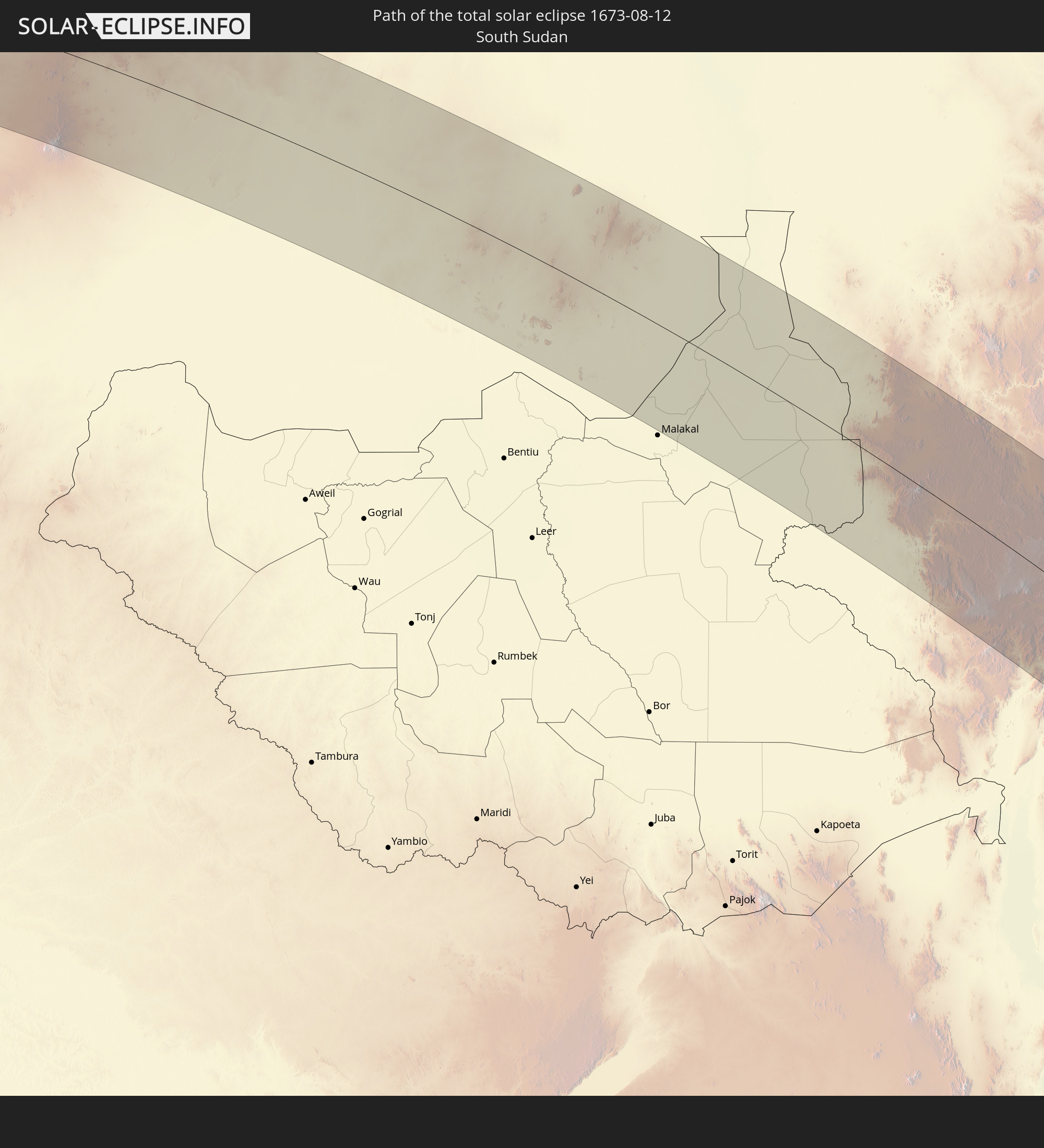
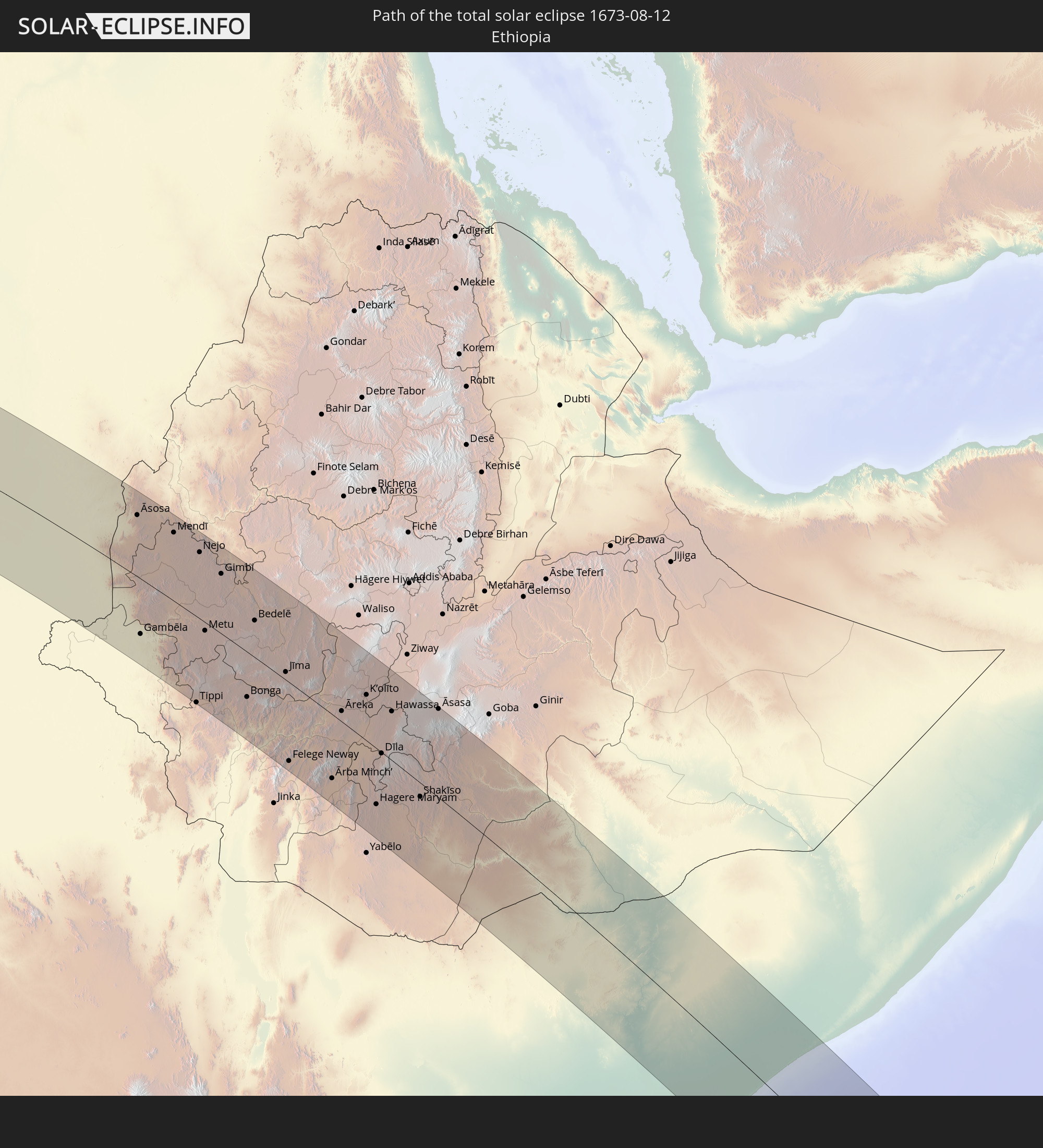 Äthiopien
 Kenia
Kenia
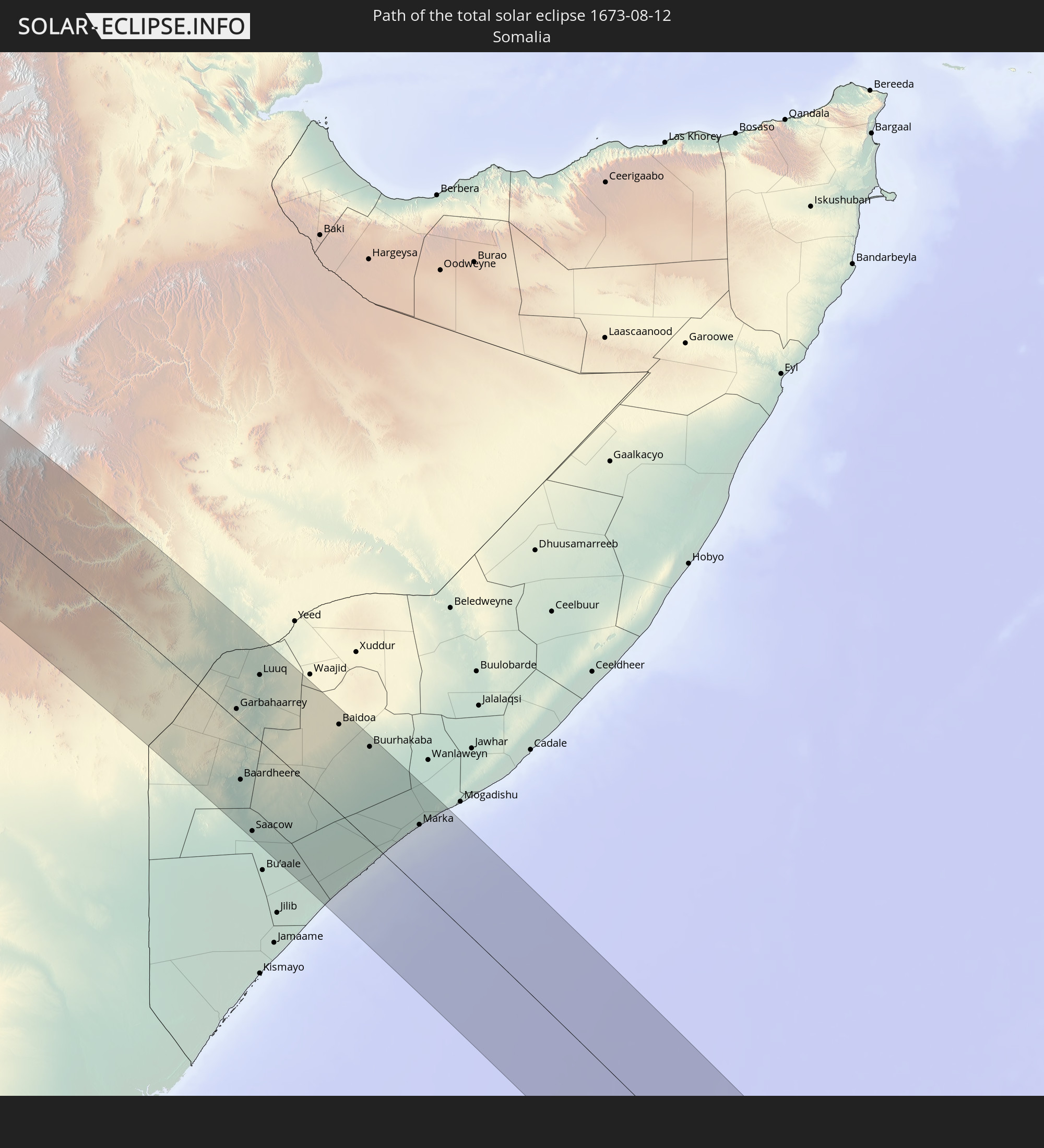 Somalia
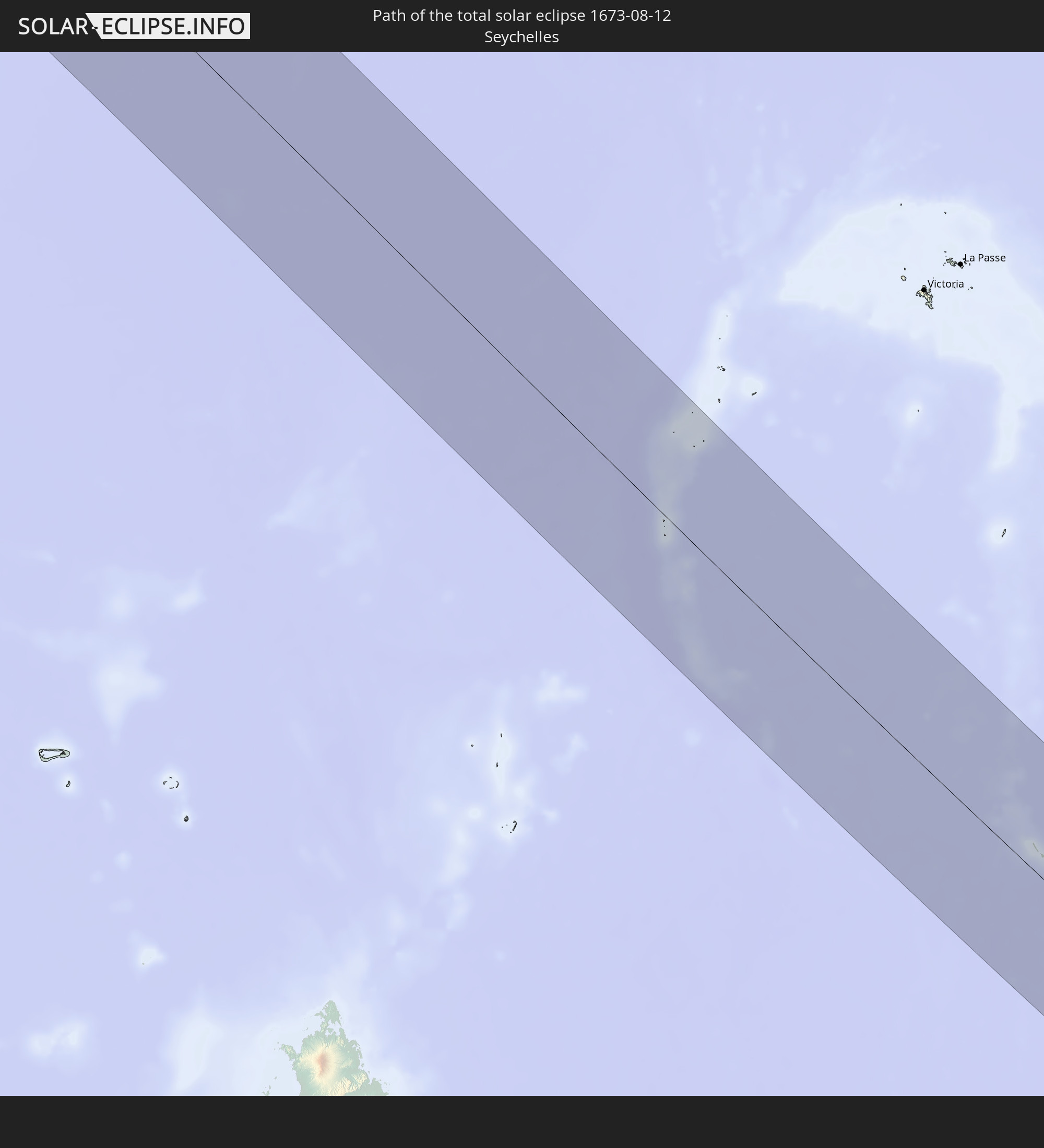 Seychellen
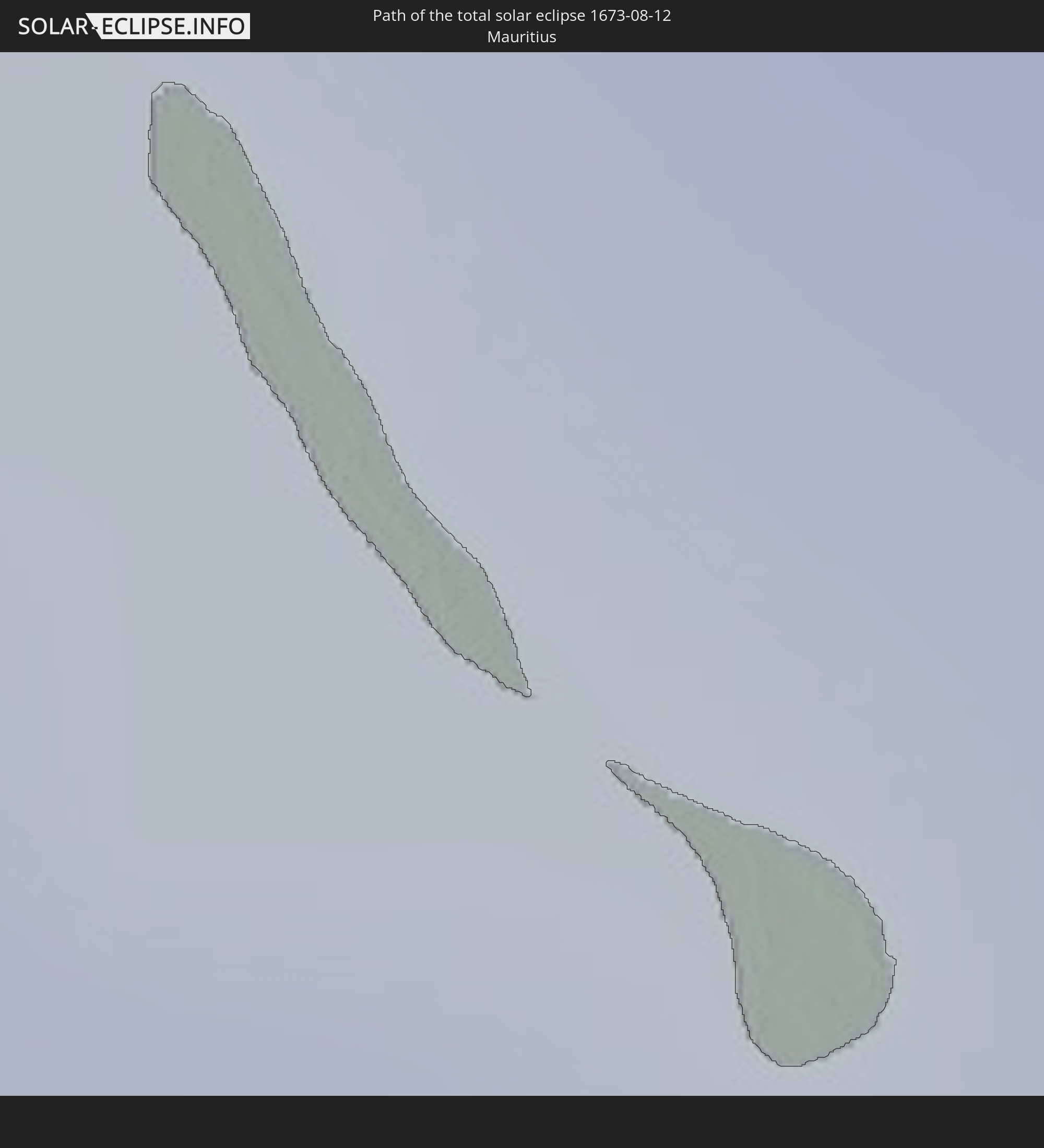 Mauritius
In den folgenden Ländern ist die Sonnenfinsternis partiell zu sehen
 Portugal
 Kap Verde
 Spanien
 Senegal
 Mauretanien
 Gambia
 Guinea-Bissau
 Guinea
 St. Helena
 Sierra Leone
 Marokko
 Mali
Mali
 Liberia
 Algerien
 Elfenbeinküste
 Burkina Faso
 Gibraltar
 Frankreich
 Ghana
Ghana
 Togo
Togo
 Niger
Niger
 Benin
Benin
 Andorra
 Nigeria
 Äquatorialguinea
 Deutschland
 Schweiz
 São Tomé und Príncipe
 Italien
 Monaco
 Tunesien
 Kamerun
 Gabun
Gabun
 Libyen
 Liechtenstein
 Österreich
 Republik Kongo
 Angola
 Namibia
 Demokratische Republik Kongo
 San Marino
 Vatikanstadt
 Slowenien
 Tschad
 Kroatien
 Malta
Malta
 Zentralafrikanische Republik
 Bosnien und Herzegowina
 Ungarn
 Südafrika
 Montenegro
 Serbien
 Albanien
 Griechenland
 Botswana
 Rumänien
 Mazedonien
 Sudan
Sudan
 Sambia
 Ukraine
 Bulgarien
 Ägypten
 Simbabwe
 Türkei
 Lesotho
 Ruanda
 Burundi
 Tansania
 Uganda
 Mosambik
 Swasiland
 Republik Zypern
 Malawi
 Äthiopien
 Kenia
Kenia
 Staat Palästina
 Israel
 Saudi-Arabien
 Jordanien
 Libanon
 Syrien
 Eritrea
 Irak
Irak
 Französische Süd- und Antarktisgebiete
 Somalia
 Dschibuti
 Jemen
Jemen
 Madagaskar
 Komoren
 Armenien
 Iran
Iran
 Aserbaidschan
 Mayotte
 Seychellen
 Kuwait
 Bahrain
 Katar
Katar
 Vereinigte Arabische Emirate
 Oman
Oman
 Réunion
 Mauritius
 Pakistan
 Indien
 Britisches Territorium im Indischen Ozean
 Heard und McDonaldinseln
 Malediven
 Sri Lanka
 Indonesien
 Kokosinseln
 Weihnachtsinsel
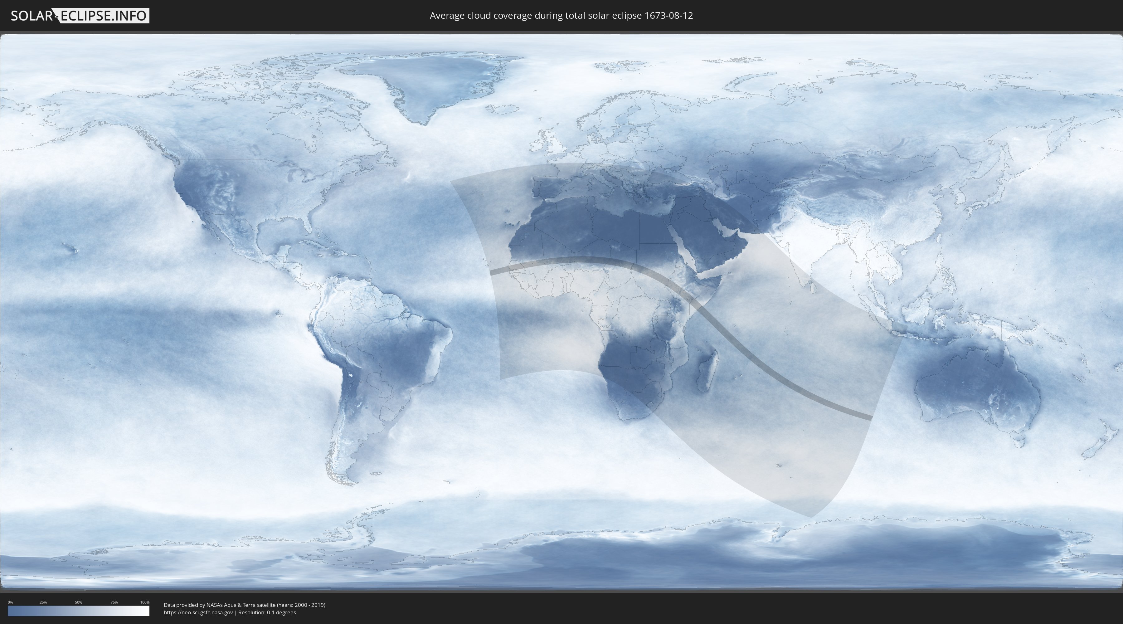
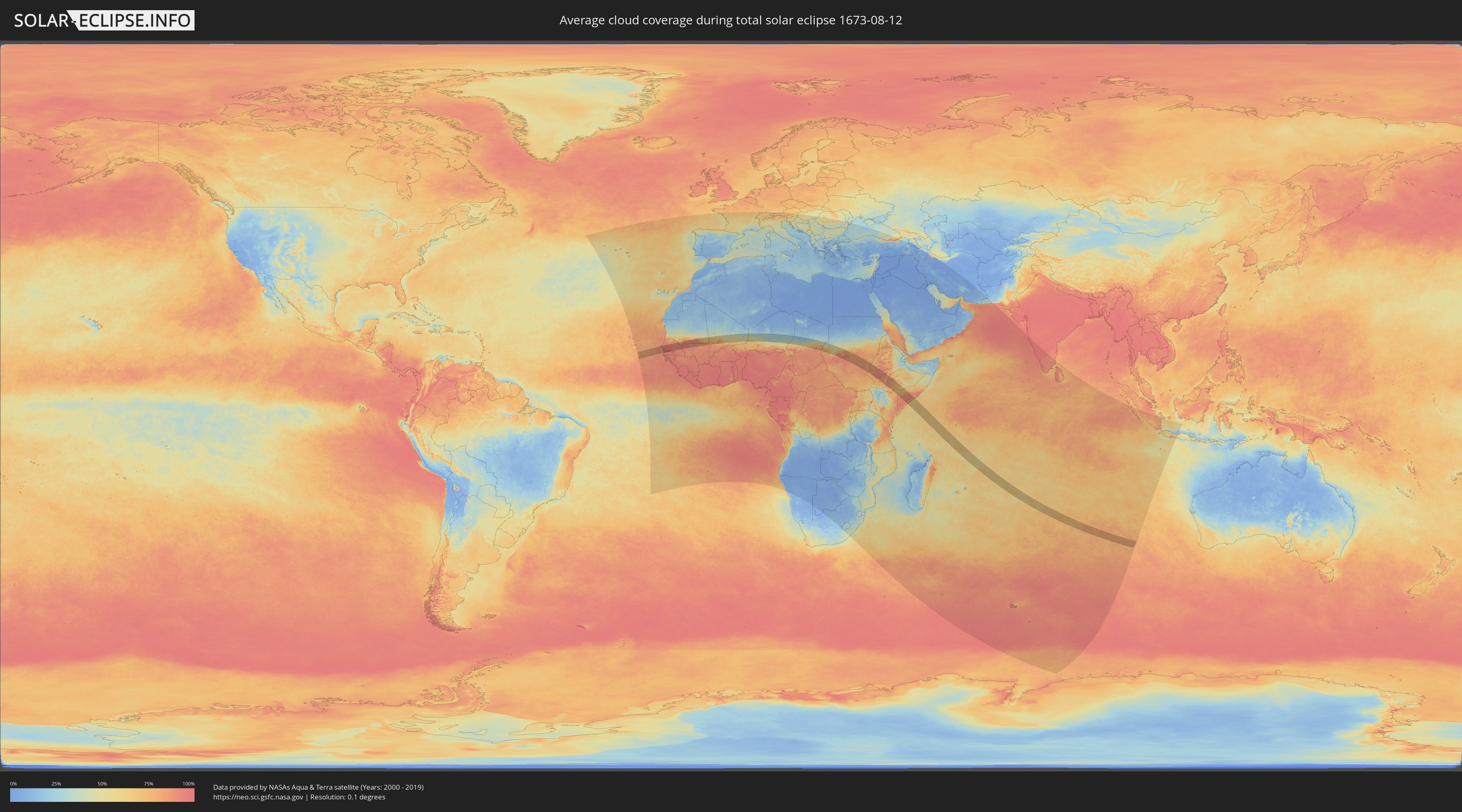
Wie wird das Wetter während der totalen Sonnenfinsternis am 12.08.1673?
Wo ist der beste Ort, um die totale Sonnenfinsternis vom 12.08.1673 zu beobachten?
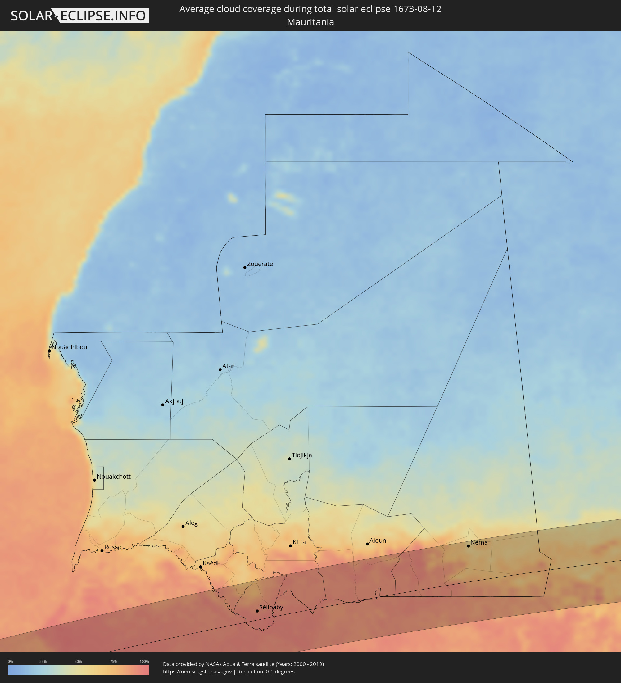
Die folgenden Karten zeigen die durchschnittliche Bewölkung für den Tag, an dem die totale Sonnenfinsternis
stattfindet. Mit Hilfe der Karten lässt sich der Ort entlang des Finsternispfades eingrenzen,
der die besten Aussichen auf einen klaren wolkenfreien Himmel bietet.
Trotzdem muss man immer lokale Gegenenheiten beachten und sollte sich genau über das Wetter an seinem
gewählten Beobachtungsort informieren.
Die Daten stammen von den beiden NASA-Satelliten
AQUA und TERRA
und wurden über einen Zeitraum von 19 Jahren (2000 - 2019) gemittelt.
Detaillierte Länderkarten
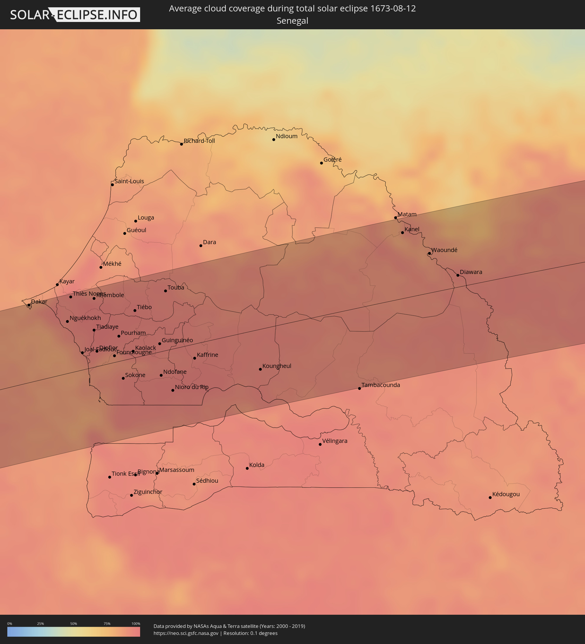 Senegal
 Mauretanien
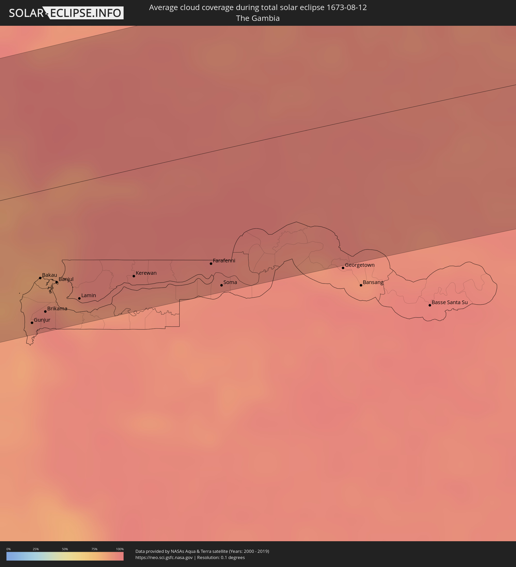 Gambia
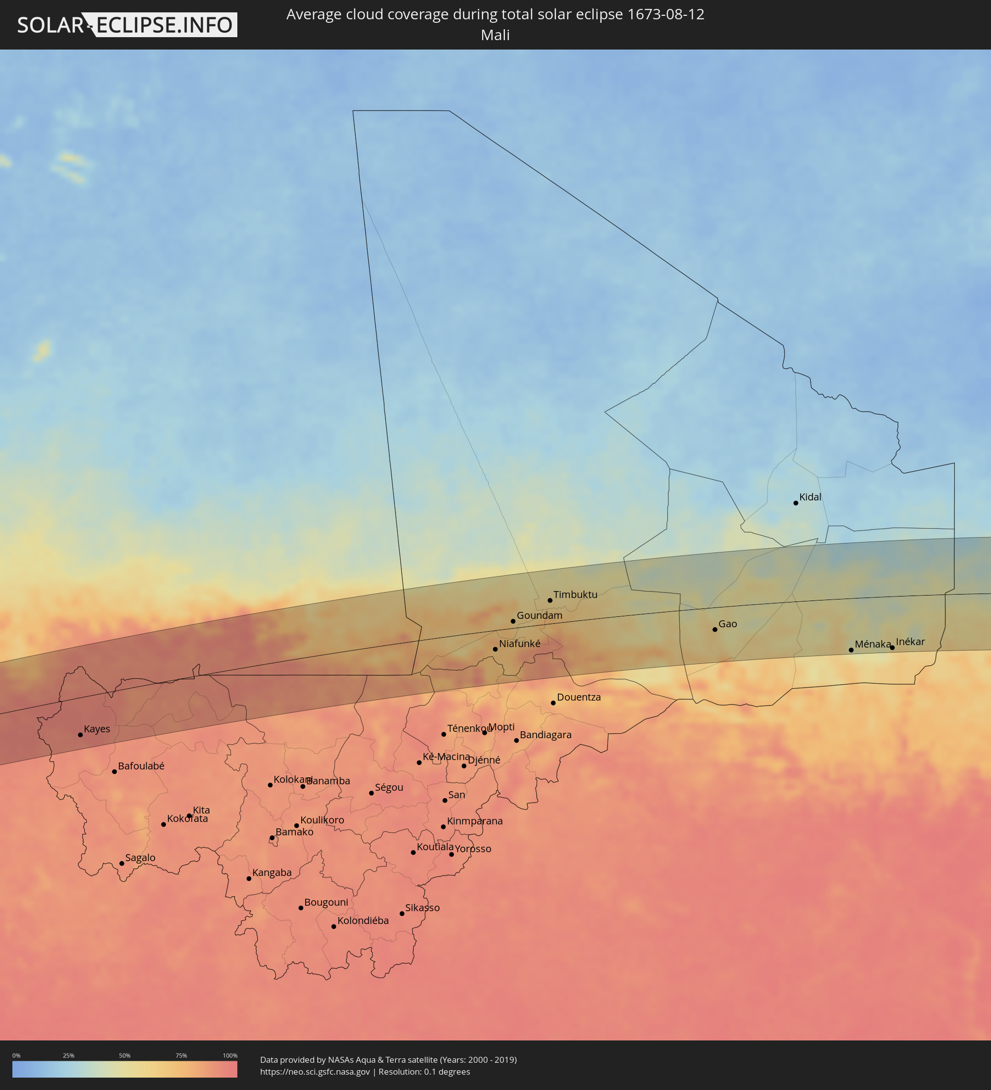 Mali
Mali
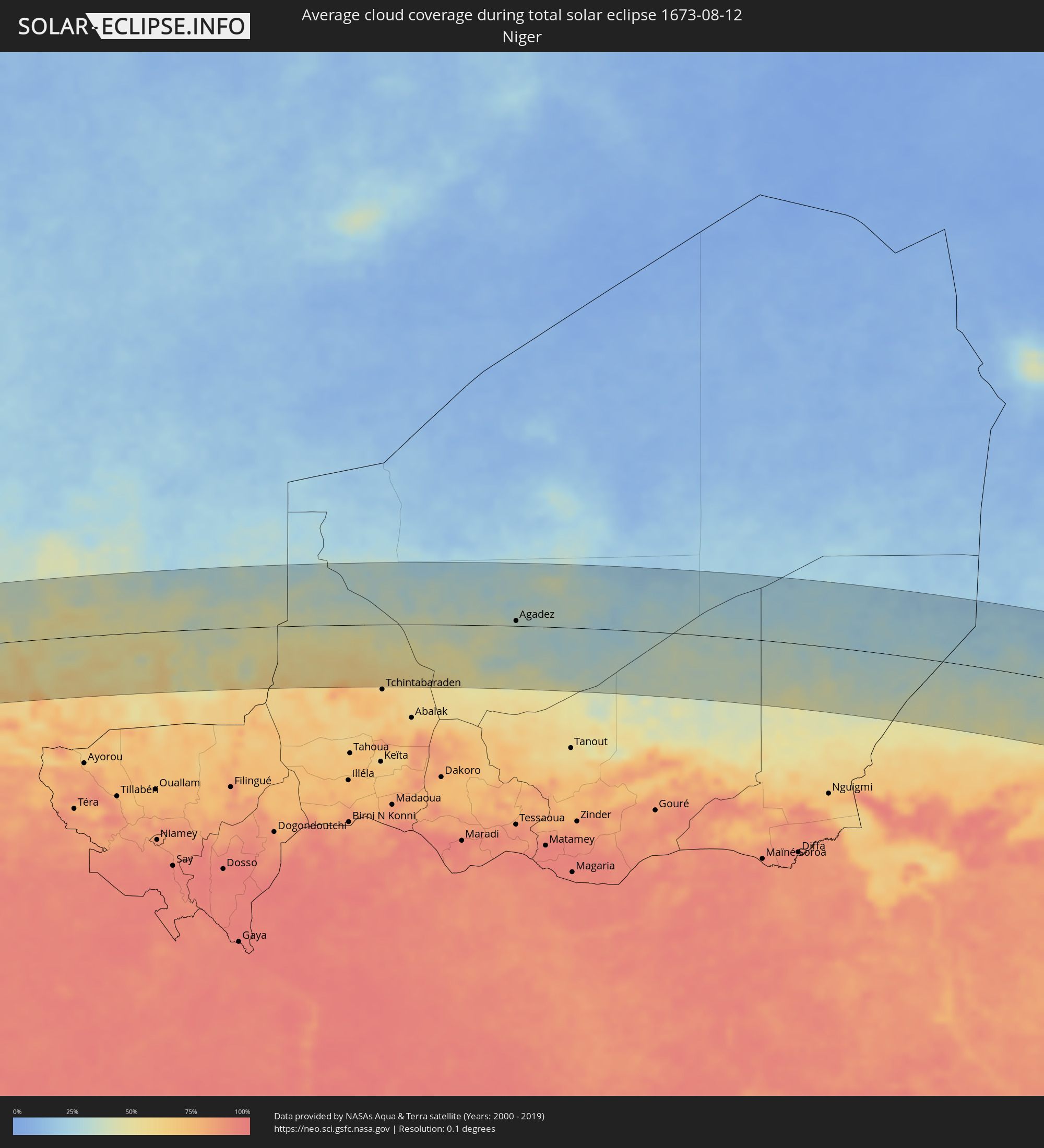 Niger
Niger
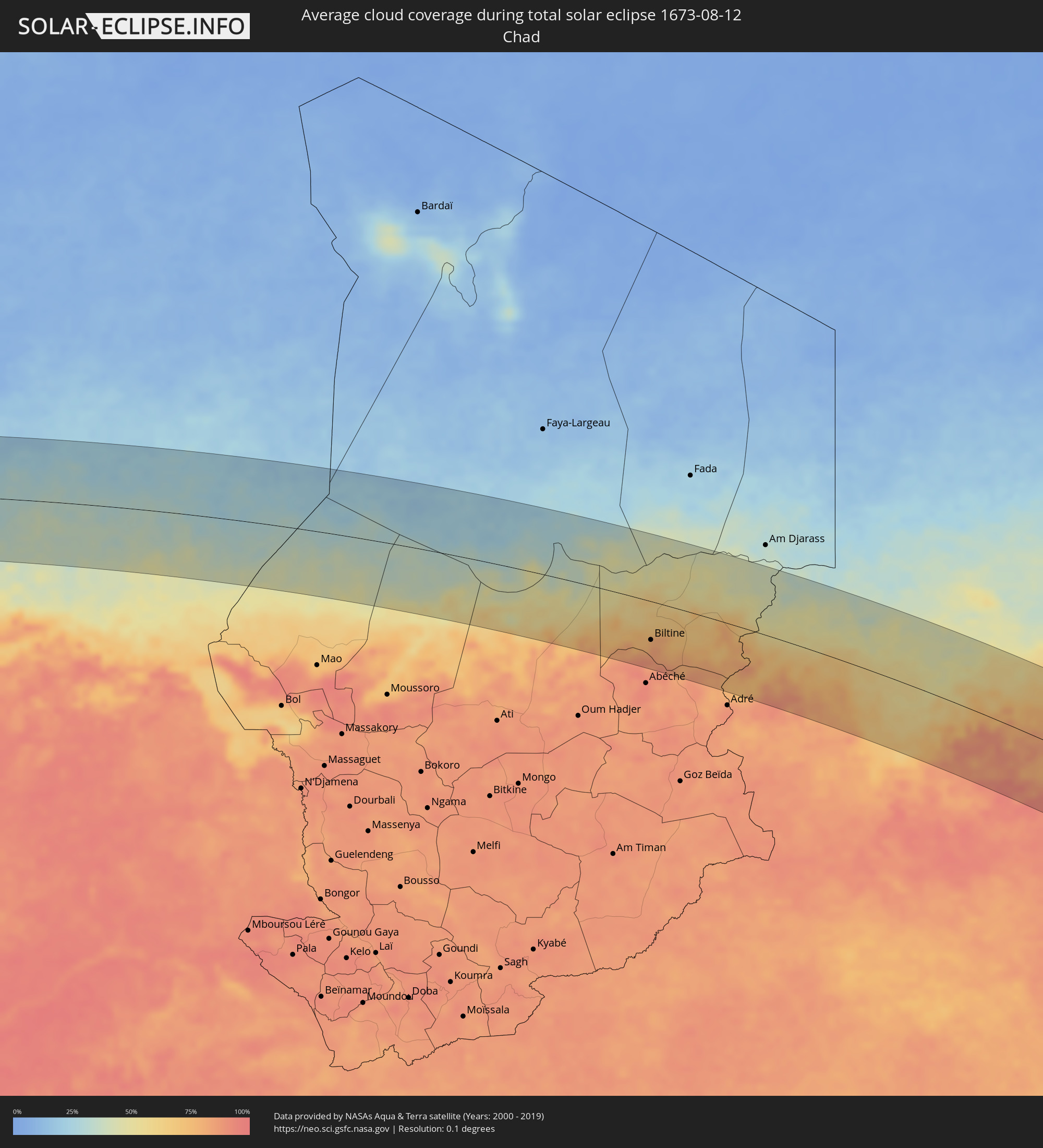 Tschad
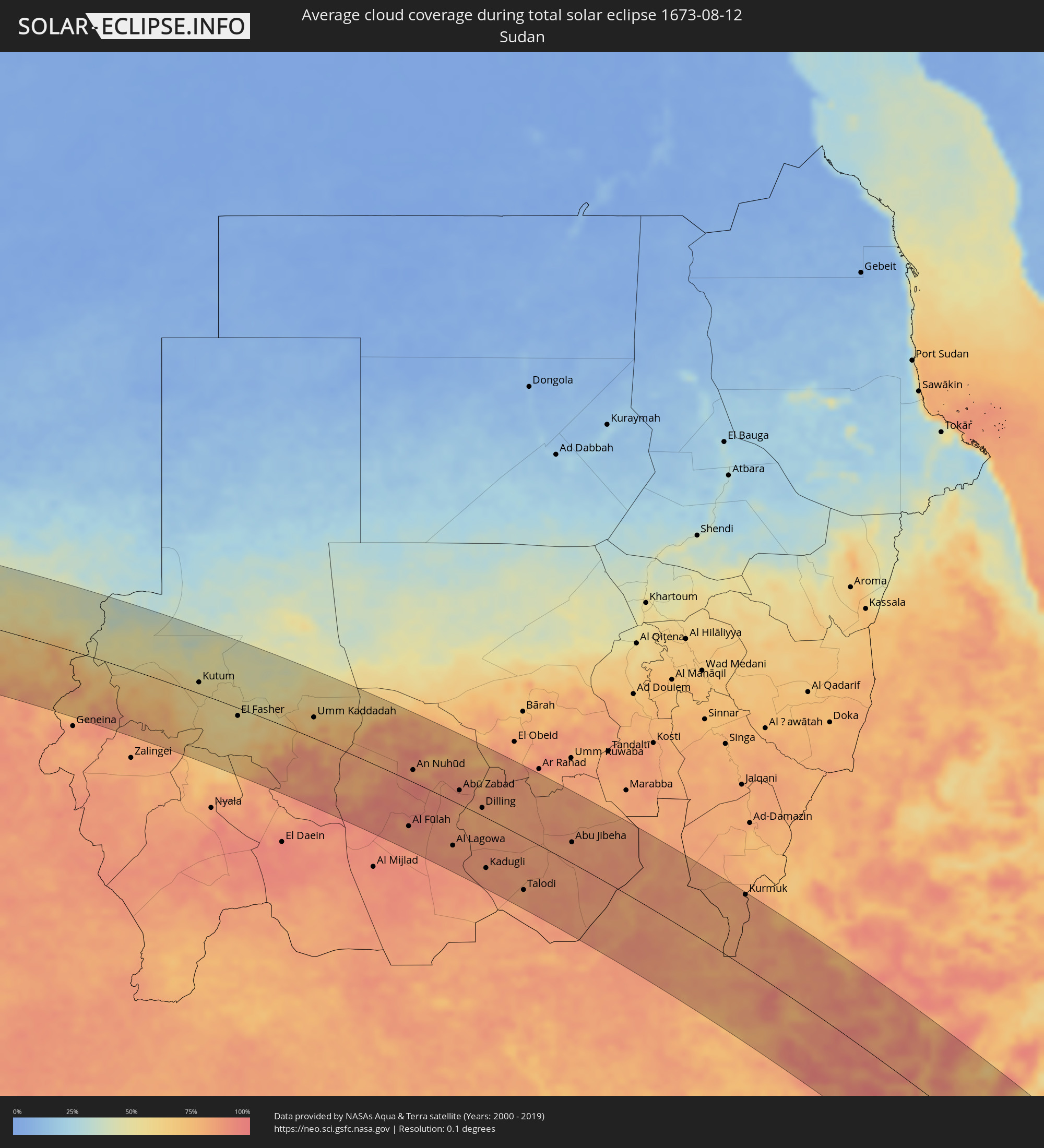 Sudan
Sudan
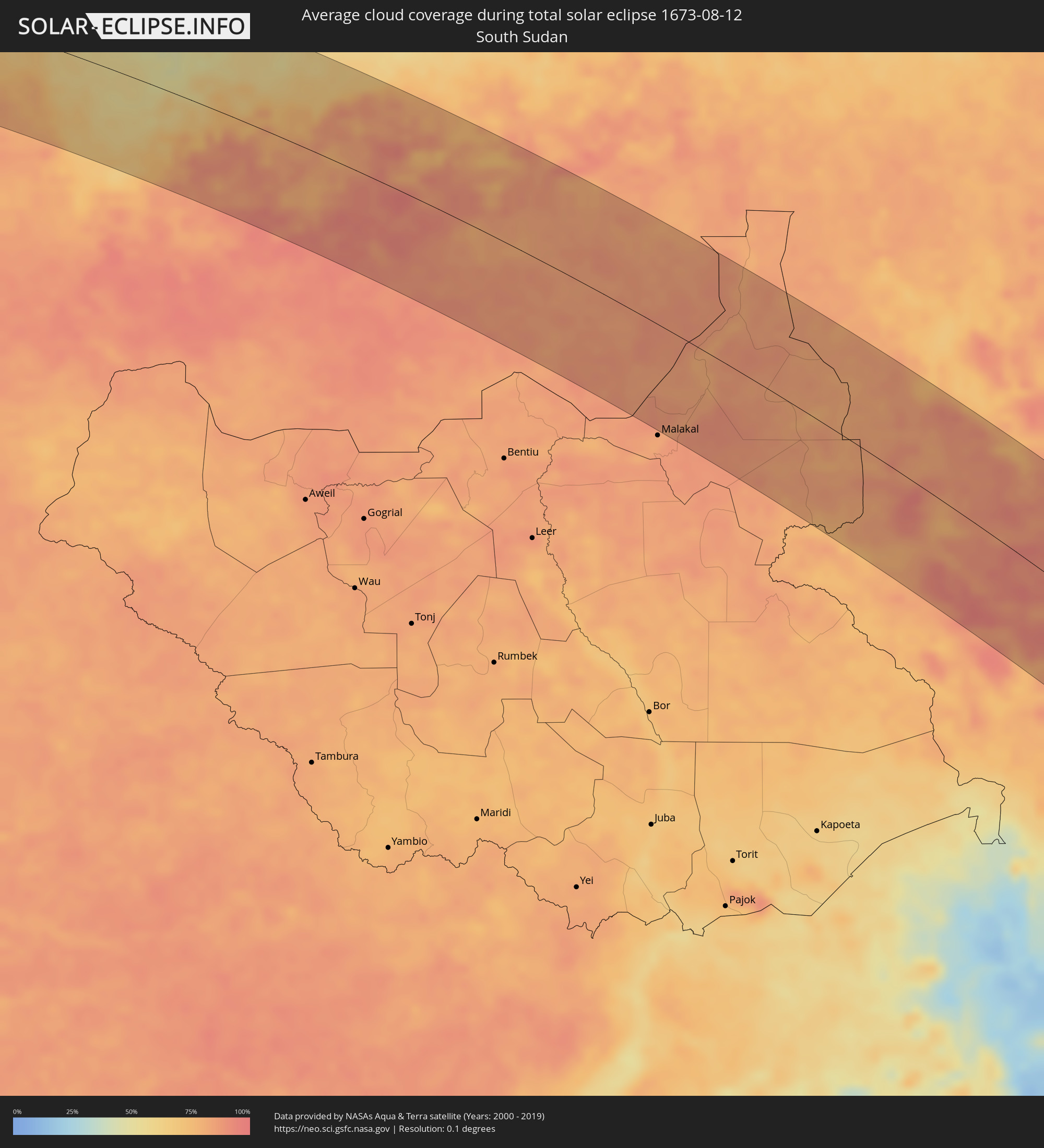 Südsudan
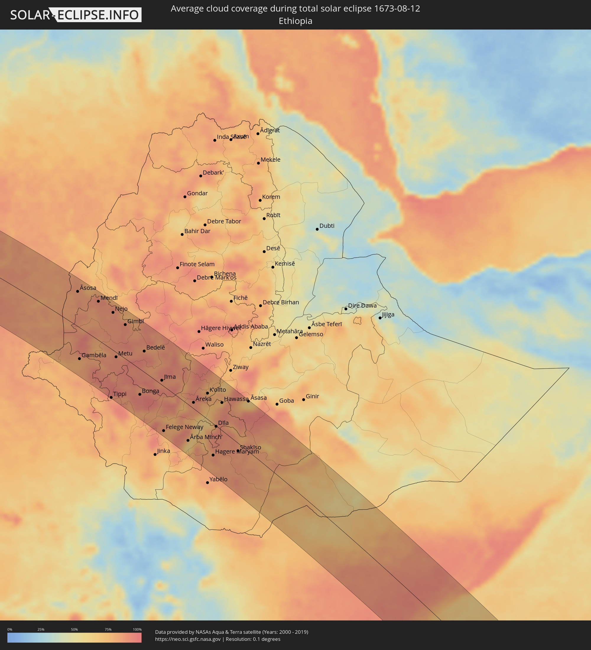 Äthiopien
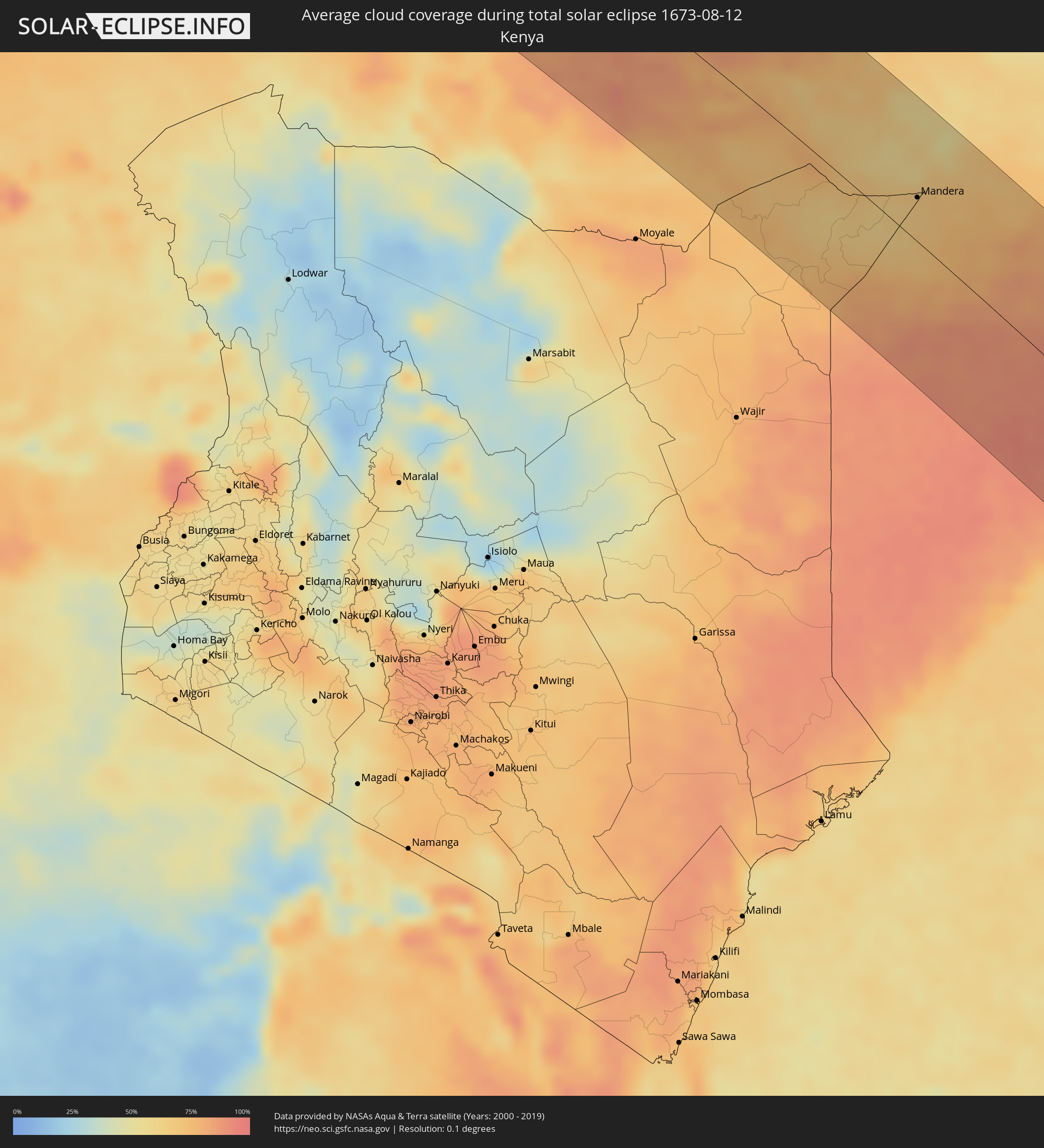 Kenia
Kenia
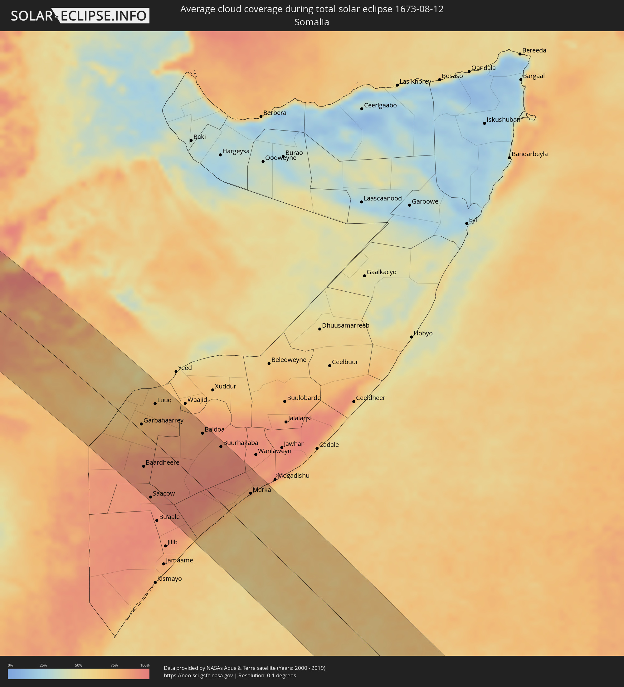 Somalia
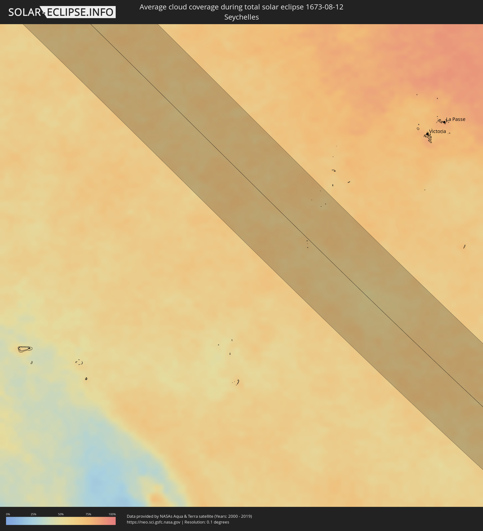 Seychellen
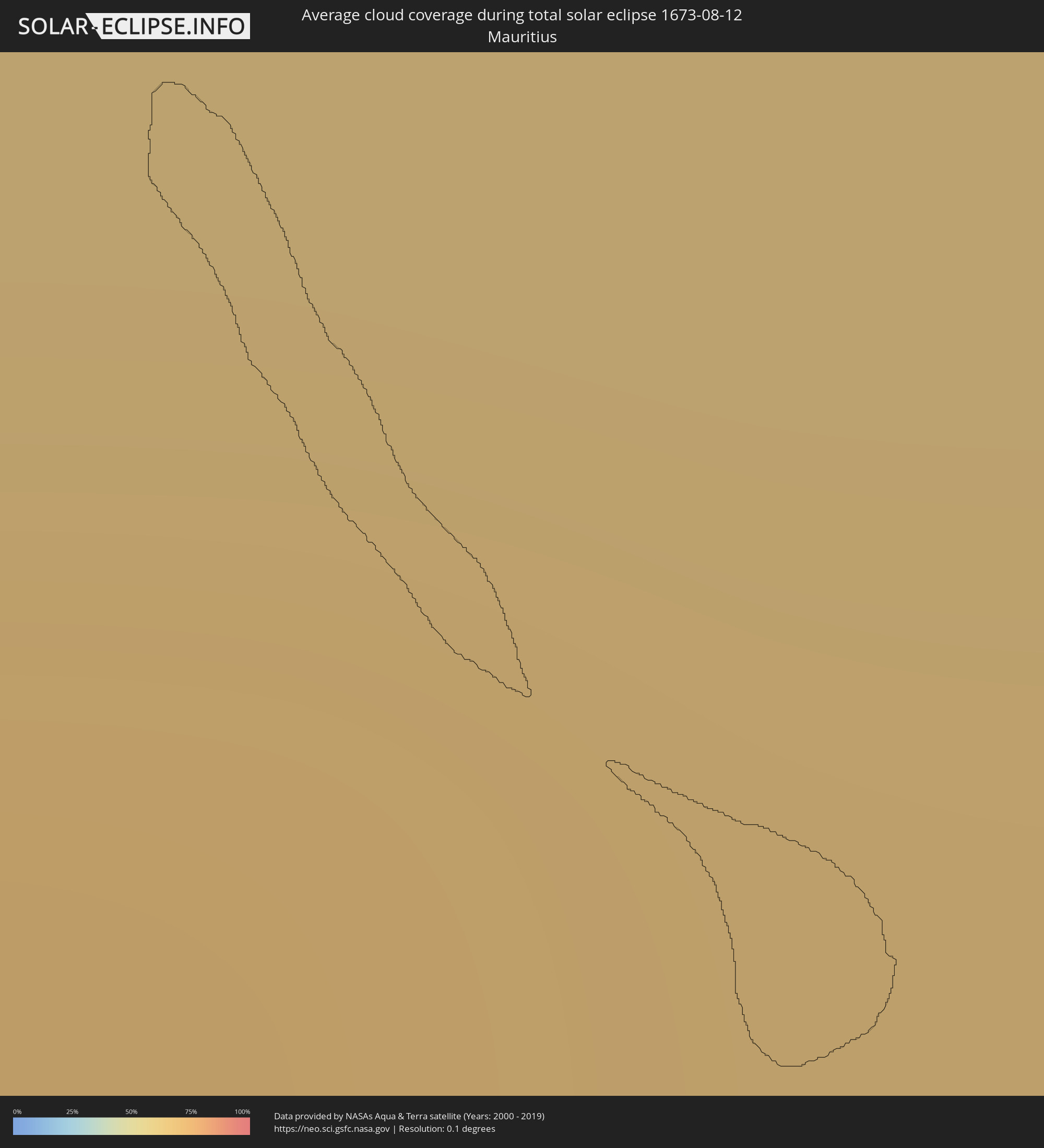 Mauritius
Orte im Finsternispfad
Die nachfolgene Tabelle zeigt Städte und Orte mit mehr als 5.000 Einwohnern, die sich im Finsternispfad befinden. Städte mit mehr als 100.000 Einwohnern sind dick gekennzeichnet. Mit einem Klick auf den Ort öffnet sich eine Detailkarte die die Lage des jeweiligen Ortes zusammen mit dem Verlauf der zentralen Finsternis präsentiert.
| Ort | Typ | Dauer der Verfinsterung | Ortszeit bei maximaler Verfinsterung | Entfernung zur Zentrallinie | Ø Bewölkung |
|
Dakar, Dakar
|
total | - | 07:06:58 UTC-00:16 | 92 km | 88% |
|
Pout, Thiès
|
total | - | 07:07:03 UTC-00:16 | 91 km | 96% |
|
Nguékhokh, Thiès
|
total | - | 07:07:05 UTC-00:16 | 62 km | 92% |
|
Thiès Nones, Thiès
|
total | - | 07:07:04 UTC-00:16 | 90 km | 94% |
|
Joal-Fadiout, Thiès
|
total | - | 07:07:10 UTC-00:16 | 20 km | 89% |
|
Gunjur, Western
|
total | - | 07:07:19 UTC-00:16 | 87 km | 91% |
|
Sukuta, Western
|
total | - | 07:07:18 UTC-00:16 | 65 km | 94% |
|
Khombole, Thiès
|
total | - | 07:07:08 UTC-00:16 | 82 km | 97% |
|
Tiadiaye, Thiès
|
total | - | 07:07:10 UTC-00:16 | 44 km | 96% |
|
Bakau, Banjul
|
total | - | 07:07:18 UTC-00:16 | 58 km | 87% |
|
Abuko, Western
|
total | - | 07:07:19 UTC-00:16 | 67 km | 94% |
|
Brikama, Western
|
total | - | 07:07:20 UTC-00:16 | 81 km | 95% |
|
Banjul, Banjul
|
total | - | 07:07:19 UTC-00:16 | 64 km | 86% |
|
Barra, North Bank
|
total | - | 07:07:20 UTC-00:16 | 61 km | 87% |
|
Essau, North Bank
|
total | - | 07:07:20 UTC-00:16 | 61 km | 87% |
|
Lamin, North Bank
|
total | - | 07:07:23 UTC-00:16 | 78 km | 87% |
|
Pourham, Fatick
|
total | - | 07:07:15 UTC-00:16 | 30 km | 95% |
|
Sokone, Fatick
|
total | - | 07:07:19 UTC-00:16 | 22 km | 93% |
|
Gandiaye, Kaolack
|
total | - | 07:07:18 UTC-00:16 | 13 km | 90% |
|
Kaolack, Kaolack
|
total | - | 07:07:19 UTC-00:16 | 8 km | 90% |
|
Tiébo, Diourbel
|
total | - | 07:07:16 UTC-00:16 | 56 km | 96% |
|
Kerewan, North Bank
|
total | - | 07:07:27 UTC-00:16 | 72 km | 92% |
|
Guinguinéo, Fatick
|
total | - | 07:07:23 UTC-00:16 | 9 km | 96% |
|
Ndofane, Kaolack
|
total | - | 07:07:26 UTC-00:16 | 29 km | 97% |
|
Touba, Diourbel
|
total | - | 07:07:20 UTC-00:16 | 71 km | 94% |
|
Nioro du Rip, Kaolack
|
total | - | 07:07:29 UTC-00:16 | 50 km | 96% |
|
Farafenni, North Bank
|
total | - | 07:07:34 UTC-00:16 | 75 km | 93% |
|
Kaffrine, Kaffrine
|
total | - | 07:07:31 UTC-00:16 | 18 km | 96% |
|
Mansa Konko, Lower River
|
total | - | 07:07:36 UTC-00:16 | 87 km | 92% |
|
Soma, Lower River
|
total | - | 07:07:37 UTC-00:16 | 91 km | 93% |
|
Koungheul, Kaffrine
|
total | - | 07:07:45 UTC-00:16 | 49 km | 95% |
|
Ouro Sogui, Matam
|
total | - | 07:08:03 UTC-00:16 | 94 km | 90% |
|
Kanel, Matam
|
total | - | 07:08:07 UTC-00:16 | 79 km | 90% |
|
Sélibaby, Guidimaka
|
total | - | 07:08:32 UTC-00:16 | 21 km | 92% |
|
Kayes, Kayes
|
total | - | 07:08:57 UTC-00:16 | 72 km | 91% |
|
Néma, Hodh ech Chargui
|
total | - | 07:10:49 UTC-00:16 | 87 km | 60% |
|
Niafunké, Tombouctou
|
total | - | 07:13:08 UTC-00:16 | 37 km | 71% |
|
Goundam, Tombouctou
|
total | - | 07:13:17 UTC-00:16 | 12 km | 70% |
|
Timbuktu, Tombouctou
|
total | - | 07:13:44 UTC-00:16 | 43 km | 59% |
|
Gao, Gao
|
total | - | 07:16:23 UTC-00:16 | 43 km | 62% |
|
Ménaka, Gao
|
total | - | 07:18:55 UTC-00:16 | 100 km | 56% |
|
Inékar, Gao
|
total | - | 07:19:42 UTC-00:16 | 99 km | 52% |
|
Agadez, Agadez
|
total | - | 07:54:53 UTC+00:13 | 9 km | 36% |
|
Alaghsas, Agadez
|
total | - | 07:54:54 UTC+00:13 | 14 km | 36% |
|
Biltine, Wadi Fira
|
total | - | 09:04:36 UTC+01:00 | 67 km | 83% |
|
Kutum, Northern Darfur
|
total | - | 10:22:32 UTC+02:10 | 20 km | 55% |
|
El Fasher, Northern Darfur
|
total | - | 10:24:39 UTC+02:10 | 14 km | 54% |
|
Umm Kaddadah, Northern Darfur
|
total | - | 10:27:33 UTC+02:10 | 37 km | 66% |
|
El Fula, West Kordofan State
|
total | - | 10:33:42 UTC+02:10 | 83 km | 89% |
|
Al Fūlah, Southern Kordofan
|
total | - | 10:33:42 UTC+02:10 | 80 km | 89% |
|
An Nuhūd, West Kordofan State
|
total | - | 10:32:33 UTC+02:10 | 21 km | 85% |
|
Al Lagowa, West Kordofan State
|
total | - | 10:35:55 UTC+02:10 | 76 km | 87% |
|
Abū Zabad, West Kordofan State
|
total | - | 10:34:51 UTC+02:10 | 24 km | 90% |
|
Dilling, Southern Kordofan
|
total | - | 10:36:10 UTC+02:10 | 14 km | 82% |
|
Kadugli, Southern Kordofan
|
total | - | 10:37:49 UTC+02:10 | 86 km | 86% |
|
Talodi, Southern Kordofan
|
total | - | 10:39:53 UTC+02:10 | 90 km | 84% |
|
Abu Jibeha, Southern Kordofan
|
total | - | 10:40:36 UTC+02:10 | 35 km | 84% |
|
Kurmuk, Blue Nile
|
total | - | 10:48:59 UTC+02:10 | 118 km | 84% |
|
Āsosa, Bīnshangul Gumuz
|
total | - | 11:07:29 UTC+02:27 | 88 km | 84% |
|
Gambēla, Gambela
|
total | - | 11:10:37 UTC+02:27 | 78 km | 79% |
|
Dembī Dolo, Oromiya
|
total | - | 11:10:39 UTC+02:27 | 39 km | 89% |
|
Mendī, Oromiya
|
total | - | 11:09:13 UTC+02:27 | 97 km | 89% |
|
Tippi, Southern Nations, Nationalities, and People's Region
|
total | - | 11:14:27 UTC+02:27 | 120 km | 86% |
|
Metu, Oromiya
|
total | - | 11:12:52 UTC+02:27 | 12 km | 90% |
|
Gimbi, Oromiya
|
total | - | 11:11:58 UTC+02:27 | 84 km | 90% |
|
Āgaro, Oromiya
|
total | - | 11:16:07 UTC+02:27 | 15 km | 85% |
|
Jīma, Oromiya
|
total | - | 11:16:52 UTC+02:27 | 11 km | 86% |
|
Felege Neway, Southern Nations, Nationalities, and People's Region
|
total | - | 11:19:23 UTC+02:27 | 108 km | 81% |
|
Ārba Minch’, Southern Nations, Nationalities, and People's Region
|
total | - | 11:21:25 UTC+02:27 | 87 km | 61% |
|
Āreka, Southern Nations, Nationalities, and People's Region
|
total | - | 11:19:55 UTC+02:27 | 14 km | 87% |
|
Bodītī, Southern Nations, Nationalities, and People's Region
|
total | - | 11:20:29 UTC+02:27 | 17 km | 85% |
|
K’olīto, Southern Nations, Nationalities, and People's Region
|
total | - | 11:20:21 UTC+02:27 | 62 km | 82% |
|
Dīla, Southern Nations, Nationalities, and People's Region
|
total | - | 11:22:30 UTC+02:27 | 1 km | 84% |
|
Yirga ‘Alem, Southern Nations, Nationalities, and People's Region
|
total | - | 11:22:08 UTC+02:27 | 35 km | 86% |
|
Hawassa, Southern Nations, Nationalities, and People's Region
|
total | - | 11:21:42 UTC+02:27 | 66 km | 76% |
|
Shashemenē, Oromiya
|
total | - | 11:21:44 UTC+02:27 | 87 km | 81% |
|
Shakīso, Oromiya
|
total | - | 11:25:05 UTC+02:27 | 18 km | 86% |
|
Kibre Mengist, Oromiya
|
total | - | 11:25:00 UTC+02:27 | 2 km | 84% |
|
Mandera, Mandera
|
total | - | 11:35:03 UTC+02:27 | 37 km | 66% |
|
Garbahaarrey, Gedo
|
total | - | 11:36:59 UTC+02:27 | 13 km | 73% |
|
Baardheere, Gedo
|
total | - | 11:38:57 UTC+02:27 | 65 km | 86% |
|
Saacow, Middle Juba
|
total | - | 11:40:39 UTC+02:27 | 112 km | 90% |
|
Luuq, Gedo
|
total | - | 11:36:49 UTC+02:27 | 76 km | 74% |
|
Baidoa, Bay
|
total | - | 11:40:30 UTC+02:27 | 101 km | 83% |
|
Buurhakaba, Bay
|
total | - | 11:42:01 UTC+02:27 | 108 km | 87% |
|
Qoryooley, Lower Shabeelle
|
total | - | 11:44:52 UTC+02:27 | 59 km | 84% |
|
Marka, Lower Shabeelle
|
total | - | 11:45:31 UTC+02:27 | 71 km | 68% |