Totale Sonnenfinsternis vom 24.06.1778
| Wochentag: | Mittwoch |
| Maximale Dauer der Verfinsterung: | 05m52s |
| Maximale Breite des Finsternispfades: | 255 km |
| Saroszyklus: | 133 |
| Bedeckungsgrad: | 100% |
| Magnitude: | 1.0746 |
| Gamma: | 0.3127 |
Wo kann man die Sonnenfinsternis vom 24.06.1778 sehen?
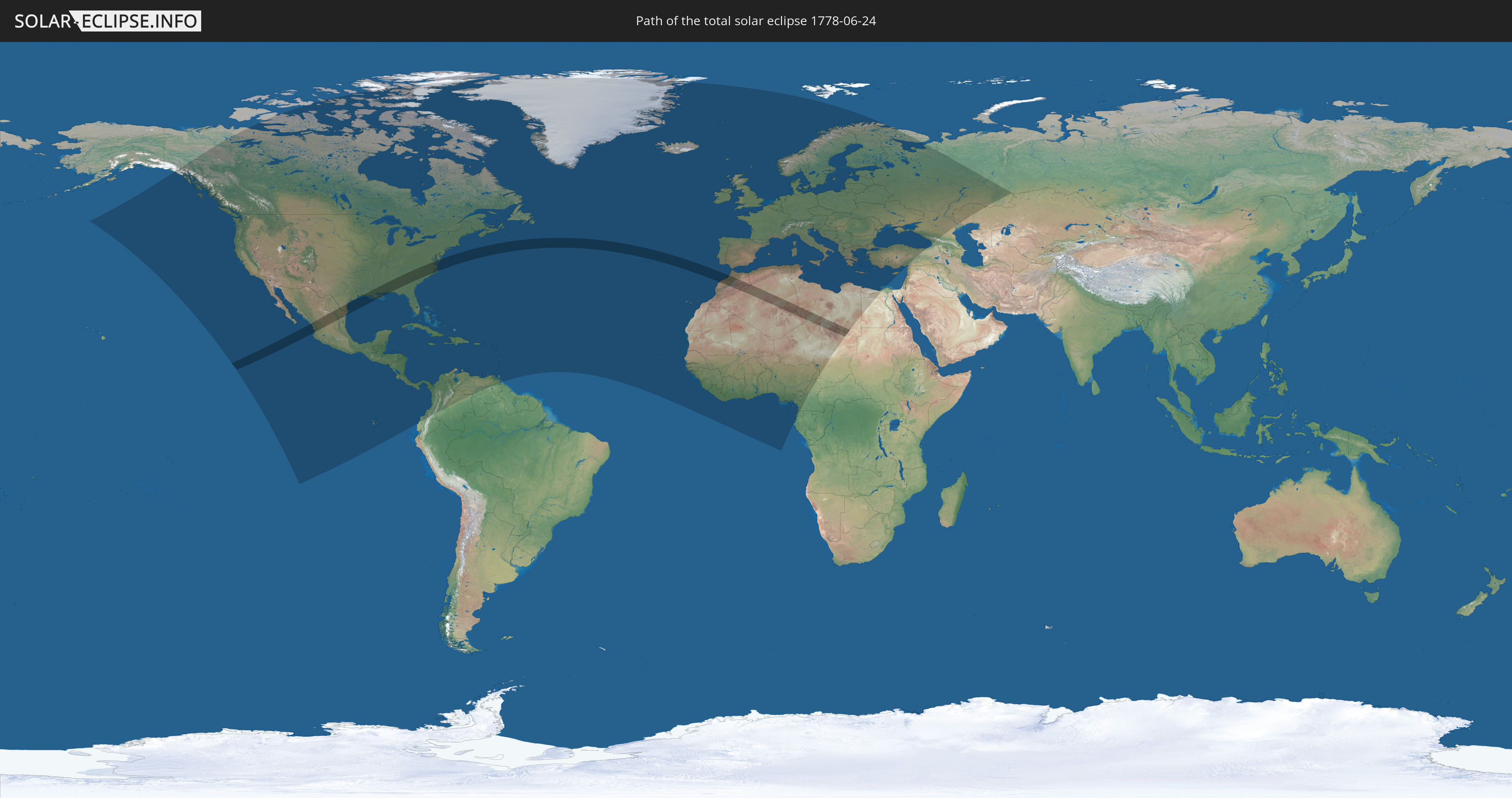
Die Sonnenfinsternis am 24.06.1778 kann man in 123 Ländern als partielle Sonnenfinsternis beobachten.
Der Finsternispfad verläuft durch 8 Länder. Nur in diesen Ländern ist sie als totale Sonnenfinsternis zu sehen.
In den folgenden Ländern ist die Sonnenfinsternis total zu sehen
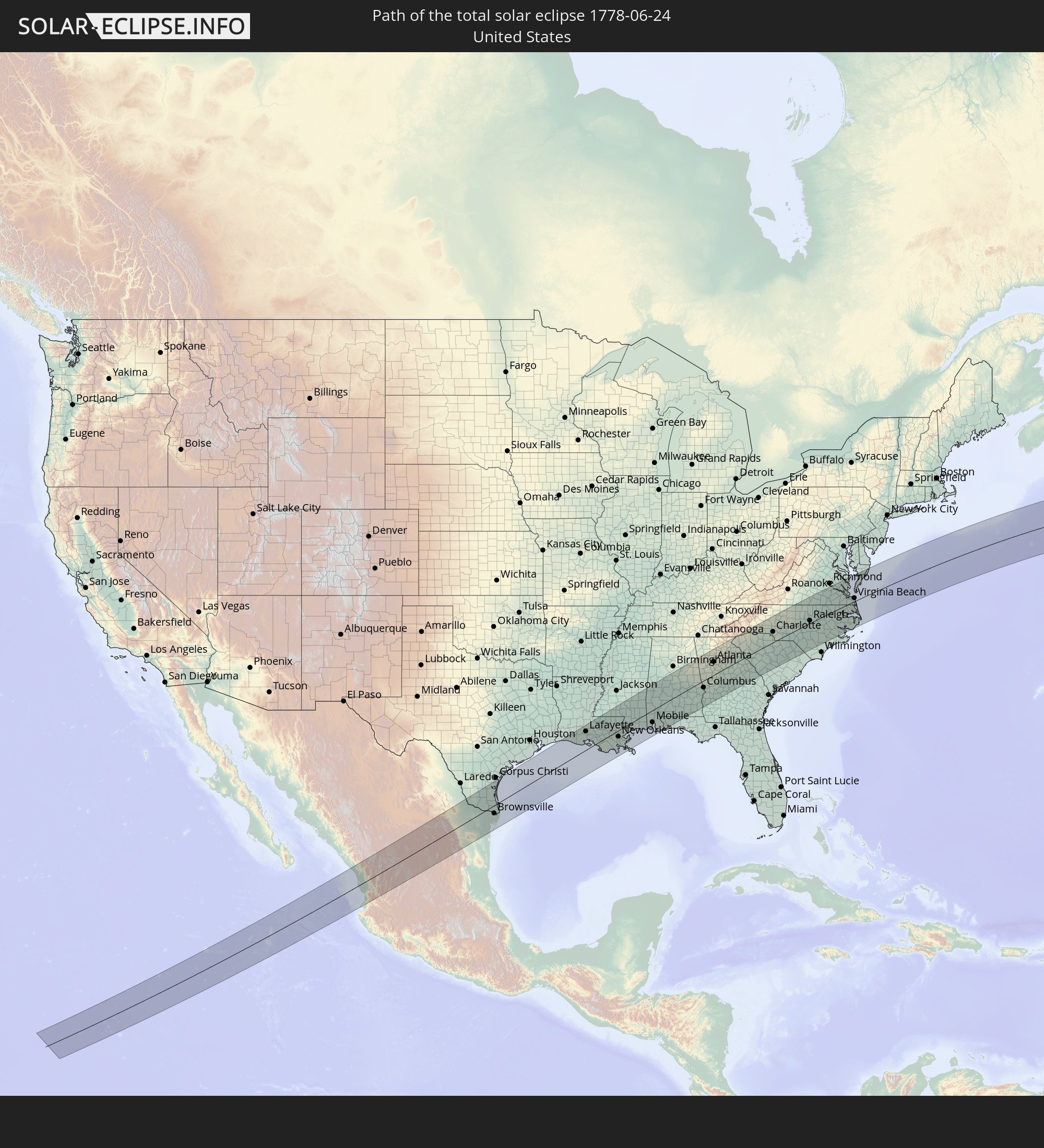 Vereinigte Staaten
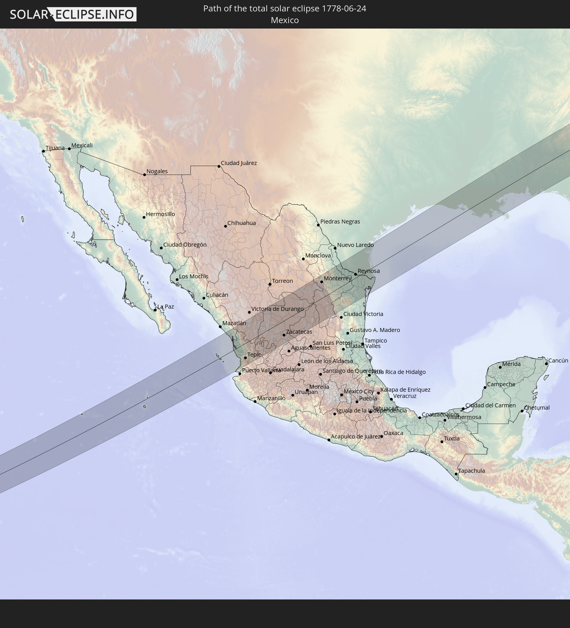 Mexiko
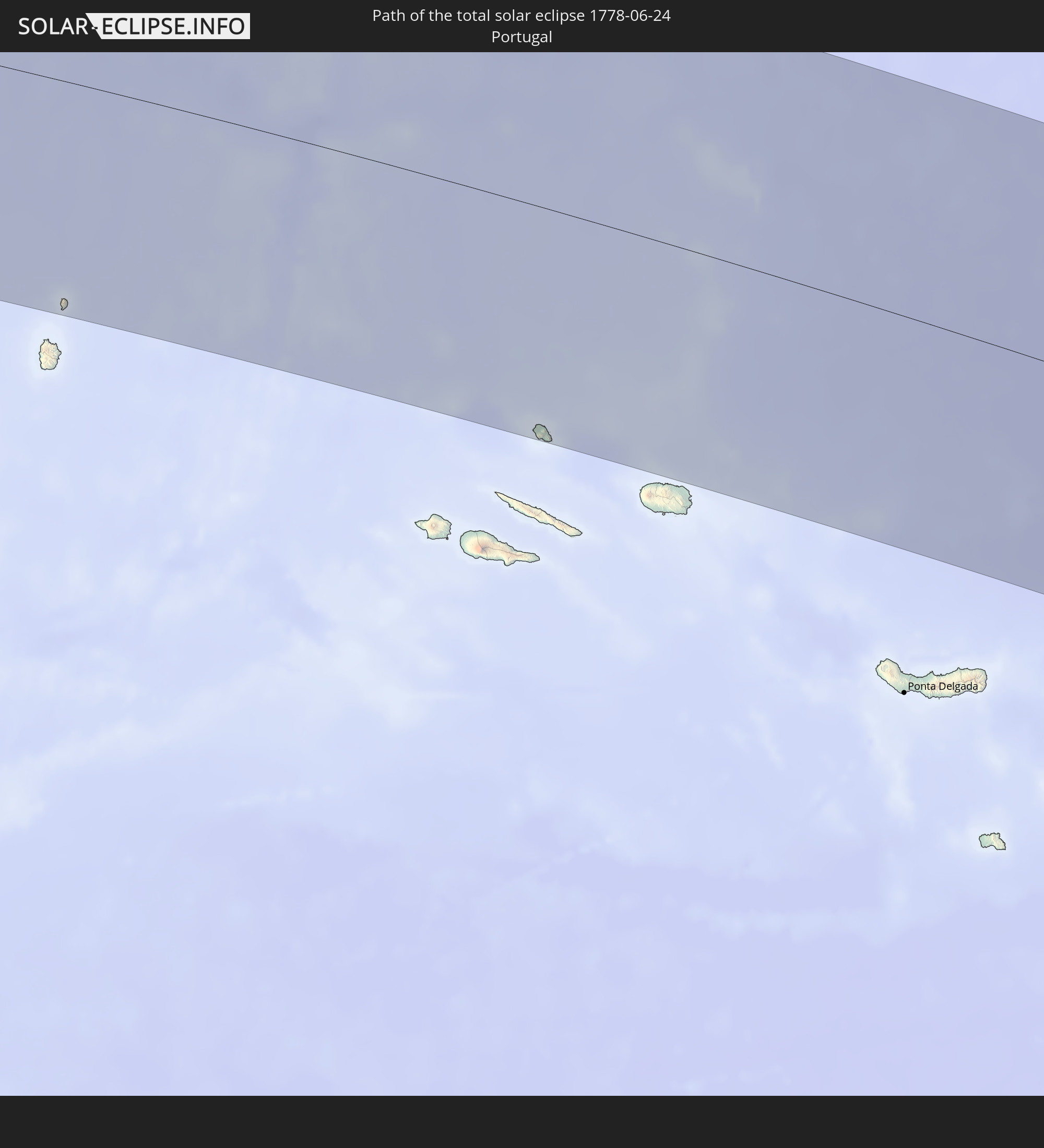 Portugal
 Marokko
 Algerien
 Niger
Niger
 Libyen
 Tschad
In den folgenden Ländern ist die Sonnenfinsternis partiell zu sehen
 Russland
 Vereinigte Staaten
 United States Minor Outlying Islands
 Kanada
 Mexiko
 Grönland
 Guatemala
 Ecuador
 El Salvador
 Honduras
 Belize
 Nicaragua
 Costa Rica
 Kuba
Kuba
 Panama
 Kolumbien
 Kaimaninseln
 Bahamas
 Jamaika
 Haiti
Haiti
 Venezuela
 Turks- und Caicosinseln
 Dominikanische Republik
 Aruba
Aruba
 Puerto Rico
 Amerikanische Jungferninseln
 Bermuda
 Britische Jungferninseln
 Anguilla
 Saint-Martin
 Saint-Barthélemy
 St. Kitts und Nevis
 Antigua und Barbuda
 Montserrat
 Trinidad und Tobago
 Guadeloupe
 Grenada
 Dominica
 St. Vincent und die Grenadinen
 Martinique
 St. Lucia
 Barbados
 Saint-Pierre und Miquelon
 Portugal
 Kap Verde
 Island
 Spanien
 Senegal
 Mauretanien
 Gambia
 Guinea-Bissau
 Guinea
 Sierra Leone
 Marokko
 Mali
Mali
 Liberia
 Irland
 Spitzbergen
 Algerien
 Vereinigtes Königreich
 Elfenbeinküste
 Färöer
 Burkina Faso
 Gibraltar
 Frankreich
 Isle of Man
 Ghana
Ghana
 Guernsey
 Jersey
 Togo
Togo
 Niger
Niger
 Benin
Benin
 Andorra
 Belgien
 Nigeria
 Niederlande
 Norwegen
 Äquatorialguinea
 Luxemburg
 Deutschland
 Schweiz
 São Tomé und Príncipe
 Italien
 Monaco
 Tunesien
 Dänemark
 Kamerun
 Gabun
Gabun
 Libyen
 Liechtenstein
 Österreich
 Schweden
 Tschechien
 San Marino
 Vatikanstadt
 Slowenien
 Tschad
 Kroatien
 Polen
Polen
 Malta
Malta
 Bosnien und Herzegowina
 Ungarn
 Slowakei
 Montenegro
 Serbien
 Albanien
 Åland Islands
 Griechenland
 Rumänien
 Mazedonien
 Finnland
 Litauen
 Lettland
 Estland
 Ukraine
 Bulgarien
 Weißrussland
 Ägypten
 Türkei
 Moldawien
 Republik Zypern
 Georgien
 Kasachstan
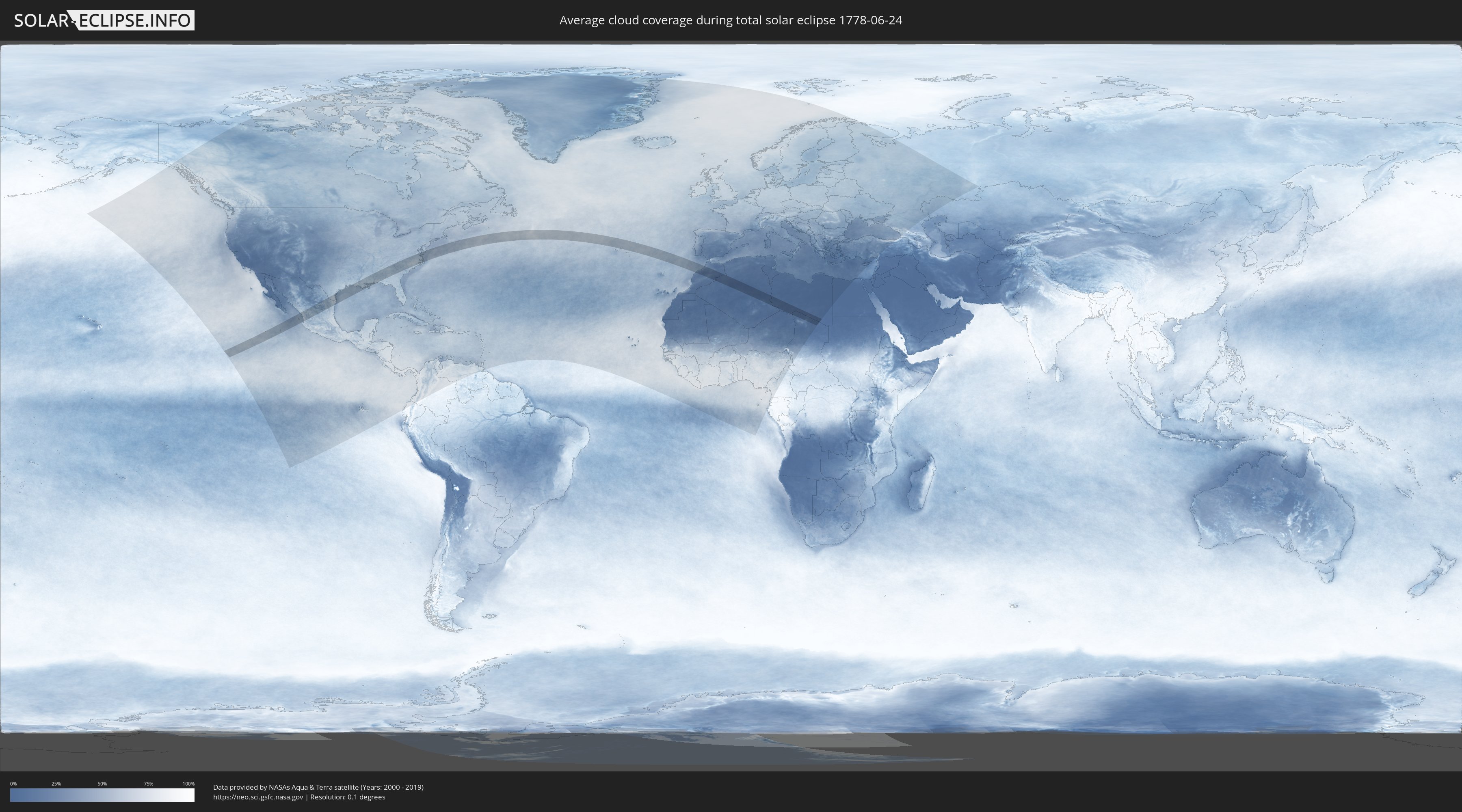
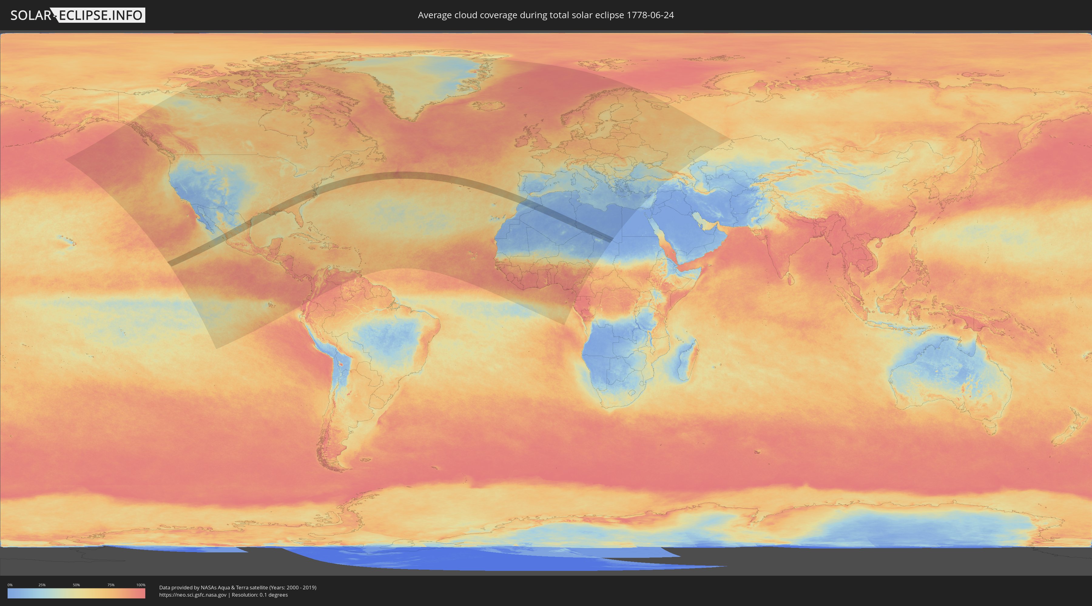
Wie wird das Wetter während der totalen Sonnenfinsternis am 24.06.1778?
Wo ist der beste Ort, um die totale Sonnenfinsternis vom 24.06.1778 zu beobachten?
Die folgenden Karten zeigen die durchschnittliche Bewölkung für den Tag, an dem die totale Sonnenfinsternis
stattfindet. Mit Hilfe der Karten lässt sich der Ort entlang des Finsternispfades eingrenzen,
der die besten Aussichen auf einen klaren wolkenfreien Himmel bietet.
Trotzdem muss man immer lokale Gegenenheiten beachten und sollte sich genau über das Wetter an seinem
gewählten Beobachtungsort informieren.
Die Daten stammen von den beiden NASA-Satelliten
AQUA und TERRA
und wurden über einen Zeitraum von 19 Jahren (2000 - 2019) gemittelt.
Detaillierte Länderkarten
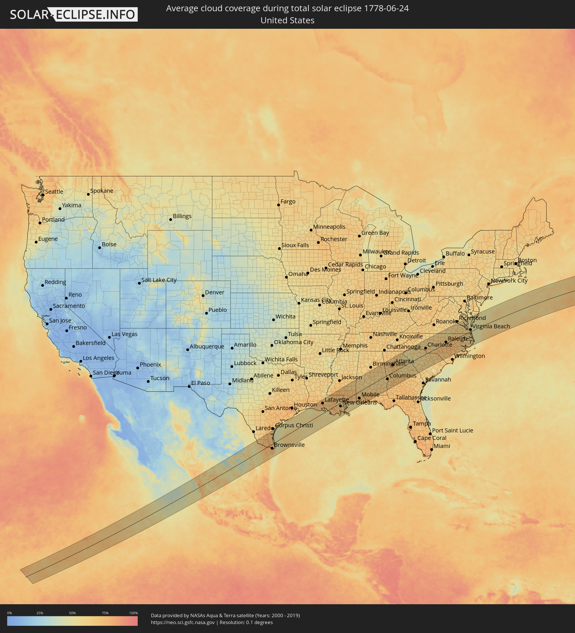 Vereinigte Staaten
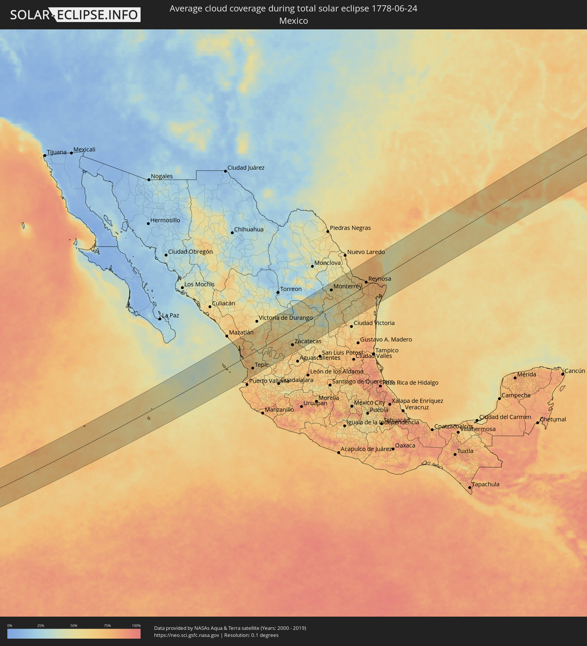 Mexiko
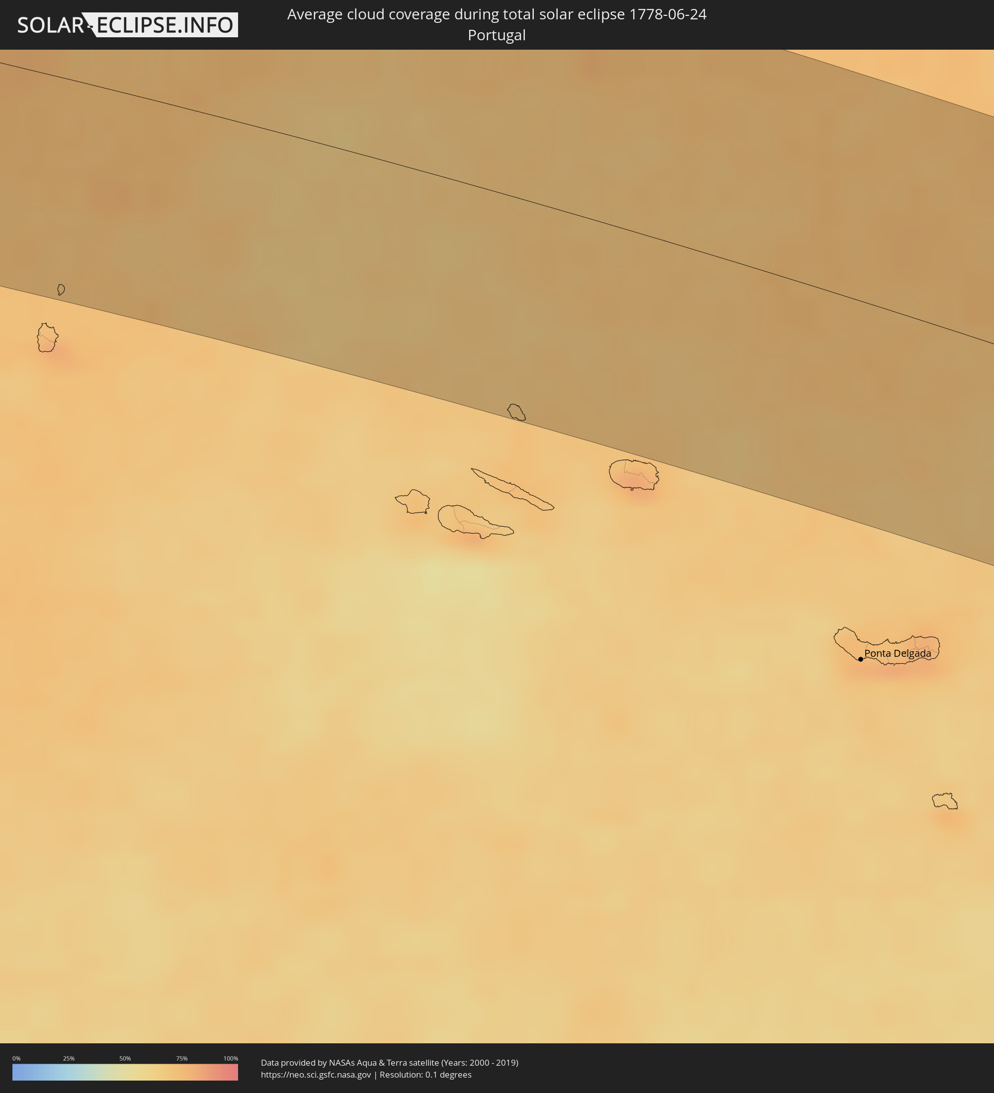 Portugal
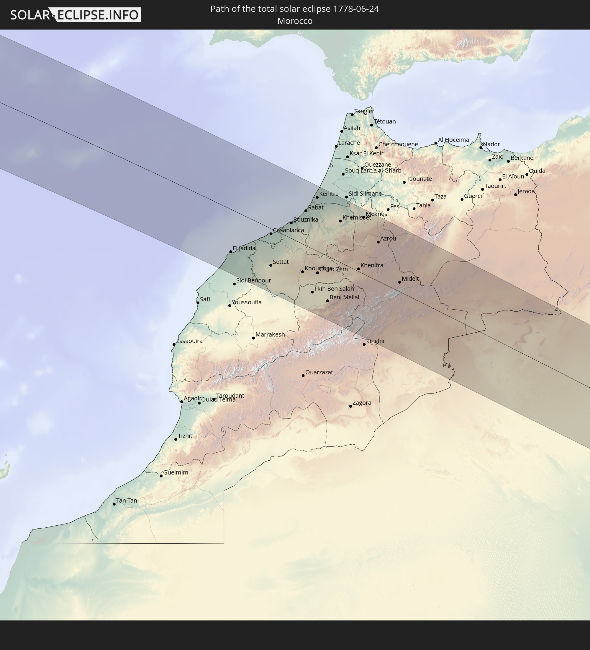
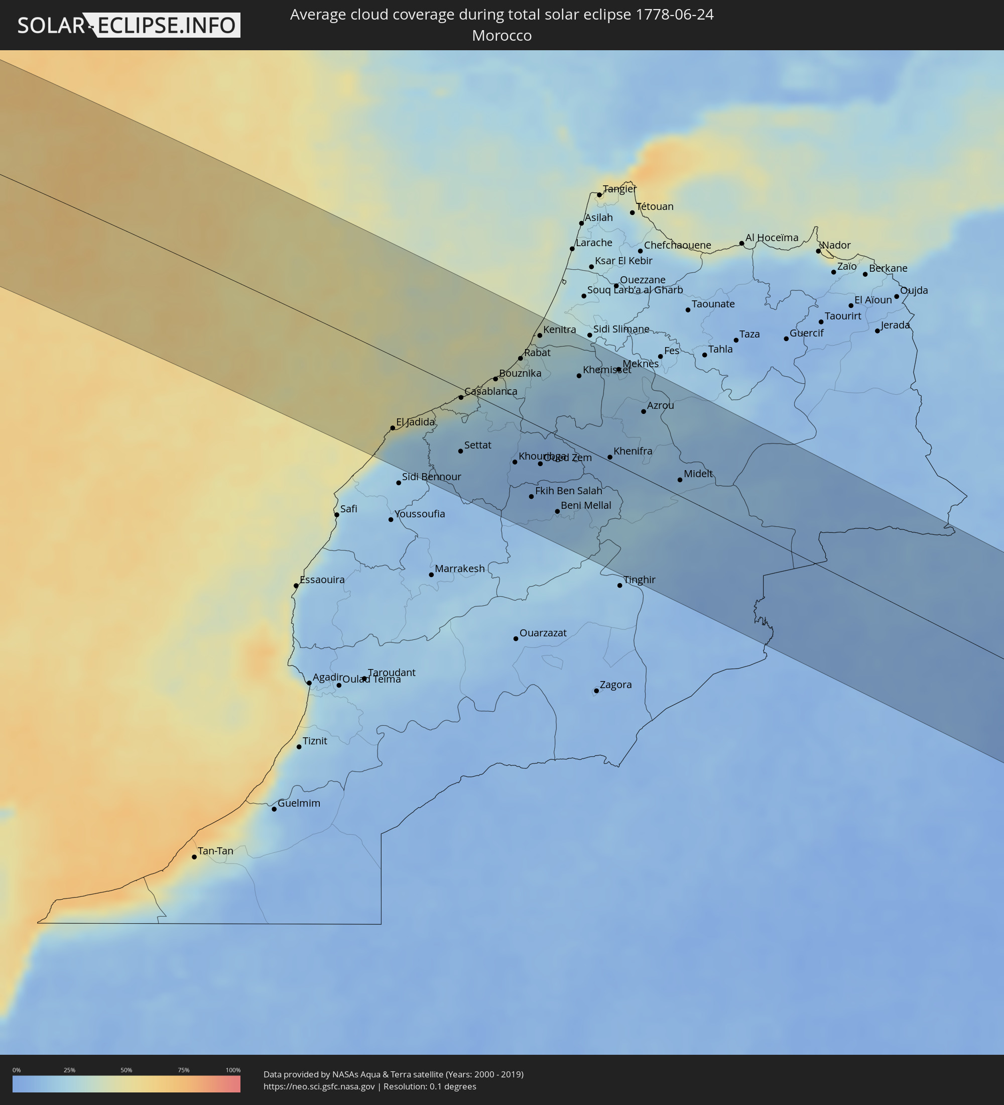 Marokko
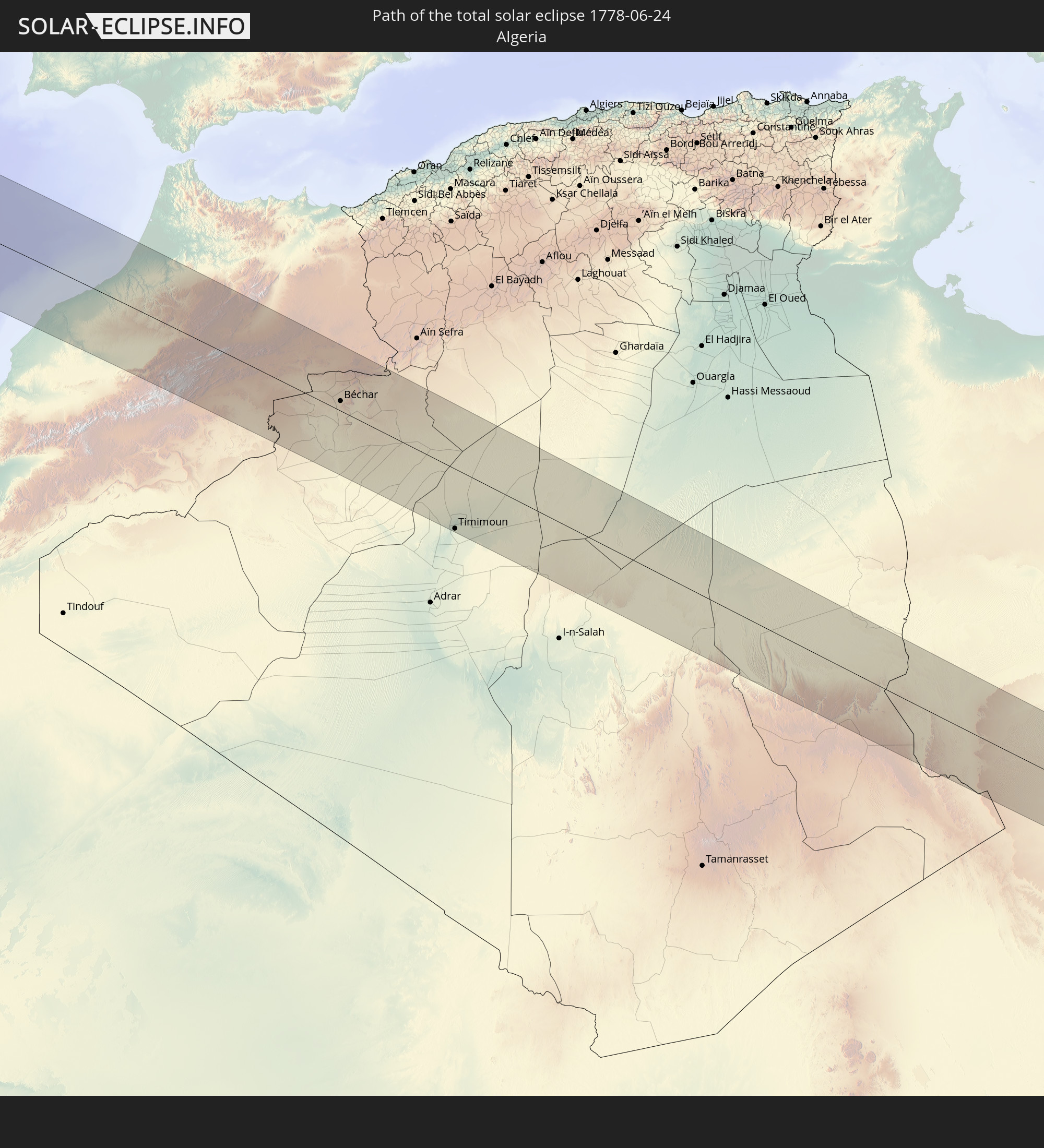
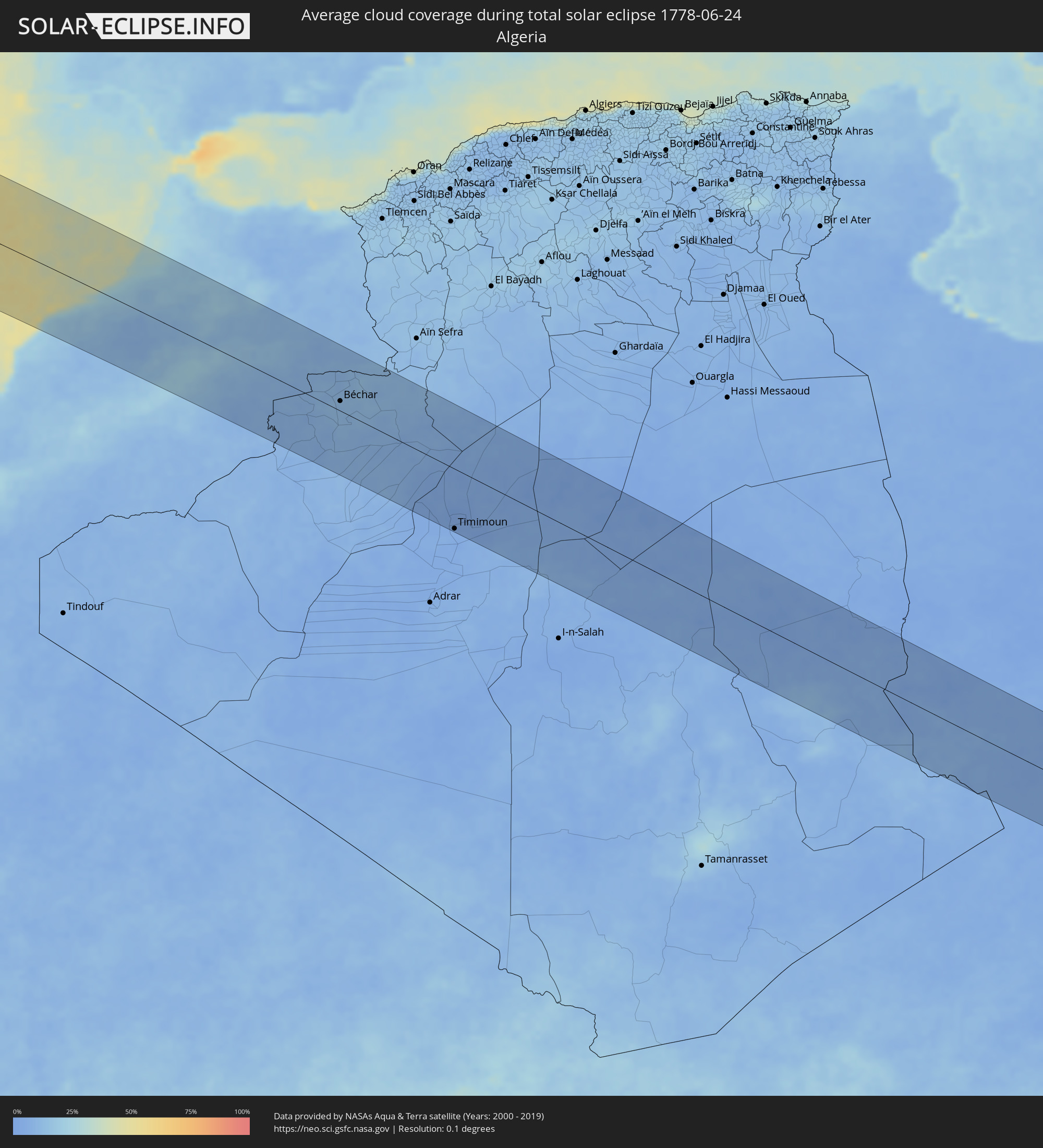 Algerien
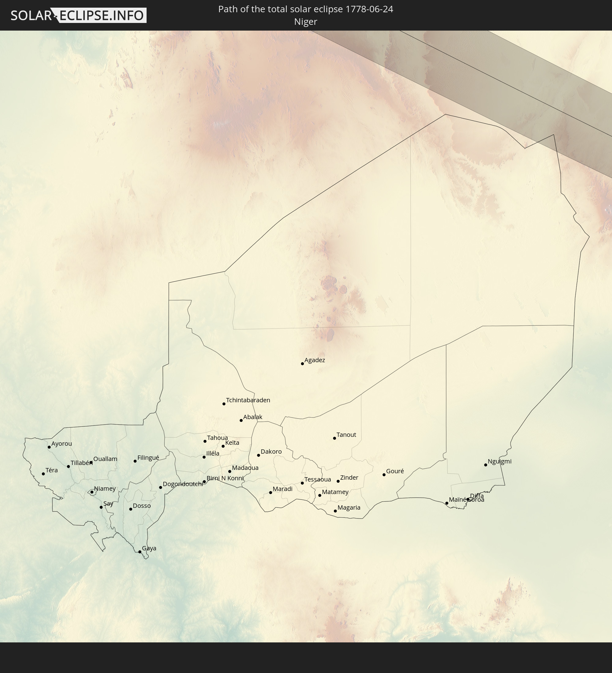
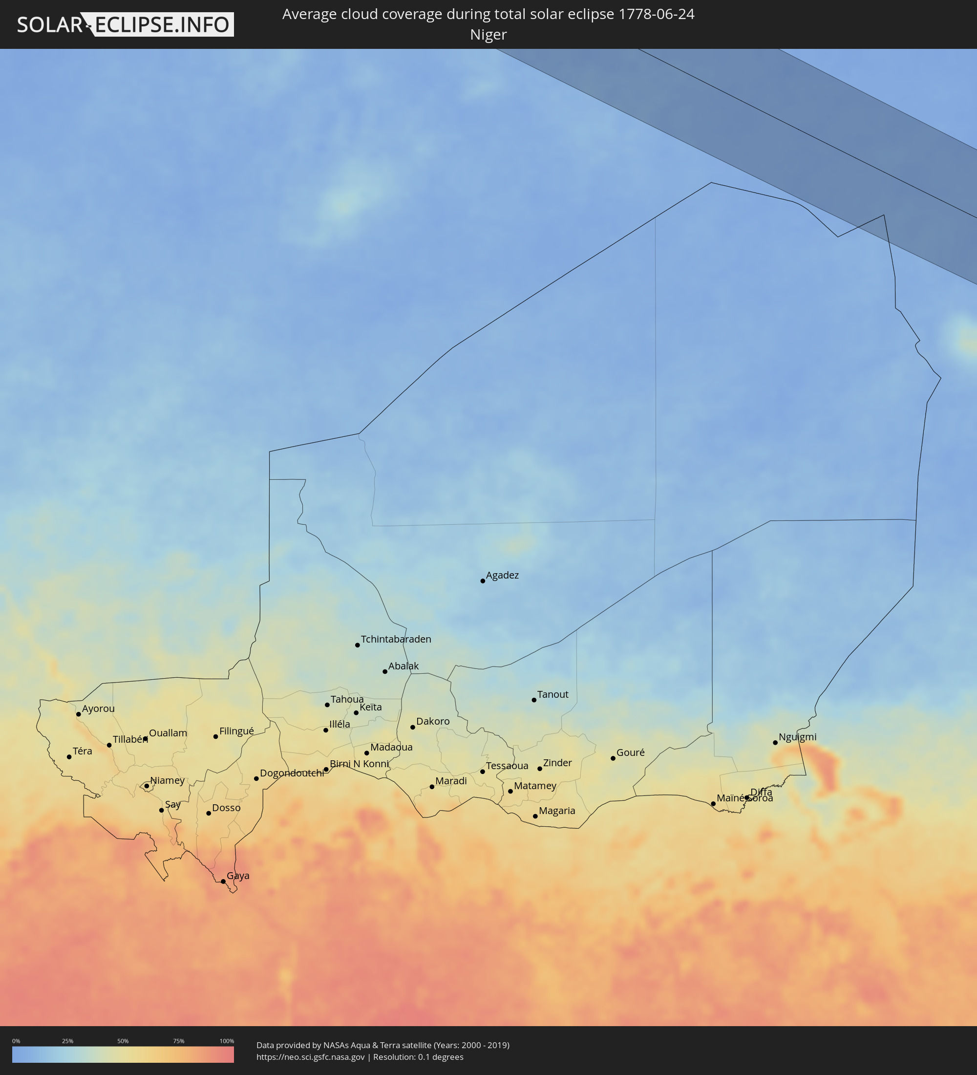 Niger
Niger
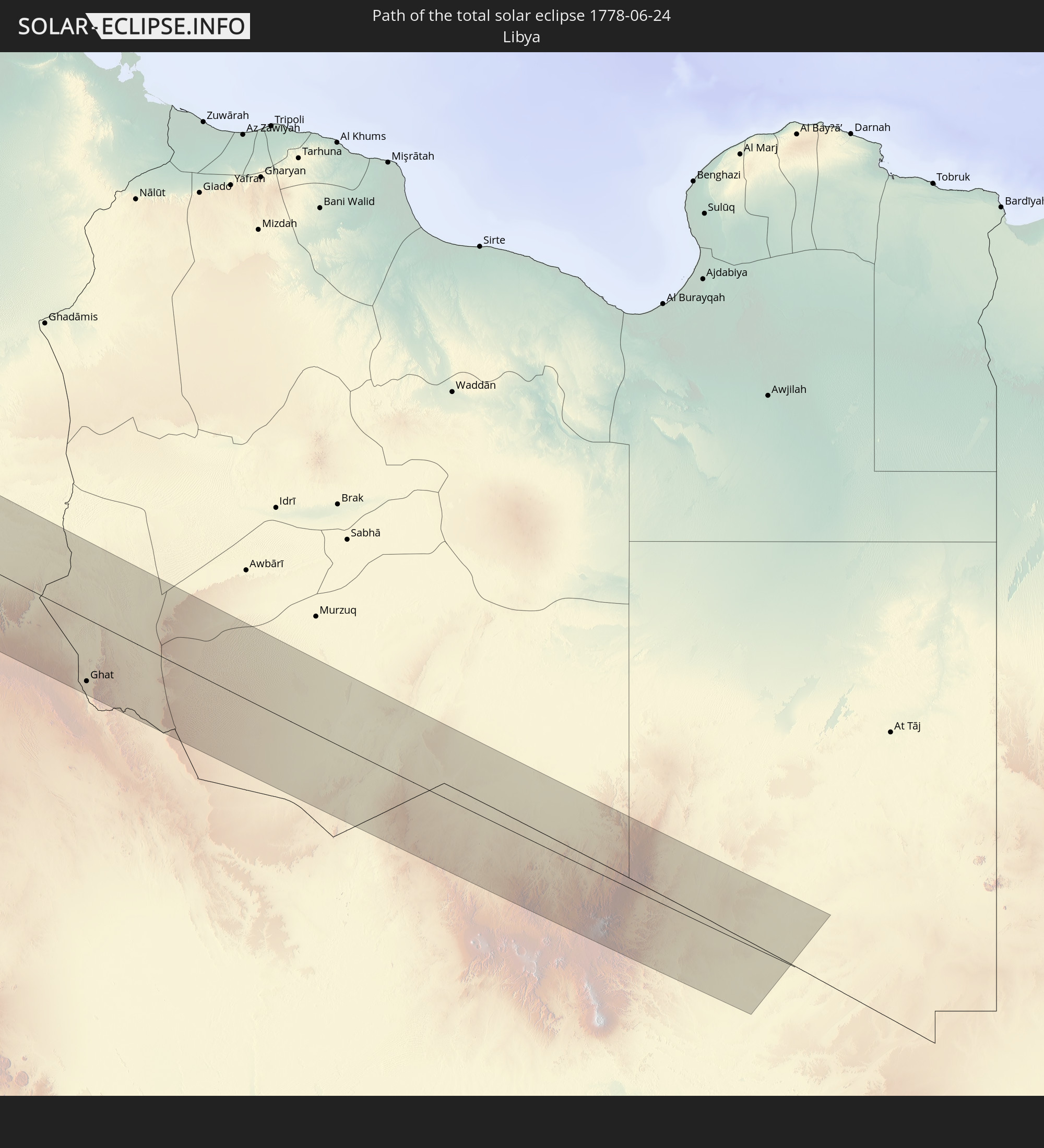
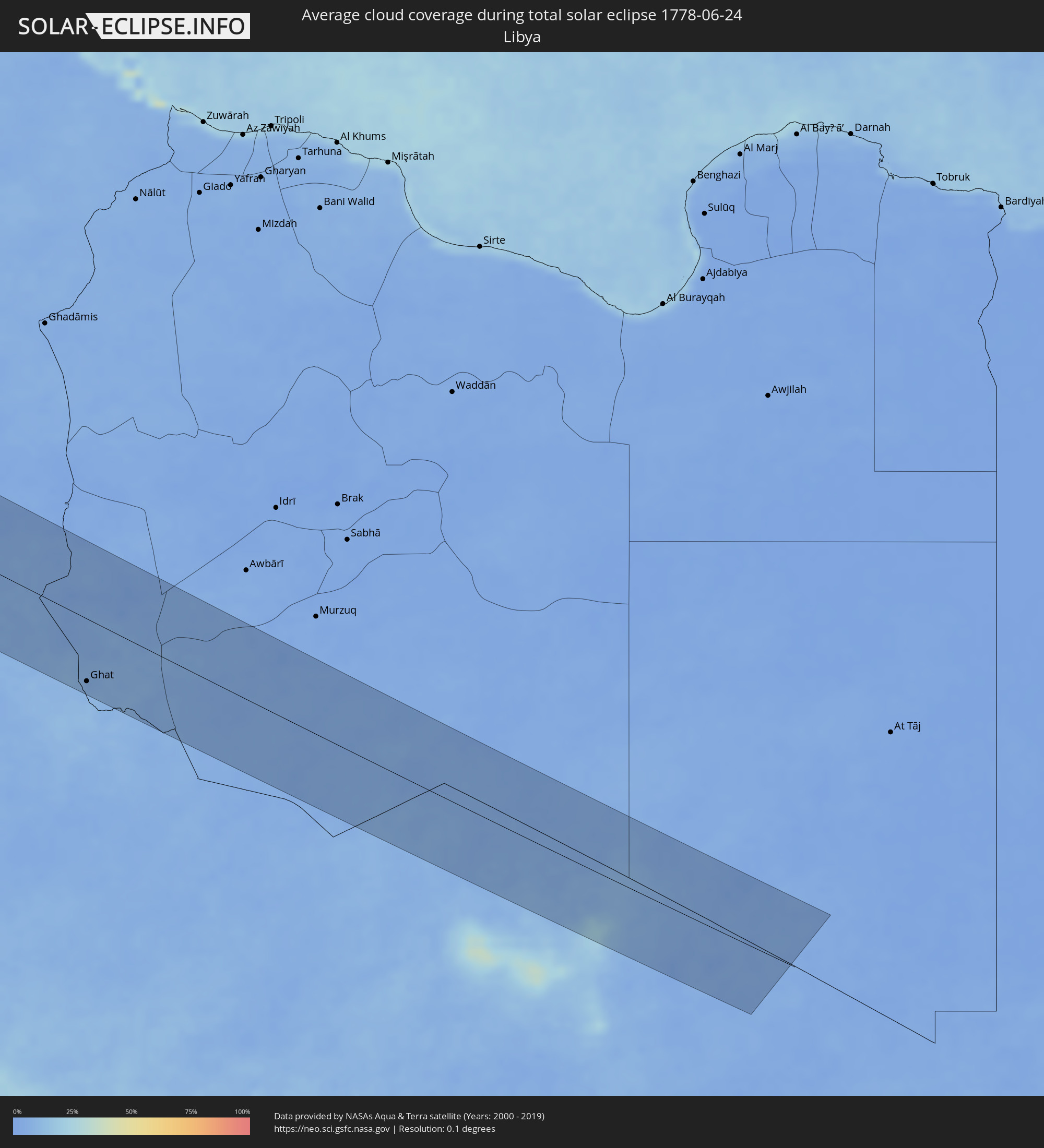 Libyen
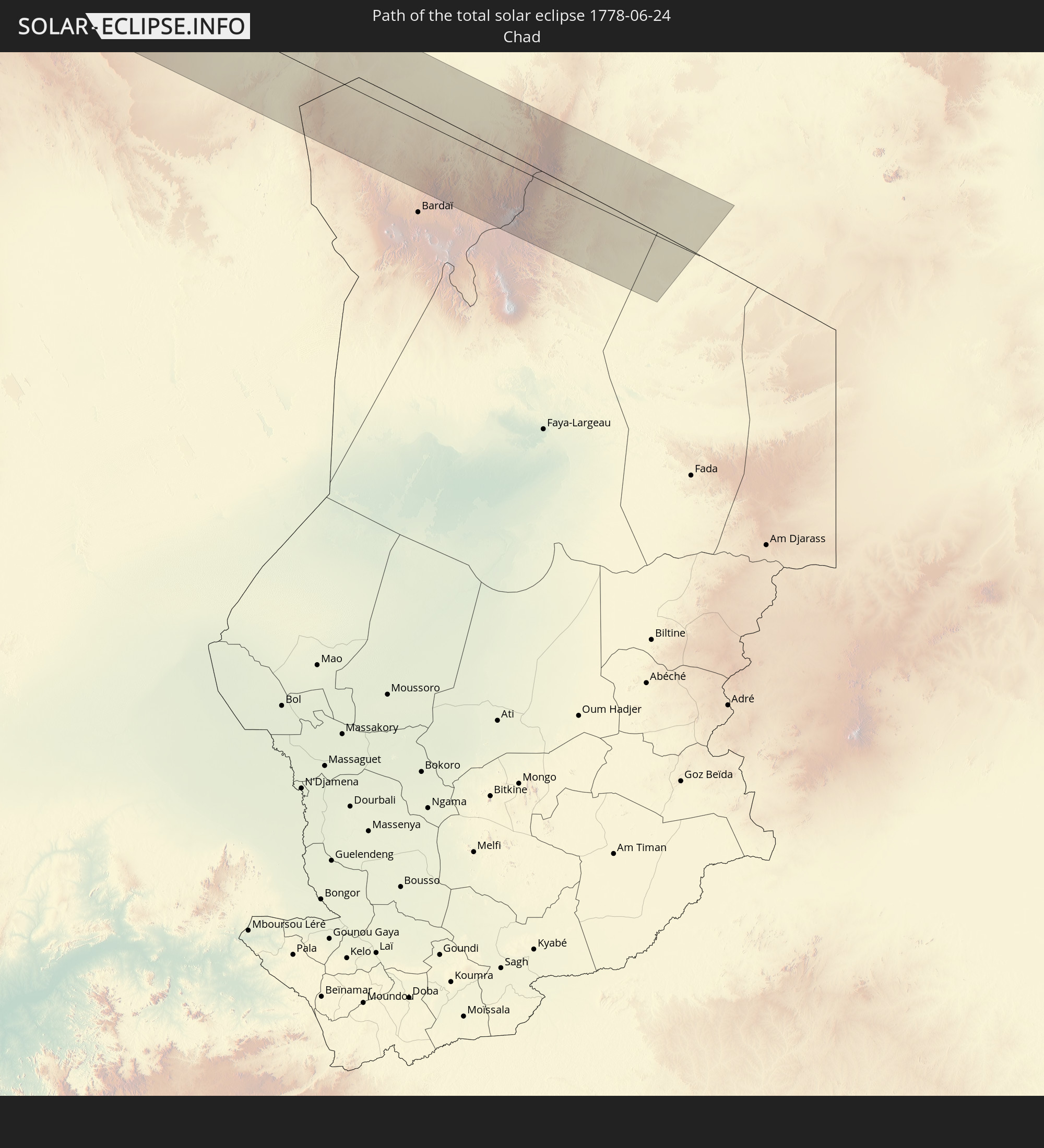
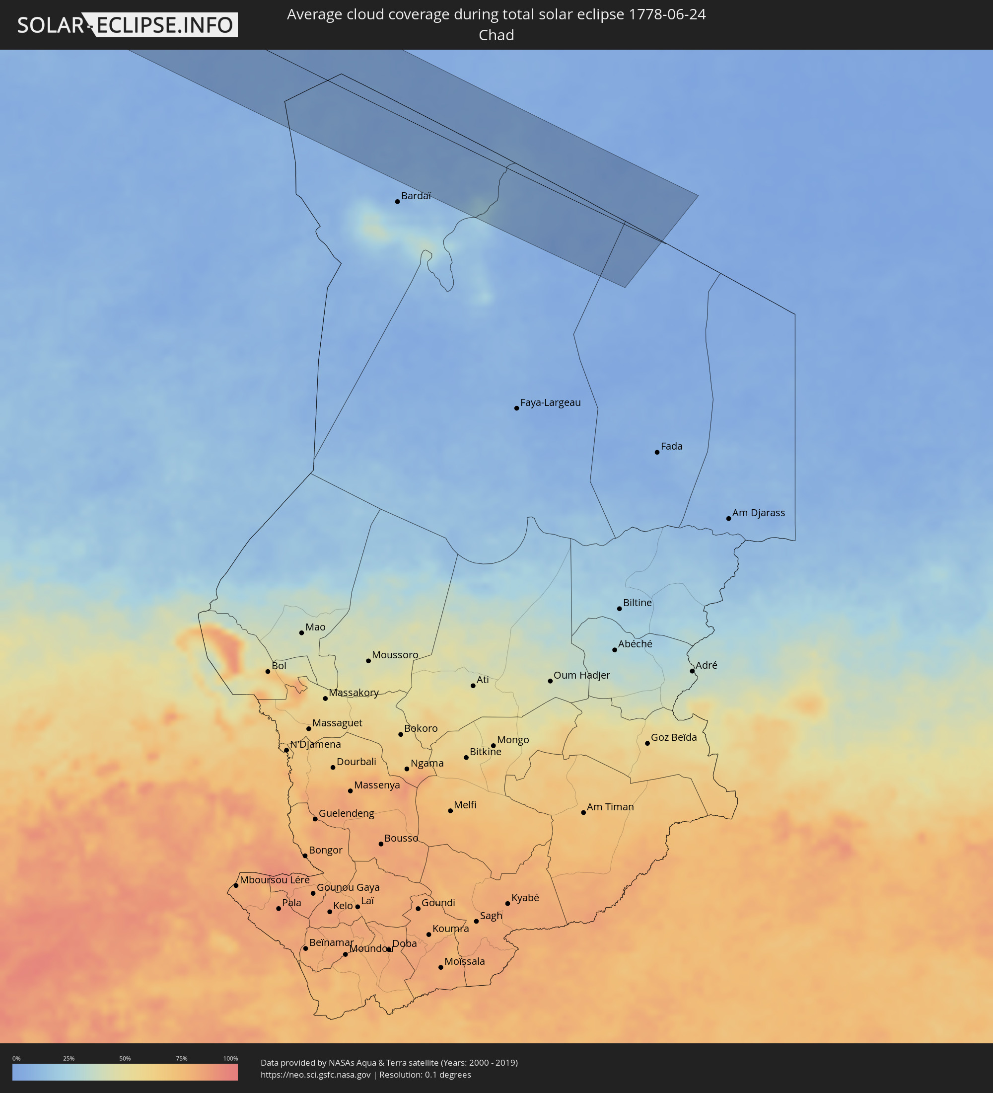 Tschad
Orte im Finsternispfad
Die nachfolgene Tabelle zeigt Städte und Orte mit mehr als 5.000 Einwohnern, die sich im Finsternispfad befinden. Städte mit mehr als 100.000 Einwohnern sind dick gekennzeichnet. Mit einem Klick auf den Ort öffnet sich eine Detailkarte die die Lage des jeweiligen Ortes zusammen mit dem Verlauf der zentralen Finsternis präsentiert.
| Ort | Typ | Dauer der Verfinsterung | Ortszeit bei maximaler Verfinsterung | Entfernung zur Zentrallinie | Ø Bewölkung |
|
Escuinapa de Hidalgo, Sinaloa
|
total | - | 06:59:34 UTC-07:05 | 93 km | 65% |
|
Acaponeta, Nayarit
|
total | - | 06:59:17 UTC-07:05 | 39 km | 83% |
|
Santiago Ixcuintla, Nayarit
|
total | - | 06:58:34 UTC-07:05 | 35 km | 73% |
|
Las Varas, Nayarit
|
total | - | 06:57:52 UTC-07:05 | 99 km | 73% |
|
Compostela, Nayarit
|
total | - | 06:58:00 UTC-07:05 | 106 km | 65% |
|
Tepic, Nayarit
|
total | - | 06:58:19 UTC-07:05 | 80 km | 68% |
|
Vicente Guerrero, Durango
|
total | - | 07:30:14 UTC-06:36 | 87 km | 55% |
|
Sombrerete, Zacatecas
|
total | - | 07:30:14 UTC-06:36 | 60 km | 55% |
|
Juan Aldama, Zacatecas
|
total | - | 07:31:07 UTC-06:36 | 110 km | 50% |
|
Colotlán, Jalisco
|
total | - | 07:28:36 UTC-06:36 | 106 km | 59% |
|
Río Grande, Zacatecas
|
total | - | 07:30:42 UTC-06:36 | 47 km | 52% |
|
Jerez de García Salinas, Zacatecas
|
total | - | 07:29:19 UTC-06:36 | 68 km | 60% |
|
Fresnillo, Zacatecas
|
total | - | 07:29:59 UTC-06:36 | 23 km | 54% |
|
Víctor Rosales, Zacatecas
|
total | - | 07:29:47 UTC-06:36 | 55 km | 63% |
|
Zacatecas, Zacatecas
|
total | - | 07:29:37 UTC-06:36 | 78 km | 66% |
|
Saltillo, Coahuila
|
total | - | 07:33:30 UTC-06:36 | 95 km | 50% |
|
Matehuala, San Luis Potosí
|
total | - | 07:31:29 UTC-06:36 | 94 km | 52% |
|
García, Nuevo León
|
total | - | 07:34:11 UTC-06:36 | 110 km | 41% |
|
Mitras Poniente, Nuevo León
|
total | - | 07:34:14 UTC-06:36 | 98 km | 48% |
|
Monterrey, Nuevo León
|
total | - | 07:34:09 UTC-06:36 | 83 km | 50% |
|
Apodaca, Nuevo León
|
total | - | 07:34:20 UTC-06:36 | 83 km | 52% |
|
Fraccionamiento Real Palmas, Nuevo León
|
total | - | 07:34:31 UTC-06:36 | 97 km | 55% |
|
Santiago, Nuevo León
|
total | - | 07:33:55 UTC-06:36 | 51 km | 64% |
|
Allende, Nuevo León
|
total | - | 07:33:48 UTC-06:36 | 29 km | 62% |
|
Cadereyta, Nuevo León
|
total | - | 07:34:12 UTC-06:36 | 57 km | 54% |
|
Montemorelos, Nuevo León
|
total | - | 07:33:47 UTC-06:36 | 11 km | 57% |
|
Hidalgo, Nuevo León
|
total | - | 07:34:44 UTC-06:36 | 64 km | 49% |
|
Linares, Nuevo León
|
total | - | 07:33:30 UTC-06:36 | 34 km | 54% |
|
Ciudad Miguel Alemán, Tamaulipas
|
total | - | 07:35:45 UTC-06:36 | 85 km | 61% |
|
Reynosa, Tamaulipas
|
total | - | 07:35:45 UTC-06:36 | 17 km | 74% |
|
McAllen, Texas
|
total | - | 08:12:33 UTC-06:00 | 25 km | 74% |
|
San Fernando, Tamaulipas
|
total | - | 07:34:15 UTC-06:36 | 108 km | 68% |
|
Río Bravo, Tamaulipas
|
total | - | 07:35:45 UTC-06:36 | 2 km | 76% |
|
Valle Hermoso, Tamaulipas
|
total | - | 07:35:30 UTC-06:36 | 47 km | 75% |
|
Harlingen, Texas
|
total | - | 08:12:51 UTC-06:00 | 3 km | 77% |
|
Heroica Matamoros, Tamaulipas
|
total | - | 07:35:57 UTC-06:36 | 43 km | 79% |
|
Brownsville, Texas
|
total | - | 08:12:35 UTC-06:00 | 41 km | 79% |
|
Lafayette, Louisiana
|
total | - | 08:22:25 UTC-06:00 | 91 km | 80% |
|
Baton Rouge, Louisiana
|
total | - | 08:23:30 UTC-06:00 | 70 km | 74% |
|
Kenner, Louisiana
|
total | - | 08:23:41 UTC-06:00 | 19 km | 73% |
|
New Orleans, Louisiana
|
total | - | 08:23:47 UTC-06:00 | 31 km | 78% |
|
West Gulfport, Mississippi
|
total | - | 08:25:22 UTC-06:00 | 36 km | 62% |
|
Mobile, Alabama
|
total | - | 08:26:50 UTC-06:00 | 59 km | 65% |
|
Montgomery, Alabama
|
total | - | 08:31:05 UTC-06:00 | 18 km | 65% |
|
Columbus, Georgia
|
total | - | 09:32:43 UTC-05:00 | 34 km | 63% |
|
Atlanta, Georgia
|
total | - | 09:35:17 UTC-05:00 | 63 km | 75% |
|
Sandy Springs, Georgia
|
total | - | 09:35:32 UTC-05:00 | 80 km | 73% |
|
Johns Creek, Georgia
|
total | - | 09:35:54 UTC-05:00 | 82 km | 72% |
|
Macon, Georgia
|
total | - | 09:34:53 UTC-05:00 | 59 km | 60% |
|
Warner Robins, Georgia
|
total | - | 09:34:35 UTC-05:00 | 81 km | 67% |
|
Athens, Georgia
|
total | - | 09:36:48 UTC-05:00 | 38 km | 68% |
|
Greenville, South Carolina
|
total | - | 09:39:19 UTC-05:00 | 81 km | 60% |
|
Gastonia, North Carolina
|
total | - | 09:41:28 UTC-05:00 | 69 km | 65% |
|
Columbia, South Carolina
|
total | - | 09:39:54 UTC-05:00 | 61 km | 63% |
|
Rock Hill, South Carolina
|
total | - | 09:41:13 UTC-05:00 | 29 km | 62% |
|
Charlotte, North Carolina
|
total | - | 09:41:53 UTC-05:00 | 51 km | 69% |
|
Concord, North Carolina
|
total | - | 09:42:30 UTC-05:00 | 57 km | 66% |
|
Winston-Salem, North Carolina
|
total | - | 09:43:55 UTC-05:00 | 111 km | 64% |
|
High Point, North Carolina
|
total | - | 09:44:03 UTC-05:00 | 87 km | 65% |
|
Greensboro, North Carolina
|
total | - | 09:44:30 UTC-05:00 | 90 km | 67% |
|
Durham, North Carolina
|
total | - | 09:45:39 UTC-05:00 | 45 km | 72% |
|
Fayetteville, North Carolina
|
total | - | 09:44:23 UTC-05:00 | 49 km | 77% |
|
Raleigh, North Carolina
|
total | - | 09:45:43 UTC-05:00 | 12 km | 74% |
|
Greenville, North Carolina
|
total | - | 09:47:22 UTC-05:00 | 55 km | 74% |
|
Suffolk, Virginia
|
total | - | 09:50:04 UTC-05:00 | 26 km | 64% |
|
Newport News, Virginia
|
total | - | 09:50:43 UTC-05:00 | 57 km | 60% |
|
Norfolk, Virginia
|
total | - | 09:50:41 UTC-05:00 | 26 km | 67% |
|
Virginia Beach, Virginia
|
total | - | 09:51:09 UTC-05:00 | 15 km | 59% |
|
Lagoa, Azores
|
total | - | 14:32:28 UTC-01:54 | 120 km | 70% |
|
El Jadida, Doukkala-Abda
|
total | - | 16:25:20 UTC-00:30 | 79 km | 37% |
|
Azemmour, Doukkala-Abda
|
total | - | 16:25:25 UTC-00:30 | 69 km | 26% |
|
Nouaseur, Chaouia-Ouardigha
|
total | - | 16:25:48 UTC-00:30 | 31 km | 21% |
|
Settat, Chaouia-Ouardigha
|
total | - | 16:26:16 UTC-00:30 | 69 km | 14% |
|
Casablanca, Grand Casablanca
|
total | - | 16:25:34 UTC-00:30 | 10 km | 31% |
|
Berrechid, Chaouia-Ouardigha
|
total | - | 16:25:58 UTC-00:30 | 41 km | 19% |
|
Mohammedia, Grand Casablanca
|
total | - | 16:25:36 UTC-00:30 | 9 km | 32% |
|
Bouznika, Chaouia-Ouardigha
|
total | - | 16:25:37 UTC-00:30 | 28 km | 31% |
|
Skhirate, Rabat-Salé-Zemmour-Zaër
|
total | - | 16:25:38 UTC-00:30 | 40 km | 30% |
|
Khouribga, Chaouia-Ouardigha
|
total | - | 16:26:53 UTC-00:30 | 52 km | 9% |
|
Rabat, Rabat-Salé-Zemmour-Zaër
|
total | - | 16:25:34 UTC-00:30 | 64 km | 28% |
|
Sale, Rabat-Salé-Zemmour-Zaër
|
total | - | 16:25:32 UTC-00:30 | 69 km | 32% |
|
Boujniba, Chaouia-Ouardigha
|
total | - | 16:26:56 UTC-00:30 | 45 km | 9% |
|
Fkih Ben Salah, Tadla-Azilal
|
total | - | 16:27:28 UTC-00:30 | 82 km | 11% |
|
Kenitra, Gharb-Chrarda-Beni Hssen
|
total | - | 16:25:26 UTC-00:30 | 99 km | 29% |
|
Oued Zem, Chaouia-Ouardigha
|
total | - | 16:27:07 UTC-00:30 | 41 km | 9% |
|
Beni Mellal, Tadla-Azilal
|
total | - | 16:27:52 UTC-00:30 | 84 km | 15% |
|
Tiflet, Rabat-Salé-Zemmour-Zaër
|
total | - | 16:26:03 UTC-00:30 | 74 km | 18% |
|
Sidi Yahia El Gharb, Gharb-Chrarda-Beni Hssen
|
total | - | 16:25:33 UTC-00:30 | 115 km | 30% |
|
Kasba Tadla, Tadla-Azilal
|
total | - | 16:27:37 UTC-00:30 | 55 km | 13% |
|
Khemisset, Rabat-Salé-Zemmour-Zaër
|
total | - | 16:26:17 UTC-00:30 | 76 km | 17% |
|
Khenifra, Meknès-Tafilalet
|
total | - | 16:27:35 UTC-00:30 | 4 km | 12% |
|
Meknès, Meknès-Tafilalet
|
total | - | 16:26:30 UTC-00:30 | 104 km | 18% |
|
El Hajeb, Meknès-Tafilalet
|
total | - | 16:26:52 UTC-00:30 | 91 km | 19% |
|
Azrou, Meknès-Tafilalet
|
total | - | 16:27:15 UTC-00:30 | 72 km | 17% |
|
Midelt, Meknès-Tafilalet
|
total | - | 16:28:25 UTC-00:30 | 17 km | 16% |
|
Béchar, Béchar
|
total | - | 17:10:38 UTC+00:09 | 18 km | 10% |
|
Figuig (Centre), Oriental
|
total | - | 16:30:50 UTC-00:30 | 109 km | 12% |
|
Timimoun, Adrar
|
total | - | 17:14:16 UTC+00:09 | 110 km | 4% |
|
Illizi, Illizi
|
total | - | 17:18:53 UTC+00:09 | 18 km | 6% |
|
Ghat, Sha‘bīyat Ghāt
|
total | - | 18:03:46 UTC+00:52 | 92 km | 6% |