Totale Sonnenfinsternis vom 04.06.1788
| Wochentag: | Mittwoch |
| Maximale Dauer der Verfinsterung: | 05m15s |
| Maximale Breite des Finsternispfades: | 211 km |
| Saroszyklus: | 124 |
| Bedeckungsgrad: | 100% |
| Magnitude: | 1.0623 |
| Gamma: | 0.2465 |
Wo kann man die Sonnenfinsternis vom 04.06.1788 sehen?
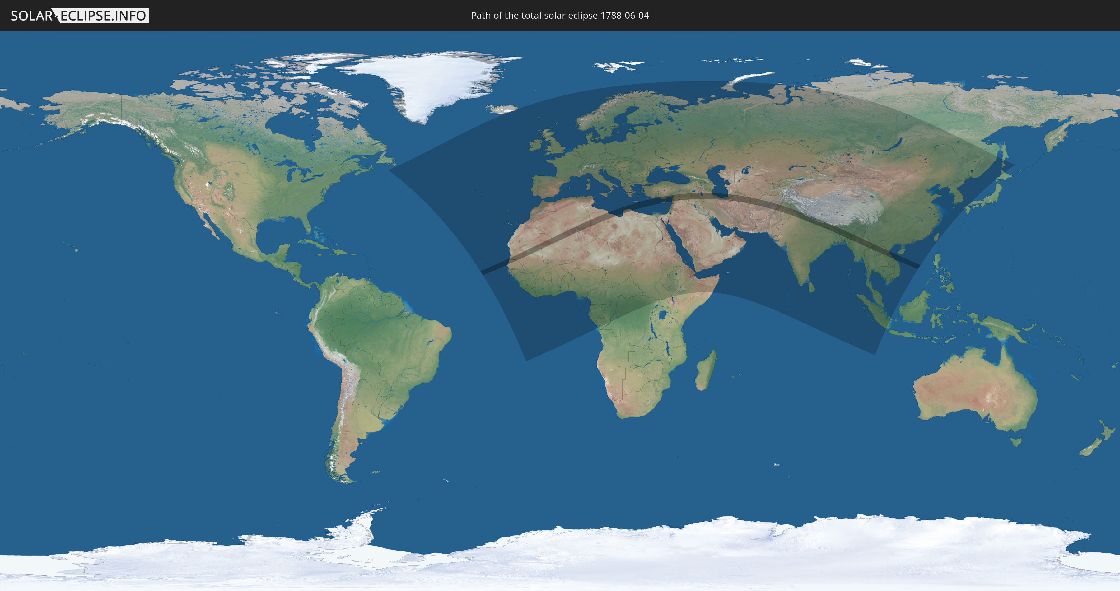
Die Sonnenfinsternis am 04.06.1788 kann man in 137 Ländern als partielle Sonnenfinsternis beobachten.
Der Finsternispfad verläuft durch 23 Länder. Nur in diesen Ländern ist sie als totale Sonnenfinsternis zu sehen.
In den folgenden Ländern ist die Sonnenfinsternis total zu sehen
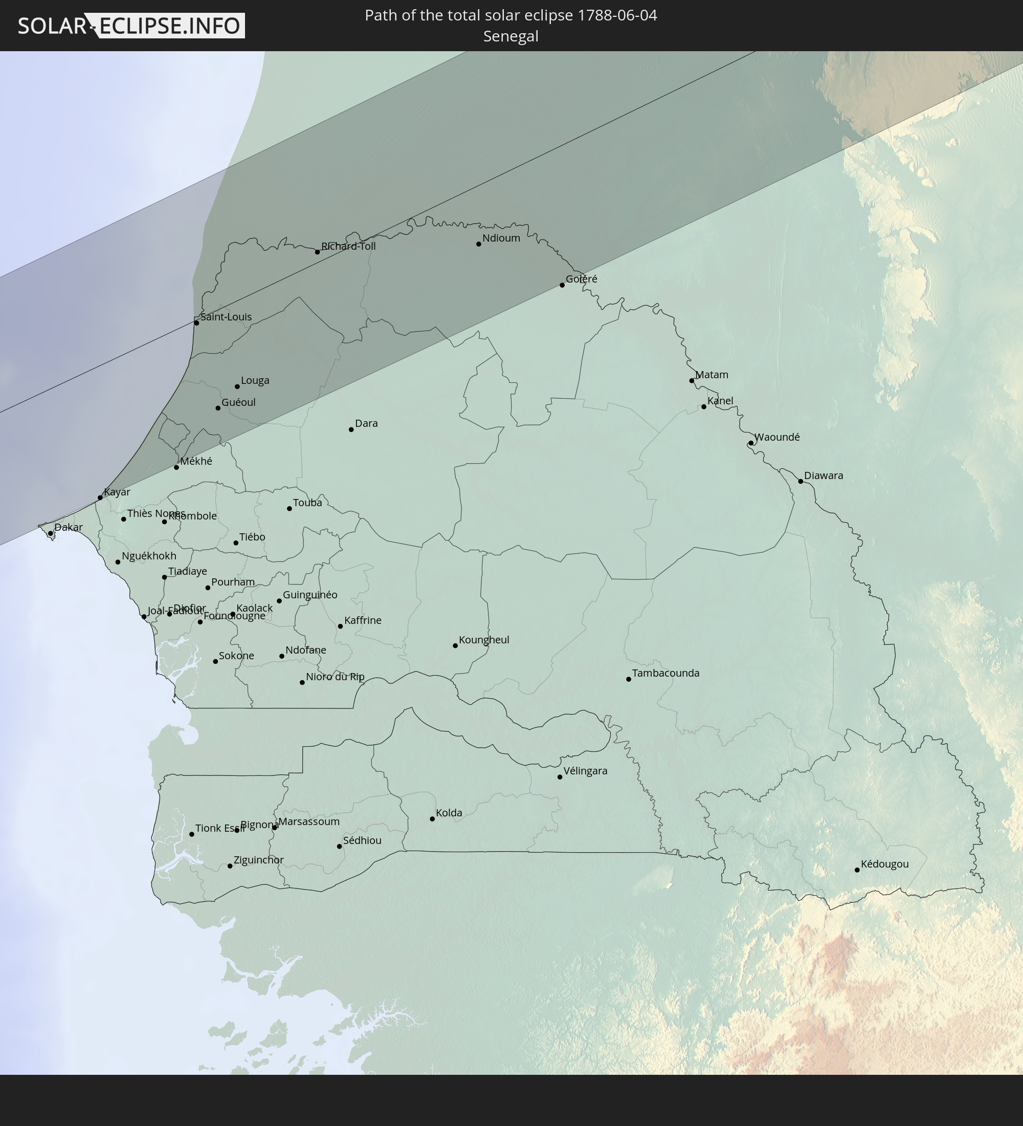 Senegal
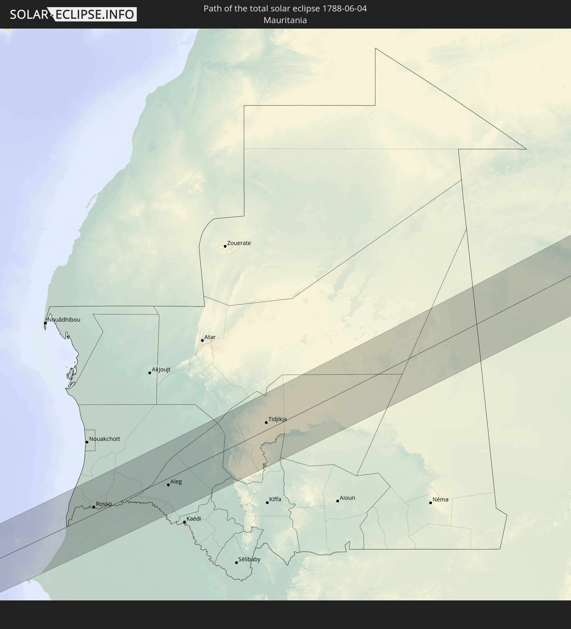 Mauretanien
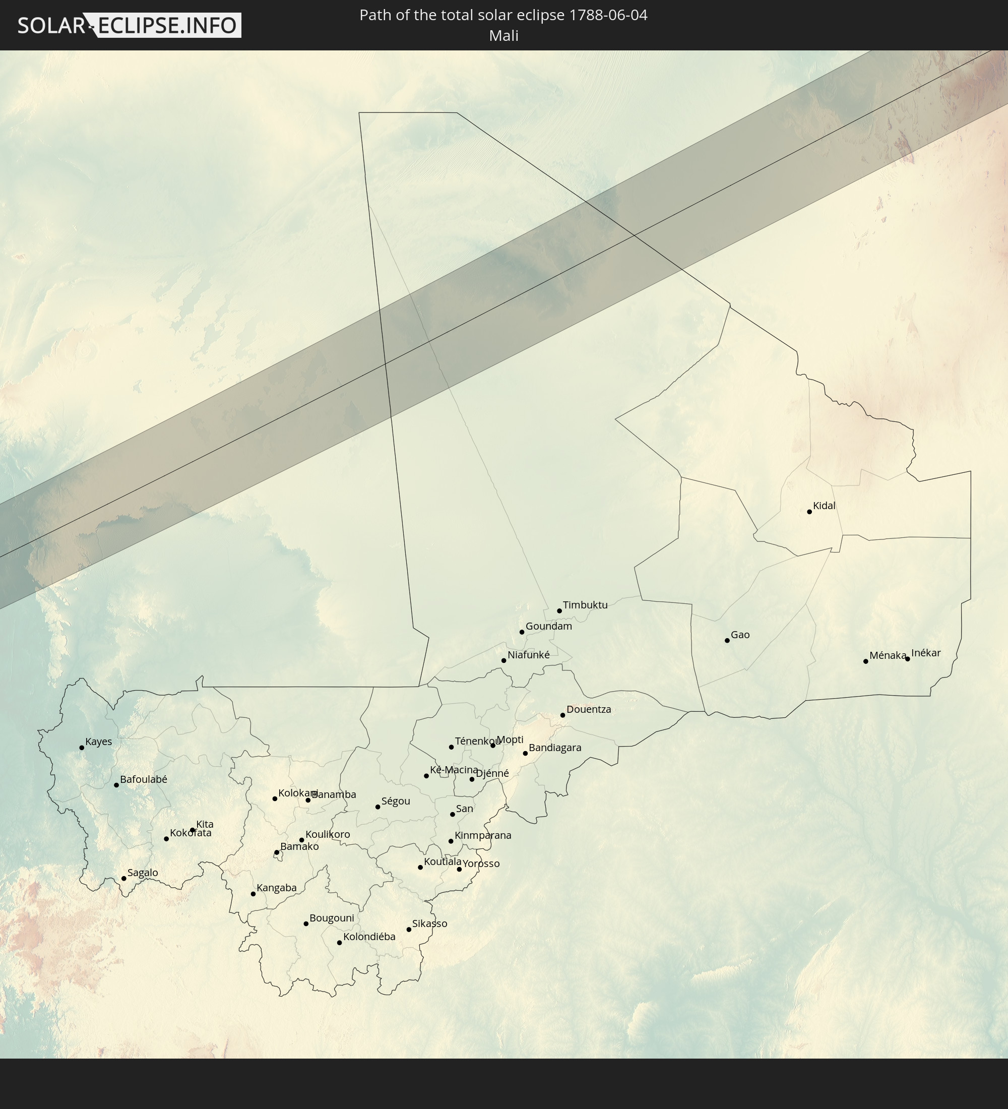 Mali
Mali
 Algerien
 Libyen
 Griechenland
 Türkei
 Republik Zypern
 Syrien
 Irak
Irak
 Iran
Iran
 Turkmenistan
 Afghanistan
 Pakistan
 Indien
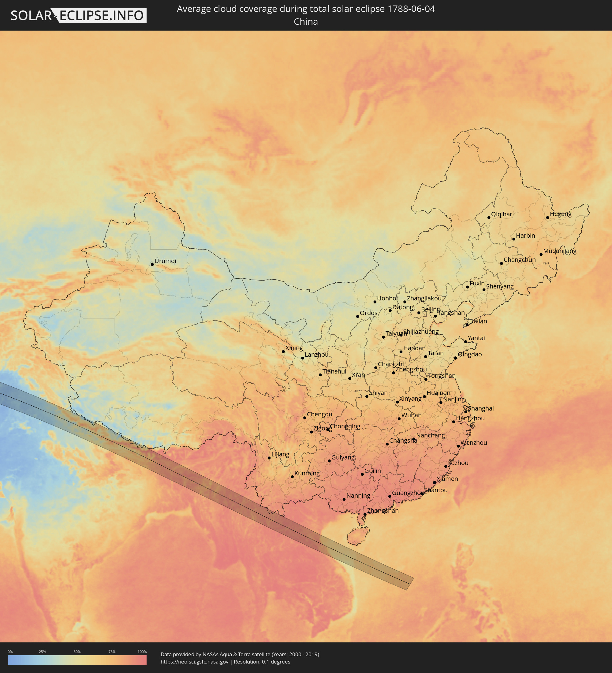
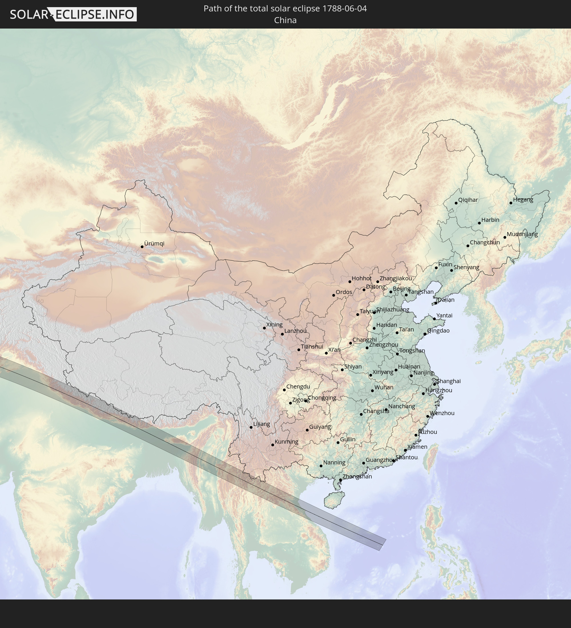 Volksrepublik China
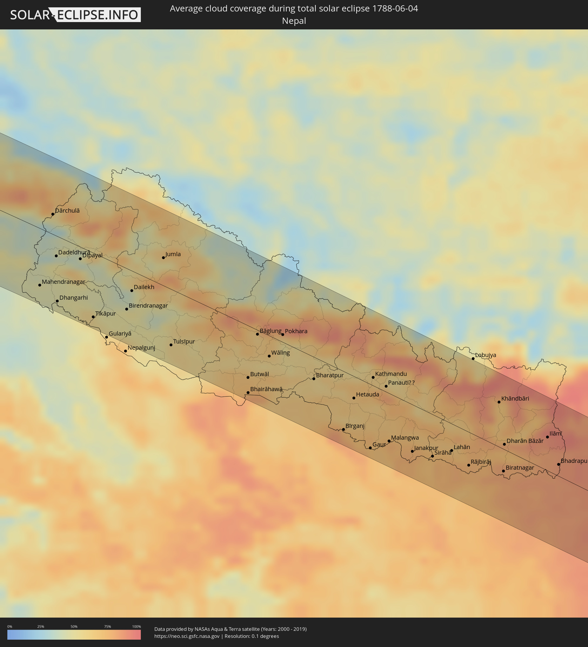
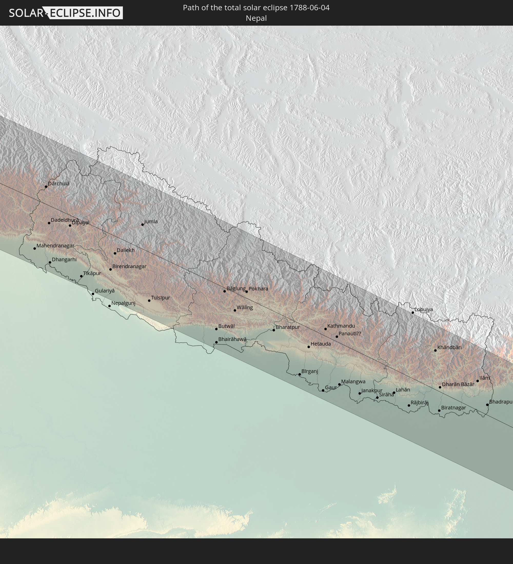 Nepal
Nepal
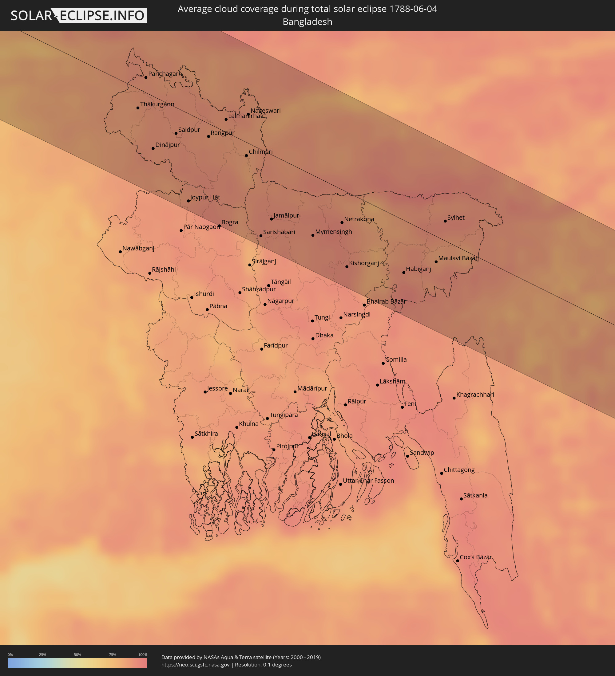
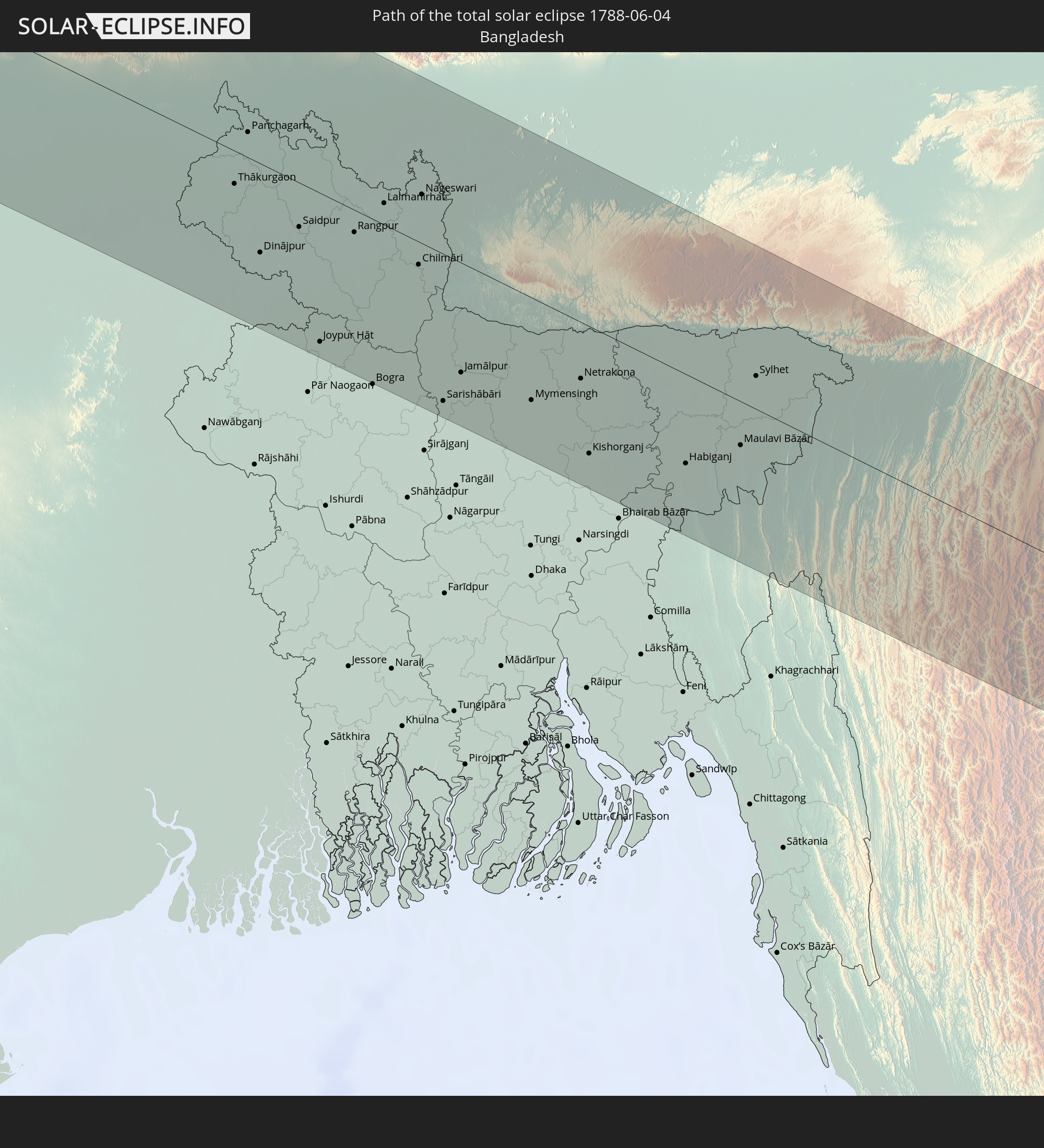 Bangladesch
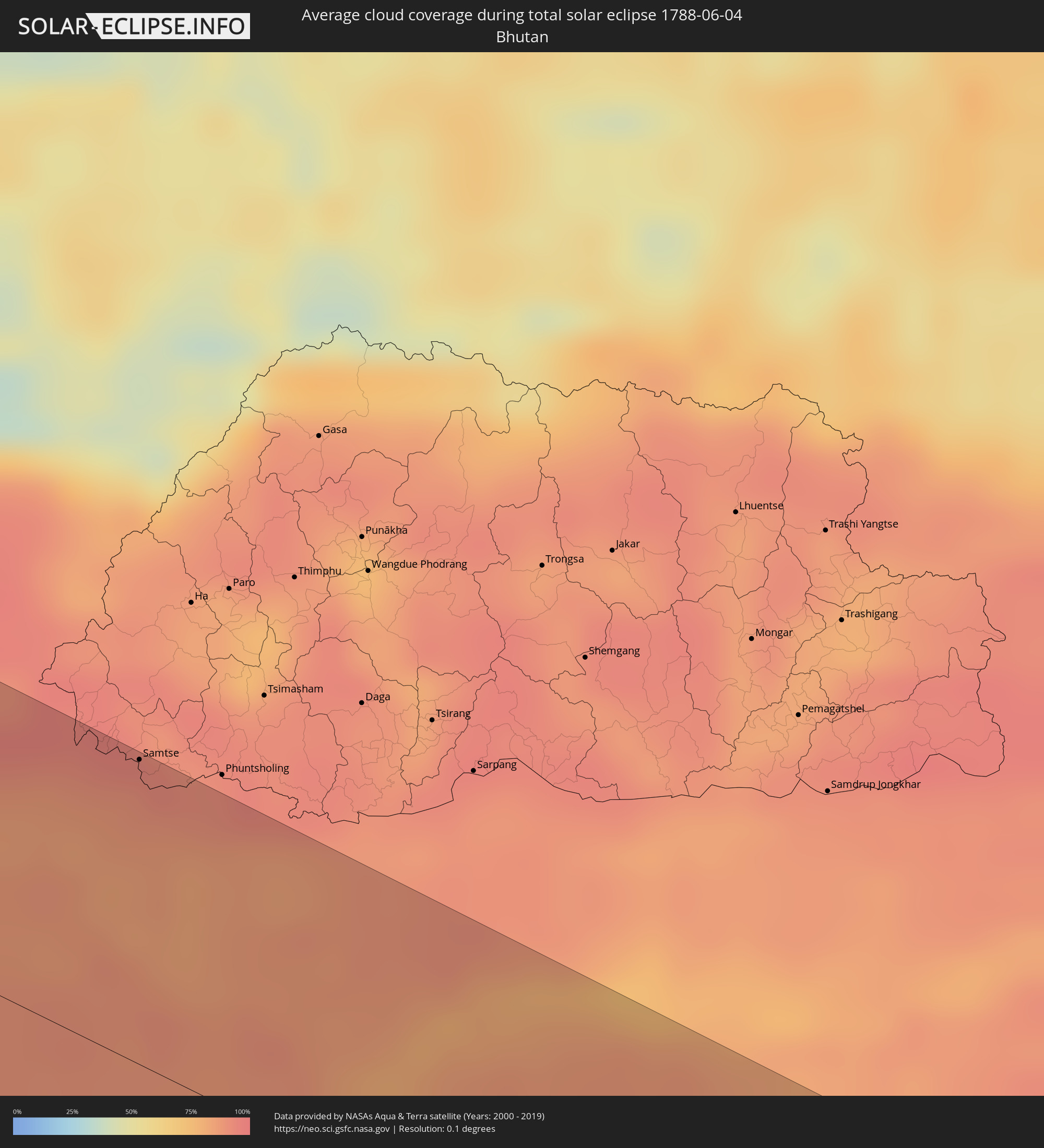
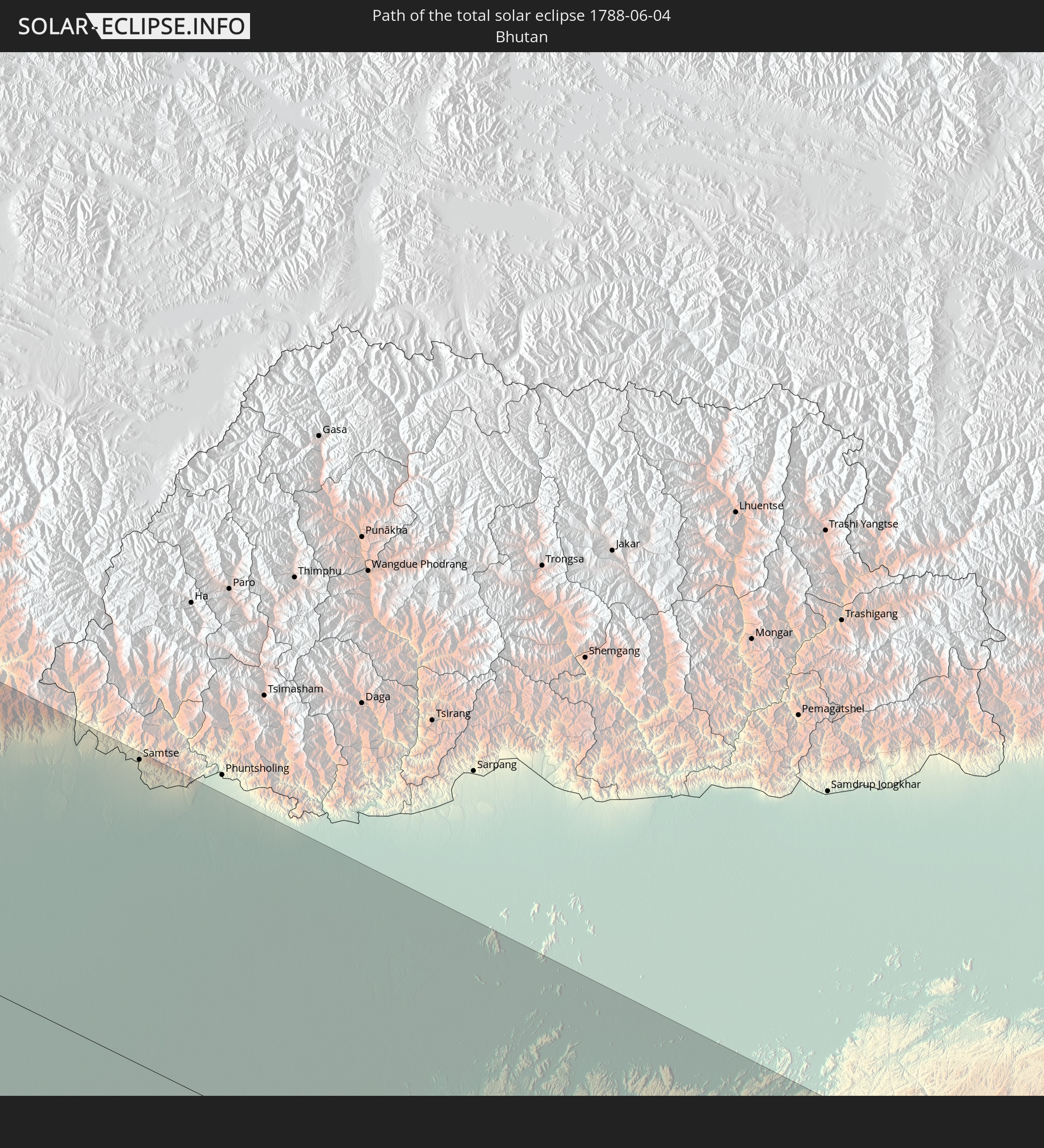 Bhutan
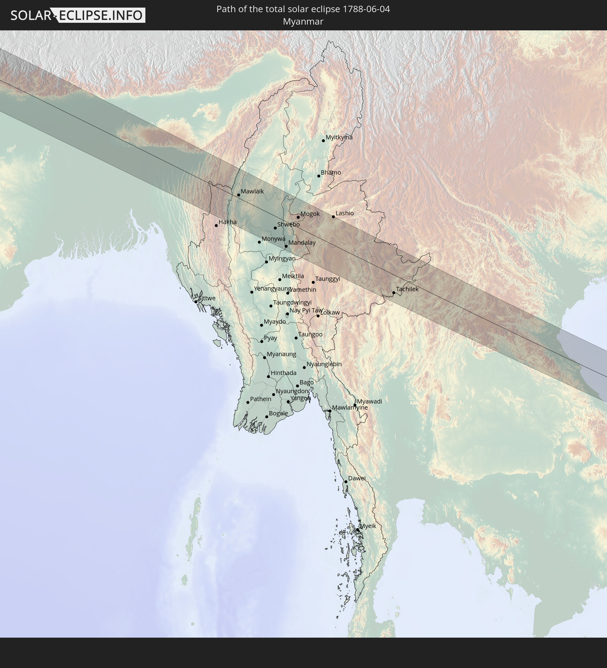 Myanmar
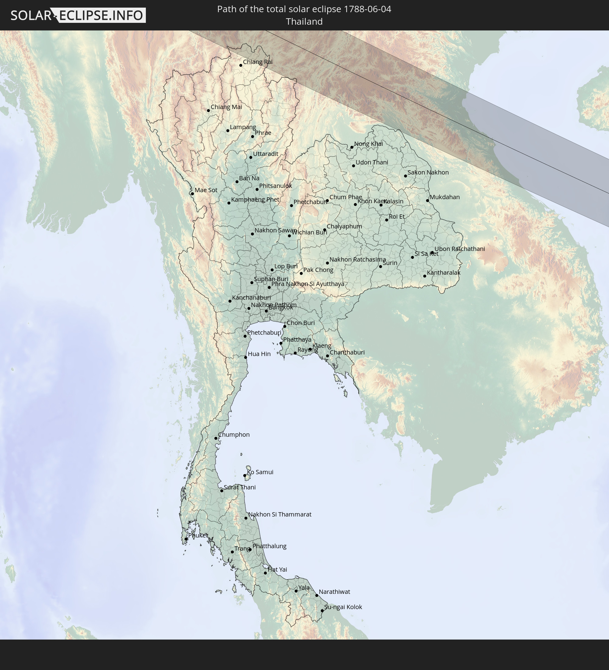 Thailand
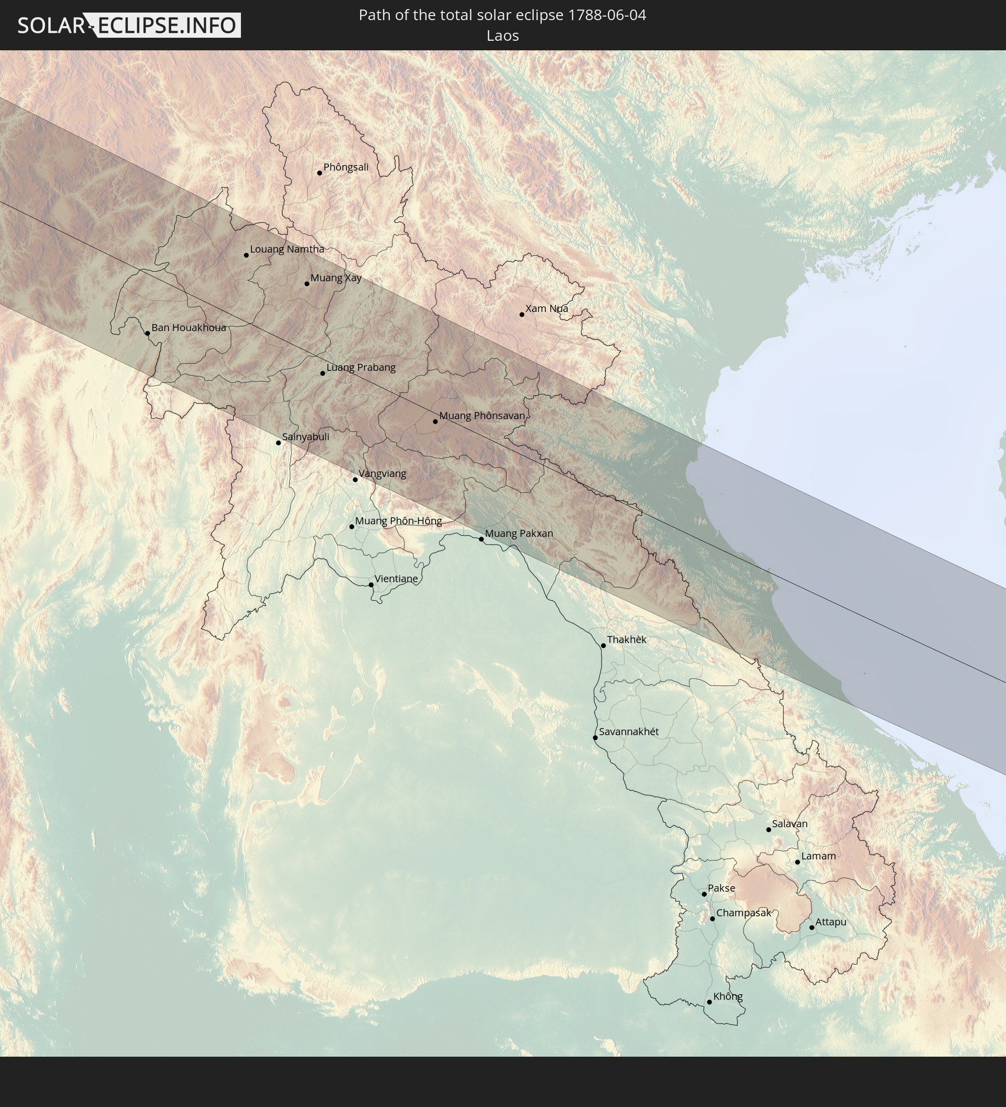 Laos
Laos
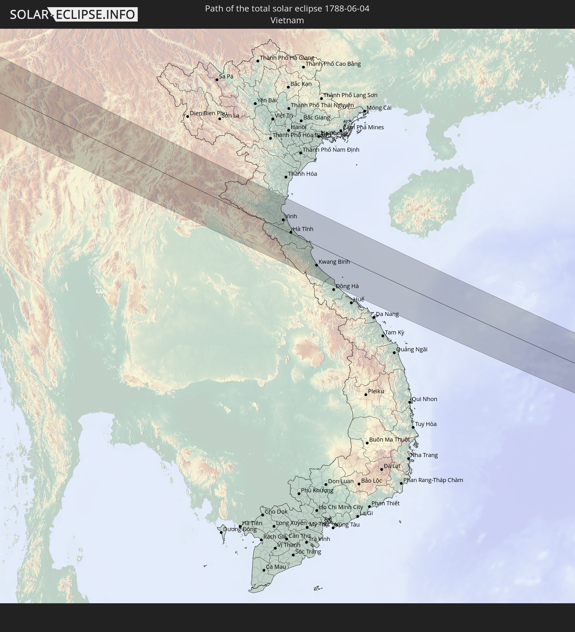 Vietnam
In den folgenden Ländern ist die Sonnenfinsternis partiell zu sehen
 Russland
 Portugal
 Kap Verde
 Island
 Spanien
 Senegal
 Mauretanien
 Gambia
 Guinea-Bissau
 Guinea
 St. Helena
 Sierra Leone
 Marokko
 Mali
Mali
 Liberia
 Irland
 Algerien
 Vereinigtes Königreich
 Elfenbeinküste
 Färöer
 Burkina Faso
 Gibraltar
 Frankreich
 Isle of Man
 Ghana
Ghana
 Guernsey
 Jersey
 Togo
Togo
 Niger
Niger
 Benin
Benin
 Andorra
 Belgien
 Nigeria
 Niederlande
 Norwegen
 Äquatorialguinea
 Luxemburg
 Deutschland
 Schweiz
 São Tomé und Príncipe
 Italien
 Monaco
 Tunesien
 Dänemark
 Kamerun
 Gabun
Gabun
 Libyen
 Liechtenstein
 Österreich
 Schweden
 Republik Kongo
 Angola
 Tschechien
 Demokratische Republik Kongo
 San Marino
 Vatikanstadt
 Slowenien
 Tschad
 Kroatien
 Polen
Polen
 Malta
Malta
 Zentralafrikanische Republik
 Bosnien und Herzegowina
 Ungarn
 Slowakei
 Montenegro
 Serbien
 Albanien
 Åland Islands
 Griechenland
 Rumänien
 Mazedonien
 Finnland
 Litauen
 Lettland
 Estland
 Sudan
Sudan
 Ukraine
 Bulgarien
 Weißrussland
 Ägypten
 Türkei
 Moldawien
 Uganda
 Republik Zypern
 Äthiopien
 Kenia
Kenia
 Staat Palästina
 Israel
 Saudi-Arabien
 Jordanien
 Libanon
 Syrien
 Eritrea
 Irak
Irak
 Georgien
 Somalia
 Dschibuti
 Jemen
Jemen
 Armenien
 Iran
Iran
 Aserbaidschan
 Kasachstan
 Kuwait
 Bahrain
 Katar
Katar
 Vereinigte Arabische Emirate
 Oman
Oman
 Turkmenistan
 Usbekistan
 Afghanistan
 Pakistan
 Tadschikistan
 Indien
 Kirgisistan
 Malediven
 Volksrepublik China
 Sri Lanka
 Nepal
Nepal
 Mongolei
 Bangladesch
 Bhutan
 Myanmar
 Indonesien
 Kokosinseln
 Thailand
 Malaysia
 Laos
Laos
 Vietnam
 Kambodscha
 Singapur
 Macau
Macau
 Hongkong
 Taiwan
 Japan
Japan
 Nordkorea
 Südkorea
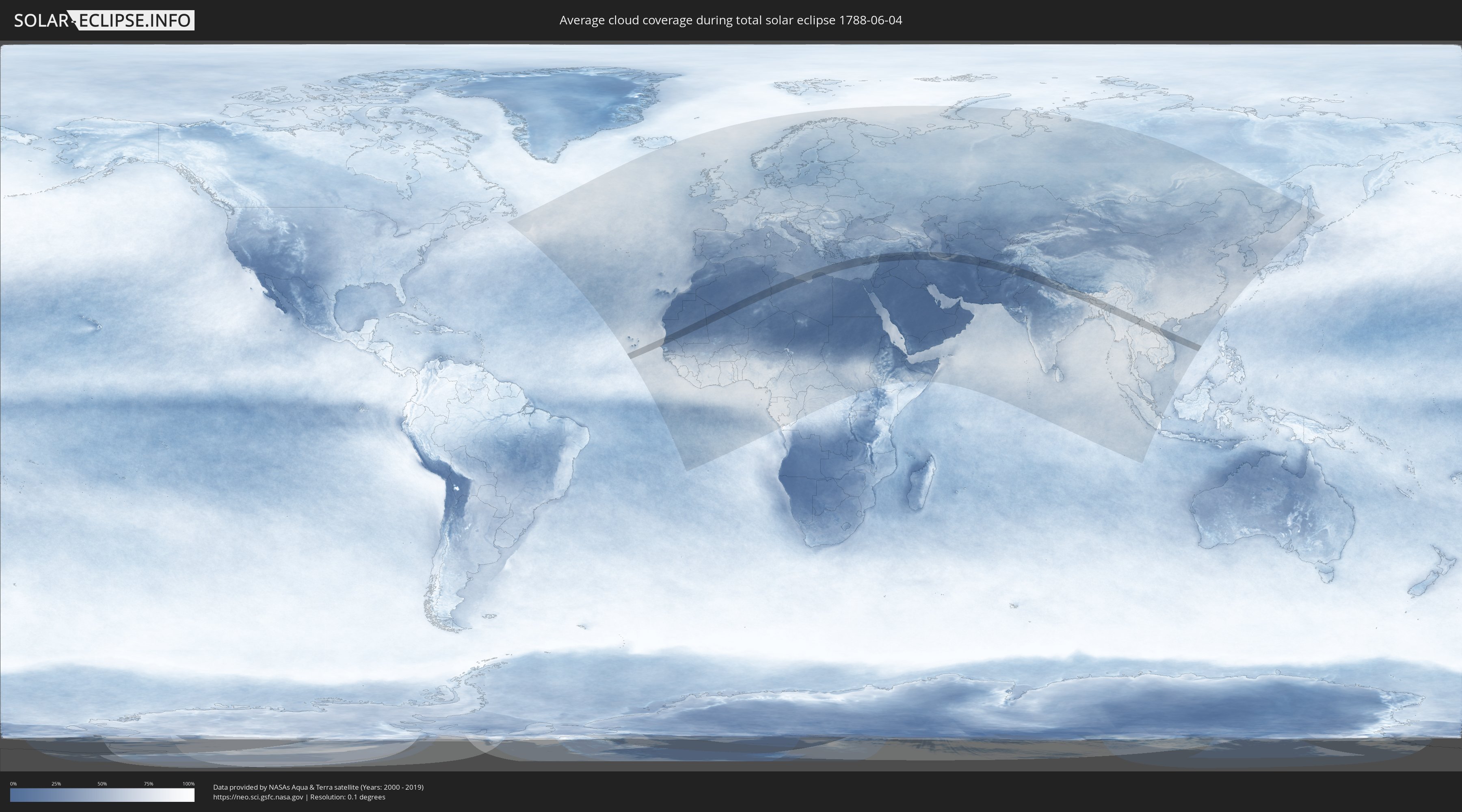
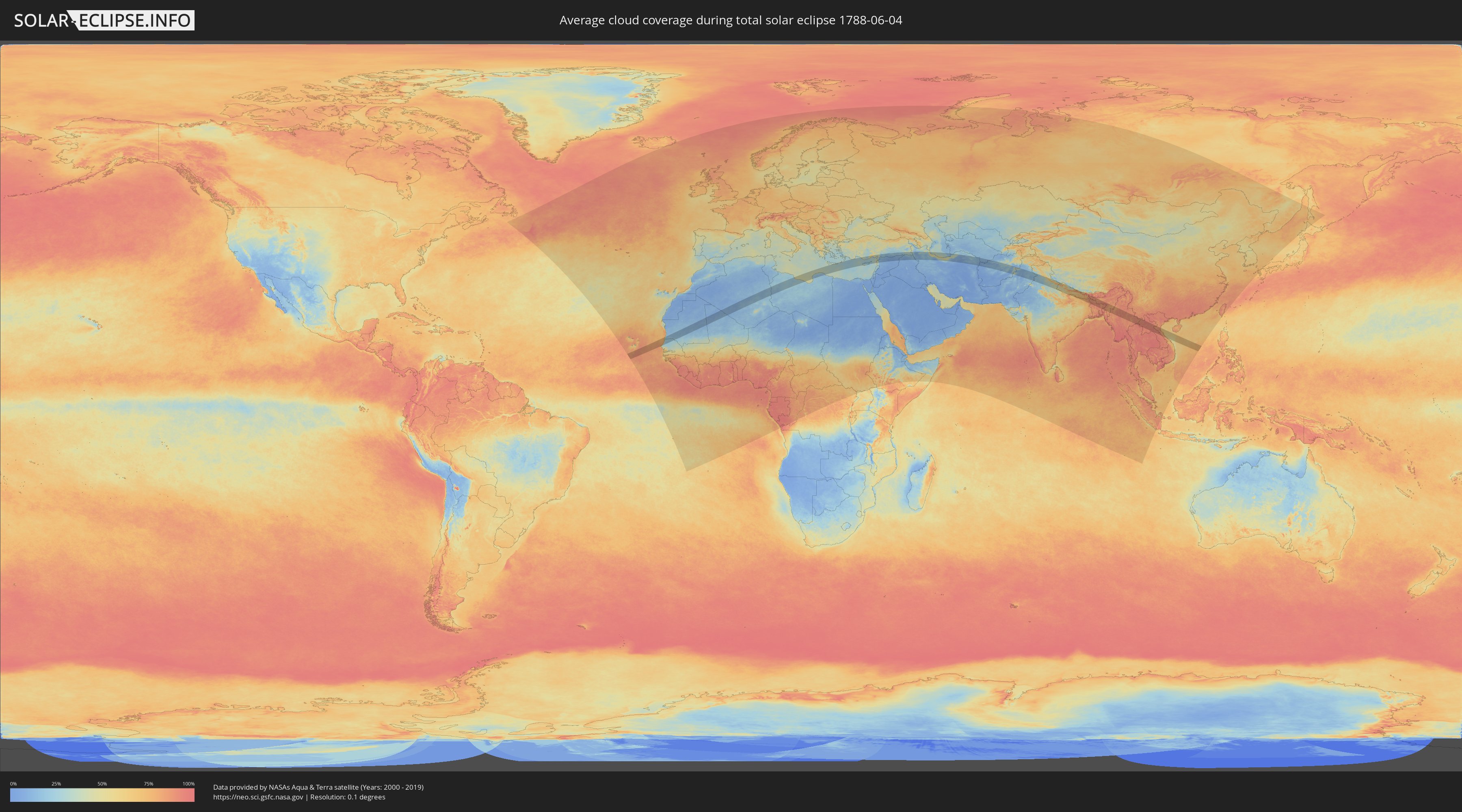
Wie wird das Wetter während der totalen Sonnenfinsternis am 04.06.1788?
Wo ist der beste Ort, um die totale Sonnenfinsternis vom 04.06.1788 zu beobachten?
Die folgenden Karten zeigen die durchschnittliche Bewölkung für den Tag, an dem die totale Sonnenfinsternis
stattfindet. Mit Hilfe der Karten lässt sich der Ort entlang des Finsternispfades eingrenzen,
der die besten Aussichen auf einen klaren wolkenfreien Himmel bietet.
Trotzdem muss man immer lokale Gegenenheiten beachten und sollte sich genau über das Wetter an seinem
gewählten Beobachtungsort informieren.
Die Daten stammen von den beiden NASA-Satelliten
AQUA und TERRA
und wurden über einen Zeitraum von 19 Jahren (2000 - 2019) gemittelt.
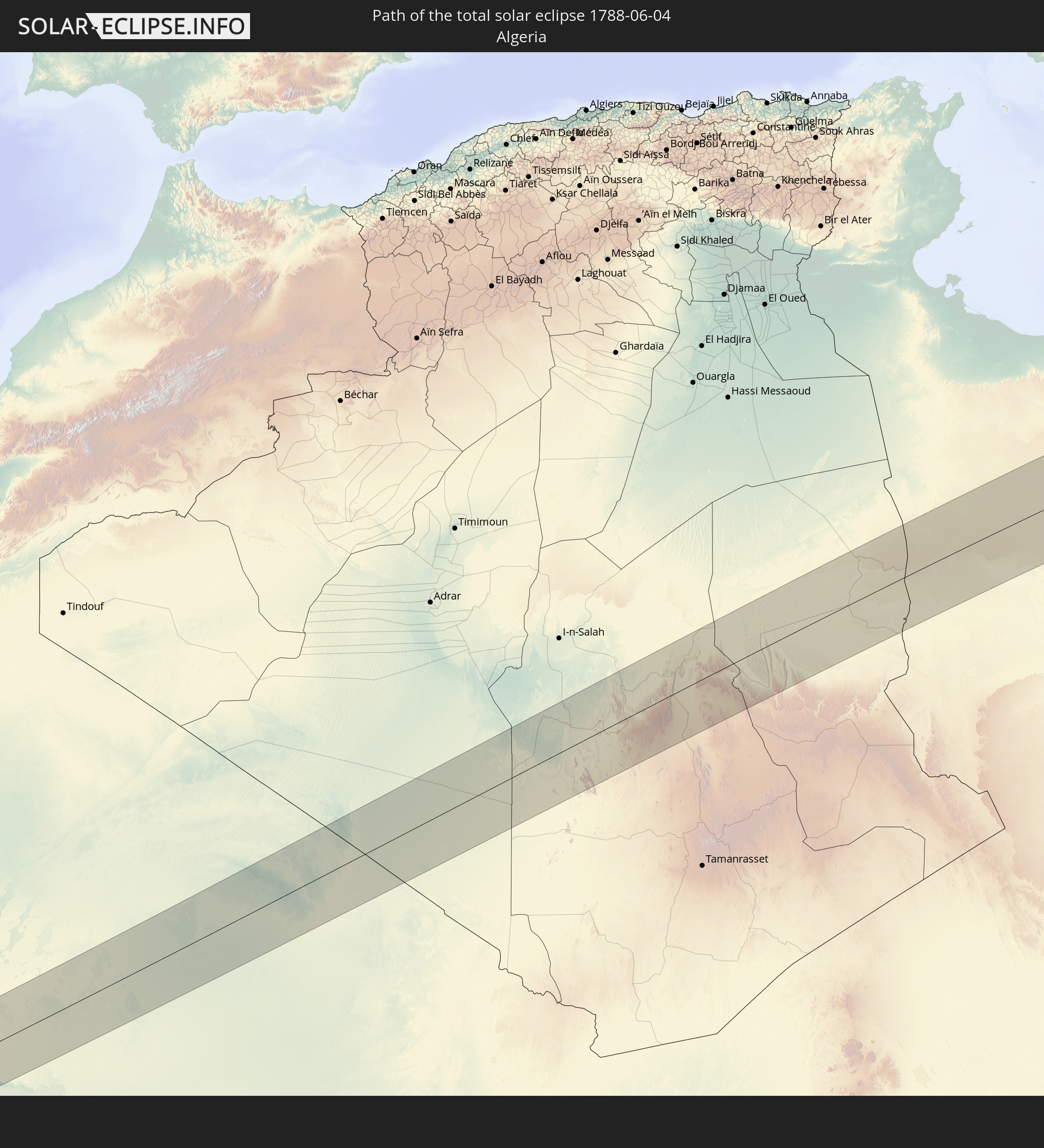
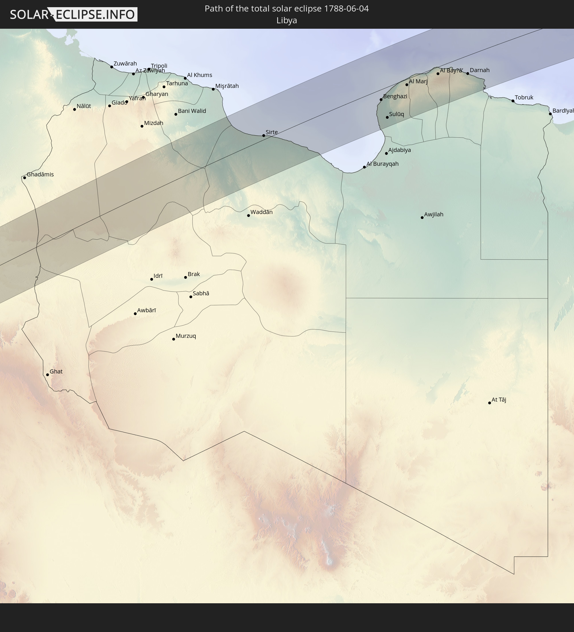
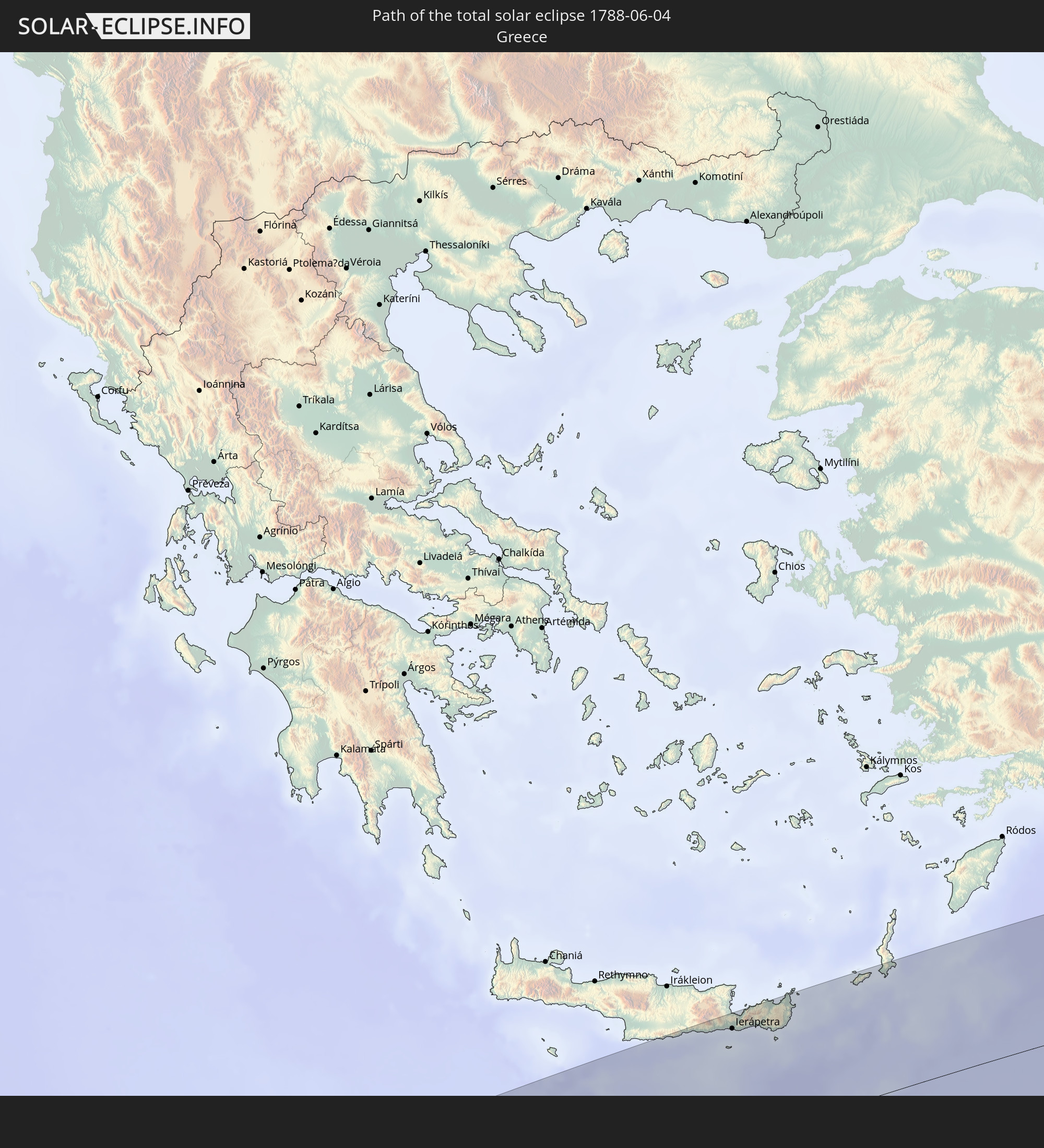
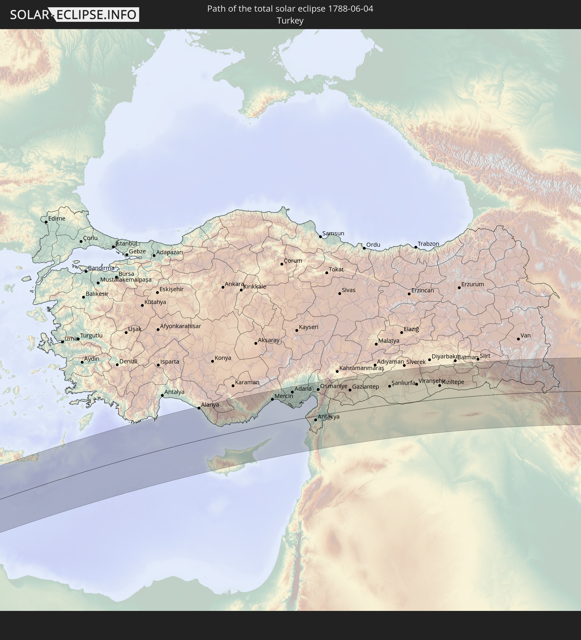
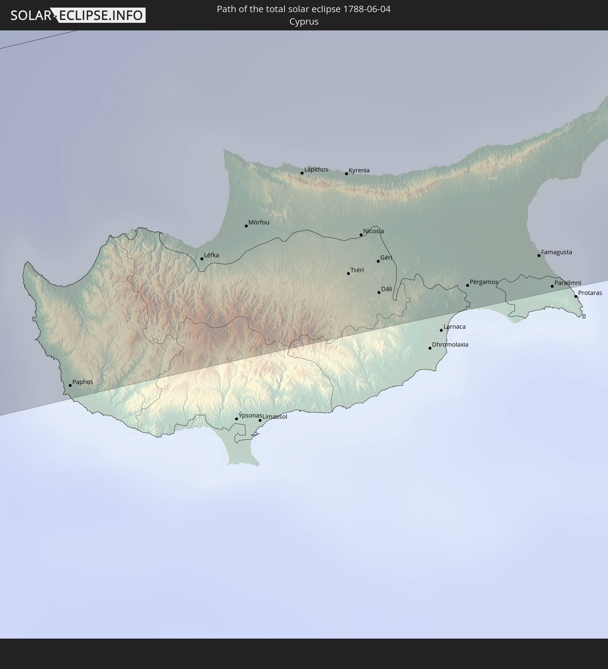
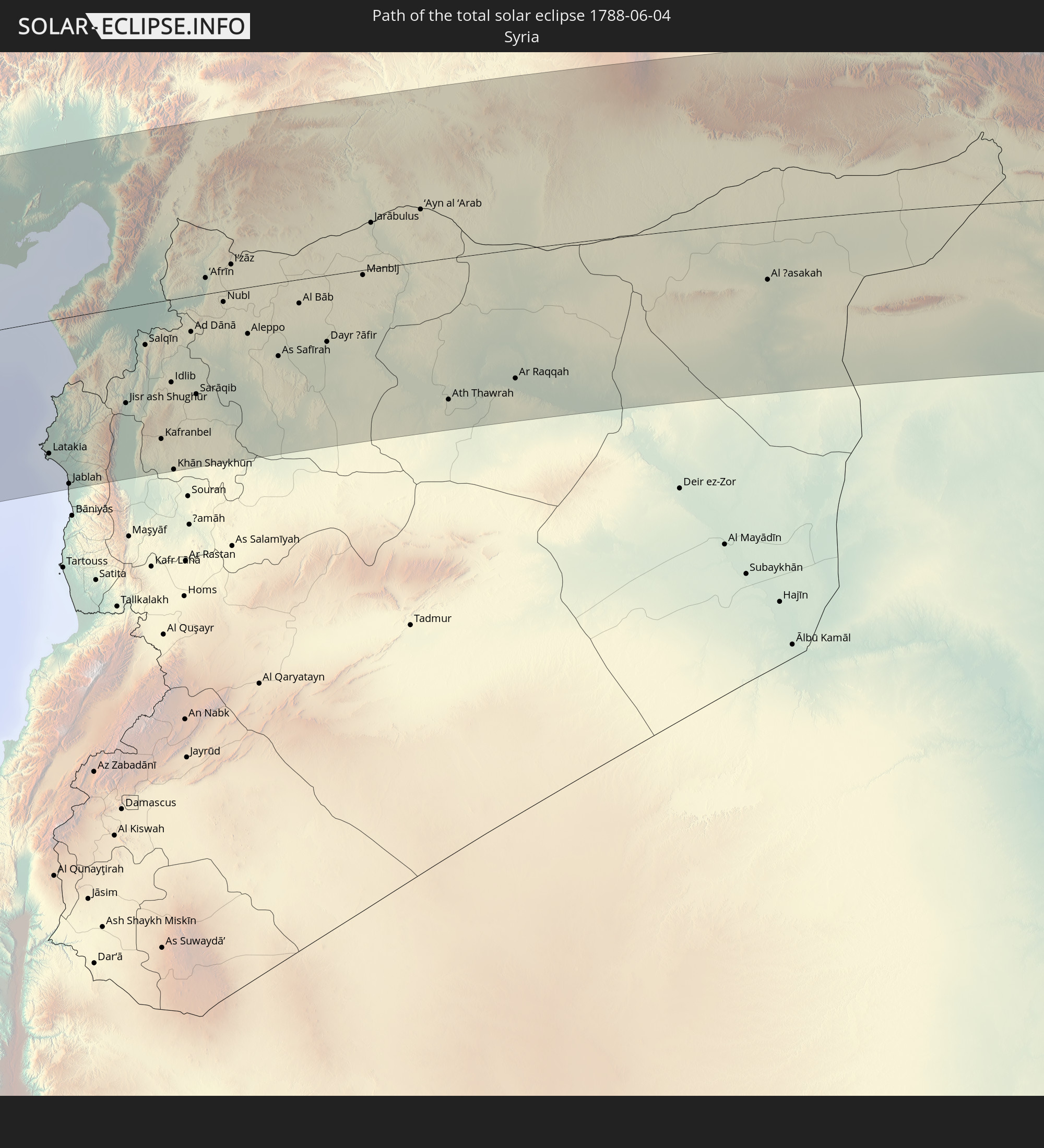
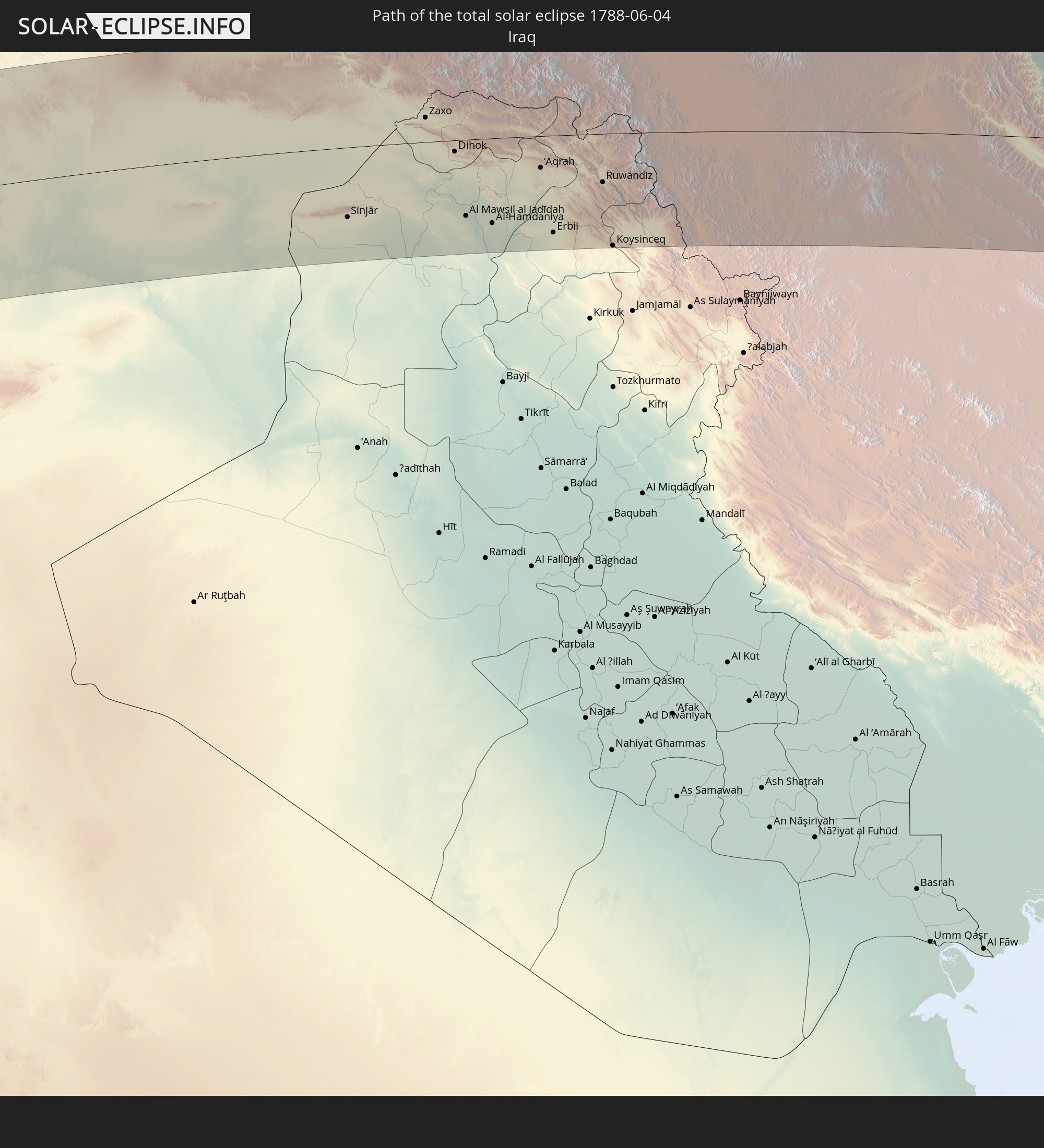
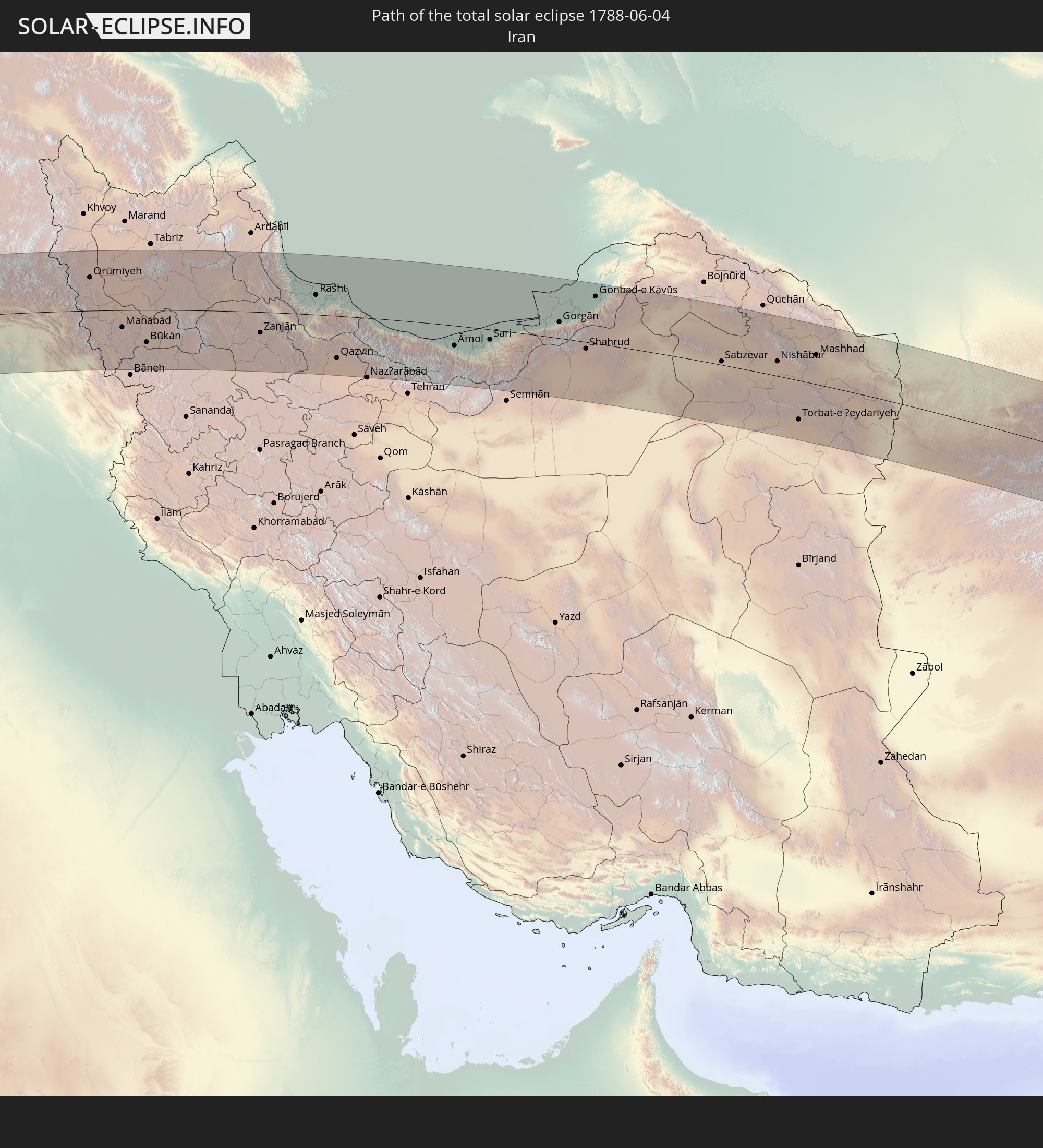
Detaillierte Länderkarten
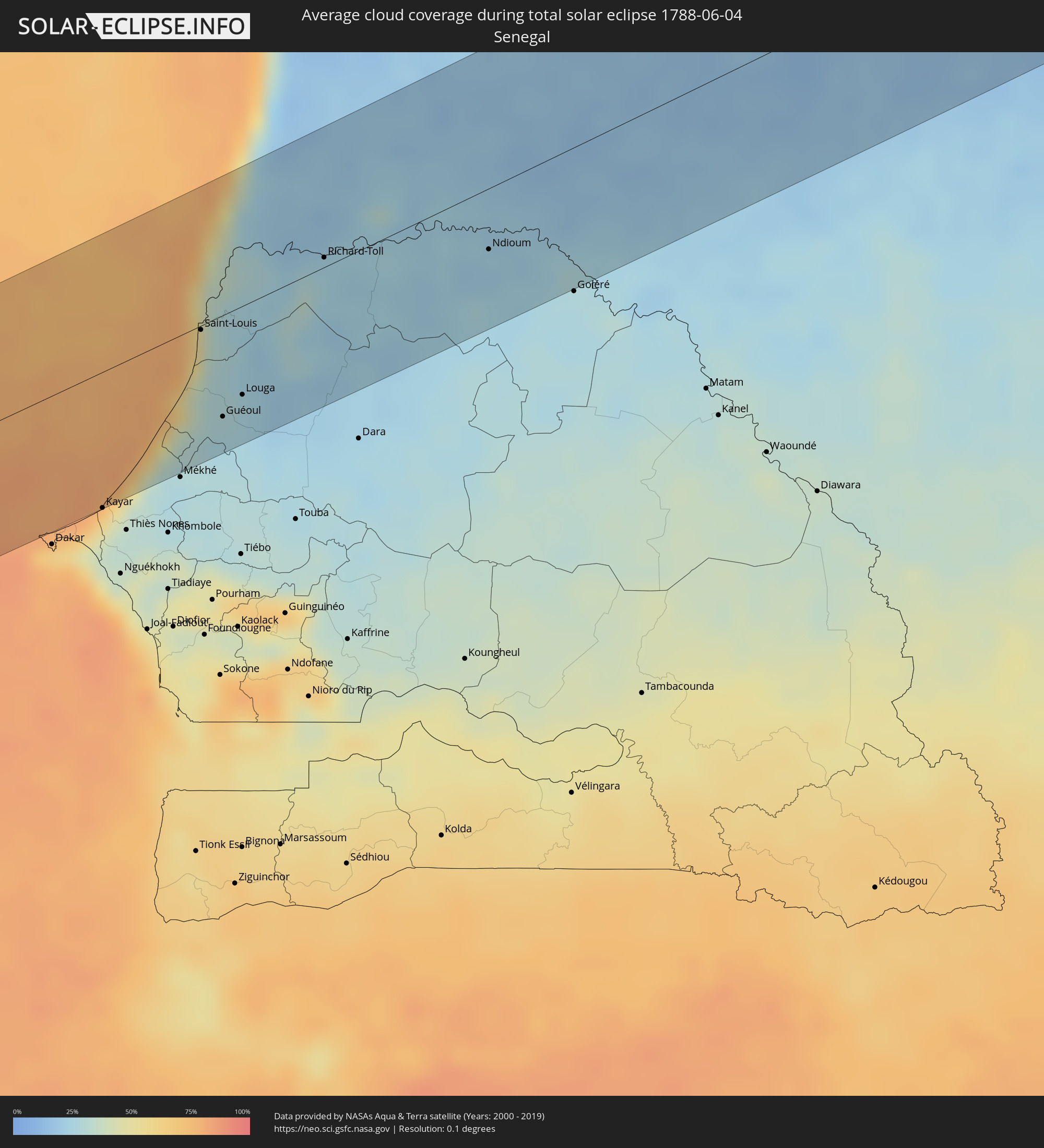 Senegal
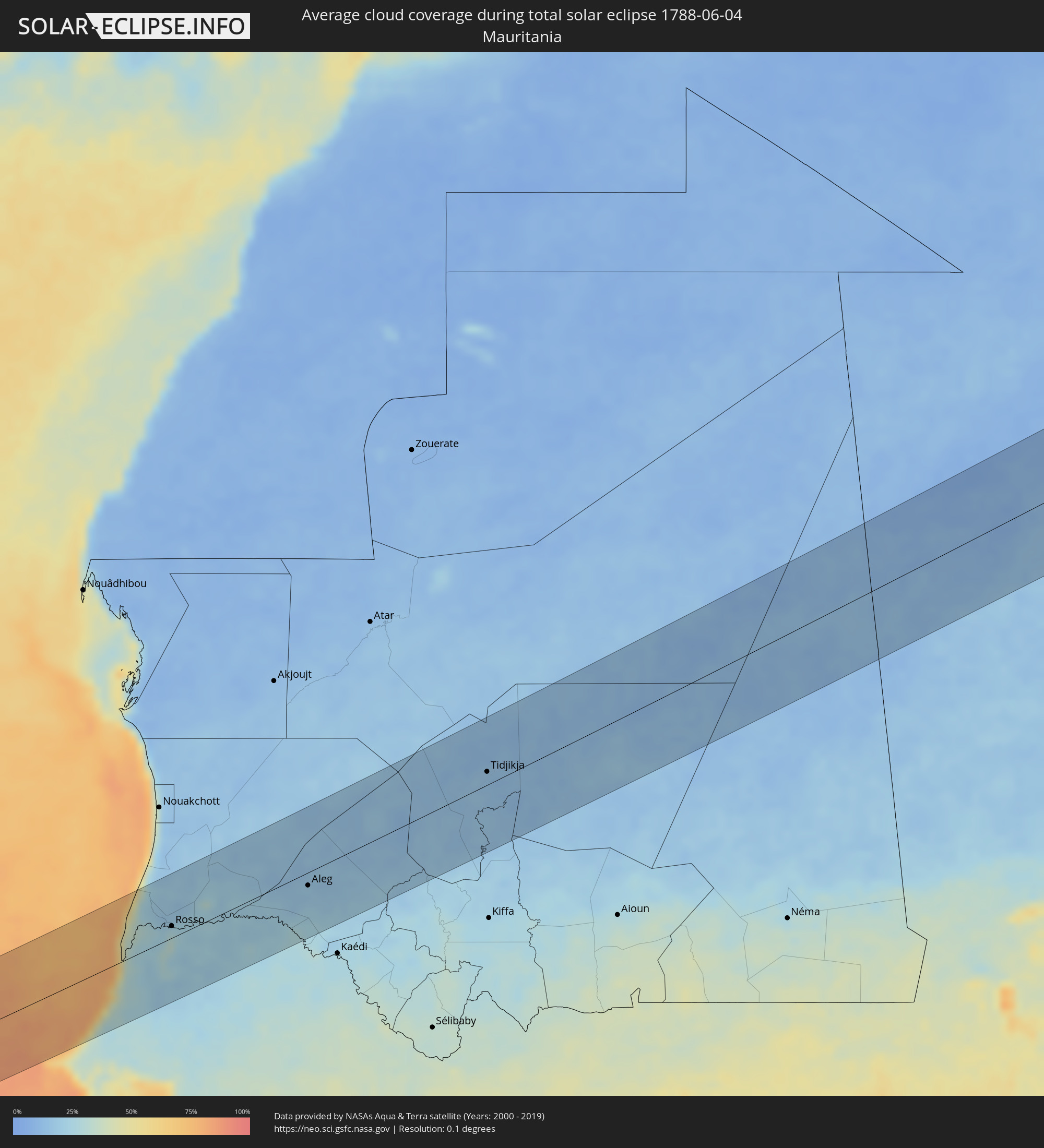 Mauretanien
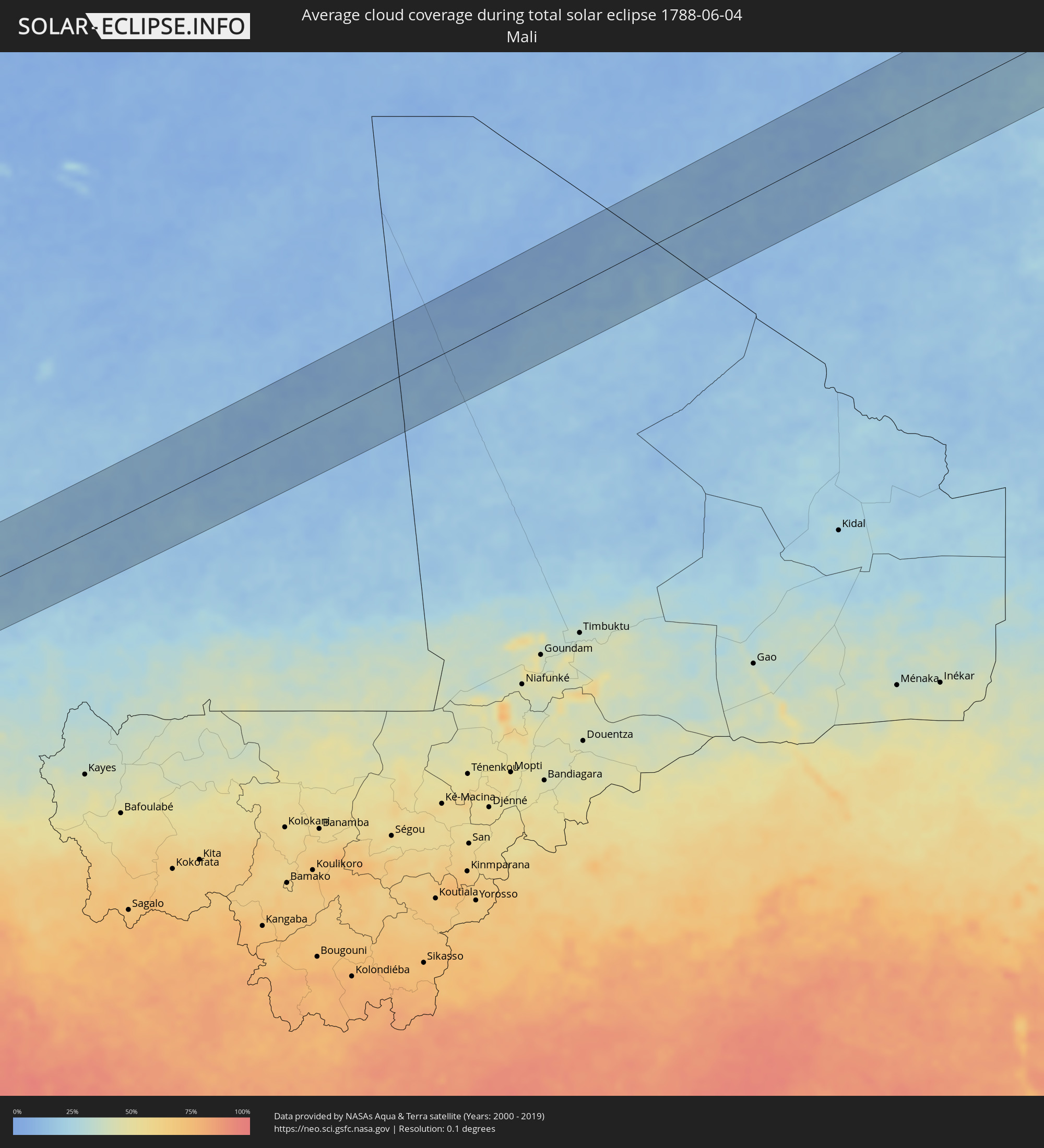 Mali
Mali
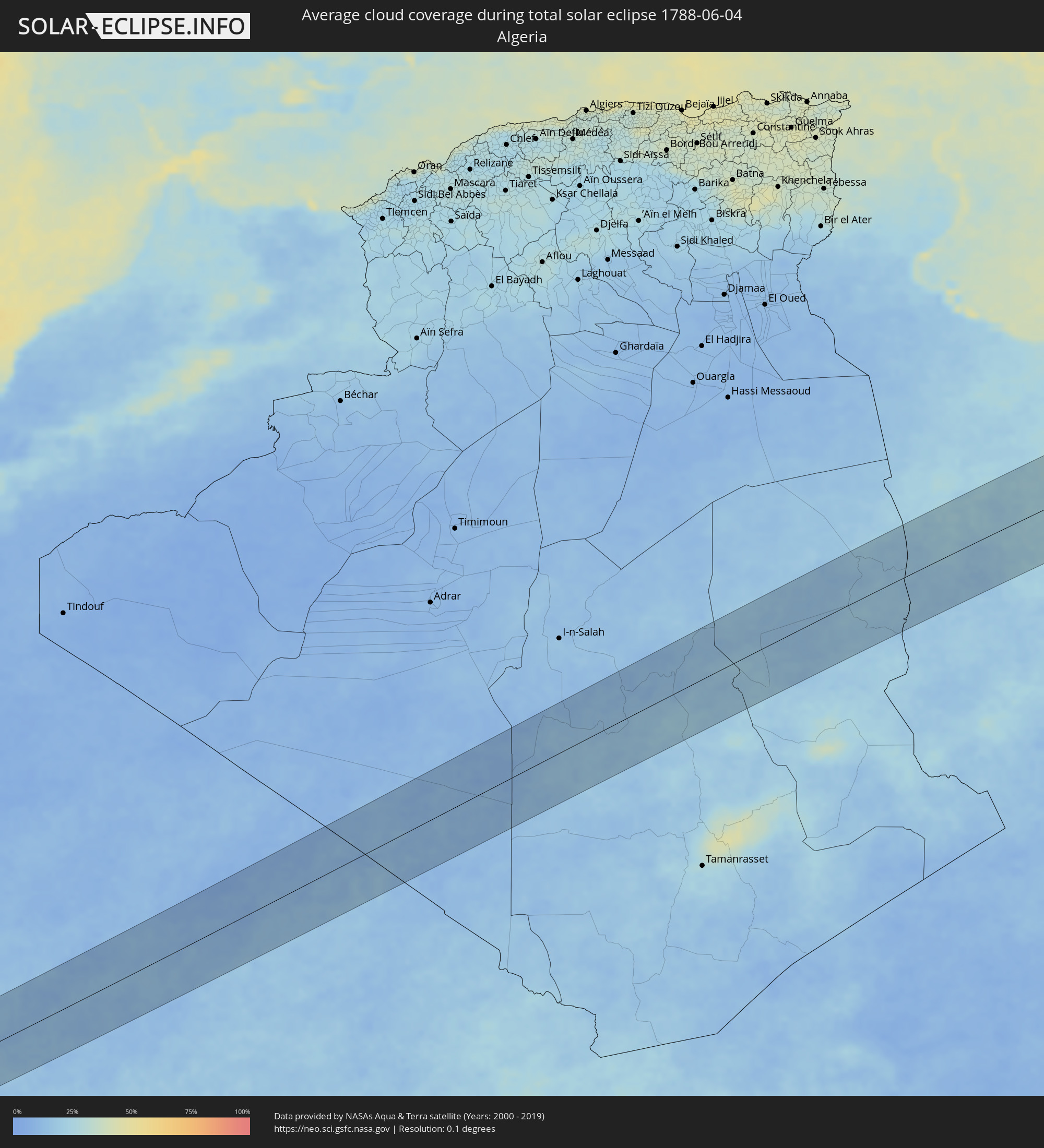 Algerien
 Libyen
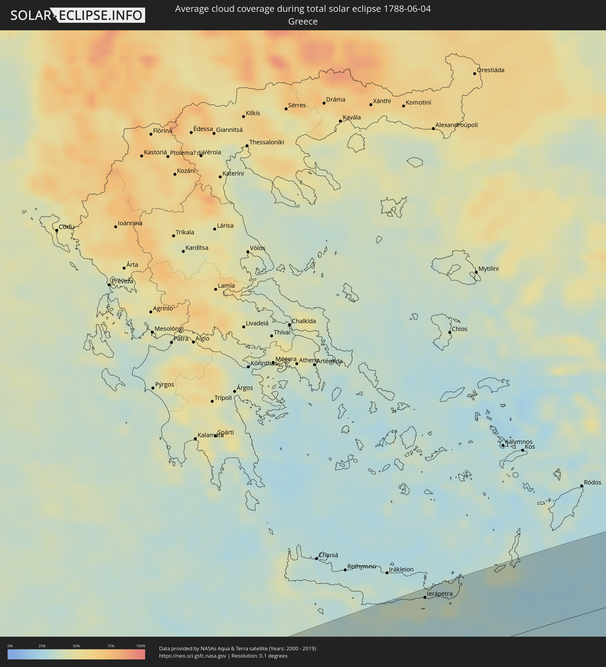 Griechenland
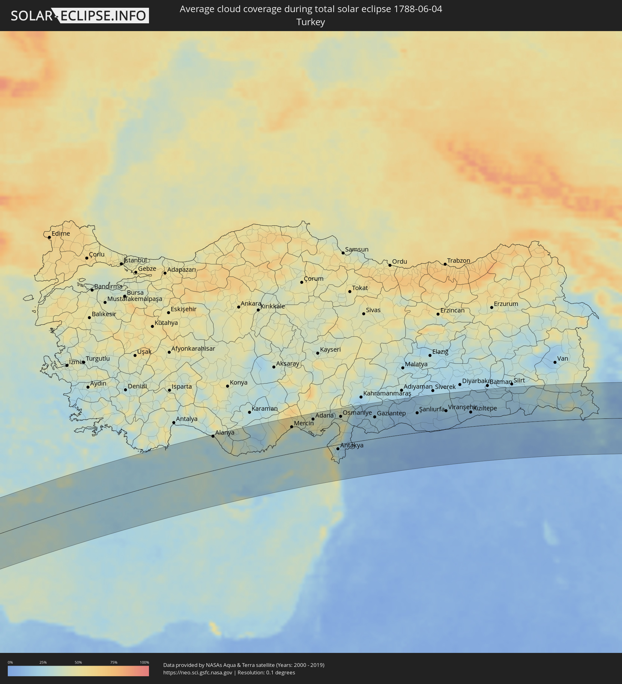 Türkei
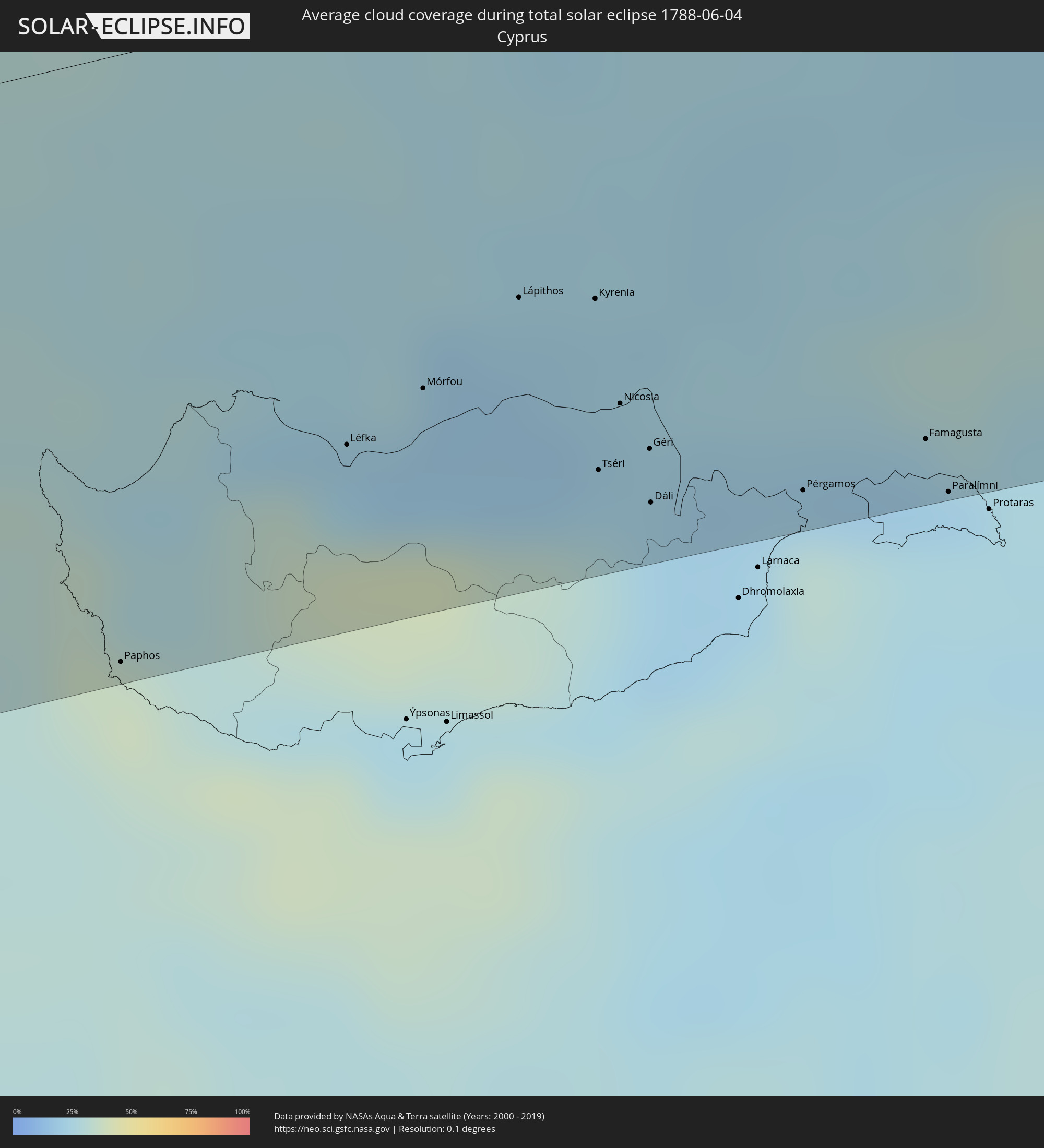 Republik Zypern
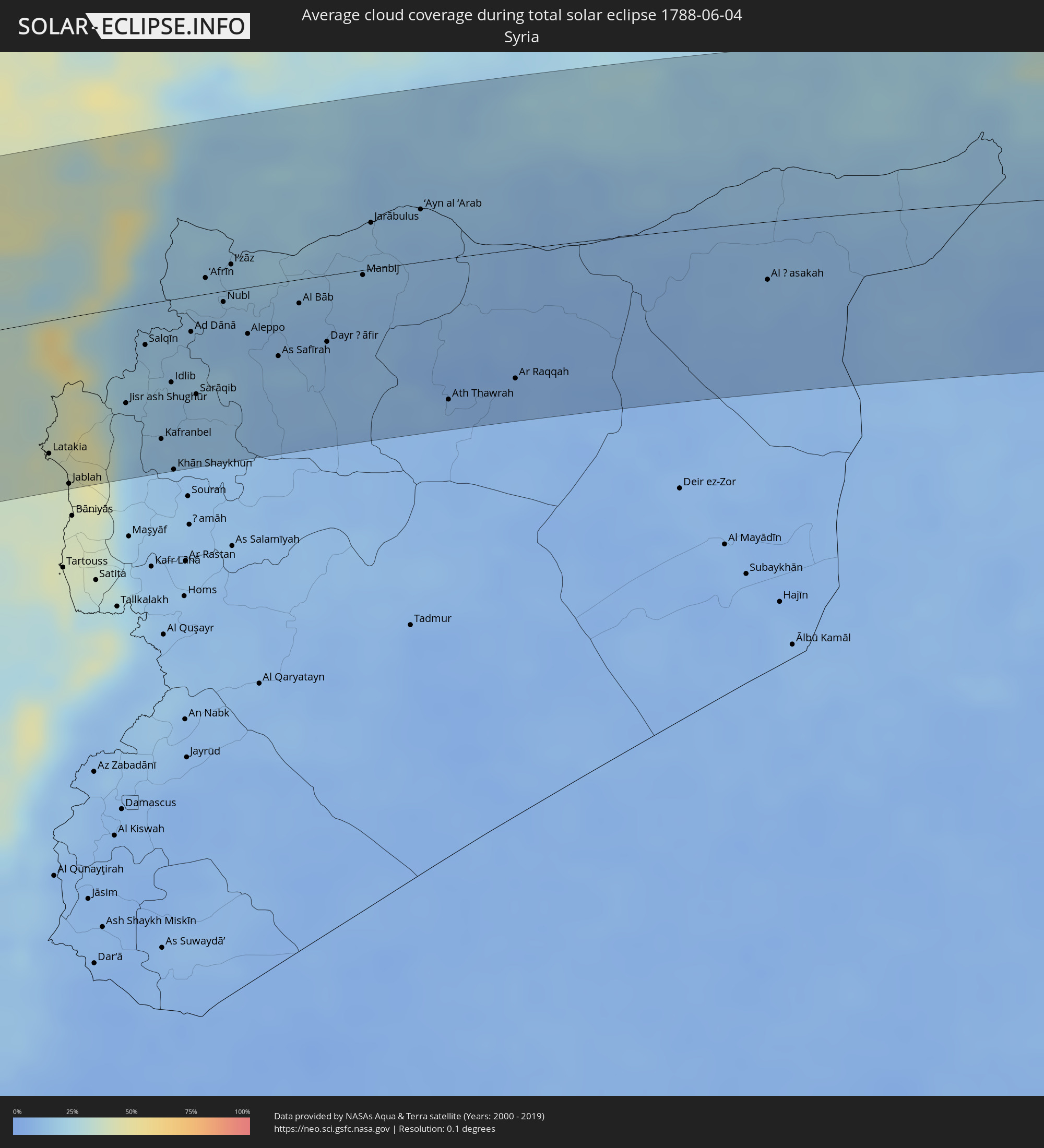 Syrien
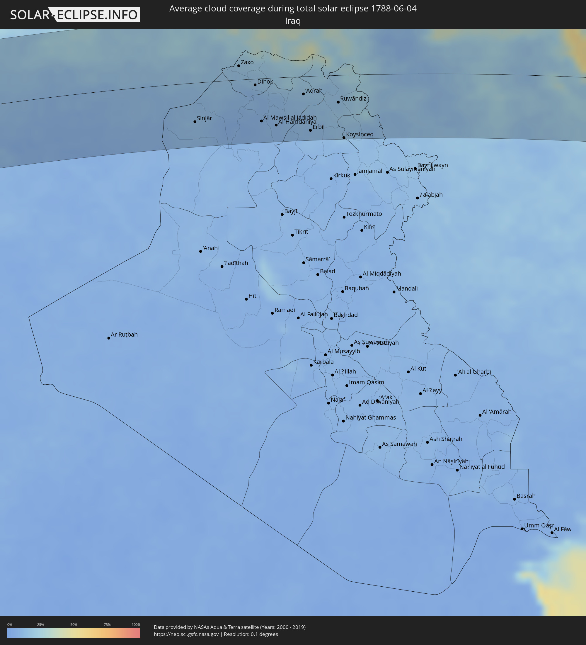 Irak
Irak
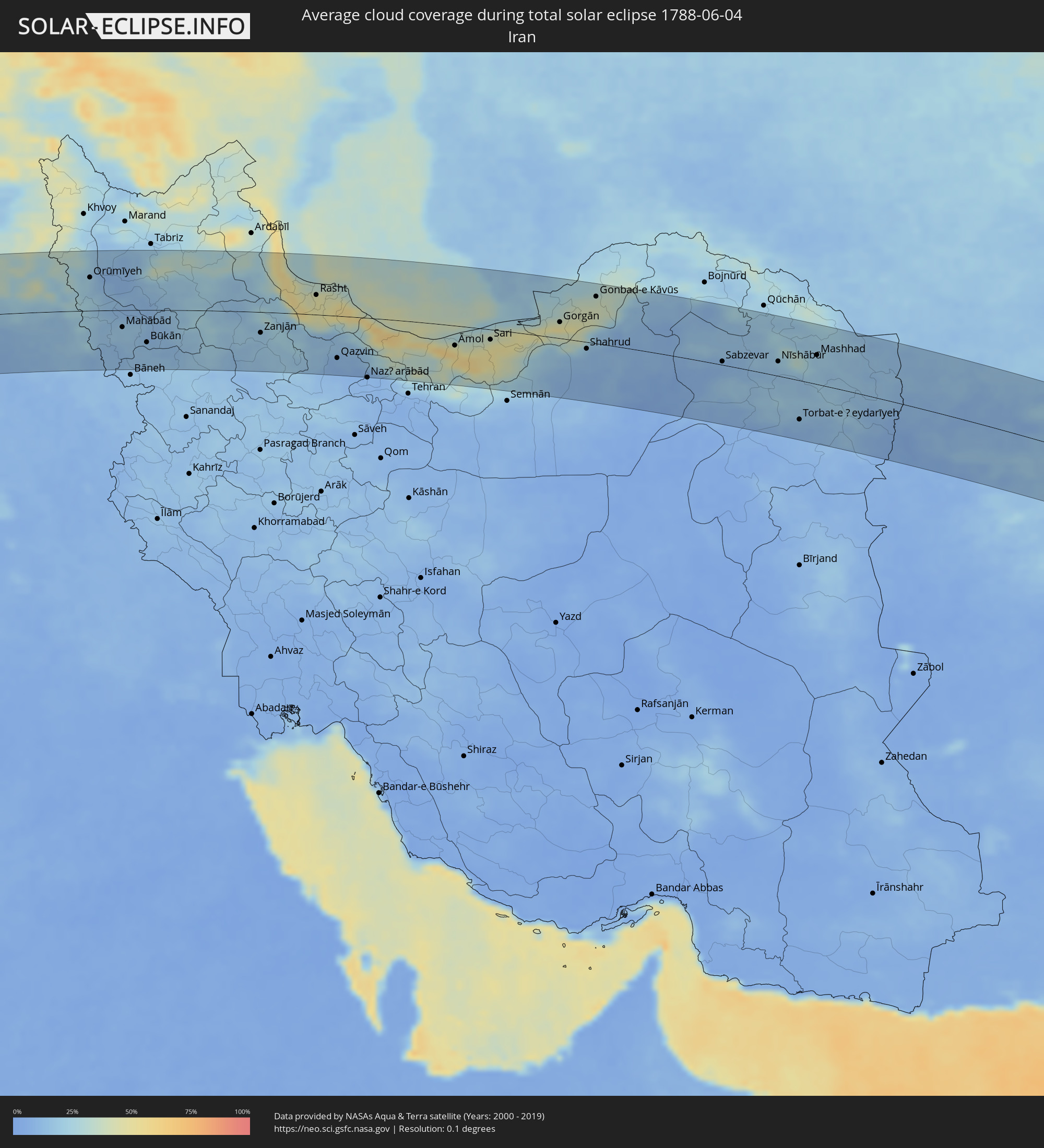 Iran
Iran
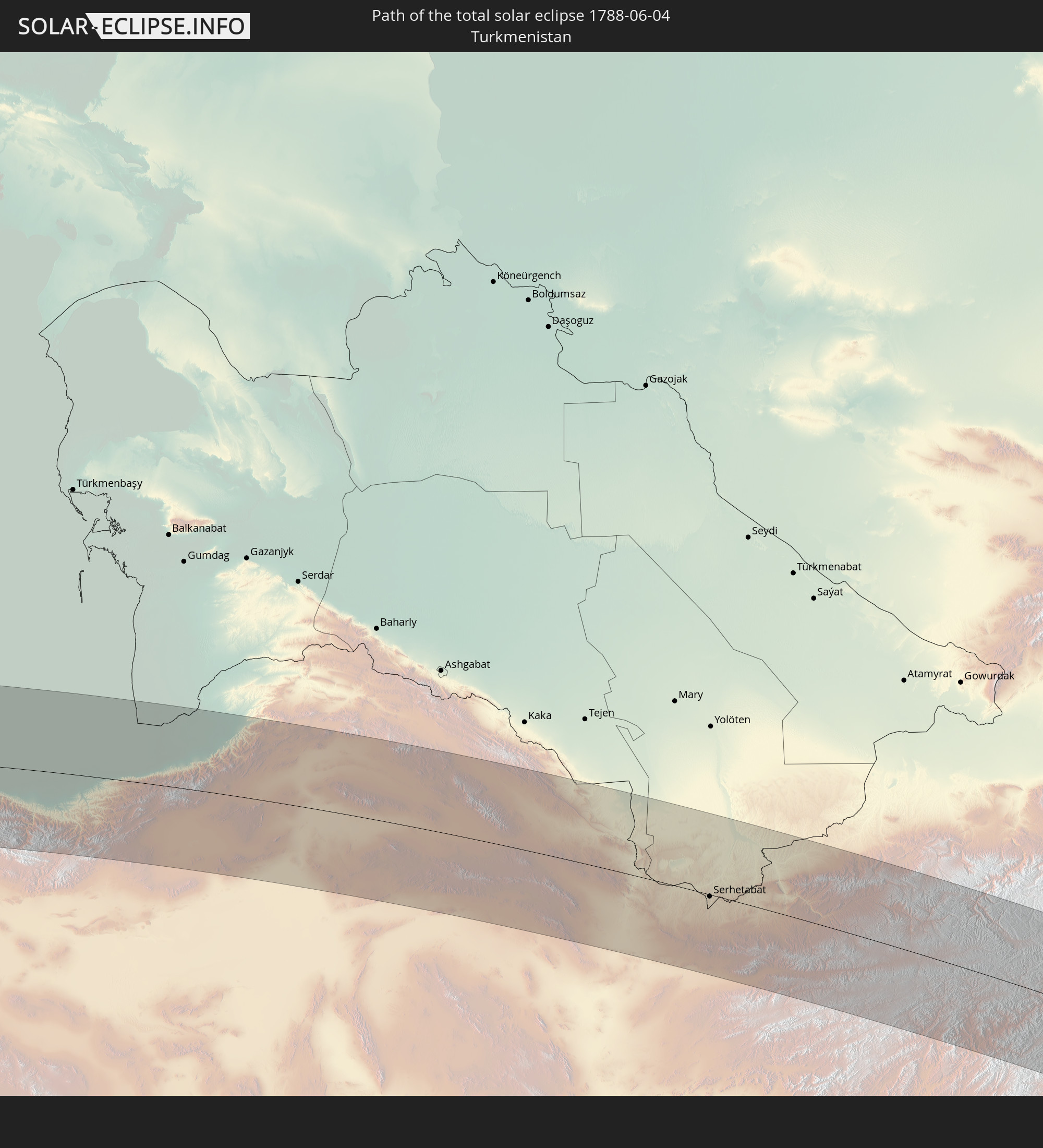
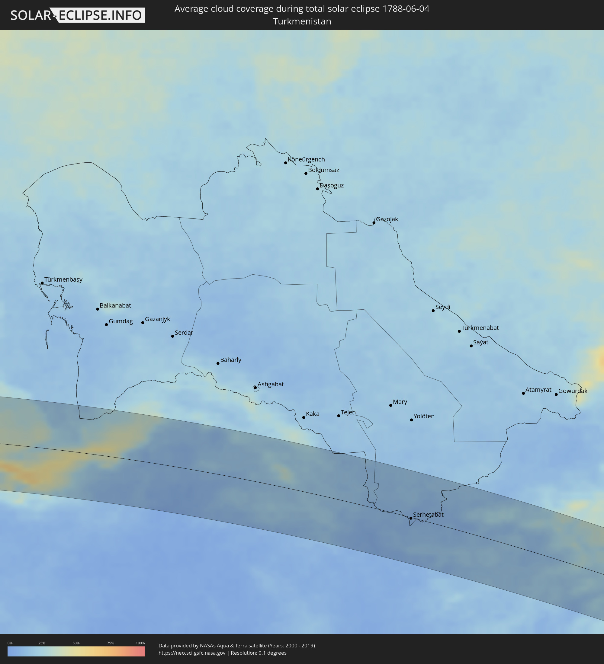 Turkmenistan
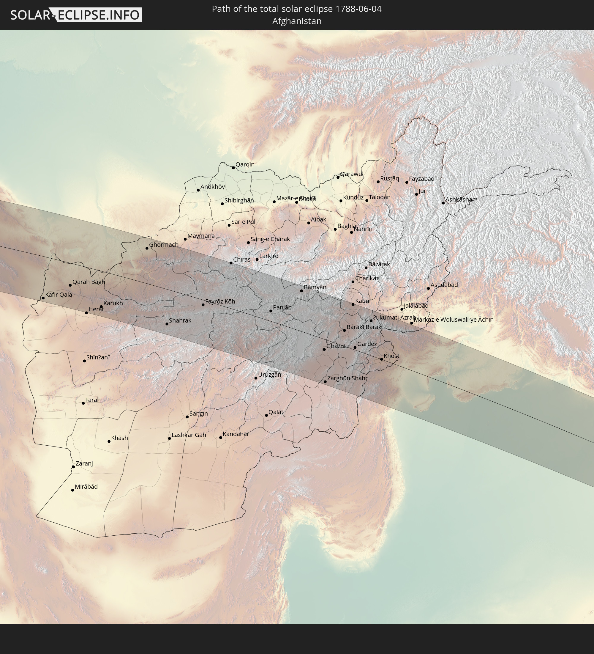
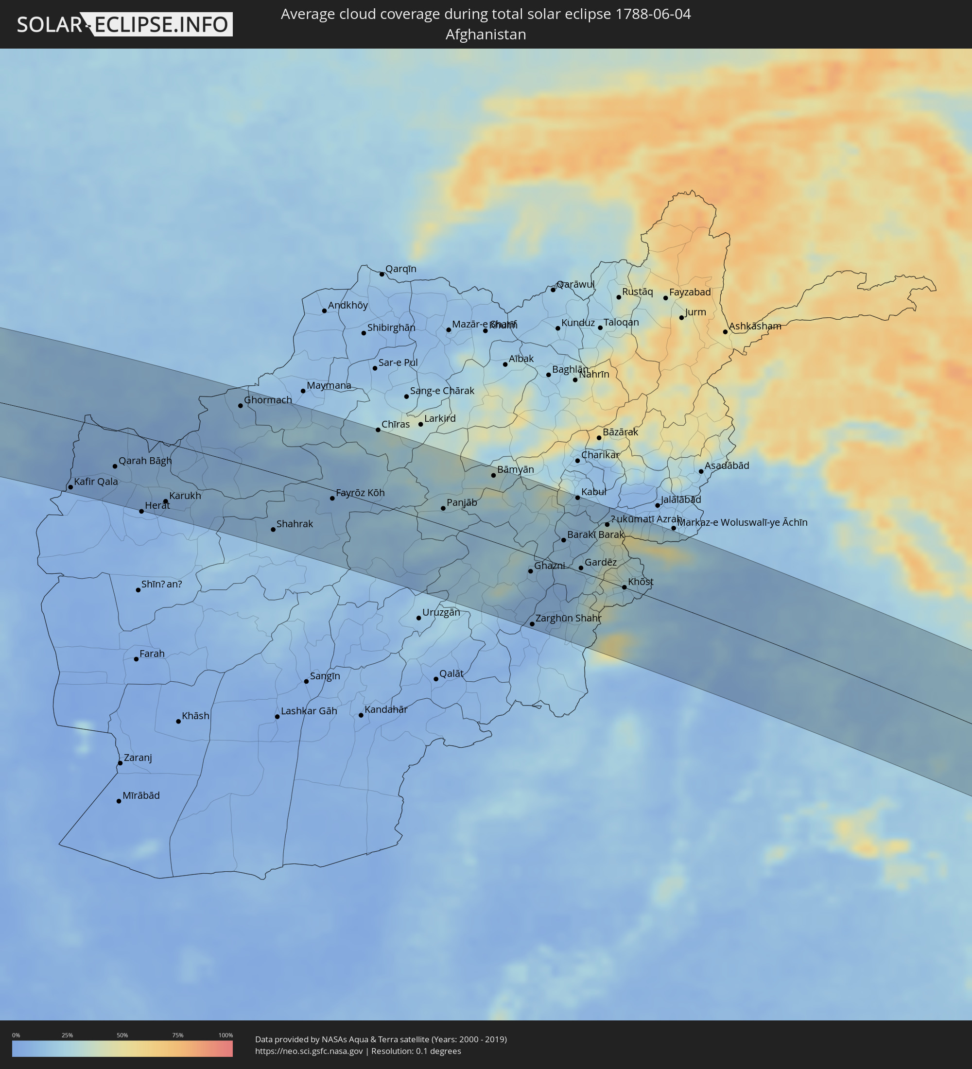 Afghanistan
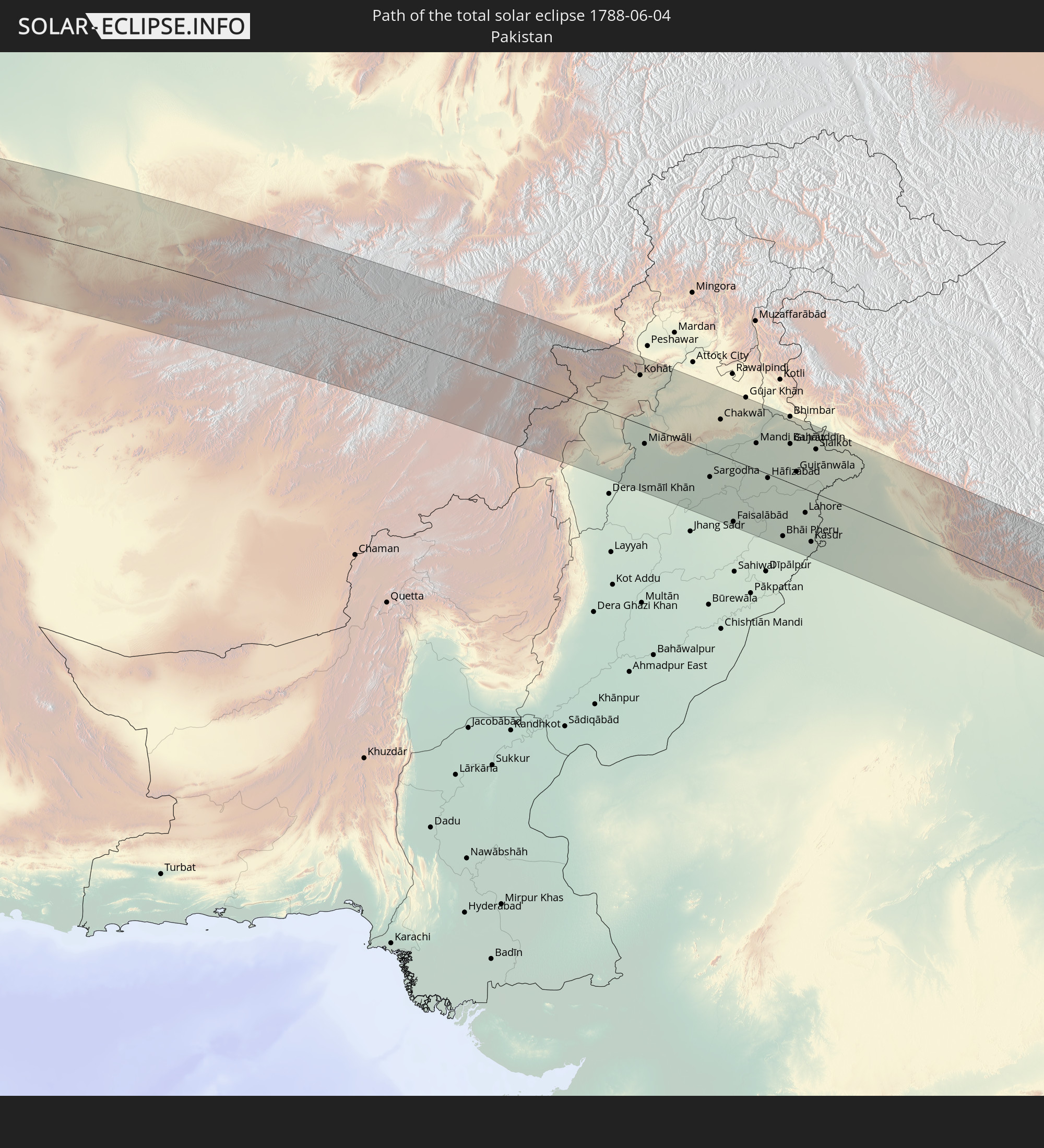
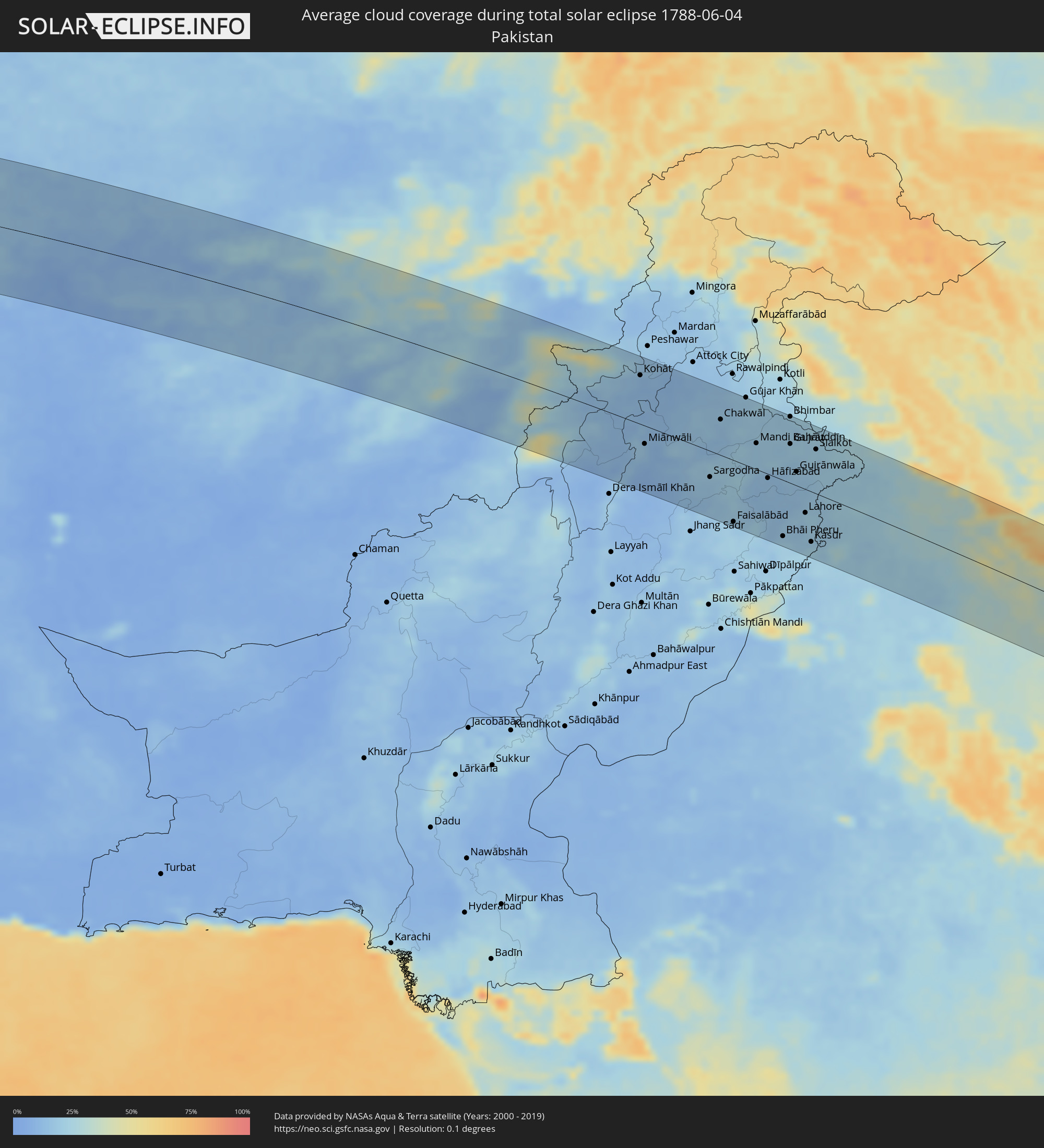 Pakistan
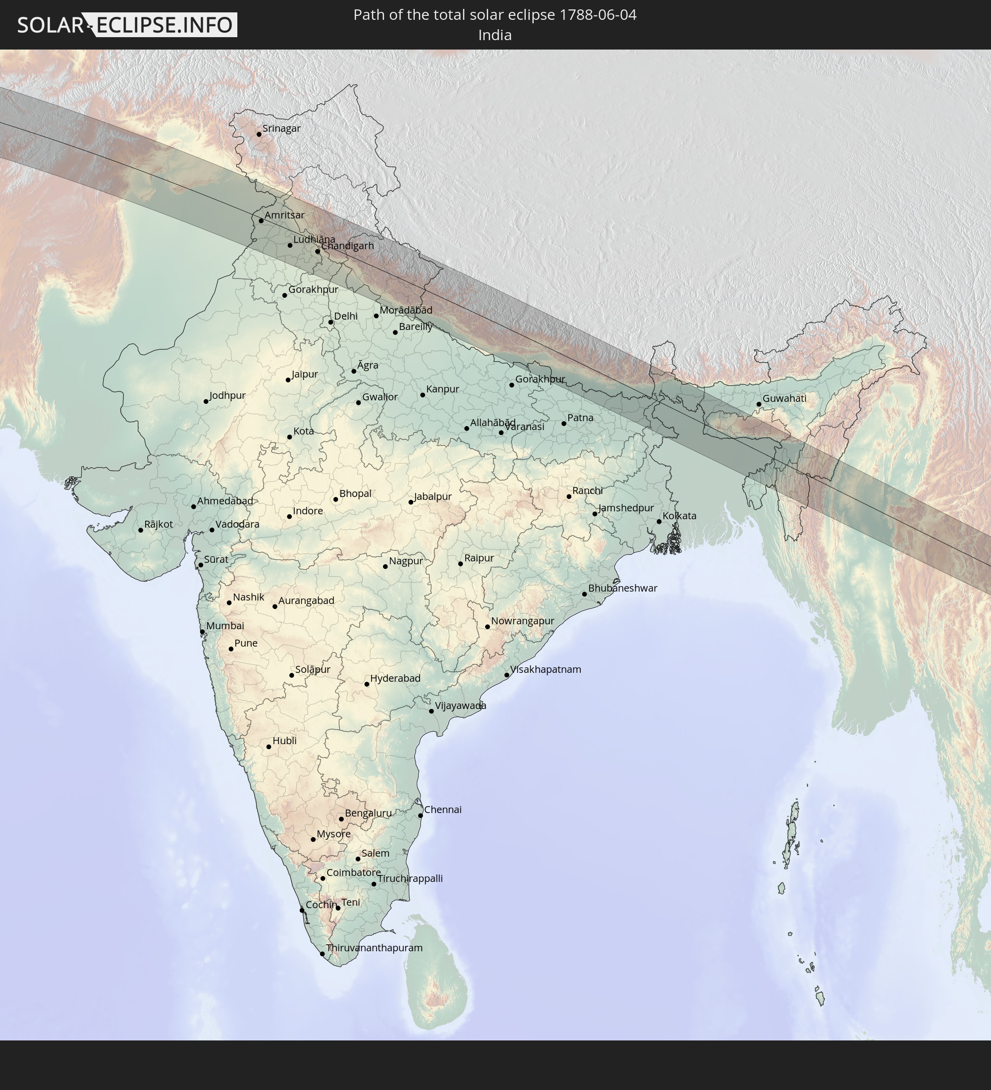
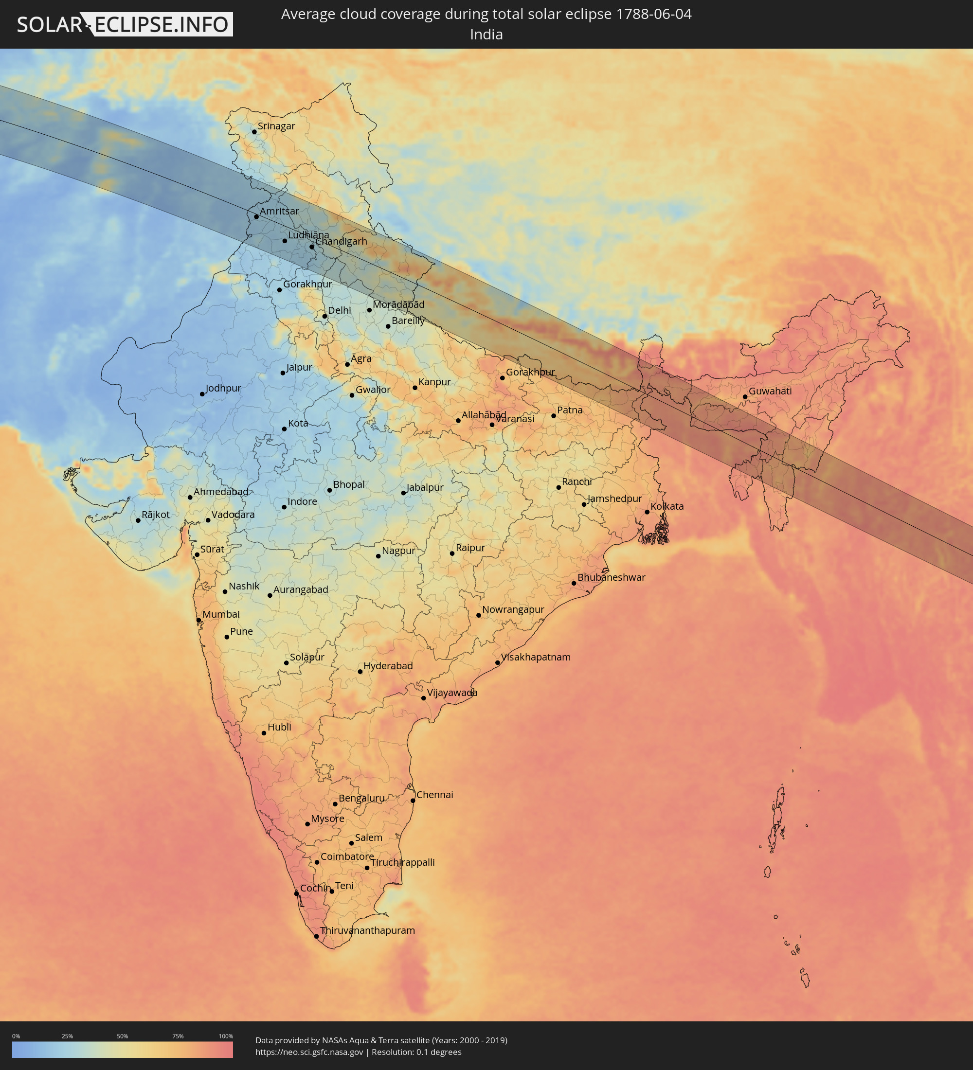 Indien
 Volksrepublik China
 Nepal
Nepal
 Bangladesch
 Bhutan
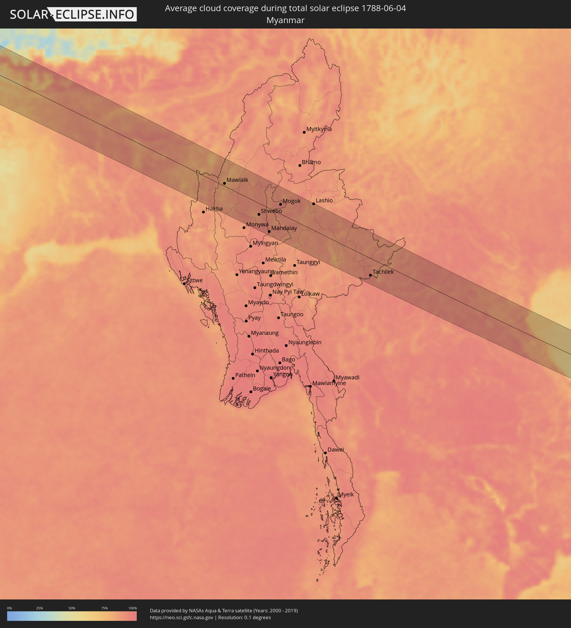 Myanmar
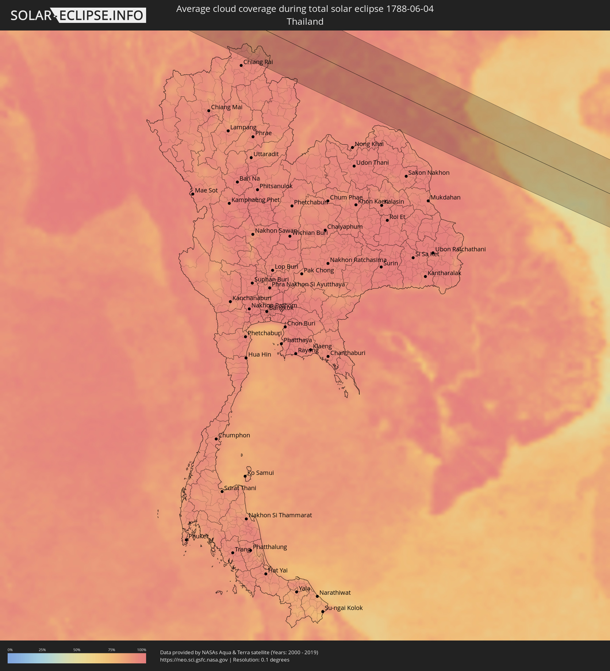 Thailand
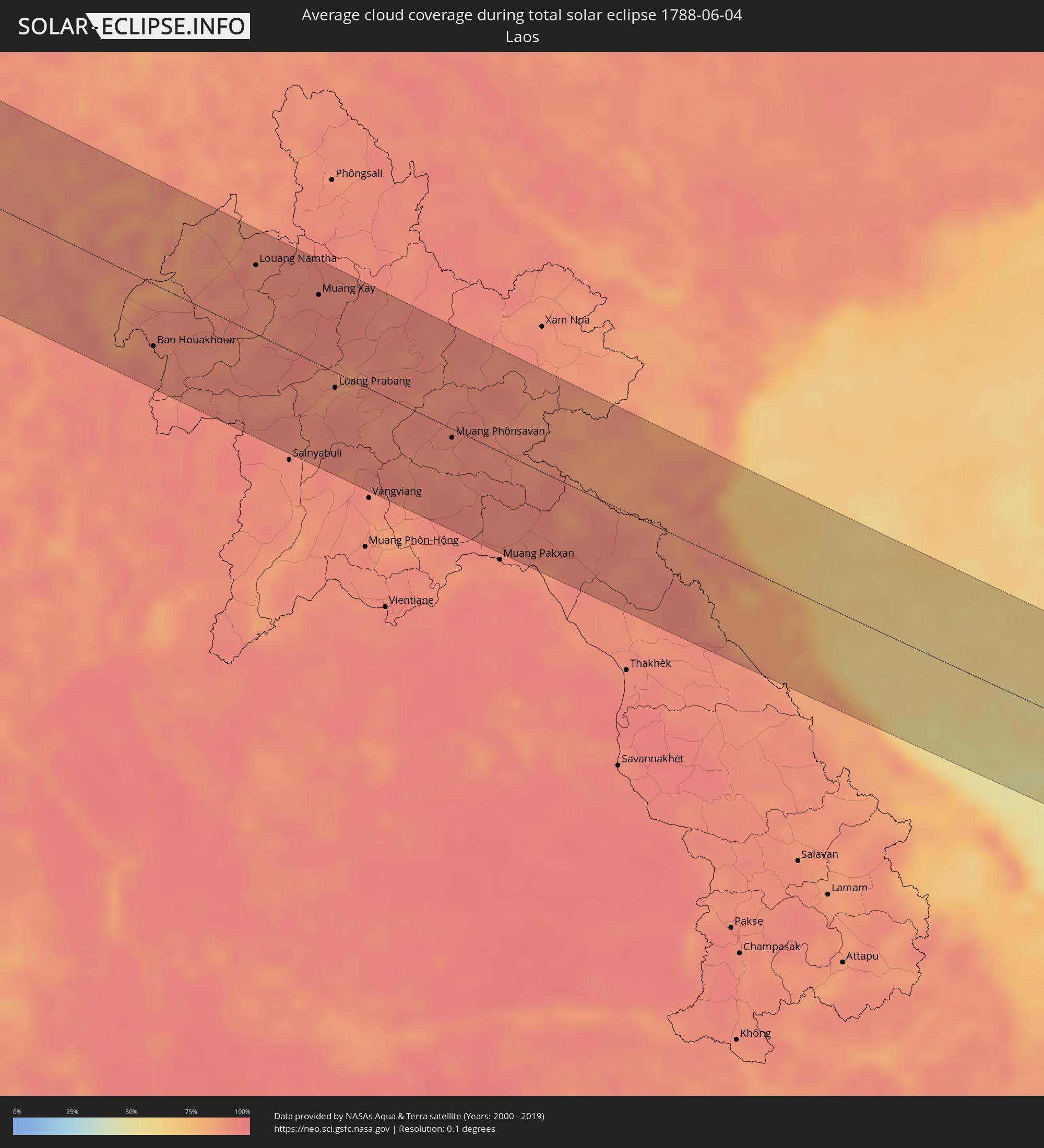 Laos
Laos
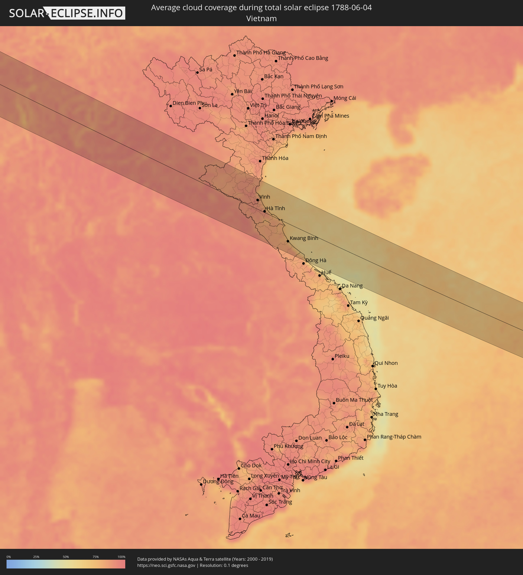 Vietnam
Orte im Finsternispfad
Die nachfolgene Tabelle zeigt Städte und Orte mit mehr als 5.000 Einwohnern, die sich im Finsternispfad befinden. Städte mit mehr als 100.000 Einwohnern sind dick gekennzeichnet. Mit einem Klick auf den Ort öffnet sich eine Detailkarte die die Lage des jeweiligen Ortes zusammen mit dem Verlauf der zentralen Finsternis präsentiert.
| Ort | Typ | Dauer der Verfinsterung | Ortszeit bei maximaler Verfinsterung | Entfernung zur Zentrallinie | Ø Bewölkung |
|
Kayar, Thiès
|
total | - | 07:02:33 UTC-00:16 | 85 km | 43% |
|
Saint-Louis, Saint-Louis
|
total | - | 07:03:24 UTC-00:16 | 3 km | 60% |
|
Guéoul, Louga
|
total | - | 07:02:58 UTC-00:16 | 63 km | 26% |
|
Louga, Louga
|
total | - | 07:03:05 UTC-00:16 | 55 km | 26% |
|
Rosso, Trarza
|
total | - | 07:03:48 UTC-00:16 | 16 km | 27% |
|
Rosso, Saint-Louis
|
total | - | 07:03:44 UTC-00:16 | 6 km | 30% |
|
Richard-Toll, Saint-Louis
|
total | - | 07:03:46 UTC-00:16 | 6 km | 25% |
|
Tékane, Trarza
|
total | - | 07:03:52 UTC-00:16 | 6 km | 24% |
|
Ndioum, Saint-Louis
|
total | - | 07:03:50 UTC-00:16 | 38 km | 21% |
|
Aleg, Brakna
|
total | - | 07:04:21 UTC-00:16 | 17 km | 19% |
|
Tidjikja, Tagant
|
total | - | 07:05:59 UTC-00:16 | 17 km | 15% |
|
Sirte, Surt
|
total | - | 08:51:10 UTC+00:52 | 10 km | 31% |
|
Benghazi, Banghāzī
|
total | - | 08:57:38 UTC+00:52 | 27 km | 26% |
|
Sulūq, Banghāzī
|
total | - | 08:57:24 UTC+00:52 | 80 km | 23% |
|
Tūkrah, Al Marj
|
total | - | 08:58:59 UTC+00:52 | 2 km | 27% |
|
Al Abyār, Al Marj
|
total | - | 08:58:36 UTC+00:52 | 38 km | 24% |
|
Al Marj, Al Marj
|
total | - | 08:59:21 UTC+00:52 | 15 km | 24% |
|
Al Bayḑā’, Al Jabal al Akhḑar
|
total | - | 09:01:13 UTC+00:52 | 19 km | 28% |
|
Al Qubbah, Darnah
|
total | - | 09:02:03 UTC+00:52 | 35 km | 27% |
|
Darnah, Darnah
|
total | - | 09:02:45 UTC+00:52 | 48 km | 29% |
|
Ierápetra, Crete
|
total | - | 09:52:58 UTC+01:34 | 92 km | 39% |
|
Sitia, Crete
|
total | - | 09:53:51 UTC+01:34 | 102 km | 33% |
|
Paphos, Pafos
|
total | - | 10:44:42 UTC+02:13 | 101 km | 37% |
|
Léfka, Nicosia
|
total | - | 10:45:53 UTC+02:13 | 74 km | 25% |
|
Mórfou, Nicosia
|
total | - | 10:46:15 UTC+02:13 | 67 km | 19% |
|
Kyrenia, Keryneia
|
total | - | 10:47:03 UTC+02:13 | 59 km | 22% |
|
Nicosia, Nicosia
|
total | - | 10:47:02 UTC+02:13 | 77 km | 23% |
|
Géri, Nicosia
|
total | - | 10:47:06 UTC+02:13 | 86 km | 22% |
|
Dáli, Nicosia
|
total | - | 10:47:03 UTC+02:13 | 95 km | 22% |
|
Pérgamos, Larnaka
|
total | - | 10:47:41 UTC+02:13 | 98 km | 31% |
|
Famagusta, Ammochostos
|
total | - | 10:48:15 UTC+02:13 | 94 km | 20% |
|
Paralímni, Ammochostos
|
total | - | 10:48:17 UTC+02:13 | 104 km | 26% |
|
Mercin, Mersin
|
total | - | 10:34:21 UTC+01:56 | 76 km | 37% |
|
Tarsus, Mersin
|
total | - | 10:35:01 UTC+01:56 | 85 km | 37% |
|
Adana, Adana
|
total | - | 10:36:00 UTC+01:56 | 87 km | 47% |
|
Latakia, Latakia
|
total | - | 11:04:21 UTC+02:25 | 81 km | 40% |
|
Antakya, Hatay
|
total | - | 10:37:19 UTC+01:56 | 13 km | 25% |
|
İskenderun, Hatay
|
total | - | 10:37:35 UTC+01:56 | 28 km | 43% |
|
Osmaniye, Osmaniye
|
total | - | 10:38:01 UTC+01:56 | 81 km | 39% |
|
Idlib, Idlib
|
total | - | 11:06:29 UTC+02:25 | 51 km | 16% |
|
I‘zāz, Aleppo
|
total | - | 11:07:46 UTC+02:25 | 16 km | 17% |
|
Aleppo, Aleppo
|
total | - | 11:07:48 UTC+02:25 | 28 km | 13% |
|
As Safīrah, Aleppo
|
total | - | 11:08:13 UTC+02:25 | 45 km | 15% |
|
Gaziantep, Gaziantep
|
total | - | 10:40:29 UTC+01:56 | 63 km | 20% |
|
Al Bāb, Aleppo
|
total | - | 11:08:41 UTC+02:25 | 15 km | 12% |
|
Manbij, Aleppo
|
total | - | 11:09:45 UTC+02:25 | 3 km | 12% |
|
Ath Thawrah, Ar-Raqqah
|
total | - | 11:10:45 UTC+02:25 | 87 km | 8% |
|
Şanlıurfa, Şanlıurfa
|
total | - | 10:43:39 UTC+01:56 | 57 km | 17% |
|
Ar Raqqah, Ar-Raqqah
|
total | - | 11:11:52 UTC+02:25 | 79 km | 7% |
|
Viranşehir, Şanlıurfa
|
total | - | 10:45:48 UTC+01:56 | 53 km | 16% |
|
Kızıltepe, Mardin
|
total | - | 10:47:38 UTC+01:56 | 42 km | 14% |
|
Al Ḩasakah, Al-Hasakah
|
total | - | 11:16:04 UTC+02:25 | 36 km | 11% |
|
Sinjār, Nīnawá
|
total | - | 11:51:00 UTC+02:57 | 64 km | 12% |
|
Zaxo, Dahūk
|
total | - | 11:53:03 UTC+02:57 | 23 km | 15% |
|
Dihok, Dahūk
|
total | - | 11:53:41 UTC+02:57 | 10 km | 12% |
|
Sīnah, Dahūk
|
total | - | 11:53:48 UTC+02:57 | 17 km | 10% |
|
Al Mawşil al Jadīdah, Nīnawá
|
total | - | 11:53:52 UTC+02:57 | 70 km | 9% |
|
Tallkayf, Nīnawá
|
total | - | 11:53:56 UTC+02:57 | 53 km | 9% |
|
Al-Hamdaniya, Nīnawá
|
total | - | 11:54:29 UTC+02:57 | 78 km | 10% |
|
‘Aqrah, Nīnawá
|
total | - | 11:55:43 UTC+02:57 | 29 km | 13% |
|
Erbil, Arbīl
|
total | - | 11:55:57 UTC+02:57 | 90 km | 12% |
|
Koysinceq, Arbīl
|
total | - | 11:57:24 UTC+02:57 | 104 km | 12% |
|
Orūmīyeh, Āz̄ārbāyjān-e Gharbī
|
total | - | 12:26:39 UTC+03:25 | 59 km | 19% |
|
Būkān, Āz̄ārbāyjān-e Gharbī
|
total | - | 12:29:14 UTC+03:25 | 57 km | 14% |
|
Zanjān, Zanjan
|
total | - | 12:34:27 UTC+03:25 | 37 km | 18% |
|
Rasht, Gīlān
|
total | - | 12:36:51 UTC+03:25 | 35 km | 47% |
|
Qazvin, Qazvīn
|
total | - | 12:38:03 UTC+03:25 | 75 km | 10% |
|
Sari, Māzandarān
|
total | - | 12:44:50 UTC+03:25 | 18 km | 47% |
|
Gorgān, Golestān
|
total | - | 12:47:43 UTC+03:25 | 28 km | 52% |
|
Sabzevar, Razavi Khorasan
|
total | - | 12:54:59 UTC+03:25 | 6 km | 10% |
|
Nīshābūr, Razavi Khorasan
|
total | - | 12:57:17 UTC+03:25 | 26 km | 17% |
|
Mashhad, Razavi Khorasan
|
total | - | 12:58:46 UTC+03:25 | 51 km | 20% |
|
Kafir Qala, Herat
|
total | - | 13:37:24 UTC+04:00 | 97 km | 8% |
|
Serhetabat, Mary
|
total | - | 13:32:55 UTC+03:53 | 2 km | 8% |
|
Karukh, Herat
|
total | - | 13:40:35 UTC+04:00 | 83 km | 8% |
|
Ghormach, Badghis
|
total | - | 13:41:40 UTC+04:00 | 80 km | 13% |
|
Bāmyān, Bamyan
|
total | - | 13:49:44 UTC+04:00 | 92 km | 34% |
|
Ghazni, Ghazni
|
total | - | 13:52:07 UTC+04:00 | 24 km | 17% |
|
Barakī Barak, Logar
|
total | - | 13:52:33 UTC+04:00 | 35 km | 17% |
|
Paghmān, Kabul
|
total | - | 13:51:51 UTC+04:00 | 101 km | 26% |
|
Kabul, Kabul
|
total | - | 13:52:17 UTC+04:00 | 101 km | 15% |
|
Gardēz, Paktia
|
total | - | 13:53:25 UTC+04:00 | 5 km | 15% |
|
Khōst, Khowst
|
total | - | 13:54:50 UTC+04:00 | 0 km | 24% |
|
Sargodha, Punjab
|
total | - | 14:28:44 UTC+04:28 | 40 km | 18% |
|
Chiniot, Punjab
|
total | - | 14:29:37 UTC+04:28 | 67 km | 19% |
|
Faisalābād, Punjab
|
total | - | 14:30:07 UTC+04:28 | 95 km | 19% |
|
Sheikhupura, Punjab
|
total | - | 14:31:04 UTC+04:28 | 32 km | 13% |
|
Bhimbar, Azad Kashmir
|
total | - | 14:29:41 UTC+04:28 | 101 km | 20% |
|
Gujrāt, Punjab
|
total | - | 14:30:10 UTC+04:28 | 60 km | 20% |
|
Gujrānwāla, Punjab
|
total | - | 14:30:49 UTC+04:28 | 21 km | 19% |
|
Lahore, Punjab
|
total | - | 14:31:46 UTC+04:28 | 36 km | 18% |
|
Kasūr, Punjab
|
total | - | 14:32:26 UTC+04:28 | 77 km | 21% |
|
Sialkot, Punjab
|
total | - | 14:30:54 UTC+04:28 | 68 km | 21% |
|
Amritsar, Punjab
|
total | - | 15:25:23 UTC+05:21 | 10 km | 22% |
|
Jalandhar, Punjab
|
total | - | 15:26:42 UTC+05:21 | 14 km | 22% |
|
Ludhiāna, Punjab
|
total | - | 15:27:34 UTC+05:21 | 47 km | 20% |
|
Patiāla, Punjab
|
total | - | 15:28:58 UTC+05:21 | 85 km | 21% |
|
Chandigarh, Chandigarh
|
total | - | 15:28:59 UTC+05:21 | 29 km | 25% |
|
Yamunānagar, Haryana
|
total | - | 15:30:21 UTC+05:21 | 73 km | 32% |
|
Sahāranpur, Uttar Pradesh
|
total | - | 15:30:52 UTC+05:21 | 79 km | 31% |
|
Dehra Dūn, Uttarakhand
|
total | - | 15:31:02 UTC+05:21 | 24 km | 36% |
|
Mahendranagar, Far Western
|
total | - | 15:55:31 UTC+05:41 | 75 km | 45% |
|
Dhangarhi, Far Western
|
total | - | 15:56:03 UTC+05:41 | 86 km | 47% |
|
Burang, Tibet Autonomous Region
|
total | - | 18:13:28 UTC+08:00 | 98 km | 29% |
|
Butwāl, Western Region
|
total | - | 16:00:10 UTC+05:41 | 69 km | 71% |
|
Pokhara, Western Region
|
total | - | 15:59:58 UTC+05:41 | 10 km | 63% |
|
Bharatpur, Central Region
|
total | - | 16:01:05 UTC+05:41 | 29 km | 61% |
|
Bīrganj, Central Region
|
total | - | 16:02:17 UTC+05:41 | 78 km | 78% |
|
Kathmandu, Central Region
|
total | - | 16:01:51 UTC+05:41 | 11 km | 67% |
|
Janakpur, Central Region
|
total | - | 16:03:30 UTC+05:41 | 63 km | 78% |
|
Biratnagar, Eastern Region
|
total | - | 16:04:54 UTC+05:41 | 30 km | 82% |
|
Dharān Bāzār, Eastern Region
|
total | - | 16:04:29 UTC+05:41 | 7 km | 72% |
|
Shiliguri, West Bengal
|
total | - | 15:45:21 UTC+05:21 | 47 km | 87% |
|
Dinājpur, Rangpur Division
|
total | - | 16:18:54 UTC+05:53 | 52 km | 88% |
|
Saidpur, Rājshāhi
|
total | - | 16:18:55 UTC+05:53 | 26 km | 89% |
|
Samtse, Samchi
|
total | - | 16:23:02 UTC+05:58 | 95 km | 90% |
|
Rangpur, Rangpur Division
|
total | - | 16:19:12 UTC+05:53 | 13 km | 88% |
|
Sarishābāri, Dhaka
|
total | - | 16:20:42 UTC+05:53 | 87 km | 85% |
|
Jamālpur, Dhaka
|
total | - | 16:20:35 UTC+05:53 | 65 km | 90% |
|
Mymensingh, Dhaka
|
total | - | 16:21:03 UTC+05:53 | 60 km | 89% |
|
Netrakona, Dhaka
|
total | - | 16:21:06 UTC+05:53 | 33 km | 92% |
|
Kishorganj, Dhaka
|
total | - | 16:21:38 UTC+05:53 | 75 km | 92% |
|
Habiganj, Sylhet
|
total | - | 16:22:04 UTC+05:53 | 53 km | 93% |
|
Sylhet, Sylhet
|
total | - | 16:21:45 UTC+05:53 | 20 km | 89% |
|
Aizawl, Mizoram
|
total | - | 15:51:19 UTC+05:21 | 59 km | 81% |
|
Mawlaik, Sagain
|
total | - | 16:55:50 UTC+06:24 | 9 km | 79% |
|
Shwebo, Sagain
|
total | - | 16:57:29 UTC+06:24 | 39 km | 88% |
|
Mandalay, Mandalay
|
total | - | 16:58:14 UTC+06:24 | 81 km | 91% |
|
Pyin Oo Lwin, Mandalay
|
total | - | 16:58:18 UTC+06:24 | 58 km | 90% |
|
Mogok, Mandalay
|
total | - | 16:57:26 UTC+06:24 | 33 km | 90% |
|
Lashio, Shan
|
total | - | 16:57:51 UTC+06:24 | 91 km | 88% |
|
Mae Sai, Chiang Rai
|
total | - | 17:18:08 UTC+06:42 | 62 km | 94% |
|
Tachilek, Shan
|
total | - | 17:18:07 UTC+06:42 | 60 km | 94% |
|
Chiang Saen, Chiang Rai
|
total | - | 17:18:19 UTC+06:42 | 68 km | 90% |
|
Chiang Khong, Chiang Rai
|
total | - | 17:18:24 UTC+06:42 | 55 km | 90% |
|
Ban Houayxay, Bokeo Province
|
total | - | 17:18:23 UTC+06:42 | 53 km | 90% |
|
Ban Houakhoua, Bokeo Province
|
total | - | 17:18:26 UTC+06:42 | 54 km | 89% |
|
Louang Namtha, Loungnamtha
|
total | - | 17:17:58 UTC+06:42 | 60 km | 90% |
|
Muang Xay, Oudômxai
|
total | - | 17:18:18 UTC+06:42 | 60 km | 94% |
|
Luang Prabang, Louangphabang
|
total | - | 17:19:03 UTC+06:42 | 13 km | 88% |
|
Muang Phônsavan, Xiangkhoang
|
total | - | 17:19:34 UTC+06:42 | 8 km | 89% |
|
Yên Vinh, Nghệ An
|
total | - | 17:45:00 UTC+07:06 | 25 km | 87% |
|
Vinh, Nghệ An
|
total | - | 17:45:00 UTC+07:06 | 26 km | 87% |
|
Hà Tĩnh, Hà Tĩnh
|
total | - | 17:45:16 UTC+07:06 | 3 km | 85% |
|
Kwang Binh, Quảng Bình
|
total | - | 17:45:59 UTC+07:06 | 53 km | 82% |