Totale Sonnenfinsternis vom 08.07.1842
| Wochentag: | Freitag |
| Maximale Dauer der Verfinsterung: | 04m05s |
| Maximale Breite des Finsternispfades: | 204 km |
| Saroszyklus: | 124 |
| Bedeckungsgrad: | 100% |
| Magnitude: | 1.0543 |
| Gamma: | 0.4727 |
Wo kann man die Sonnenfinsternis vom 08.07.1842 sehen?
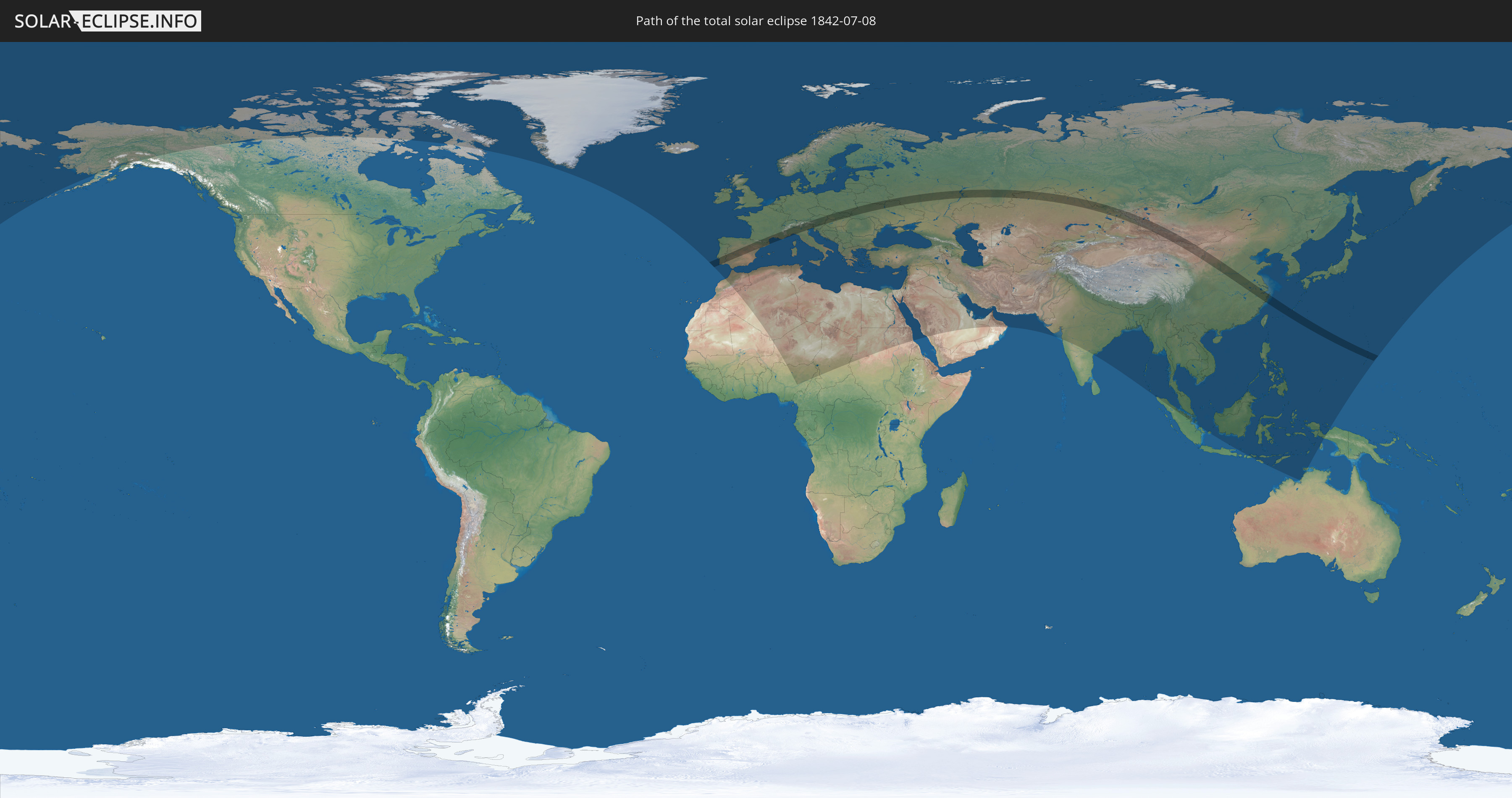
Die Sonnenfinsternis am 08.07.1842 kann man in 118 Ländern als partielle Sonnenfinsternis beobachten.
Der Finsternispfad verläuft durch 21 Länder. Nur in diesen Ländern ist sie als totale Sonnenfinsternis zu sehen.
In den folgenden Ländern ist die Sonnenfinsternis total zu sehen
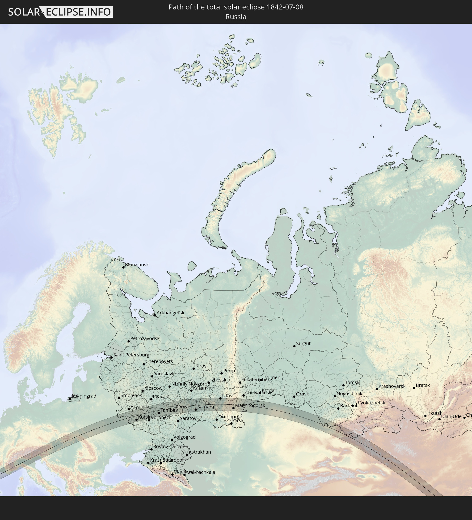 Russland
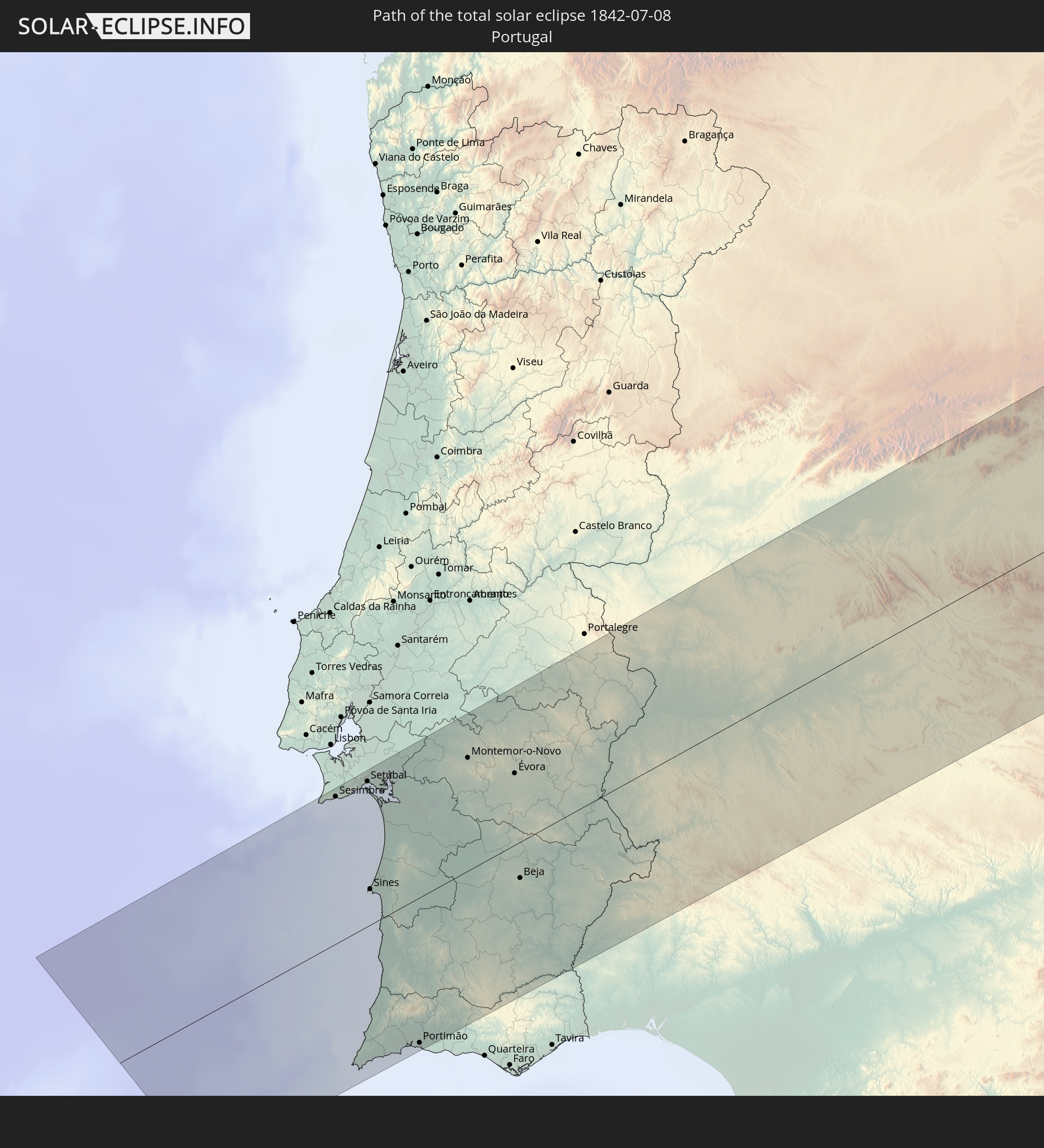 Portugal
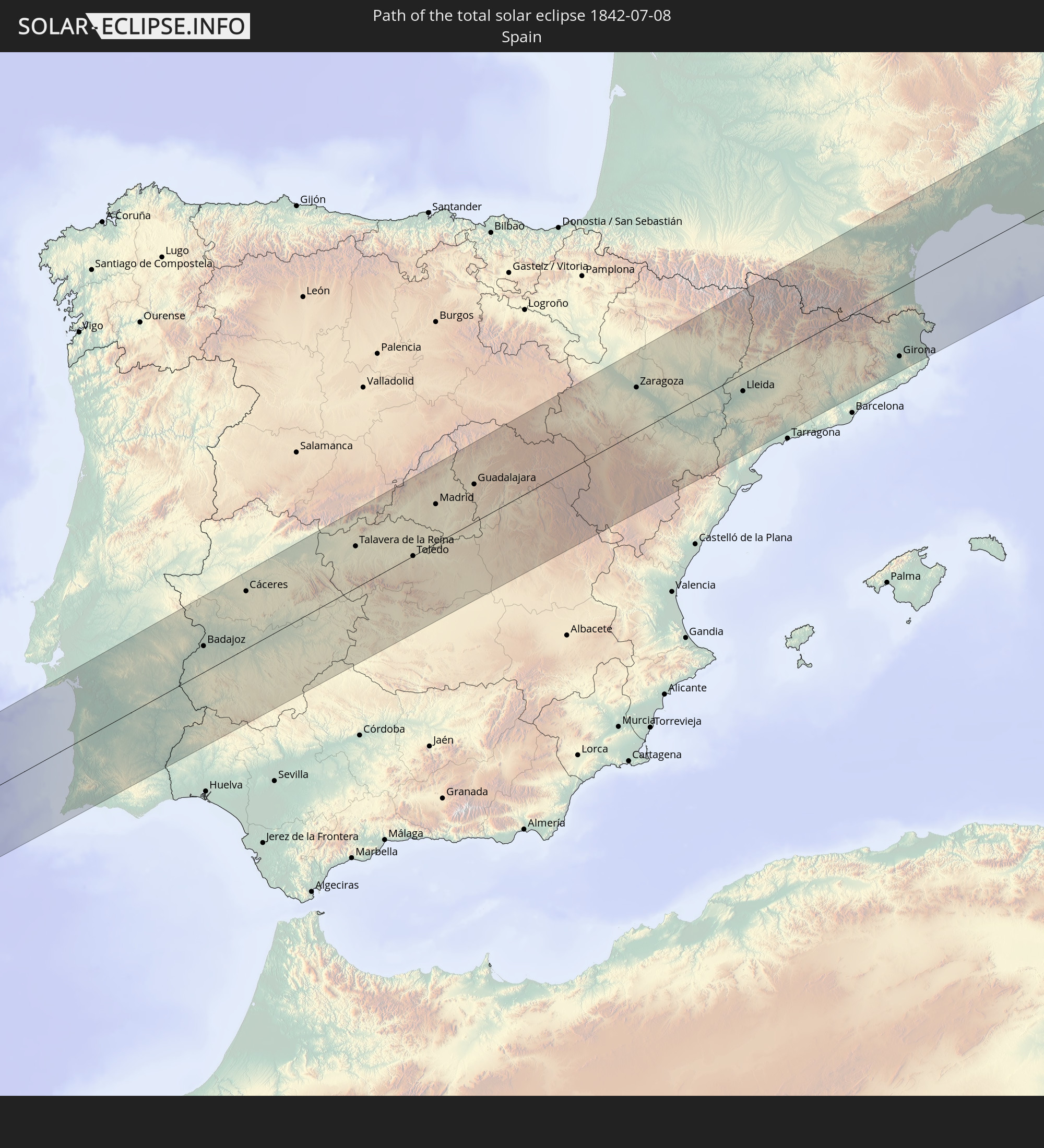 Spanien
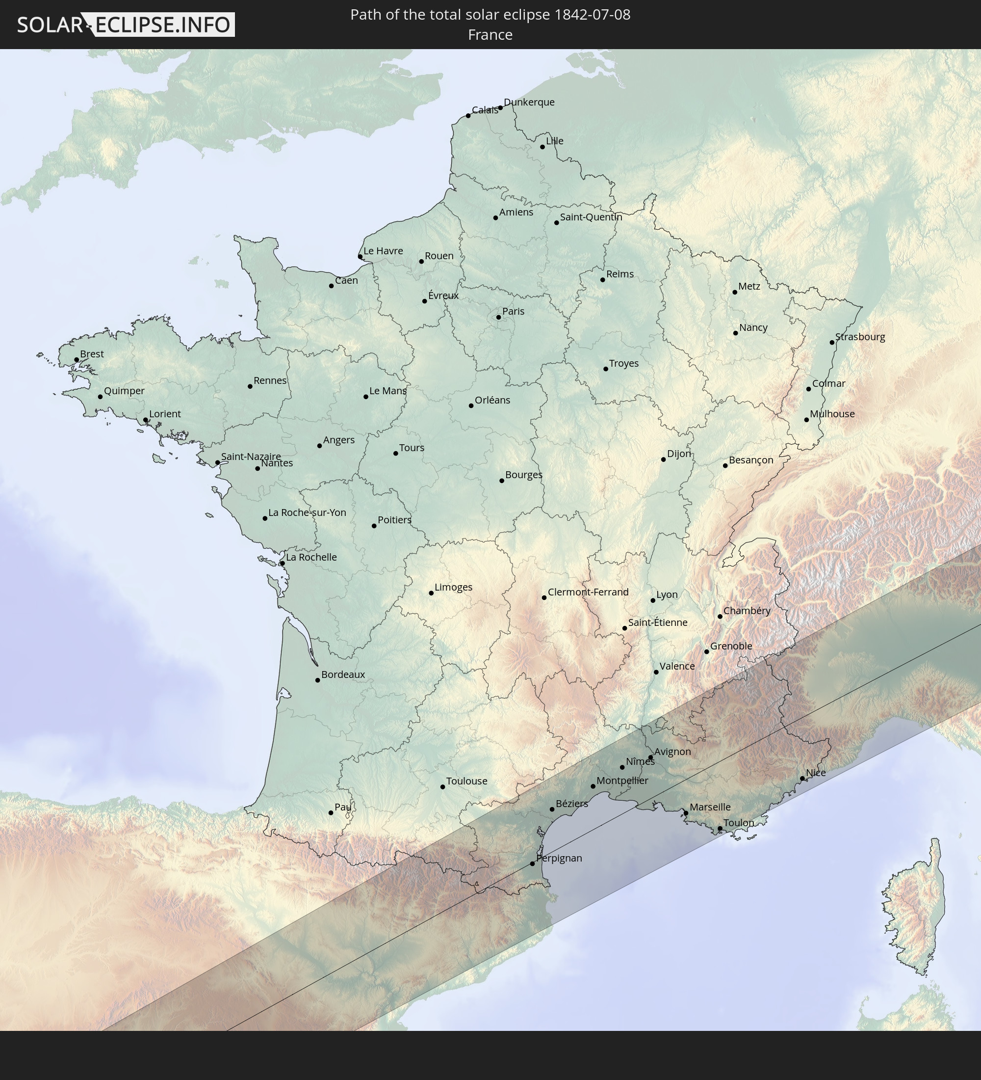 Frankreich
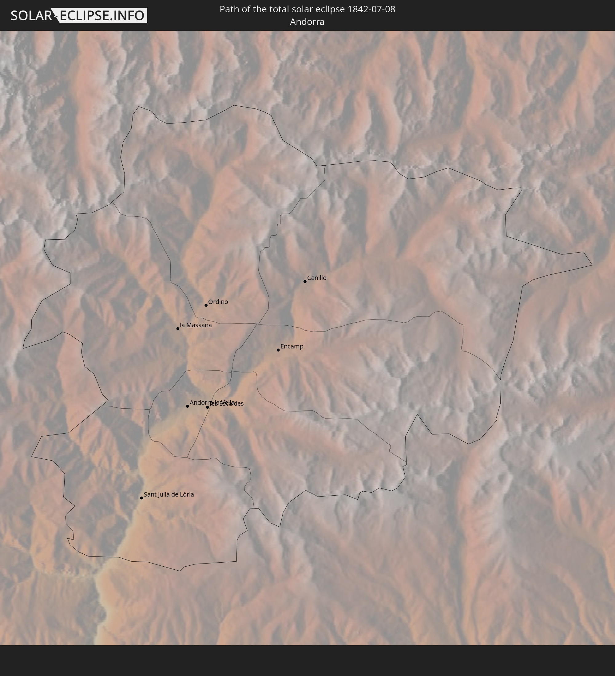 Andorra
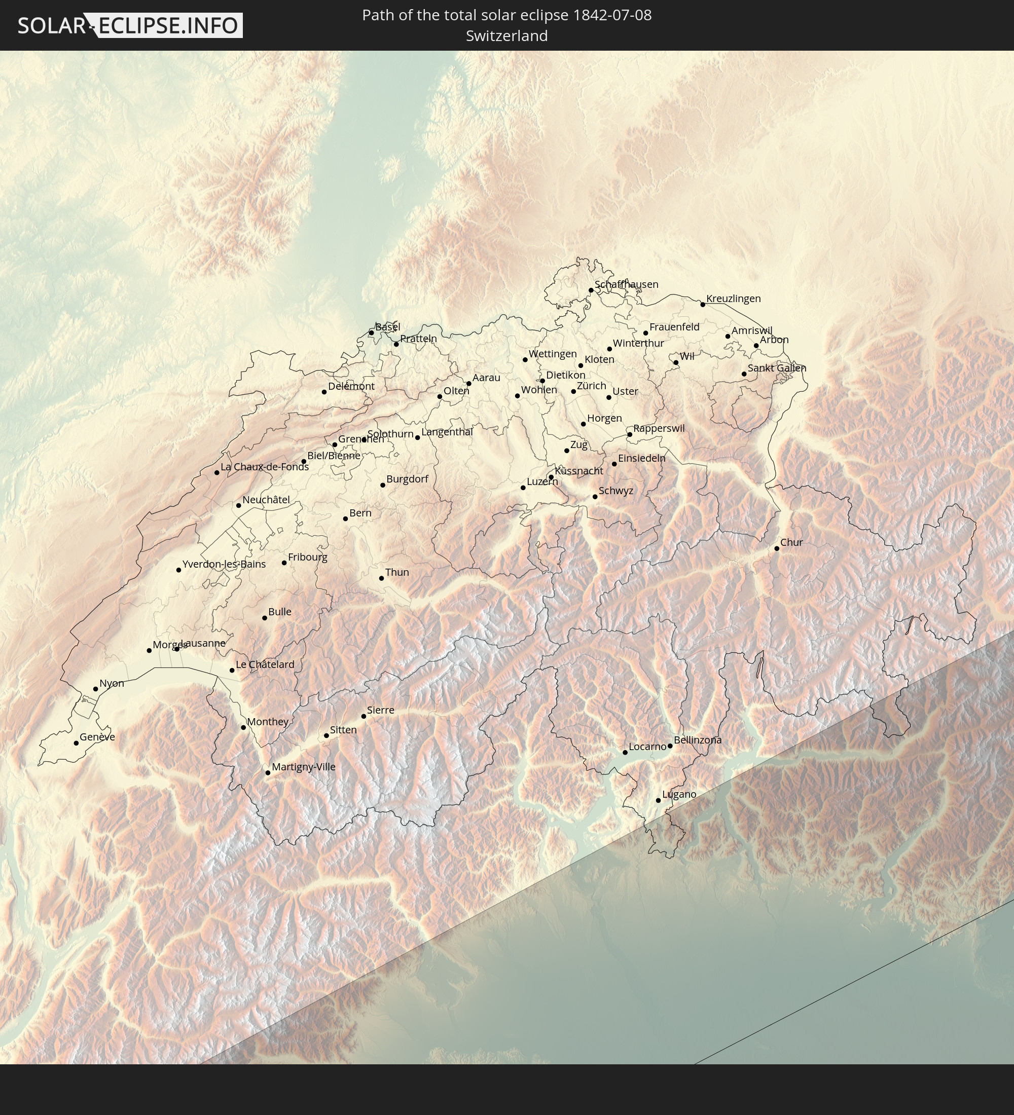 Schweiz
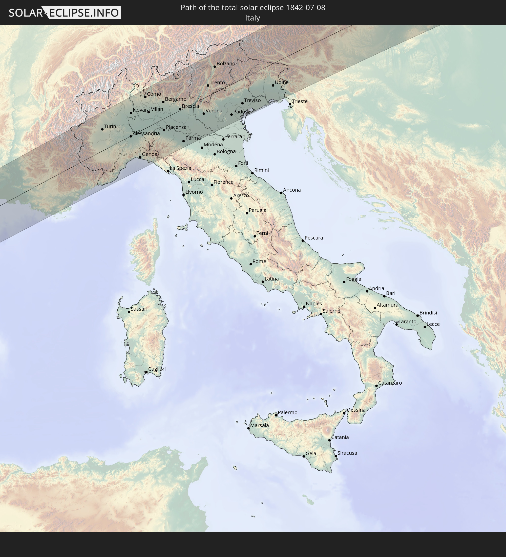 Italien
 Monaco
 Österreich
 Tschechien
 Slowenien
 Polen
Polen
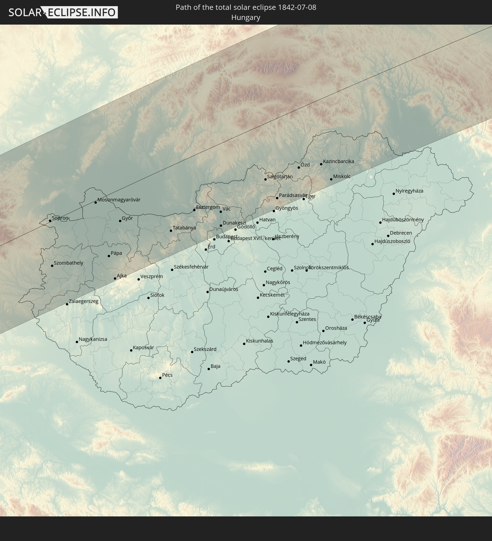 Ungarn
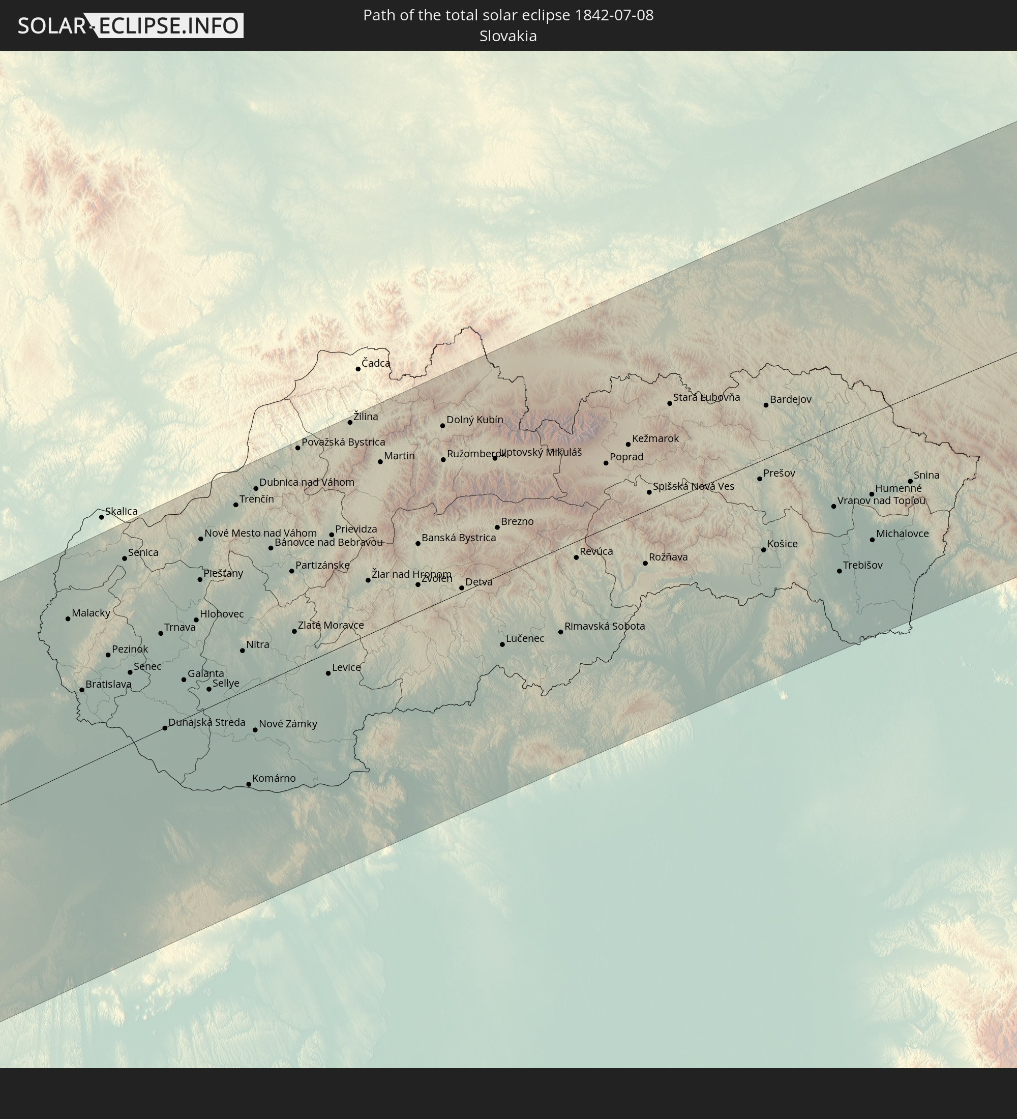 Slowakei
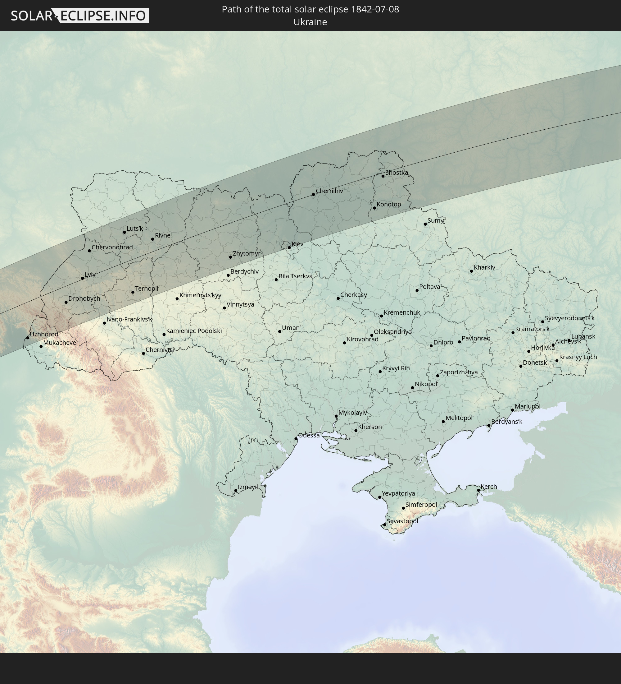 Ukraine
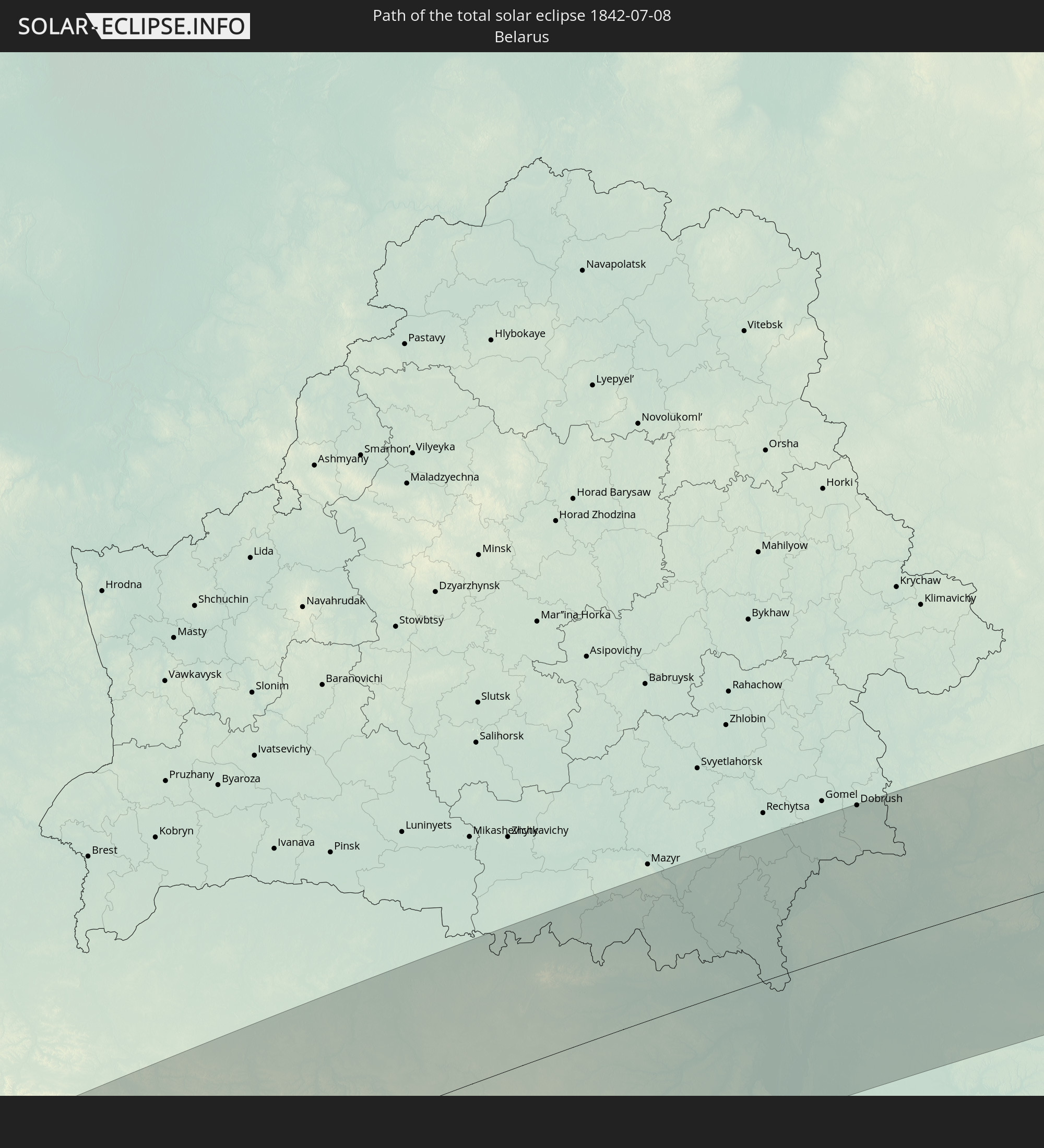 Weißrussland
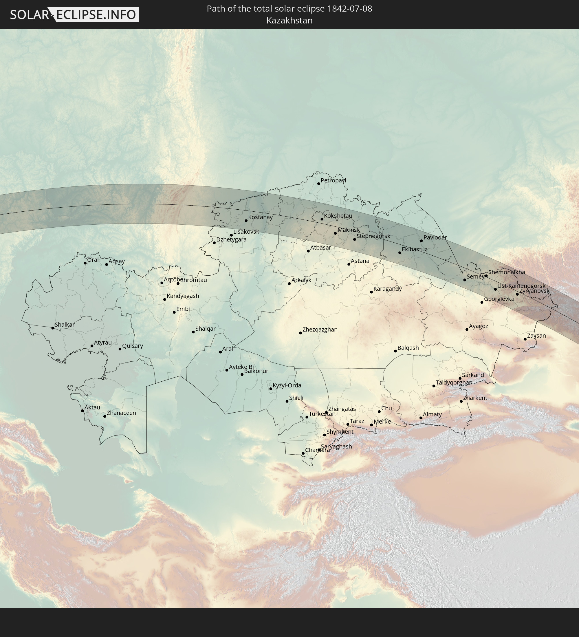 Kasachstan
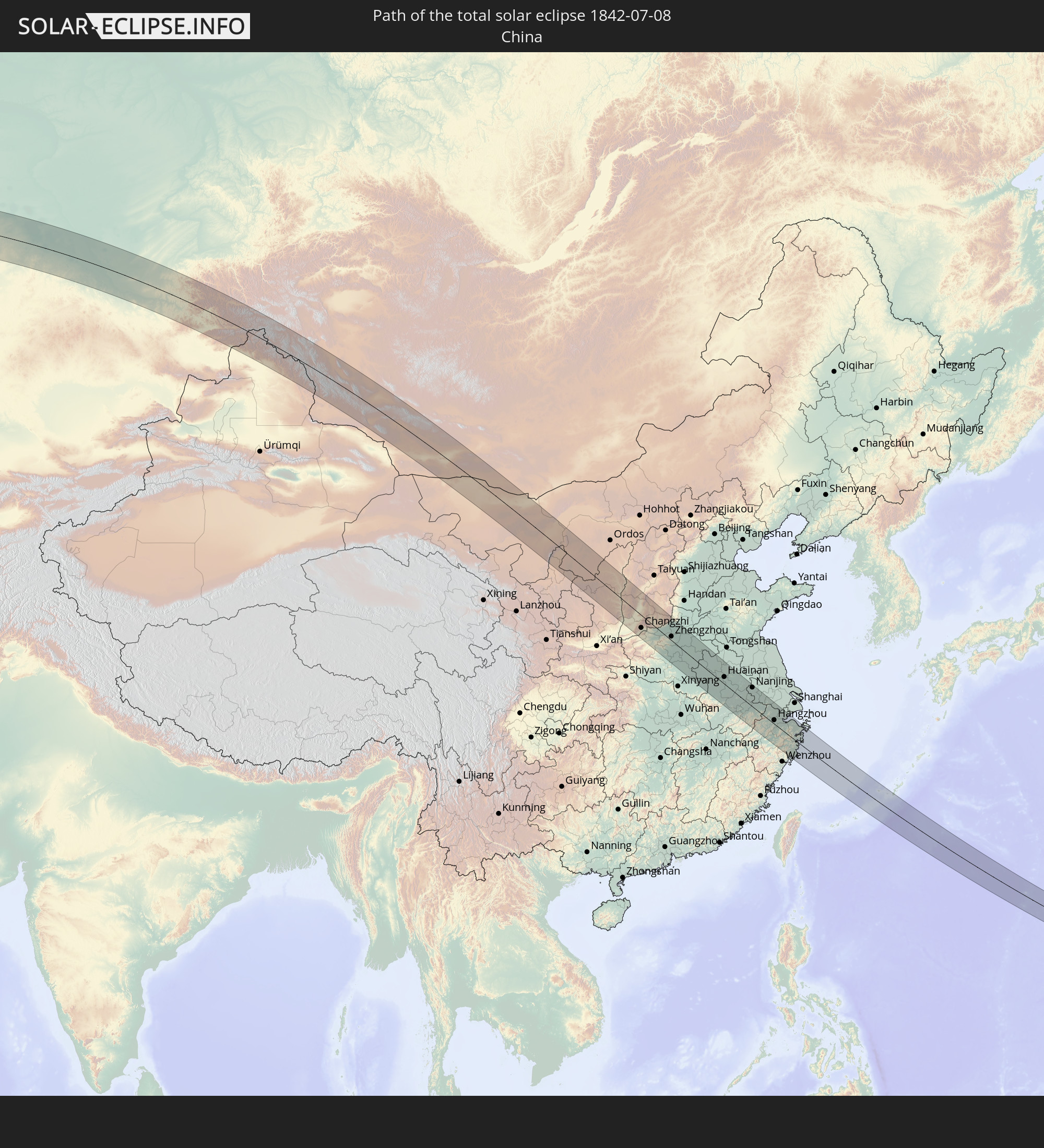 Volksrepublik China
 Mongolei
 Japan
Japan
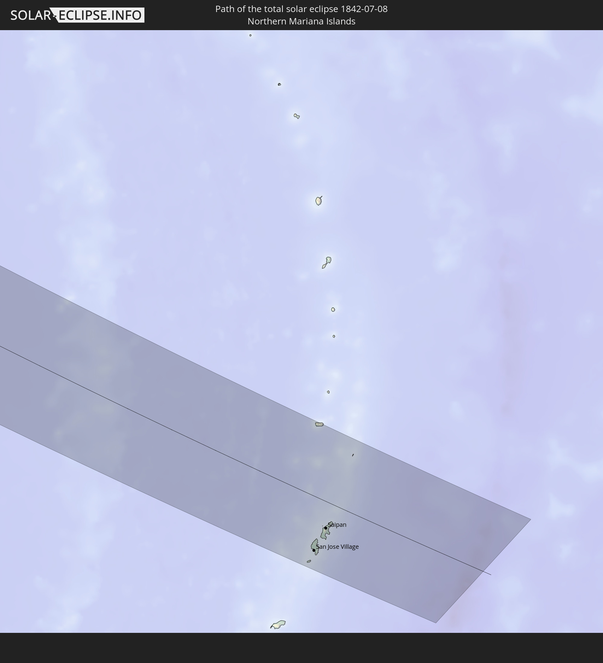 Nördliche Marianen
In den folgenden Ländern ist die Sonnenfinsternis partiell zu sehen
 Russland
 Vereinigte Staaten
 Kanada
 Grönland
 Portugal
 Island
 Spanien
 Marokko
 Mali
Mali
 Irland
 Spitzbergen
 Algerien
 Vereinigtes Königreich
 Färöer
 Gibraltar
 Frankreich
 Isle of Man
 Guernsey
 Jersey
 Niger
Niger
 Andorra
 Belgien
 Nigeria
 Niederlande
 Norwegen
 Luxemburg
 Deutschland
 Schweiz
 Italien
 Monaco
 Tunesien
 Dänemark
 Kamerun
 Libyen
 Liechtenstein
 Österreich
 Schweden
 Tschechien
 San Marino
 Vatikanstadt
 Slowenien
 Tschad
 Kroatien
 Polen
Polen
 Malta
Malta
 Bosnien und Herzegowina
 Ungarn
 Slowakei
 Montenegro
 Serbien
 Albanien
 Åland Islands
 Griechenland
 Rumänien
 Mazedonien
 Finnland
 Litauen
 Lettland
 Estland
 Sudan
Sudan
 Ukraine
 Bulgarien
 Weißrussland
 Ägypten
 Türkei
 Moldawien
 Republik Zypern
 Staat Palästina
 Israel
 Saudi-Arabien
 Jordanien
 Libanon
 Syrien
 Irak
Irak
 Georgien
 Armenien
 Iran
Iran
 Aserbaidschan
 Kasachstan
 Kuwait
 Bahrain
 Katar
Katar
 Vereinigte Arabische Emirate
 Oman
Oman
 Turkmenistan
 Usbekistan
 Afghanistan
 Pakistan
 Tadschikistan
 Indien
 Kirgisistan
 Volksrepublik China
 Nepal
Nepal
 Mongolei
 Bangladesch
 Bhutan
 Myanmar
 Indonesien
 Thailand
 Malaysia
 Laos
Laos
 Vietnam
 Kambodscha
 Singapur
 Australien
 Macau
Macau
 Hongkong
 Brunei
 Taiwan
 Philippinen
 Japan
Japan
 Osttimor
 Nordkorea
 Südkorea
 Palau
Palau
 Föderierte Staaten von Mikronesien
 Guam
Guam
 Nördliche Marianen
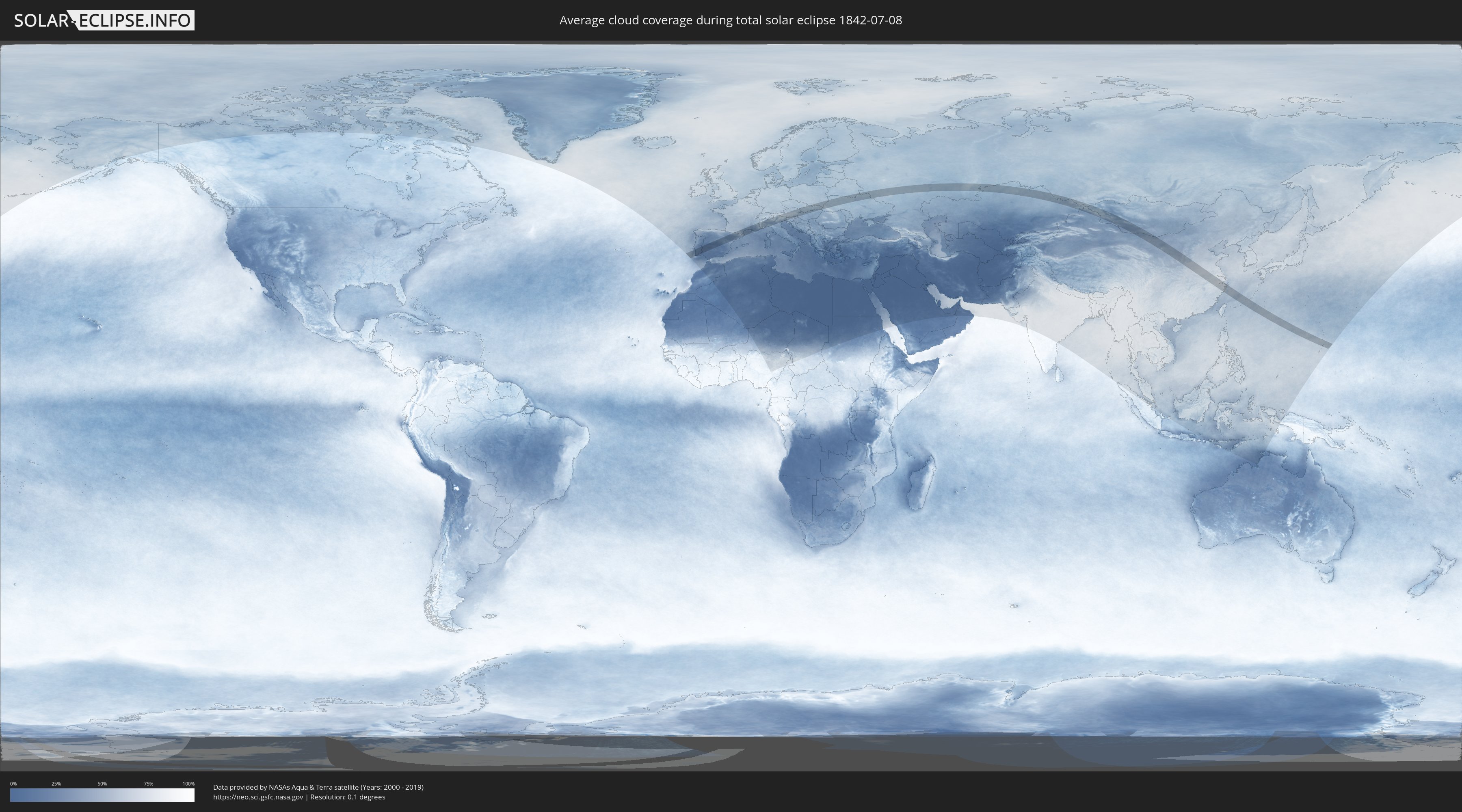
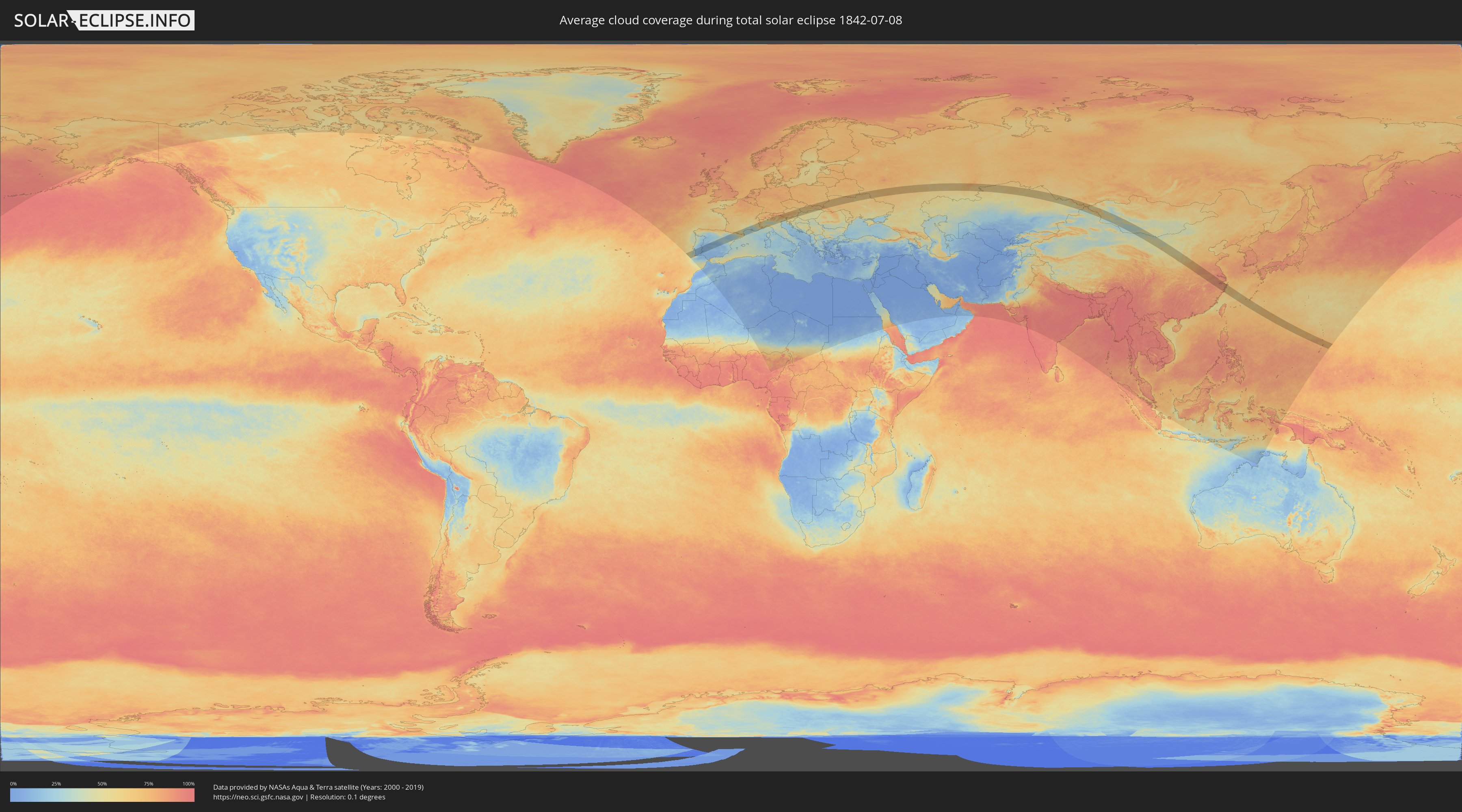
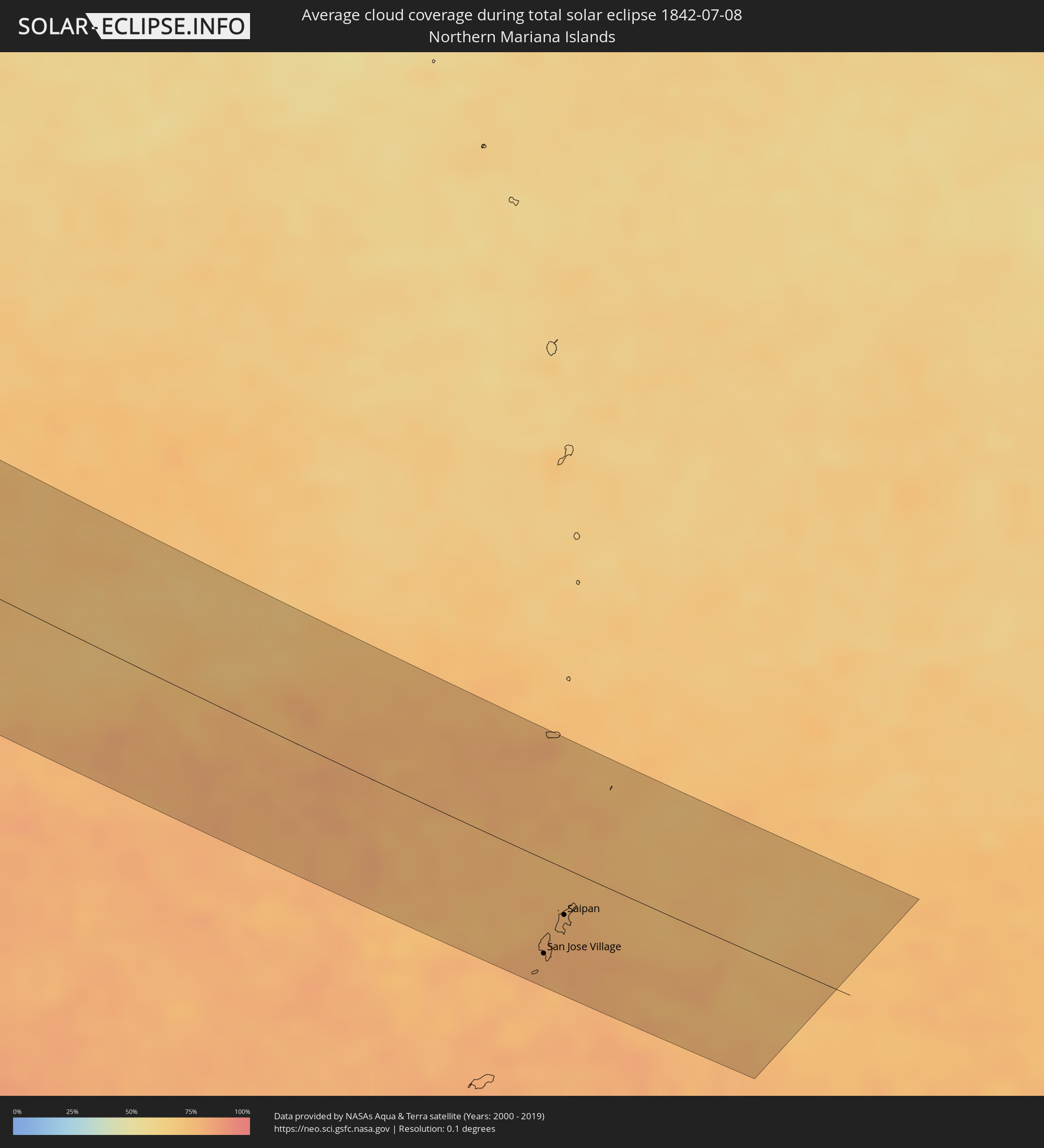
Wie wird das Wetter während der totalen Sonnenfinsternis am 08.07.1842?
Wo ist der beste Ort, um die totale Sonnenfinsternis vom 08.07.1842 zu beobachten?
Die folgenden Karten zeigen die durchschnittliche Bewölkung für den Tag, an dem die totale Sonnenfinsternis
stattfindet. Mit Hilfe der Karten lässt sich der Ort entlang des Finsternispfades eingrenzen,
der die besten Aussichen auf einen klaren wolkenfreien Himmel bietet.
Trotzdem muss man immer lokale Gegenenheiten beachten und sollte sich genau über das Wetter an seinem
gewählten Beobachtungsort informieren.
Die Daten stammen von den beiden NASA-Satelliten
AQUA und TERRA
und wurden über einen Zeitraum von 19 Jahren (2000 - 2019) gemittelt.
Detaillierte Länderkarten
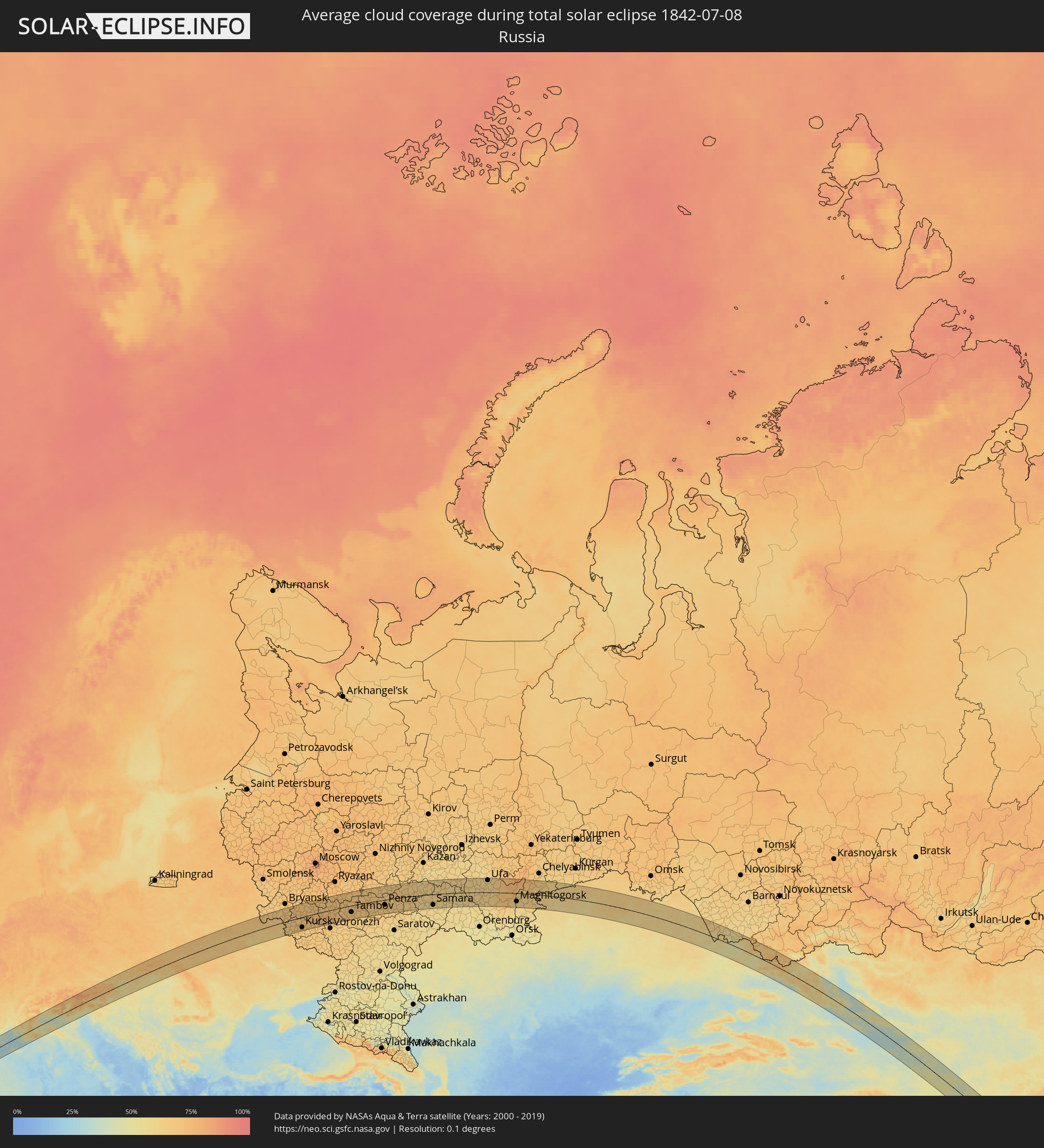 Russland
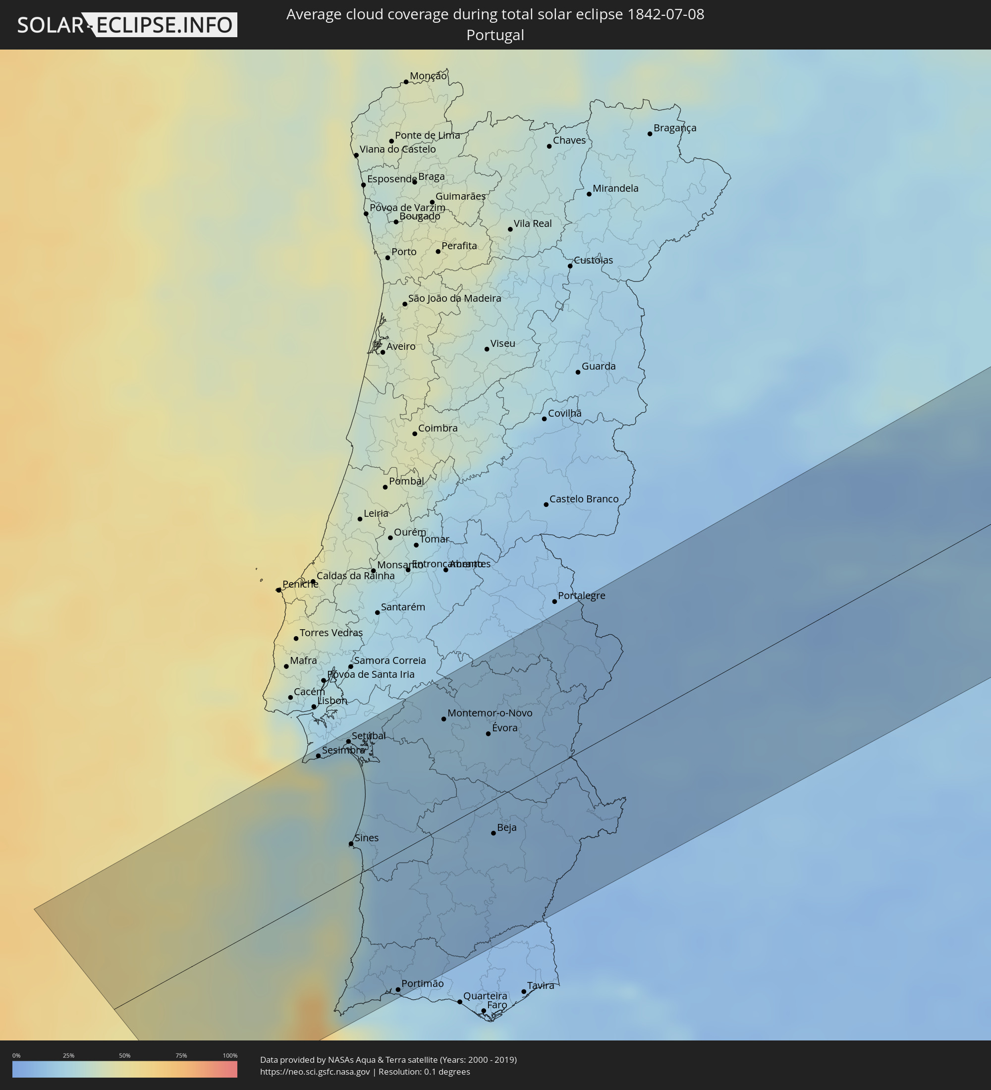 Portugal
 Spanien
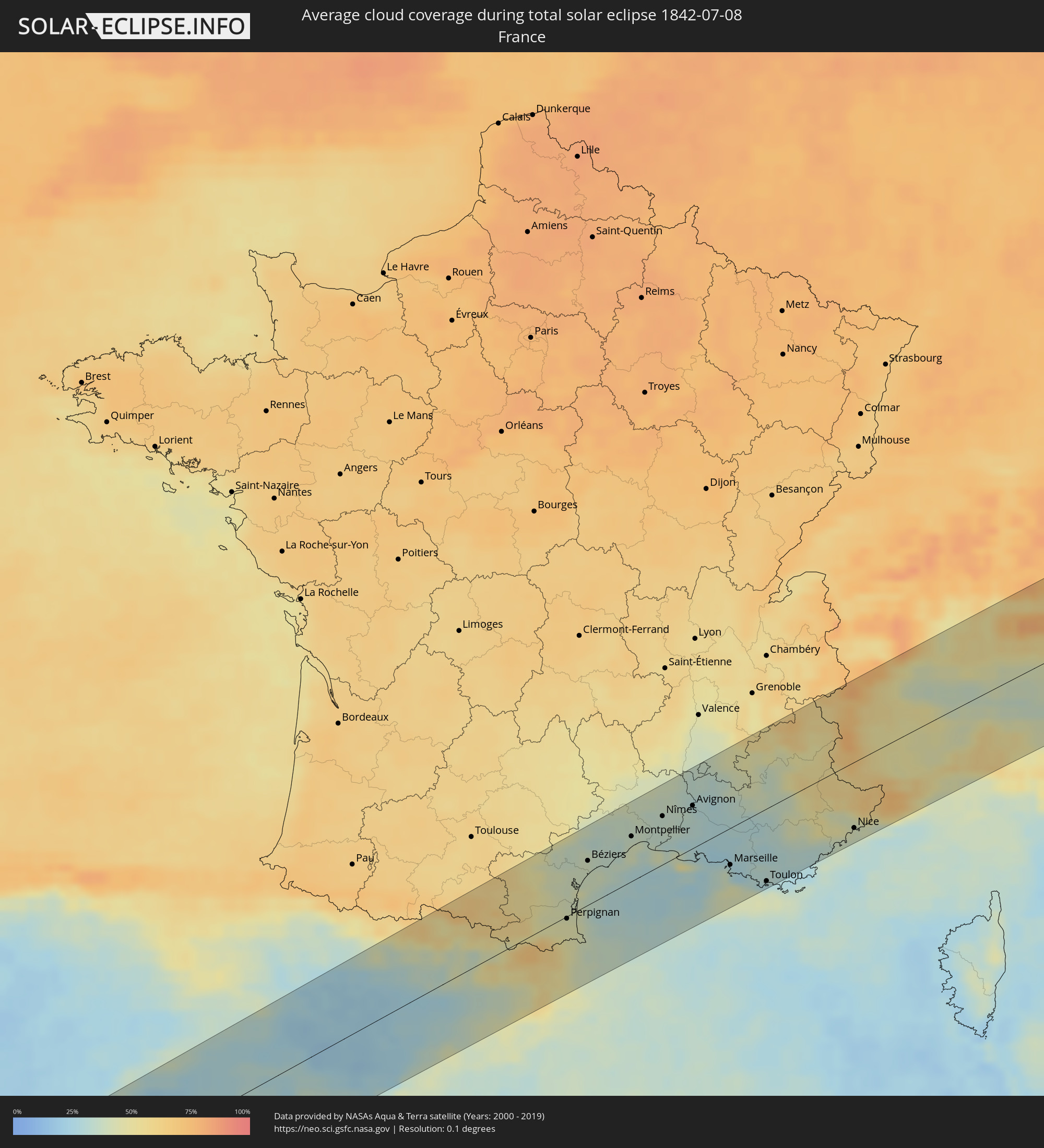 Frankreich
 Andorra
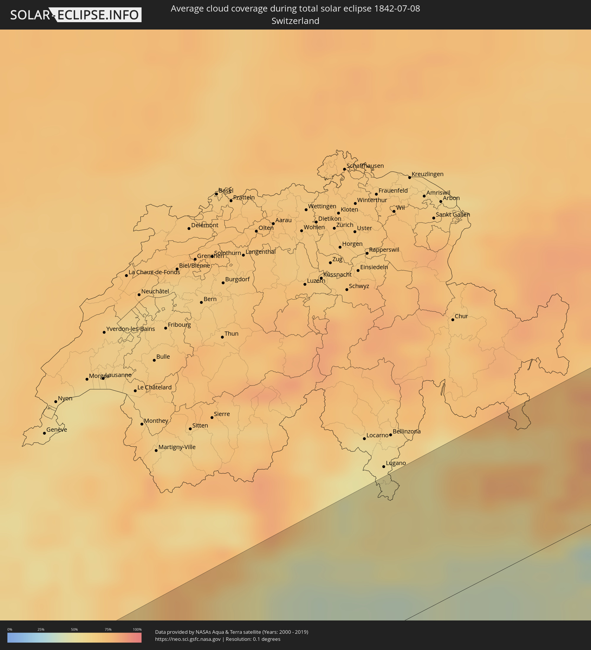 Schweiz
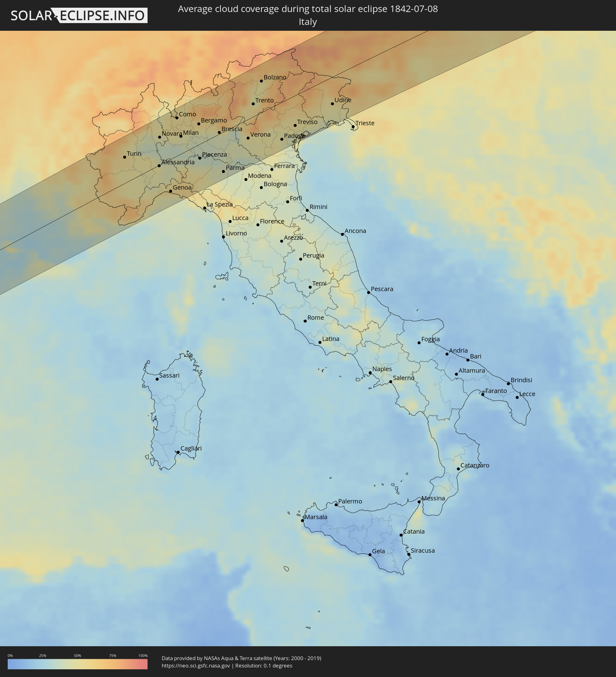 Italien
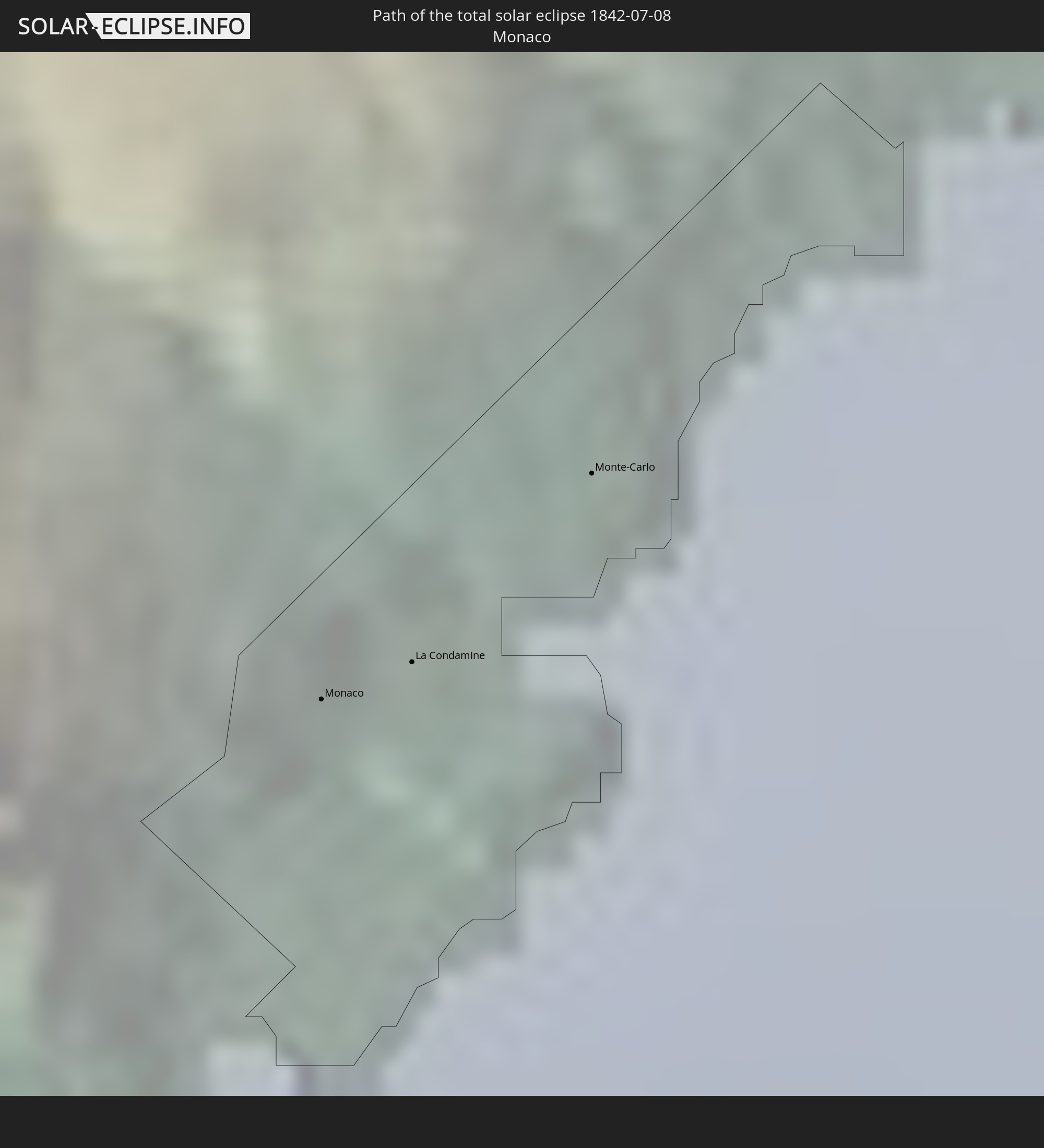
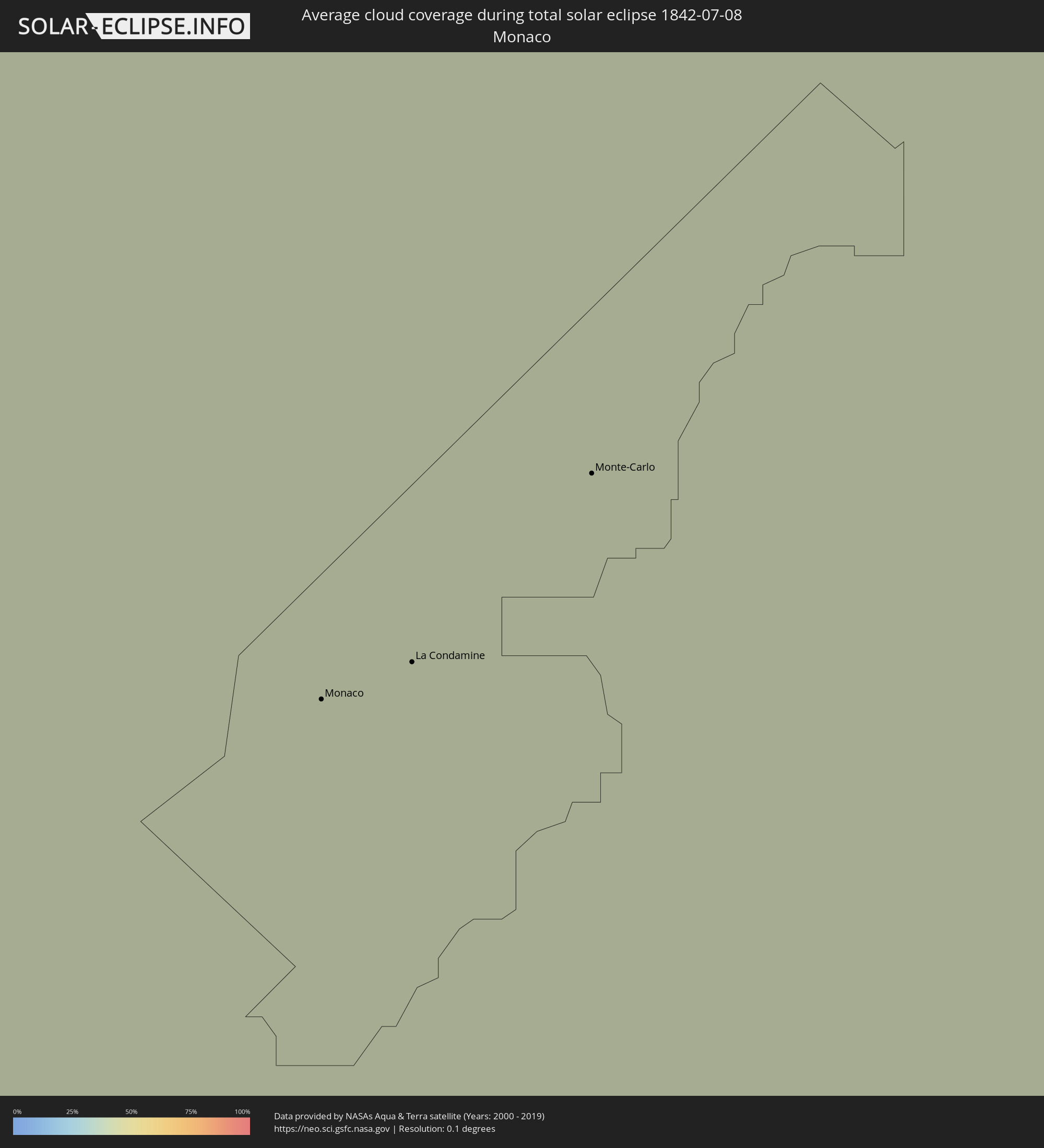 Monaco
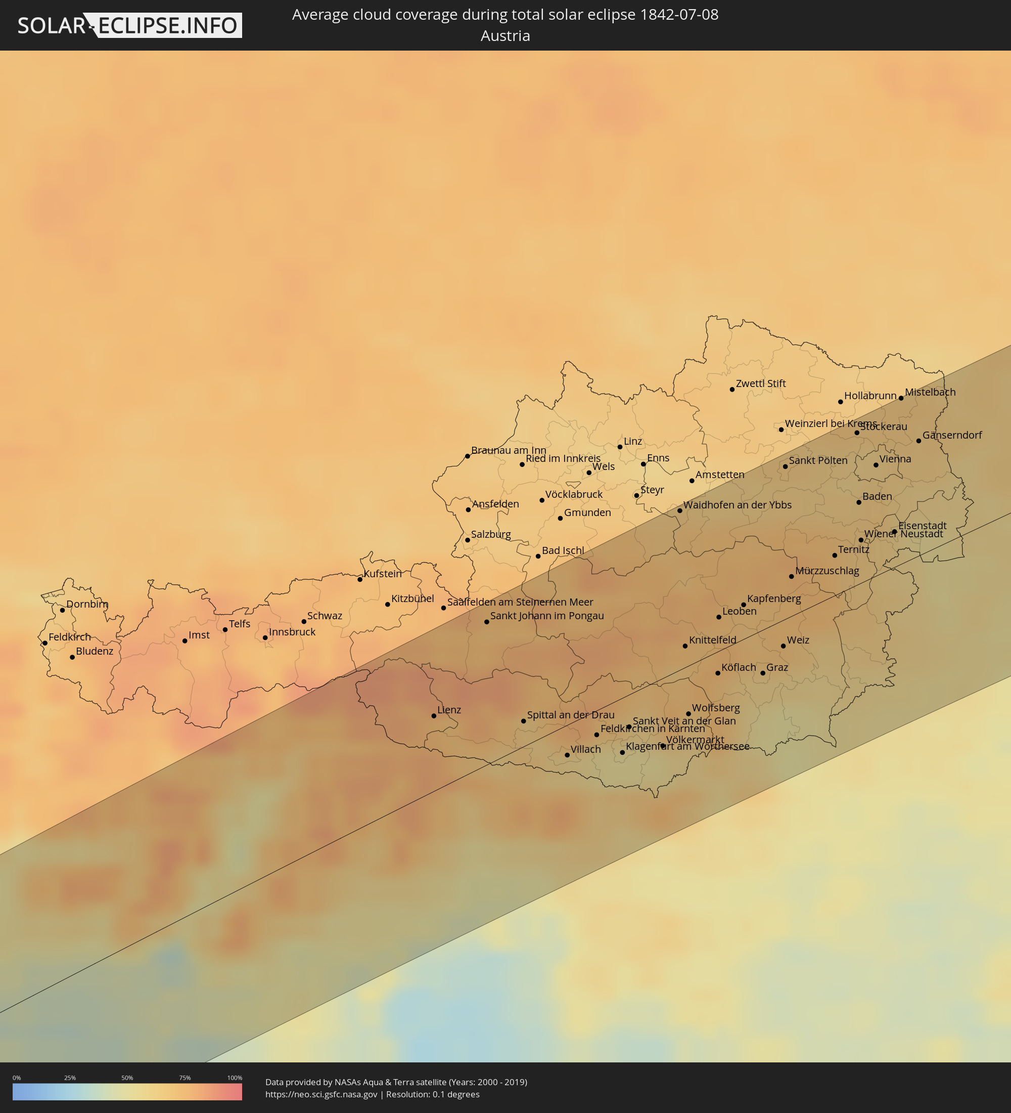 Österreich
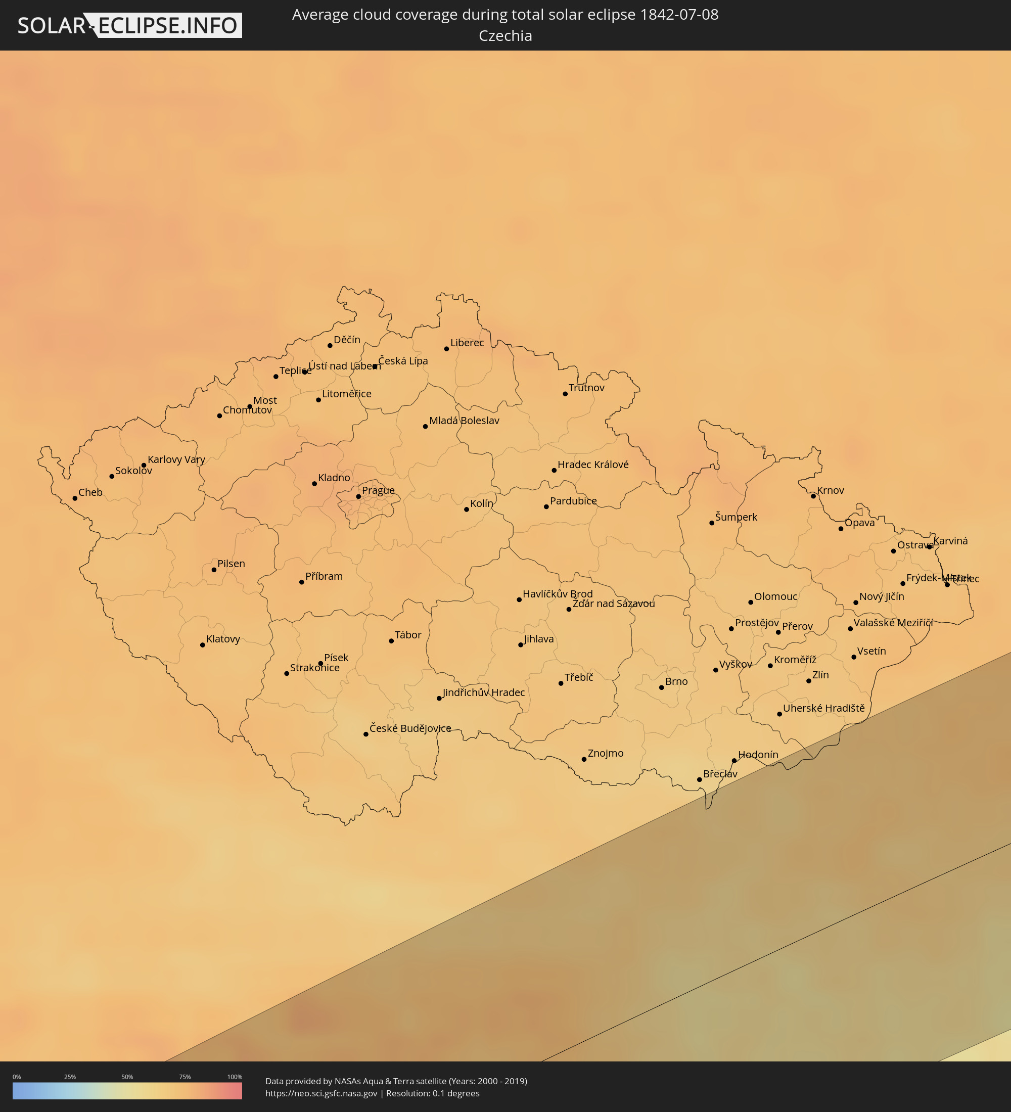 Tschechien
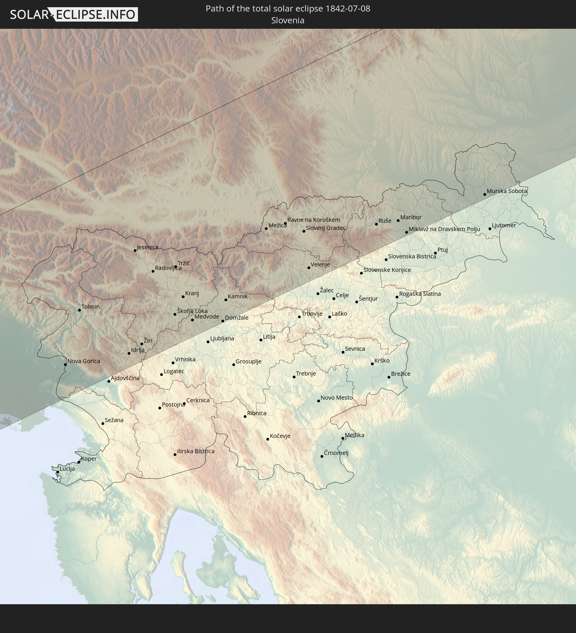
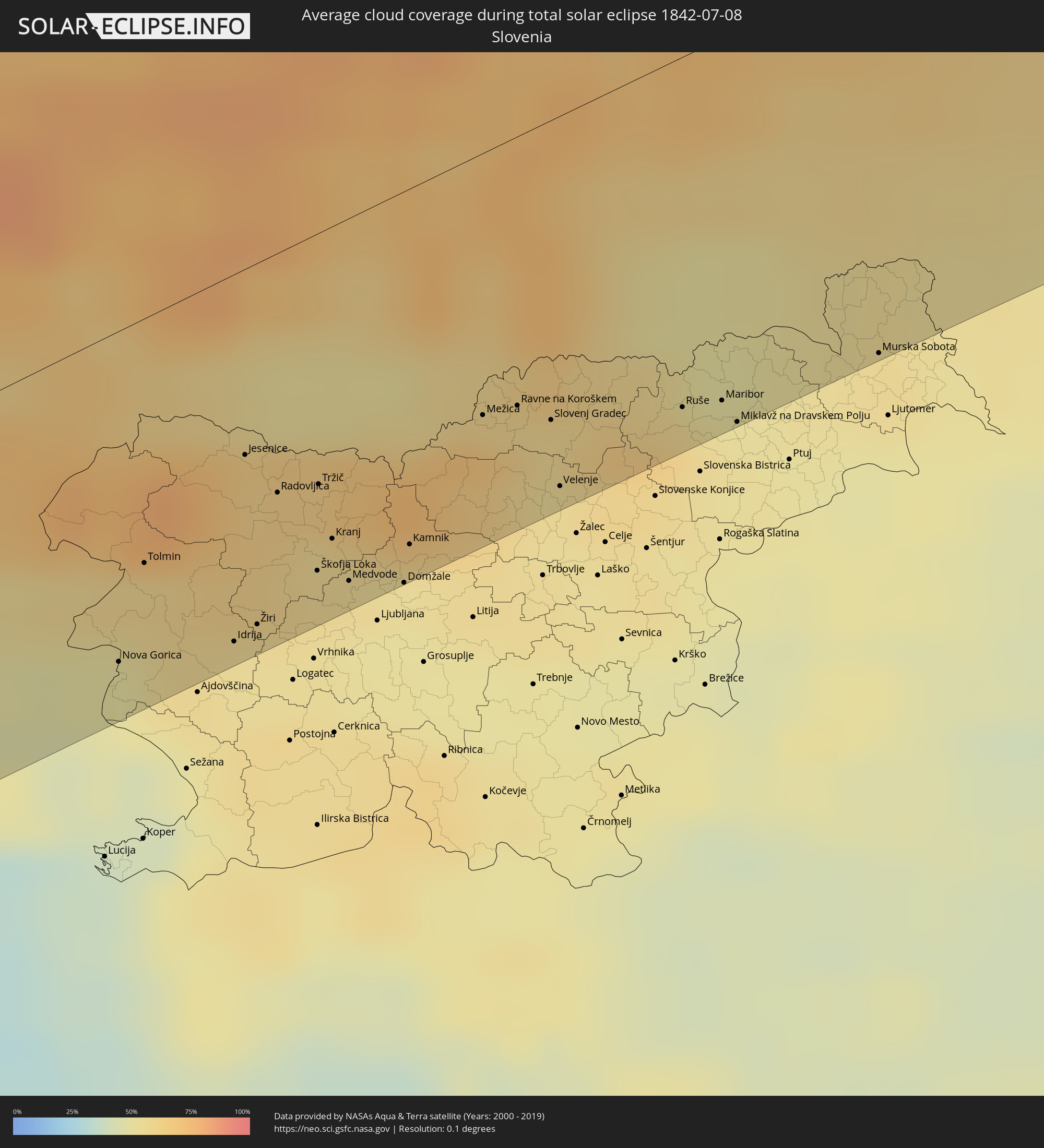 Slowenien
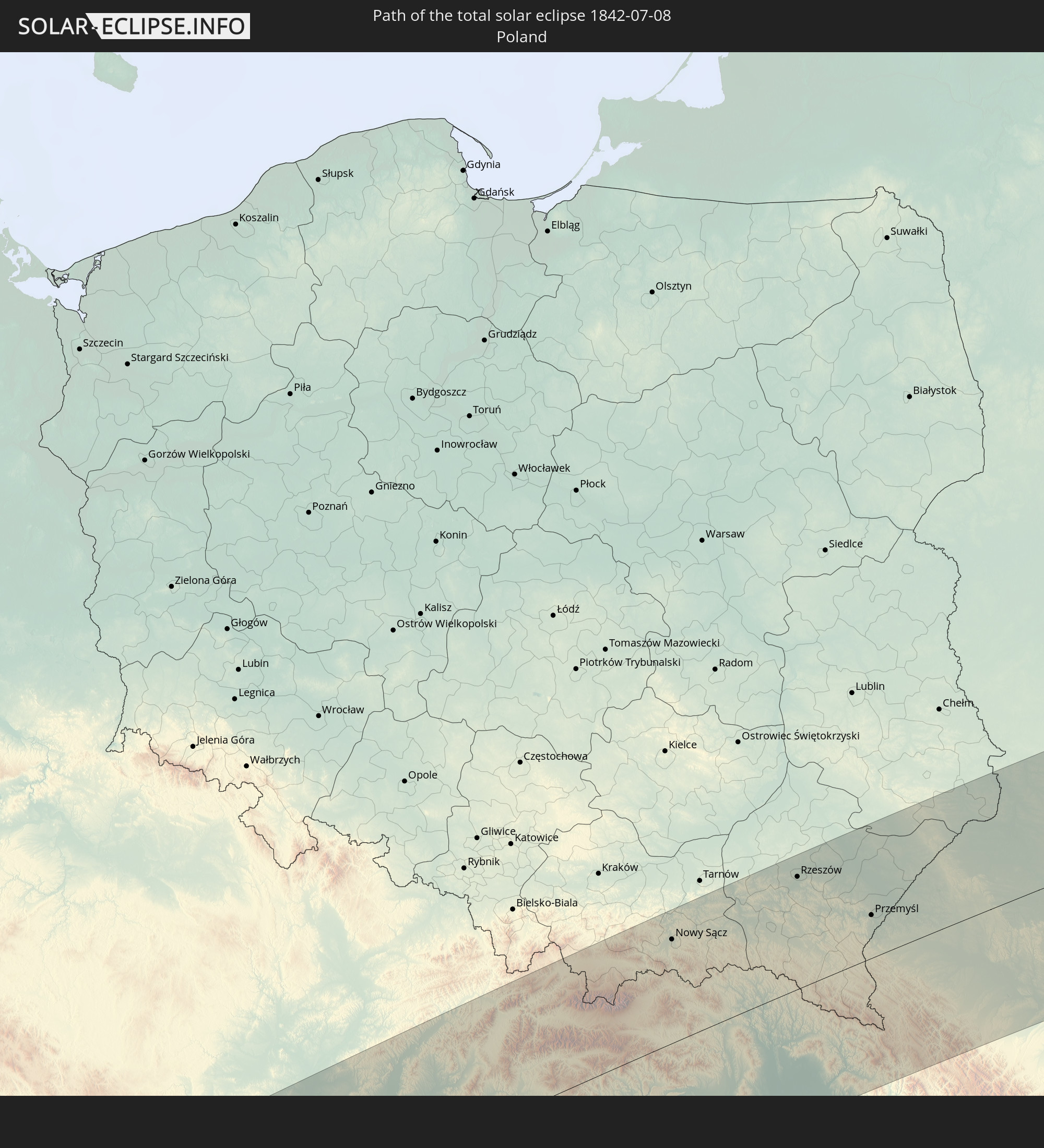
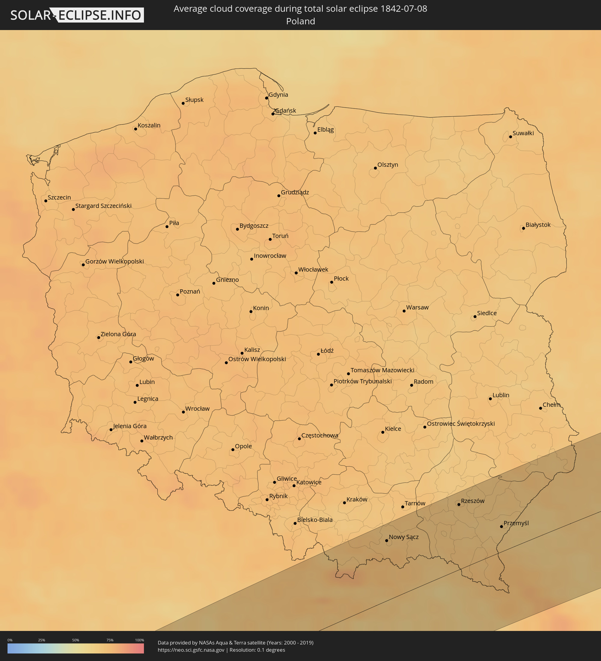 Polen
Polen
 Ungarn
 Slowakei
 Ukraine
 Weißrussland
 Kasachstan
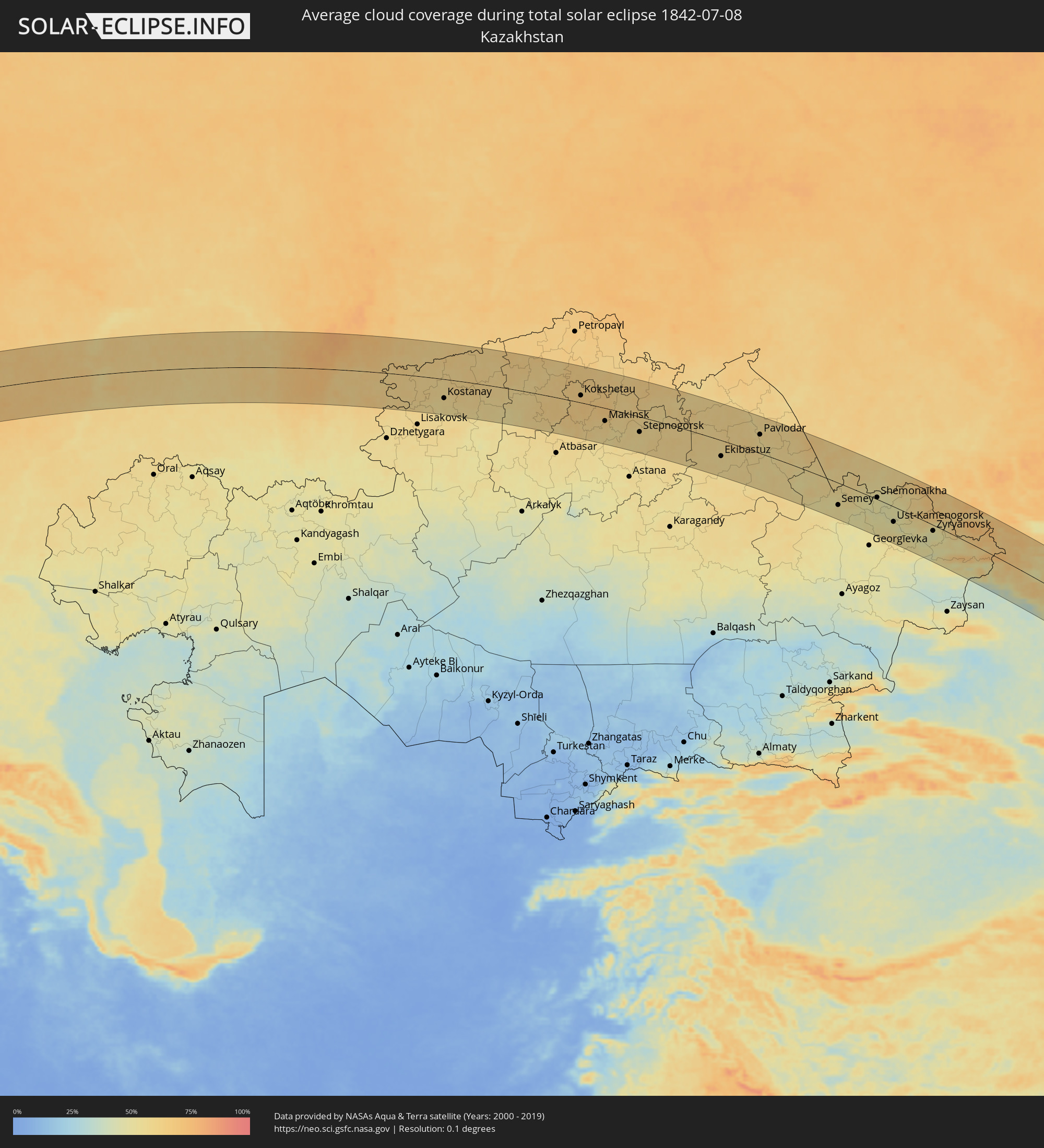
 Volksrepublik China
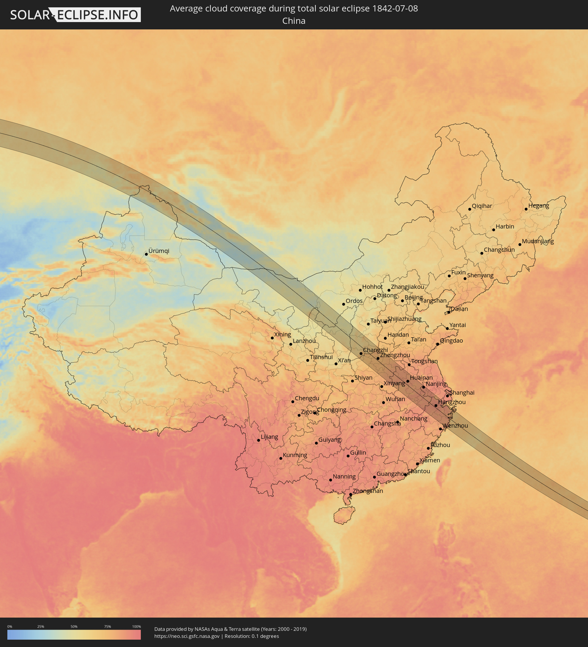
 Mongolei
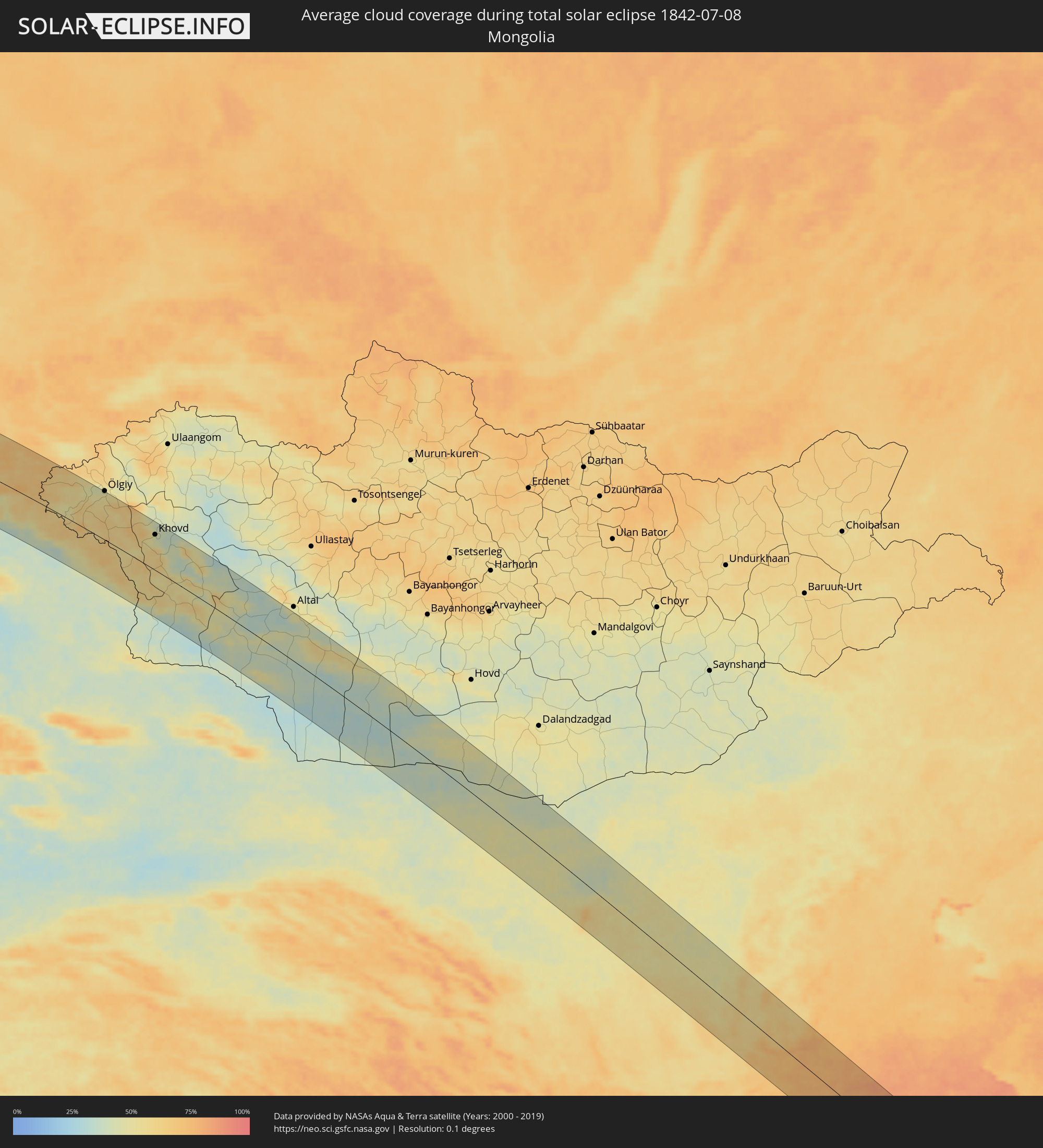
 Japan
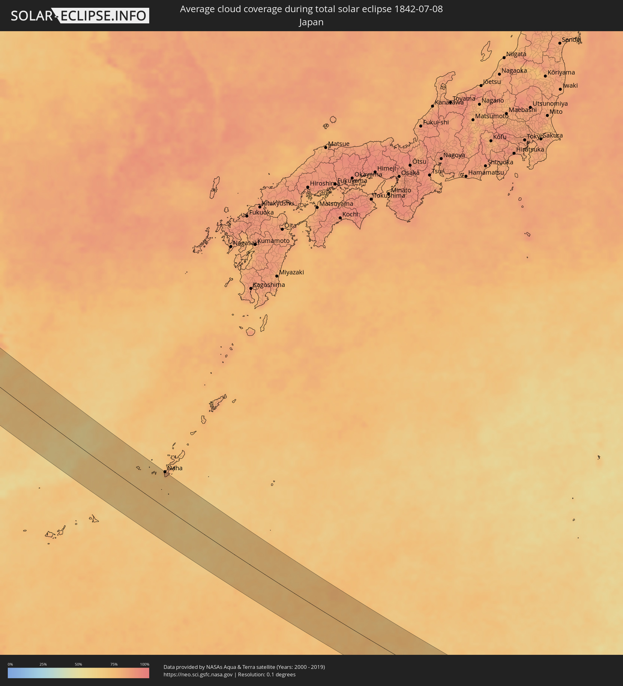
Japan
 Nördliche Marianen
Orte im Finsternispfad
Die nachfolgene Tabelle zeigt Städte und Orte mit mehr als 5.000 Einwohnern, die sich im Finsternispfad befinden. Städte mit mehr als 100.000 Einwohnern sind dick gekennzeichnet. Mit einem Klick auf den Ort öffnet sich eine Detailkarte die die Lage des jeweiligen Ortes zusammen mit dem Verlauf der zentralen Finsternis präsentiert.
| Ort | Typ | Dauer der Verfinsterung | Ortszeit bei maximaler Verfinsterung | Entfernung zur Zentrallinie | Ø Bewölkung |
|
Sesimbra, Setúbal
|
total | - | 04:57:44 UTC-00:36 | 78 km | 44% |
|
Setúbal, Setúbal
|
total | - | 04:57:44 UTC-00:36 | 75 km | 34% |
|
Sines, Setúbal
|
total | - | 04:57:13 UTC-00:36 | 30 km | 32% |
|
Grândola, Setúbal
|
total | - | 04:57:19 UTC-00:36 | 28 km | 16% |
|
Portimão, Faro
|
total | - | 04:56:21 UTC-00:36 | 76 km | 23% |
|
Vendas Novas, Évora
|
total | - | 04:57:44 UTC-00:36 | 71 km | 20% |
|
Montemor-o-Novo, Évora
|
total | - | 04:57:38 UTC-00:36 | 59 km | 19% |
|
Évora, Évora
|
total | - | 04:57:27 UTC-00:36 | 42 km | 17% |
|
Beja, Beja
|
total | - | 04:56:56 UTC-00:36 | 19 km | 14% |
|
Vale da Amoreira, Portalegre
|
total | - | 04:57:52 UTC-00:36 | 80 km | 16% |
|
Badajoz, Extremadura
|
total | - | 05:34:13 UTC+00:00 | 33 km | 12% |
|
Móstoles, Madrid
|
total | - | 05:34:49 UTC+00:00 | 41 km | 13% |
|
Madrid, Madrid
|
total | - | 05:34:53 UTC+00:00 | 41 km | 13% |
|
Alcobendas, Madrid
|
total | - | 05:35:00 UTC+00:00 | 53 km | 15% |
|
Alcalá de Henares, Madrid
|
total | - | 05:34:53 UTC+00:00 | 37 km | 15% |
|
Zaragoza, Aragon
|
total | - | 05:35:40 UTC+00:00 | 47 km | 24% |
|
Lleida, Catalonia
|
total | - | 05:35:25 UTC+00:00 | 18 km | 26% |
|
Reus, Catalonia
|
total | - | 05:34:52 UTC+00:00 | 84 km | 41% |
|
Sant Julià de Lòria, Sant Julià de Loria
|
total | - | 05:36:16 UTC+00:00 | 34 km | 49% |
|
la Massana, La Massana
|
total | - | 05:36:21 UTC+00:00 | 43 km | 49% |
|
Andorra la Vella, Andorra la Vella
|
total | - | 05:36:19 UTC+00:00 | 39 km | 49% |
|
Ordino, Ordino
|
total | - | 05:36:22 UTC+00:00 | 44 km | 54% |
|
les Escaldes, Escaldes-Engordany
|
total | - | 05:36:19 UTC+00:00 | 39 km | 49% |
|
Encamp, Encamp
|
total | - | 05:36:20 UTC+00:00 | 39 km | 50% |
|
Canillo, Canillo
|
total | - | 05:36:22 UTC+00:00 | 40 km | 52% |
|
Terrassa, Catalonia
|
total | - | 05:35:14 UTC+00:00 | 79 km | 45% |
|
Girona, Catalonia
|
total | - | 05:35:38 UTC+00:00 | 70 km | 48% |
|
Perpignan, Occitania
|
total | - | 05:45:47 UTC+00:09 | 11 km | 45% |
|
Béziers, Occitania
|
total | - | 05:46:30 UTC+00:09 | 48 km | 38% |
|
Montpellier, Occitania
|
total | - | 05:46:47 UTC+00:09 | 51 km | 41% |
|
Nîmes, Occitania
|
total | - | 05:47:02 UTC+00:09 | 52 km | 35% |
|
Avignon, Provence-Alpes-Côte d'Azur
|
total | - | 05:47:10 UTC+00:09 | 46 km | 32% |
|
Marseille, Provence-Alpes-Côte d'Azur
|
total | - | 05:46:25 UTC+00:09 | 40 km | 30% |
|
Aix-en-Provence, Provence-Alpes-Côte d'Azur
|
total | - | 05:46:41 UTC+00:09 | 20 km | 27% |
|
Toulon, Provence-Alpes-Côte d'Azur
|
total | - | 05:46:13 UTC+00:09 | 79 km | 37% |
|
Antibes, Provence-Alpes-Côte d'Azur
|
total | - | 05:46:47 UTC+00:09 | 80 km | 38% |
|
Nice, Provence-Alpes-Côte d'Azur
|
total | - | 05:46:57 UTC+00:09 | 71 km | 38% |
|
Monaco
|
total | - | 05:47:00 UTC+00:09 | 74 km | 36% |
|
La Condamine
|
total | - | 05:47:00 UTC+00:09 | 74 km | 36% |
|
Monte-Carlo
|
total | - | 05:47:00 UTC+00:09 | 74 km | 36% |
|
Turin, Piedmont
|
total | - | 06:39:16 UTC+01:00 | 48 km | 55% |
|
Genoa, Liguria
|
total | - | 06:38:36 UTC+01:00 | 61 km | 48% |
|
Mendrisio, Ticino
|
total | - | 06:40:22 UTC+01:00 | 79 km | 56% |
|
Chiasso, Ticino
|
total | - | 06:40:20 UTC+01:00 | 74 km | 54% |
|
Milan, Lombardy
|
total | - | 06:39:54 UTC+01:00 | 32 km | 47% |
|
Bergamo, Lombardy
|
total | - | 06:40:14 UTC+01:00 | 38 km | 52% |
|
Brescia, Lombardy
|
total | - | 06:40:07 UTC+01:00 | 2 km | 43% |
|
Parma, Emilia-Romagna
|
total | - | 06:39:14 UTC+01:00 | 75 km | 42% |
|
Verona, Veneto
|
total | - | 06:40:06 UTC+01:00 | 36 km | 45% |
|
Vicenza, Veneto
|
total | - | 06:40:21 UTC+01:00 | 44 km | 50% |
|
Padova, Veneto
|
total | - | 06:40:14 UTC+01:00 | 70 km | 47% |
|
Mestre, Veneto
|
total | - | 06:40:24 UTC+01:00 | 75 km | 43% |
|
Nova Gorica, Nova Gorica
|
total | - | 06:41:18 UTC+01:00 | 76 km | 49% |
|
Tolmin, Tolmin
|
total | - | 06:41:36 UTC+01:00 | 56 km | 59% |
|
Villach, Carinthia
|
total | - | 06:42:10 UTC+01:00 | 17 km | 60% |
|
Idrija, Idrija
|
total | - | 06:41:27 UTC+01:00 | 84 km | 54% |
|
Jesenice, Jesenice
|
total | - | 06:42:00 UTC+01:00 | 42 km | 63% |
|
Klagenfurt am Wörthersee, Carinthia
|
total | - | 06:42:18 UTC+01:00 | 31 km | 54% |
|
Kranj, Kranj
|
total | - | 06:41:49 UTC+01:00 | 71 km | 56% |
|
Kamnik, Kamnik
|
total | - | 06:41:52 UTC+01:00 | 81 km | 53% |
|
Wolfsberg, Carinthia
|
total | - | 06:42:43 UTC+01:00 | 27 km | 62% |
|
Slovenj Gradec, Slovenj Gradec
|
total | - | 06:42:22 UTC+01:00 | 68 km | 57% |
|
Leoben, Styria
|
total | - | 06:43:28 UTC+01:00 | 18 km | 70% |
|
Velenje, Velenje
|
total | - | 06:42:11 UTC+01:00 | 84 km | 55% |
|
Kapfenberg, Styria
|
total | - | 06:43:37 UTC+01:00 | 20 km | 68% |
|
Graz, Styria
|
total | - | 06:43:11 UTC+01:00 | 29 km | 60% |
|
Sankt Pölten, Lower Austria
|
total | - | 06:44:42 UTC+01:00 | 83 km | 64% |
|
Maribor, Maribor
|
total | - | 06:42:35 UTC+01:00 | 82 km | 53% |
|
Murska Sobota, Murska Sobota
|
total | - | 06:42:52 UTC+01:00 | 90 km | 55% |
|
Baden, Lower Austria
|
total | - | 06:44:38 UTC+01:00 | 44 km | 66% |
|
Wiener Neustadt, Lower Austria
|
total | - | 06:44:22 UTC+01:00 | 25 km | 65% |
|
Vienna, Vienna
|
total | - | 06:44:56 UTC+01:00 | 63 km | 65% |
|
Sopron, Győr-Moson-Sopron
|
total | - | 06:44:19 UTC+01:00 | 8 km | 58% |
|
Szombathely, Vas
|
total | - | 06:43:45 UTC+01:00 | 47 km | 58% |
|
Bratislava, Bratislavský
|
total | - | 06:45:06 UTC+01:00 | 36 km | 59% |
|
Trnava, Trnavský
|
total | - | 06:45:33 UTC+01:00 | 42 km | 65% |
|
Győr, Győr-Moson-Sopron
|
total | - | 06:44:40 UTC+01:00 | 33 km | 55% |
|
Trenčín, Trenčiansky
|
total | - | 06:46:24 UTC+01:00 | 77 km | 67% |
|
Nitra, Nitriansky
|
total | - | 06:45:38 UTC+01:00 | 22 km | 65% |
|
Tatabánya, Komárom-Esztergom
|
total | - | 06:44:49 UTC+01:00 | 66 km | 55% |
|
Žilina, Žilinský
|
total | - | 06:47:05 UTC+01:00 | 91 km | 71% |
|
Martin, Žilinský
|
total | - | 06:46:57 UTC+01:00 | 70 km | 70% |
|
Budapest III. kerület, Budapest
|
total | - | 06:45:00 UTC+01:00 | 91 km | 55% |
|
Vác, Pest
|
total | - | 06:45:21 UTC+01:00 | 73 km | 51% |
|
Banská Bystrica, Banskobystrický
|
total | - | 06:46:37 UTC+01:00 | 32 km | 65% |
|
Salgótarján, Nógrád
|
total | - | 06:46:02 UTC+01:00 | 57 km | 55% |
|
Zakopane, Lesser Poland Voivodeship
|
total | - | 07:11:40 UTC+01:24 | 63 km | 79% |
|
Parádsasvár, Heves
|
total | - | 06:45:52 UTC+01:00 | 81 km | 55% |
|
Nowy Targ, Lesser Poland Voivodeship
|
total | - | 07:11:56 UTC+01:24 | 77 km | 69% |
|
Poprad, Prešovský
|
total | - | 06:47:30 UTC+01:00 | 27 km | 67% |
|
Ózd, Borsod-Abaúj-Zemplén
|
total | - | 06:46:24 UTC+01:00 | 60 km | 51% |
|
Nowy Sącz, Lesser Poland Voivodeship
|
total | - | 07:12:24 UTC+01:24 | 72 km | 70% |
|
Miskolc, Borsod-Abaúj-Zemplén
|
total | - | 06:46:27 UTC+01:00 | 87 km | 54% |
|
Gorlice, Lesser Poland Voivodeship
|
total | - | 07:12:39 UTC+01:24 | 62 km | 69% |
|
Prešov, Prešovský
|
total | - | 06:47:49 UTC+01:00 | 17 km | 65% |
|
Košice, Košický
|
total | - | 06:47:28 UTC+01:00 | 38 km | 64% |
|
Jasło, Subcarpathian Voivodeship
|
total | - | 07:12:55 UTC+01:24 | 64 km | 69% |
|
Krosno, Subcarpathian Voivodeship
|
total | - | 07:12:58 UTC+01:24 | 48 km | 69% |
|
Rzeszów, Subcarpathian Voivodeship
|
total | - | 07:13:33 UTC+01:24 | 78 km | 67% |
|
Sanok, Subcarpathian Voivodeship
|
total | - | 07:13:00 UTC+01:24 | 26 km | 69% |
|
Uzhhorod, Zakarpattia
|
total | - | 07:49:53 UTC+02:02 | 78 km | 61% |
|
Jarosław, Subcarpathian Voivodeship
|
total | - | 07:13:50 UTC+01:24 | 56 km | 66% |
|
Przemyśl, Subcarpathian Voivodeship
|
total | - | 07:13:35 UTC+01:24 | 30 km | 65% |
|
Lviv, Lviv
|
total | - | 07:52:21 UTC+02:02 | 2 km | 66% |
|
Chervonohrad, Lviv
|
total | - | 07:53:11 UTC+02:02 | 52 km | 68% |
|
Luts’k, Volyn
|
total | - | 07:54:16 UTC+02:02 | 62 km | 67% |
|
Ternopil’, Ternopil
|
total | - | 07:52:51 UTC+02:02 | 73 km | 65% |
|
Rivne, Rivne
|
total | - | 07:54:36 UTC+02:02 | 27 km | 63% |
|
Zhytomyr, Zhytomyr
|
total | - | 07:55:40 UTC+02:02 | 73 km | 68% |
|
Khoyniki, Gomel
|
total | - | 07:46:31 UTC+01:50 | 69 km | 69% |
|
Loyew, Gomel
|
total | - | 07:59:14 UTC+02:02 | 56 km | 66% |
|
Chernihiv, Chernihiv
|
total | - | 07:59:02 UTC+02:02 | 1 km | 64% |
|
Dobrush, Gomel
|
total | - | 07:48:07 UTC+01:50 | 94 km | 71% |
|
Konotop, Sumy
|
total | - | 08:00:09 UTC+02:02 | 69 km | 60% |
|
Shostka, Sumy
|
total | - | 08:01:07 UTC+02:02 | 8 km | 65% |
|
Orël, Orjol
|
total | - | 08:32:45 UTC+02:30 | 63 km | 72% |
|
Kursk, Kursk
|
total | - | 08:31:24 UTC+02:30 | 73 km | 70% |
|
Lipetsk, Lipetsk
|
total | - | 08:35:26 UTC+02:30 | 34 km | 74% |
|
Penza, Penza
|
total | - | 08:41:30 UTC+02:30 | 35 km | 70% |
|
Saransk, Mordoviya
|
total | - | 08:42:36 UTC+02:30 | 72 km | 66% |
|
Ulyanovsk, Ulyanovsk
|
total | - | 09:36:14 UTC+03:20 | 62 km | 62% |
|
Tol’yatti, Samara
|
total | - | 09:36:41 UTC+03:20 | 35 km | 59% |
|
Samara, Samara
|
total | - | 09:37:22 UTC+03:20 | 74 km | 60% |
|
Ufa, Bashkortostan
|
total | - | 10:27:40 UTC+04:02 | 84 km | 61% |
|
Magnitogorsk, Chelyabinsk
|
total | - | 10:31:05 UTC+04:02 | 58 km | 65% |
|
Rudnyy, Qostanay
|
total | - | 10:55:58 UTC+04:21 | 85 km | 59% |
|
Kostanay, Qostanay
|
total | - | 10:56:43 UTC+04:21 | 55 km | 57% |
|
Kokshetau, Aqmola
|
total | - | 11:05:01 UTC+04:21 | 23 km | 66% |
|
Shchuchinsk, Aqmola
|
total | - | 11:06:15 UTC+04:21 | 16 km | 65% |
|
Stepnogorsk, Aqmola
|
total | - | 11:08:56 UTC+04:21 | 42 km | 59% |
|
Ekibastuz, Pavlodar
|
total | - | 11:14:25 UTC+04:21 | 44 km | 58% |
|
Pavlodar, Pavlodar
|
total | - | 11:16:33 UTC+04:21 | 51 km | 59% |
|
Semey, East Kazakhstan
|
total | - | 11:22:53 UTC+04:21 | 61 km | 54% |
|
Ust-Kamenogorsk, East Kazakhstan
|
total | - | 11:26:52 UTC+04:21 | 43 km | 50% |
|
Ridder, East Kazakhstan
|
total | - | 11:27:52 UTC+04:21 | 25 km | 61% |
|
Khovd, Hovd
|
total | - | 13:27:09 UTC+06:06 | 76 km | 45% |
|
Luoyang, Henan
|
total | - | 16:06:35 UTC+08:00 | 61 km | 73% |
|
Pingdingshan, Henan
|
total | - | 16:08:52 UTC+08:00 | 91 km | 76% |
|
Zhengzhou, Henan
|
total | - | 16:07:22 UTC+08:00 | 18 km | 75% |
|
Kaifeng, Henan
|
total | - | 16:07:47 UTC+08:00 | 61 km | 77% |
|
Huainan, Anhui
|
total | - | 16:13:17 UTC+08:00 | 42 km | 85% |
|
Hefei, Anhui
|
total | - | 16:14:43 UTC+08:00 | 21 km | 84% |
|
Nanjing, Jiangsu
|
total | - | 16:15:15 UTC+08:00 | 92 km | 87% |
|
Puyang, Zhejiang
|
total | - | 16:20:03 UTC+08:00 | 74 km | 83% |
|
Hangzhou, Zhejiang
|
total | - | 16:18:51 UTC+08:00 | 19 km | 87% |
|
Ningbo, Zhejiang
|
total | - | 16:20:09 UTC+08:00 | 67 km | 87% |
|
Itoman, Okinawa
|
total | - | 17:27:48 UTC+09:00 | 91 km | 71% |
|
Tomigusuku, Okinawa
|
total | - | 17:27:43 UTC+09:00 | 96 km | 79% |
|
Naha, Okinawa
|
total | - | 17:27:40 UTC+09:00 | 99 km | 79% |
|
San Jose Village, Tinian
|
total | - | 18:39:33 UTC+10:00 | 63 km | 79% |
|
Saipan, Saipan
|
total | - | 18:39:17 UTC+10:00 | 34 km | 78% |