Totale Sonnenfinsternis vom 19.08.1887
| Wochentag: | Freitag |
| Maximale Dauer der Verfinsterung: | 03m50s |
| Maximale Breite des Finsternispfades: | 221 km |
| Saroszyklus: | 143 |
| Bedeckungsgrad: | 100% |
| Magnitude: | 1.0518 |
| Gamma: | 0.6312 |
Wo kann man die Sonnenfinsternis vom 19.08.1887 sehen?
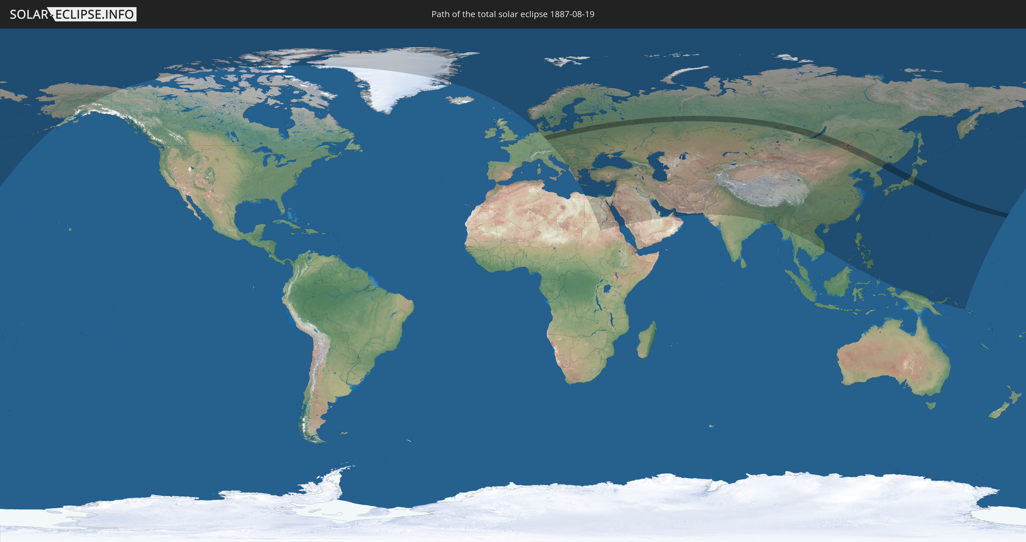
Die Sonnenfinsternis am 19.08.1887 kann man in 86 Ländern als partielle Sonnenfinsternis beobachten.
Der Finsternispfad verläuft durch 10 Länder. Nur in diesen Ländern ist sie als totale Sonnenfinsternis zu sehen.
In den folgenden Ländern ist die Sonnenfinsternis total zu sehen
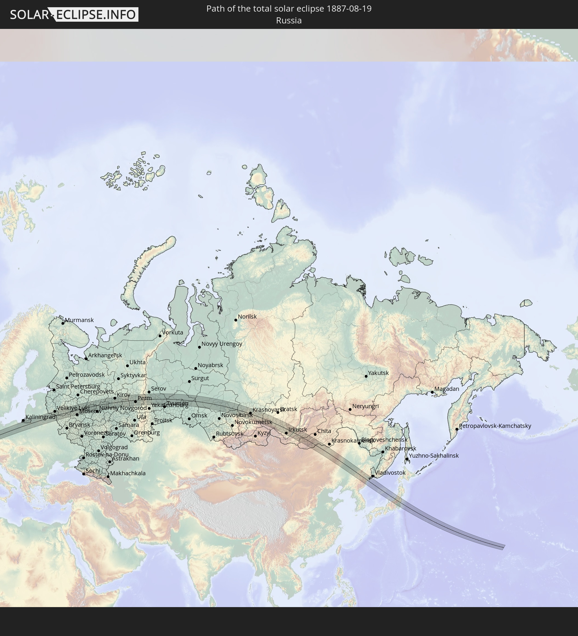 Russland
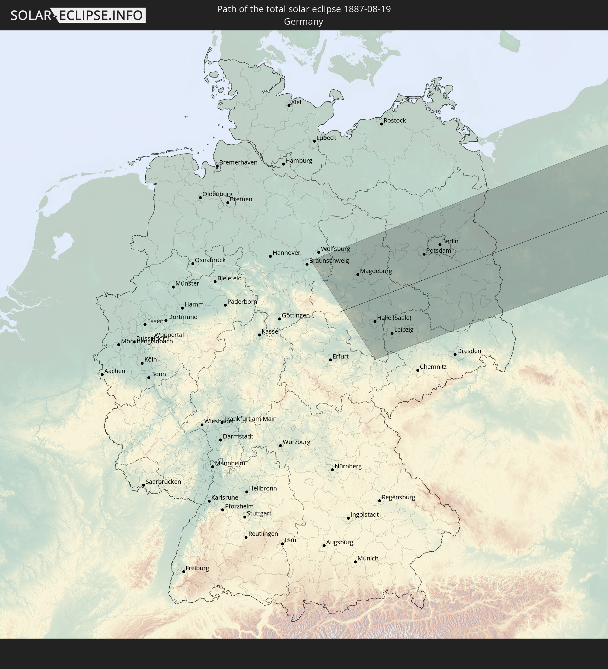 Deutschland
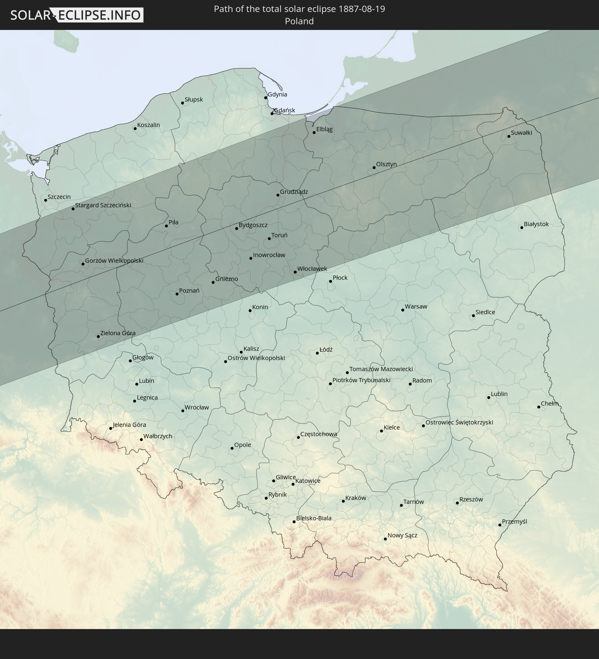 Polen
Polen
 Litauen
 Lettland
 Weißrussland
 Volksrepublik China
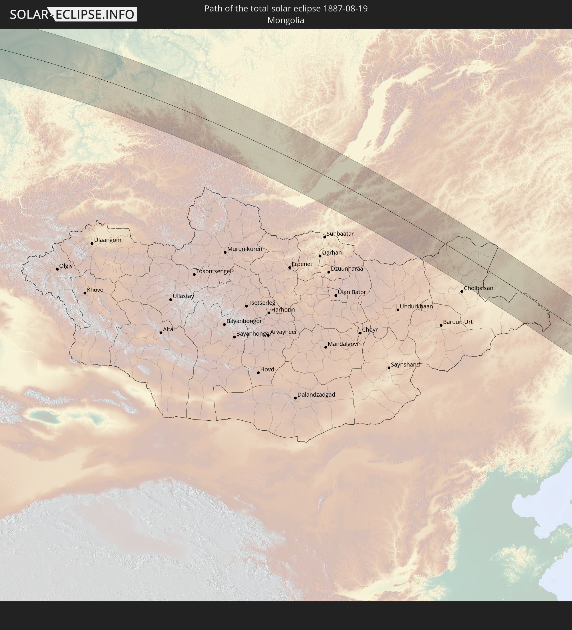 Mongolei
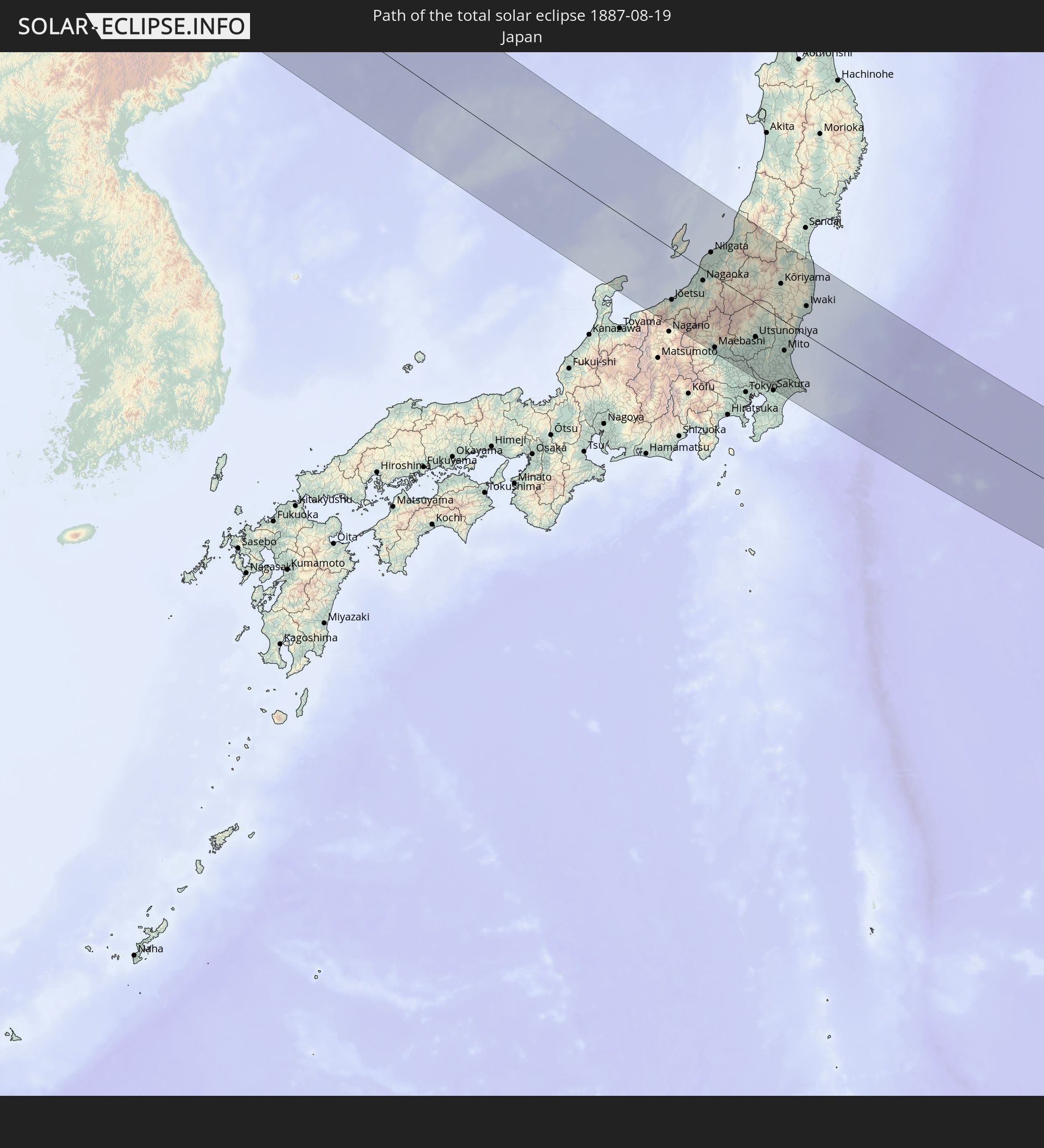 Japan
Japan
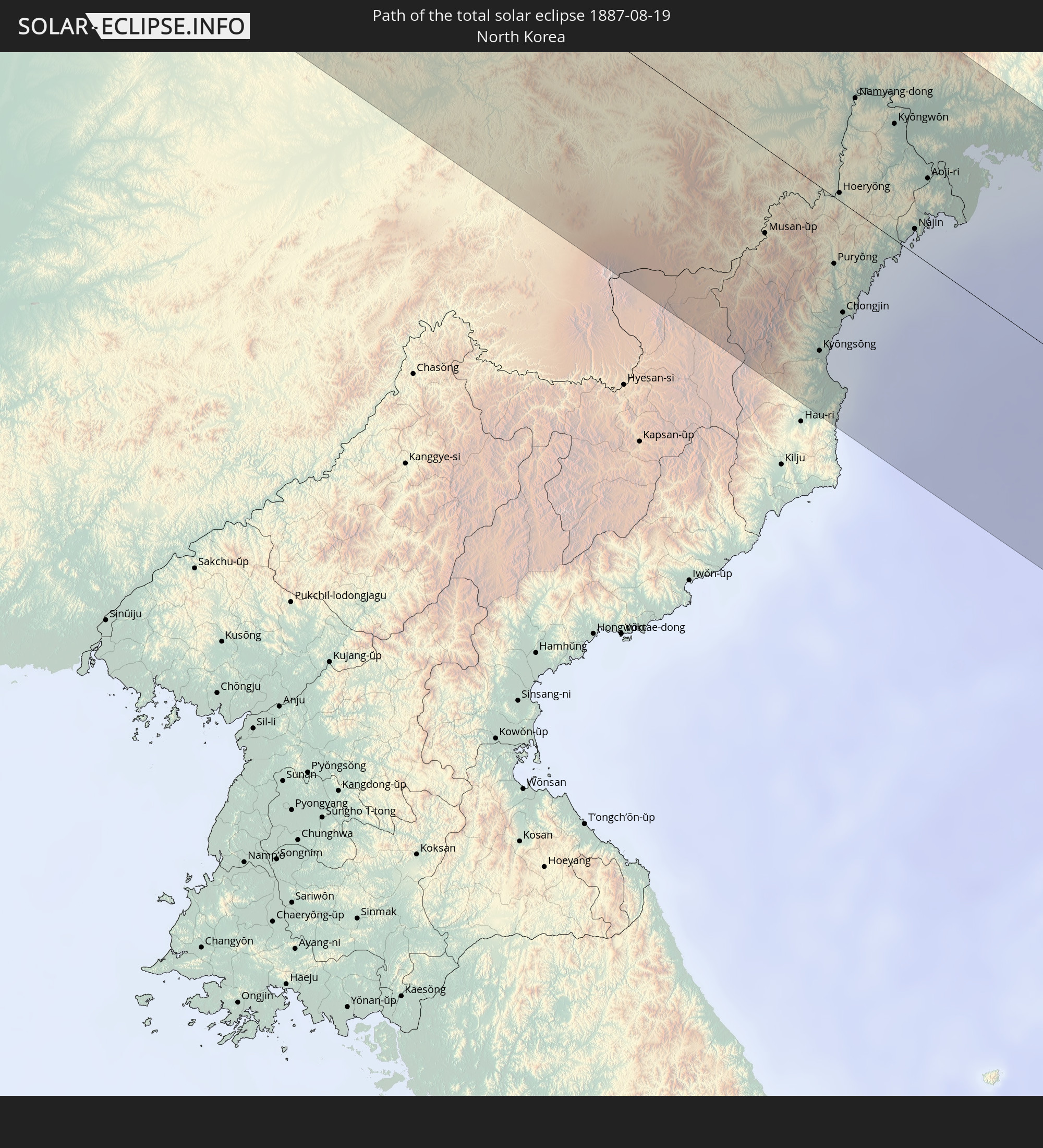 Nordkorea
In den folgenden Ländern ist die Sonnenfinsternis partiell zu sehen
 Russland
 Vereinigte Staaten
 United States Minor Outlying Islands
 Kanada
 Grönland
 Spitzbergen
 Norwegen
 Deutschland
 Dänemark
 Österreich
 Schweden
 Tschechien
 Slowenien
 Kroatien
 Polen
Polen
 Bosnien und Herzegowina
 Ungarn
 Slowakei
 Montenegro
 Serbien
 Albanien
 Åland Islands
 Griechenland
 Rumänien
 Mazedonien
 Finnland
 Litauen
 Lettland
 Estland
 Sudan
Sudan
 Ukraine
 Bulgarien
 Weißrussland
 Ägypten
 Türkei
 Moldawien
 Republik Zypern
 Staat Palästina
 Israel
 Saudi-Arabien
 Jordanien
 Libanon
 Syrien
 Irak
Irak
 Georgien
 Armenien
 Iran
Iran
 Aserbaidschan
 Kasachstan
 Kuwait
 Bahrain
 Katar
Katar
 Vereinigte Arabische Emirate
 Oman
Oman
 Turkmenistan
 Usbekistan
 Afghanistan
 Pakistan
 Tadschikistan
 Indien
 Kirgisistan
 Volksrepublik China
 Nepal
Nepal
 Mongolei
 Bangladesch
 Bhutan
 Myanmar
 Indonesien
 Thailand
 Laos
Laos
 Vietnam
 Kambodscha
 Macau
Macau
 Hongkong
 Taiwan
 Philippinen
 Japan
Japan
 Nordkorea
 Südkorea
 Palau
Palau
 Föderierte Staaten von Mikronesien
 Papua-Neuguinea
 Guam
Guam
 Nördliche Marianen
 Salomonen
 Marshallinseln
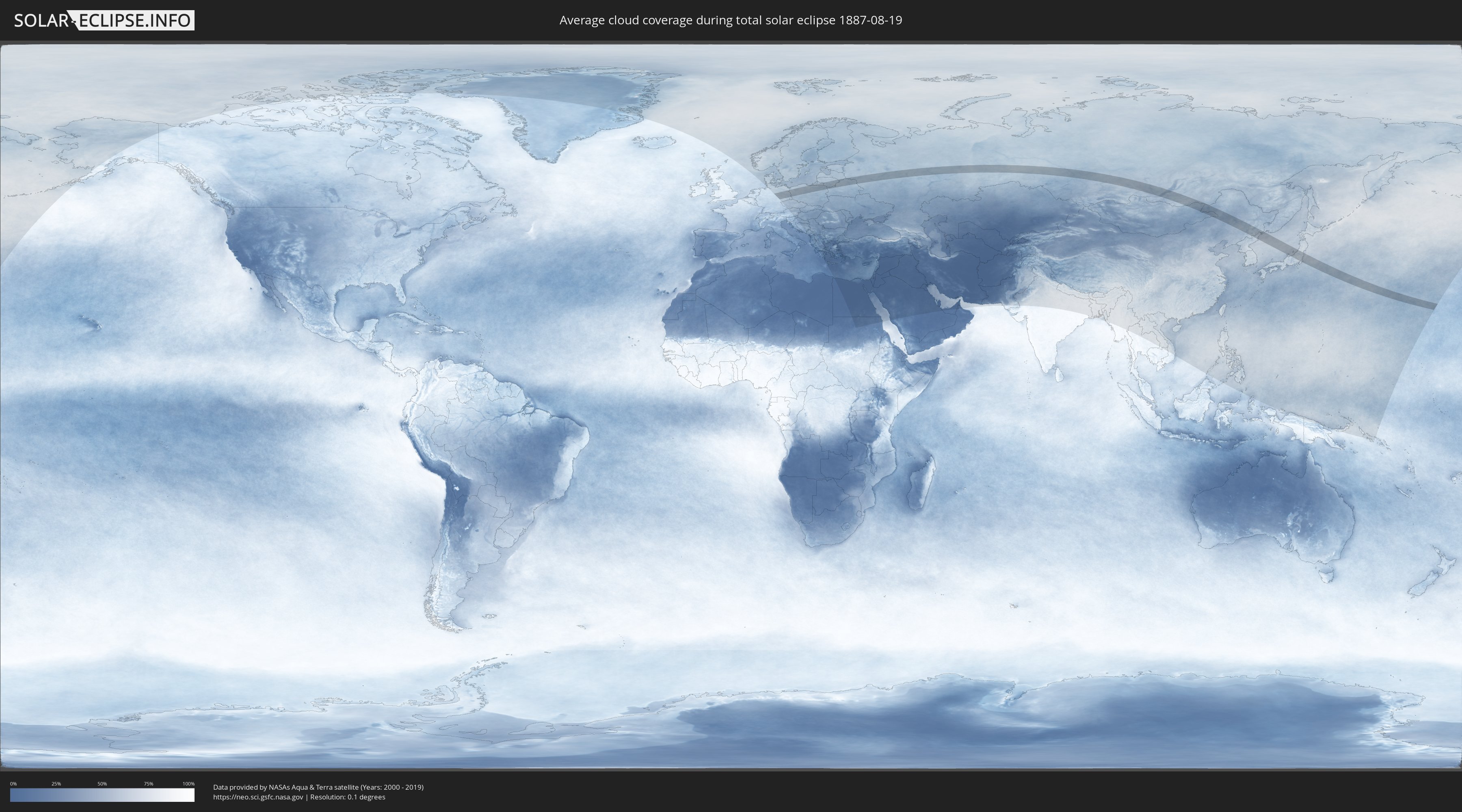
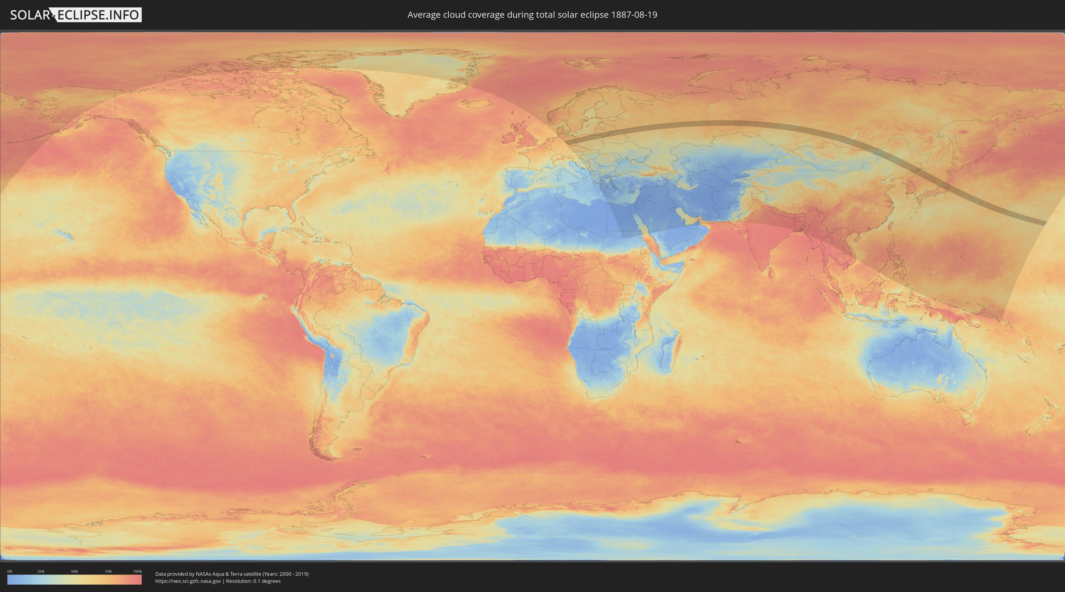
Wie wird das Wetter während der totalen Sonnenfinsternis am 19.08.1887?
Wo ist der beste Ort, um die totale Sonnenfinsternis vom 19.08.1887 zu beobachten?
Die folgenden Karten zeigen die durchschnittliche Bewölkung für den Tag, an dem die totale Sonnenfinsternis
stattfindet. Mit Hilfe der Karten lässt sich der Ort entlang des Finsternispfades eingrenzen,
der die besten Aussichen auf einen klaren wolkenfreien Himmel bietet.
Trotzdem muss man immer lokale Gegenenheiten beachten und sollte sich genau über das Wetter an seinem
gewählten Beobachtungsort informieren.
Die Daten stammen von den beiden NASA-Satelliten
AQUA und TERRA
und wurden über einen Zeitraum von 19 Jahren (2000 - 2019) gemittelt.
Detaillierte Länderkarten
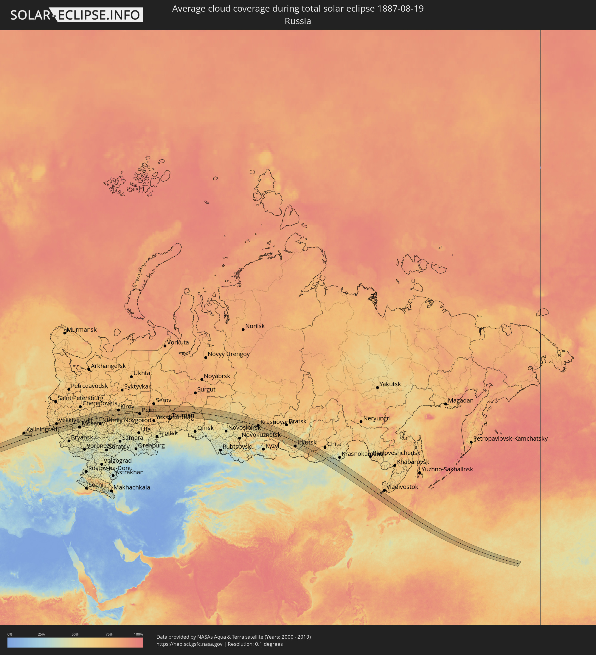 Russland
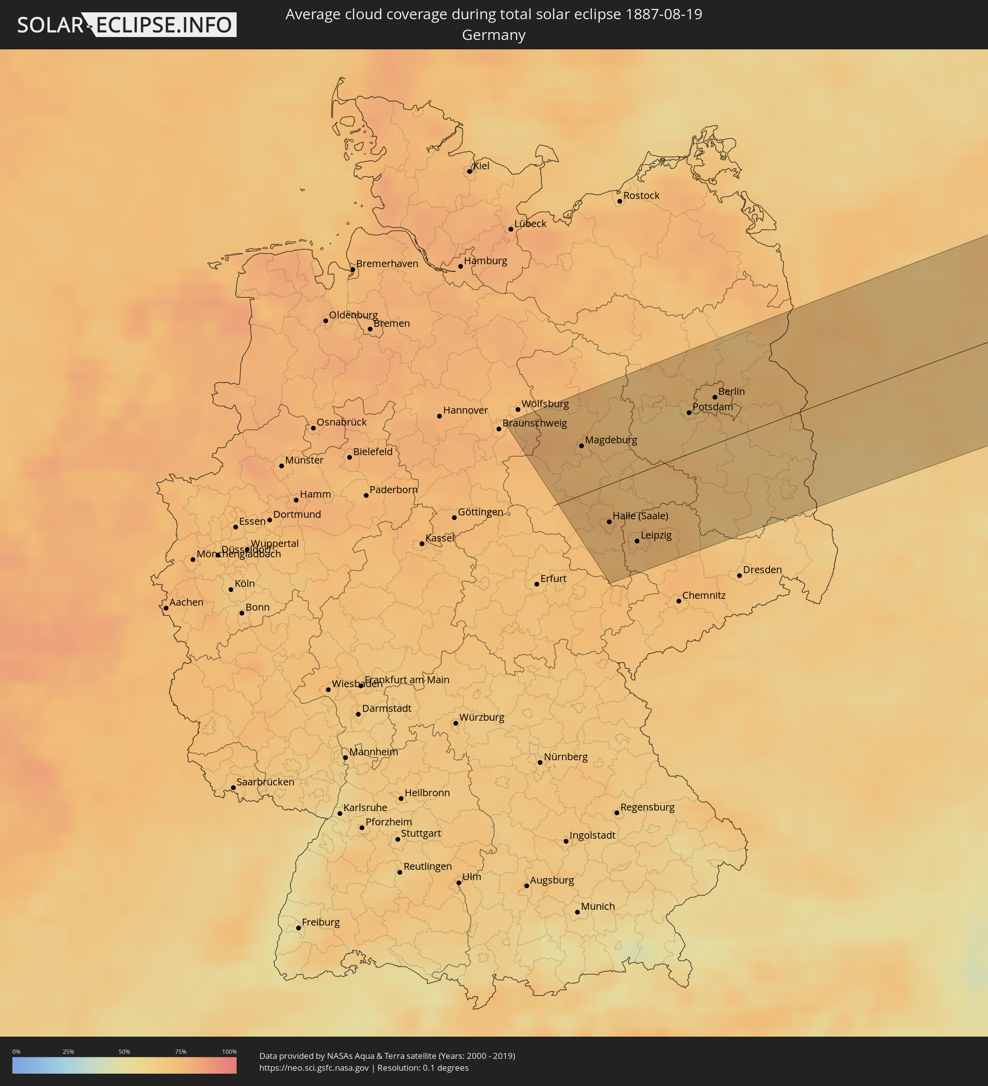 Deutschland
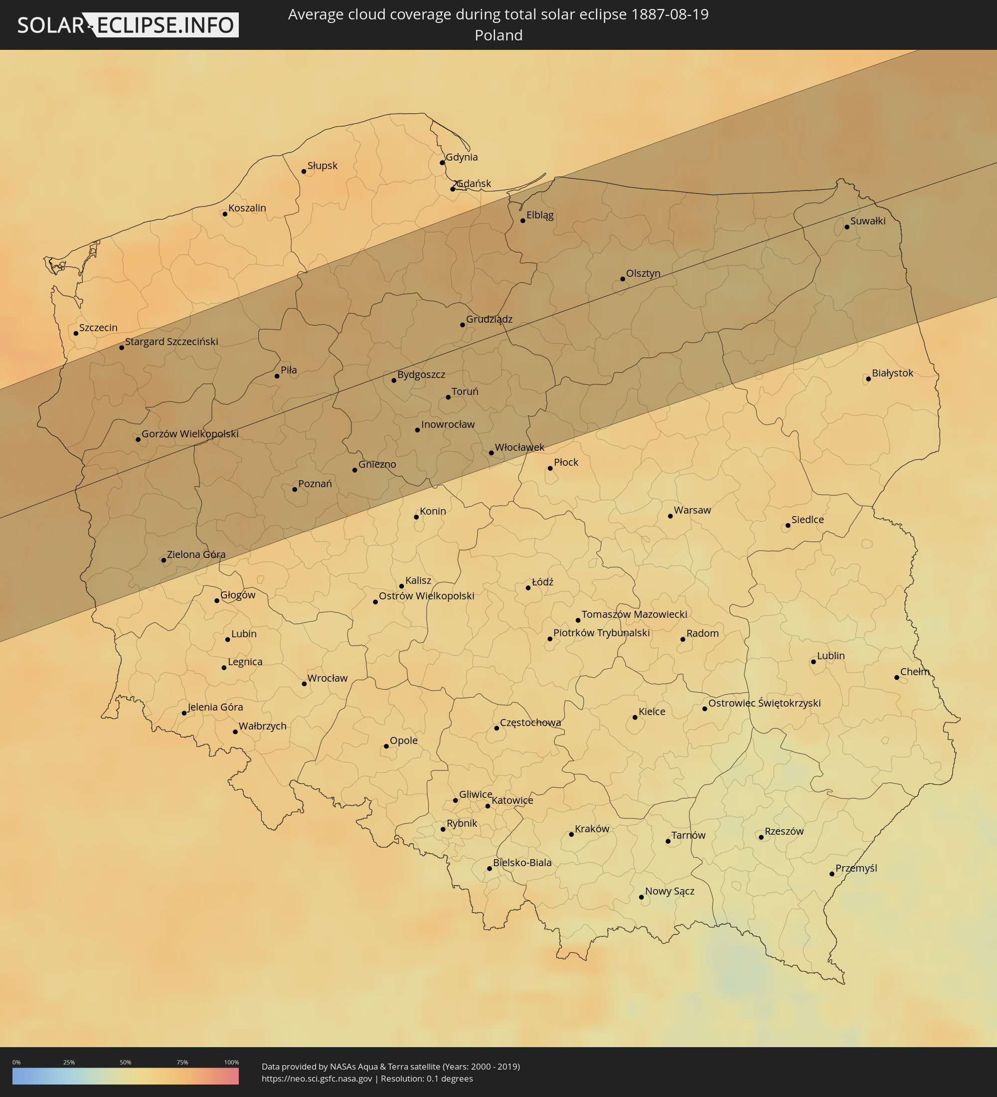 Polen
Polen
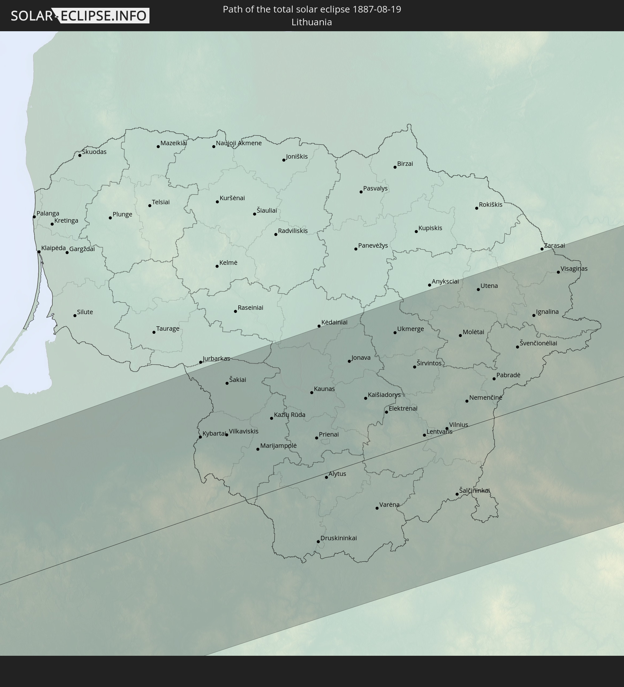
 Litauen
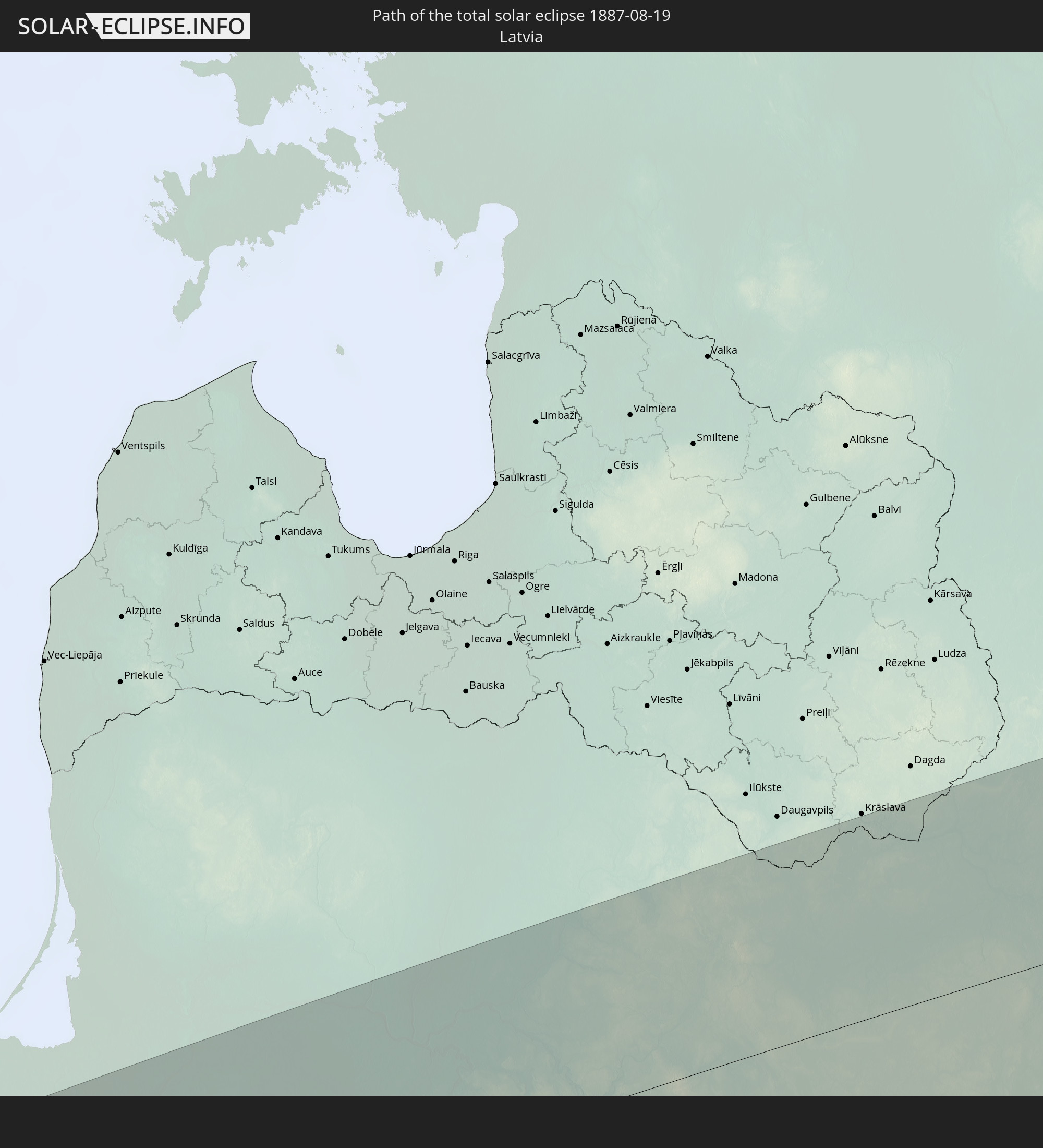
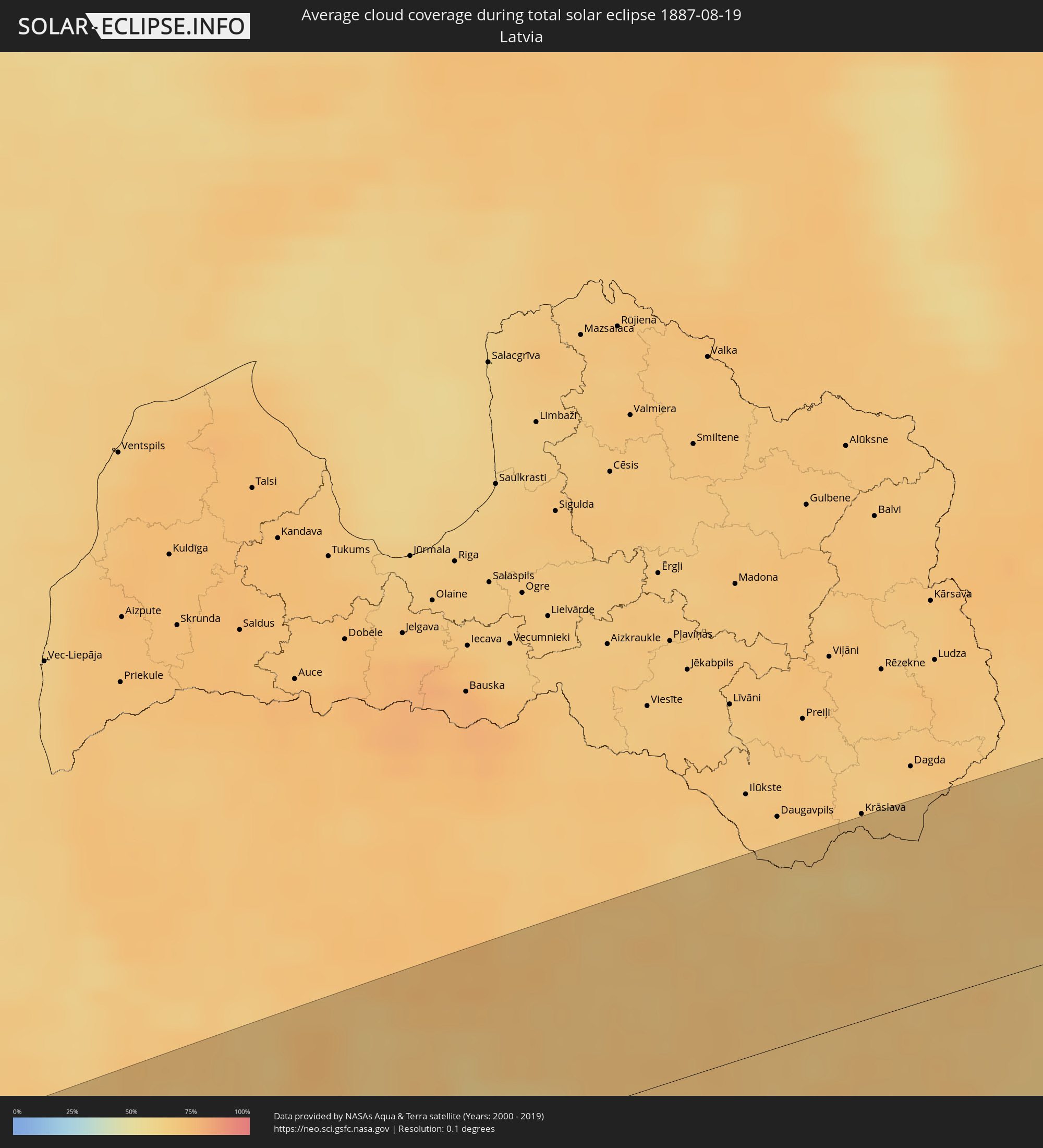 Lettland
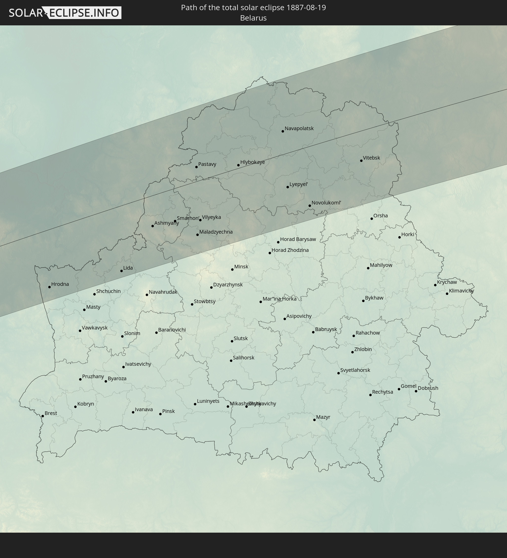
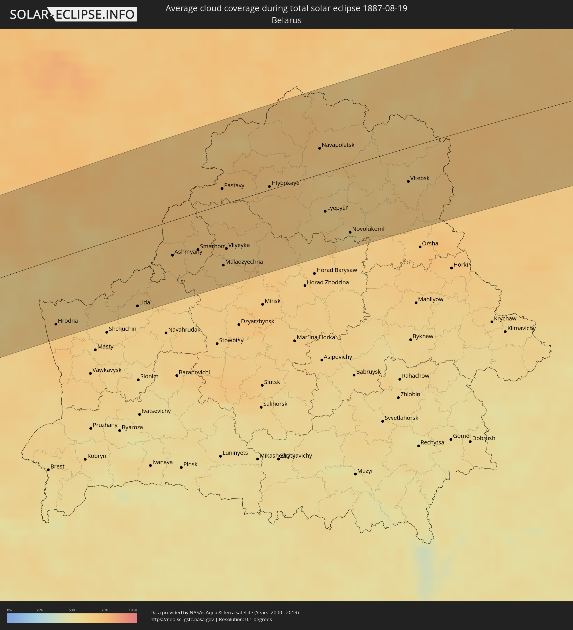 Weißrussland
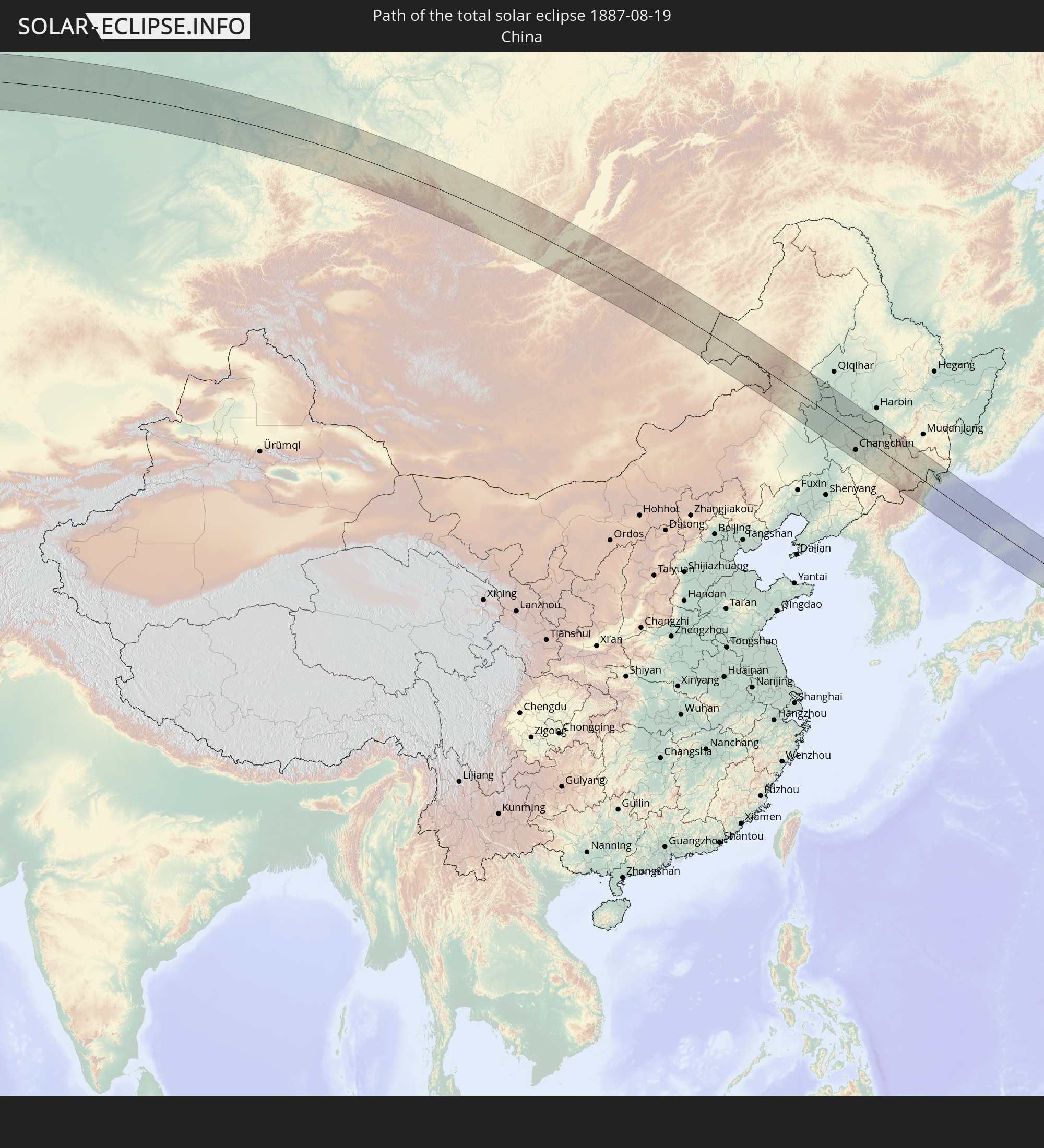
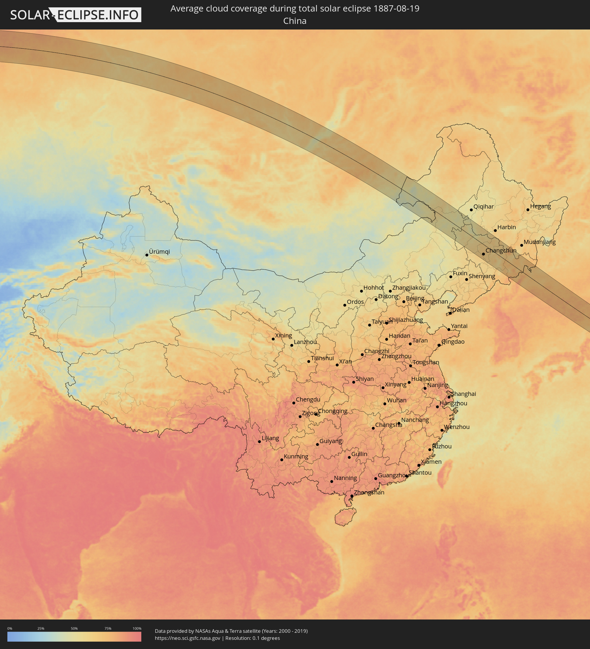 Volksrepublik China
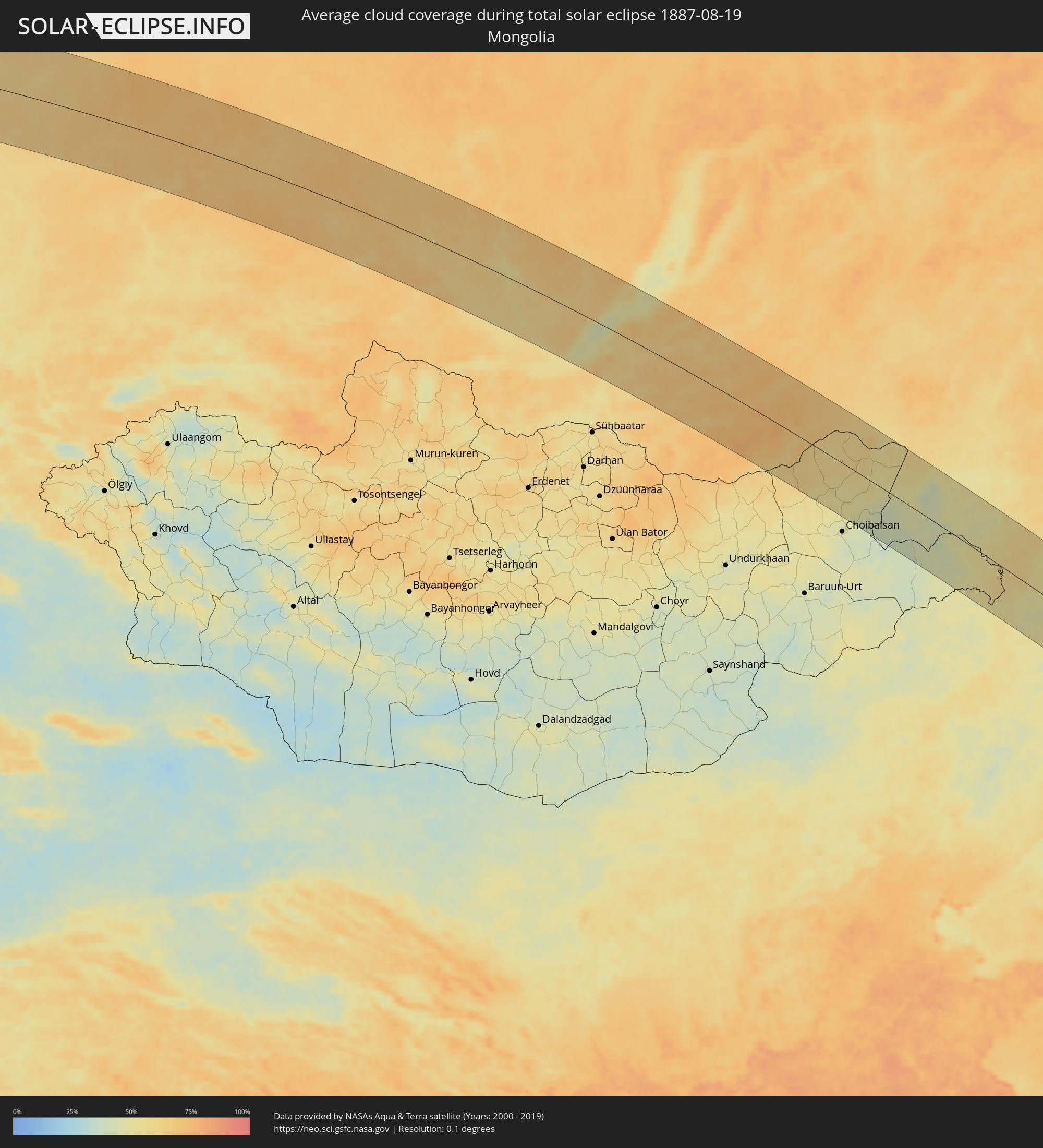 Mongolei
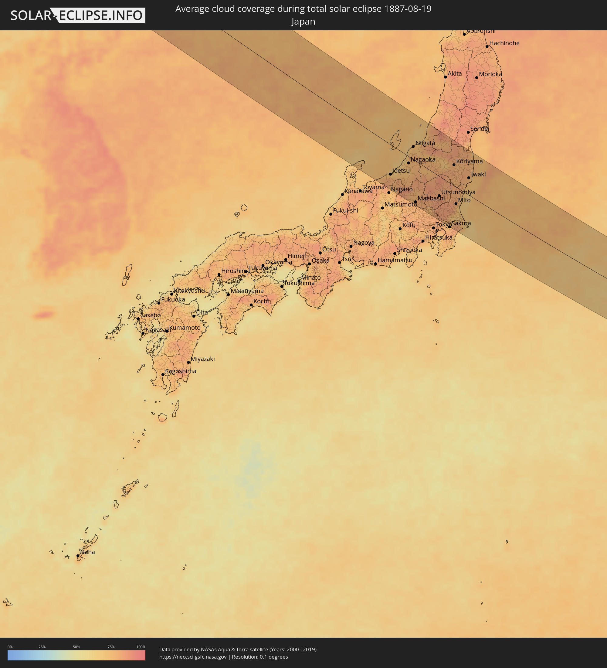 Japan
Japan
 Nordkorea
Orte im Finsternispfad
Die nachfolgene Tabelle zeigt Städte und Orte mit mehr als 5.000 Einwohnern, die sich im Finsternispfad befinden. Städte mit mehr als 100.000 Einwohnern sind dick gekennzeichnet. Mit einem Klick auf den Ort öffnet sich eine Detailkarte die die Lage des jeweiligen Ortes zusammen mit dem Verlauf der zentralen Finsternis präsentiert.
| Ort | Typ | Dauer der Verfinsterung | Ortszeit bei maximaler Verfinsterung | Entfernung zur Zentrallinie | Ø Bewölkung |
|
Halberstadt, Saxony-Anhalt
|
total | - | 05:11:18 UTC+01:00 | 32 km | 73% |
|
Magdeburg, Saxony-Anhalt
|
total | - | 05:11:25 UTC+01:00 | 41 km | 72% |
|
Bernburg, Saxony-Anhalt
|
total | - | 05:11:01 UTC+01:00 | 4 km | 74% |
|
Stendal, Saxony-Anhalt
|
total | - | 05:11:54 UTC+01:00 | 85 km | 72% |
|
Weißenfels, Saxony-Anhalt
|
total | - | 05:10:18 UTC+01:00 | 63 km | 73% |
|
Merseburg, Saxony-Anhalt
|
total | - | 05:10:28 UTC+01:00 | 48 km | 72% |
|
Halle (Saale), Saxony-Anhalt
|
total | - | 05:10:37 UTC+01:00 | 33 km | 73% |
|
Zeitz, Saxony-Anhalt
|
total | - | 05:10:05 UTC+01:00 | 83 km | 75% |
|
Dessau, Saxony-Anhalt
|
total | - | 05:10:56 UTC+01:00 | 4 km | 70% |
|
Leipzig, Saxony
|
total | - | 05:10:21 UTC+01:00 | 59 km | 71% |
|
Brandenburg an der Havel, Brandenburg
|
total | - | 05:11:31 UTC+01:00 | 51 km | 68% |
|
Potsdam, Brandenburg
|
total | - | 05:11:22 UTC+01:00 | 39 km | 69% |
|
Staaken, Berlin
|
total | - | 05:11:31 UTC+01:00 | 47 km | 69% |
|
Oranienburg, Brandenburg
|
total | - | 05:11:44 UTC+01:00 | 67 km | 72% |
|
Riesa, Saxony
|
total | - | 05:10:06 UTC+01:00 | 85 km | 72% |
|
Berlin, Berlin
|
total | - | 05:11:26 UTC+01:00 | 39 km | 74% |
|
Bernau bei Berlin, Brandenburg
|
total | - | 05:11:35 UTC+01:00 | 51 km | 75% |
|
Königs Wusterhausen, Brandenburg
|
total | - | 05:11:08 UTC+01:00 | 10 km | 68% |
|
Eberswalde, Brandenburg
|
total | - | 05:11:42 UTC+01:00 | 61 km | 72% |
|
Senftenberg, Brandenburg
|
total | - | 05:10:10 UTC+01:00 | 79 km | 65% |
|
Fürstenwalde, Brandenburg
|
total | - | 05:11:07 UTC+01:00 | 6 km | 68% |
|
Schwedt (Oder), Brandenburg
|
total | - | 05:11:52 UTC+01:00 | 74 km | 71% |
|
Cottbus, Brandenburg
|
total | - | 05:10:22 UTC+01:00 | 63 km | 67% |
|
Frankfurt (Oder), Brandenburg
|
total | - | 05:10:59 UTC+01:00 | 7 km | 68% |
|
Eisenhüttenstadt, Brandenburg
|
total | - | 05:10:45 UTC+01:00 | 30 km | 68% |
|
Stargard Szczeciński, West Pomeranian Voivodeship
|
total | - | 05:36:03 UTC+01:24 | 84 km | 72% |
|
Gorzów Wielkopolski, Lubusz
|
total | - | 05:35:18 UTC+01:24 | 18 km | 69% |
|
Zielona Góra, Lubusz
|
total | - | 05:34:20 UTC+01:24 | 73 km | 62% |
|
Szczecinek, West Pomeranian Voivodeship
|
total | - | 05:36:12 UTC+01:24 | 85 km | 68% |
|
Piła, Greater Poland Voivodeship
|
total | - | 05:35:32 UTC+01:24 | 27 km | 69% |
|
Poznań, Greater Poland Voivodeship
|
total | - | 05:34:37 UTC+01:24 | 57 km | 66% |
|
Chojnice, Pomeranian Voivodeship
|
total | - | 05:36:03 UTC+01:24 | 64 km | 71% |
|
Gniezno, Greater Poland Voivodeship
|
total | - | 05:34:40 UTC+01:24 | 58 km | 65% |
|
Bydgoszcz, Kujawsko-Pomorskie
|
total | - | 05:35:18 UTC+01:24 | 7 km | 64% |
|
Inowrocław, Kujawsko-Pomorskie
|
total | - | 05:34:53 UTC+01:24 | 46 km | 63% |
|
Starogard Gdański, Pomeranian Voivodeship
|
total | - | 05:36:15 UTC+01:24 | 70 km | 69% |
|
Toruń, Kujawsko-Pomorskie
|
total | - | 05:35:05 UTC+01:24 | 31 km | 62% |
|
Grudziądz, Kujawsko-Pomorskie
|
total | - | 05:35:38 UTC+01:24 | 19 km | 65% |
|
Tczew, Pomeranian Voivodeship
|
total | - | 05:36:22 UTC+01:24 | 79 km | 71% |
|
Kwidzyn, Pomeranian Voivodeship
|
total | - | 05:35:54 UTC+01:24 | 37 km | 70% |
|
Malbork, Pomeranian Voivodeship
|
total | - | 05:36:16 UTC+01:24 | 66 km | 71% |
|
Włocławek, Kujawsko-Pomorskie
|
total | - | 05:34:35 UTC+01:24 | 80 km | 63% |
|
Elbląg, Warmian-Masurian Voivodeship
|
total | - | 05:36:22 UTC+01:24 | 70 km | 69% |
|
Iława, Warmian-Masurian Voivodeship
|
total | - | 05:35:41 UTC+01:24 | 8 km | 65% |
|
Ostróda, Warmian-Masurian Voivodeship
|
total | - | 05:35:45 UTC+01:24 | 10 km | 68% |
|
Olsztyn, Warmian-Masurian Voivodeship
|
total | - | 05:35:48 UTC+01:24 | 7 km | 63% |
|
Giżycko, Warmian-Masurian Voivodeship
|
total | - | 05:36:01 UTC+01:24 | 15 km | 61% |
|
Ełk, Warmian-Masurian Voivodeship
|
total | - | 05:35:43 UTC+01:24 | 32 km | 60% |
|
Suwałki, Podlasie
|
total | - | 05:36:03 UTC+01:24 | 13 km | 61% |
|
Augustów, Podlasie
|
total | - | 05:35:43 UTC+01:24 | 42 km | 58% |
|
Vilkaviskis
|
total | - | 05:36:43 UTC+01:24 | 48 km | 70% |
|
Šakiai
|
total | - | 05:37:07 UTC+01:24 | 77 km | 73% |
|
Marijampolė, Marijampolė County
|
total | - | 05:36:36 UTC+01:24 | 29 km | 69% |
|
Kazlų Rūda, Marijampolė County
|
total | - | 05:36:50 UTC+01:24 | 48 km | 66% |
|
Hrodna, Grodnenskaya
|
total | - | 06:01:29 UTC+01:50 | 74 km | 66% |
|
Garliava, Kaunas County
|
total | - | 05:36:54 UTC+01:24 | 45 km | 69% |
|
Kaunas, Kaunas County
|
total | - | 05:37:01 UTC+01:24 | 54 km | 68% |
|
Prienai
|
total | - | 05:36:40 UTC+01:24 | 24 km | 67% |
|
Druskininkai, Alytus County
|
total | - | 05:35:53 UTC+01:24 | 45 km | 63% |
|
Alytus, Alytus County
|
total | - | 05:36:22 UTC+01:24 | 4 km | 65% |
|
Jonava, Kaunas County
|
total | - | 05:37:14 UTC+01:24 | 65 km | 71% |
|
Kaišiadorys
|
total | - | 05:36:57 UTC+01:24 | 39 km | 70% |
|
Varėna, Alytus County
|
total | - | 05:36:08 UTC+01:24 | 34 km | 66% |
|
Elektrėnai, Vilnius County
|
total | - | 05:36:51 UTC+01:24 | 29 km | 64% |
|
Ukmerge, Vilnius County
|
total | - | 05:37:27 UTC+01:24 | 73 km | 72% |
|
Širvintos, Vilnius County
|
total | - | 05:37:11 UTC+01:24 | 49 km | 68% |
|
Lentvaris, Vilnius County
|
total | - | 05:36:40 UTC+01:24 | 5 km | 67% |
|
Grigiškės
|
total | - | 05:36:43 UTC+01:24 | 10 km | 67% |
|
Pilaitė, Vilnius County
|
total | - | 05:36:44 UTC+01:24 | 15 km | 68% |
|
Vilnius, Vilnius County
|
total | - | 05:36:43 UTC+01:24 | 14 km | 70% |
|
Lida, Grodnenskaya
|
total | - | 06:01:42 UTC+01:50 | 83 km | 63% |
|
Rasos, Vilnius County
|
total | - | 05:36:43 UTC+01:24 | 12 km | 70% |
|
Šalčininkai
|
total | - | 05:36:14 UTC+01:24 | 43 km | 66% |
|
Molėtai, Utena County
|
total | - | 05:37:25 UTC+01:24 | 59 km | 67% |
|
Utena, Utena County
|
total | - | 05:37:46 UTC+01:24 | 82 km | 68% |
|
Iwye, Grodnenskaya
|
total | - | 06:01:46 UTC+01:50 | 88 km | 63% |
|
Ashmyany, Grodnenskaya
|
total | - | 06:02:23 UTC+01:50 | 42 km | 67% |
|
Astravyets, Grodnenskaya
|
total | - | 06:02:38 UTC+01:50 | 21 km | 68% |
|
Švenčionėliai
|
total | - | 05:37:21 UTC+01:24 | 41 km | 68% |
|
Smarhon’, Grodnenskaya
|
total | - | 06:02:28 UTC+01:50 | 44 km | 66% |
|
Visaginas, Utena County
|
total | - | 05:37:55 UTC+01:24 | 78 km | 66% |
|
Valozhyn, Minsk
|
total | - | 06:01:58 UTC+01:50 | 86 km | 66% |
|
Pastavy, Vitebsk
|
total | - | 06:03:18 UTC+01:50 | 18 km | 68% |
|
Maladzyechna, Minsk
|
total | - | 06:02:16 UTC+01:50 | 68 km | 65% |
|
Vilyeyka, Minsk
|
total | - | 06:02:30 UTC+01:50 | 52 km | 65% |
|
Myadzyel, Minsk
|
total | - | 06:03:00 UTC+01:50 | 12 km | 66% |
|
Braslaw, Vitebsk
|
total | - | 06:03:59 UTC+01:50 | 70 km | 65% |
|
Sharkawshchyna, Vitebsk
|
total | - | 06:03:39 UTC+01:50 | 33 km | 70% |
|
Myory, Vitebsk
|
total | - | 06:03:59 UTC+01:50 | 56 km | 67% |
|
Hlybokaye, Vitebsk
|
total | - | 06:03:22 UTC+01:50 | 14 km | 67% |
|
Dokshytsy, Vitebsk
|
total | - | 06:03:03 UTC+01:50 | 26 km | 69% |
|
Plyeshchanitsy, Minsk
|
total | - | 06:02:27 UTC+01:50 | 75 km | 66% |
|
Vyerkhnyadzvinsk, Vitebsk
|
total | - | 06:04:12 UTC+01:50 | 69 km | 69% |
|
Navapolatsk, Vitebsk
|
total | - | 06:03:56 UTC+01:50 | 32 km | 67% |
|
Lyepyel’, Vitebsk
|
total | - | 06:03:05 UTC+01:50 | 43 km | 61% |
|
Novolukoml’
|
total | - | 06:02:50 UTC+01:50 | 76 km | 59% |
|
Chashniki, Vitebsk
|
total | - | 06:03:05 UTC+01:50 | 54 km | 64% |
|
Syanno, Vitebsk
|
total | - | 06:03:04 UTC+01:50 | 69 km | 66% |
|
Haradok, Vitebsk
|
total | - | 06:03:57 UTC+01:50 | 5 km | 64% |
|
Vitebsk, Vitebsk
|
total | - | 06:03:36 UTC+01:50 | 38 km | 65% |
|
Velikiye Luki, Pskov
|
total | - | 06:45:27 UTC+02:30 | 79 km | 67% |
|
Tver, Tverskaya
|
total | - | 06:46:59 UTC+02:30 | 47 km | 72% |
|
Zelenograd, Moscow
|
total | - | 06:46:06 UTC+02:30 | 67 km | 65% |
|
Khimki, Moscow Oblast
|
total | - | 06:46:03 UTC+02:30 | 80 km | 66% |
|
Mytishchi, Moscow Oblast
|
total | - | 06:46:08 UTC+02:30 | 83 km | 67% |
|
Shchelkovo, Moscow Oblast
|
total | - | 06:46:13 UTC+02:30 | 86 km | 63% |
|
Sergiyev Posad, Moscow Oblast
|
total | - | 06:46:46 UTC+02:30 | 47 km | 67% |
|
Yaroslavl, Jaroslavl
|
total | - | 06:49:01 UTC+02:30 | 74 km | 69% |
|
Kostroma, Kostroma
|
total | - | 06:49:31 UTC+02:30 | 75 km | 67% |
|
Ivanovo, Ivanovo
|
total | - | 06:48:30 UTC+02:30 | 11 km | 66% |
|
Kovrov, Vladimir
|
total | - | 06:47:46 UTC+02:30 | 84 km | 65% |
|
Kineshma, Ivanovo
|
total | - | 06:49:28 UTC+02:30 | 27 km | 67% |
|
Kirov, Kirov
|
total | - | 06:54:05 UTC+02:30 | 74 km | 68% |
|
Glazov, Udmurtiya
|
total | - | 07:45:06 UTC+03:20 | 0 km | 71% |
|
Perm, Perm
|
total | - | 08:29:18 UTC+04:02 | 37 km | 75% |
|
Nizhniy Tagil, Sverdlovsk
|
total | - | 08:31:41 UTC+04:02 | 59 km | 75% |
|
Tobol’sk, Tyumenskaya
|
total | - | 08:38:32 UTC+04:02 | 31 km | 76% |
|
Tomsk, Tomsk
|
total | - | 11:03:50 UTC+06:11 | 77 km | 60% |
|
Achinsk, Krasnoyarskiy
|
total | - | 11:10:35 UTC+06:11 | 10 km | 69% |
|
Krasnoyarsk, Krasnoyarskiy
|
total | - | 11:13:36 UTC+06:11 | 9 km | 69% |
|
Zheleznogorsk, Krasnoyarskiy
|
total | - | 11:14:25 UTC+06:11 | 47 km | 70% |
|
Kansk, Krasnoyarskiy
|
total | - | 11:17:13 UTC+06:11 | 90 km | 65% |
|
Angarsk, Irkutsk
|
total | - | 12:15:47 UTC+06:57 | 74 km | 57% |
|
Irkutsk, Irkutsk
|
total | - | 12:16:33 UTC+06:57 | 86 km | 56% |
|
Ulan-Ude, Respublika Buryatiya
|
total | - | 12:21:40 UTC+06:57 | 32 km | 57% |
|
Ulanhot, Inner Mongolia
|
total | - | 13:52:01 UTC+08:00 | 23 km | 51% |
|
Guangming, Jilin
|
total | - | 13:54:06 UTC+08:00 | 55 km | 53% |
|
Baicheng, Jilin
|
total | - | 13:53:43 UTC+08:00 | 26 km | 57% |
|
Zhenlai, Jilin
|
total | - | 13:53:57 UTC+08:00 | 24 km | 56% |
|
Tailai, Heilongjiang
|
total | - | 13:53:15 UTC+08:00 | 72 km | 50% |
|
Dalai, Jilin
|
total | - | 13:55:46 UTC+08:00 | 31 km | 51% |
|
Fuyu, Jilin
|
total | - | 13:56:56 UTC+08:00 | 28 km | 60% |
|
Changchun, Jilin
|
total | - | 13:59:41 UTC+08:00 | 73 km | 67% |
|
Dehui, Jilin
|
total | - | 13:59:05 UTC+08:00 | 17 km | 66% |
|
Jiutai, Jilin
|
total | - | 13:59:52 UTC+08:00 | 23 km | 68% |
|
Shuangcheng, Heilongjiang
|
total | - | 13:58:27 UTC+08:00 | 106 km | 63% |
|
Yushu, Jilin
|
total | - | 13:59:39 UTC+08:00 | 68 km | 65% |
|
Jilin, Jilin
|
total | - | 14:01:16 UTC+08:00 | 25 km | 64% |
|
Huadian, Jilin
|
total | - | 14:02:58 UTC+08:00 | 90 km | 60% |
|
Jishu, Jilin
|
total | - | 14:00:47 UTC+08:00 | 36 km | 64% |
|
Shulan, Jilin
|
total | - | 14:00:47 UTC+08:00 | 52 km | 62% |
|
Wuchang, Heilongjiang
|
total | - | 14:00:12 UTC+08:00 | 107 km | 65% |
|
Minzhu, Jilin
|
total | - | 14:02:25 UTC+08:00 | 22 km | 60% |
|
Dunhua, Jilin
|
total | - | 14:04:04 UTC+08:00 | 21 km | 68% |
|
Helong, Jilin
|
total | - | 14:06:22 UTC+08:00 | 28 km | 72% |
|
Musan-ŭp, Hamgyŏng-bukto
|
total | - | 14:30:08 UTC+08:23 | 42 km | 69% |
|
Longjing, Jilin
|
total | - | 14:06:27 UTC+08:00 | 27 km | 66% |
|
Yanji, Jilin
|
total | - | 14:06:19 UTC+08:00 | 42 km | 67% |
|
Kyŏngsŏng, Hamgyŏng-bukto
|
total | - | 14:31:41 UTC+08:23 | 83 km | 70% |
|
Sŭngam-nodongjagu, Hamgyŏng-bukto
|
total | - | 14:31:37 UTC+08:23 | 72 km | 68% |
|
Hoemul-li, Hamgyŏng-bukto
|
total | - | 14:32:02 UTC+08:23 | 94 km | 67% |
|
Nanam, Hamgyŏng-bukto
|
total | - | 14:31:34 UTC+08:23 | 67 km | 68% |
|
Komusan 1-tong, Hamgyŏng-bukto
|
total | - | 14:30:54 UTC+08:23 | 31 km | 77% |
|
Puryŏng, Hamgyŏng-bukto
|
total | - | 14:31:00 UTC+08:23 | 33 km | 77% |
|
Hoeryŏng, Hamgyŏng-bukto
|
total | - | 14:30:23 UTC+08:23 | 23 km | 71% |
|
Wangqing, Jilin
|
total | - | 14:05:54 UTC+08:00 | 86 km | 69% |
|
Chongjin, Hamgyŏng-bukto
|
total | - | 14:31:32 UTC+08:23 | 56 km | 70% |
|
Tumen, Jilin
|
total | - | 14:06:36 UTC+08:00 | 56 km | 70% |
|
Namyang-dong, Hamgyŏng-bukto
|
total | - | 14:29:39 UTC+08:23 | 55 km | 69% |
|
Onsŏng, Hamgyŏng-bukto
|
total | - | 14:29:47 UTC+08:23 | 62 km | 68% |
|
Kyŏngwŏn, Hamgyŏng-bukto
|
total | - | 14:30:12 UTC+08:23 | 62 km | 64% |
|
Najin, Rason
|
total | - | 14:31:20 UTC+08:23 | 25 km | 70% |
|
Hunchun, Jilin
|
total | - | 14:07:20 UTC+08:00 | 73 km | 66% |
|
Aoji-ri, Hamgyŏng-bukto
|
total | - | 14:30:58 UTC+08:23 | 43 km | 70% |
|
Sŏnbong, Rason
|
total | - | 14:31:17 UTC+08:23 | 34 km | 71% |
|
Ungsang-nodongjagu, Rason
|
total | - | 14:31:20 UTC+08:23 | 39 km | 71% |
|
Jōetsu, Niigata
|
total | - | 15:25:06 UTC+09:00 | 75 km | 81% |
|
Kashiwazaki, Niigata
|
total | - | 15:24:59 UTC+09:00 | 45 km | 71% |
|
Nagaoka, Niigata
|
total | - | 15:25:06 UTC+09:00 | 18 km | 77% |
|
Sanjō, Niigata
|
total | - | 15:24:53 UTC+09:00 | 8 km | 77% |
|
Niigata, Niigata
|
total | - | 15:24:28 UTC+09:00 | 37 km | 75% |
|
Maebashi, Gunma
|
total | - | 15:27:07 UTC+09:00 | 106 km | 78% |
|
Shibata, Niigata
|
total | - | 15:24:37 UTC+09:00 | 53 km | 79% |
|
Ashikaga, Tochigi
|
total | - | 15:27:32 UTC+09:00 | 93 km | 76% |
|
Gyōda, Saitama
|
partiell | - | 15:27:52 UTC+09:00 | 110 km | 80% |
|
Kasukabe, Saitama
|
partiell | - | 15:28:22 UTC+09:00 | 111 km | 81% |
|
Oyama, Tochigi
|
total | - | 15:27:52 UTC+09:00 | 79 km | 84% |
|
Utsunomiya, Tochigi
|
total | - | 15:27:28 UTC+09:00 | 50 km | 84% |
|
Kashiwa, Chiba
|
partiell | - | 15:28:46 UTC+09:00 | 112 km | 78% |
|
Mooka, Tochigi
|
total | - | 15:27:48 UTC+09:00 | 56 km | 85% |
|
Tsukuba, Ibaraki
|
total | - | 15:28:17 UTC+09:00 | 74 km | 85% |
|
Yonezawa, Yamagata
|
total | - | 15:25:20 UTC+09:00 | 87 km | 81% |
|
Ryūgasaki, Ibaraki
|
total | - | 15:28:52 UTC+09:00 | 98 km | 72% |
|
Narita, Chiba
|
total | - | 15:29:10 UTC+09:00 | 103 km | 81% |
|
Kōriyama, Fukushima
|
total | - | 15:26:25 UTC+09:00 | 52 km | 79% |
|
Mito, Ibaraki
|
total | - | 15:28:18 UTC+09:00 | 43 km | 76% |
|
Fukushima, Fukushima
|
total | - | 15:25:53 UTC+09:00 | 89 km | 82% |
|
Katori-shi, Chiba
|
total | - | 15:29:07 UTC+09:00 | 84 km | 82% |
|
Kashima-shi, Ibaraki
|
total | - | 15:29:06 UTC+09:00 | 70 km | 73% |
|
Hitachi, Ibaraki
|
total | - | 15:28:01 UTC+09:00 | 10 km | 69% |
|
Iwaki, Fukushima
|
total | - | 15:27:25 UTC+09:00 | 43 km | 76% |