Totale Sonnenfinsternis vom 21.08.1914
| Wochentag: | Freitag |
| Maximale Dauer der Verfinsterung: | 02m14s |
| Maximale Breite des Finsternispfades: | 170 km |
| Saroszyklus: | 124 |
| Bedeckungsgrad: | 100% |
| Magnitude: | 1.0328 |
| Gamma: | 0.7655 |
Wo kann man die Sonnenfinsternis vom 21.08.1914 sehen?
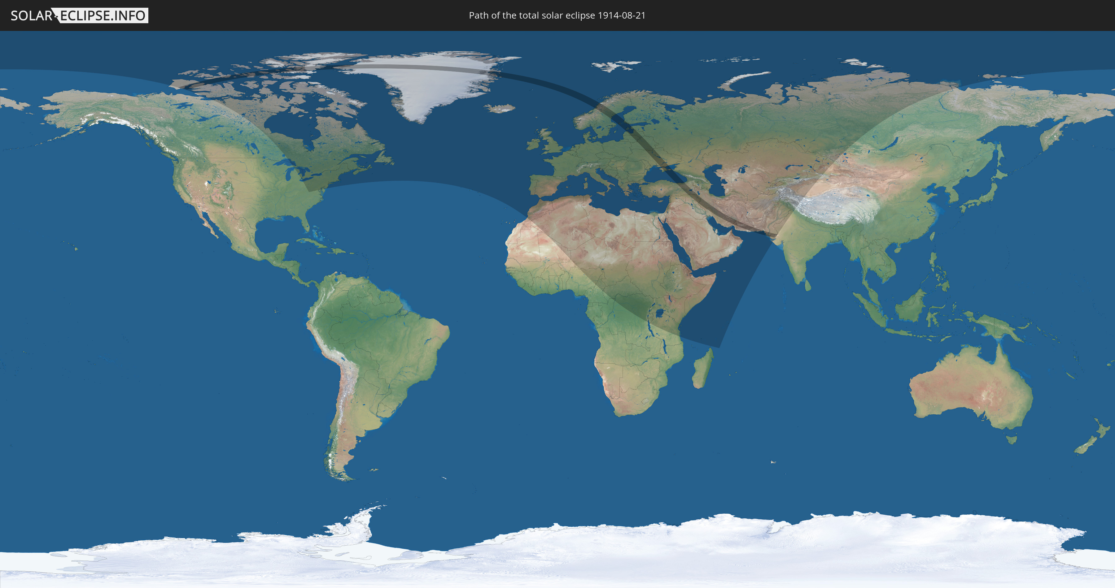
Die Sonnenfinsternis am 21.08.1914 kann man in 108 Ländern als partielle Sonnenfinsternis beobachten.
Der Finsternispfad verläuft durch 18 Länder. Nur in diesen Ländern ist sie als totale Sonnenfinsternis zu sehen.
In den folgenden Ländern ist die Sonnenfinsternis total zu sehen
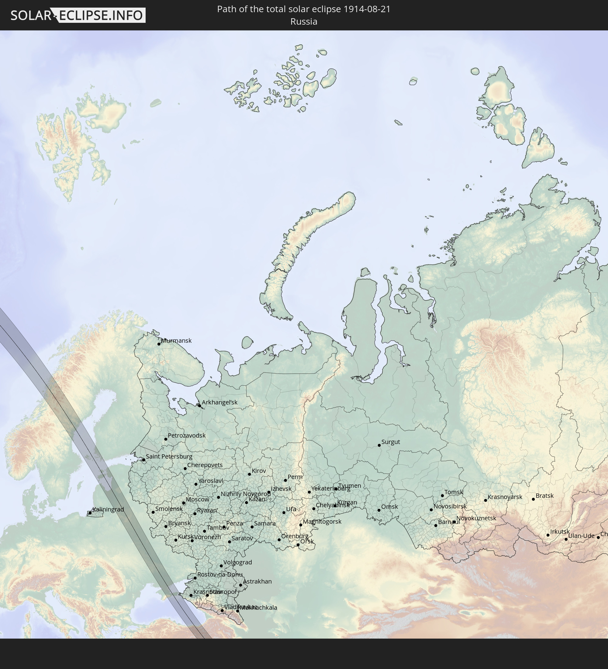 Russland
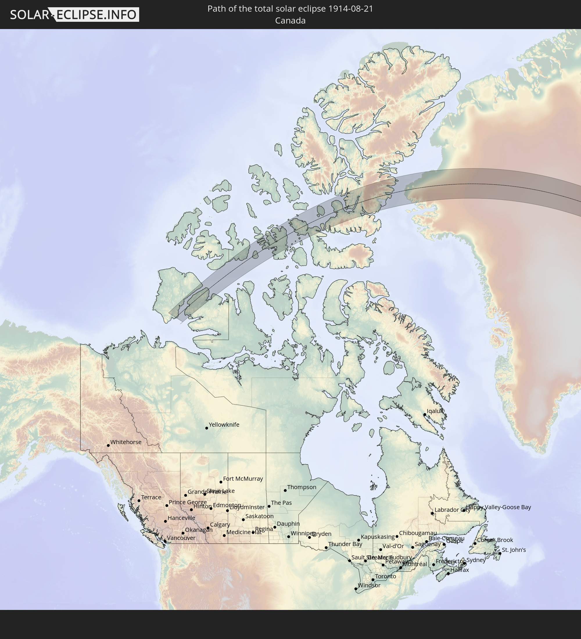 Kanada
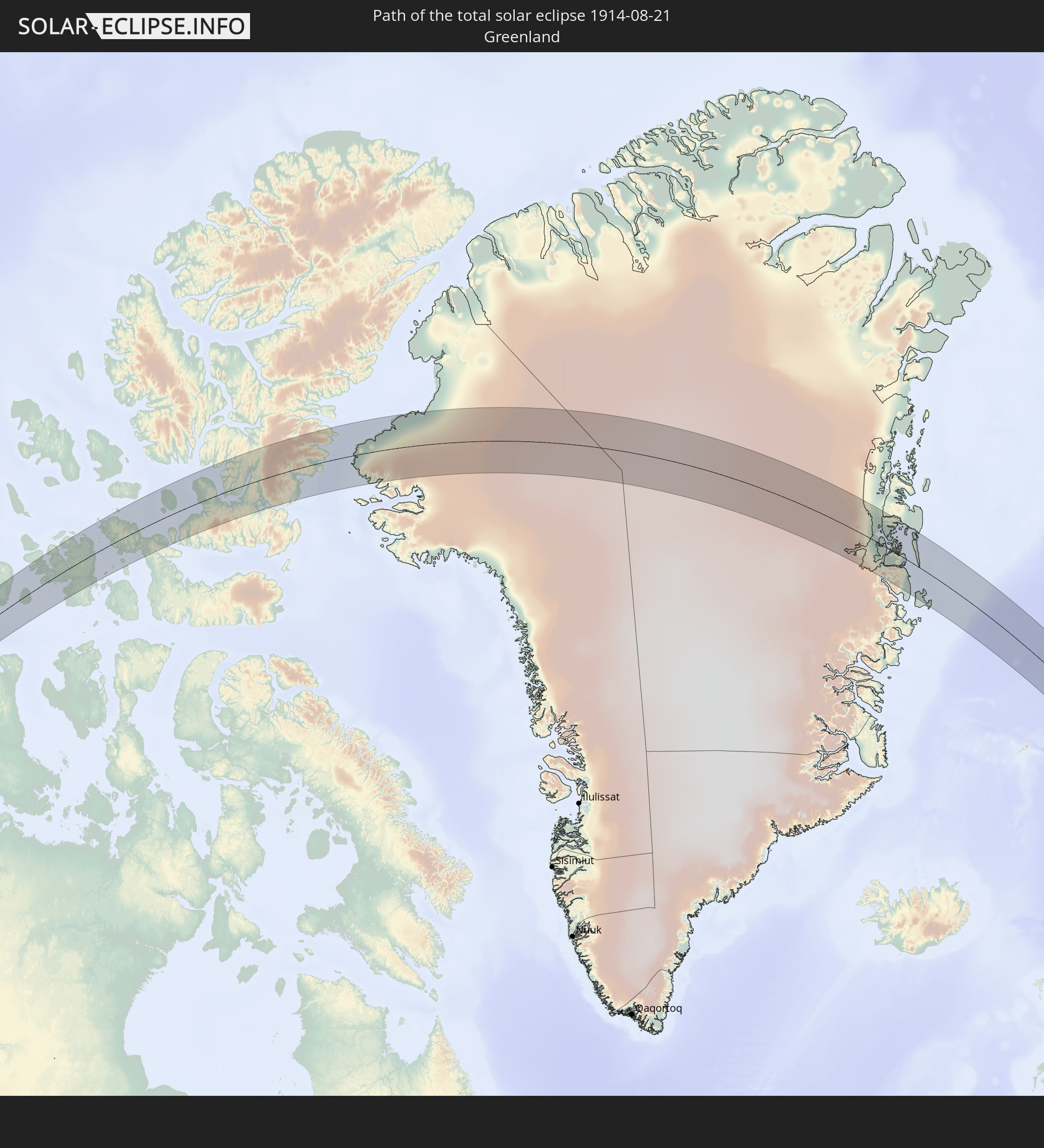 Grönland
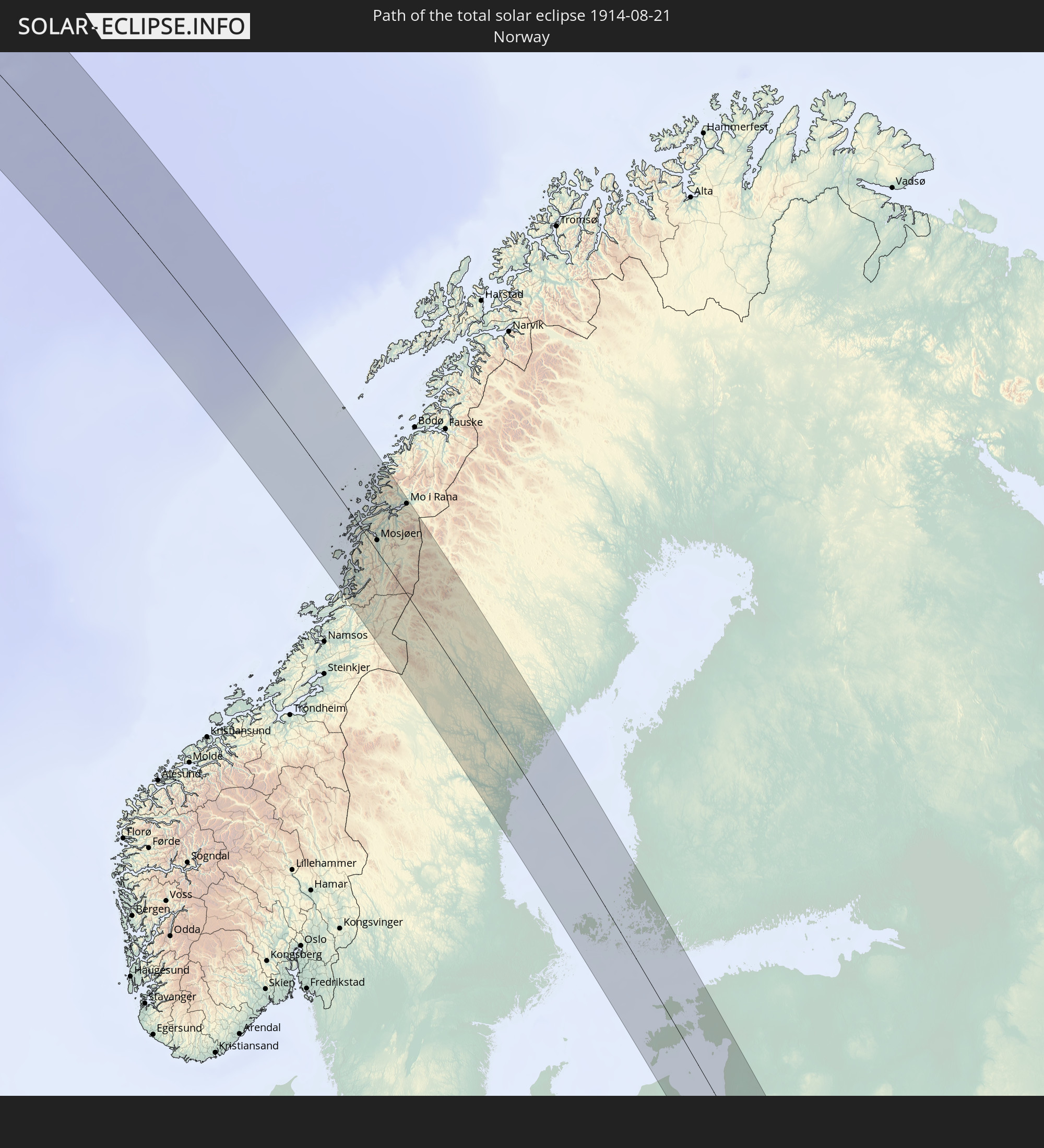 Norwegen
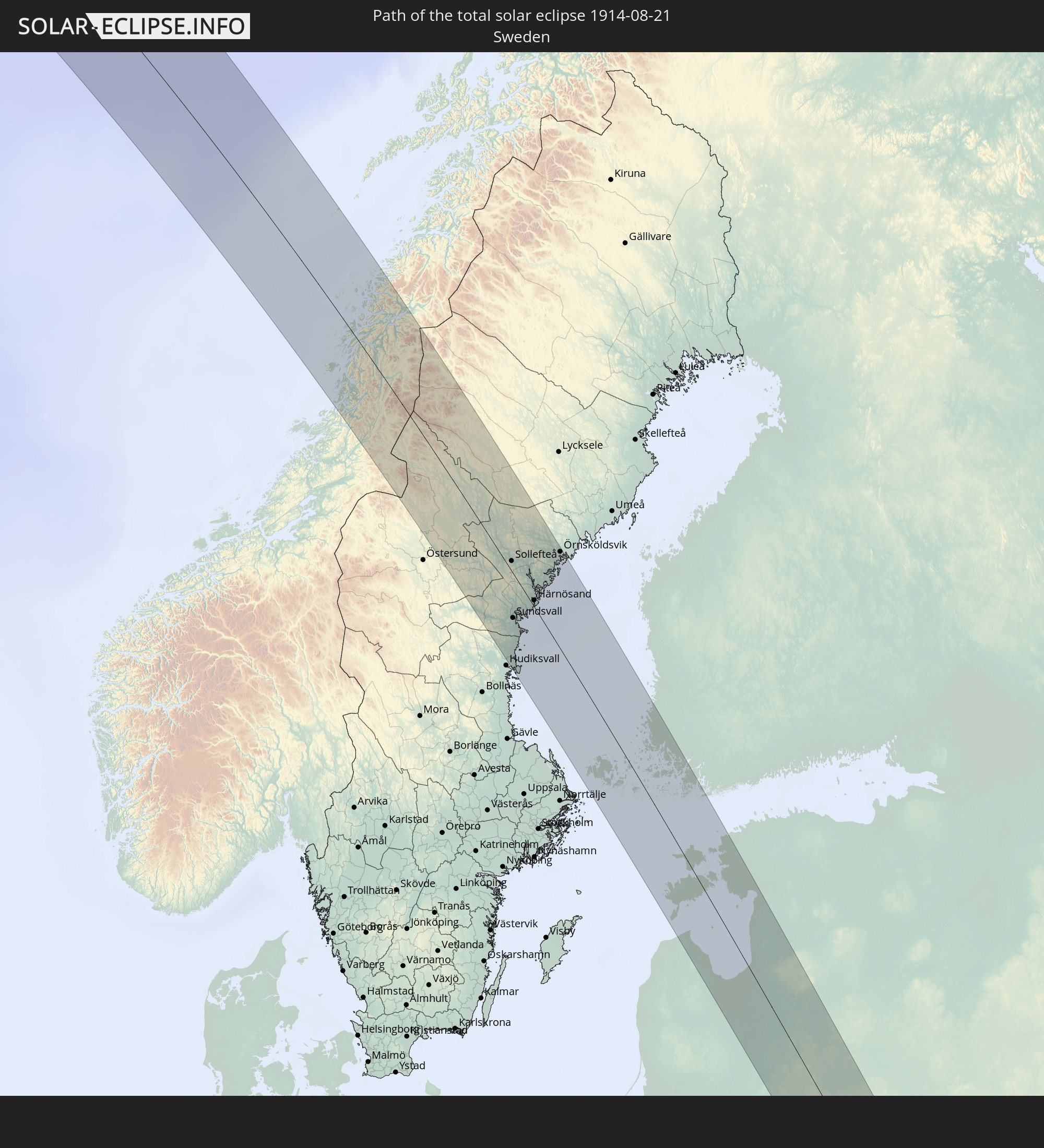 Schweden
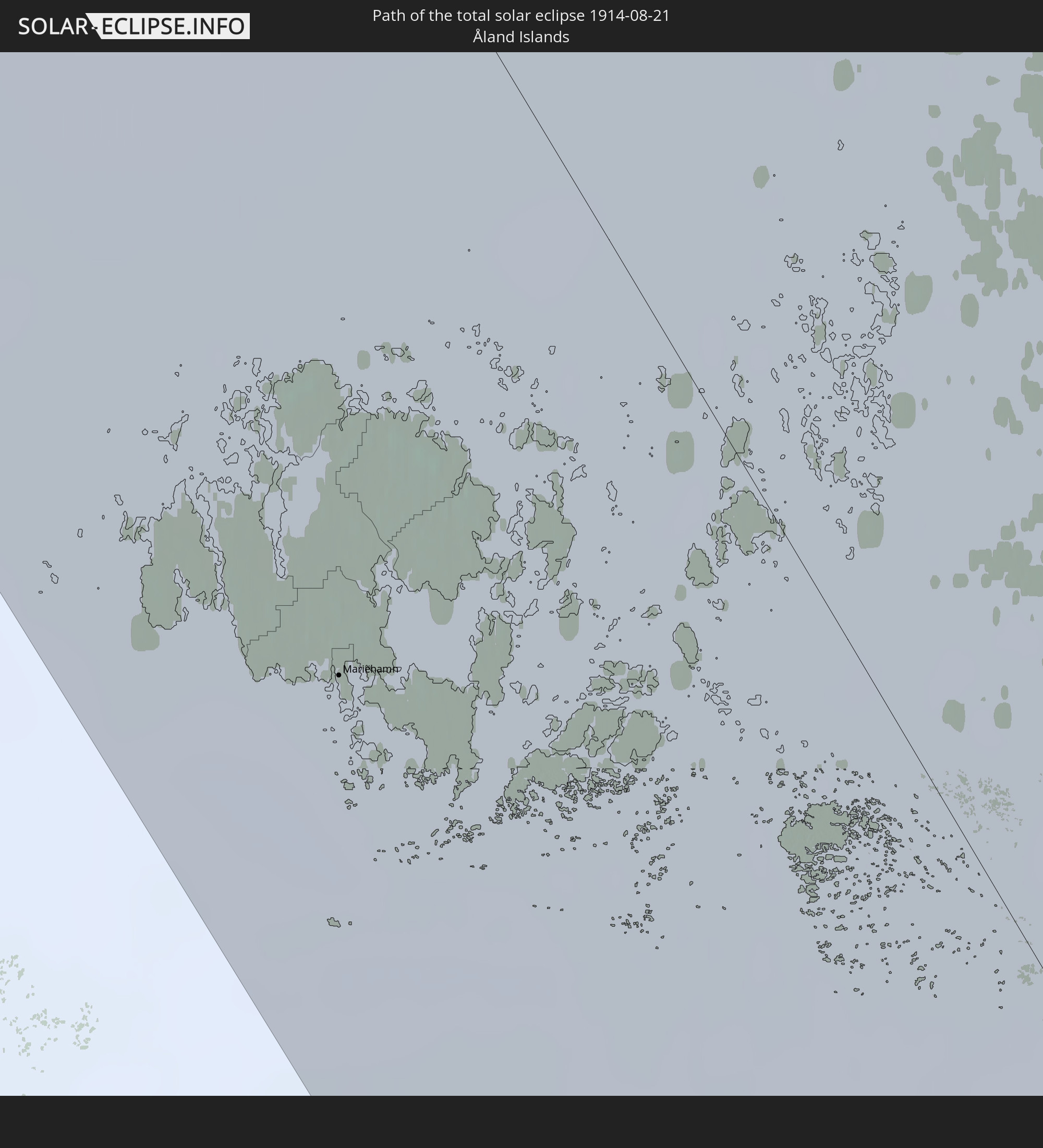 Åland Islands
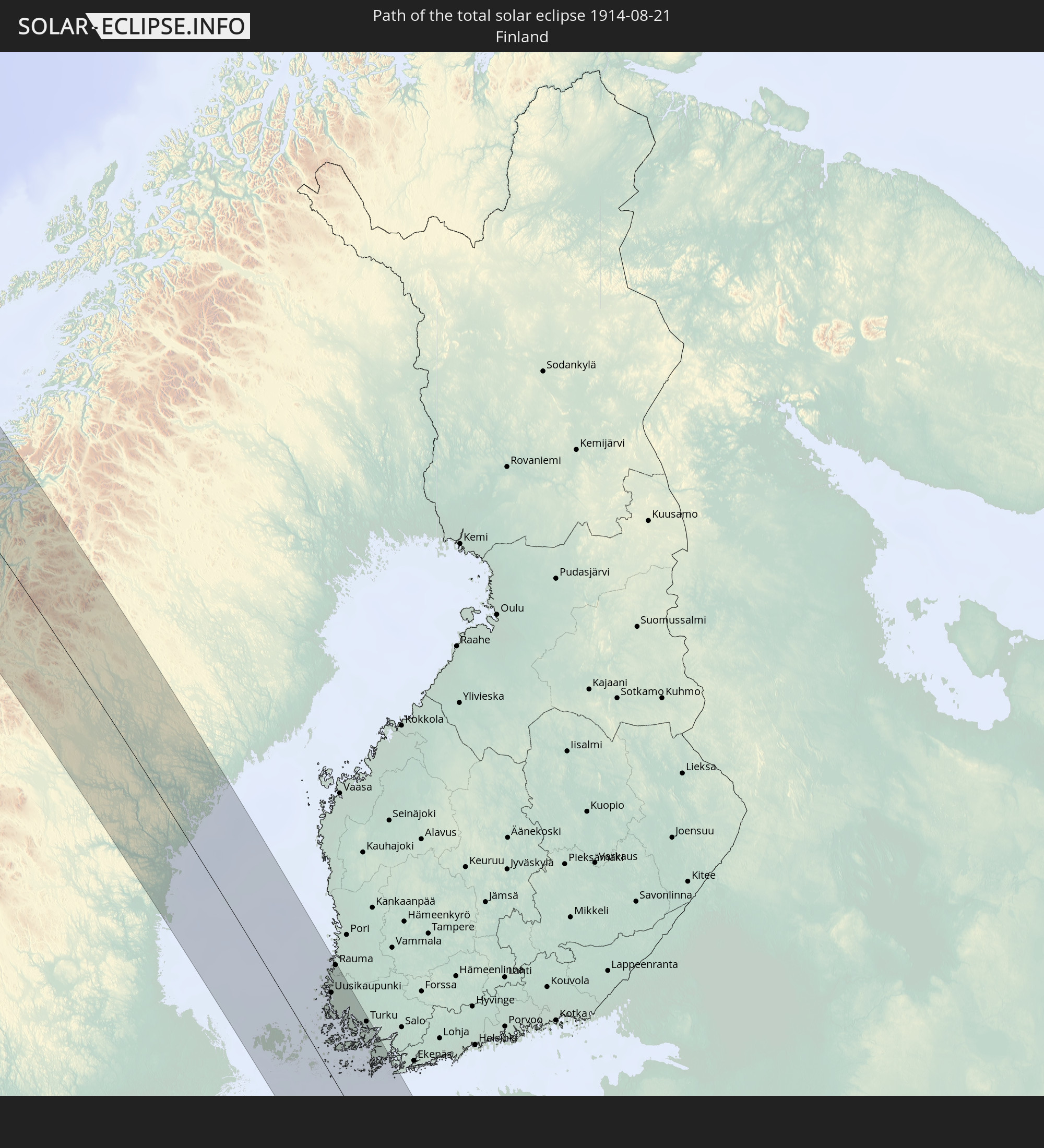 Finnland
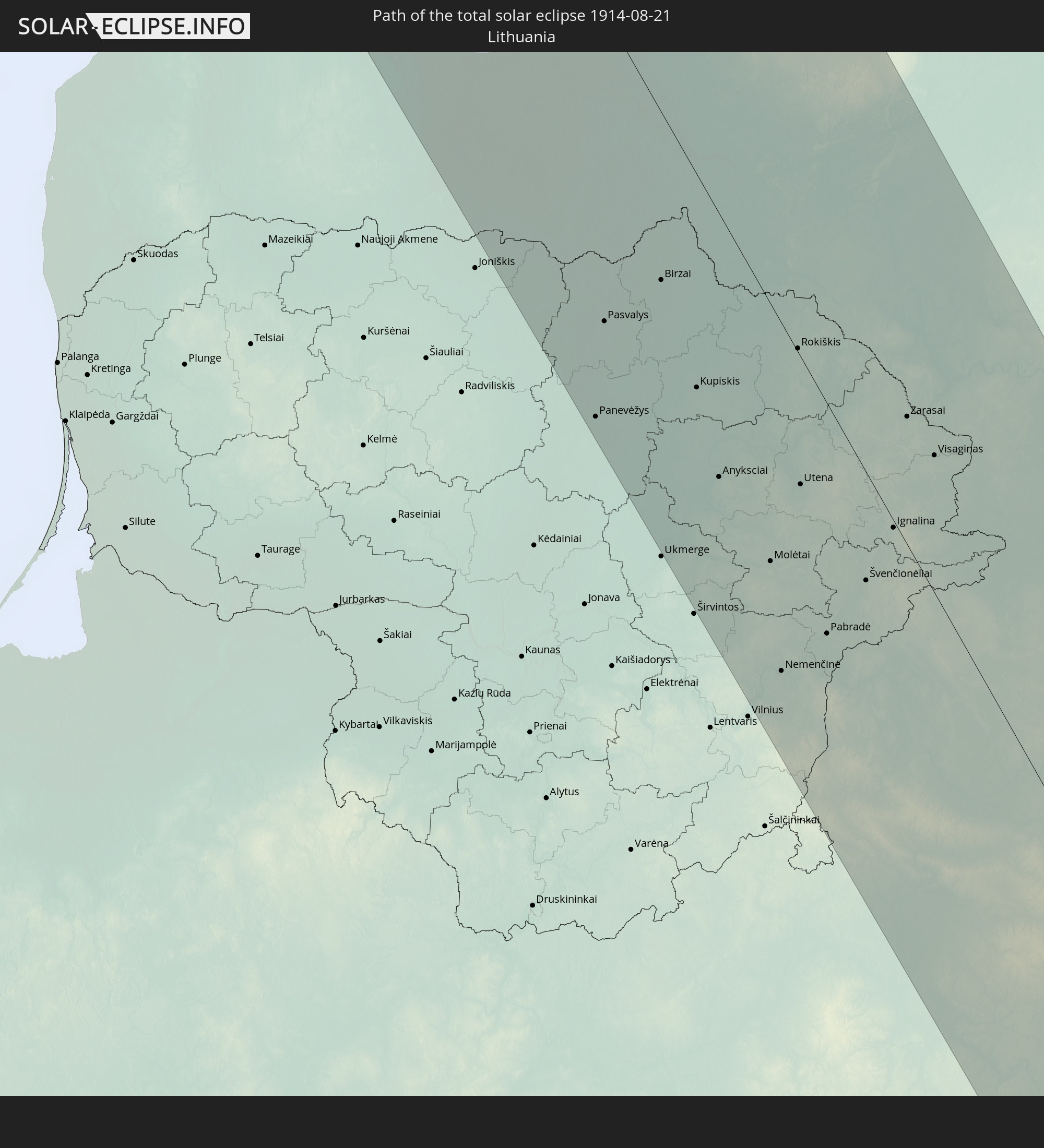 Litauen
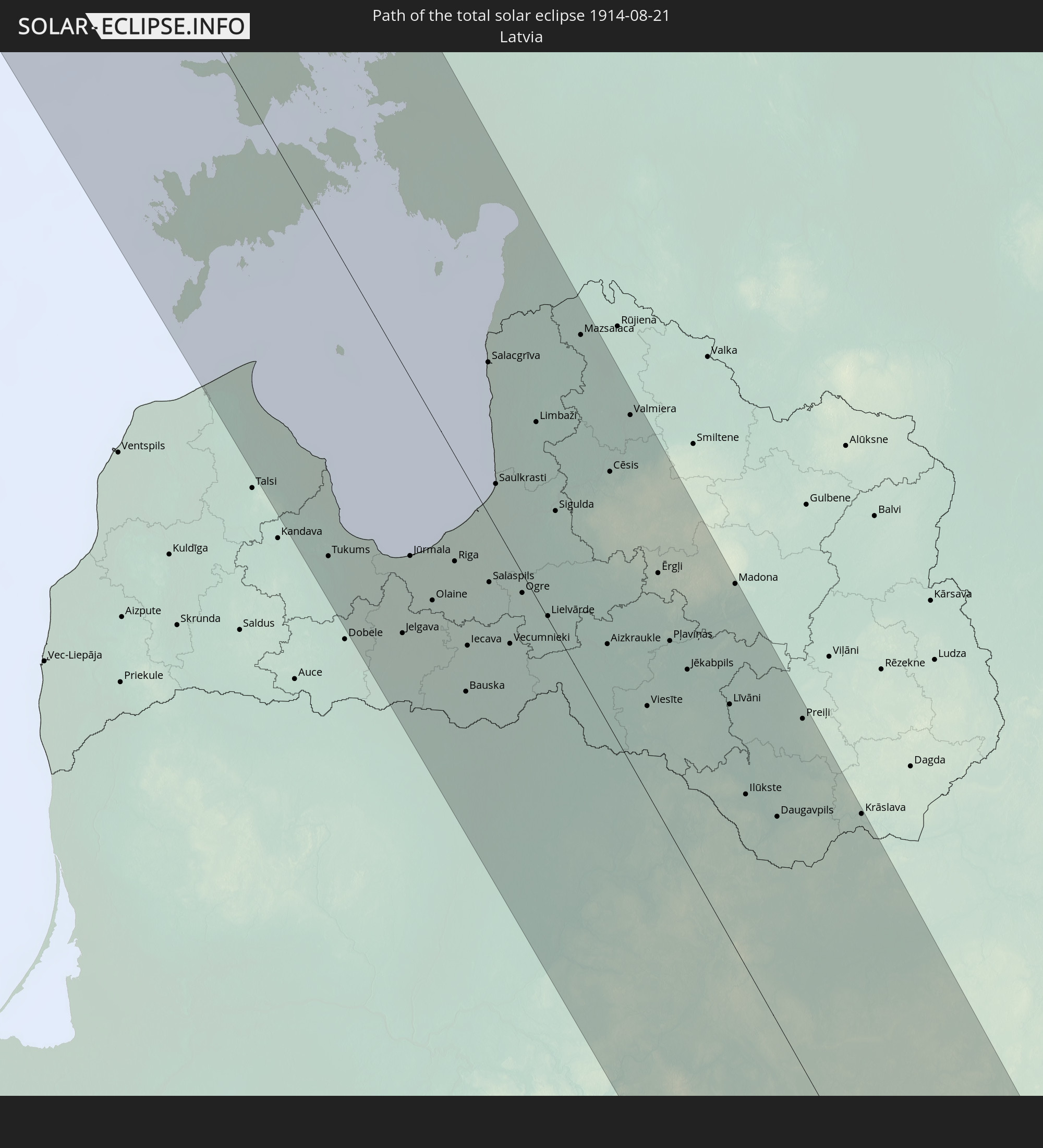 Lettland
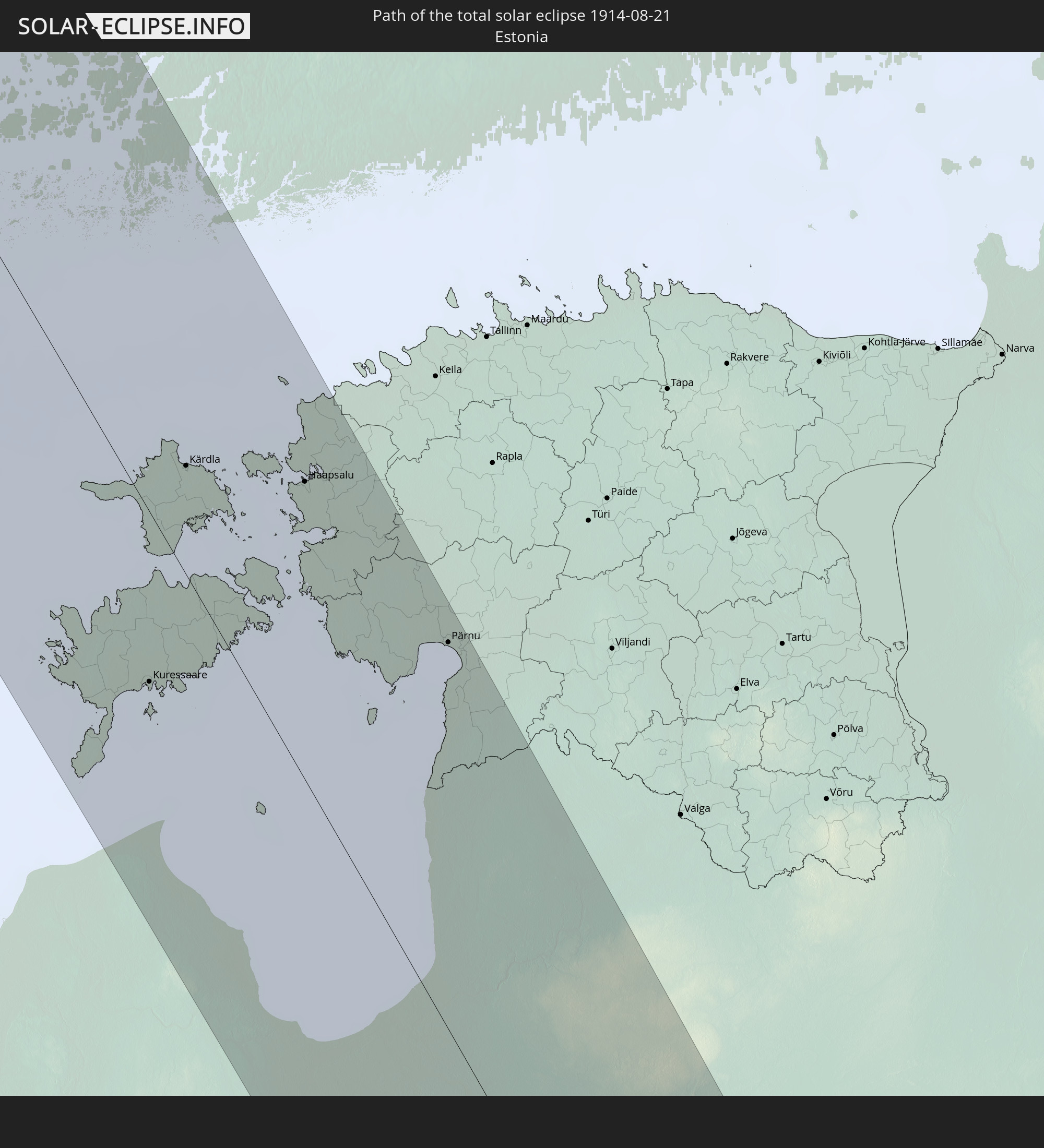 Estland
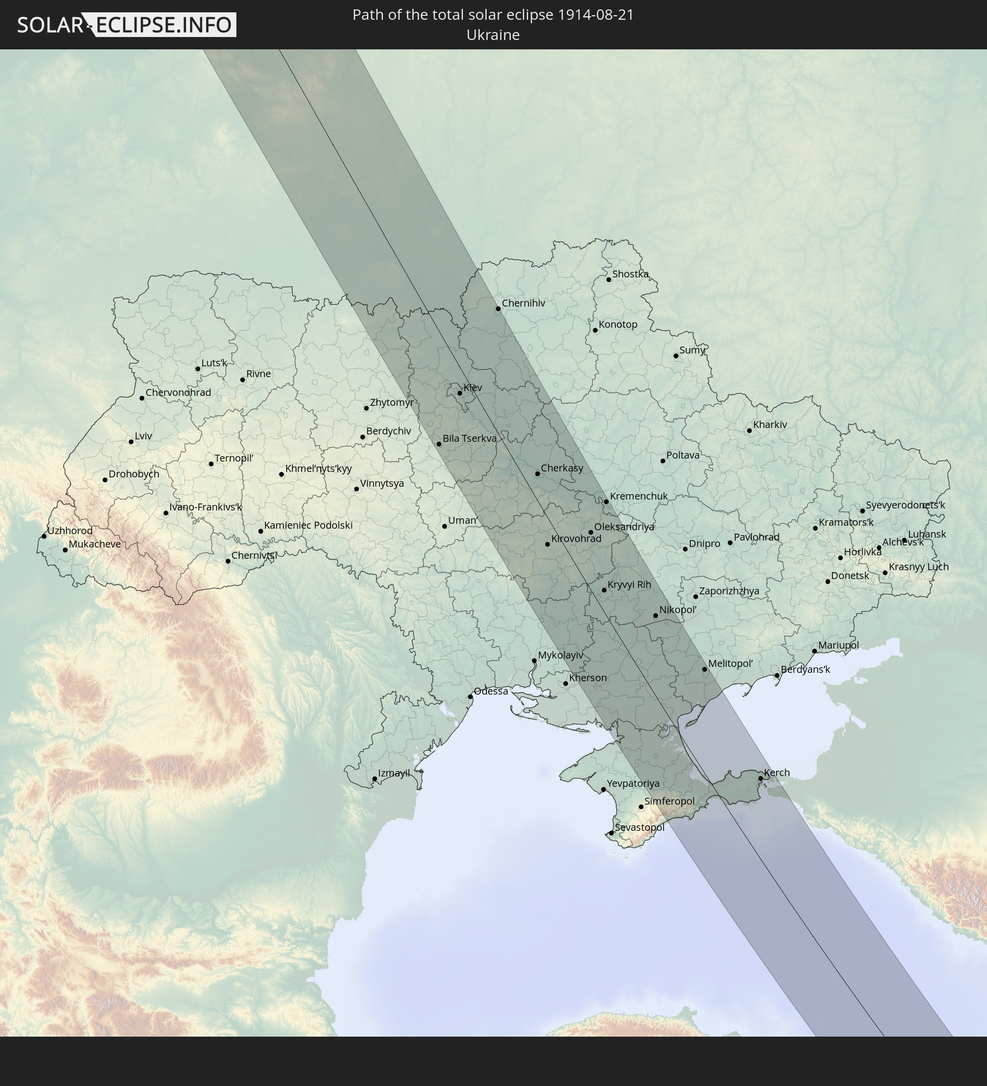 Ukraine
 Weißrussland
 Türkei
 Syrien
 Irak
Irak
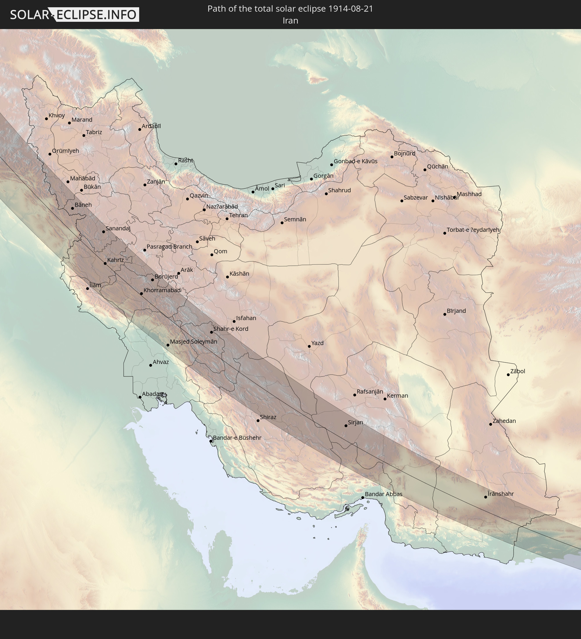 Iran
Iran
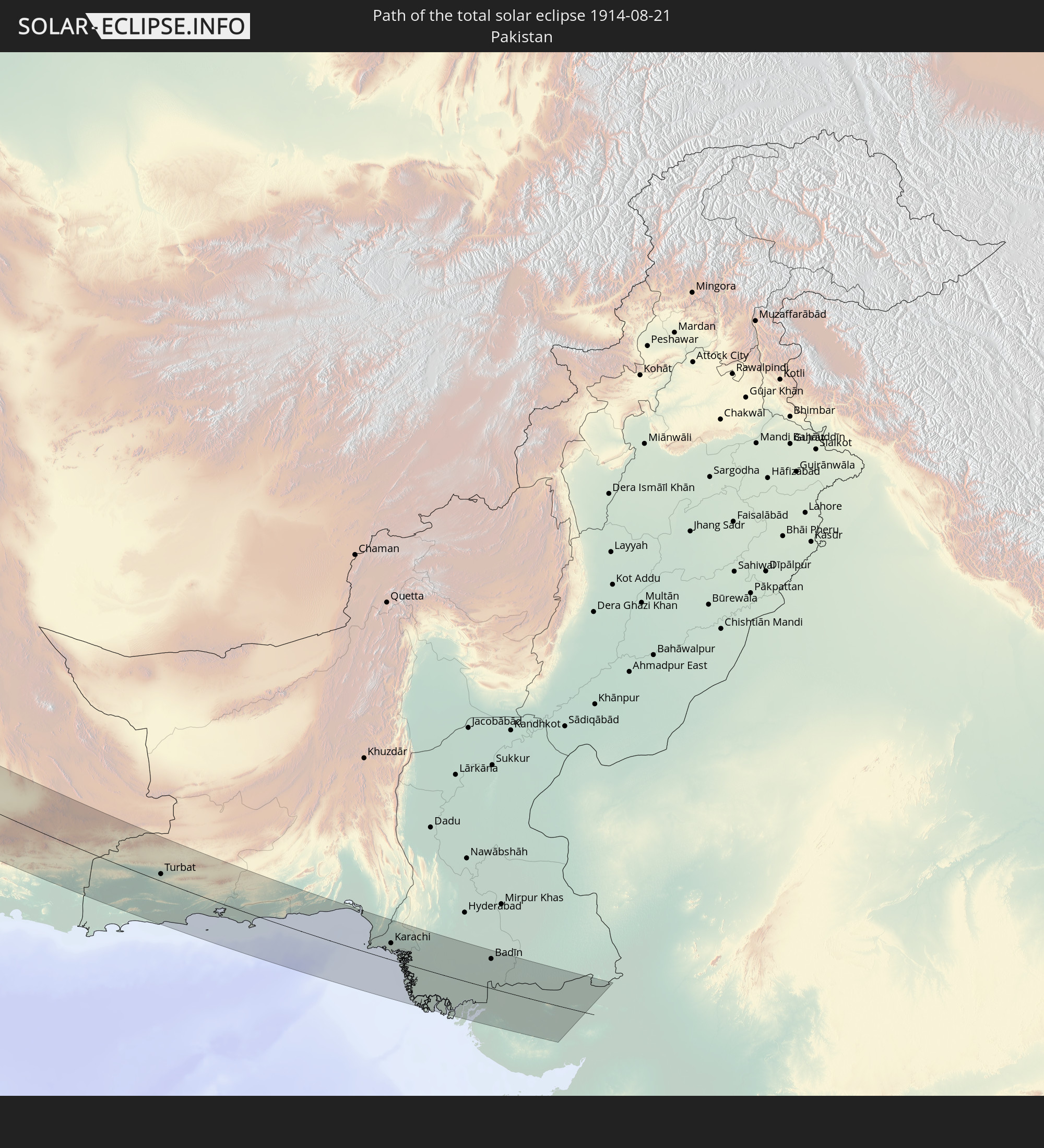 Pakistan
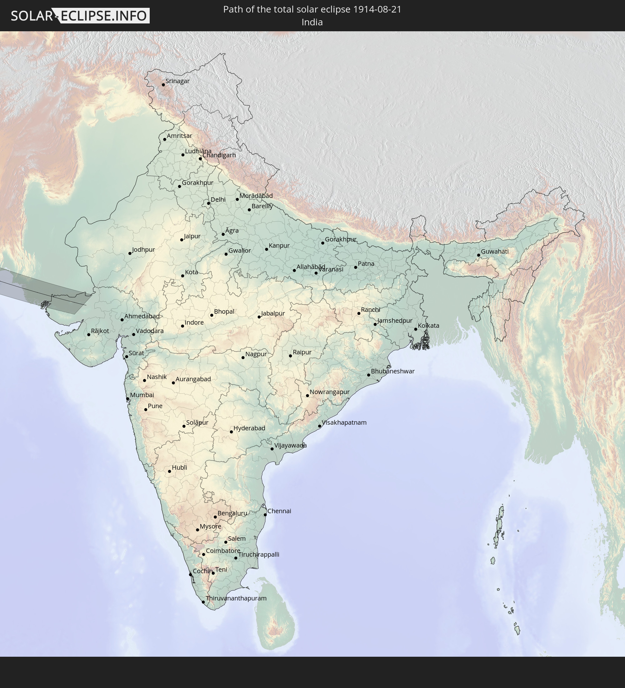 Indien
In den folgenden Ländern ist die Sonnenfinsternis partiell zu sehen
 Russland
 Vereinigte Staaten
 Kanada
 Grönland
 Saint-Pierre und Miquelon
 Portugal
 Island
 Spanien
 Marokko
 Mali
Mali
 Irland
 Spitzbergen
 Algerien
 Vereinigtes Königreich
 Färöer
 Gibraltar
 Frankreich
 Isle of Man
 Guernsey
 Jersey
 Niger
Niger
 Andorra
 Belgien
 Nigeria
 Niederlande
 Norwegen
 Luxemburg
 Deutschland
 Schweiz
 Italien
 Monaco
 Tunesien
 Dänemark
 Kamerun
 Libyen
 Liechtenstein
 Österreich
 Schweden
 Republik Kongo
 Tschechien
 Demokratische Republik Kongo
 San Marino
 Vatikanstadt
 Slowenien
 Tschad
 Kroatien
 Polen
Polen
 Malta
Malta
 Zentralafrikanische Republik
 Bosnien und Herzegowina
 Ungarn
 Slowakei
 Montenegro
 Serbien
 Albanien
 Åland Islands
 Griechenland
 Rumänien
 Mazedonien
 Finnland
 Litauen
 Lettland
 Estland
 Sudan
Sudan
 Ukraine
 Bulgarien
 Weißrussland
 Ägypten
 Türkei
 Moldawien
 Ruanda
 Burundi
 Tansania
 Uganda
 Republik Zypern
 Äthiopien
 Kenia
Kenia
 Staat Palästina
 Israel
 Saudi-Arabien
 Jordanien
 Libanon
 Syrien
 Eritrea
 Irak
Irak
 Georgien
 Somalia
 Dschibuti
 Jemen
Jemen
 Armenien
 Iran
Iran
 Aserbaidschan
 Seychellen
 Kasachstan
 Kuwait
 Bahrain
 Katar
Katar
 Vereinigte Arabische Emirate
 Oman
Oman
 Turkmenistan
 Usbekistan
 Afghanistan
 Pakistan
 Tadschikistan
 Indien
 Kirgisistan
 Volksrepublik China
 Mongolei
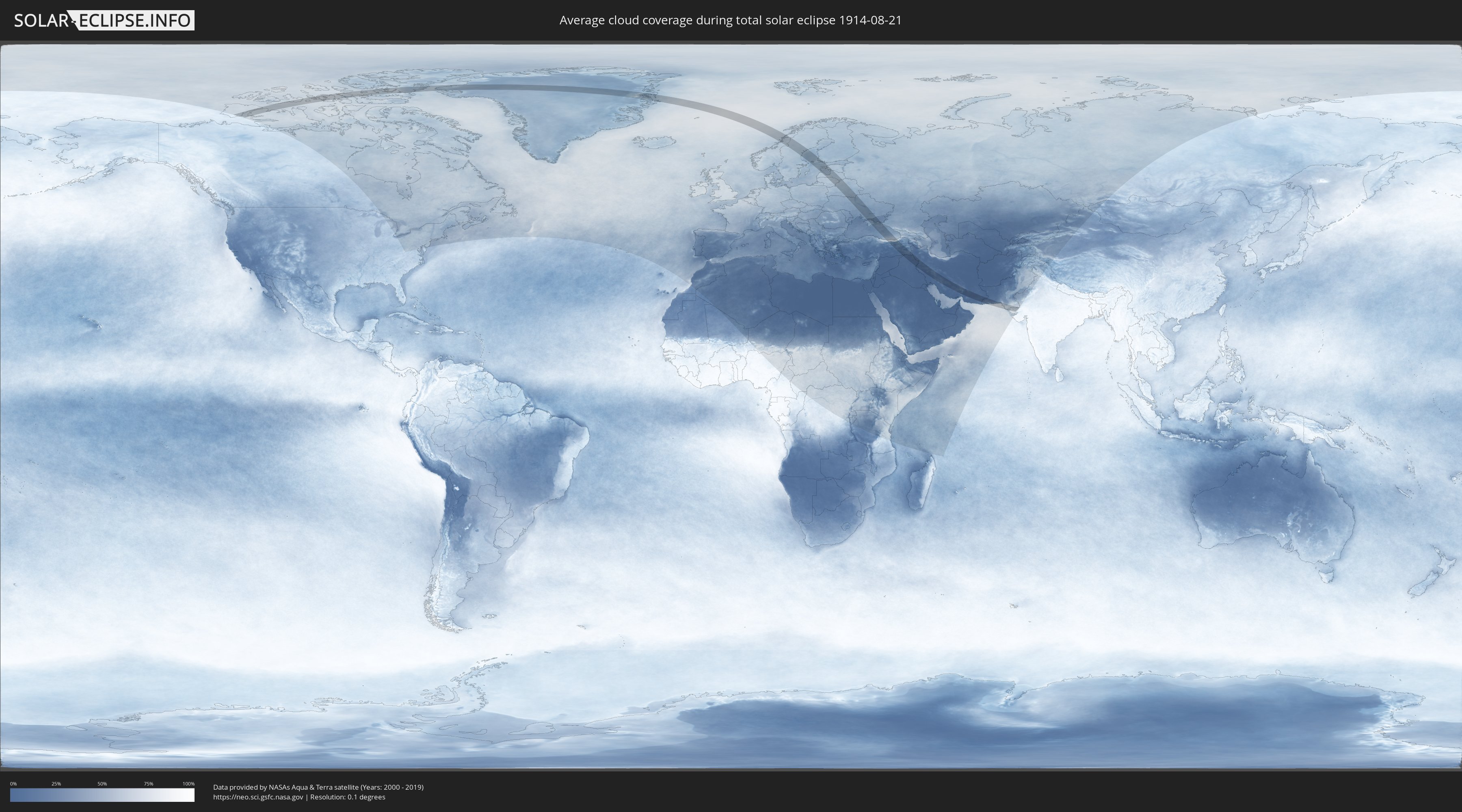
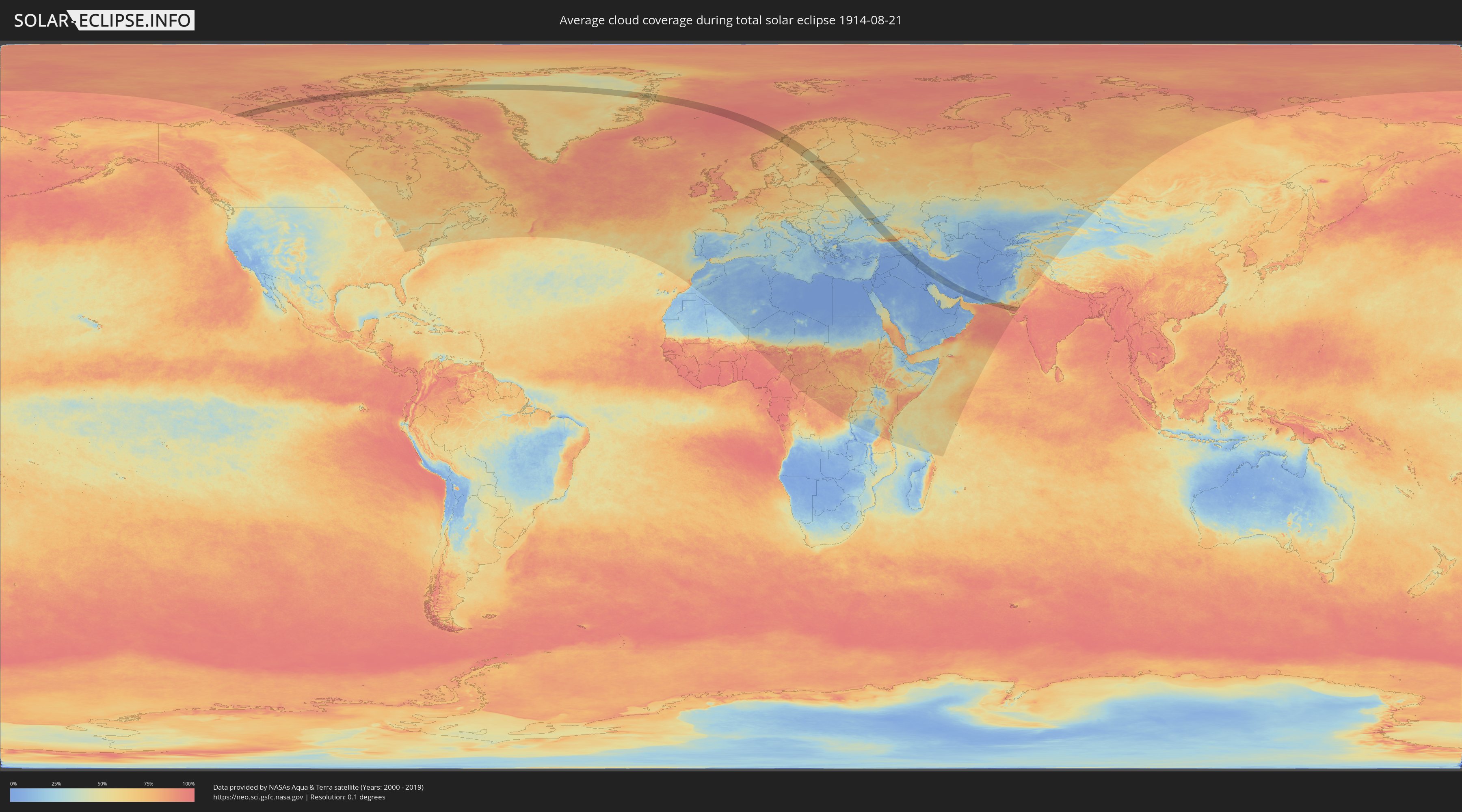
Wie wird das Wetter während der totalen Sonnenfinsternis am 21.08.1914?
Wo ist der beste Ort, um die totale Sonnenfinsternis vom 21.08.1914 zu beobachten?
Die folgenden Karten zeigen die durchschnittliche Bewölkung für den Tag, an dem die totale Sonnenfinsternis
stattfindet. Mit Hilfe der Karten lässt sich der Ort entlang des Finsternispfades eingrenzen,
der die besten Aussichen auf einen klaren wolkenfreien Himmel bietet.
Trotzdem muss man immer lokale Gegenenheiten beachten und sollte sich genau über das Wetter an seinem
gewählten Beobachtungsort informieren.
Die Daten stammen von den beiden NASA-Satelliten
AQUA und TERRA
und wurden über einen Zeitraum von 19 Jahren (2000 - 2019) gemittelt.
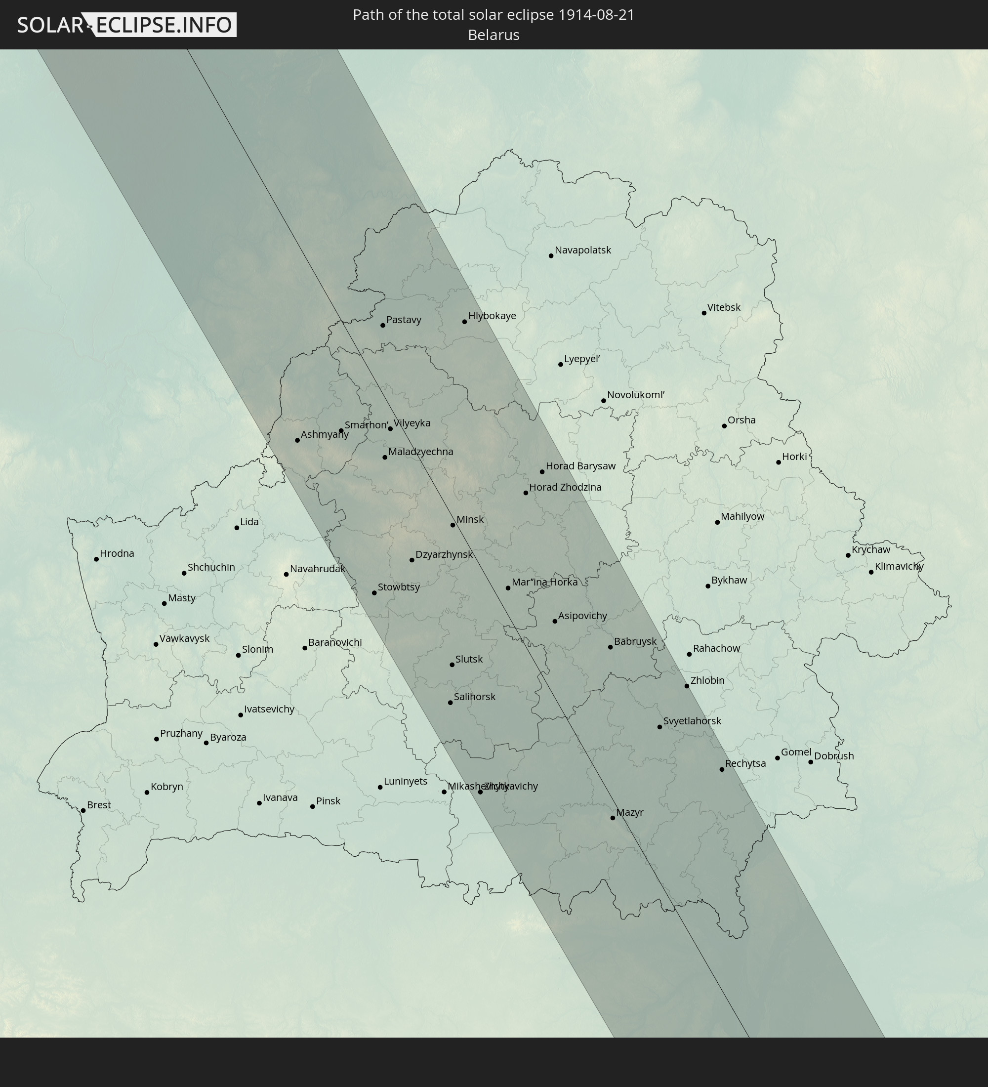
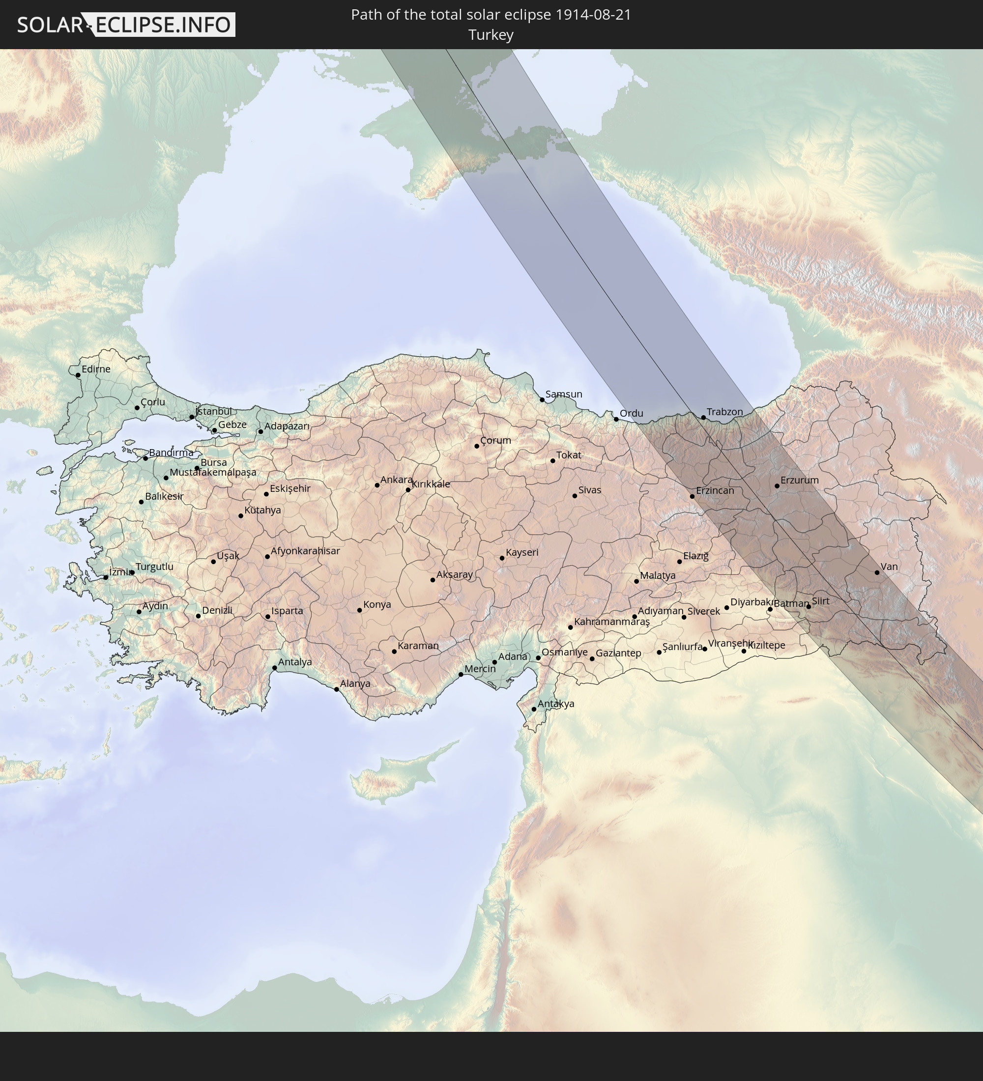
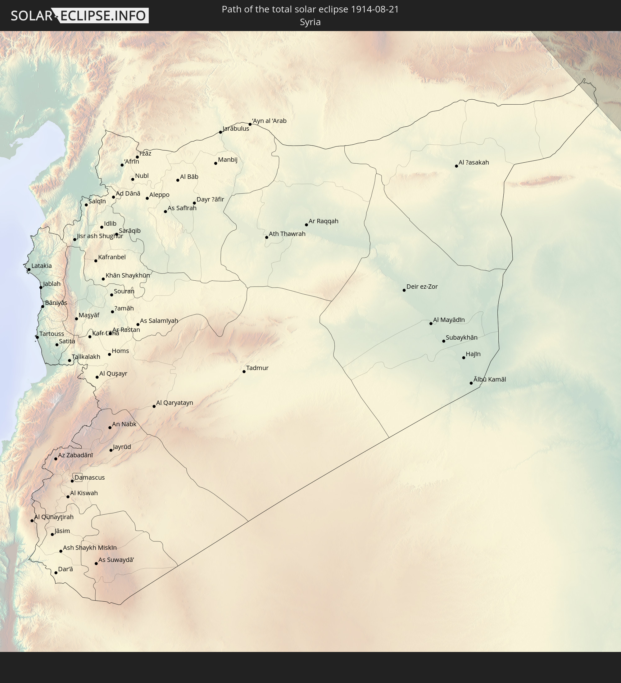
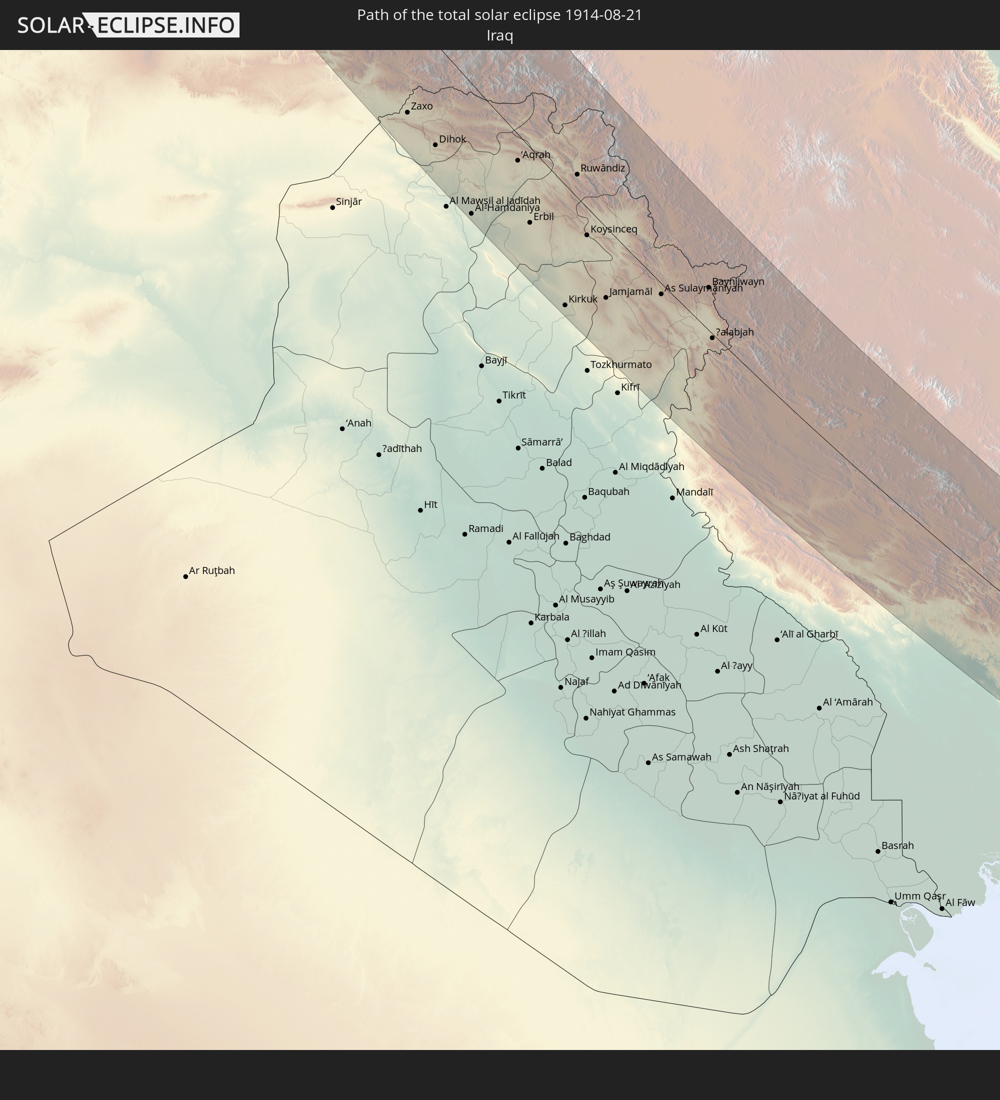
Detaillierte Länderkarten
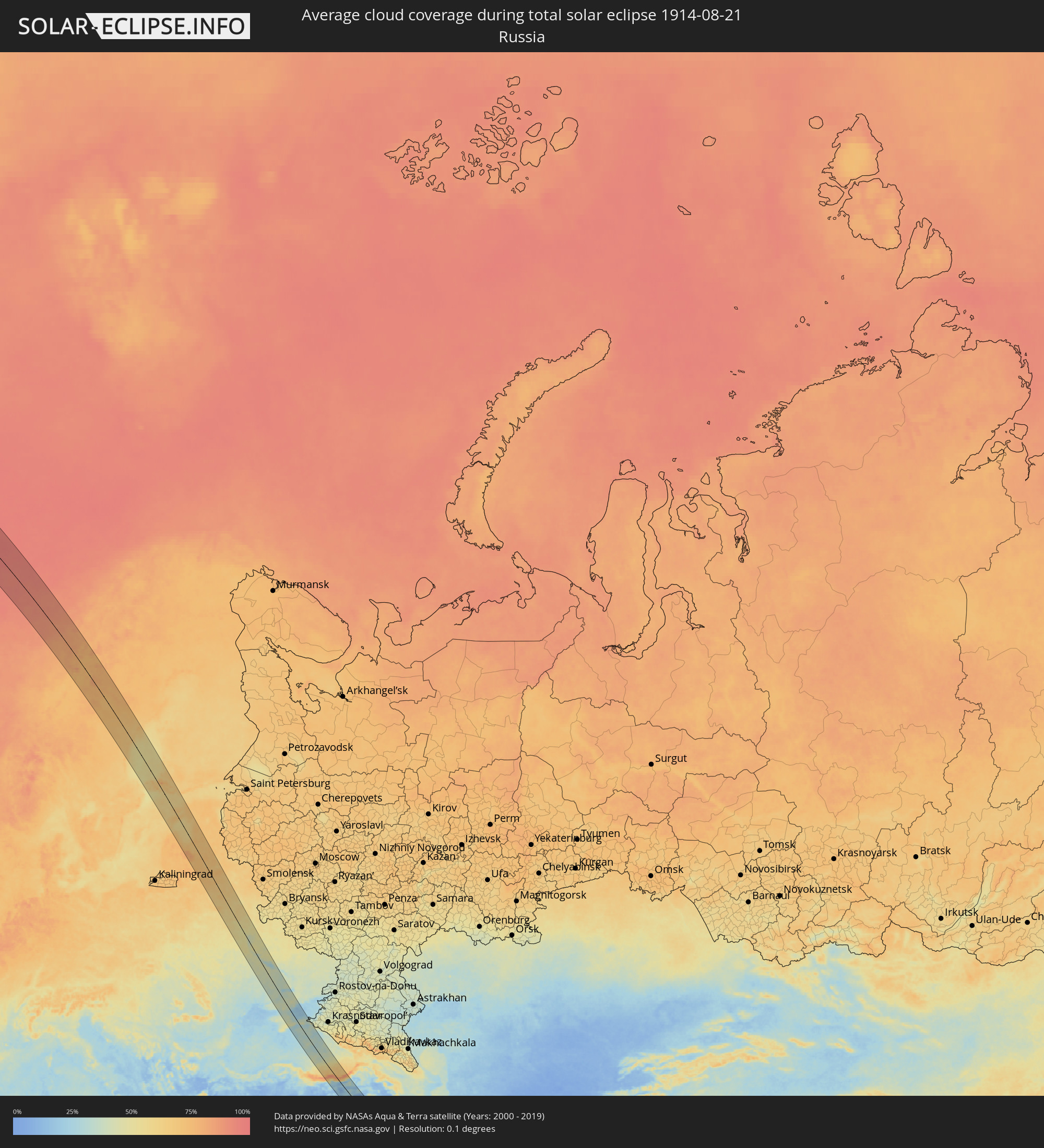 Russland
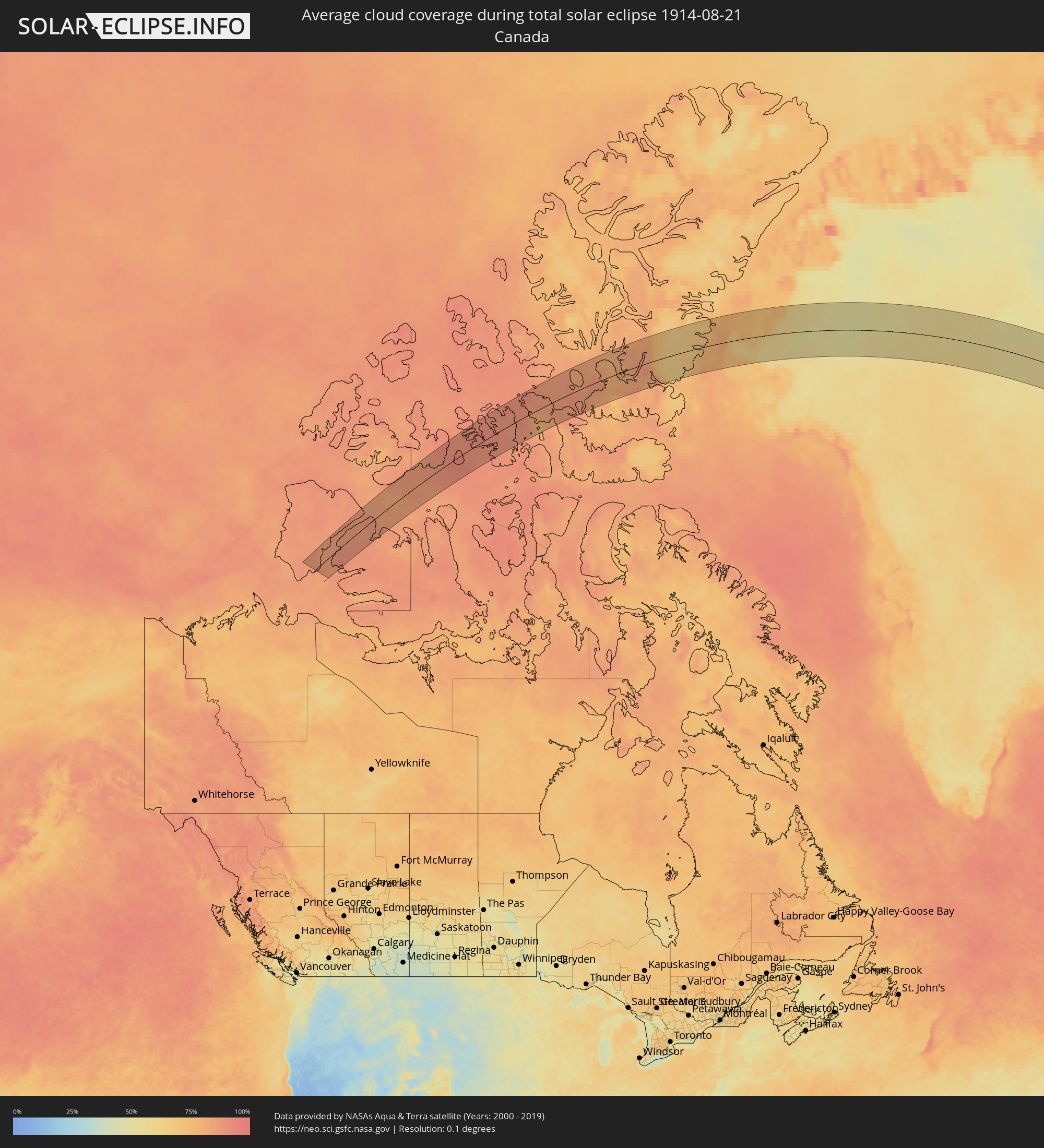 Kanada
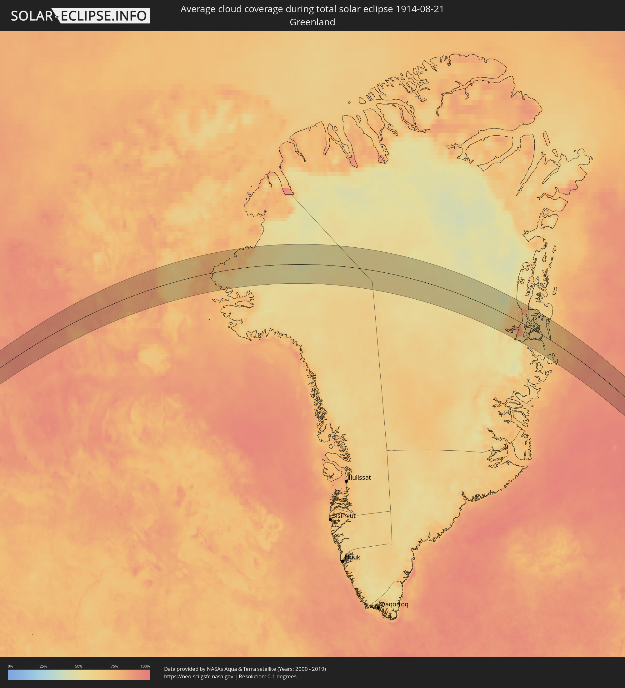 Grönland
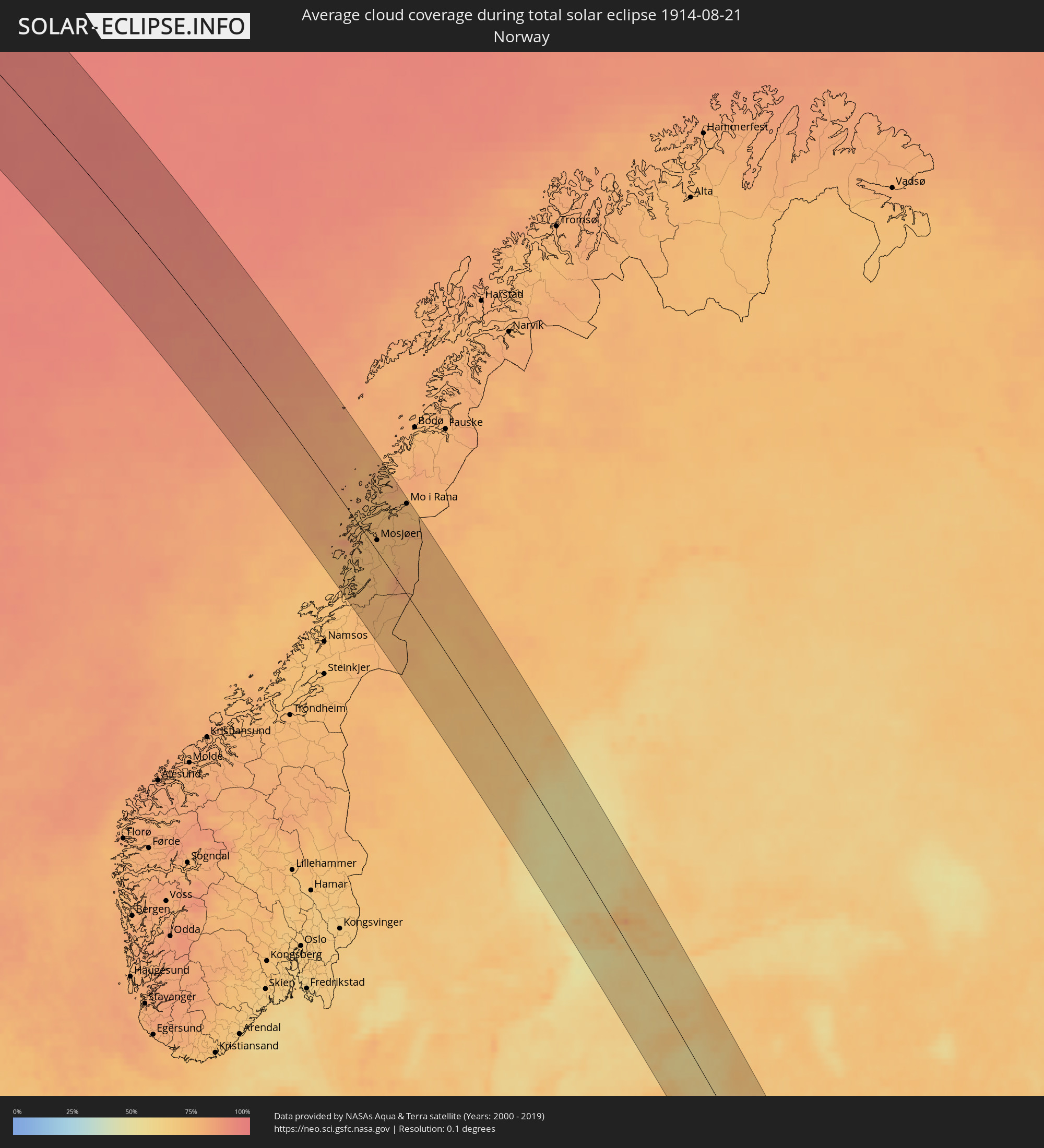 Norwegen
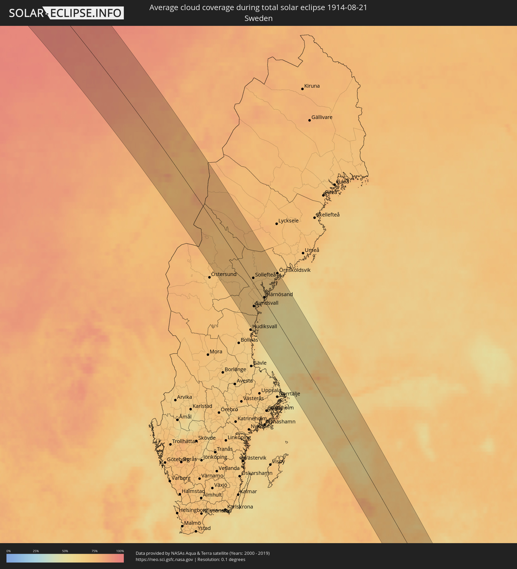 Schweden
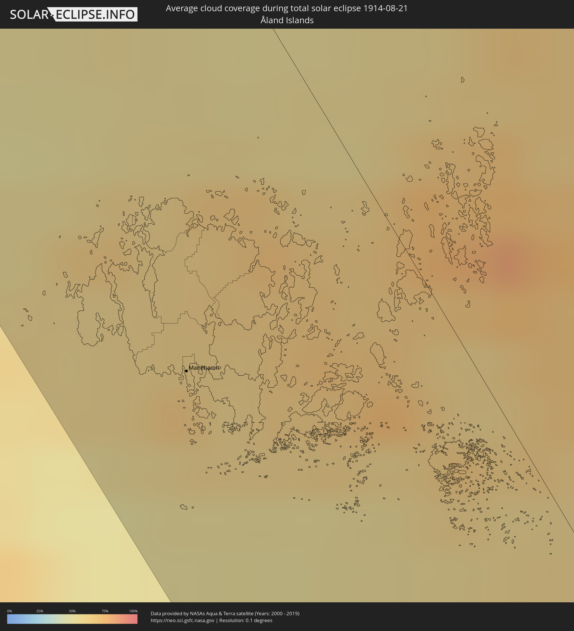 Åland Islands
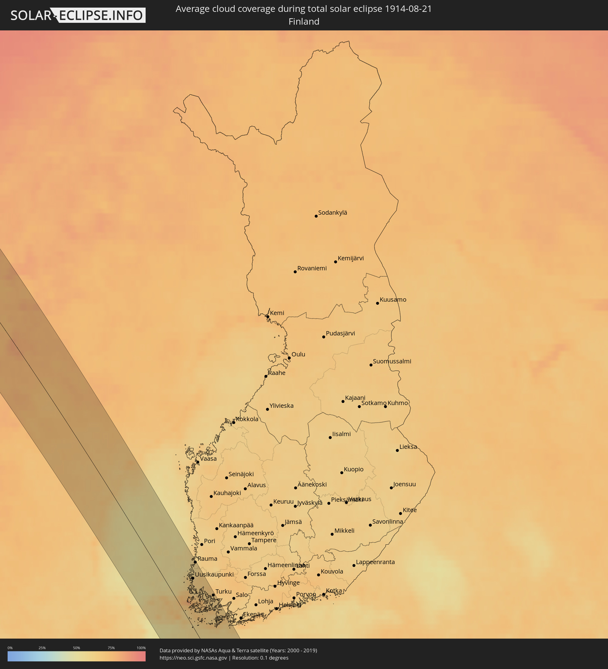 Finnland
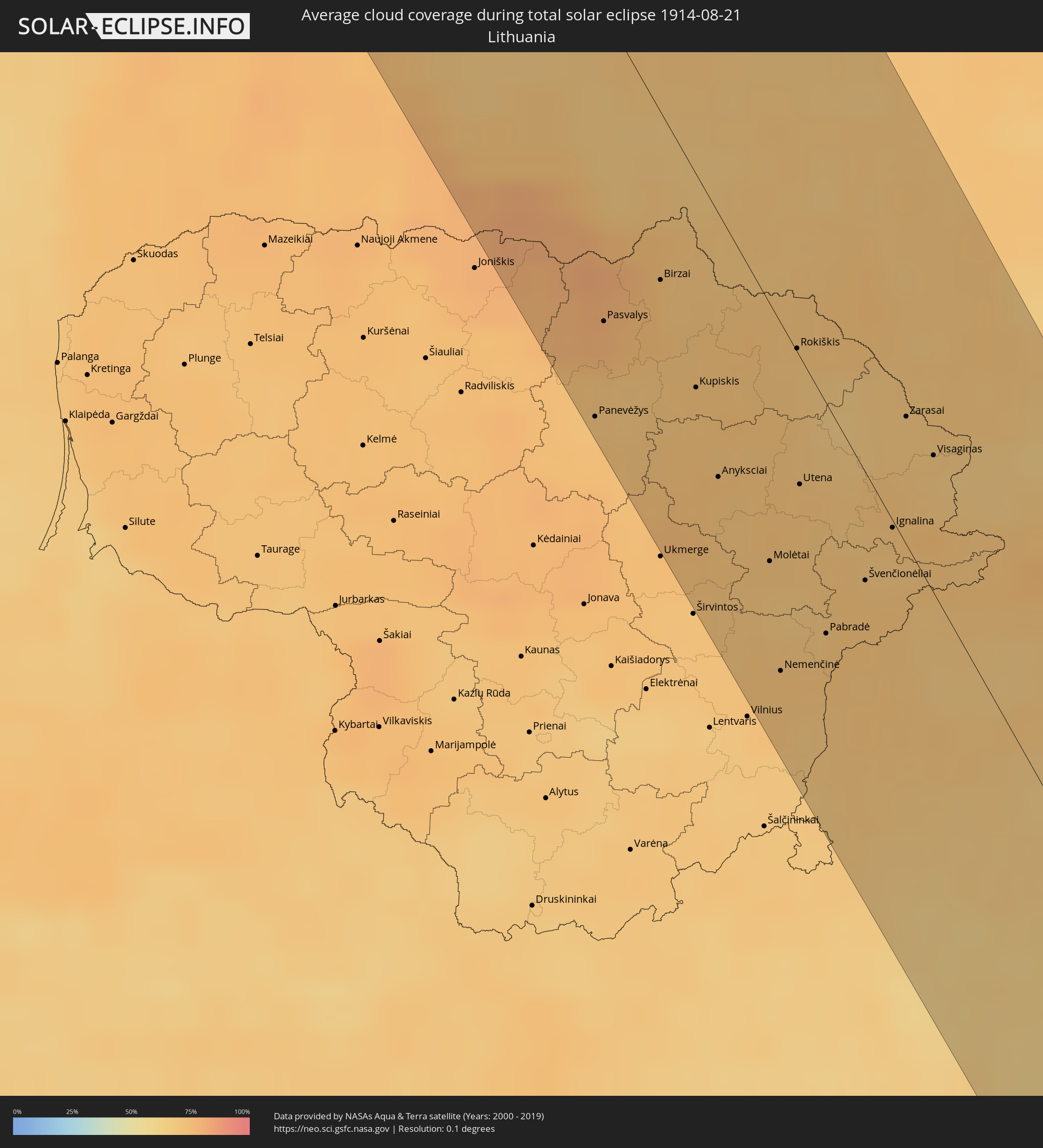 Litauen
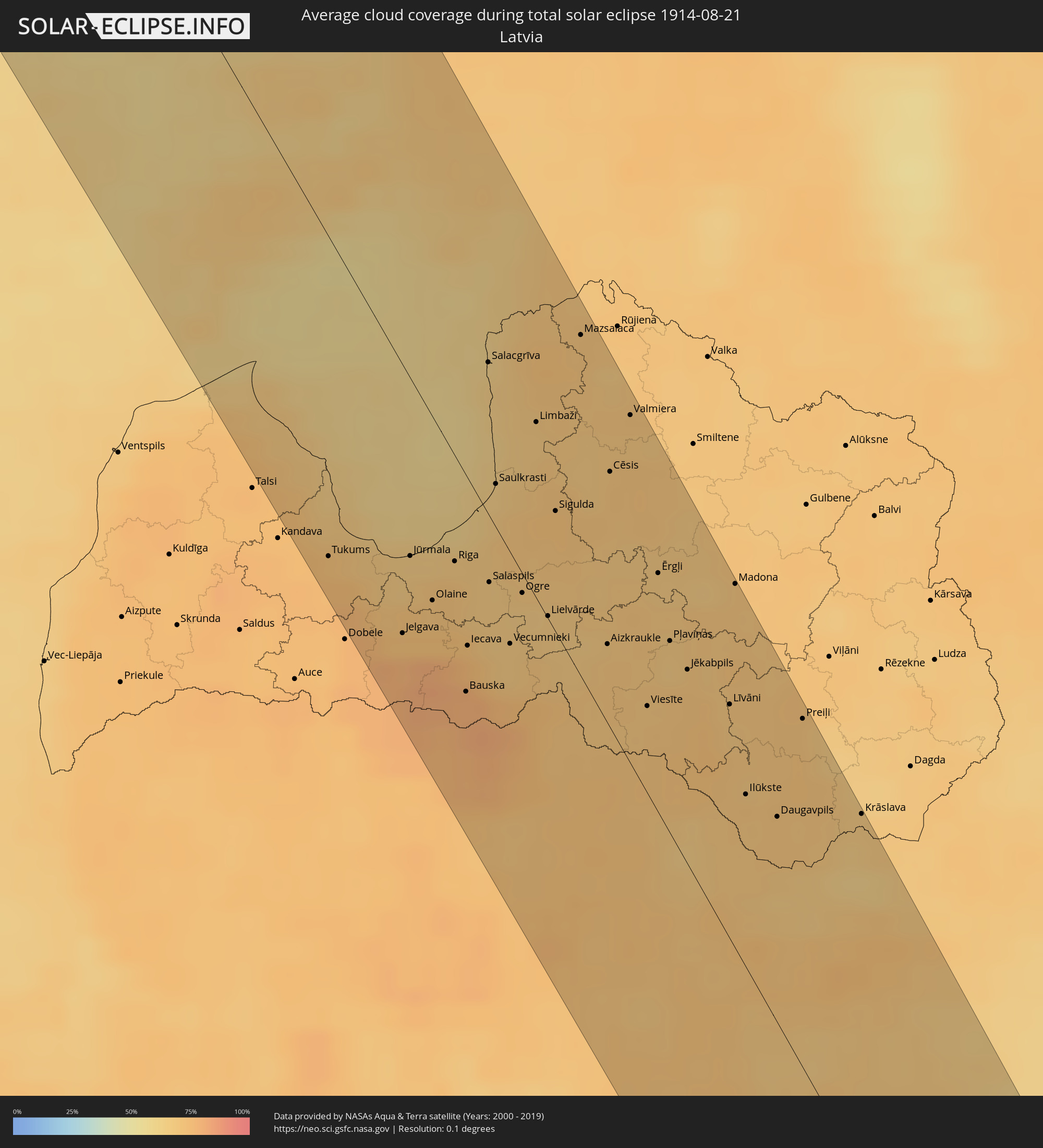 Lettland
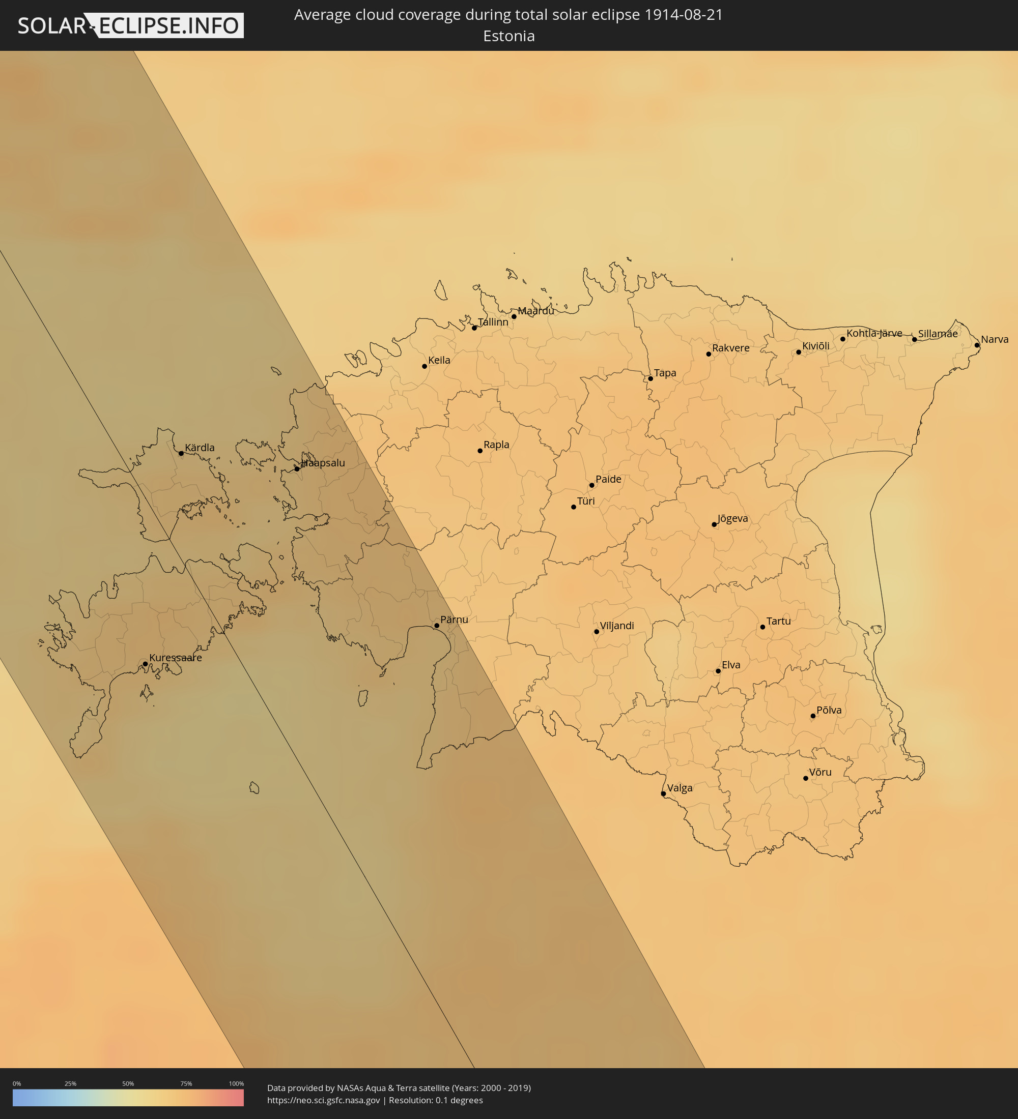 Estland
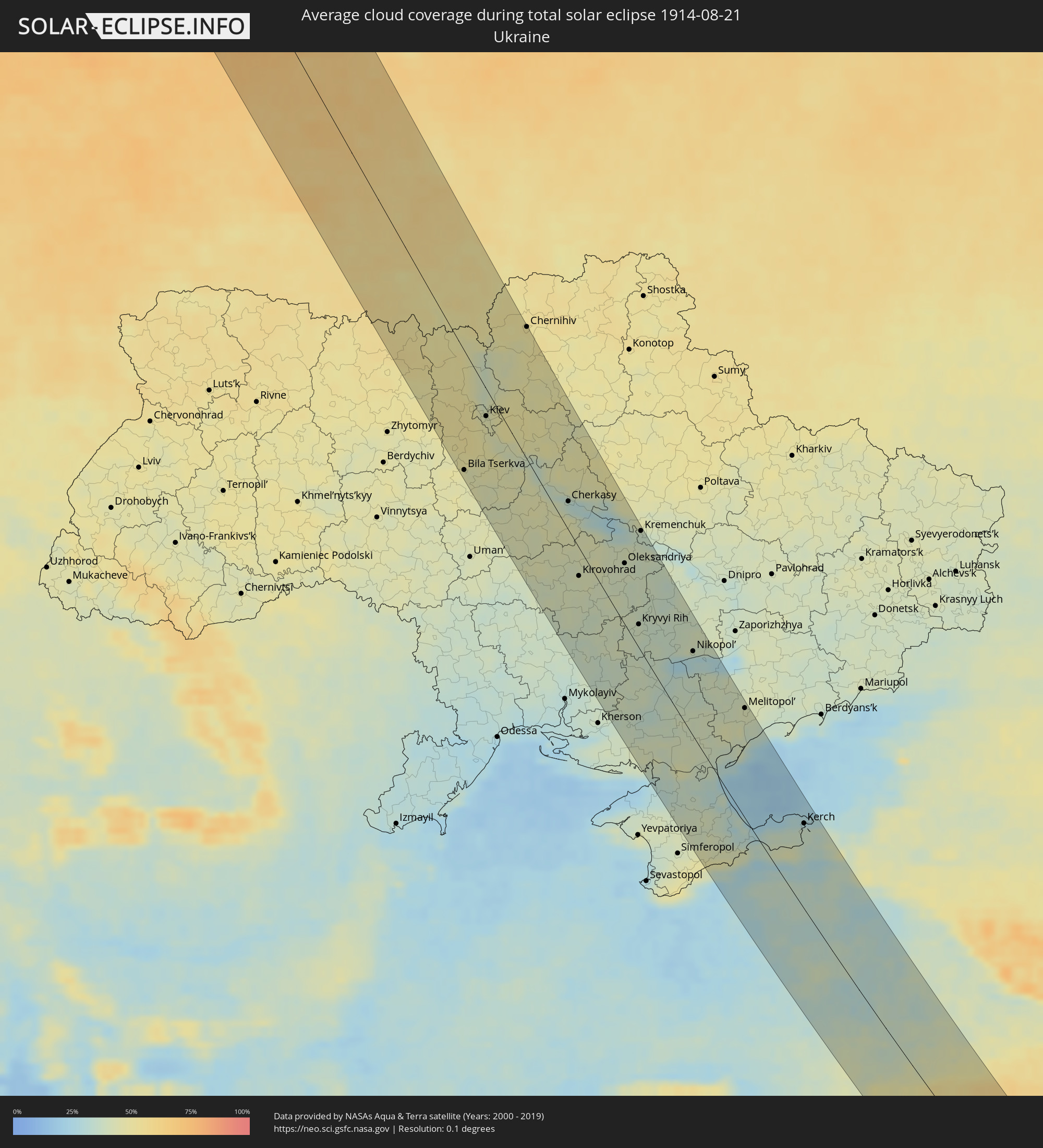 Ukraine
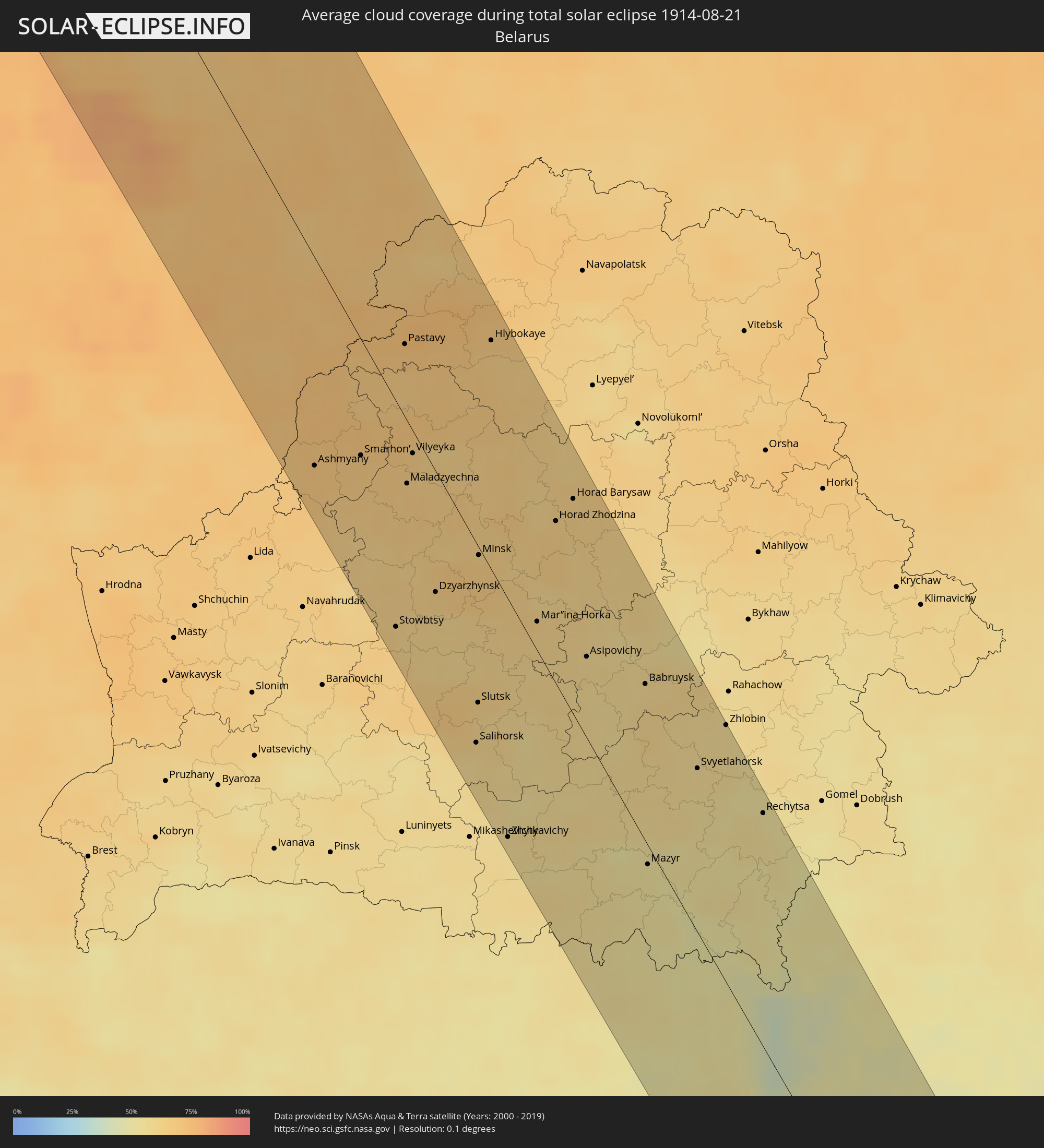 Weißrussland
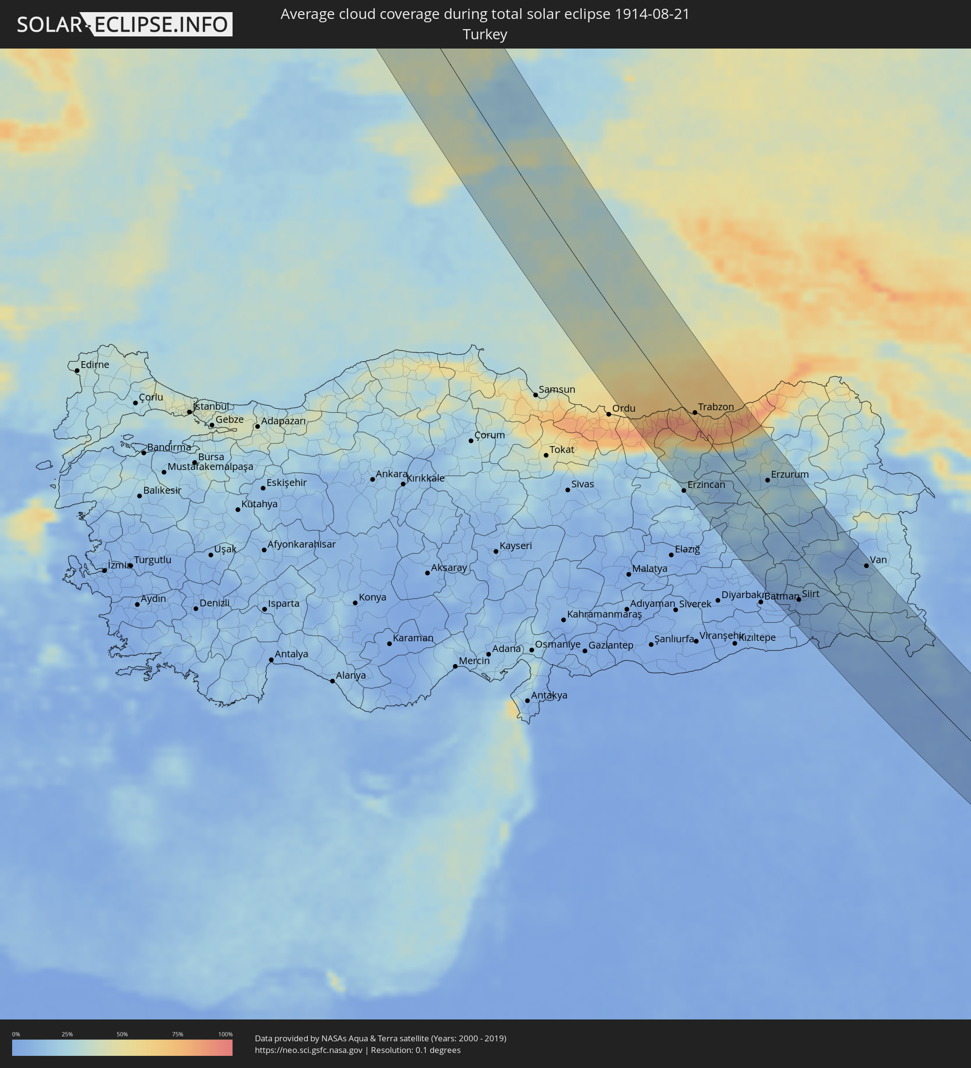 Türkei
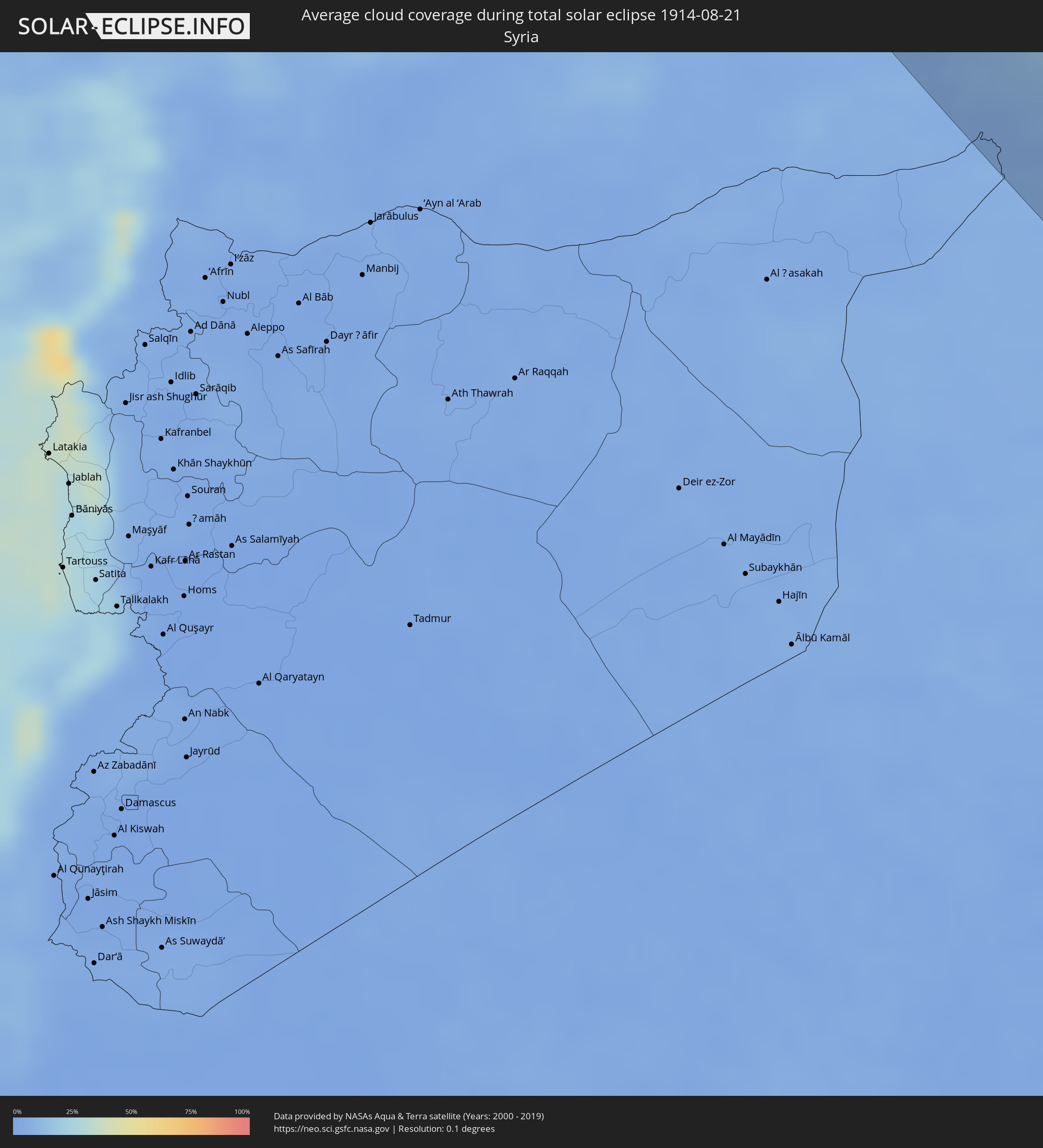 Syrien
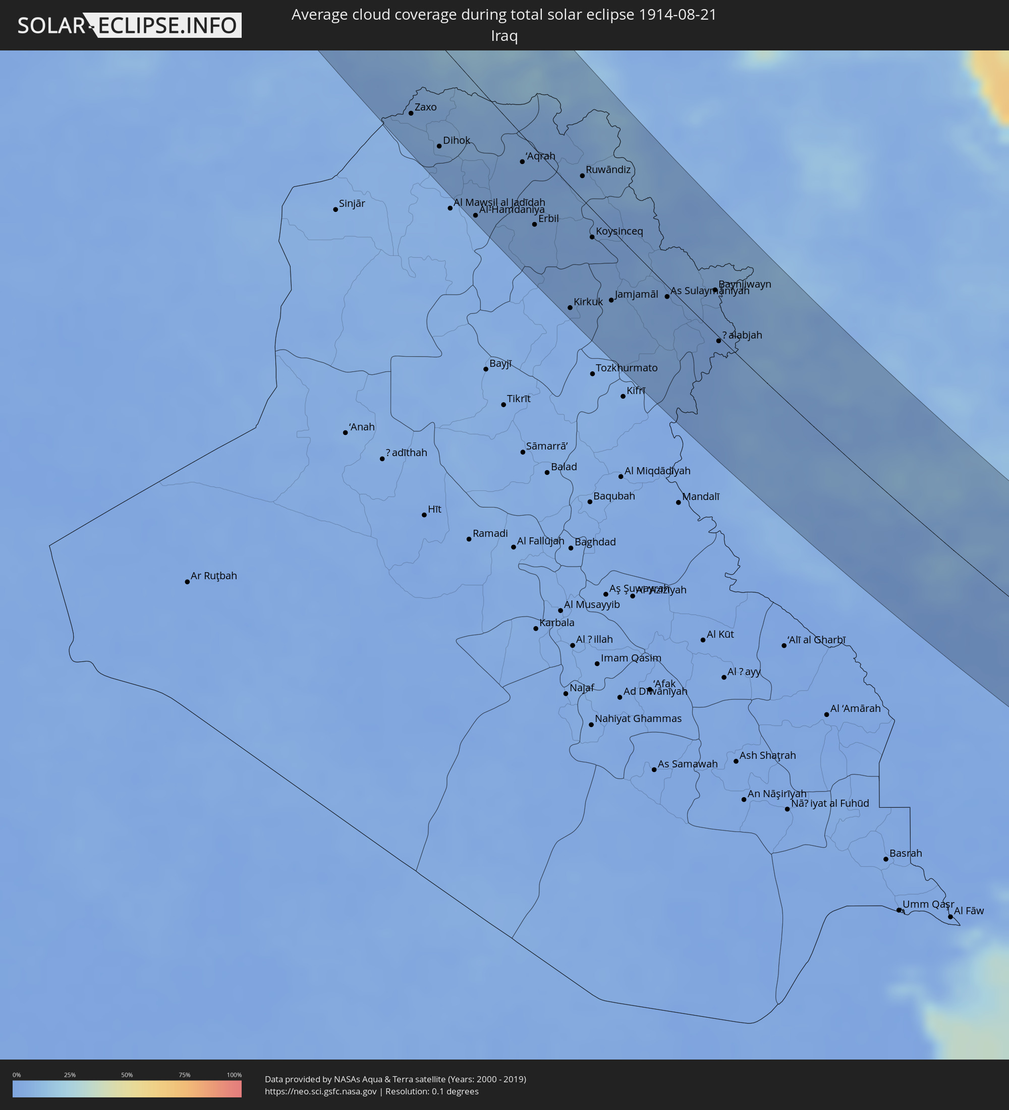 Irak
Irak
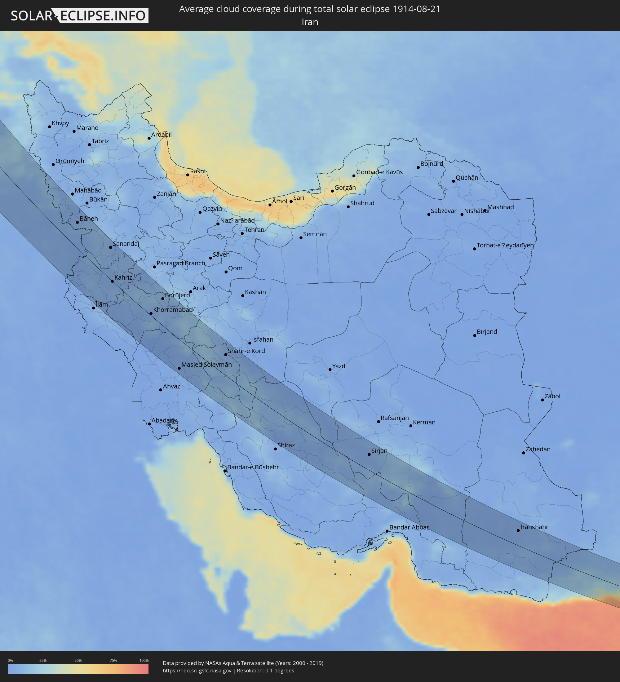 Iran
Iran
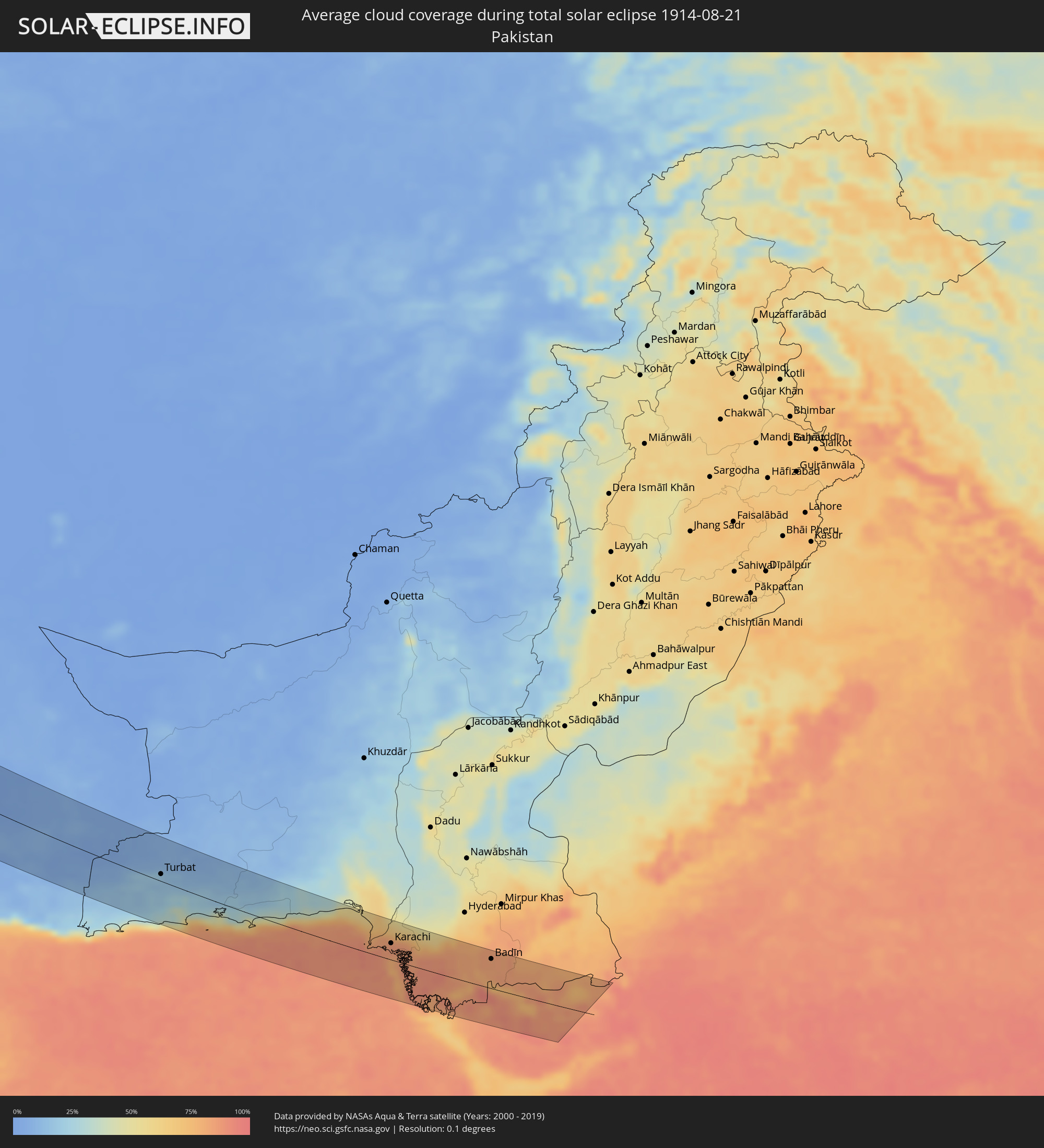 Pakistan
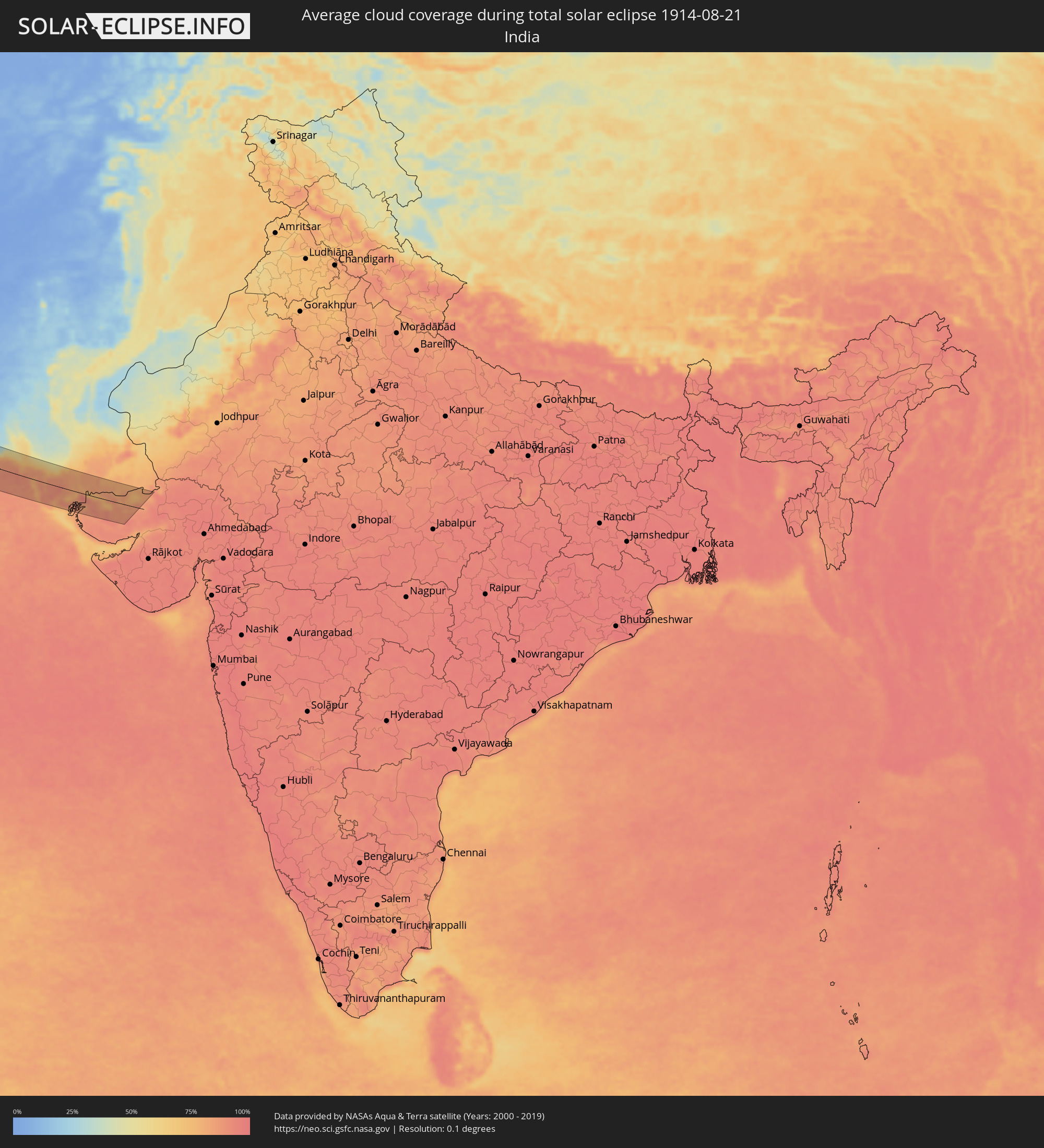 Indien
Orte im Finsternispfad
Die nachfolgene Tabelle zeigt Städte und Orte mit mehr als 5.000 Einwohnern, die sich im Finsternispfad befinden. Städte mit mehr als 100.000 Einwohnern sind dick gekennzeichnet. Mit einem Klick auf den Ort öffnet sich eine Detailkarte die die Lage des jeweiligen Ortes zusammen mit dem Verlauf der zentralen Finsternis präsentiert.
| Ort | Typ | Dauer der Verfinsterung | Ortszeit bei maximaler Verfinsterung | Entfernung zur Zentrallinie | Ø Bewölkung |
|
Sandnessjøen, Nordland
|
total | - | 13:05:56 UTC+01:00 | 10 km | 75% |
|
Mosjøen, Nordland
|
total | - | 13:06:32 UTC+01:00 | 9 km | 75% |
|
Mo i Rana, Nordland
|
total | - | 13:06:41 UTC+01:00 | 77 km | 75% |
|
Sollefteå, Västernorrland
|
total | - | 13:12:47 UTC+01:00 | 14 km | 68% |
|
Sundsvall, Västernorrland
|
total | - | 13:13:51 UTC+01:00 | 38 km | 68% |
|
Timrå, Västernorrland
|
total | - | 13:13:44 UTC+01:00 | 35 km | 68% |
|
Kramfors, Västernorrland
|
total | - | 13:13:29 UTC+01:00 | 16 km | 65% |
|
Härnösand, Västernorrland
|
total | - | 13:14:01 UTC+01:00 | 16 km | 67% |
|
Örnsköldsvik, Västernorrland
|
total | - | 13:13:43 UTC+01:00 | 78 km | 68% |
|
Mariehamn, Mariehamns stad
|
total | - | 13:59:00 UTC+01:39 | 59 km | 66% |
|
Uusikaupunki, Southwest Finland
|
total | - | 13:59:07 UTC+01:39 | 57 km | 63% |
|
Rauma, Satakunta
|
total | - | 13:58:42 UTC+01:39 | 84 km | 60% |
|
Laitila, Southwest Finland
|
total | - | 13:59:13 UTC+01:39 | 75 km | 67% |
|
Mynämäki, Southwest Finland
|
total | - | 13:59:45 UTC+01:39 | 82 km | 68% |
|
Naantali, Southwest Finland
|
total | - | 14:00:05 UTC+01:39 | 68 km | 64% |
|
Masku, Southwest Finland
|
total | - | 13:59:59 UTC+01:39 | 78 km | 66% |
|
Raisio, Southwest Finland
|
total | - | 14:00:10 UTC+01:39 | 75 km | 64% |
|
Turku, Southwest Finland
|
total | - | 14:00:18 UTC+01:39 | 78 km | 66% |
|
Länsi-Turunmaa, Southwest Finland
|
total | - | 14:00:33 UTC+01:39 | 74 km | 62% |
|
Pargas, Southwest Finland
|
total | - | 14:00:33 UTC+01:39 | 74 km | 62% |
|
Kaarina, Southwest Finland
|
total | - | 14:00:27 UTC+01:39 | 81 km | 63% |
|
Kuressaare, Saare
|
total | - | 14:03:06 UTC+01:39 | 33 km | 63% |
|
Kärdla, Hiiumaa
|
total | - | 14:02:06 UTC+01:39 | 22 km | 66% |
|
Hanko, Uusimaa
|
total | - | 14:01:46 UTC+01:39 | 81 km | 63% |
|
Tukums, Tukuma Rajons
|
total | - | 14:03:16 UTC+01:36 | 76 km | 71% |
|
Haapsalu, Lääne
|
total | - | 14:02:49 UTC+01:39 | 61 km | 62% |
|
Jelgava, Jelgava
|
total | - | 14:04:15 UTC+01:36 | 62 km | 72% |
|
Jūrmala, Jūrmala
|
total | - | 14:03:47 UTC+01:36 | 44 km | 66% |
|
Olaine, Olaine
|
total | - | 14:04:13 UTC+01:36 | 42 km | 70% |
|
Riga, Riga
|
total | - | 14:04:05 UTC+01:36 | 25 km | 70% |
|
Bauska, Bauskas Rajons
|
total | - | 14:05:03 UTC+01:36 | 51 km | 79% |
|
Panevėžys, Panevėžys
|
total | - | 13:53:46 UTC+01:24 | 79 km | 73% |
|
Salaspils, Salaspils
|
total | - | 14:04:26 UTC+01:36 | 18 km | 67% |
|
Pasvalys, Panevėžys
|
total | - | 13:53:15 UTC+01:24 | 64 km | 77% |
|
Pärnu, Pärnumaa
|
total | - | 14:04:28 UTC+01:39 | 77 km | 63% |
|
Ogre, Ogre
|
total | - | 14:04:43 UTC+01:36 | 22 km | 67% |
|
Birzai, Panevėžys
|
total | - | 13:53:18 UTC+01:24 | 39 km | 70% |
|
Sigulda, Sigulda
|
total | - | 14:04:21 UTC+01:36 | 28 km | 72% |
|
Kupiskis
|
total | - | 13:54:06 UTC+01:24 | 40 km | 71% |
|
Anyksciai, Utena County
|
total | - | 13:54:44 UTC+01:24 | 57 km | 72% |
|
Cēsis, Cēsu Rajons
|
total | - | 14:04:24 UTC+01:36 | 58 km | 71% |
|
Molėtai, Utena County
|
total | - | 13:55:30 UTC+01:24 | 50 km | 69% |
|
Valmiera, Valmieras Rajons
|
total | - | 14:04:09 UTC+01:36 | 82 km | 69% |
|
Nemenčinė, Vilnius County
|
total | - | 13:56:13 UTC+01:24 | 68 km | 72% |
|
Rokiškis, Panevėžys
|
total | - | 13:54:22 UTC+01:24 | 9 km | 70% |
|
Utena, Utena County
|
total | - | 13:55:11 UTC+01:24 | 26 km | 71% |
|
Pabradė, Vilnius County
|
total | - | 13:56:13 UTC+01:24 | 48 km | 72% |
|
Jēkabpils, Jēkabpils Municipality
|
total | - | 14:06:14 UTC+01:36 | 53 km | 70% |
|
Švenčionėliai
|
total | - | 13:56:05 UTC+01:24 | 35 km | 70% |
|
Ignalina
|
total | - | 13:55:54 UTC+01:24 | 24 km | 71% |
|
Zarasai, Utena County
|
total | - | 13:55:18 UTC+01:24 | 27 km | 69% |
|
Smarhon’, Grodnenskaya
|
total | - | 14:23:36 UTC+01:50 | 39 km | 68% |
|
Visaginas, Utena County
|
total | - | 13:55:40 UTC+01:24 | 27 km | 67% |
|
Daugavpils, Daugavpils municipality
|
total | - | 14:07:50 UTC+01:36 | 51 km | 70% |
|
Maladzyechna, Minsk
|
total | - | 14:24:16 UTC+01:50 | 25 km | 66% |
|
Vilyeyka, Minsk
|
total | - | 14:24:00 UTC+01:50 | 7 km | 66% |
|
Krāslava, Krāslavas Rajons
|
total | - | 14:08:18 UTC+01:36 | 83 km | 67% |
|
Salihorsk, Minsk
|
total | - | 14:27:34 UTC+01:50 | 67 km | 58% |
|
Slutsk, Minsk
|
total | - | 14:27:09 UTC+01:50 | 59 km | 61% |
|
Minsk, Minsk City
|
total | - | 14:25:35 UTC+01:50 | 13 km | 66% |
|
Horad Zhodzina, Minsk
|
total | - | 14:25:50 UTC+01:50 | 55 km | 64% |
|
Horad Barysaw, Minsk
|
total | - | 14:25:44 UTC+01:50 | 70 km | 64% |
|
Asipovichy, Mogilev
|
total | - | 14:27:30 UTC+01:50 | 39 km | 59% |
|
Babruysk, Mogilev
|
total | - | 14:28:15 UTC+01:50 | 52 km | 60% |
|
Mazyr, Gomel
|
total | - | 14:30:17 UTC+01:50 | 25 km | 52% |
|
Svyetlahorsk, Gomel
|
total | - | 14:29:35 UTC+01:50 | 55 km | 56% |
|
Zhlobin, Gomel
|
total | - | 14:29:20 UTC+01:50 | 86 km | 57% |
|
Bila Tserkva, Kiev
|
total | - | 14:47:14 UTC+02:02 | 80 km | 44% |
|
Rechytsa, Gomel
|
total | - | 14:30:35 UTC+01:50 | 80 km | 52% |
|
Kiev, Kyiv City
|
total | - | 14:46:20 UTC+02:02 | 39 km | 46% |
|
Brovary, Kiev
|
total | - | 14:46:26 UTC+02:02 | 33 km | 49% |
|
Chernihiv, Chernihiv
|
total | - | 14:44:56 UTC+02:02 | 91 km | 49% |
|
Smila, Cherkasy
|
total | - | 14:49:43 UTC+02:02 | 12 km | 44% |
|
Cherkasy, Cherkasy
|
total | - | 14:49:28 UTC+02:02 | 32 km | 37% |
|
Kirovohrad, Kirovohrad
|
total | - | 14:51:22 UTC+02:02 | 20 km | 42% |
|
Oleksandriya, Kirovohrad
|
total | - | 14:51:42 UTC+02:02 | 46 km | 40% |
|
Kryvyi Rih, Dnipropetrovsk
|
total | - | 14:53:22 UTC+02:02 | 32 km | 39% |
|
Kremenchuk, Poltava
|
total | - | 14:51:09 UTC+02:02 | 86 km | 37% |
|
Nikopol’, Dnipropetrovsk
|
total | - | 14:54:45 UTC+02:02 | 68 km | 30% |
|
Melitopol’, Zaporizhia
|
total | - | 14:56:50 UTC+02:02 | 85 km | 41% |
|
Feodosiya, Republic of Crimea
|
total | - | 15:14:21 UTC+02:16 | 28 km | 37% |
|
Kerch, Republic of Crimea
|
total | - | 15:14:28 UTC+02:16 | 77 km | 36% |
|
Taman’, Krasnodarskiy
|
total | - | 15:29:11 UTC+02:30 | 78 km | 35% |
|
Giresun, Giresun
|
total | - | 15:08:27 UTC+02:00 | 89 km | 80% |
|
Trabzon, Trabzon
|
total | - | 15:09:04 UTC+02:00 | 20 km | 80% |
|
Bingöl, Bingöl
|
total | - | 15:13:39 UTC+02:00 | 90 km | 12% |
|
Rize, Rize
|
total | - | 15:09:29 UTC+02:00 | 67 km | 83% |
|
Erzurum, Erzurum
|
total | - | 15:12:04 UTC+02:00 | 43 km | 29% |
|
Muş, Muş
|
total | - | 15:14:29 UTC+02:00 | 42 km | 18% |
|
Siirt, Siirt
|
total | - | 15:16:16 UTC+02:00 | 57 km | 4% |
|
Cizre, Şırnak
|
total | - | 15:17:33 UTC+02:00 | 85 km | 5% |
|
Tatvan, Bitlis
|
total | - | 15:15:21 UTC+02:00 | 30 km | 15% |
|
Silopi, Şırnak
|
total | - | 15:17:51 UTC+02:00 | 72 km | 7% |
|
Ahlat, Bitlis
|
total | - | 15:14:57 UTC+02:00 | 43 km | 7% |
|
Zaxo, Dahūk
|
total | - | 16:15:45 UTC+02:57 | 71 km | 7% |
|
Dihok, Dahūk
|
total | - | 16:16:26 UTC+02:57 | 65 km | 6% |
|
Sīnah, Dahūk
|
total | - | 16:16:34 UTC+02:57 | 68 km | 5% |
|
Tallkayf, Nīnawá
|
total | - | 16:17:13 UTC+02:57 | 88 km | 5% |
|
Al-Hamdaniya, Nīnawá
|
total | - | 16:17:45 UTC+02:57 | 86 km | 5% |
|
Van, Van
|
total | - | 15:15:53 UTC+02:00 | 85 km | 10% |
|
Hakkari, Hakkâri
|
total | - | 15:17:49 UTC+02:00 | 38 km | 12% |
|
‘Aqrah, Nīnawá
|
total | - | 16:17:06 UTC+02:57 | 17 km | 5% |
|
Erbil, Arbīl
|
total | - | 16:18:11 UTC+02:57 | 51 km | 3% |
|
Yüksekova, Hakkâri
|
total | - | 15:18:04 UTC+02:00 | 76 km | 11% |
|
Kirkuk, At Taʼmīm
|
total | - | 16:19:44 UTC+02:57 | 82 km | 4% |
|
Ruwāndiz, Arbīl
|
total | - | 16:17:37 UTC+02:57 | 20 km | 9% |
|
Koysinceq, Arbīl
|
total | - | 16:18:40 UTC+02:57 | 34 km | 3% |
|
Jamjamāl, As Sulaymānīyah
|
total | - | 16:19:47 UTC+02:57 | 55 km | 7% |
|
As Sulaymānīyah, As Sulaymānīyah
|
total | - | 16:19:58 UTC+02:57 | 7 km | 3% |
|
Bāneh, Kordestān
|
total | - | 16:47:28 UTC+03:25 | 56 km | 8% |
|
Baynjiwayn, As Sulaymānīyah
|
total | - | 16:20:04 UTC+02:57 | 41 km | 4% |
|
Ḩalabjah, As Sulaymānīyah
|
total | - | 16:20:55 UTC+02:57 | 3 km | 3% |
|
Sanandaj, Kordestān
|
total | - | 16:49:10 UTC+03:25 | 72 km | 6% |
|
Kahrīz, Kermānshāh
|
total | - | 16:50:55 UTC+03:25 | 7 km | 5% |
|
Kūhdasht, Lorestān
|
total | - | 16:52:40 UTC+03:25 | 40 km | 4% |
|
Khorramabad, Lorestān
|
total | - | 16:52:59 UTC+03:25 | 22 km | 7% |
|
Nahāvand, Hamadān
|
total | - | 16:51:42 UTC+03:25 | 66 km | 11% |
|
Borūjerd, Lorestān
|
total | - | 16:52:22 UTC+03:25 | 68 km | 7% |
|
Masjed Soleymān, Khuzestan
|
total | - | 16:56:04 UTC+03:25 | 77 km | 3% |
|
Alīgūdarz, Lorestān
|
total | - | 16:53:32 UTC+03:25 | 80 km | 14% |
|
Shahr-e Kord, Chahār Maḩāll va Bakhtīārī
|
total | - | 16:55:46 UTC+03:25 | 53 km | 7% |
|
Yasuj, Kohgīlūyeh va Būyer Aḩmad
|
total | - | 16:58:50 UTC+03:25 | 56 km | 14% |
|
Shāhreẕā, Isfahan
|
total | - | 16:56:30 UTC+03:25 | 86 km | 4% |
|
Sirjan, Kerman
|
total | - | 17:01:29 UTC+03:25 | 44 km | 5% |
|
Īrānshahr, Sistan and Baluchestan
|
total | - | 17:05:12 UTC+03:25 | 45 km | 4% |
|
Turbat, Balochistān
|
total | - | 19:11:05 UTC+05:30 | 12 km | 18% |
|
Pasni, Balochistān
|
total | - | 19:12:08 UTC+05:30 | 53 km | 64% |
|
Ormāra, Balochistān
|
total | - | 19:12:02 UTC+05:30 | 26 km | 75% |
|
Gadāni, Balochistān
|
total | - | 19:11:47 UTC+05:30 | 42 km | 80% |
|
Karachi, Sindh
|
total | - | 19:12:01 UTC+05:30 | 28 km | 86% |
|
Ghāro, Sindh
|
total | - | 19:12:08 UTC+05:30 | 25 km | 87% |
|
Mīrpur Sakro, Sindh
|
total | - | 19:12:24 UTC+05:30 | 13 km | 89% |
|
Thatta, Sindh
|
total | - | 19:12:03 UTC+05:30 | 40 km | 87% |
|
Chuhar Jamāli, Sindh
|
total | - | 19:12:32 UTC+05:30 | 1 km | 89% |
|
Dāro Mehar, Sindh
|
total | - | 19:11:56 UTC+05:30 | 48 km | 84% |
|
Mīrpur Batoro, Sindh
|
total | - | 19:12:00 UTC+05:30 | 45 km | 82% |
|
Jāti, Sindh
|
total | - | 19:12:31 UTC+05:30 | 25 km | 84% |
|
Badīn, Sindh
|
total | - | 19:11:58 UTC+05:30 | 55 km | 83% |
|
Dayapar, Gujarat
|
total | - | 19:13:21 UTC+05:30 | 58 km | 89% |
|
Diplo, Sindh
|
total | - | 19:12:02 UTC+05:30 | 50 km | 83% |