Totale Sonnenfinsternis vom 02.10.1959
11 Personen haben diese Sonnenfinsternis beobachtet.
| Wochentag: | Freitag |
| Maximale Dauer der Verfinsterung: | 03m02s |
| Maximale Breite des Finsternispfades: | 120 km |
| Saroszyklus: | 143 |
| Bedeckungsgrad: | 100% |
| Magnitude: | 1.0325 |
| Gamma: | 0.4207 |
Wo kann man die Sonnenfinsternis vom 02.10.1959 sehen?
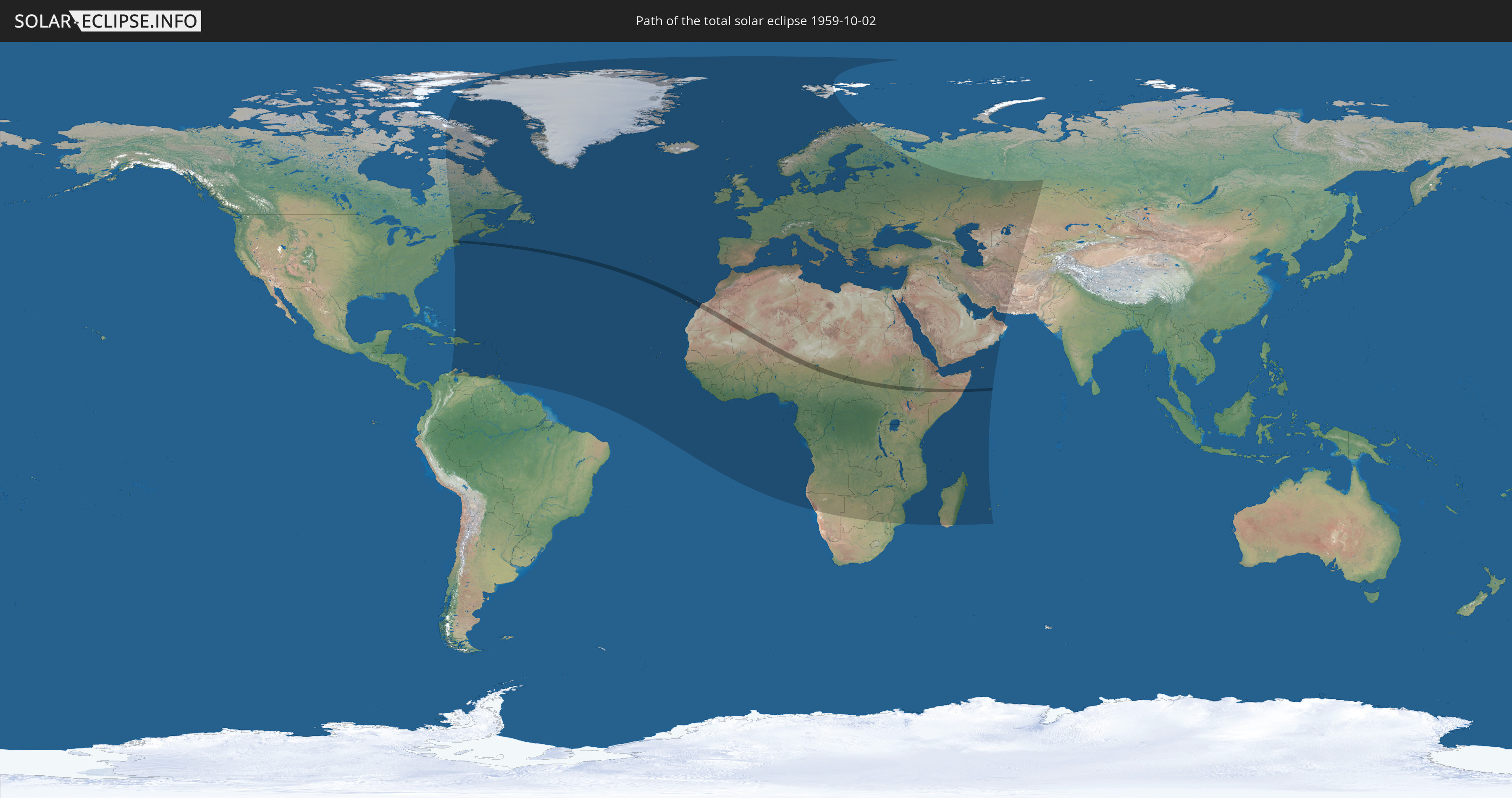
Die Sonnenfinsternis am 02.10.1959 kann man in 156 Ländern als partielle Sonnenfinsternis beobachten.
Der Finsternispfad verläuft durch 14 Länder. Nur in diesen Ländern ist sie als totale Sonnenfinsternis zu sehen.
In den folgenden Ländern ist die Sonnenfinsternis total zu sehen
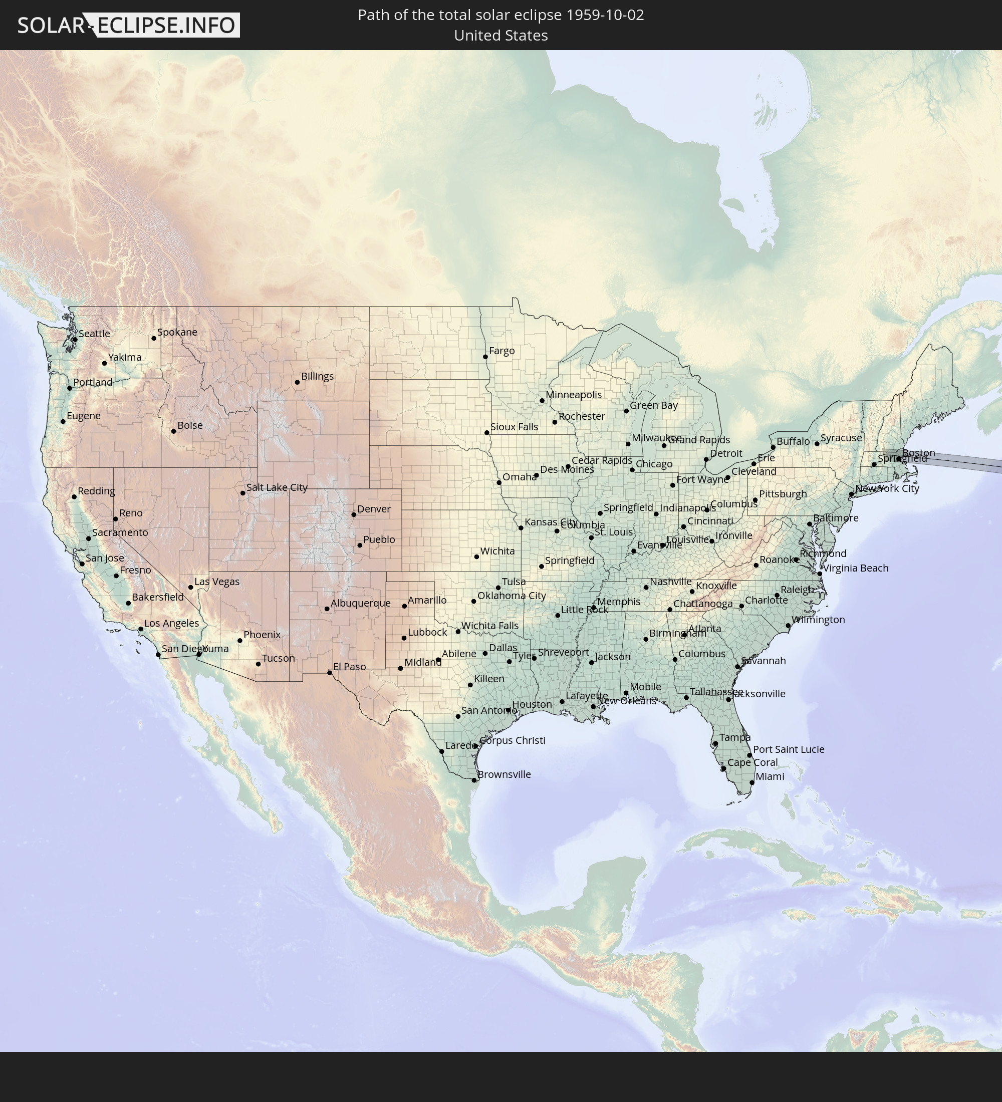 Vereinigte Staaten
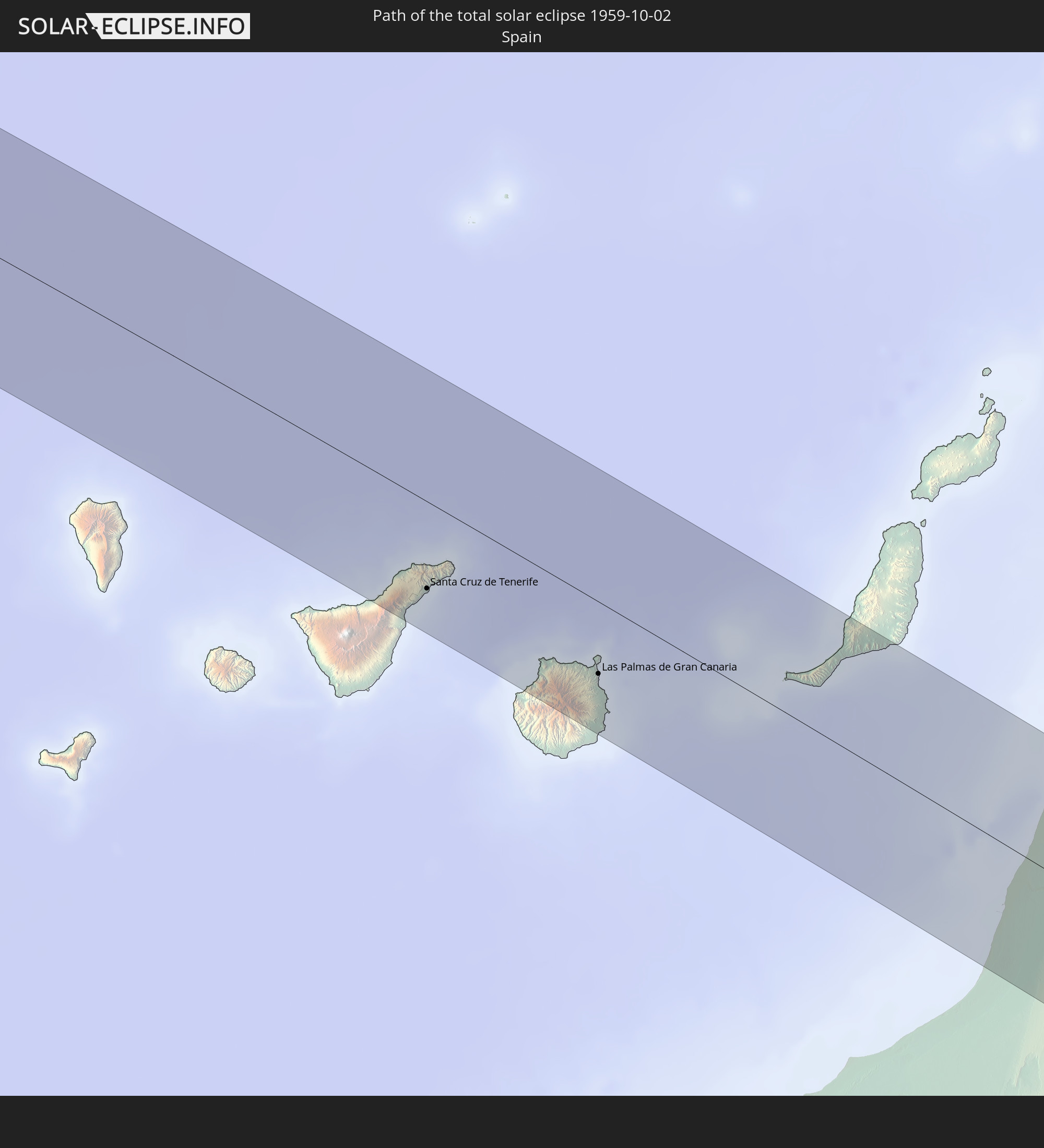 Spanien
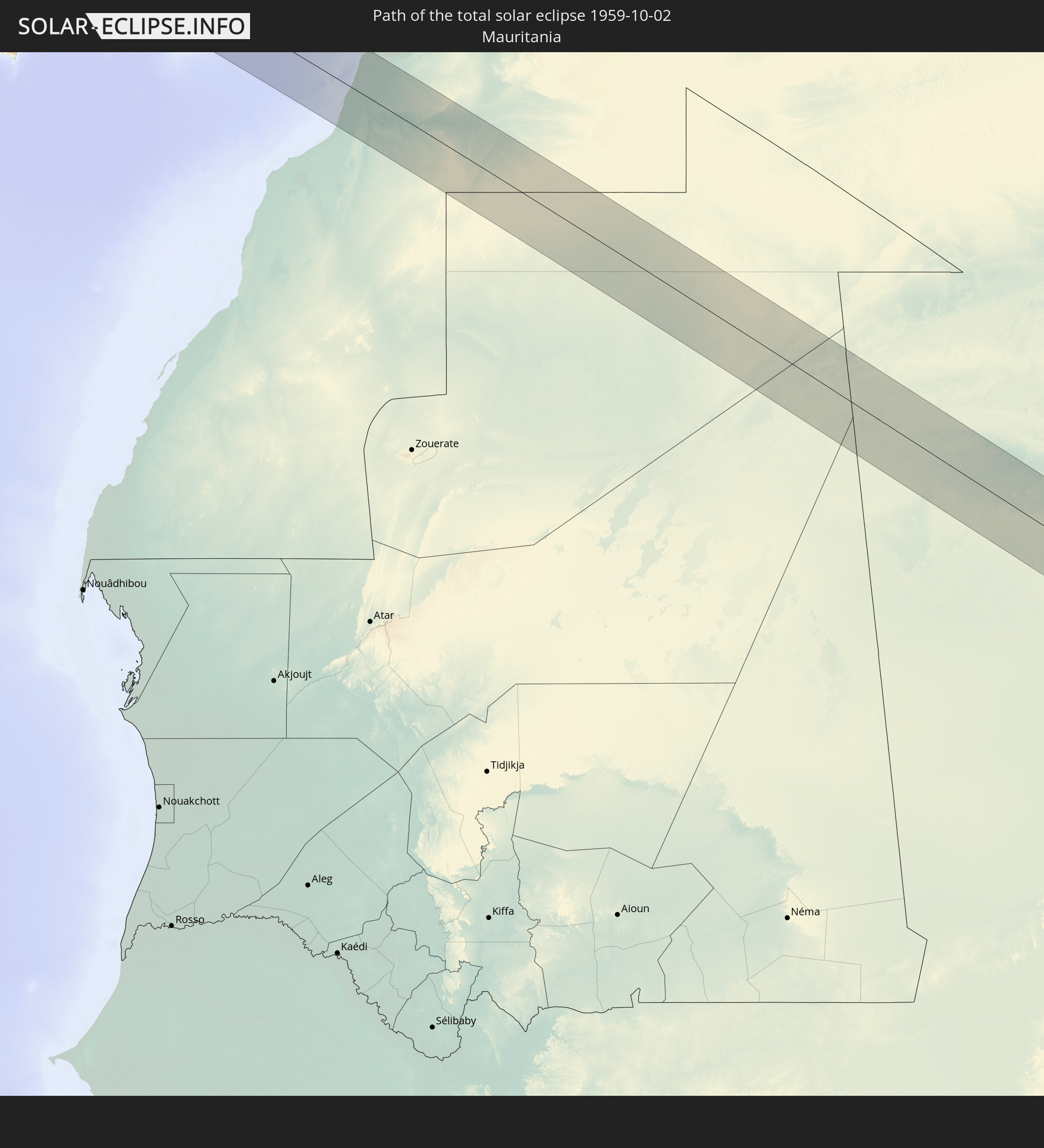 Mauretanien
 Marokko
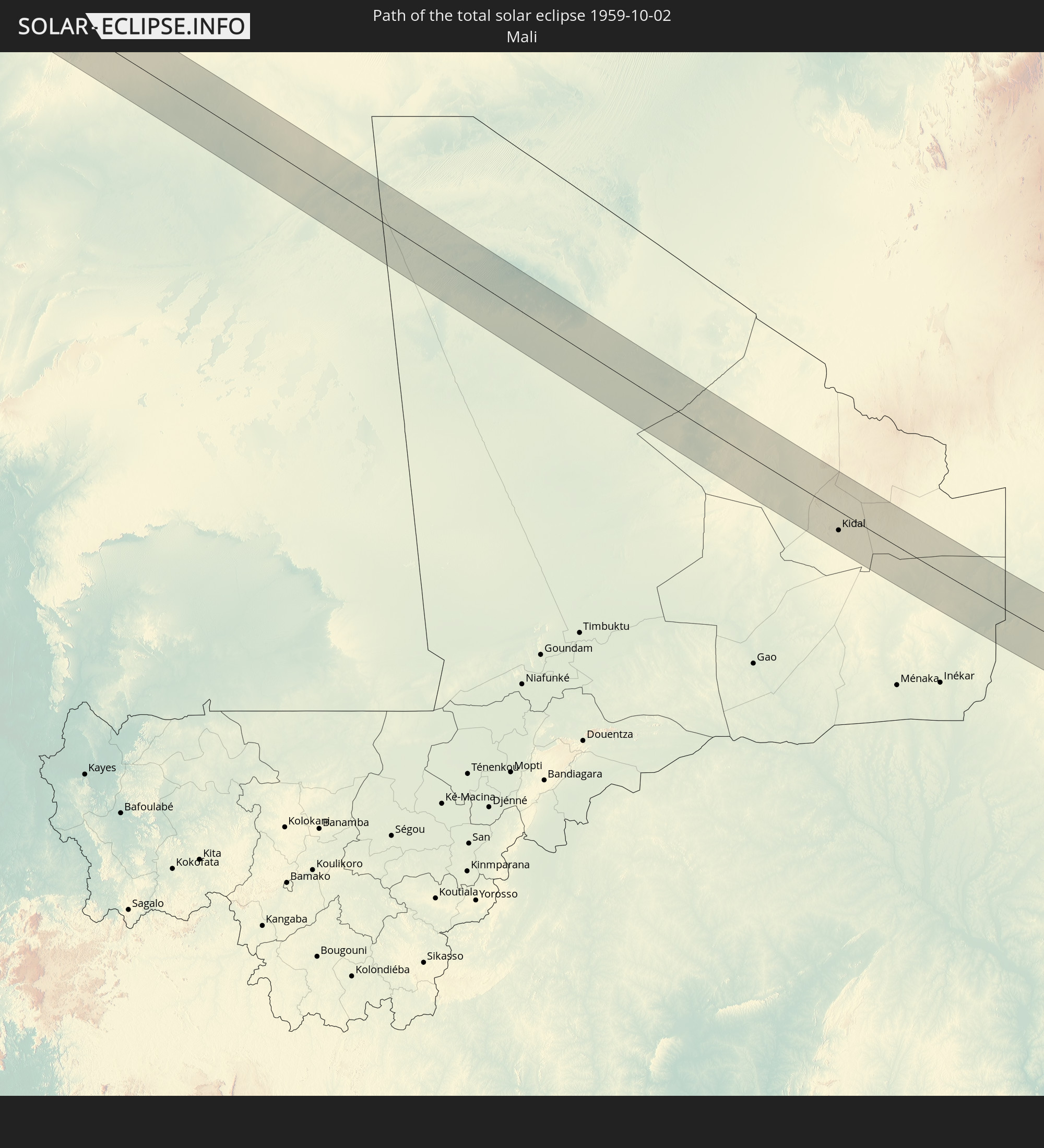 Mali
Mali
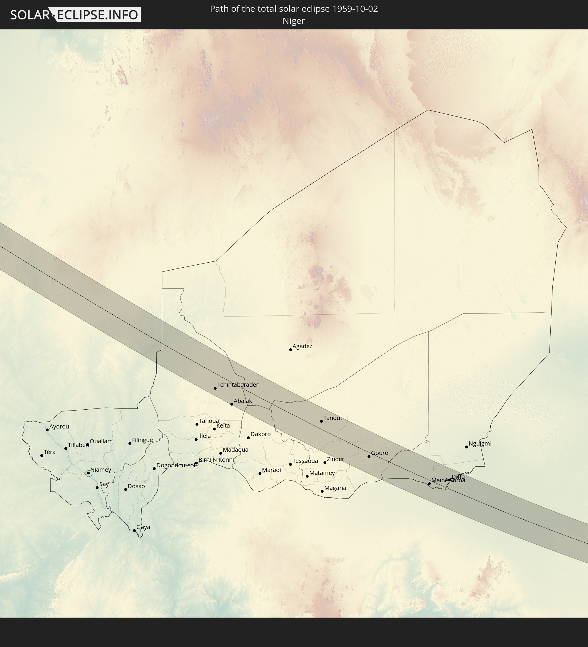 Niger
Niger
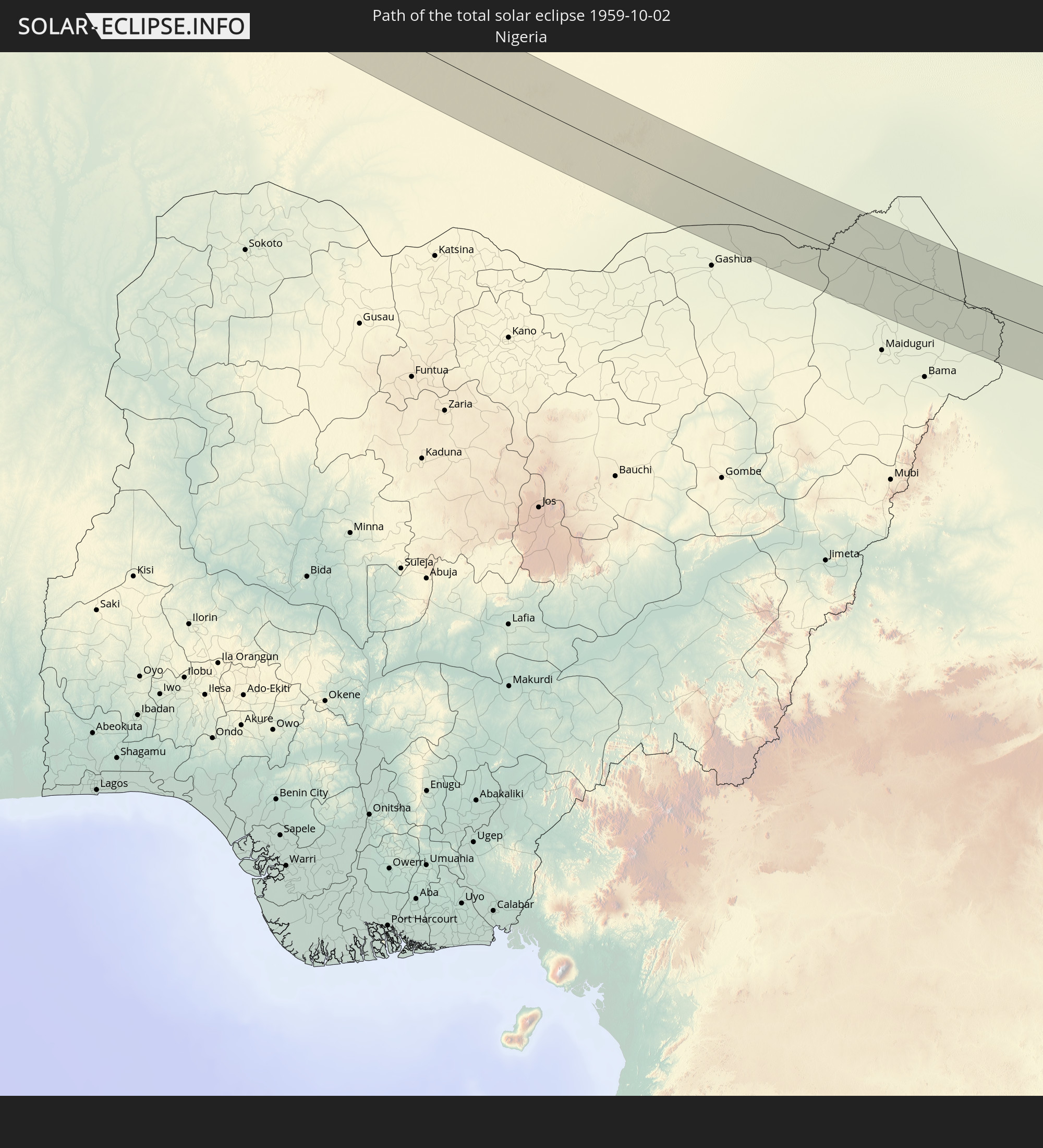 Nigeria
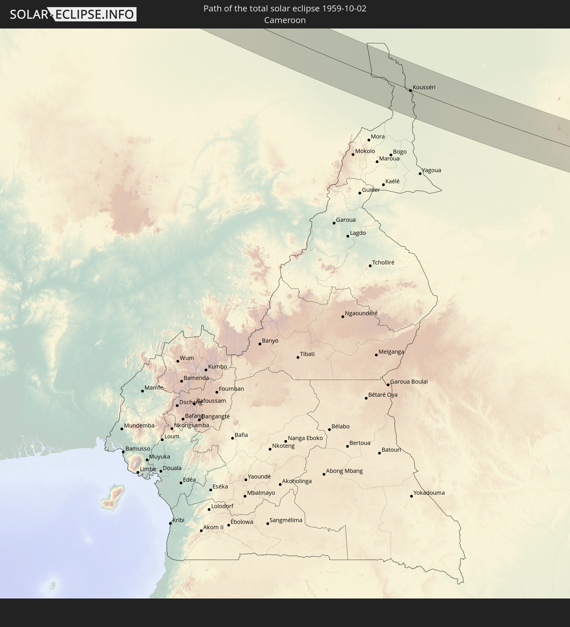 Kamerun
 Tschad
 Zentralafrikanische Republik
 Sudan
Sudan
 Südsudan
 Äthiopien
 Somalia
In den folgenden Ländern ist die Sonnenfinsternis partiell zu sehen
 Russland
 Vereinigte Staaten
 Kanada
 Grönland
 Kolumbien
 Haiti
Haiti
 Venezuela
 Turks- und Caicosinseln
 Dominikanische Republik
 Aruba
Aruba
 Puerto Rico
 Amerikanische Jungferninseln
 Bermuda
 Britische Jungferninseln
 Anguilla
 Saint-Martin
 Saint-Barthélemy
 St. Kitts und Nevis
 Antigua und Barbuda
 Montserrat
 Trinidad und Tobago
 Guadeloupe
 Grenada
 Dominica
 St. Vincent und die Grenadinen
 Martinique
 St. Lucia
 Barbados
 Saint-Pierre und Miquelon
 Portugal
 Kap Verde
 Island
 Spanien
 Senegal
 Mauretanien
 Gambia
 Guinea-Bissau
 Guinea
 St. Helena
 Sierra Leone
 Marokko
 Mali
Mali
 Liberia
 Irland
 Spitzbergen
 Algerien
 Vereinigtes Königreich
 Elfenbeinküste
 Färöer
 Burkina Faso
 Gibraltar
 Frankreich
 Isle of Man
 Ghana
Ghana
 Guernsey
 Jersey
 Togo
Togo
 Niger
Niger
 Benin
Benin
 Andorra
 Belgien
 Nigeria
 Niederlande
 Norwegen
 Äquatorialguinea
 Luxemburg
 Deutschland
 Schweiz
 São Tomé und Príncipe
 Italien
 Monaco
 Tunesien
 Dänemark
 Kamerun
 Gabun
Gabun
 Libyen
 Liechtenstein
 Österreich
 Schweden
 Republik Kongo
 Angola
 Namibia
 Tschechien
 Demokratische Republik Kongo
 San Marino
 Vatikanstadt
 Slowenien
 Tschad
 Kroatien
 Polen
Polen
 Malta
Malta
 Zentralafrikanische Republik
 Bosnien und Herzegowina
 Ungarn
 Südafrika
 Slowakei
 Montenegro
 Serbien
 Albanien
 Åland Islands
 Griechenland
 Botswana
 Rumänien
 Mazedonien
 Finnland
 Litauen
 Lettland
 Estland
 Sudan
Sudan
 Sambia
 Ukraine
 Bulgarien
 Weißrussland
 Ägypten
 Simbabwe
 Türkei
 Moldawien
 Ruanda
 Burundi
 Tansania
 Uganda
 Mosambik
 Republik Zypern
 Malawi
 Äthiopien
 Kenia
Kenia
 Staat Palästina
 Israel
 Saudi-Arabien
 Jordanien
 Libanon
 Syrien
 Eritrea
 Irak
Irak
 Georgien
 Französische Süd- und Antarktisgebiete
 Somalia
 Dschibuti
 Jemen
Jemen
 Madagaskar
 Komoren
 Armenien
 Iran
Iran
 Aserbaidschan
 Mayotte
 Seychellen
 Kasachstan
 Kuwait
 Bahrain
 Katar
Katar
 Vereinigte Arabische Emirate
 Oman
Oman
 Turkmenistan
 Réunion
 Usbekistan
 Afghanistan
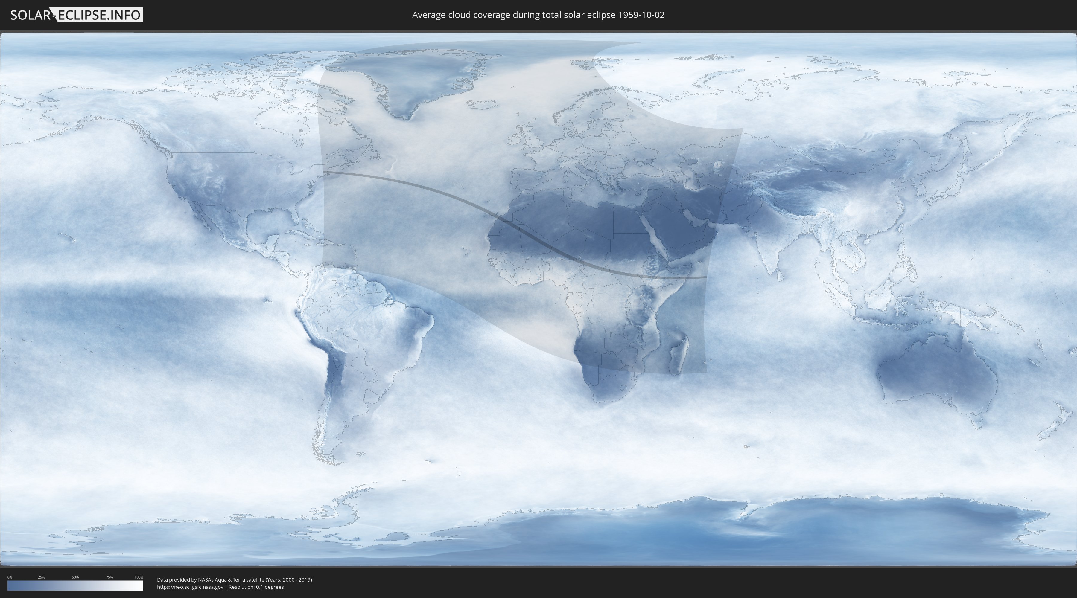
Wie wird das Wetter während der totalen Sonnenfinsternis am 02.10.1959?
Wo ist der beste Ort, um die totale Sonnenfinsternis vom 02.10.1959 zu beobachten?
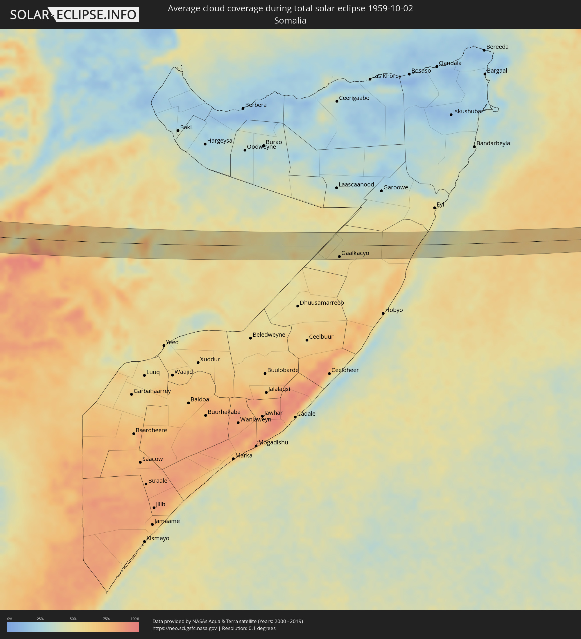
Die folgenden Karten zeigen die durchschnittliche Bewölkung für den Tag, an dem die totale Sonnenfinsternis
stattfindet. Mit Hilfe der Karten lässt sich der Ort entlang des Finsternispfades eingrenzen,
der die besten Aussichen auf einen klaren wolkenfreien Himmel bietet.
Trotzdem muss man immer lokale Gegenenheiten beachten und sollte sich genau über das Wetter an seinem
gewählten Beobachtungsort informieren.
Die Daten stammen von den beiden NASA-Satelliten
AQUA und TERRA
und wurden über einen Zeitraum von 19 Jahren (2000 - 2019) gemittelt.

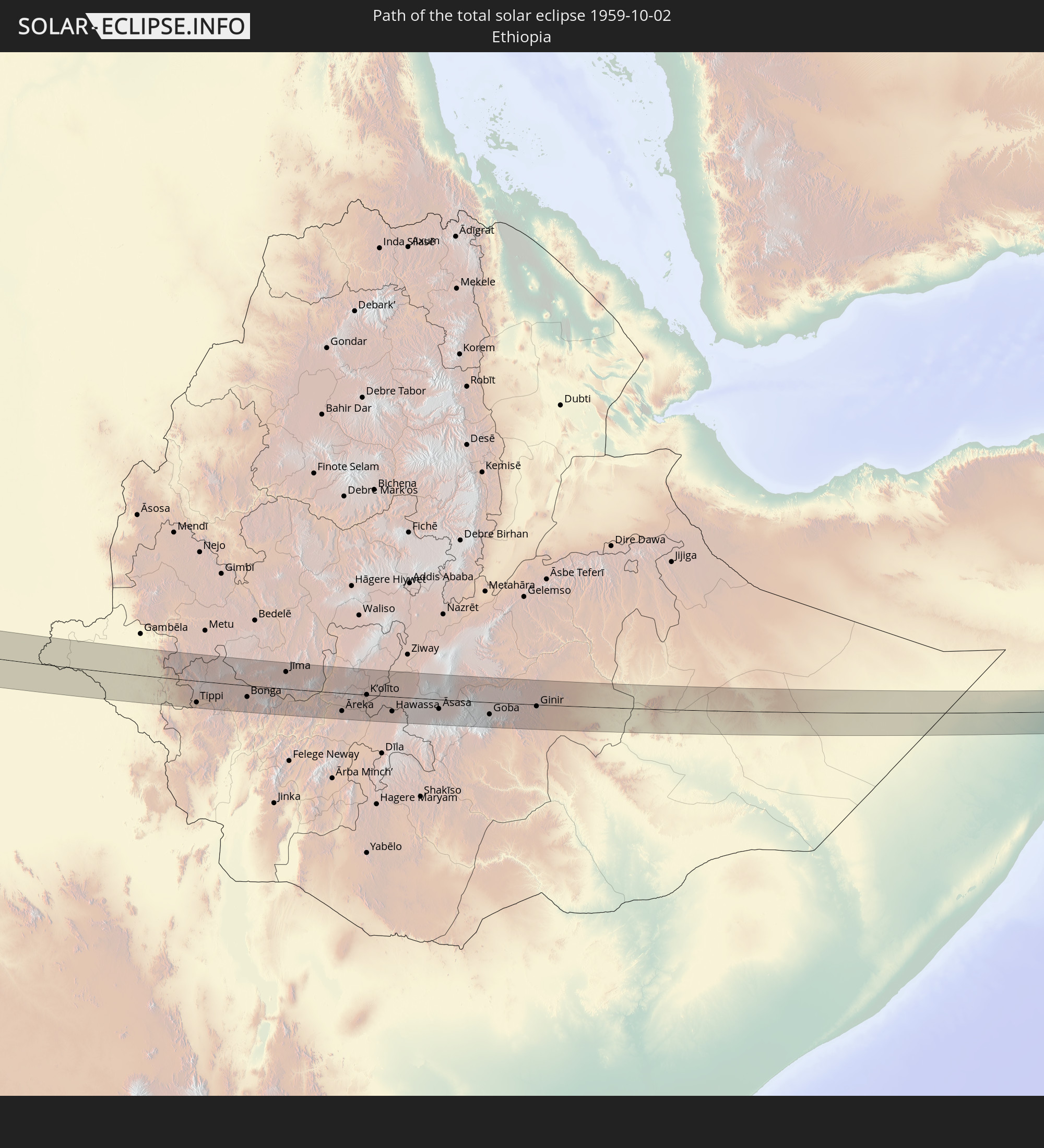
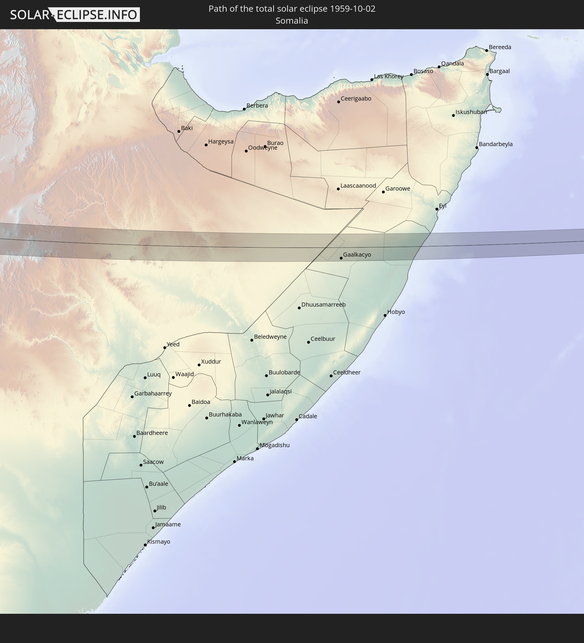
Detaillierte Länderkarten
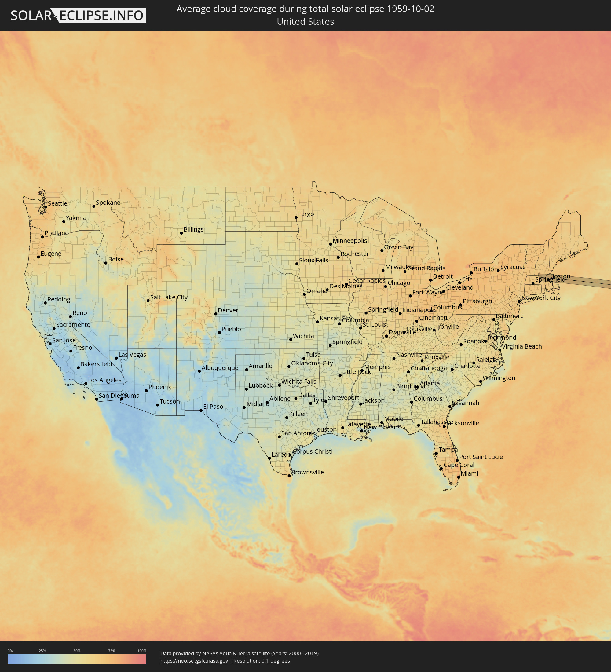 Vereinigte Staaten
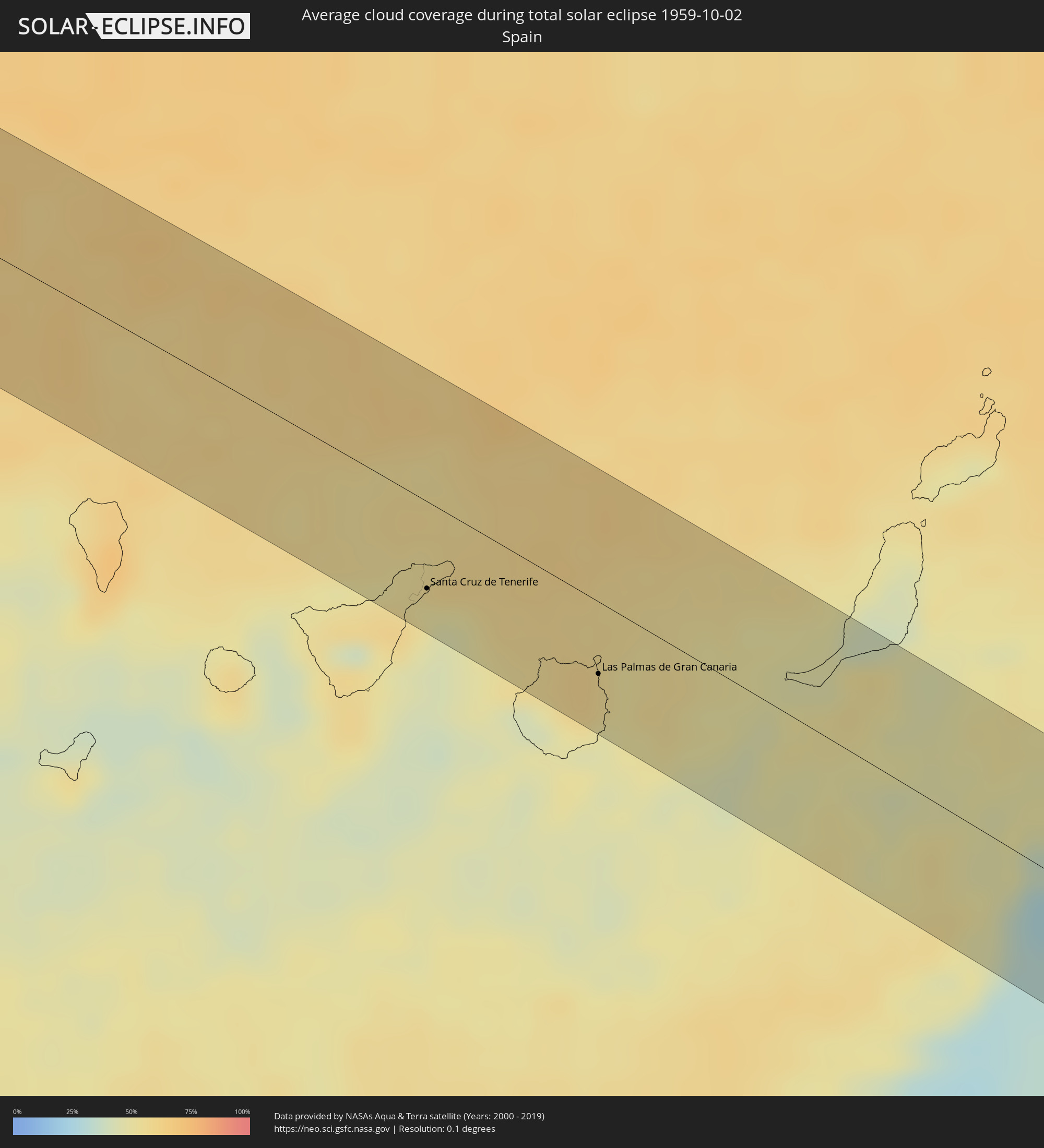 Spanien
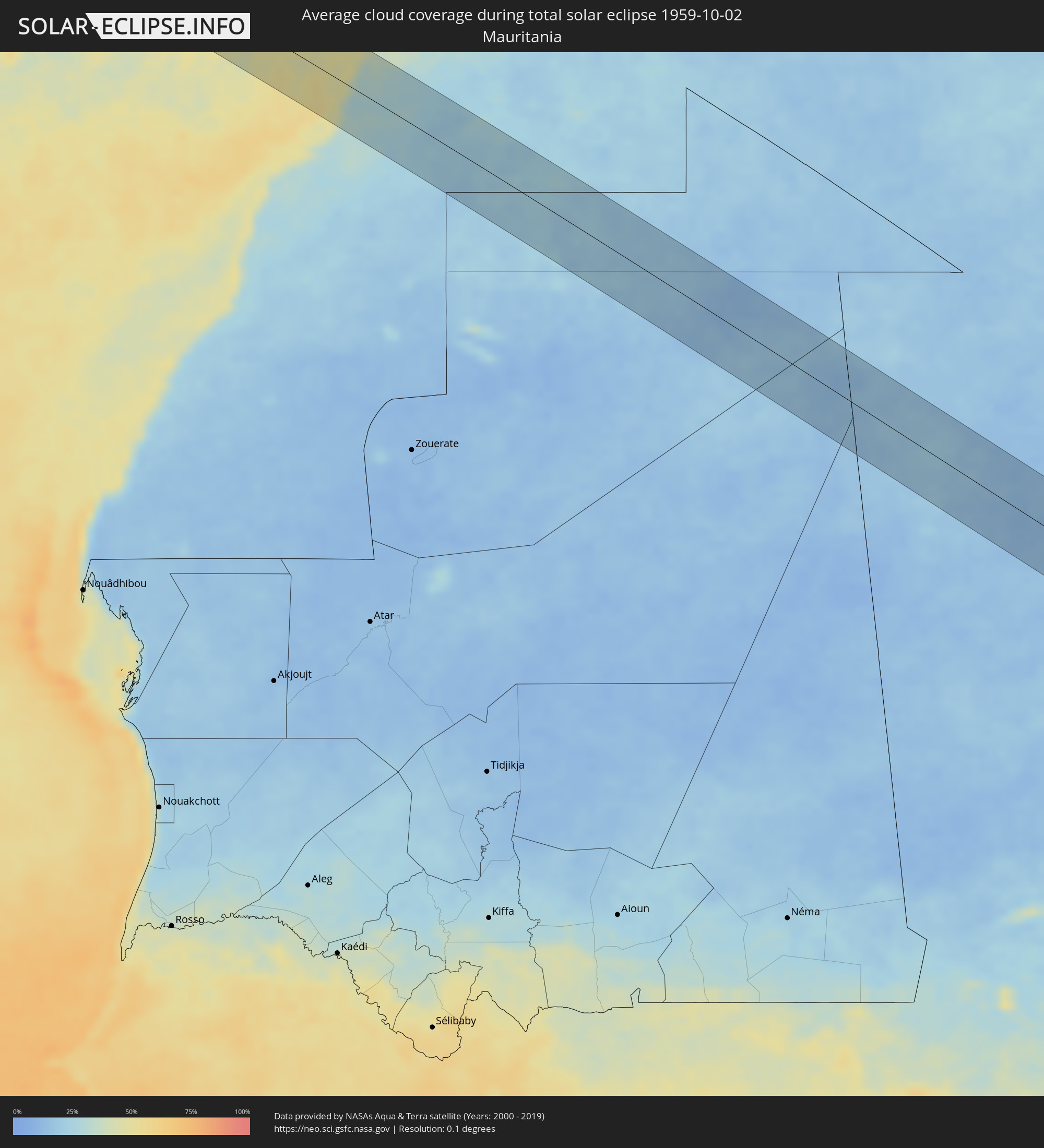 Mauretanien
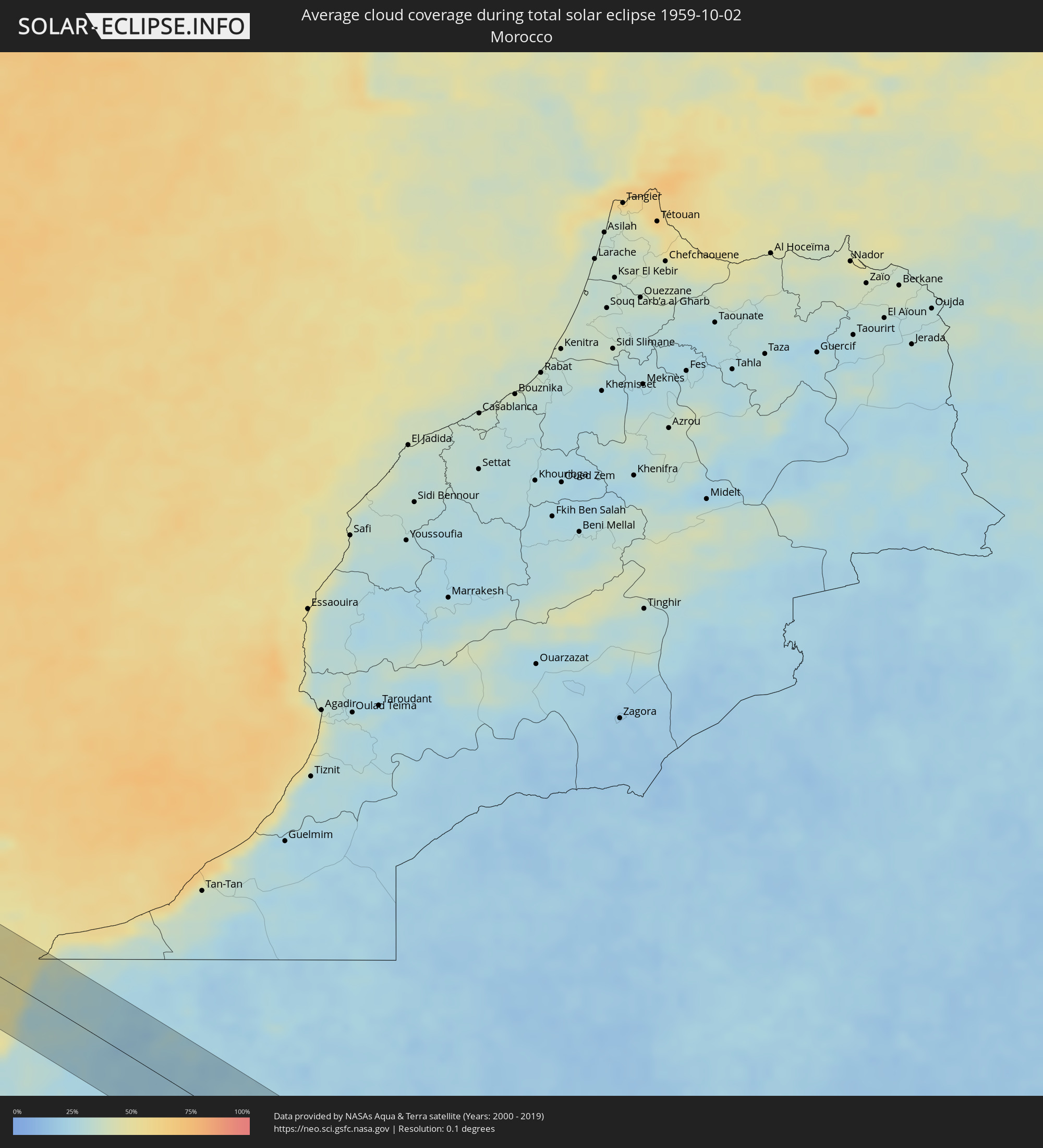 Marokko
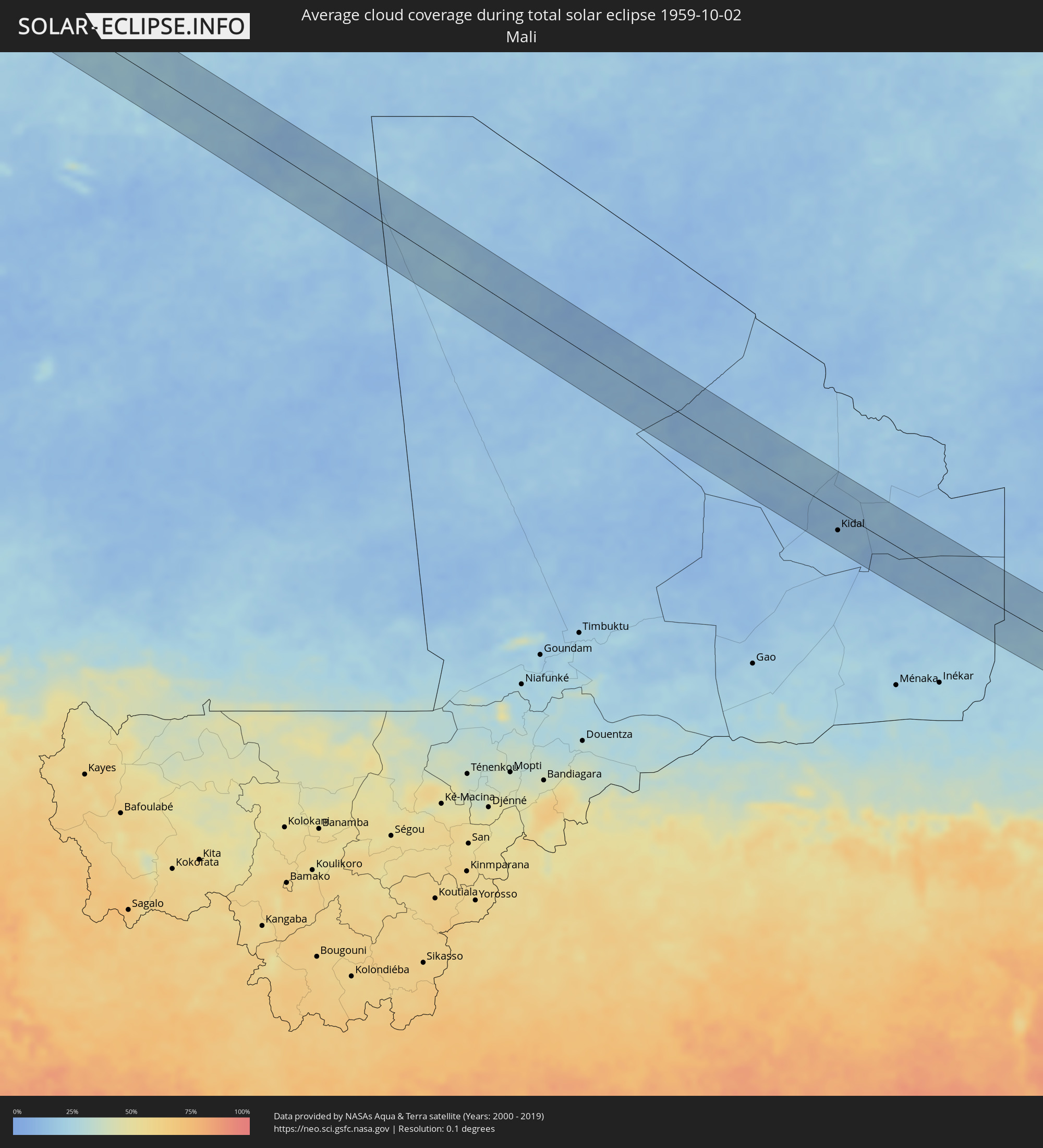 Mali
Mali
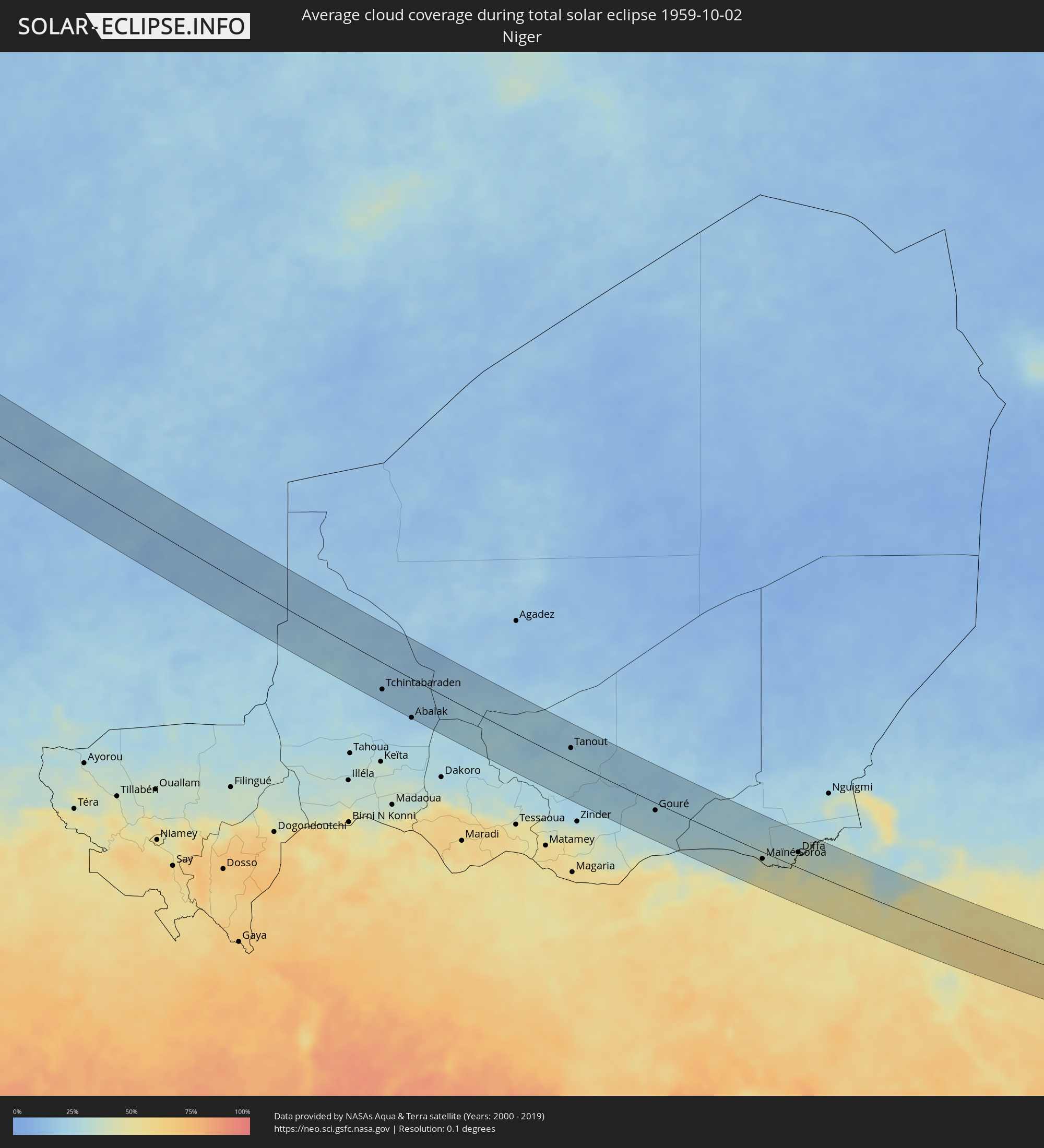 Niger
Niger
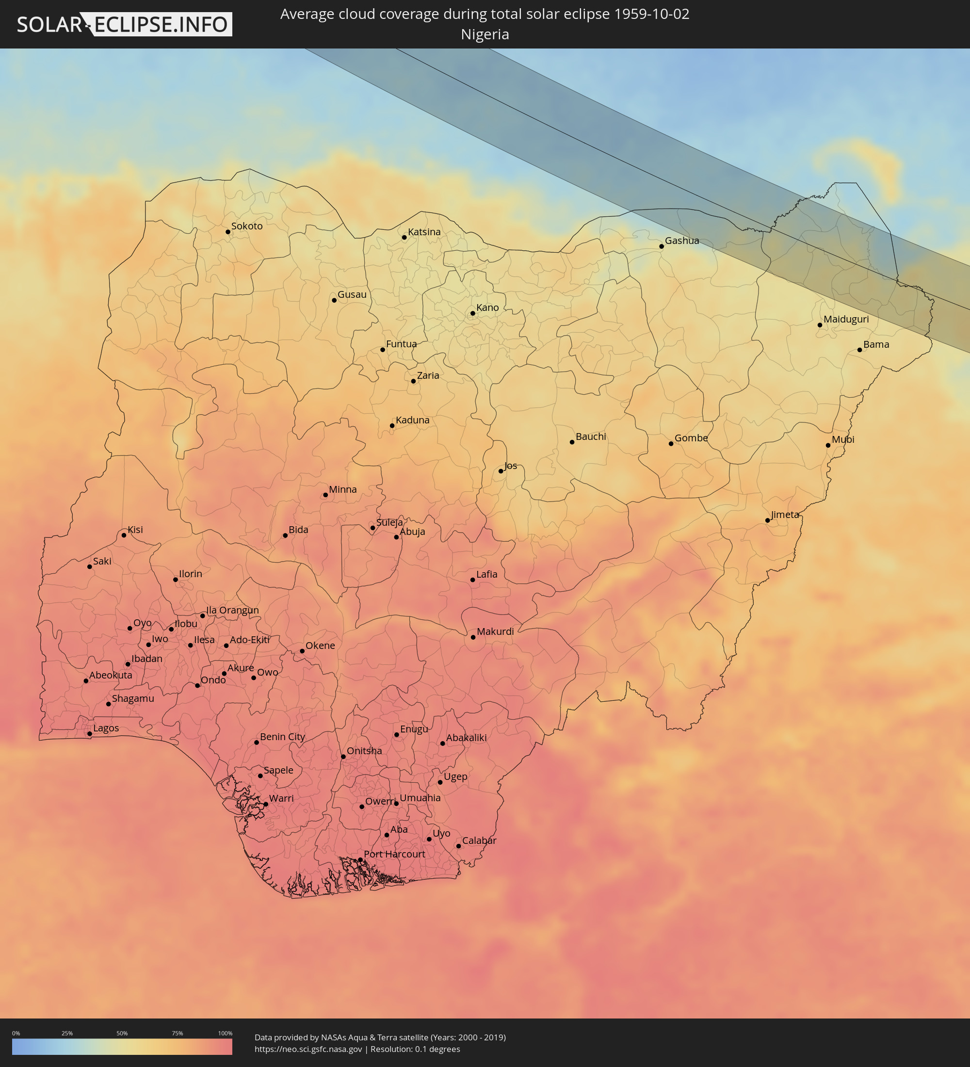 Nigeria
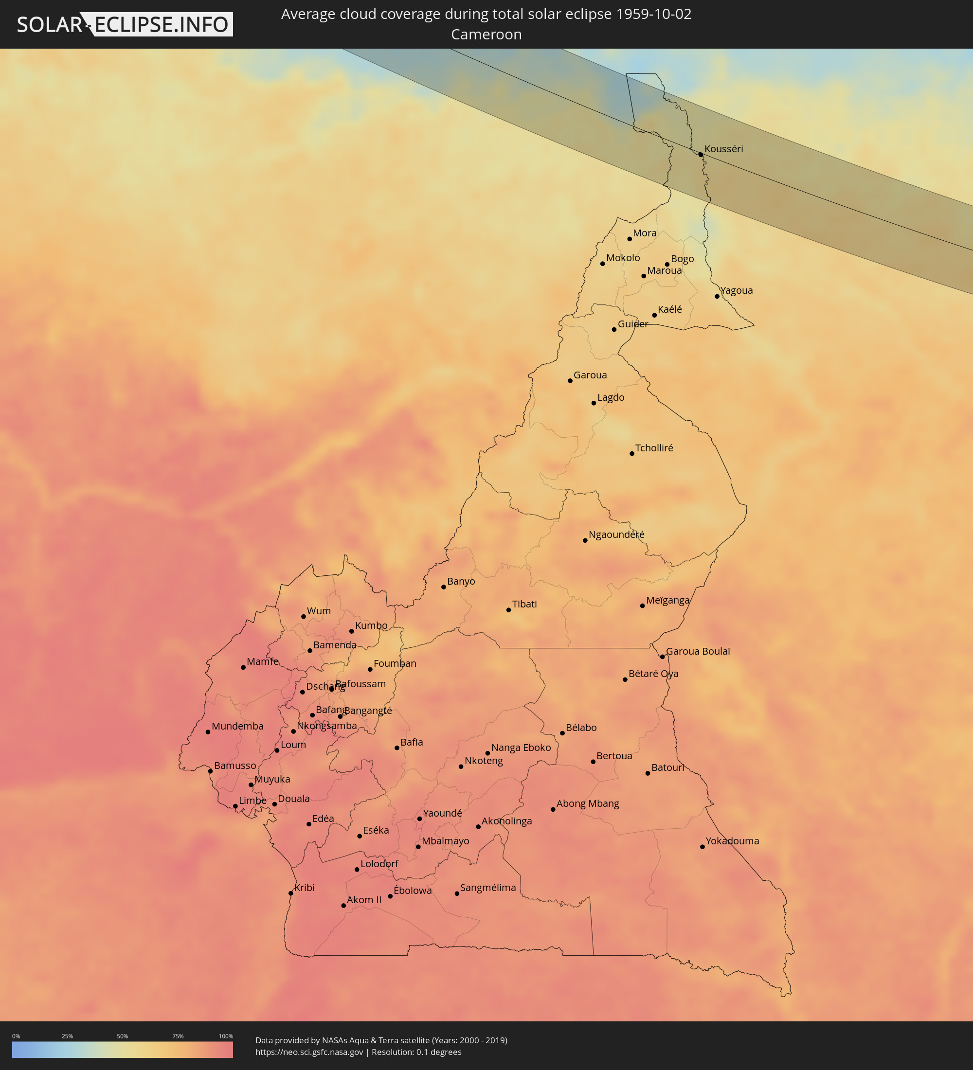 Kamerun
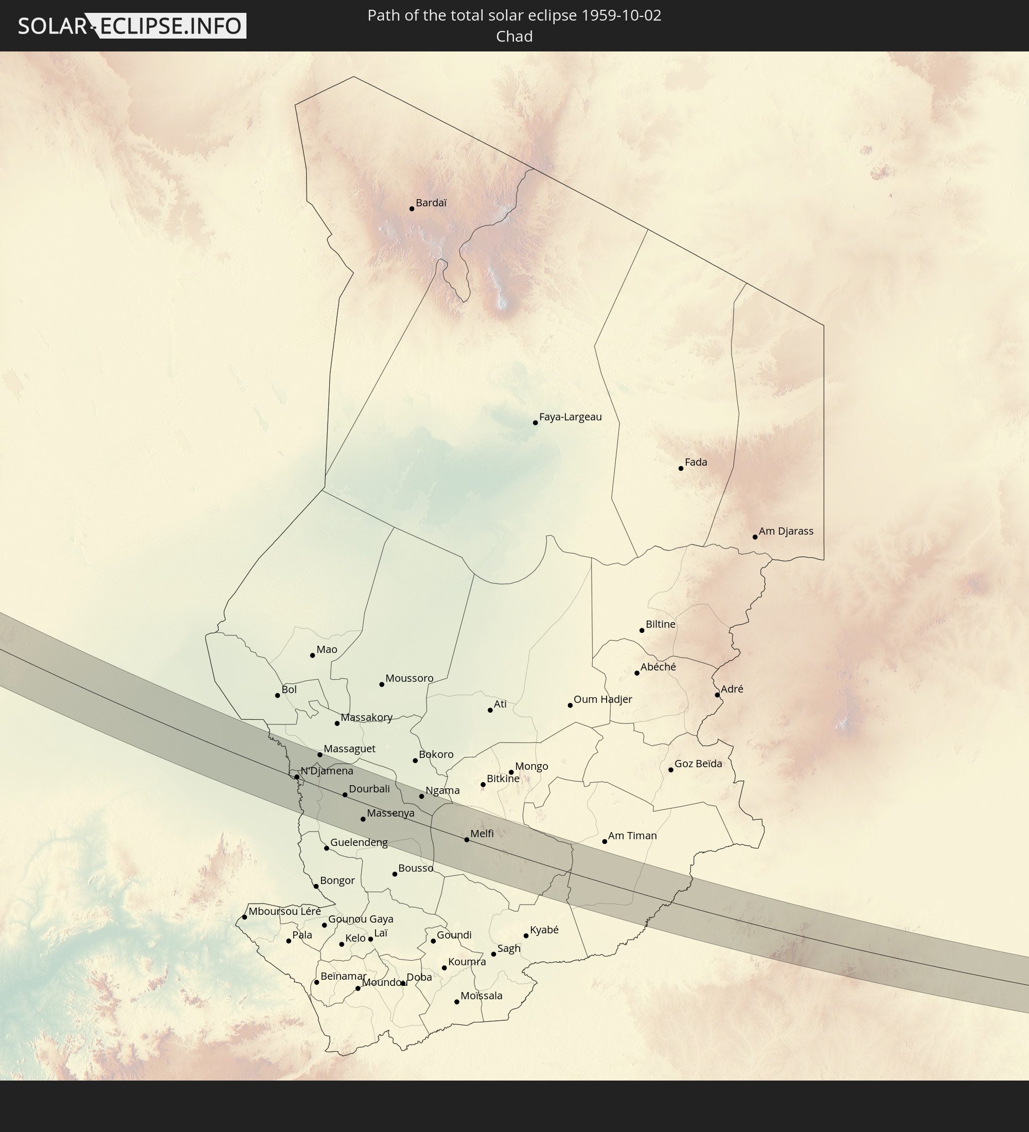
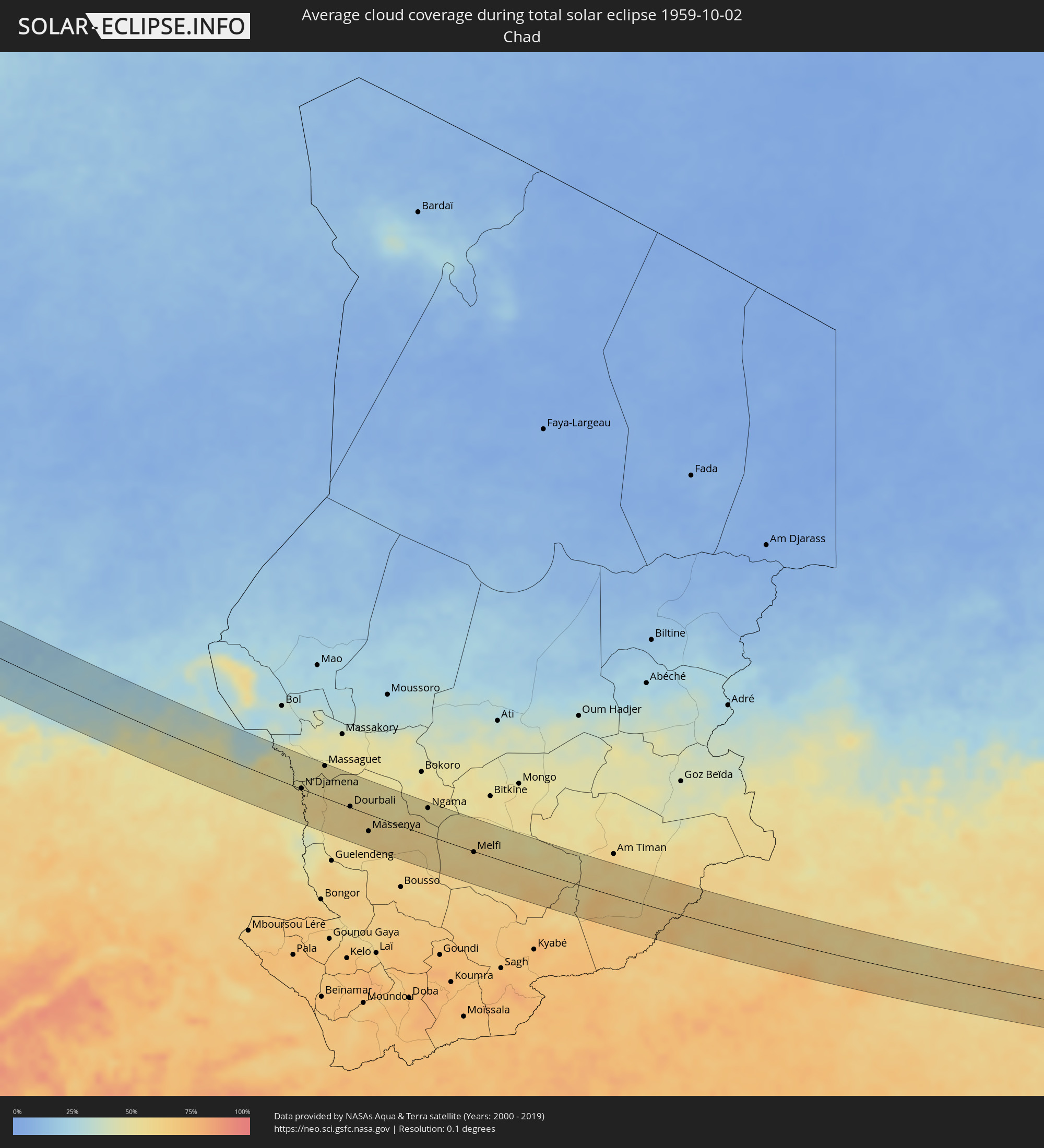 Tschad
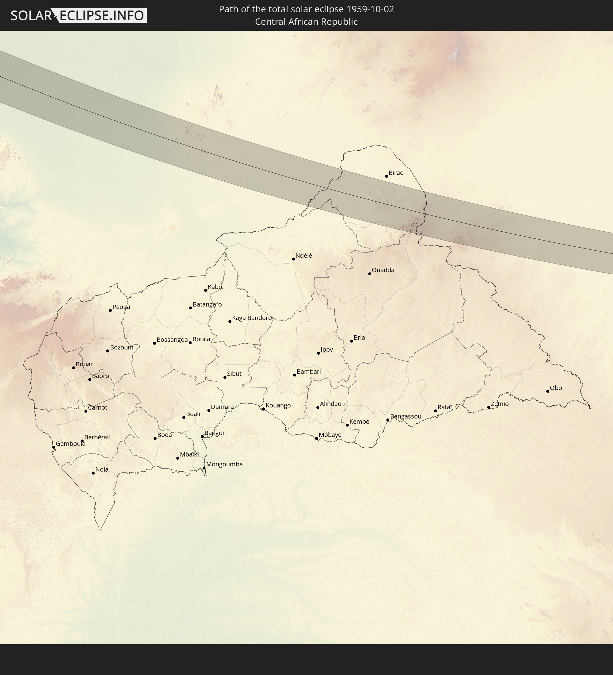
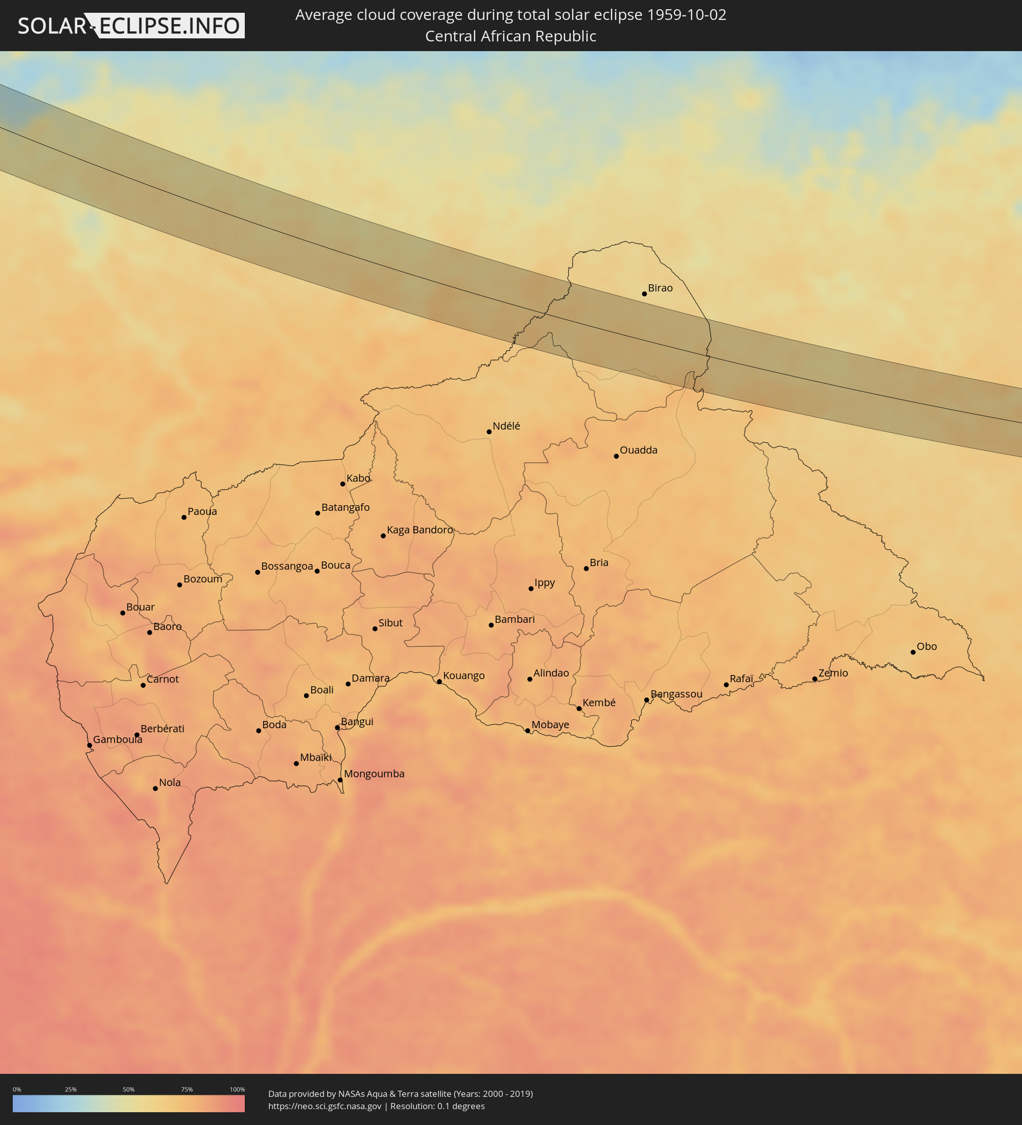 Zentralafrikanische Republik
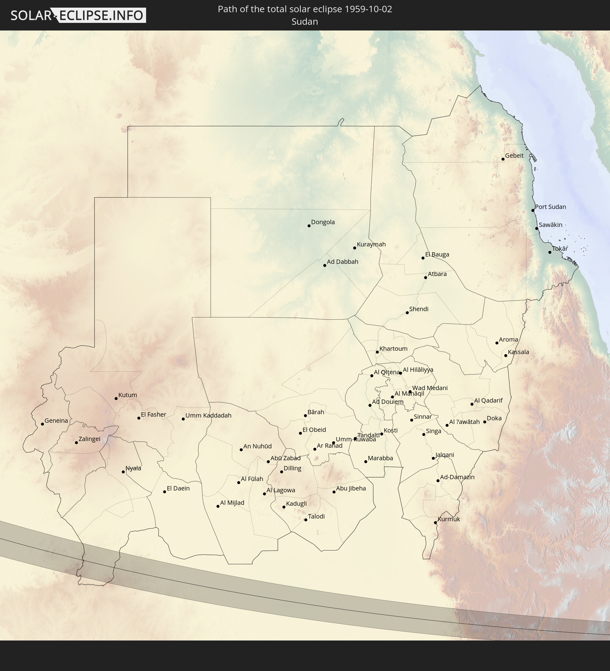
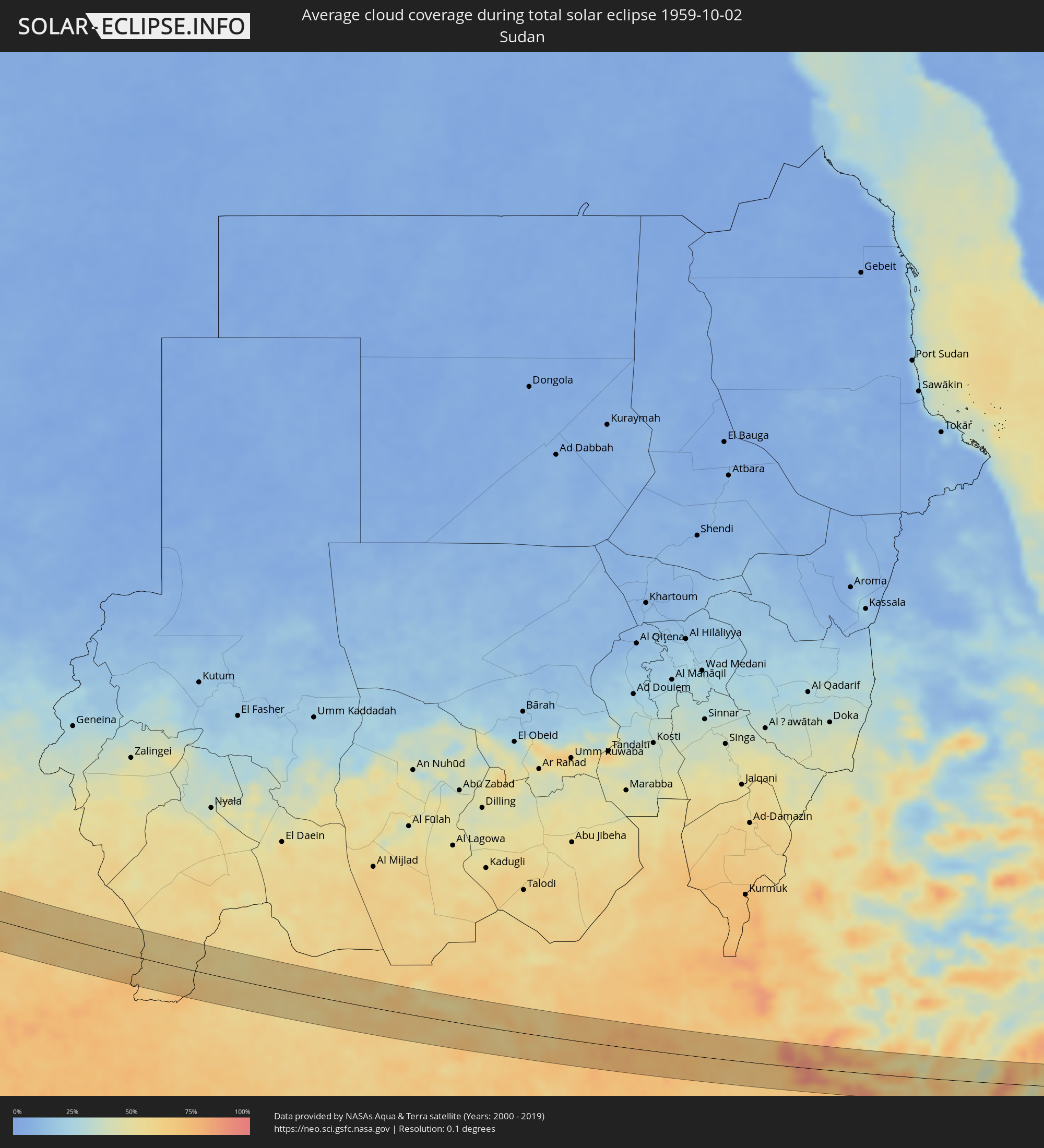 Sudan
Sudan
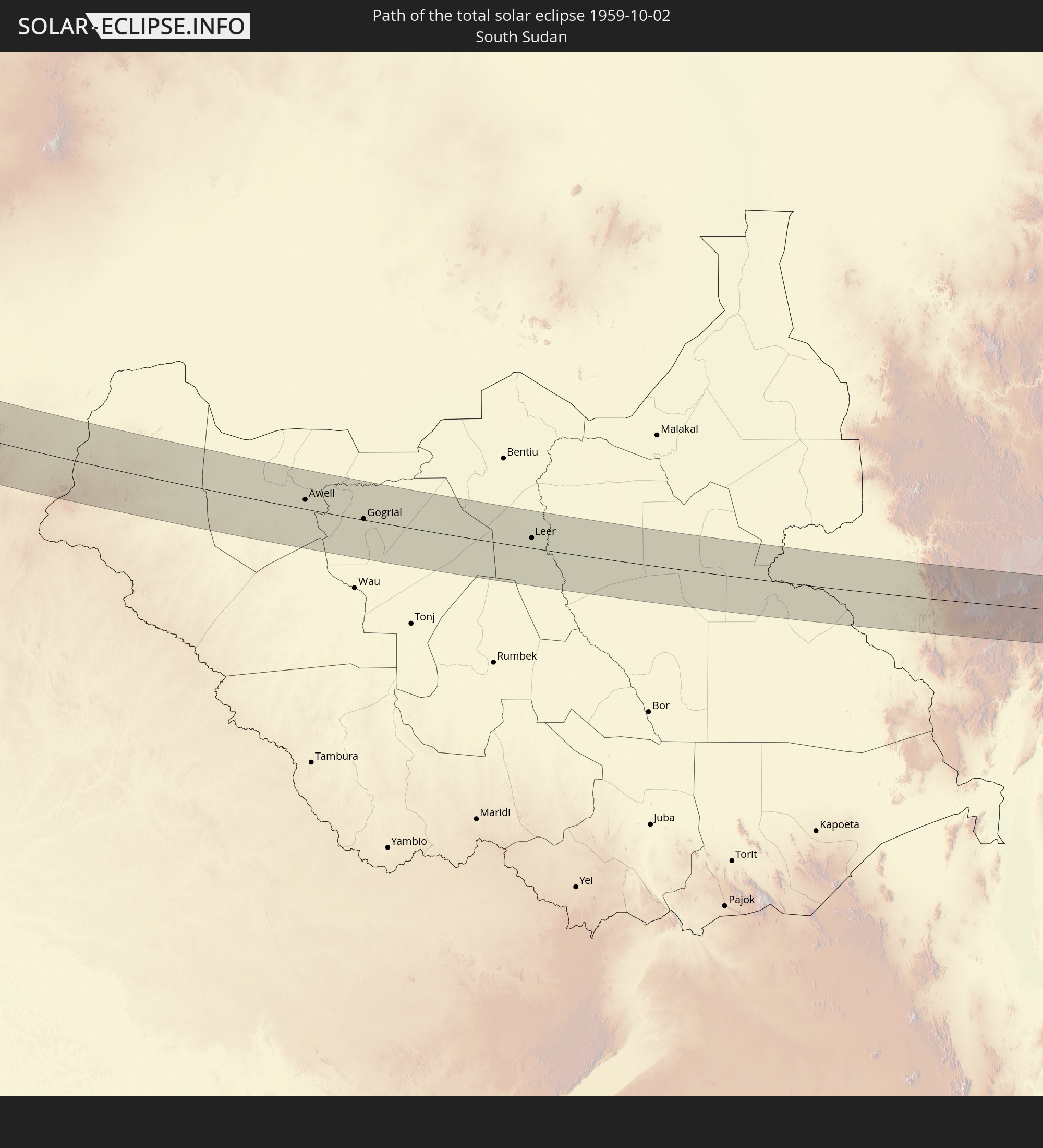
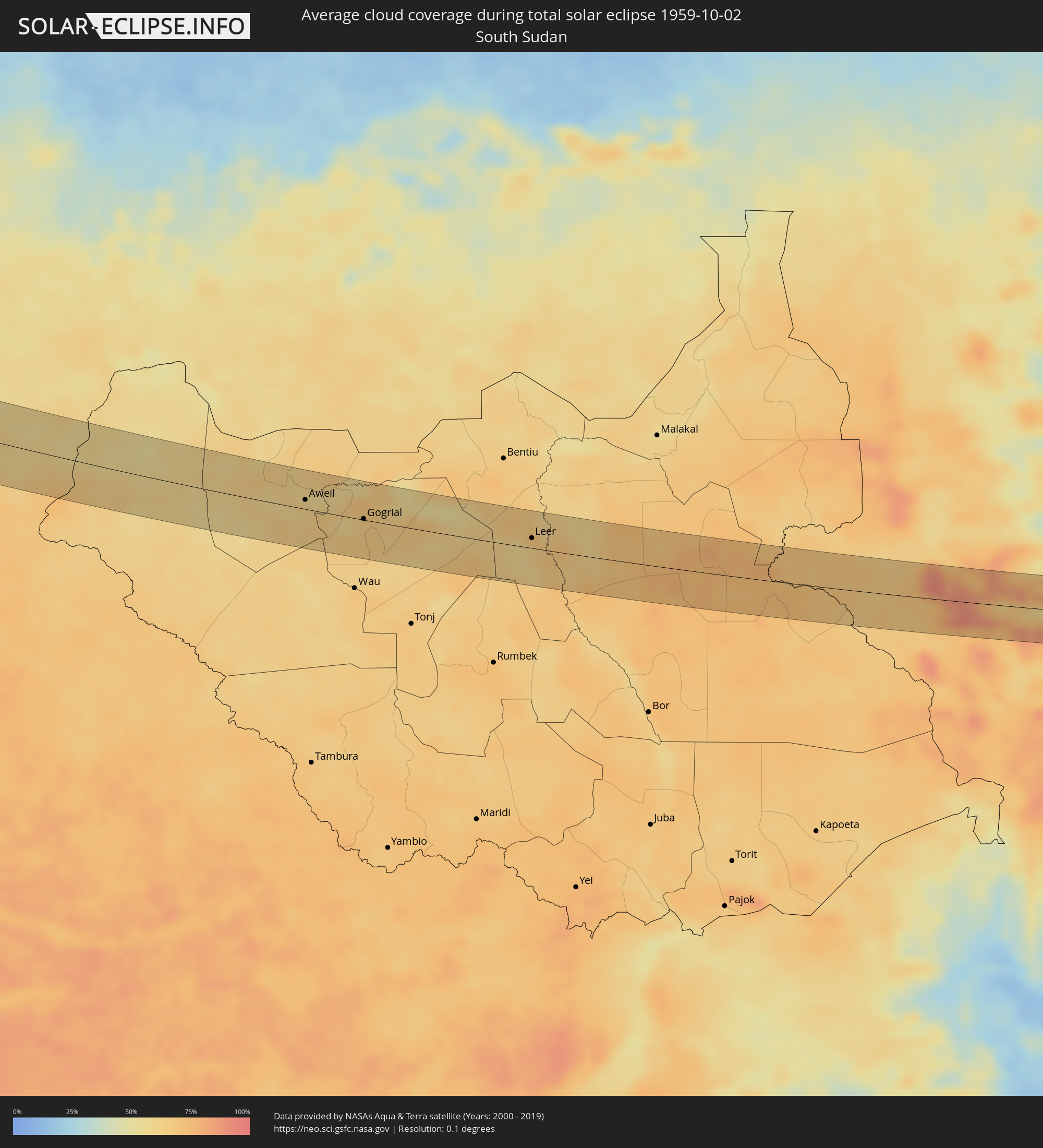 Südsudan
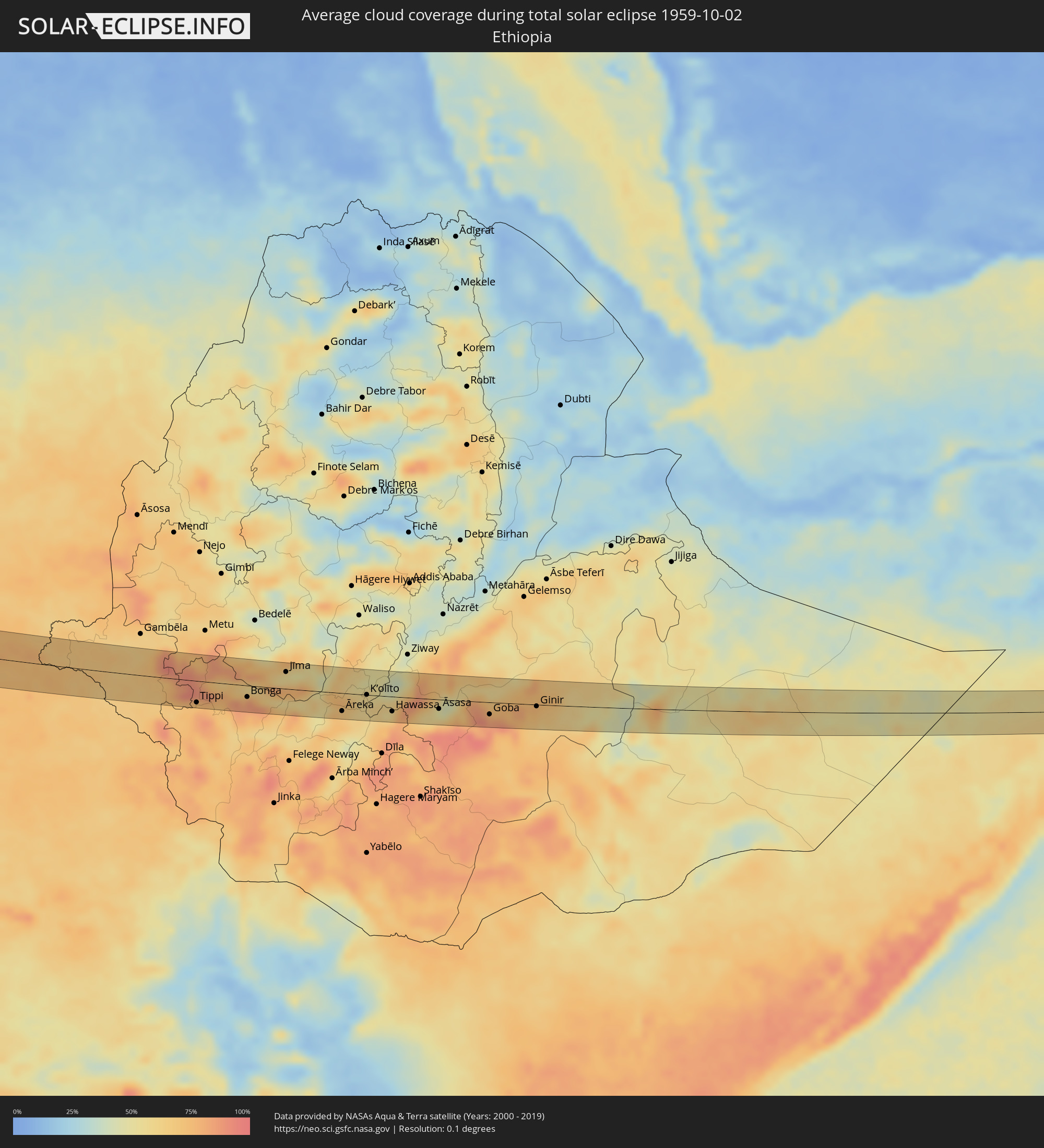 Äthiopien
 Somalia
Orte im Finsternispfad
Die nachfolgene Tabelle zeigt Städte und Orte mit mehr als 5.000 Einwohnern, die sich im Finsternispfad befinden. Städte mit mehr als 100.000 Einwohnern sind dick gekennzeichnet. Mit einem Klick auf den Ort öffnet sich eine Detailkarte die die Lage des jeweiligen Ortes zusammen mit dem Verlauf der zentralen Finsternis präsentiert.
| Ort | Typ | Dauer der Verfinsterung | Ortszeit bei maximaler Verfinsterung | Entfernung zur Zentrallinie | Ø Bewölkung |
|
Gardner, Massachusetts
|
total | - | 06:50:22 UTC-04:00 | 1 km | 64% |
|
Holden, Massachusetts
|
total | - | 06:50:12 UTC-04:00 | 28 km | 64% |
|
West Boylston, Massachusetts
|
total | - | 06:50:13 UTC-04:00 | 23 km | 63% |
|
Leominster, Massachusetts
|
total | - | 06:50:20 UTC-04:00 | 5 km | 64% |
|
Clinton, Massachusetts
|
total | - | 06:50:16 UTC-04:00 | 17 km | 63% |
|
Lancaster, Massachusetts
|
total | - | 06:50:17 UTC-04:00 | 12 km | 63% |
|
Hollis, New Hampshire
|
total | - | 06:50:31 UTC-04:00 | 20 km | 63% |
|
Nashua, New Hampshire
|
total | - | 06:50:32 UTC-04:00 | 24 km | 64% |
|
Framingham Center, Massachusetts
|
total | - | 06:50:11 UTC-04:00 | 28 km | 66% |
|
Acton, Massachusetts
|
total | - | 06:50:20 UTC-04:00 | 7 km | 66% |
|
Lowell, Massachusetts
|
total | - | 06:50:27 UTC-04:00 | 10 km | 67% |
|
Needham, Massachusetts
|
total | - | 06:50:11 UTC-04:00 | 28 km | 68% |
|
Woburn, Massachusetts
|
total | - | 06:50:20 UTC-04:00 | 6 km | 68% |
|
Haverhill, Massachusetts
|
total | - | 06:50:34 UTC-04:00 | 27 km | 66% |
|
Boston, Massachusetts
|
total | - | 06:50:15 UTC-04:00 | 19 km | 69% |
|
Middleton, Massachusetts
|
total | - | 06:50:26 UTC-04:00 | 8 km | 67% |
|
Lynn, Massachusetts
|
total | - | 06:50:21 UTC-04:00 | 6 km | 67% |
|
Cohasset, Massachusetts
|
total | - | 06:50:11 UTC-04:00 | 30 km | 63% |
|
Gloucester, Massachusetts
|
total | - | 06:50:29 UTC-04:00 | 13 km | 66% |
|
Santa Úrsula, Canary Islands
|
total | - | 11:41:44 UTC+00:00 | 52 km | 59% |
|
La Victoria de Acentejo, Canary Islands
|
total | - | 11:41:47 UTC+00:00 | 50 km | 59% |
|
La Matanza de Acentejo, Canary Islands
|
total | - | 11:41:48 UTC+00:00 | 47 km | 55% |
|
Sauzal, Canary Islands
|
total | - | 11:41:51 UTC+00:00 | 44 km | 55% |
|
Tacoronte, Canary Islands
|
total | - | 11:41:51 UTC+00:00 | 43 km | 55% |
|
Candelaria, Canary Islands
|
total | - | 11:42:02 UTC+00:00 | 53 km | 59% |
|
Tegueste, Canary Islands
|
total | - | 11:42:01 UTC+00:00 | 34 km | 51% |
|
Santa Cruz de Tenerife, Canary Islands
|
total | - | 11:42:11 UTC+00:00 | 36 km | 51% |
|
Gáldar, Canary Islands
|
total | - | 11:43:43 UTC+00:00 | 37 km | 47% |
|
Guia, Canary Islands
|
total | - | 11:43:45 UTC+00:00 | 37 km | 56% |
|
Moya, Canary Islands
|
total | - | 11:43:53 UTC+00:00 | 38 km | 56% |
|
Teror, Canary Islands
|
total | - | 11:44:00 UTC+00:00 | 40 km | 58% |
|
Santa Lucía, Canary Islands
|
total | - | 11:44:09 UTC+00:00 | 54 km | 45% |
|
Vega de San Mateo, Canary Islands
|
total | - | 11:44:05 UTC+00:00 | 45 km | 52% |
|
Santa Brígida, Canary Islands
|
total | - | 11:44:07 UTC+00:00 | 41 km | 52% |
|
Valsequillo de Gran Canaria, Canary Islands
|
total | - | 11:44:10 UTC+00:00 | 45 km | 52% |
|
Agüimes, Canary Islands
|
total | - | 11:44:21 UTC+00:00 | 50 km | 46% |
|
Ingenio, Canary Islands
|
total | - | 11:44:22 UTC+00:00 | 48 km | 46% |
|
Las Palmas de Gran Canaria, Canary Islands
|
total | - | 11:44:15 UTC+00:00 | 30 km | 54% |
 Laayoune Plage
|
total | - | 10:49:28 UTC-01:00 | 25 km | 35% |
|
Laâyoune / El Aaiún, Oued Ed-Dahab-Lagouira
|
total | - | 10:49:56 UTC-01:00 | 9 km | 28% |
|
Smara, Oued Ed-Dahab-Lagouira
|
total | - | 10:53:42 UTC-01:00 | 32 km | 23% |
|
Kidal, Kidal
|
total | - | 12:36:37 UTC+00:00 | 30 km | 15% |
|
Tchintabaraden, Tahoua
|
total | - | 13:51:28 UTC+01:00 | 41 km | 19% |
|
Abalak, Tahoua
|
total | - | 13:53:21 UTC+01:00 | 60 km | 18% |
|
Tanout, Zinder
|
total | - | 14:00:15 UTC+01:00 | 21 km | 25% |
|
Gouré, Zinder
|
total | - | 14:04:58 UTC+01:00 | 12 km | 24% |
|
Geidam, Yobe
|
total | - | 14:10:20 UTC+01:00 | 48 km | 50% |
|
Maïné Soroa, Diffa
|
total | - | 14:10:03 UTC+01:00 | 11 km | 41% |
|
Damasak, Borno
|
total | - | 14:11:16 UTC+01:00 | 1 km | 46% |
|
Diffa, Diffa
|
total | - | 14:11:10 UTC+01:00 | 25 km | 38% |
|
Kukawa, Borno
|
total | - | 14:13:47 UTC+01:00 | 25 km | 47% |
|
Monguno, Borno
|
total | - | 14:14:16 UTC+01:00 | 1 km | 52% |
|
Marte, Borno
|
total | - | 14:15:11 UTC+01:00 | 21 km | 50% |
|
Dikwa, Borno
|
total | - | 14:15:52 UTC+01:00 | 52 km | 52% |
|
Ngala, Borno
|
total | - | 14:15:58 UTC+01:00 | 9 km | 51% |
|
Gamboru, Borno
|
total | - | 14:15:58 UTC+01:00 | 5 km | 53% |
|
Makary, Far North
|
total | - | 14:16:10 UTC+01:00 | 26 km | 51% |
|
Kousséri, Far North
|
total | - | 14:18:05 UTC+01:00 | 3 km | 55% |
|
N'Djamena, Chari-Baguirmi
|
total | - | 14:18:04 UTC+01:00 | 1 km | 55% |
|
Massaguet, Hadjer-Lamis
|
total | - | 14:18:18 UTC+01:00 | 55 km | 53% |
|
Dourbali, Chari-Baguirmi
|
total | - | 14:20:09 UTC+01:00 | 2 km | 59% |
|
Massenya, Chari-Baguirmi
|
total | - | 14:21:21 UTC+01:00 | 29 km | 60% |
|
Ngama, Chari-Baguirmi
|
total | - | 14:22:43 UTC+01:00 | 47 km | 54% |
|
Melfi, Guéra
|
total | - | 14:25:12 UTC+01:00 | 1 km | 57% |
 Aweil, Northern Bahr al Ghazal
|
total | - | 15:43:14 UTC+02:00 | 12 km | 62% |
|
Kuacjok, Warrap
|
total | - | 15:44:32 UTC+02:00 | 26 km | 67% |
|
Gogrial, Warrap
|
total | - | 15:44:25 UTC+02:00 | 1 km | 65% |
|
Leer, Unity
|
total | - | 15:47:11 UTC+02:00 | 13 km | 62% |
|
Tippi, Southern Nations, Nationalities, and People's Region
|
total | - | 16:53:46 UTC+03:00 | 37 km | 74% |
|
Bonga, Southern Nations, Nationalities, and People's Region
|
total | - | 16:54:21 UTC+03:00 | 20 km | 80% |
|
Jīma, Oromiya
|
total | - | 16:54:29 UTC+03:00 | 29 km | 57% |
|
Āreka, Southern Nations, Nationalities, and People's Region
|
total | - | 16:55:45 UTC+03:00 | 31 km | 69% |
|
Bodītī, Southern Nations, Nationalities, and People's Region
|
total | - | 16:55:59 UTC+03:00 | 40 km | 63% |
|
K’olīto, Southern Nations, Nationalities, and People's Region
|
total | - | 16:55:48 UTC+03:00 | 0 km | 59% |
|
Hawassa, Southern Nations, Nationalities, and People's Region
|
total | - | 16:56:21 UTC+03:00 | 25 km | 60% |
|
Shashemenē, Oromiya
|
total | - | 16:56:18 UTC+03:00 | 9 km | 73% |
|
Kofelē, Oromiya
|
total | - | 16:56:34 UTC+03:00 | 23 km | 77% |
|
Dodola, Oromiya
|
total | - | 16:56:55 UTC+03:00 | 29 km | 60% |
|
Āsasa, Oromiya
|
total | - | 16:56:50 UTC+03:00 | 16 km | 50% |
|
Goba, Oromiya
|
total | - | 16:57:26 UTC+03:00 | 21 km | 83% |
|
Ginir, Oromiya
|
total | - | 16:57:48 UTC+03:00 | 3 km | 73% |
|
Gaalkacyo, Mudug
|
total | - | 17:01:25 UTC+03:00 | 30 km | 50% |