Totale Sonnenfinsternis vom 02.08.2027
| Wochentag: | Montag |
| Maximale Dauer der Verfinsterung: | 06m23s |
| Maximale Breite des Finsternispfades: | 258 km |
| Saroszyklus: | 136 |
| Bedeckungsgrad: | 100% |
| Magnitude: | 1.079 |
| Gamma: | 0.1421 |
Wo kann man die Sonnenfinsternis vom 02.08.2027 sehen?
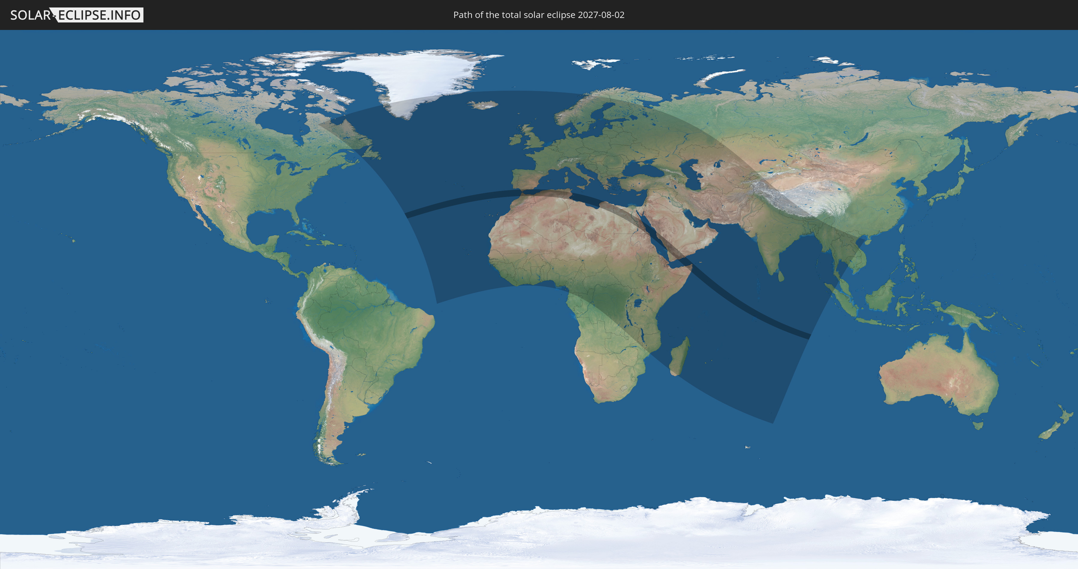
Die Sonnenfinsternis am 02.08.2027 kann man in 142 Ländern als partielle Sonnenfinsternis beobachten.
Der Finsternispfad verläuft durch 12 Länder. Nur in diesen Ländern ist sie als totale Sonnenfinsternis zu sehen.
In den folgenden Ländern ist die Sonnenfinsternis total zu sehen
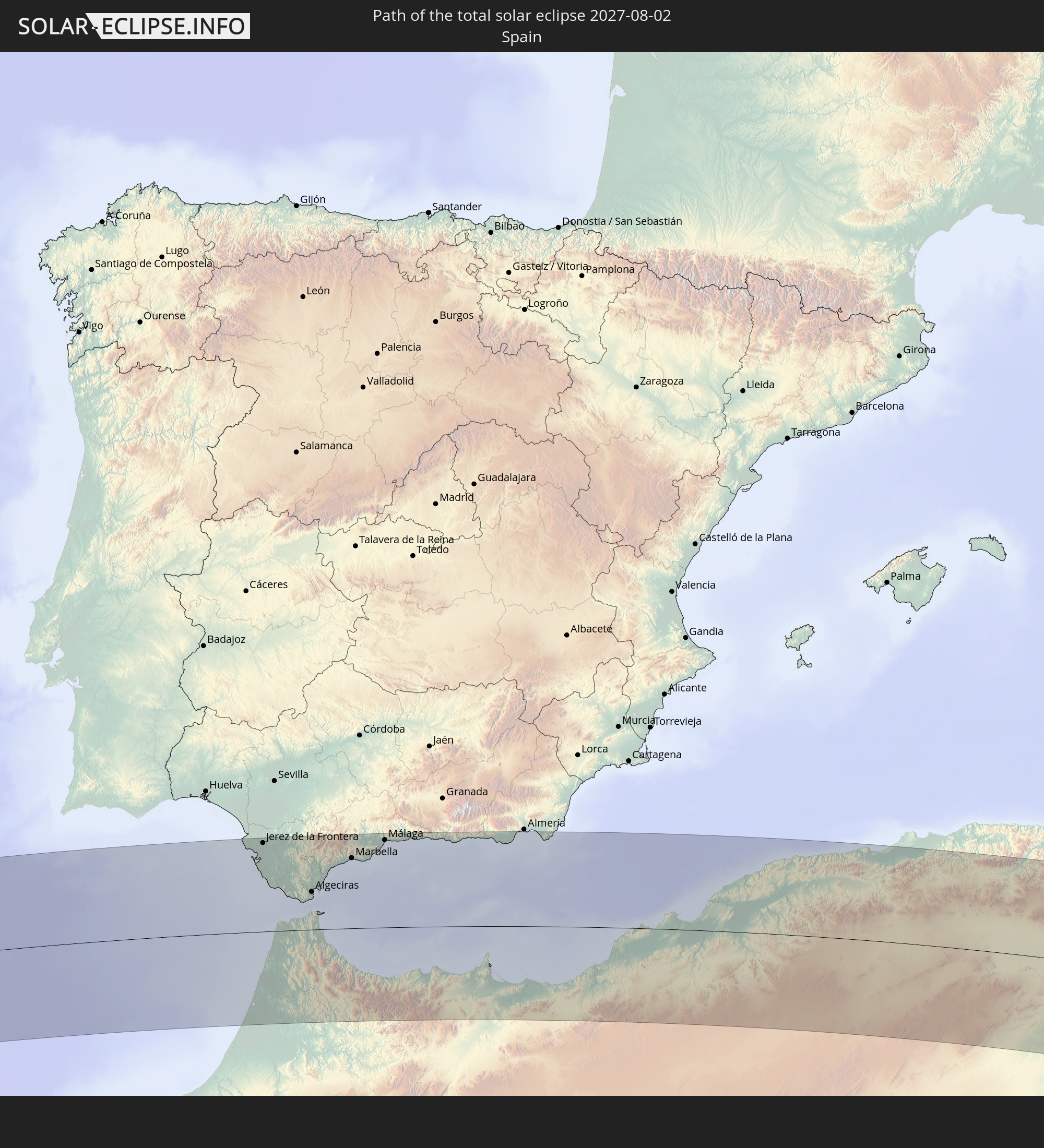 Spanien
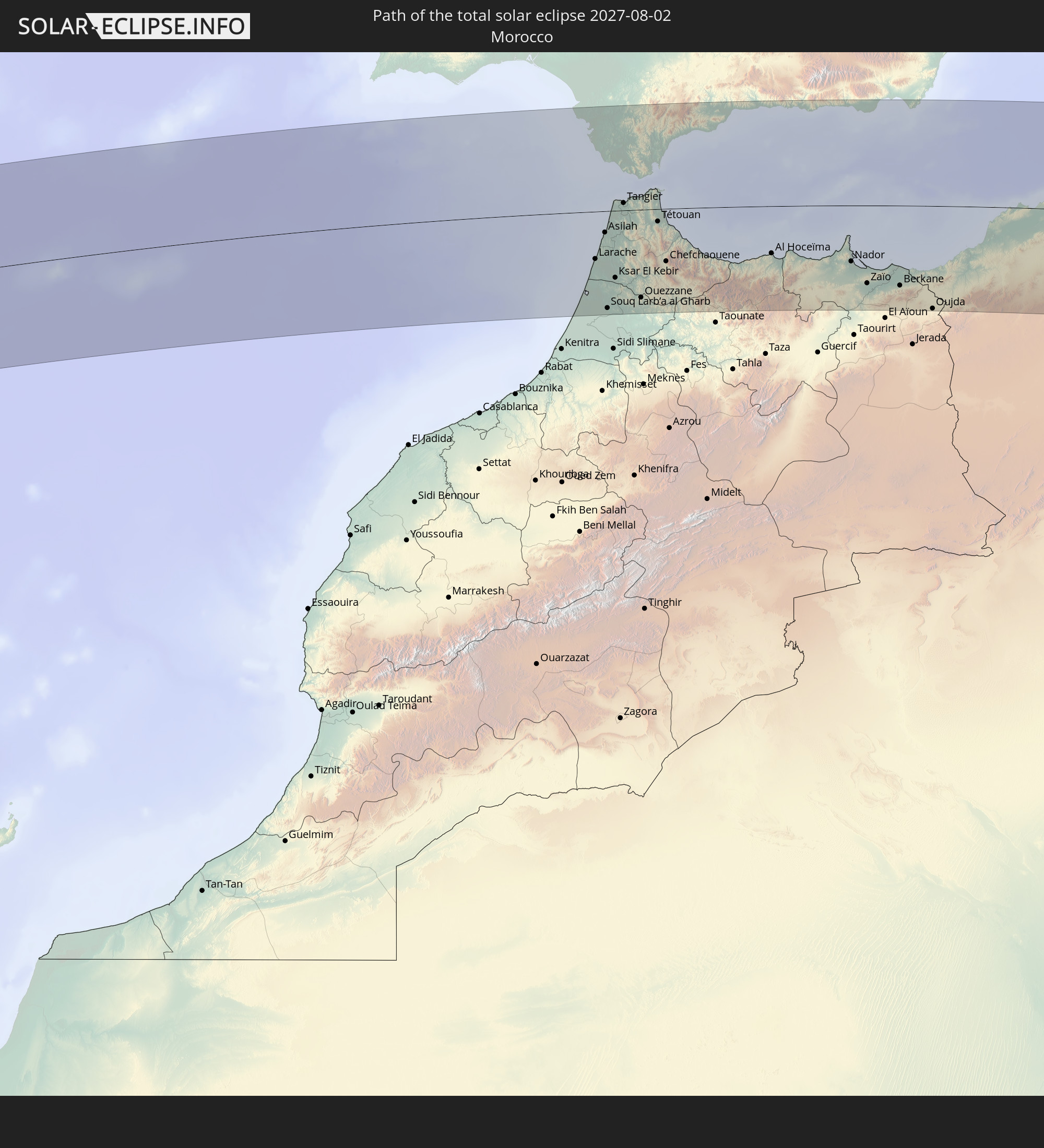 Marokko
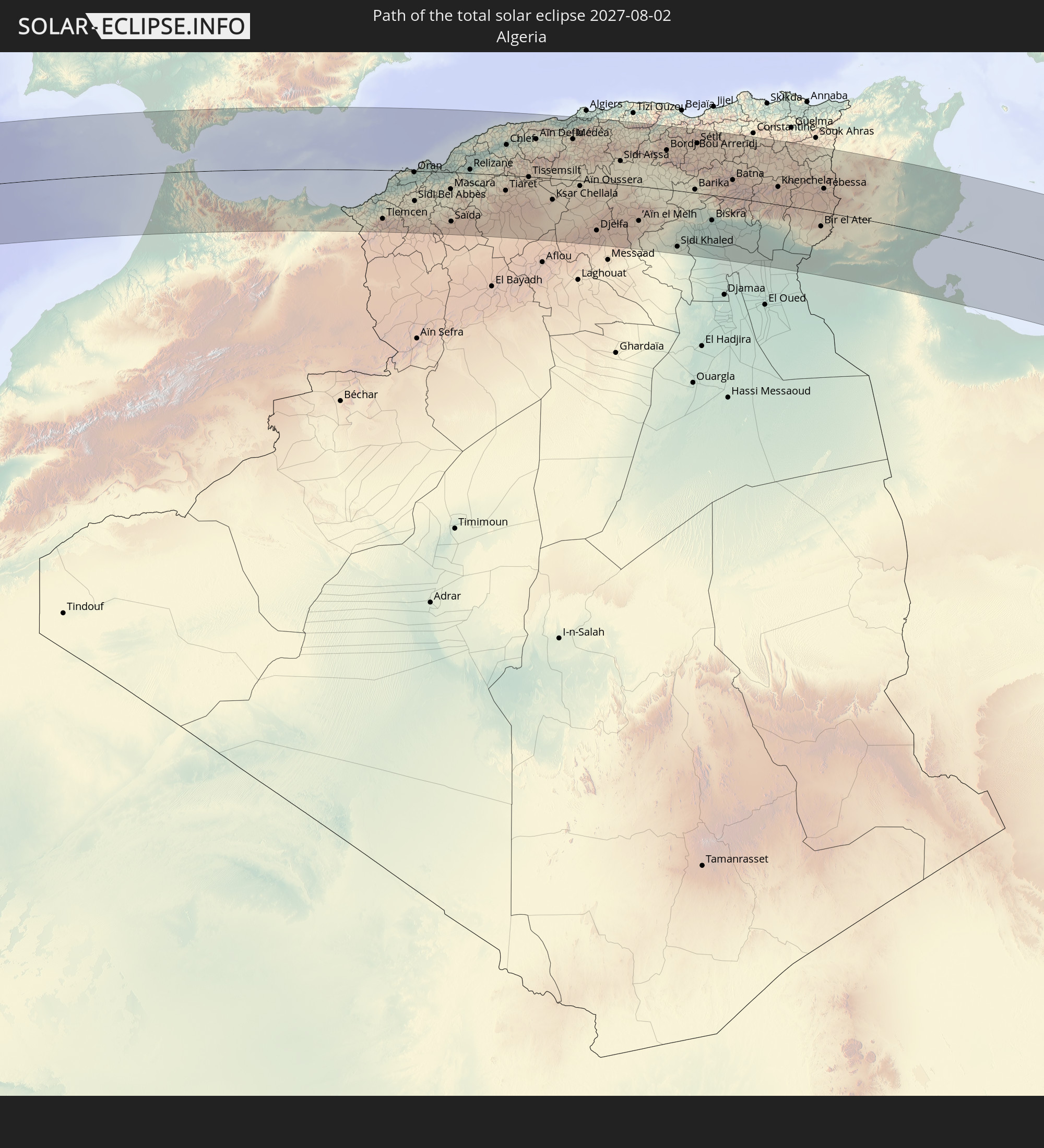 Algerien
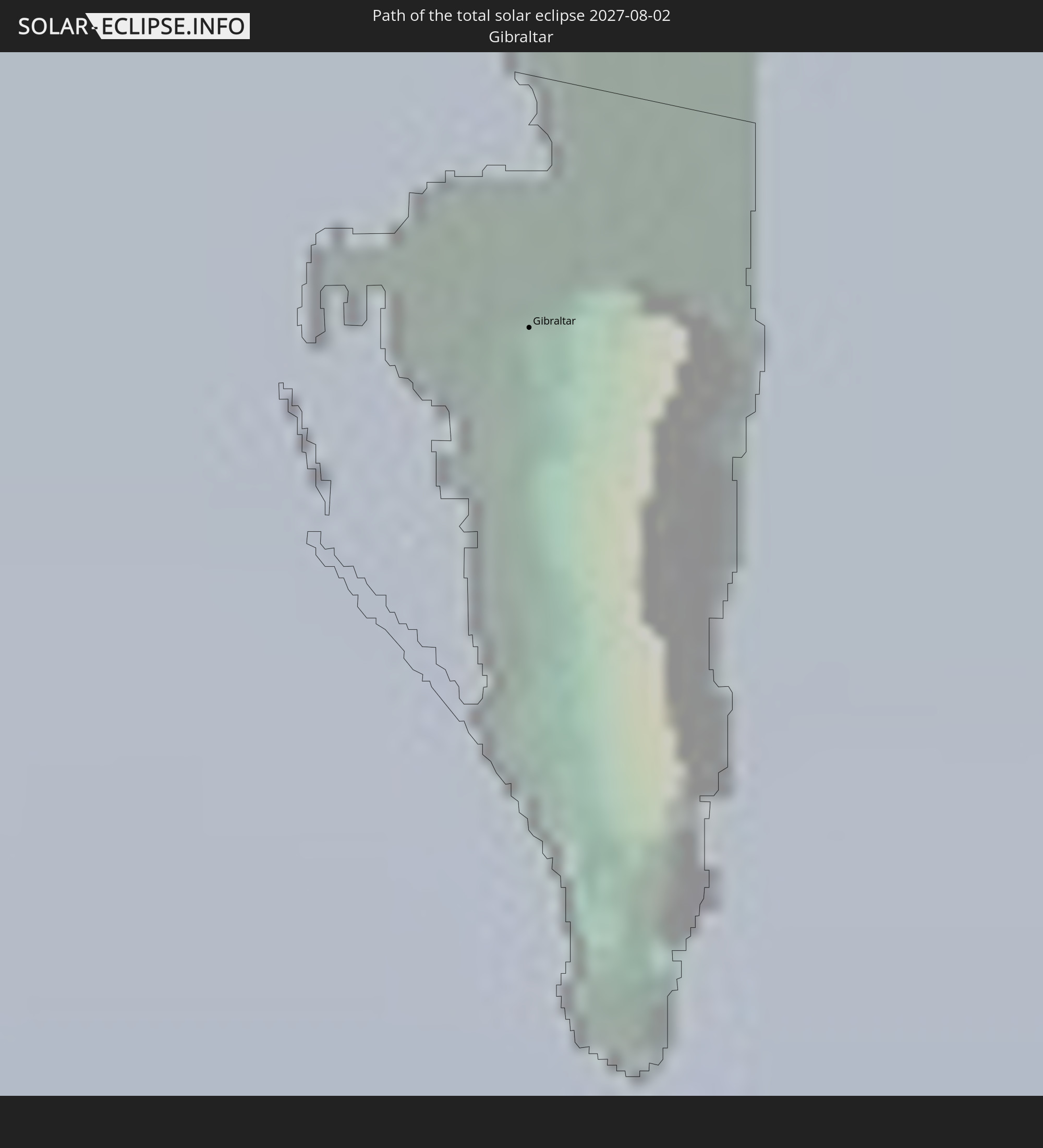 Gibraltar
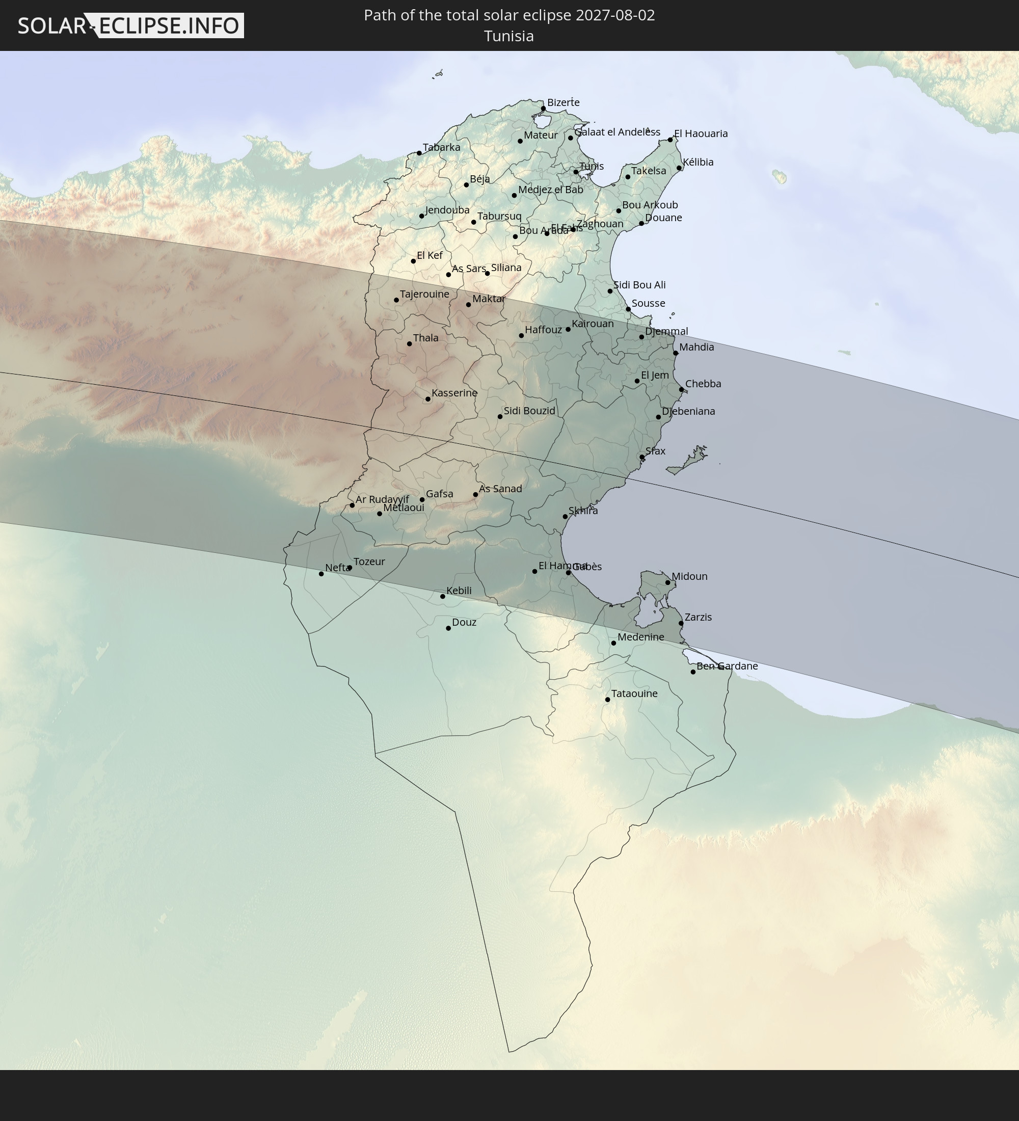 Tunesien
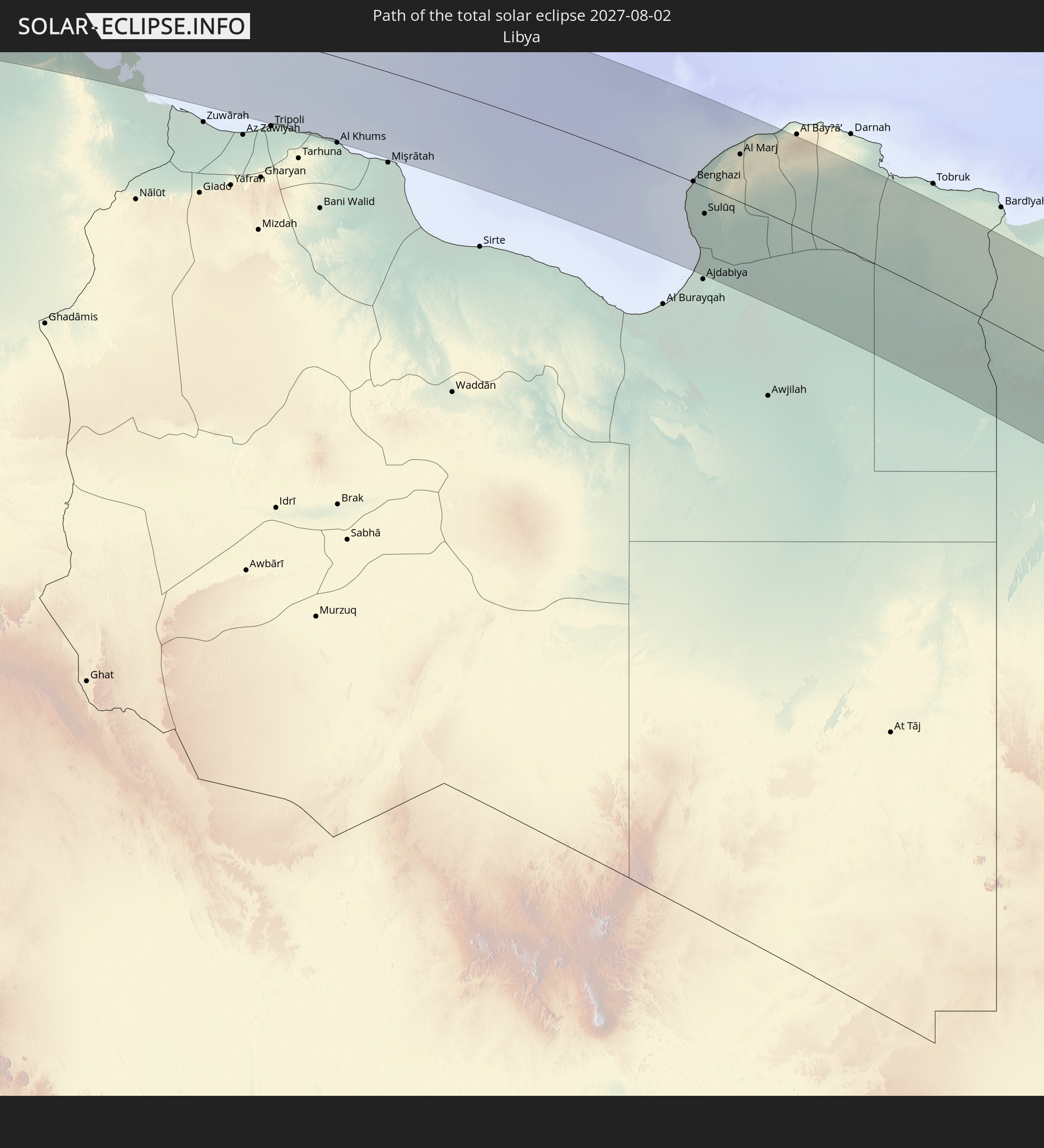 Libyen
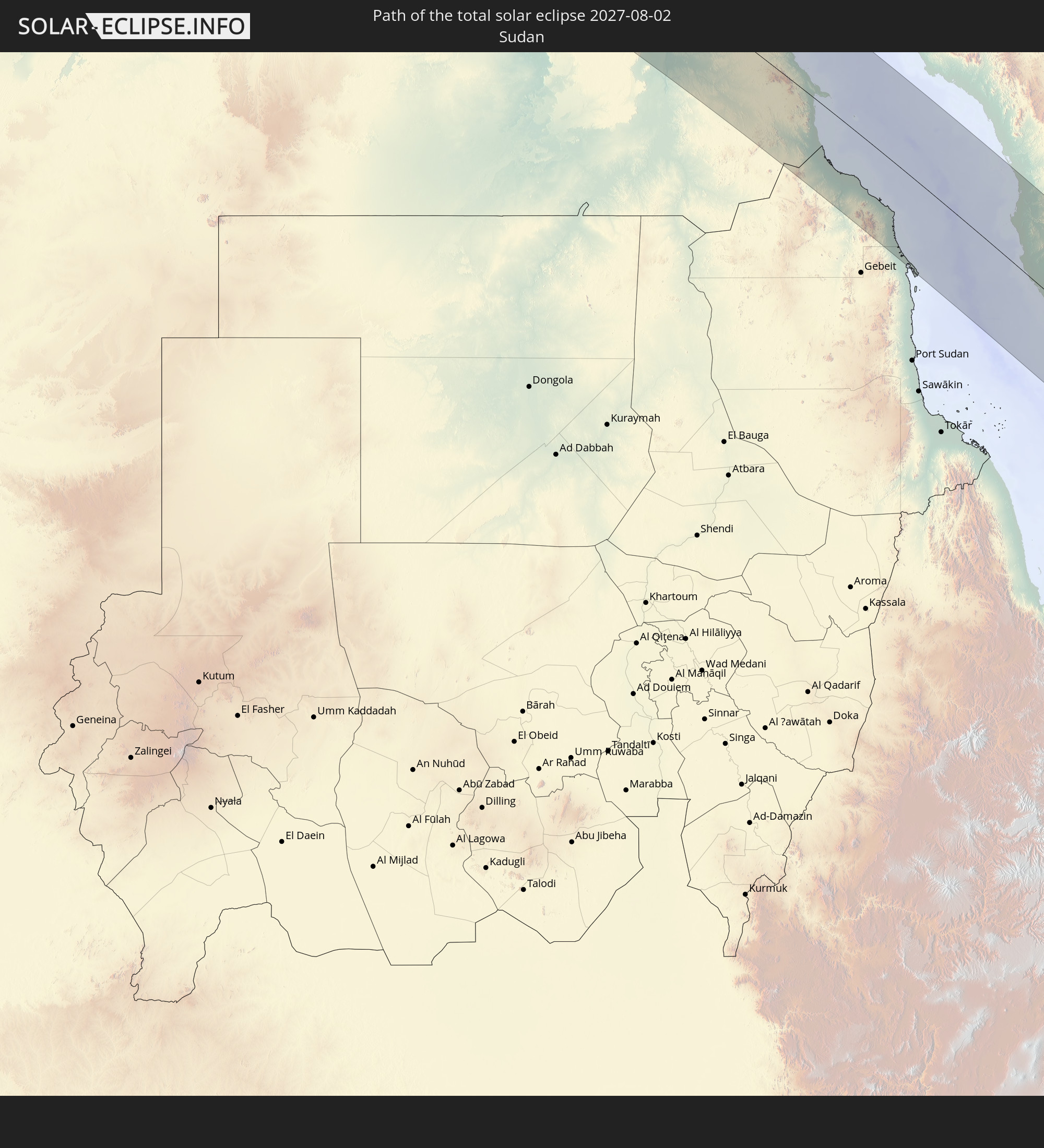 Sudan
Sudan
 Ägypten
 Saudi-Arabien
 Somalia
 Jemen
Jemen
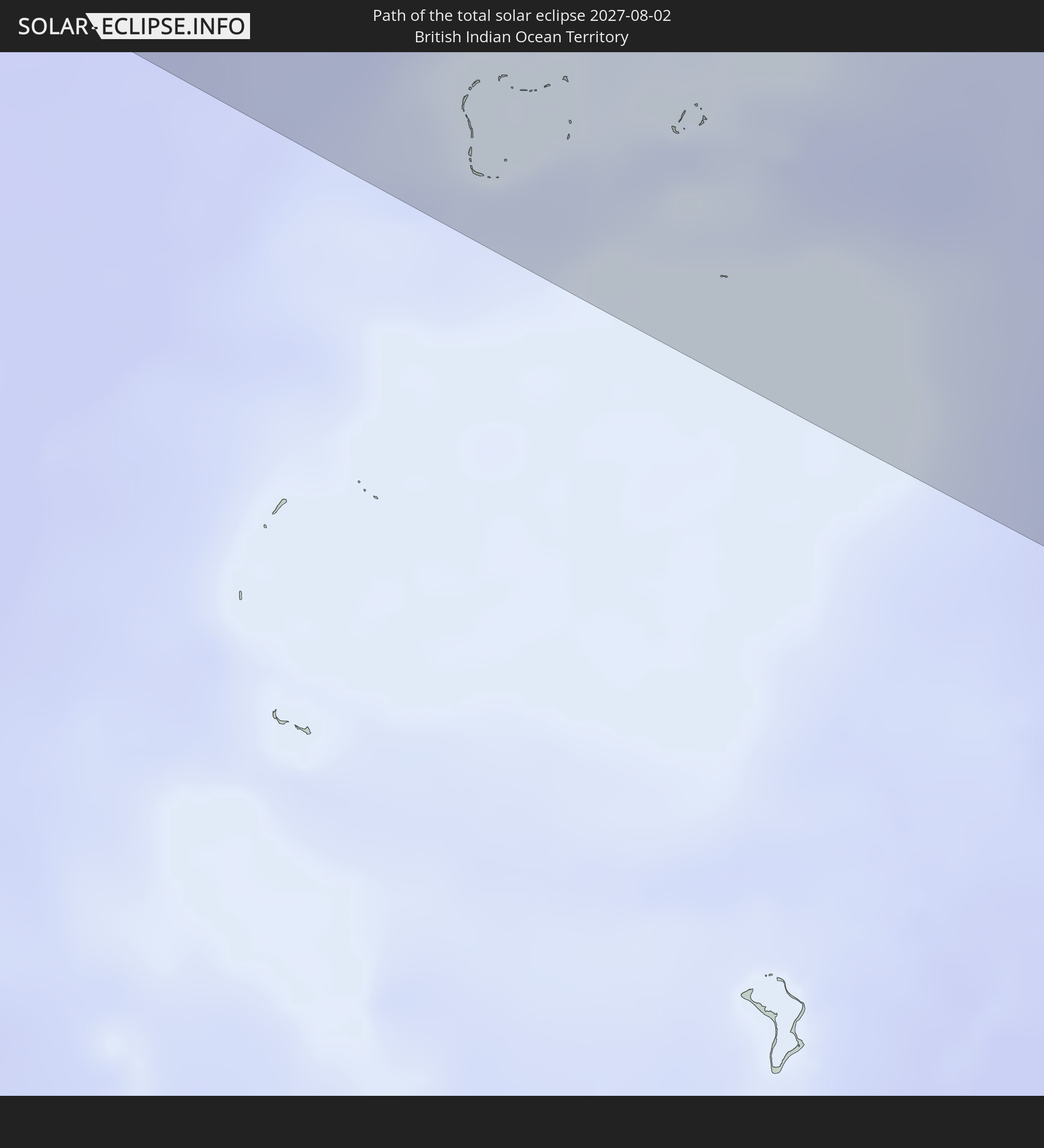 Britisches Territorium im Indischen Ozean
In den folgenden Ländern ist die Sonnenfinsternis partiell zu sehen
 Russland
 Kanada
 Grönland
 Saint-Pierre und Miquelon
 Portugal
 Kap Verde
 Island
 Spanien
 Senegal
 Mauretanien
 Gambia
 Guinea-Bissau
 Guinea
 Sierra Leone
 Marokko
 Mali
Mali
 Liberia
 Irland
 Algerien
 Vereinigtes Königreich
 Elfenbeinküste
 Färöer
 Burkina Faso
 Gibraltar
 Frankreich
 Isle of Man
 Ghana
Ghana
 Guernsey
 Jersey
 Togo
Togo
 Niger
Niger
 Benin
Benin
 Andorra
 Belgien
 Nigeria
 Niederlande
 Norwegen
 Äquatorialguinea
 Luxemburg
 Deutschland
 Schweiz
 Italien
 Monaco
 Tunesien
 Dänemark
 Kamerun
 Gabun
Gabun
 Libyen
 Liechtenstein
 Österreich
 Schweden
 Republik Kongo
 Tschechien
 Demokratische Republik Kongo
 San Marino
 Vatikanstadt
 Slowenien
 Tschad
 Kroatien
 Polen
Polen
 Malta
Malta
 Zentralafrikanische Republik
 Bosnien und Herzegowina
 Ungarn
 Slowakei
 Montenegro
 Serbien
 Albanien
 Åland Islands
 Griechenland
 Rumänien
 Mazedonien
 Finnland
 Litauen
 Lettland
 Estland
 Sudan
Sudan
 Sambia
 Ukraine
 Bulgarien
 Weißrussland
 Ägypten
 Türkei
 Moldawien
 Ruanda
 Burundi
 Tansania
 Uganda
 Mosambik
 Republik Zypern
 Malawi
 Äthiopien
 Kenia
Kenia
 Staat Palästina
 Israel
 Saudi-Arabien
 Jordanien
 Libanon
 Syrien
 Eritrea
 Irak
Irak
 Georgien
 Französische Süd- und Antarktisgebiete
 Somalia
 Dschibuti
 Jemen
Jemen
 Madagaskar
 Komoren
 Armenien
 Iran
Iran
 Aserbaidschan
 Mayotte
 Seychellen
 Kasachstan
 Kuwait
 Bahrain
 Katar
Katar
 Vereinigte Arabische Emirate
 Oman
Oman
 Turkmenistan
 Réunion
 Usbekistan
 Mauritius
 Afghanistan
 Pakistan
 Tadschikistan
 Indien
 Kirgisistan
 Britisches Territorium im Indischen Ozean
 Malediven
 Volksrepublik China
 Sri Lanka
 Nepal
Nepal
 Bangladesch
 Bhutan
 Myanmar
 Indonesien
 Thailand
 Malaysia
 Laos
Laos
 Vietnam
 Kambodscha
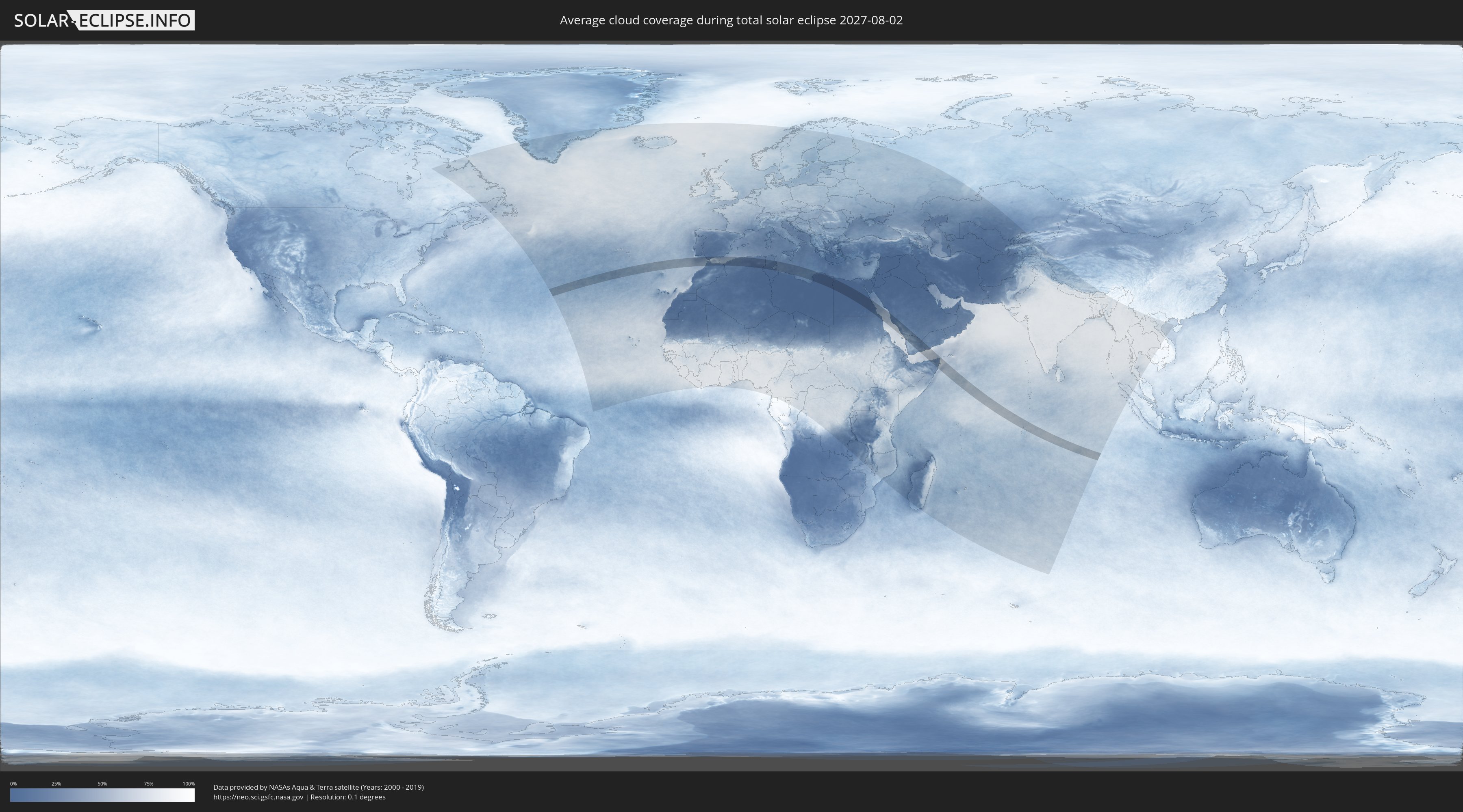
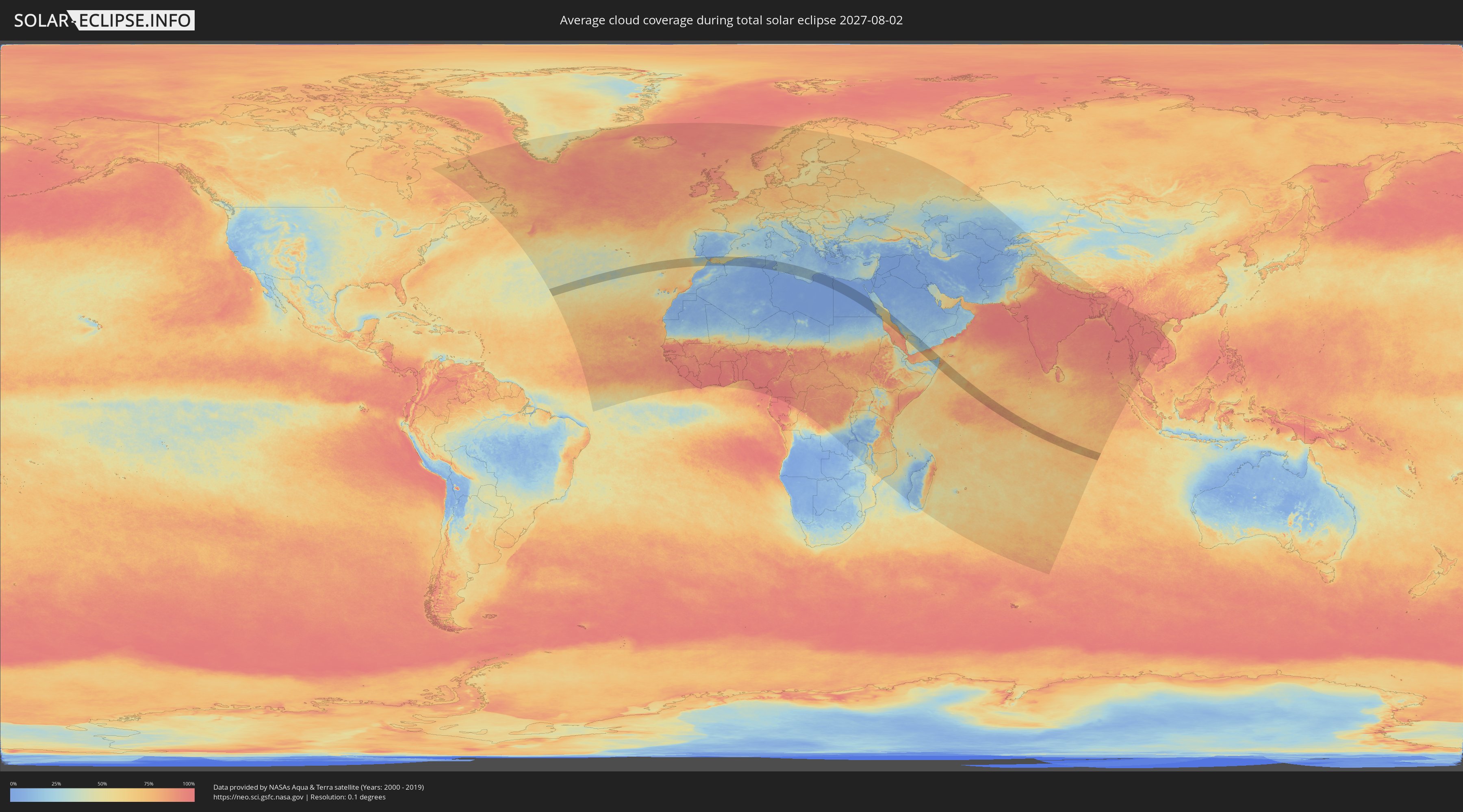
Wie wird das Wetter während der totalen Sonnenfinsternis am 02.08.2027?
Wo ist der beste Ort, um die totale Sonnenfinsternis vom 02.08.2027 zu beobachten?
Die folgenden Karten zeigen die durchschnittliche Bewölkung für den Tag, an dem die totale Sonnenfinsternis
stattfindet. Mit Hilfe der Karten lässt sich der Ort entlang des Finsternispfades eingrenzen,
der die besten Aussichen auf einen klaren wolkenfreien Himmel bietet.
Trotzdem muss man immer lokale Gegenenheiten beachten und sollte sich genau über das Wetter an seinem
gewählten Beobachtungsort informieren.
Die Daten stammen von den beiden NASA-Satelliten
AQUA und TERRA
und wurden über einen Zeitraum von 19 Jahren (2000 - 2019) gemittelt.
Detaillierte Länderkarten
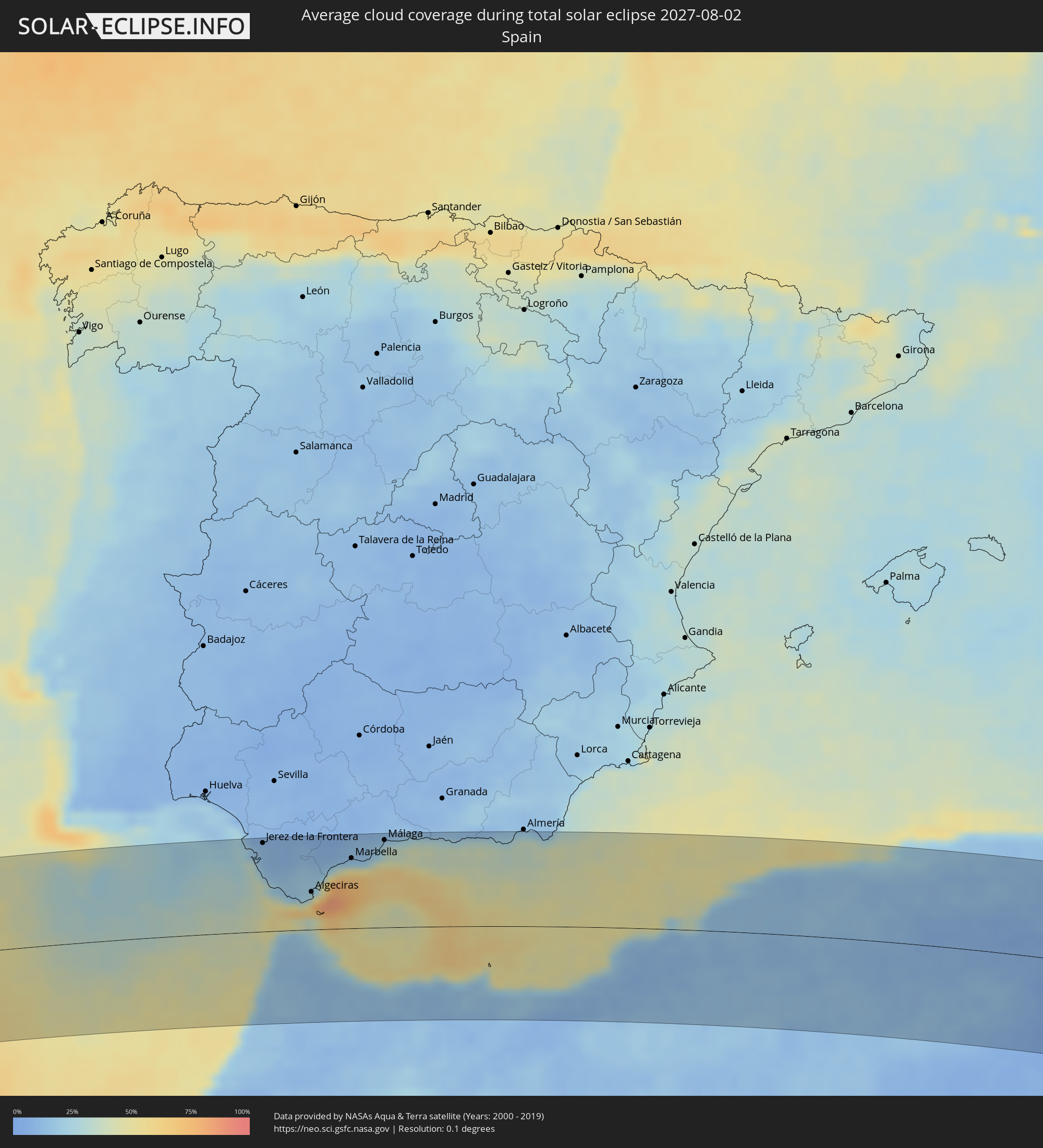 Spanien
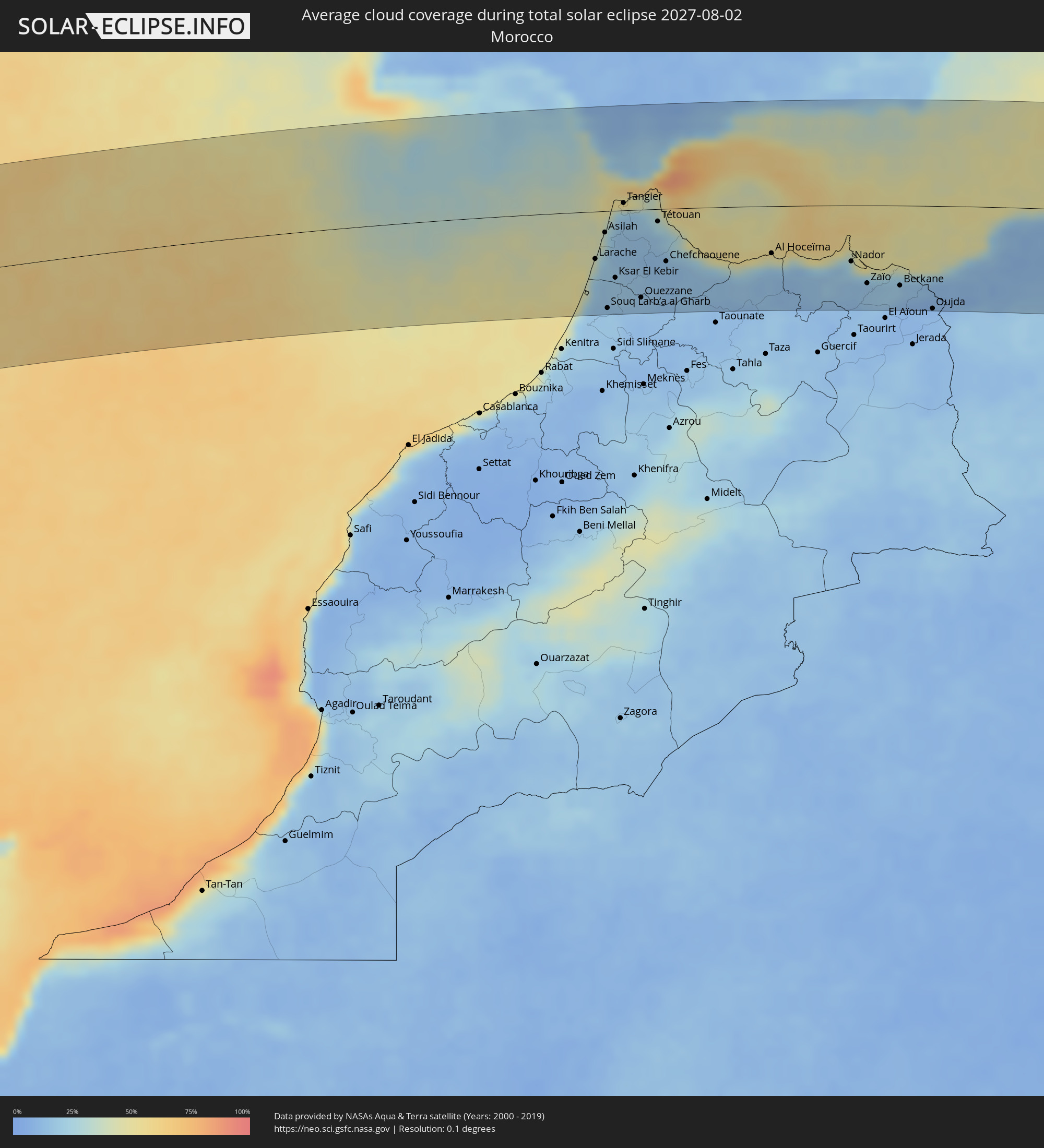 Marokko
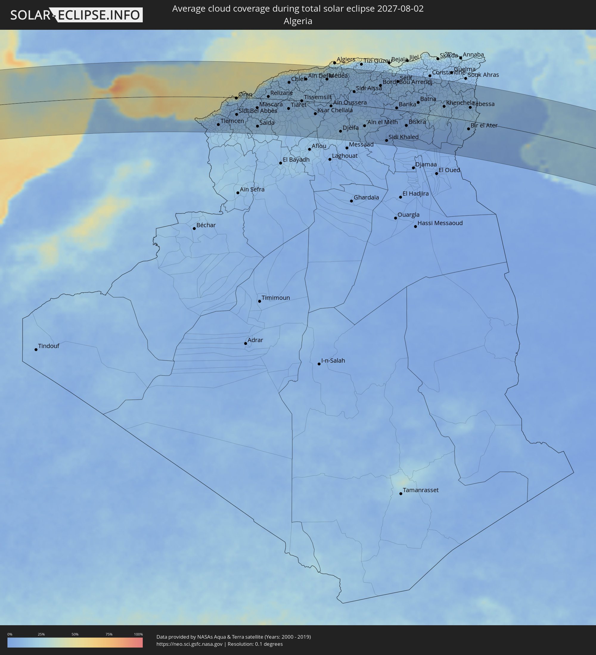 Algerien
 Gibraltar
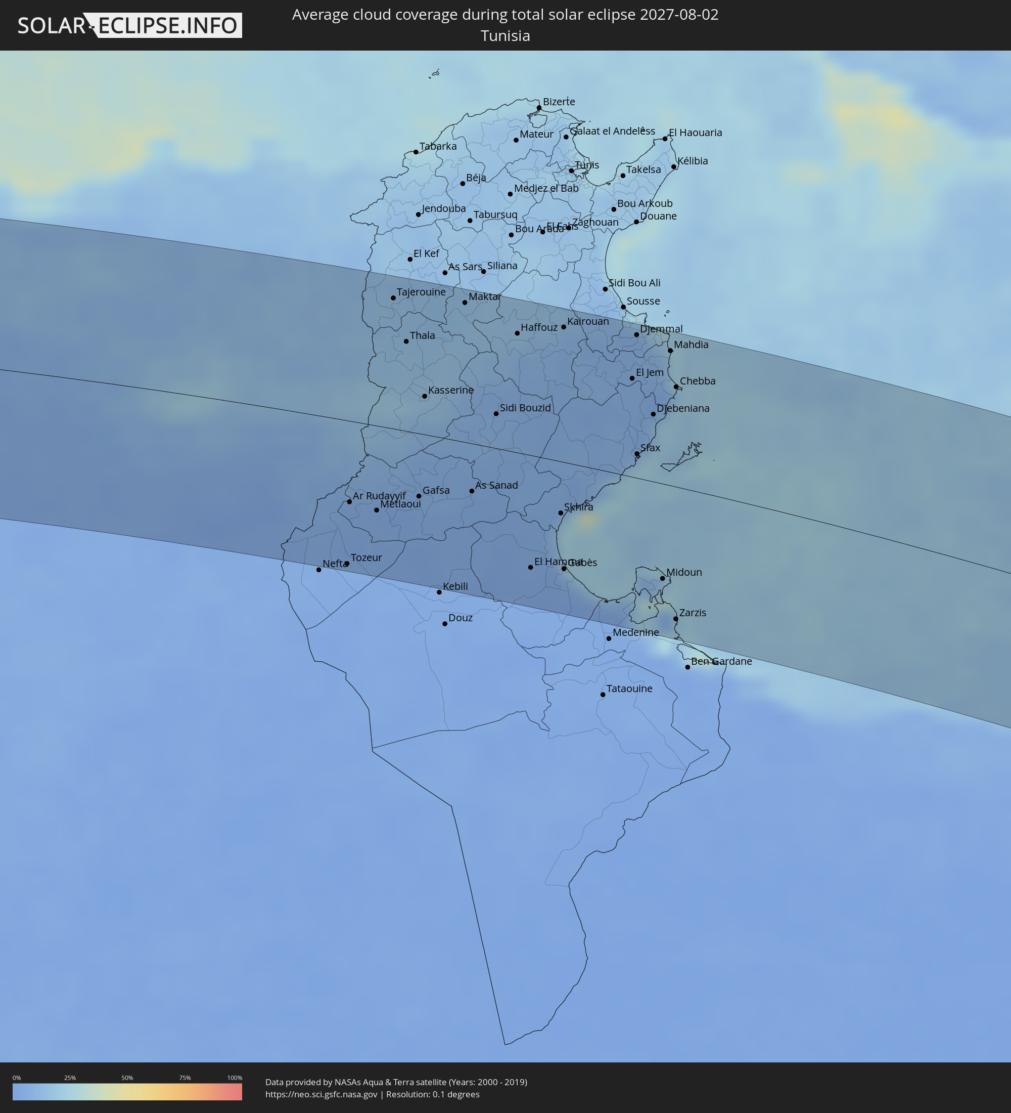 Tunesien
 Libyen
 Sudan
Sudan
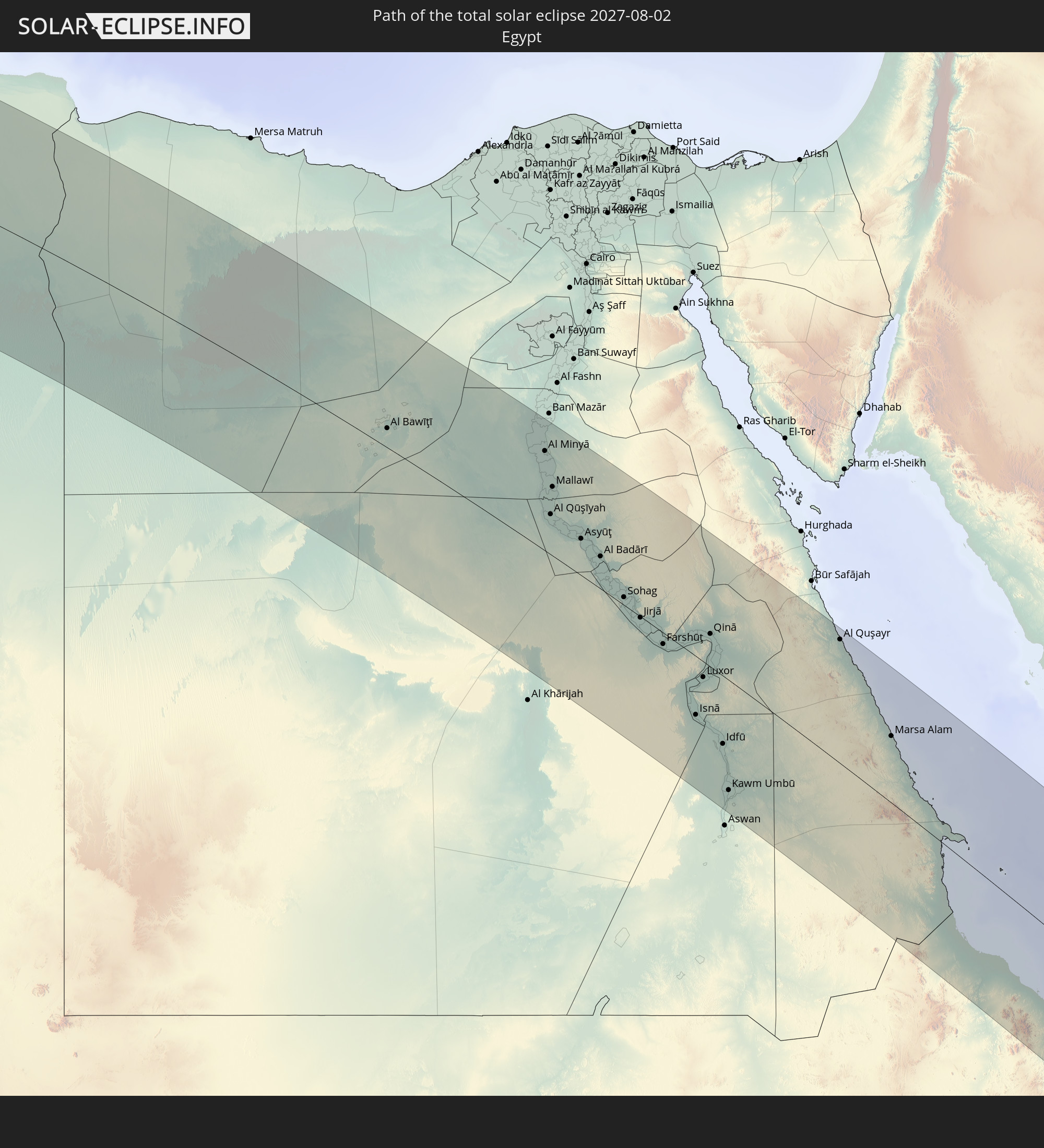
 Ägypten
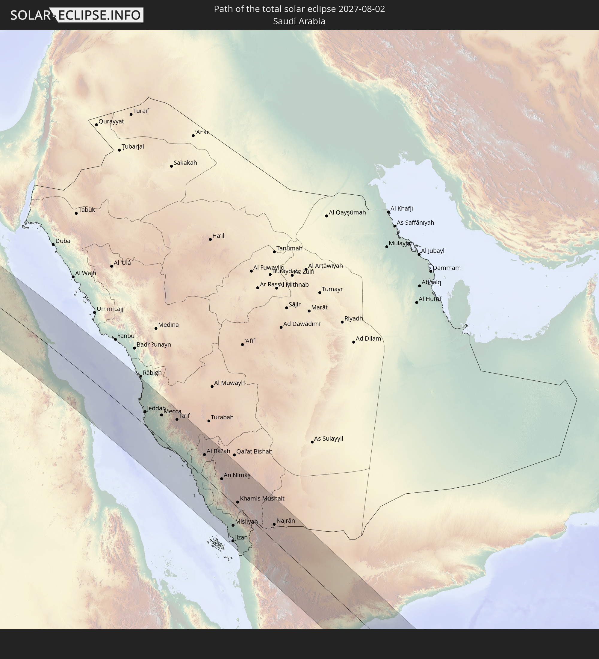
 Saudi-Arabien
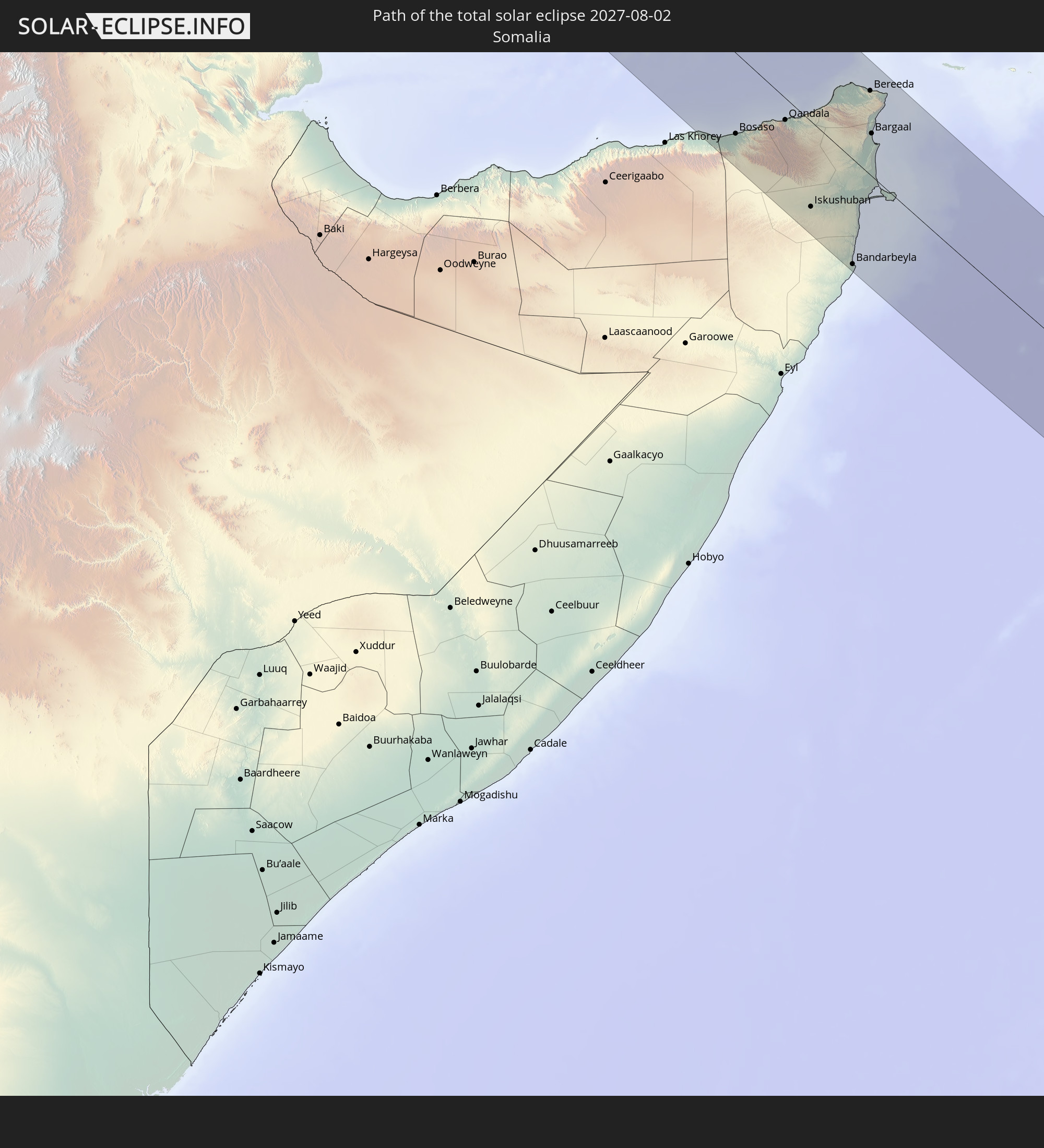
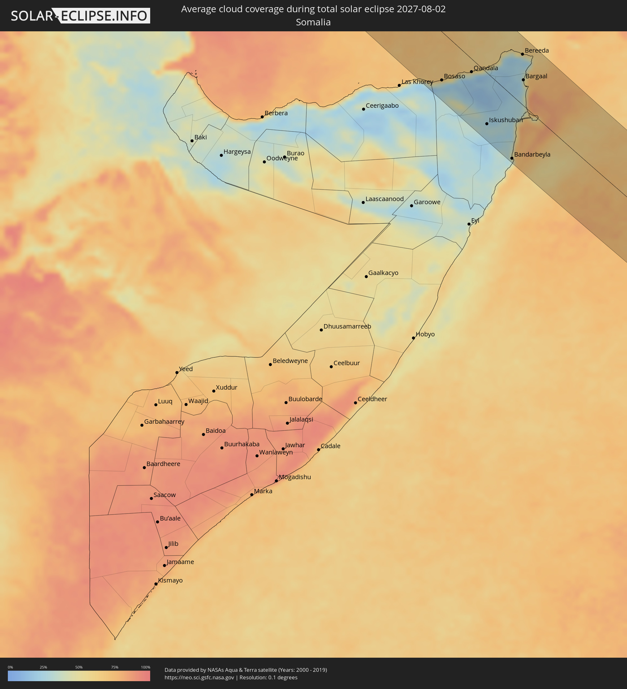 Somalia
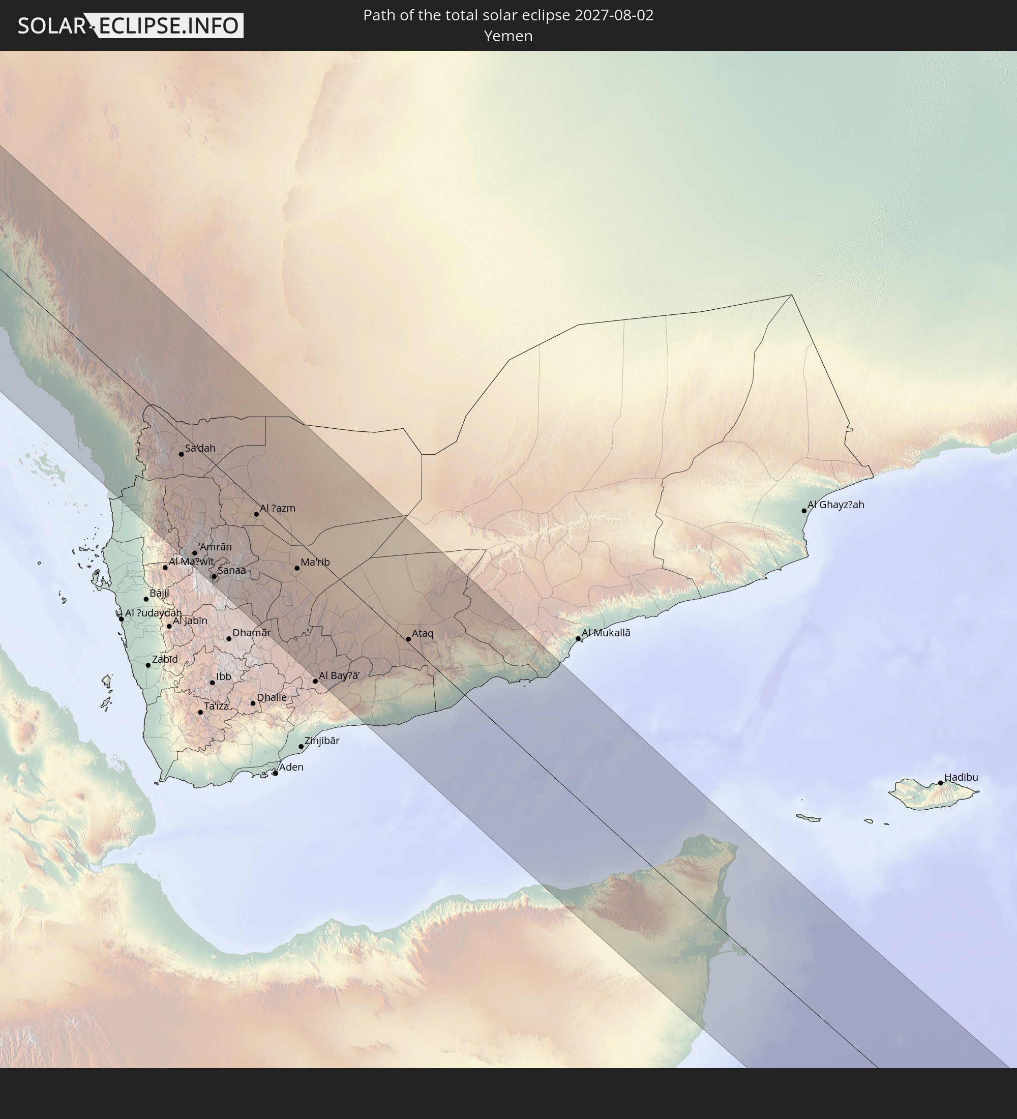
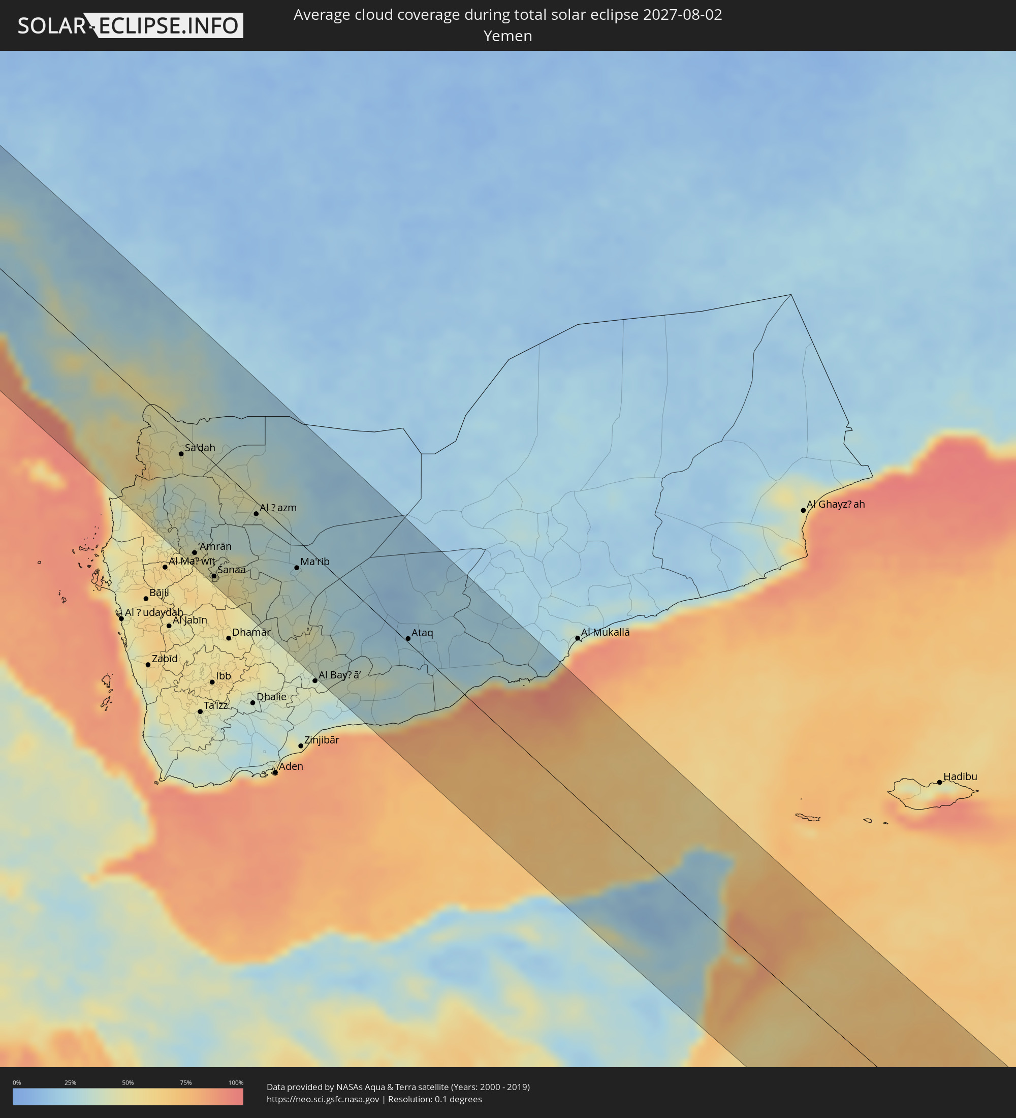 Jemen
Jemen
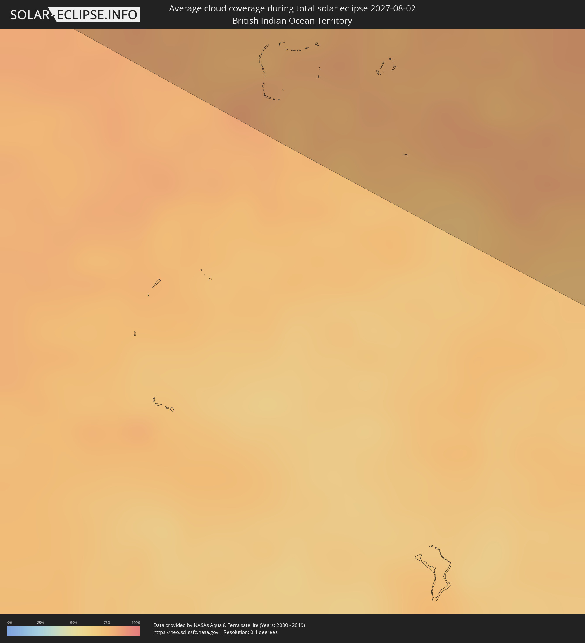 Britisches Territorium im Indischen Ozean
Orte im Finsternispfad
Die nachfolgene Tabelle zeigt Städte und Orte mit mehr als 5.000 Einwohnern, die sich im Finsternispfad befinden. Städte mit mehr als 100.000 Einwohnern sind dick gekennzeichnet. Mit einem Klick auf den Ort öffnet sich eine Detailkarte die die Lage des jeweiligen Ortes zusammen mit dem Verlauf der zentralen Finsternis präsentiert.
| Ort | Typ | Dauer der Verfinsterung | Ortszeit bei maximaler Verfinsterung | Entfernung zur Zentrallinie | Ø Bewölkung |
|
Cadiz, Andalusia
|
total | - | 10:46:43 UTC+02:00 | 95 km | 35% |
|
Larache, Tanger-Tétouan
|
total | - | 09:46:24 UTC+01:00 | 54 km | 37% |
|
Chiclana de la Frontera, Andalusia
|
total | - | 10:46:50 UTC+02:00 | 82 km | 19% |
|
Jerez de la Frontera, Andalusia
|
total | - | 10:46:57 UTC+02:00 | 112 km | 11% |
|
Asilah, Tanger-Tétouan
|
total | - | 09:46:38 UTC+01:00 | 24 km | 22% |
|
Souq Larb’a al Gharb, Gharb-Chrarda-Beni Hssen
|
total | - | 09:46:25 UTC+01:00 | 111 km | 17% |
|
Barbate de Franco, Andalusia
|
total | - | 10:47:01 UTC+02:00 | 56 km | 34% |
|
Ksar El Kebir, Tanger-Tétouan
|
total | - | 09:46:38 UTC+01:00 | 77 km | 17% |
|
Arcos de la Frontera, Andalusia
|
total | - | 10:47:21 UTC+02:00 | 118 km | 9% |
|
Tangier, Tanger-Tétouan
|
total | - | 09:47:00 UTC+01:00 | 8 km | 23% |
|
Ouezzane, Gharb-Chrarda-Beni Hssen
|
total | - | 09:46:57 UTC+01:00 | 100 km | 14% |
|
Algeciras, Andalusia
|
total | - | 10:47:32 UTC+02:00 | 48 km | 53% |
|
Tétouan, Tanger-Tétouan
|
total | - | 09:47:27 UTC+01:00 | 14 km | 25% |
|
Gibraltar
|
total | - | 10:47:39 UTC+02:00 | 49 km | 75% |
|
Ceuta, Ceuta
|
total | - | 10:47:36 UTC+02:00 | 20 km | 58% |
|
Martil, Tanger-Tétouan
|
total | - | 09:47:34 UTC+01:00 | 10 km | 28% |
|
Chefchaouene, Tanger-Tétouan
|
total | - | 09:47:26 UTC+01:00 | 60 km | 13% |
|
Ronda, Andalusia
|
total | - | 10:48:05 UTC+02:00 | 115 km | 9% |
|
Estepona, Andalusia
|
total | - | 10:48:00 UTC+02:00 | 80 km | 64% |
|
Marbella, Andalusia
|
total | - | 10:48:20 UTC+02:00 | 89 km | 52% |
|
Mijas, Andalusia
|
total | - | 10:48:39 UTC+02:00 | 97 km | 32% |
|
Málaga, Andalusia
|
total | - | 10:48:57 UTC+02:00 | 111 km | 35% |
|
Vélez-Málaga, Andalusia
|
total | - | 10:49:20 UTC+02:00 | 117 km | 28% |
|
Tirhanimîne, Taza-Al Hoceima-Taounate
|
total | - | 09:49:04 UTC+01:00 | 55 km | 19% |
|
Al Hoceïma, Taza-Al Hoceima-Taounate
|
total | - | 09:49:05 UTC+01:00 | 54 km | 42% |
|
Nerja, Andalusia
|
total | - | 10:49:36 UTC+02:00 | 113 km | 32% |
|
Imzoûrene, Taza-Al Hoceima-Taounate
|
total | - | 09:49:09 UTC+01:00 | 65 km | 19% |
|
Almuñécar, Andalusia
|
total | - | 10:49:49 UTC+02:00 | 111 km | 37% |
|
Motril, Andalusia
|
total | - | 10:50:02 UTC+02:00 | 113 km | 27% |
|
Adra, Andalusia
|
total | - | 10:50:39 UTC+02:00 | 112 km | 38% |
|
Melilla, Melilla
|
total | - | 10:50:22 UTC+02:00 | 50 km | 48% |
|
Nador, Oriental
|
total | - | 09:50:20 UTC+01:00 | 64 km | 41% |
|
El Ejido, Andalusia
|
total | - | 10:50:55 UTC+02:00 | 115 km | 25% |
|
Zaïo, Oriental
|
total | - | 09:50:33 UTC+01:00 | 89 km | 17% |
|
Roquetas de Mar, Andalusia
|
total | - | 10:51:09 UTC+02:00 | 114 km | 31% |
|
Berkane, Oriental
|
total | - | 09:51:05 UTC+01:00 | 91 km | 12% |
|
Ahfir, Oriental
|
total | - | 09:51:23 UTC+01:00 | 87 km | 14% |
|
Oujda, Oriental
|
total | - | 09:51:35 UTC+01:00 | 117 km | 10% |
|
Tlemcen, Tlemcen
|
total | - | 09:52:25 UTC+01:00 | 95 km | 12% |
|
Oran, Oran
|
total | - | 09:53:29 UTC+01:00 | 2 km | 15% |
|
Sidi Bel Abbès, Sidi Bel Abbès
|
total | - | 09:53:25 UTC+01:00 | 58 km | 11% |
|
Mostaganem, Mostaganem
|
total | - | 09:54:32 UTC+01:00 | 27 km | 17% |
|
Mascara, Mascara
|
total | - | 09:54:31 UTC+01:00 | 33 km | 14% |
|
Saïda, Saida
|
total | - | 09:54:27 UTC+01:00 | 96 km | 15% |
|
Relizane, Relizane
|
total | - | 09:55:09 UTC+01:00 | 7 km | 14% |
|
Tiaret, Tiaret
|
total | - | 09:56:11 UTC+01:00 | 30 km | 14% |
|
Chlef, Chlef
|
total | - | 09:56:18 UTC+01:00 | 59 km | 13% |
|
Médéa, Medea
|
total | - | 09:58:21 UTC+01:00 | 79 km | 13% |
|
Blida, Blida
|
total | - | 09:58:29 UTC+01:00 | 102 km | 17% |
|
Aïn Oussera, Djelfa
|
total | - | 09:58:32 UTC+01:00 | 10 km | 10% |
|
Djelfa, Djelfa
|
total | - | 09:59:03 UTC+01:00 | 94 km | 14% |
|
Bordj Bou Arreridj, Bordj Bou Arréridj
|
total | - | 10:01:21 UTC+01:00 | 75 km | 9% |
|
Sétif, Sétif
|
total | - | 10:02:22 UTC+01:00 | 96 km | 11% |
|
El Eulma, Sétif
|
total | - | 10:02:48 UTC+01:00 | 94 km | 13% |
|
Biskra, Biskra
|
total | - | 10:02:56 UTC+01:00 | 49 km | 6% |
|
Batna, Batna
|
total | - | 10:03:36 UTC+01:00 | 34 km | 11% |
|
Khenchela, Khenchela
|
total | - | 10:05:11 UTC+01:00 | 34 km | 16% |
|
Tébessa, Tébessa
|
total | - | 10:06:48 UTC+01:00 | 45 km | 15% |
|
Tozeur, Tawzar
|
total | - | 10:07:07 UTC+01:00 | 118 km | 4% |
|
Ar Rudayyif, Gafsa
|
total | - | 10:07:03 UTC+01:00 | 66 km | 5% |
|
Metlaoui, Gafsa
|
total | - | 10:07:29 UTC+01:00 | 69 km | 4% |
|
Tajerouine, Kef
|
total | - | 10:07:26 UTC+01:00 | 105 km | 13% |
|
Thala, Al Qaşrayn
|
total | - | 10:07:41 UTC+01:00 | 72 km | 14% |
|
Gafsa, Gafsa
|
total | - | 10:08:07 UTC+01:00 | 51 km | 5% |
|
Kasserine, Al Qaşrayn
|
total | - | 10:08:03 UTC+01:00 | 31 km | 16% |
|
Maktar, Silyānah
|
total | - | 10:08:31 UTC+01:00 | 112 km | 13% |
|
Sidi Bouzid, Sīdī Bū Zayd
|
total | - | 10:09:11 UTC+01:00 | 28 km | 8% |
|
El Hamma, Qābis
|
total | - | 10:10:02 UTC+01:00 | 92 km | 3% |
|
Kairouan, Al Qayrawān
|
total | - | 10:10:04 UTC+01:00 | 109 km | 9% |
|
Gabès, Qābis
|
total | - | 10:10:35 UTC+01:00 | 87 km | 8% |
|
Msaken, Sūsah
|
total | - | 10:10:53 UTC+01:00 | 123 km | 6% |
|
El Jem, Al Mahdīyah
|
total | - | 10:11:14 UTC+01:00 | 79 km | 7% |
|
Djemmal, Al Munastīr
|
total | - | 10:11:13 UTC+01:00 | 115 km | 8% |
|
Sfax, Şafāqis
|
total | - | 10:11:29 UTC+01:00 | 19 km | 24% |
|
Midoun, Madanīn
|
total | - | 10:12:13 UTC+01:00 | 77 km | 22% |
|
Mahdia, Al Mahdīyah
|
total | - | 10:11:46 UTC+01:00 | 108 km | 23% |
|
Zarzis, Madanīn
|
total | - | 10:12:33 UTC+01:00 | 108 km | 20% |
|
Chebba, Al Mahdīyah
|
total | - | 10:11:57 UTC+01:00 | 80 km | 18% |
|
Tagiura, Tripoli
|
total | - | 11:17:01 UTC+02:00 | 124 km | 8% |
|
Benghazi, Banghāzī
|
total | - | 11:30:47 UTC+02:00 | 1 km | 5% |
|
Az Zuwaytīnah, Sha‘bīyat al Wāḩāt
|
total | - | 11:31:57 UTC+02:00 | 117 km | 7% |
|
Sulūq, Banghāzī
|
total | - | 11:31:33 UTC+02:00 | 38 km | 2% |
|
Tūkrah, Al Marj
|
total | - | 11:31:26 UTC+02:00 | 62 km | 7% |
|
Al Abyār, Al Marj
|
total | - | 11:31:47 UTC+02:00 | 28 km | 3% |
|
Al Marj, Al Marj
|
total | - | 11:31:59 UTC+02:00 | 67 km | 4% |
|
Samālūţ, Minya
|
total | - | 11:57:09 UTC+02:00 | 114 km | 1% |
|
Al Minyā, Minya
|
total | - | 11:57:32 UTC+02:00 | 97 km | 1% |
|
Dayrūţ, Asyut
|
total | - | 11:58:28 UTC+02:00 | 49 km | 0% |
|
Al Qūşīyah, Asyut
|
total | - | 11:58:40 UTC+02:00 | 39 km | 0% |
|
Abū Qurqāş, Minya
|
total | - | 11:57:58 UTC+02:00 | 86 km | 1% |
|
Mallawī, Minya
|
total | - | 11:58:17 UTC+02:00 | 67 km | 0% |
|
Manfalūţ, Asyut
|
total | - | 11:59:10 UTC+02:00 | 36 km | 0% |
|
Abnūb, Asyut
|
total | - | 11:59:36 UTC+02:00 | 42 km | 0% |
|
Asyūţ, Asyut
|
total | - | 11:59:48 UTC+02:00 | 36 km | 1% |
|
Abū Tīj, Asyut
|
total | - | 12:00:18 UTC+02:00 | 31 km | 1% |
|
Ţahţā, Sohag
|
total | - | 12:01:05 UTC+02:00 | 16 km | 1% |
|
Sohag, Sohag
|
total | - | 12:01:49 UTC+02:00 | 8 km | 2% |
|
Al Manshāh, Sohag
|
total | - | 12:02:10 UTC+02:00 | 7 km | 2% |
|
Jirjā, Sohag
|
total | - | 12:02:34 UTC+02:00 | 1 km | 1% |
|
Isnā, Qena
|
total | - | 12:05:35 UTC+02:00 | 57 km | 2% |
|
Luxor, Luxor
|
total | - | 12:05:07 UTC+02:00 | 15 km | 1% |
|
Qinā, Qena
|
total | - | 12:04:33 UTC+02:00 | 32 km | 2% |
|
Kousa, Qena
|
total | - | 12:05:01 UTC+02:00 | 11 km | 2% |
|
Idfū, Aswan
|
total | - | 12:06:46 UTC+02:00 | 66 km | 2% |
|
Kawm Umbū, Aswan
|
total | - | 12:07:44 UTC+02:00 | 107 km | 1% |
|
Jeddah, Makkah
|
total | - | 13:25:08 UTC+03:00 | 40 km | 25% |
|
Al Jumūm, Makkah
|
total | - | 13:25:56 UTC+03:00 | 80 km | 10% |
|
Mecca, Makkah
|
total | - | 13:26:30 UTC+03:00 | 73 km | 10% |
|
Al Hadā, Makkah
|
total | - | 13:27:27 UTC+03:00 | 99 km | 12% |
|
Ash Shafā, Makkah
|
total | - | 13:28:02 UTC+03:00 | 76 km | 18% |
|
Ta’if, Makkah
|
total | - | 13:27:52 UTC+03:00 | 100 km | 13% |
|
Al Mindak, Al Bahah
|
total | - | 13:31:27 UTC+03:00 | 67 km | 33% |
|
Al Bāḩah, Al Bahah
|
total | - | 13:32:03 UTC+03:00 | 68 km | 40% |
|
Al Majāridah, 'Asir
|
total | - | 13:34:27 UTC+03:00 | 26 km | 30% |
|
An Nimāş, 'Asir
|
total | - | 13:34:47 UTC+03:00 | 42 km | 40% |
|
Abha, 'Asir
|
total | - | 13:37:09 UTC+03:00 | 7 km | 43% |
|
Jizan, Jizan
|
total | - | 13:39:40 UTC+03:00 | 113 km | 65% |
|
Mislīyah, Jizan
|
total | - | 13:38:38 UTC+03:00 | 66 km | 48% |
|
Şabyā, Jizan
|
total | - | 13:39:19 UTC+03:00 | 87 km | 47% |
|
Khamis Mushait, 'Asir
|
total | - | 13:37:24 UTC+03:00 | 16 km | 40% |
|
Mizhirah, Jizan
|
total | - | 13:40:06 UTC+03:00 | 106 km | 64% |
|
Abū ‘Arīsh, Jizan
|
total | - | 13:40:00 UTC+03:00 | 87 km | 52% |
|
Al Jarādīyah, Jizan
|
total | - | 13:40:51 UTC+03:00 | 113 km | 44% |
|
Şāmitah, Jizan
|
total | - | 13:40:53 UTC+03:00 | 109 km | 44% |
|
Sa'dah, Şa‘dah
|
total | - | 13:41:38 UTC+03:00 | 22 km | 48% |
|
‘Amrān, Omran
|
total | - | 13:44:16 UTC+03:00 | 114 km | 50% |
|
Najrān, Najran
|
total | - | 13:41:14 UTC+03:00 | 49 km | 34% |
|
Sanaa, Sanaa
|
total | - | 13:45:16 UTC+03:00 | 120 km | 53% |
|
Saḩar, Sanaa
|
total | - | 13:45:30 UTC+03:00 | 116 km | 56% |
|
Sayyān, Sanaa
|
total | - | 13:45:47 UTC+03:00 | 127 km | 57% |
|
Al Ḩazm, Al Jawf
|
total | - | 13:44:43 UTC+03:00 | 13 km | 35% |
|
Ma'rib, Ma’rib
|
total | - | 13:46:53 UTC+03:00 | 30 km | 32% |
|
Jawf al Maqbābah, Abyan
|
total | - | 13:50:37 UTC+03:00 | 126 km | 28% |
|
Ataq, Shabwah
|
total | - | 13:50:55 UTC+03:00 | 4 km | 25% |
|
Bosaso, Bari
|
total | - | 14:00:04 UTC+03:00 | 91 km | 31% |
|
Qandala, Bari
|
total | - | 14:00:42 UTC+03:00 | 24 km | 29% |
|
Iskushuban, Bari
|
total | - | 14:03:13 UTC+03:00 | 97 km | 28% |
|
Bandarbeyla, Bari
|
total | - | 14:05:18 UTC+03:00 | 120 km | 37% |
|
Bereeda, Bari
|
total | - | 14:01:38 UTC+03:00 | 95 km | 36% |
|
Bargaal, Bari
|
total | - | 14:02:39 UTC+03:00 | 48 km | 55% |