Totale Sonnenfinsternis vom 24.08.2063
| Wochentag: | Freitag |
| Maximale Dauer der Verfinsterung: | 05m49s |
| Maximale Breite des Finsternispfades: | 252 km |
| Saroszyklus: | 136 |
| Bedeckungsgrad: | 100% |
| Magnitude: | 1.075 |
| Gamma: | 0.2771 |
Wo kann man die Sonnenfinsternis vom 24.08.2063 sehen?
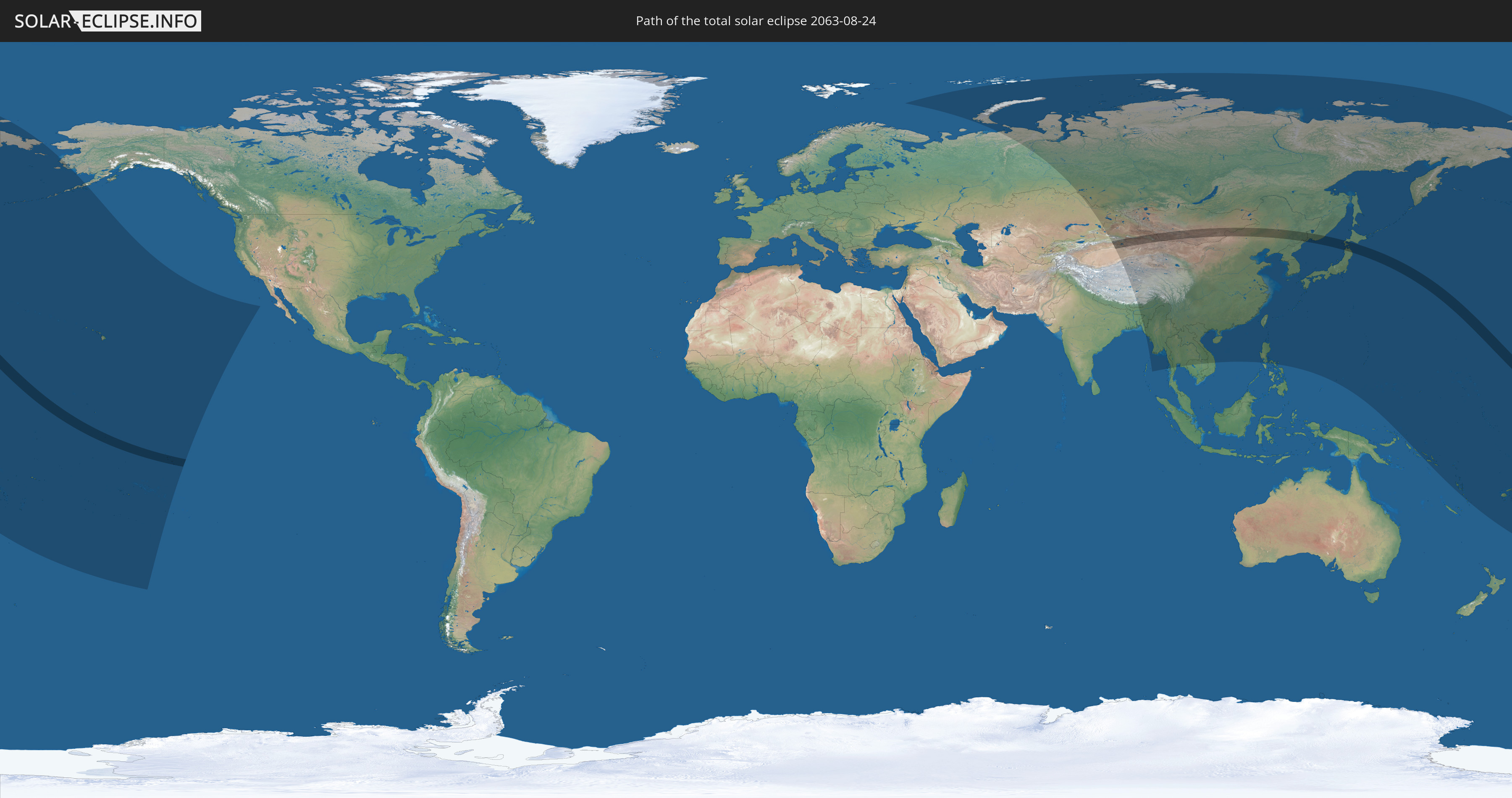
Die Sonnenfinsternis am 24.08.2063 kann man in 40 Ländern als partielle Sonnenfinsternis beobachten.
Der Finsternispfad verläuft durch 7 Länder. Nur in diesen Ländern ist sie als totale Sonnenfinsternis zu sehen.
In den folgenden Ländern ist die Sonnenfinsternis total zu sehen
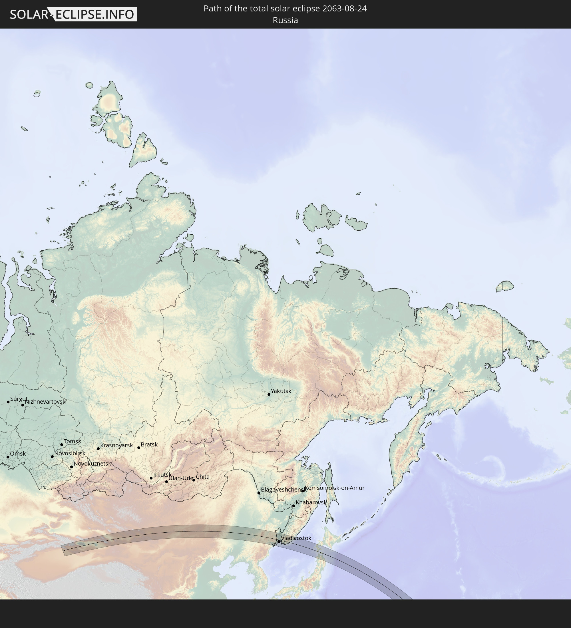 Russland
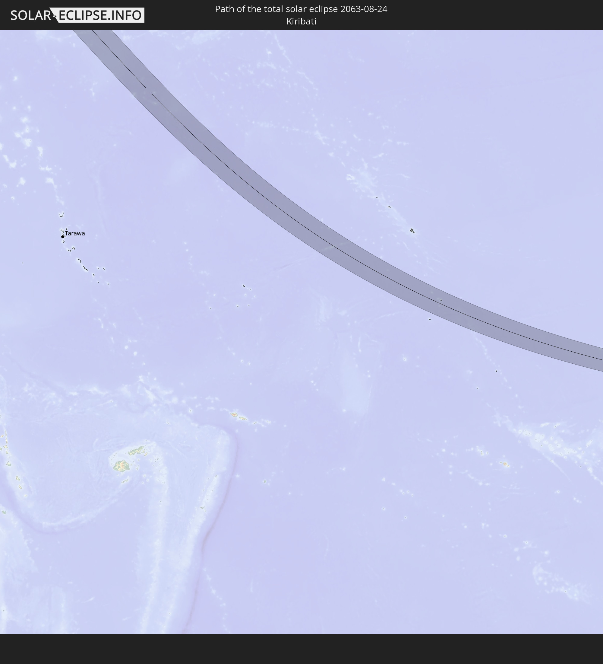 Kiribati
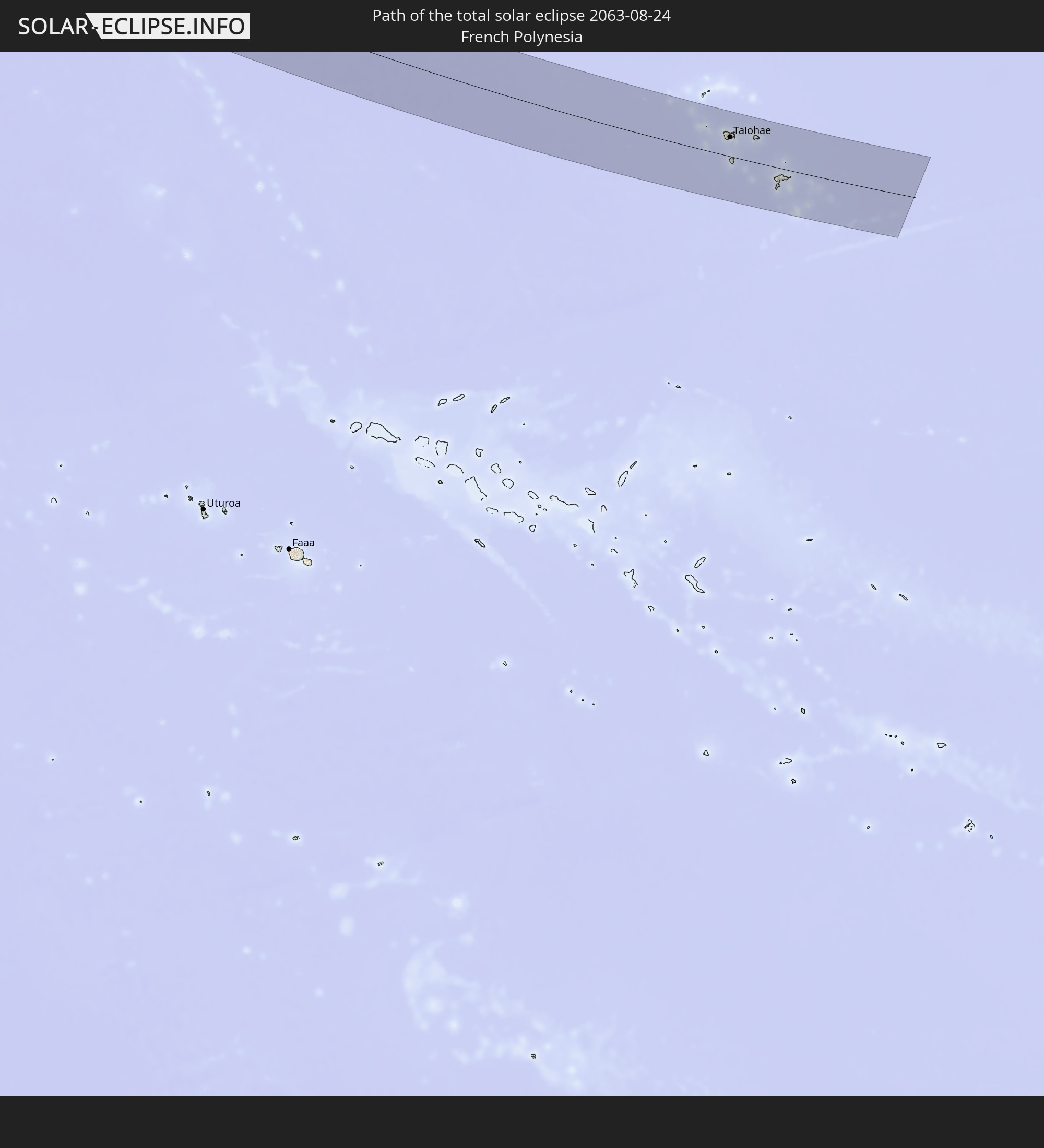 Französisch-Polynesien
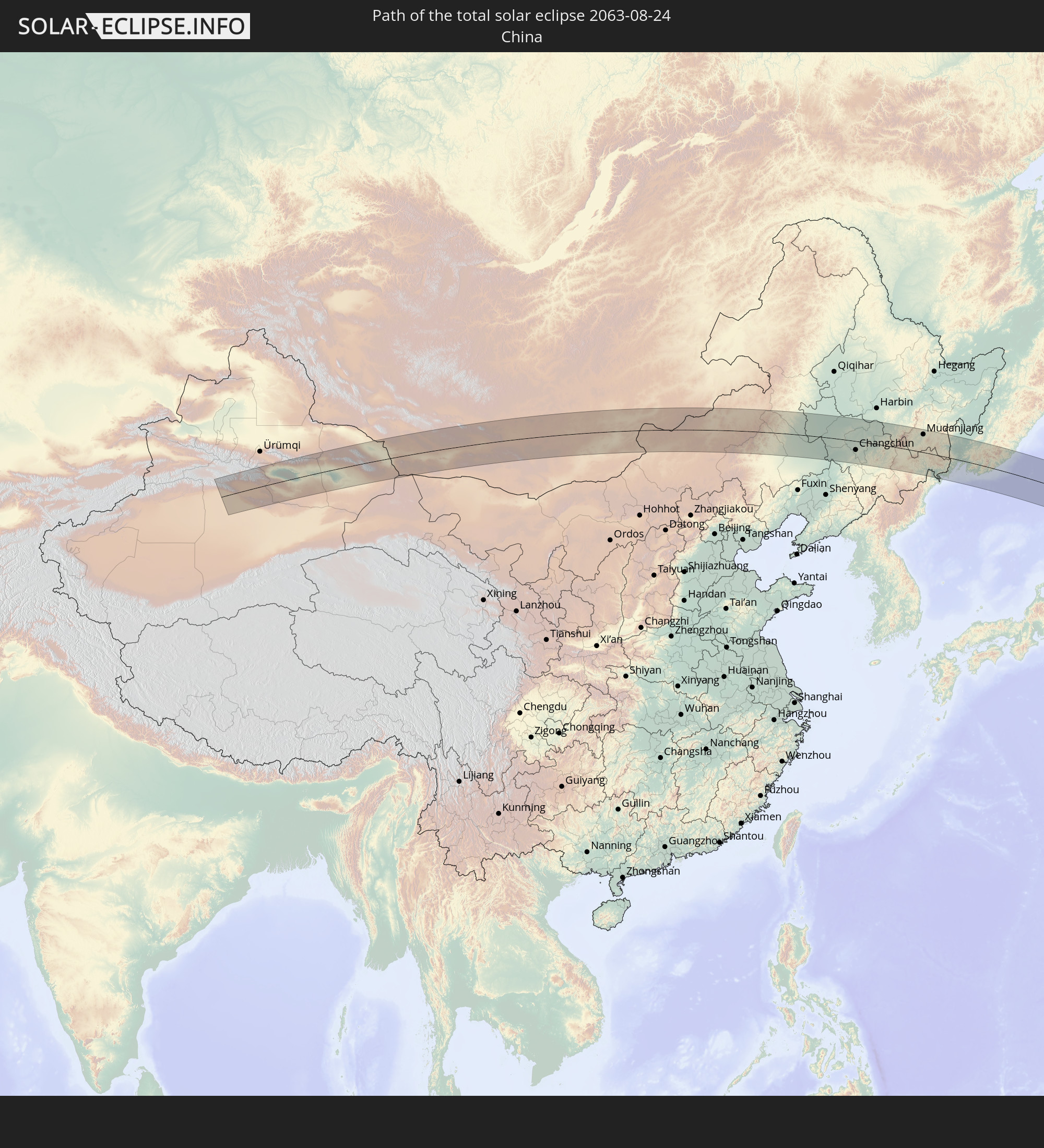 Volksrepublik China
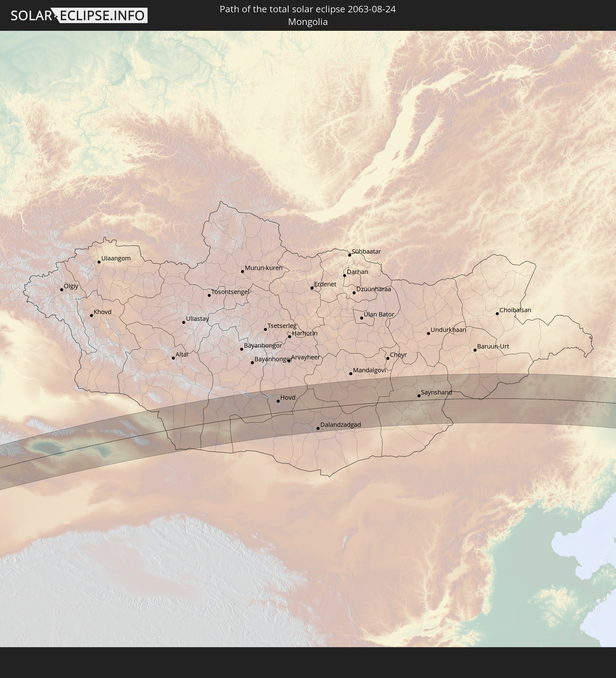 Mongolei
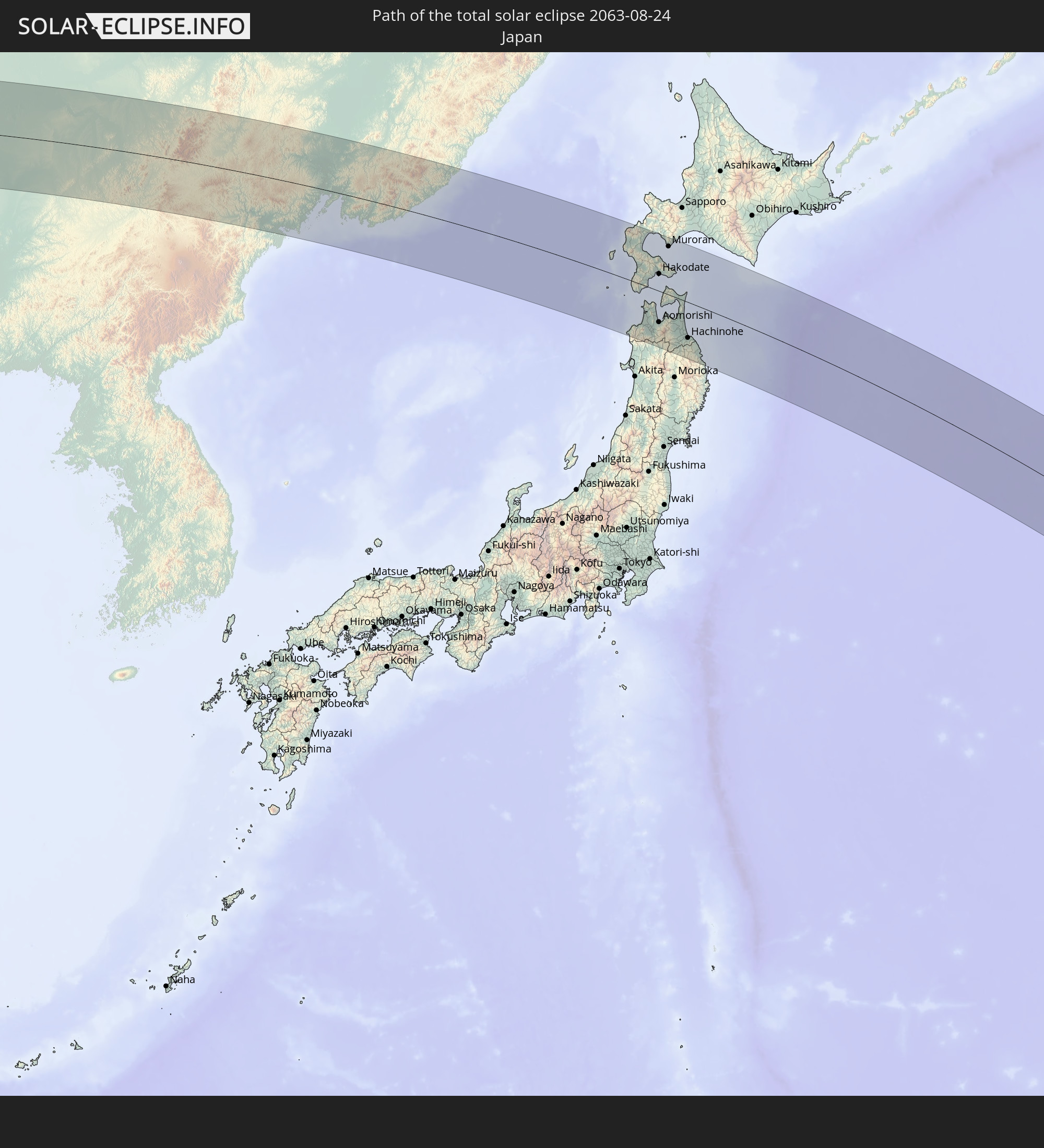 Japan
Japan
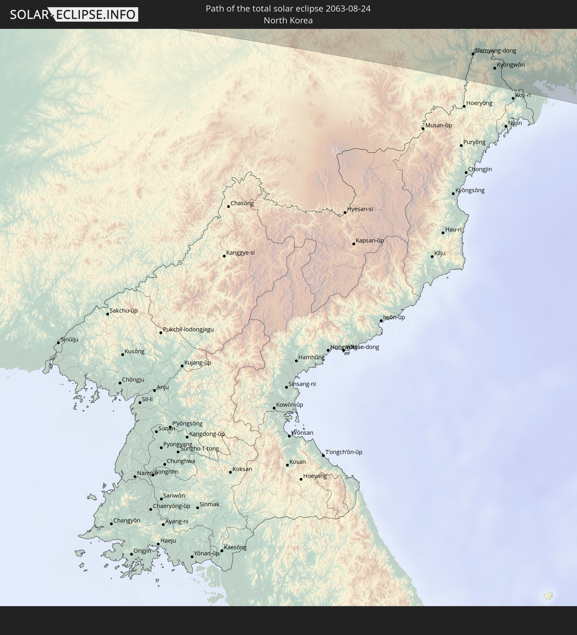 Nordkorea
In den folgenden Ländern ist die Sonnenfinsternis partiell zu sehen
 Fidschi
 Russland
 Vereinigte Staaten
 United States Minor Outlying Islands
 Wallis und Futuna
 Tonga
Tonga
 Kiribati
 Samoa
Samoa
 Tokelau
 Amerikanisch-Samoa
 Niue
Niue
 Cookinseln
 Französisch-Polynesien
 Kasachstan
 Indien
 Volksrepublik China
 Mongolei
 Bangladesch
 Bhutan
 Myanmar
 Thailand
 Laos
Laos
 Vietnam
 Kambodscha
 Macau
Macau
 Hongkong
 Taiwan
 Philippinen
 Japan
Japan
 Nordkorea
 Südkorea
 Föderierte Staaten von Mikronesien
 Papua-Neuguinea
 Guam
Guam
 Nördliche Marianen
 Salomonen
 Marshallinseln
 Vanuatu
 Nauru
Nauru
 Tuvalu
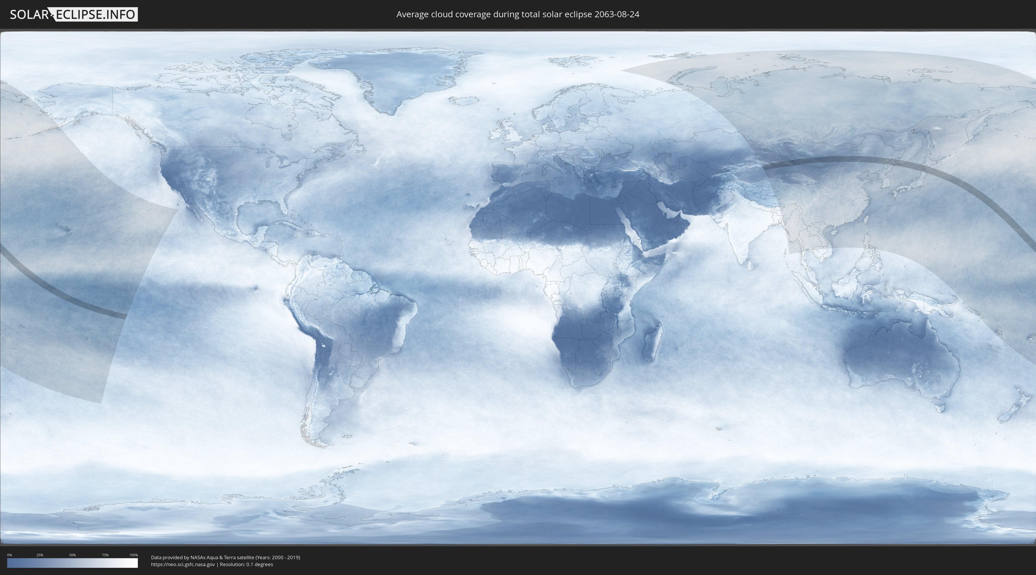
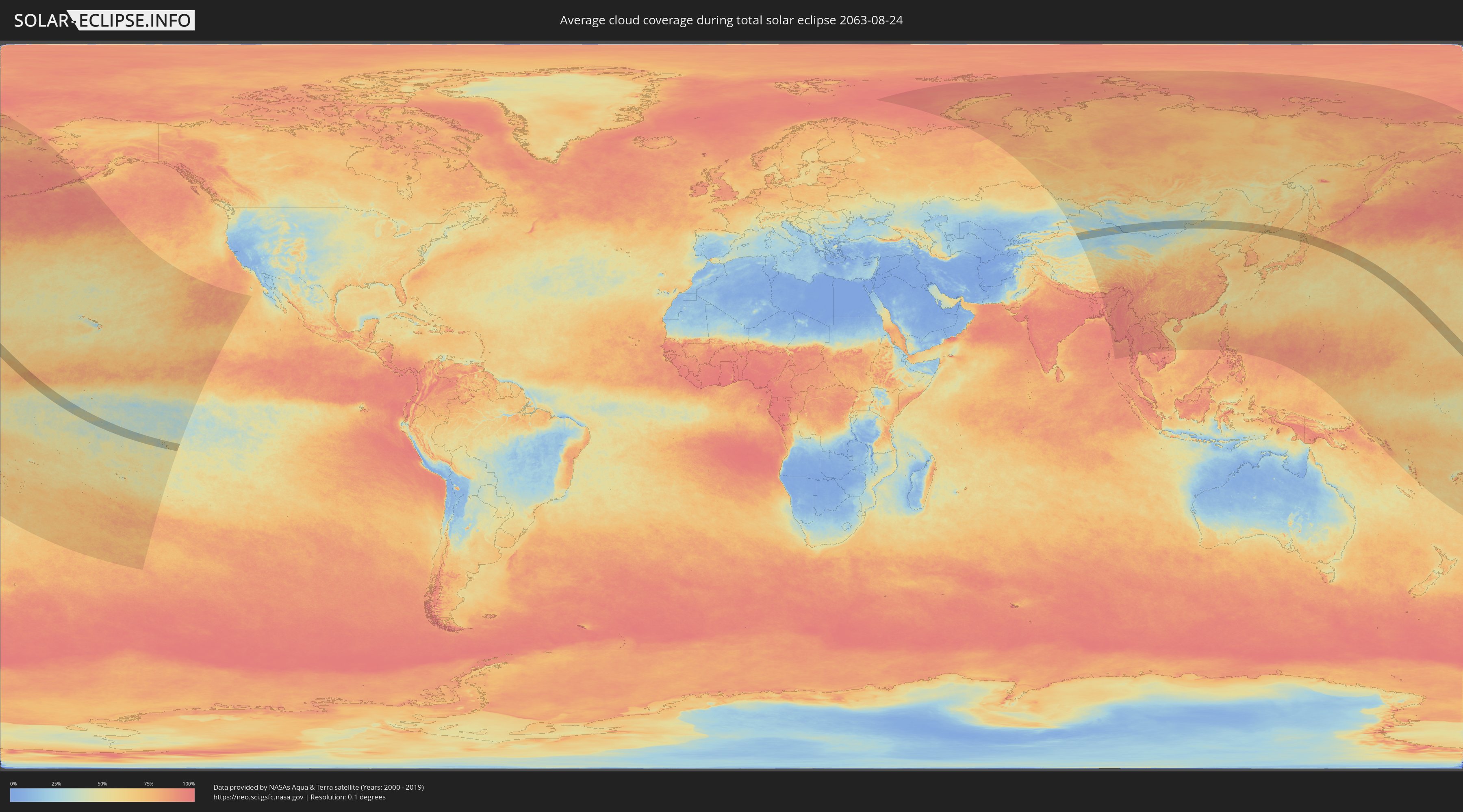
Wie wird das Wetter während der totalen Sonnenfinsternis am 24.08.2063?
Wo ist der beste Ort, um die totale Sonnenfinsternis vom 24.08.2063 zu beobachten?
Die folgenden Karten zeigen die durchschnittliche Bewölkung für den Tag, an dem die totale Sonnenfinsternis
stattfindet. Mit Hilfe der Karten lässt sich der Ort entlang des Finsternispfades eingrenzen,
der die besten Aussichen auf einen klaren wolkenfreien Himmel bietet.
Trotzdem muss man immer lokale Gegenenheiten beachten und sollte sich genau über das Wetter an seinem
gewählten Beobachtungsort informieren.
Die Daten stammen von den beiden NASA-Satelliten
AQUA und TERRA
und wurden über einen Zeitraum von 19 Jahren (2000 - 2019) gemittelt.
Detaillierte Länderkarten
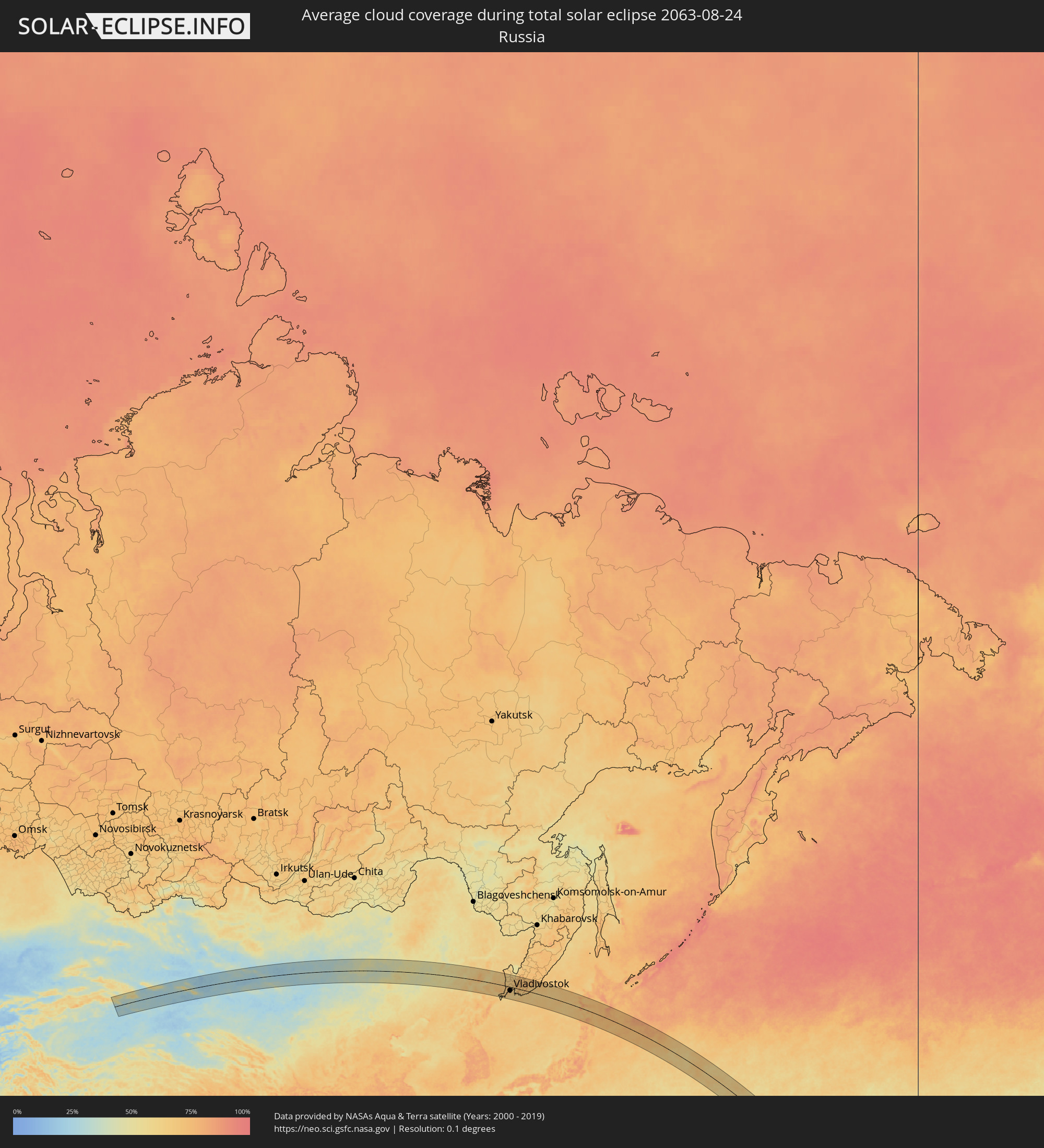 Russland
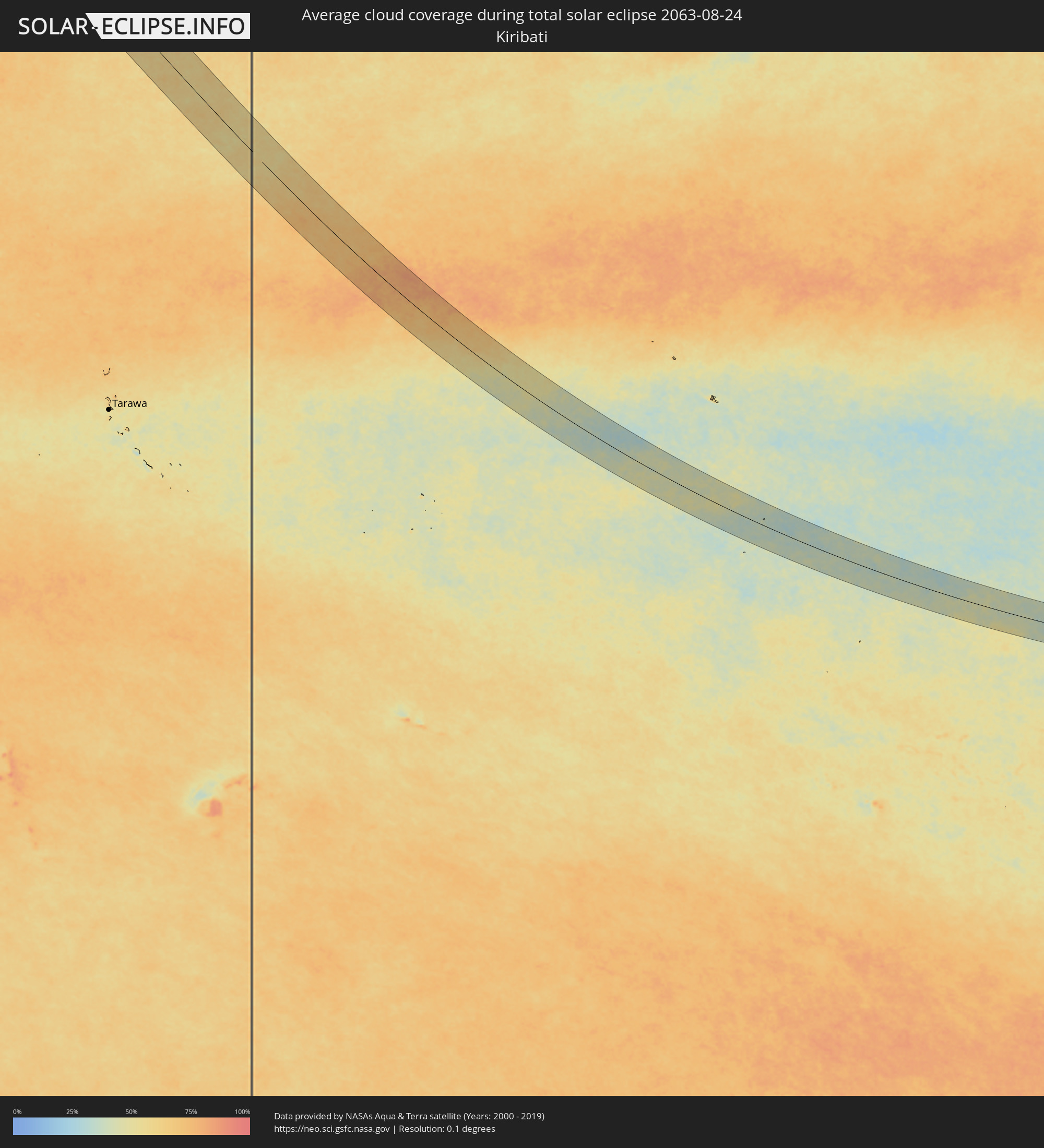 Kiribati
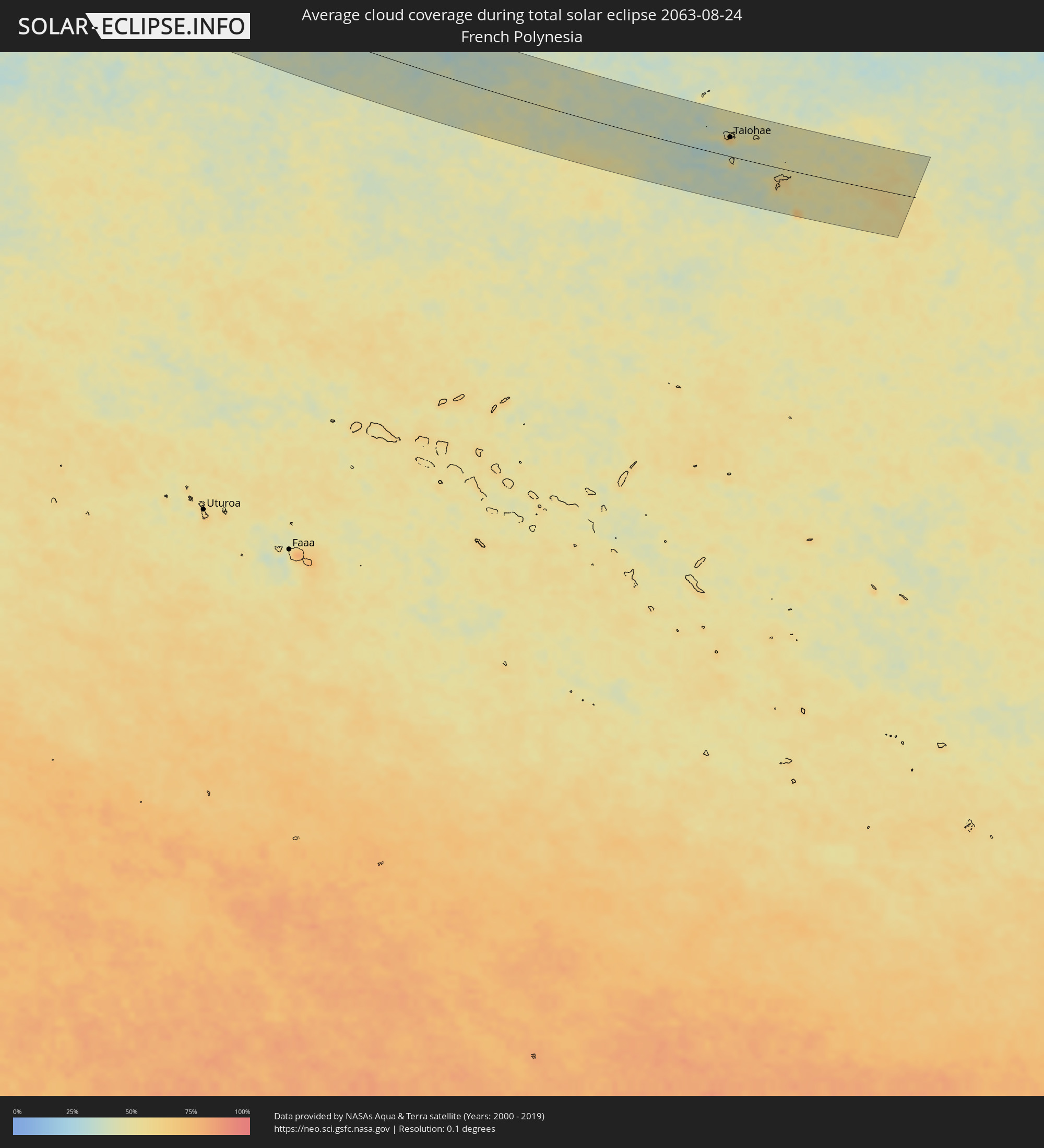 Französisch-Polynesien
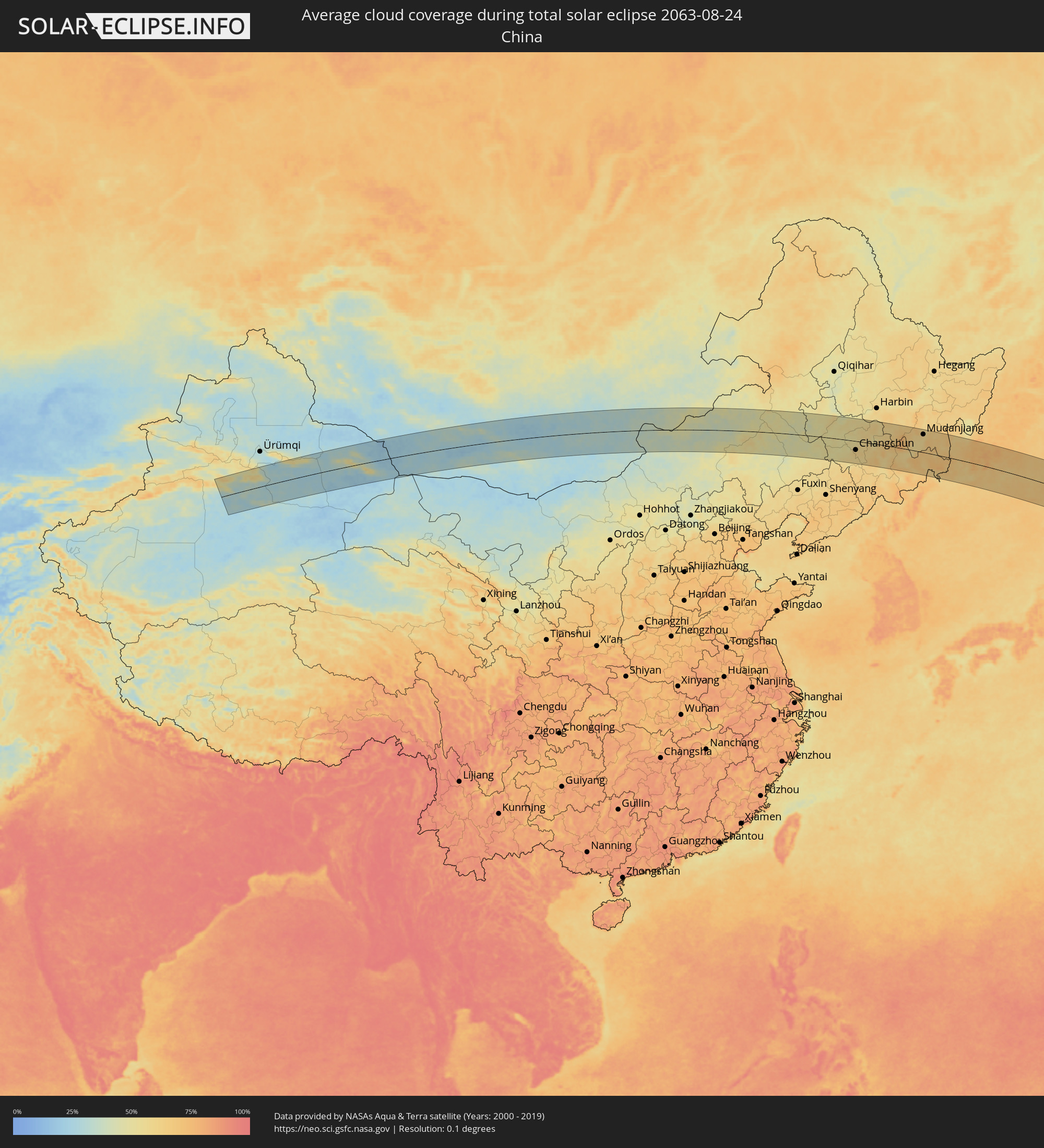 Volksrepublik China
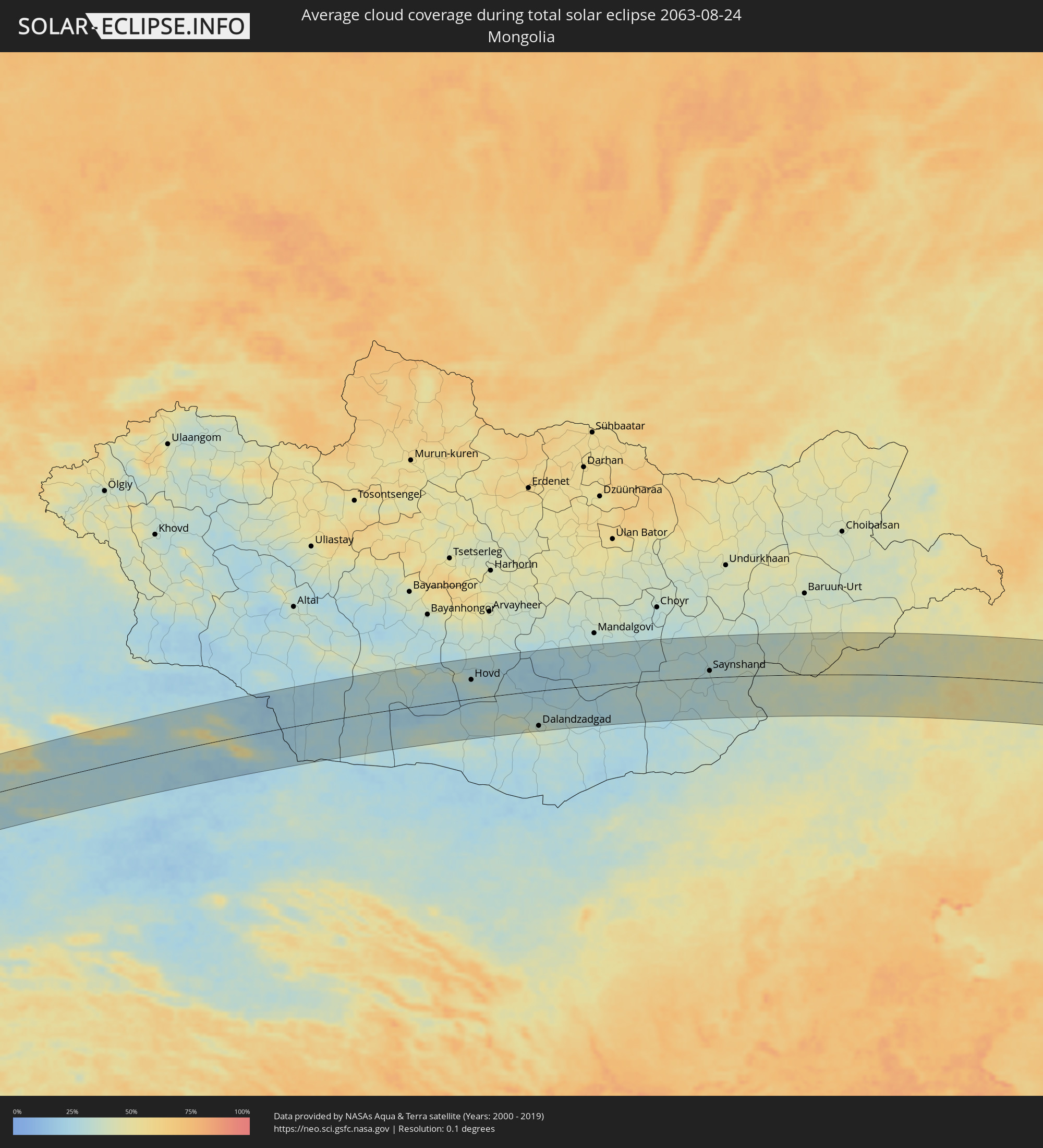 Mongolei
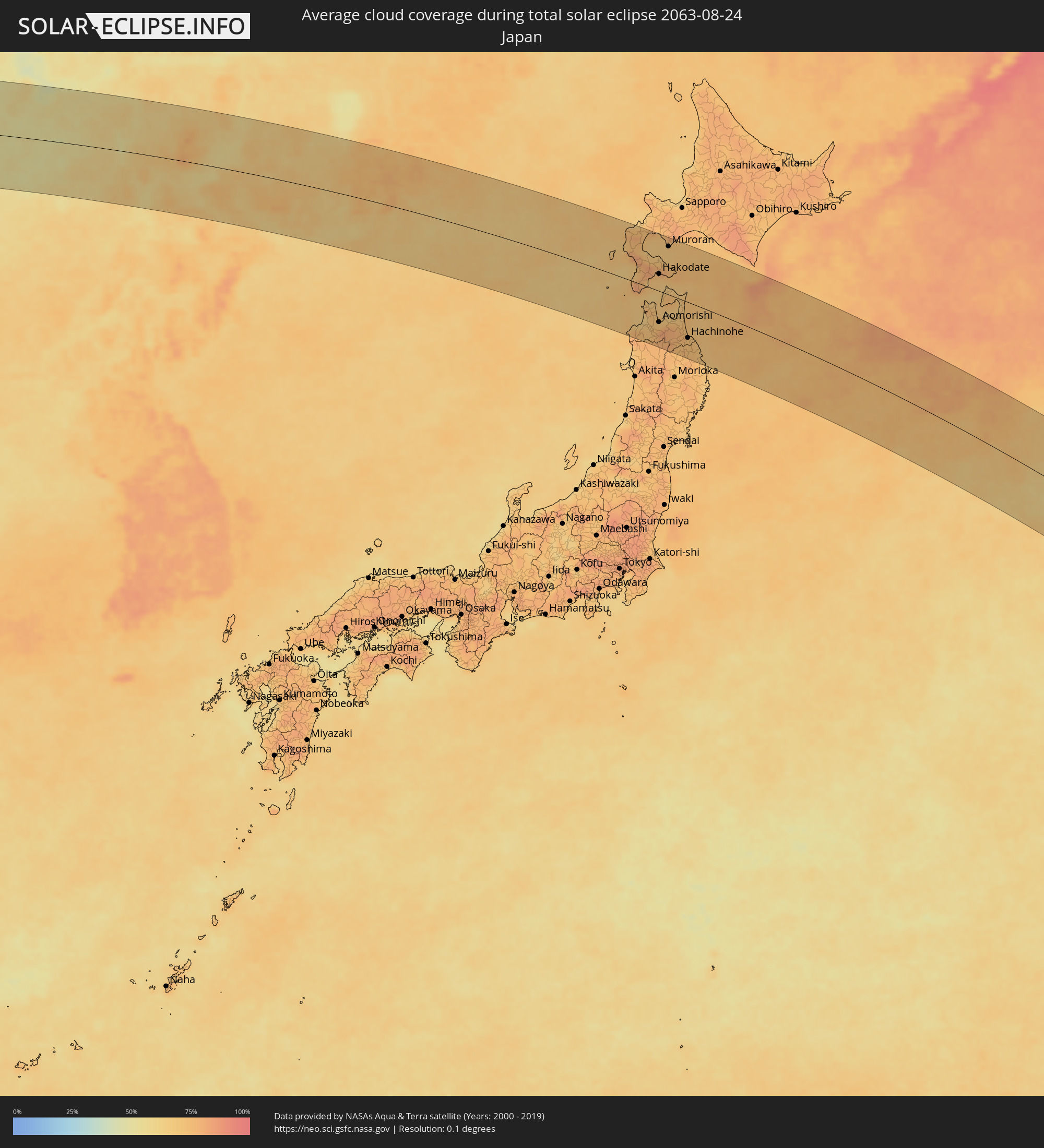 Japan
Japan
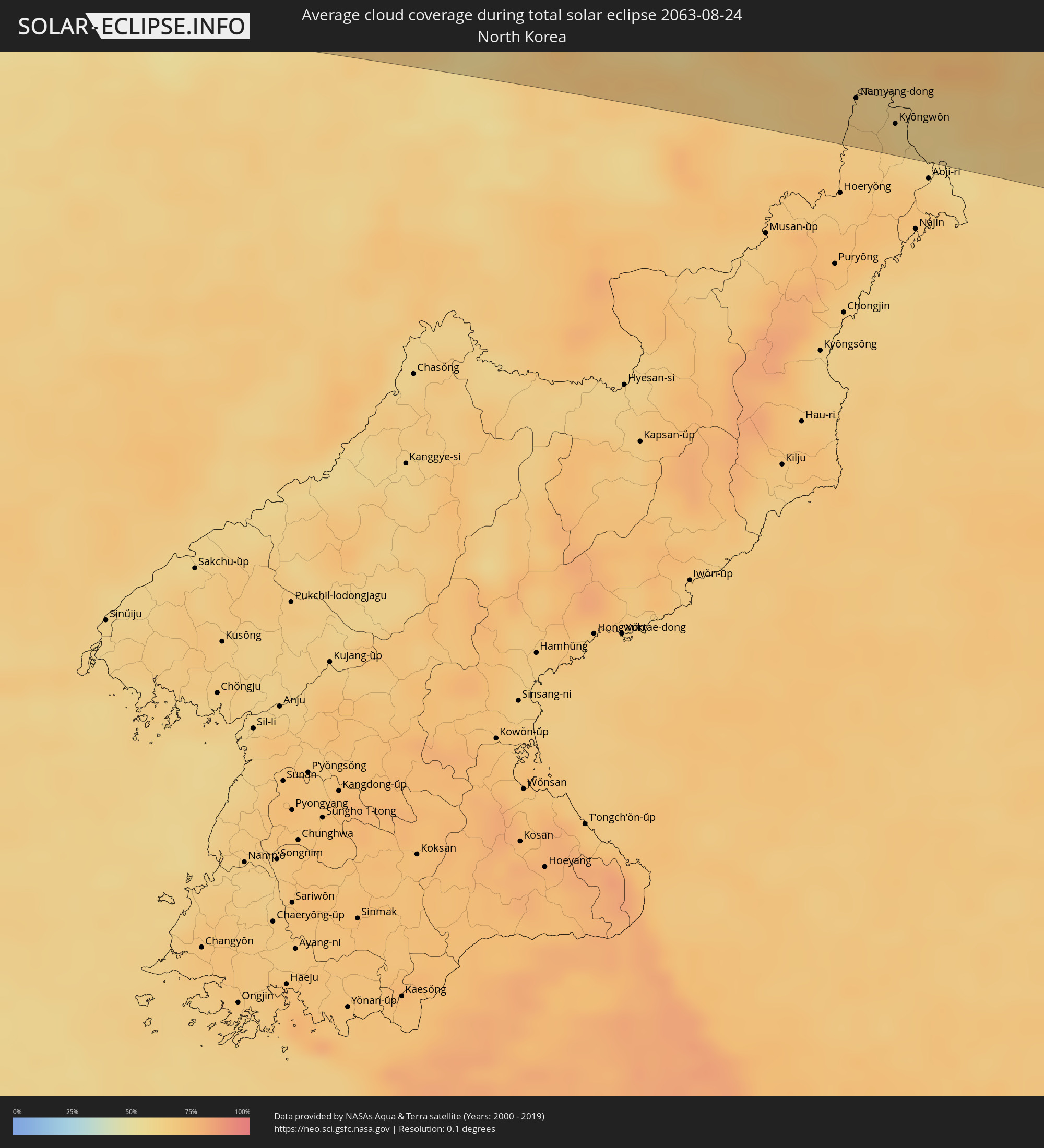 Nordkorea
Orte im Finsternispfad
Die nachfolgene Tabelle zeigt Städte und Orte mit mehr als 5.000 Einwohnern, die sich im Finsternispfad befinden. Städte mit mehr als 100.000 Einwohnern sind dick gekennzeichnet. Mit einem Klick auf den Ort öffnet sich eine Detailkarte die die Lage des jeweiligen Ortes zusammen mit dem Verlauf der zentralen Finsternis präsentiert.
| Ort | Typ | Dauer der Verfinsterung | Ortszeit bei maximaler Verfinsterung | Entfernung zur Zentrallinie | Ø Bewölkung |
|
Taiohae, Îles Marquises
|
total | - | 17:28:17 UTC-09:30 | 44 km | 62% |
|
Korla, Xinjiang Uyghur Autonomous Region
|
total | - | 07:41:32 UTC+08:00 | 15 km | 30% |
|
Turpan, Xinjiang Uyghur Autonomous Region
|
total | - | 07:42:05 UTC+08:00 | 53 km | 31% |
|
Hami, Xinjiang Uyghur Autonomous Region
|
total | - | 07:42:05 UTC+08:00 | 36 km | 23% |
|
Hovd, Övörhangay
|
total | - | 07:44:44 UTC+08:00 | 50 km | 29% |
|
Dalandzadgad, Ömnögovĭ
|
total | - | 07:44:44 UTC+08:00 | 93 km | 34% |
|
Saynshand, East Gobi Aymag
|
total | - | 07:47:50 UTC+08:00 | 18 km | 31% |
|
Xilin Hot, Inner Mongolia
|
total | - | 07:50:41 UTC+08:00 | 91 km | 45% |
|
Tongliao, Inner Mongolia
|
total | - | 07:55:09 UTC+08:00 | 102 km | 50% |
|
Guangming, Jilin
|
total | - | 07:56:12 UTC+08:00 | 93 km | 49% |
|
Kaitong, Jilin
|
total | - | 07:56:18 UTC+08:00 | 38 km | 50% |
|
Zhengjiatun, Jilin
|
total | - | 07:56:10 UTC+08:00 | 104 km | 54% |
|
Fuyu, Jilin
|
total | - | 07:57:50 UTC+08:00 | 94 km | 57% |
|
Gongzhuling, Jilin
|
total | - | 07:57:20 UTC+08:00 | 91 km | 58% |
|
Qianguo, Jilin
|
total | - | 07:57:51 UTC+08:00 | 87 km | 54% |
|
Changchun, Jilin
|
total | - | 07:57:54 UTC+08:00 | 44 km | 59% |
|
Xinglongshan, Jilin
|
total | - | 07:58:03 UTC+08:00 | 34 km | 59% |
|
Shuangyang, Jilin
|
total | - | 07:58:07 UTC+08:00 | 80 km | 56% |
|
Dehui, Jilin
|
total | - | 07:58:25 UTC+08:00 | 32 km | 57% |
|
Jiutai, Jilin
|
total | - | 07:58:26 UTC+08:00 | 9 km | 59% |
|
Yushu, Jilin
|
total | - | 07:59:15 UTC+08:00 | 71 km | 61% |
|
Jilin, Jilin
|
total | - | 07:59:02 UTC+08:00 | 33 km | 63% |
|
Jishu, Jilin
|
total | - | 07:59:22 UTC+08:00 | 21 km | 61% |
|
Shulan, Jilin
|
total | - | 07:59:32 UTC+08:00 | 34 km | 61% |
|
Wuchang, Heilongjiang
|
total | - | 07:59:51 UTC+08:00 | 91 km | 59% |
|
Minzhu, Jilin
|
total | - | 07:59:44 UTC+08:00 | 38 km | 60% |
|
Dunhua, Jilin
|
total | - | 08:00:34 UTC+08:00 | 64 km | 63% |
|
Dashitou, Jilin
|
total | - | 08:00:49 UTC+08:00 | 67 km | 59% |
|
Mingyue, Jilin
|
total | - | 08:01:12 UTC+08:00 | 83 km | 62% |
|
Hailin, Heilongjiang
|
total | - | 08:01:55 UTC+08:00 | 84 km | 60% |
|
Longjing, Jilin
|
total | - | 08:01:40 UTC+08:00 | 112 km | 65% |
|
Yanji, Jilin
|
total | - | 08:01:47 UTC+08:00 | 96 km | 65% |
|
Mudanjiang, Heilongjiang
|
total | - | 08:02:08 UTC+08:00 | 89 km | 59% |
|
Chaihe, Heilongjiang
|
total | - | 08:02:14 UTC+08:00 | 109 km | 57% |
|
Wangqing, Jilin
|
total | - | 08:02:06 UTC+08:00 | 46 km | 64% |
|
Tumen, Jilin
|
total | - | 08:02:08 UTC+08:00 | 84 km | 65% |
|
Namyang-dong, Hamgyŏng-bukto
|
total | - | 09:02:10 UTC+09:00 | 85 km | 63% |
|
Onsŏng, Hamgyŏng-bukto
|
total | - | 09:02:18 UTC+09:00 | 82 km | 62% |
|
Kyŏngwŏn, Hamgyŏng-bukto
|
total | - | 09:02:27 UTC+09:00 | 96 km | 61% |
|
Hunchun, Jilin
|
total | - | 08:02:40 UTC+08:00 | 86 km | 61% |
|
Dongning, Heilongjiang
|
total | - | 08:03:36 UTC+08:00 | 57 km | 63% |
|
Pogranichnyy, Primorskiy
|
total | - | 10:03:55 UTC+10:00 | 99 km | 62% |
|
Slavyanka, Primorskiy
|
total | - | 10:03:47 UTC+10:00 | 69 km | 67% |
|
Pokrovka, Primorskiy
|
total | - | 10:04:08 UTC+10:00 | 54 km | 64% |
|
Lipovtsy, Primorskiy
|
total | - | 10:04:15 UTC+10:00 | 82 km | 64% |
|
Tavrichanka, Primorskiy
|
total | - | 10:04:20 UTC+10:00 | 10 km | 62% |
|
Vladivostok, Primorskiy
|
total | - | 10:04:20 UTC+10:00 | 34 km | 64% |
|
Razdol’noye, Primorskiy
|
total | - | 10:04:23 UTC+10:00 | 14 km | 64% |
|
Ussuriysk, Primorskiy
|
total | - | 10:04:27 UTC+10:00 | 43 km | 66% |
|
Vozdvizhenka, Primorskiy
|
total | - | 10:04:28 UTC+10:00 | 53 km | 66% |
|
Vol’no-Nadezhdinskoye, Primorskiy
|
total | - | 10:04:29 UTC+10:00 | 2 km | 65% |
|
Mikhaylovka, Primorskiy
|
total | - | 10:04:32 UTC+10:00 | 58 km | 67% |
|
Novyy, Primorskiy
|
total | - | 10:04:30 UTC+10:00 | 3 km | 65% |
|
Trudovoye, Primorskiy
|
total | - | 10:04:33 UTC+10:00 | 9 km | 63% |
|
Khorol’, Primorskiy
|
total | - | 10:04:39 UTC+10:00 | 113 km | 61% |
|
Uglovoye, Primorskiy
|
total | - | 10:04:35 UTC+10:00 | 6 km | 63% |
|
Novoshakhtinskiy, Primorskiy
|
total | - | 10:04:43 UTC+10:00 | 71 km | 68% |
|
Artëm, Primorskiy
|
total | - | 10:04:41 UTC+10:00 | 1 km | 67% |
|
Yaroslavskiy, Primorskiy
|
total | - | 10:04:47 UTC+10:00 | 90 km | 64% |
|
Zavodskoy, Primorskiy
|
total | - | 10:04:48 UTC+10:00 | 12 km | 68% |
|
Dunay, Primorskiy
|
total | - | 10:04:50 UTC+10:00 | 50 km | 63% |
|
Bol’shoy Kamen’, Primorskiy
|
total | - | 10:04:51 UTC+10:00 | 24 km | 63% |
|
Shkotovo, Primorskiy
|
total | - | 10:04:52 UTC+10:00 | 2 km | 63% |
|
Fokino, Primorskiy
|
total | - | 10:04:55 UTC+10:00 | 38 km | 63% |
|
Smolyaninovo, Primorskiy
|
total | - | 10:04:59 UTC+10:00 | 3 km | 65% |
|
Chernigovka, Primorskiy
|
total | - | 10:05:10 UTC+10:00 | 113 km | 69% |
|
Livadiya, Primorskiy
|
total | - | 10:05:12 UTC+10:00 | 45 km | 64% |
|
Nakhodka, Primorskiy
|
total | - | 10:05:26 UTC+10:00 | 47 km | 64% |
|
Vladimiro-Aleksandrovskoye, Primorskiy
|
total | - | 10:05:40 UTC+10:00 | 34 km | 64% |
|
Vrangel’, Primorskiy
|
total | - | 10:05:40 UTC+10:00 | 51 km | 66% |
|
Partizansk, Primorskiy
|
total | - | 10:05:43 UTC+10:00 | 8 km | 69% |
|
Uglekamensk, Primorskiy
|
total | - | 10:05:50 UTC+10:00 | 4 km | 66% |
|
Arsen’yev, Primorskiy
|
total | - | 10:05:55 UTC+10:00 | 106 km | 71% |
|
Sergeyevka, Primorskiy
|
total | - | 10:05:59 UTC+10:00 | 21 km | 70% |
|
Preobrazheniye, Primorskiy
|
total | - | 10:06:36 UTC+10:00 | 16 km | 66% |
|
Shimokizukuri, Aomori
|
total | - | 09:15:04 UTC+09:00 | 75 km | 69% |
|
Goshogawara, Aomori
|
total | - | 09:15:09 UTC+09:00 | 75 km | 69% |
|
Hirosaki, Aomori
|
total | - | 09:15:16 UTC+09:00 | 96 km | 73% |
|
Kuroishi, Aomori
|
total | - | 09:15:24 UTC+09:00 | 87 km | 75% |
|
Namioka, Aomori
|
total | - | 09:15:23 UTC+09:00 | 80 km | 73% |
|
Kamiiso, Hokkaido
|
total | - | 09:15:06 UTC+09:00 | 37 km | 73% |
|
Nanae, Hokkaido
|
total | - | 09:15:08 UTC+09:00 | 45 km | 75% |
|
Aomorishi, Aomori
|
total | - | 09:15:33 UTC+09:00 | 65 km | 74% |
|
Hakodate, Hokkaido
|
total | - | 09:15:15 UTC+09:00 | 35 km | 71% |
|
Date, Hokkaido
|
total | - | 09:15:13 UTC+09:00 | 111 km | 71% |
|
Muroran, Hokkaido
|
total | - | 09:15:25 UTC+09:00 | 99 km | 68% |
|
Mutsu, Aomori
|
total | - | 09:16:02 UTC+09:00 | 1 km | 72% |
|
Ichinohe, Iwate
|
total | - | 09:16:32 UTC+09:00 | 110 km | 74% |
|
Misawa, Aomori
|
total | - | 09:16:29 UTC+09:00 | 58 km | 74% |
|
Hachinohe, Aomori
|
total | - | 09:16:43 UTC+09:00 | 74 km | 73% |