Totale Sonnenfinsternis vom 03.09.2081
| Wochentag: | Mittwoch |
| Maximale Dauer der Verfinsterung: | 05m33s |
| Maximale Breite des Finsternispfades: | 247 km |
| Saroszyklus: | 136 |
| Bedeckungsgrad: | 100% |
| Magnitude: | 1.072 |
| Gamma: | 0.3378 |
Wo kann man die Sonnenfinsternis vom 03.09.2081 sehen?
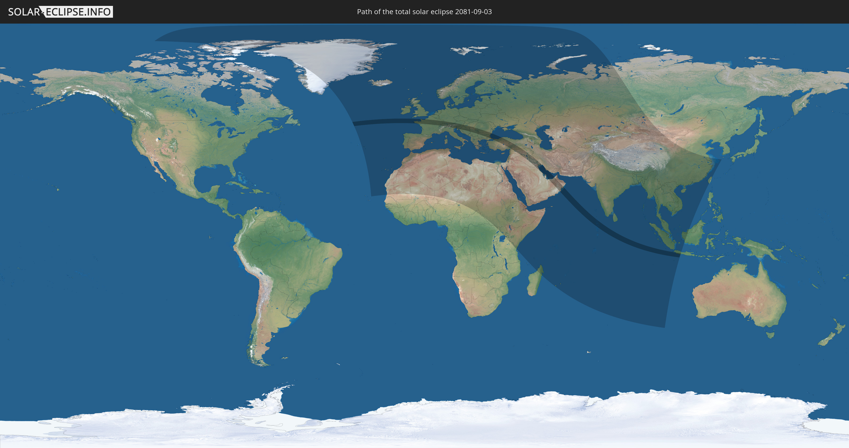
Die Sonnenfinsternis am 03.09.2081 kann man in 125 Ländern als partielle Sonnenfinsternis beobachten.
Der Finsternispfad verläuft durch 27 Länder. Nur in diesen Ländern ist sie als totale Sonnenfinsternis zu sehen.
In den folgenden Ländern ist die Sonnenfinsternis total zu sehen
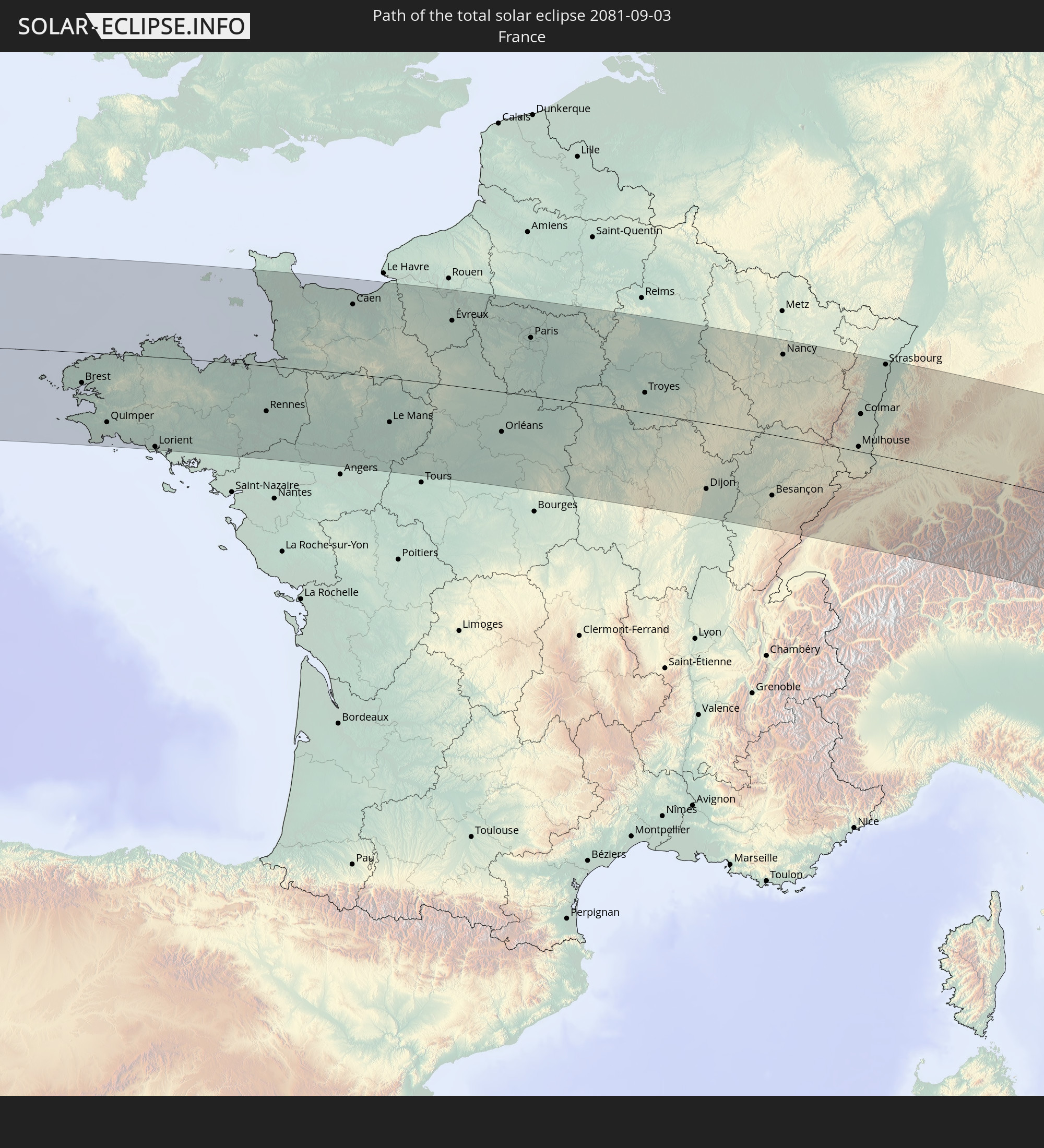 Frankreich
 Guernsey
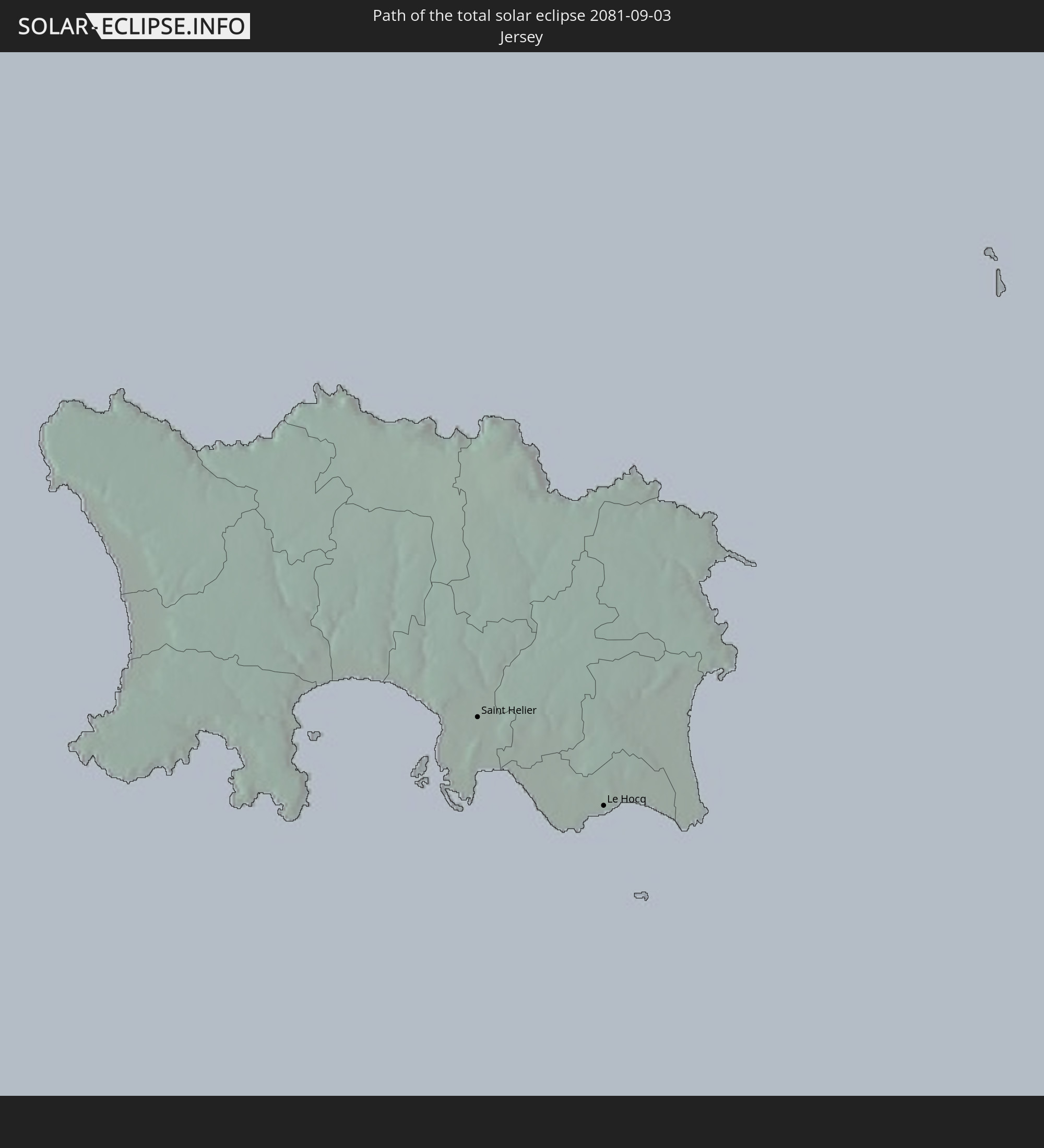 Jersey
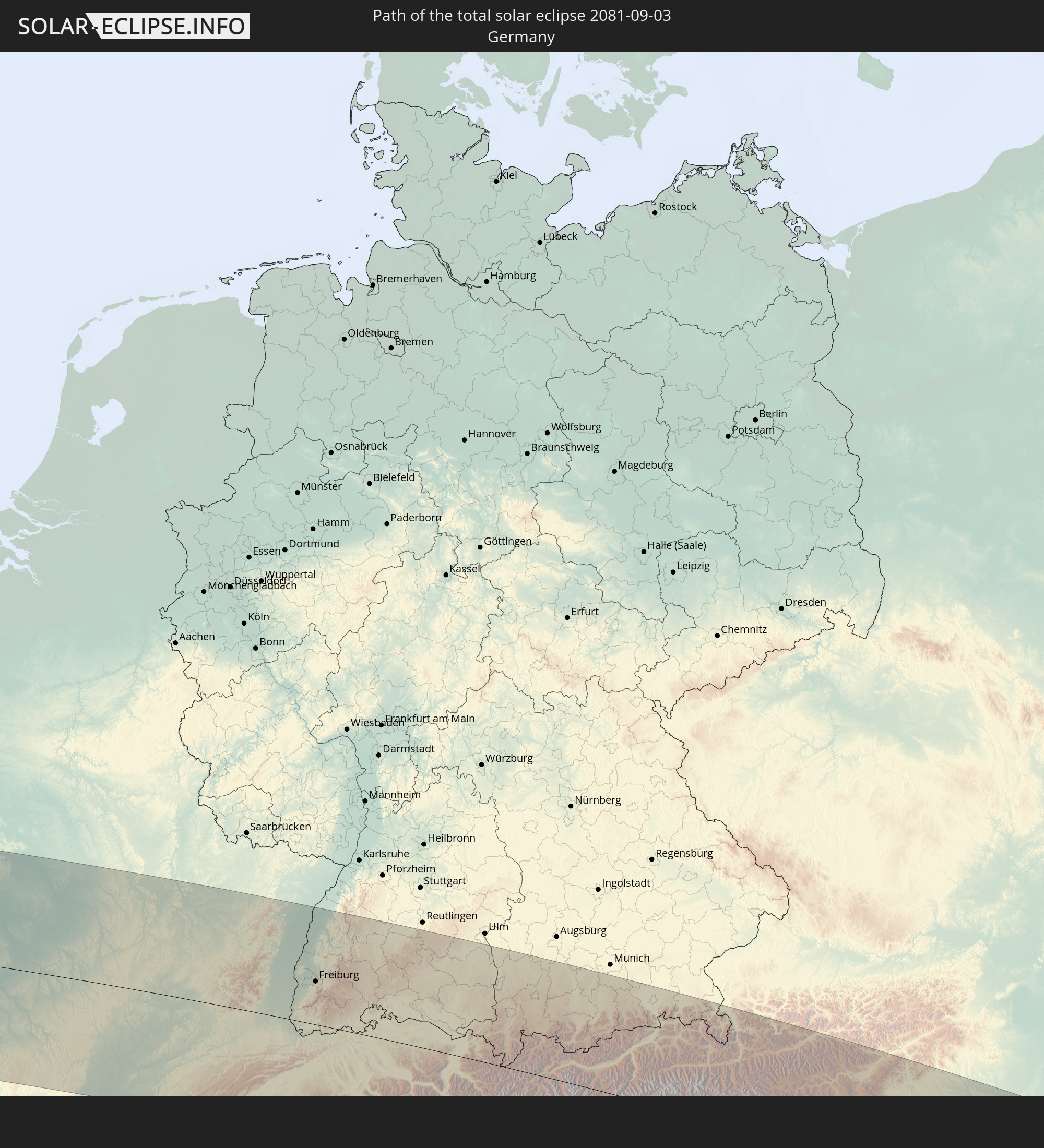 Deutschland
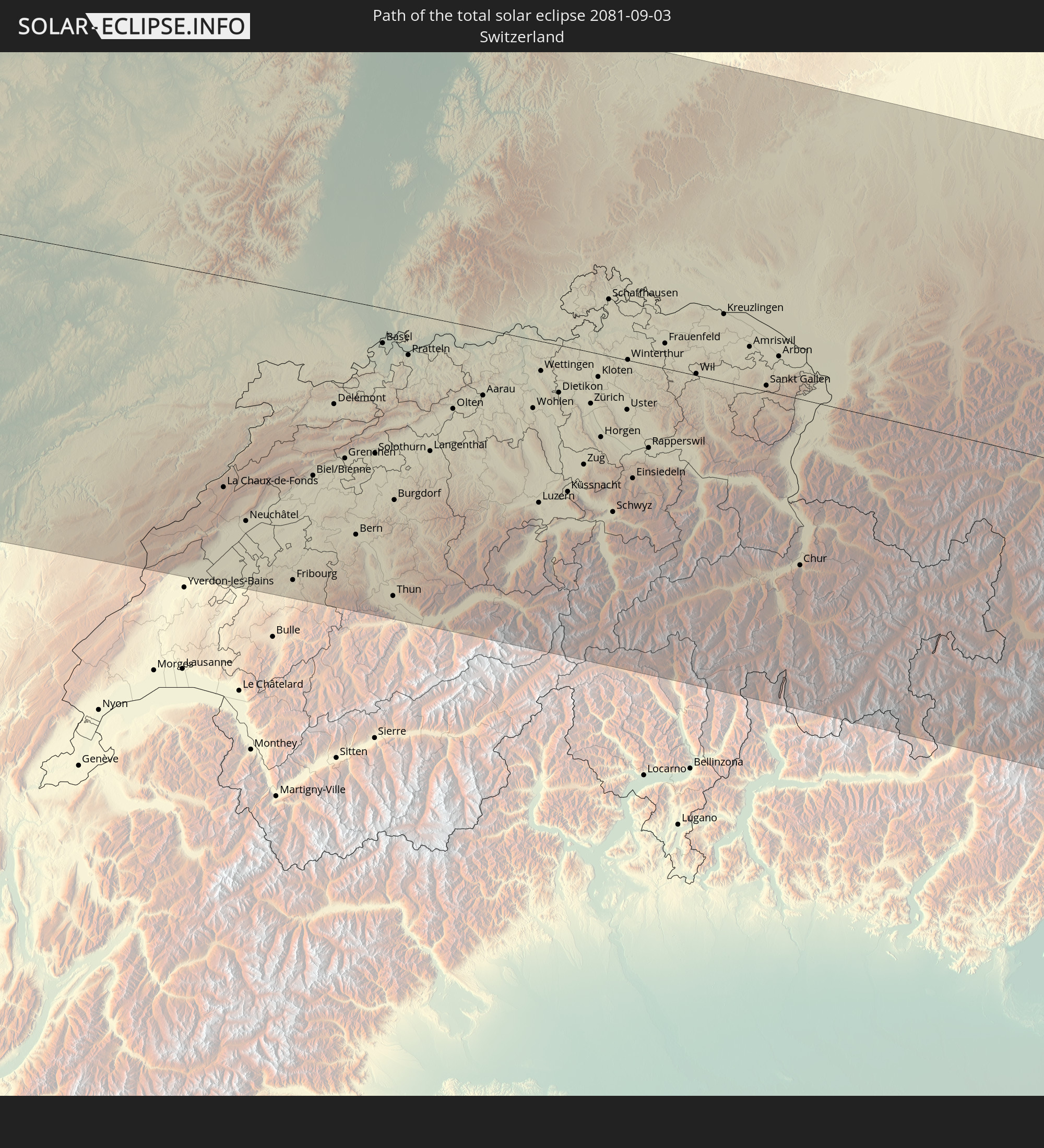 Schweiz
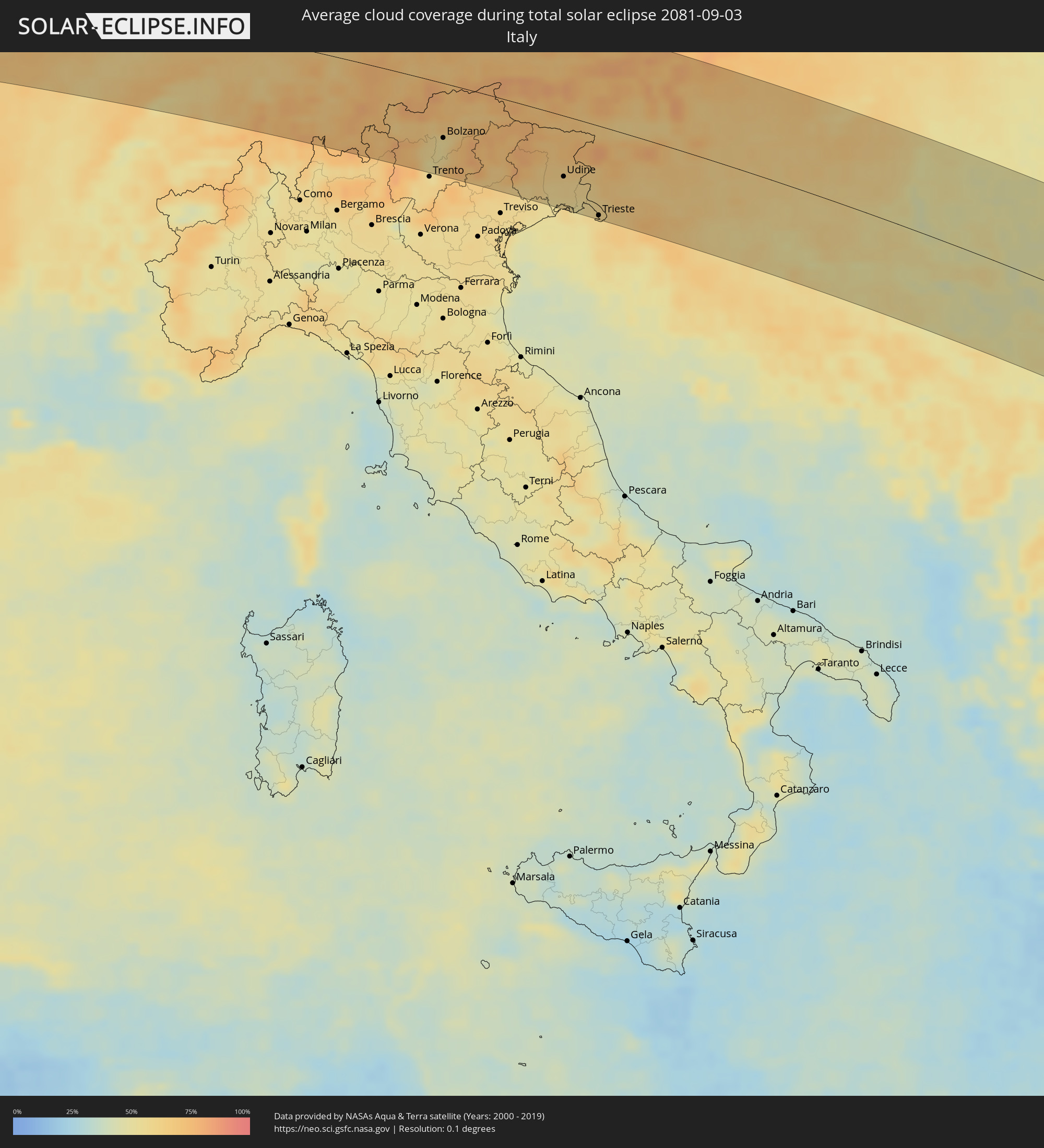
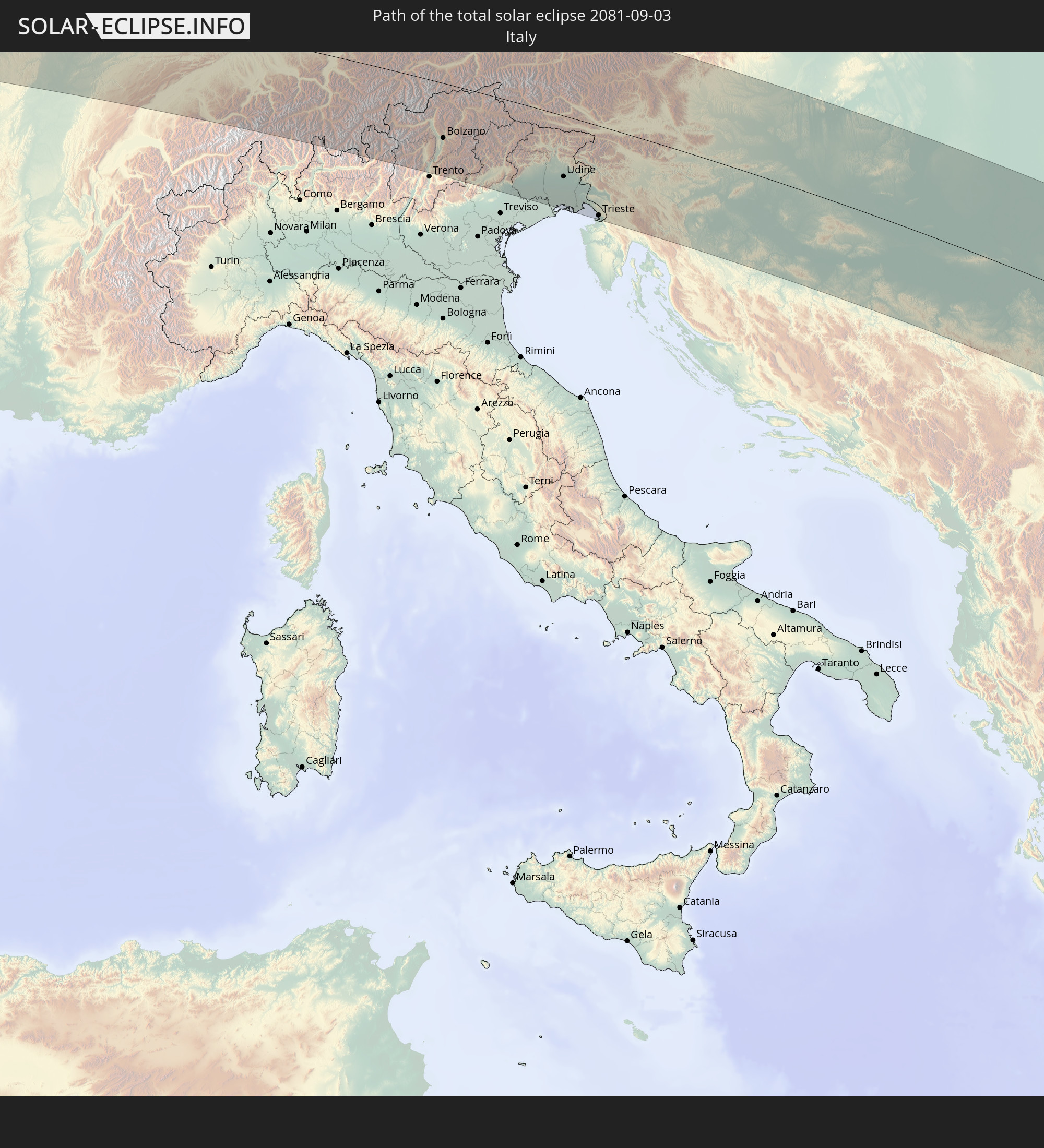 Italien
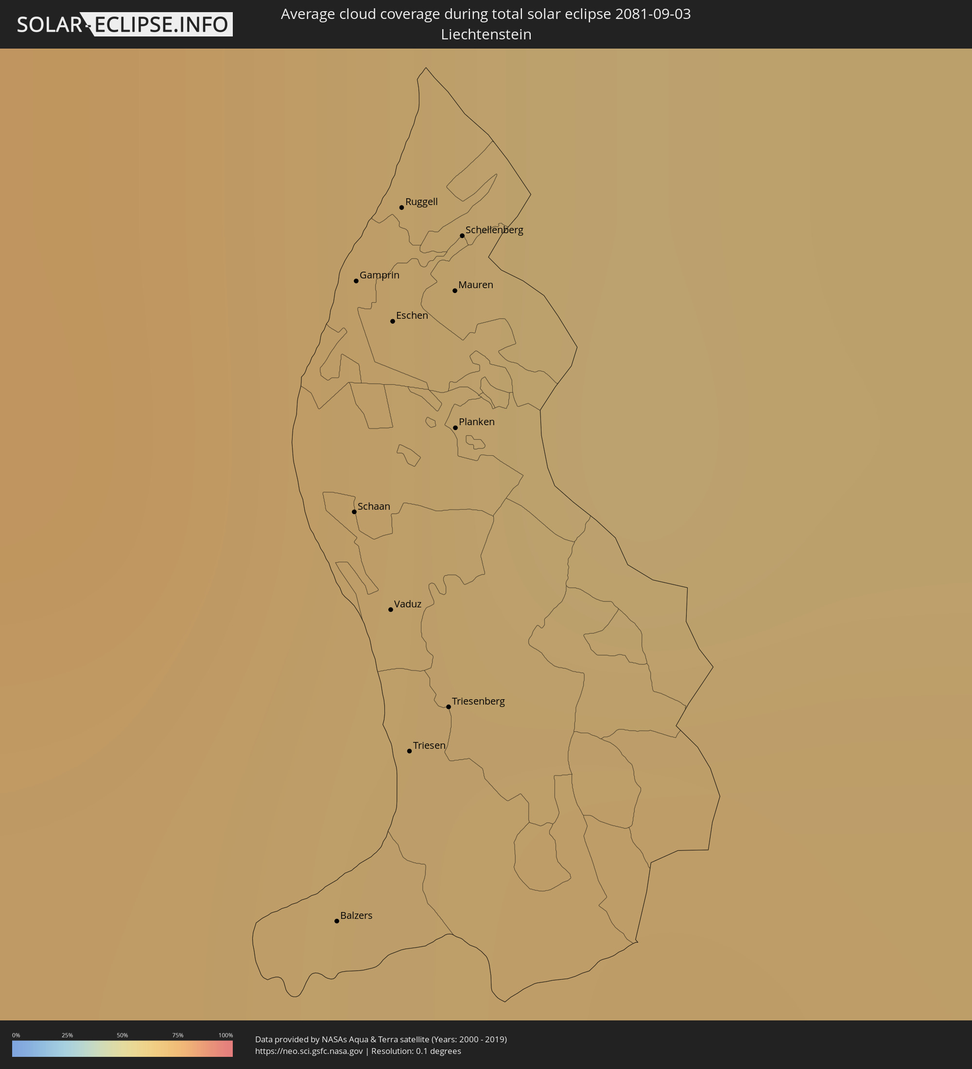
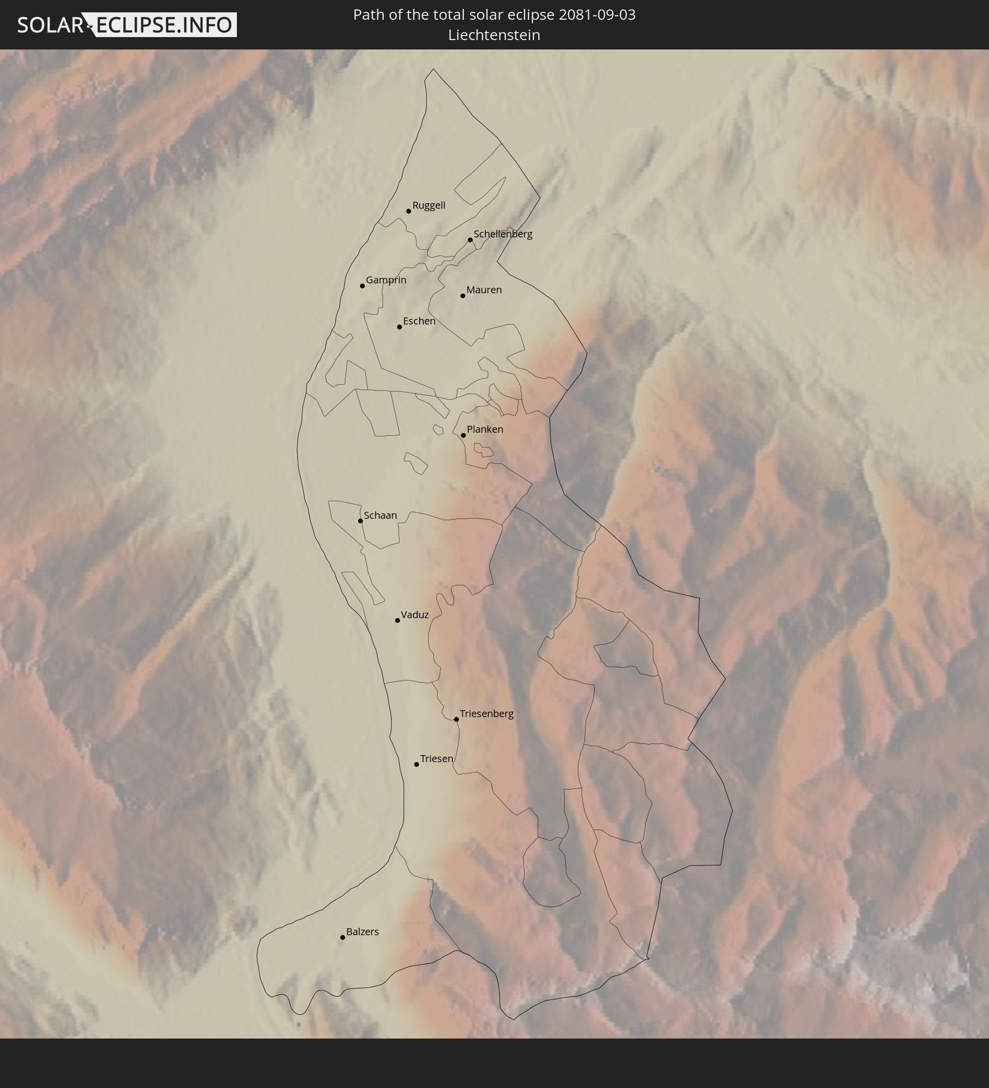 Liechtenstein
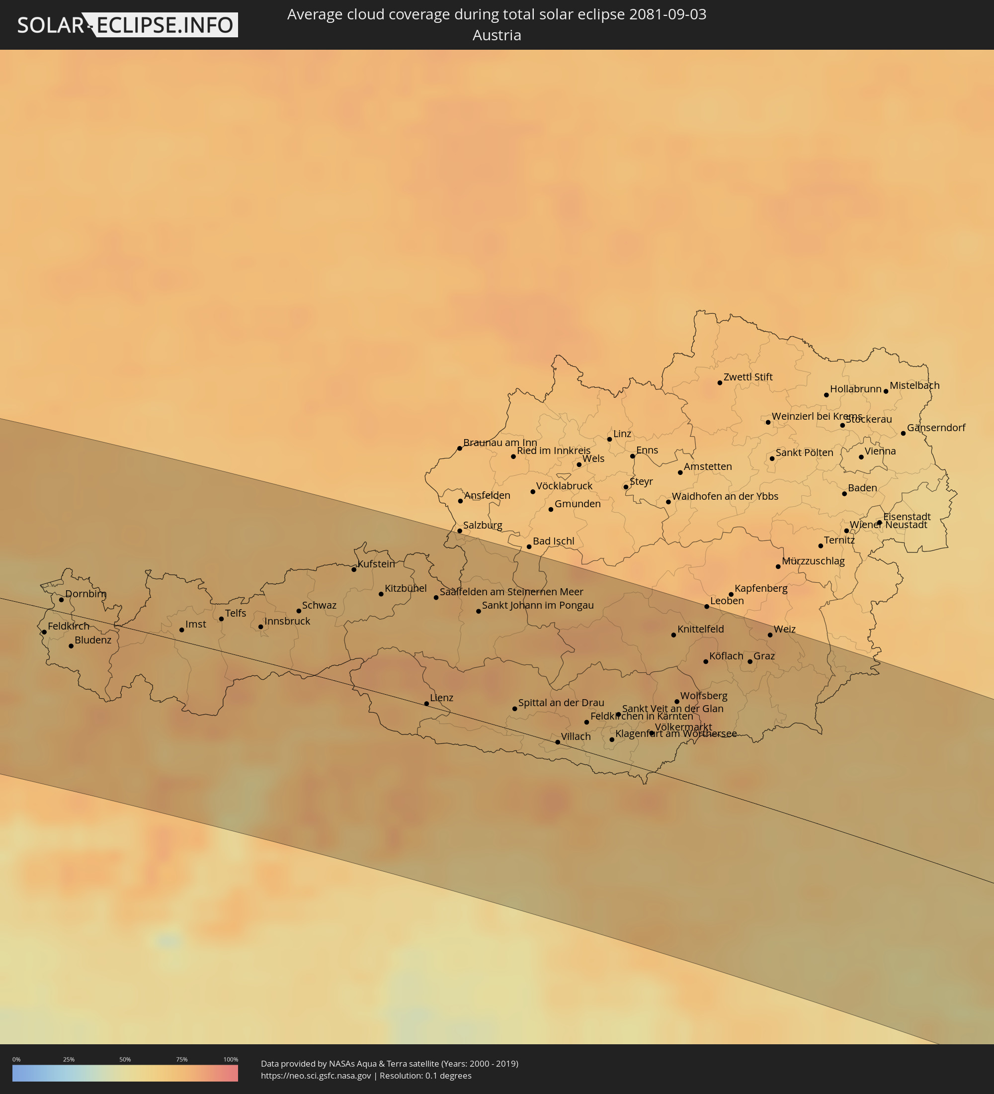
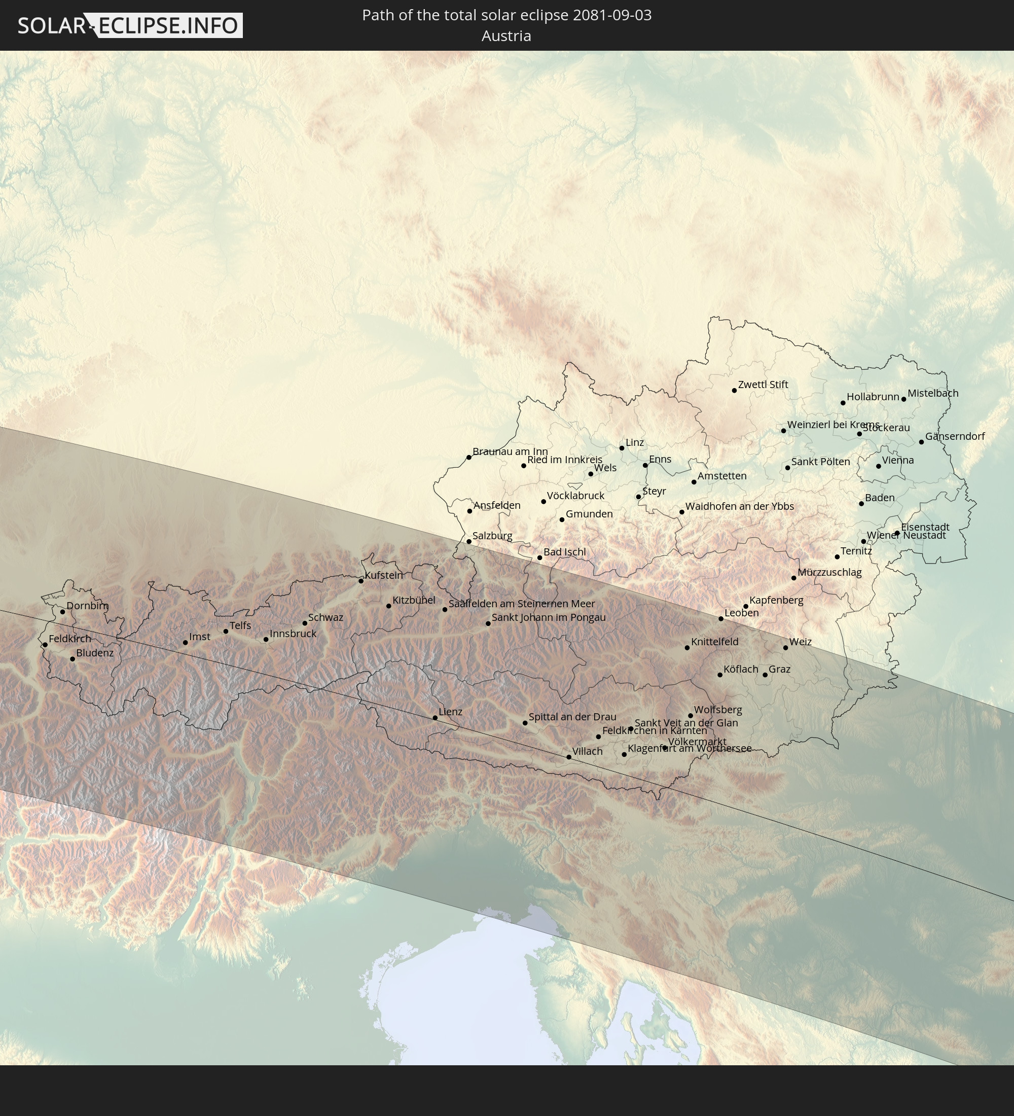 Österreich
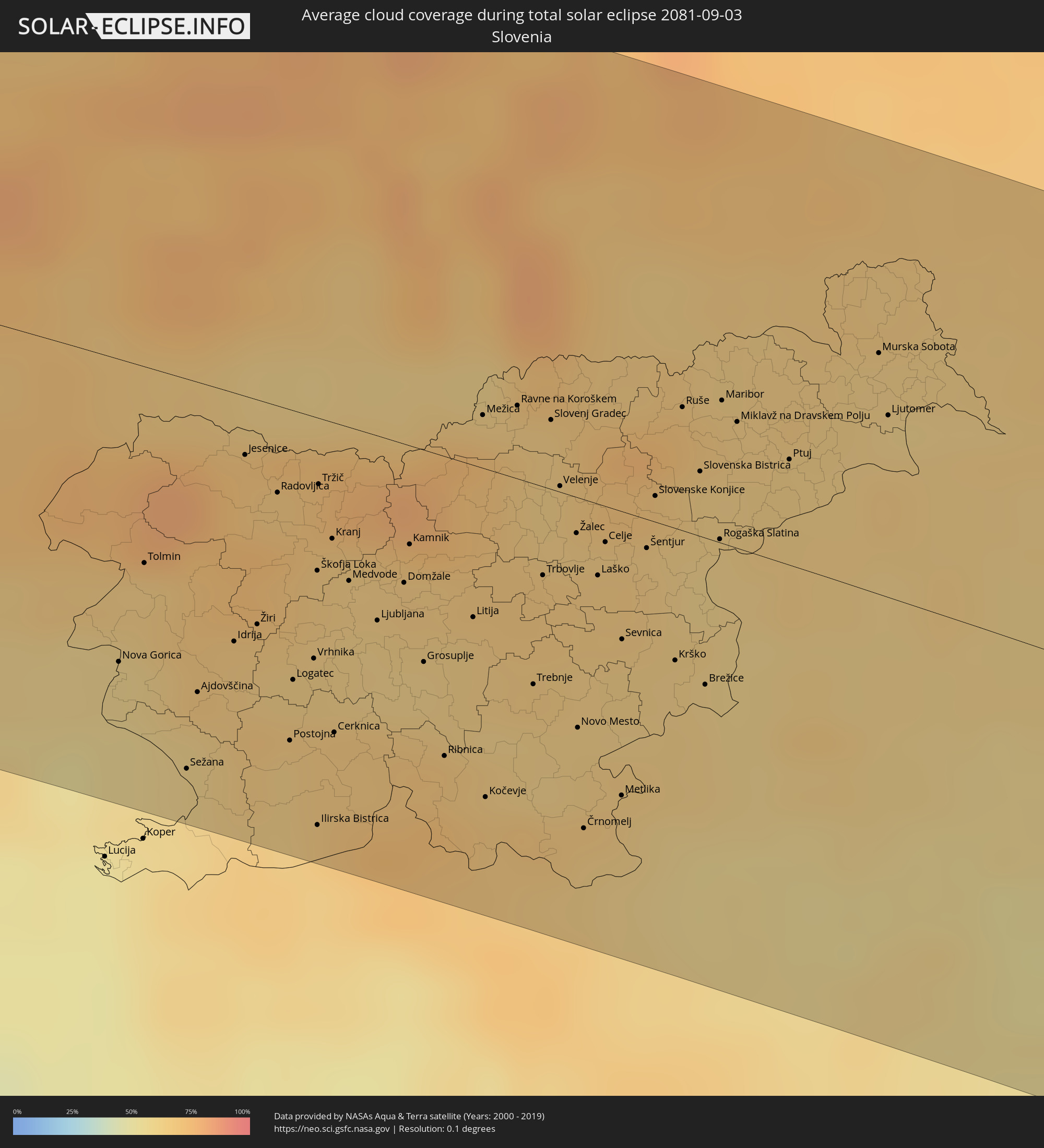
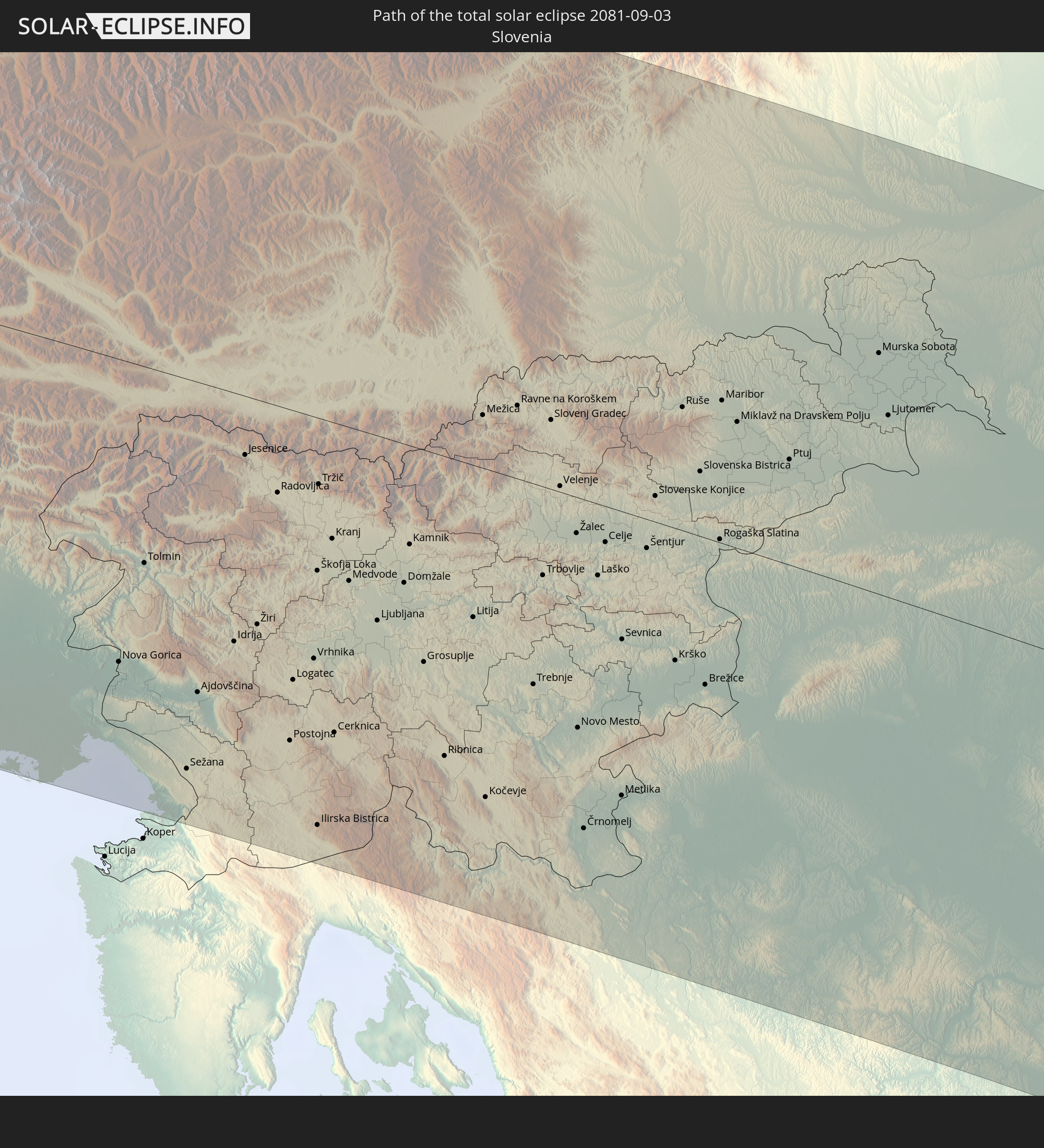 Slowenien
 Kroatien
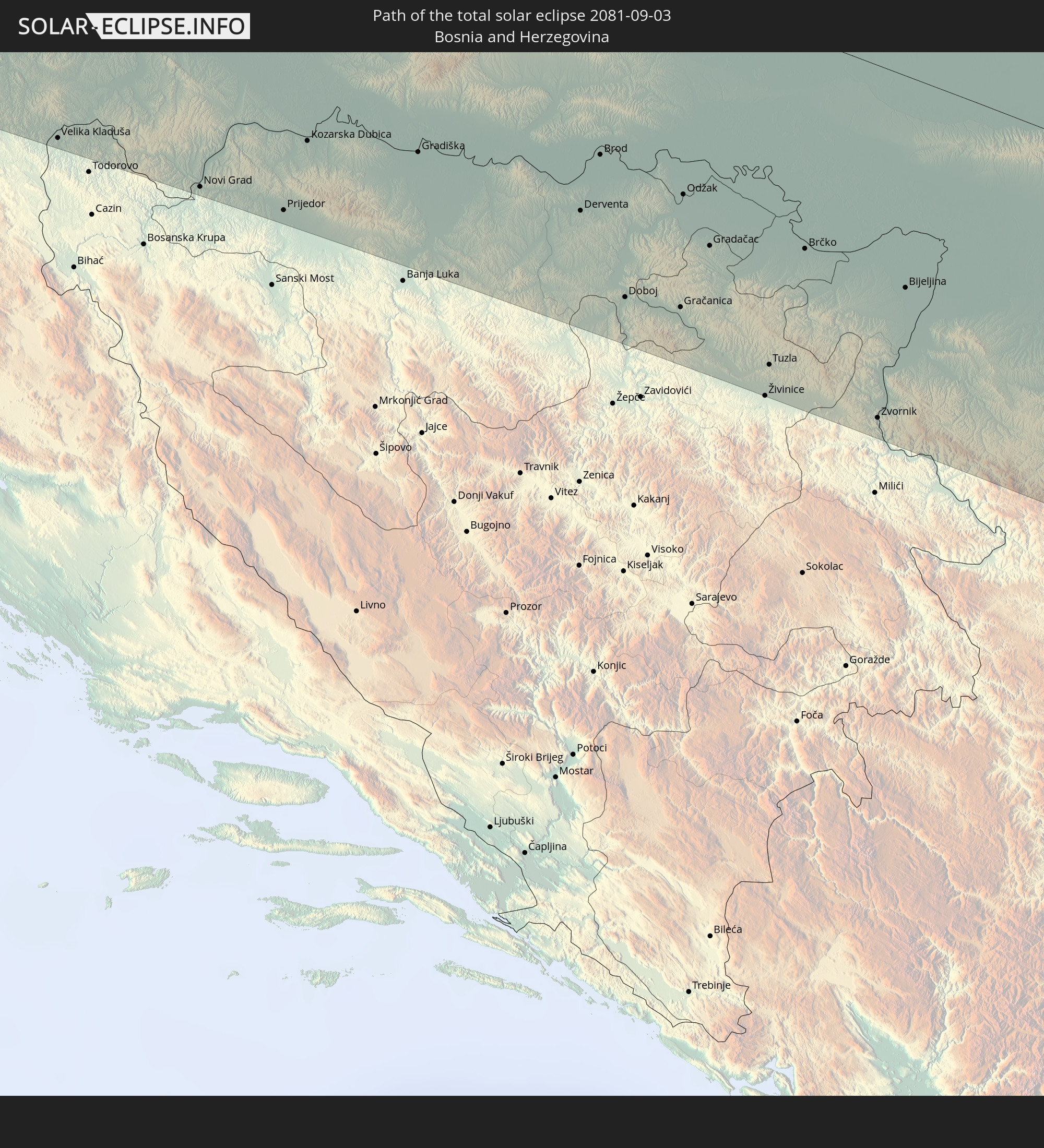 Bosnien und Herzegowina
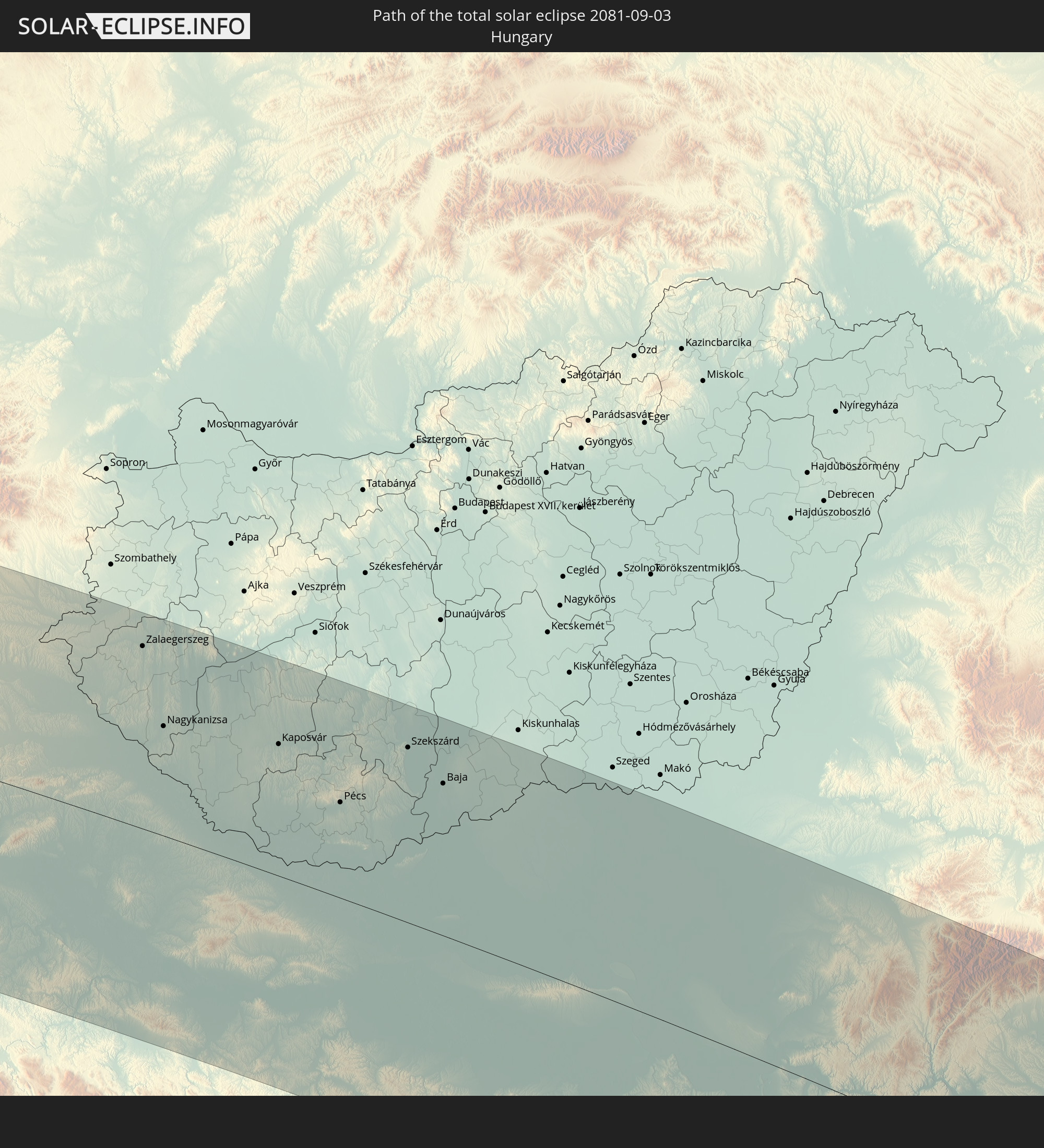 Ungarn
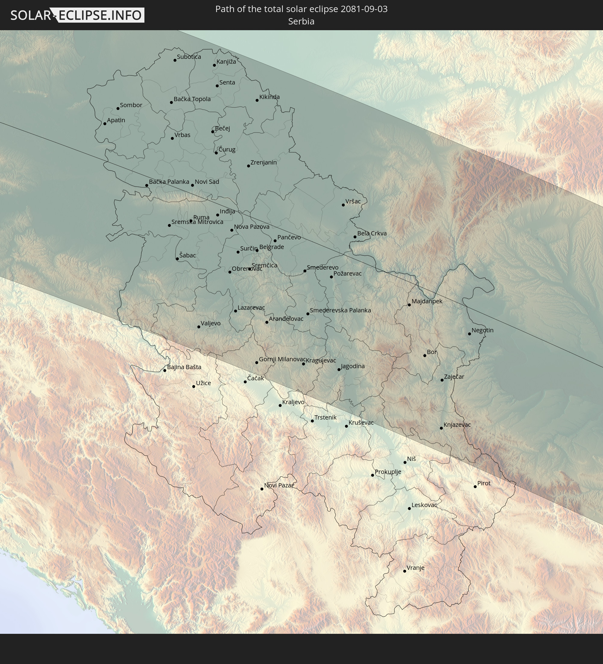 Serbien
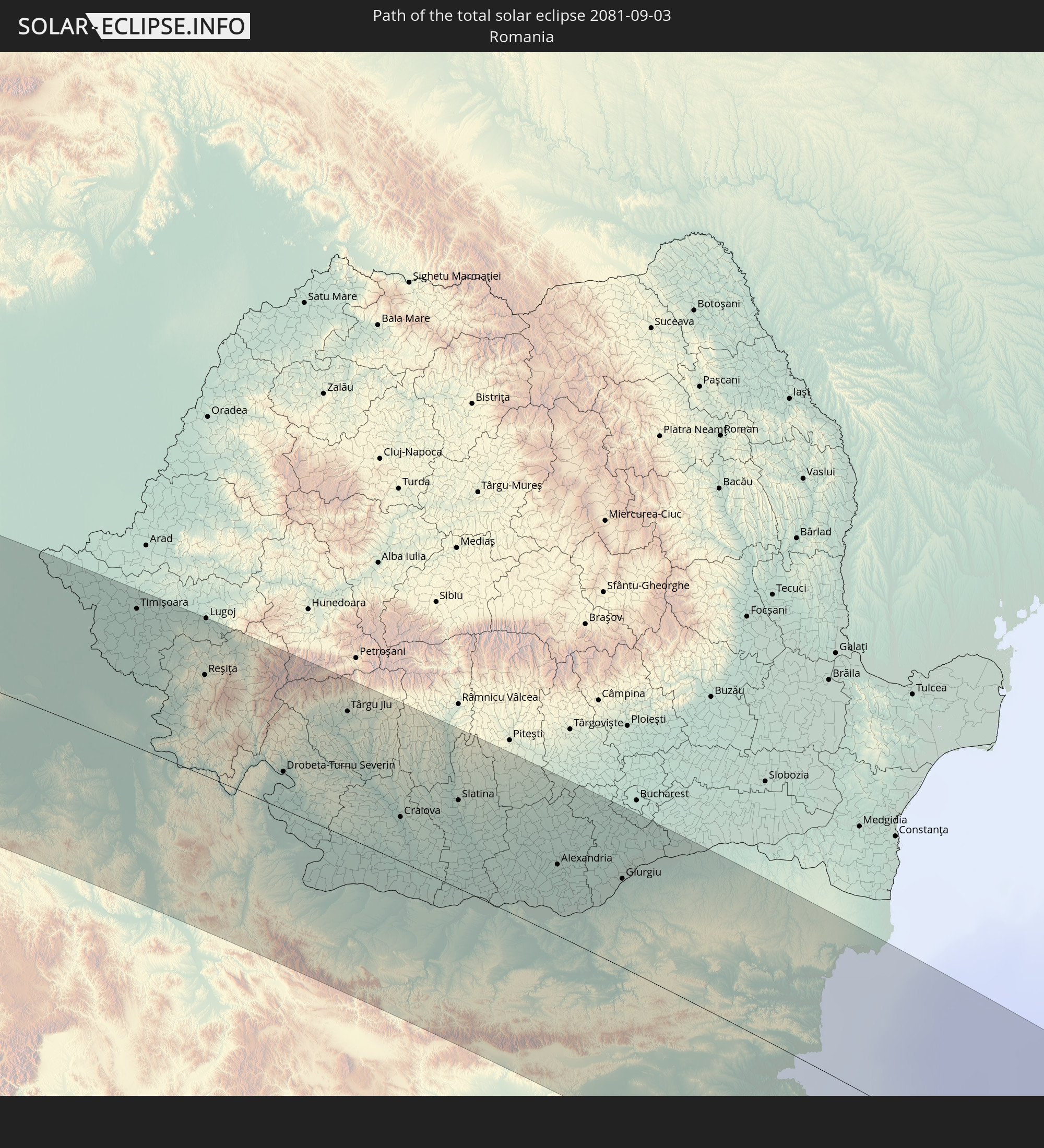 Rumänien
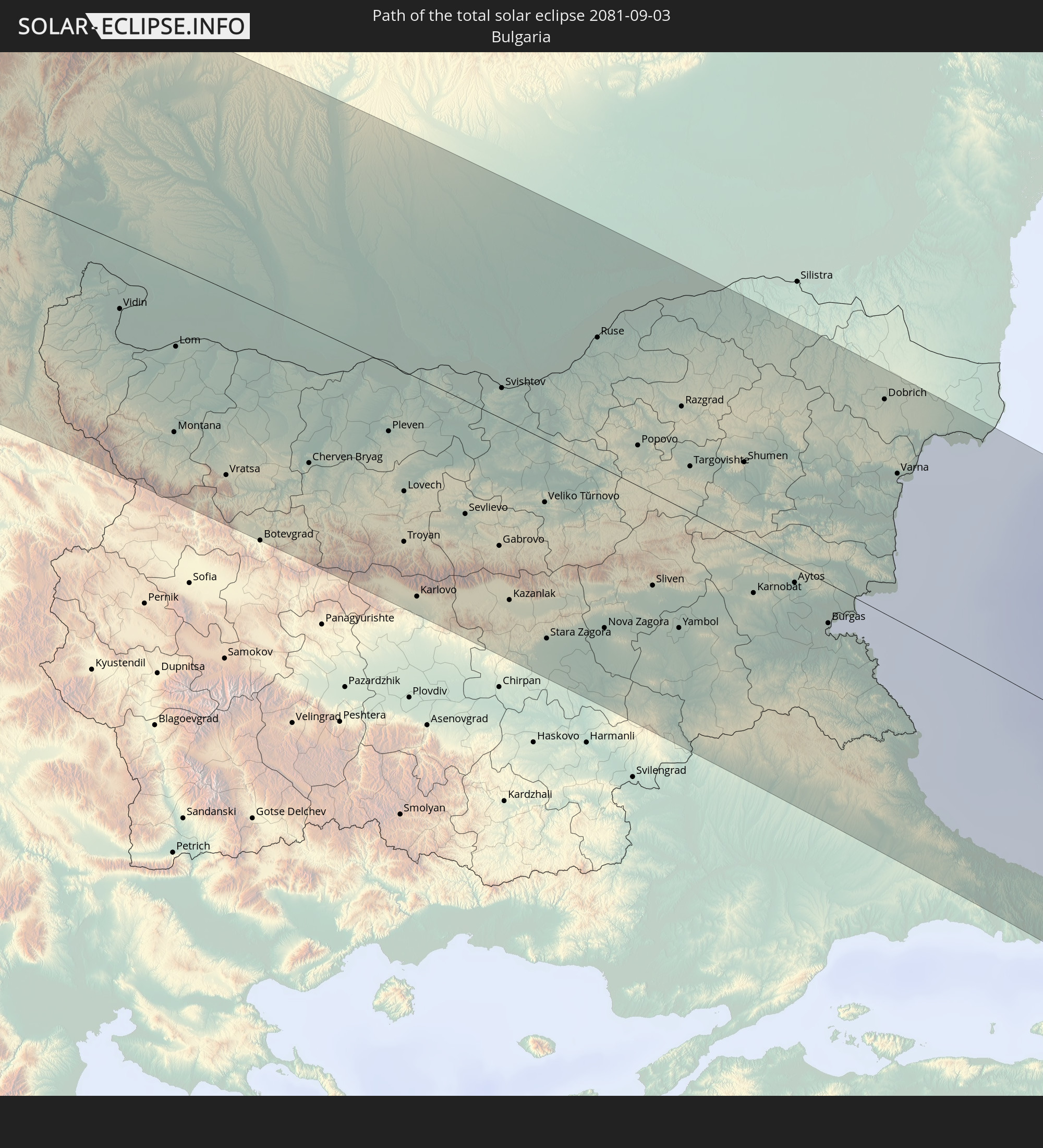 Bulgarien
 Türkei
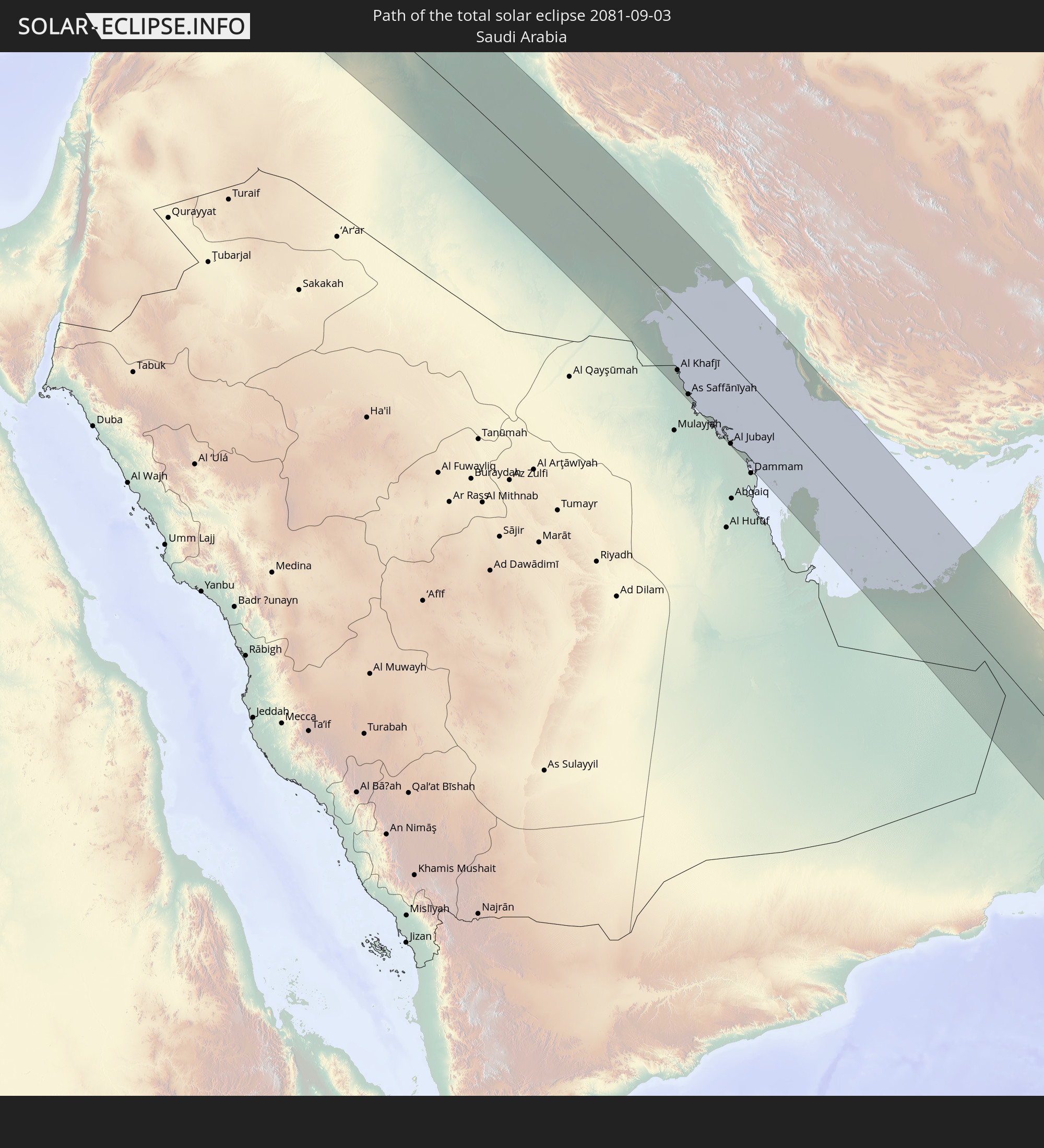 Saudi-Arabien
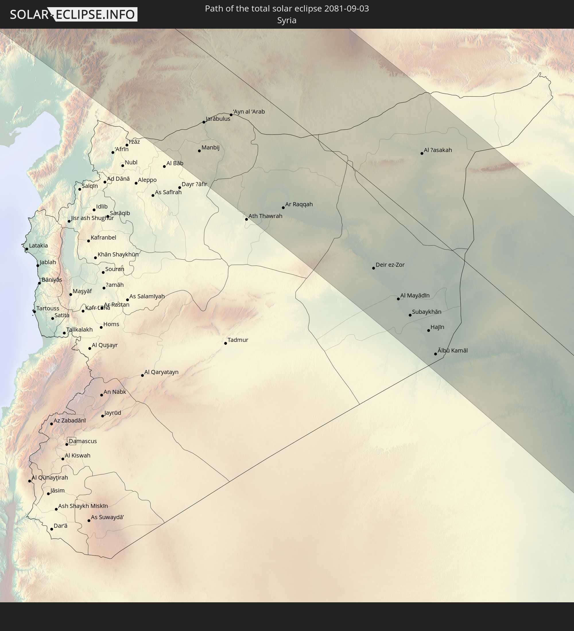 Syrien
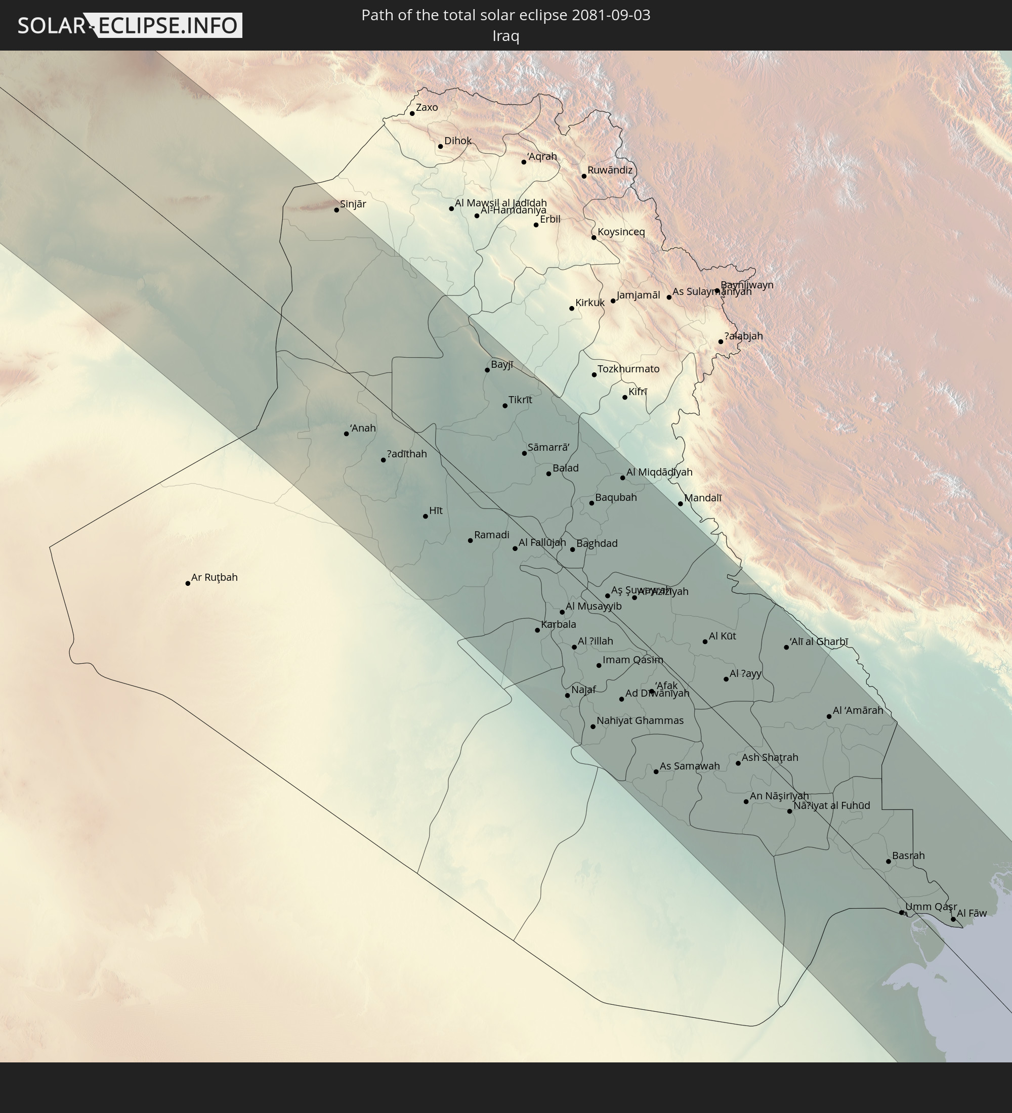 Irak
Irak
 Iran
Iran
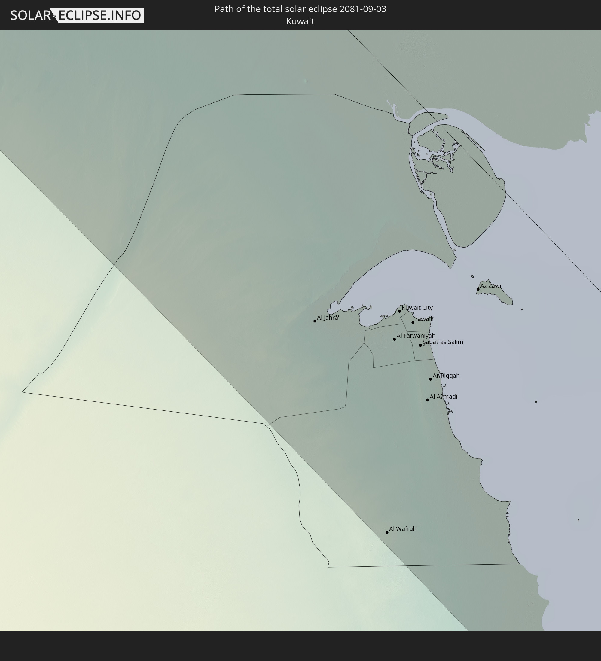 Kuwait
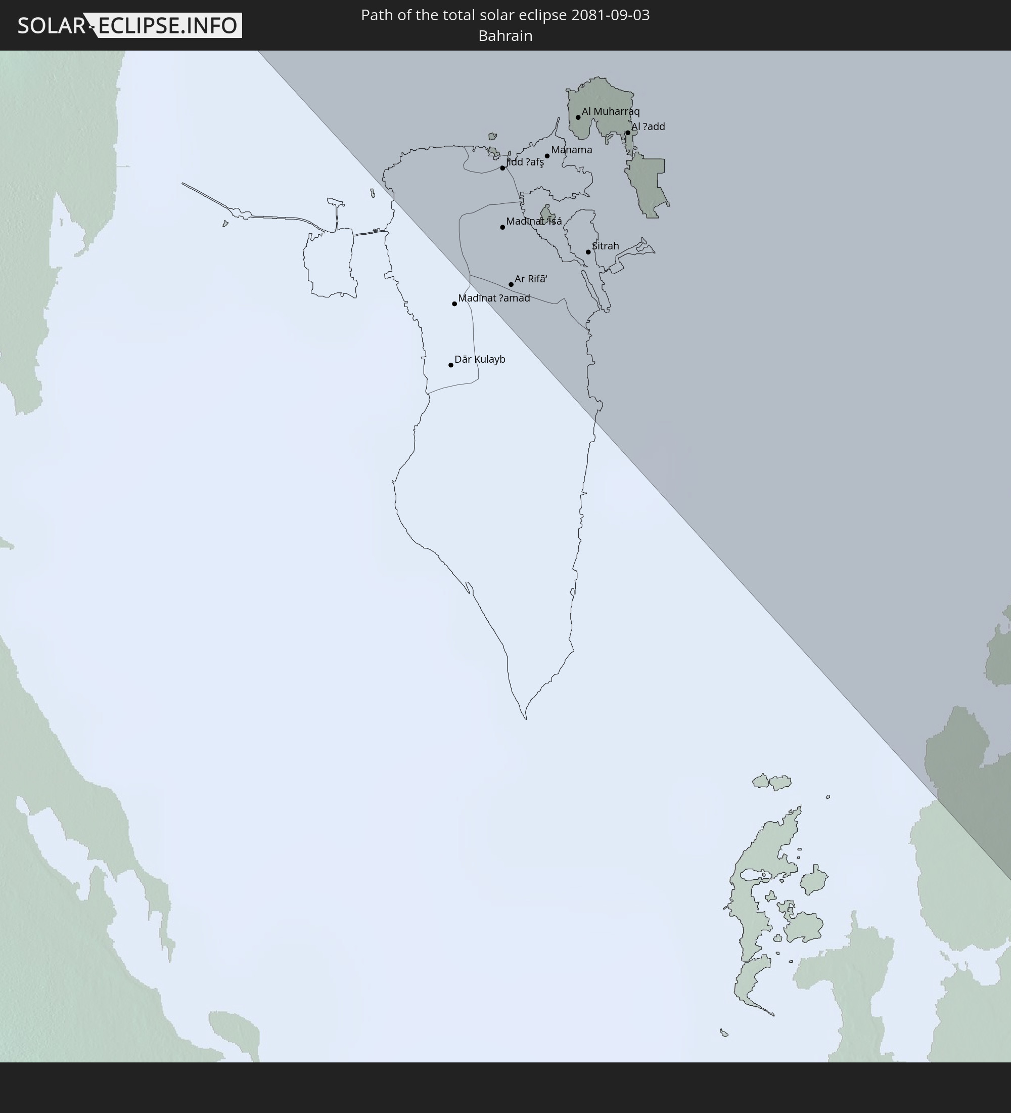 Bahrain
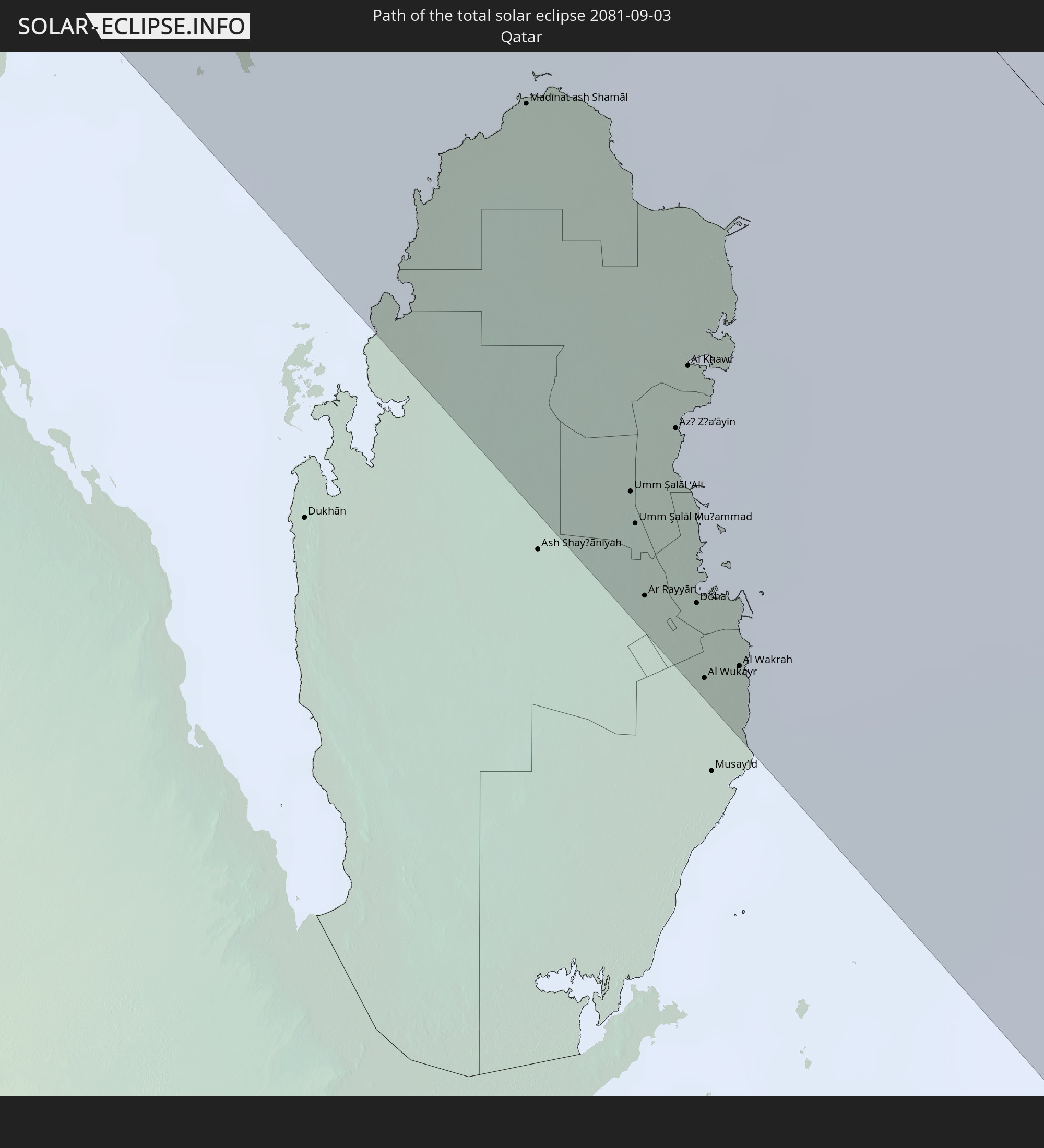 Katar
Katar
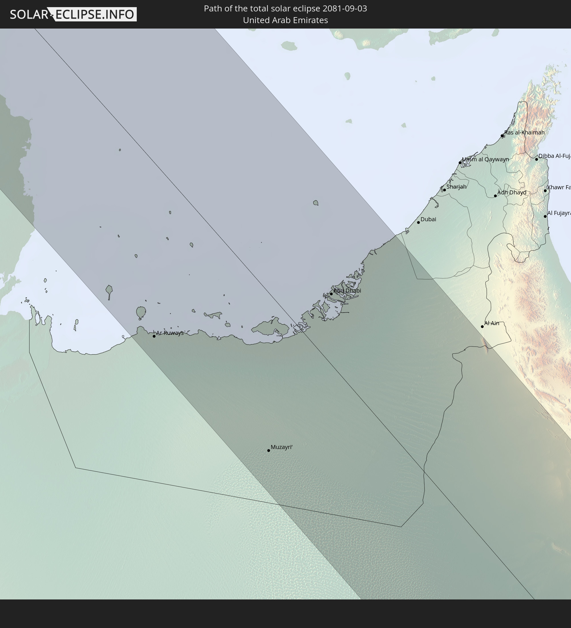 Vereinigte Arabische Emirate
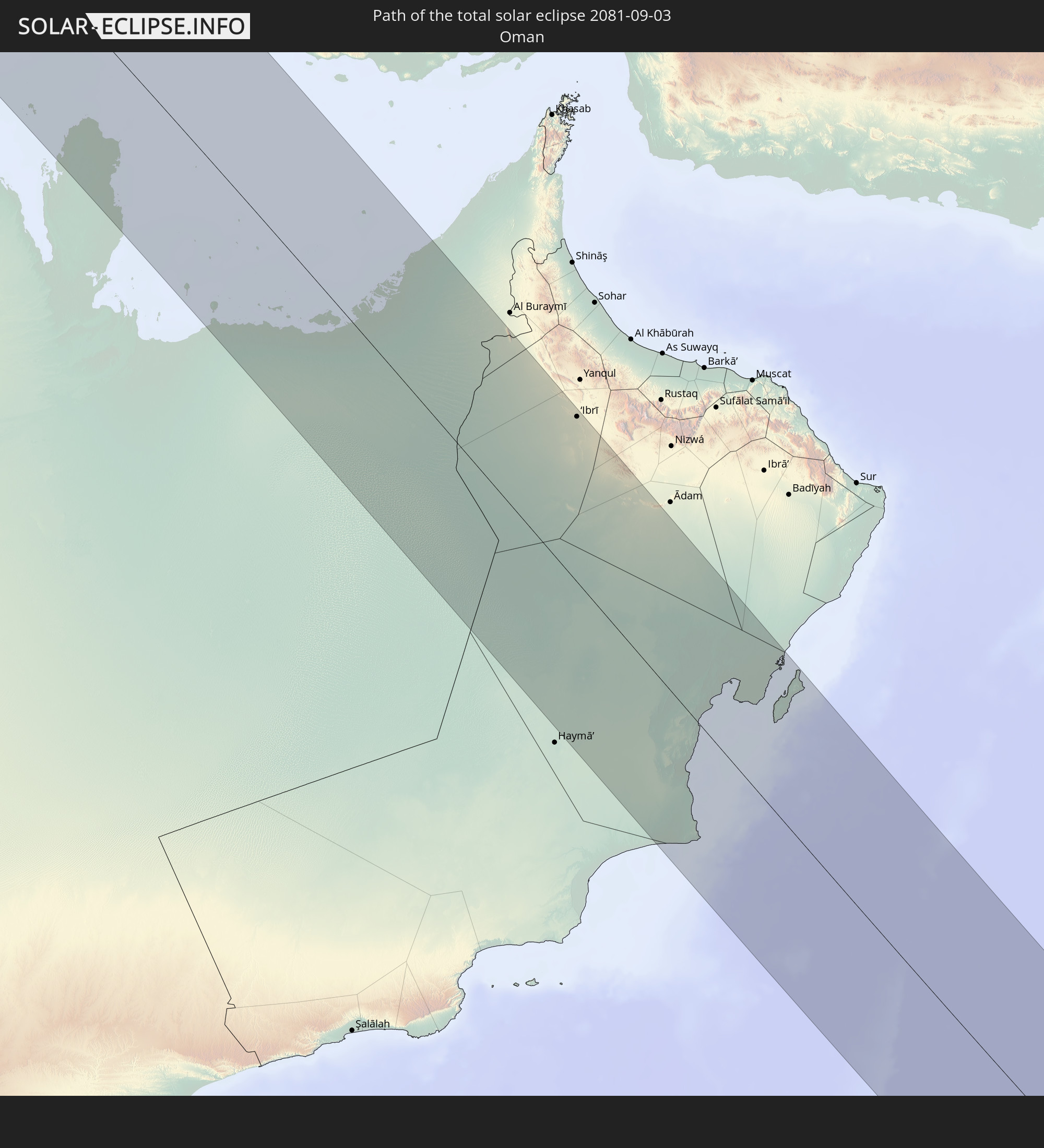 Oman
Oman
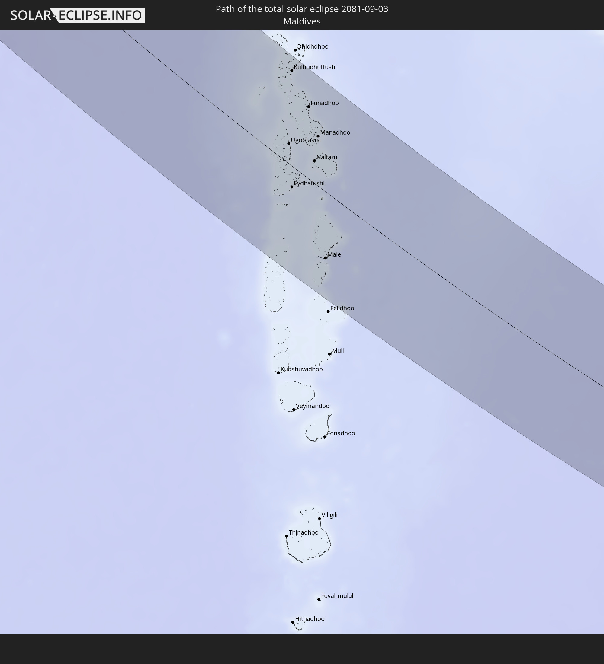 Malediven
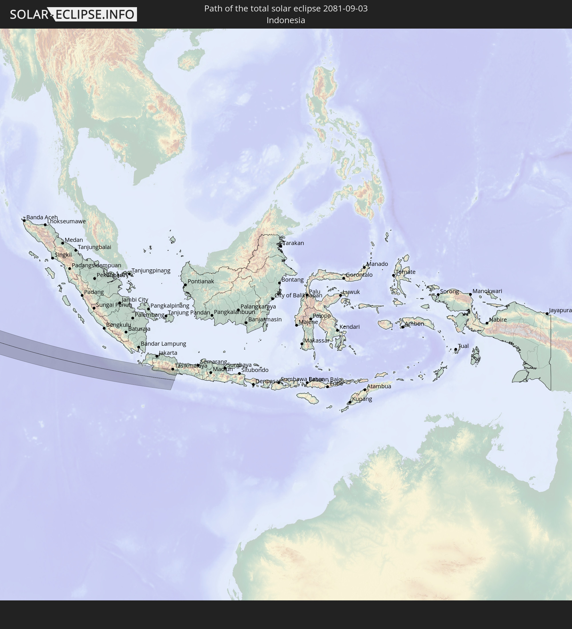 Indonesien
In den folgenden Ländern ist die Sonnenfinsternis partiell zu sehen
 Russland
 Kanada
 Grönland
 Portugal
 Island
 Spanien
 Mauretanien
 Marokko
 Mali
Mali
 Irland
 Spitzbergen
 Algerien
 Vereinigtes Königreich
 Färöer
 Gibraltar
 Frankreich
 Isle of Man
 Guernsey
 Jersey
 Niger
Niger
 Andorra
 Belgien
 Niederlande
 Norwegen
 Luxemburg
 Deutschland
 Schweiz
 Italien
 Monaco
 Tunesien
 Dänemark
 Libyen
 Liechtenstein
 Österreich
 Schweden
 Tschechien
 Demokratische Republik Kongo
 San Marino
 Vatikanstadt
 Slowenien
 Tschad
 Kroatien
 Polen
Polen
 Malta
Malta
 Zentralafrikanische Republik
 Bosnien und Herzegowina
 Ungarn
 Slowakei
 Montenegro
 Serbien
 Albanien
 Åland Islands
 Griechenland
 Rumänien
 Mazedonien
 Finnland
 Litauen
 Lettland
 Estland
 Sudan
Sudan
 Ukraine
 Bulgarien
 Weißrussland
 Ägypten
 Türkei
 Moldawien
 Tansania
 Uganda
 Republik Zypern
 Äthiopien
 Kenia
Kenia
 Staat Palästina
 Israel
 Saudi-Arabien
 Jordanien
 Libanon
 Syrien
 Eritrea
 Irak
Irak
 Georgien
 Französische Süd- und Antarktisgebiete
 Somalia
 Dschibuti
 Jemen
Jemen
 Madagaskar
 Armenien
 Iran
Iran
 Aserbaidschan
 Seychellen
 Kasachstan
 Kuwait
 Bahrain
 Katar
Katar
 Vereinigte Arabische Emirate
 Oman
Oman
 Turkmenistan
 Réunion
 Usbekistan
 Mauritius
 Afghanistan
 Pakistan
 Tadschikistan
 Indien
 Kirgisistan
 Britisches Territorium im Indischen Ozean
 Malediven
 Volksrepublik China
 Sri Lanka
 Nepal
Nepal
 Mongolei
 Bangladesch
 Bhutan
 Myanmar
 Indonesien
 Kokosinseln
 Thailand
 Malaysia
 Laos
Laos
 Vietnam
 Kambodscha
 Singapur
 Weihnachtsinsel
 Macau
Macau
 Hongkong
 Taiwan
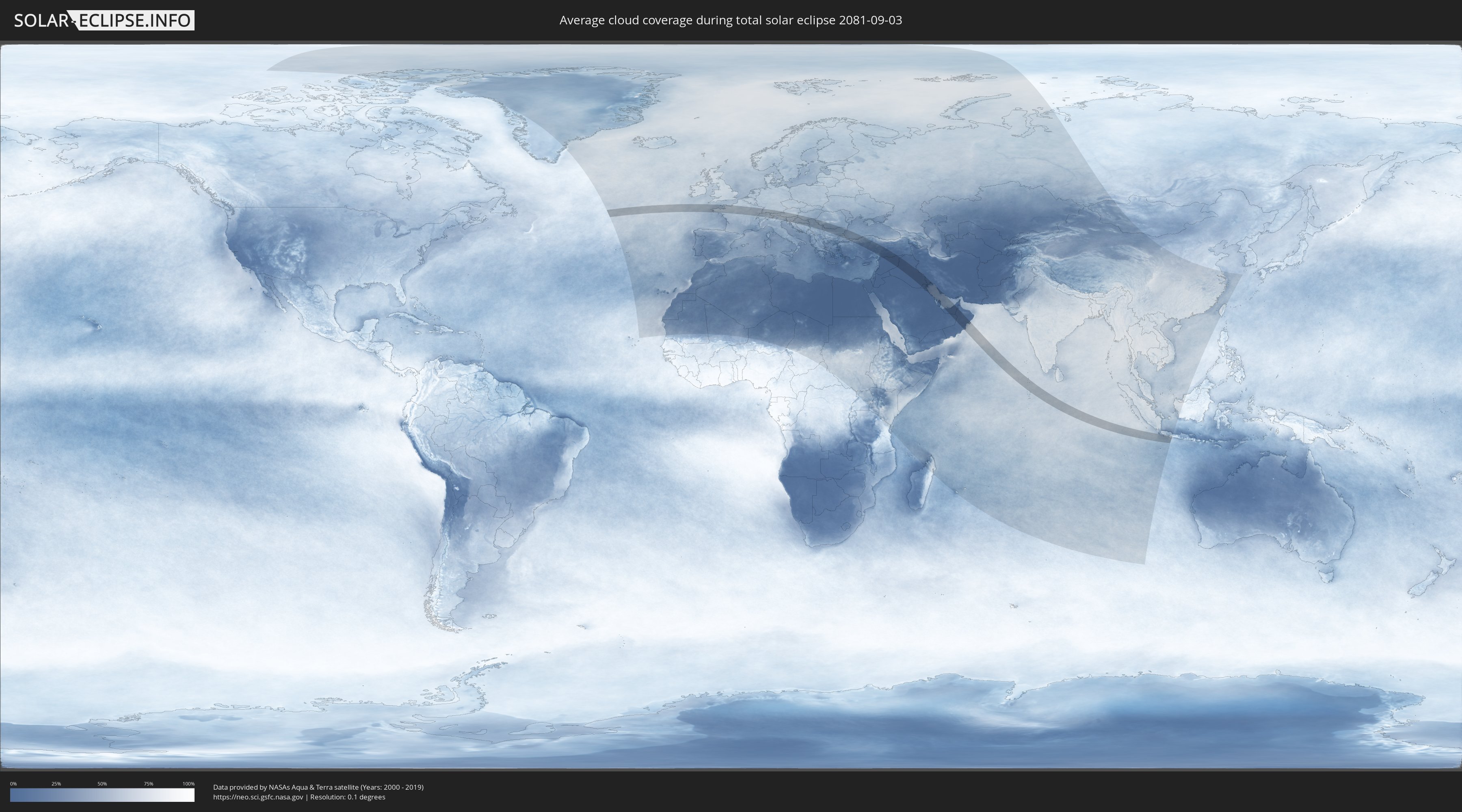
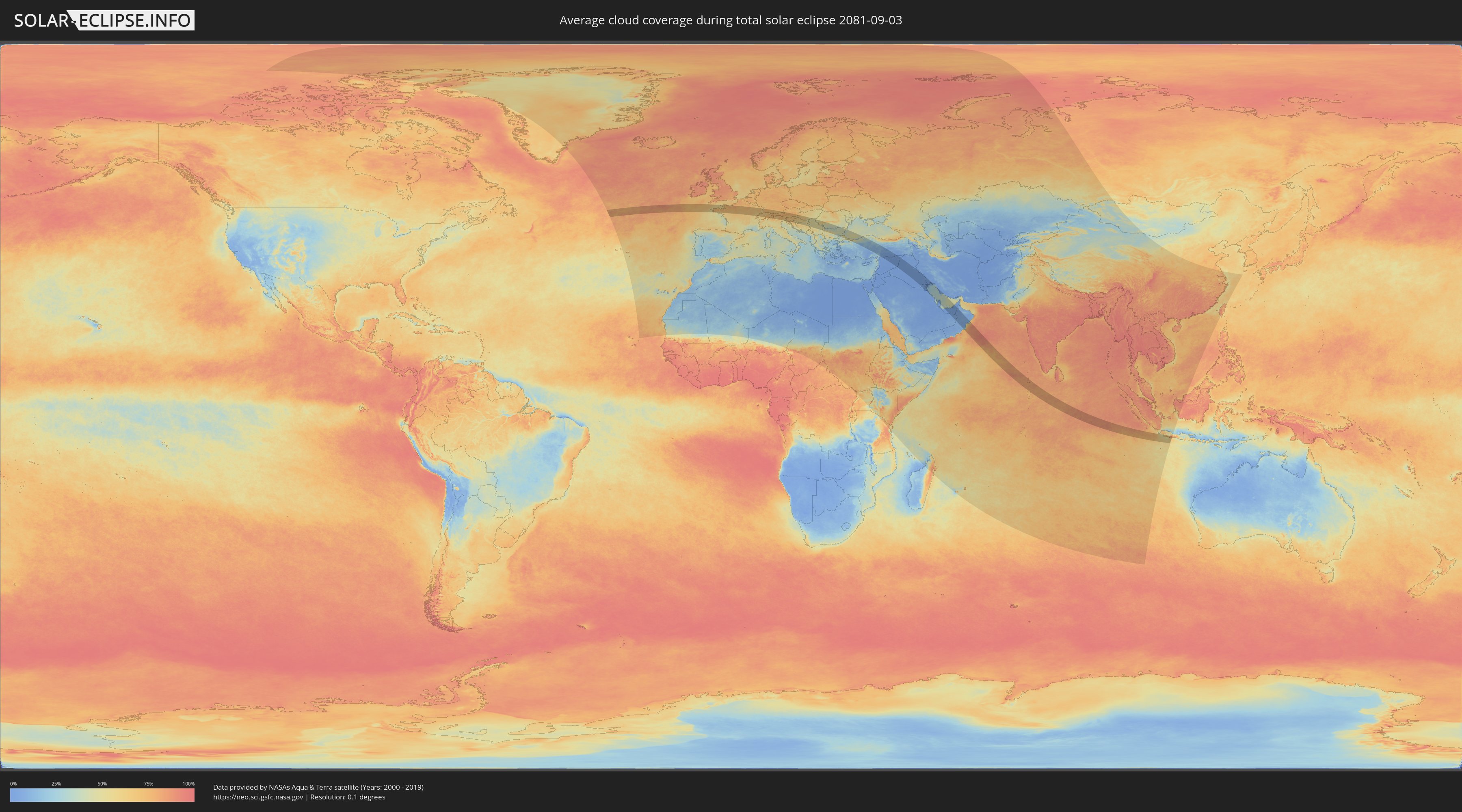
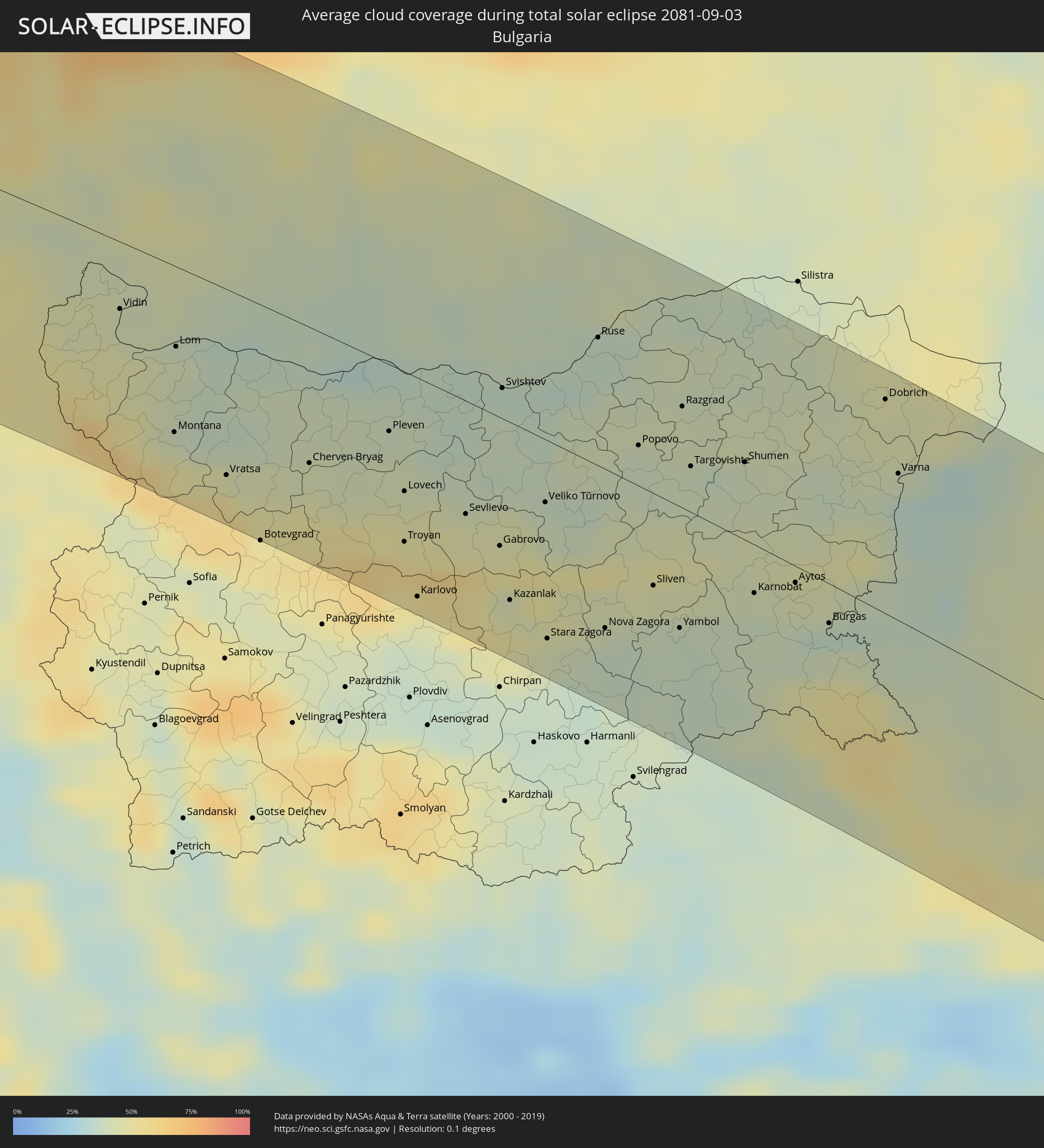
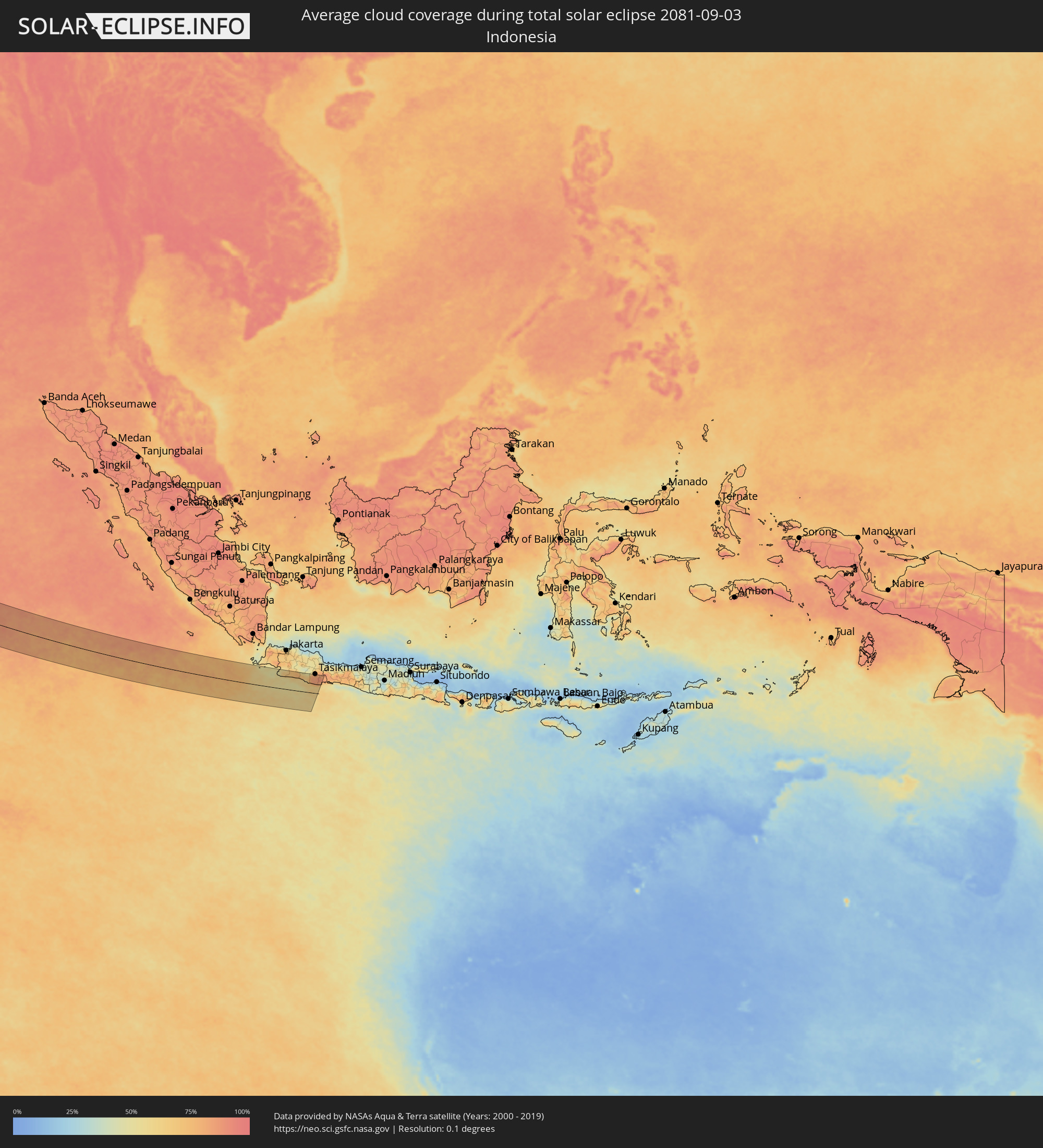
Wie wird das Wetter während der totalen Sonnenfinsternis am 03.09.2081?
Wo ist der beste Ort, um die totale Sonnenfinsternis vom 03.09.2081 zu beobachten?
Die folgenden Karten zeigen die durchschnittliche Bewölkung für den Tag, an dem die totale Sonnenfinsternis
stattfindet. Mit Hilfe der Karten lässt sich der Ort entlang des Finsternispfades eingrenzen,
der die besten Aussichen auf einen klaren wolkenfreien Himmel bietet.
Trotzdem muss man immer lokale Gegenenheiten beachten und sollte sich genau über das Wetter an seinem
gewählten Beobachtungsort informieren.
Die Daten stammen von den beiden NASA-Satelliten
AQUA und TERRA
und wurden über einen Zeitraum von 19 Jahren (2000 - 2019) gemittelt.
Detaillierte Länderkarten
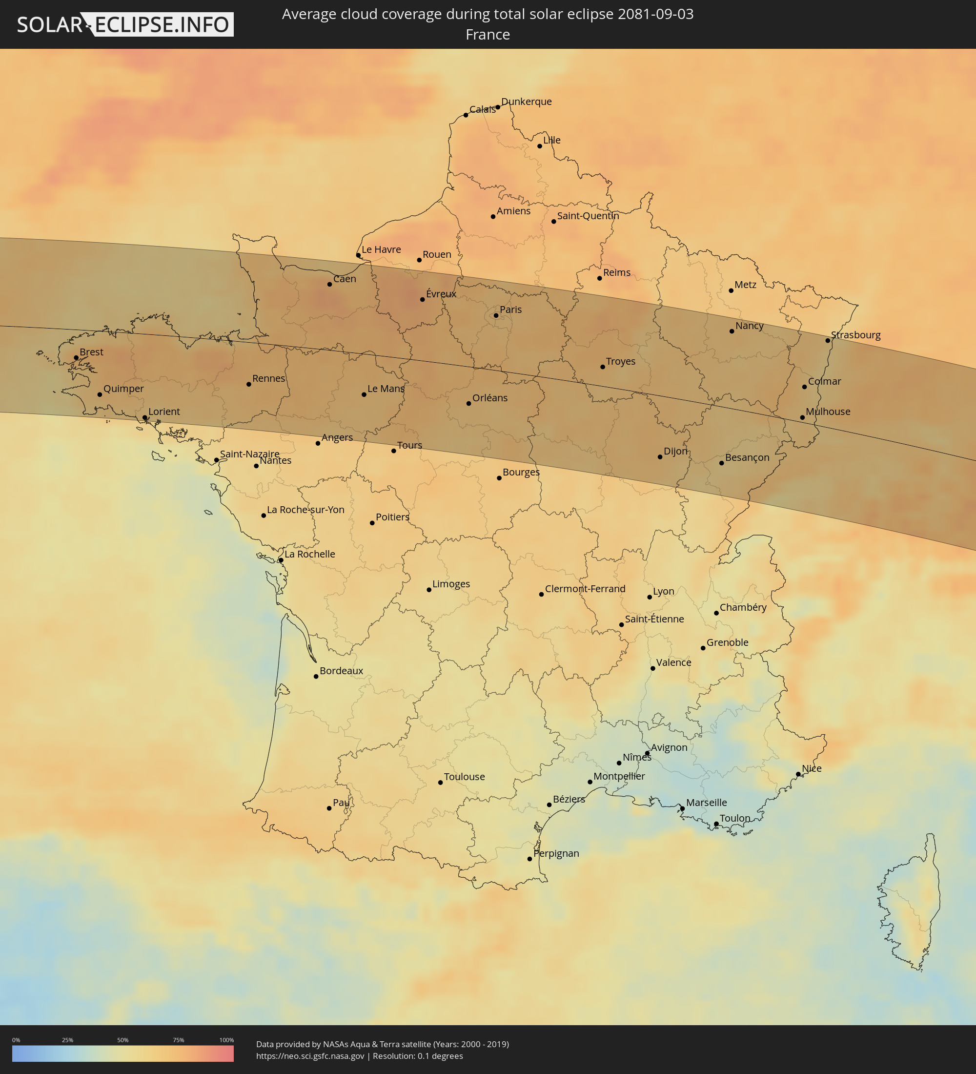 Frankreich
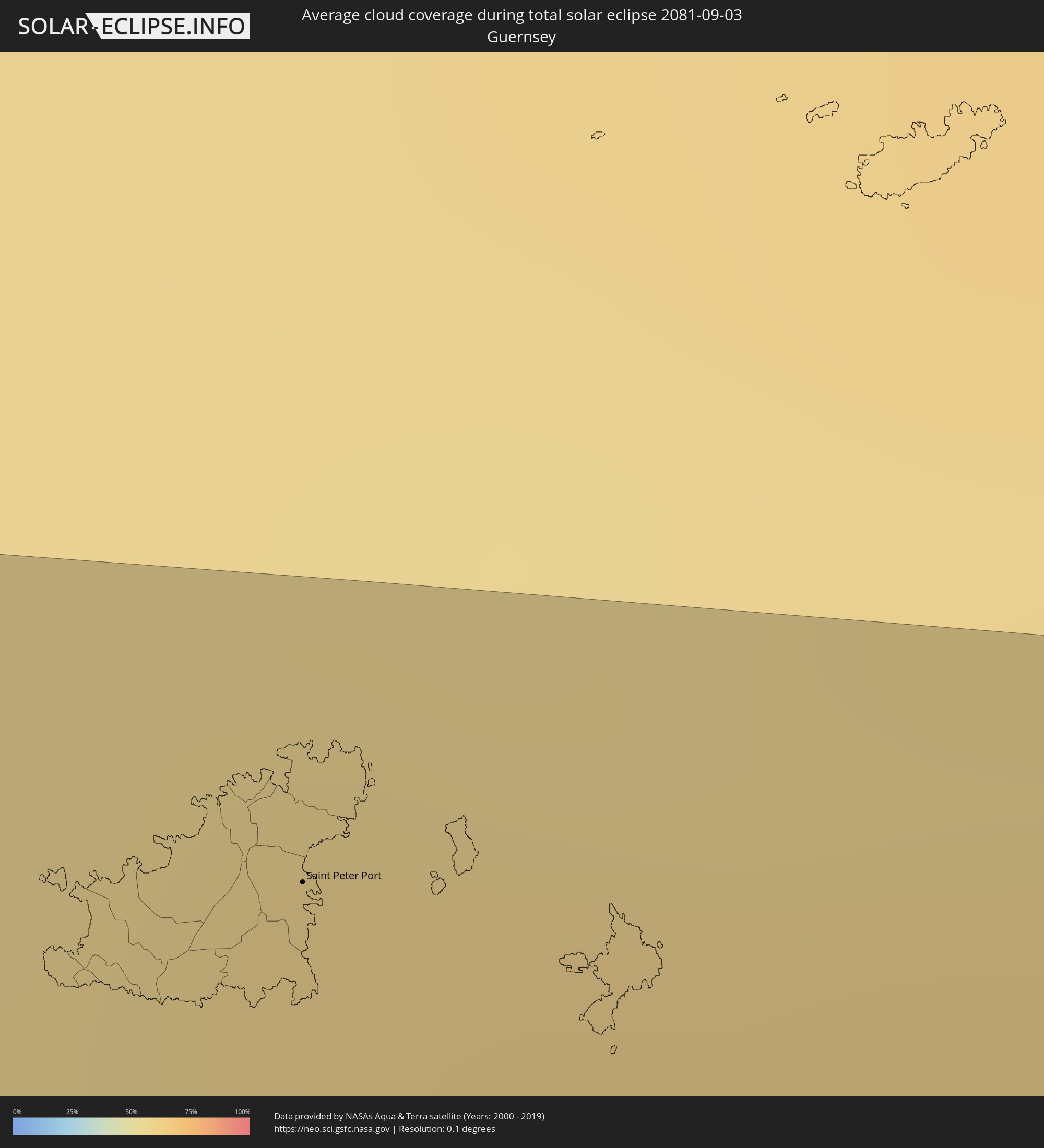 Guernsey
 Jersey
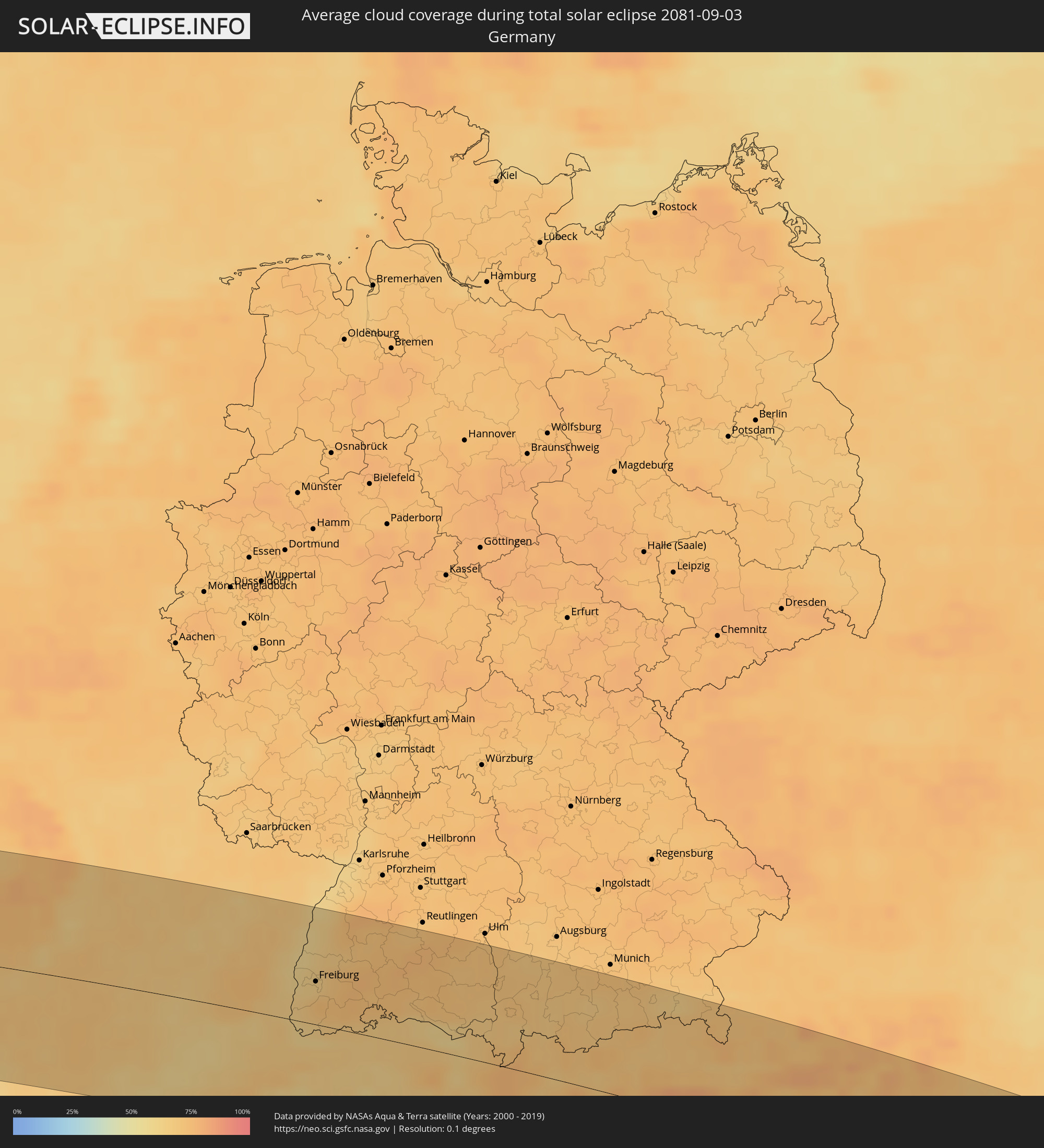 Deutschland
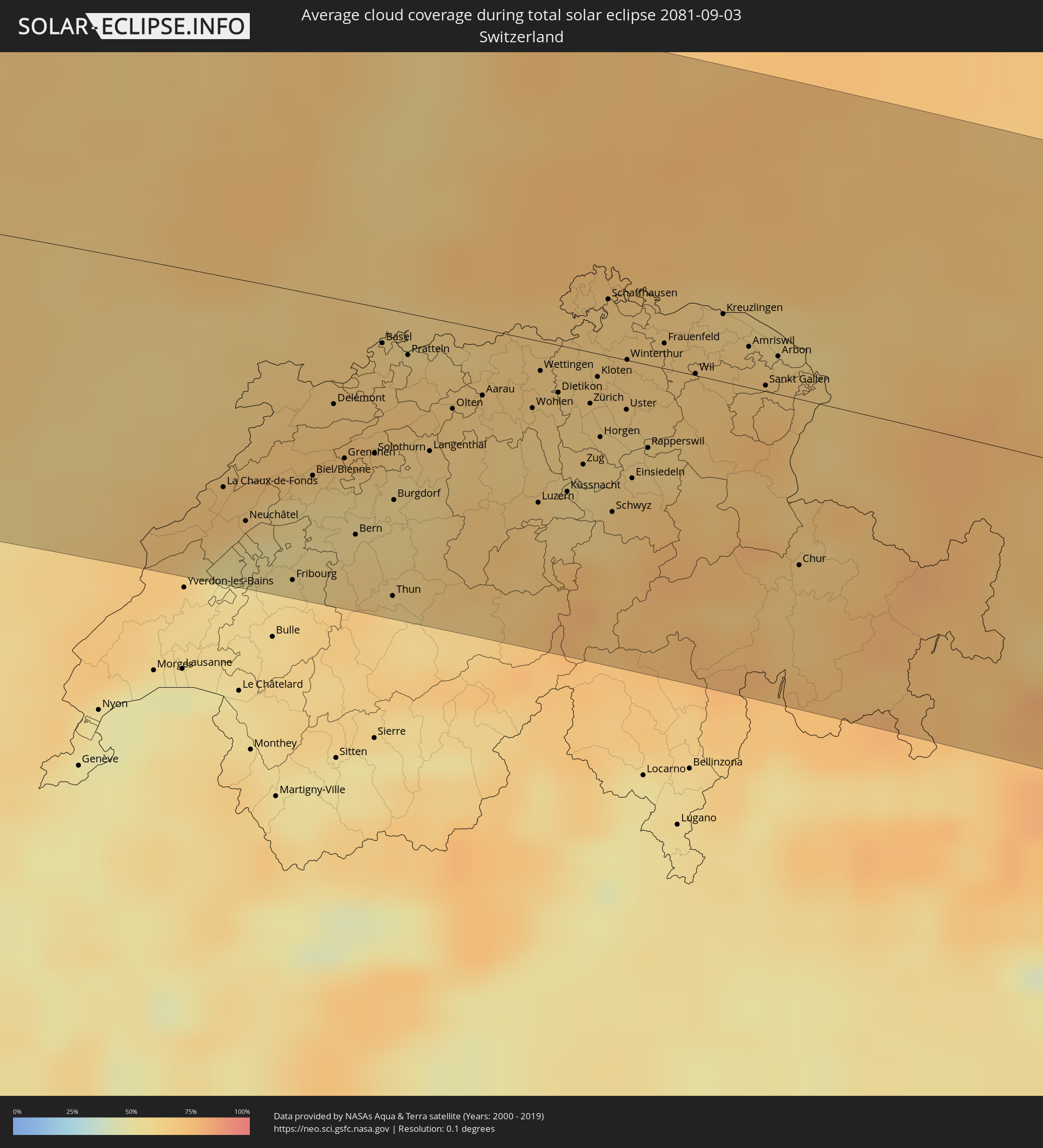 Schweiz
 Italien
 Liechtenstein
 Österreich
 Slowenien
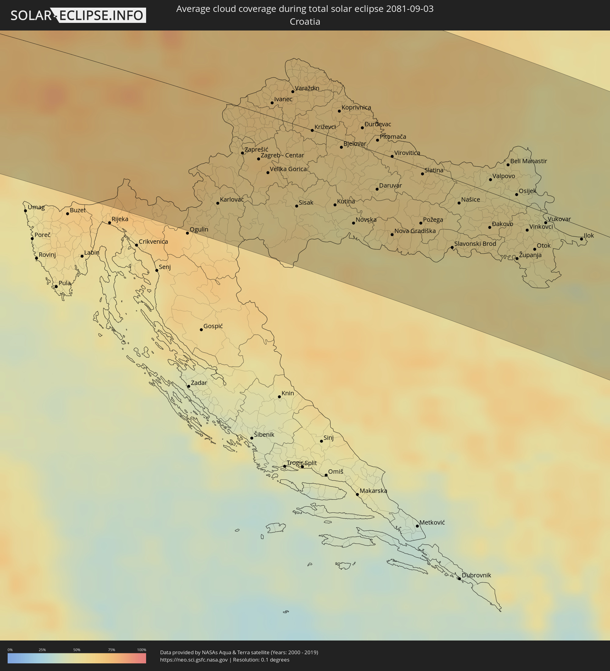 Kroatien
 Bosnien und Herzegowina
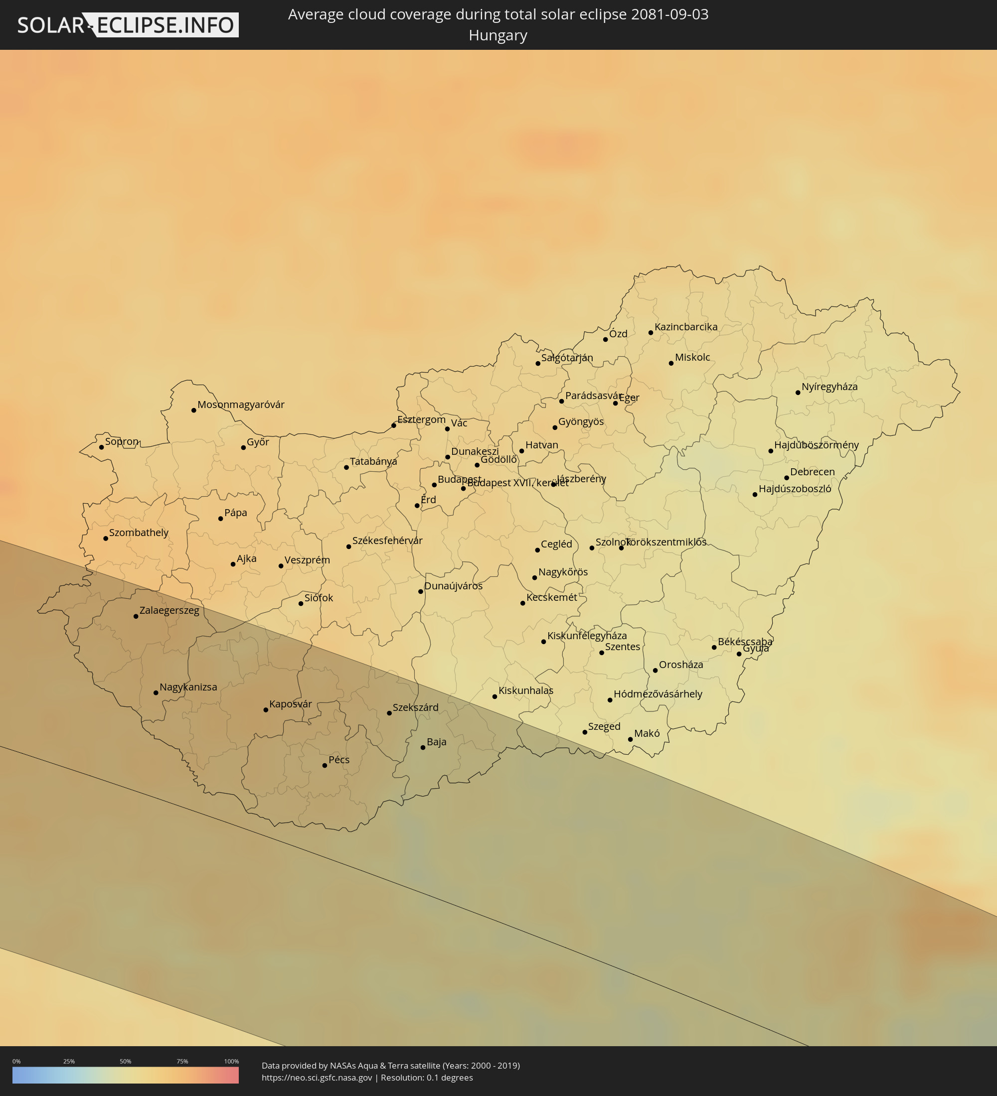 Ungarn
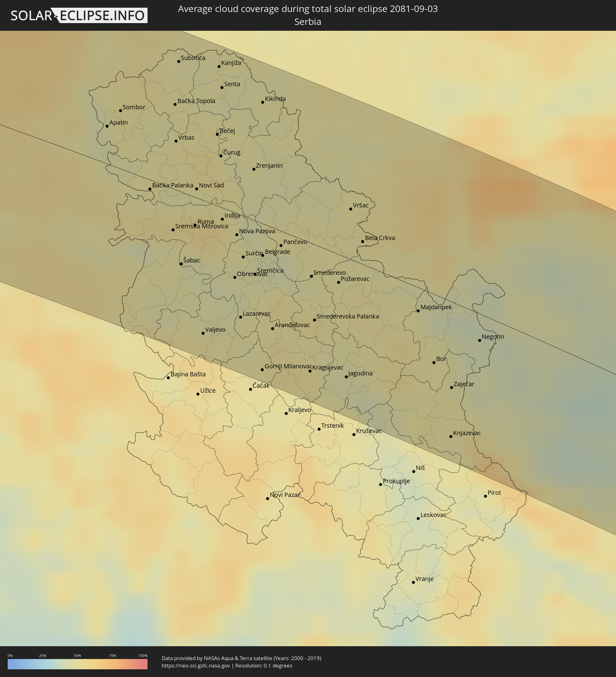 Serbien
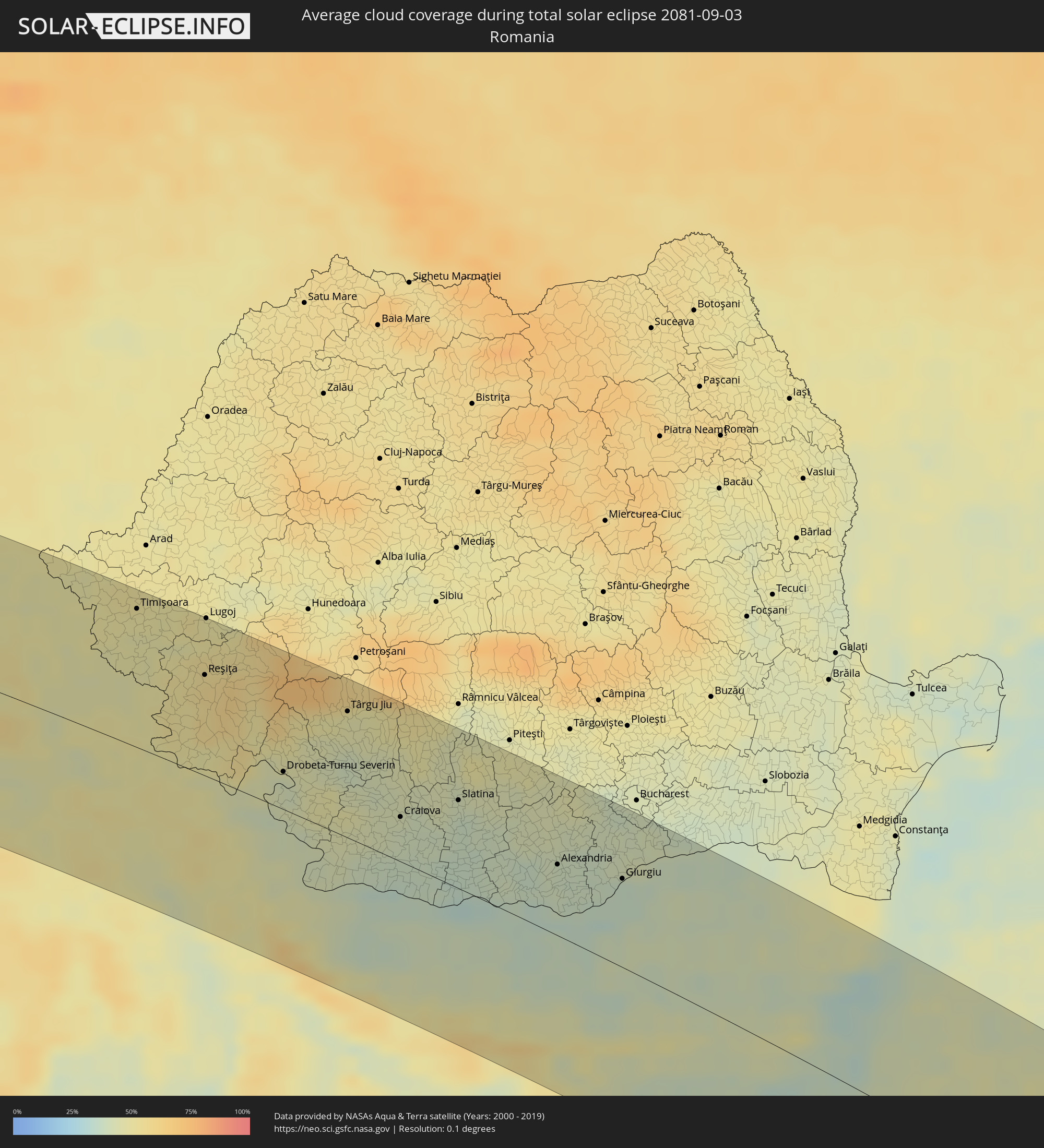 Rumänien
 Bulgarien
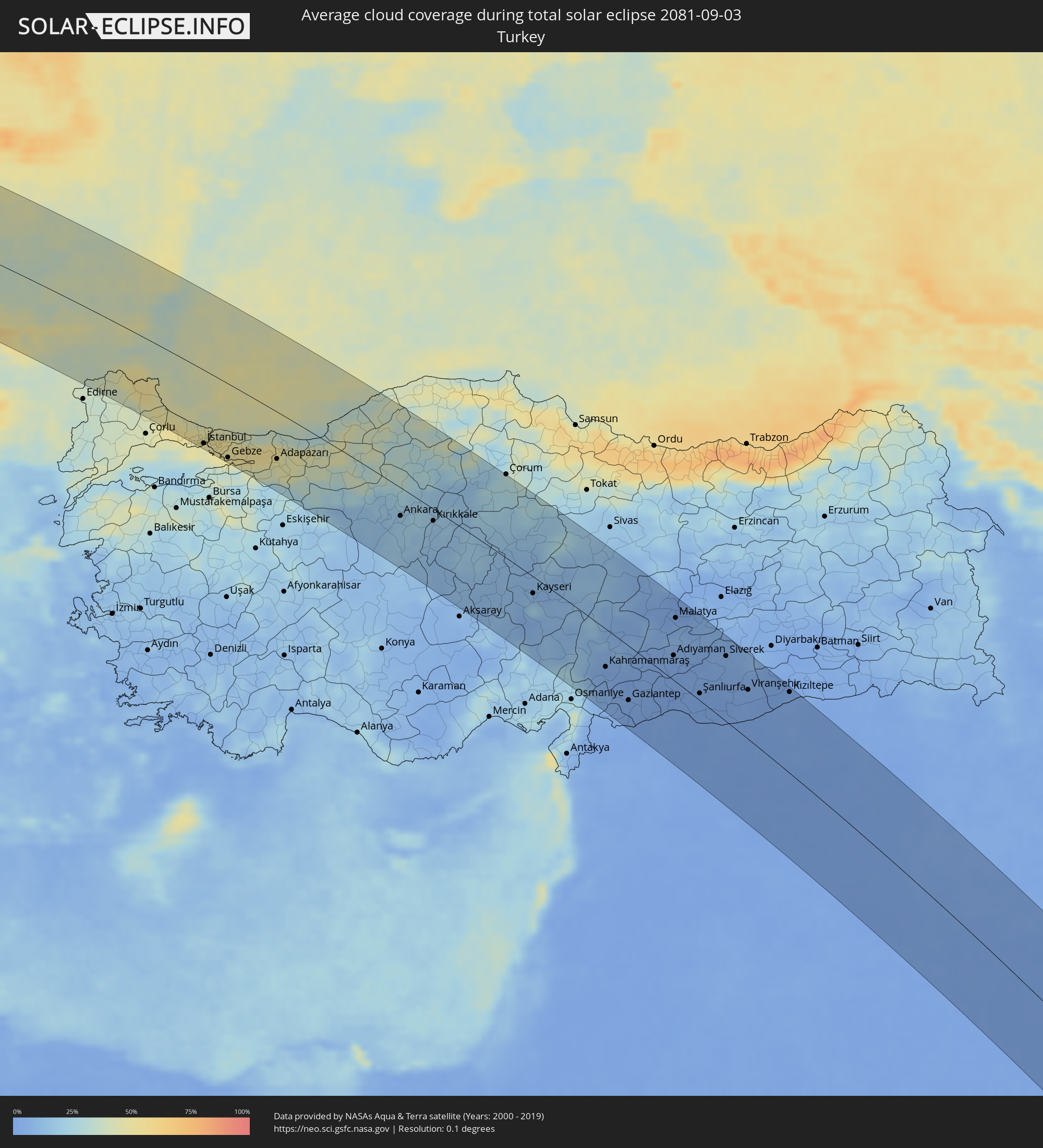 Türkei
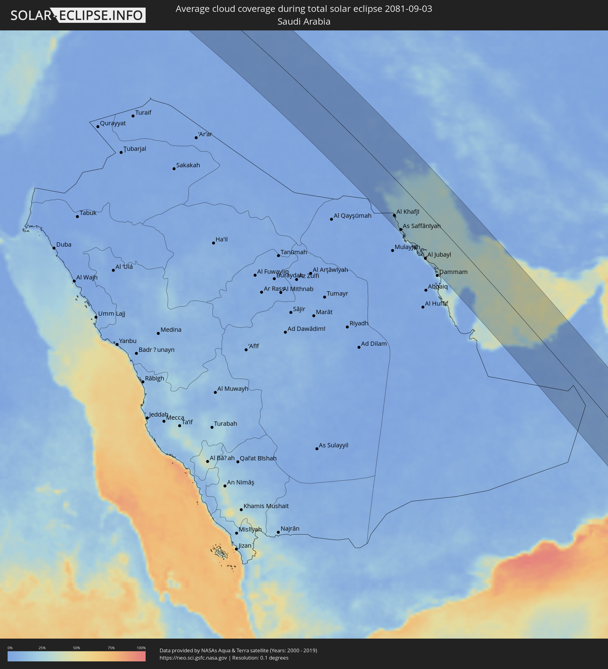 Saudi-Arabien
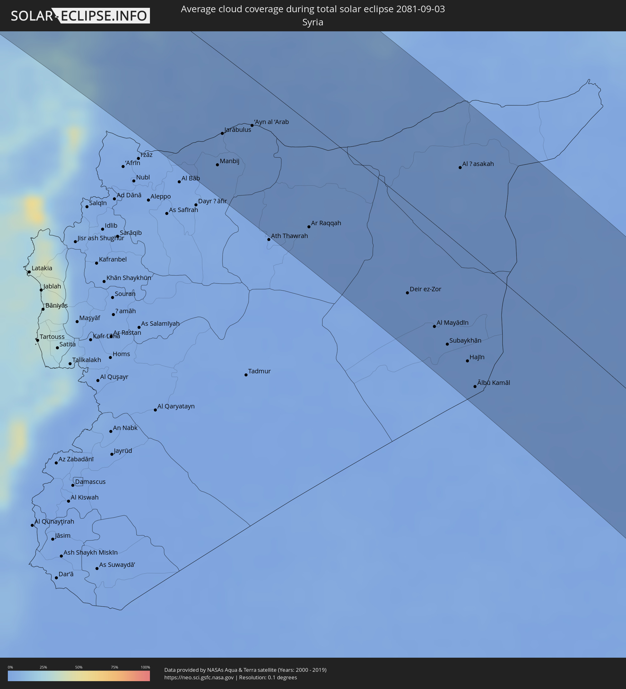 Syrien
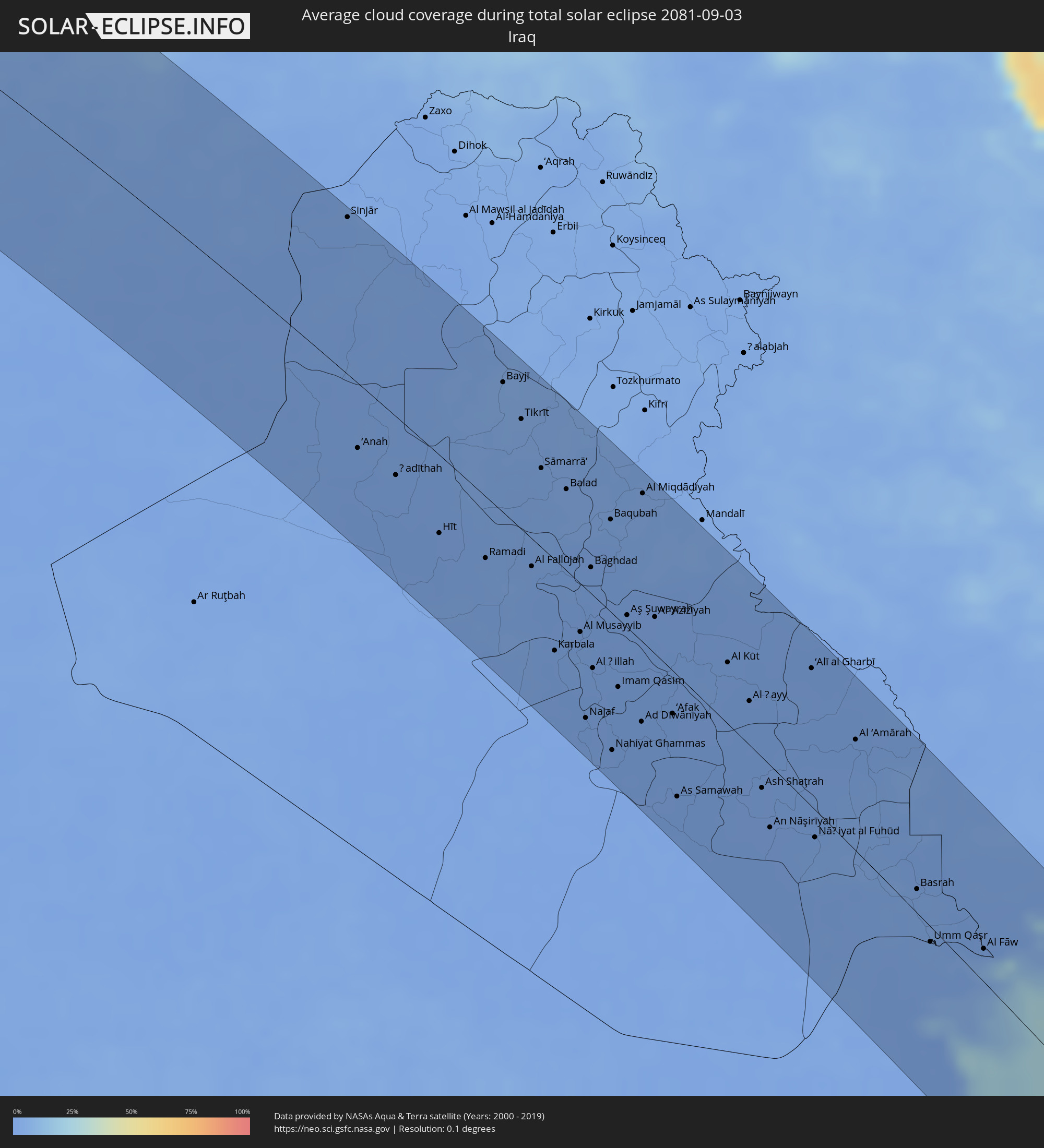 Irak
Irak
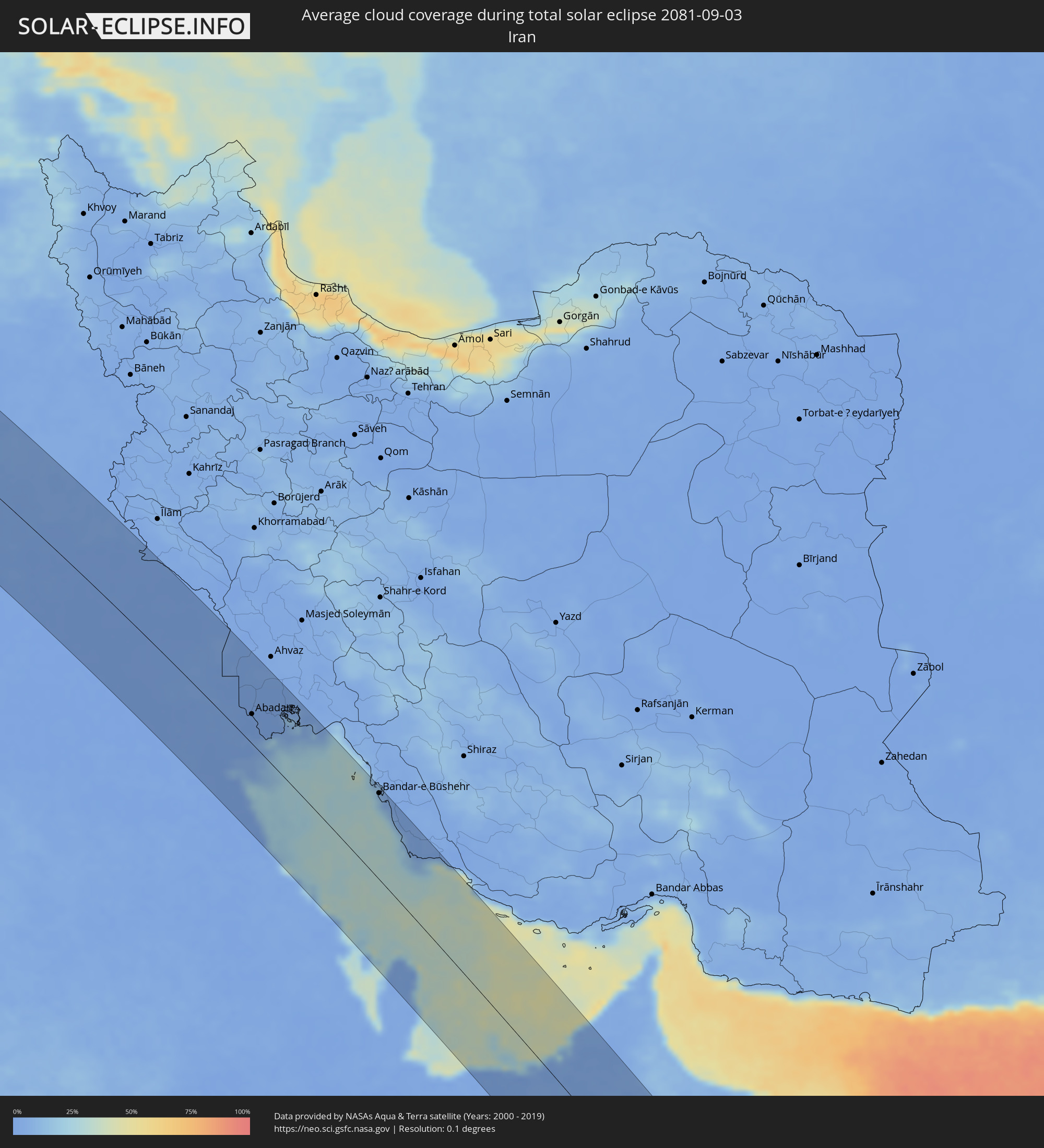 Iran
Iran
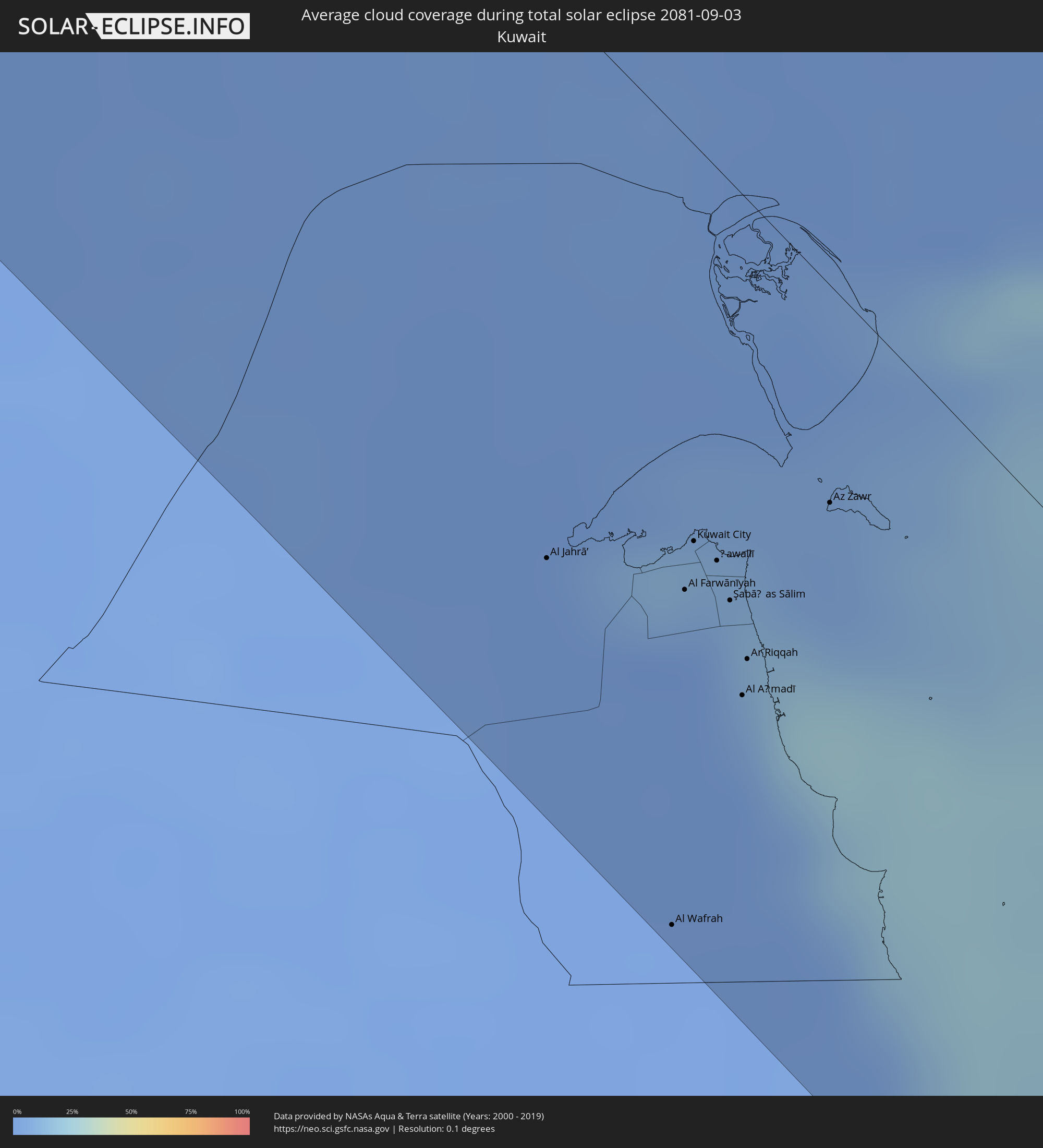 Kuwait
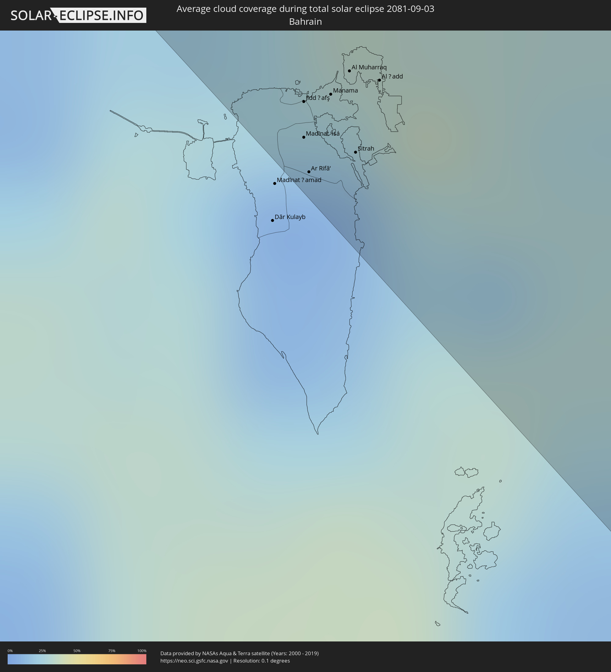 Bahrain
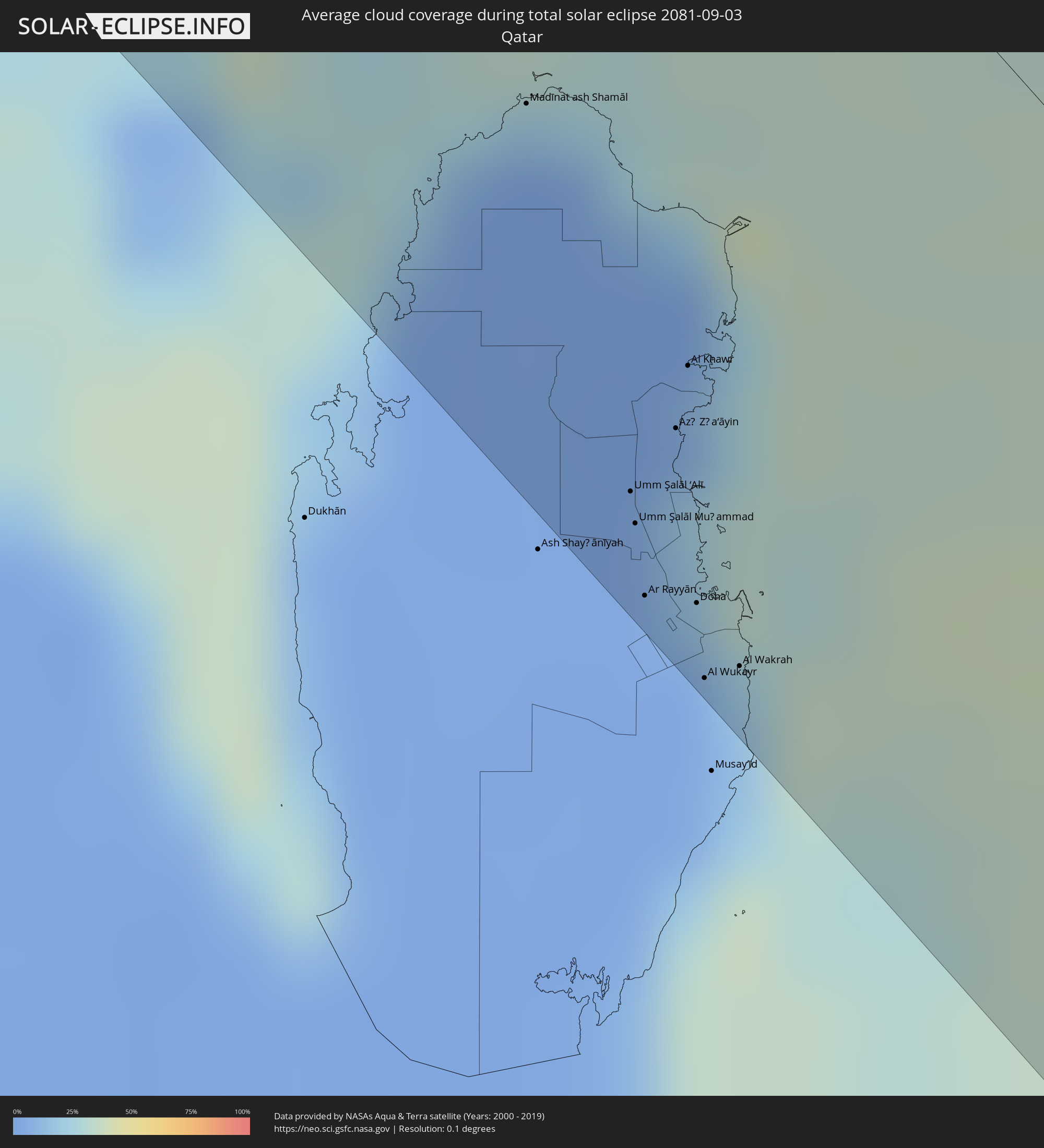 Katar
Katar
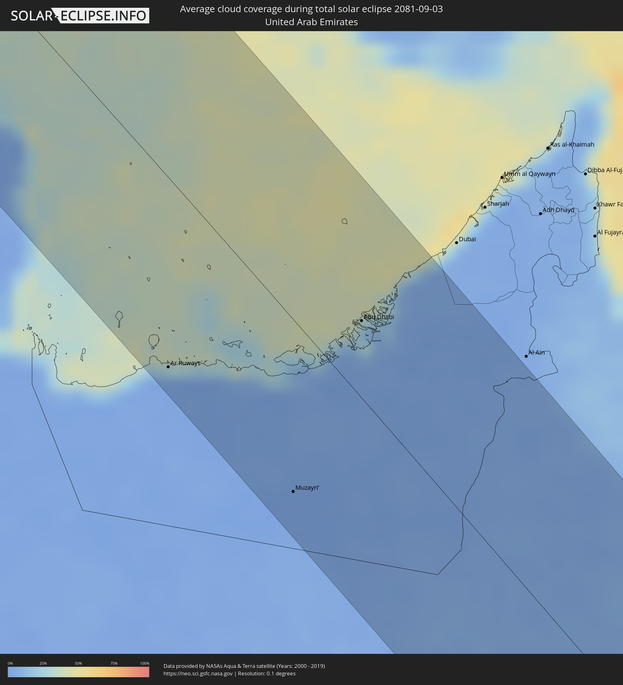 Vereinigte Arabische Emirate
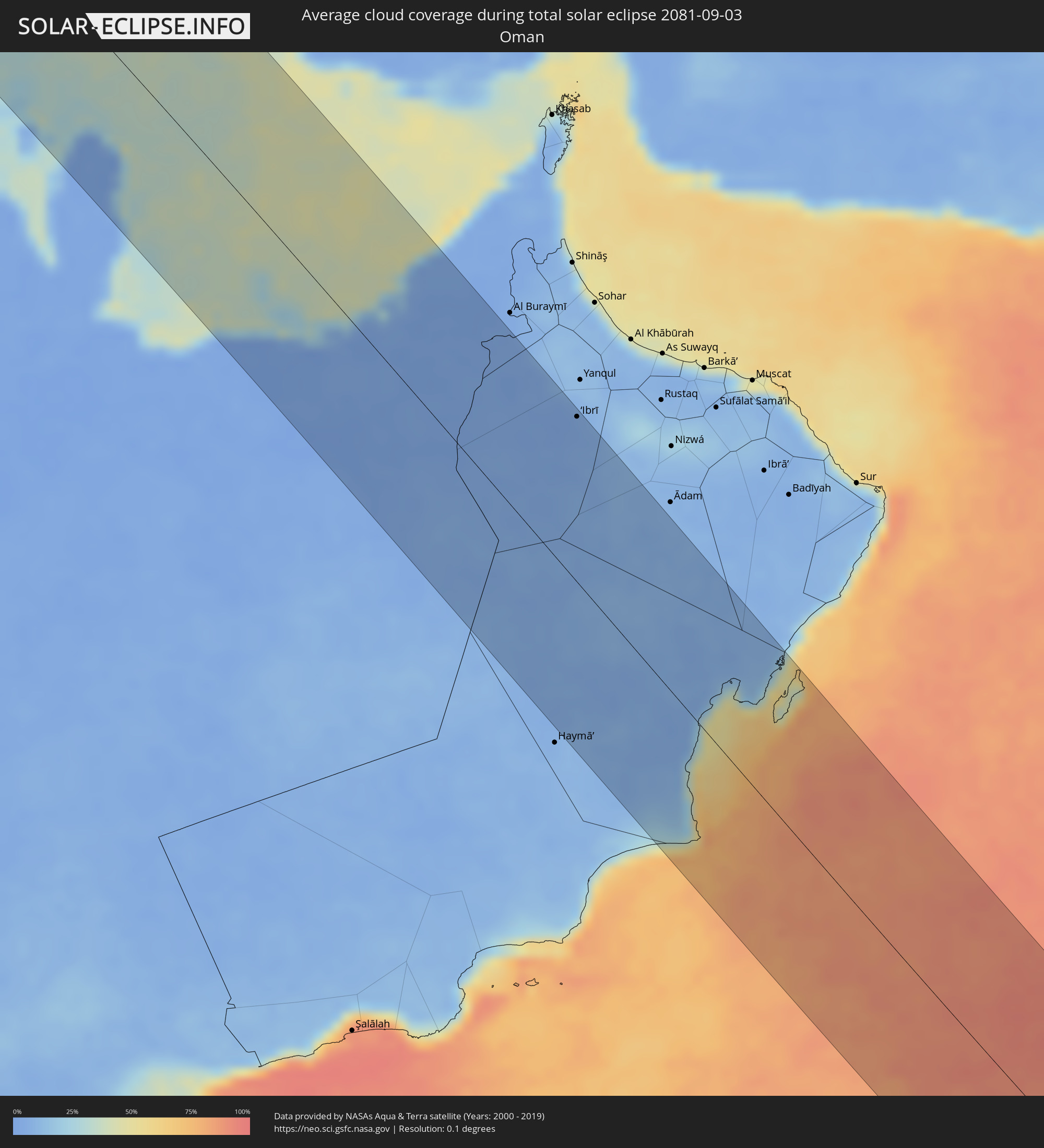 Oman
Oman
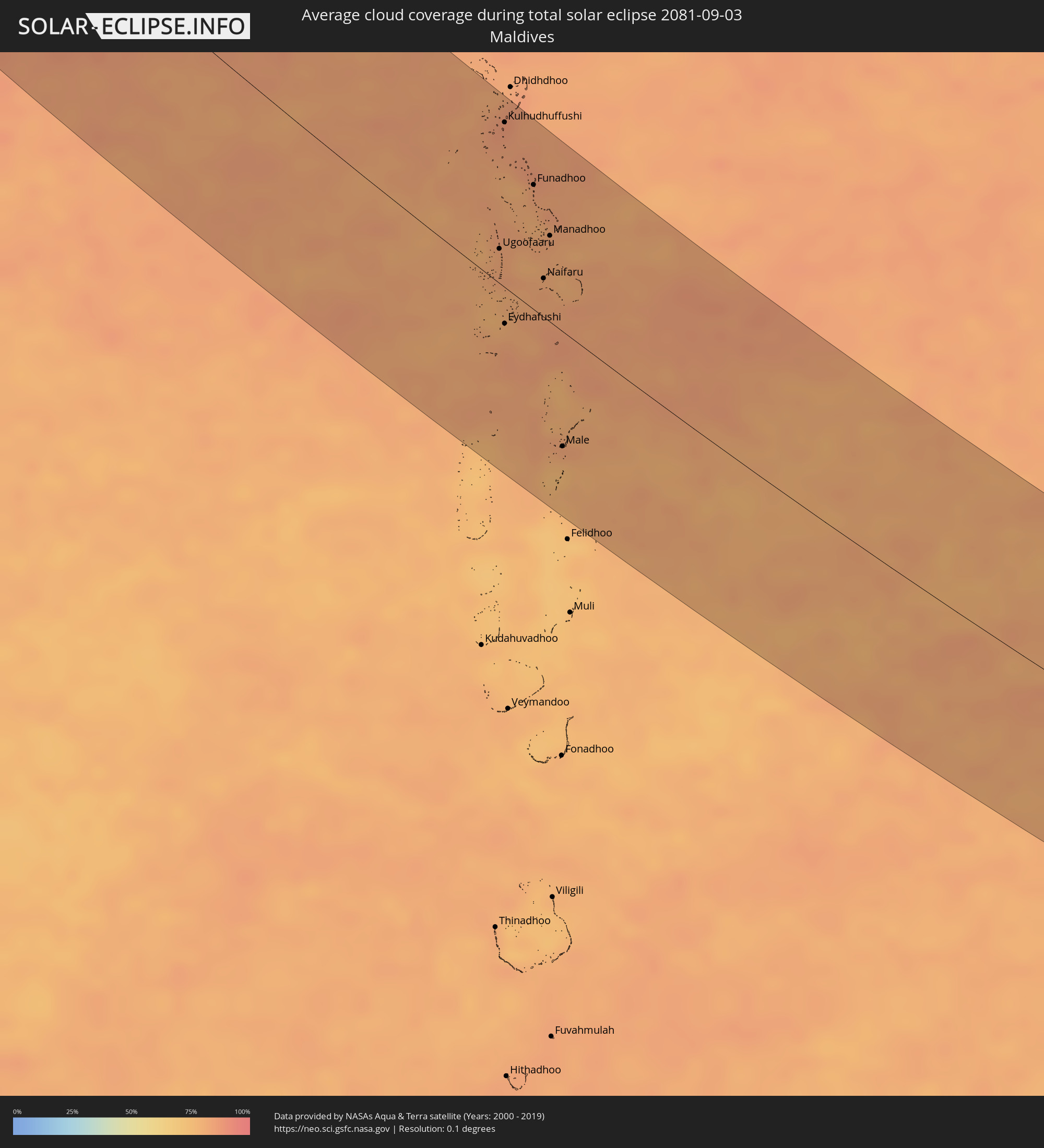 Malediven
 Indonesien
Orte im Finsternispfad
Die nachfolgene Tabelle zeigt Städte und Orte mit mehr als 5.000 Einwohnern, die sich im Finsternispfad befinden. Städte mit mehr als 100.000 Einwohnern sind dick gekennzeichnet. Mit einem Klick auf den Ort öffnet sich eine Detailkarte die die Lage des jeweiligen Ortes zusammen mit dem Verlauf der zentralen Finsternis präsentiert.
| Ort | Typ | Dauer der Verfinsterung | Ortszeit bei maximaler Verfinsterung | Entfernung zur Zentrallinie | Ø Bewölkung |
|
Brest, Brittany
|
total | - | 08:33:31 UTC+01:00 | 34 km | 69% |
|
Saint Peter Port, St Peter Port
|
total | - | 07:35:03 UTC+00:00 | 93 km | 60% |
|
Saint Helier, St Helier
|
total | - | 07:35:06 UTC+00:00 | 66 km | 63% |
|
Le Hocq, St Clement
|
total | - | 07:35:07 UTC+00:00 | 64 km | 63% |
|
Rennes, Brittany
|
total | - | 08:34:45 UTC+01:00 | 51 km | 69% |
|
Le Mans, Pays de la Loire
|
total | - | 08:35:43 UTC+01:00 | 49 km | 69% |
|
Saint-Quentin-en-Yvelines, Île-de-France
|
total | - | 08:37:10 UTC+01:00 | 52 km | 70% |
|
Cergy-Pontoise, Île-de-France
|
total | - | 08:37:19 UTC+01:00 | 82 km | 69% |
|
Paris, Île-de-France
|
total | - | 08:37:24 UTC+01:00 | 65 km | 67% |
|
Dijon, Bourgogne-Franche-Comté
|
total | - | 08:38:28 UTC+01:00 | 74 km | 69% |
|
Biel/Bienne, Bern
|
total | - | 08:40:01 UTC+01:00 | 63 km | 58% |
|
Bern, Bern
|
total | - | 08:40:07 UTC+01:00 | 81 km | 63% |
|
Basel, Basel-City
|
total | - | 08:40:24 UTC+01:00 | 12 km | 62% |
|
Thun, Bern
|
total | - | 08:40:11 UTC+01:00 | 99 km | 61% |
|
Strasbourg, Grand-Est
|
total | - | 08:40:53 UTC+01:00 | 102 km | 63% |
|
Freiburg, Baden-Württemberg
|
total | - | 08:40:46 UTC+01:00 | 40 km | 67% |
|
Offenburg, Baden-Württemberg
|
total | - | 08:41:00 UTC+01:00 | 93 km | 63% |
|
Luzern, Lucerne
|
total | - | 08:40:48 UTC+01:00 | 56 km | 64% |
|
Villingen-Schwenningen, Baden-Württemberg
|
total | - | 08:41:16 UTC+01:00 | 57 km | 75% |
|
Zürich, Zurich
|
total | - | 08:41:05 UTC+01:00 | 18 km | 62% |
|
Winterthur, Zurich
|
total | - | 08:41:16 UTC+01:00 | 0 km | 66% |
|
Konstanz, Baden-Württemberg
|
total | - | 08:41:40 UTC+01:00 | 24 km | 63% |
|
Sankt Gallen, Saint Gallen
|
total | - | 08:41:45 UTC+01:00 | 2 km | 72% |
|
Friedrichshafen, Baden-Württemberg
|
total | - | 08:41:54 UTC+01:00 | 29 km | 62% |
|
Schaan, Schaan
|
total | - | 08:41:47 UTC+01:00 | 24 km | 66% |
|
Gamprin, Gamprin
|
total | - | 08:41:48 UTC+01:00 | 18 km | 66% |
|
Eschen, Eschen
|
total | - | 08:41:49 UTC+01:00 | 19 km | 66% |
|
Ruggell, Ruggell
|
total | - | 08:41:49 UTC+01:00 | 16 km | 66% |
|
Triesenberg, Triesenberg
|
total | - | 08:41:48 UTC+01:00 | 28 km | 66% |
|
Mauren, Mauren
|
total | - | 08:41:50 UTC+01:00 | 17 km | 66% |
|
Planken, Planken
|
total | - | 08:41:49 UTC+01:00 | 21 km | 66% |
|
Schellenberg, Schellenberg
|
total | - | 08:41:50 UTC+01:00 | 16 km | 66% |
|
Feldkirch, Vorarlberg
|
total | - | 08:41:53 UTC+01:00 | 15 km | 67% |
|
Ravensburg, Baden-Württemberg
|
total | - | 08:42:02 UTC+01:00 | 45 km | 70% |
|
Dornbirn, Vorarlberg
|
total | - | 08:42:02 UTC+01:00 | 7 km | 65% |
|
Kempten (Allgäu), Bavaria
|
total | - | 08:42:35 UTC+01:00 | 51 km | 67% |
|
Merano, Trentino-Alto Adige
|
total | - | 08:43:01 UTC+01:00 | 48 km | 64% |
|
Bolzano, Trentino-Alto Adige
|
total | - | 08:43:08 UTC+01:00 | 64 km | 54% |
|
Innsbruck, Tyrol
|
total | - | 08:43:21 UTC+01:00 | 21 km | 66% |
|
Rosenheim, Bavaria
|
total | - | 08:44:06 UTC+01:00 | 98 km | 67% |
|
Belluno, Veneto
|
total | - | 08:43:50 UTC+01:00 | 84 km | 64% |
|
Pordenone, Friuli Venezia Giulia
|
total | - | 08:44:12 UTC+01:00 | 95 km | 59% |
|
Udine, Friuli Venezia Giulia
|
total | - | 08:44:45 UTC+01:00 | 71 km | 61% |
|
Monfalcone, Friuli Venezia Giulia
|
total | - | 08:44:59 UTC+01:00 | 93 km | 52% |
|
Gorizia, Friuli Venezia Giulia
|
total | - | 08:45:05 UTC+01:00 | 76 km | 57% |
|
Trieste, Friuli Venezia Giulia
|
total | - | 08:45:12 UTC+01:00 | 104 km | 58% |
|
Villach, Carinthia
|
total | - | 08:45:23 UTC+01:00 | 0 km | 67% |
|
Klagenfurt am Wörthersee, Carinthia
|
total | - | 08:45:48 UTC+01:00 | 12 km | 64% |
|
Kranj, Kranj
|
total | - | 08:45:47 UTC+01:00 | 28 km | 65% |
|
Ljubljana, Ljubljana
|
total | - | 08:45:55 UTC+01:00 | 45 km | 63% |
|
Wolfsberg, Carinthia
|
total | - | 08:46:19 UTC+01:00 | 47 km | 66% |
|
Trbovlje, Trbovlje
|
total | - | 08:46:26 UTC+01:00 | 22 km | 67% |
|
Leoben, Styria
|
total | - | 08:46:37 UTC+01:00 | 109 km | 73% |
|
Velenje, Velenje
|
total | - | 08:46:30 UTC+01:00 | 1 km | 64% |
|
Novo Mesto, Novo Mesto
|
total | - | 08:46:31 UTC+01:00 | 56 km | 64% |
|
Celje, Celje
|
total | - | 08:46:38 UTC+01:00 | 9 km | 67% |
|
Graz, Styria
|
total | - | 08:46:54 UTC+01:00 | 84 km | 72% |
|
Karlovac, Karlovačka
|
total | - | 08:46:52 UTC+01:00 | 81 km | 58% |
|
Maribor, Maribor
|
total | - | 08:47:02 UTC+01:00 | 35 km | 68% |
|
Velika Kladuša, Federation of Bosnia and Herzegovina
|
total | - | 08:47:06 UTC+01:00 | 107 km | 61% |
|
Ptuj, Ptuj
|
total | - | 08:47:14 UTC+01:00 | 26 km | 64% |
|
Zagreb - Centar, City of Zagreb
|
total | - | 08:47:18 UTC+01:00 | 36 km | 62% |
|
Varaždin, Varaždinska
|
total | - | 08:47:40 UTC+01:00 | 25 km | 64% |
|
Sisak, Sisačko-Moslavačka
|
total | - | 08:47:40 UTC+01:00 | 63 km | 56% |
|
Prijedor, Republic of Srspka
|
total | - | 08:48:00 UTC+01:00 | 106 km | 55% |
|
Zalaegerszeg, Zala
|
total | - | 08:48:12 UTC+01:00 | 93 km | 67% |
|
Nagykanizsa, Zala
|
total | - | 08:48:19 UTC+01:00 | 56 km | 64% |
|
Keszthely, Zala
|
total | - | 08:48:34 UTC+01:00 | 96 km | 65% |
|
Kaposvár, Somogy
|
total | - | 08:49:06 UTC+01:00 | 67 km | 66% |
|
Slavonski Brod, Slavonski Brod-Posavina
|
total | - | 08:49:20 UTC+01:00 | 53 km | 50% |
|
Doboj, Republic of Srspka
|
total | - | 08:49:25 UTC+01:00 | 96 km | 53% |
|
Dombóvár, Tolna
|
total | - | 08:49:26 UTC+01:00 | 77 km | 63% |
|
Pécs, Baranya
|
total | - | 08:49:32 UTC+01:00 | 49 km | 60% |
|
Gračanica, Federation of Bosnia and Herzegovina
|
total | - | 08:49:39 UTC+01:00 | 93 km | 54% |
|
Gradačac, Federation of Bosnia and Herzegovina
|
total | - | 08:49:46 UTC+01:00 | 72 km | 56% |
|
Tuzla, Federation of Bosnia and Herzegovina
|
total | - | 08:50:03 UTC+01:00 | 101 km | 50% |
|
Osijek, Osječko-Baranjska
|
total | - | 08:50:01 UTC+01:00 | 6 km | 49% |
|
Szekszárd, Tolna
|
total | - | 08:50:01 UTC+01:00 | 89 km | 58% |
|
Vinkovci, Vukovar-Sirmium
|
total | - | 08:50:09 UTC+01:00 | 19 km | 54% |
|
Brčko, Brčko
|
total | - | 08:50:10 UTC+01:00 | 62 km | 48% |
|
Baja, Bács-Kiskun
|
total | - | 08:50:16 UTC+01:00 | 78 km | 50% |
|
Vukovar, Vukovar-Sirmium
|
total | - | 08:50:21 UTC+01:00 | 8 km | 52% |
|
Bijeljina, Republic of Srspka
|
total | - | 08:50:37 UTC+01:00 | 63 km | 51% |
|
Subotica, Vojvodina
|
total | - | 08:51:00 UTC+01:00 | 89 km | 48% |
|
Novi Sad, Vojvodina
|
total | - | 08:51:14 UTC+01:00 | 6 km | 48% |
|
Valjevo, Central Serbia
|
total | - | 08:51:24 UTC+01:00 | 94 km | 51% |
|
Zrenjanin, Vojvodina
|
total | - | 08:51:48 UTC+01:00 | 35 km | 48% |
|
Belgrade, Central Serbia
|
total | - | 08:51:57 UTC+01:00 | 22 km | 45% |
|
Pančevo, Vojvodina
|
total | - | 08:52:08 UTC+01:00 | 10 km | 43% |
|
Kragujevac, Central Serbia
|
total | - | 08:52:34 UTC+01:00 | 90 km | 51% |
|
Smederevo, Central Serbia
|
total | - | 08:52:29 UTC+01:00 | 23 km | 47% |
|
Timişoara, Timiş
|
total | - | 09:52:40 UTC+02:00 | 98 km | 49% |
|
Reşiţa, Caraş-Severin
|
total | - | 09:53:26 UTC+02:00 | 71 km | 57% |
|
Drobeta-Turnu Severin, Mehedinţi
|
total | - | 09:54:25 UTC+02:00 | 27 km | 41% |
|
Târgu Jiu, Gorj
|
total | - | 09:55:02 UTC+02:00 | 89 km | 46% |
|
Craiova, Dolj
|
total | - | 09:55:47 UTC+02:00 | 32 km | 40% |
|
Slatina, Olt County
|
total | - | 09:56:25 UTC+02:00 | 62 km | 37% |
|
Pleven, Pleven
|
total | - | 09:57:01 UTC+02:00 | 32 km | 40% |
|
Alexandria, Teleorman
|
total | - | 09:57:41 UTC+02:00 | 50 km | 38% |
|
Stara Zagora, Stara Zagora
|
total | - | 09:58:37 UTC+02:00 | 94 km | 43% |
|
Giurgiu, Giurgiu
|
total | - | 09:58:29 UTC+02:00 | 63 km | 36% |
|
Ruse, Ruse
|
total | - | 09:58:30 UTC+02:00 | 60 km | 36% |
|
Sliven, Sliven
|
total | - | 09:59:22 UTC+02:00 | 44 km | 44% |
|
Shumen, Shumen
|
total | - | 09:59:52 UTC+02:00 | 36 km | 40% |
|
Burgas, Burgas
|
total | - | 10:00:53 UTC+02:00 | 19 km | 35% |
|
Dobrich, Dobrich
|
total | - | 10:00:53 UTC+02:00 | 100 km | 46% |
|
Varna, Varna
|
total | - | 10:01:08 UTC+02:00 | 68 km | 35% |
|
İstanbul, Istanbul
|
total | - | 11:03:36 UTC+03:00 | 106 km | 44% |
|
Maltepe, Istanbul
|
total | - | 11:03:55 UTC+03:00 | 105 km | 48% |
|
Ankara, Ankara
|
total | - | 11:09:43 UTC+03:00 | 40 km | 19% |
|
Kayseri, Kayseri
|
total | - | 11:14:31 UTC+03:00 | 23 km | 13% |
|
Kahramanmaraş, Kahramanmaraş
|
total | - | 11:17:46 UTC+03:00 | 53 km | 3% |
|
Gaziantep, Gaziantep
|
total | - | 11:19:00 UTC+03:00 | 76 km | 3% |
|
Manbij, Aleppo
|
total | - | 10:20:28 UTC+02:00 | 92 km | 2% |
|
Malatya, Malatya
|
total | - | 11:19:05 UTC+03:00 | 88 km | 3% |
|
‘Ayn al ‘Arab, Aleppo
|
total | - | 10:20:41 UTC+02:00 | 38 km | 1% |
|
Şanlıurfa, Şanlıurfa
|
total | - | 11:21:03 UTC+03:00 | 10 km | 2% |
|
Ar Raqqah, Ar-Raqqah
|
total | - | 10:22:45 UTC+02:00 | 84 km | 2% |
|
Deir ez-Zor, Deir ez-Zor
|
total | - | 10:25:17 UTC+02:00 | 73 km | 0% |
|
Al Mayādīn, Deir ez-Zor
|
total | - | 10:26:10 UTC+02:00 | 82 km | 1% |
|
Al Ḩasakah, Al-Hasakah
|
total | - | 10:24:49 UTC+02:00 | 62 km | 1% |
|
Hajīn, Deir ez-Zor
|
total | - | 10:27:11 UTC+02:00 | 88 km | 1% |
|
Ālbū Kamāl, Deir ez-Zor
|
total | - | 10:27:38 UTC+02:00 | 103 km | 1% |
|
Karbala, Karbalāʼ
|
total | - | 11:35:13 UTC+03:00 | 65 km | 1% |
|
Abū Ghurayb, Mayorality of Baghdad
|
total | - | 11:34:28 UTC+03:00 | 2 km | 2% |
|
Najaf, An Najaf
|
total | - | 11:36:37 UTC+03:00 | 92 km | 0% |
|
Baghdad, Mayorality of Baghdad
|
total | - | 11:34:46 UTC+03:00 | 19 km | 1% |
|
Ad Dīwānīyah, Al Qādisīyah
|
total | - | 11:37:37 UTC+03:00 | 57 km | 0% |
|
Mehrān, Īlām
|
total | - | 12:07:56 UTC+03:30 | 114 km | 1% |
|
An Nāşirīyah, Dhi Qar
|
total | - | 11:41:16 UTC+03:00 | 44 km | 1% |
|
Al ‘Amārah, Maysan
|
total | - | 11:41:30 UTC+03:00 | 77 km | 0% |
|
Al Jahrā’, Al Jahrāʼ
|
total | - | 11:46:24 UTC+03:00 | 83 km | 0% |
|
Basrah, Basra Governorate
|
total | - | 11:44:39 UTC+03:00 | 17 km | 2% |
|
Al Wafrah, Al Aḩmadī
|
total | - | 11:48:02 UTC+03:00 | 118 km | 0% |
|
Ash Shāmīyah, Al Asimah
|
total | - | 11:46:53 UTC+03:00 | 61 km | 2% |
|
Janūb as Surrah, Al Farwaniyah
|
total | - | 11:47:03 UTC+03:00 | 66 km | 2% |
|
Ad Dasmah, Al Asimah
|
total | - | 11:46:55 UTC+03:00 | 57 km | 7% |
|
Ḩawallī, Hawalli
|
total | - | 11:47:01 UTC+03:00 | 57 km | 2% |
|
Al Aḩmadī, Al Aḩmadī
|
total | - | 11:47:33 UTC+03:00 | 73 km | 6% |
|
Al Mahbūlah, Al Aḩmadī
|
total | - | 11:47:30 UTC+03:00 | 65 km | 6% |
|
Khorramshahr, Khuzestan
|
total | - | 12:15:26 UTC+03:30 | 39 km | 1% |
|
Abadan, Khuzestan
|
total | - | 12:15:48 UTC+03:30 | 40 km | 1% |
|
Al Khafjī, Eastern Province
|
total | - | 11:49:19 UTC+03:00 | 94 km | 11% |
|
Shādegān, Khuzestan
|
total | - | 12:15:53 UTC+03:30 | 88 km | 2% |
|
As Saffānīyah, Eastern Province
|
total | - | 11:50:32 UTC+03:00 | 113 km | 5% |
|
Al Jubayl, Eastern Province
|
total | - | 11:53:47 UTC+03:00 | 119 km | 16% |
|
Raḩīmah, Eastern Province
|
total | - | 11:55:01 UTC+03:00 | 113 km | 28% |
|
Khārk, Bushehr
|
total | - | 12:20:57 UTC+03:30 | 100 km | 32% |
|
Madīnat ‘Īsá, Southern Governorate
|
total | - | 11:56:48 UTC+03:00 | 117 km | 8% |
|
Jidd Ḩafş, Manama
|
total | - | 11:56:43 UTC+03:00 | 114 km | 8% |
|
Ar Rifā‘, Southern Governorate
|
total | - | 11:56:54 UTC+03:00 | 120 km | 11% |
|
Manama, Manama
|
total | - | 11:56:46 UTC+03:00 | 111 km | 10% |
|
Al Muharraq, Muharraq
|
total | - | 11:56:45 UTC+03:00 | 106 km | 25% |
|
Sitrah, Manama
|
total | - | 11:56:57 UTC+03:00 | 113 km | 10% |
|
Al Ḩadd, Muharraq
|
total | - | 11:56:51 UTC+03:00 | 104 km | 27% |
|
Bandar-e Būshehr, Bushehr
|
total | - | 12:22:17 UTC+03:30 | 114 km | 10% |
|
Madīnat ash Shamāl, Madīnat ash Shamāl
|
total | - | 11:57:58 UTC+03:00 | 72 km | 3% |
|
Umm Şalāl ‘Alī, Baladīyat Umm Şalāl
|
total | - | 11:59:31 UTC+03:00 | 107 km | 4% |
|
Umm Şalāl Muḩammad, Baladīyat Umm Şalāl
|
total | - | 11:59:38 UTC+03:00 | 110 km | 3% |
|
Az̧ Z̧a‘āyin, Baladīyat az̧ Z̧a‘āyin
|
total | - | 11:59:28 UTC+03:00 | 93 km | 19% |
|
Al Khawr, Al Khawr
|
total | - | 11:59:18 UTC+03:00 | 83 km | 9% |
|
Doha, Baladīyat ad Dawḩah
|
total | - | 12:00:05 UTC+03:00 | 112 km | 4% |
|
Al Wukayr, Al Wakrah
|
total | - | 12:00:21 UTC+03:00 | 120 km | 2% |
|
Al Wakrah, Al Wakrah
|
total | - | 12:00:25 UTC+03:00 | 114 km | 16% |
|
Ar Ruways, Abu Dhabi
|
total | - | 13:04:18 UTC+04:00 | 108 km | 2% |
|
Muzayri‘, Abu Dhabi
|
total | - | 13:07:55 UTC+04:00 | 98 km | 1% |
|
Abu Dhabi, Abu Dhabi
|
total | - | 13:06:19 UTC+04:00 | 43 km | 15% |
|
‘Ibrī, Az̧ Z̧āhirah
|
total | - | 13:12:11 UTC+04:00 | 119 km | 3% |
|
Ugoofaaru, Raa Atoll
|
total | - | 15:08:31 UTC+05:00 | 23 km | 81% |
|
Kulhudhuffushi, Haa Dhaalu Atholhu
|
total | - | 15:06:58 UTC+05:00 | 109 km | 85% |
|
Eydhafushi, Baa Atholhu
|
total | - | 15:09:30 UTC+05:00 | 24 km | 80% |
|
Funadhoo, Shaviyani Atholhu
|
total | - | 15:08:00 UTC+05:00 | 83 km | 84% |
|
Naifaru, Lhaviyani Atholhu
|
total | - | 15:09:15 UTC+05:00 | 26 km | 82% |
|
Manadhoo, Noonu Atoll
|
total | - | 15:08:46 UTC+05:00 | 58 km | 83% |
|
Male, Kaafu Atoll
|
total | - | 15:11:29 UTC+05:00 | 77 km | 82% |
|
Singaparna, West Java
|
total | - | 17:40:57 UTC+07:00 | 95 km | 84% |
|
Kawalu, West Java
|
total | - | 17:40:58 UTC+07:00 | 93 km | 84% |