Totale Sonnenfinsternis vom 03.06.2114
| Wochentag: | Sonntag |
| Maximale Dauer der Verfinsterung: | 06m32s |
| Maximale Breite des Finsternispfades: | 248 km |
| Saroszyklus: | 139 |
| Bedeckungsgrad: | 100% |
| Magnitude: | 1.0766 |
| Gamma: | 0.0525 |
Wo kann man die Sonnenfinsternis vom 03.06.2114 sehen?
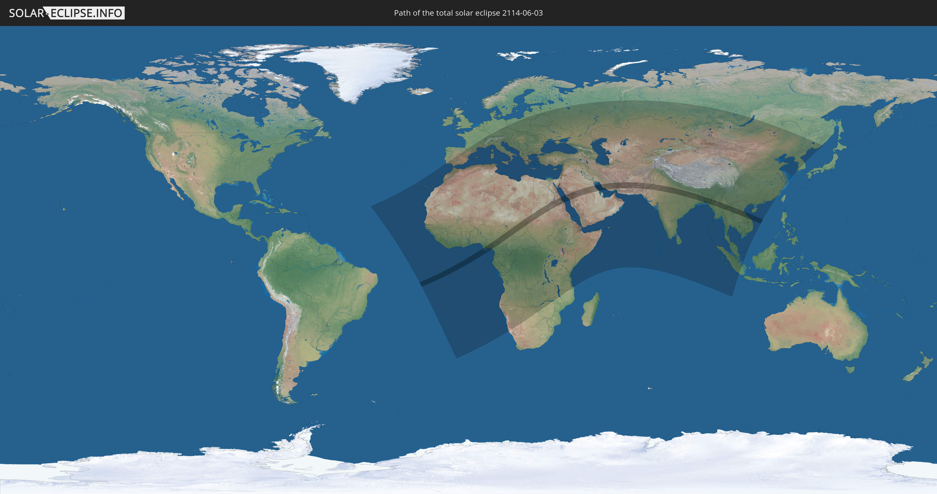
Die Sonnenfinsternis am 03.06.2114 kann man in 129 Ländern als partielle Sonnenfinsternis beobachten.
Der Finsternispfad verläuft durch 17 Länder. Nur in diesen Ländern ist sie als totale Sonnenfinsternis zu sehen.
In den folgenden Ländern ist die Sonnenfinsternis total zu sehen
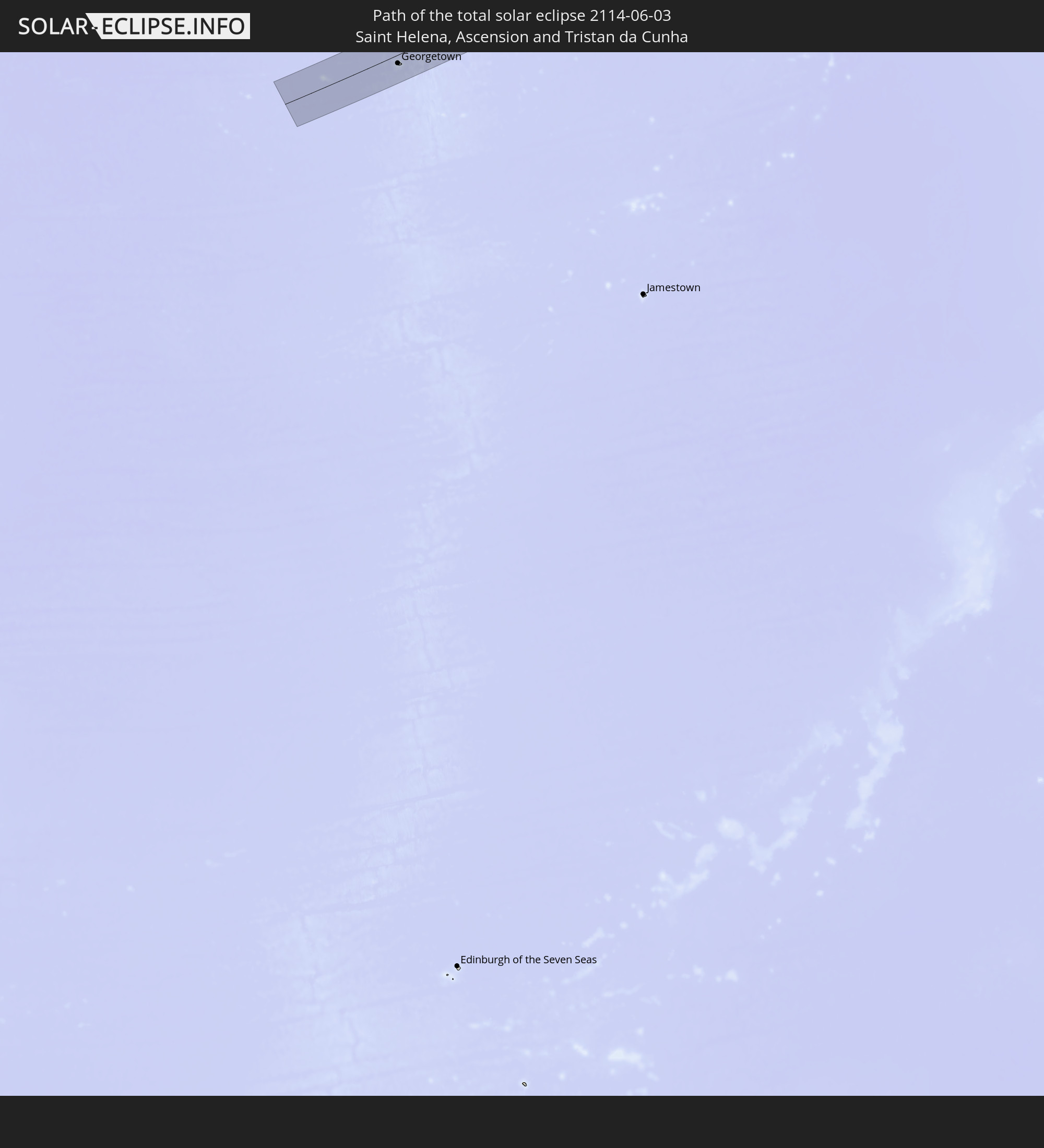 St. Helena
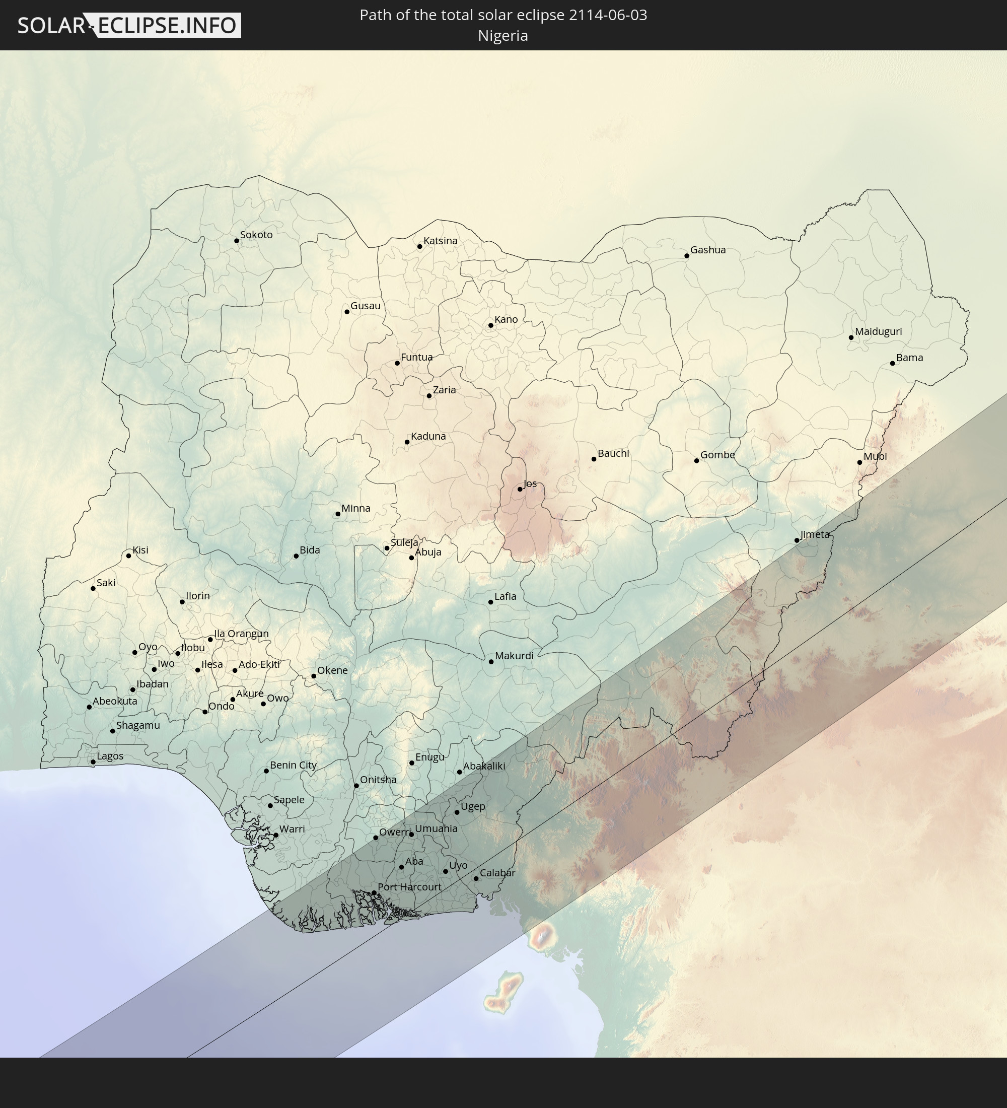 Nigeria
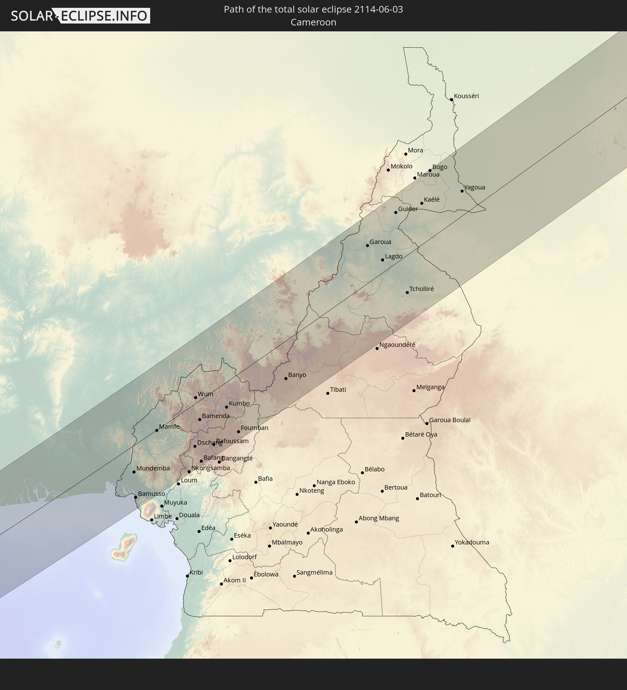 Kamerun
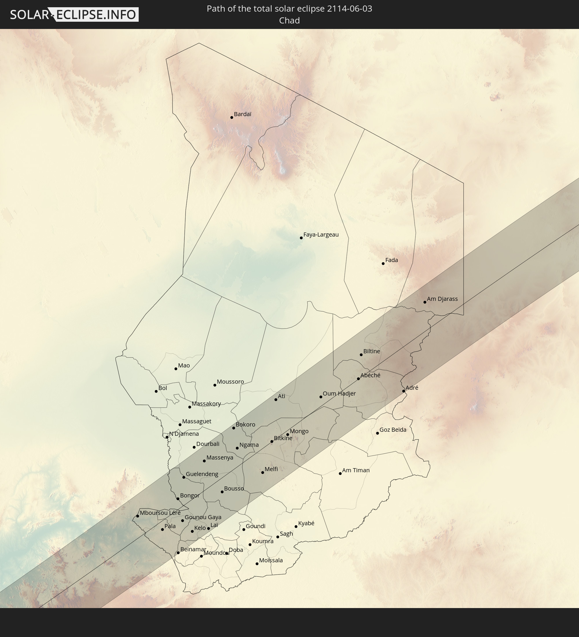 Tschad
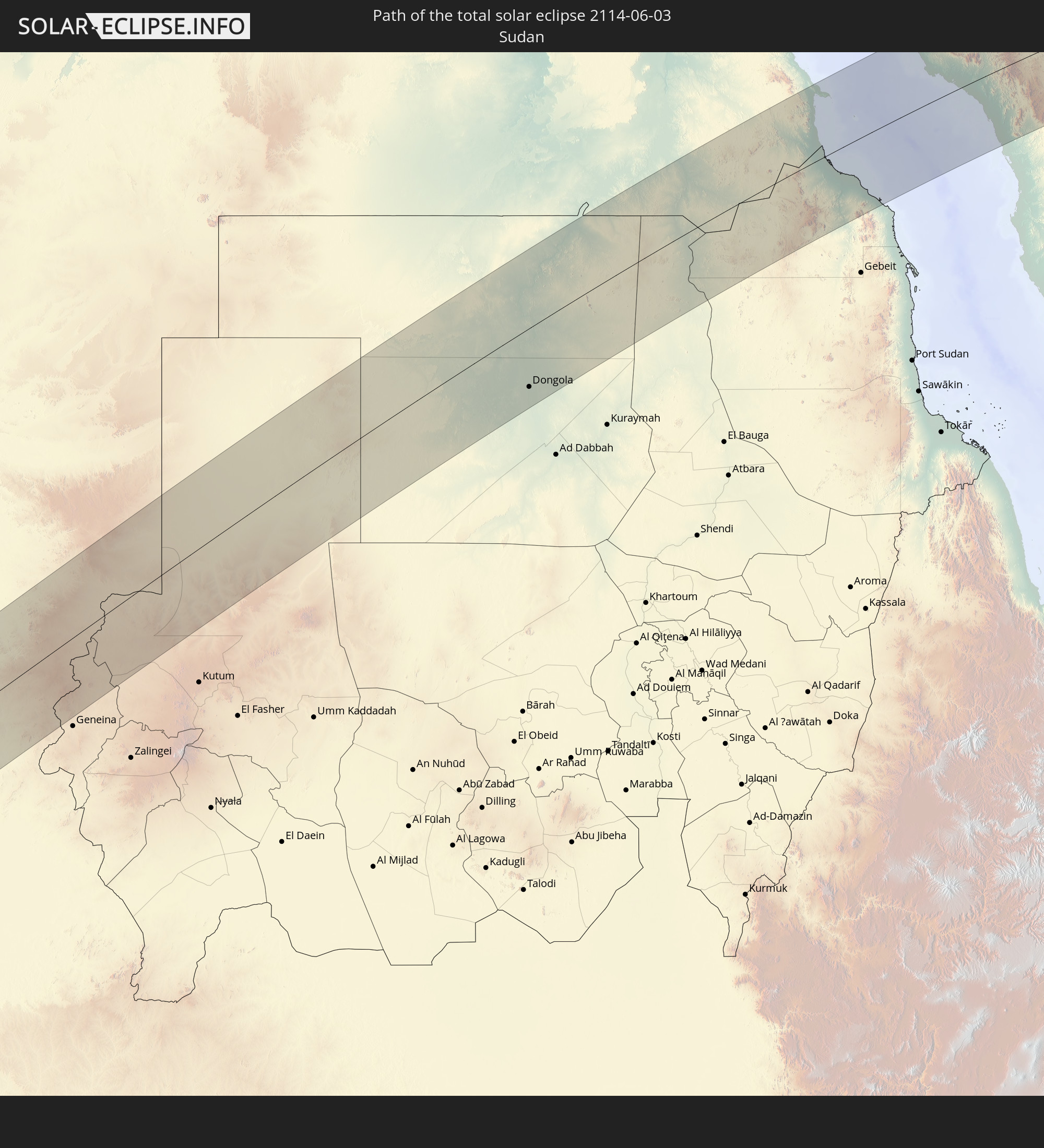 Sudan
Sudan
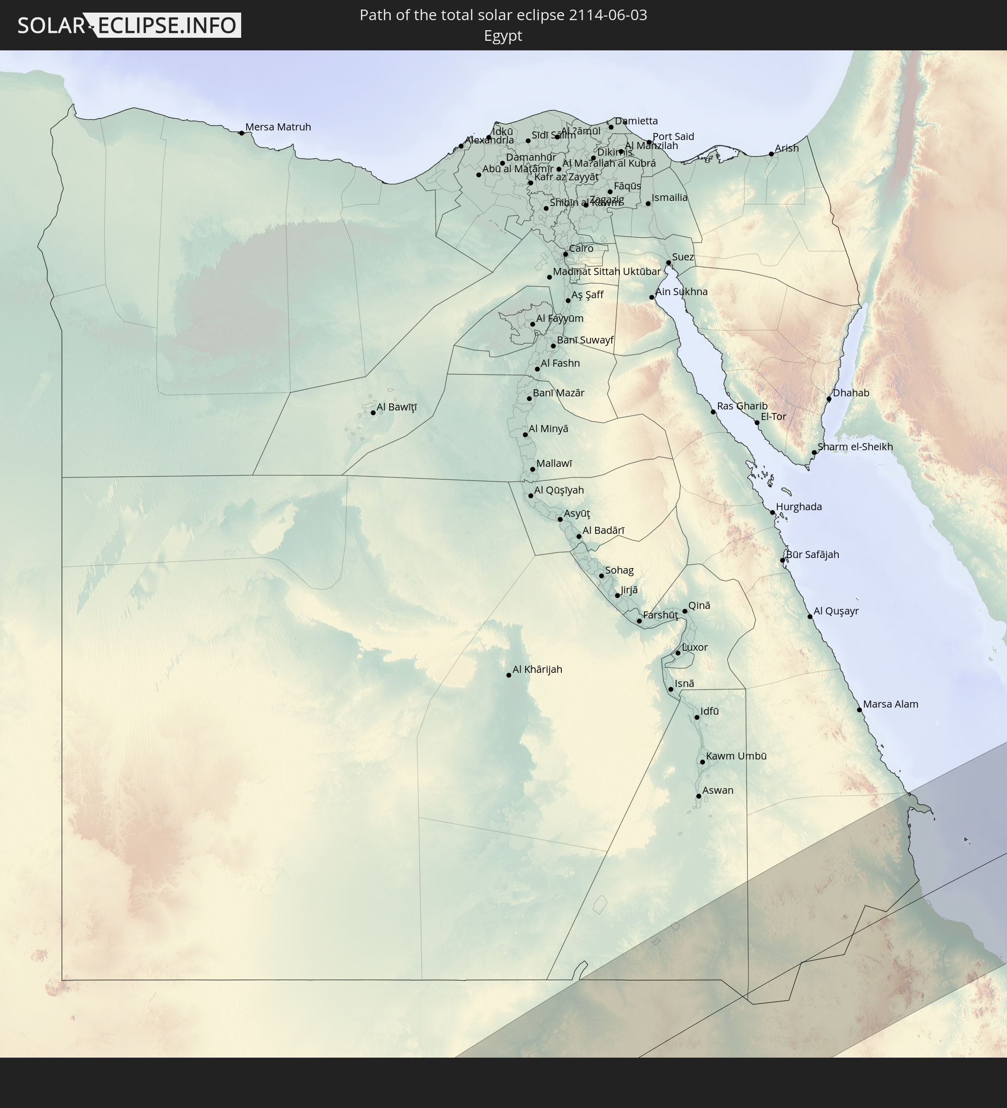 Ägypten
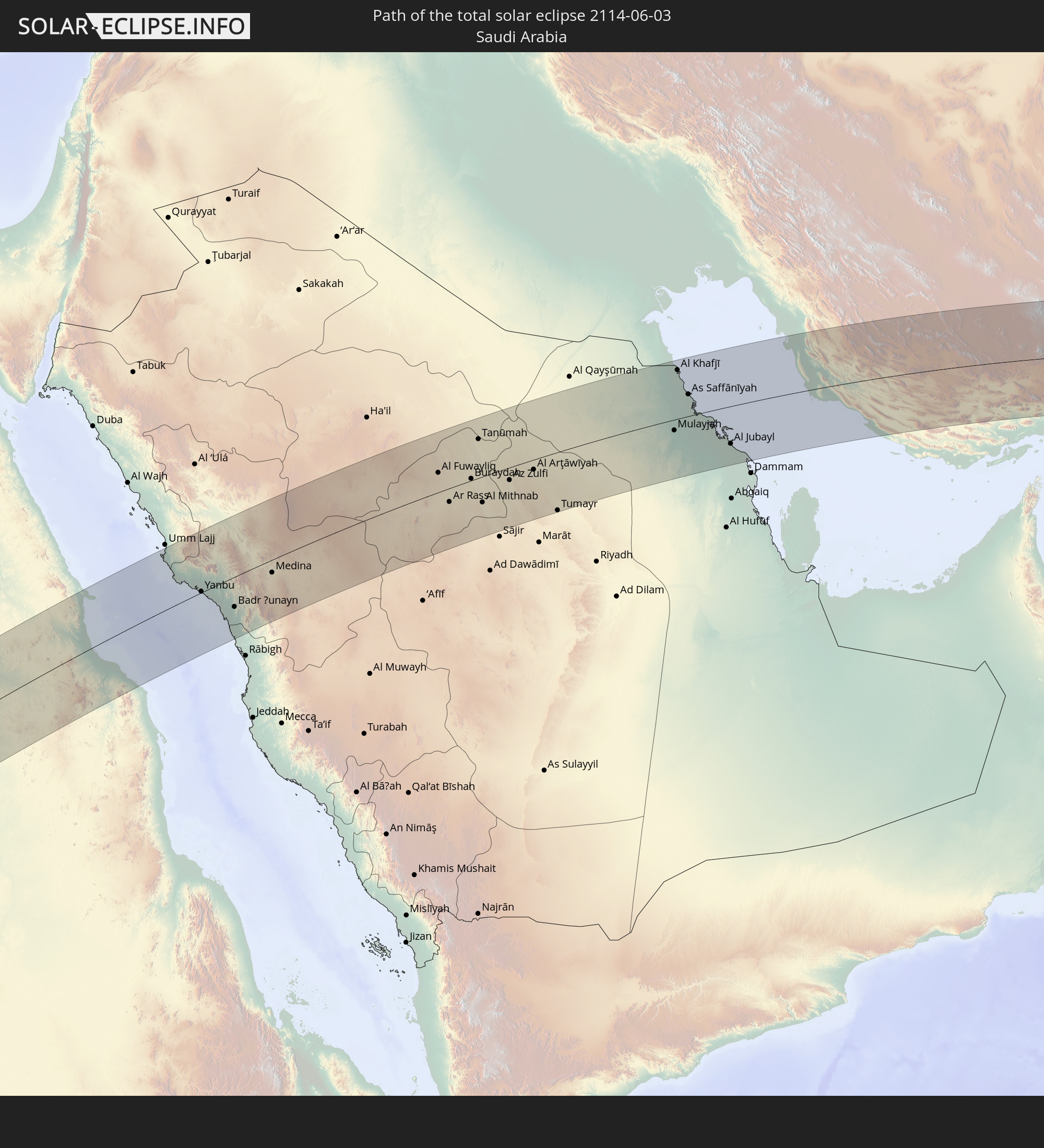 Saudi-Arabien
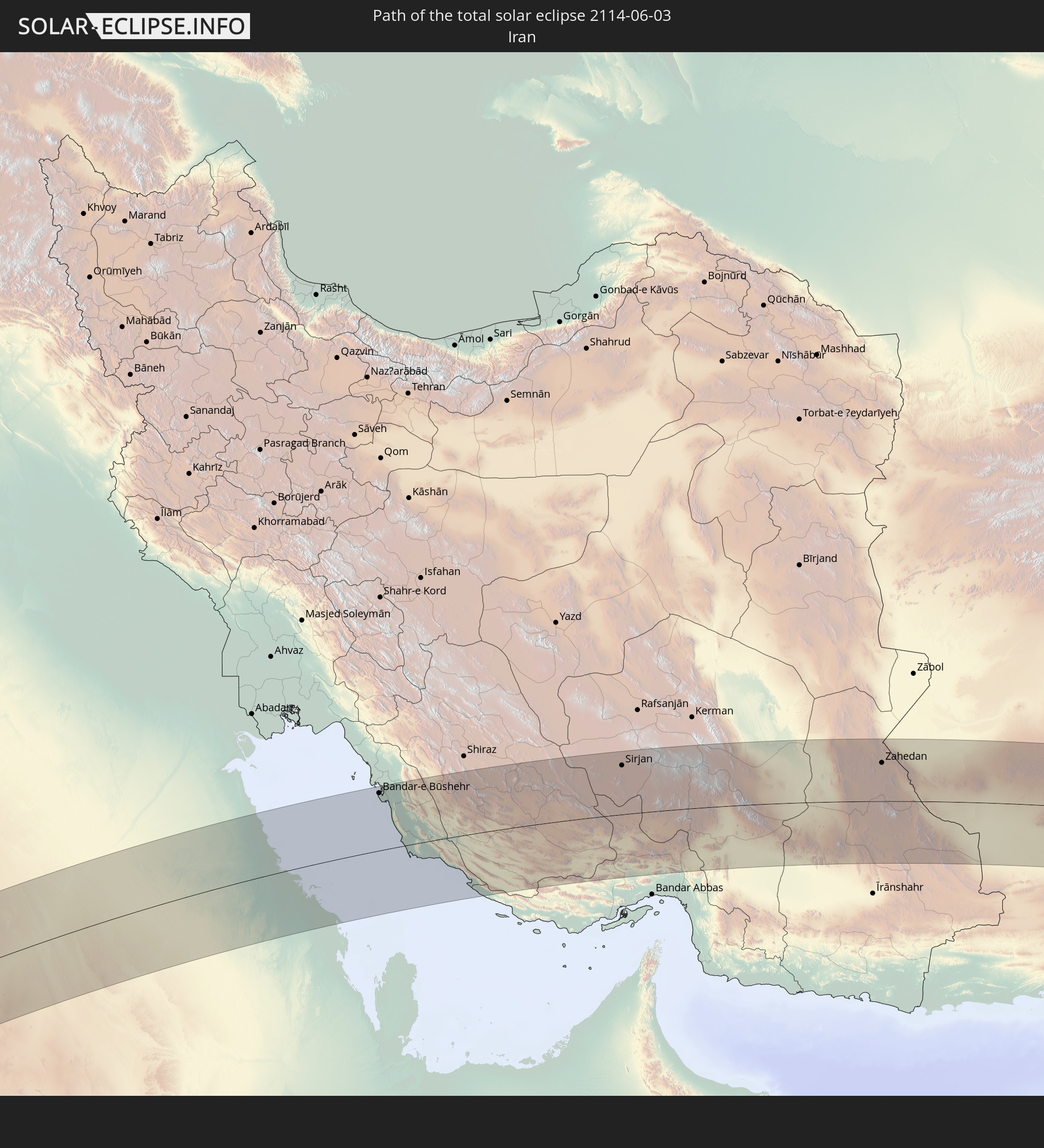 Iran
Iran
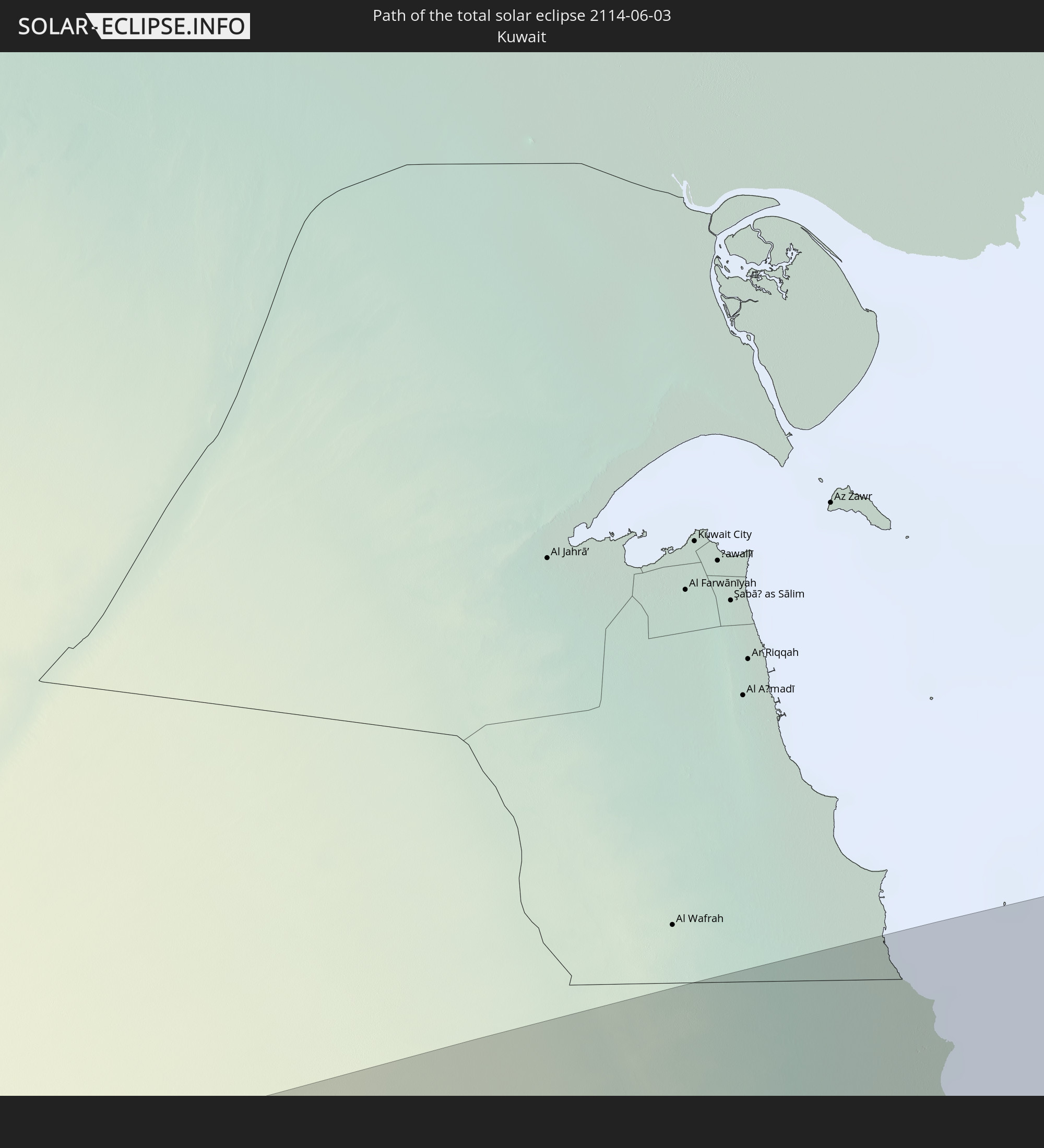 Kuwait
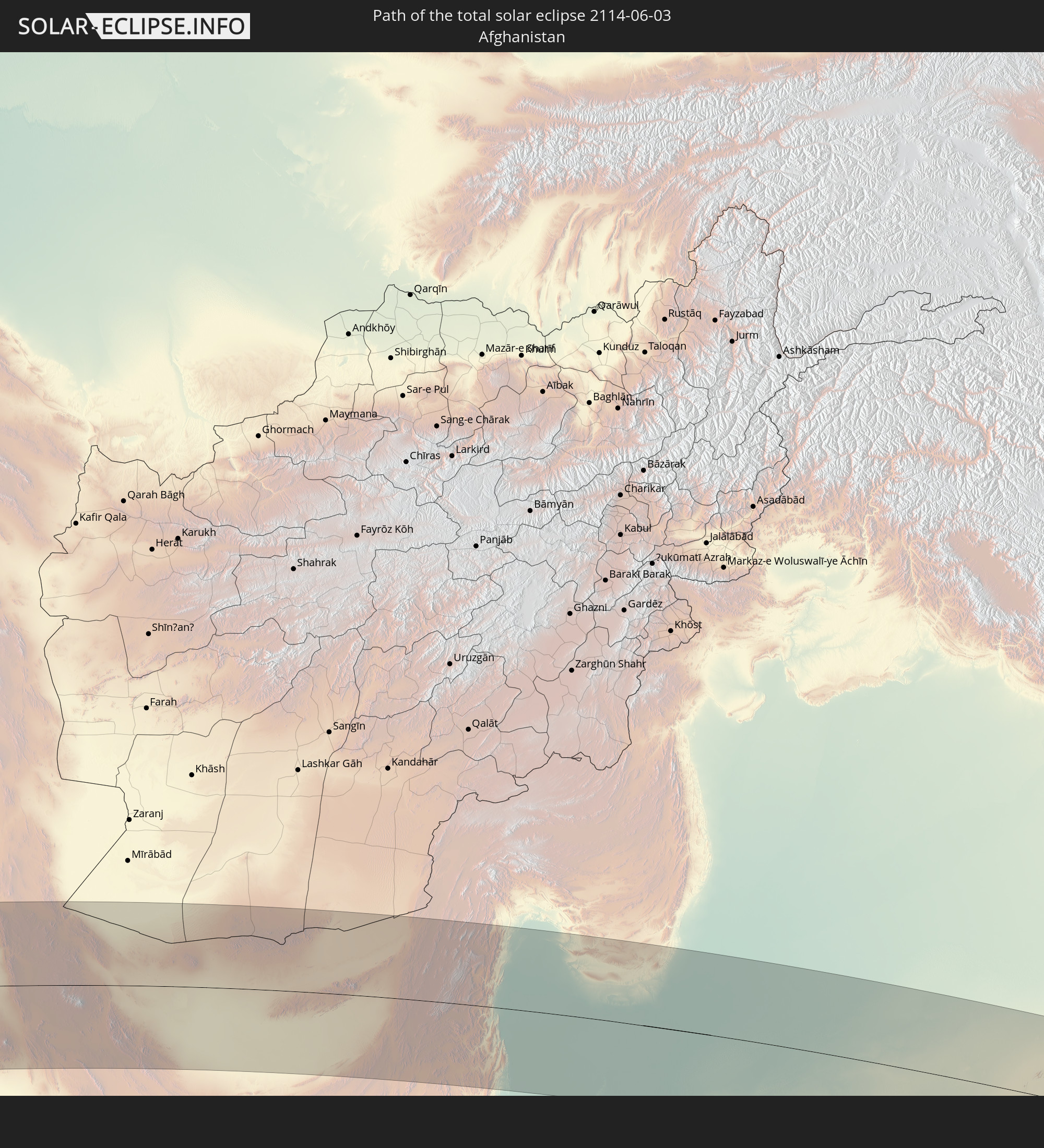 Afghanistan
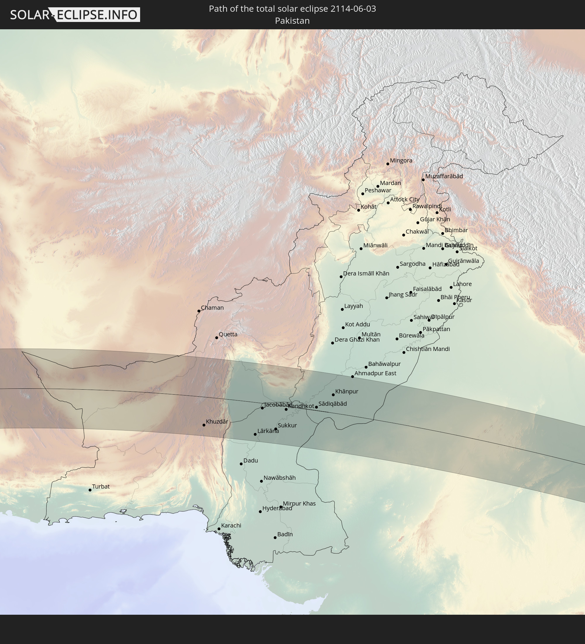 Pakistan
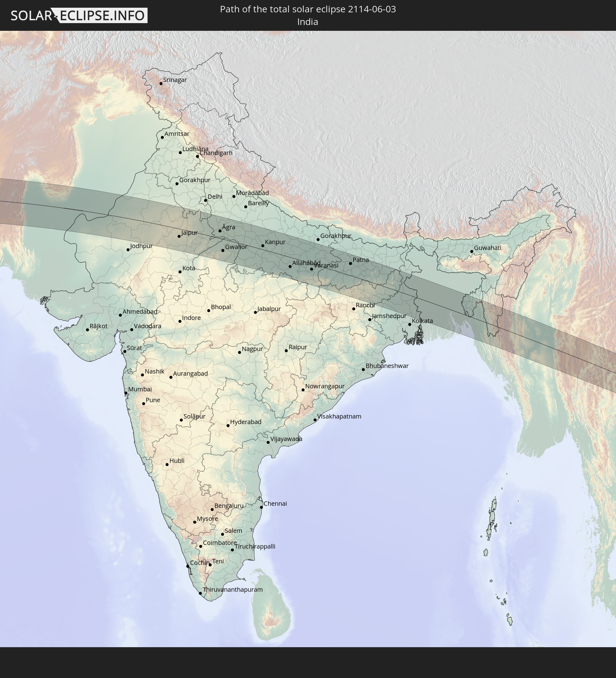 Indien
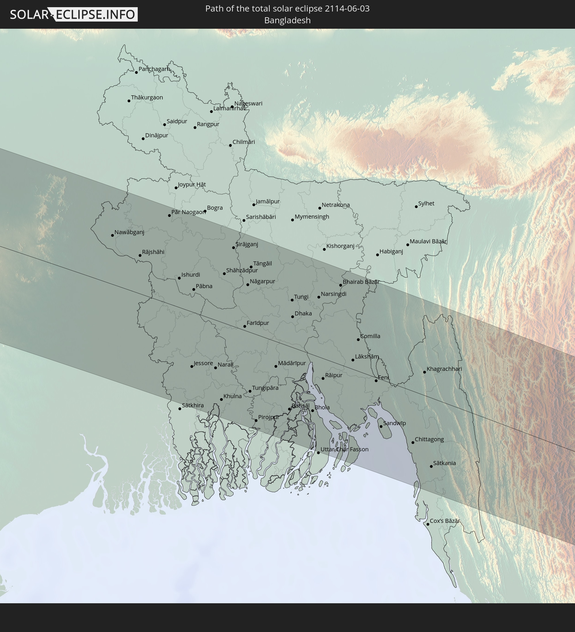 Bangladesch
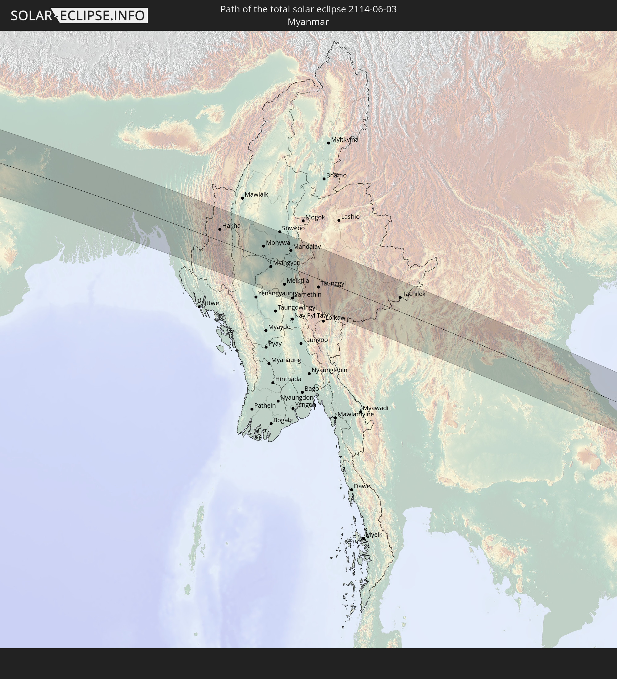 Myanmar
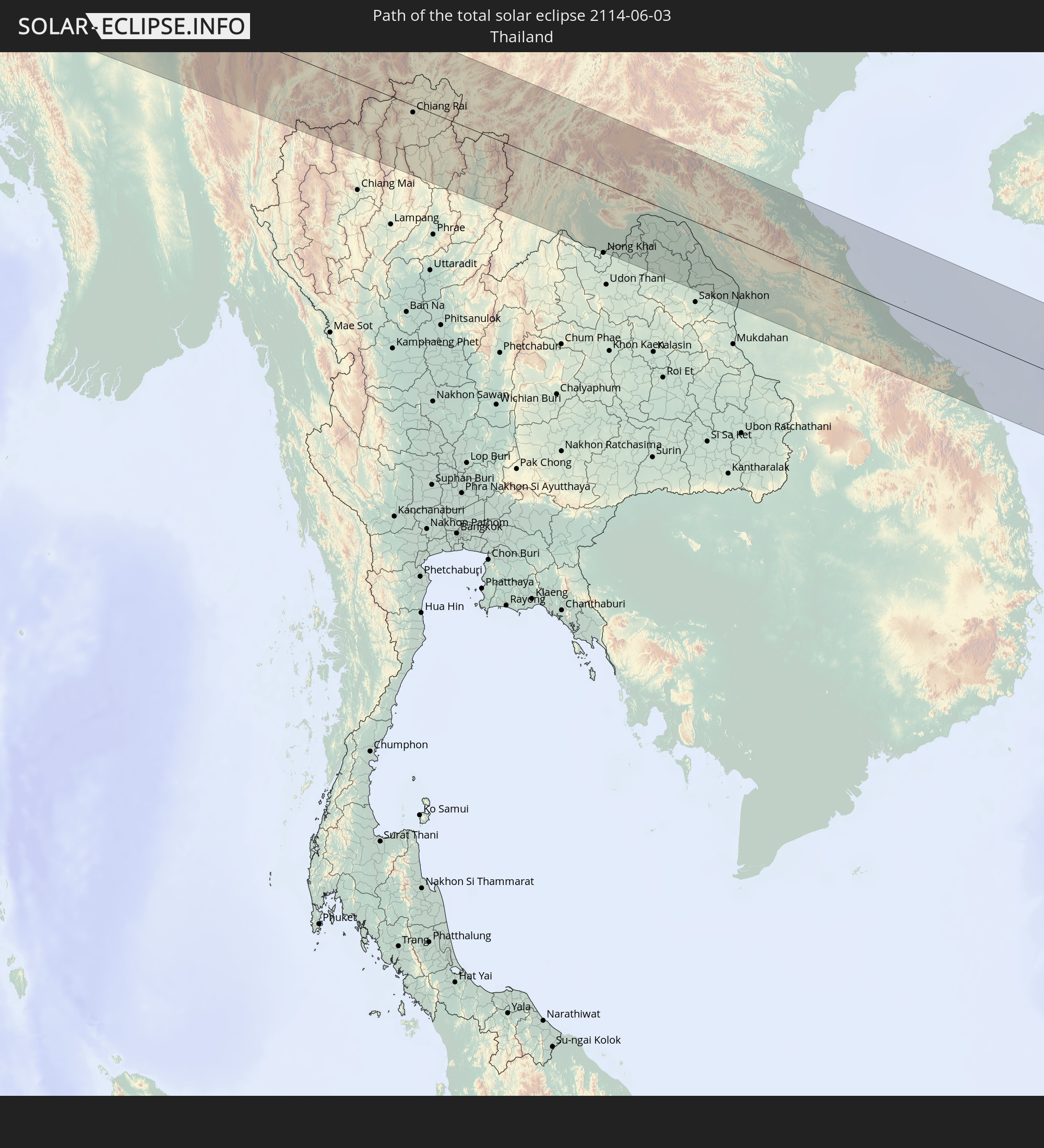 Thailand
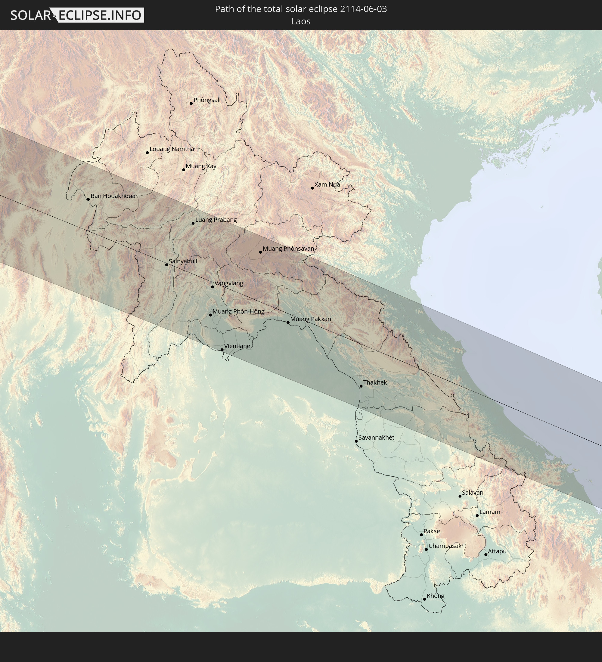 Laos
Laos
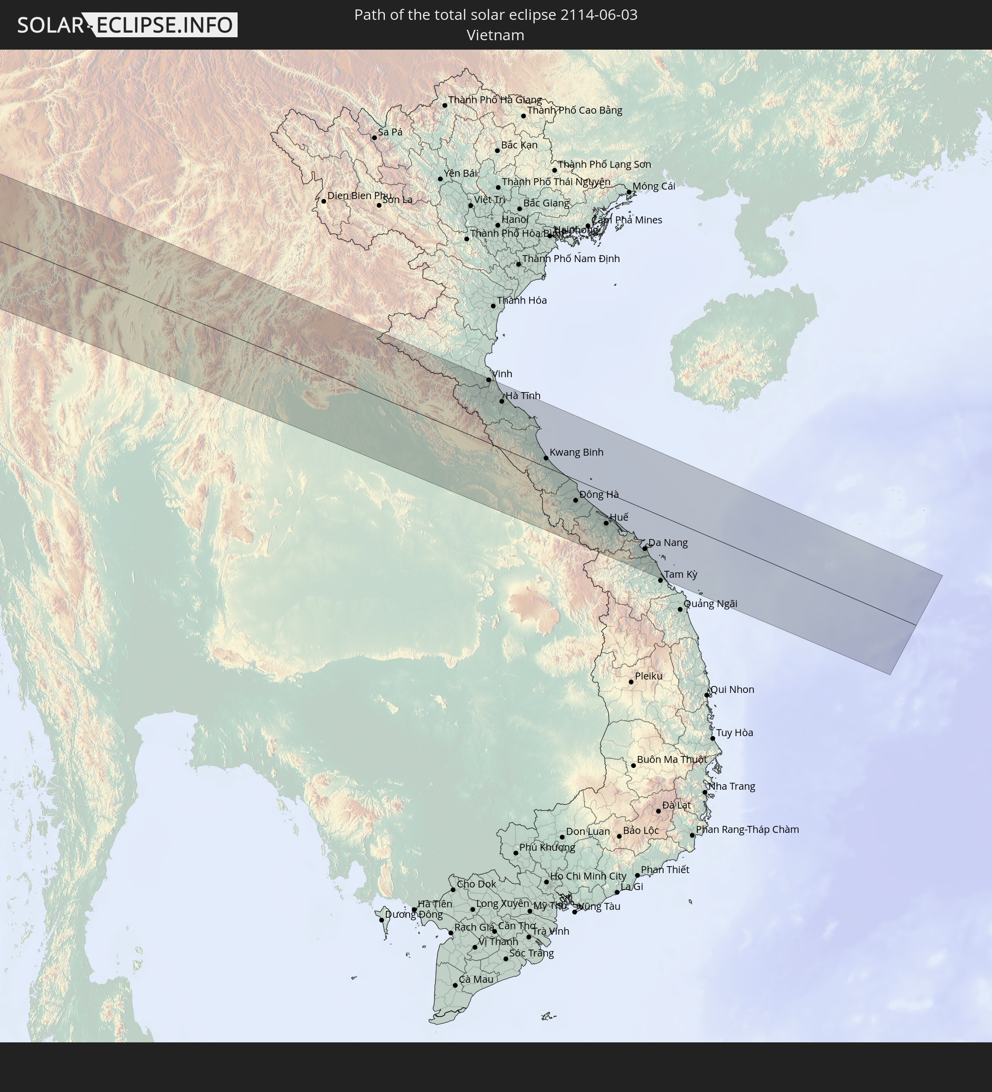 Vietnam
In den folgenden Ländern ist die Sonnenfinsternis partiell zu sehen
 Russland
 Portugal
 Kap Verde
 Spanien
 Senegal
 Mauretanien
 Gambia
 Guinea-Bissau
 Guinea
 St. Helena
 Sierra Leone
 Marokko
 Mali
Mali
 Liberia
 Algerien
 Elfenbeinküste
 Burkina Faso
 Gibraltar
 Frankreich
 Ghana
Ghana
 Togo
Togo
 Niger
Niger
 Benin
Benin
 Andorra
 Nigeria
 Äquatorialguinea
 Deutschland
 Schweiz
 São Tomé und Príncipe
 Italien
 Monaco
 Tunesien
 Kamerun
 Gabun
Gabun
 Libyen
 Liechtenstein
 Österreich
 Republik Kongo
 Angola
 Namibia
 Tschechien
 Demokratische Republik Kongo
 San Marino
 Vatikanstadt
 Slowenien
 Tschad
 Kroatien
 Polen
Polen
 Malta
Malta
 Zentralafrikanische Republik
 Bosnien und Herzegowina
 Ungarn
 Slowakei
 Montenegro
 Serbien
 Albanien
 Griechenland
 Botswana
 Rumänien
 Mazedonien
 Litauen
 Lettland
 Sudan
Sudan
 Sambia
 Ukraine
 Bulgarien
 Weißrussland
 Ägypten
 Simbabwe
 Türkei
 Moldawien
 Ruanda
 Burundi
 Tansania
 Uganda
 Mosambik
 Republik Zypern
 Malawi
 Äthiopien
 Kenia
Kenia
 Staat Palästina
 Israel
 Saudi-Arabien
 Jordanien
 Libanon
 Syrien
 Eritrea
 Irak
Irak
 Georgien
 Somalia
 Dschibuti
 Jemen
Jemen
 Armenien
 Iran
Iran
 Aserbaidschan
 Kasachstan
 Kuwait
 Bahrain
 Katar
Katar
 Vereinigte Arabische Emirate
 Oman
Oman
 Turkmenistan
 Usbekistan
 Afghanistan
 Pakistan
 Tadschikistan
 Indien
 Kirgisistan
 Malediven
 Volksrepublik China
 Sri Lanka
 Nepal
Nepal
 Mongolei
 Bangladesch
 Bhutan
 Myanmar
 Indonesien
 Kokosinseln
 Thailand
 Malaysia
 Laos
Laos
 Vietnam
 Kambodscha
 Singapur
 Macau
Macau
 Hongkong
 Taiwan
 Nordkorea
 Südkorea
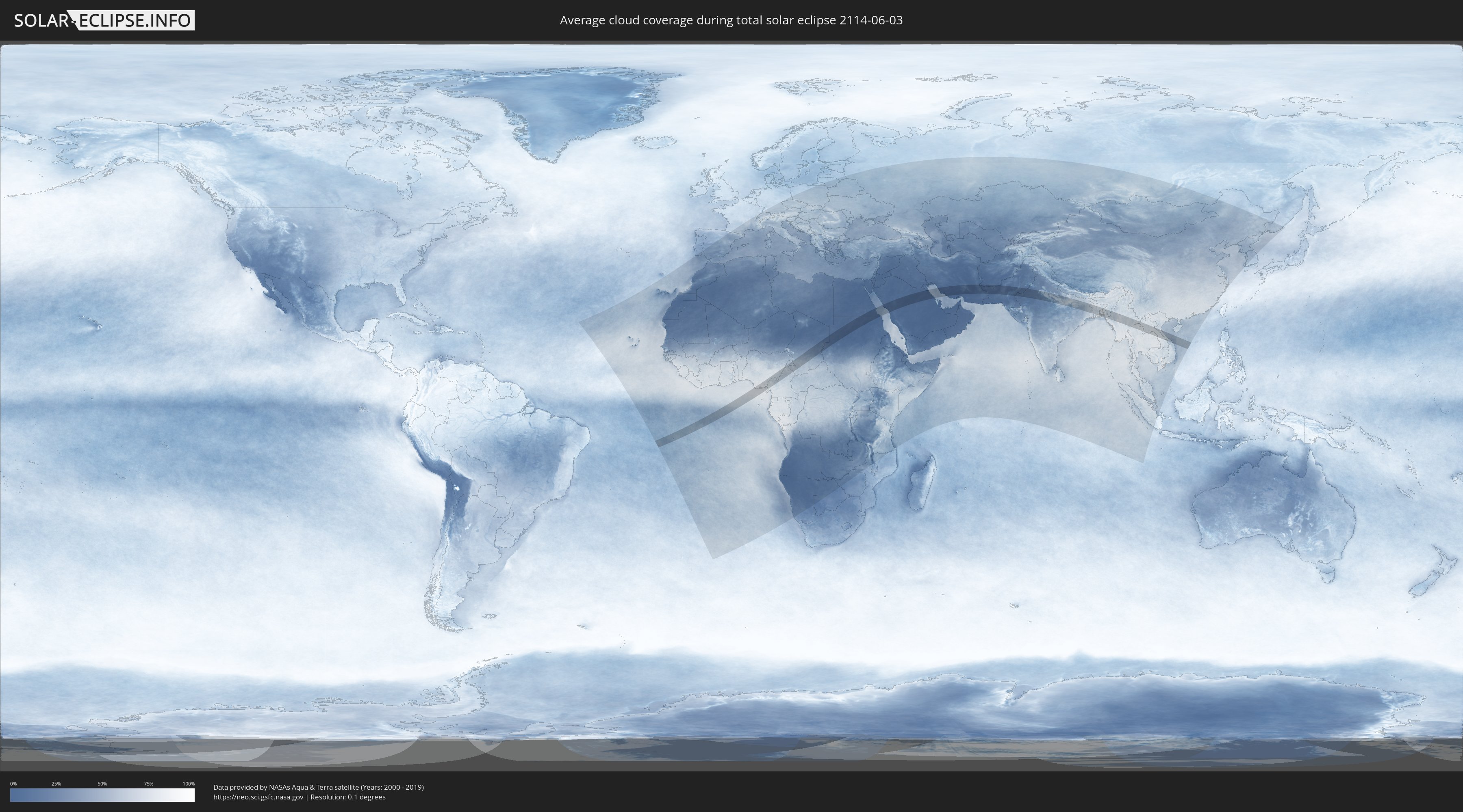
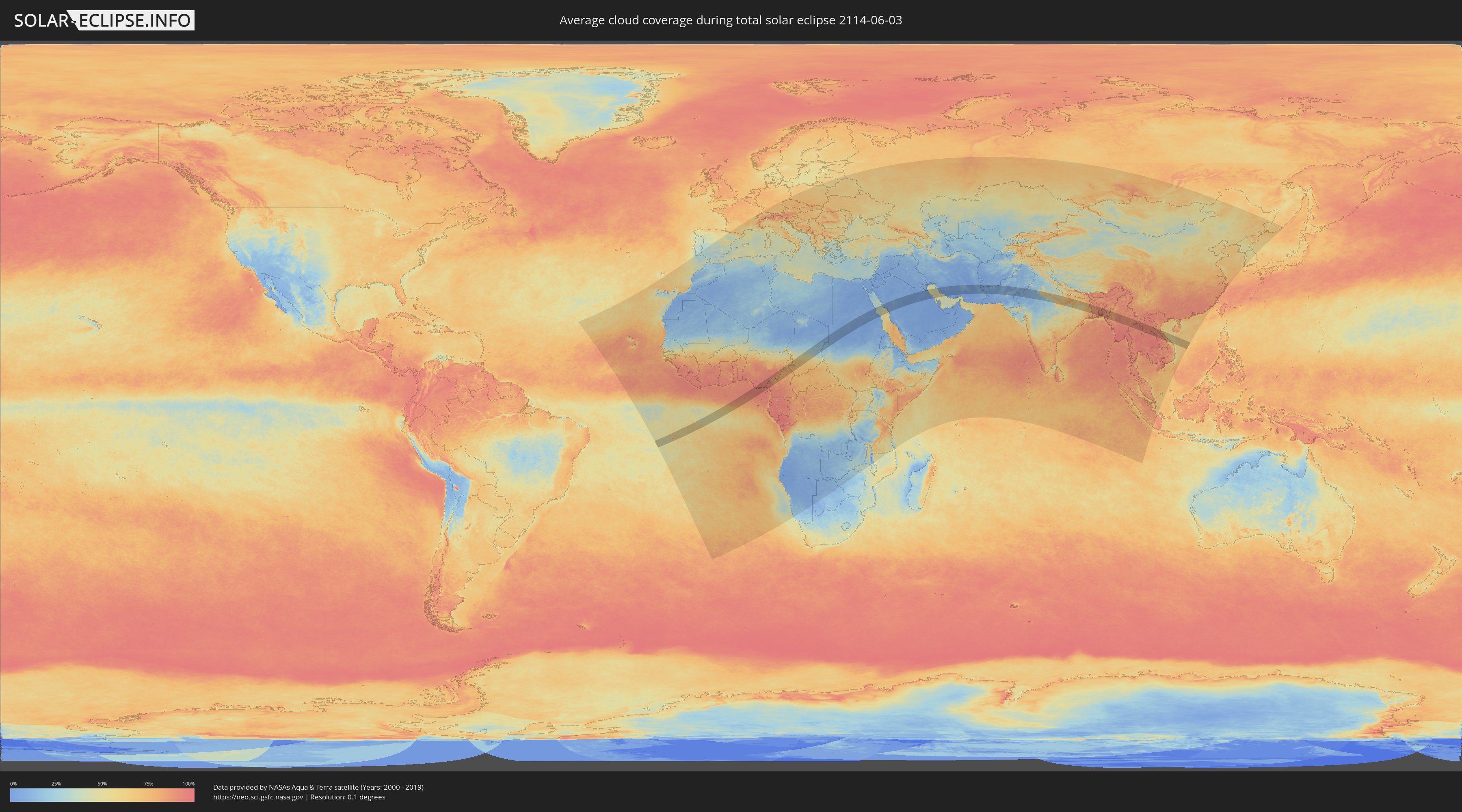
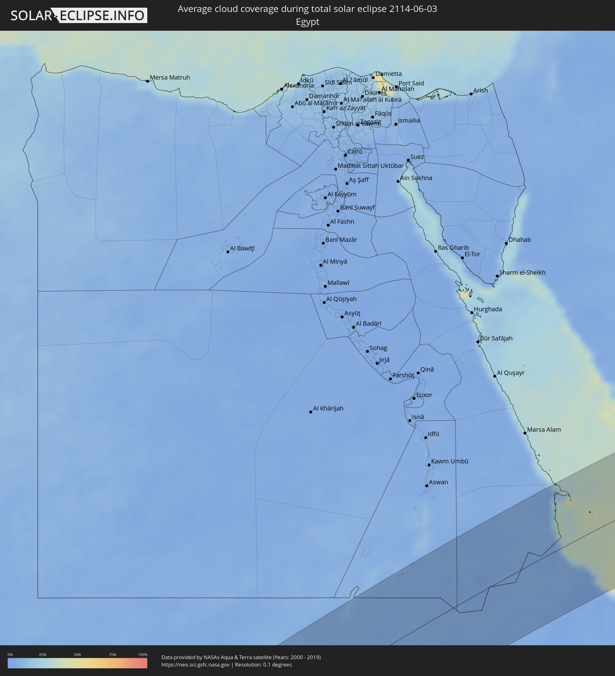
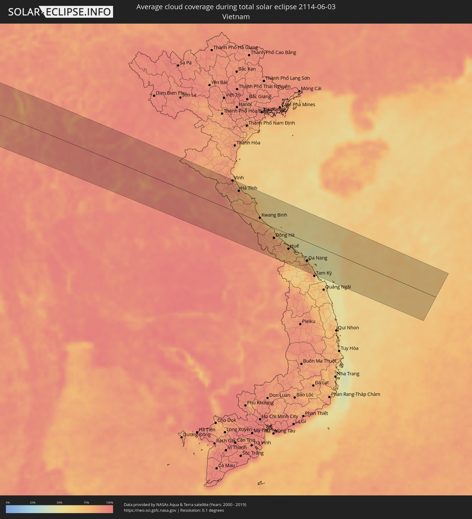
Wie wird das Wetter während der totalen Sonnenfinsternis am 03.06.2114?
Wo ist der beste Ort, um die totale Sonnenfinsternis vom 03.06.2114 zu beobachten?
Die folgenden Karten zeigen die durchschnittliche Bewölkung für den Tag, an dem die totale Sonnenfinsternis
stattfindet. Mit Hilfe der Karten lässt sich der Ort entlang des Finsternispfades eingrenzen,
der die besten Aussichen auf einen klaren wolkenfreien Himmel bietet.
Trotzdem muss man immer lokale Gegenenheiten beachten und sollte sich genau über das Wetter an seinem
gewählten Beobachtungsort informieren.
Die Daten stammen von den beiden NASA-Satelliten
AQUA und TERRA
und wurden über einen Zeitraum von 19 Jahren (2000 - 2019) gemittelt.
Detaillierte Länderkarten
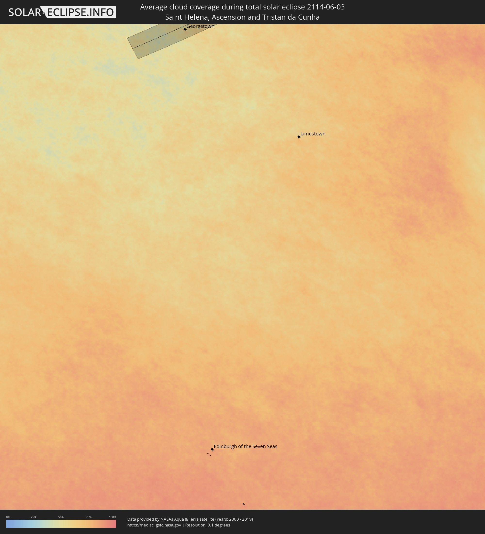 St. Helena
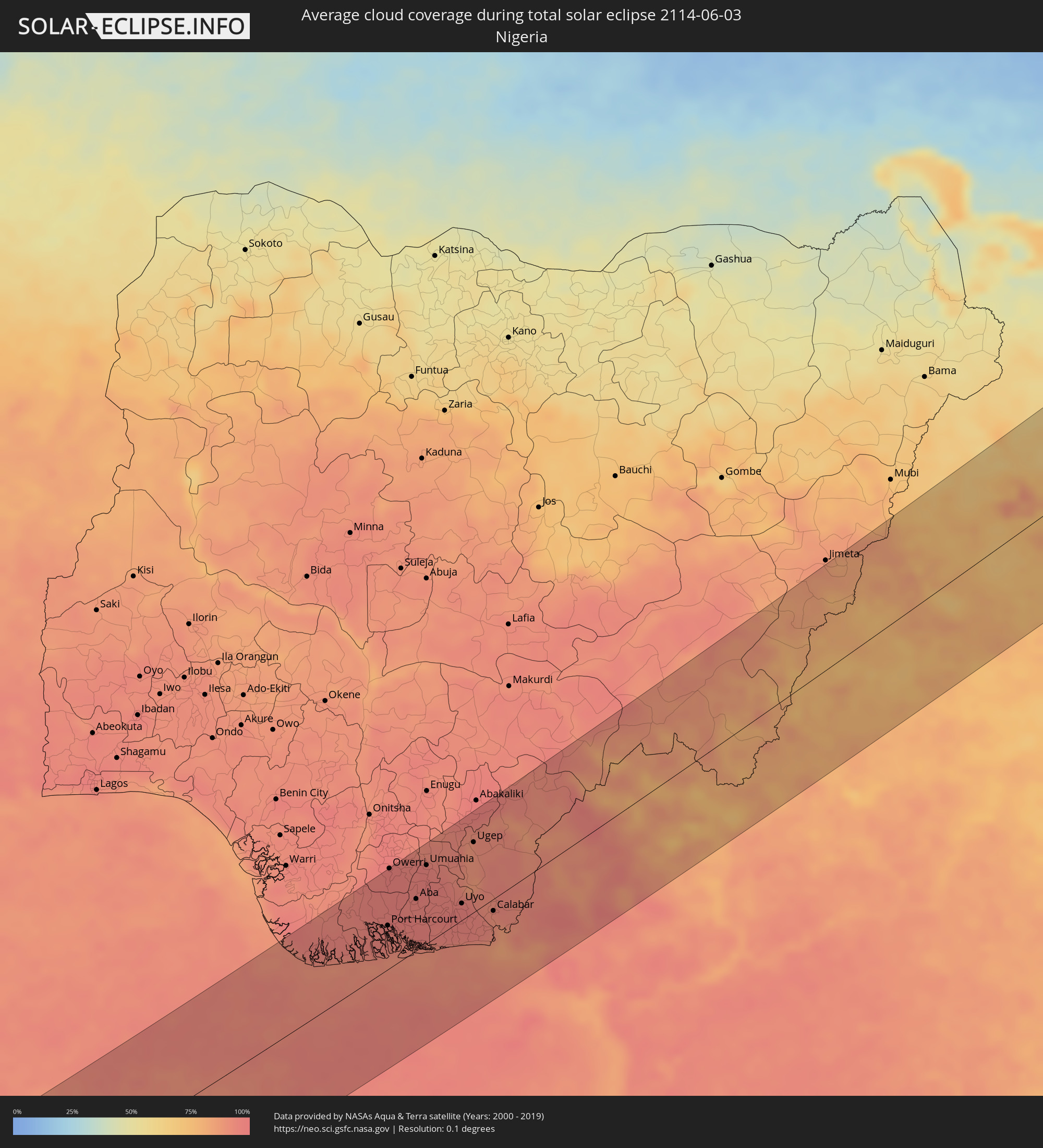 Nigeria
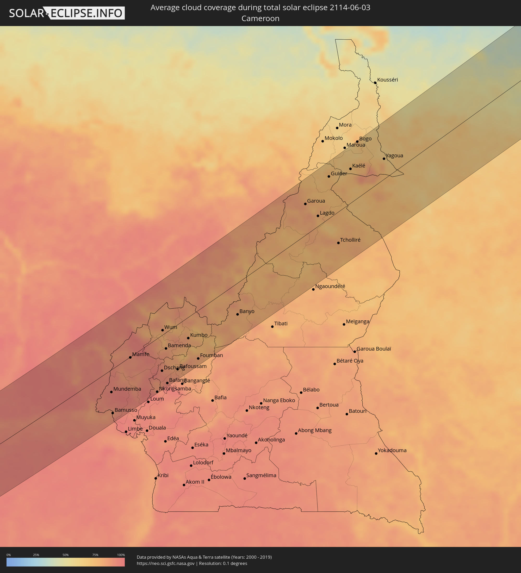 Kamerun
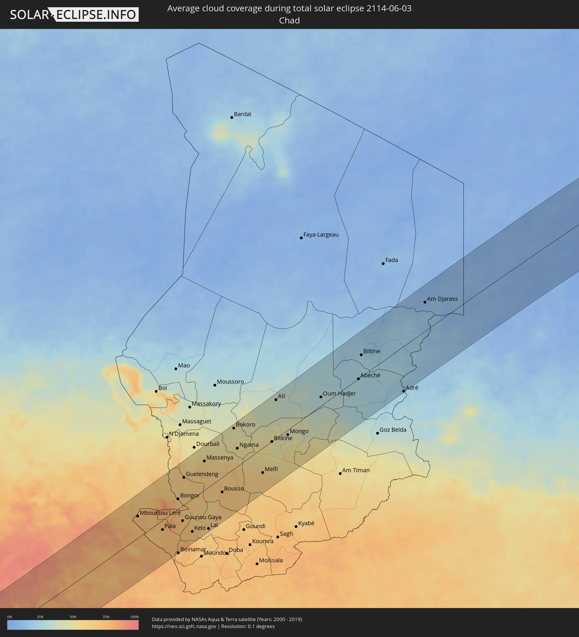 Tschad
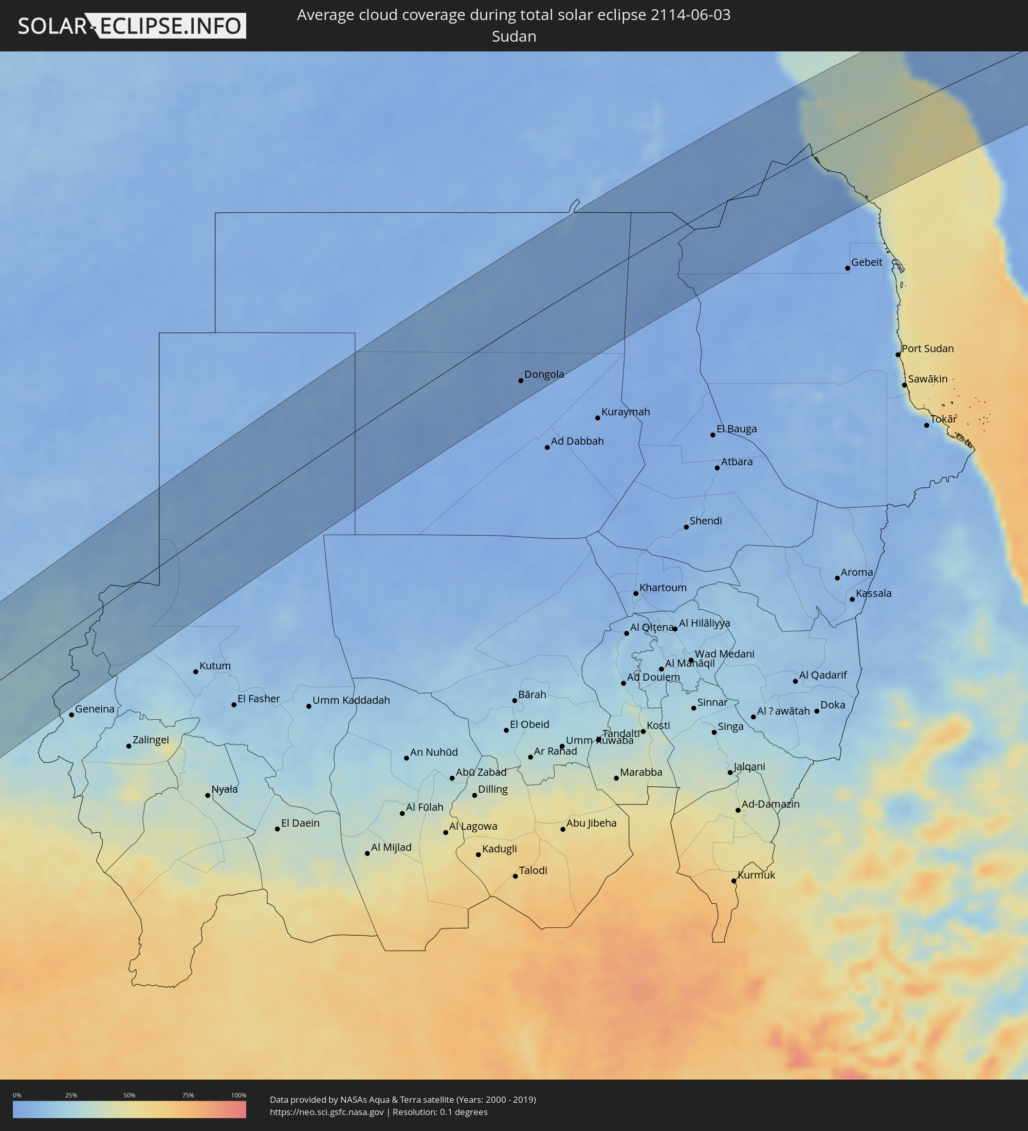 Sudan
Sudan
 Ägypten
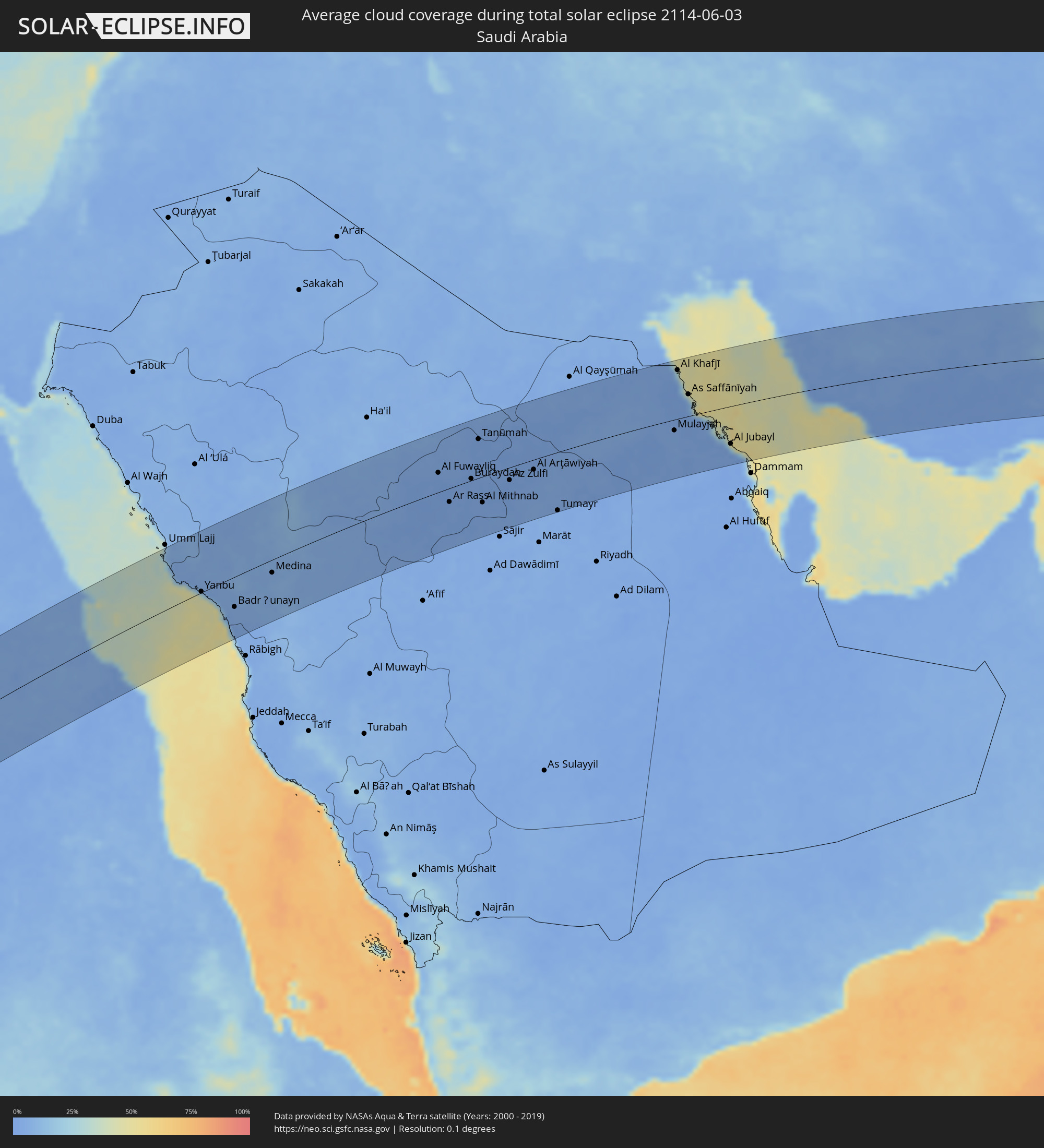 Saudi-Arabien
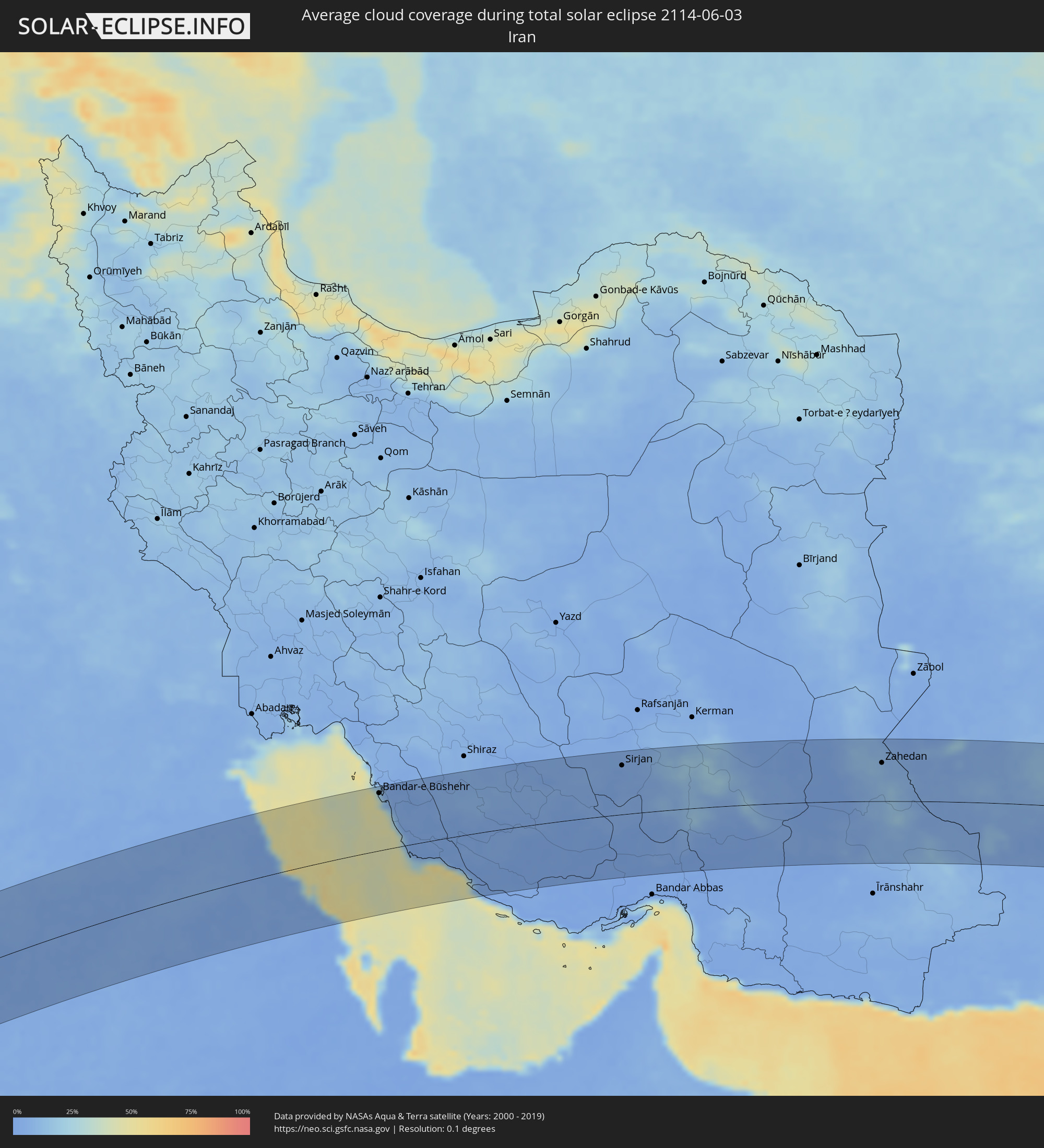 Iran
Iran
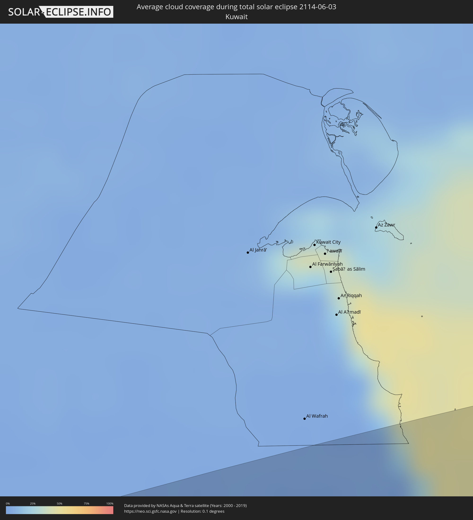 Kuwait
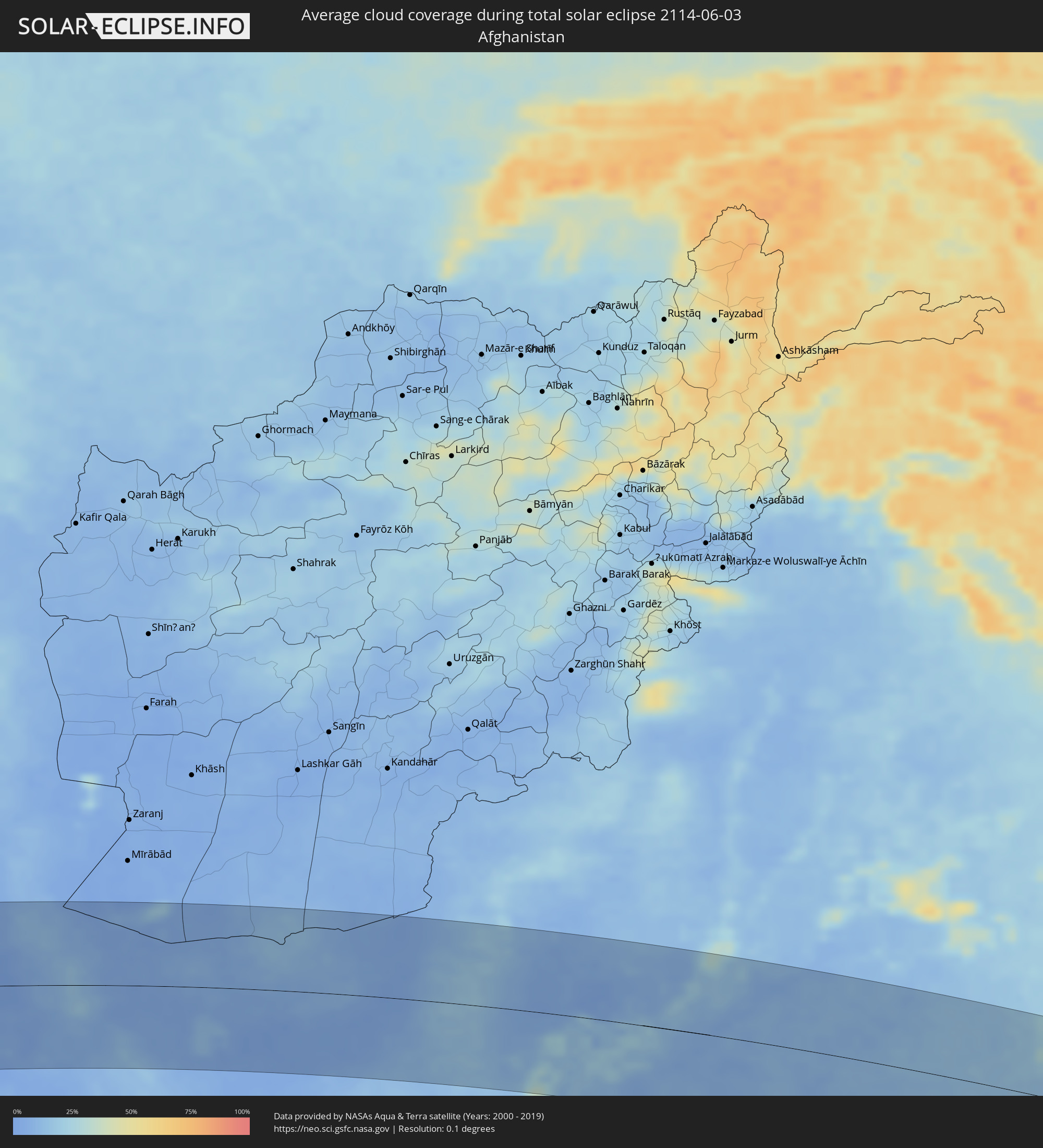 Afghanistan
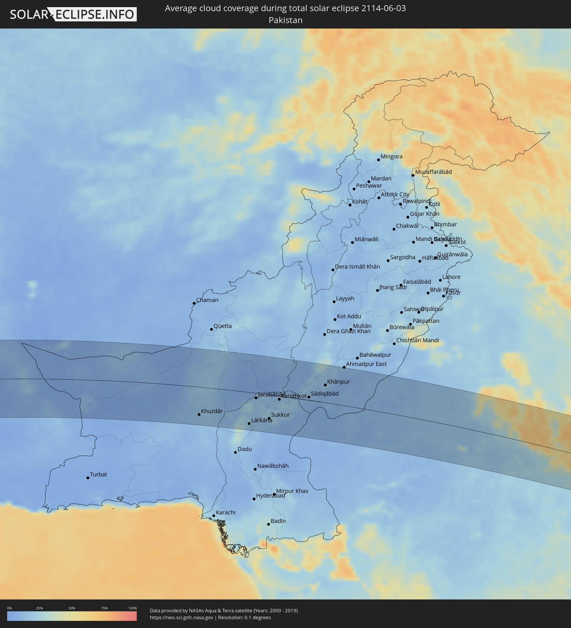 Pakistan
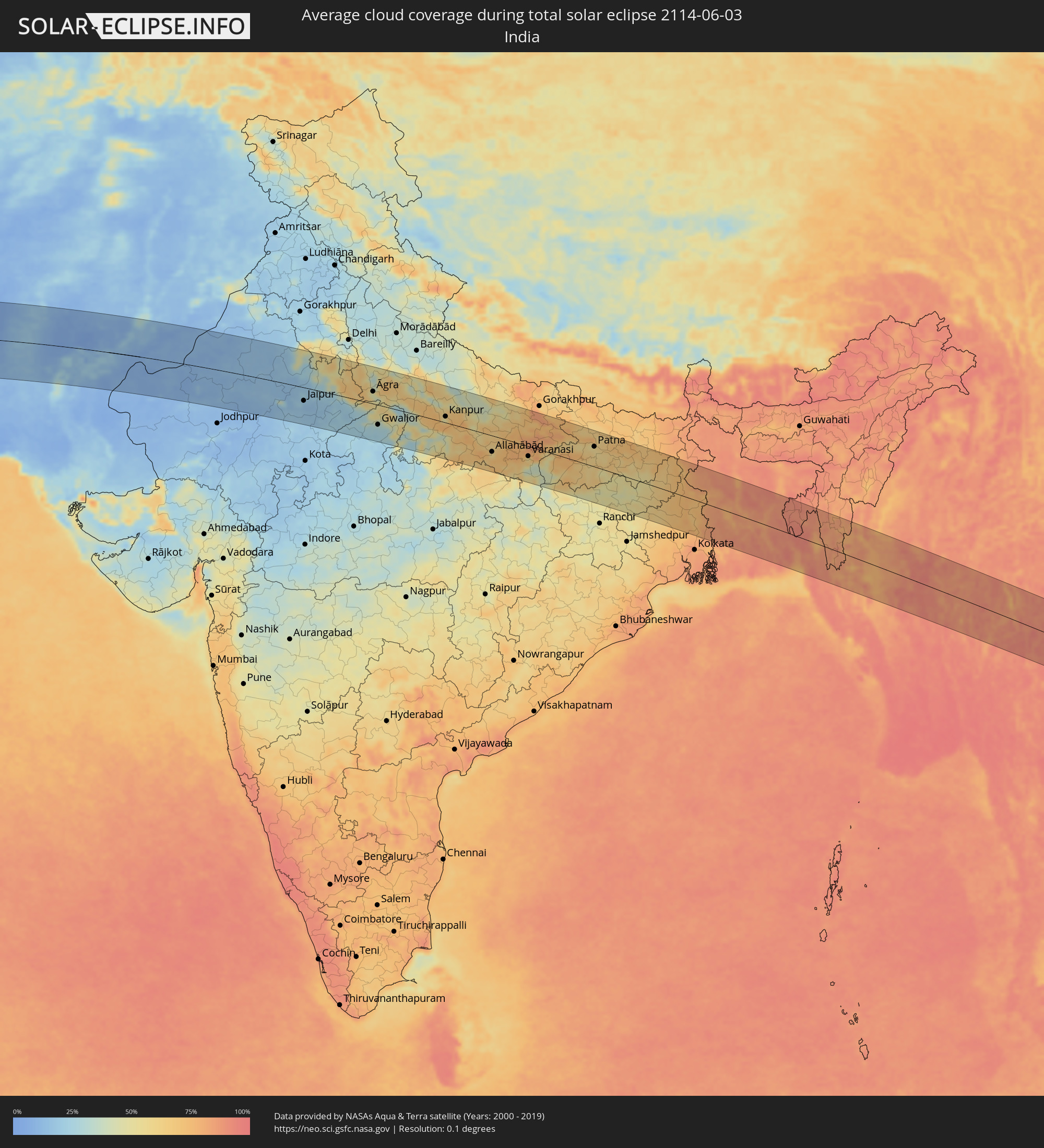 Indien
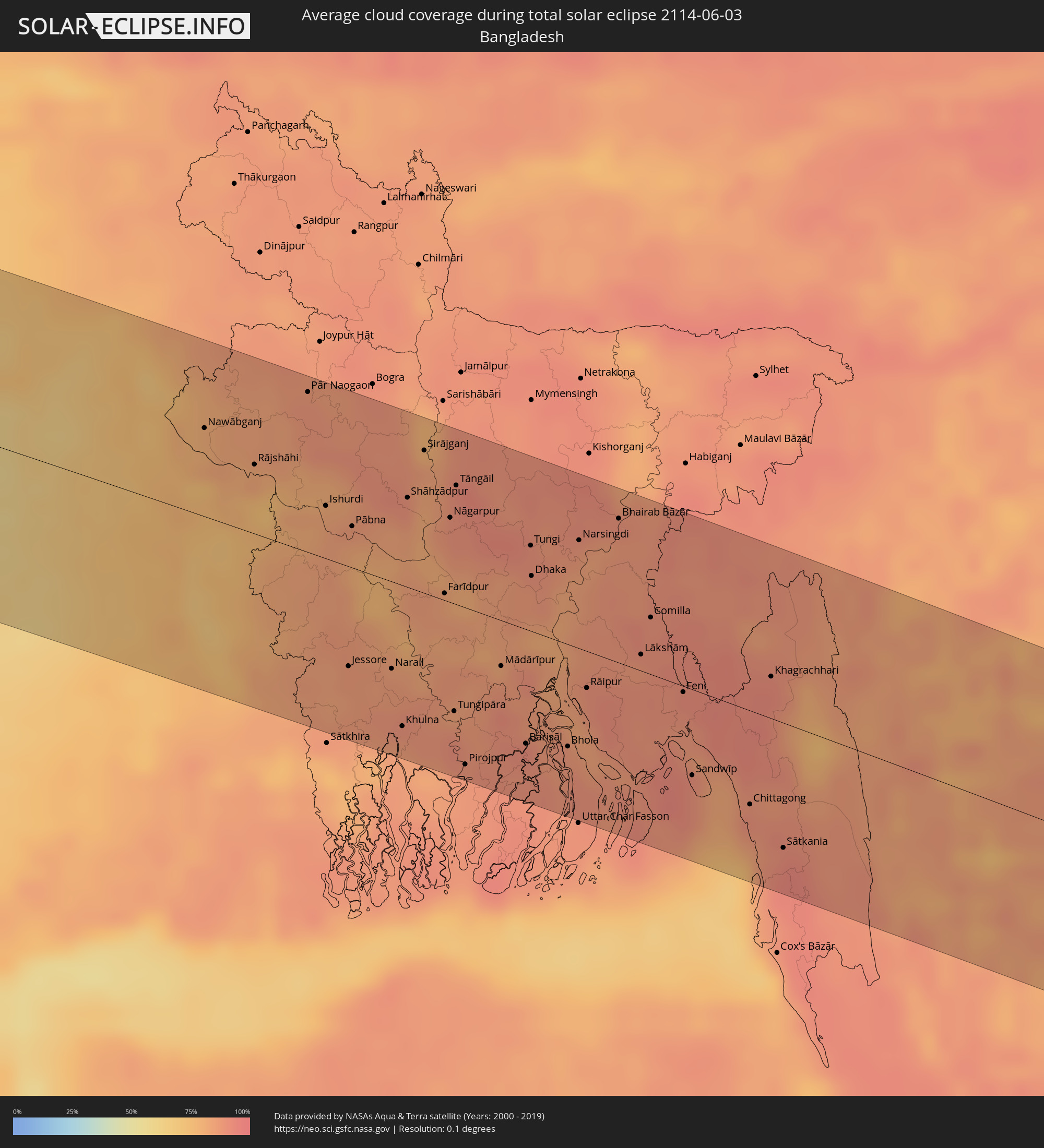 Bangladesch
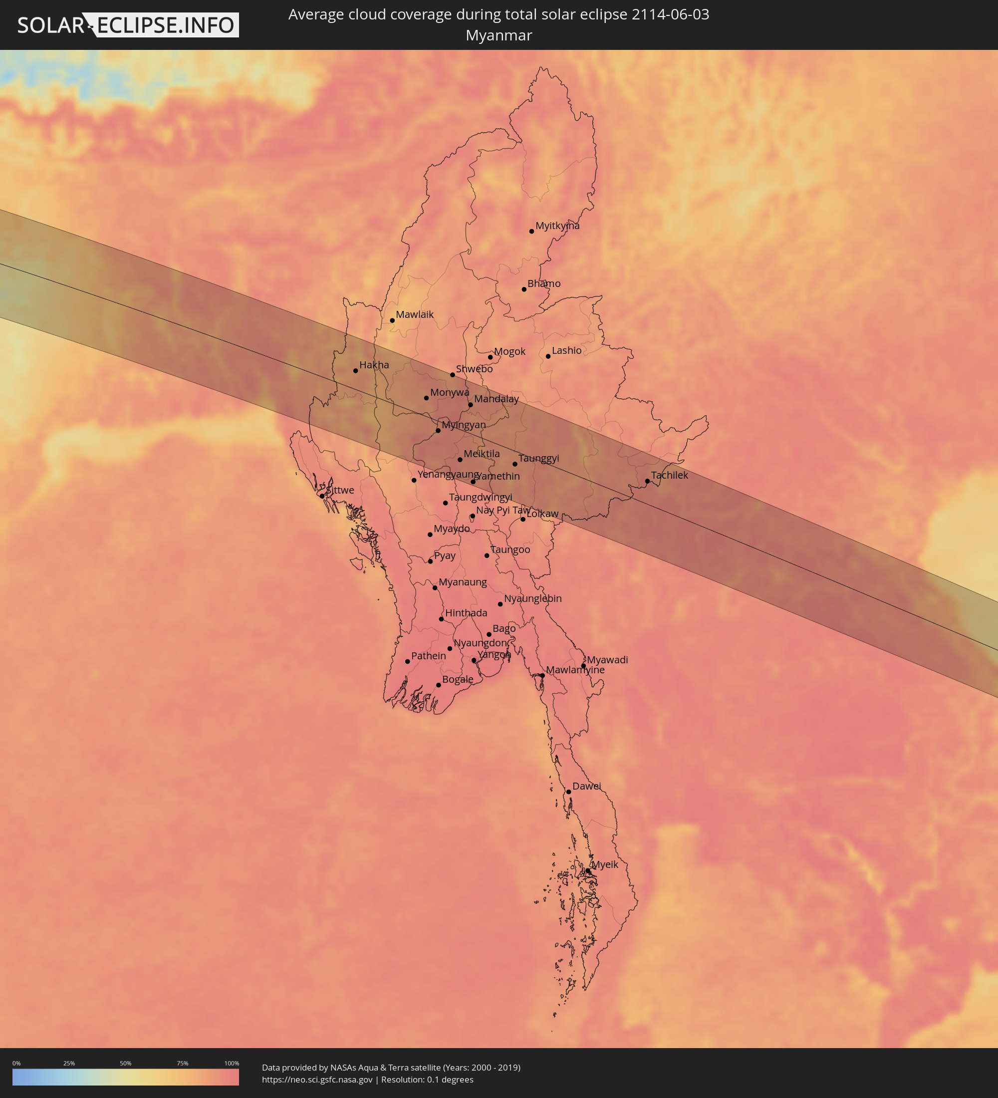 Myanmar
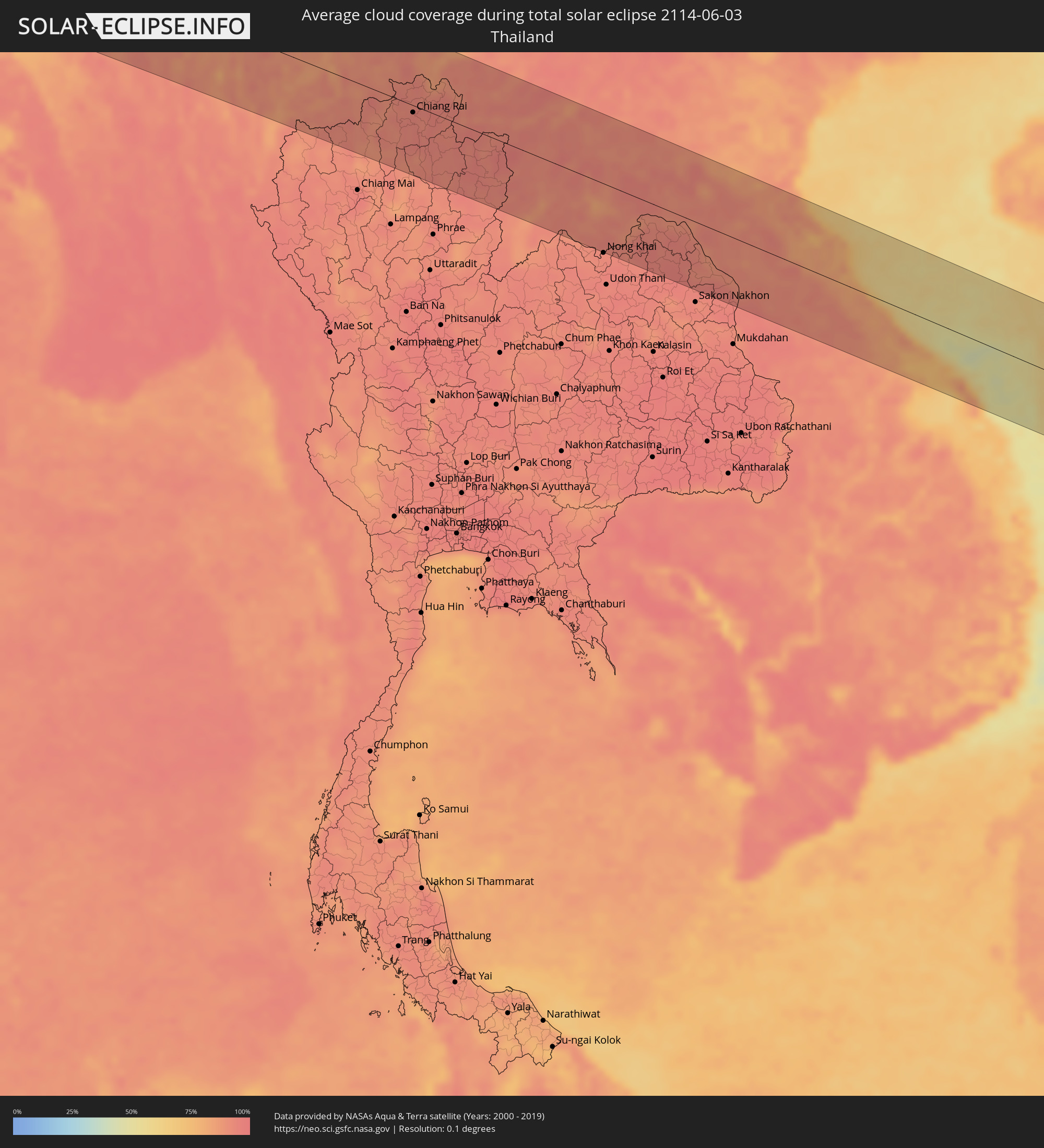 Thailand
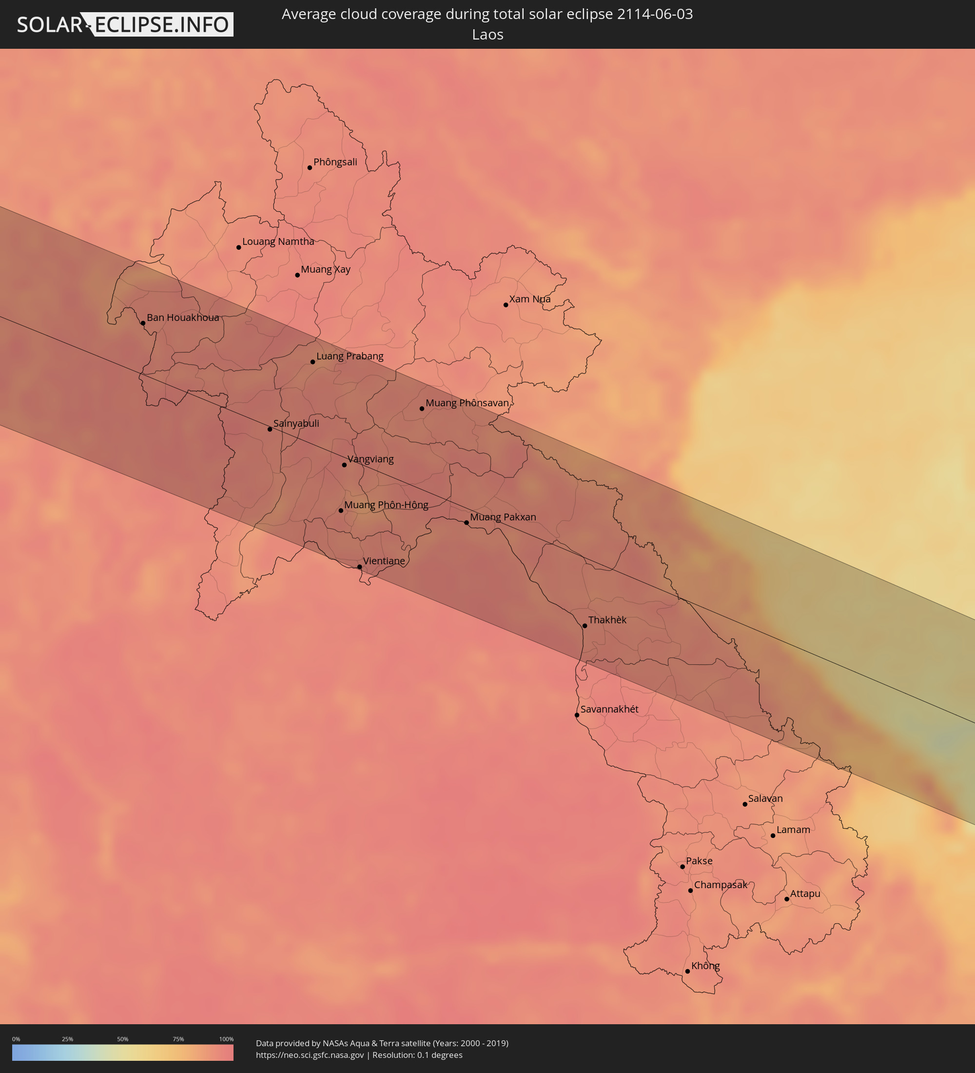 Laos
Laos
 Vietnam
Orte im Finsternispfad
Die nachfolgene Tabelle zeigt Städte und Orte mit mehr als 5.000 Einwohnern, die sich im Finsternispfad befinden. Städte mit mehr als 100.000 Einwohnern sind dick gekennzeichnet. Mit einem Klick auf den Ort öffnet sich eine Detailkarte die die Lage des jeweiligen Ortes zusammen mit dem Verlauf der zentralen Finsternis präsentiert.
| Ort | Typ | Dauer der Verfinsterung | Ortszeit bei maximaler Verfinsterung | Entfernung zur Zentrallinie | Ø Bewölkung |
|
Georgetown, Ascension
|
total | - | 07:27:38 UTC+00:00 | 30 km | 63% |
|
Buguma, Rivers
|
total | - | 08:43:48 UTC+01:00 | 56 km | 96% |
|
Port Harcourt, Rivers
|
total | - | 08:43:58 UTC+01:00 | 50 km | 96% |
|
Owerri, Imo
|
total | - | 08:44:44 UTC+01:00 | 115 km | 97% |
|
Aba, Abia
|
total | - | 08:44:35 UTC+01:00 | 59 km | 96% |
|
Umuahia, Abia
|
total | - | 08:45:09 UTC+01:00 | 90 km | 96% |
|
Bende, Abia
|
total | - | 08:45:18 UTC+01:00 | 85 km | 94% |
|
Ikot Ekpene, Akwa Ibom
|
total | - | 08:44:57 UTC+01:00 | 45 km | 96% |
|
Ohafia-Ifigh, Abia
|
total | - | 08:45:30 UTC+01:00 | 79 km | 93% |
|
Amaigbo, Abia
|
total | - | 08:45:43 UTC+01:00 | 93 km | 94% |
|
Uyo, Akwa Ibom
|
total | - | 08:44:59 UTC+01:00 | 19 km | 97% |
|
Ugep, Cross River
|
total | - | 08:45:56 UTC+01:00 | 80 km | 92% |
|
Esuk Oron, Akwa Ibom
|
total | - | 08:44:58 UTC+01:00 | 24 km | 92% |
|
Calabar, Cross River
|
total | - | 08:45:12 UTC+01:00 | 14 km | 92% |
|
Ikom, Cross River
|
total | - | 08:46:38 UTC+01:00 | 56 km | 85% |
|
Kumba, South-West
|
total | - | 08:45:48 UTC+01:00 | 113 km | 93% |
|
Nkongsamba, Littoral
|
total | - | 08:46:35 UTC+01:00 | 114 km | 94% |
|
Bali, North-West
|
total | - | 08:47:42 UTC+01:00 | 33 km | 88% |
|
Dschang, West
|
total | - | 08:47:14 UTC+01:00 | 76 km | 92% |
|
Wum, North-West
|
total | - | 08:48:19 UTC+01:00 | 9 km | 80% |
|
Bamenda, North-West
|
total | - | 08:47:54 UTC+01:00 | 35 km | 86% |
|
Bafang, West
|
total | - | 08:47:01 UTC+01:00 | 110 km | 94% |
|
Mbouda, West
|
total | - | 08:47:37 UTC+01:00 | 72 km | 83% |
|
Bafoussam, West
|
total | - | 08:47:36 UTC+01:00 | 96 km | 86% |
|
Foumbot, West
|
total | - | 08:47:50 UTC+01:00 | 107 km | 83% |
|
Kumbo, North-West
|
total | - | 08:48:39 UTC+01:00 | 45 km | 81% |
|
Foumban, West
|
total | - | 08:48:20 UTC+01:00 | 103 km | 80% |
|
Yola, Adamawa
|
total | - | 08:54:07 UTC+01:00 | 115 km | 85% |
|
Garoua, North
|
total | - | 08:55:14 UTC+01:00 | 65 km | 80% |
|
Guider, North
|
total | - | 08:56:40 UTC+01:00 | 87 km | 74% |
|
Mboursou Léré, Mayo-Kebbi Ouest
|
total | - | 08:56:41 UTC+01:00 | 58 km | 76% |
|
Pala, Mayo-Kebbi Ouest
|
total | - | 08:57:02 UTC+01:00 | 26 km | 71% |
|
Yagoua, Far North
|
total | - | 08:58:42 UTC+01:00 | 42 km | 80% |
|
Bongor, Mayo-Kebbi Est
|
total | - | 08:58:48 UTC+01:00 | 27 km | 68% |
|
Kelo, Tandjilé
|
total | - | 08:58:02 UTC+01:00 | 88 km | 73% |
|
Béré, Tandjilé
|
total | - | 08:58:29 UTC+01:00 | 110 km | 68% |
|
Laï, Tandjilé
|
total | - | 08:58:46 UTC+01:00 | 112 km | 65% |
|
Bousso, Chari-Baguirmi
|
total | - | 09:00:44 UTC+01:00 | 40 km | 70% |
|
Bokoro, Hadjer-Lamis
|
total | - | 09:03:47 UTC+01:00 | 109 km | 49% |
|
Ngama, Chari-Baguirmi
|
total | - | 09:03:06 UTC+01:00 | 48 km | 54% |
|
Bitkine, Guéra
|
total | - | 09:04:47 UTC+01:00 | 1 km | 49% |
|
Ati, Batha
|
total | - | 09:06:42 UTC+01:00 | 102 km | 37% |
|
Mongo, Guéra
|
total | - | 09:05:45 UTC+01:00 | 13 km | 45% |
|
Oum Hadjer, Batha
|
total | - | 09:08:46 UTC+01:00 | 23 km | 30% |
|
Abéché, Ouadaï
|
total | - | 09:11:15 UTC+01:00 | 1 km | 26% |
|
Adré, Ouadaï
|
total | - | 09:12:52 UTC+01:00 | 120 km | 23% |
|
Argo, Northern State
|
total | - | 10:37:13 UTC+02:00 | 57 km | 5% |
|
Dongola, Northern State
|
total | - | 10:36:50 UTC+02:00 | 92 km | 6% |
|
Yanbu, Al Madīnah al Munawwarah
|
total | - | 12:00:53 UTC+03:00 | 2 km | 28% |
|
Badr Ḩunayn, Al Madīnah al Munawwarah
|
total | - | 12:02:15 UTC+03:00 | 61 km | 5% |
|
Medina, Al Madīnah al Munawwarah
|
total | - | 12:05:06 UTC+03:00 | 26 km | 6% |
|
Ar Rass, Al-Qassim
|
total | - | 12:16:13 UTC+03:00 | 28 km | 1% |
|
Al Bukayrīyah, Al-Qassim
|
total | - | 12:16:53 UTC+03:00 | 5 km | 3% |
|
Buraydah, Al-Qassim
|
total | - | 12:17:50 UTC+03:00 | 4 km | 2% |
|
Unaizah, Al-Qassim
|
total | - | 12:17:40 UTC+03:00 | 22 km | 2% |
|
Tanūmah, Al-Qassim
|
total | - | 12:18:57 UTC+03:00 | 80 km | 1% |
|
Al Mithnab, Al-Qassim
|
total | - | 12:18:01 UTC+03:00 | 53 km | 3% |
|
Az Zulfi, Ar Riyāḑ
|
total | - | 12:19:55 UTC+03:00 | 26 km | 1% |
|
Al Arţāwīyah, Ar Riyāḑ
|
total | - | 12:21:25 UTC+03:00 | 21 km | 2% |
|
Al Khafjī, Eastern Province
|
total | - | 12:30:37 UTC+03:00 | 102 km | 19% |
|
Al Jubayl, Eastern Province
|
total | - | 12:32:35 UTC+03:00 | 79 km | 22% |
|
Umm as Sāhik, Eastern Province
|
total | - | 12:33:01 UTC+03:00 | 124 km | 2% |
|
Raḩīmah, Eastern Province
|
total | - | 12:33:25 UTC+03:00 | 121 km | 42% |
|
Bandar-e Būshehr, Bushehr
|
total | - | 13:06:32 UTC+03:30 | 110 km | 23% |
|
Fīrūzābād, Fars
|
total | - | 13:10:35 UTC+03:30 | 67 km | 6% |
|
Akbarābād, Fars
|
total | - | 13:11:13 UTC+03:30 | 108 km | 5% |
|
Fasā, Fars
|
total | - | 13:13:09 UTC+03:30 | 61 km | 4% |
|
Gerāsh, Fars
|
total | - | 13:13:53 UTC+03:30 | 86 km | 1% |
|
Neyrīz, Fars
|
total | - | 13:14:48 UTC+03:30 | 81 km | 3% |
|
Dārāb, Fars
|
total | - | 13:15:11 UTC+03:30 | 29 km | 1% |
|
Sirjan, Kerman
|
total | - | 13:17:57 UTC+03:30 | 95 km | 2% |
|
Bam, Kerman
|
total | - | 13:23:52 UTC+03:30 | 37 km | 5% |
|
Zahedan, Sistan and Baluchestan
|
total | - | 13:29:14 UTC+03:30 | 74 km | 9% |
|
Khāsh, Sistan and Baluchestan
|
total | - | 13:30:04 UTC+03:30 | 68 km | 7% |
|
Khuzdār, Balochistān
|
total | - | 15:10:59 UTC+05:00 | 87 km | 13% |
|
Sibi, Balochistān
|
total | - | 15:12:41 UTC+05:00 | 118 km | 9% |
|
Shahdād Kot, Sindh
|
total | - | 15:13:22 UTC+05:00 | 70 km | 24% |
|
Kambar, Sindh
|
total | - | 15:13:37 UTC+05:00 | 98 km | 28% |
|
Lārkāna, Sindh
|
total | - | 15:14:01 UTC+05:00 | 99 km | 18% |
|
Jacobābād, Sindh
|
total | - | 15:14:09 UTC+05:00 | 16 km | 15% |
|
Shikārpur, Sindh
|
total | - | 15:14:38 UTC+05:00 | 49 km | 17% |
|
Khairpur, Sindh
|
total | - | 15:15:00 UTC+05:00 | 95 km | 11% |
|
Sukkur, Sindh
|
total | - | 15:15:07 UTC+05:00 | 74 km | 15% |
|
Pāno Āqil, Sindh
|
total | - | 15:15:30 UTC+05:00 | 54 km | 15% |
|
Kandhkot, Sindh
|
total | - | 15:15:28 UTC+05:00 | 11 km | 20% |
|
Ghotki, Sindh
|
total | - | 15:15:48 UTC+05:00 | 35 km | 14% |
|
Sādiqābād, Punjab
|
total | - | 15:17:03 UTC+05:00 | 9 km | 10% |
|
Rājanpur, Punjab
|
total | - | 15:17:01 UTC+05:00 | 100 km | 14% |
|
Khānpur, Punjab
|
total | - | 15:17:46 UTC+05:00 | 54 km | 10% |
|
Bīkaner, Rajasthan
|
total | - | 15:52:15 UTC+05:30 | 29 km | 14% |
|
Jaipur, Rajasthan
|
total | - | 15:56:25 UTC+05:30 | 41 km | 17% |
|
Āgra, Uttar Pradesh
|
total | - | 15:59:13 UTC+05:30 | 38 km | 44% |
|
Alīgarh, Uttar Pradesh
|
total | - | 15:58:53 UTC+05:30 | 115 km | 50% |
|
Gwalior, Madhya Pradesh
|
total | - | 15:59:59 UTC+05:30 | 62 km | 26% |
|
Kanpur, Uttar Pradesh
|
total | - | 16:02:29 UTC+05:30 | 19 km | 48% |
|
Lucknow, Uttar Pradesh
|
total | - | 16:02:53 UTC+05:30 | 74 km | 51% |
|
Allahābād, Uttar Pradesh
|
total | - | 16:04:46 UTC+05:30 | 50 km | 65% |
|
Varanasi, Uttar Pradesh
|
total | - | 16:06:05 UTC+05:30 | 31 km | 59% |
|
Gaya, Bihar
|
total | - | 16:08:20 UTC+05:30 | 27 km | 61% |
|
Patna, Bihar
|
total | - | 16:07:57 UTC+05:30 | 62 km | 57% |
|
Bokāro, Jharkhand
|
total | - | 16:09:50 UTC+05:30 | 104 km | 54% |
|
Bhāgalpur, Bihar
|
total | - | 16:09:46 UTC+05:30 | 82 km | 66% |
|
Āsansol, West Bengal
|
total | - | 16:10:46 UTC+05:30 | 82 km | 63% |
|
Durgapur, West Bengal
|
total | - | 16:11:08 UTC+05:30 | 90 km | 63% |
|
Nawābganj, Rājshāhi
|
total | - | 16:41:14 UTC+06:00 | 55 km | 79% |
|
Rājshāhi, Rājshāhi
|
total | - | 16:41:37 UTC+06:00 | 43 km | 82% |
|
Pār Naogaon, Rājshāhi
|
total | - | 16:41:36 UTC+06:00 | 100 km | 88% |
|
Kushtia, Khulna
|
total | - | 16:42:18 UTC+06:00 | 11 km | 84% |
|
Jessore, Khulna
|
total | - | 16:42:49 UTC+06:00 | 63 km | 86% |
|
Pābna, Rājshāhi
|
total | - | 16:42:19 UTC+06:00 | 26 km | 83% |
|
Khulna, Khulna
|
total | - | 16:43:18 UTC+06:00 | 89 km | 86% |
|
Nāgarpur, Dhaka
|
total | - | 16:42:44 UTC+06:00 | 53 km | 89% |
|
Tāngāil, Dhaka
|
total | - | 16:42:39 UTC+06:00 | 74 km | 89% |
|
Barisāl, Barisāl
|
total | - | 16:43:55 UTC+06:00 | 72 km | 91% |
|
Tungi, Dhaka
|
total | - | 16:43:12 UTC+06:00 | 54 km | 90% |
|
Dhaka, Dhaka
|
total | - | 16:43:19 UTC+06:00 | 35 km | 87% |
|
Narsingdi, Dhaka
|
total | - | 16:43:24 UTC+06:00 | 68 km | 87% |
|
Comilla, Chittagong
|
total | - | 16:43:59 UTC+06:00 | 36 km | 90% |
|
Chittagong, Chittagong
|
total | - | 16:45:04 UTC+06:00 | 59 km | 86% |
|
Hakha, Chin
|
total | - | 17:15:54 UTC+06:30 | 38 km | 83% |
|
Falam, Chin
|
total | - | 17:15:46 UTC+06:30 | 67 km | 82% |
|
Chauk, Magway
|
total | - | 17:17:32 UTC+06:30 | 100 km | 89% |
|
Pakokku, Magway
|
total | - | 17:17:24 UTC+06:30 | 45 km | 93% |
|
Monywa, Sagain
|
total | - | 17:16:59 UTC+06:30 | 37 km | 86% |
|
Myingyan, Mandalay
|
total | - | 17:17:29 UTC+06:30 | 21 km | 90% |
|
Shwebo, Sagain
|
total | - | 17:16:58 UTC+06:30 | 106 km | 86% |
|
Meiktila, Mandalay
|
total | - | 17:18:01 UTC+06:30 | 64 km | 89% |
|
Sagaing, Sagain
|
total | - | 17:17:30 UTC+06:30 | 45 km | 87% |
|
Mandalay, Mandalay
|
total | - | 17:17:29 UTC+06:30 | 59 km | 90% |
|
Kyaukse, Mandalay
|
total | - | 17:17:43 UTC+06:30 | 22 km | 88% |
|
Yamethin, Mandalay
|
total | - | 17:18:23 UTC+06:30 | 99 km | 92% |
|
Pyin Oo Lwin, Mandalay
|
total | - | 17:17:36 UTC+06:30 | 79 km | 89% |
|
Taunggyi, Shan
|
total | - | 17:18:33 UTC+06:30 | 28 km | 86% |
|
Chiang Rai, Chiang Rai
|
total | - | 17:49:58 UTC+07:00 | 11 km | 94% |
|
Mae Chan, Chiang Rai
|
total | - | 17:49:51 UTC+07:00 | 15 km | 93% |
|
Mae Sai, Chiang Rai
|
total | - | 17:49:42 UTC+07:00 | 45 km | 94% |
|
Tachilek, Shan
|
total | - | 17:49:41 UTC+07:00 | 47 km | 94% |
|
Pa Daet, Chiang Rai
|
total | - | 17:50:13 UTC+07:00 | 46 km | 93% |
|
Dok Kham Tai, Phayao
|
total | - | 17:50:24 UTC+07:00 | 81 km | 92% |
|
Pong, Phayao
|
total | - | 17:50:29 UTC+07:00 | 71 km | 91% |
|
Chiang Kham, Phayao
|
total | - | 17:50:18 UTC+07:00 | 32 km | 94% |
|
Chiang Khong, Chiang Rai
|
total | - | 17:49:56 UTC+07:00 | 48 km | 91% |
|
Ban Houayxay, Bokeo Province
|
total | - | 17:49:55 UTC+07:00 | 50 km | 91% |
|
Ban Houakhoua, Bokeo Province
|
total | - | 17:49:57 UTC+07:00 | 49 km | 90% |
|
Nan, Nan
|
total | - | 17:50:47 UTC+07:00 | 89 km | 93% |
|
Chiang Klang, Nan
|
total | - | 17:50:33 UTC+07:00 | 33 km | 93% |
|
Sainyabuli, Xiagnabouli
|
total | - | 17:50:46 UTC+07:00 | 3 km | 92% |
|
Luang Prabang, Louangphabang
|
total | - | 17:50:31 UTC+07:00 | 79 km | 89% |
|
Muang Phôn-Hông, Vientiane Province
|
total | - | 17:51:17 UTC+07:00 | 53 km | 94% |
|
Vangviang, Vientiane Province
|
total | - | 17:51:04 UTC+07:00 | 8 km | 92% |
|
Si Chiang Mai, Nong Khai
|
total | - | 17:51:34 UTC+07:00 | 102 km | 93% |
|
Vientiane, Vientiane
|
total | - | 17:51:34 UTC+07:00 | 100 km | 93% |
|
Phon Charoen, Nong Khai
|
total | - | 17:51:38 UTC+07:00 | 70 km | 94% |
|
Muang Phônsavan, Xiangkhoang
|
total | - | 17:50:56 UTC+07:00 | 77 km | 89% |
|
Ban Dung, Changwat Udon Thani
|
total | - | 17:51:48 UTC+07:00 | 101 km | 94% |
|
Muang Pakxan, Bolikhamsai Province
|
total | - | 17:51:32 UTC+07:00 | 14 km | 89% |
|
Seka, Changwat Bueng Kan
|
total | - | 17:51:47 UTC+07:00 | 49 km | 95% |
|
Nakhon Phanom, Nakhon Phanom
|
total | - | 17:52:07 UTC+07:00 | 68 km | 91% |
|
Thakhèk, Khammouan
|
total | - | 17:52:07 UTC+07:00 | 66 km | 91% |
|
Yên Vinh, Nghệ An
|
total | - | 17:51:37 UTC+07:00 | 97 km | 85% |
|
Vinh, Nghệ An
|
total | - | 17:51:36 UTC+07:00 | 99 km | 85% |
|
Hà Tĩnh, Hà Tĩnh
|
total | - | 17:51:47 UTC+07:00 | 74 km | 83% |
|
Kwang Binh, Quảng Bình
|
total | - | 17:52:13 UTC+07:00 | 14 km | 81% |
|
Ðông Hà, Quảng Trị
|
total | - | 17:52:31 UTC+07:00 | 34 km | 81% |
|
Huế, Thừa Thiên-Huế
|
total | - | 17:52:40 UTC+07:00 | 49 km | 79% |
|
Da Nang, Đà Nẵng
|
total | - | 17:52:50 UTC+07:00 | 64 km | 79% |
|
Hội An, Quảng Nam
|
total | - | 17:52:54 UTC+07:00 | 78 km | 81% |