Totale Sonnenfinsternis vom 07.10.2135
| Wochentag: | Freitag |
| Maximale Dauer der Verfinsterung: | 04m50s |
| Maximale Breite des Finsternispfades: | 224 km |
| Saroszyklus: | 136 |
| Bedeckungsgrad: | 100% |
| Magnitude: | 1.0603 |
| Gamma: | 0.4884 |
Wo kann man die Sonnenfinsternis vom 07.10.2135 sehen?
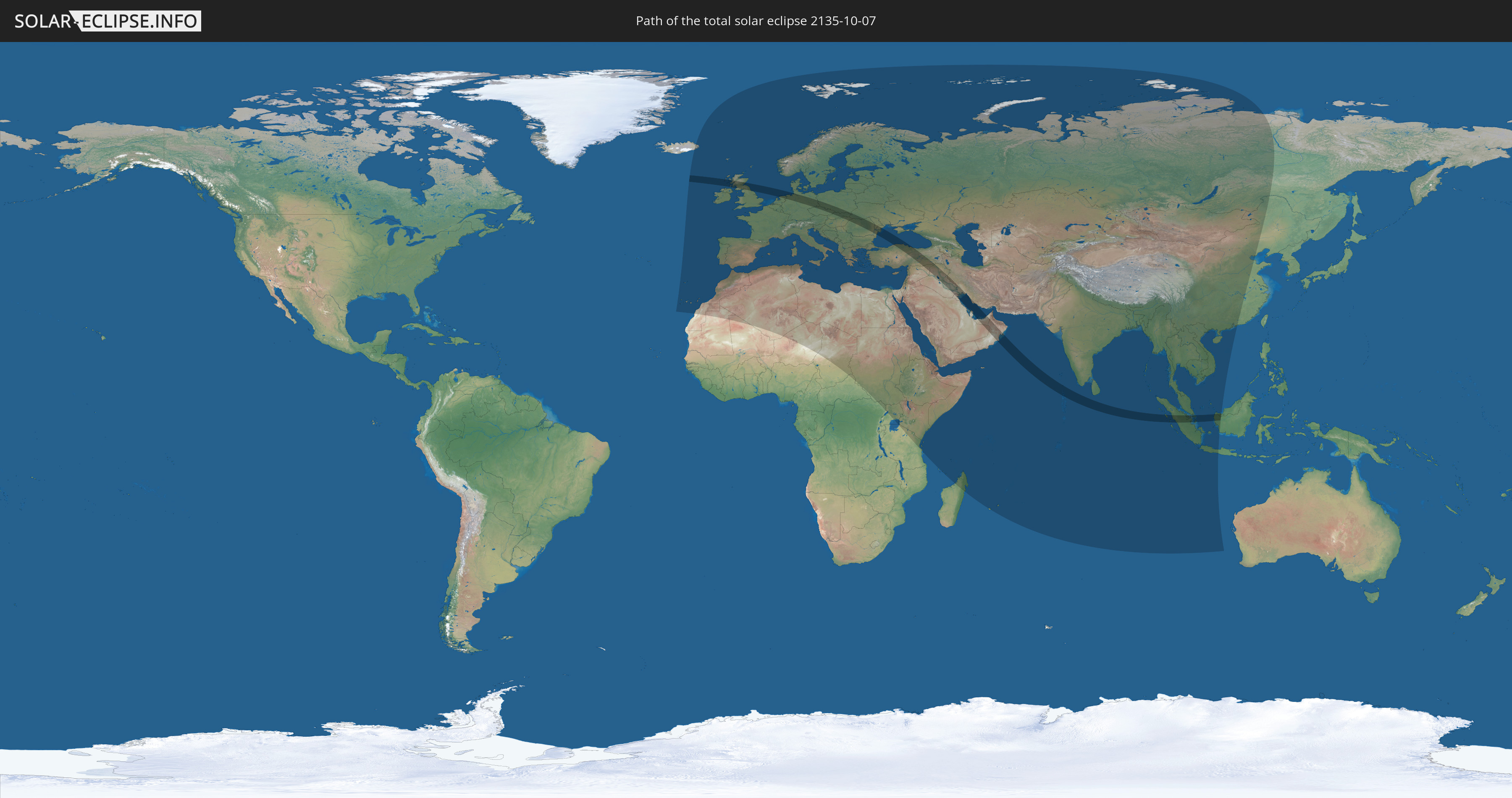
Die Sonnenfinsternis am 07.10.2135 kann man in 124 Ländern als partielle Sonnenfinsternis beobachten.
Der Finsternispfad verläuft durch 22 Länder. Nur in diesen Ländern ist sie als totale Sonnenfinsternis zu sehen.
In den folgenden Ländern ist die Sonnenfinsternis total zu sehen
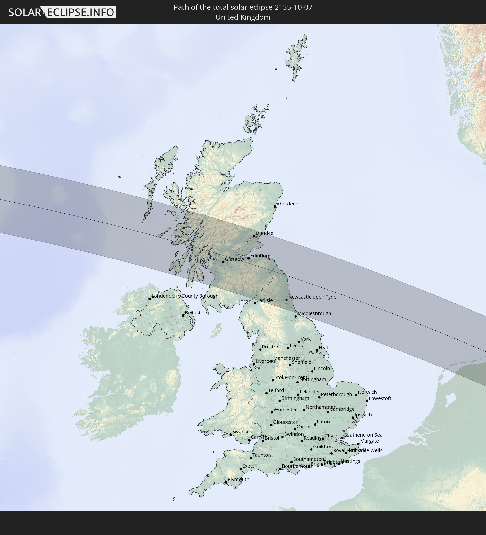 Vereinigtes Königreich
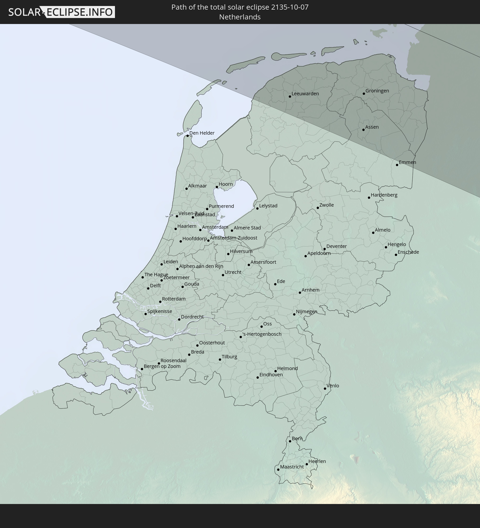 Niederlande
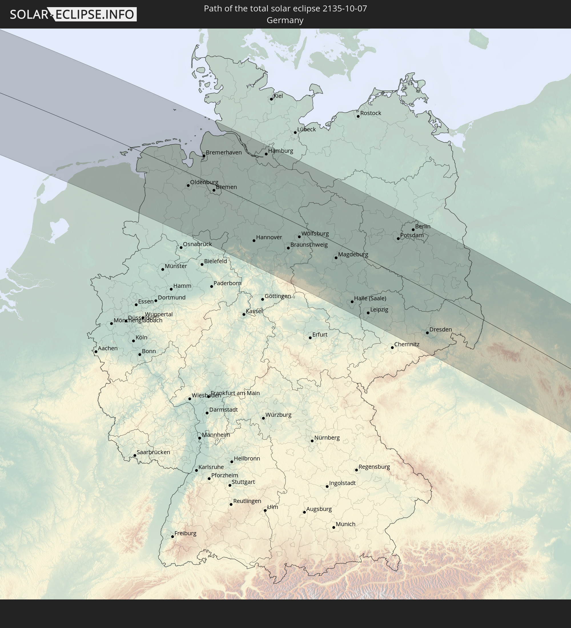 Deutschland
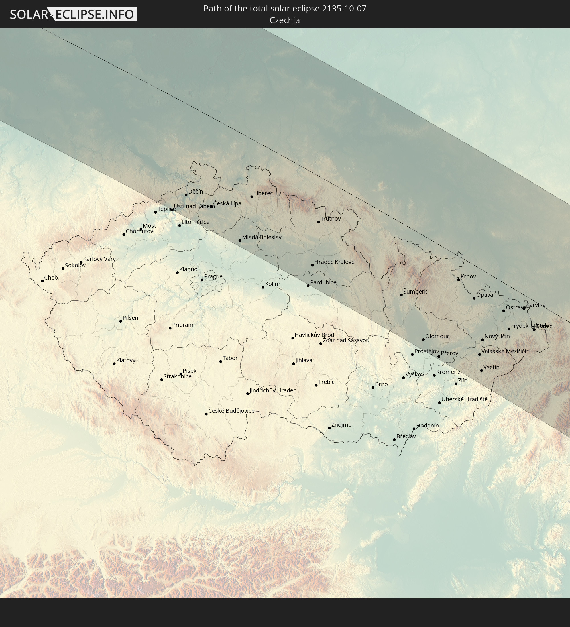 Tschechien
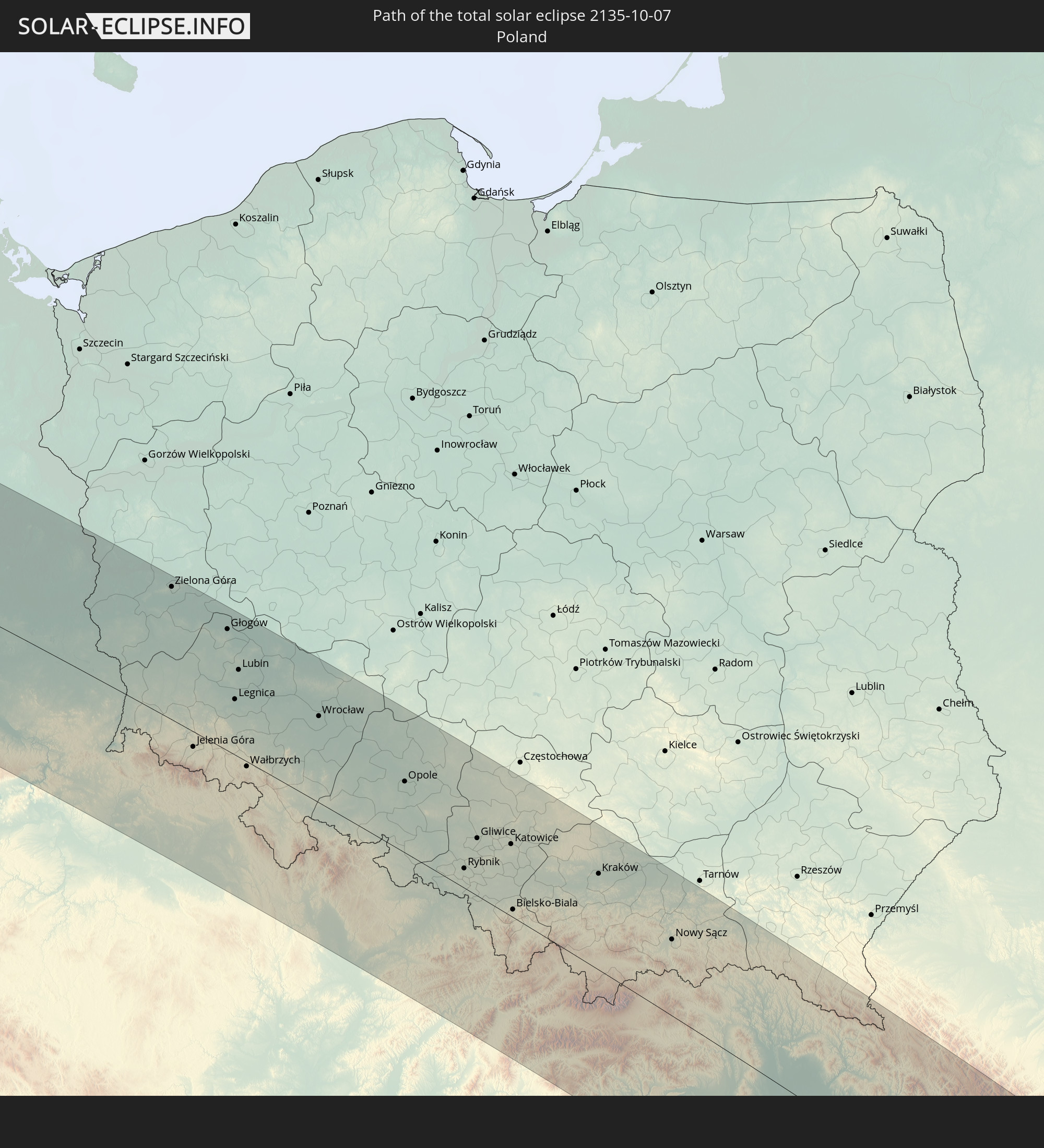 Polen
Polen
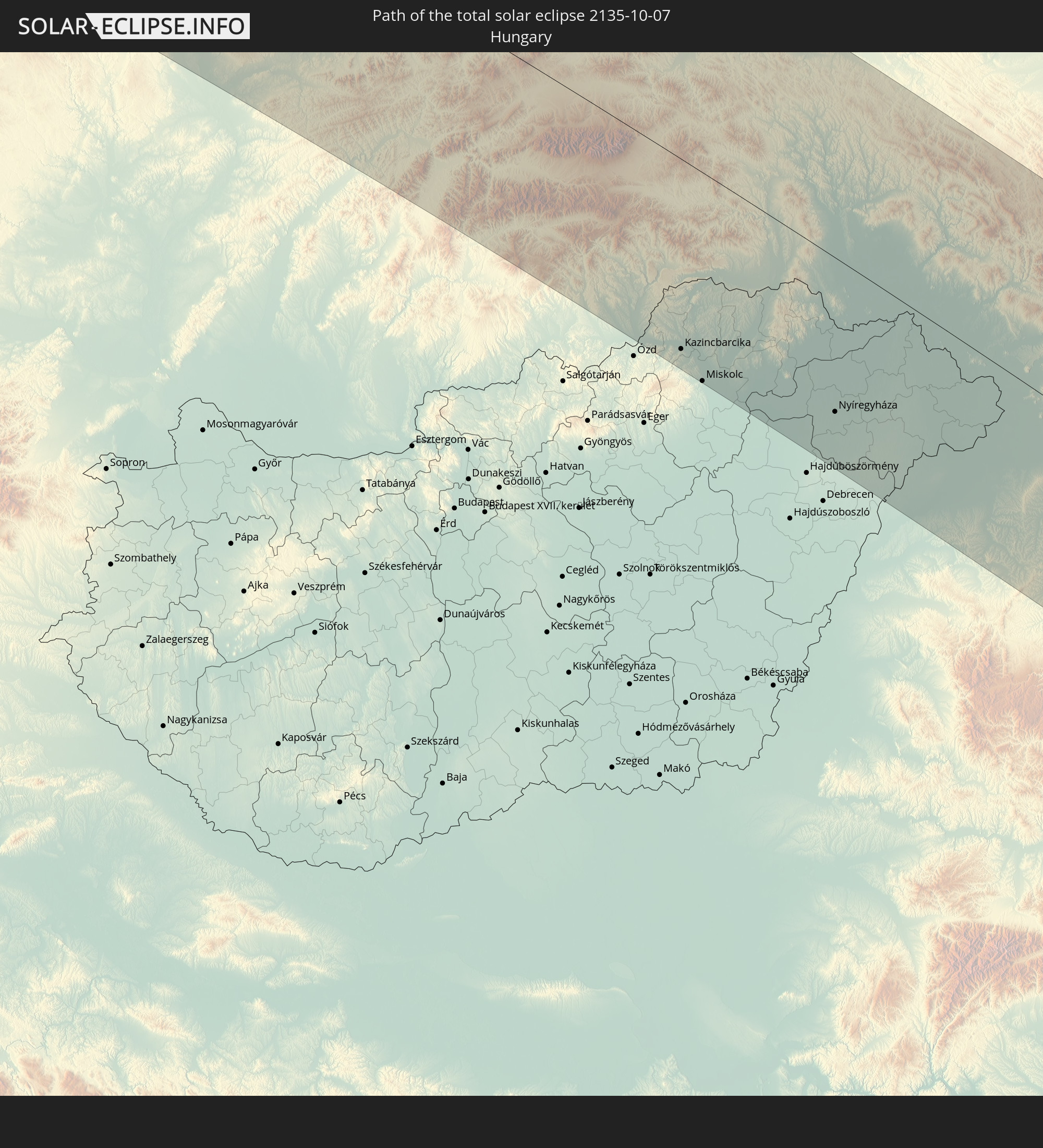 Ungarn
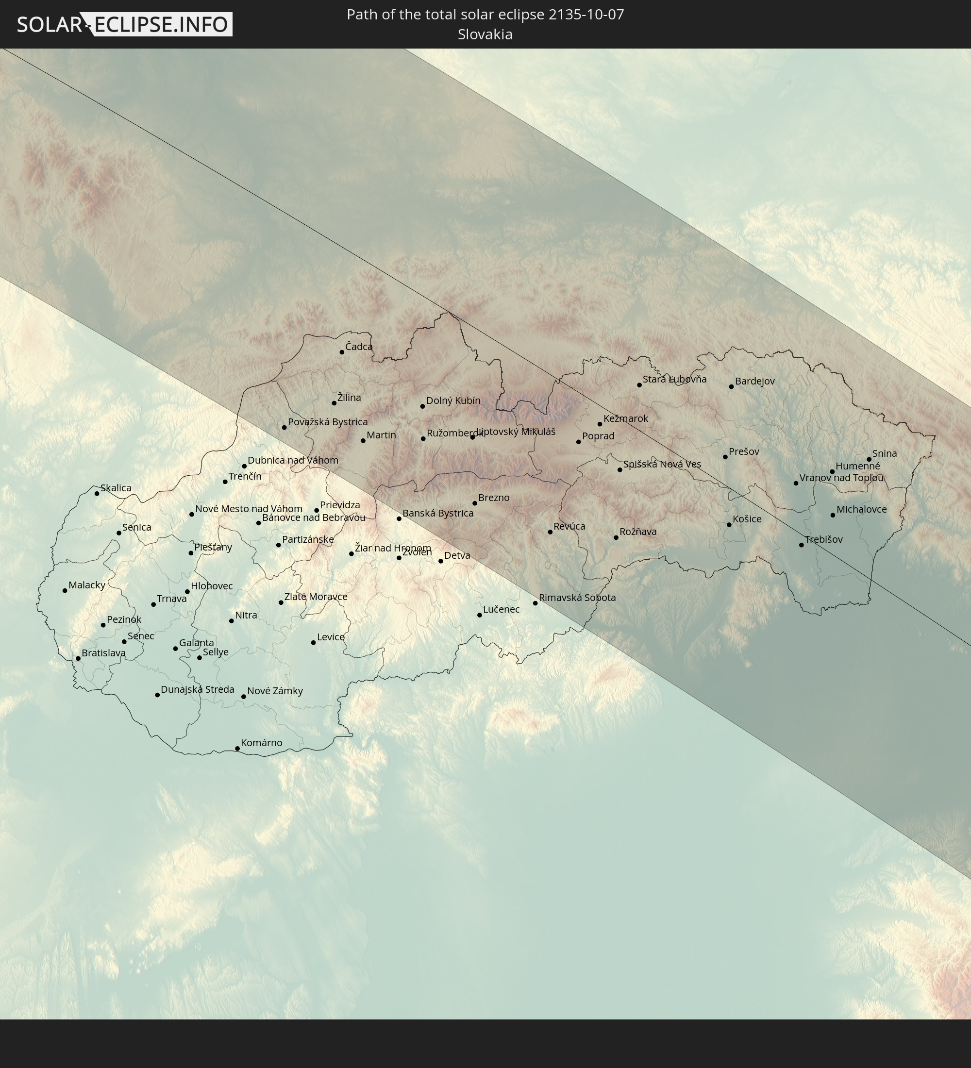 Slowakei
 Rumänien
 Ukraine
 Türkei
 Moldawien
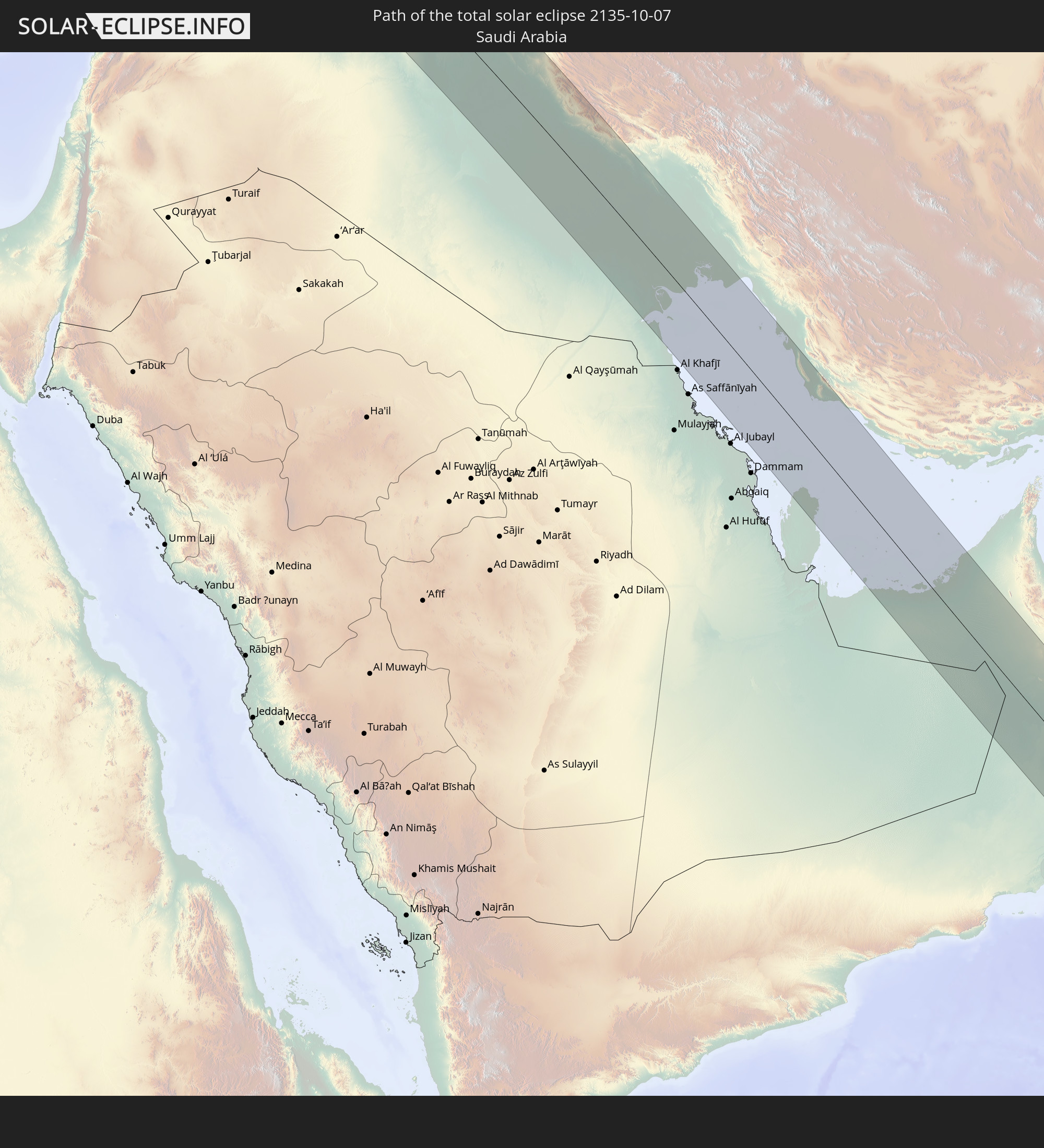 Saudi-Arabien
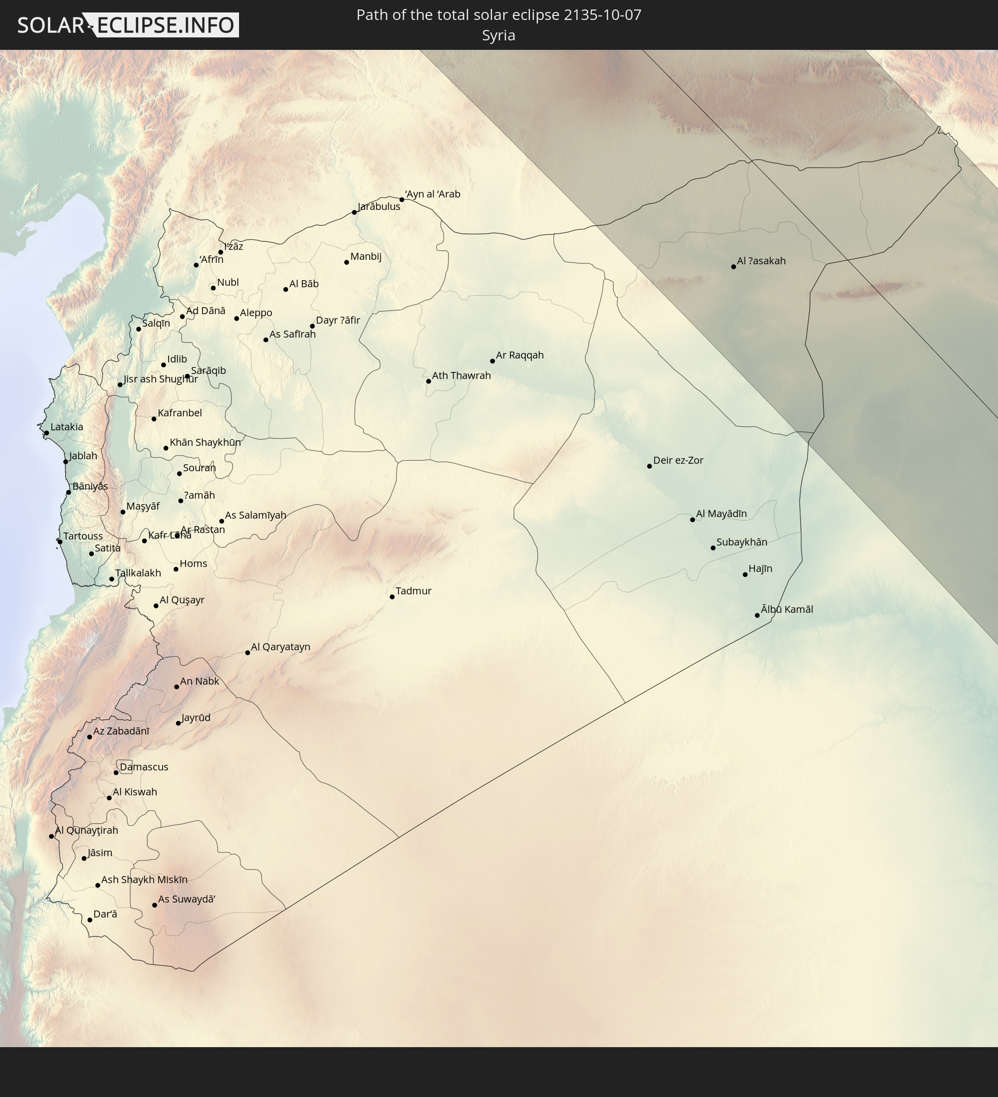 Syrien
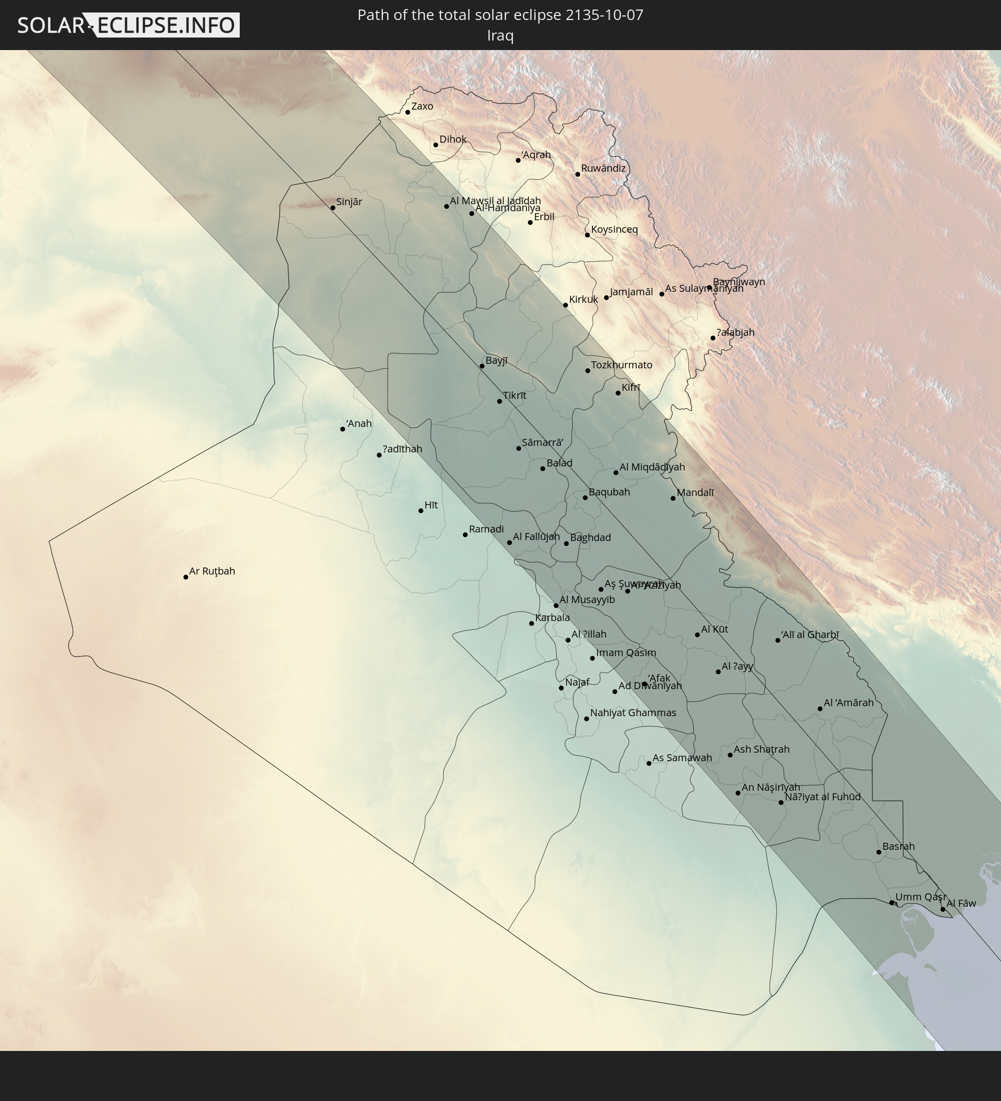 Irak
Irak
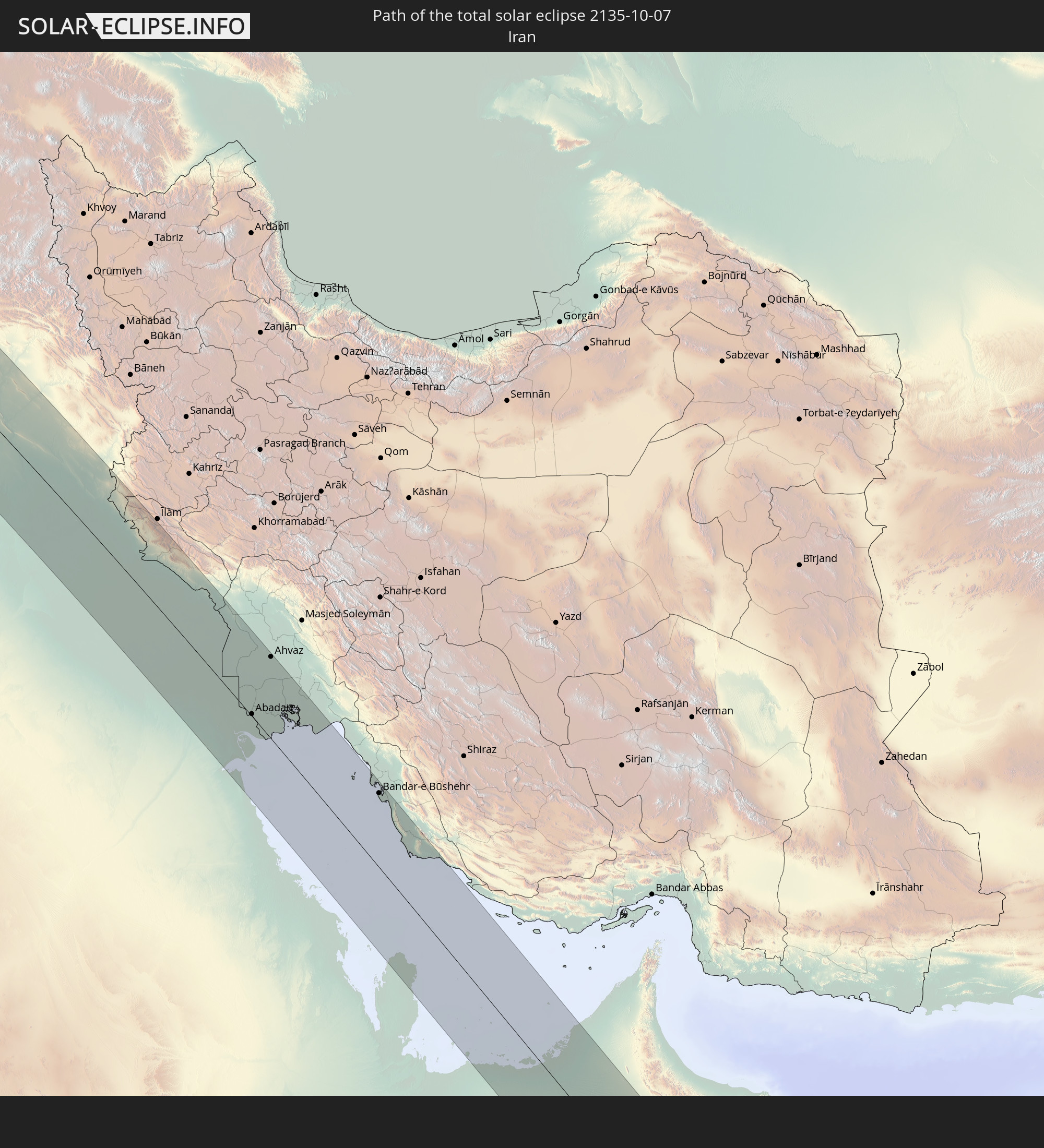 Iran
Iran
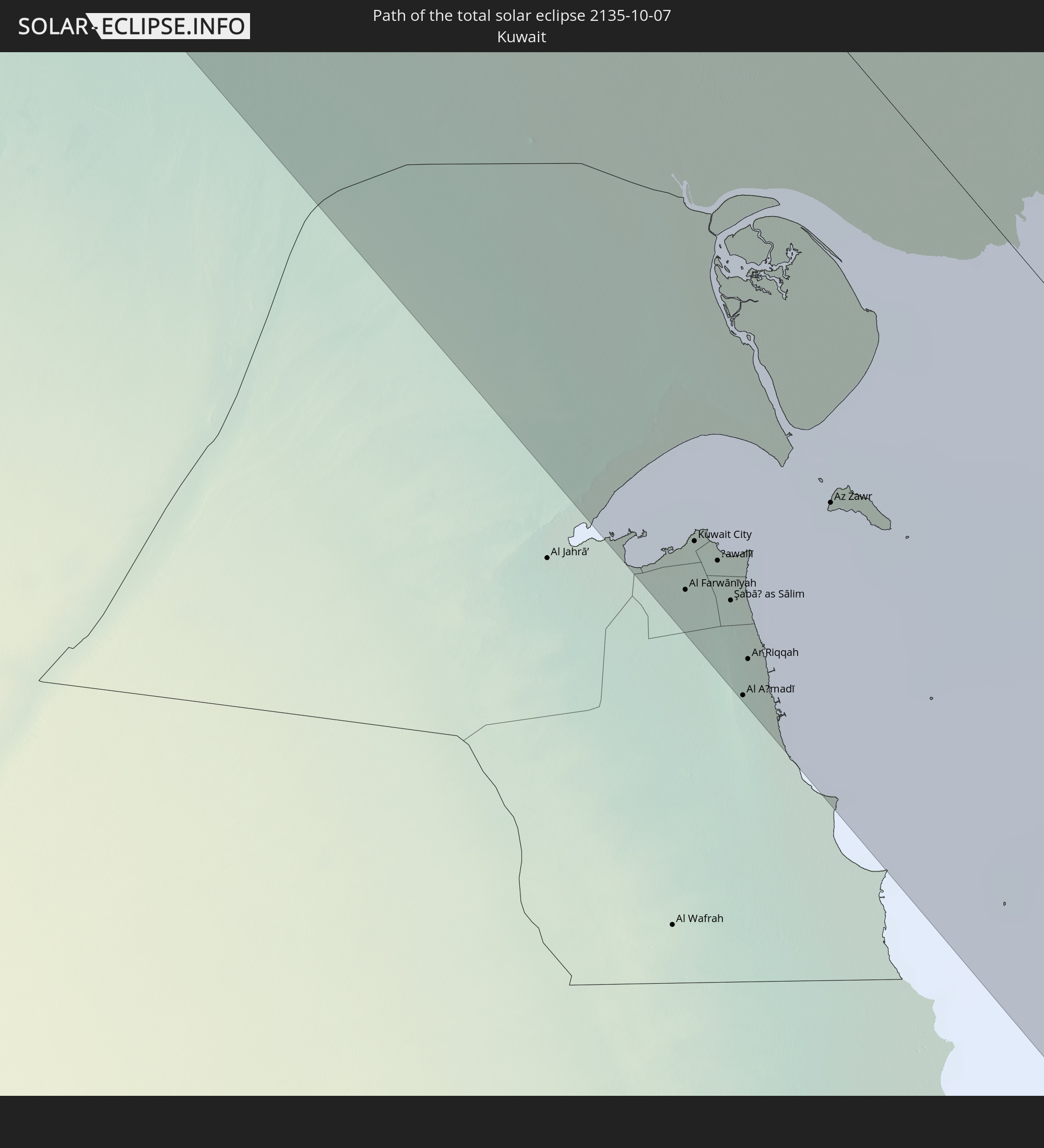 Kuwait
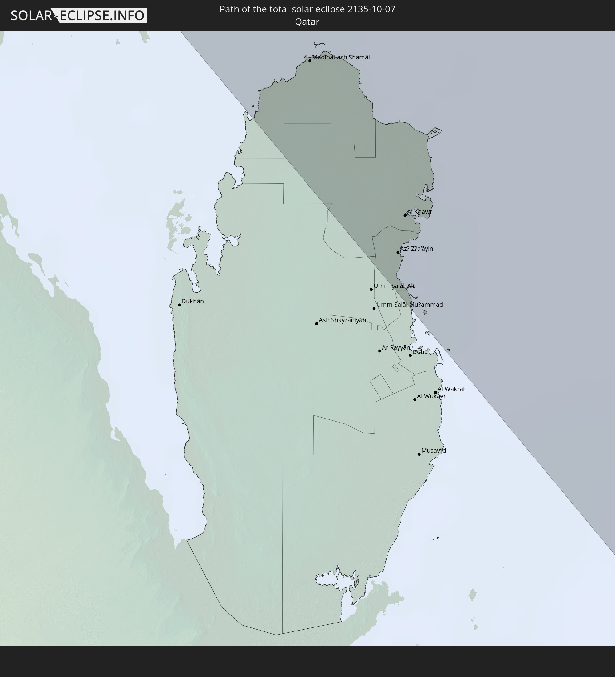 Katar
Katar
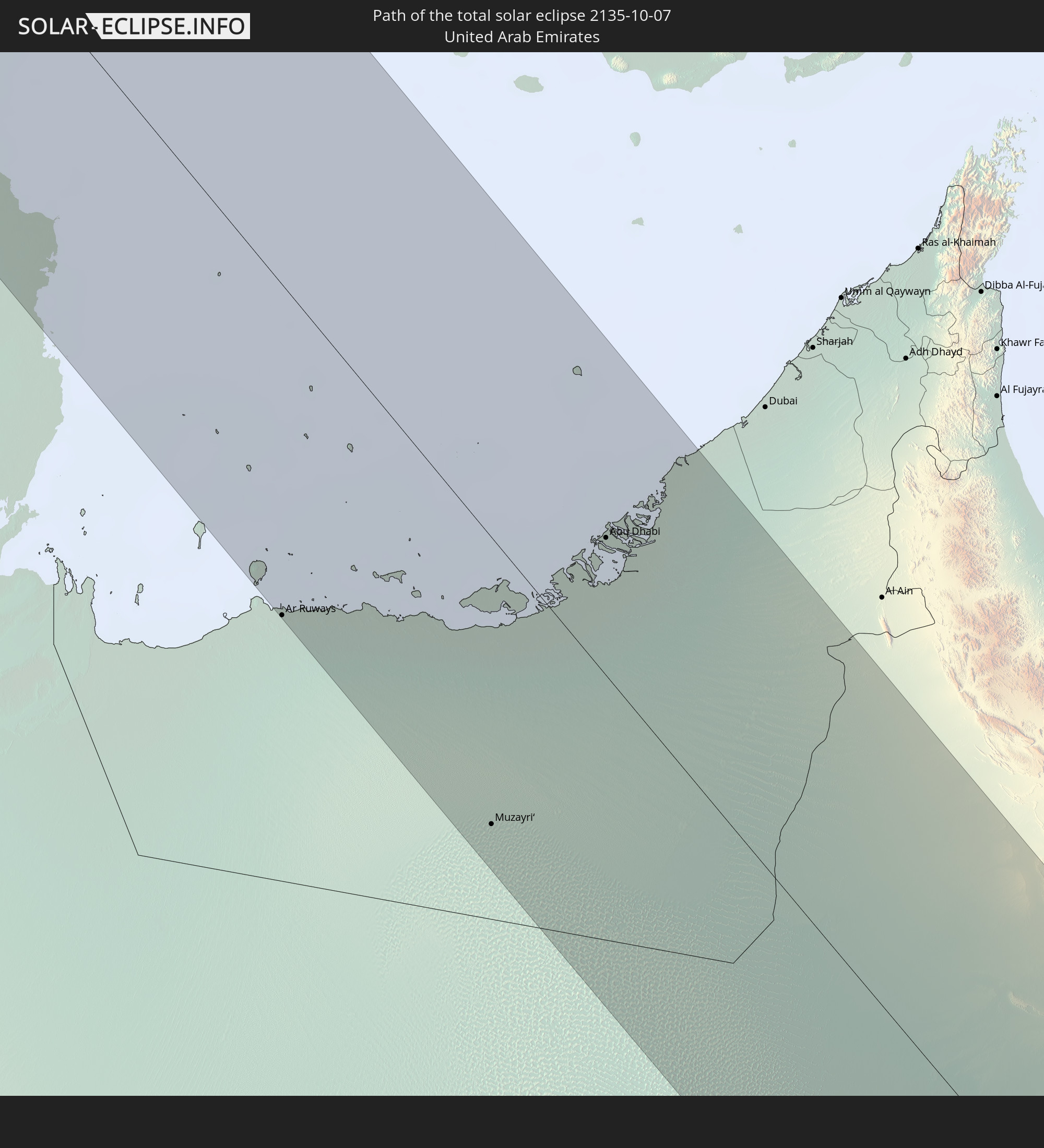 Vereinigte Arabische Emirate
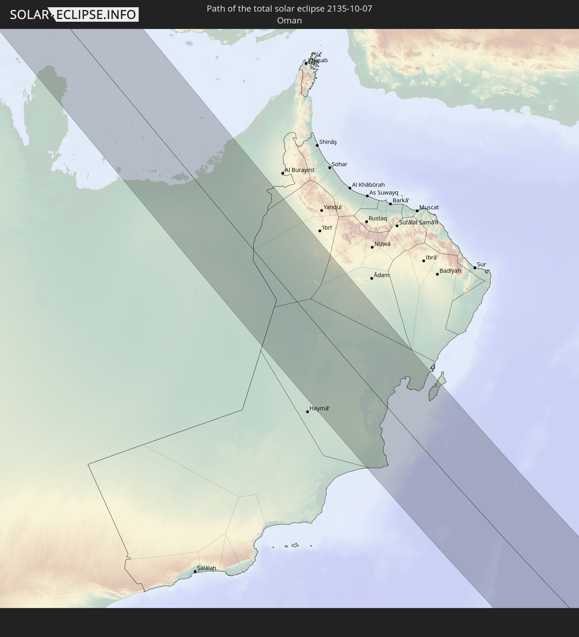 Oman
Oman
 Malediven
 Indonesien
 Malaysia
In den folgenden Ländern ist die Sonnenfinsternis partiell zu sehen
 Russland
 Portugal
 Island
 Spanien
 Mauretanien
 Marokko
 Mali
Mali
 Irland
 Spitzbergen
 Algerien
 Vereinigtes Königreich
 Färöer
 Gibraltar
 Frankreich
 Isle of Man
 Guernsey
 Jersey
 Niger
Niger
 Andorra
 Belgien
 Niederlande
 Norwegen
 Luxemburg
 Deutschland
 Schweiz
 Italien
 Monaco
 Tunesien
 Dänemark
 Libyen
 Liechtenstein
 Österreich
 Schweden
 Tschechien
 Demokratische Republik Kongo
 San Marino
 Vatikanstadt
 Slowenien
 Tschad
 Kroatien
 Polen
Polen
 Malta
Malta
 Zentralafrikanische Republik
 Bosnien und Herzegowina
 Ungarn
 Slowakei
 Montenegro
 Serbien
 Albanien
 Åland Islands
 Griechenland
 Rumänien
 Mazedonien
 Finnland
 Litauen
 Lettland
 Estland
 Sudan
Sudan
 Ukraine
 Bulgarien
 Weißrussland
 Ägypten
 Türkei
 Moldawien
 Tansania
 Uganda
 Republik Zypern
 Äthiopien
 Kenia
Kenia
 Staat Palästina
 Israel
 Saudi-Arabien
 Jordanien
 Libanon
 Syrien
 Eritrea
 Irak
Irak
 Georgien
 Französische Süd- und Antarktisgebiete
 Somalia
 Dschibuti
 Jemen
Jemen
 Madagaskar
 Komoren
 Armenien
 Iran
Iran
 Aserbaidschan
 Mayotte
 Seychellen
 Kasachstan
 Kuwait
 Bahrain
 Katar
Katar
 Vereinigte Arabische Emirate
 Oman
Oman
 Turkmenistan
 Réunion
 Usbekistan
 Mauritius
 Afghanistan
 Pakistan
 Tadschikistan
 Indien
 Kirgisistan
 Britisches Territorium im Indischen Ozean
 Malediven
 Volksrepublik China
 Sri Lanka
 Nepal
Nepal
 Mongolei
 Bangladesch
 Bhutan
 Myanmar
 Indonesien
 Kokosinseln
 Thailand
 Malaysia
 Laos
Laos
 Vietnam
 Kambodscha
 Singapur
 Weihnachtsinsel
 Macau
Macau
 Hongkong
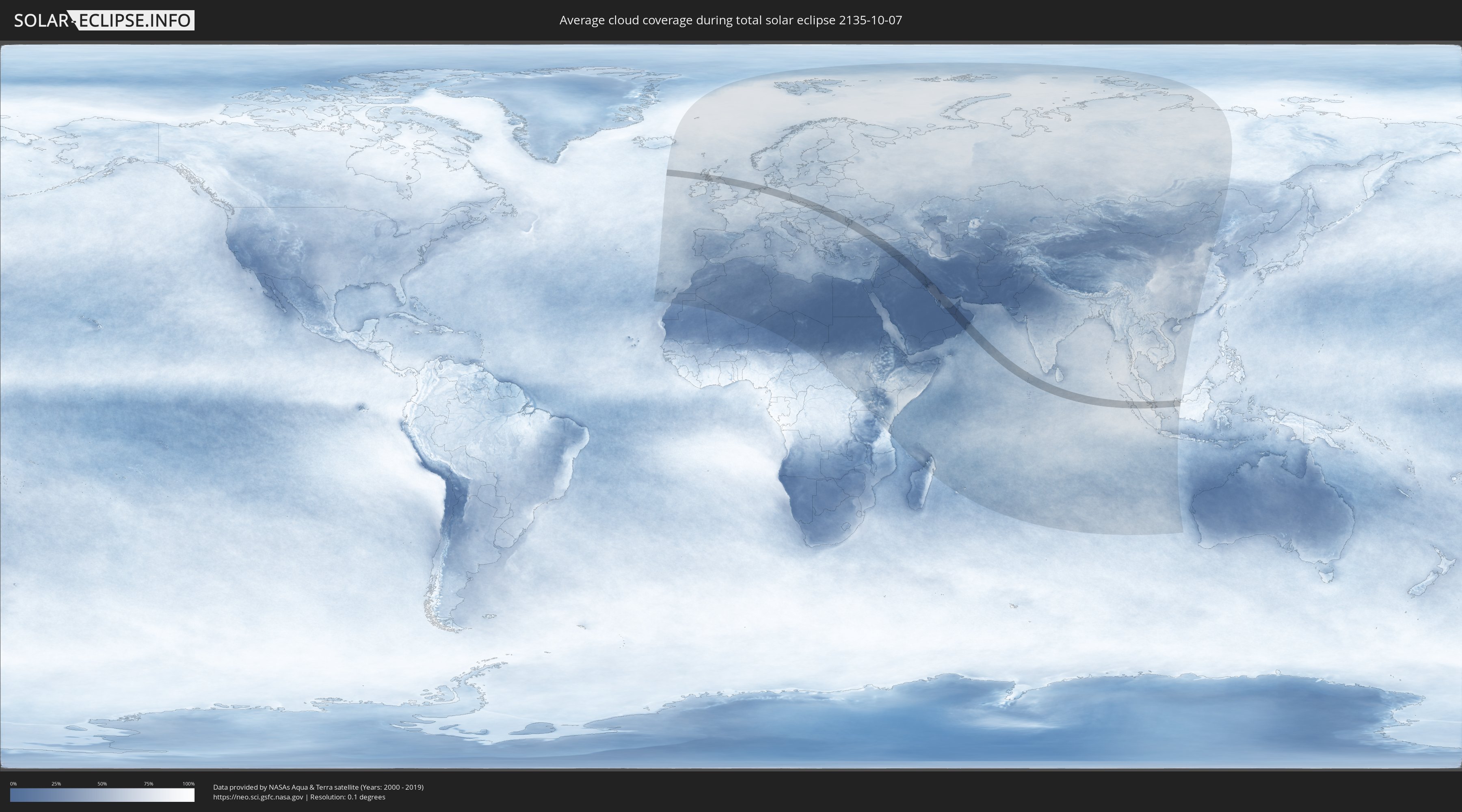
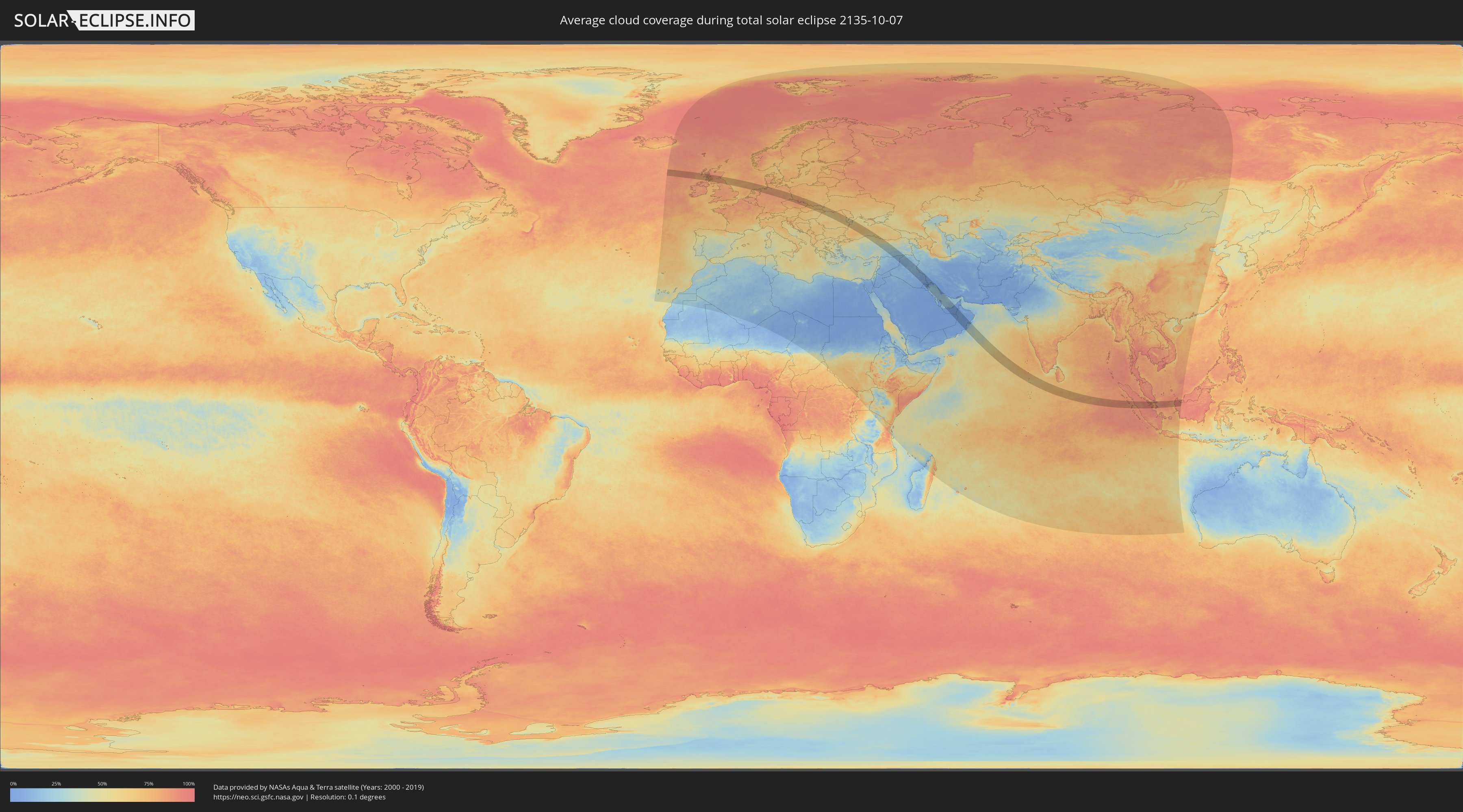
Wie wird das Wetter während der totalen Sonnenfinsternis am 07.10.2135?
Wo ist der beste Ort, um die totale Sonnenfinsternis vom 07.10.2135 zu beobachten?
Die folgenden Karten zeigen die durchschnittliche Bewölkung für den Tag, an dem die totale Sonnenfinsternis
stattfindet. Mit Hilfe der Karten lässt sich der Ort entlang des Finsternispfades eingrenzen,
der die besten Aussichen auf einen klaren wolkenfreien Himmel bietet.
Trotzdem muss man immer lokale Gegenenheiten beachten und sollte sich genau über das Wetter an seinem
gewählten Beobachtungsort informieren.
Die Daten stammen von den beiden NASA-Satelliten
AQUA und TERRA
und wurden über einen Zeitraum von 19 Jahren (2000 - 2019) gemittelt.
Detaillierte Länderkarten
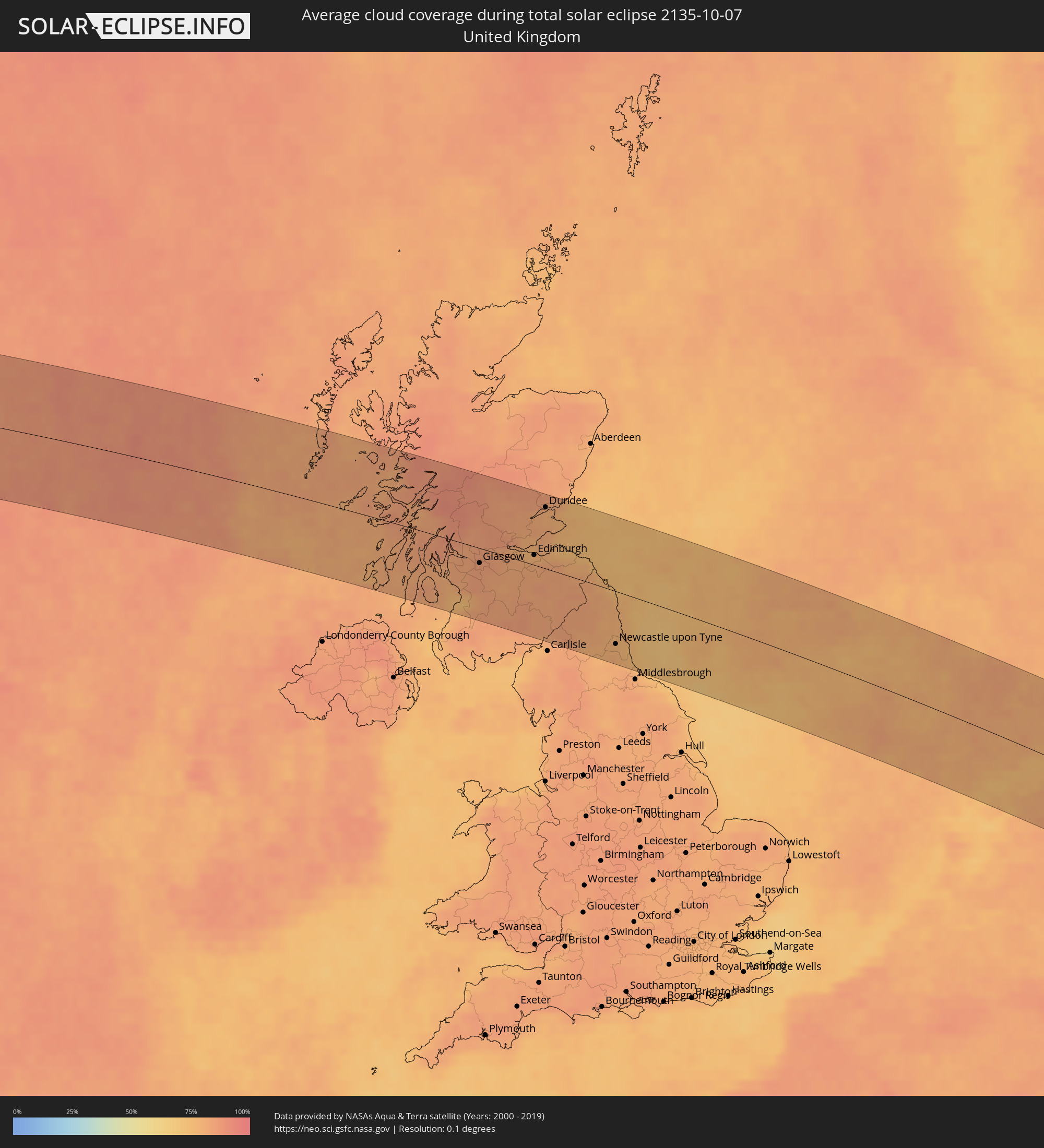 Vereinigtes Königreich
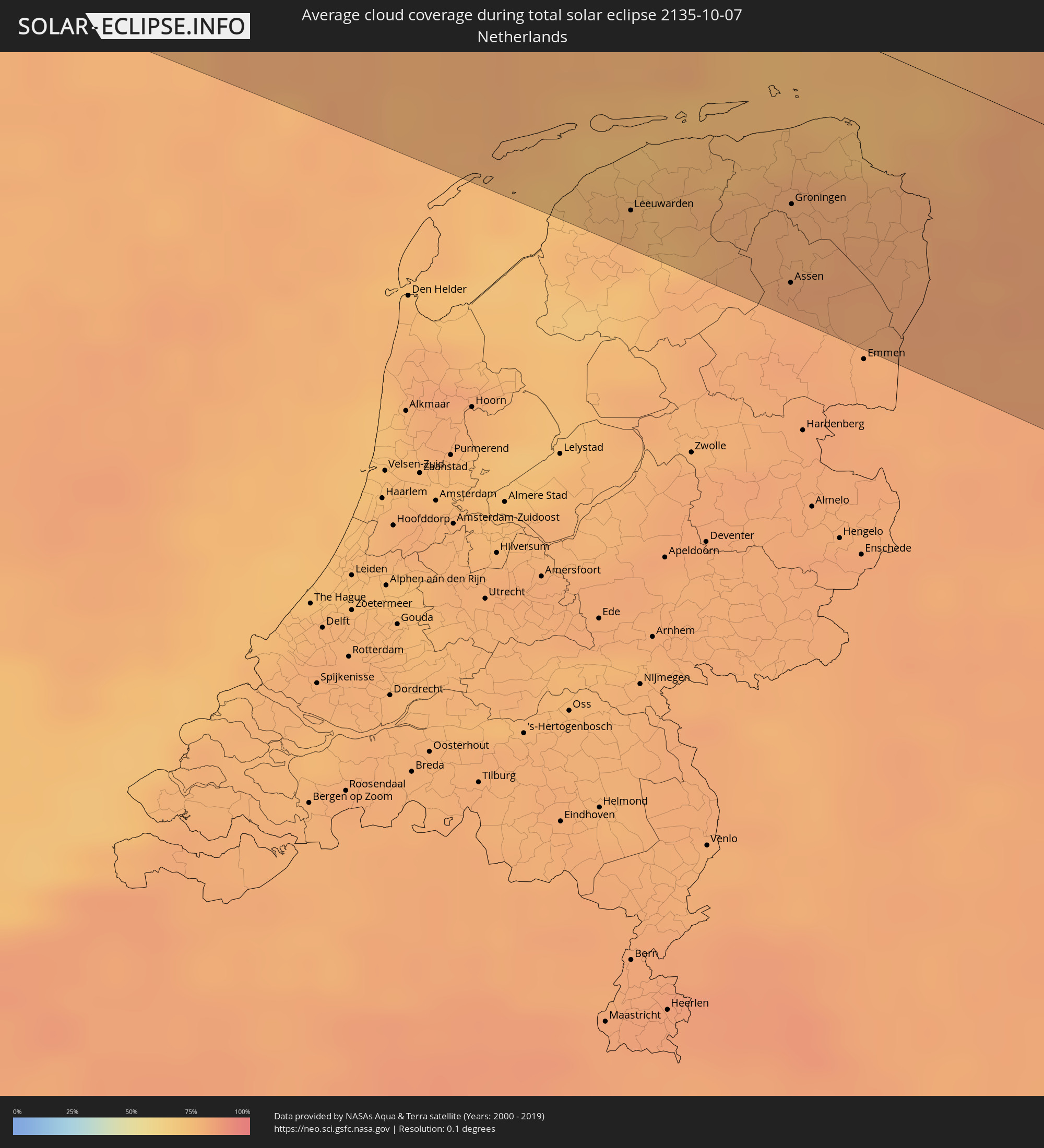 Niederlande
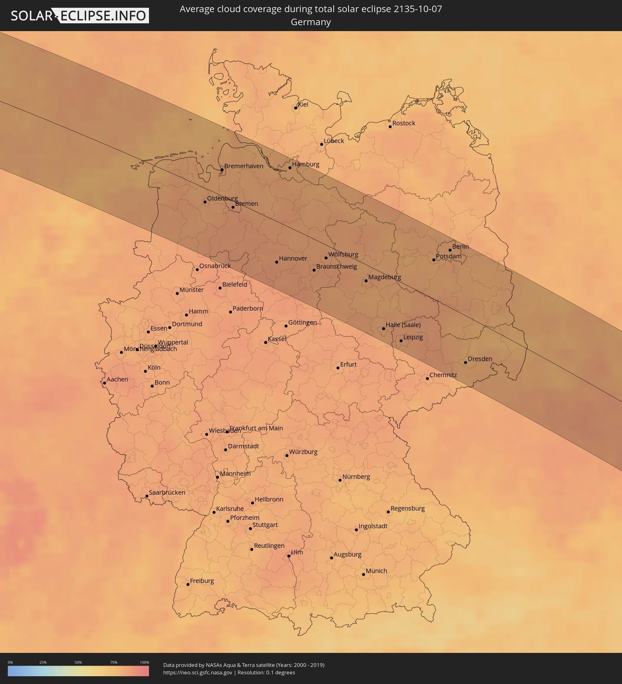 Deutschland
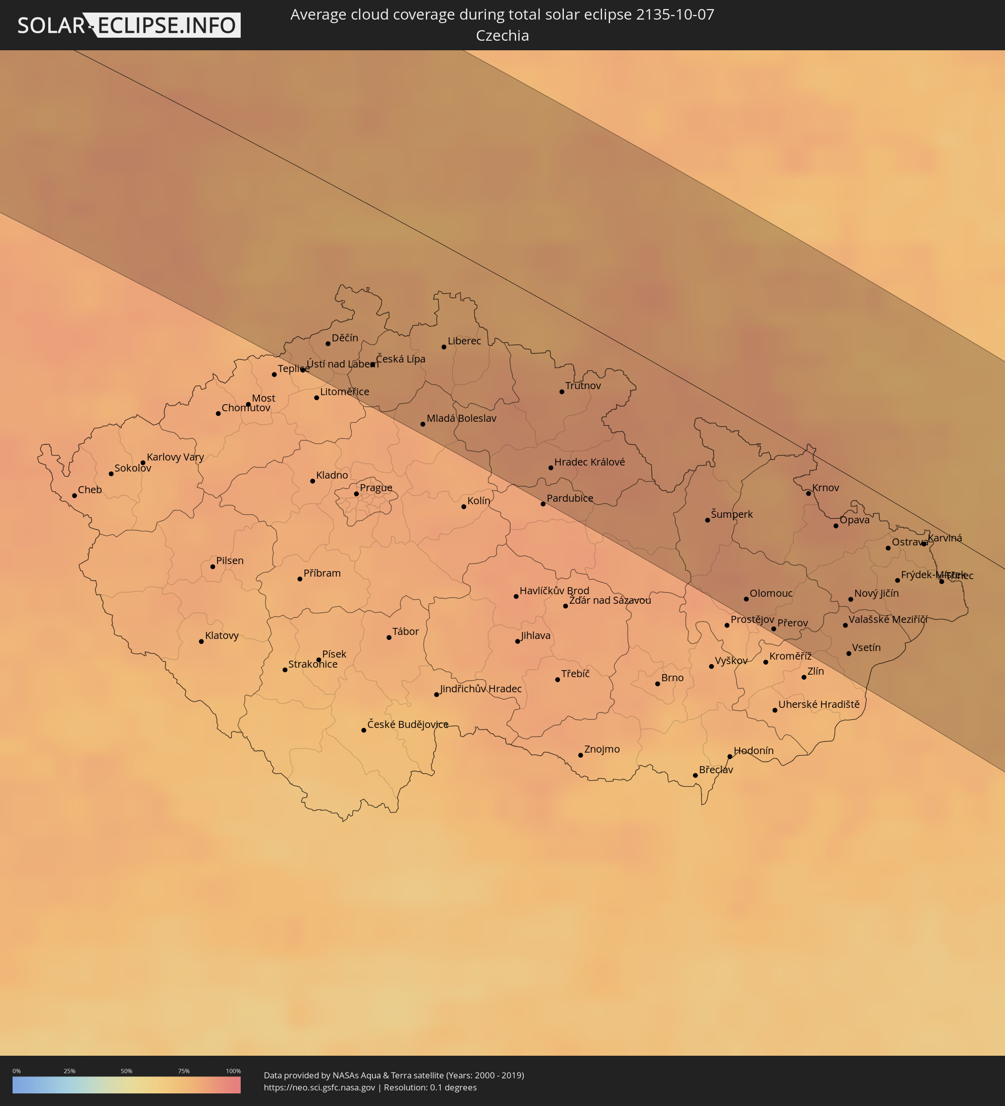 Tschechien
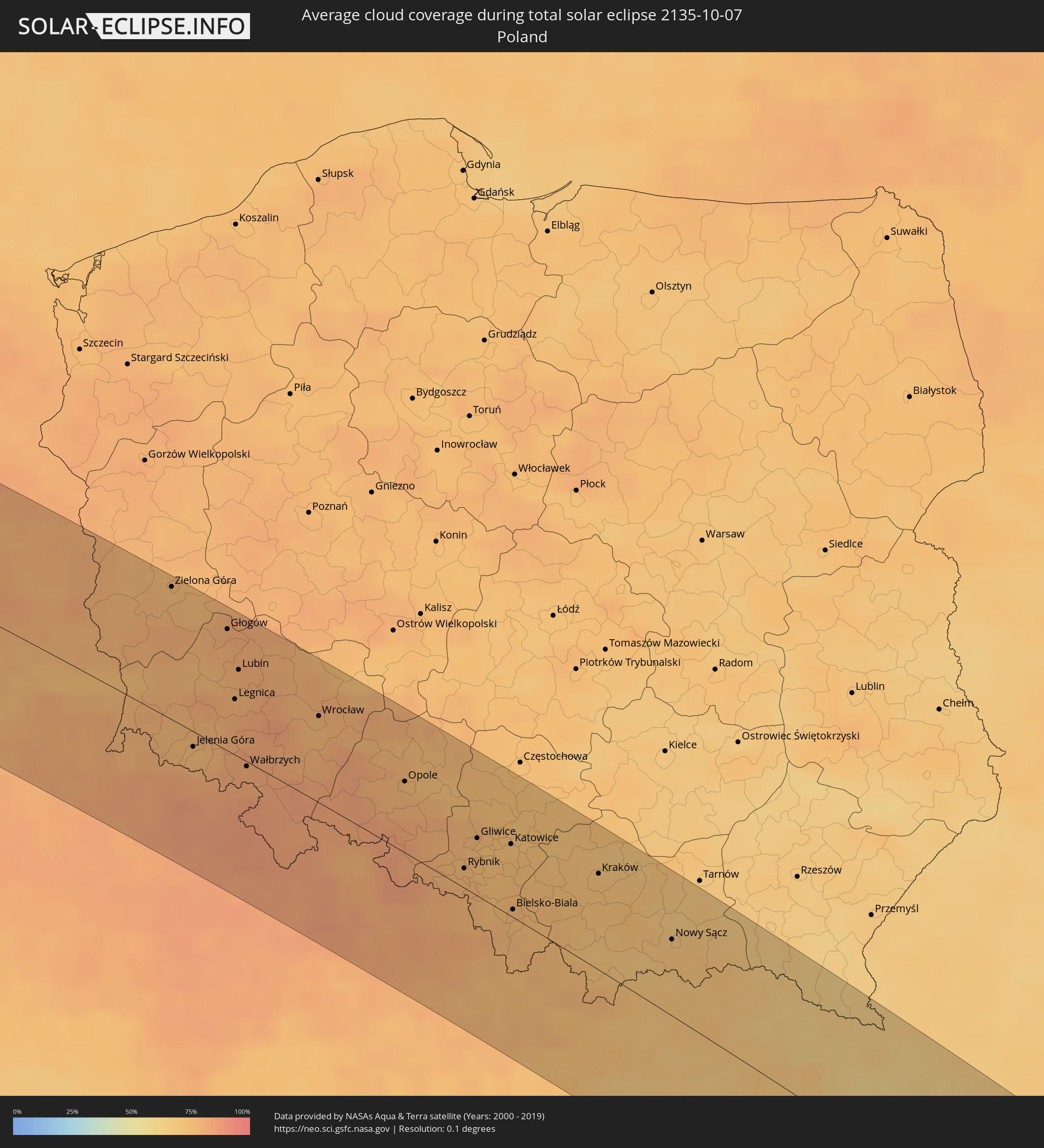 Polen
Polen
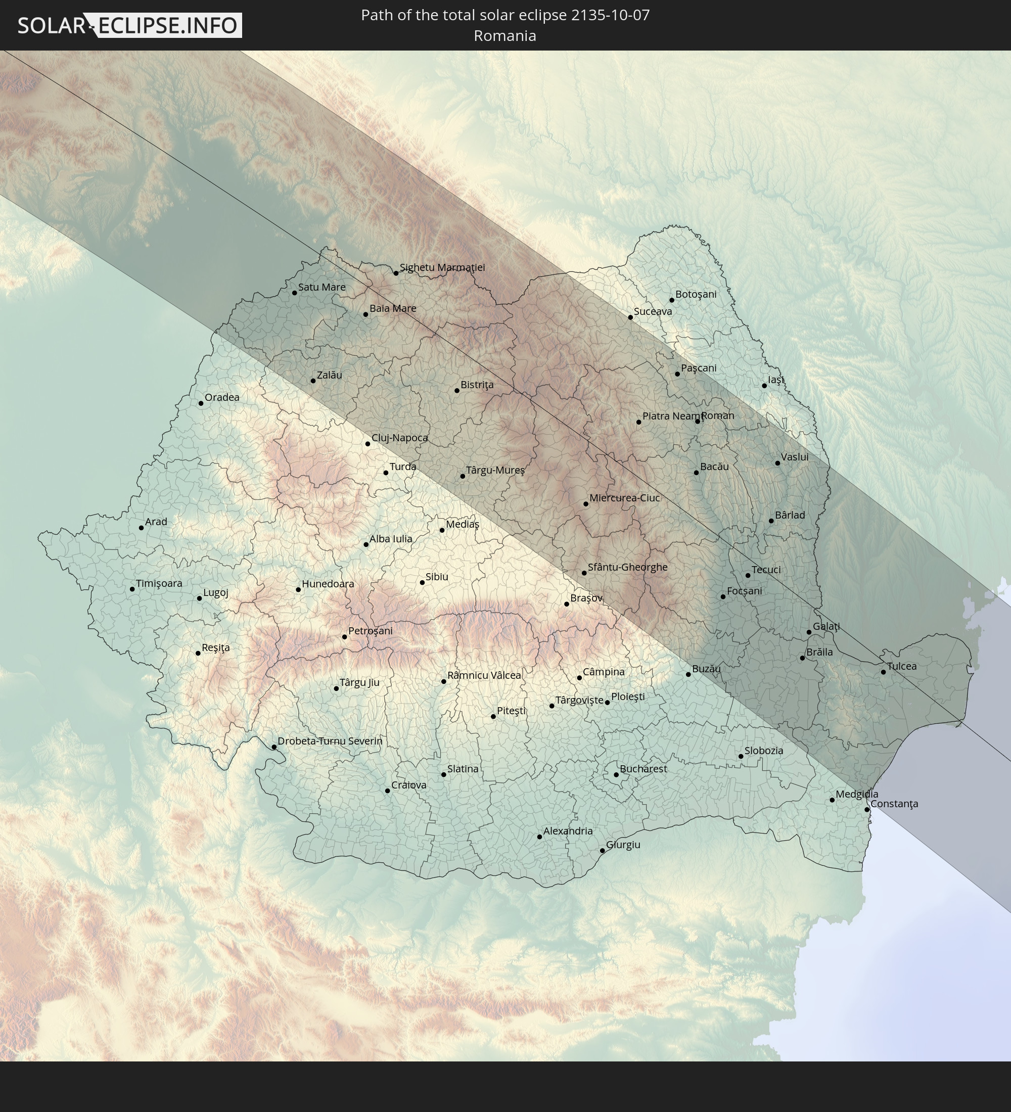
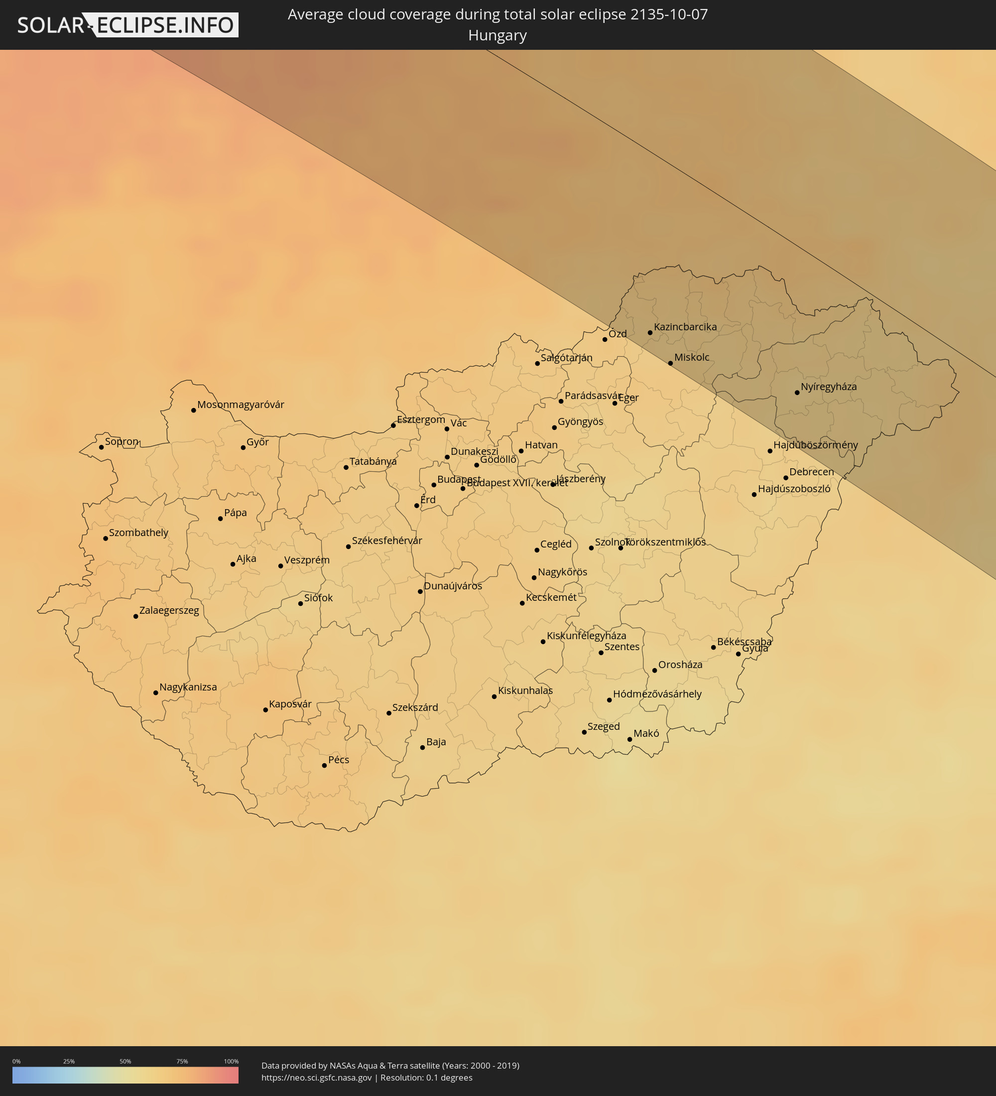 Ungarn
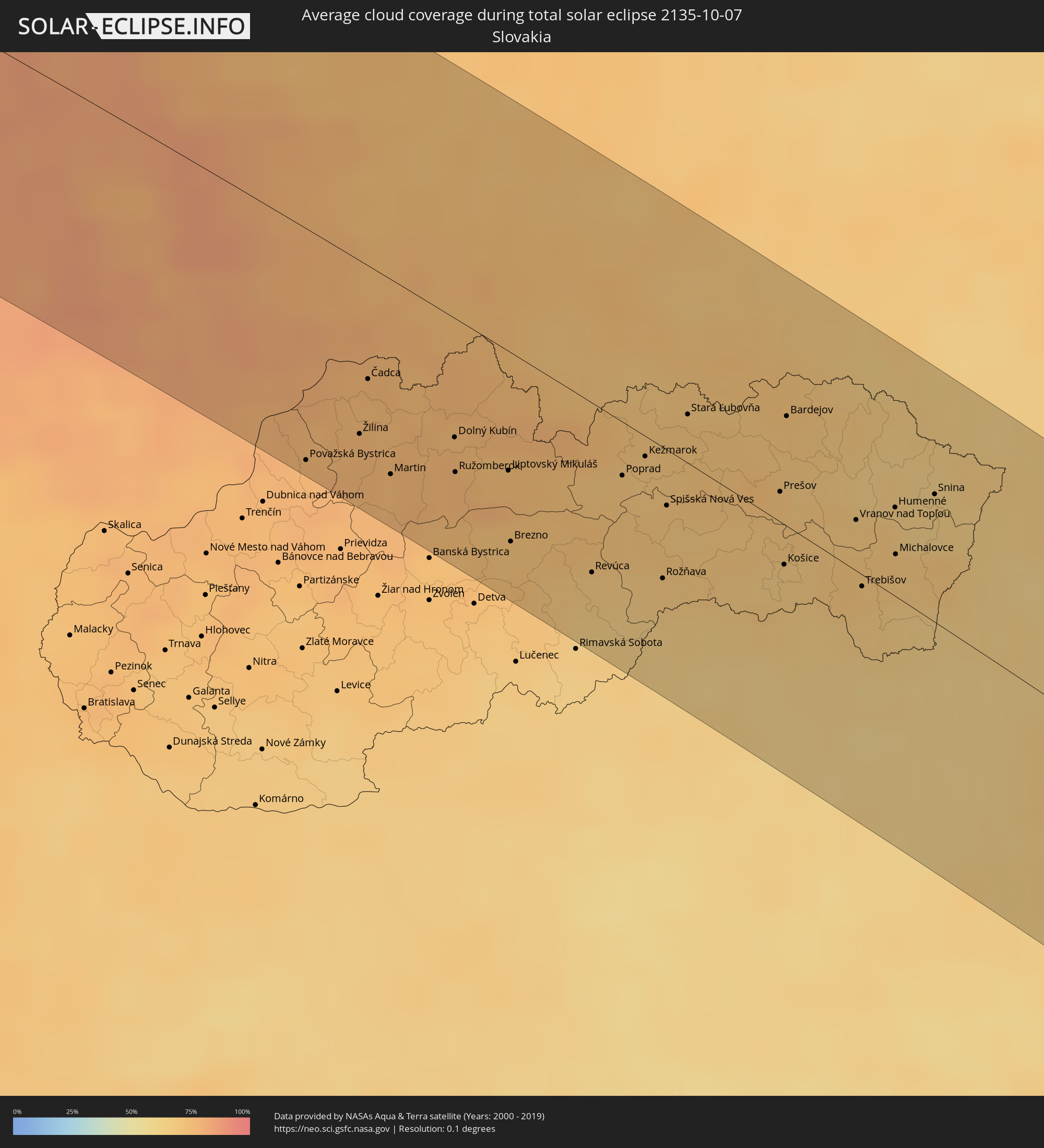 Slowakei
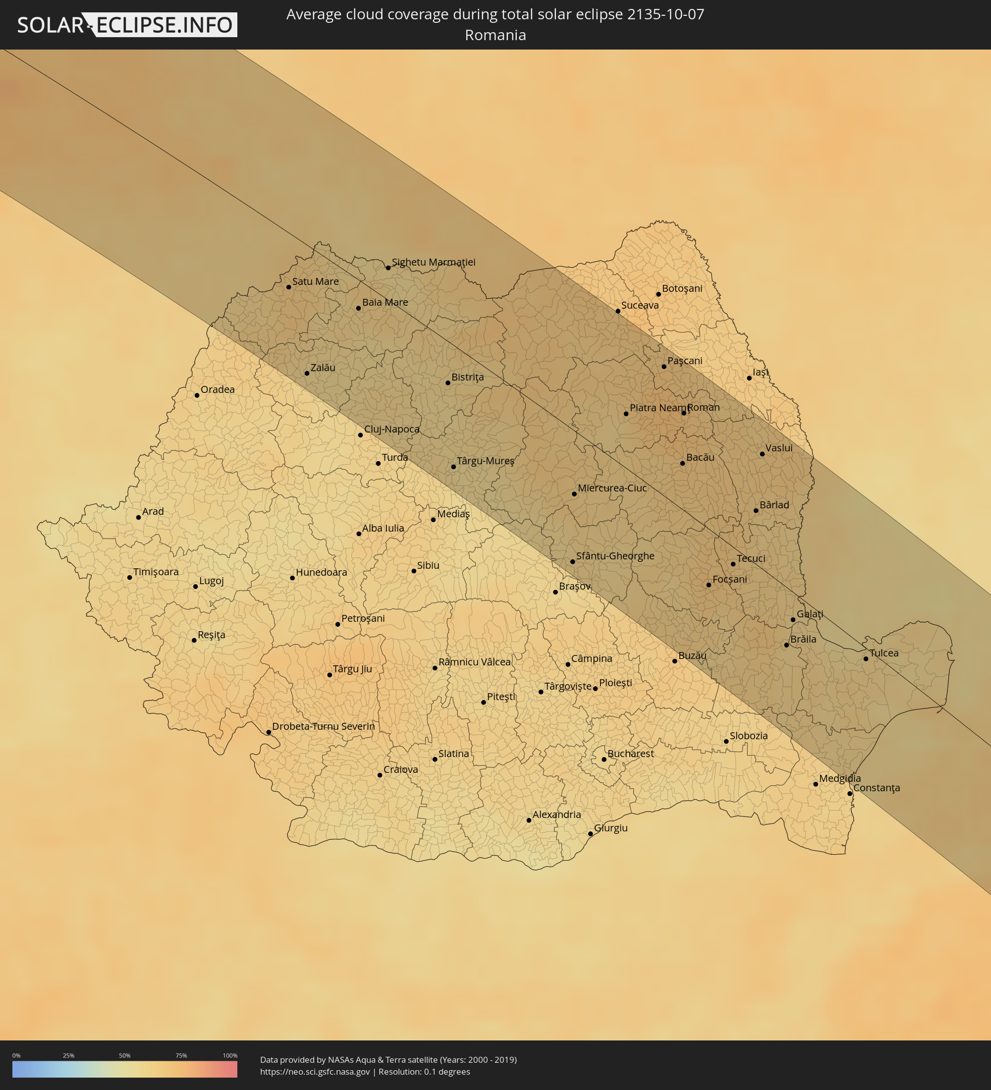 Rumänien
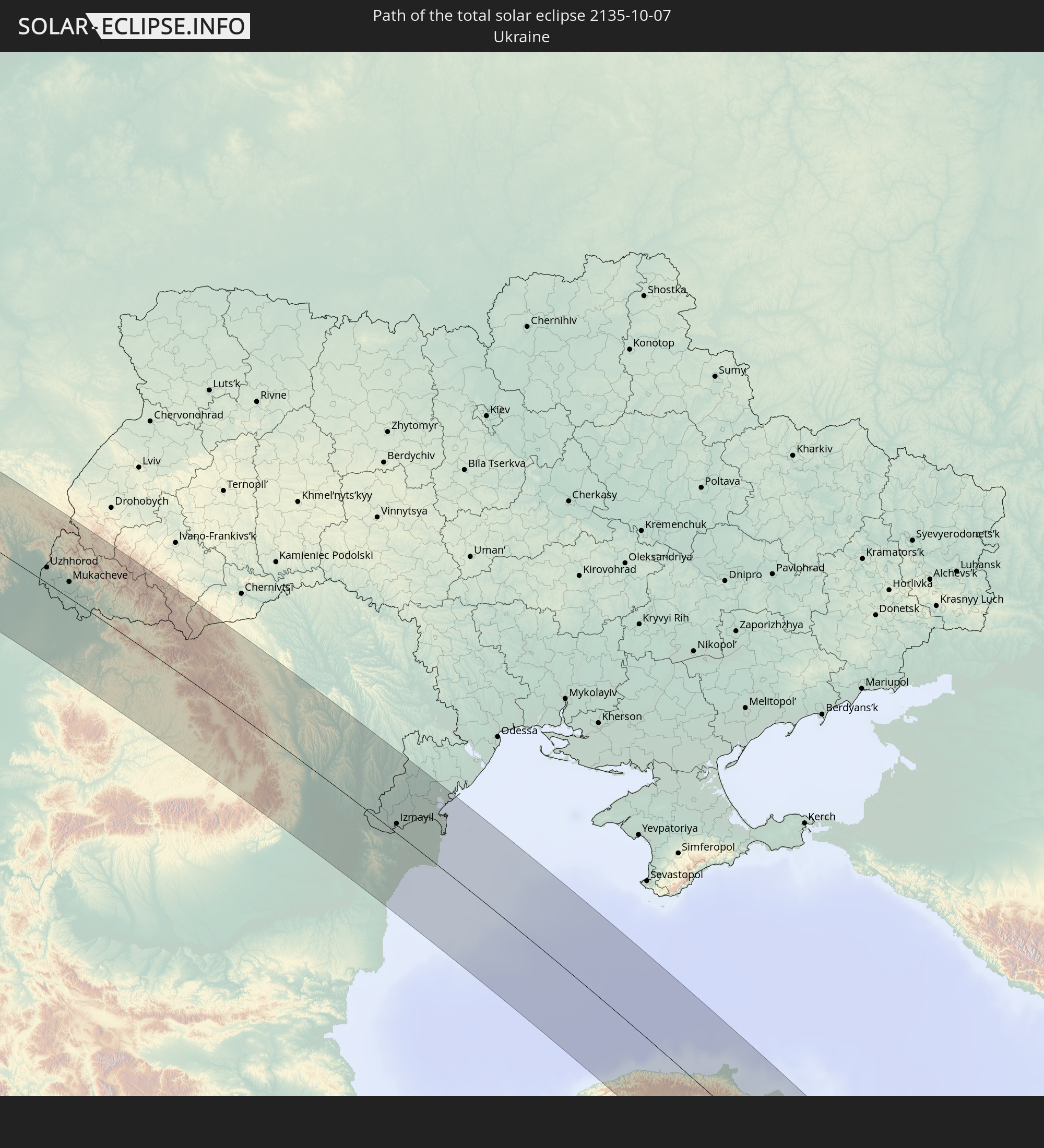
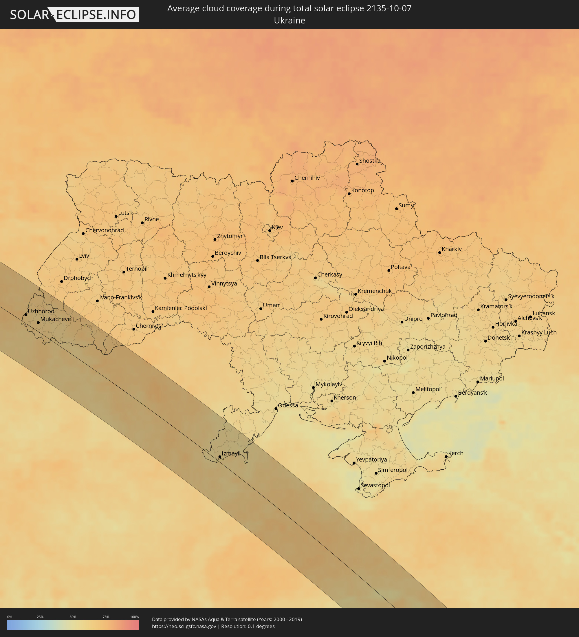 Ukraine
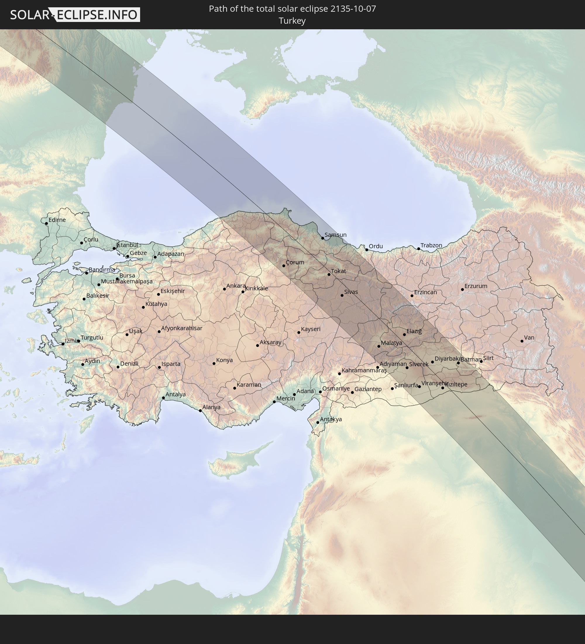
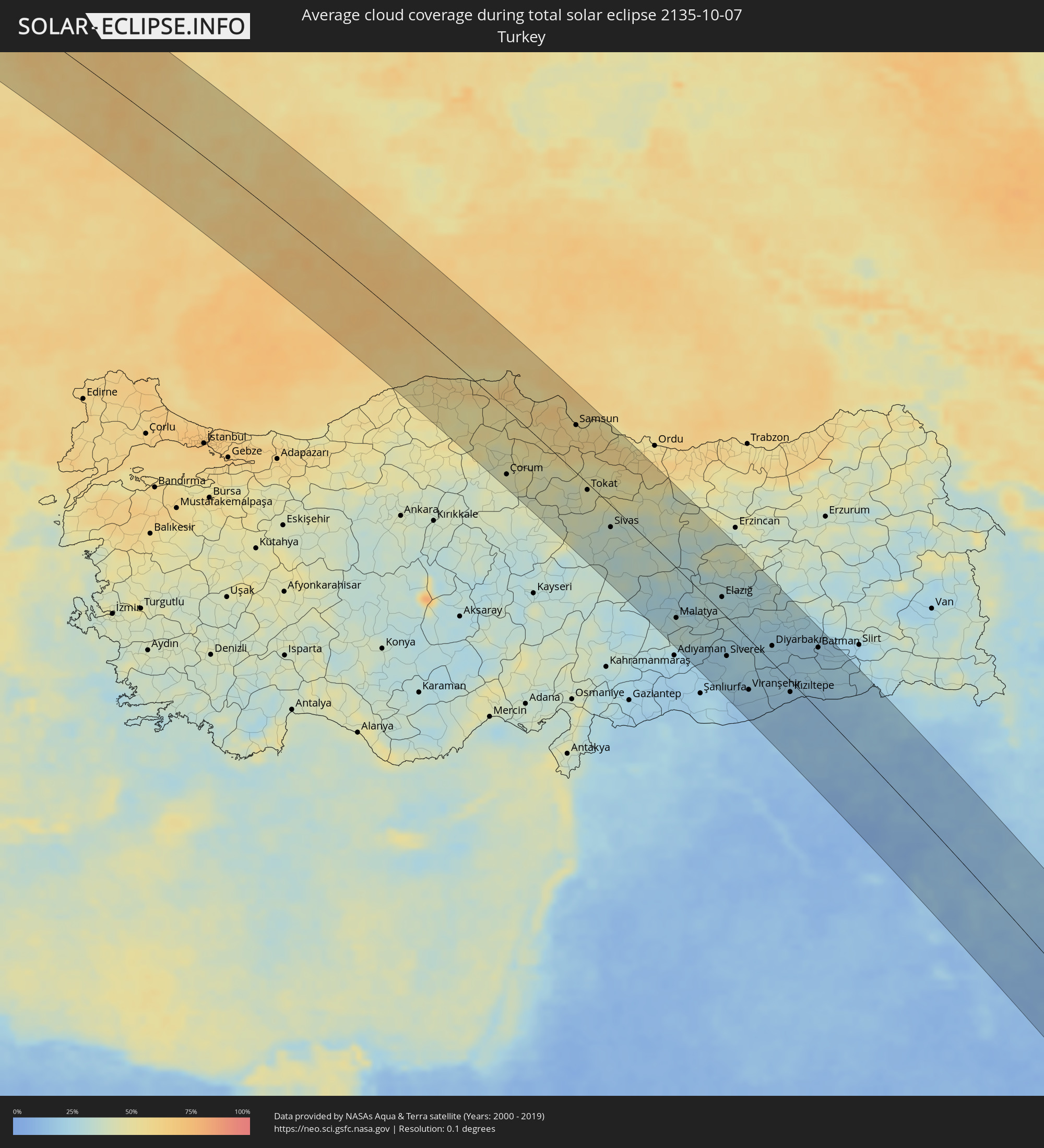 Türkei
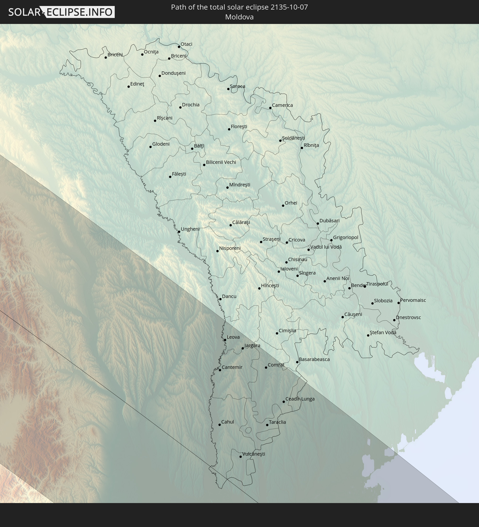
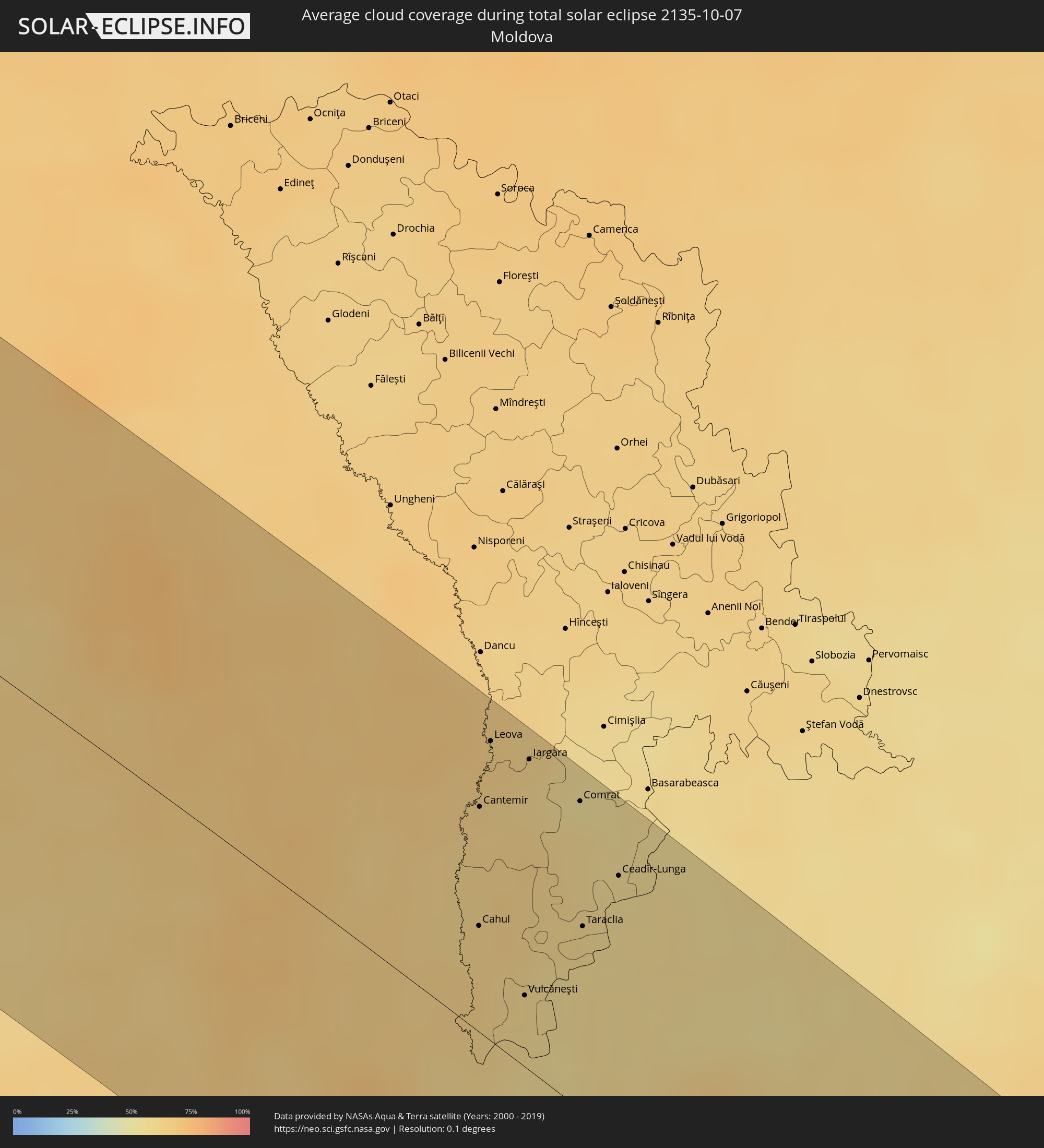 Moldawien
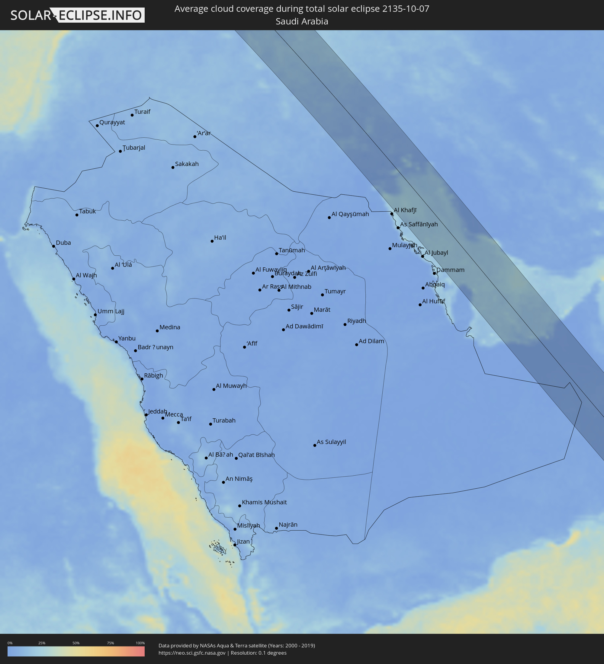 Saudi-Arabien
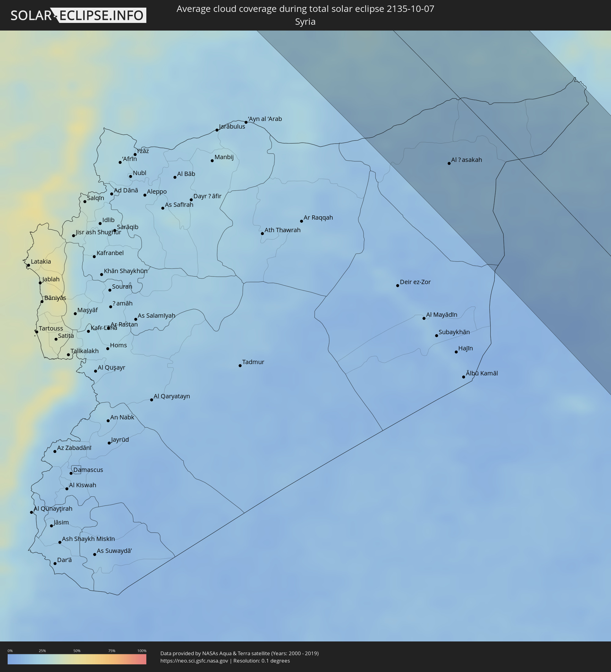 Syrien
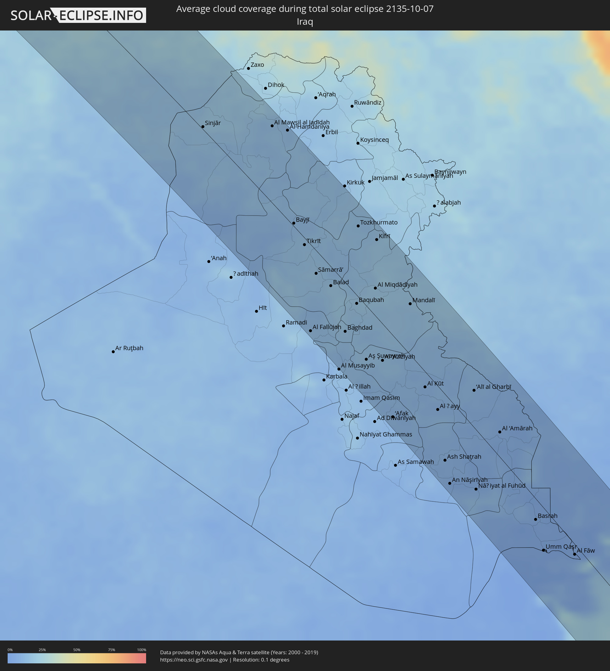 Irak
Irak
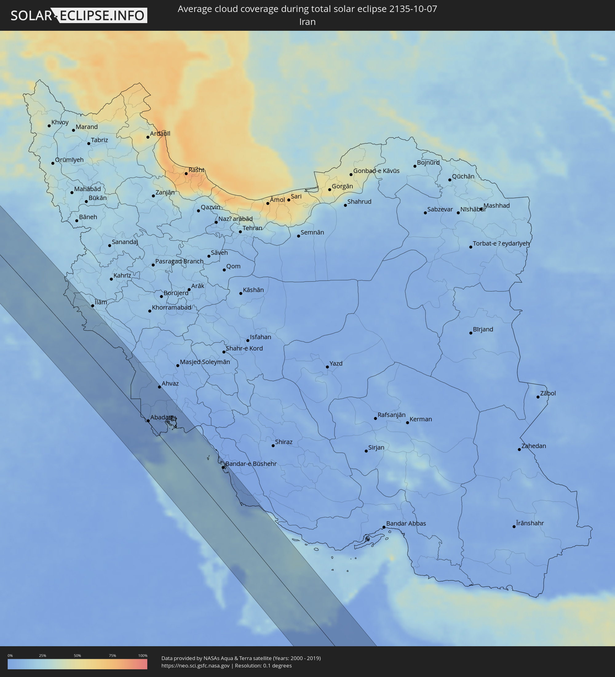 Iran
Iran
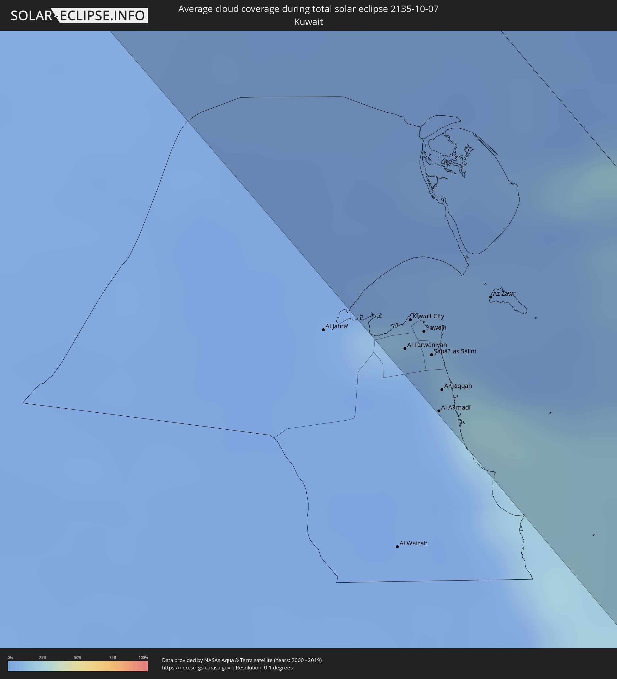 Kuwait
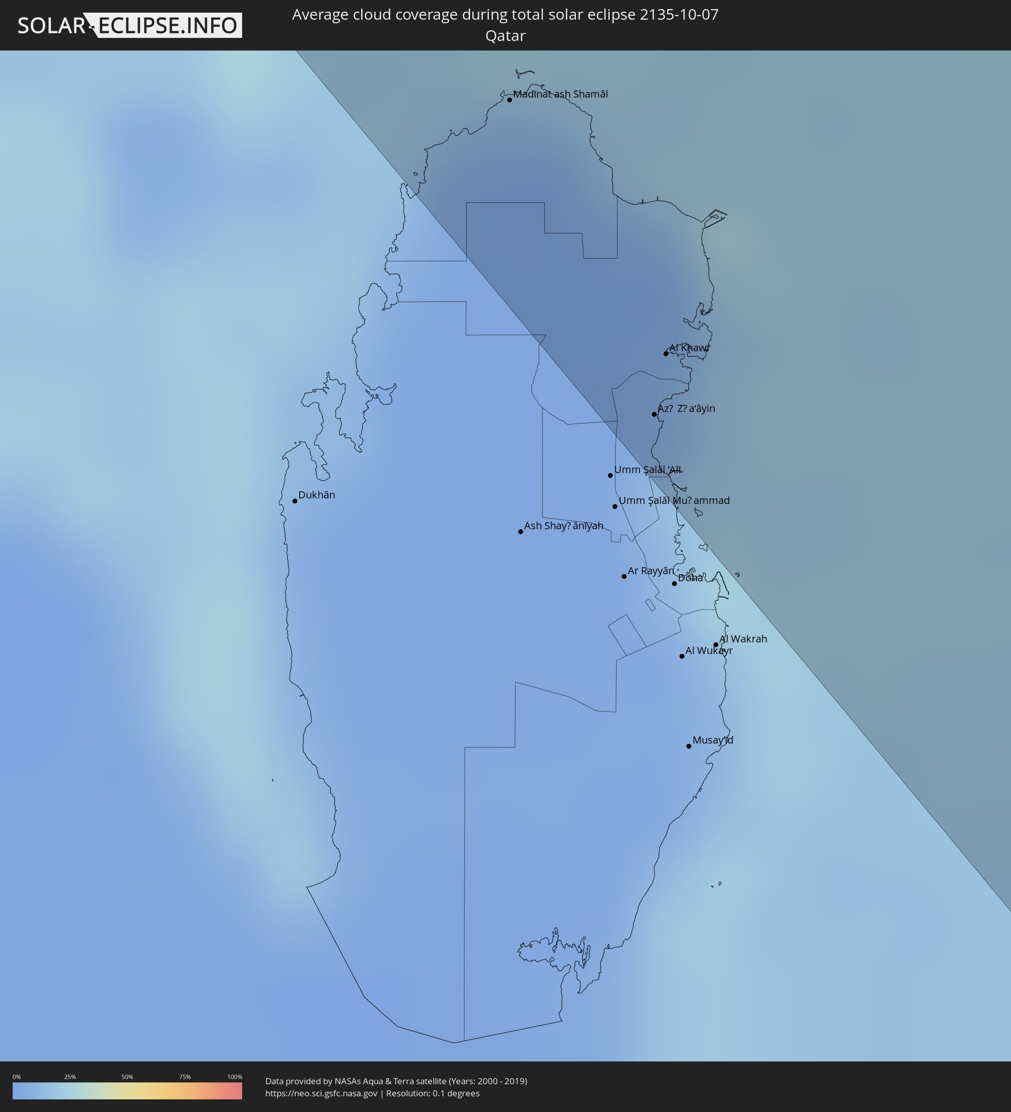 Katar
Katar
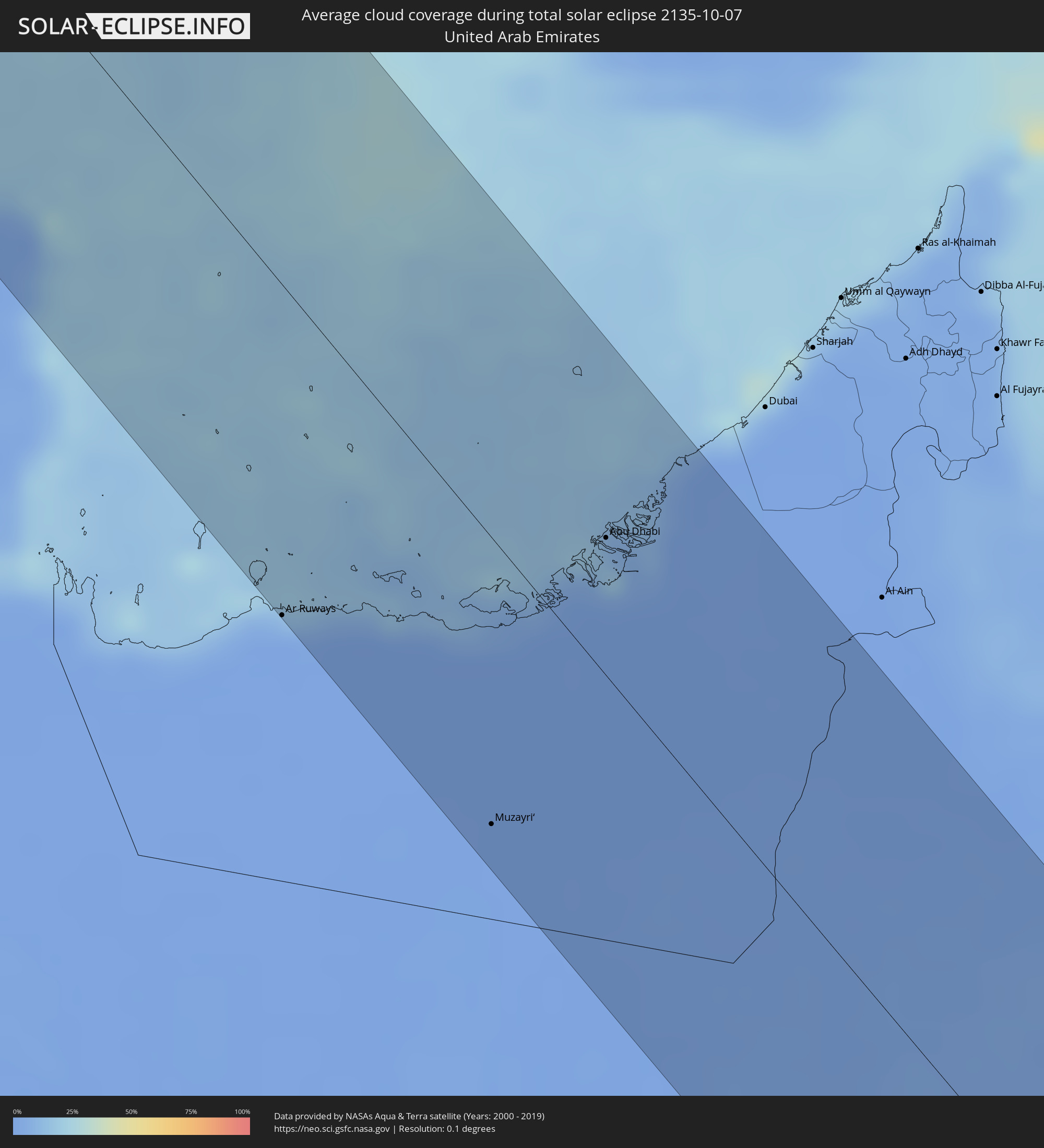 Vereinigte Arabische Emirate
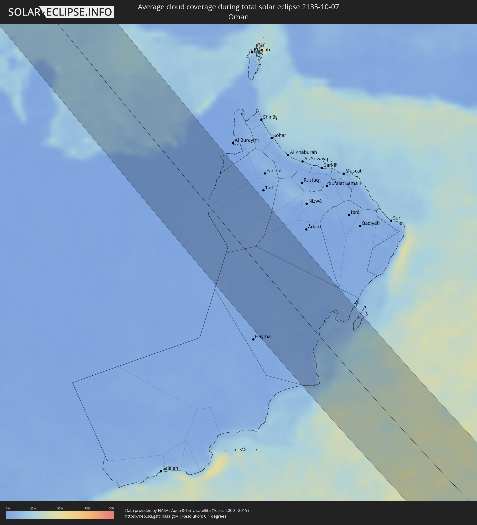 Oman
Oman
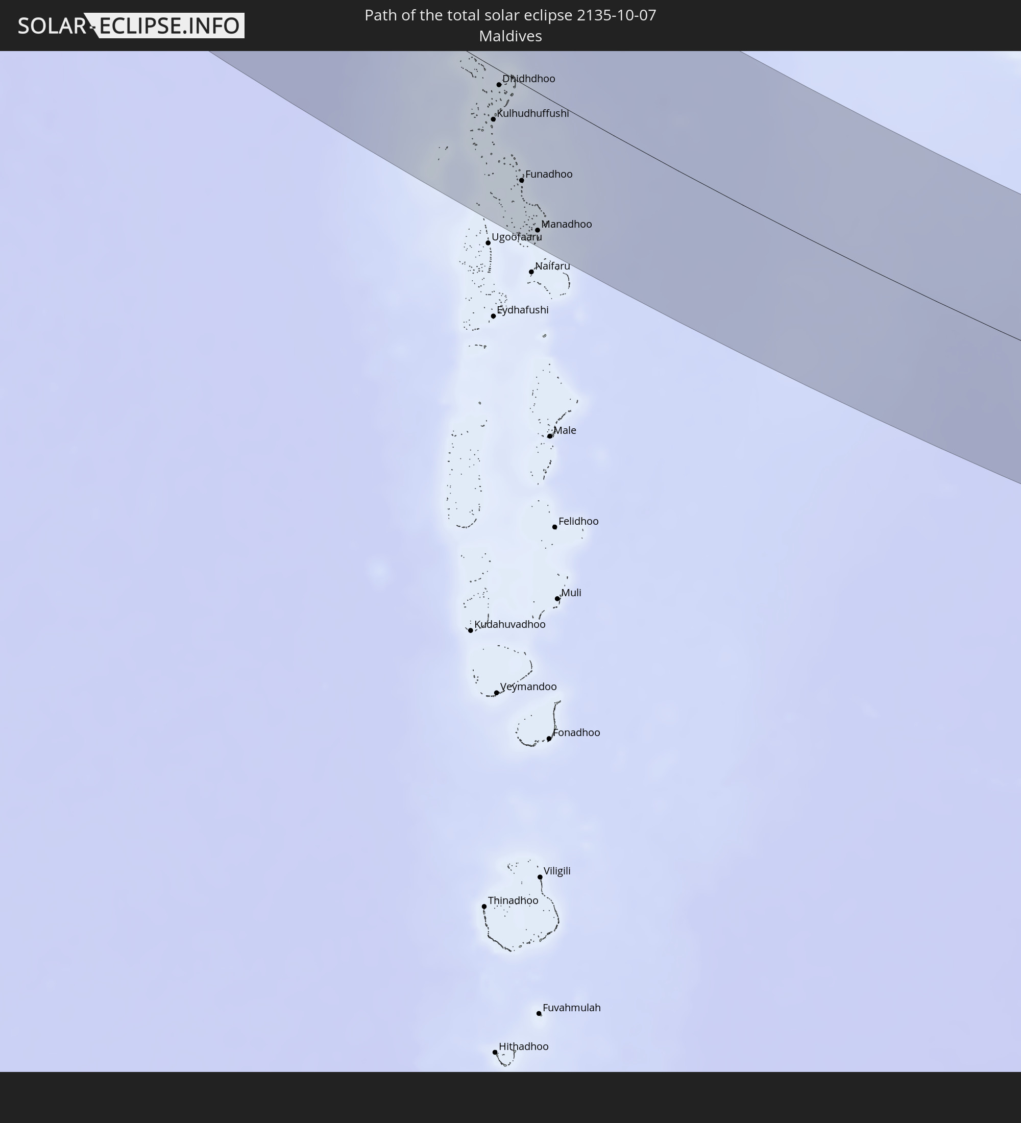
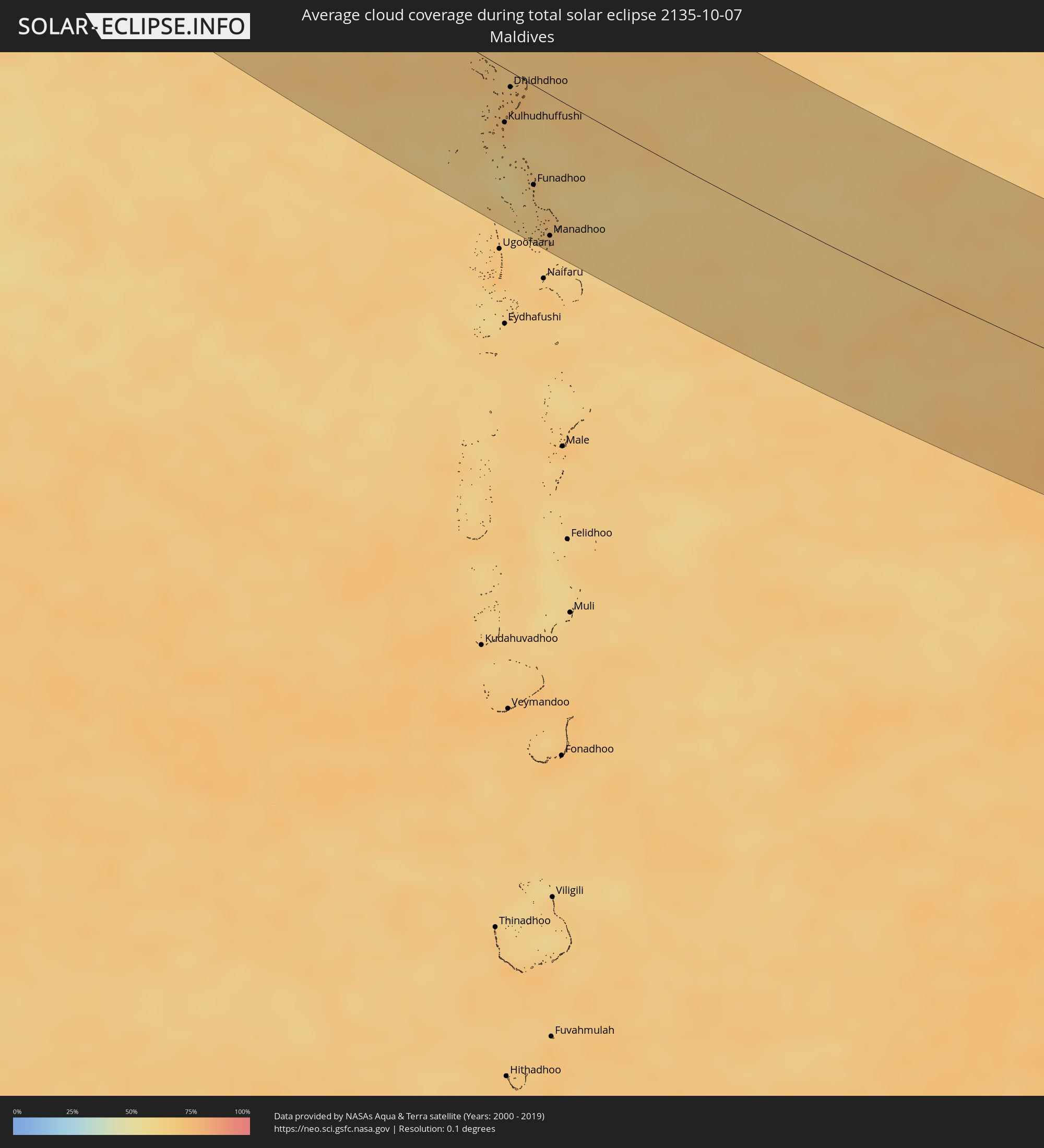 Malediven
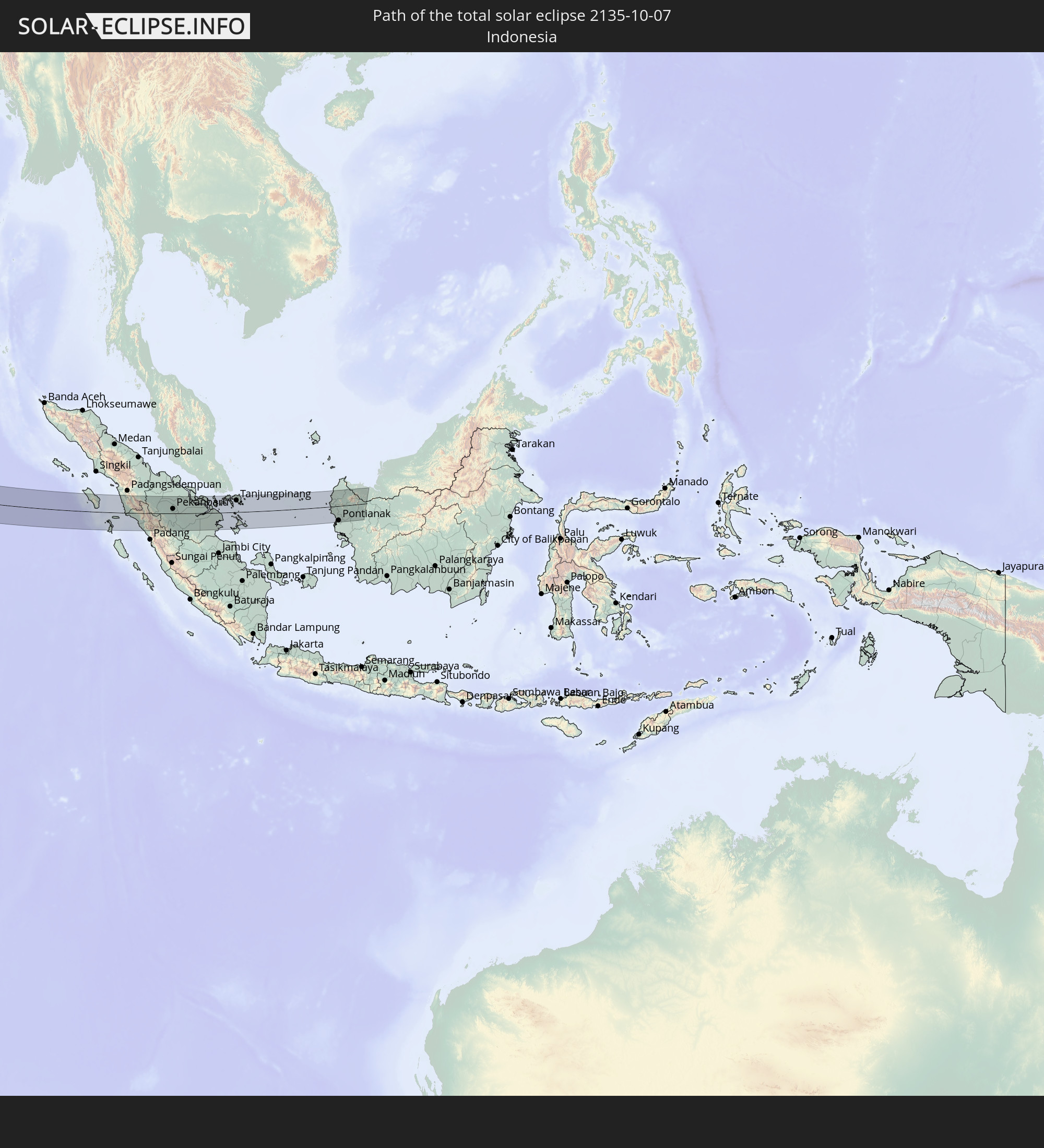
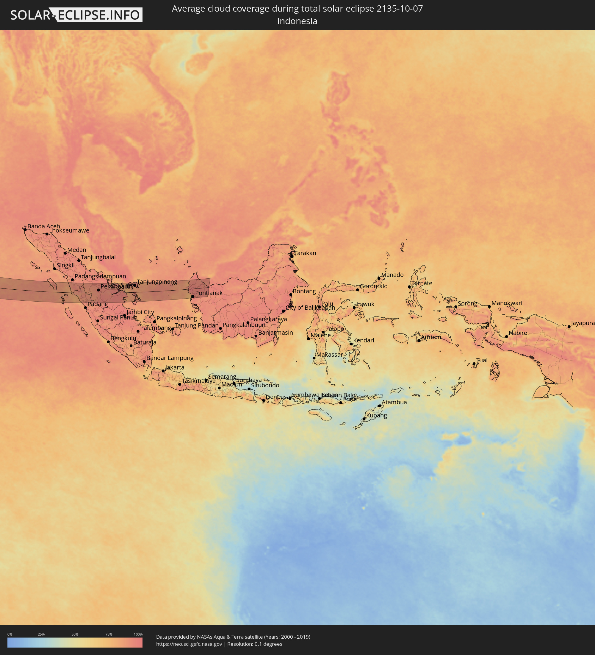 Indonesien
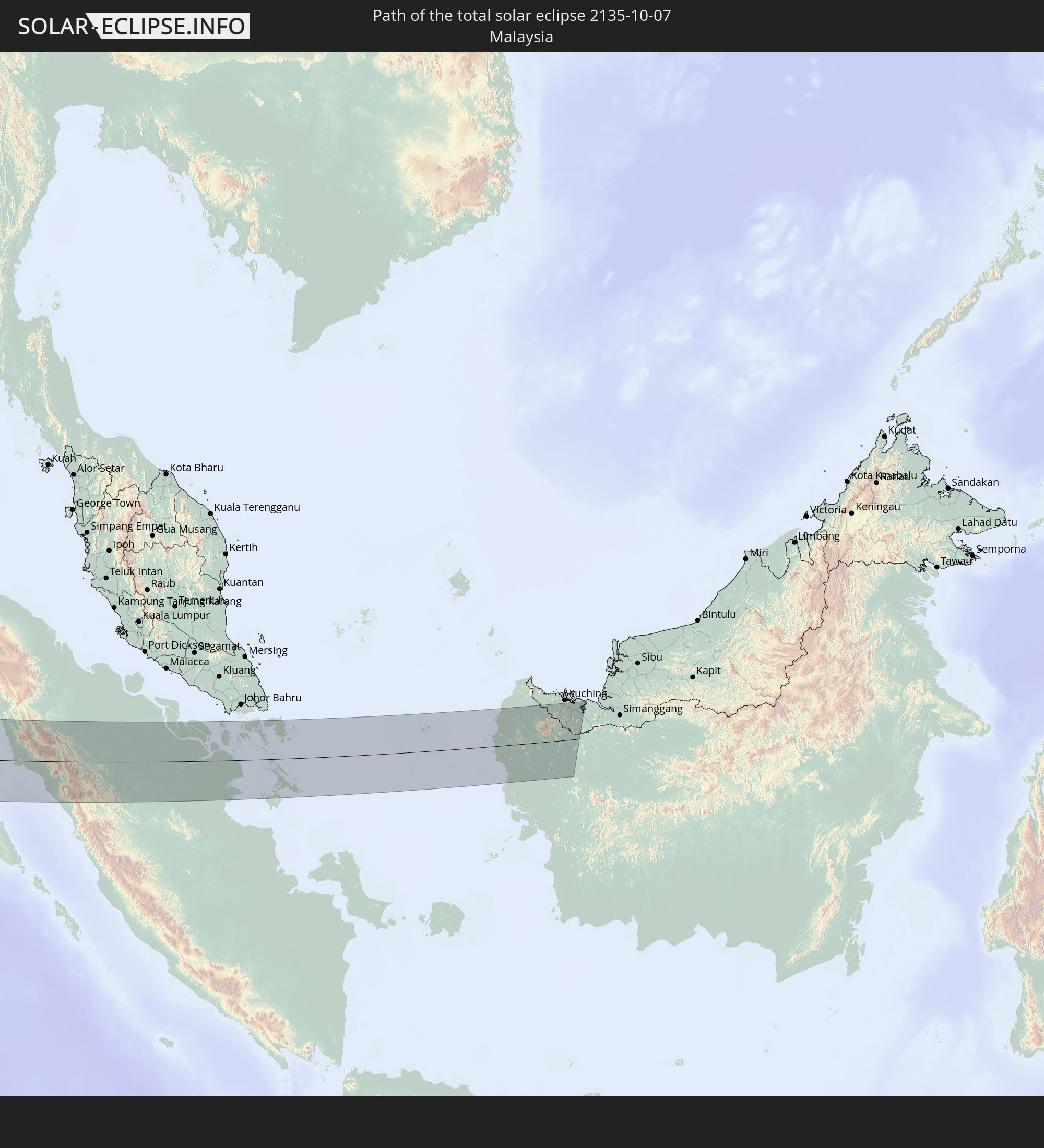
 Malaysia
Orte im Finsternispfad
Die nachfolgene Tabelle zeigt Städte und Orte mit mehr als 5.000 Einwohnern, die sich im Finsternispfad befinden. Städte mit mehr als 100.000 Einwohnern sind dick gekennzeichnet. Mit einem Klick auf den Ort öffnet sich eine Detailkarte die die Lage des jeweiligen Ortes zusammen mit dem Verlauf der zentralen Finsternis präsentiert.
| Ort | Typ | Dauer der Verfinsterung | Ortszeit bei maximaler Verfinsterung | Entfernung zur Zentrallinie | Ø Bewölkung |
|
Glasgow, Scotland
|
total | - | 07:26:17 UTC+00:00 | 17 km | 84% |
|
Hamilton, Scotland
|
total | - | 07:26:17 UTC+00:00 | 24 km | 82% |
|
Cumbernauld, Scotland
|
total | - | 07:26:25 UTC+00:00 | 4 km | 84% |
|
Livingston, Scotland
|
total | - | 07:26:31 UTC+00:00 | 0 km | 82% |
|
Edinburgh, Scotland
|
total | - | 07:26:38 UTC+00:00 | 11 km | 77% |
|
Kirkcaldy, Scotland
|
total | - | 07:26:46 UTC+00:00 | 30 km | 78% |
|
Dundee, Scotland
|
total | - | 07:27:04 UTC+00:00 | 70 km | 79% |
|
Newcastle upon Tyne, England
|
total | - | 07:26:27 UTC+00:00 | 62 km | 78% |
|
Durham, England
|
total | - | 07:26:20 UTC+00:00 | 82 km | 80% |
|
Sunderland, England
|
total | - | 07:26:28 UTC+00:00 | 64 km | 76% |
|
Hartlepool, England
|
total | - | 07:26:23 UTC+00:00 | 84 km | 78% |
|
Franeker, Friesland
|
total | - | 08:28:09 UTC+01:00 | 85 km | 76% |
|
Leeuwarden, Friesland
|
total | - | 08:28:17 UTC+01:00 | 76 km | 78% |
|
Dokkum, Friesland
|
total | - | 08:28:26 UTC+01:00 | 59 km | 76% |
|
Drachten, Friesland
|
total | - | 08:28:22 UTC+01:00 | 78 km | 80% |
|
Grootegast, Groningen
|
total | - | 08:28:30 UTC+01:00 | 63 km | 80% |
|
Assen, Drenthe
|
total | - | 08:28:32 UTC+01:00 | 78 km | 82% |
|
Groningen, Groningen
|
total | - | 08:28:39 UTC+01:00 | 55 km | 80% |
|
Borger, Drenthe
|
total | - | 08:28:37 UTC+01:00 | 79 km | 81% |
|
Veendam, Groningen
|
total | - | 08:28:45 UTC+01:00 | 58 km | 81% |
|
Delfzijl, Groningen
|
total | - | 08:28:52 UTC+01:00 | 34 km | 80% |
|
Vlagtwedde, Groningen
|
total | - | 08:28:49 UTC+01:00 | 60 km | 82% |
|
Oldenburg, Lower Saxony
|
total | - | 08:29:25 UTC+01:00 | 18 km | 81% |
|
Bremen, Bremen
|
total | - | 08:29:41 UTC+01:00 | 8 km | 84% |
|
Hannover, Lower Saxony
|
total | - | 08:29:52 UTC+01:00 | 53 km | 85% |
|
Hamburg, Hamburg
|
total | - | 08:30:34 UTC+01:00 | 76 km | 78% |
|
Braunschweig, Lower Saxony
|
total | - | 08:30:15 UTC+01:00 | 40 km | 83% |
|
Magdeburg, Saxony-Anhalt
|
total | - | 08:30:50 UTC+01:00 | 21 km | 80% |
|
Halle (Saale), Saxony-Anhalt
|
total | - | 08:30:49 UTC+01:00 | 72 km | 81% |
|
Leipzig, Saxony
|
total | - | 08:30:58 UTC+01:00 | 77 km | 81% |
|
Potsdam, Brandenburg
|
total | - | 08:31:47 UTC+01:00 | 50 km | 78% |
|
Berlin, Berlin
|
total | - | 08:32:02 UTC+01:00 | 73 km | 79% |
|
Dresden, Saxony
|
total | - | 08:31:44 UTC+01:00 | 61 km | 78% |
|
Děčín, Ústecký
|
total | - | 08:31:57 UTC+01:00 | 72 km | 81% |
|
Česká Lípa, Liberecký
|
total | - | 08:32:08 UTC+01:00 | 71 km | 80% |
|
Mladá Boleslav, Central Bohemia
|
total | - | 08:32:18 UTC+01:00 | 85 km | 82% |
|
Liberec, Liberecký
|
total | - | 08:32:30 UTC+01:00 | 46 km | 80% |
|
Zielona Góra, Lubusz
|
total | - | 08:33:08 UTC+01:00 | 84 km | 77% |
|
Hradec Králové, Královéhradecký
|
total | - | 08:32:52 UTC+01:00 | 73 km | 84% |
|
Legnica, Lower Silesian Voivodeship
|
total | - | 08:33:21 UTC+01:00 | 35 km | 80% |
|
Wałbrzych, Lower Silesian Voivodeship
|
total | - | 08:33:19 UTC+01:00 | 3 km | 80% |
|
Wrocław, Lower Silesian Voivodeship
|
total | - | 08:33:55 UTC+01:00 | 55 km | 76% |
|
Olomouc, Olomoucký
|
total | - | 08:33:44 UTC+01:00 | 83 km | 82% |
|
Přerov, Olomoucký
|
total | - | 08:33:51 UTC+01:00 | 89 km | 80% |
|
Opava, Moravskoslezský
|
total | - | 08:34:17 UTC+01:00 | 26 km | 81% |
|
Opole, Opole Voivodeship
|
total | - | 08:34:27 UTC+01:00 | 45 km | 77% |
|
Ostrava, Moravskoslezský
|
total | - | 08:34:32 UTC+01:00 | 22 km | 79% |
|
Frýdek-Místek, Moravskoslezský
|
total | - | 08:34:33 UTC+01:00 | 34 km | 81% |
|
Považská Bystrica, Trenčiansky
|
total | - | 08:34:31 UTC+01:00 | 85 km | 76% |
|
Karviná, Moravskoslezský
|
total | - | 08:34:44 UTC+01:00 | 11 km | 77% |
|
Rybnik, Silesian Voivodeship
|
total | - | 08:34:46 UTC+01:00 | 12 km | 76% |
|
Gliwice, Silesian Voivodeship
|
total | - | 08:34:55 UTC+01:00 | 37 km | 74% |
|
Žilina, Žilinský
|
total | - | 08:34:46 UTC+01:00 | 64 km | 75% |
|
Martin, Žilinský
|
total | - | 08:34:54 UTC+01:00 | 72 km | 75% |
|
Katowice, Silesian Voivodeship
|
total | - | 08:35:10 UTC+01:00 | 46 km | 73% |
|
Bielsko-Biala, Silesian Voivodeship
|
total | - | 08:35:06 UTC+01:00 | 5 km | 76% |
|
Dąbrowa Górnicza, Silesian Voivodeship
|
total | - | 08:35:20 UTC+01:00 | 59 km | 72% |
|
Liptovský Mikuláš, Žilinský
|
total | - | 08:35:26 UTC+01:00 | 44 km | 75% |
|
Kraków, Lesser Poland Voivodeship
|
total | - | 08:35:49 UTC+01:00 | 61 km | 72% |
|
Poprad, Prešovský
|
total | - | 08:35:57 UTC+01:00 | 20 km | 70% |
|
Spišská Nová Ves, Košický
|
total | - | 08:36:09 UTC+01:00 | 20 km | 68% |
|
Kazincbarcika, Borsod-Abaúj-Zemplén
|
total | - | 08:36:09 UTC+01:00 | 83 km | 63% |
|
Miskolc, Borsod-Abaúj-Zemplén
|
total | - | 08:36:16 UTC+01:00 | 91 km | 65% |
|
Szerencs, Borsod-Abaúj-Zemplén
|
total | - | 08:36:37 UTC+01:00 | 69 km | 61% |
|
Prešov, Prešovský
|
total | - | 08:36:42 UTC+01:00 | 11 km | 71% |
|
Košice, Košický
|
total | - | 08:36:41 UTC+01:00 | 15 km | 68% |
|
Bardejov, Prešovský
|
total | - | 08:36:45 UTC+01:00 | 40 km | 70% |
|
Hajdúnánás, Hajdú-Bihar
|
total | - | 08:36:47 UTC+01:00 | 89 km | 61% |
|
Sátoraljaújhely, Borsod-Abaúj-Zemplén
|
total | - | 08:37:00 UTC+01:00 | 29 km | 65% |
|
Újfehértó, Szabolcs-Szatmár-Bereg
|
total | - | 08:37:00 UTC+01:00 | 83 km | 63% |
|
Nyíregyháza, Szabolcs-Szatmár-Bereg
|
total | - | 08:37:02 UTC+01:00 | 67 km | 61% |
|
Humenné, Prešovský
|
total | - | 08:37:14 UTC+01:00 | 32 km | 67% |
|
Michalovce, Košický
|
total | - | 08:37:14 UTC+01:00 | 15 km | 70% |
|
Kisvárda, Szabolcs-Szatmár-Bereg
|
total | - | 08:37:20 UTC+01:00 | 28 km | 62% |
|
Nyírbátor, Szabolcs-Szatmár-Bereg
|
total | - | 08:37:22 UTC+01:00 | 62 km | 62% |
|
Uzhhorod, Zakarpattia
|
total | - | 09:37:32 UTC+02:00 | 18 km | 65% |
|
Vásárosnamény, Szabolcs-Szatmár-Bereg
|
total | - | 08:37:32 UTC+01:00 | 27 km | 61% |
|
Mátészalka, Szabolcs-Szatmár-Bereg
|
total | - | 08:37:32 UTC+01:00 | 43 km | 61% |
|
Berehove, Zakarpattia
|
total | - | 09:37:49 UTC+02:00 | 6 km | 62% |
|
Mukacheve, Zakarpattia
|
total | - | 09:37:53 UTC+02:00 | 18 km | 63% |
|
Satu Mare, Satu Mare
|
total | - | 09:37:59 UTC+02:00 | 35 km | 67% |
|
Svalyava, Zakarpattia
|
total | - | 09:38:07 UTC+02:00 | 40 km | 61% |
|
Vynohradiv, Zakarpattia
|
total | - | 09:38:08 UTC+02:00 | 4 km | 65% |
|
Khust, Zakarpattia
|
total | - | 09:38:22 UTC+02:00 | 18 km | 61% |
|
Baia Mare, Satu Mare
|
total | - | 09:38:37 UTC+02:00 | 18 km | 62% |
|
Bistriţa, Bistriţa-Năsăud
|
total | - | 09:39:27 UTC+02:00 | 27 km | 58% |
|
Târgu-Mureş, Mureş
|
total | - | 09:39:33 UTC+02:00 | 78 km | 58% |
|
Piatra Neamţ, Neamţ
|
total | - | 09:41:09 UTC+02:00 | 34 km | 63% |
|
Bacău, Bacău
|
total | - | 09:41:44 UTC+02:00 | 29 km | 68% |
|
Focșani, Vrancea
|
total | - | 09:42:09 UTC+02:00 | 36 km | 65% |
|
Vaslui, Vaslui
|
total | - | 09:42:31 UTC+02:00 | 73 km | 66% |
|
Brăila, Brăila
|
total | - | 09:43:02 UTC+02:00 | 37 km | 61% |
|
Galaţi, Galaţi
|
total | - | 09:43:03 UTC+02:00 | 18 km | 60% |
|
Cahul, Cahul
|
total | - | 09:43:06 UTC+02:00 | 30 km | 62% |
|
Cantemir, Cantemir
|
total | - | 09:43:02 UTC+02:00 | 63 km | 62% |
|
Leova, Leova
|
total | - | 09:43:03 UTC+02:00 | 83 km | 63% |
|
Reni, Odessa
|
total | - | 09:43:18 UTC+02:00 | 6 km | 58% |
|
Vulcăneşti, Găgăuzia
|
total | - | 09:43:21 UTC+02:00 | 20 km | 58% |
|
Iargara, Cantemir
|
total | - | 09:43:13 UTC+02:00 | 86 km | 60% |
|
Bolhrad, Odessa
|
total | - | 09:43:34 UTC+02:00 | 30 km | 56% |
|
Comrat, Găgăuzia
|
total | - | 09:43:29 UTC+02:00 | 86 km | 58% |
|
Taraclia, Taraclia
|
total | - | 09:43:34 UTC+02:00 | 52 km | 56% |
|
Tulcea, Tulcea
|
total | - | 09:43:52 UTC+02:00 | 7 km | 63% |
|
Ceadîr-Lunga, Găgăuzia
|
total | - | 09:43:42 UTC+02:00 | 73 km | 57% |
|
Izmayil, Odessa
|
total | - | 09:43:52 UTC+02:00 | 11 km | 61% |
|
Kiliya, Odessa
|
total | - | 09:44:16 UTC+02:00 | 41 km | 63% |
|
Artsyz, Odessa
|
total | - | 09:44:18 UTC+02:00 | 95 km | 56% |
|
Çorum, Çorum
|
total | - | 10:52:47 UTC+03:00 | 80 km | 43% |
|
Samsun, Samsun
|
total | - | 10:54:01 UTC+03:00 | 58 km | 57% |
|
Tokat, Tokat
|
total | - | 10:54:55 UTC+03:00 | 8 km | 45% |
|
Sivas, Sivas
|
total | - | 10:55:54 UTC+03:00 | 27 km | 37% |
|
Malatya, Malatya
|
total | - | 10:58:40 UTC+03:00 | 62 km | 30% |
|
Elazığ, Elazığ
|
total | - | 10:59:36 UTC+03:00 | 19 km | 29% |
|
Siverek, Şanlıurfa
|
total | - | 11:00:30 UTC+03:00 | 48 km | 21% |
|
Viranşehir, Şanlıurfa
|
total | - | 11:01:34 UTC+03:00 | 62 km | 20% |
|
Diyarbakır, Diyarbakır
|
total | - | 11:01:35 UTC+03:00 | 21 km | 22% |
|
Kızıltepe, Mardin
|
total | - | 11:02:44 UTC+03:00 | 13 km | 17% |
|
Ad Darbāsīyah, Al-Hasakah
|
total | - | 10:02:57 UTC+02:00 | 18 km | 15% |
|
Al Ḩasakah, Al-Hasakah
|
total | - | 10:03:38 UTC+02:00 | 56 km | 17% |
|
Batman, Batman
|
total | - | 11:02:51 UTC+03:00 | 76 km | 21% |
|
Al Mawşil al Jadīdah, Nīnawá
|
total | - | 11:07:08 UTC+03:00 | 84 km | 14% |
|
Al Fallūjah, Anbar
|
total | - | 11:11:28 UTC+03:00 | 96 km | 13% |
|
Sāmarrā’, Salah ad Din Governorate
|
total | - | 11:10:37 UTC+03:00 | 25 km | 15% |
|
Abū Ghurayb, Mayorality of Baghdad
|
total | - | 11:12:07 UTC+03:00 | 72 km | 14% |
|
Baghdad, Mayorality of Baghdad
|
total | - | 11:12:24 UTC+03:00 | 54 km | 13% |
|
Baqubah, Diyālá
|
total | - | 11:12:13 UTC+03:00 | 9 km | 17% |
|
Al Kūt, Wāsiţ
|
total | - | 11:15:36 UTC+03:00 | 17 km | 9% |
|
Mehrān, Īlām
|
total | - | 11:45:21 UTC+03:30 | 52 km | 12% |
|
An Nāşirīyah, Dhi Qar
|
total | - | 11:18:12 UTC+03:00 | 93 km | 7% |
|
Al ‘Amārah, Maysan
|
total | - | 11:18:33 UTC+03:00 | 28 km | 6% |
|
Dehlorān, Īlām
|
total | - | 11:47:36 UTC+03:30 | 99 km | 9% |
|
Basrah, Basra Governorate
|
total | - | 11:21:23 UTC+03:00 | 23 km | 4% |
|
Umm Qaşr, Basra Governorate
|
total | - | 11:22:16 UTC+03:00 | 47 km | 3% |
|
Ar Rābiyah, Al Asimah
|
total | - | 11:23:22 UTC+03:00 | 100 km | 2% |
|
Ash Shāmīyah, Al Asimah
|
total | - | 11:23:20 UTC+03:00 | 94 km | 4% |
|
Janūb as Surrah, Al Farwaniyah
|
total | - | 11:23:29 UTC+03:00 | 99 km | 4% |
|
Ad Dasmah, Al Asimah
|
total | - | 11:23:23 UTC+03:00 | 90 km | 8% |
|
Ḩawallī, Hawalli
|
total | - | 11:23:28 UTC+03:00 | 90 km | 4% |
|
Bayān, Hawalli
|
total | - | 11:23:33 UTC+03:00 | 91 km | 4% |
|
Al Aḩmadī, Al Aḩmadī
|
total | - | 11:23:56 UTC+03:00 | 105 km | 7% |
|
Al Finţās, Al Aḩmadī
|
total | - | 11:23:51 UTC+03:00 | 95 km | 11% |
|
Al Mahbūlah, Al Aḩmadī
|
total | - | 11:23:55 UTC+03:00 | 96 km | 7% |
|
Al Manqaf, Al Aḩmadī
|
total | - | 11:23:59 UTC+03:00 | 100 km | 7% |
|
Khorramshahr, Khuzestan
|
total | - | 11:52:07 UTC+03:30 | 2 km | 3% |
|
Sūsangerd, Khuzestan
|
total | - | 11:50:34 UTC+03:30 | 83 km | 5% |
|
Az Zawr, Al Asimah
|
total | - | 11:23:42 UTC+03:00 | 64 km | 4% |
|
Abadan, Khuzestan
|
total | - | 11:52:28 UTC+03:30 | 3 km | 3% |
|
Shādegān, Khuzestan
|
total | - | 11:52:36 UTC+03:30 | 52 km | 4% |
|
Ahvaz, Khuzestan
|
total | - | 11:51:41 UTC+03:30 | 101 km | 4% |
|
Khārk, Bushehr
|
total | - | 11:57:21 UTC+03:30 | 75 km | 19% |
|
Bandar-e Būshehr, Bushehr
|
total | - | 11:58:38 UTC+03:30 | 93 km | 6% |
|
Madīnat ash Shamāl, Madīnat ash Shamāl
|
total | - | 11:33:45 UTC+03:00 | 82 km | 3% |
|
Az̧ Z̧a‘āyin, Baladīyat az̧ Z̧a‘āyin
|
total | - | 11:35:09 UTC+03:00 | 100 km | 13% |
|
Al Khawr, Al Khawr
|
total | - | 11:35:00 UTC+03:00 | 90 km | 6% |
|
Ar Ruways, Abu Dhabi
|
total | - | 12:39:48 UTC+04:00 | 108 km | 1% |
|
Muzayri‘, Abu Dhabi
|
total | - | 12:43:20 UTC+04:00 | 94 km | 0% |
|
Abu Dhabi, Abu Dhabi
|
total | - | 12:42:01 UTC+04:00 | 45 km | 10% |
|
Kulhudhuffushi, Haa Dhaalu Atholhu
|
total | - | 14:47:39 UTC+05:00 | 39 km | 68% |
|
Dhidhdhoo, Haa Alifu Atholhu
|
total | - | 14:47:16 UTC+05:00 | 11 km | 70% |
|
Funadhoo, Shaviyani Atholhu
|
total | - | 14:48:47 UTC+05:00 | 72 km | 68% |
|
Manadhoo, Noonu Atoll
|
total | - | 14:49:37 UTC+05:00 | 103 km | 70% |
|
Bukittinggi, West Sumatra
|
total | - | 17:23:33 UTC+07:00 | 68 km | 91% |
|
Payakumbuh, West Sumatra
|
total | - | 17:23:34 UTC+07:00 | 58 km | 87% |
|
Balaipungut, Riau
|
total | - | 17:22:38 UTC+07:00 | 84 km | 92% |
|
Pekanbaru, Riau
|
total | - | 17:23:12 UTC+07:00 | 24 km | 96% |
|
Tanjungpinang, Riau Islands
|
total | - | 17:23:50 UTC+07:00 | 62 km | 90% |
|
Kijang, Riau Islands
|
total | - | 17:23:54 UTC+07:00 | 59 km | 92% |
|
Sungai Raya, West Kalimantan
|
total | - | 17:24:57 UTC+07:00 | 9 km | 88% |
|
Pemangkat, West Kalimantan
|
total | - | 17:24:34 UTC+07:00 | 60 km | 90% |
|
Singkawang, West Kalimantan
|
total | - | 17:24:47 UTC+07:00 | 31 km | 94% |
|
Pontianak, West Kalimantan
|
total | - | 17:25:36 UTC+07:00 | 76 km | 95% |