Totale Sonnenfinsternis vom 25.06.2169
| Wochentag: | Sonntag |
| Maximale Dauer der Verfinsterung: | 03m58s |
| Maximale Breite des Finsternispfades: | 229 km |
| Saroszyklus: | 149 |
| Bedeckungsgrad: | 100% |
| Magnitude: | 1.0562 |
| Gamma: | 0.5841 |
Wo kann man die Sonnenfinsternis vom 25.06.2169 sehen?
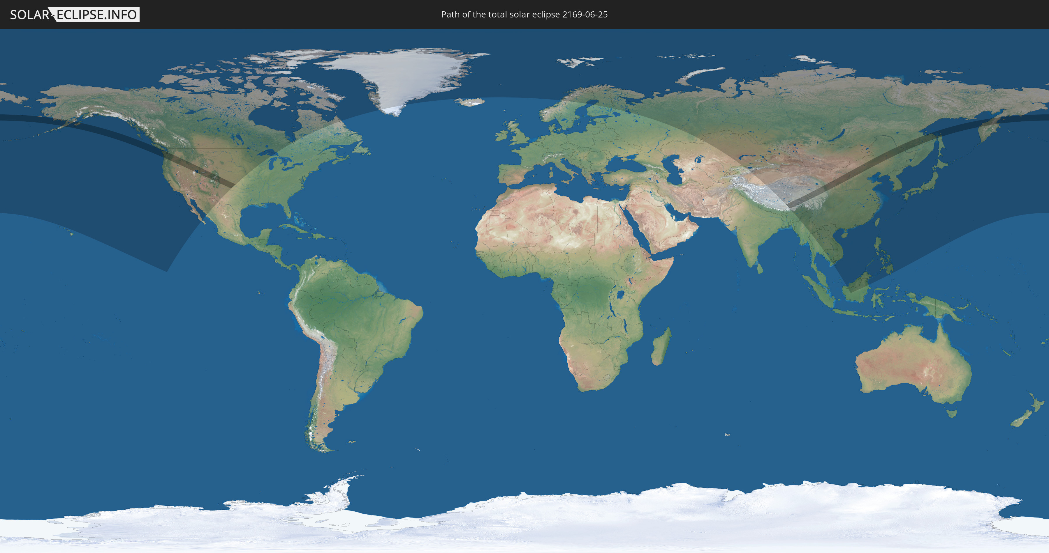
Die Sonnenfinsternis am 25.06.2169 kann man in 33 Ländern als partielle Sonnenfinsternis beobachten.
Der Finsternispfad verläuft durch 4 Länder. Nur in diesen Ländern ist sie als totale Sonnenfinsternis zu sehen.
In den folgenden Ländern ist die Sonnenfinsternis total zu sehen
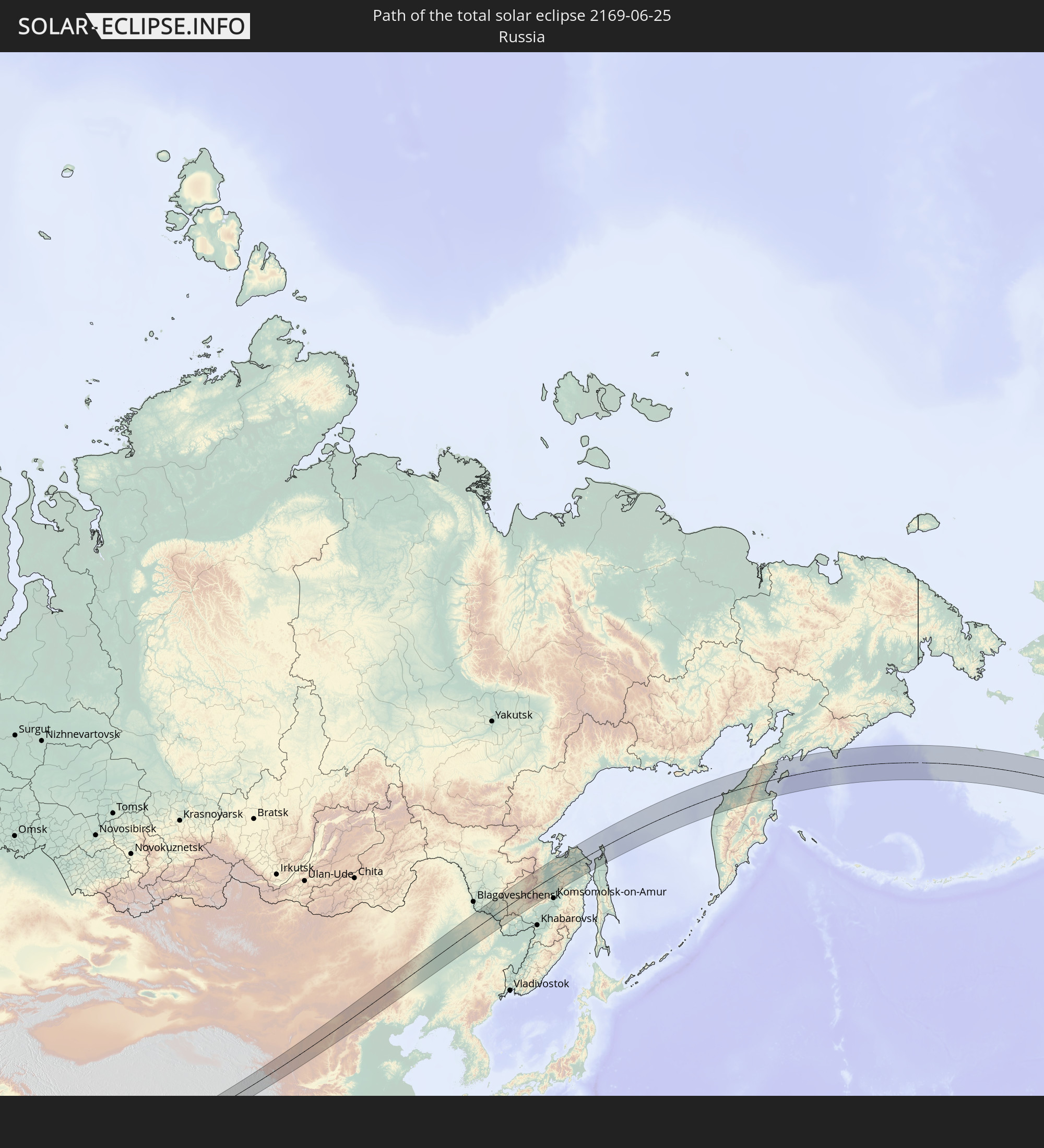 Russland
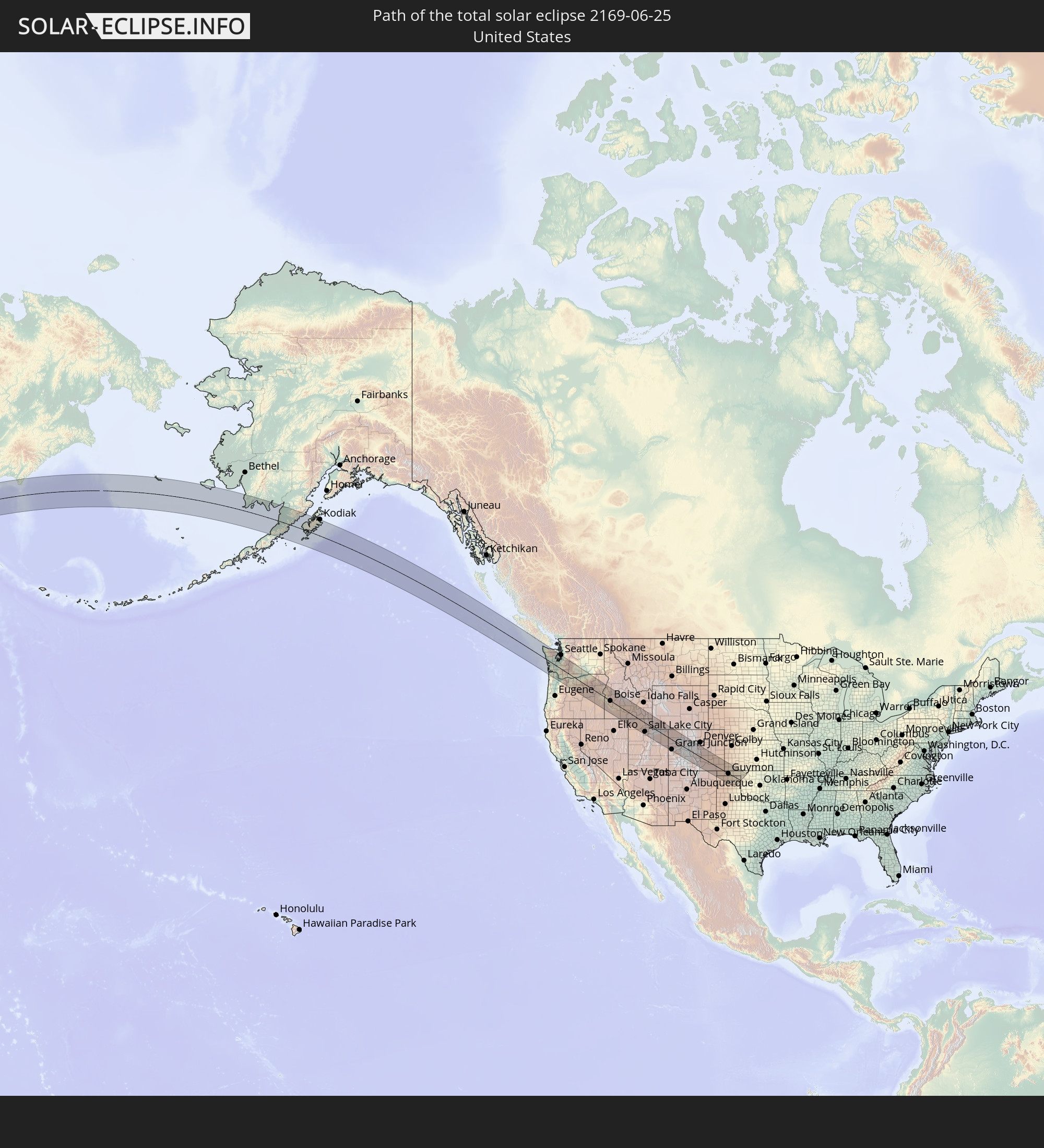 Vereinigte Staaten
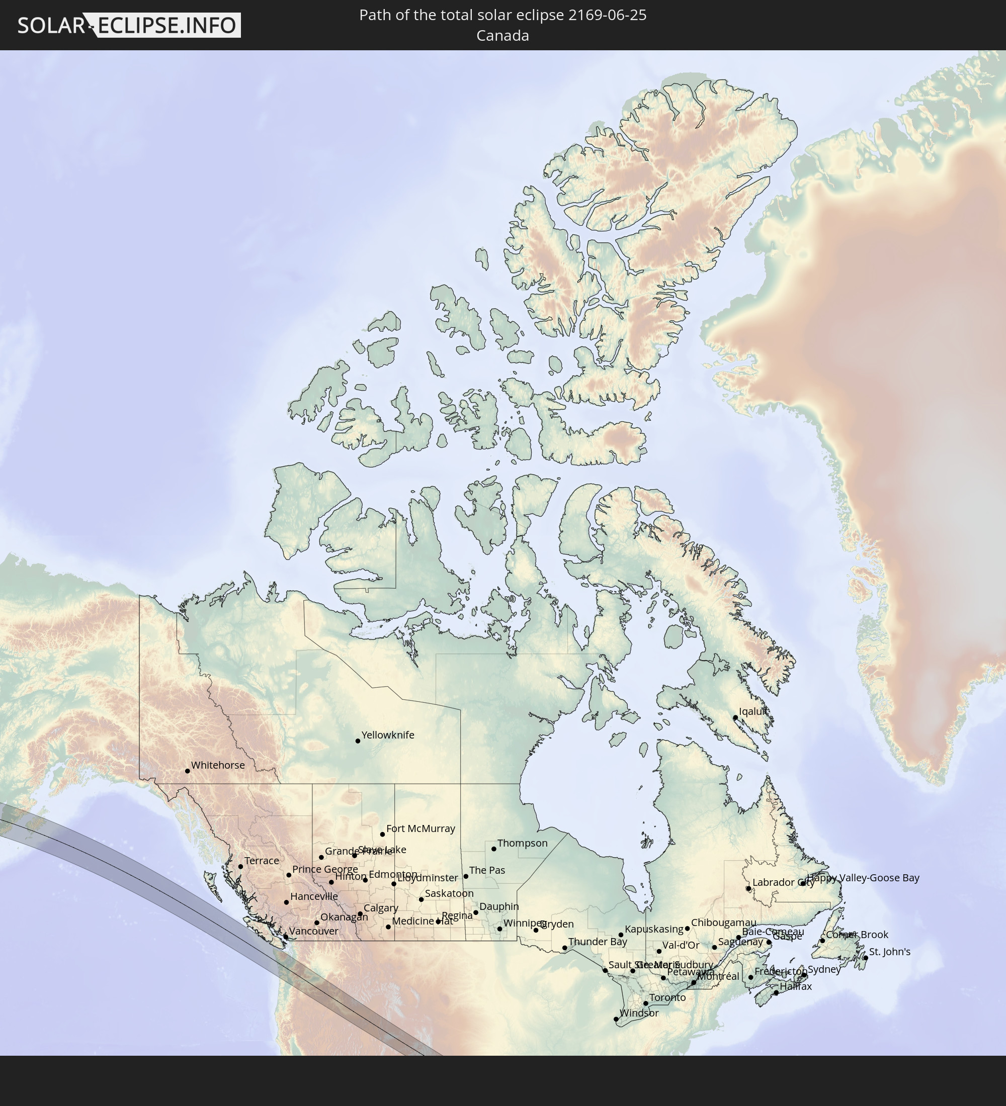 Kanada
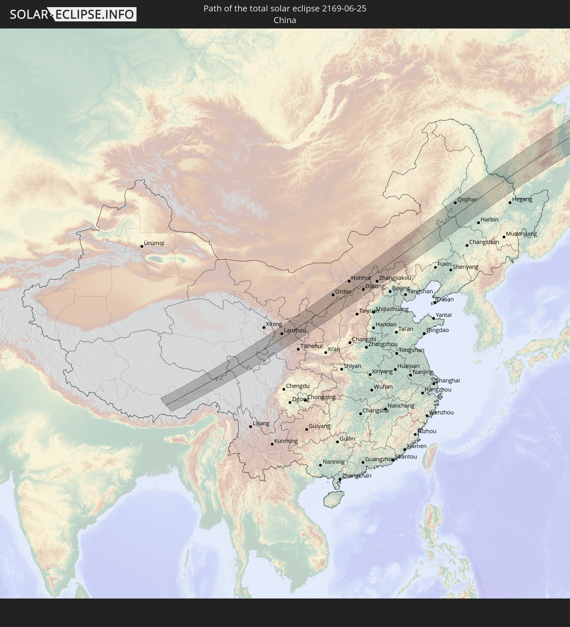 Volksrepublik China
In den folgenden Ländern ist die Sonnenfinsternis partiell zu sehen
 Russland
 Vereinigte Staaten
 United States Minor Outlying Islands
 Kanada
 Mexiko
 Grönland
 Island
 Spitzbergen
 Norwegen
 Schweden
 Finnland
 Kasachstan
 Indien
 Kirgisistan
 Volksrepublik China
 Mongolei
 Bhutan
 Myanmar
 Indonesien
 Thailand
 Malaysia
 Laos
Laos
 Vietnam
 Kambodscha
 Macau
Macau
 Hongkong
 Brunei
 Taiwan
 Philippinen
 Japan
Japan
 Nordkorea
 Südkorea
 Nördliche Marianen
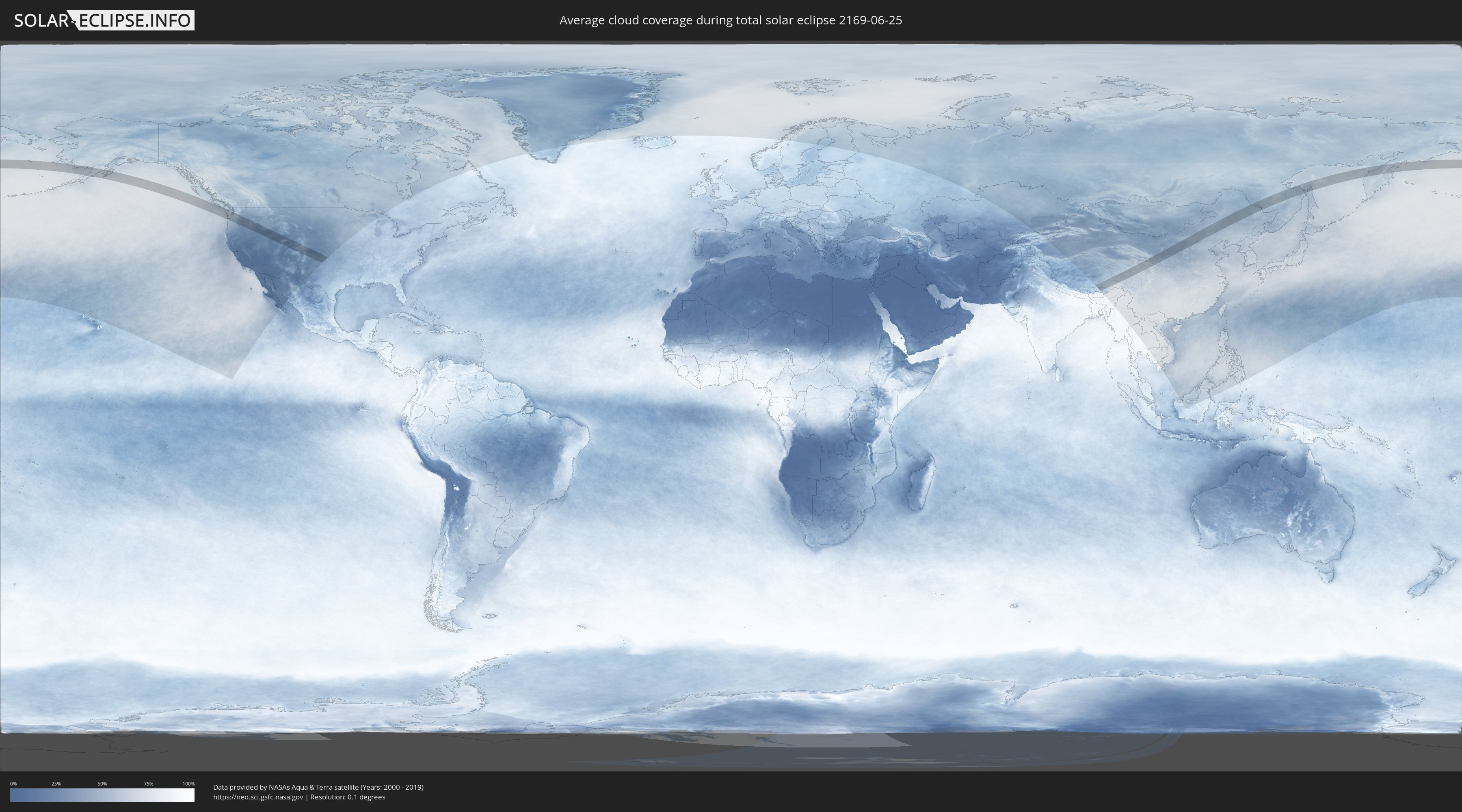
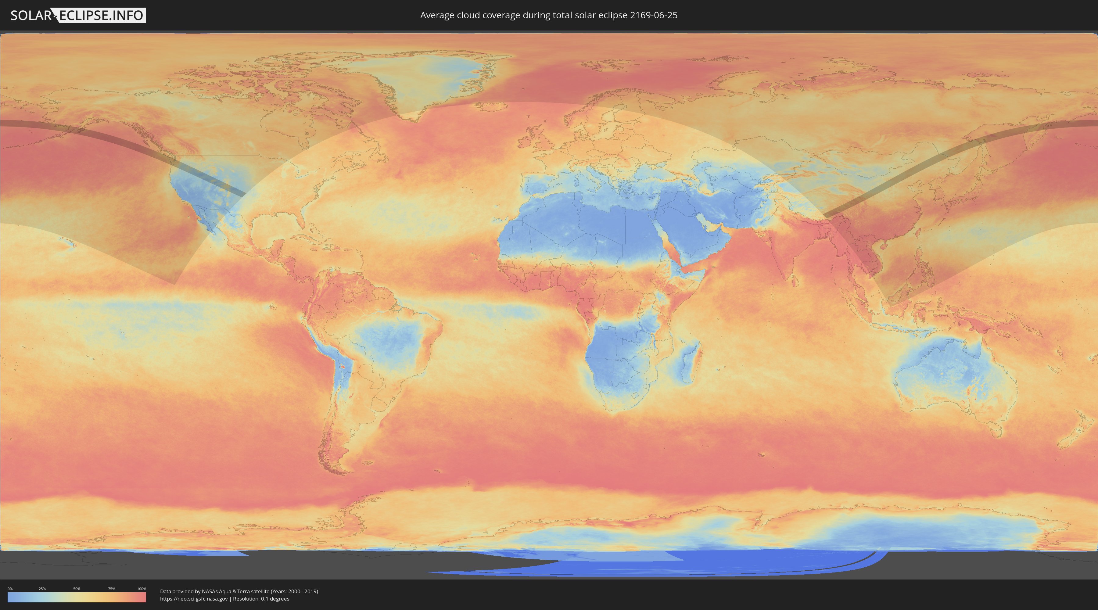
Wie wird das Wetter während der totalen Sonnenfinsternis am 25.06.2169?
Wo ist der beste Ort, um die totale Sonnenfinsternis vom 25.06.2169 zu beobachten?
Die folgenden Karten zeigen die durchschnittliche Bewölkung für den Tag, an dem die totale Sonnenfinsternis
stattfindet. Mit Hilfe der Karten lässt sich der Ort entlang des Finsternispfades eingrenzen,
der die besten Aussichen auf einen klaren wolkenfreien Himmel bietet.
Trotzdem muss man immer lokale Gegenenheiten beachten und sollte sich genau über das Wetter an seinem
gewählten Beobachtungsort informieren.
Die Daten stammen von den beiden NASA-Satelliten
AQUA und TERRA
und wurden über einen Zeitraum von 19 Jahren (2000 - 2019) gemittelt.
Detaillierte Länderkarten
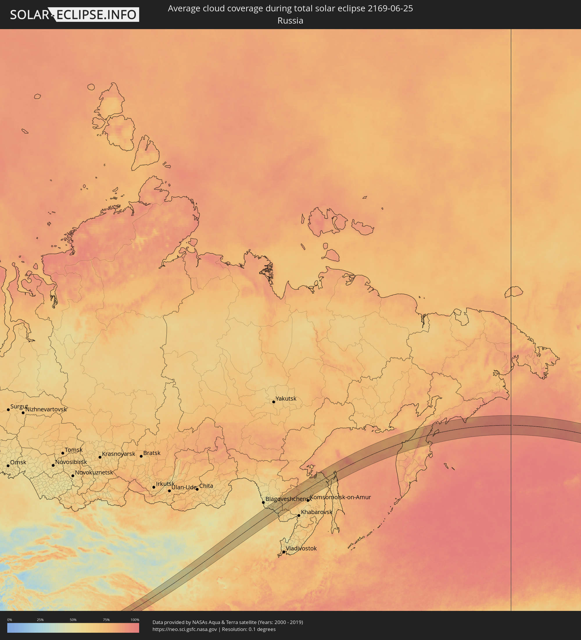 Russland
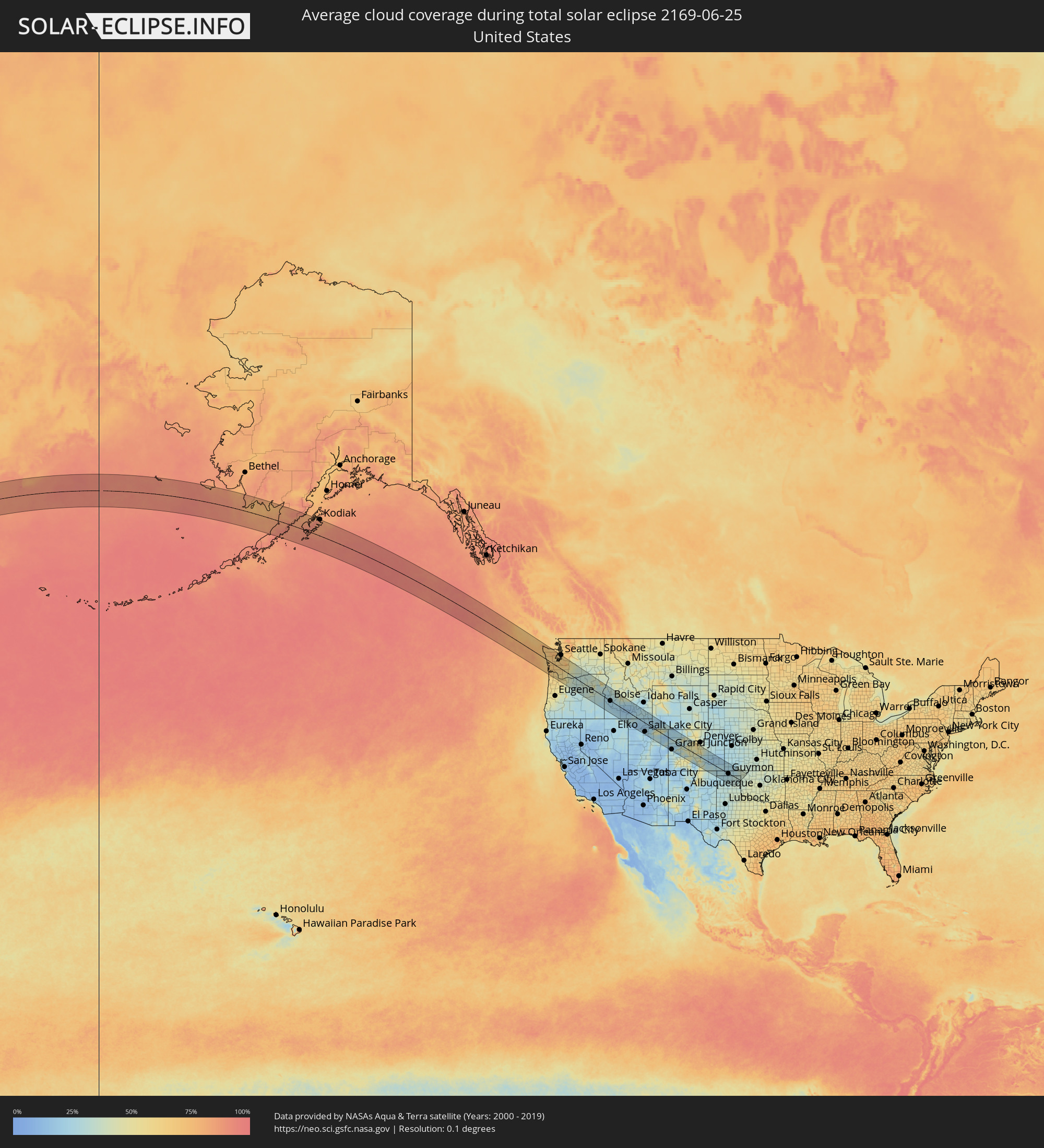 Vereinigte Staaten
 Kanada
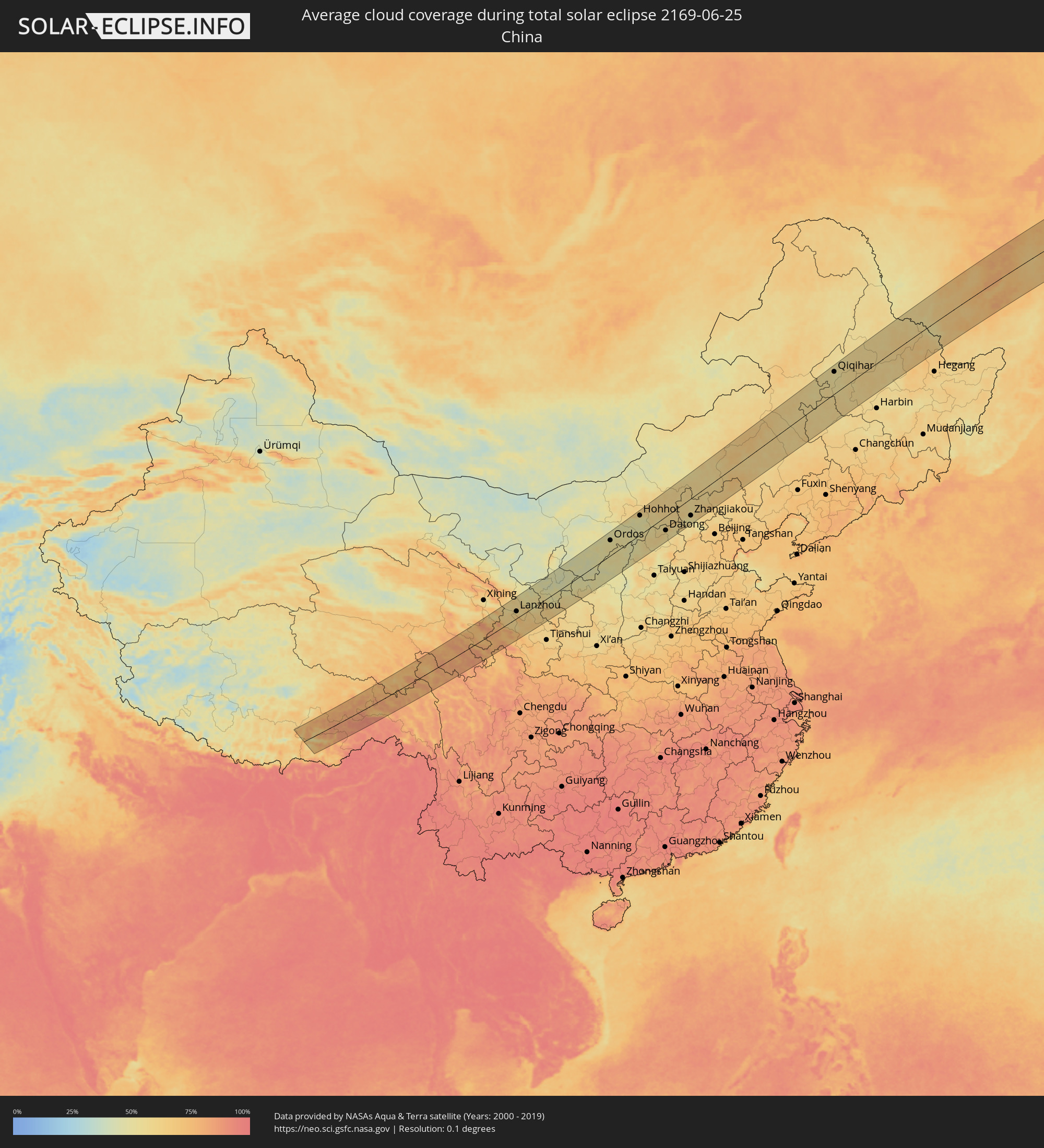 Volksrepublik China
Orte im Finsternispfad
Die nachfolgene Tabelle zeigt Städte und Orte mit mehr als 5.000 Einwohnern, die sich im Finsternispfad befinden. Städte mit mehr als 100.000 Einwohnern sind dick gekennzeichnet. Mit einem Klick auf den Ort öffnet sich eine Detailkarte die die Lage des jeweiligen Ortes zusammen mit dem Verlauf der zentralen Finsternis präsentiert.
| Ort | Typ | Dauer der Verfinsterung | Ortszeit bei maximaler Verfinsterung | Entfernung zur Zentrallinie | Ø Bewölkung |
|
Astoria, Oregon
|
total | - | 17:47:24 UTC-08:00 | 87 km | 65% |
|
Aberdeen, Washington
|
total | - | 17:46:16 UTC-08:00 | 24 km | 66% |
|
Shelton, Washington
|
total | - | 17:46:01 UTC-08:00 | 43 km | 63% |
|
Centralia, Washington
|
total | - | 17:46:46 UTC-08:00 | 4 km | 66% |
|
Longview, Washington
|
total | - | 17:47:36 UTC-08:00 | 52 km | 59% |
|
Olympia, Washington
|
total | - | 17:46:18 UTC-08:00 | 36 km | 64% |
|
Bethany, Oregon
|
total | - | 17:48:26 UTC-08:00 | 104 km | 61% |
|
Saint Helens, Oregon
|
total | - | 17:48:00 UTC-08:00 | 72 km | 53% |
|
Portland, Oregon
|
total | - | 17:48:30 UTC-08:00 | 99 km | 60% |
|
Salmon Creek, Washington
|
total | - | 17:48:15 UTC-08:00 | 80 km | 58% |
|
Poulsbo, Washington
|
total | - | 17:45:19 UTC-08:00 | 109 km | 61% |
|
Bremerton, Washington
|
total | - | 17:45:34 UTC-08:00 | 96 km | 61% |
|
Fort Lewis, Washington
|
total | - | 17:46:15 UTC-08:00 | 54 km | 65% |
|
Tacoma, Washington
|
total | - | 17:46:03 UTC-08:00 | 73 km | 63% |
|
Gresham, Oregon
|
total | - | 17:48:34 UTC-08:00 | 93 km | 60% |
|
White Center, Washington
|
total | - | 17:45:40 UTC-08:00 | 101 km | 60% |
|
South Hill, Washington
|
total | - | 17:46:14 UTC-08:00 | 73 km | 66% |
|
Sandy, Oregon
|
total | - | 17:48:44 UTC-08:00 | 94 km | 58% |
|
Kent, Washington
|
total | - | 17:45:53 UTC-08:00 | 94 km | 64% |
|
Enumclaw, Washington
|
total | - | 17:46:10 UTC-08:00 | 87 km | 68% |
|
The Dalles, Oregon
|
total | - | 17:48:33 UTC-08:00 | 29 km | 41% |
|
Yakima, Washington
|
total | - | 17:47:10 UTC-08:00 | 93 km | 40% |
|
Toppenish, Washington
|
total | - | 17:47:30 UTC-08:00 | 81 km | 36% |
|
Sunnyside, Washington
|
total | - | 17:47:36 UTC-08:00 | 89 km | 36% |
|
Hermiston, Oregon
|
total | - | 17:48:19 UTC-08:00 | 74 km | 34% |
|
Pendleton, Oregon
|
total | - | 17:48:34 UTC-08:00 | 80 km | 32% |
|
La Grande, Oregon
|
total | - | 17:49:03 UTC-08:00 | 78 km | 38% |
|
Baker City, Oregon
|
total | - | 17:49:48 UTC-08:00 | 38 km | 30% |
|
Ontario, Oregon
|
total | - | 18:50:48 UTC-07:00 | 5 km | 28% |
|
Caldwell, Idaho
|
total | - | 18:51:17 UTC-07:00 | 18 km | 24% |
|
Nampa, Idaho
|
total | - | 18:51:26 UTC-07:00 | 25 km | 24% |
|
Meridian, Idaho
|
total | - | 18:51:20 UTC-07:00 | 19 km | 23% |
|
Boise, Idaho
|
total | - | 18:51:19 UTC-07:00 | 19 km | 24% |
|
Mountain Home, Idaho
|
total | - | 18:51:55 UTC-07:00 | 24 km | 23% |
|
Jerome, Idaho
|
total | - | 18:52:21 UTC-07:00 | 10 km | 17% |
|
Twin Falls, Idaho
|
total | - | 18:52:34 UTC-07:00 | 23 km | 18% |
|
Burley, Idaho
|
total | - | 18:52:31 UTC-07:00 | 18 km | 20% |
|
Pocatello, Idaho
|
total | - | 18:51:55 UTC-07:00 | 95 km | 25% |
|
Magna, Utah
|
total | - | 18:54:34 UTC-07:00 | 93 km | 24% |
|
Brigham City, Utah
|
total | - | 18:53:34 UTC-07:00 | 15 km | 18% |
|
Ogden, Utah
|
total | - | 18:53:55 UTC-07:00 | 45 km | 17% |
|
Layton, Utah
|
total | - | 18:54:07 UTC-07:00 | 55 km | 18% |
|
West Jordan, Utah
|
total | - | 18:54:39 UTC-07:00 | 96 km | 21% |
|
Salt Lake City, Utah
|
total | - | 18:54:28 UTC-07:00 | 79 km | 19% |
|
Centerville, Utah
|
total | - | 18:54:16 UTC-07:00 | 63 km | 19% |
|
Logan, Utah
|
total | - | 18:53:15 UTC-07:00 | 17 km | 21% |
|
Alpine, Utah
|
total | - | 18:54:49 UTC-07:00 | 104 km | 21% |
|
Heber City, Utah
|
total | - | 18:54:41 UTC-07:00 | 82 km | 20% |
|
Evanston, Wyoming
|
total | - | 18:53:41 UTC-07:00 | 11 km | 24% |
|
Vernal, Utah
|
total | - | 18:54:22 UTC-07:00 | 2 km | 21% |
|
Green River, Wyoming
|
total | - | 18:53:03 UTC-07:00 | 102 km | 24% |
|
Fruita, Colorado
|
total | - | 18:55:41 UTC-07:00 | 91 km | 20% |
|
Grand Junction, Colorado
|
total | - | 18:55:45 UTC-07:00 | 91 km | 23% |
|
Delta, Colorado
|
total | - | 18:55:59 UTC-07:00 | 100 km | 28% |
|
Rifle, Colorado
|
total | - | 18:55:00 UTC-07:00 | 11 km | 26% |
|
Craig, Colorado
|
total | - | 18:53:48 UTC-07:00 | 93 km | 27% |
|
Glenwood Springs, Colorado
|
total | - | 18:54:52 UTC-07:00 | 11 km | 26% |
|
Edwards, Colorado
|
total | - | 18:54:33 UTC-07:00 | 53 km | 43% |
|
Cañon City, Colorado
|
total | - | 18:55:28 UTC-07:00 | 24 km | 36% |
|
Colorado Springs, Colorado
|
total | - | 18:54:54 UTC-07:00 | 56 km | 46% |
|
Black Forest, Colorado
|
total | - | 18:54:40 UTC-07:00 | 79 km | 40% |
|
Fountain, Colorado
|
total | - | 18:55:01 UTC-07:00 | 46 km | 42% |
|
Pueblo, Colorado
|
total | - | 18:55:28 UTC-07:00 | 9 km | 25% |
|
Trinidad, Colorado
|
total | - | 18:56:35 UTC-07:00 | 90 km | 32% |
|
Guymon, Oklahoma
|
total | - | 19:55:55 UTC-06:00 | 4 km | 26% |
|
Pampa, Texas
|
total | - | 19:56:51 UTC-06:00 | 91 km | 33% |
|
Liberal, Kansas
|
total | - | 19:55:19 UTC-06:00 | 62 km | 26% |
|
Dêqên, Tibet Autonomous Region
|
total | - | 07:06:40 UTC+08:00 | 68 km | 75% |
|
Lhasa, Tibet Autonomous Region
|
total | - | 07:06:11 UTC+08:00 | 29 km | 58% |
|
Linxia Chengguanzhen, Gansu
|
total | - | 07:09:41 UTC+08:00 | 28 km | 62% |
|
Lanzhou, Gansu
|
total | - | 07:10:12 UTC+08:00 | 34 km | 58% |
|
Baiyin, Gansu
|
total | - | 07:10:49 UTC+08:00 | 63 km | 58% |
|
Yulin, Shaanxi
|
total | - | 07:13:07 UTC+08:00 | 52 km | 49% |
|
Ordos, Inner Mongolia
|
total | - | 07:15:01 UTC+08:00 | 72 km | 51% |
|
Dongsheng, Inner Mongolia
|
total | - | 07:15:20 UTC+08:00 | 77 km | 50% |
|
Hohhot, Inner Mongolia
|
total | - | 07:16:58 UTC+08:00 | 88 km | 50% |
|
Jining, Inner Mongolia
|
total | - | 07:17:31 UTC+08:00 | 37 km | 59% |
|
Beichengqu, Inner Mongolia
|
total | - | 07:16:38 UTC+08:00 | 23 km | 56% |
|
Datong, Shanxi
|
total | - | 07:16:08 UTC+08:00 | 63 km | 57% |
|
Zhangjiakou, Hebei
|
total | - | 07:17:31 UTC+08:00 | 75 km | 54% |
|
Zhangjiakou Shi Xuanhua Qu, Hebei
|
total | - | 07:17:15 UTC+08:00 | 101 km | 49% |
|
Ulanhot, Inner Mongolia
|
total | - | 07:28:18 UTC+08:00 | 58 km | 57% |
|
Guangming, Jilin
|
total | - | 07:27:24 UTC+08:00 | 42 km | 58% |
|
Baicheng, Jilin
|
total | - | 07:27:52 UTC+08:00 | 19 km | 58% |
|
Kaitong, Jilin
|
total | - | 07:26:43 UTC+08:00 | 105 km | 60% |
|
Zhenlai, Jilin
|
total | - | 07:28:29 UTC+08:00 | 19 km | 57% |
|
Tailai, Heilongjiang
|
total | - | 07:29:26 UTC+08:00 | 25 km | 58% |
|
Hulan Ergi, Heilongjiang
|
total | - | 07:30:53 UTC+08:00 | 90 km | 55% |
|
Qiqihar, Heilongjiang
|
total | - | 07:31:16 UTC+08:00 | 86 km | 53% |
|
Dalai, Jilin
|
total | - | 07:28:24 UTC+08:00 | 96 km | 57% |
|
Taikang, Heilongjiang
|
total | - | 07:30:44 UTC+08:00 | 23 km | 53% |
|
Fuyu, Heilongjiang
|
total | - | 07:32:17 UTC+08:00 | 106 km | 55% |
|
Fendou, Heilongjiang
|
total | - | 07:30:35 UTC+08:00 | 28 km | 61% |
|
Honggang, Heilongjiang
|
total | - | 07:30:12 UTC+08:00 | 41 km | 59% |
|
Daqing, Heilongjiang
|
total | - | 07:30:34 UTC+08:00 | 36 km | 62% |
|
Longfeng, Heilongjiang
|
total | - | 07:30:32 UTC+08:00 | 43 km | 60% |
|
Anda, Heilongjiang
|
total | - | 07:30:26 UTC+08:00 | 61 km | 58% |
|
Mingshui, Heilongjiang
|
total | - | 07:32:02 UTC+08:00 | 25 km | 63% |
|
Baiquan, Heilongjiang
|
total | - | 07:32:51 UTC+08:00 | 24 km | 61% |
|
Qinggang, Heilongjiang
|
total | - | 07:31:20 UTC+08:00 | 70 km | 61% |
|
Wangkui, Heilongjiang
|
total | - | 07:31:48 UTC+08:00 | 72 km | 61% |
|
Bei’an, Heilongjiang
|
total | - | 07:34:15 UTC+08:00 | 52 km | 59% |
|
Hailun, Heilongjiang
|
total | - | 07:33:06 UTC+08:00 | 40 km | 60% |
|
Suihua, Heilongjiang
|
total | - | 07:31:46 UTC+08:00 | 113 km | 60% |
|
Suileng, Heilongjiang
|
total | - | 07:32:51 UTC+08:00 | 62 km | 60% |
|
Poyarkovo, Amur
|
total | - | 08:37:45 UTC+09:00 | 89 km | 55% |
|
Youhao, Heilongjiang
|
total | - | 07:34:56 UTC+08:00 | 83 km | 62% |
|
Yichun, Heilongjiang
|
total | - | 07:34:44 UTC+08:00 | 96 km | 65% |
|
Raychikhinsk, Amur
|
total | - | 08:38:31 UTC+09:00 | 72 km | 58% |
|
Zavitinsk, Amur
|
total | - | 08:39:04 UTC+09:00 | 102 km | 58% |
|
Xinqing, Heilongjiang
|
total | - | 07:36:06 UTC+08:00 | 71 km | 61% |
|
Bureya, Amur
|
total | - | 08:38:49 UTC+09:00 | 61 km | 54% |
|
Novobureyskiy, Amur
|
total | - | 08:38:50 UTC+09:00 | 56 km | 56% |
|
Arkhara, Amur
|
total | - | 08:38:22 UTC+09:00 | 18 km | 55% |
|
Talakan, Amur
|
total | - | 08:39:52 UTC+09:00 | 80 km | 58% |
|
Novyy Urgal, Khabarovsk Krai
|
total | - | 09:42:52 UTC+10:00 | 61 km | 64% |
|
Chegdomyn, Khabarovsk Krai
|
total | - | 09:43:16 UTC+10:00 | 51 km | 69% |
|
Berëzovyy, Khabarovsk Krai
|
total | - | 09:46:14 UTC+10:00 | 13 km | 69% |
|
Nikolayevsk-on-Amure, Khabarovsk Krai
|
total | - | 09:53:00 UTC+10:00 | 38 km | 67% |
|
Okha, Sakhalin
|
total | - | 10:55:48 UTC+11:00 | 67 km | 73% |