Totale Sonnenfinsternis vom 06.07.2187
| Wochentag: | Freitag |
| Maximale Dauer der Verfinsterung: | 04m06s |
| Maximale Breite des Finsternispfades: | 211 km |
| Saroszyklus: | 149 |
| Bedeckungsgrad: | 100% |
| Magnitude: | 1.0548 |
| Gamma: | 0.5109 |
Wo kann man die Sonnenfinsternis vom 06.07.2187 sehen?
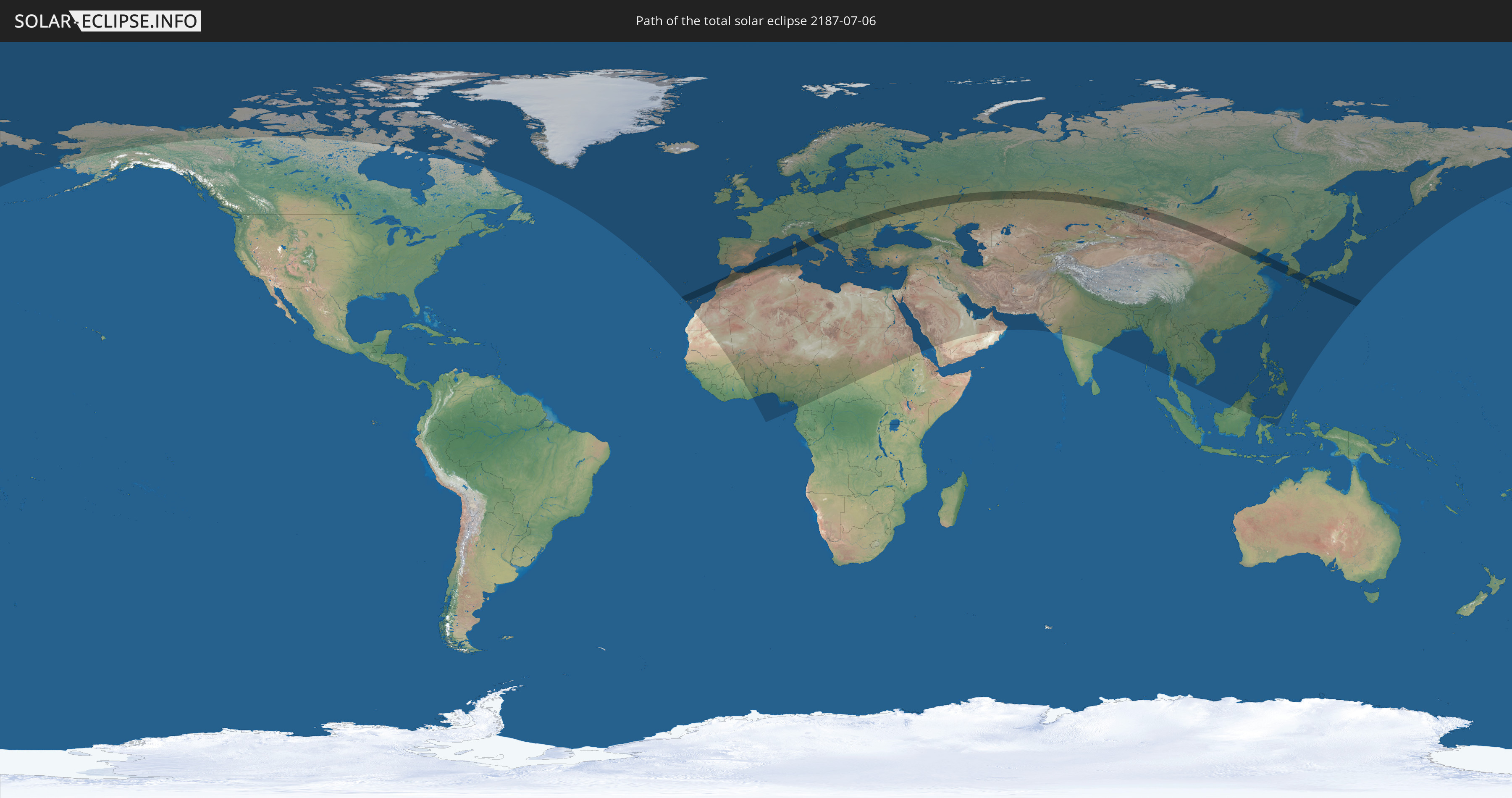
Die Sonnenfinsternis am 06.07.2187 kann man in 120 Ländern als partielle Sonnenfinsternis beobachten.
Der Finsternispfad verläuft durch 20 Länder. Nur in diesen Ländern ist sie als totale Sonnenfinsternis zu sehen.
In den folgenden Ländern ist die Sonnenfinsternis total zu sehen
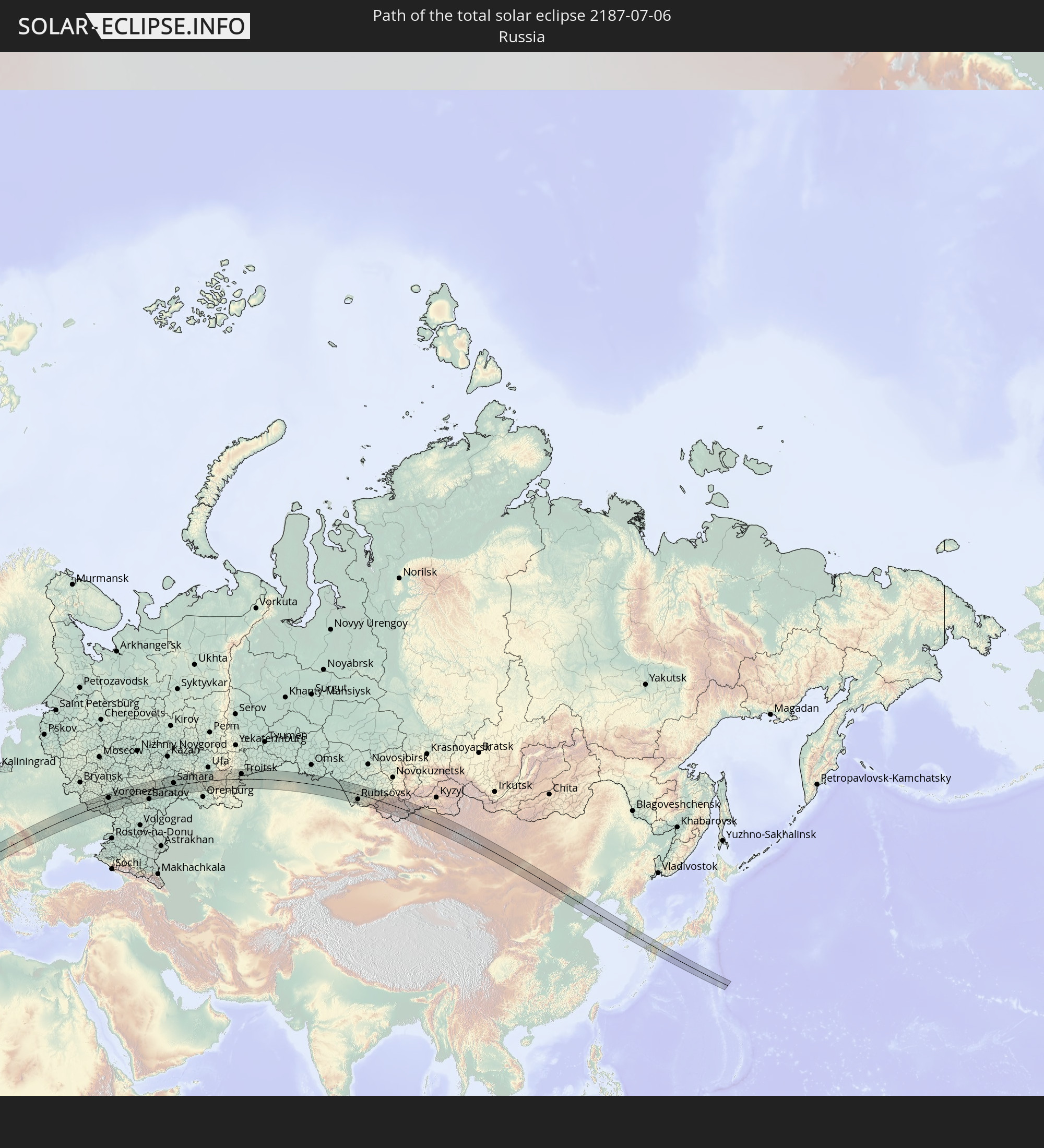 Russland
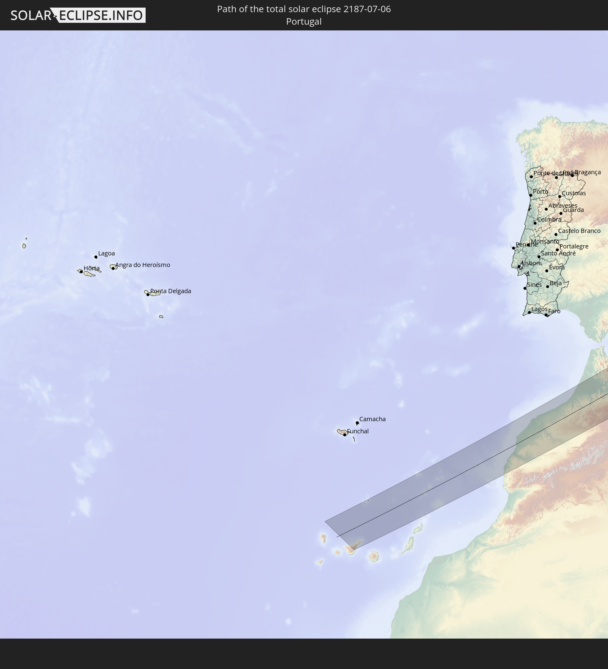 Portugal
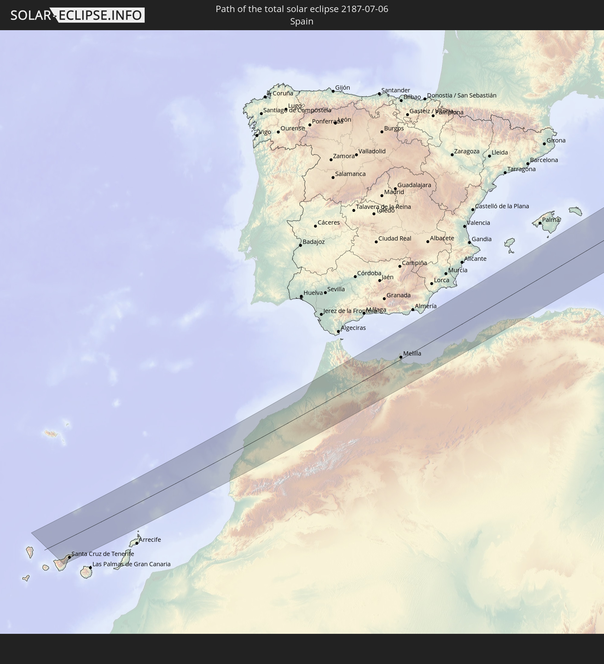 Spanien
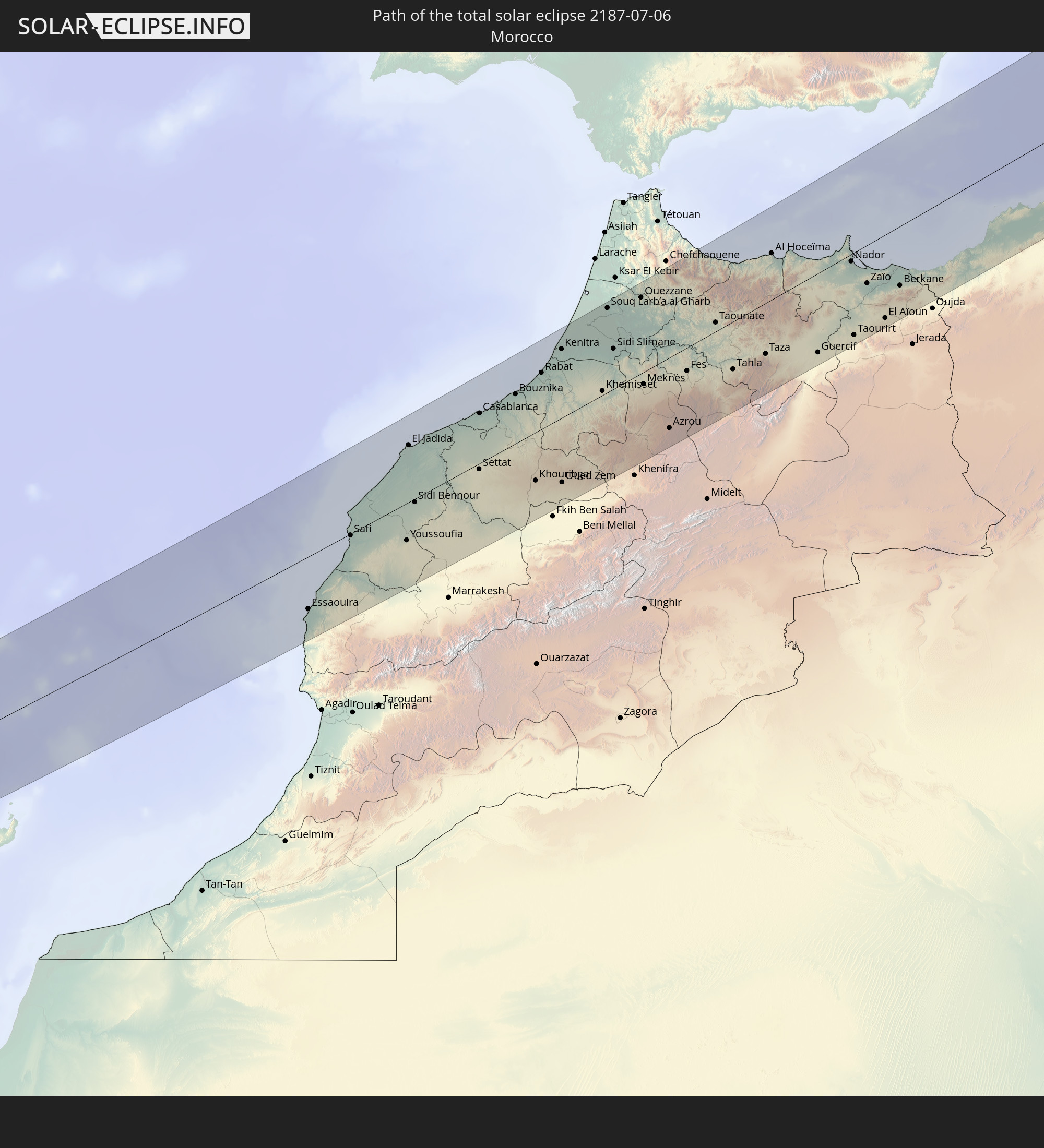 Marokko
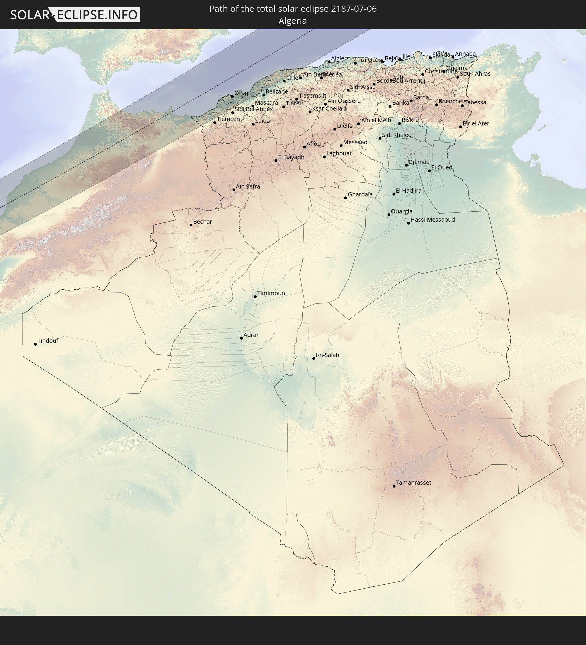 Algerien
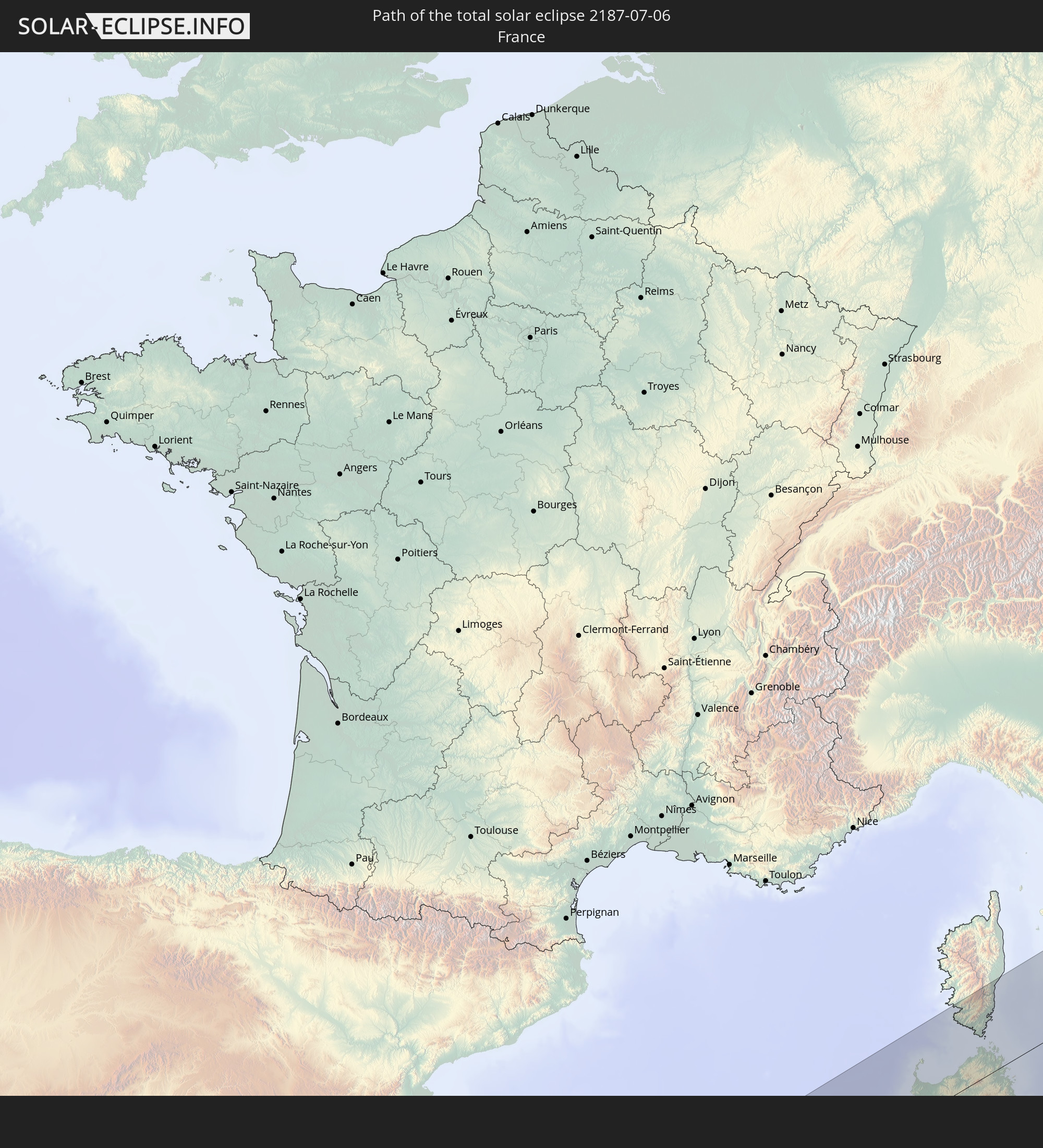 Frankreich
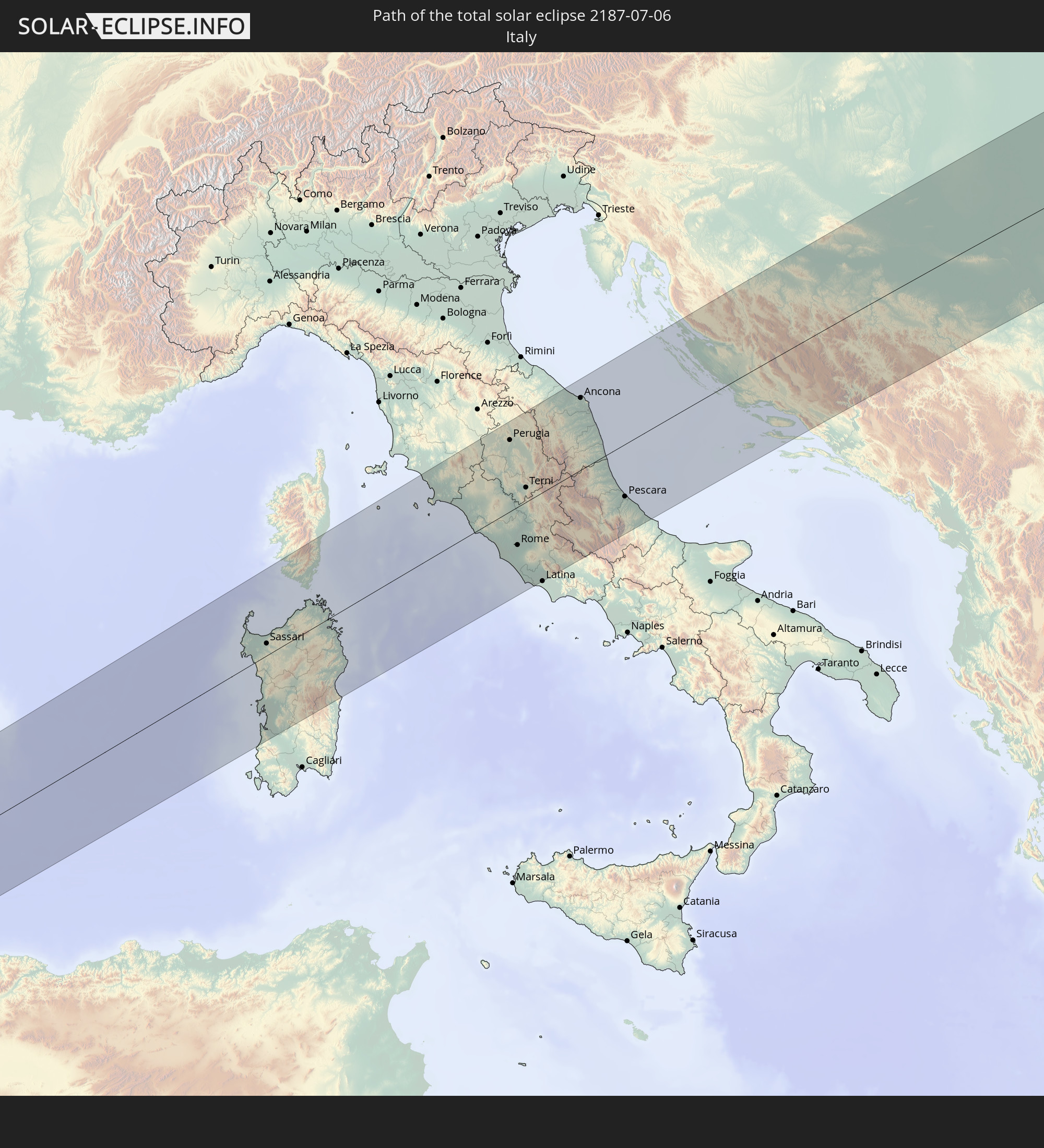 Italien
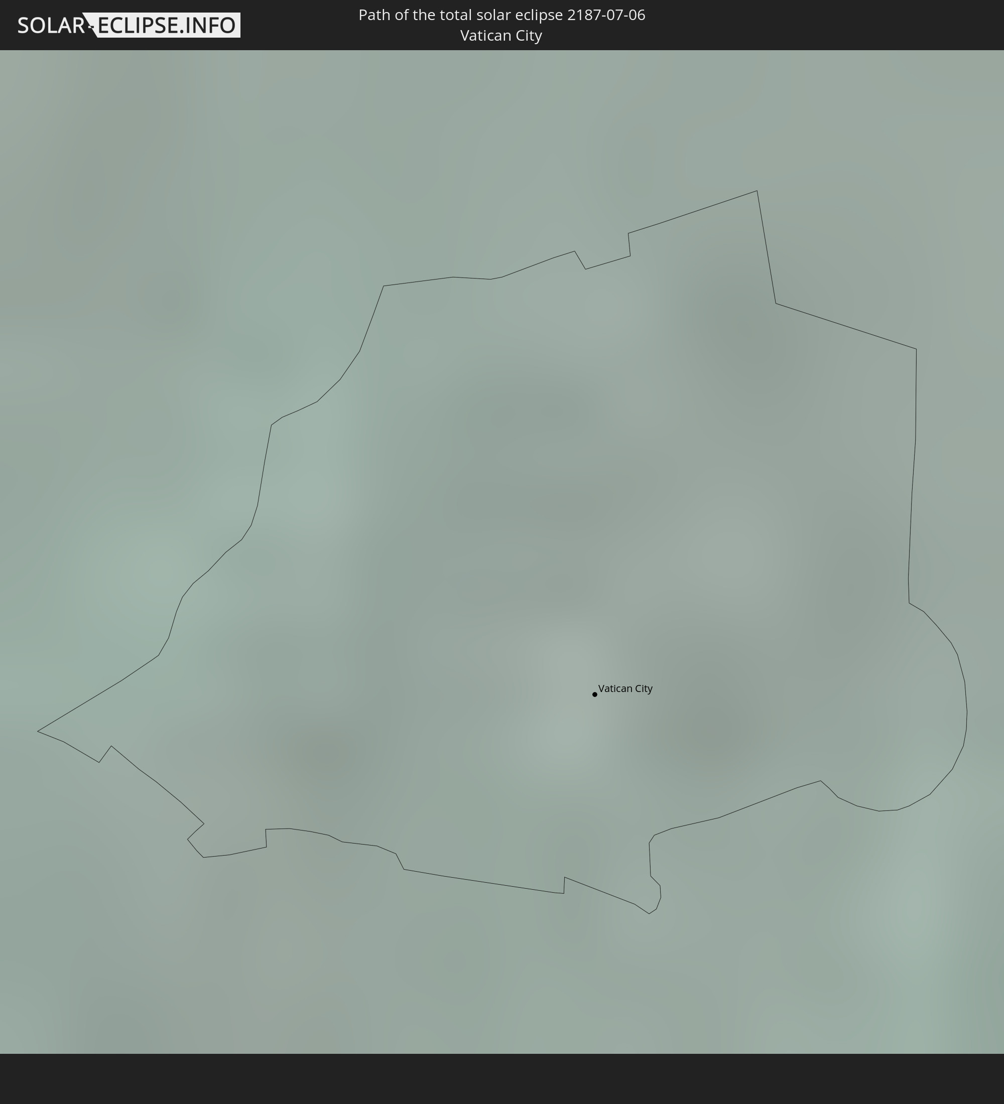 Vatikanstadt
 Kroatien
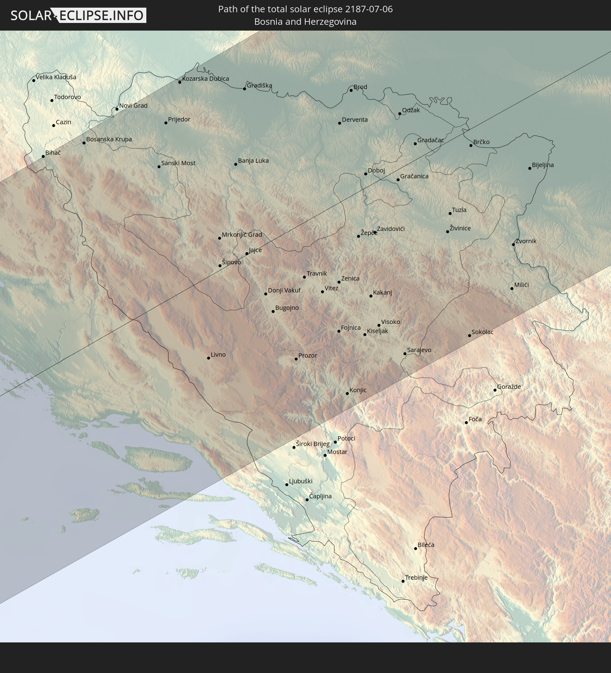 Bosnien und Herzegowina
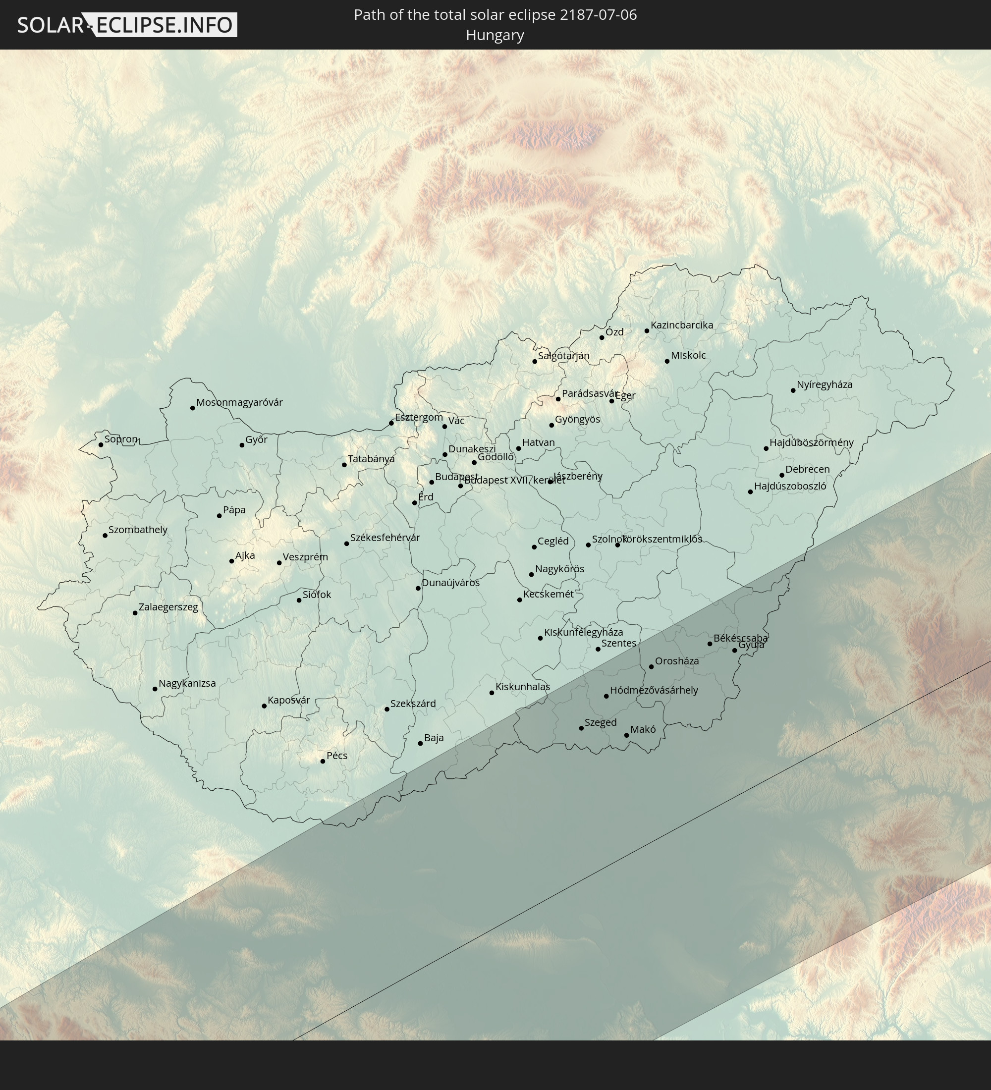 Ungarn
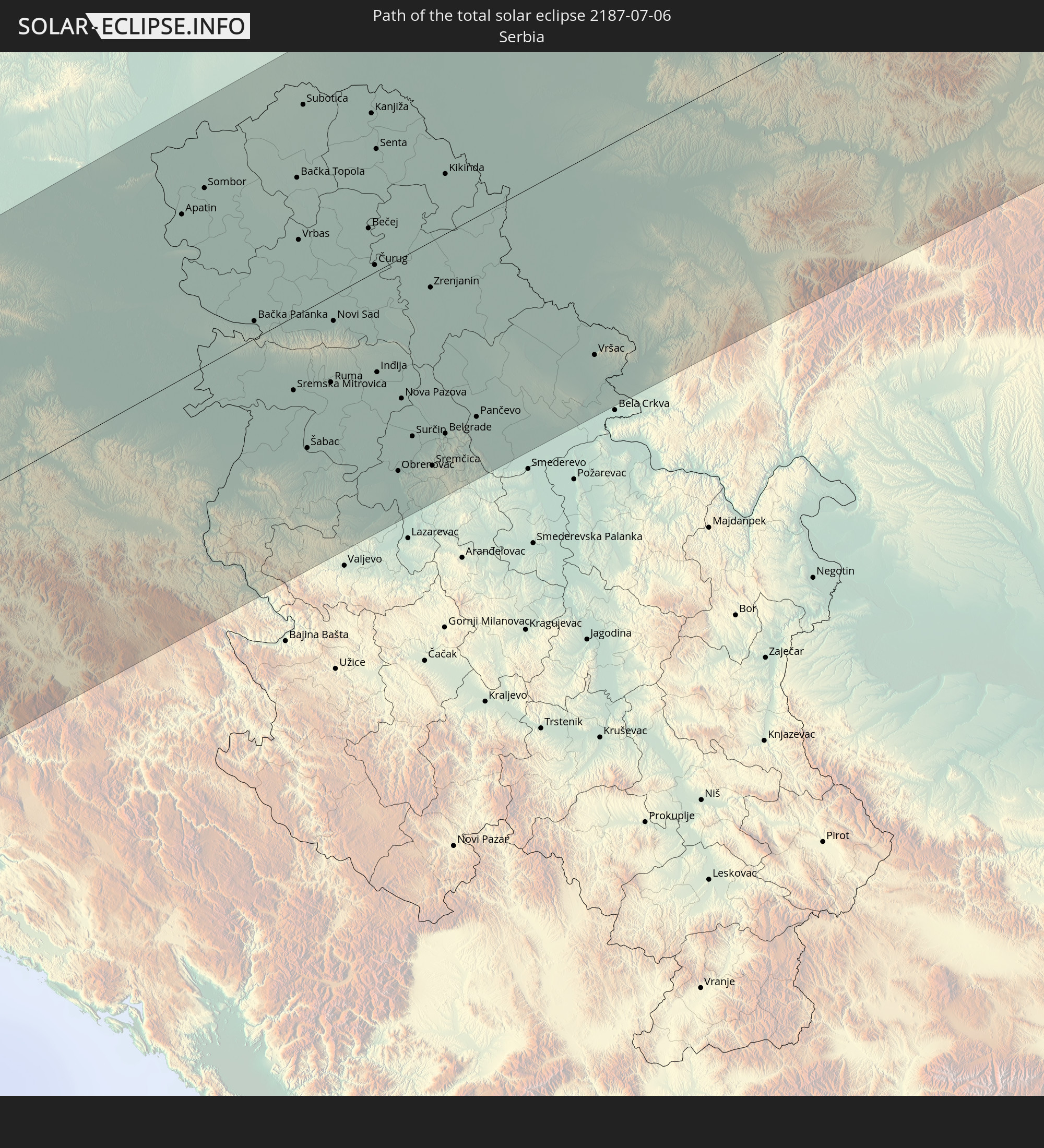 Serbien
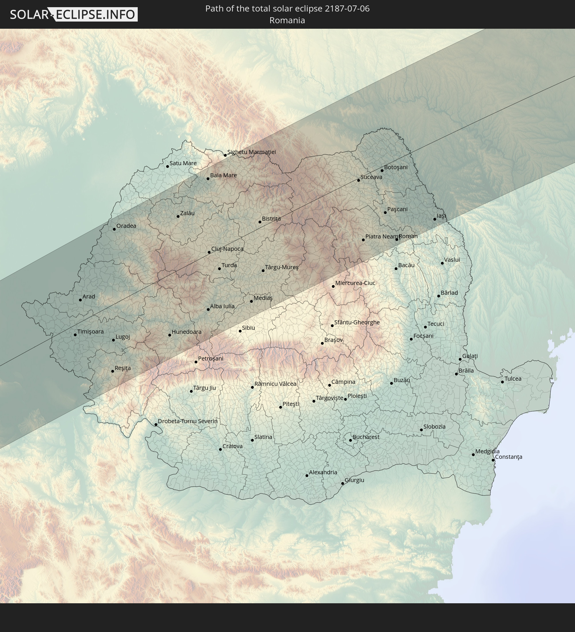 Rumänien
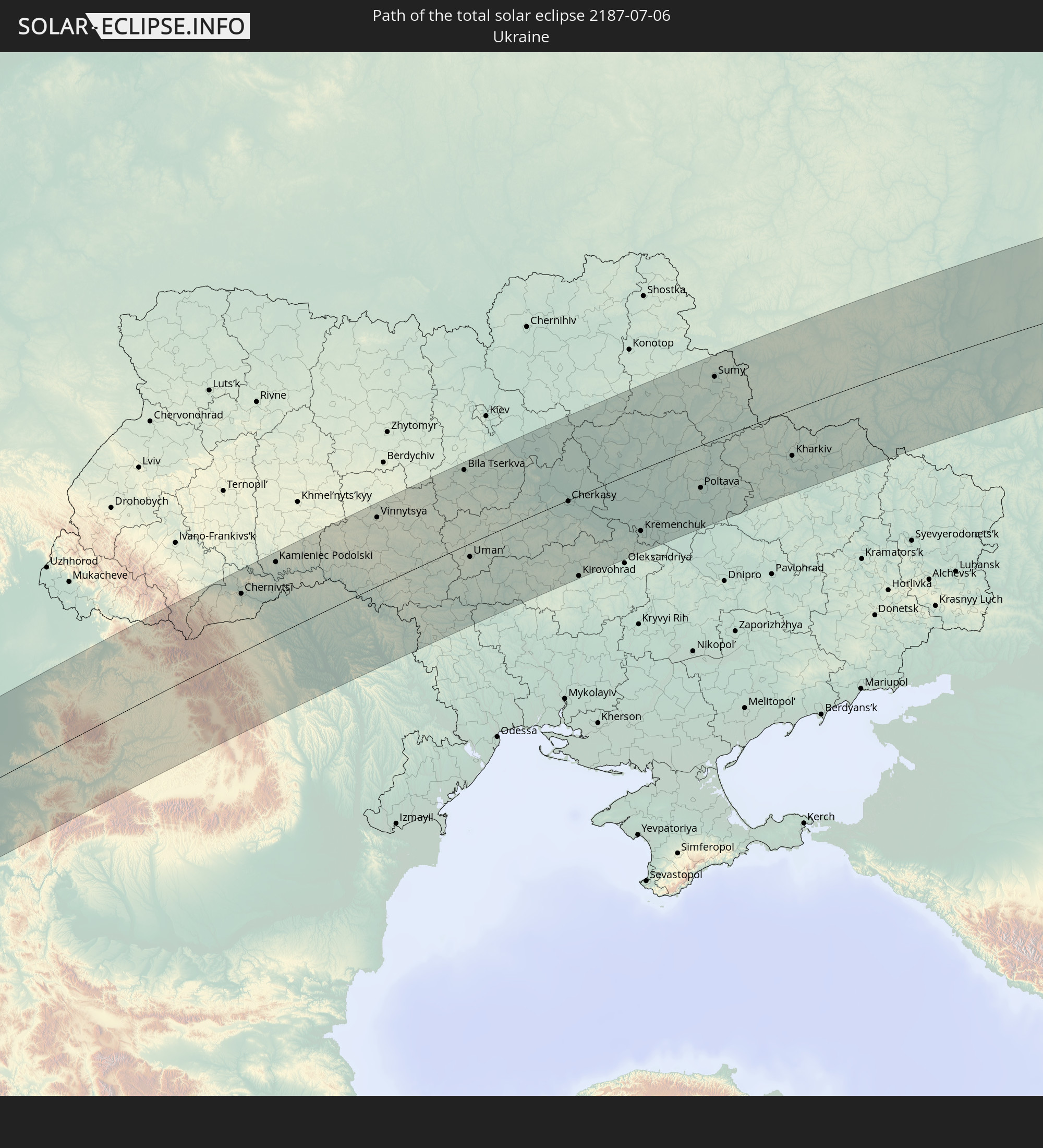 Ukraine
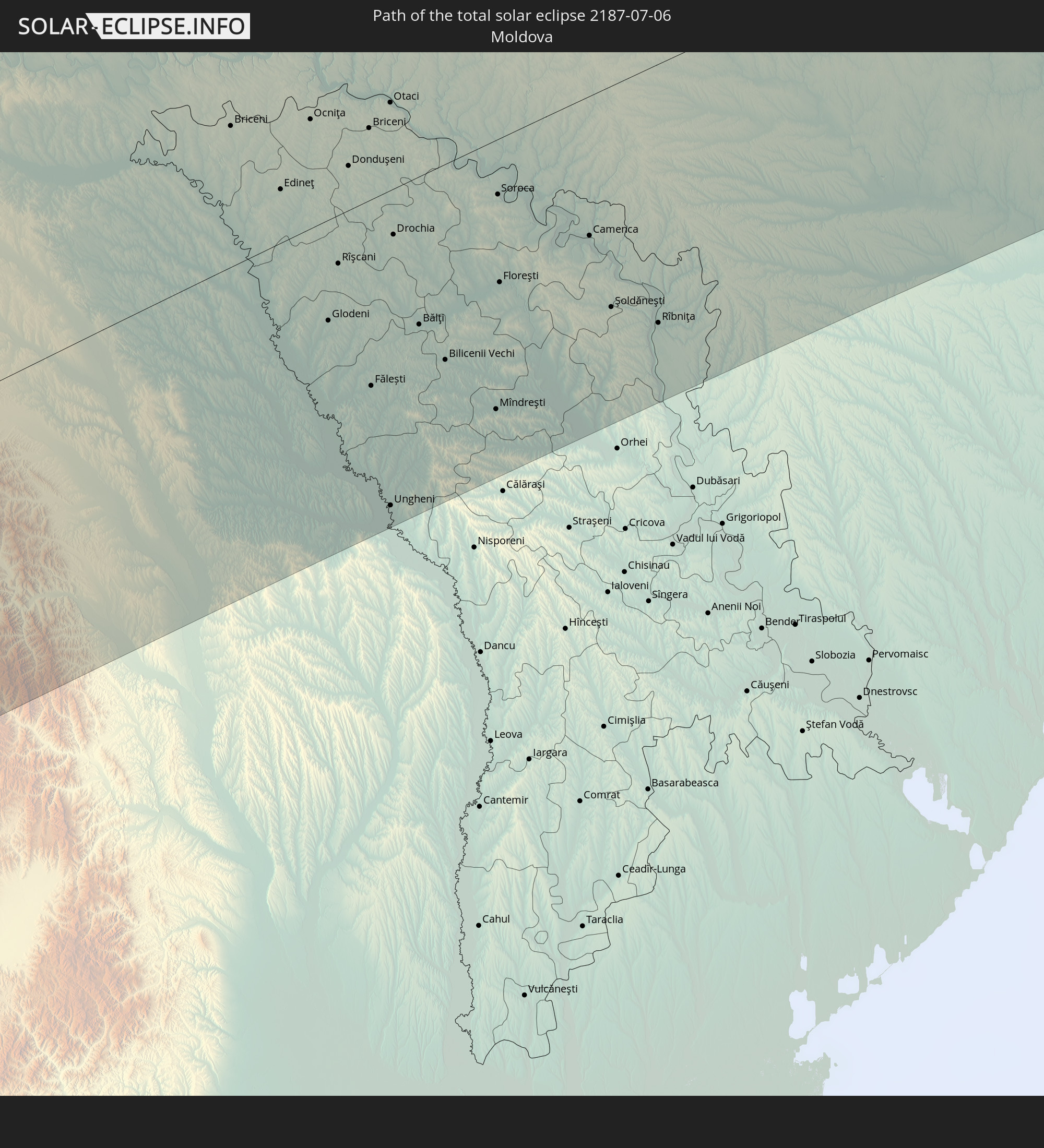 Moldawien
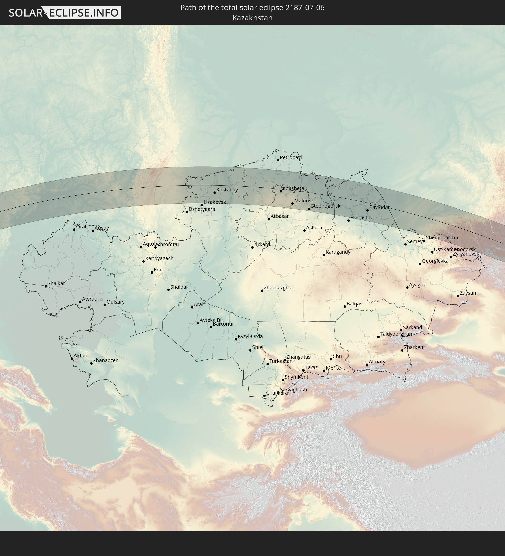 Kasachstan
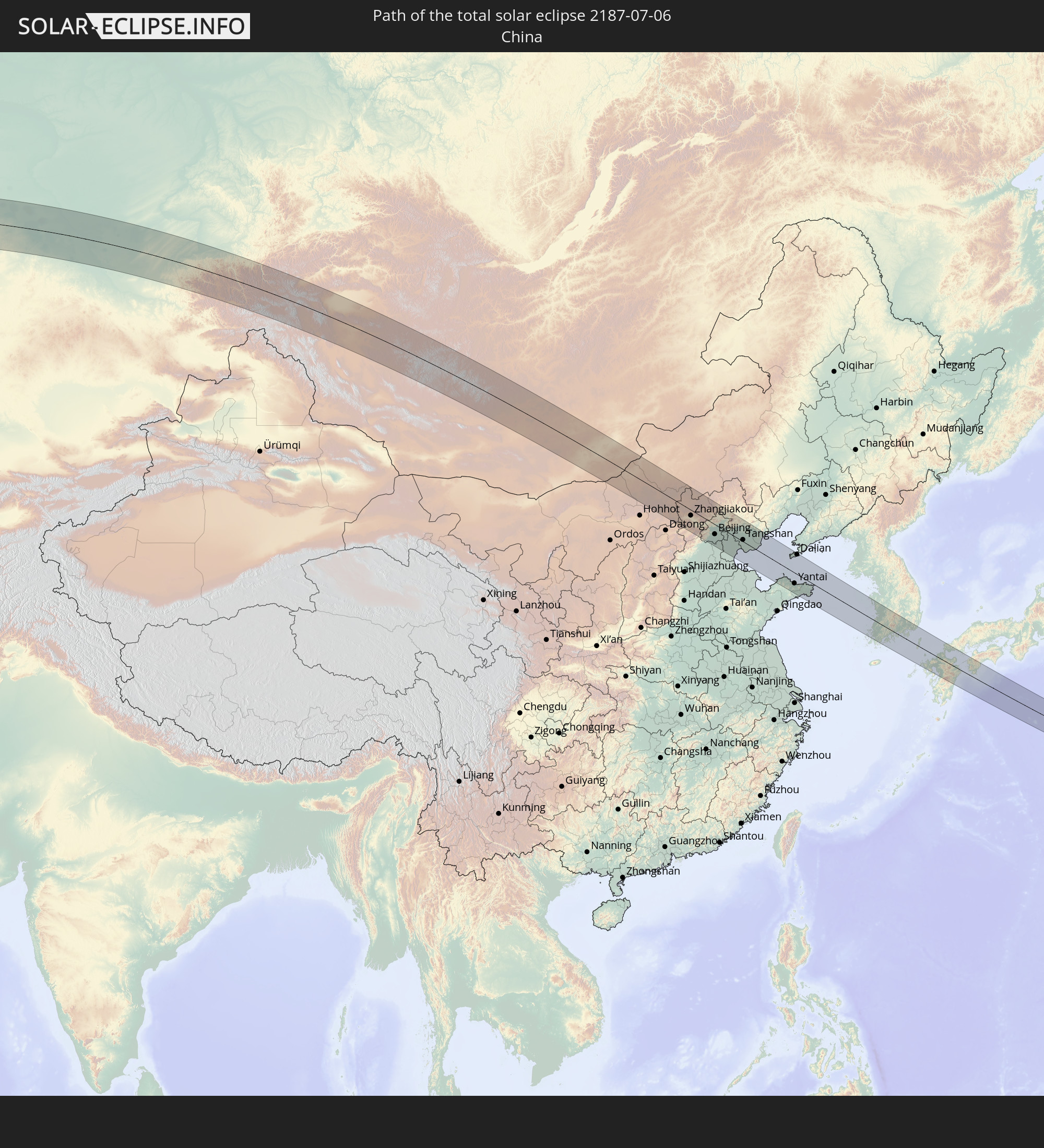 Volksrepublik China
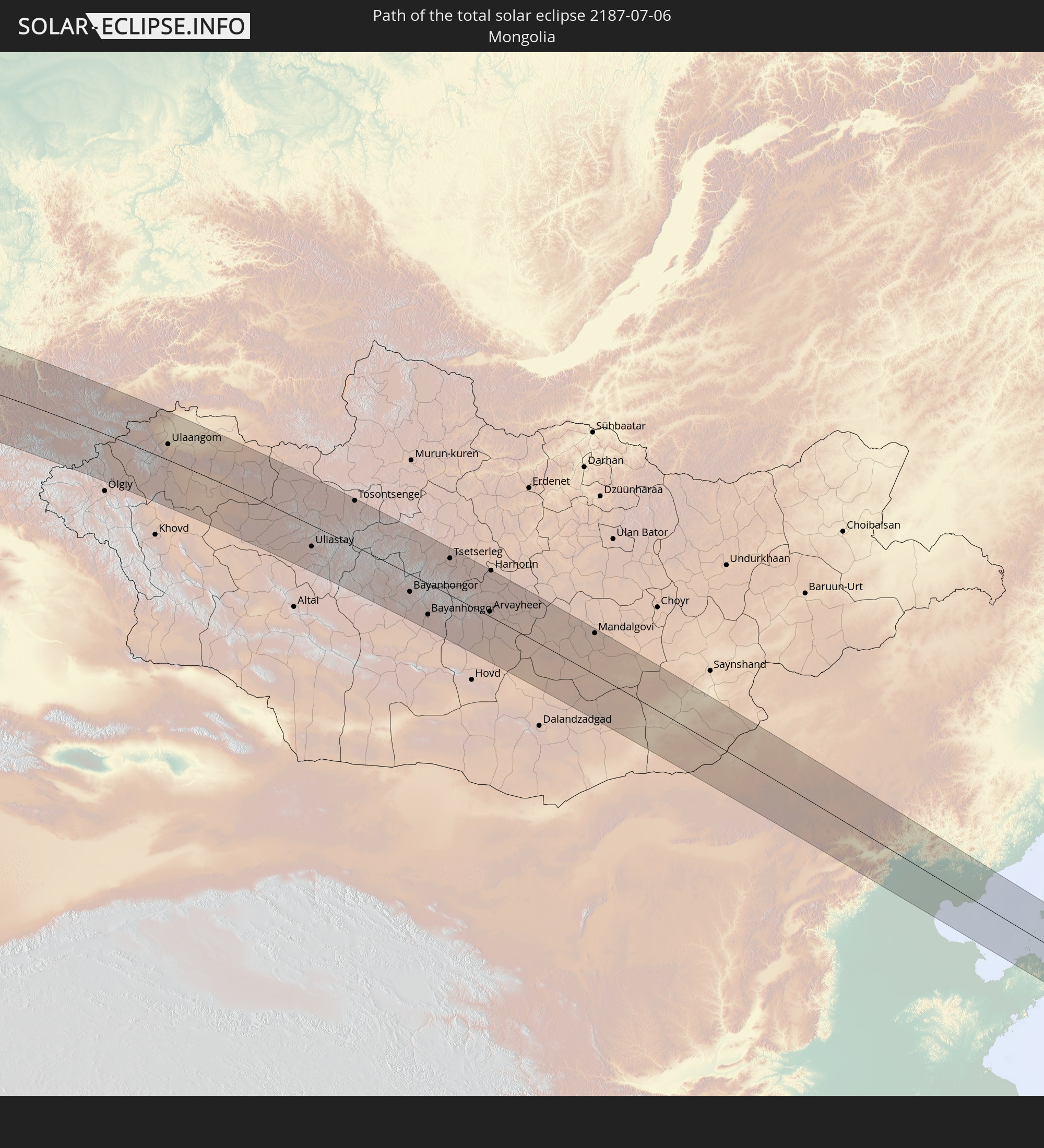 Mongolei
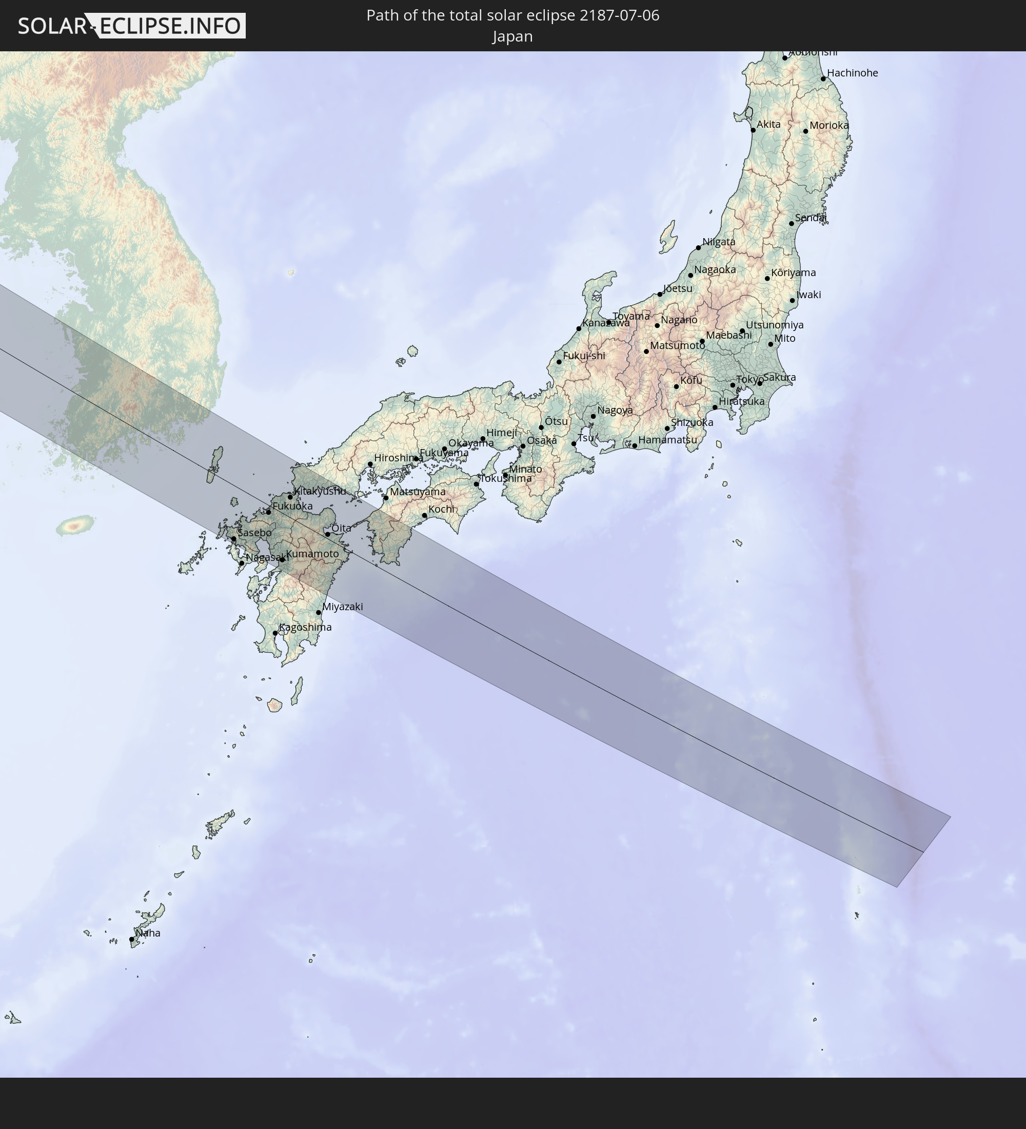 Japan
Japan
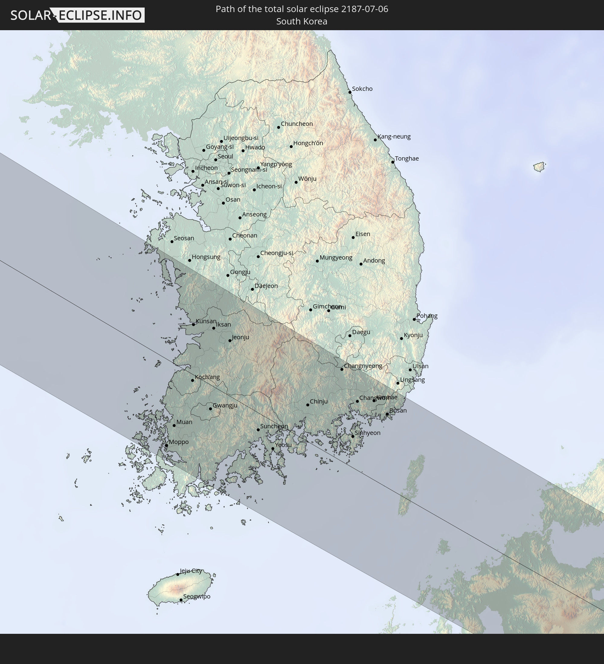 Südkorea
In den folgenden Ländern ist die Sonnenfinsternis partiell zu sehen
 Russland
 Vereinigte Staaten
 Kanada
 Grönland
 Portugal
 Island
 Spanien
 Mauretanien
 Marokko
 Mali
Mali
 Irland
 Spitzbergen
 Algerien
 Vereinigtes Königreich
 Elfenbeinküste
 Färöer
 Burkina Faso
 Gibraltar
 Frankreich
 Isle of Man
 Ghana
Ghana
 Guernsey
 Jersey
 Togo
Togo
 Niger
Niger
 Benin
Benin
 Andorra
 Belgien
 Nigeria
 Niederlande
 Norwegen
 Äquatorialguinea
 Luxemburg
 Deutschland
 Schweiz
 Italien
 Monaco
 Tunesien
 Dänemark
 Kamerun
 Libyen
 Liechtenstein
 Österreich
 Schweden
 Tschechien
 San Marino
 Vatikanstadt
 Slowenien
 Tschad
 Kroatien
 Polen
Polen
 Malta
Malta
 Zentralafrikanische Republik
 Bosnien und Herzegowina
 Ungarn
 Slowakei
 Montenegro
 Serbien
 Albanien
 Åland Islands
 Griechenland
 Rumänien
 Mazedonien
 Finnland
 Litauen
 Lettland
 Estland
 Sudan
Sudan
 Ukraine
 Bulgarien
 Weißrussland
 Ägypten
 Türkei
 Moldawien
 Republik Zypern
 Staat Palästina
 Israel
 Saudi-Arabien
 Jordanien
 Libanon
 Syrien
 Eritrea
 Irak
Irak
 Georgien
 Armenien
 Iran
Iran
 Aserbaidschan
 Kasachstan
 Kuwait
 Bahrain
 Katar
Katar
 Vereinigte Arabische Emirate
 Oman
Oman
 Turkmenistan
 Usbekistan
 Afghanistan
 Pakistan
 Tadschikistan
 Indien
 Kirgisistan
 Volksrepublik China
 Nepal
Nepal
 Mongolei
 Bangladesch
 Bhutan
 Myanmar
 Indonesien
 Thailand
 Malaysia
 Laos
Laos
 Vietnam
 Kambodscha
 Macau
Macau
 Hongkong
 Brunei
 Taiwan
 Philippinen
 Japan
Japan
 Nordkorea
 Südkorea
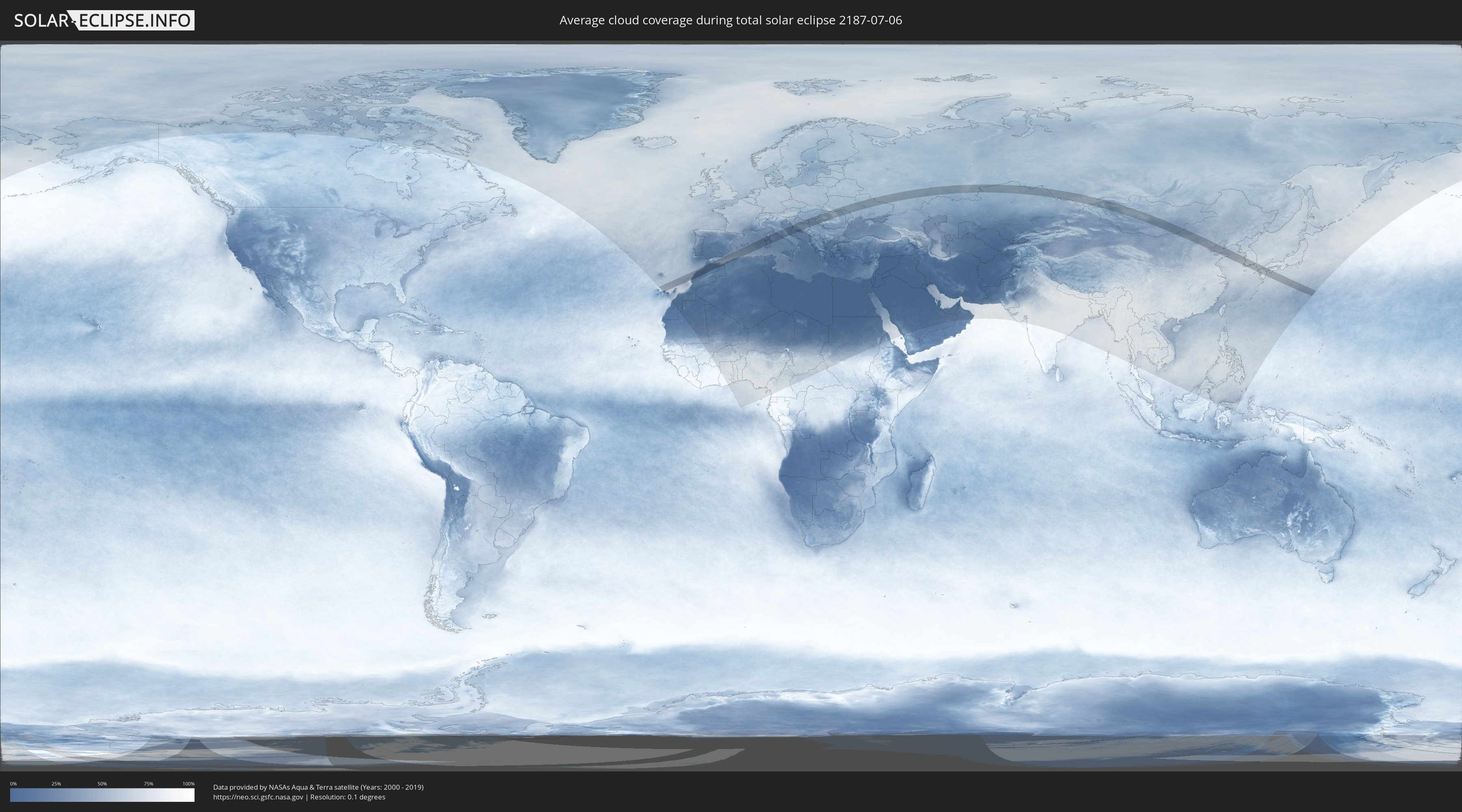
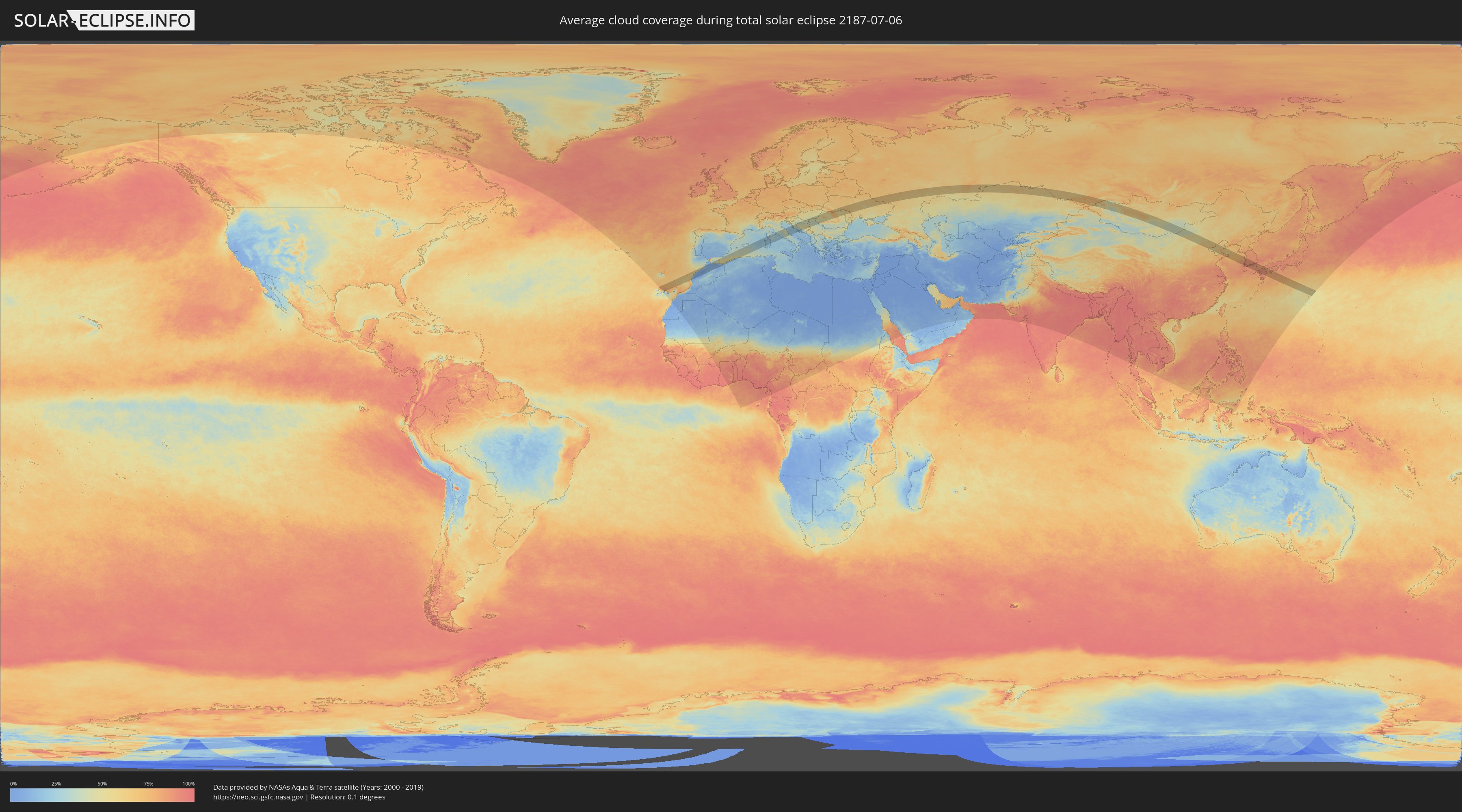
Wie wird das Wetter während der totalen Sonnenfinsternis am 06.07.2187?
Wo ist der beste Ort, um die totale Sonnenfinsternis vom 06.07.2187 zu beobachten?
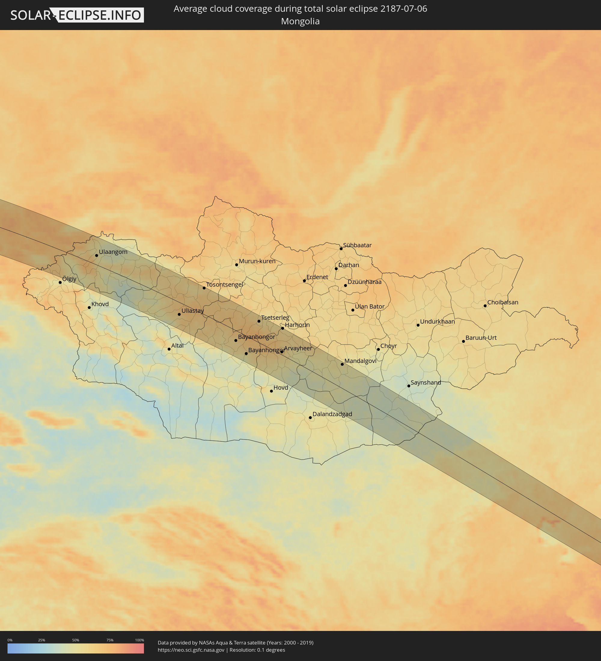
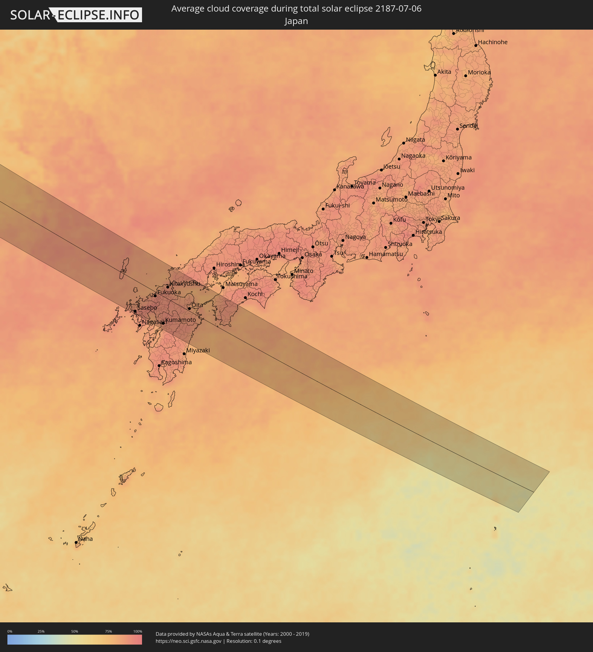
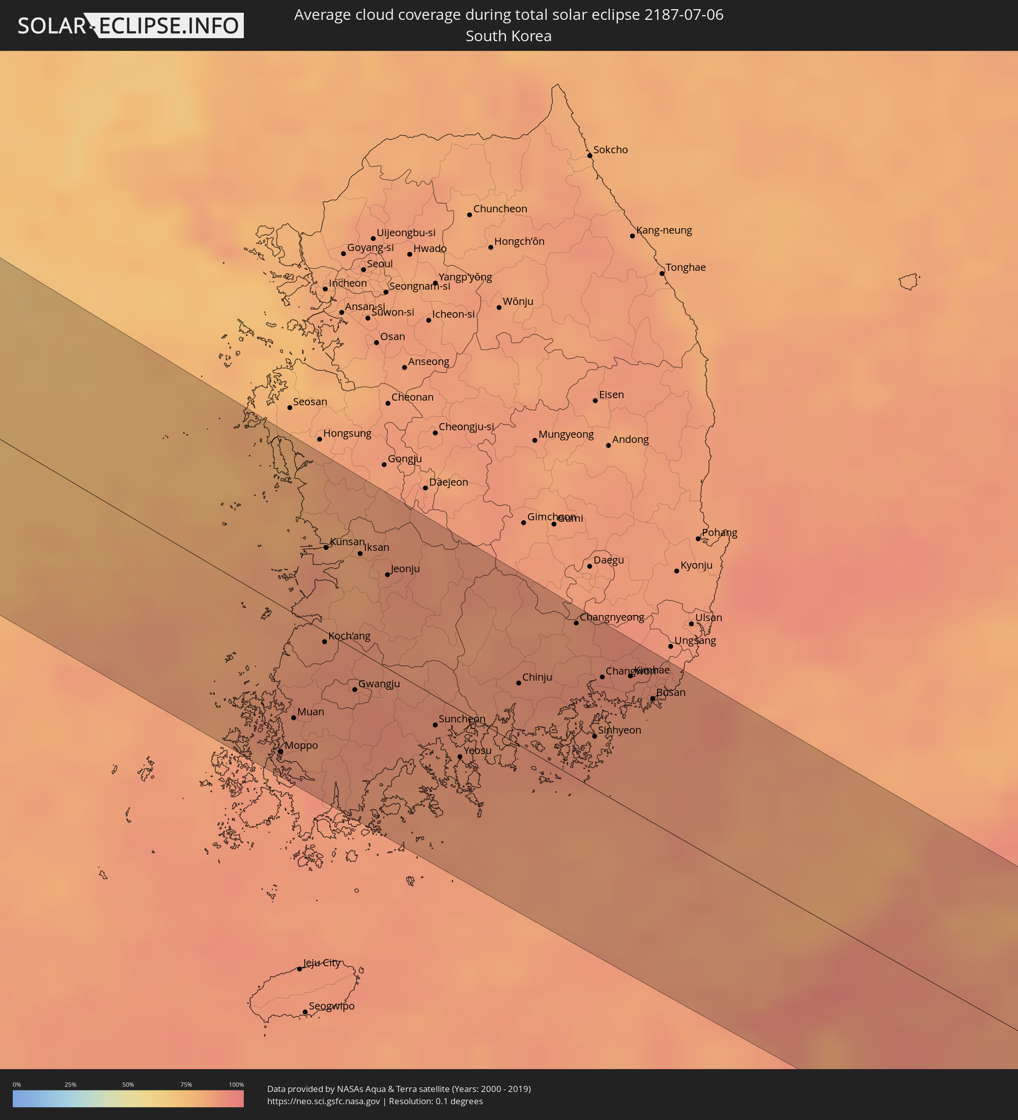
Die folgenden Karten zeigen die durchschnittliche Bewölkung für den Tag, an dem die totale Sonnenfinsternis
stattfindet. Mit Hilfe der Karten lässt sich der Ort entlang des Finsternispfades eingrenzen,
der die besten Aussichen auf einen klaren wolkenfreien Himmel bietet.
Trotzdem muss man immer lokale Gegenenheiten beachten und sollte sich genau über das Wetter an seinem
gewählten Beobachtungsort informieren.
Die Daten stammen von den beiden NASA-Satelliten
AQUA und TERRA
und wurden über einen Zeitraum von 19 Jahren (2000 - 2019) gemittelt.
Detaillierte Länderkarten
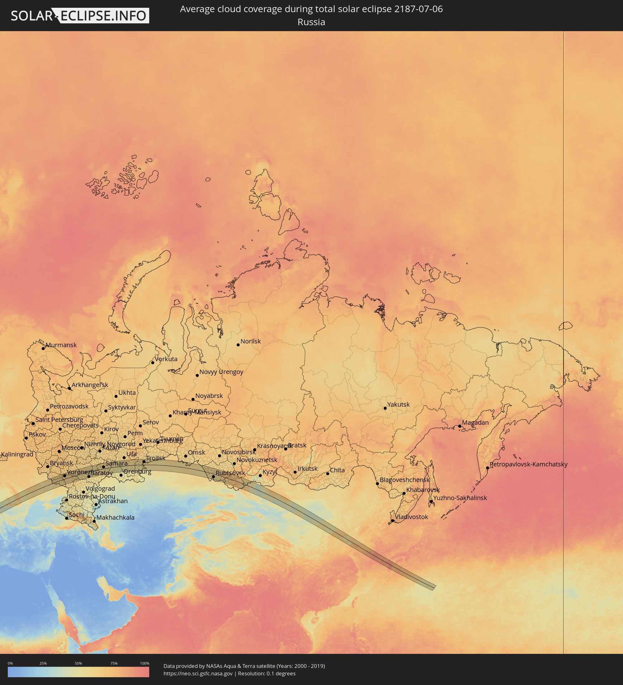 Russland
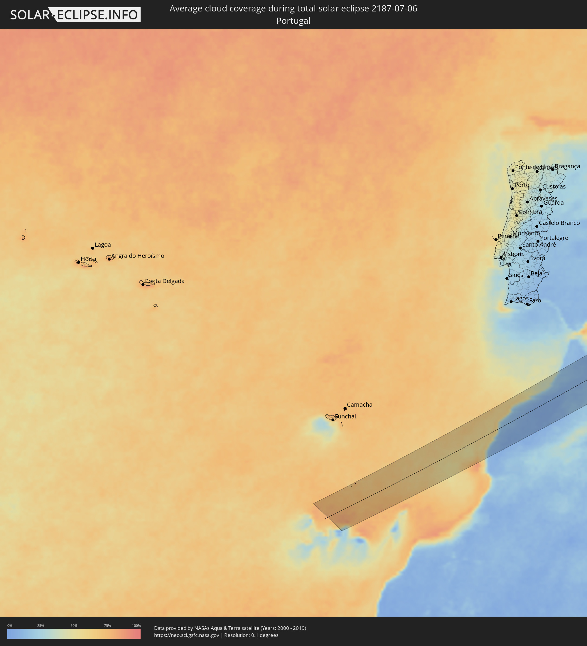 Portugal
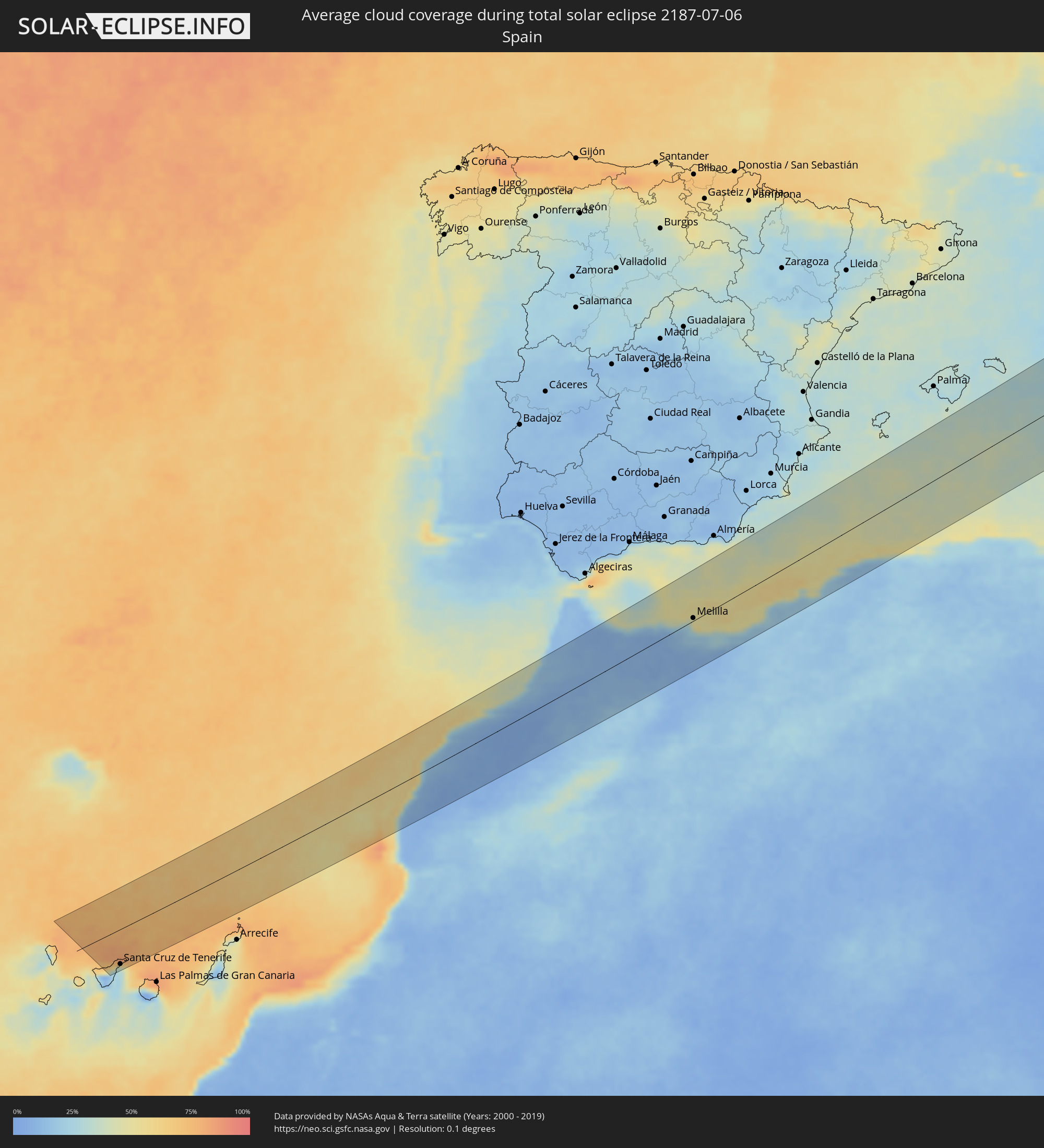 Spanien
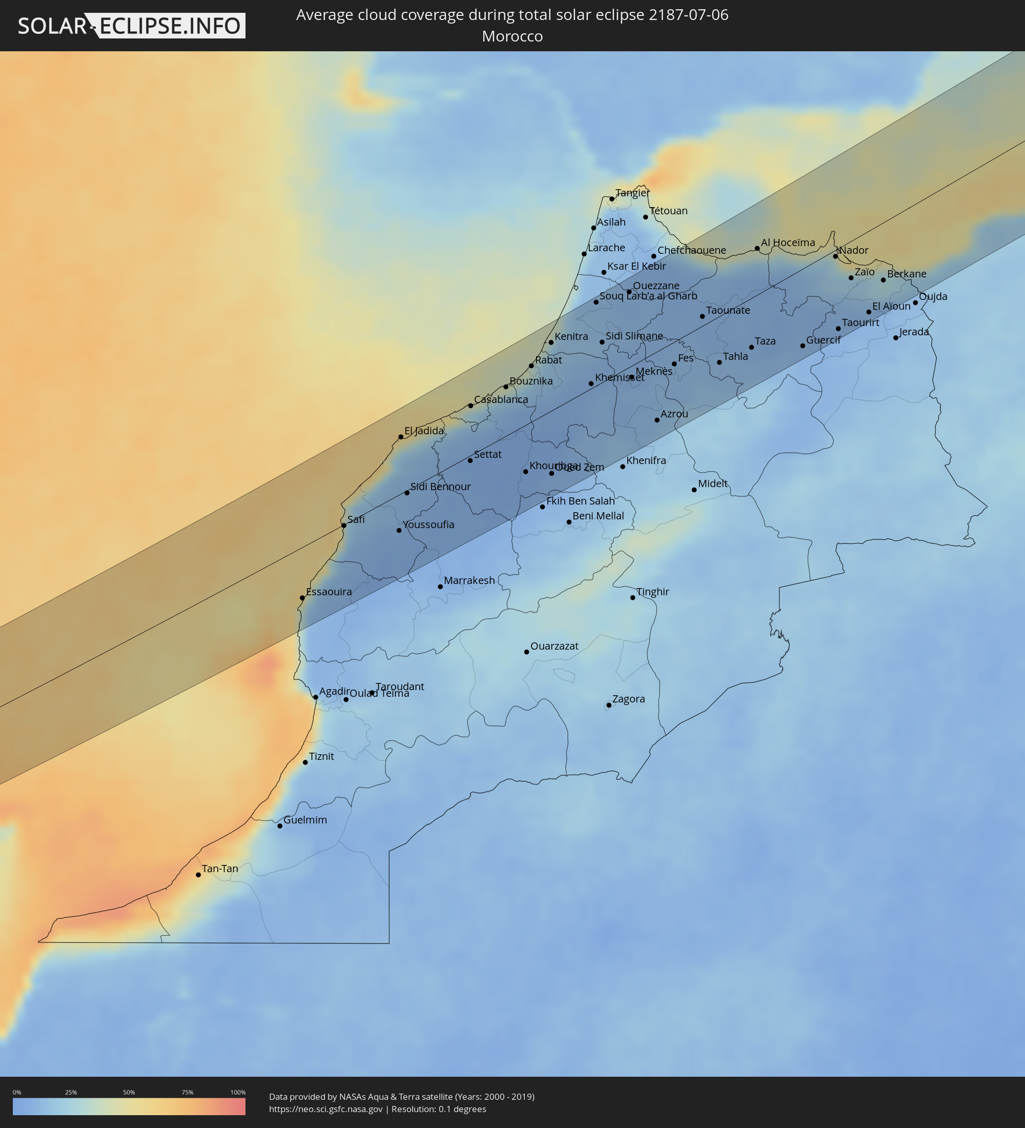 Marokko
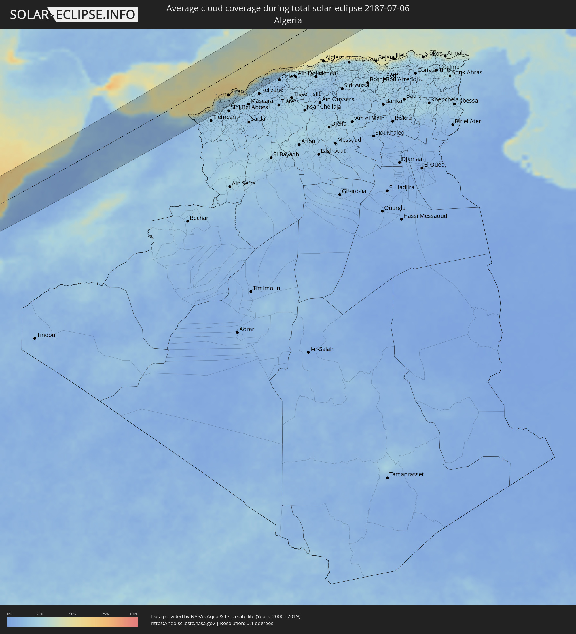 Algerien
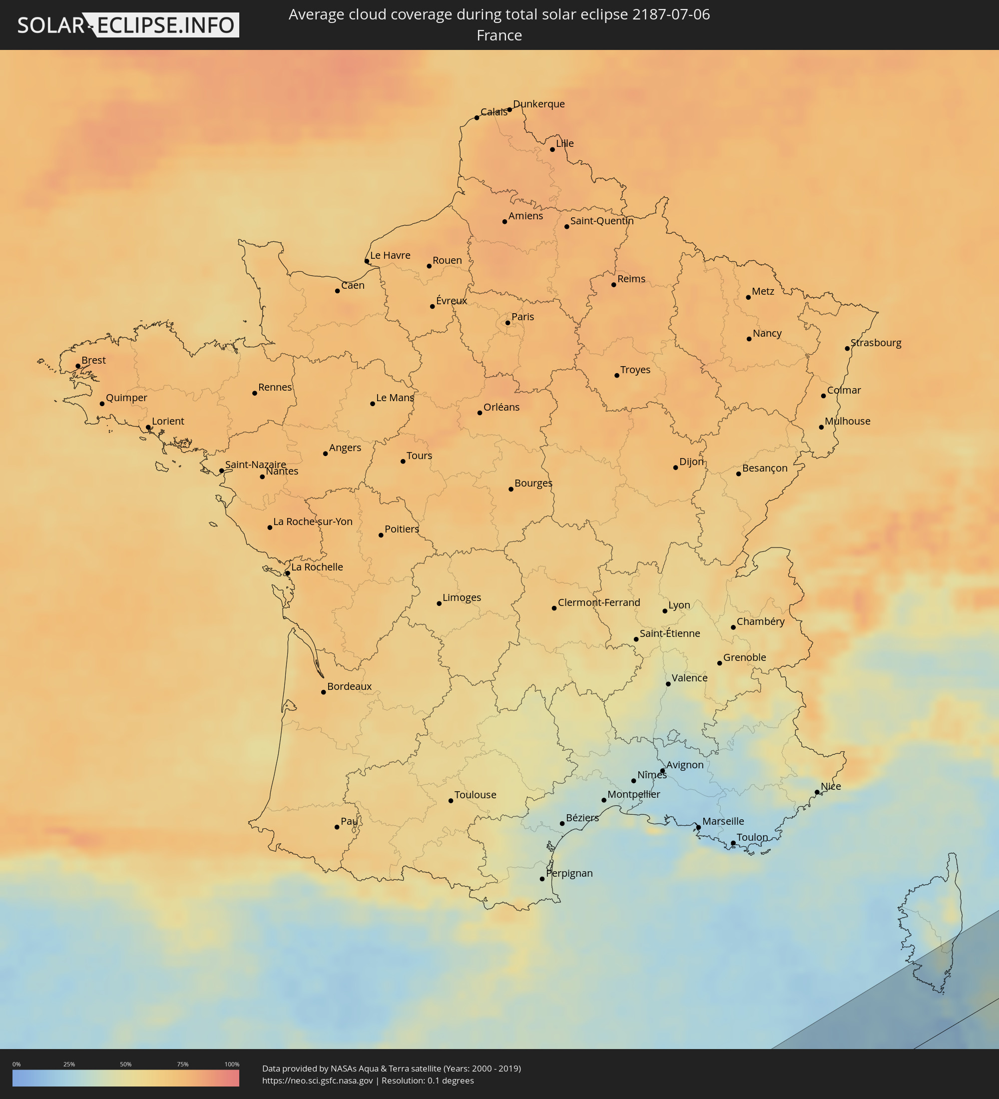 Frankreich
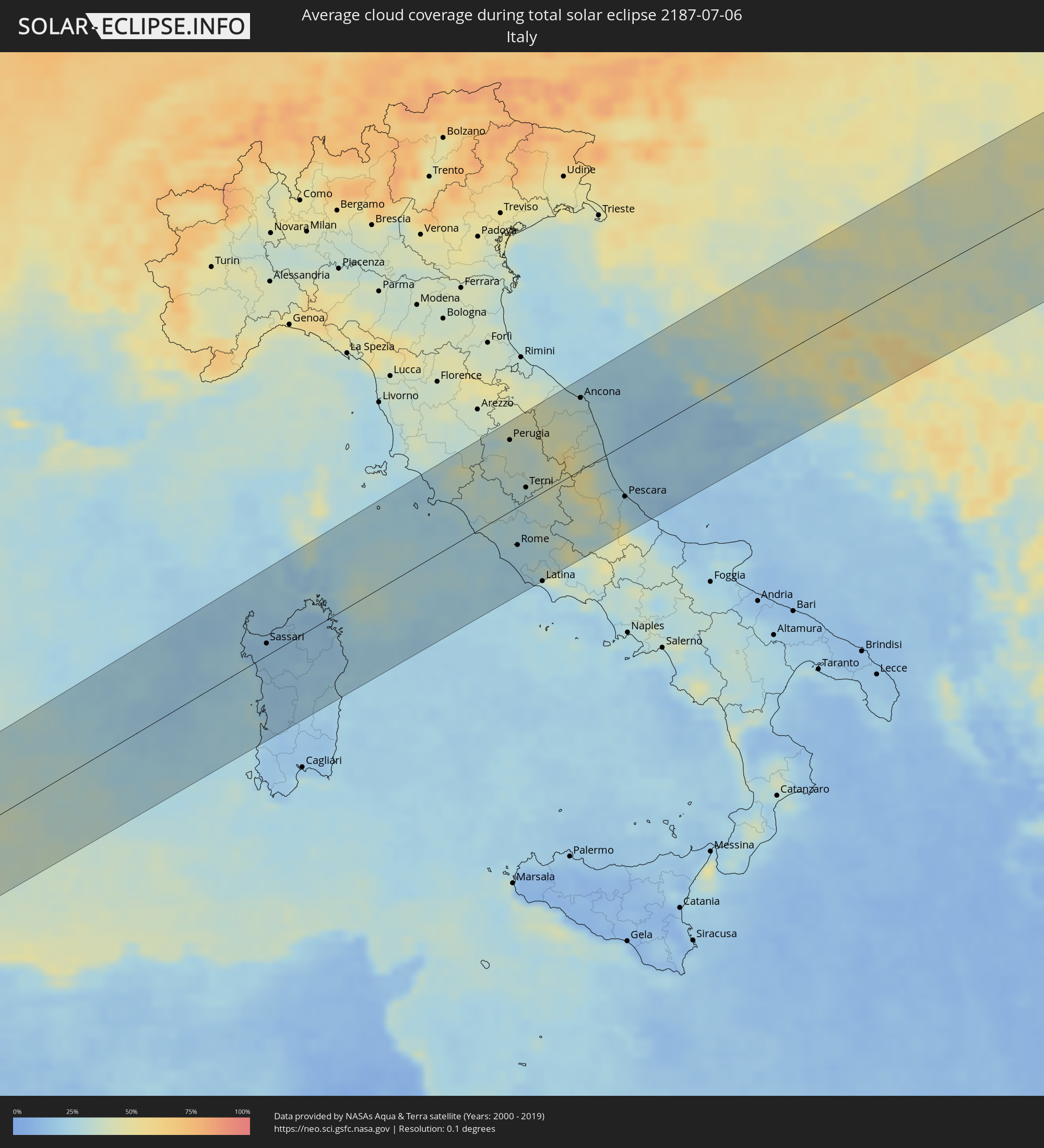 Italien
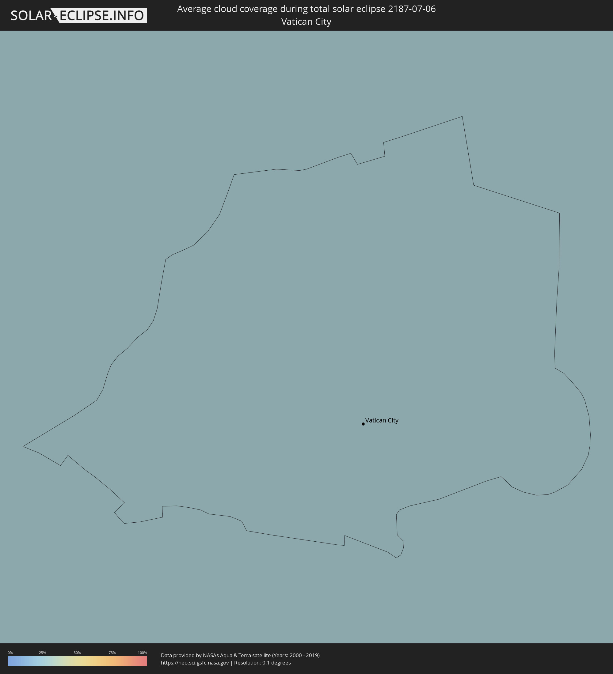 Vatikanstadt
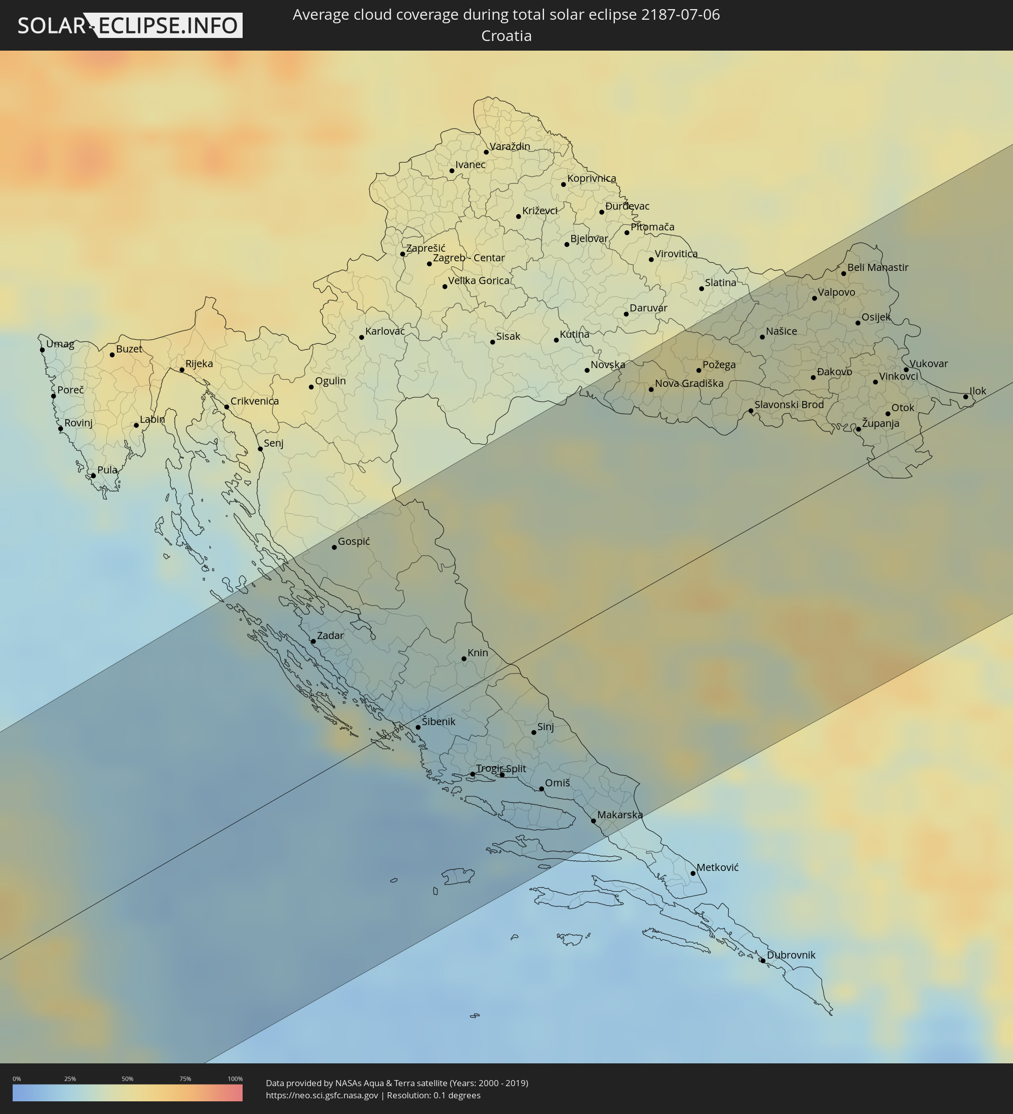 Kroatien
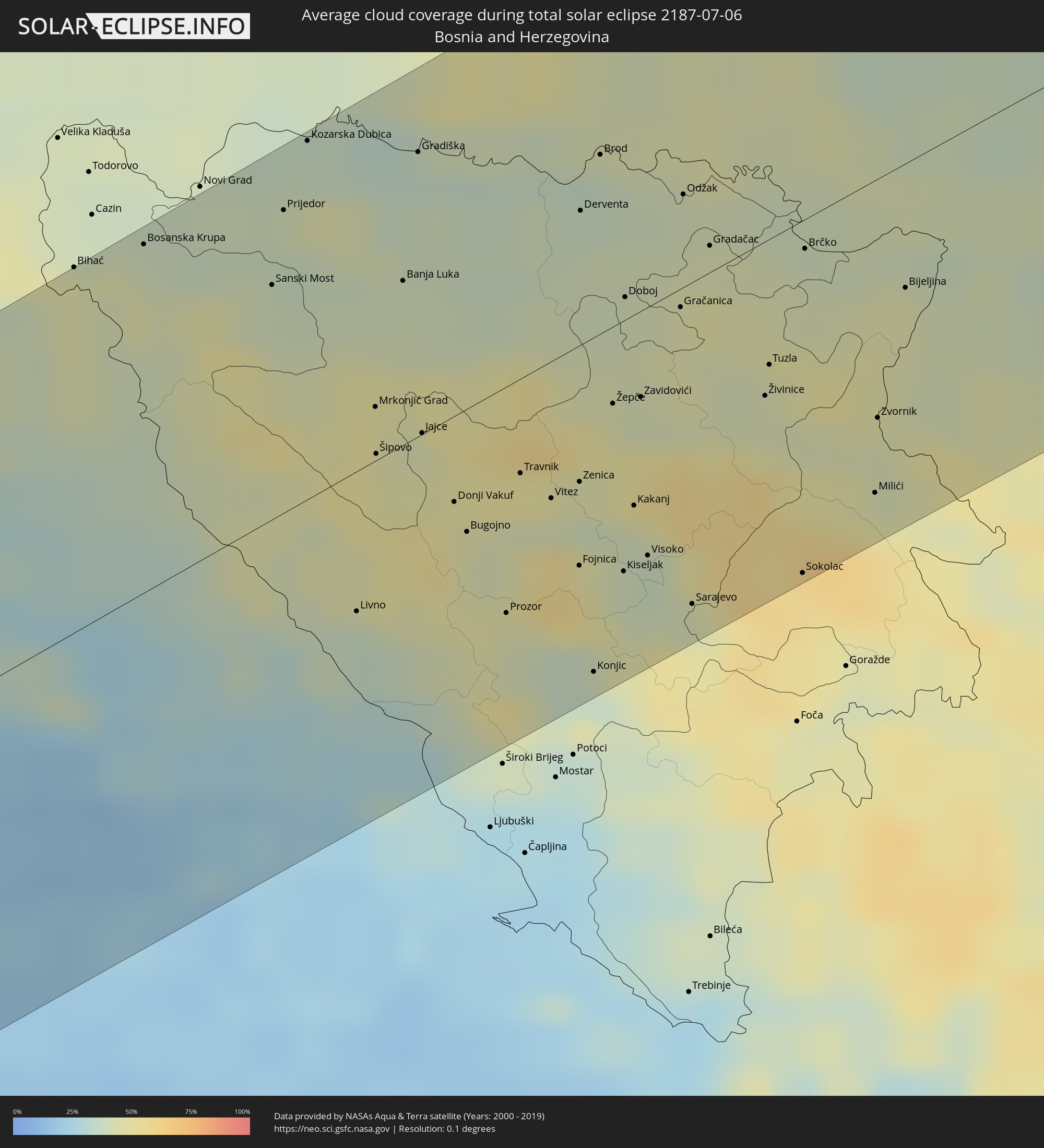 Bosnien und Herzegowina
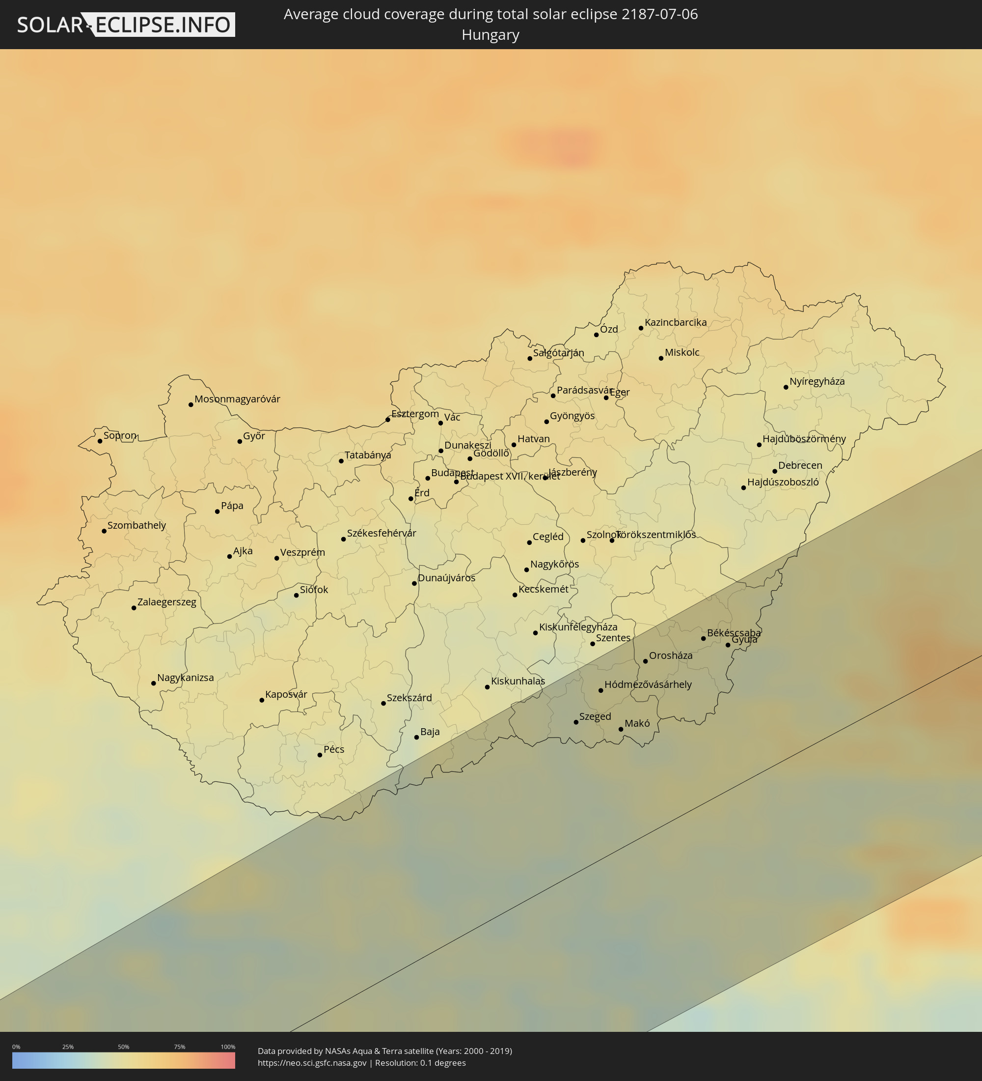 Ungarn
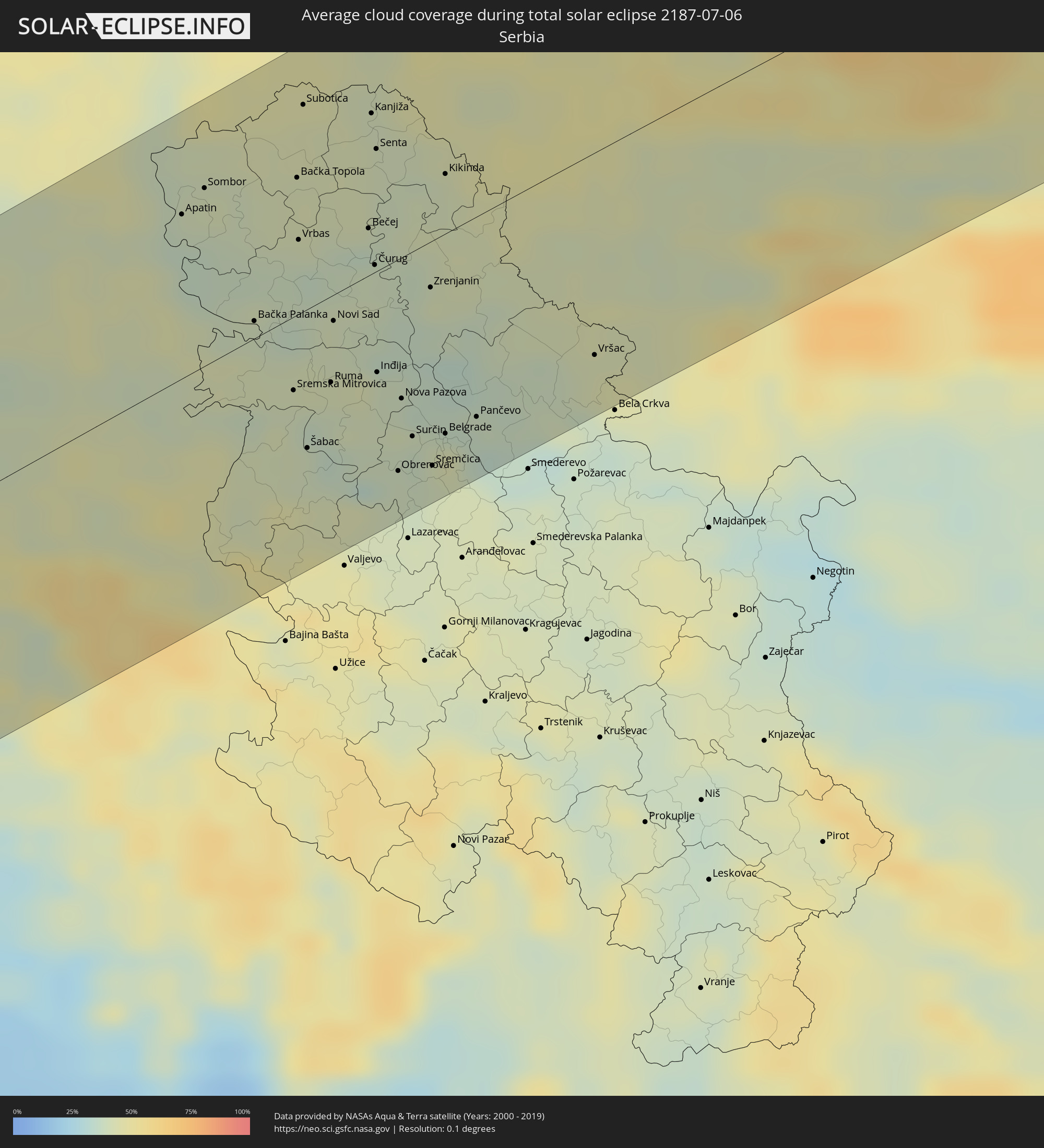 Serbien
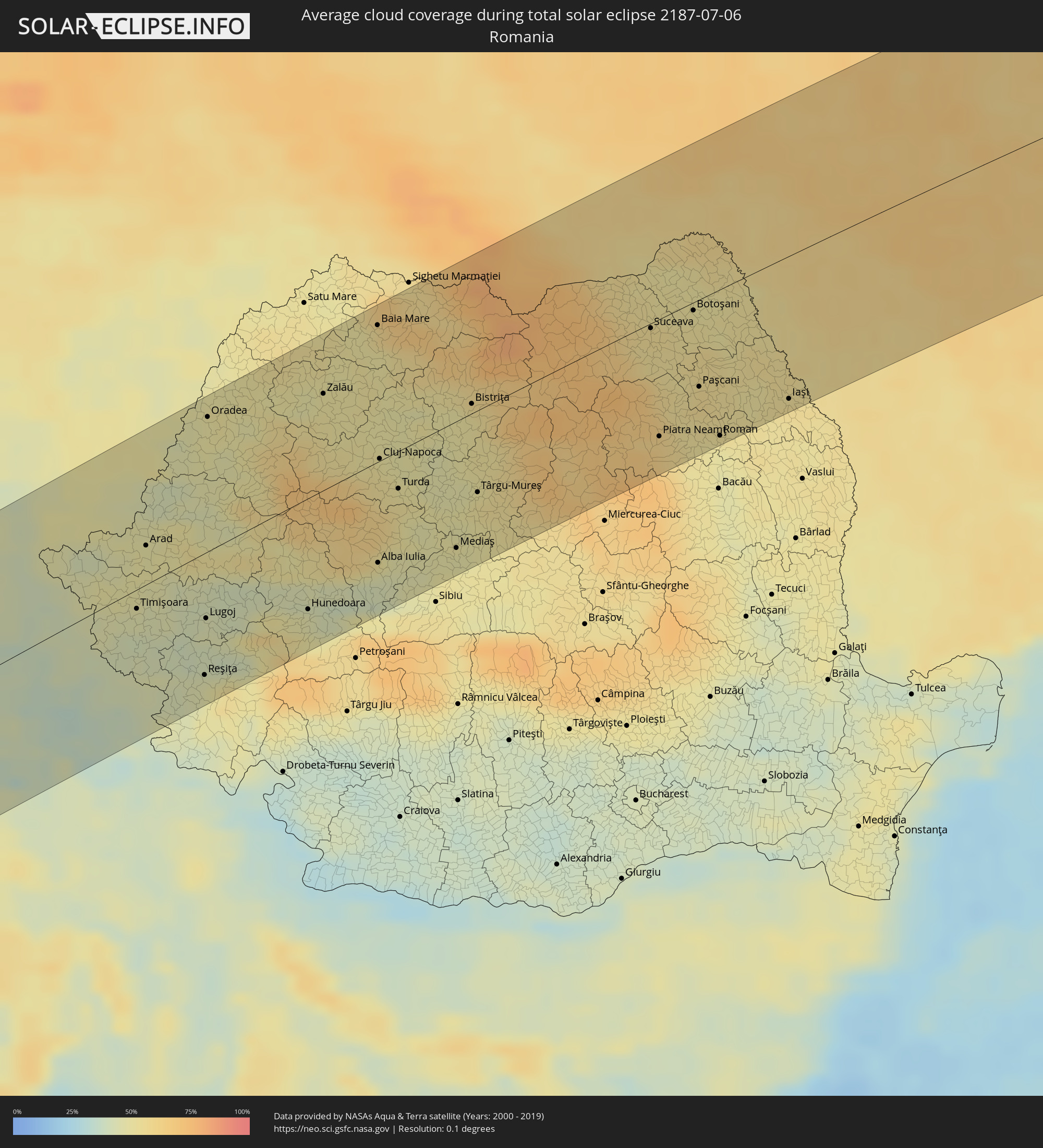 Rumänien
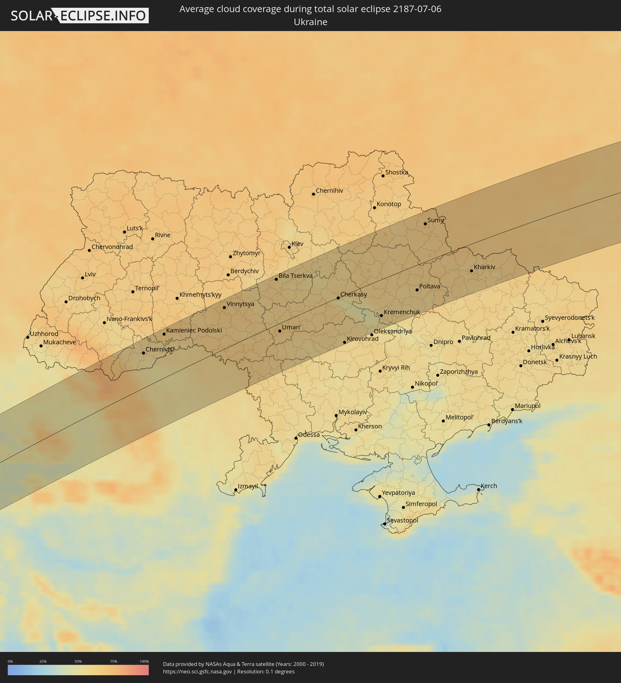 Ukraine
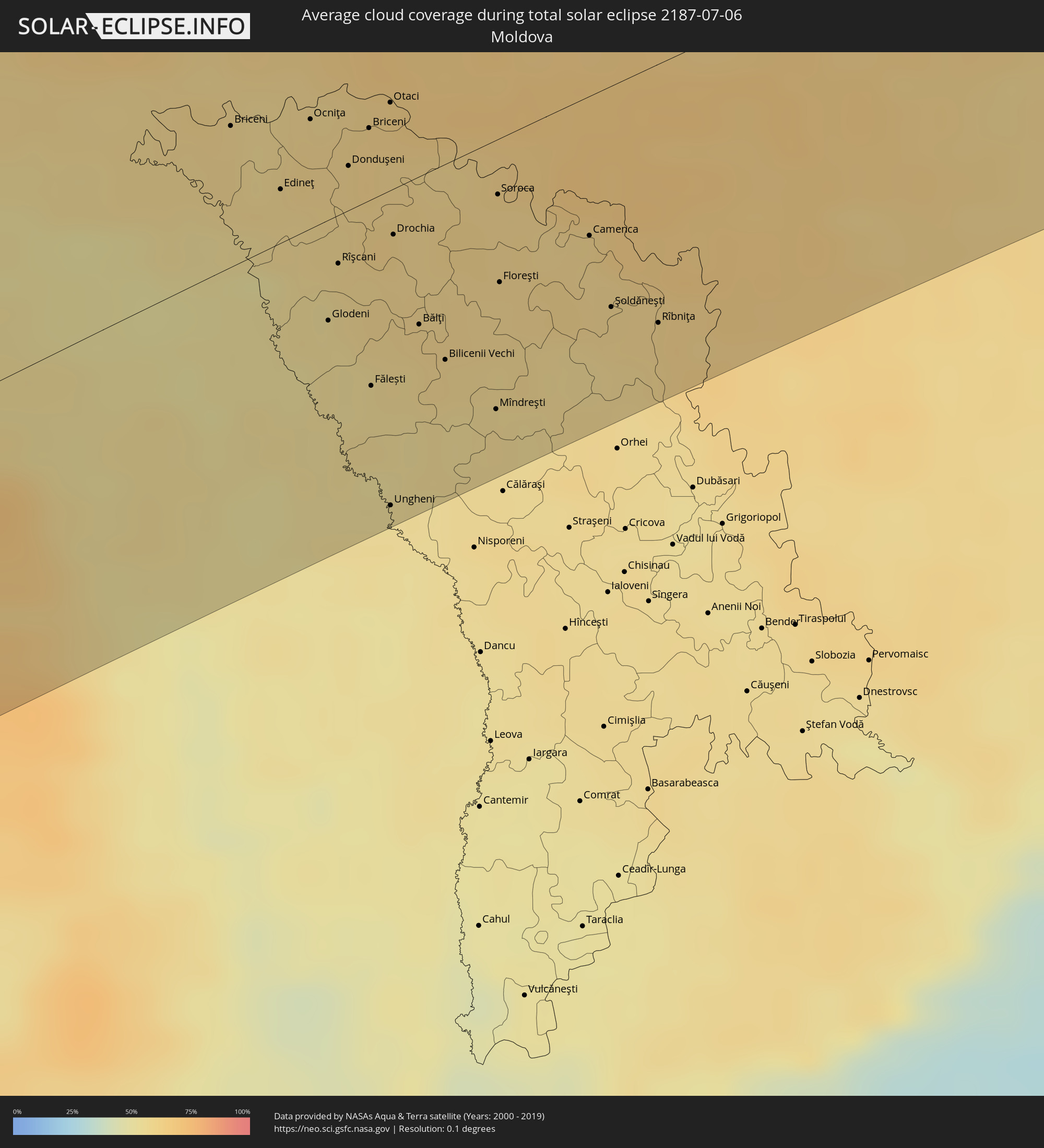 Moldawien
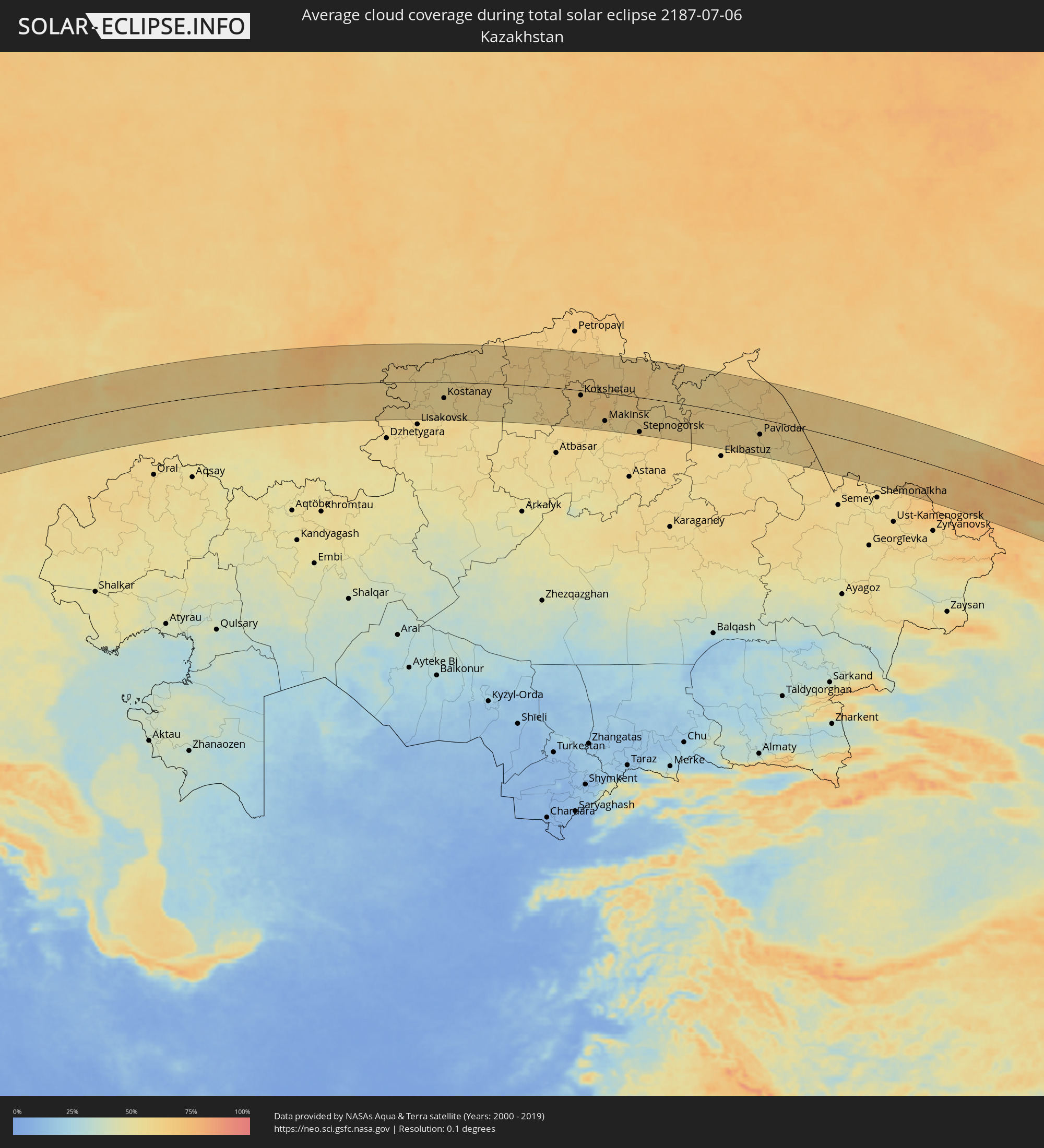 Kasachstan
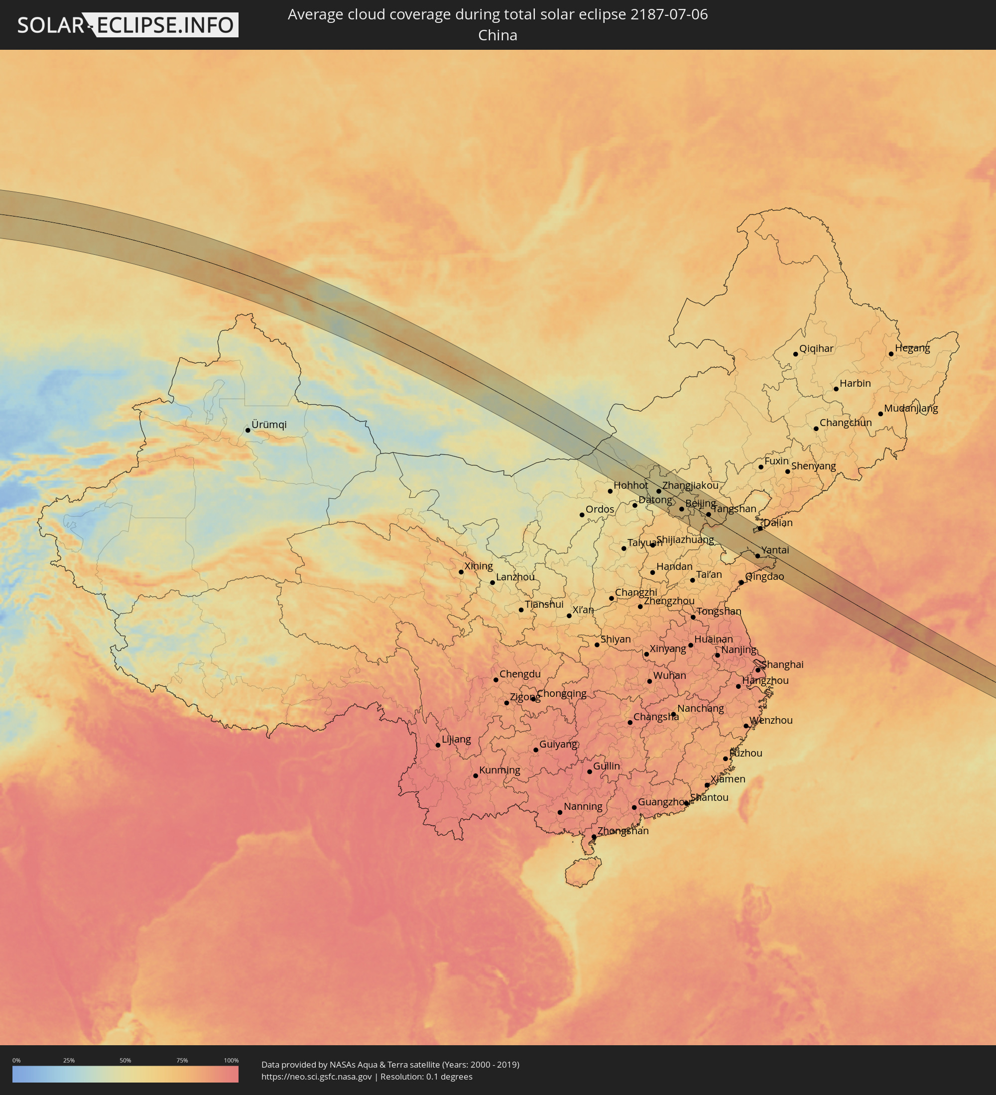 Volksrepublik China
 Mongolei
 Japan
Japan
 Südkorea
Orte im Finsternispfad
Die nachfolgene Tabelle zeigt Städte und Orte mit mehr als 5.000 Einwohnern, die sich im Finsternispfad befinden. Städte mit mehr als 100.000 Einwohnern sind dick gekennzeichnet. Mit einem Klick auf den Ort öffnet sich eine Detailkarte die die Lage des jeweiligen Ortes zusammen mit dem Verlauf der zentralen Finsternis präsentiert.
| Ort | Typ | Dauer der Verfinsterung | Ortszeit bei maximaler Verfinsterung | Entfernung zur Zentrallinie | Ø Bewölkung |
|
La Orotava, Canary Islands
|
total | - | 06:20:44 UTC+00:00 | 70 km | 40% |
|
Santa Úrsula, Canary Islands
|
total | - | 06:20:45 UTC+00:00 | 69 km | 40% |
|
La Victoria de Acentejo, Canary Islands
|
total | - | 06:20:45 UTC+00:00 | 71 km | 40% |
|
La Matanza de Acentejo, Canary Islands
|
total | - | 06:20:46 UTC+00:00 | 69 km | 51% |
|
Sauzal, Canary Islands
|
total | - | 06:20:46 UTC+00:00 | 68 km | 51% |
|
Güimar, Canary Islands
|
total | - | 06:20:37 UTC+00:00 | 84 km | 24% |
|
Tacoronte, Canary Islands
|
total | - | 06:20:46 UTC+00:00 | 67 km | 51% |
|
Candelaria, Canary Islands
|
total | - | 06:20:39 UTC+00:00 | 81 km | 26% |
|
Tegueste, Canary Islands
|
total | - | 06:20:46 UTC+00:00 | 64 km | 36% |
|
Santa Cruz de Tenerife, Canary Islands
|
total | - | 06:20:42 UTC+00:00 | 71 km | 36% |
|
Safi, Doukkala-Abda
|
total | - | 07:22:32 UTC+01:00 | 2 km | 21% |
|
El Jadida, Doukkala-Abda
|
total | - | 07:23:28 UTC+01:00 | 63 km | 42% |
|
Casablanca, Grand Casablanca
|
total | - | 07:23:42 UTC+01:00 | 54 km | 24% |
|
Mohammedia, Grand Casablanca
|
total | - | 07:23:47 UTC+01:00 | 52 km | 24% |
|
Khouribga, Chaouia-Ouardigha
|
total | - | 07:22:47 UTC+01:00 | 53 km | 5% |
|
Rabat, Rabat-Salé-Zemmour-Zaër
|
total | - | 07:24:05 UTC+01:00 | 57 km | 18% |
|
Kenitra, Gharb-Chrarda-Beni Hssen
|
total | - | 07:24:21 UTC+01:00 | 73 km | 20% |
|
Meknès, Meknès-Tafilalet
|
total | - | 07:23:48 UTC+01:00 | 17 km | 10% |
|
Fes, Fès-Boulemane
|
total | - | 07:23:55 UTC+01:00 | 27 km | 11% |
|
Taza, Taza-Al Hoceima-Taounate
|
total | - | 07:24:03 UTC+01:00 | 56 km | 9% |
|
Al Hoceïma, Taza-Al Hoceima-Taounate
|
total | - | 07:25:19 UTC+01:00 | 50 km | 33% |
|
Melilla, Melilla
|
total | - | 07:25:20 UTC+01:00 | 11 km | 49% |
|
Nedroma, Tlemcen
|
total | - | 07:24:58 UTC+01:00 | 78 km | 17% |
|
Remchi, Tlemcen
|
total | - | 07:25:02 UTC+01:00 | 86 km | 19% |
|
Beni Saf, Aïn Témouchent
|
total | - | 07:25:20 UTC+01:00 | 69 km | 28% |
|
Aïn Temouchent, Aïn Témouchent
|
total | - | 07:25:20 UTC+01:00 | 76 km | 21% |
|
Hammam Bou Hadjar, Aïn Témouchent
|
total | - | 07:25:26 UTC+01:00 | 77 km | 20% |
|
Oran, Oran
|
total | - | 07:25:51 UTC+01:00 | 60 km | 22% |
|
Sidi ech Chahmi, Oran
|
total | - | 07:25:48 UTC+01:00 | 70 km | 20% |
|
Aïn el Bya, Oran
|
total | - | 07:26:00 UTC+01:00 | 67 km | 22% |
|
Mostaganem, Mostaganem
|
total | - | 07:26:11 UTC+01:00 | 73 km | 24% |
|
’Aïn Merane, Relizane
|
total | - | 07:26:33 UTC+01:00 | 88 km | 14% |
|
Sidi Akkacha, Chlef
|
total | - | 07:26:58 UTC+01:00 | 74 km | 23% |
|
Sassari, Sardinia
|
total | - | 07:34:27 UTC+01:00 | 19 km | 18% |
|
Porto-Vecchio, Corsica
|
total | - | 07:35:58 UTC+01:00 | 65 km | 19% |
|
Grosseto, Tuscany
|
total | - | 07:38:26 UTC+01:00 | 102 km | 26% |
|
Acilia-Castel Fusano-Ostia Antica, Latium
|
total | - | 07:37:29 UTC+01:00 | 48 km | 21% |
|
Perugia, Umbria
|
total | - | 07:39:31 UTC+01:00 | 79 km | 35% |
|
Vatican City
|
total | - | 07:37:45 UTC+01:00 | 39 km | 25% |
|
Rome, Latium
|
total | - | 07:37:45 UTC+01:00 | 43 km | 25% |
|
Terni, Umbria
|
total | - | 07:38:49 UTC+01:00 | 16 km | 30% |
|
Foligno, Umbria
|
total | - | 07:39:26 UTC+01:00 | 51 km | 32% |
|
Guidonia Montecelio, Latium
|
total | - | 07:38:00 UTC+01:00 | 42 km | 25% |
|
Velletri, Latium
|
total | - | 07:37:34 UTC+01:00 | 74 km | 31% |
|
Ancona, The Marches
|
total | - | 07:40:48 UTC+01:00 | 79 km | 32% |
|
Pescara, Abruzzo
|
total | - | 07:39:26 UTC+01:00 | 58 km | 24% |
|
Zadar, Zadarska
|
total | - | 07:42:31 UTC+01:00 | 59 km | 29% |
|
Bihać, Federation of Bosnia and Herzegovina
|
total | - | 07:43:56 UTC+01:00 | 101 km | 44% |
|
Šibenik, Šibensko-Kniniska
|
total | - | 07:42:18 UTC+01:00 | 13 km | 34% |
|
Split, Splitsko-Dalmatinska
|
total | - | 07:42:17 UTC+01:00 | 49 km | 26% |
|
Prijedor, Republic of Srspka
|
total | - | 07:44:41 UTC+01:00 | 87 km | 38% |
|
Makarska, Splitsko-Dalmatinska
|
total | - | 07:42:19 UTC+01:00 | 91 km | 23% |
|
Banja Luka, Republic of Srspka
|
total | - | 07:44:41 UTC+01:00 | 46 km | 41% |
|
Bugojno, Federation of Bosnia and Herzegovina
|
total | - | 07:43:44 UTC+01:00 | 41 km | 42% |
|
Travnik, Federation of Bosnia and Herzegovina
|
total | - | 07:44:08 UTC+01:00 | 26 km | 43% |
|
Požega, Požeško-Slavonska
|
total | - | 07:45:51 UTC+01:00 | 81 km | 39% |
|
Zenica, Federation of Bosnia and Herzegovina
|
total | - | 07:44:15 UTC+01:00 | 38 km | 40% |
|
Slavonski Brod, Slavonski Brod-Posavina
|
total | - | 07:45:47 UTC+01:00 | 51 km | 38% |
|
Doboj, Republic of Srspka
|
total | - | 07:45:11 UTC+01:00 | 6 km | 43% |
|
Sarajevo, Federation of Bosnia and Herzegovina
|
total | - | 07:44:01 UTC+01:00 | 90 km | 48% |
|
Đakovo, Osječko-Baranjska
|
total | - | 07:46:16 UTC+01:00 | 50 km | 46% |
|
Tuzla, Federation of Bosnia and Herzegovina
|
total | - | 07:45:16 UTC+01:00 | 35 km | 42% |
|
Osijek, Osječko-Baranjska
|
total | - | 07:46:50 UTC+01:00 | 62 km | 42% |
|
Županja, Vukovar-Sirmium
|
total | - | 07:46:06 UTC+01:00 | 16 km | 39% |
|
Vinkovci, Vukovar-Sirmium
|
total | - | 07:46:30 UTC+01:00 | 33 km | 44% |
|
Brčko, Brčko
|
total | - | 07:45:52 UTC+01:00 | 8 km | 42% |
|
Vukovar, Vukovar-Sirmium
|
total | - | 07:46:43 UTC+01:00 | 31 km | 43% |
|
Sombor, Vojvodina
|
total | - | 07:47:27 UTC+01:00 | 68 km | 41% |
|
Bijeljina, Republic of Srspka
|
total | - | 07:45:58 UTC+01:00 | 34 km | 45% |
|
Bácsalmás, Bács-Kiskun
|
total | - | 07:48:09 UTC+01:00 | 94 km | 45% |
|
Sremska Mitrovica, Vojvodina
|
total | - | 07:46:35 UTC+01:00 | 28 km | 40% |
|
Subotica, Vojvodina
|
total | - | 07:48:20 UTC+01:00 | 79 km | 43% |
|
Šabac, Central Serbia
|
total | - | 07:46:17 UTC+01:00 | 54 km | 40% |
|
Ruma, Vojvodina
|
total | - | 07:46:47 UTC+01:00 | 33 km | 39% |
|
Novi Sad, Vojvodina
|
total | - | 07:47:10 UTC+01:00 | 10 km | 41% |
|
Szeged, Csongrád
|
total | - | 07:48:55 UTC+01:00 | 77 km | 43% |
|
Mindszent, Csongrád
|
total | - | 07:49:21 UTC+01:00 | 102 km | 45% |
|
Hódmezővásárhely, Csongrád
|
total | - | 07:49:18 UTC+01:00 | 86 km | 48% |
|
Zrenjanin, Vojvodina
|
total | - | 07:47:45 UTC+01:00 | 27 km | 42% |
|
Belgrade, Central Serbia
|
total | - | 07:46:56 UTC+01:00 | 77 km | 43% |
|
Kikinda, Vojvodina
|
total | - | 07:48:30 UTC+01:00 | 25 km | 41% |
|
Makó, Csongrád
|
total | - | 07:49:06 UTC+01:00 | 61 km | 45% |
|
Pančevo, Vojvodina
|
total | - | 07:47:10 UTC+01:00 | 77 km | 36% |
|
Orosháza, Bekes
|
total | - | 07:49:46 UTC+01:00 | 89 km | 48% |
|
Mezőkovácsháza, Bekes
|
total | - | 07:49:42 UTC+01:00 | 62 km | 48% |
|
Mezőberény, Bekes
|
total | - | 07:50:25 UTC+01:00 | 98 km | 48% |
|
Békéscsaba, Bekes
|
total | - | 07:50:16 UTC+01:00 | 83 km | 47% |
|
Timişoara, Timiş
|
total | - | 08:48:57 UTC+02:00 | 18 km | 45% |
|
Vésztő, Bekes
|
total | - | 07:50:45 UTC+01:00 | 100 km | 50% |
|
Vršac, Vojvodina
|
total | - | 07:48:02 UTC+01:00 | 80 km | 43% |
|
Arad, Arad
|
total | - | 08:49:40 UTC+02:00 | 26 km | 48% |
|
Sarkad, Bekes
|
total | - | 07:50:35 UTC+01:00 | 79 km | 50% |
|
Oradea, Bihor
|
total | - | 08:51:26 UTC+02:00 | 89 km | 50% |
|
Baia Mare, Satu Mare
|
total | - | 08:53:41 UTC+02:00 | 90 km | 59% |
|
Cluj-Napoca, Cluj
|
total | - | 08:52:22 UTC+02:00 | 9 km | 51% |
|
Bistriţa, Bistriţa-Năsăud
|
total | - | 08:53:40 UTC+02:00 | 7 km | 52% |
|
Târgu-Mureş, Mureş
|
total | - | 08:52:50 UTC+02:00 | 58 km | 54% |
|
Chernivtsi, Chernivtsi
|
total | - | 08:56:39 UTC+02:00 | 73 km | 56% |
|
Suceava, Suceava
|
total | - | 08:55:58 UTC+02:00 | 20 km | 54% |
|
Piatra Neamţ, Neamţ
|
total | - | 08:54:59 UTC+02:00 | 78 km | 62% |
|
Kamieniec Podolski, Khmelnytskyi
|
total | - | 08:57:49 UTC+02:00 | 91 km | 64% |
|
Botoşani, Botoşani
|
total | - | 08:56:31 UTC+02:00 | 12 km | 51% |
|
Edineţ, Raionul Edineţ
|
total | - | 08:57:44 UTC+02:00 | 18 km | 58% |
|
Rîşcani, Rîşcani
|
total | - | 08:57:39 UTC+02:00 | 15 km | 57% |
|
Iaşi, Iaşi
|
total | - | 08:56:32 UTC+02:00 | 94 km | 55% |
|
Briceni, Donduşeni
|
total | - | 08:58:22 UTC+02:00 | 26 km | 62% |
|
Fălești, Făleşti
|
total | - | 08:57:15 UTC+02:00 | 58 km | 55% |
|
Ungheni, Ungheni
|
total | - | 08:56:48 UTC+02:00 | 99 km | 55% |
|
Drochia, Drochia
|
total | - | 08:58:01 UTC+02:00 | 24 km | 59% |
|
Bălţi, Bălţi
|
total | - | 08:57:43 UTC+02:00 | 47 km | 59% |
|
Sîngerei, Sîngerei
|
total | - | 08:57:45 UTC+02:00 | 67 km | 56% |
|
Soroca, Raionul Soroca
|
total | - | 08:58:38 UTC+02:00 | 23 km | 60% |
|
Floreşti, Floreşti
|
total | - | 08:58:16 UTC+02:00 | 44 km | 59% |
|
Vinnytsya, Vinnyts'ka
|
total | - | 09:00:23 UTC+02:00 | 85 km | 66% |
|
Rîbniţa, Stînga Nistrului
|
total | - | 08:58:48 UTC+02:00 | 79 km | 60% |
|
Bila Tserkva, Kiev
|
total | - | 09:02:49 UTC+02:00 | 95 km | 62% |
|
Uman’, Cherkasy
|
total | - | 09:01:25 UTC+02:00 | 20 km | 63% |
|
Cherkasy, Cherkasy
|
total | - | 09:04:18 UTC+02:00 | 4 km | 55% |
|
Kirovohrad, Kirovohrad
|
total | - | 09:03:15 UTC+02:00 | 102 km | 57% |
|
Kremenchuk, Poltava
|
total | - | 09:05:18 UTC+02:00 | 77 km | 57% |
|
Poltava, Poltava
|
total | - | 09:07:16 UTC+02:00 | 56 km | 62% |
|
Sumy, Sumy
|
total | - | 09:09:18 UTC+02:00 | 79 km | 65% |
|
Kharkiv, Kharkiv
|
total | - | 09:09:46 UTC+02:00 | 57 km | 65% |
|
Belgorod, Belgorod
|
total | - | 10:10:57 UTC+03:00 | 6 km | 66% |
|
Staryy Oskol, Belgorod
|
total | - | 10:13:18 UTC+03:00 | 42 km | 68% |
|
Voronezh, Voronezj
|
total | - | 10:15:22 UTC+03:00 | 51 km | 70% |
|
Penza, Penza
|
total | - | 10:24:21 UTC+03:00 | 101 km | 69% |
|
Saratov, Saratov
|
total | - | 11:24:12 UTC+04:00 | 96 km | 58% |
|
Balakovo, Saratov
|
total | - | 11:27:09 UTC+04:00 | 70 km | 57% |
|
Syzran’, Samara
|
total | - | 11:28:59 UTC+04:00 | 45 km | 62% |
|
Tol’yatti, Samara
|
total | - | 11:30:28 UTC+04:00 | 74 km | 61% |
|
Samara, Samara
|
total | - | 11:31:21 UTC+04:00 | 31 km | 62% |
|
Sterlitamak, Bashkortostan
|
total | - | 12:39:55 UTC+05:00 | 21 km | 63% |
|
Magnitogorsk, Chelyabinsk
|
total | - | 12:44:27 UTC+05:00 | 17 km | 66% |
|
Komsomolets, Qostanay
|
total | - | 12:49:00 UTC+05:00 | 15 km | 60% |
|
Kachar, Qostanay
|
total | - | 12:50:12 UTC+05:00 | 28 km | 60% |
|
Rudnyy, Qostanay
|
total | - | 12:50:35 UTC+05:00 | 72 km | 59% |
|
Kostanay, Qostanay
|
total | - | 12:51:21 UTC+05:00 | 46 km | 58% |
|
Kokshetau, Aqmola
|
total | - | 13:00:04 UTC+05:00 | 15 km | 66% |
|
Taiynsha, Soltüstik Qazaqstan
|
total | - | 13:00:24 UTC+05:00 | 52 km | 62% |
|
Shchuchinsk, Aqmola
|
total | - | 13:01:22 UTC+05:00 | 49 km | 64% |
|
Makinsk, Aqmola
|
total | - | 13:01:51 UTC+05:00 | 79 km | 62% |
|
Stepnogorsk, Aqmola
|
total | - | 13:04:11 UTC+05:00 | 97 km | 61% |
|
Aksu, Pavlodar
|
total | - | 13:11:53 UTC+05:00 | 72 km | 59% |
|
Pavlodar, Pavlodar
|
total | - | 13:11:46 UTC+05:00 | 45 km | 59% |
|
Ulaangom, Uvs
|
total | - | 15:33:58 UTC+07:00 | 36 km | 53% |
|
Uliastay, Dzabkhan
|
total | - | 15:42:16 UTC+07:00 | 49 km | 60% |
|
Tosontsengel, Dzabkhan
|
total | - | 15:42:13 UTC+07:00 | 102 km | 59% |
|
Bayanhongor, Bayanhongor
|
total | - | 16:46:59 UTC+08:00 | 42 km | 58% |
|
Bayanhongor, Bayanhongor
|
total | - | 16:48:19 UTC+08:00 | 71 km | 51% |
|
Tsetserleg, Arhangay
|
total | - | 16:47:02 UTC+08:00 | 82 km | 57% |
|
Arvayheer, Övörhangay
|
total | - | 16:50:01 UTC+08:00 | 21 km | 62% |
|
Kharkhorin, Övörhangay
|
total | - | 16:48:37 UTC+08:00 | 103 km | 57% |
|
Harhorin, Övörhangay
|
total | - | 16:48:38 UTC+08:00 | 104 km | 57% |
|
Mandalgovi, Middle Govĭ
|
total | - | 16:53:31 UTC+08:00 | 94 km | 50% |
|
Jining, Inner Mongolia
|
total | - | 17:04:58 UTC+08:00 | 81 km | 53% |
|
Zhangjiakou, Hebei
|
total | - | 17:06:07 UTC+08:00 | 26 km | 47% |
|
Zhangjiakou Shi Xuanhua Qu, Hebei
|
total | - | 17:06:30 UTC+08:00 | 43 km | 48% |
|
Beijing, Beijing
|
total | - | 17:08:05 UTC+08:00 | 48 km | 60% |
|
Langfang, Hebei
|
total | - | 17:08:47 UTC+08:00 | 71 km | 62% |
|
Tianjin, Tianjin
|
total | - | 17:09:29 UTC+08:00 | 85 km | 64% |
|
Tanggu, Tianjin
|
total | - | 17:09:50 UTC+08:00 | 75 km | 73% |
|
Tangshan, Hebei
|
total | - | 17:09:07 UTC+08:00 | 16 km | 63% |
|
Qinhuangdao, Hebei
|
total | - | 17:09:07 UTC+08:00 | 99 km | 65% |
|
Yantai, Shandong
|
total | - | 17:13:04 UTC+08:00 | 56 km | 73% |
|
Dalian, Liaoning
|
total | - | 17:11:06 UTC+08:00 | 93 km | 69% |
|
Moppo, Jeollanam-do
|
total | - | 18:17:19 UTC+09:00 | 83 km | 88% |
|
Kunsan, Jeollabuk-do
|
total | - | 18:15:48 UTC+09:00 | 47 km | 83% |
|
Gwangju, Gwangju
|
total | - | 18:16:53 UTC+09:00 | 23 km | 88% |
|
Iksan, Jeollabuk-do
|
total | - | 18:15:52 UTC+09:00 | 57 km | 83% |
|
Jeonju, Jeollabuk-do
|
total | - | 18:16:02 UTC+09:00 | 54 km | 87% |
|
Suncheon, Jeollanam-do
|
total | - | 18:17:10 UTC+09:00 | 18 km | 87% |
|
Yeosu, Jeollanam-do
|
total | - | 18:17:24 UTC+09:00 | 33 km | 87% |
|
Chinju, Gyeongsangnam-do
|
total | - | 18:16:52 UTC+09:00 | 36 km | 88% |
|
Changwon, Gyeongsangnam-do
|
total | - | 18:16:50 UTC+09:00 | 68 km | 90% |
|
Kimhae, Gyeongsangnam-do
|
total | - | 18:16:49 UTC+09:00 | 75 km | 89% |
|
Busan, Busan
|
total | - | 18:16:59 UTC+09:00 | 72 km | 87% |
|
Sasebo, Nagasaki
|
total | - | 18:19:22 UTC+09:00 | 89 km | 87% |
|
Saga, Saga Prefecture
|
total | - | 18:19:15 UTC+09:00 | 54 km | 85% |
|
Fukuoka, Fukuoka
|
total | - | 18:18:48 UTC+09:00 | 12 km | 91% |
|
Ōmuta, Fukuoka
|
total | - | 18:19:29 UTC+09:00 | 69 km | 85% |
|
Kurume, Fukuoka
|
total | - | 18:19:08 UTC+09:00 | 41 km | 88% |
|
Kumamoto, Kumamoto
|
total | - | 18:19:44 UTC+09:00 | 77 km | 87% |
|
Kitakyushu, Fukuoka
|
total | - | 18:18:28 UTC+09:00 | 37 km | 89% |
|
Ube, Yamaguchi
|
total | - | 18:18:19 UTC+09:00 | 60 km | 81% |
|
Yamaguchi, Yamaguchi
|
total | - | 18:18:01 UTC+09:00 | 93 km | 89% |
|
Ōita, Oita
|
total | - | 18:19:09 UTC+09:00 | 10 km | 86% |
|
Nobeoka, Miyazaki
|
total | - | 18:19:55 UTC+09:00 | 53 km | 82% |