Totale Sonnenfinsternis vom 20.11.2207
| Wochentag: | Freitag |
| Maximale Dauer der Verfinsterung: | 03m56s |
| Maximale Breite des Finsternispfades: | 180 km |
| Saroszyklus: | 136 |
| Bedeckungsgrad: | 100% |
| Magnitude: | 1.0434 |
| Gamma: | 0.6027 |
Wo kann man die Sonnenfinsternis vom 20.11.2207 sehen?
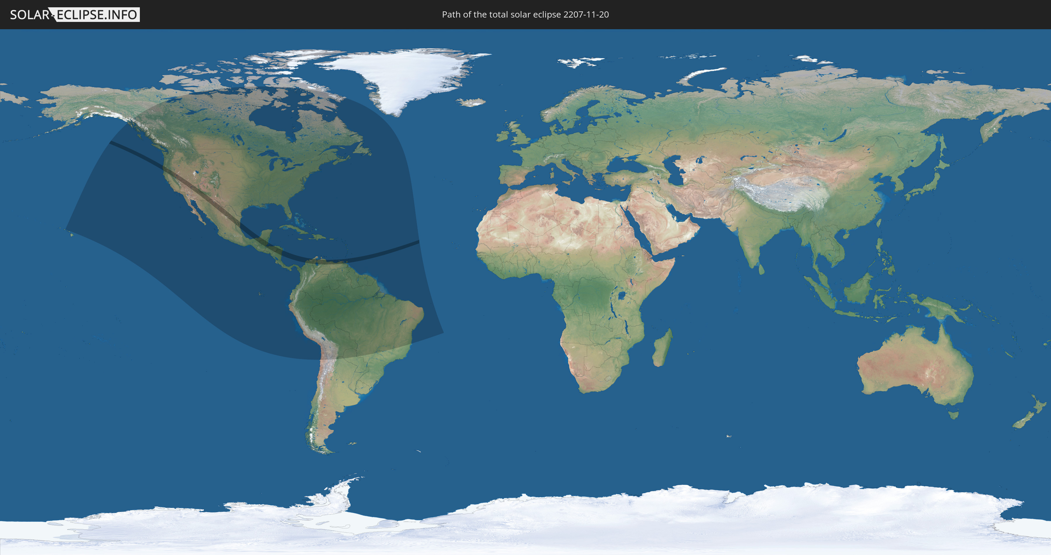
Die Sonnenfinsternis am 20.11.2207 kann man in 51 Ländern als partielle Sonnenfinsternis beobachten.
Der Finsternispfad verläuft durch 9 Länder. Nur in diesen Ländern ist sie als totale Sonnenfinsternis zu sehen.
In den folgenden Ländern ist die Sonnenfinsternis total zu sehen
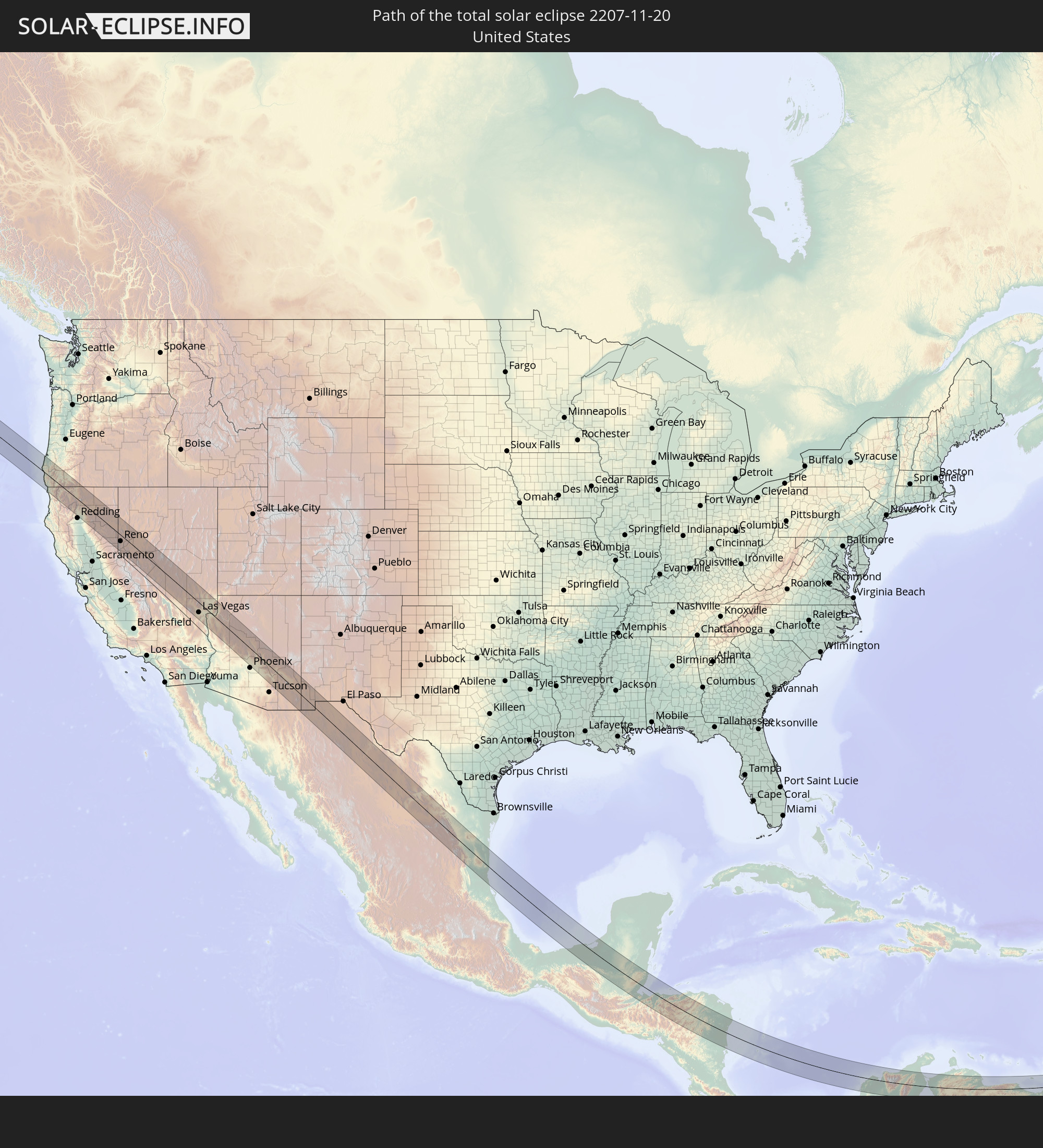 Vereinigte Staaten
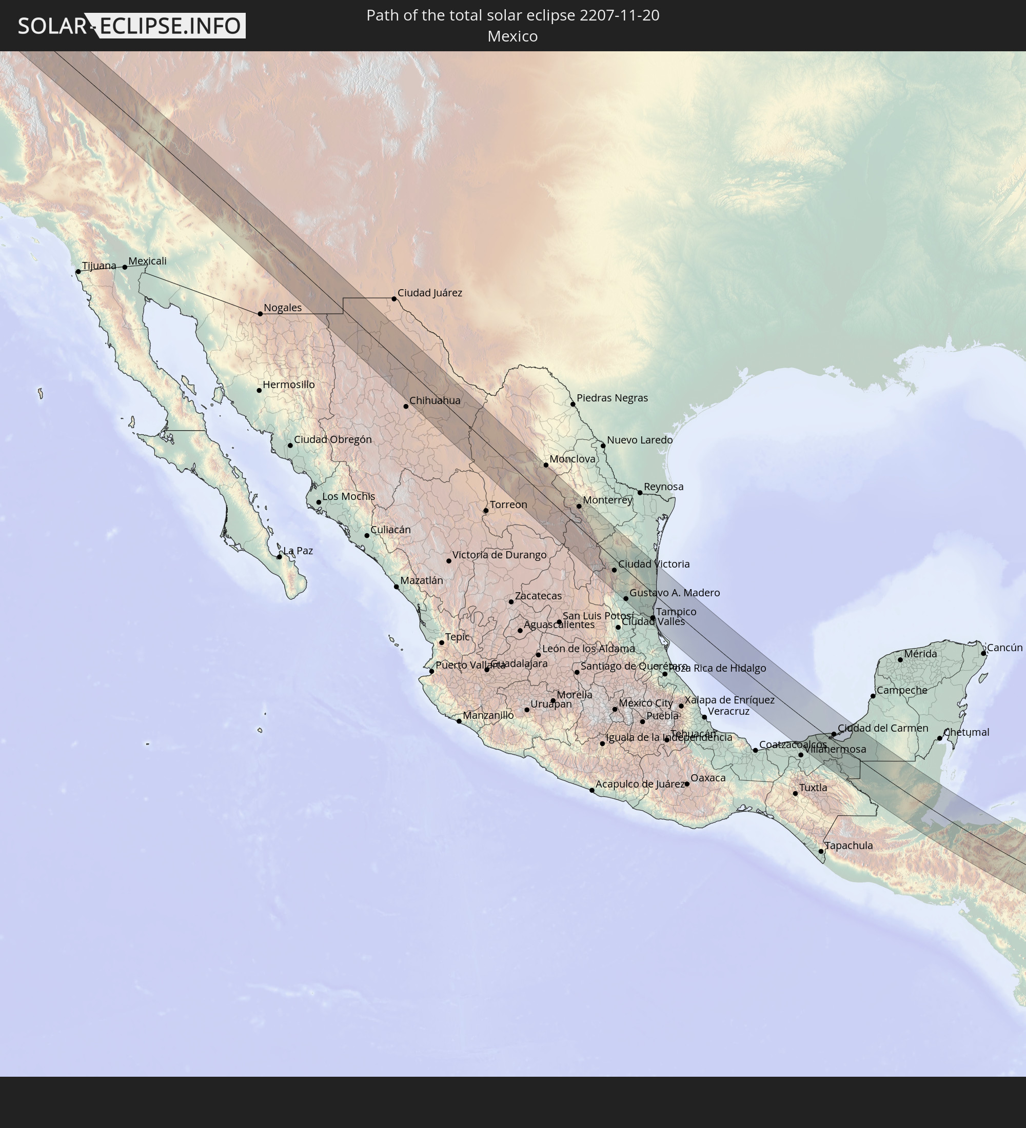 Mexiko
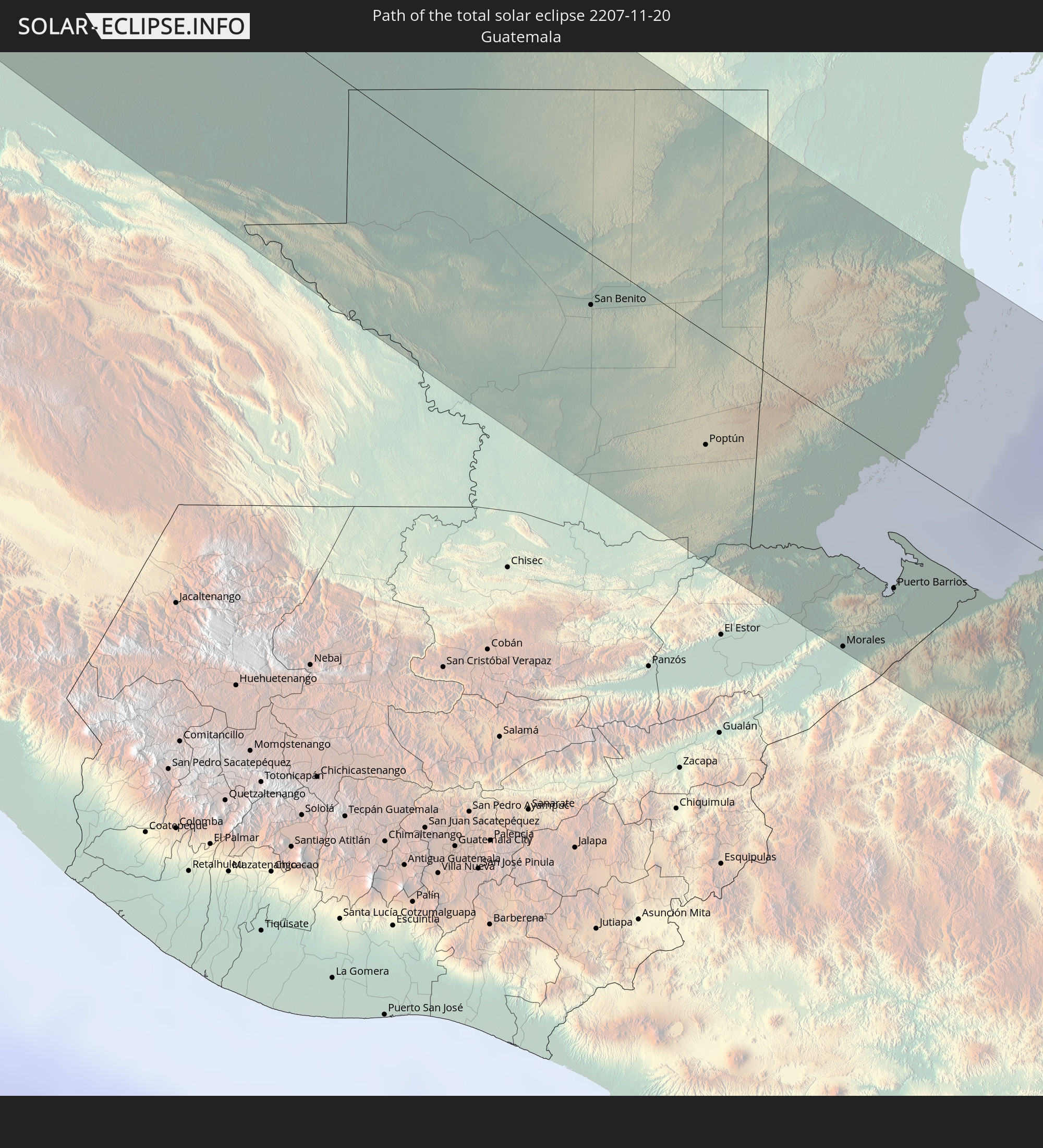 Guatemala
 Honduras
 Belize
 Nicaragua
 Kolumbien
 Venezuela
 Trinidad und Tobago
In den folgenden Ländern ist die Sonnenfinsternis partiell zu sehen
 Vereinigte Staaten
 United States Minor Outlying Islands
 Kanada
 Mexiko
 Chile
Chile
 Grönland
 Guatemala
 Ecuador
 El Salvador
 Honduras
 Belize
 Nicaragua
 Costa Rica
 Kuba
Kuba
 Panama
 Kolumbien
 Kaimaninseln
 Peru
Peru
 Bahamas
 Jamaika
 Haiti
Haiti
 Brasilien
 Argentinien
 Venezuela
 Turks- und Caicosinseln
 Dominikanische Republik
 Aruba
Aruba
 Bolivien
 Puerto Rico
 Amerikanische Jungferninseln
 Bermuda
 Britische Jungferninseln
 Anguilla
 Saint-Martin
 Saint-Barthélemy
 St. Kitts und Nevis
 Paraguay
 Antigua und Barbuda
 Montserrat
 Trinidad und Tobago
 Guadeloupe
 Grenada
 Dominica
 St. Vincent und die Grenadinen
 Guyana
 Martinique
 St. Lucia
 Barbados
 Suriname
 Saint-Pierre und Miquelon
 Französisch-Guayana
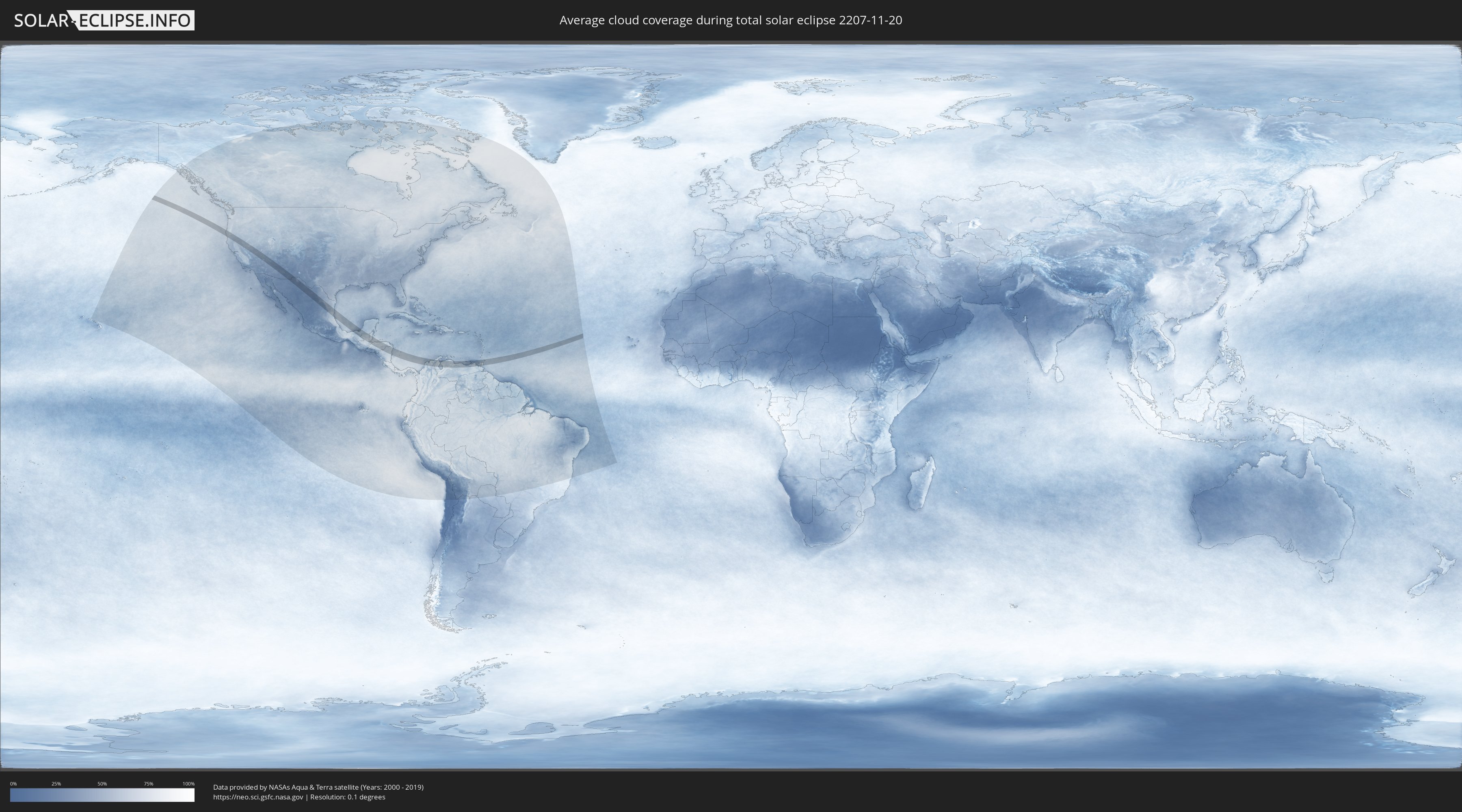
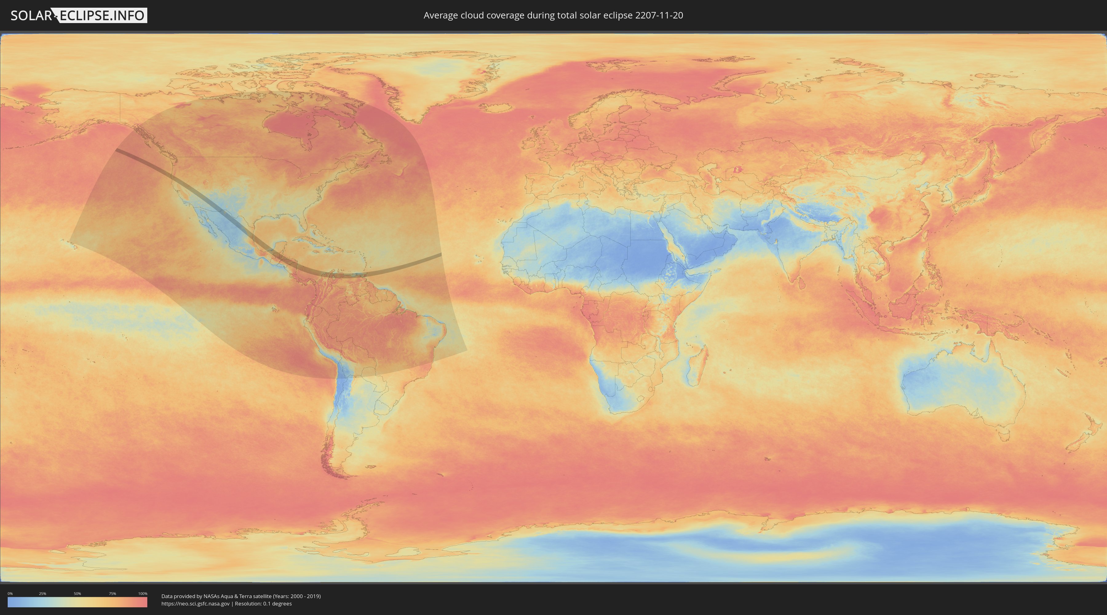
Wie wird das Wetter während der totalen Sonnenfinsternis am 20.11.2207?
Wo ist der beste Ort, um die totale Sonnenfinsternis vom 20.11.2207 zu beobachten?
Die folgenden Karten zeigen die durchschnittliche Bewölkung für den Tag, an dem die totale Sonnenfinsternis
stattfindet. Mit Hilfe der Karten lässt sich der Ort entlang des Finsternispfades eingrenzen,
der die besten Aussichen auf einen klaren wolkenfreien Himmel bietet.
Trotzdem muss man immer lokale Gegenenheiten beachten und sollte sich genau über das Wetter an seinem
gewählten Beobachtungsort informieren.
Die Daten stammen von den beiden NASA-Satelliten
AQUA und TERRA
und wurden über einen Zeitraum von 19 Jahren (2000 - 2019) gemittelt.
Detaillierte Länderkarten
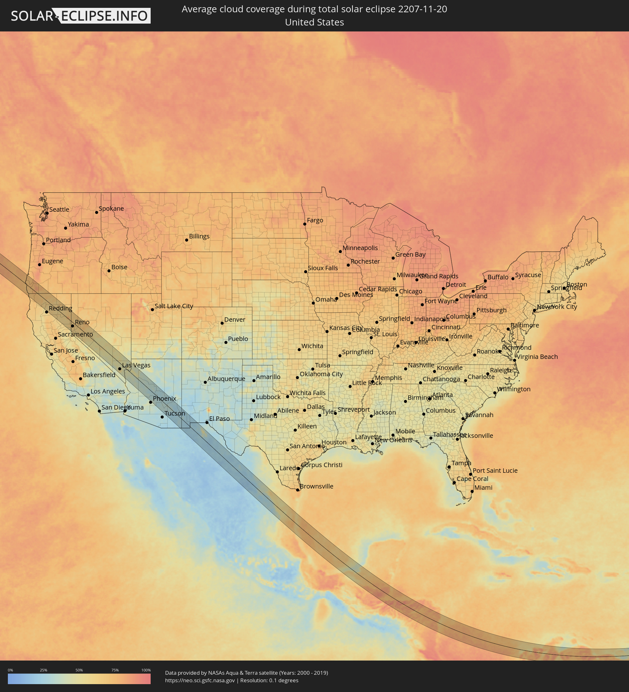 Vereinigte Staaten
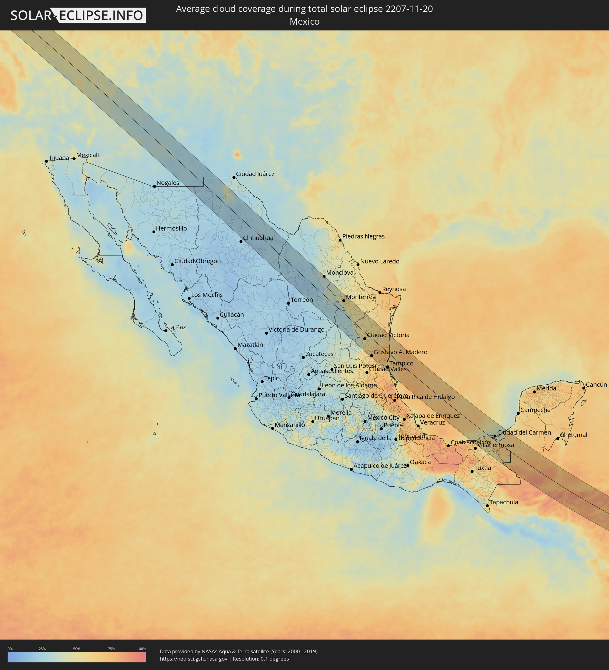 Mexiko
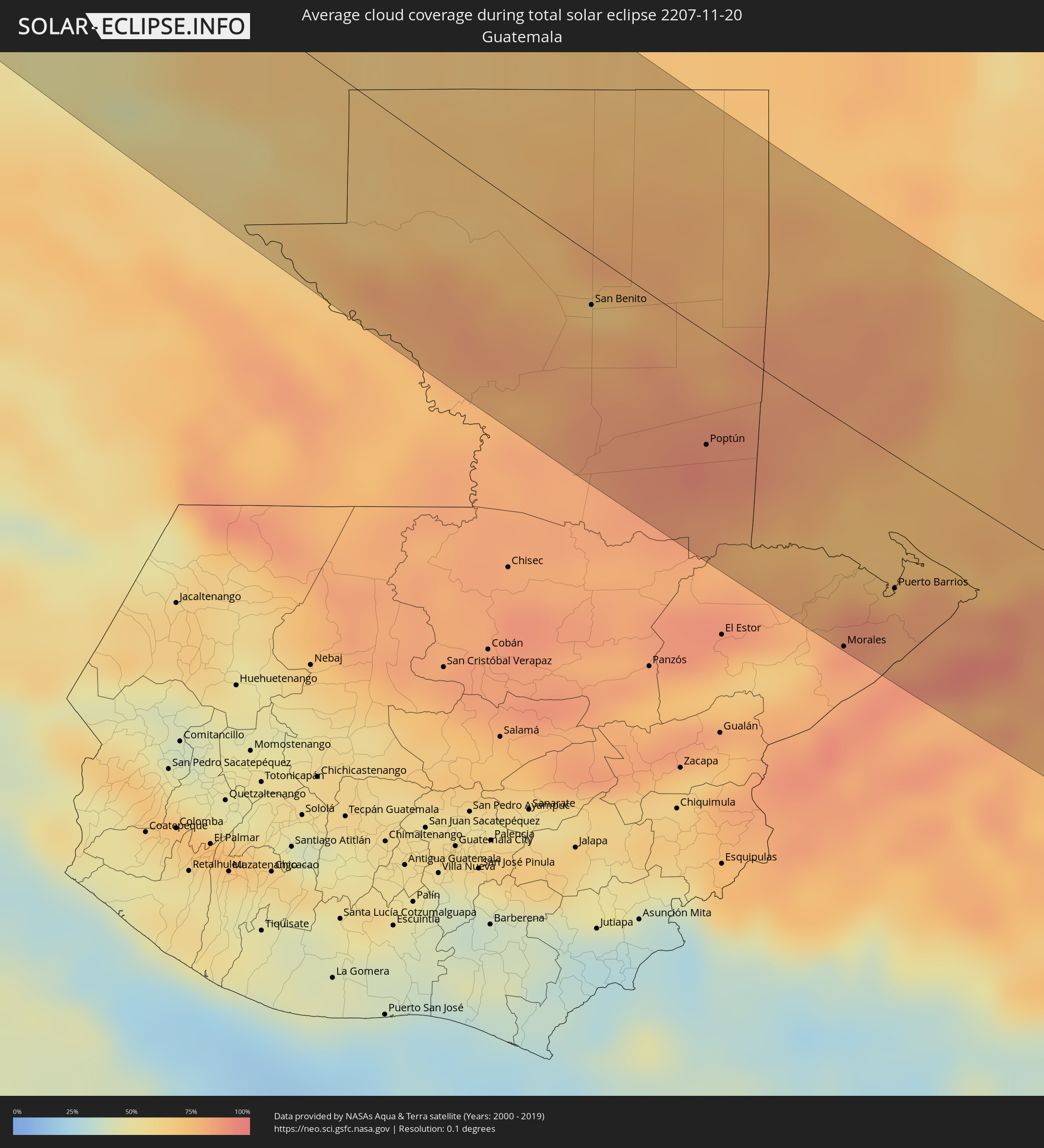 Guatemala
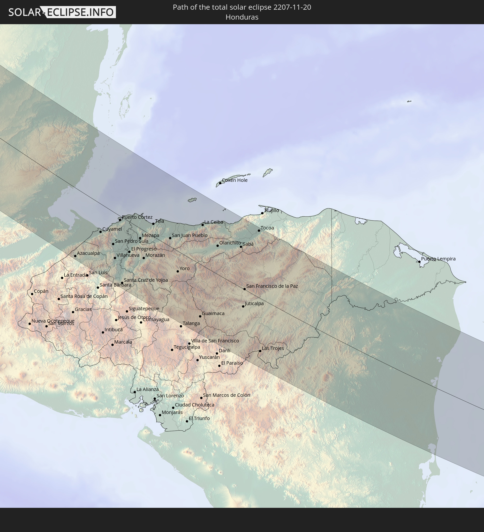
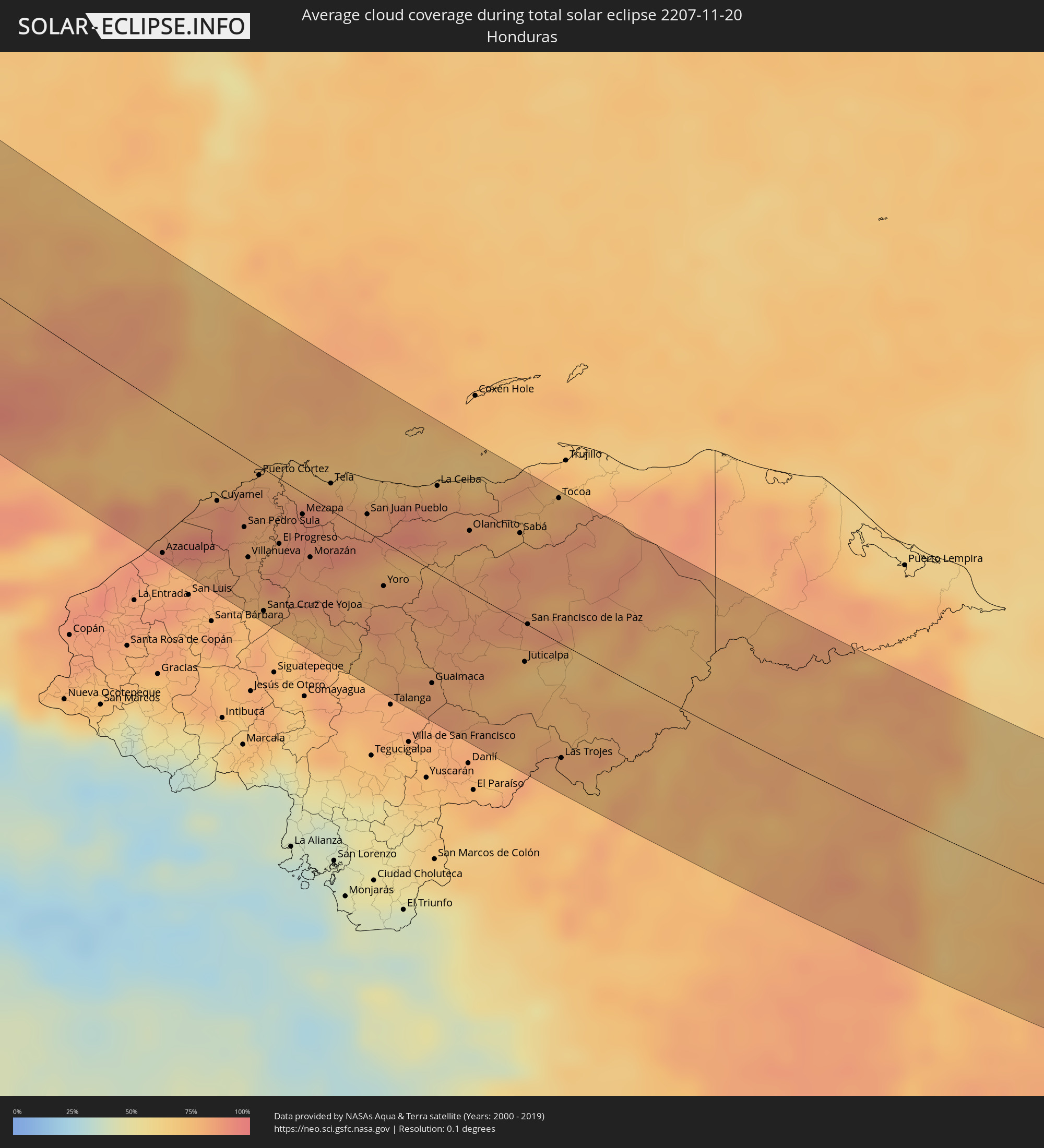 Honduras
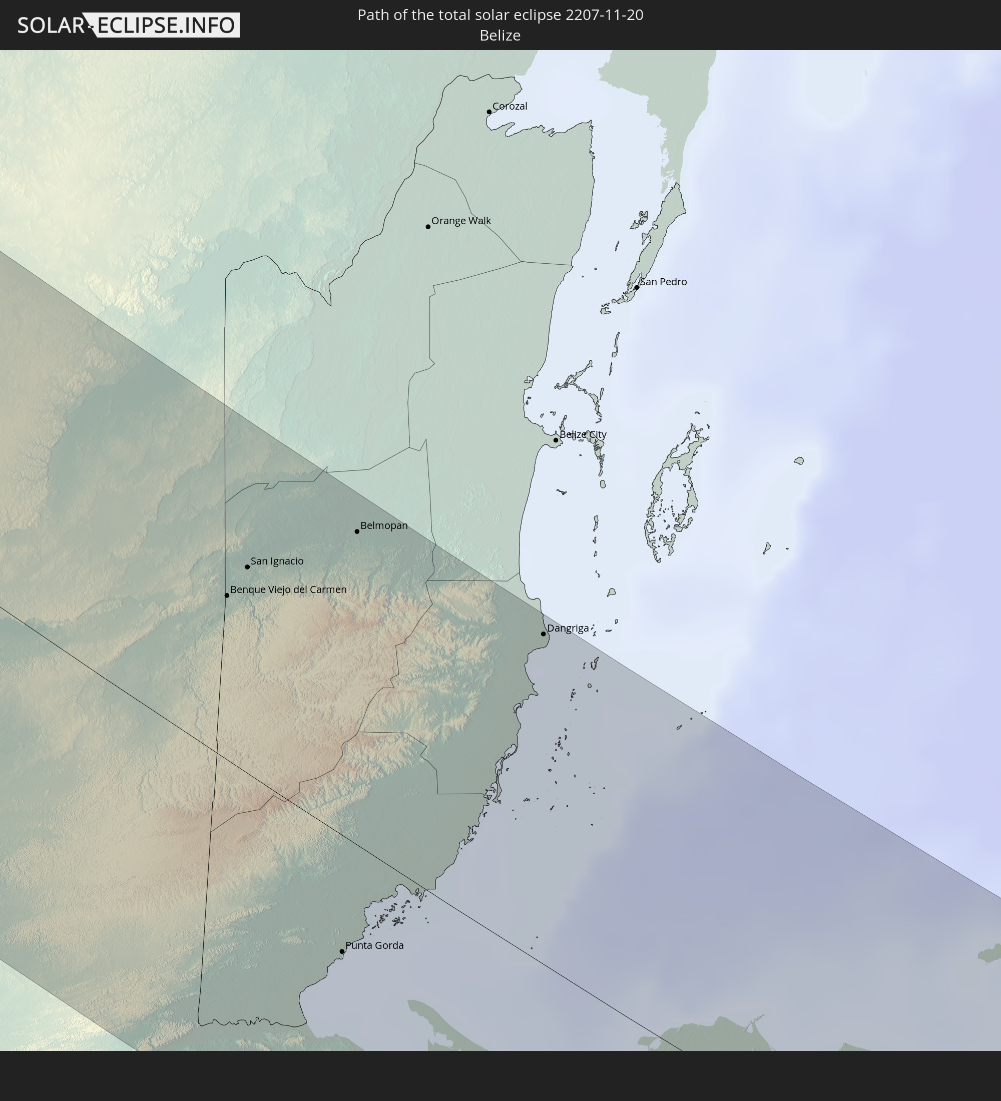
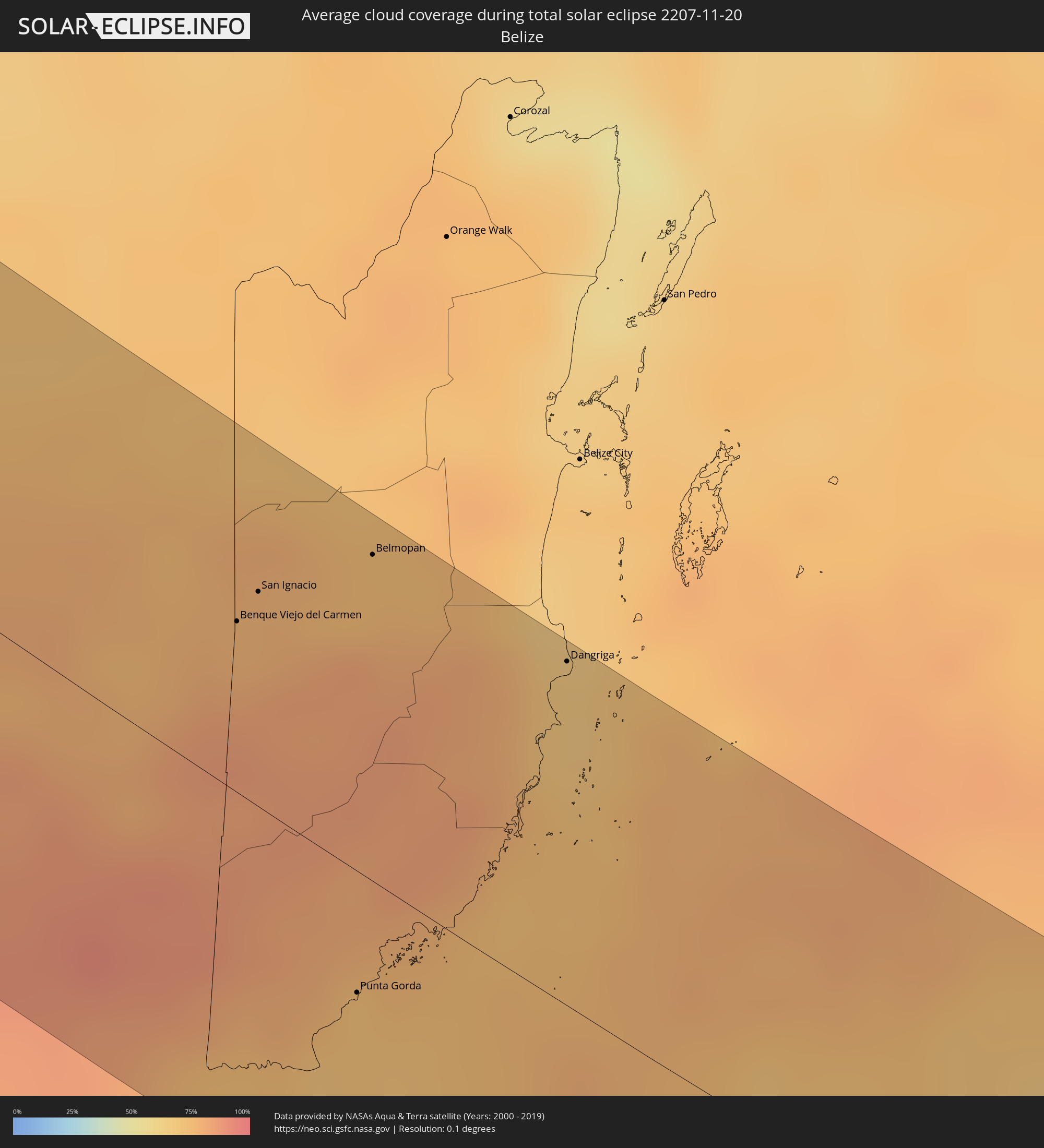 Belize
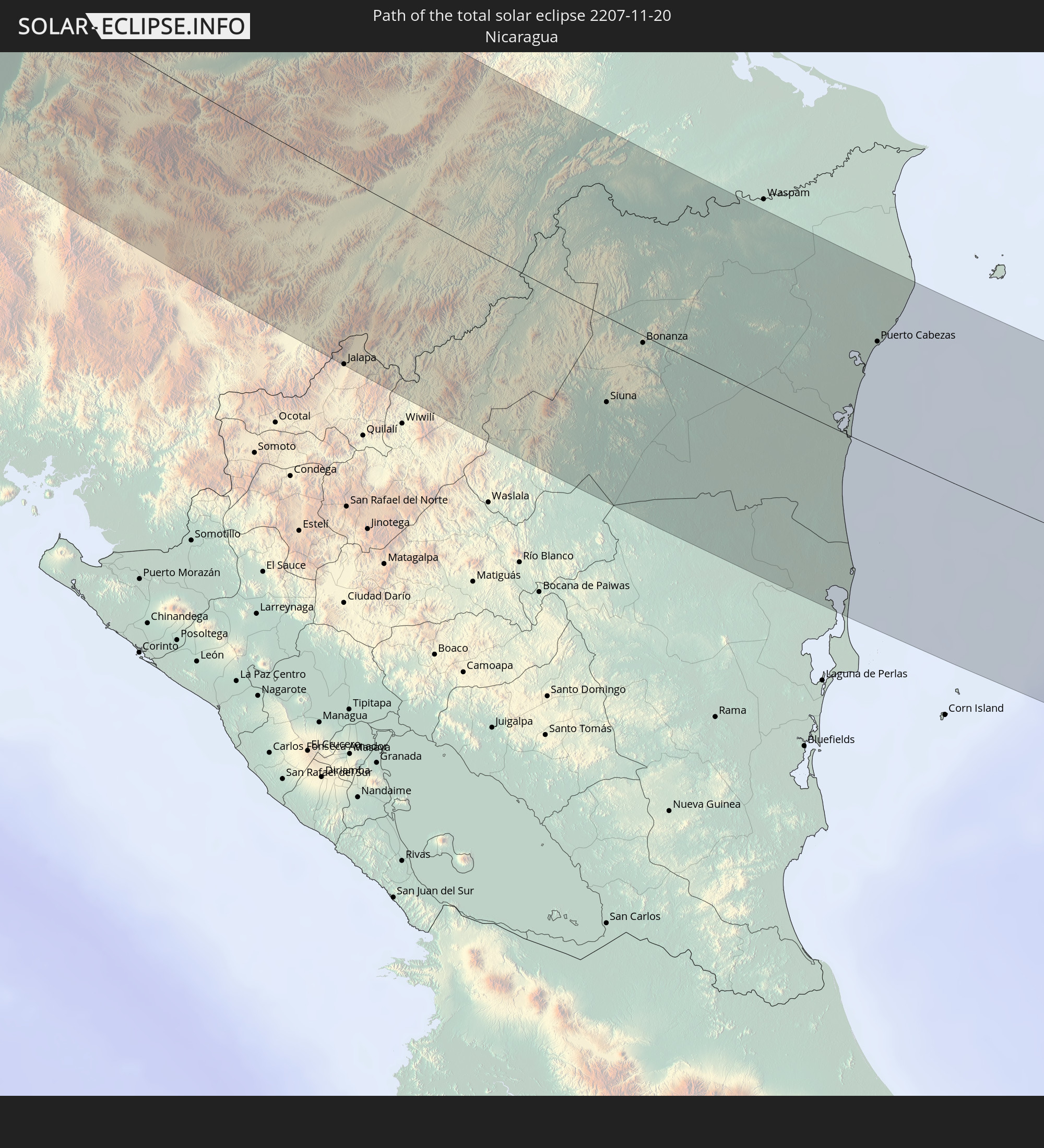
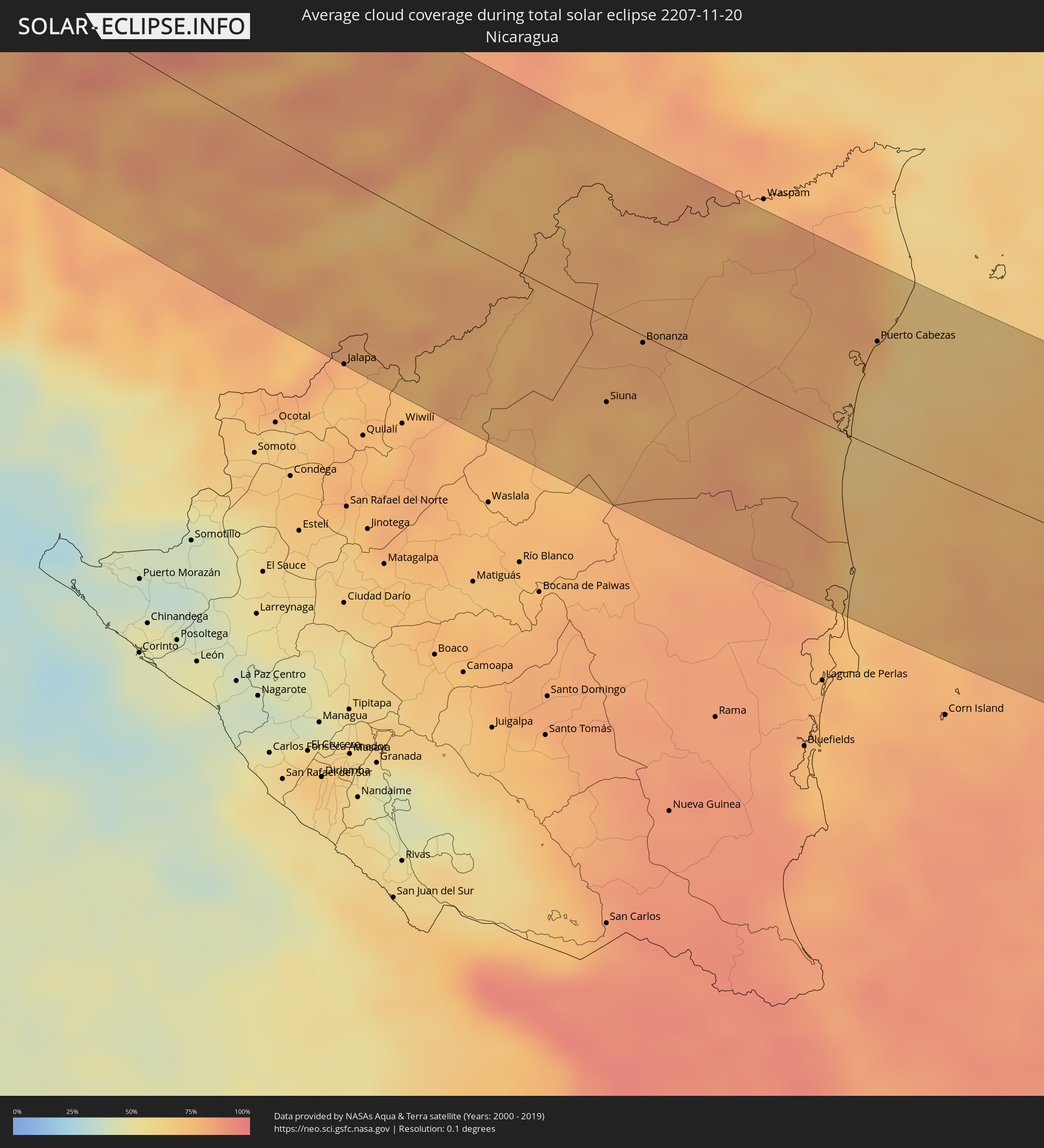 Nicaragua
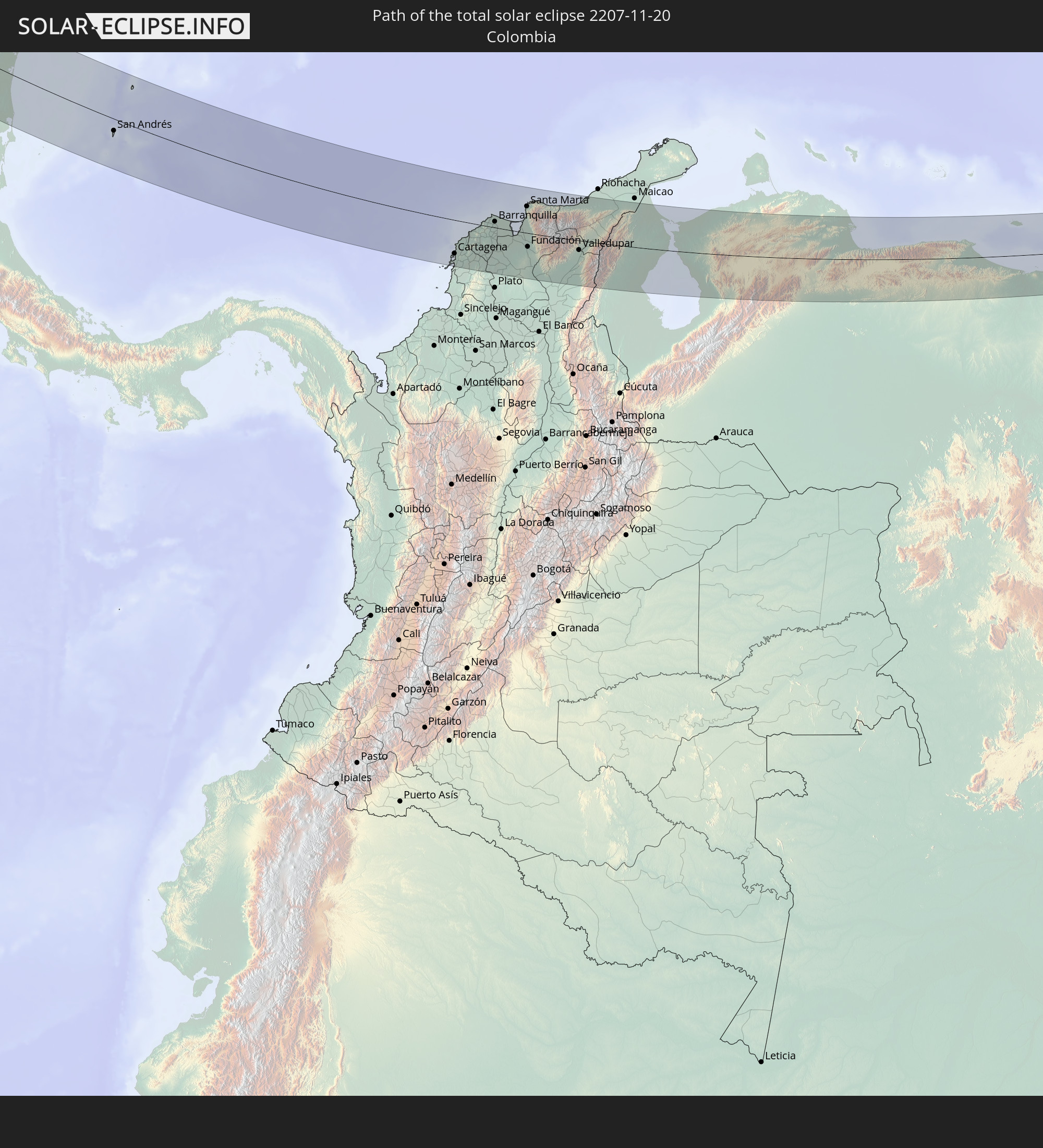
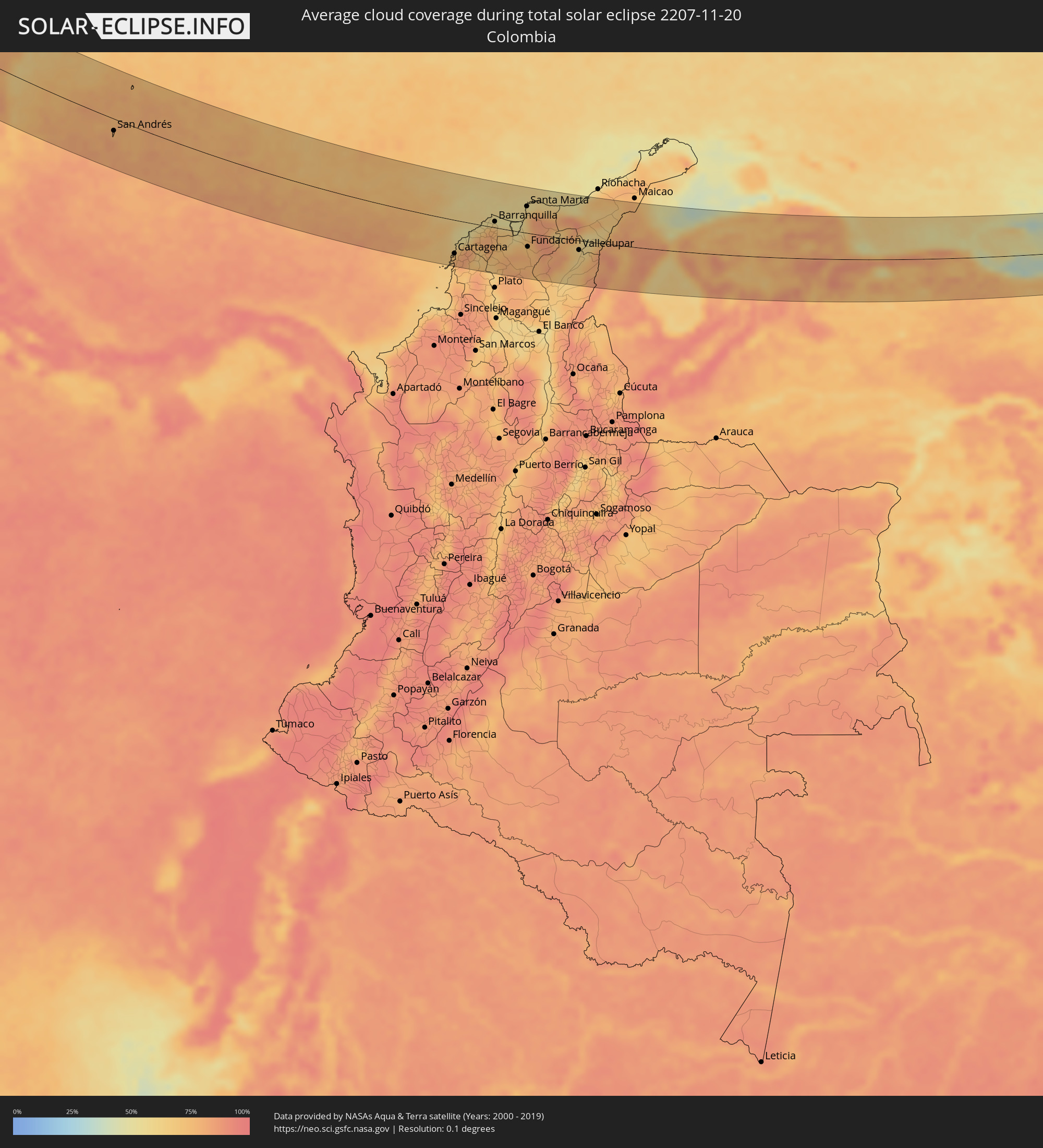 Kolumbien
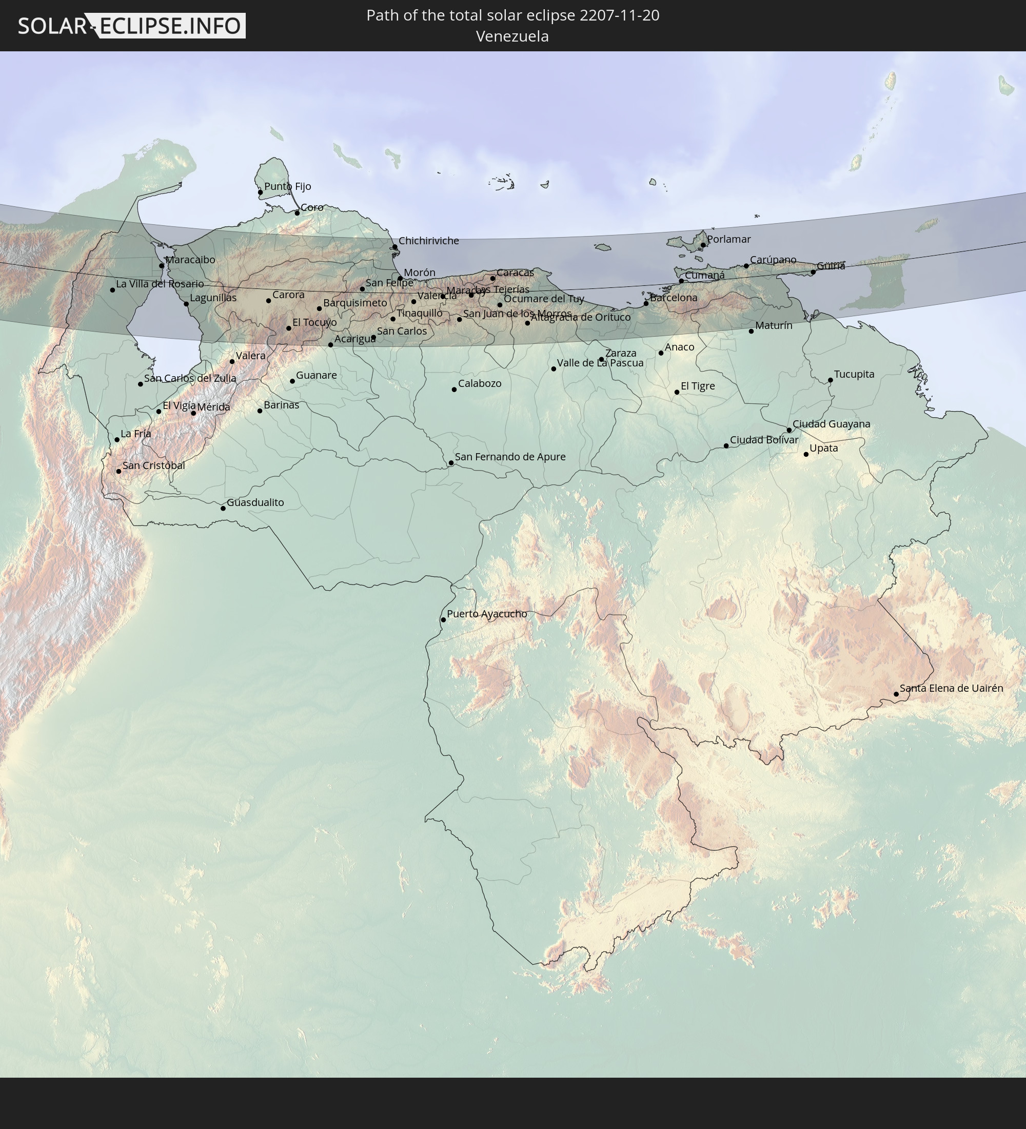
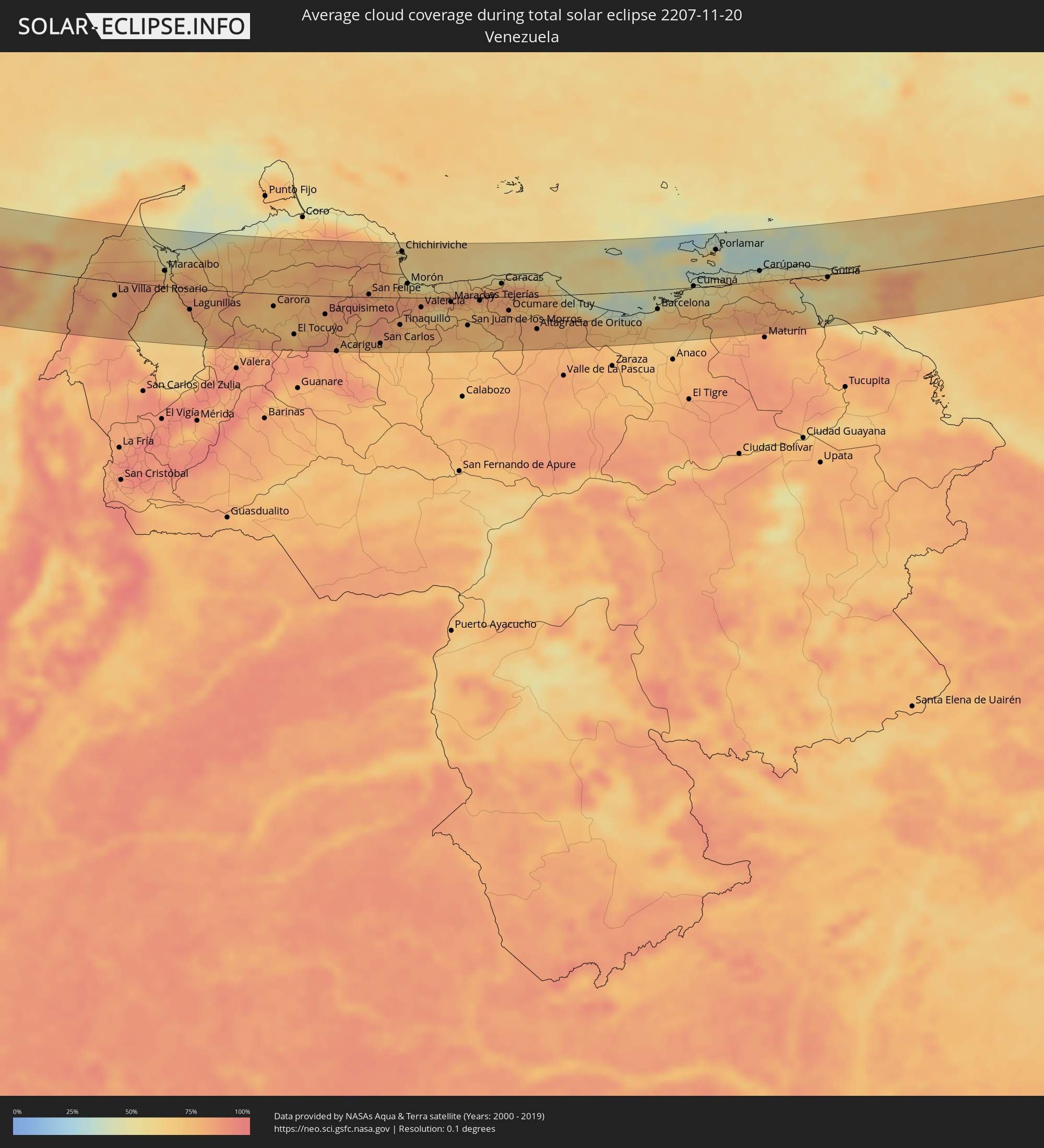 Venezuela
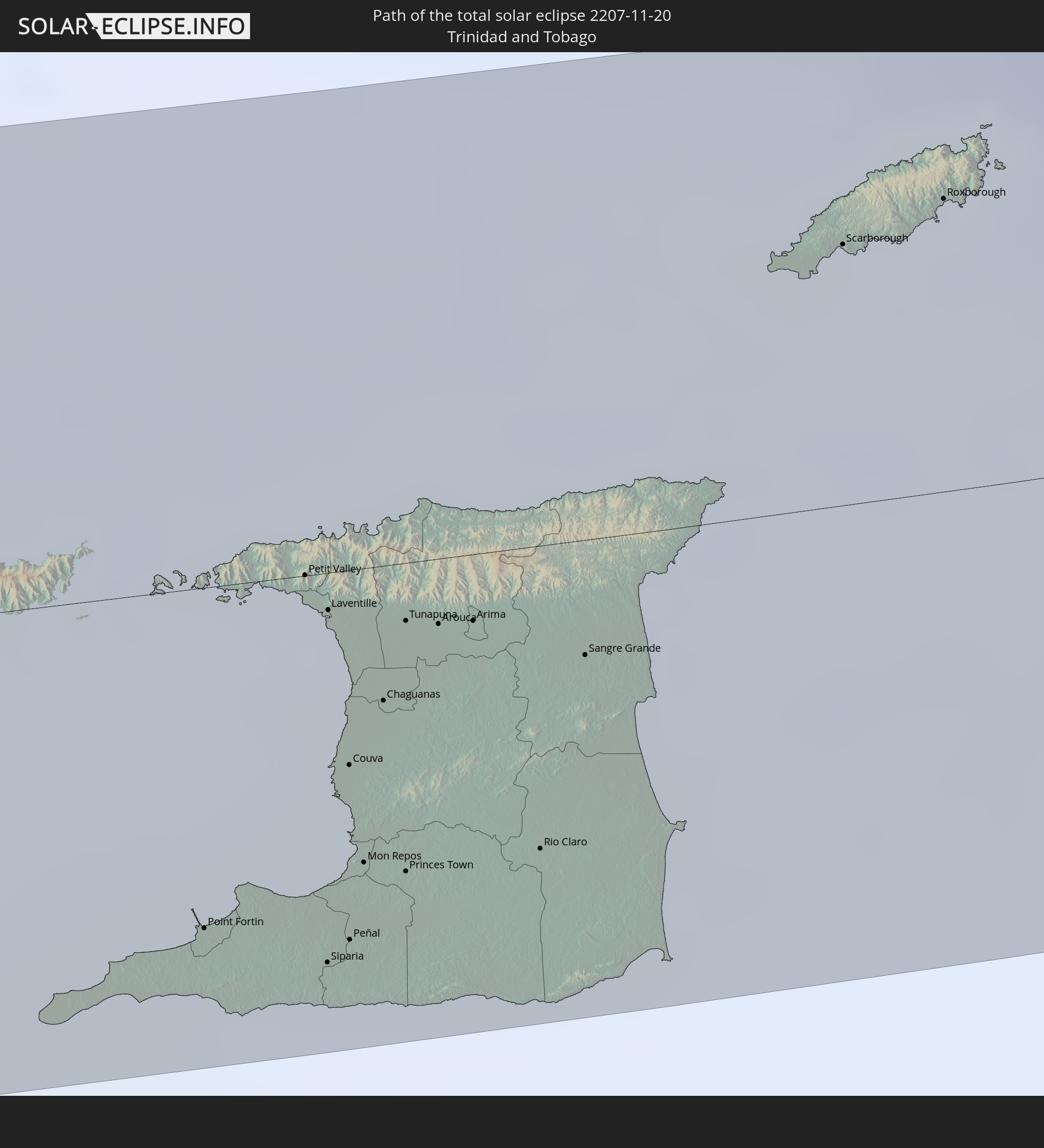
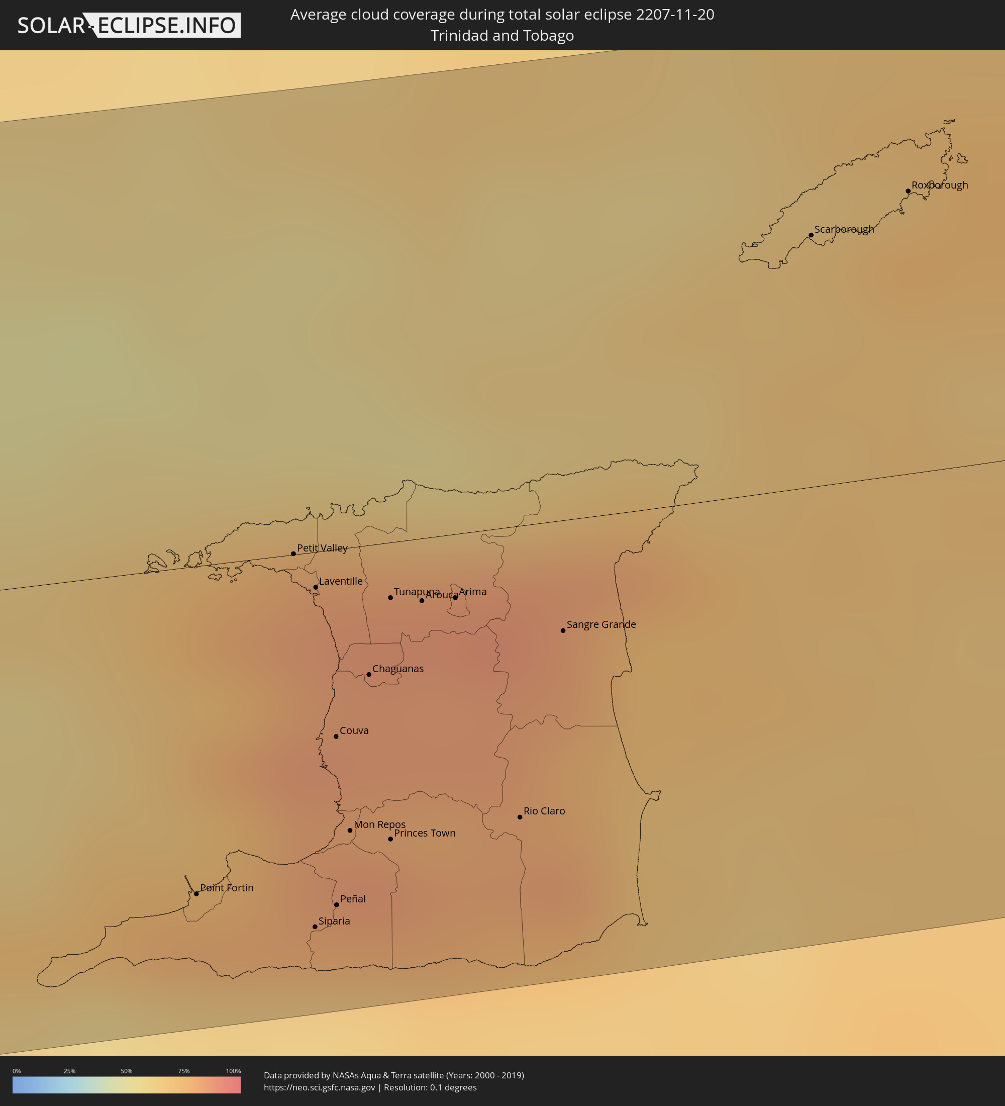 Trinidad und Tobago
Orte im Finsternispfad
Die nachfolgene Tabelle zeigt Städte und Orte mit mehr als 5.000 Einwohnern, die sich im Finsternispfad befinden. Städte mit mehr als 100.000 Einwohnern sind dick gekennzeichnet. Mit einem Klick auf den Ort öffnet sich eine Detailkarte die die Lage des jeweiligen Ortes zusammen mit dem Verlauf der zentralen Finsternis präsentiert.
| Ort | Typ | Dauer der Verfinsterung | Ortszeit bei maximaler Verfinsterung | Entfernung zur Zentrallinie | Ø Bewölkung |
|
Grants Pass, Oregon
|
total | - | 09:06:04 UTC-08:00 | 37 km | 81% |
|
Medford, Oregon
|
total | - | 09:06:26 UTC-08:00 | 51 km | 70% |
|
Ashland, Oregon
|
total | - | 09:06:32 UTC-08:00 | 48 km | 68% |
|
Susanville, California
|
total | - | 09:08:01 UTC-08:00 | 5 km | 60% |
|
Truckee, California
|
total | - | 09:08:18 UTC-08:00 | 62 km | 57% |
|
Reno, Nevada
|
total | - | 09:08:41 UTC-08:00 | 24 km | 65% |
|
Carson City, Nevada
|
total | - | 09:08:41 UTC-08:00 | 53 km | 60% |
|
Spanish Springs, Nevada
|
total | - | 09:08:49 UTC-08:00 | 8 km | 65% |
|
Fernley, Nevada
|
total | - | 09:09:16 UTC-08:00 | 14 km | 65% |
|
Enterprise, Nevada
|
total | - | 09:13:40 UTC-08:00 | 58 km | 49% |
|
Las Vegas, Nevada
|
total | - | 09:13:47 UTC-08:00 | 39 km | 57% |
|
Henderson, Nevada
|
total | - | 09:13:59 UTC-08:00 | 41 km | 44% |
|
Boulder City, Nevada
|
total | - | 09:14:10 UTC-08:00 | 38 km | 44% |
|
Kingman, Arizona
|
total | - | 10:15:14 UTC-07:00 | 57 km | 37% |
|
Prescott, Arizona
|
total | - | 10:17:25 UTC-07:00 | 14 km | 31% |
|
Prescott Valley, Arizona
|
total | - | 10:17:36 UTC-07:00 | 1 km | 29% |
|
Anthem, Arizona
|
total | - | 10:18:00 UTC-07:00 | 50 km | 30% |
|
Paradise Valley, Arizona
|
total | - | 10:18:22 UTC-07:00 | 65 km | 37% |
|
Mesa, Arizona
|
total | - | 10:18:33 UTC-07:00 | 68 km | 39% |
|
Fountain Hills, Arizona
|
total | - | 10:18:39 UTC-07:00 | 45 km | 33% |
|
Apache Junction, Arizona
|
total | - | 10:18:56 UTC-07:00 | 51 km | 29% |
|
San Tan Valley, Arizona
|
total | - | 10:19:02 UTC-07:00 | 68 km | 31% |
|
Payson, Arizona
|
total | - | 10:19:02 UTC-07:00 | 31 km | 28% |
|
Nuevo Casas Grandes, Chihuahua
|
total | - | 10:25:29 UTC-07:00 | 66 km | 19% |
|
Jiménez, Chihuahua
|
total | - | 10:30:49 UTC-07:00 | 72 km | 22% |
|
Monclova, Coahuila
|
total | - | 11:39:06 UTC-06:00 | 78 km | 36% |
|
Saltillo, Coahuila
|
total | - | 11:41:07 UTC-06:00 | 15 km | 28% |
|
García, Nuevo León
|
total | - | 11:41:36 UTC-06:00 | 44 km | 47% |
|
Mitras Poniente, Nuevo León
|
total | - | 11:41:58 UTC-06:00 | 53 km | 55% |
|
Monterrey, Nuevo León
|
total | - | 11:42:16 UTC-06:00 | 52 km | 55% |
|
Apodaca, Nuevo León
|
total | - | 11:42:30 UTC-06:00 | 69 km | 63% |
|
Santiago, Nuevo León
|
total | - | 11:42:49 UTC-06:00 | 43 km | 47% |
|
Allende, Nuevo León
|
total | - | 11:43:13 UTC-06:00 | 40 km | 53% |
|
Cadereyta, Nuevo León
|
total | - | 11:43:01 UTC-06:00 | 67 km | 56% |
|
Montemorelos, Nuevo León
|
total | - | 11:43:40 UTC-06:00 | 45 km | 52% |
|
Linares, Nuevo León
|
total | - | 11:44:30 UTC-06:00 | 35 km | 53% |
|
Ciudad Victoria, Tamaulipas
|
total | - | 11:46:25 UTC-06:00 | 29 km | 50% |
|
Gustavo A. Madero, Tamaulipas
|
total | - | 11:48:05 UTC-06:00 | 75 km | 64% |
|
Aldama, Tamaulipas
|
total | - | 11:49:29 UTC-06:00 | 25 km | 76% |
|
Tampico, Tamaulipas
|
total | - | 11:50:36 UTC-06:00 | 65 km | 66% |
|
Frontera, Tabasco
|
total | - | 12:06:55 UTC-06:00 | 42 km | 62% |
|
Ciudad del Carmen, Campeche
|
total | - | 12:08:47 UTC-06:00 | 19 km | 39% |
|
Emiliano Zapata, Chiapas
|
total | - | 12:10:05 UTC-06:00 | 58 km | 56% |
|
Tenosique de Pino Suárez, Tabasco
|
total | - | 12:11:17 UTC-06:00 | 61 km | 64% |
|
San Carlos, Tabasco
|
total | - | 12:11:51 UTC-06:00 | 37 km | 63% |
|
Escárcega, Campeche
|
total | - | 12:11:31 UTC-06:00 | 84 km | 65% |
|
Sayaxché, Petén
|
total | - | 12:15:41 UTC-06:00 | 71 km | 77% |
|
La Libertad, Petén
|
total | - | 12:15:27 UTC-06:00 | 44 km | 81% |
|
San Benito, Petén
|
total | - | 12:15:47 UTC-06:00 | 20 km | 78% |
|
San Andrés, Petén
|
total | - | 12:15:43 UTC-06:00 | 15 km | 67% |
|
Flores, Petén
|
total | - | 12:15:49 UTC-06:00 | 18 km | 78% |
|
Santa Ana, Petén
|
total | - | 12:16:09 UTC-06:00 | 25 km | 81% |
|
San Luis, Petén
|
total | - | 12:17:56 UTC-06:00 | 57 km | 87% |
|
Poptún, Petén
|
total | - | 12:17:49 UTC-06:00 | 44 km | 89% |
|
Dolores, Petén
|
total | - | 12:17:35 UTC-06:00 | 27 km | 89% |
|
Melchor de Mencos, Petén
|
total | - | 12:17:32 UTC-06:00 | 40 km | 78% |
|
Benque Viejo del Carmen, Cayo
|
total | - | 12:17:33 UTC-06:00 | 42 km | 77% |
|
San Ignacio, Cayo
|
total | - | 12:17:36 UTC-06:00 | 52 km | 77% |
|
Morales, Izabal
|
total | - | 12:20:30 UTC-06:00 | 88 km | 82% |
|
Punta Gorda, Toledo
|
total | - | 12:19:41 UTC-06:00 | 30 km | 72% |
|
Belmopan, Cayo
|
total | - | 12:18:16 UTC-06:00 | 80 km | 74% |
|
Lívingston, Izabal
|
total | - | 12:20:12 UTC-06:00 | 52 km | 78% |
|
Puerto Barrios, Izabal
|
total | - | 12:20:44 UTC-06:00 | 52 km | 82% |
|
Dangriga, Stann Creek
|
total | - | 12:20:00 UTC-06:00 | 85 km | 68% |
|
Cofradía, Cortés
|
total | - | 12:22:19 UTC-06:00 | 58 km | 77% |
|
San Pedro Sula, Cortés
|
total | - | 12:22:30 UTC-06:00 | 41 km | 81% |
|
Villanueva, Cortés
|
total | - | 12:22:49 UTC-06:00 | 57 km | 78% |
|
Pimienta Vieja, Cortés
|
total | - | 12:23:01 UTC-06:00 | 64 km | 78% |
|
Potrerillos, Cortés
|
total | - | 12:23:01 UTC-06:00 | 64 km | 78% |
|
Puerto Cortez, Cortés
|
total | - | 12:22:19 UTC-06:00 | 5 km | 82% |
|
San Manuel, Cortés
|
total | - | 12:23:01 UTC-06:00 | 51 km | 80% |
|
Santa Cruz de Yojoa, Cortés
|
total | - | 12:23:32 UTC-06:00 | 83 km | 77% |
|
Agua Blanca Sur, Yoro
|
total | - | 12:23:13 UTC-06:00 | 57 km | 80% |
|
Baracoa, Cortés
|
total | - | 12:22:36 UTC-06:00 | 6 km | 82% |
|
El Progreso, Yoro
|
total | - | 12:23:13 UTC-06:00 | 38 km | 86% |
|
El Negrito, Yoro
|
total | - | 12:23:36 UTC-06:00 | 41 km | 81% |
|
Morazán, Yoro
|
total | - | 12:23:51 UTC-06:00 | 35 km | 84% |
|
Tela, Atlántida
|
total | - | 12:23:35 UTC-06:00 | 16 km | 80% |
|
Santa Rita, Yoro
|
total | - | 12:24:53 UTC-06:00 | 32 km | 78% |
|
Yoro, Yoro
|
total | - | 12:25:19 UTC-06:00 | 26 km | 84% |
|
Guaimaca, Francisco Morazán
|
total | - | 12:26:57 UTC-06:00 | 68 km | 83% |
|
La Ceiba, Atlántida
|
total | - | 12:25:23 UTC-06:00 | 52 km | 77% |
|
Campamento, Olancho
|
total | - | 12:27:22 UTC-06:00 | 57 km | 81% |
|
Olanchito, Yoro
|
total | - | 12:26:18 UTC-06:00 | 37 km | 75% |
|
Sabá, Colón
|
total | - | 12:27:09 UTC-06:00 | 53 km | 82% |
|
Juticalpa, Olancho
|
total | - | 12:28:19 UTC-06:00 | 23 km | 70% |
|
Jalapa, Nueva Segovia
|
total | - | 12:29:35 UTC-06:00 | 91 km | 74% |
|
Tocoa, Colón
|
total | - | 12:27:31 UTC-06:00 | 87 km | 77% |
|
Siuna, Atlántico Norte (RAAN)
|
total | - | 12:33:22 UTC-06:00 | 42 km | 77% |
|
Bonanza, Atlántico Norte (RAAN)
|
total | - | 12:33:27 UTC-06:00 | 4 km | 81% |
|
Puerto Cabezas, Atlántico Norte (RAAN)
|
total | - | 12:36:35 UTC-06:00 | 54 km | 71% |
|
San Andrés, Archipiélago de San Andrés, Providencia y Santa Catalina
|
total | - | 13:42:57 UTC-05:00 | 22 km | 77% |
|
Cartagena, Bolívar
|
total | - | 14:01:16 UTC-05:00 | 65 km | 78% |
|
Arjona, Bolívar
|
total | - | 14:01:51 UTC-05:00 | 78 km | 78% |
|
Villanueva, Bolívar
|
total | - | 14:01:47 UTC-05:00 | 56 km | 81% |
|
Repelón, Atlántico
|
total | - | 14:02:04 UTC-05:00 | 47 km | 68% |
|
Puerto Colombia, Atlántico
|
total | - | 14:01:53 UTC-05:00 | 10 km | 63% |
|
Sabanalarga, Atlántico
|
total | - | 14:02:24 UTC-05:00 | 28 km | 79% |
|
Baranoa, Atlántico
|
total | - | 14:02:12 UTC-05:00 | 10 km | 80% |
|
Campo de la Cruz, Atlántico
|
total | - | 14:02:47 UTC-05:00 | 55 km | 70% |
|
Barranquilla, Atlántico
|
total | - | 14:02:19 UTC-05:00 | 12 km | 75% |
|
Palmar de Varela, Atlántico
|
total | - | 14:02:39 UTC-05:00 | 13 km | 75% |
|
Ponedera, Atlántico
|
total | - | 14:02:47 UTC-05:00 | 24 km | 76% |
|
Chivolo, Magdalena
|
total | - | 14:03:50 UTC-05:00 | 89 km | 81% |
|
Pivijay, Magdalena
|
total | - | 14:03:19 UTC-05:00 | 41 km | 76% |
|
Ciénaga, Magdalena
|
total | - | 14:03:31 UTC-05:00 | 26 km | 65% |
|
Santa Marta, Magdalena
|
total | - | 14:03:21 UTC-05:00 | 52 km | 67% |
|
Fundación, Magdalena
|
total | - | 14:04:15 UTC-05:00 | 27 km | 78% |
|
Ariguaní, Cesar
|
total | - | 14:05:00 UTC-05:00 | 53 km | 77% |
|
Valledupar, Cesar
|
total | - | 14:06:28 UTC-05:00 | 19 km | 65% |
|
Agustín Codazzi, Cesar
|
total | - | 14:07:01 UTC-05:00 | 65 km | 74% |
|
San Juan del Cesar, La Guajira
|
total | - | 14:06:40 UTC-05:00 | 19 km | 60% |
|
Villanueva, La Guajira
|
total | - | 14:06:55 UTC-05:00 | 1 km | 72% |
|
Fonseca, La Guajira
|
total | - | 14:06:53 UTC-05:00 | 34 km | 62% |
|
Maracaibo, Zulia
|
total | - | 15:09:54 UTC-04:00 | 24 km | 73% |
|
Cabimas, Zulia
|
total | - | 15:10:36 UTC-04:00 | 5 km | 78% |
|
Carora, Lara
|
total | - | 15:13:45 UTC-04:00 | 19 km | 71% |
|
Barquisimeto, Lara
|
total | - | 15:15:23 UTC-04:00 | 28 km | 75% |
|
Acarigua, Portuguesa
|
total | - | 15:16:16 UTC-04:00 | 84 km | 84% |
|
Yaritagua, Yaracuy
|
total | - | 15:15:50 UTC-04:00 | 26 km | 82% |
|
Puerto Cabello, Carabobo
|
total | - | 15:17:37 UTC-04:00 | 20 km | 76% |
|
Valencia, Carabobo
|
total | - | 15:18:00 UTC-04:00 | 15 km | 74% |
|
Guacara, Carabobo
|
total | - | 15:18:11 UTC-04:00 | 8 km | 63% |
|
Mariara, Carabobo
|
total | - | 15:18:25 UTC-04:00 | 0 km | 62% |
|
Maracay, Aragua
|
total | - | 15:18:44 UTC-04:00 | 7 km | 64% |
|
Cagua, Aragua
|
total | - | 15:19:02 UTC-04:00 | 12 km | 72% |
|
San Juan de los Morros, Guárico
|
total | - | 15:19:32 UTC-04:00 | 43 km | 76% |
|
Los Teques, Miranda
|
total | - | 15:19:40 UTC-04:00 | 5 km | 77% |
|
Catia La Mar, Vargas
|
total | - | 15:19:25 UTC-04:00 | 34 km | 76% |
|
Cúa, Miranda
|
total | - | 15:20:10 UTC-04:00 | 16 km | 78% |
|
Caracas, Capital
|
total | - | 15:19:50 UTC-04:00 | 20 km | 79% |
|
Santa Teresa, Miranda
|
total | - | 15:20:31 UTC-04:00 | 9 km | 76% |
|
Guatire, Miranda
|
total | - | 15:20:29 UTC-04:00 | 18 km | 77% |
|
Barcelona, Anzoátegui
|
total | - | 15:24:14 UTC-04:00 | 30 km | 69% |
|
Cumaná, Sucre
|
total | - | 15:24:48 UTC-04:00 | 2 km | 52% |
|
Porlamar, Nueva Esparta
|
total | - | 15:24:49 UTC-04:00 | 55 km | 58% |
|
Carúpano, Sucre
|
total | - | 15:26:10 UTC-04:00 | 17 km | 65% |
|
Point Fortin, Point Fortin
|
total | - | 15:29:12 UTC-04:00 | 55 km | 77% |
|
Petit Valley, Diego Martin
|
total | - | 15:28:56 UTC-04:00 | 0 km | 83% |
|
Port of Spain, City of Port of Spain
|
total | - | 15:28:59 UTC-04:00 | 4 km | 83% |
|
Siparia, Siparia
|
total | - | 15:29:32 UTC-04:00 | 63 km | 63% |
|
Laventille, San Juan/Laventille
|
total | - | 15:29:02 UTC-04:00 | 6 km | 81% |
|
Couva, Couva-Tabaquite-Talparo
|
total | - | 15:29:18 UTC-04:00 | 31 km | 81% |
|
San Fernando, City of San Fernando
|
total | - | 15:29:27 UTC-04:00 | 47 km | 81% |
|
Peñal, Penal/Debe
|
total | - | 15:29:33 UTC-04:00 | 60 km | 78% |
|
Marabella, City of San Fernando
|
total | - | 15:29:27 UTC-04:00 | 45 km | 85% |
|
Mon Repos, City of San Fernando
|
total | - | 15:29:29 UTC-04:00 | 48 km | 85% |
|
Chaguanas, Chaguanas
|
total | - | 15:29:18 UTC-04:00 | 22 km | 84% |
|
Princes Town, Princes Town
|
total | - | 15:29:35 UTC-04:00 | 50 km | 85% |
|
Tunapuna, Tunapuna/Piarco
|
total | - | 15:29:14 UTC-04:00 | 9 km | 84% |
|
Paradise, Tunapuna/Piarco
|
total | - | 15:29:15 UTC-04:00 | 7 km | 86% |
|
Arouca, Tunapuna/Piarco
|
total | - | 15:29:19 UTC-04:00 | 11 km | 83% |
|
Arima, Borough of Arima
|
total | - | 15:29:23 UTC-04:00 | 11 km | 83% |
|
Rio Claro, Mayaro
|
total | - | 15:29:52 UTC-04:00 | 49 km | 81% |
|
Sangre Grande, Sangre Grande
|
total | - | 15:29:42 UTC-04:00 | 19 km | 81% |
|
Scarborough, Tobago
|
total | - | 15:29:42 UTC-04:00 | 42 km | 68% |
|
Roxborough, Eastern Tobago
|
total | - | 15:29:52 UTC-04:00 | 47 km | 74% |