Totale Sonnenfinsternis vom 15.04.2219
| Wochentag: | Donnerstag |
| Maximale Dauer der Verfinsterung: | 05m45s |
| Maximale Breite des Finsternispfades: | 207 km |
| Saroszyklus: | 142 |
| Bedeckungsgrad: | 100% |
| Magnitude: | 1.0628 |
| Gamma: | -0.1086 |
Wo kann man die Sonnenfinsternis vom 15.04.2219 sehen?
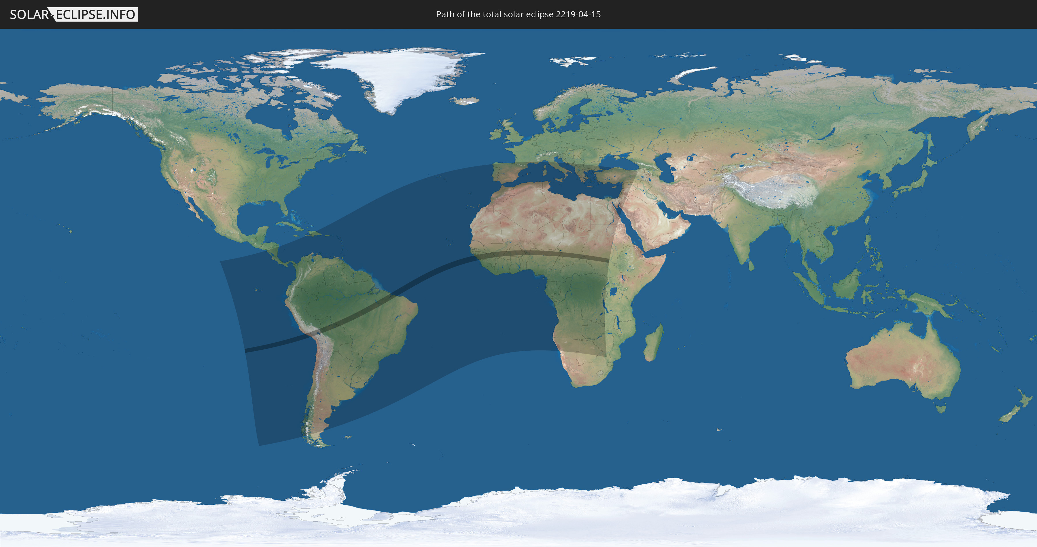
Die Sonnenfinsternis am 15.04.2219 kann man in 102 Ländern als partielle Sonnenfinsternis beobachten.
Der Finsternispfad verläuft durch 15 Länder. Nur in diesen Ländern ist sie als totale Sonnenfinsternis zu sehen.
In den folgenden Ländern ist die Sonnenfinsternis total zu sehen
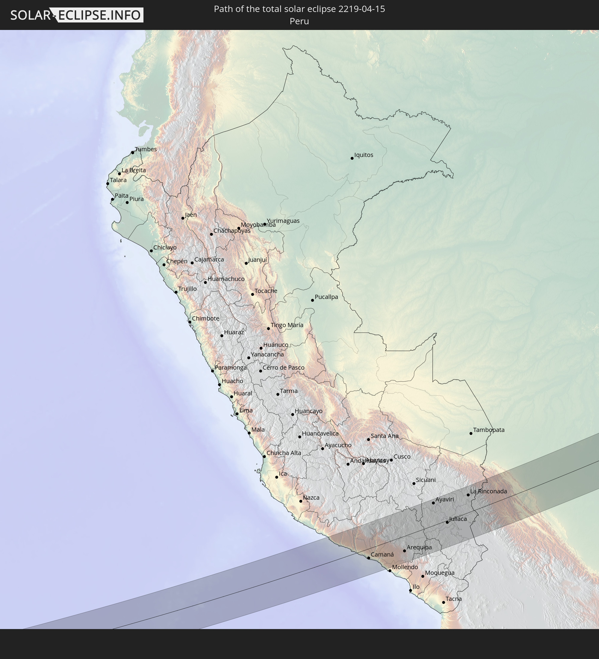 Peru
Peru
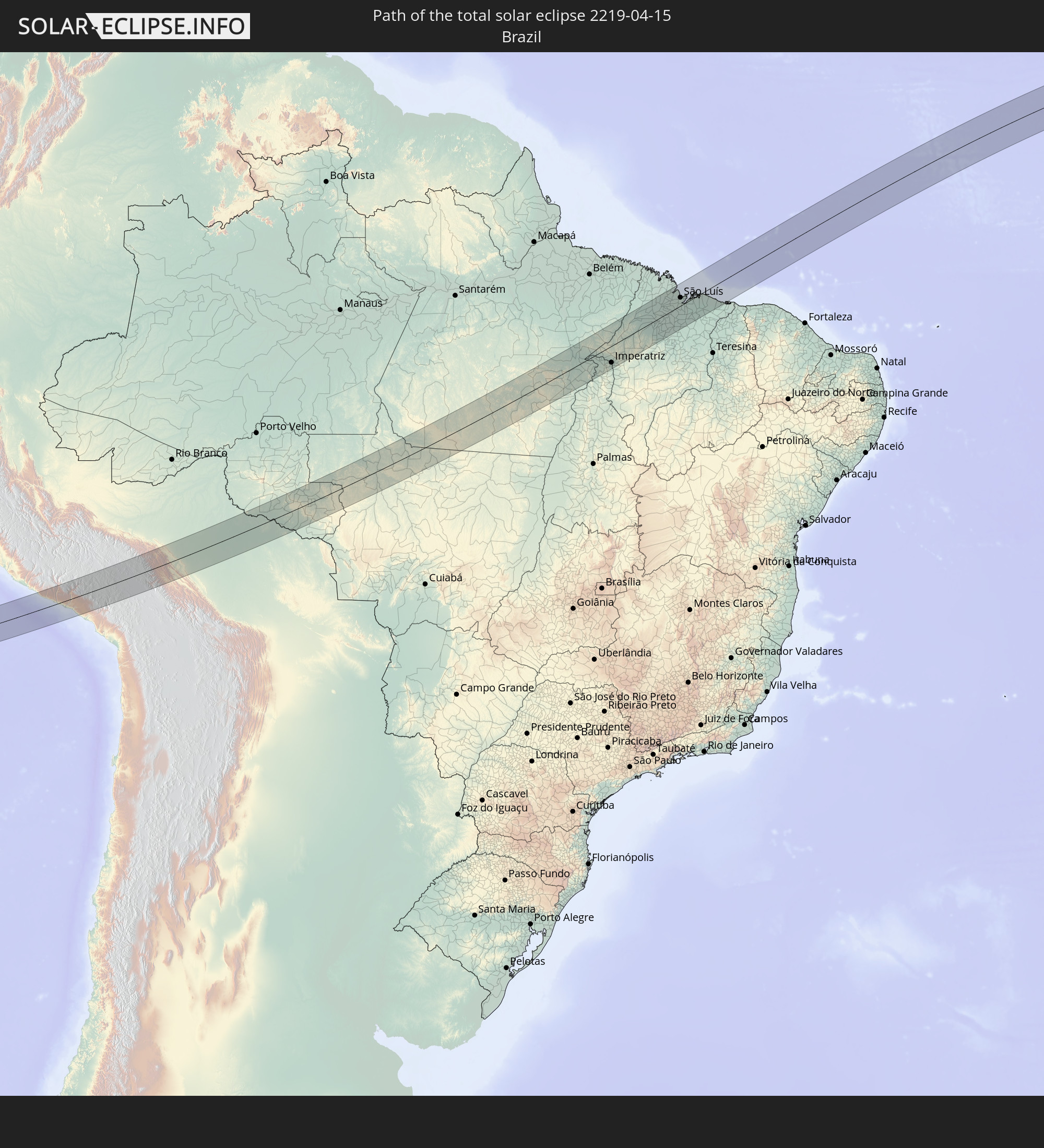 Brasilien
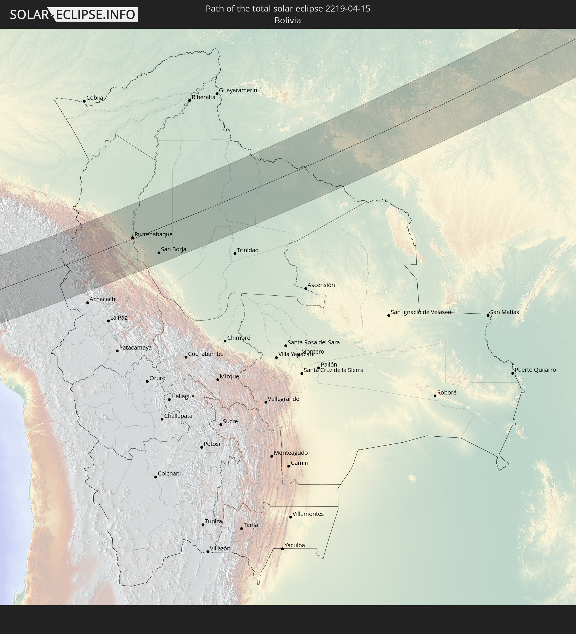 Bolivien
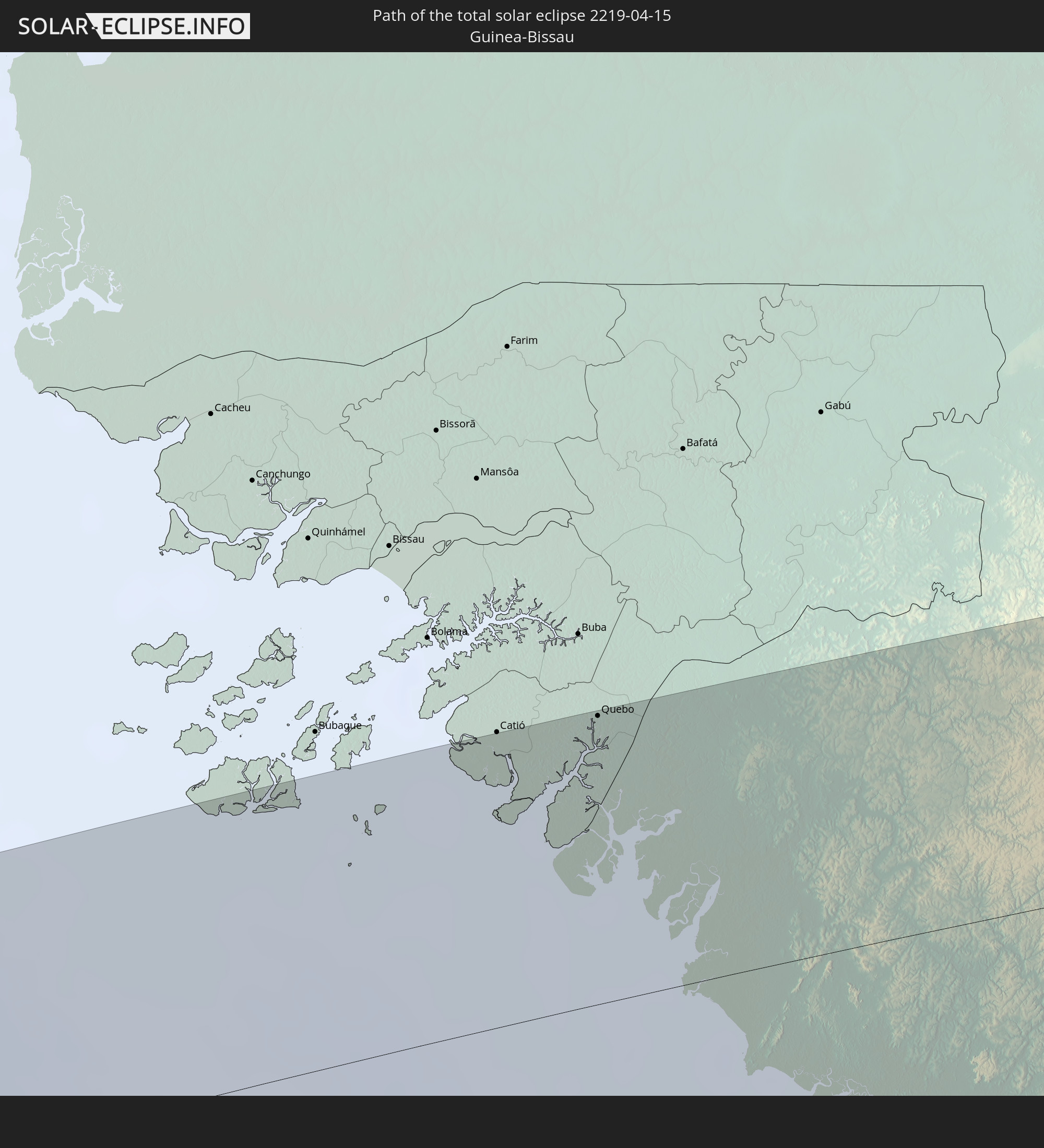 Guinea-Bissau
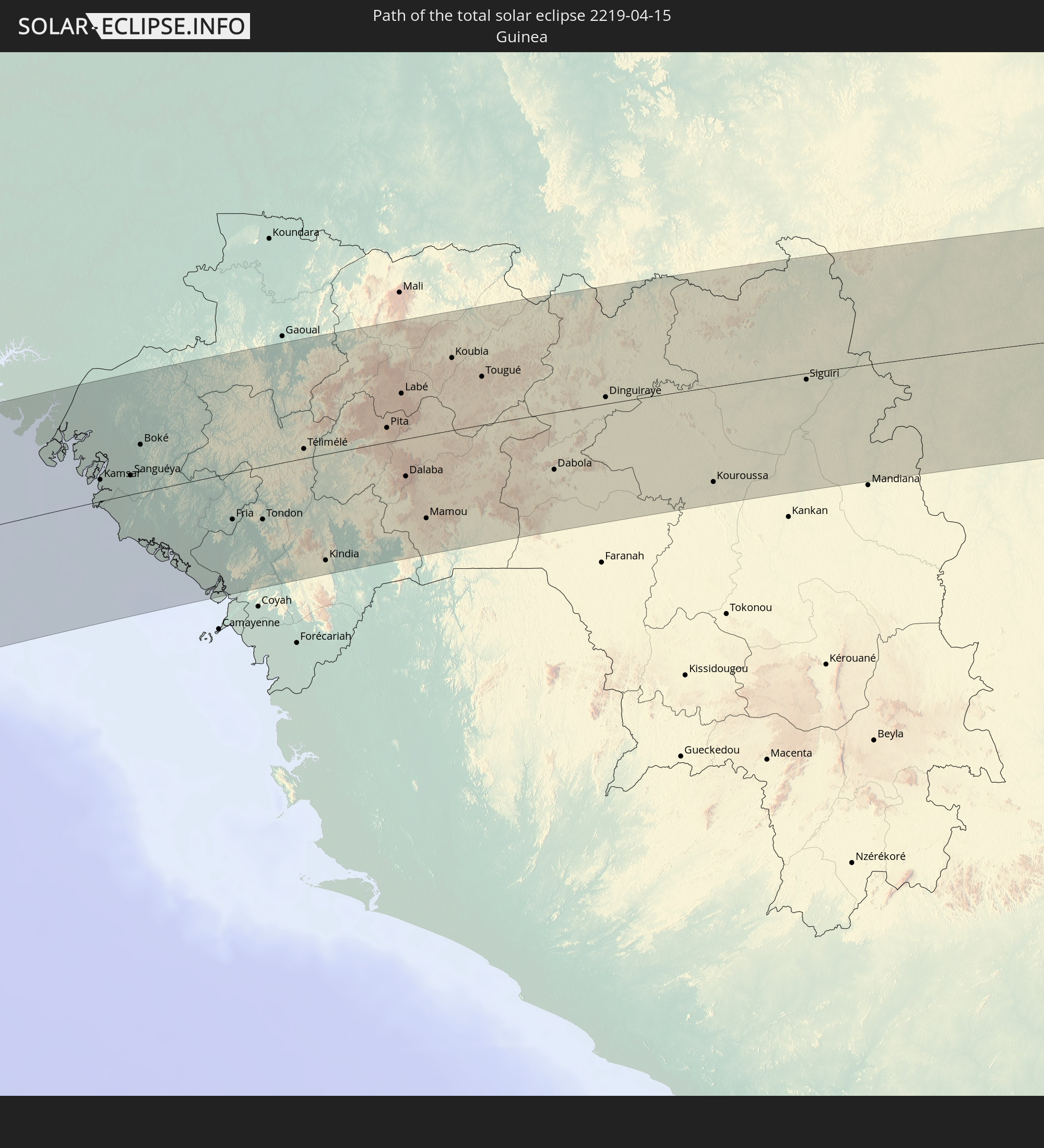 Guinea
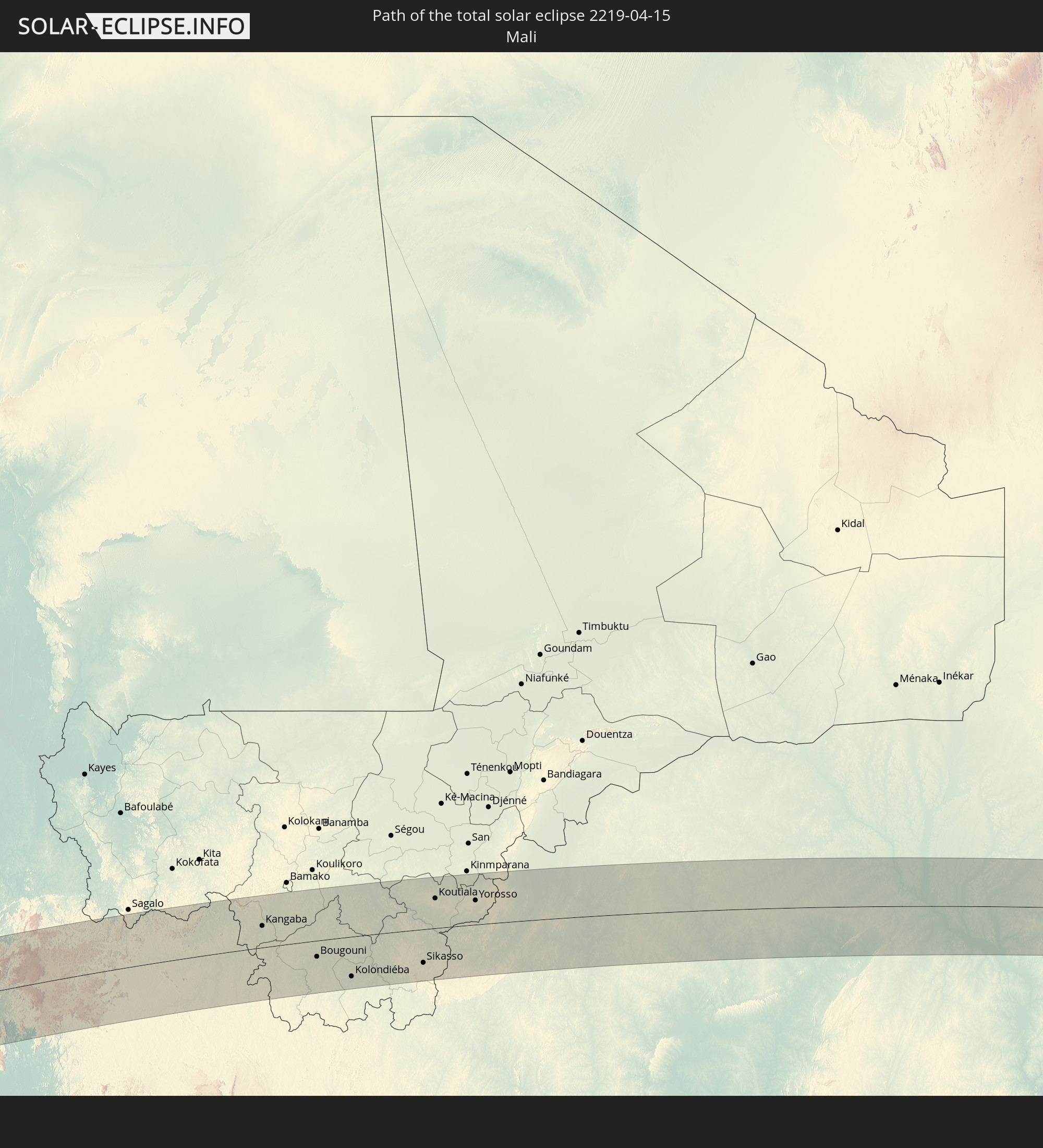 Mali
Mali
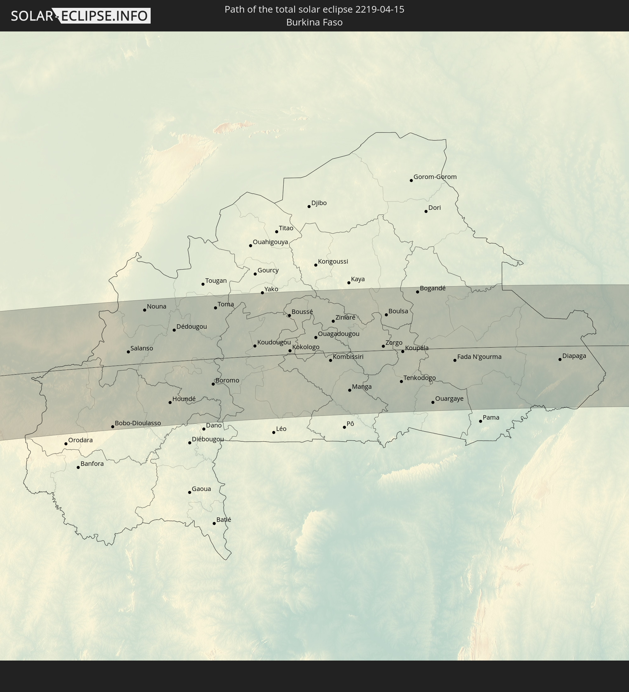 Burkina Faso
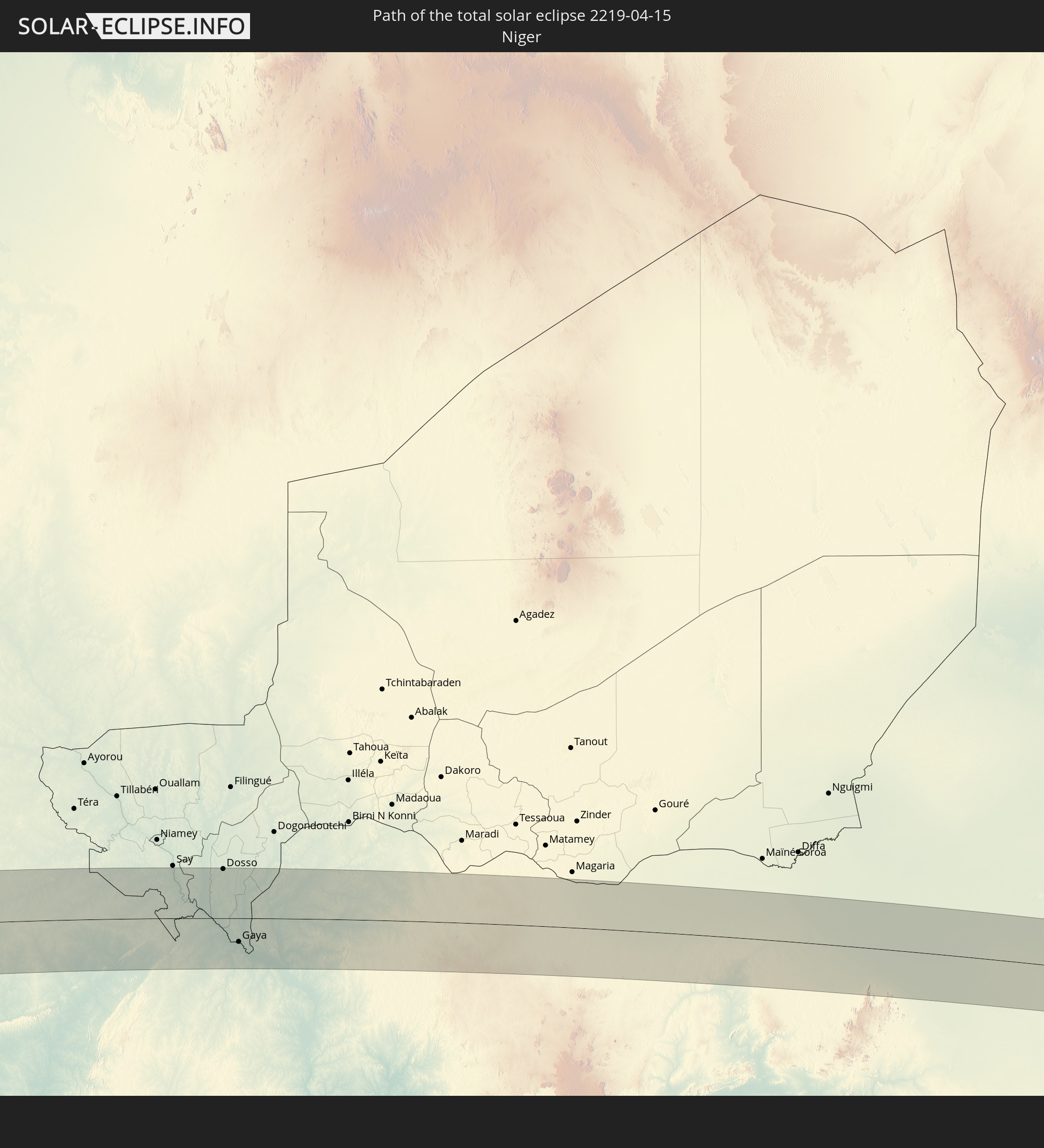 Niger
Niger
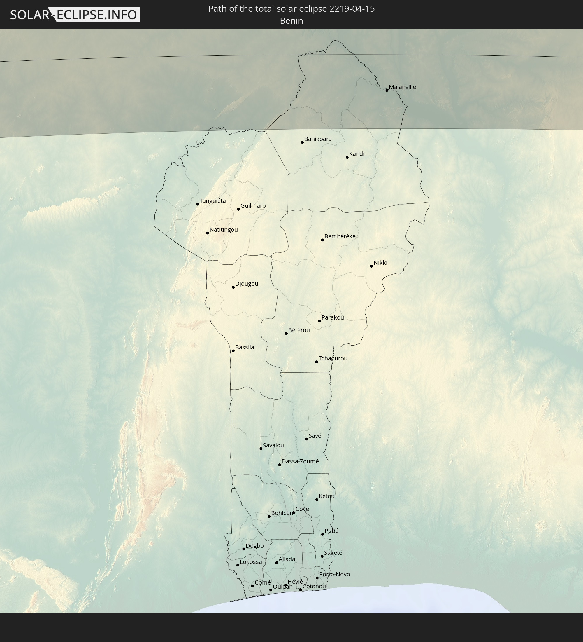 Benin
Benin
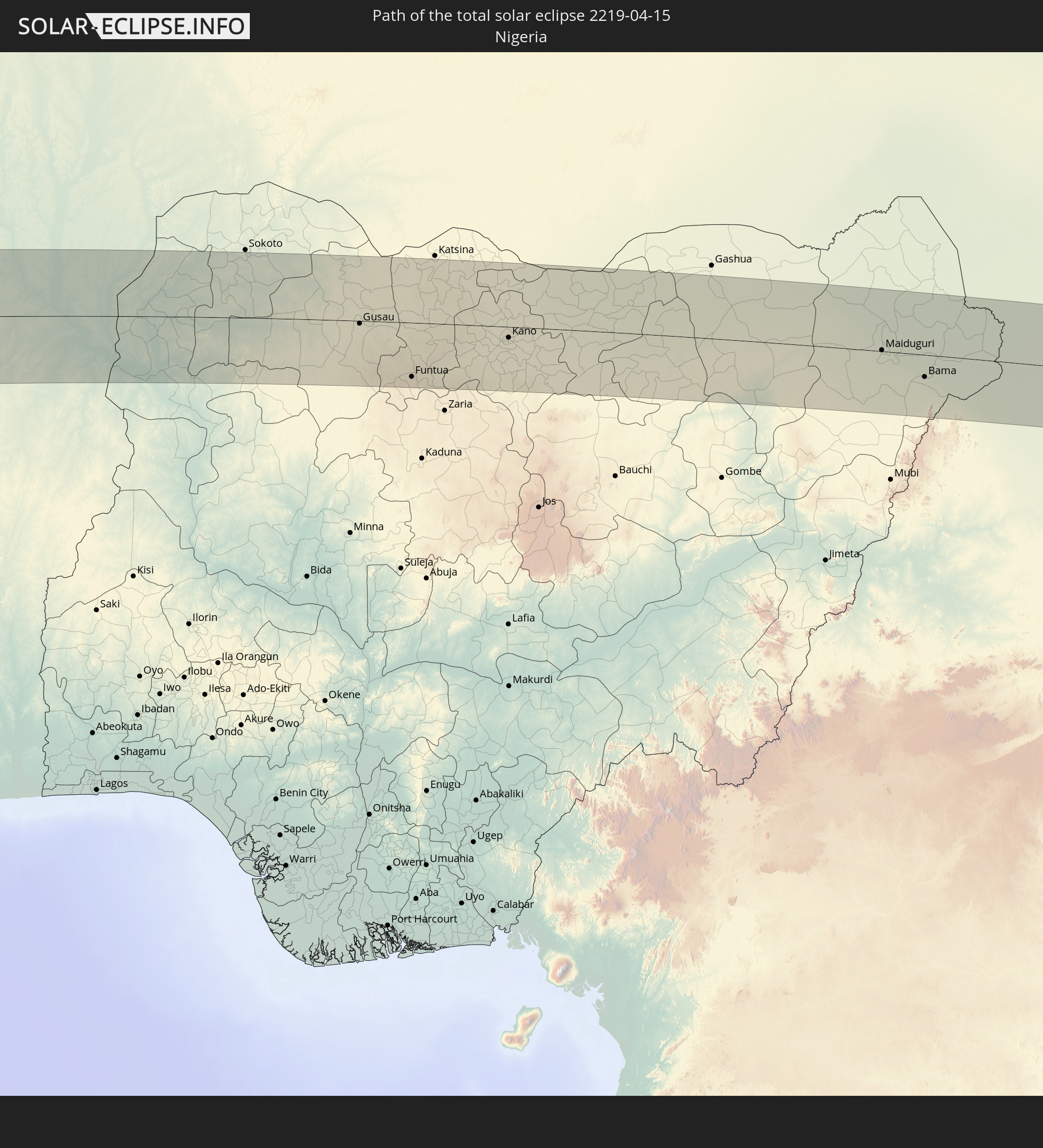 Nigeria
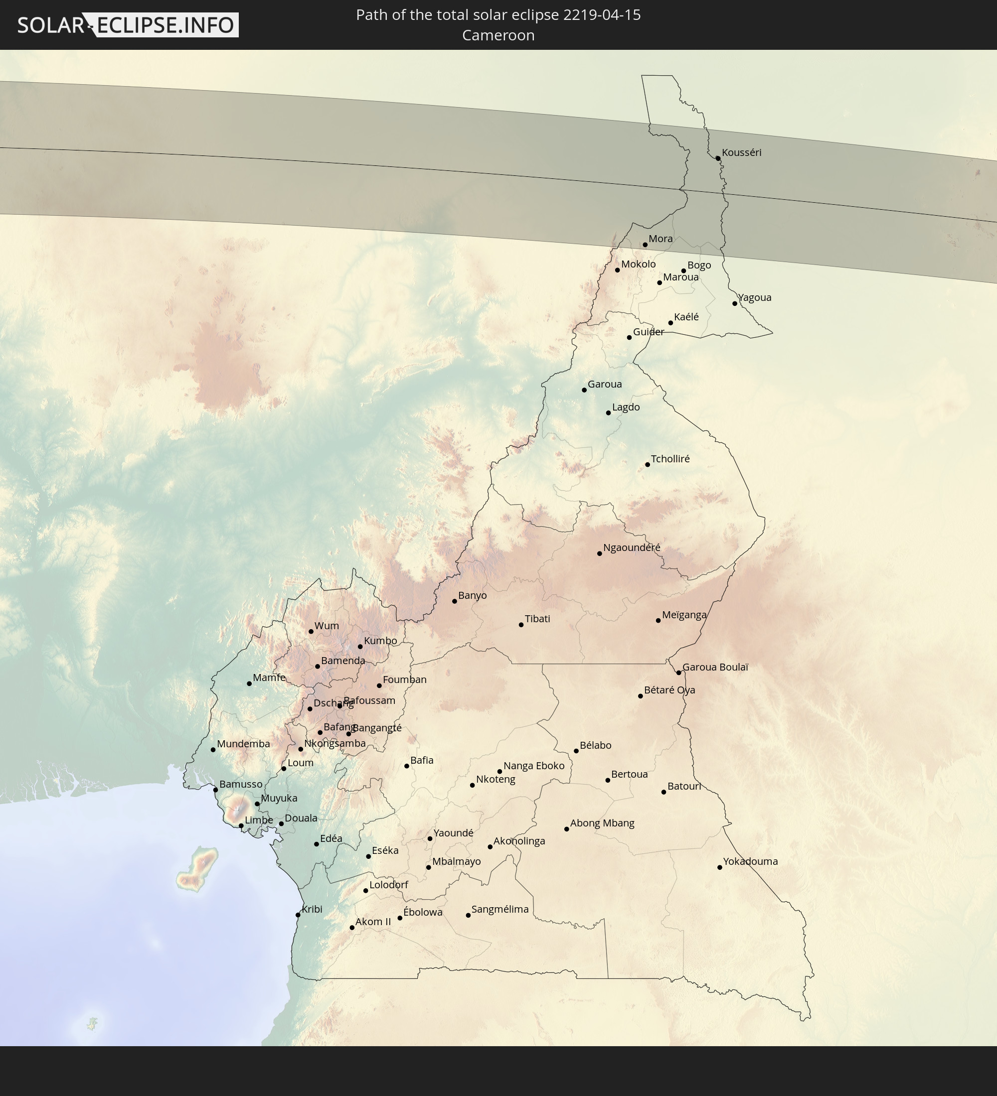 Kamerun
 Tschad
 Zentralafrikanische Republik
 Sudan
Sudan
 Südsudan
In den folgenden Ländern ist die Sonnenfinsternis partiell zu sehen
 Chile
Chile
 Ecuador
 Honduras
 Nicaragua
 Costa Rica
 Panama
 Kolumbien
 Peru
Peru
 Haiti
Haiti
 Brasilien
 Argentinien
 Venezuela
 Dominikanische Republik
 Aruba
Aruba
 Bolivien
 Puerto Rico
 Amerikanische Jungferninseln
 Britische Jungferninseln
 Anguilla
 Saint-Martin
 Saint-Barthélemy
 St. Kitts und Nevis
 Paraguay
 Antigua und Barbuda
 Montserrat
 Trinidad und Tobago
 Guadeloupe
 Grenada
 Dominica
 St. Vincent und die Grenadinen
 Guyana
 Martinique
 St. Lucia
 Barbados
 Uruguay
 Suriname
 Französisch-Guayana
 Portugal
 Kap Verde
 Spanien
 Senegal
 Mauretanien
 Gambia
 Guinea-Bissau
 Guinea
 St. Helena
 Sierra Leone
 Marokko
 Mali
Mali
 Liberia
 Algerien
 Elfenbeinküste
 Burkina Faso
 Gibraltar
 Frankreich
 Ghana
Ghana
 Togo
Togo
 Niger
Niger
 Benin
Benin
 Andorra
 Nigeria
 Äquatorialguinea
 São Tomé und Príncipe
 Italien
 Tunesien
 Kamerun
 Gabun
Gabun
 Libyen
 Republik Kongo
 Angola
 Namibia
 Demokratische Republik Kongo
 Vatikanstadt
 Tschad
 Kroatien
 Malta
Malta
 Zentralafrikanische Republik
 Bosnien und Herzegowina
 Südafrika
 Montenegro
 Serbien
 Albanien
 Griechenland
 Botswana
 Mazedonien
 Sudan
Sudan
 Sambia
 Bulgarien
 Ägypten
 Simbabwe
 Türkei
 Ruanda
 Burundi
 Tansania
 Uganda
 Republik Zypern
 Staat Palästina
 Israel
 Saudi-Arabien
 Jordanien
 Libanon
 Syrien
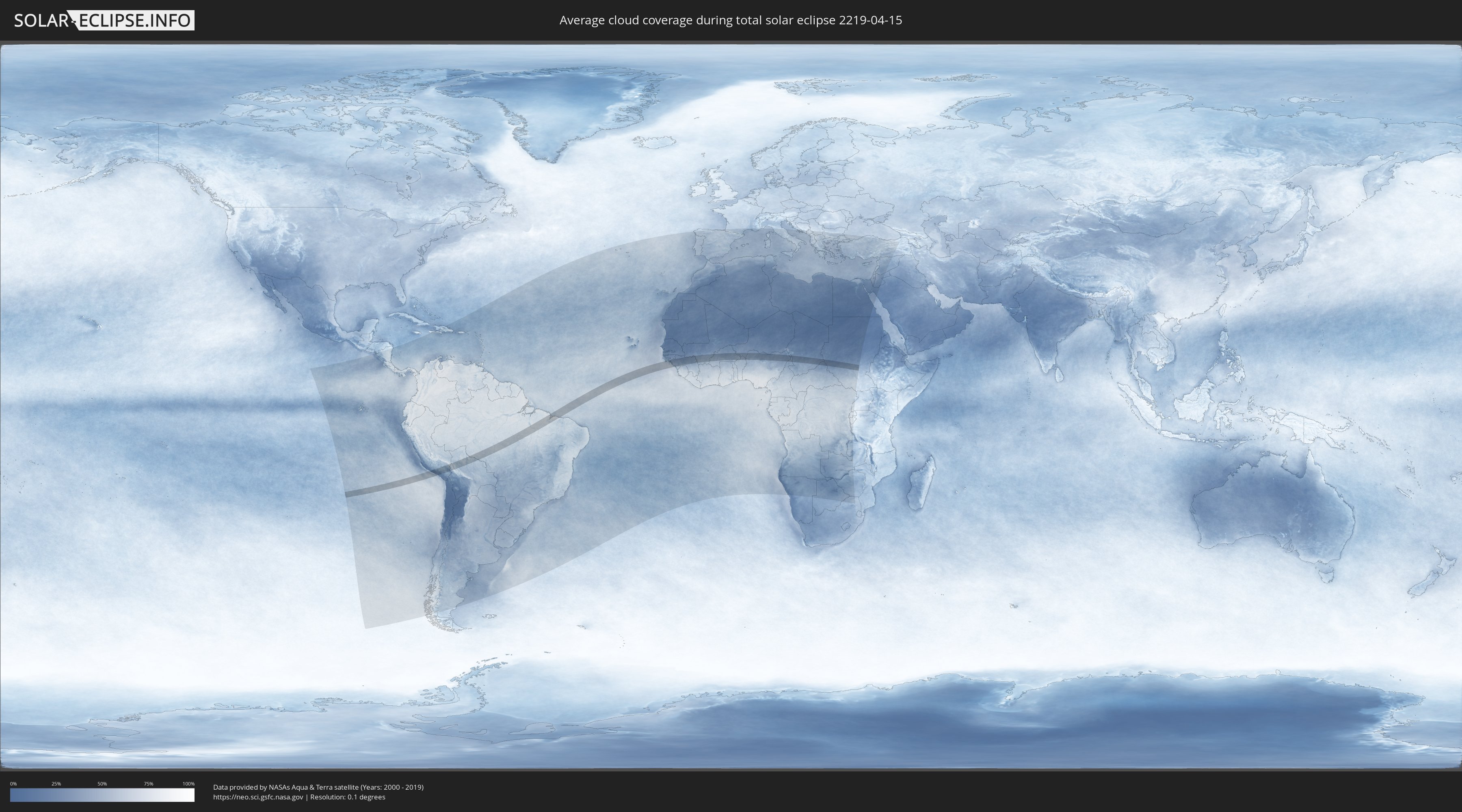
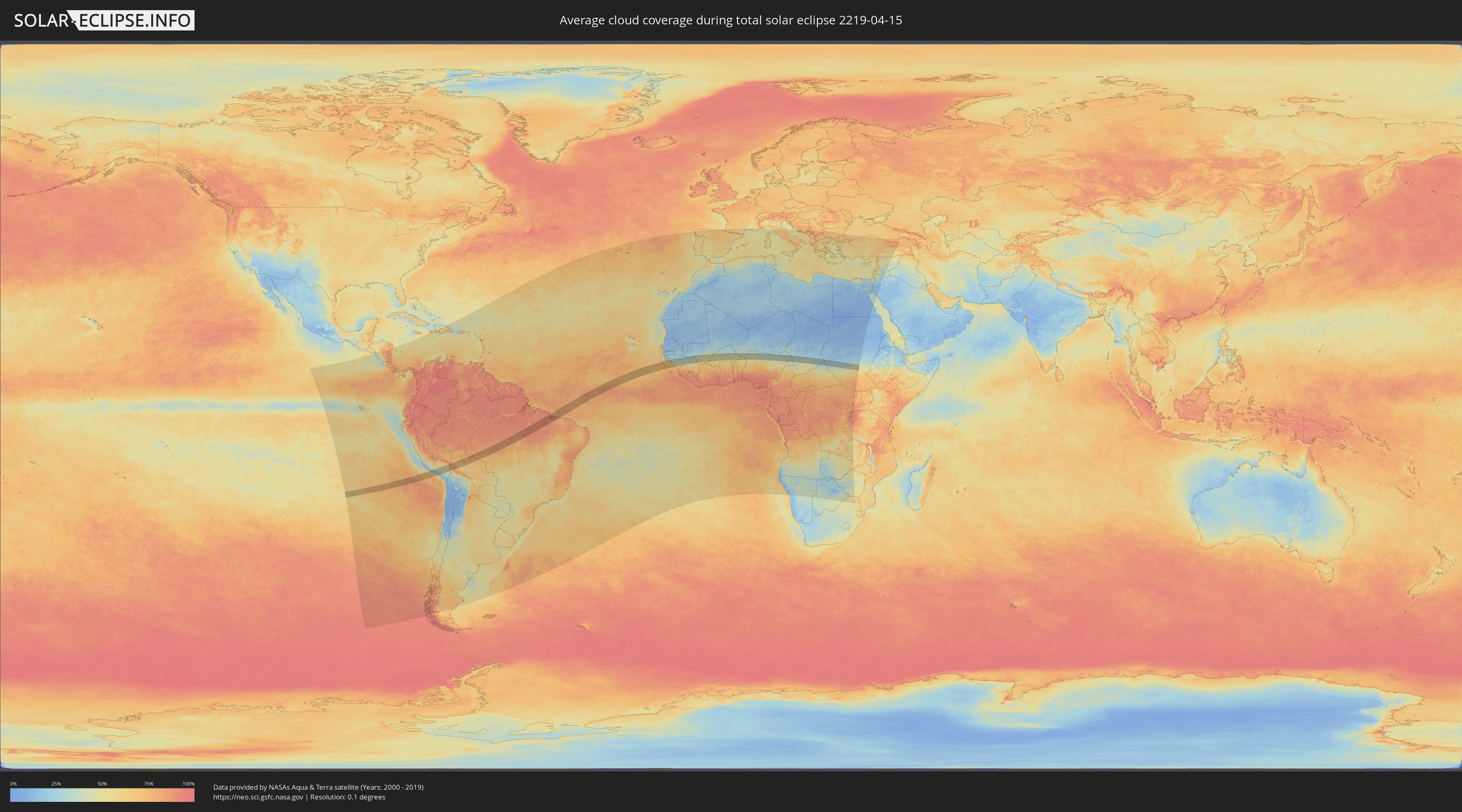
Wie wird das Wetter während der totalen Sonnenfinsternis am 15.04.2219?
Wo ist der beste Ort, um die totale Sonnenfinsternis vom 15.04.2219 zu beobachten?
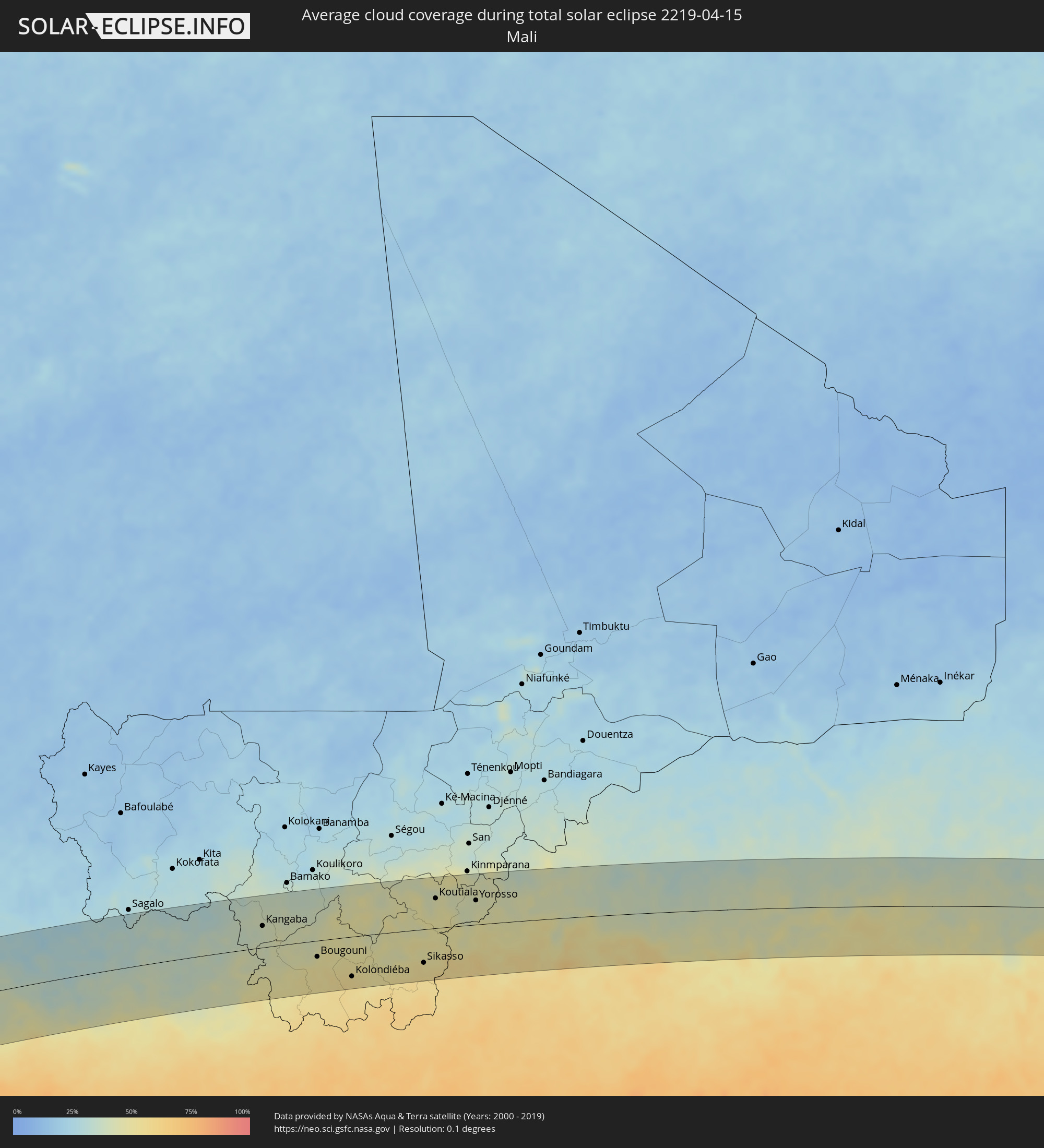
Die folgenden Karten zeigen die durchschnittliche Bewölkung für den Tag, an dem die totale Sonnenfinsternis
stattfindet. Mit Hilfe der Karten lässt sich der Ort entlang des Finsternispfades eingrenzen,
der die besten Aussichen auf einen klaren wolkenfreien Himmel bietet.
Trotzdem muss man immer lokale Gegenenheiten beachten und sollte sich genau über das Wetter an seinem
gewählten Beobachtungsort informieren.
Die Daten stammen von den beiden NASA-Satelliten
AQUA und TERRA
und wurden über einen Zeitraum von 19 Jahren (2000 - 2019) gemittelt.
Detaillierte Länderkarten
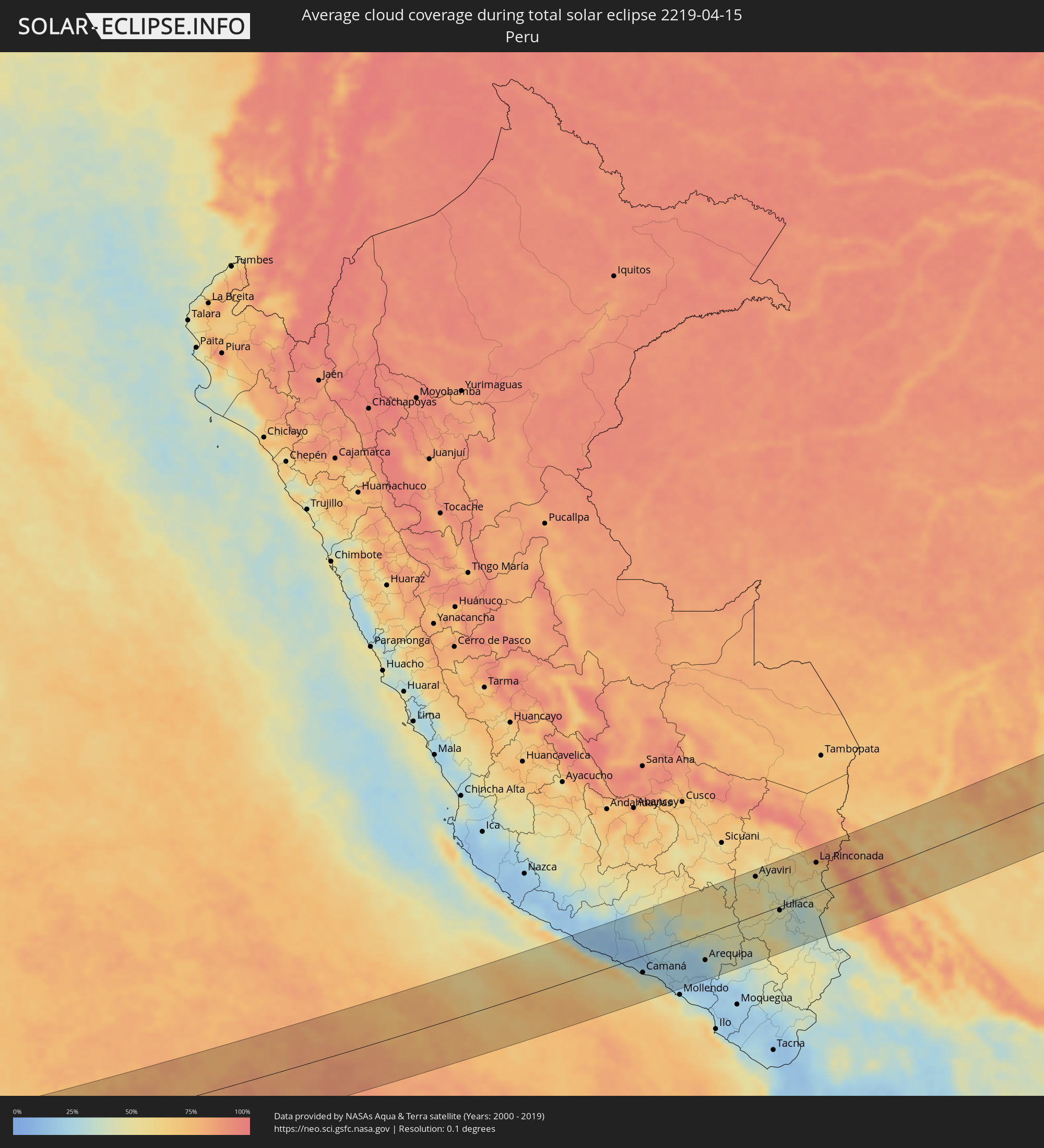 Peru
Peru
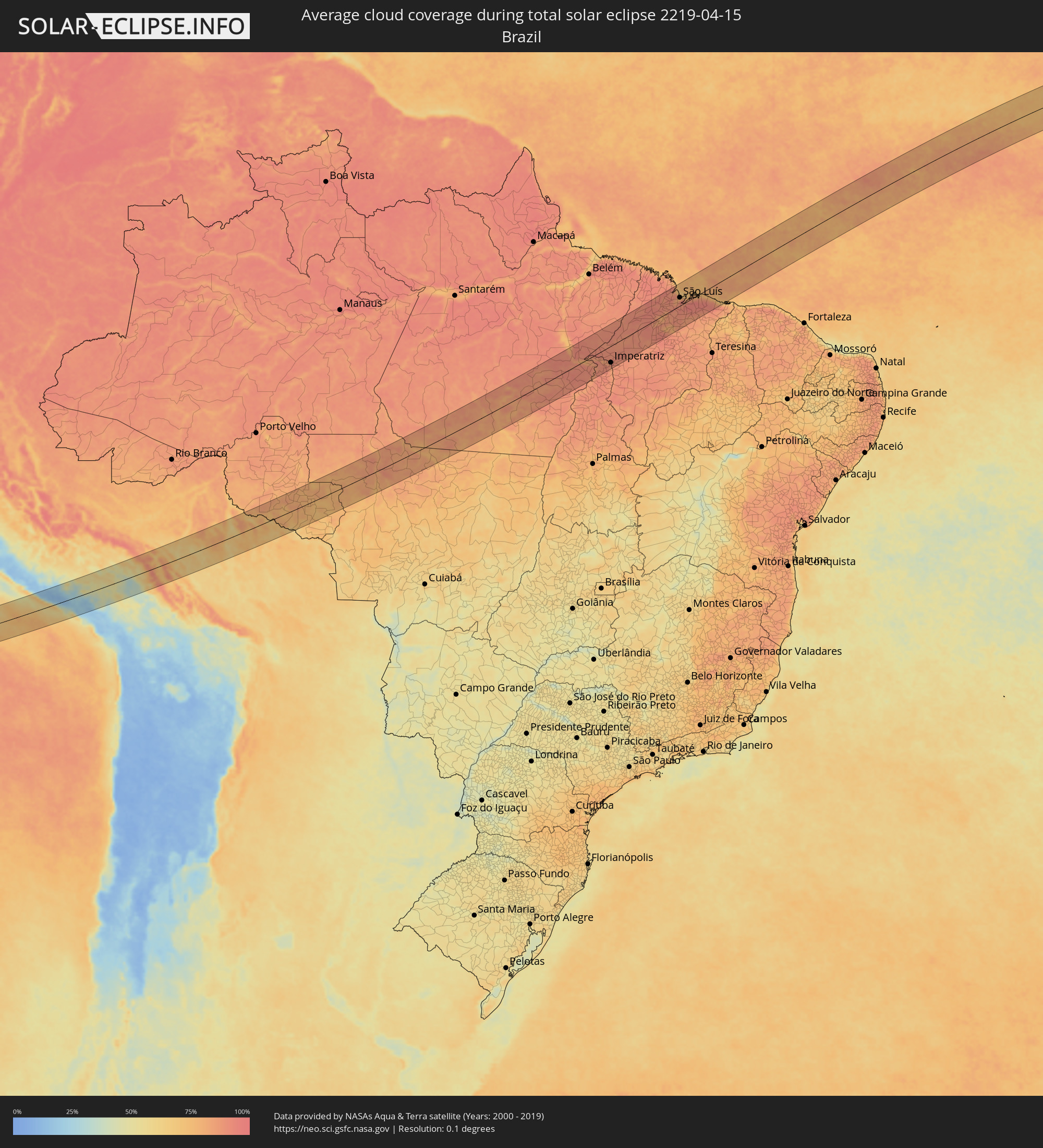 Brasilien
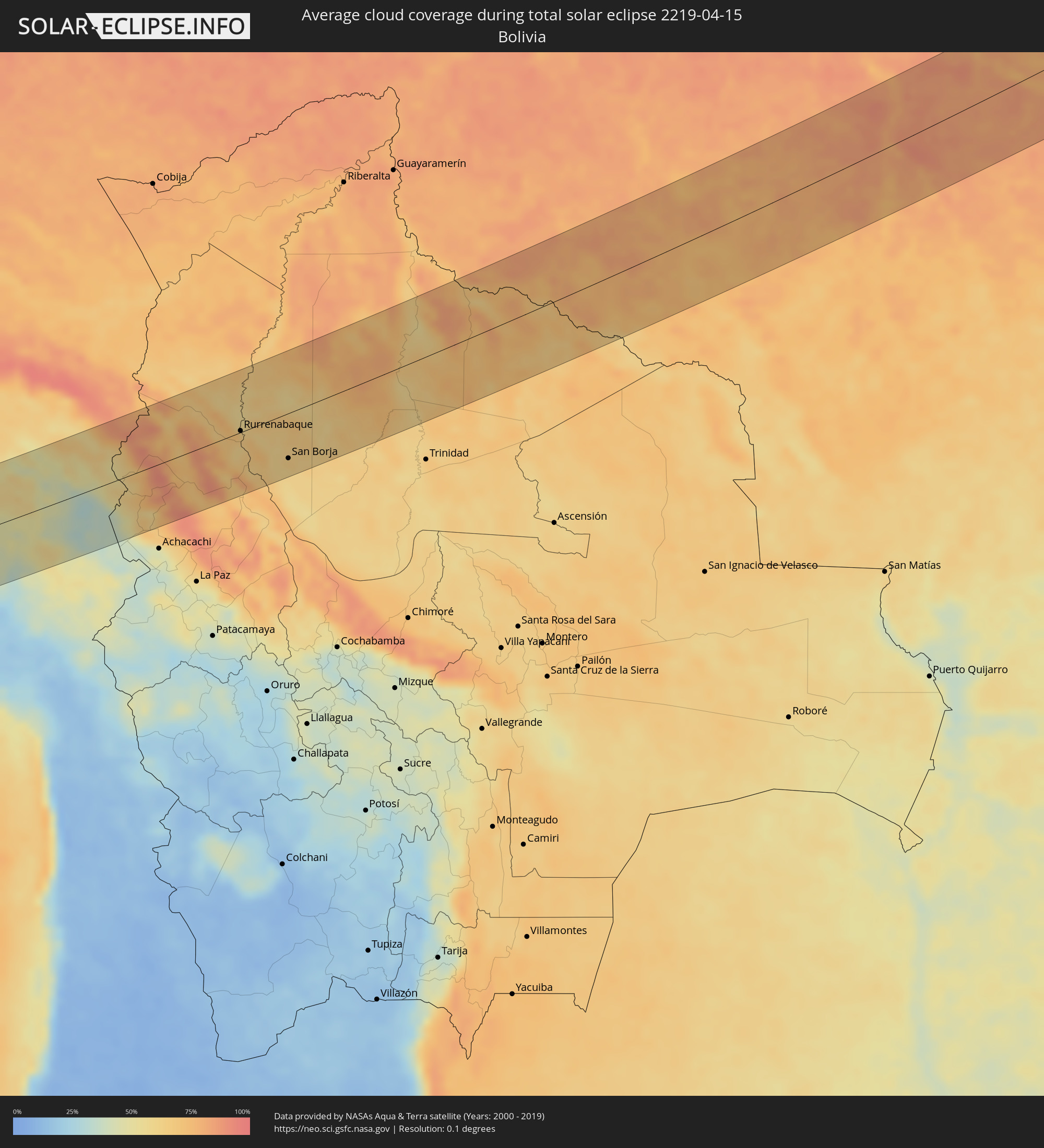 Bolivien
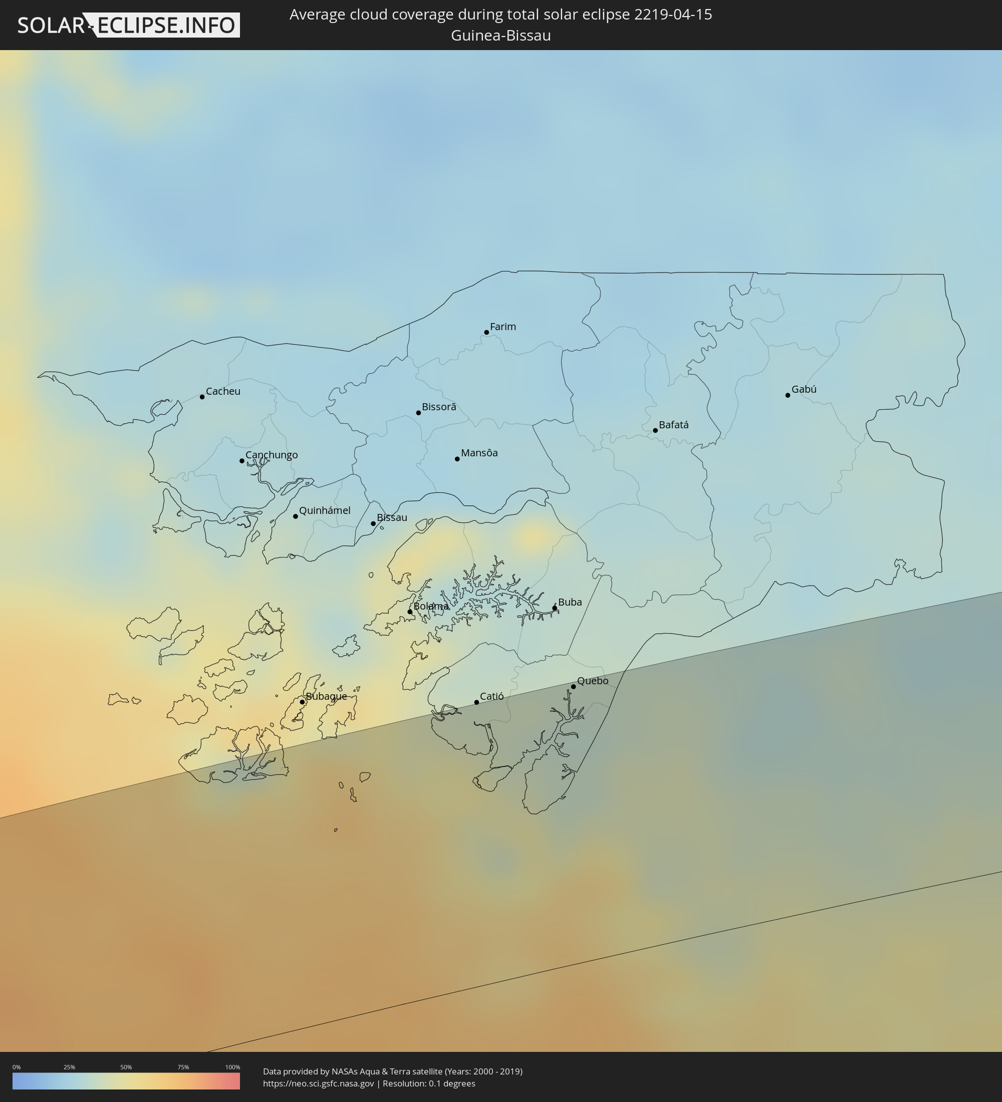 Guinea-Bissau
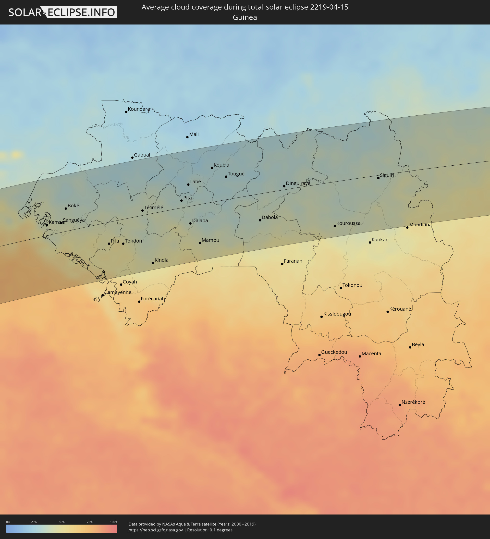 Guinea
 Mali
Mali
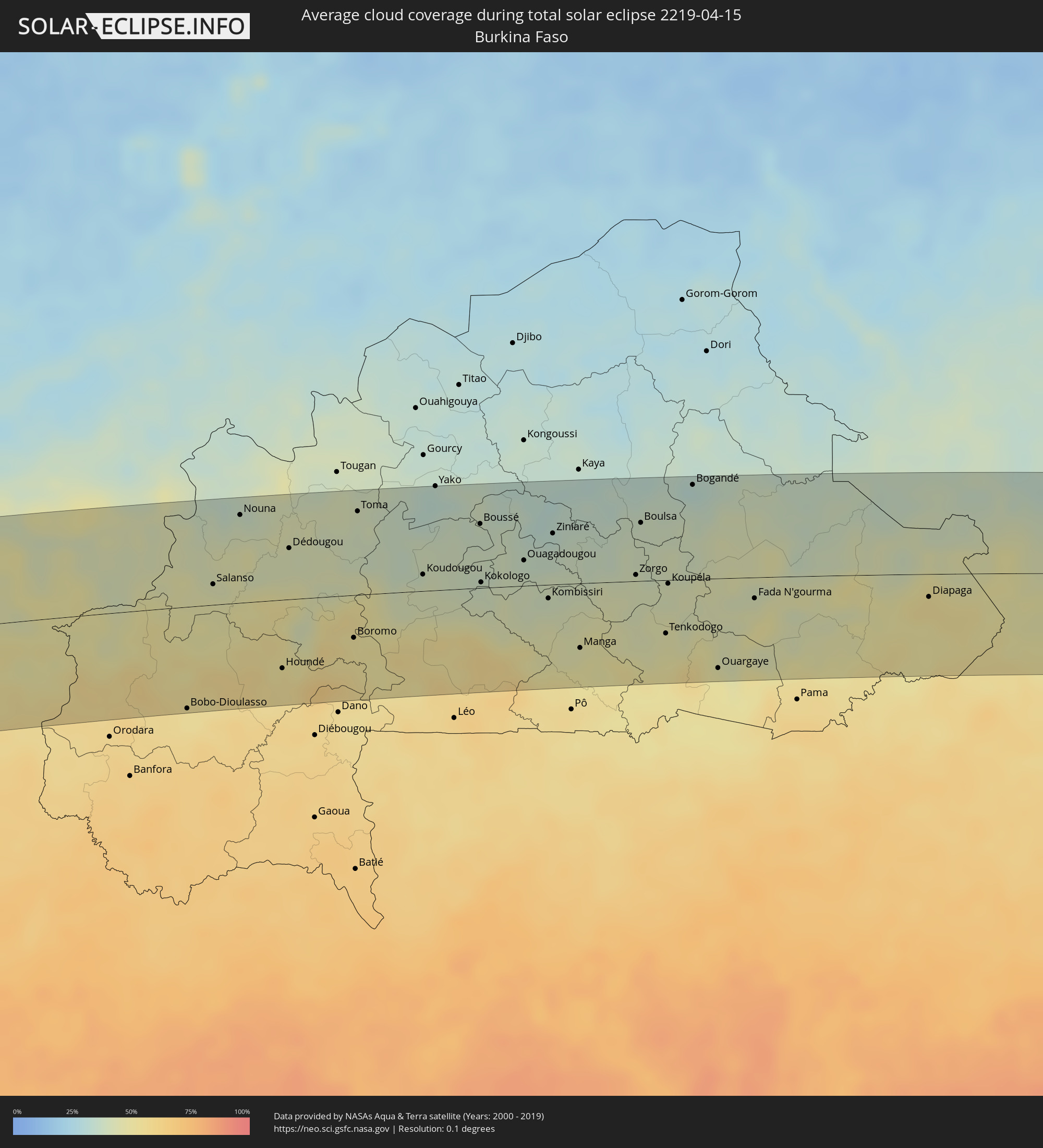 Burkina Faso
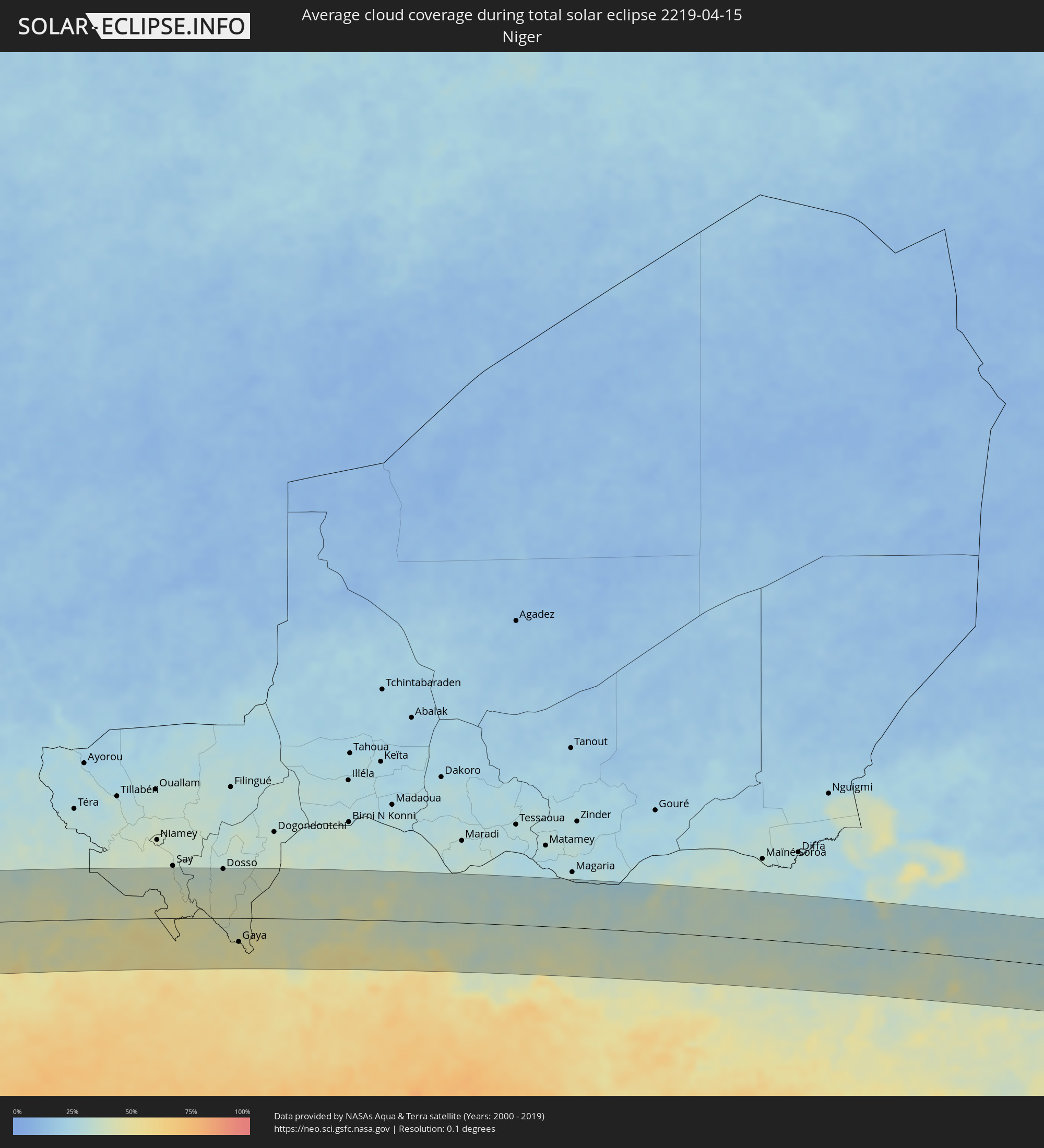 Niger
Niger
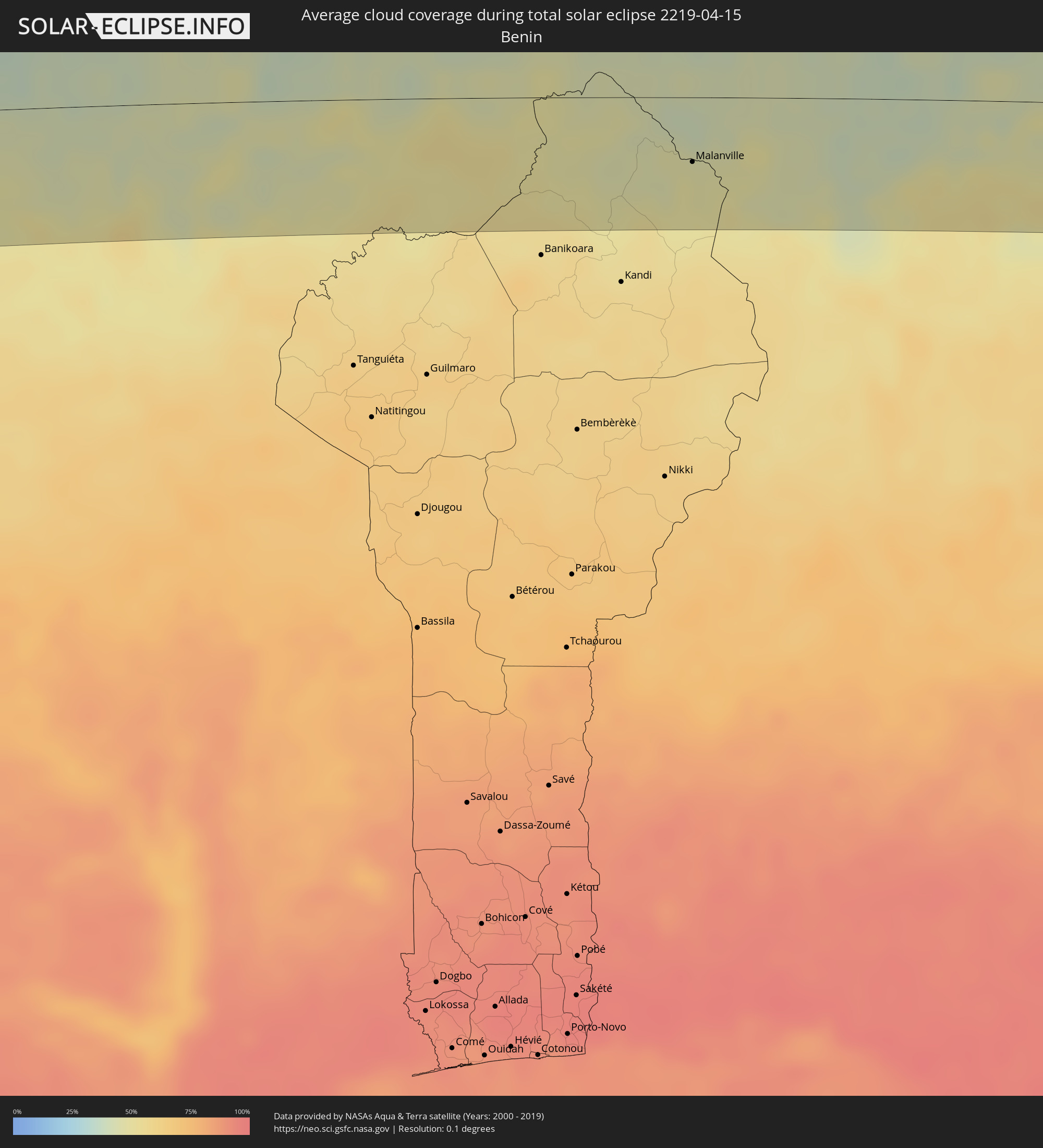 Benin
Benin
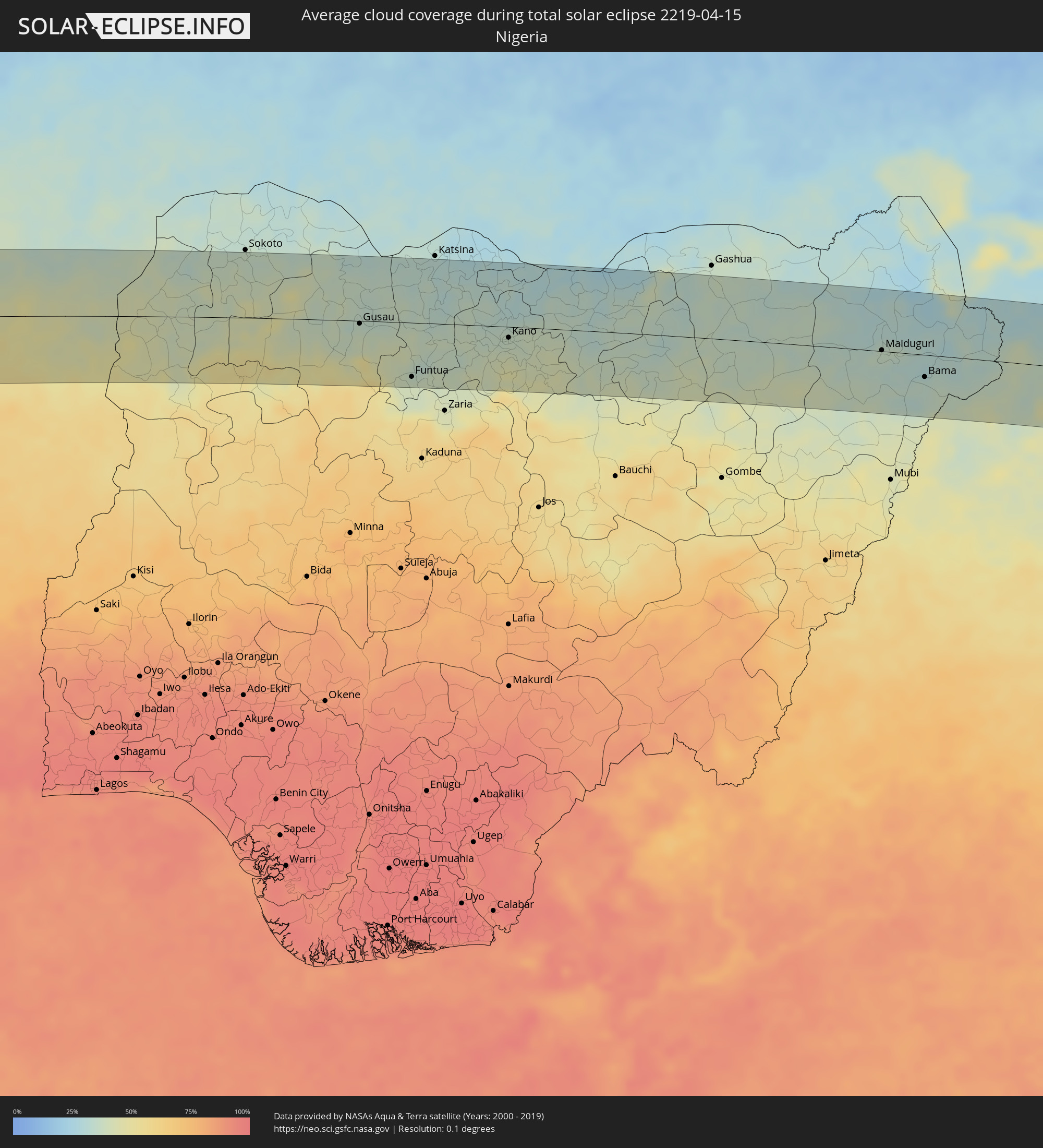 Nigeria
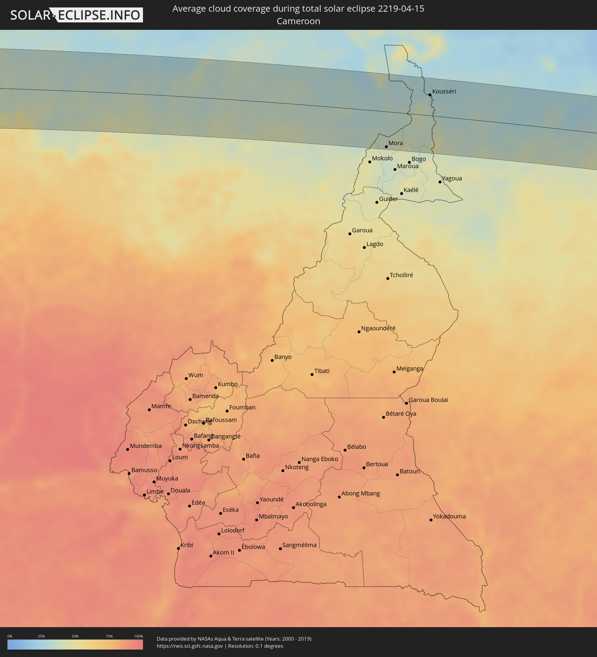 Kamerun
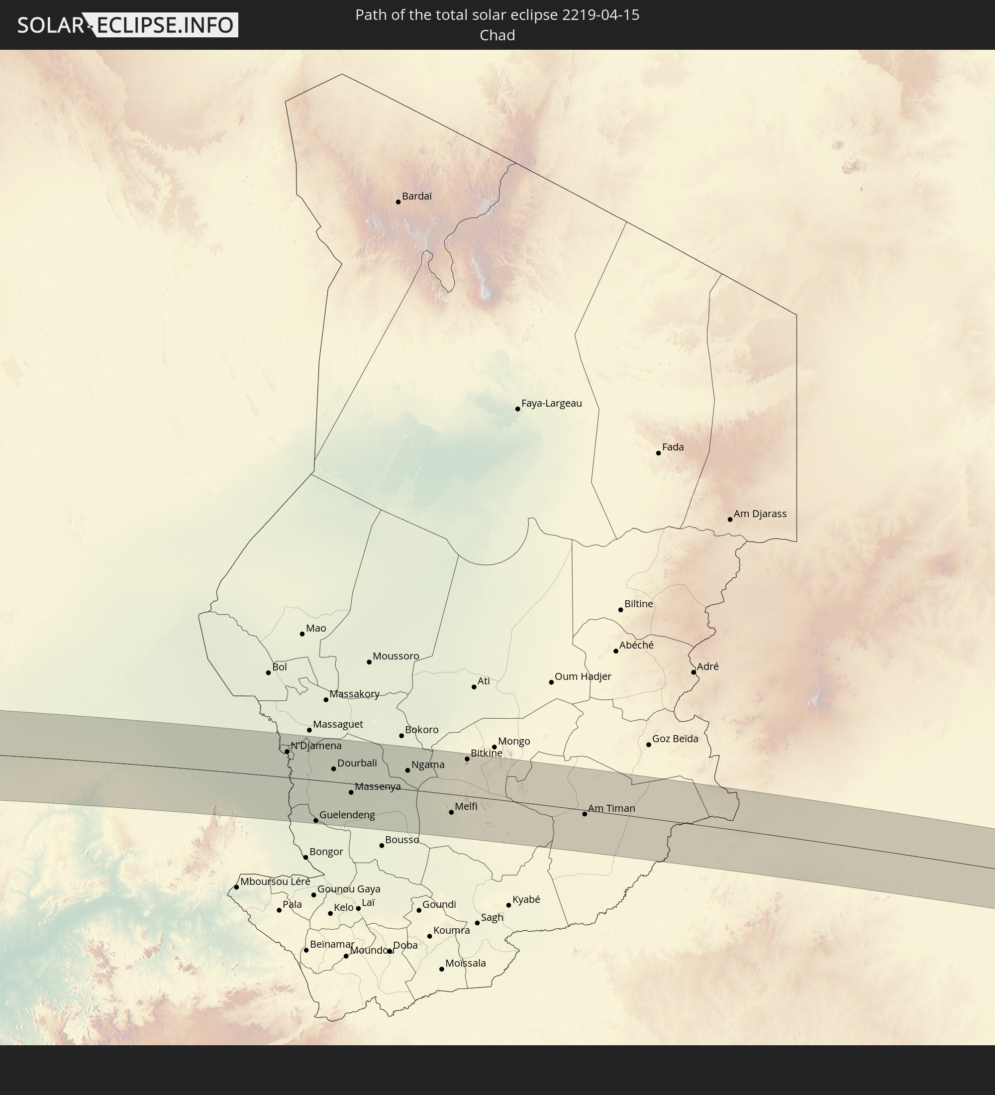
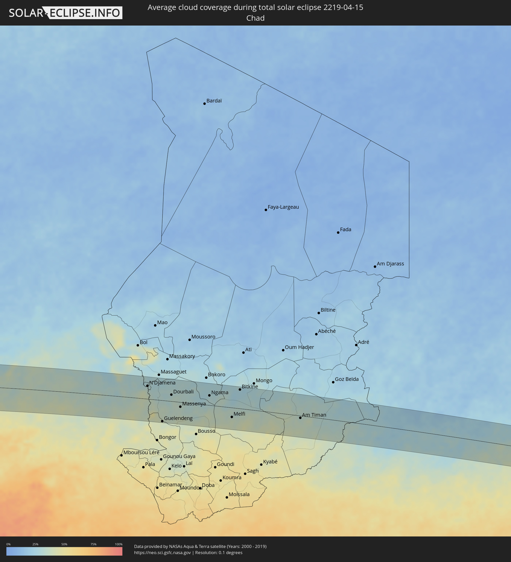 Tschad
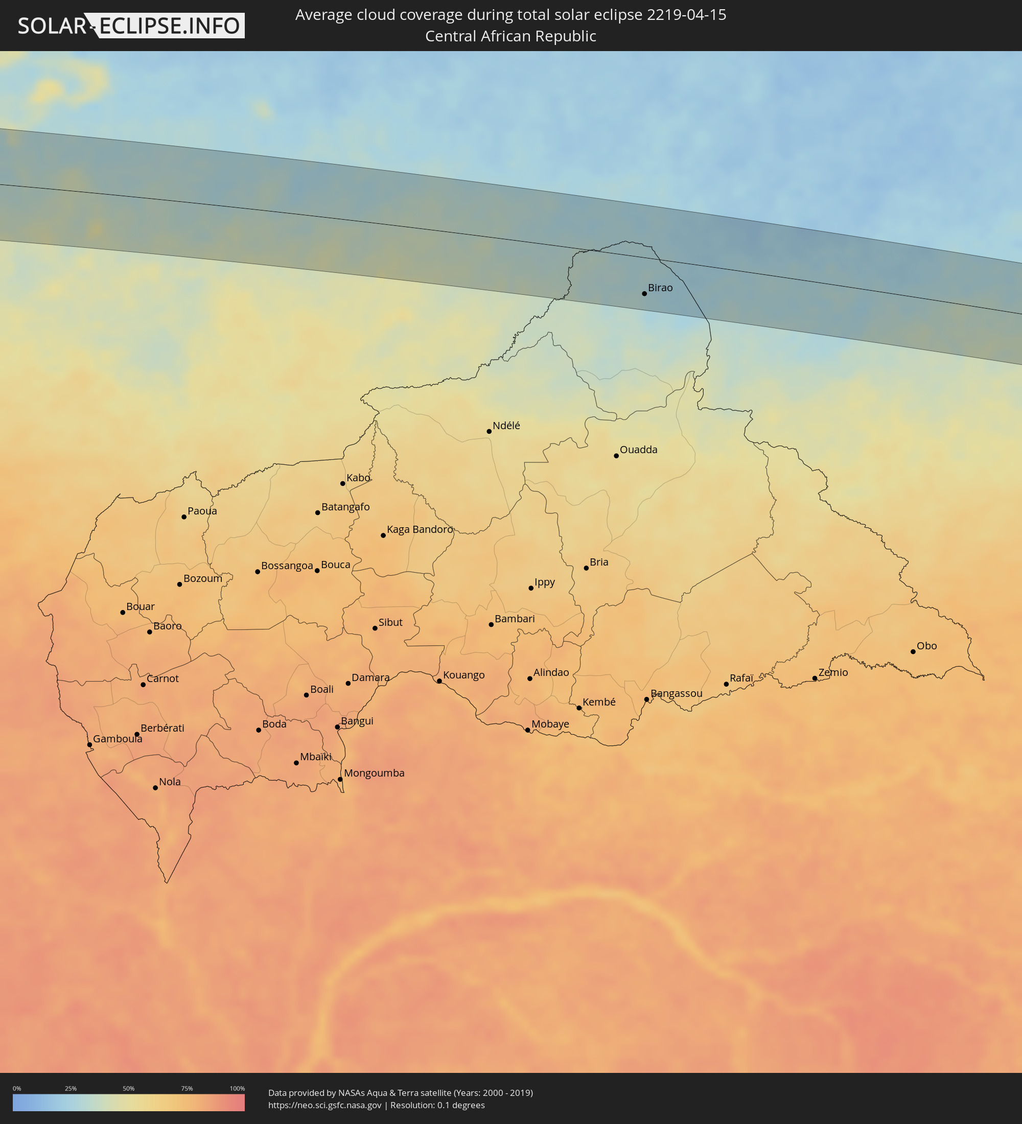 Zentralafrikanische Republik
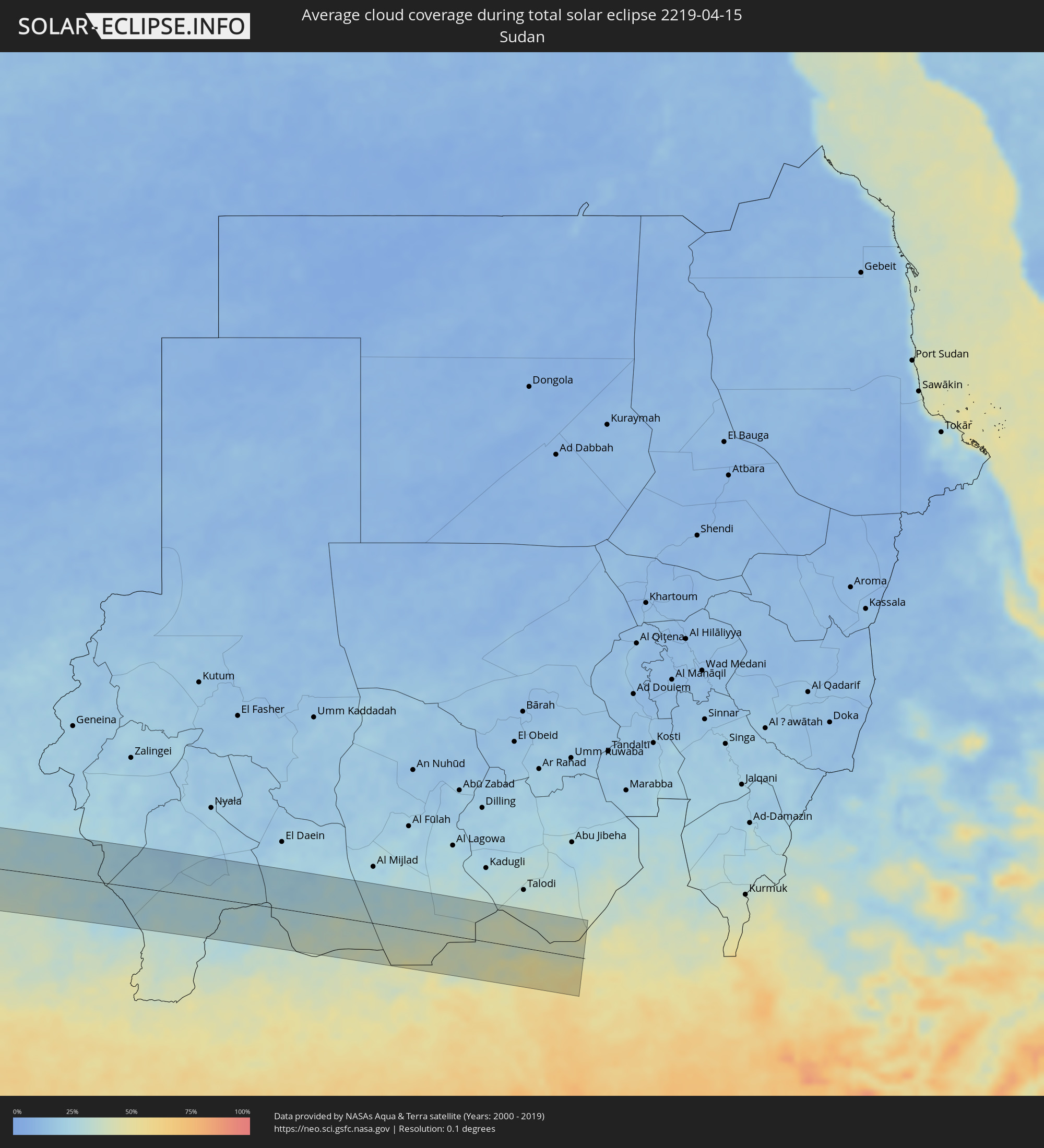 Sudan
Sudan
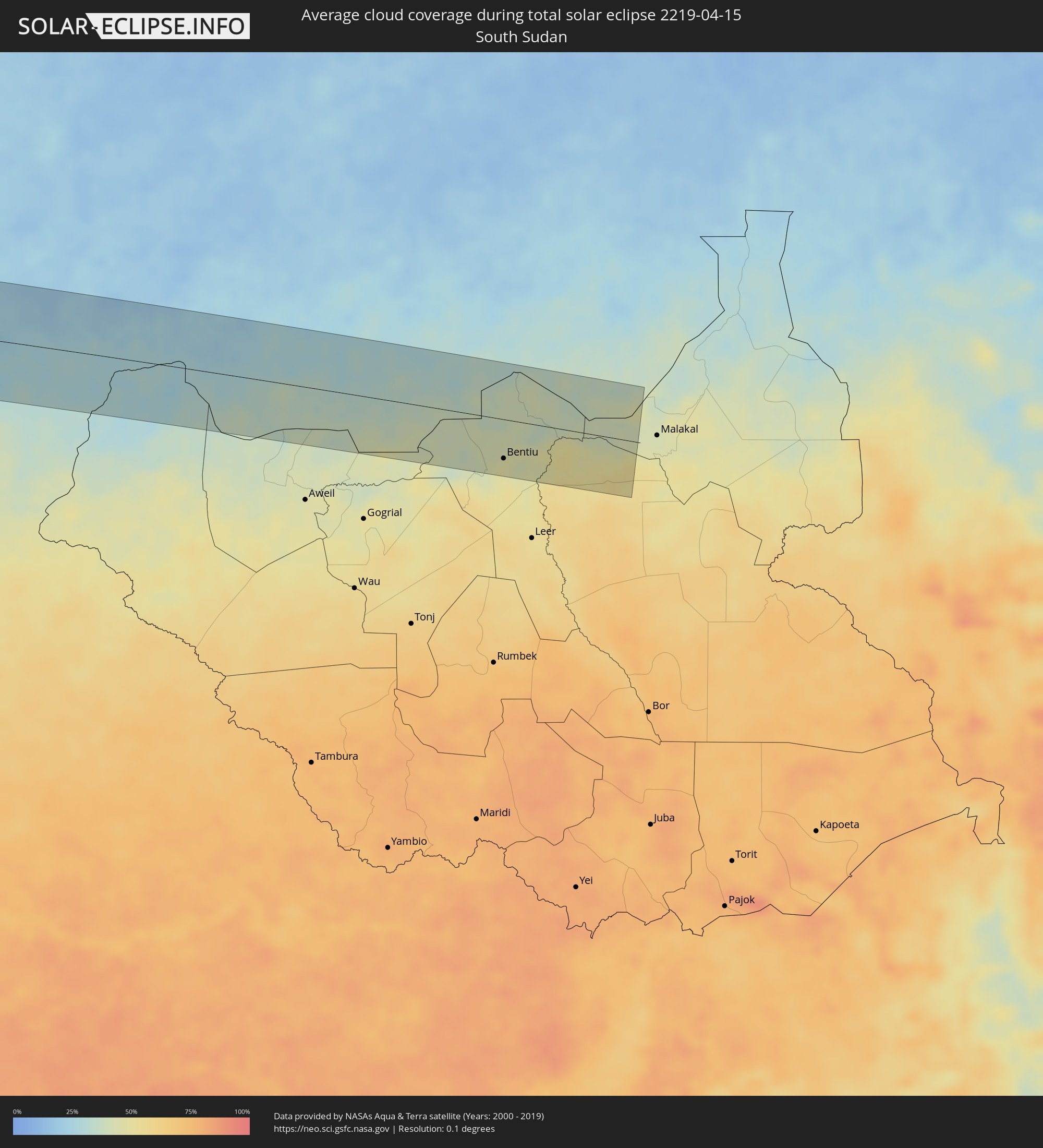 Südsudan
Orte im Finsternispfad
Die nachfolgene Tabelle zeigt Städte und Orte mit mehr als 5.000 Einwohnern, die sich im Finsternispfad befinden. Städte mit mehr als 100.000 Einwohnern sind dick gekennzeichnet. Mit einem Klick auf den Ort öffnet sich eine Detailkarte die die Lage des jeweiligen Ortes zusammen mit dem Verlauf der zentralen Finsternis präsentiert.
| Ort | Typ | Dauer der Verfinsterung | Ortszeit bei maximaler Verfinsterung | Entfernung zur Zentrallinie | Ø Bewölkung |
|
Camaná, Arequipa
|
total | - | 07:44:36 UTC-05:00 | 32 km | 38% |
|
Lluta, Arequipa
|
total | - | 07:45:21 UTC-05:00 | 7 km | 27% |
|
Yura, Arequipa
|
total | - | 07:45:33 UTC-05:00 | 30 km | 21% |
|
Arequipa, Arequipa
|
total | - | 07:45:37 UTC-05:00 | 50 km | 24% |
|
Hacienda Huancane, Puno
|
total | - | 07:46:22 UTC-05:00 | 14 km | 47% |
|
Ayaviri, Puno
|
total | - | 07:46:59 UTC-05:00 | 73 km | 44% |
|
Azángaro, Puno
|
total | - | 07:47:20 UTC-05:00 | 56 km | 48% |
|
Atuncolla, Puno
|
total | - | 07:47:04 UTC-05:00 | 26 km | 42% |
|
Juliaca, Puno
|
total | - | 07:47:09 UTC-05:00 | 8 km | 43% |
|
Puno, Puno
|
total | - | 07:47:07 UTC-05:00 | 48 km | 39% |
|
Ilave, Puno
|
total | - | 07:47:21 UTC-05:00 | 86 km | 45% |
|
La Rinconada, Puno
|
total | - | 07:48:08 UTC-05:00 | 57 km | 62% |
|
Putina, Puno
|
total | - | 07:47:48 UTC-05:00 | 32 km | 36% |
|
Rurrenabaque, El Beni
|
total | - | 08:50:07 UTC-04:00 | 2 km | 63% |
|
Reyes, El Beni
|
total | - | 08:50:23 UTC-04:00 | 9 km | 67% |
|
San Borja, El Beni
|
total | - | 08:50:38 UTC-04:00 | 64 km | 64% |
|
Pôsto Fiscal Rolim de Moura, Rondônia
|
total | - | 08:56:53 UTC-04:00 | 79 km | 66% |
|
Cacoal, Rondônia
|
total | - | 08:59:04 UTC-04:00 | 51 km | 79% |
|
Pimenta Bueno, Rondônia
|
total | - | 08:59:14 UTC-04:00 | 16 km | 76% |
|
Itupiranga, Pará
|
total | - | 10:25:38 UTC-03:00 | 64 km | 83% |
|
Marabá, Pará
|
total | - | 10:25:45 UTC-03:00 | 30 km | 90% |
|
Imperatriz, Maranhão
|
total | - | 10:29:01 UTC-03:00 | 74 km | 89% |
|
Santa Inês, Maranhão
|
total | - | 10:36:01 UTC-03:00 | 13 km | 91% |
|
Lago da Pedra, Maranhão
|
total | - | 10:35:32 UTC-03:00 | 80 km | 93% |
|
Pinheiro, Maranhão
|
total | - | 10:38:11 UTC-03:00 | 80 km | 86% |
|
Viana, Maranhão
|
total | - | 10:37:27 UTC-03:00 | 9 km | 83% |
|
São Mateus do Maranhão, Maranhão
|
total | - | 10:37:36 UTC-03:00 | 100 km | 87% |
|
Itapecuru Mirim, Maranhão
|
total | - | 10:38:43 UTC-03:00 | 44 km | 88% |
|
São Luís, Maranhão
|
total | - | 10:39:59 UTC-03:00 | 36 km | 91% |
|
São José de Ribamar, Maranhão
|
total | - | 10:40:32 UTC-03:00 | 18 km | 86% |
|
Vargem Grande, Maranhão
|
total | - | 10:39:33 UTC-03:00 | 83 km | 88% |
|
Quebo, Tombali
|
total | - | 15:13:44 UTC+00:00 | 98 km | 34% |
|
Kamsar, Boke
|
total | - | 15:13:59 UTC+00:00 | 18 km | 45% |
|
Boké, Boke
|
total | - | 15:14:52 UTC+00:00 | 39 km | 40% |
|
Fria, Boke
|
total | - | 15:16:02 UTC+00:00 | 38 km | 49% |
|
Kimbo, Boke
|
total | - | 15:16:07 UTC+00:00 | 36 km | 49% |
|
Tondon, Kindia
|
total | - | 15:16:32 UTC+00:00 | 44 km | 50% |
|
Télimélé, Kindia
|
total | - | 15:17:35 UTC+00:00 | 8 km | 37% |
|
Kindia, Kindia
|
total | - | 15:17:22 UTC+00:00 | 88 km | 48% |
|
Pita, Mamou
|
total | - | 15:19:04 UTC+00:00 | 12 km | 36% |
|
Labé, Labe
|
total | - | 15:19:28 UTC+00:00 | 38 km | 32% |
|
Mamou, Mamou
|
total | - | 15:19:15 UTC+00:00 | 69 km | 47% |
|
Koubia, Labe
|
total | - | 15:20:26 UTC+00:00 | 60 km | 29% |
|
Tougué, Labe
|
total | - | 15:20:50 UTC+00:00 | 40 km | 29% |
|
Dabola, Faranah
|
total | - | 15:21:33 UTC+00:00 | 47 km | 42% |
|
Kouroussa, Kankan
|
total | - | 15:23:58 UTC+00:00 | 79 km | 43% |
|
Siguiri, Kankan
|
total | - | 15:25:48 UTC+00:00 | 5 km | 38% |
|
Kangaba, Koulikoro
|
total | - | 15:27:30 UTC+00:00 | 40 km | 39% |
|
Bougouni, Sikasso
|
total | - | 15:28:59 UTC+00:00 | 30 km | 52% |
|
Kolondiéba, Sikasso
|
total | - | 15:29:54 UTC+00:00 | 73 km | 56% |
|
Ntossoni, Sikasso
|
total | - | 15:32:30 UTC+00:00 | 74 km | 49% |
|
Sikasso, Sikasso
|
total | - | 15:32:11 UTC+00:00 | 62 km | 55% |
|
Koutiala, Sikasso
|
total | - | 15:32:58 UTC+00:00 | 55 km | 43% |
|
Yorosso, Sikasso
|
total | - | 15:34:07 UTC+00:00 | 45 km | 43% |
|
Bobo-Dioulasso, Hauts-Bassins
|
total | - | 15:34:26 UTC+00:00 | 91 km | 52% |
|
Nouna, Boucle du Mouhoun
|
total | - | 15:35:44 UTC+00:00 | 78 km | 40% |
|
Houndé, Hauts-Bassins
|
total | - | 15:35:50 UTC+00:00 | 61 km | 53% |
|
Dédougou, Boucle du Mouhoun
|
total | - | 15:36:17 UTC+00:00 | 46 km | 43% |
|
Koudougou, Centre-Ouest
|
total | - | 15:37:55 UTC+00:00 | 15 km | 41% |
|
Yako, Nord
|
total | - | 15:38:17 UTC+00:00 | 93 km | 33% |
|
Kokologo, Centre-Ouest
|
total | - | 15:38:36 UTC+00:00 | 5 km | 40% |
|
Ouagadougou, Centre
|
total | - | 15:39:11 UTC+00:00 | 23 km | 38% |
|
Kombissiri, Centre-Sud
|
total | - | 15:39:23 UTC+00:00 | 12 km | 41% |
|
Zorgo, Plateau-Central
|
total | - | 15:40:29 UTC+00:00 | 6 km | 42% |
|
Garango, Centre-Est
|
total | - | 15:40:26 UTC+00:00 | 45 km | 45% |
|
Tenkodogo, Centre-Est
|
total | - | 15:40:41 UTC+00:00 | 48 km | 46% |
|
Koupéla, Centre-Est
|
total | - | 15:40:50 UTC+00:00 | 3 km | 41% |
|
Fada N'gourma, Est
|
total | - | 15:41:47 UTC+00:00 | 19 km | 46% |
|
Diapaga, Est
|
total | - | 15:43:41 UTC+00:00 | 20 km | 53% |
|
Dosso, Dosso
|
total | - | 16:45:39 UTC+01:00 | 87 km | 38% |
|
Malanville, Atakora
|
total | - | 16:45:38 UTC+01:00 | 44 km | 47% |
|
Gaya, Dosso
|
total | - | 16:45:43 UTC+01:00 | 42 km | 47% |
|
Birnin Kebbi, Kebbi
|
total | - | 16:46:43 UTC+01:00 | 22 km | 41% |
|
Jega, Kebbi
|
total | - | 16:46:53 UTC+01:00 | 4 km | 41% |
|
Kaura Namoda, Zamfara
|
total | - | 16:49:20 UTC+01:00 | 43 km | 36% |
|
Gusau, Zamfara
|
total | - | 16:49:21 UTC+01:00 | 4 km | 38% |
|
Funtua, Katsina
|
total | - | 16:49:54 UTC+01:00 | 73 km | 40% |
|
Malumfashi, Katsina
|
total | - | 16:50:15 UTC+01:00 | 42 km | 37% |
|
Kano, Kano
|
total | - | 16:51:08 UTC+01:00 | 15 km | 39% |
|
Hadejia, Jigawa
|
total | - | 16:52:33 UTC+01:00 | 45 km | 36% |
|
Azare, Bauchi
|
total | - | 16:52:35 UTC+01:00 | 41 km | 37% |
|
Potiskum, Yobe
|
total | - | 16:53:20 UTC+01:00 | 30 km | 39% |
|
Daura, Yobe
|
total | - | 16:53:34 UTC+01:00 | 46 km | 38% |
|
Damaturu, Yobe
|
total | - | 16:54:01 UTC+01:00 | 20 km | 38% |
|
Maiduguri, Borno
|
total | - | 16:54:55 UTC+01:00 | 1 km | 33% |
|
Bama, Borno
|
total | - | 16:55:15 UTC+01:00 | 30 km | 34% |
|
Mora, Far North
|
total | - | 16:55:31 UTC+01:00 | 78 km | 38% |
|
Gamboru, Borno
|
total | - | 16:55:40 UTC+01:00 | 70 km | 30% |
|
Kousséri, Far North
|
total | - | 16:56:10 UTC+01:00 | 45 km | 34% |
|
N'Djamena, Chari-Baguirmi
|
total | - | 16:56:11 UTC+01:00 | 48 km | 34% |
|
Guelendeng, Mayo-Kebbi Est
|
total | - | 16:56:24 UTC+01:00 | 78 km | 38% |
|
Dourbali, Chari-Baguirmi
|
total | - | 16:56:39 UTC+01:00 | 24 km | 34% |
|
Massenya, Chari-Baguirmi
|
total | - | 16:56:48 UTC+01:00 | 18 km | 33% |
|
Ngama, Chari-Baguirmi
|
total | - | 16:57:23 UTC+01:00 | 36 km | 30% |
|
Melfi, Guéra
|
total | - | 16:57:44 UTC+01:00 | 35 km | 38% |
|
Bitkine, Guéra
|
total | - | 16:57:55 UTC+01:00 | 70 km | 26% |
|
Am Timan, Salamat
|
total | - | 16:58:47 UTC+01:00 | 8 km | 35% |
|
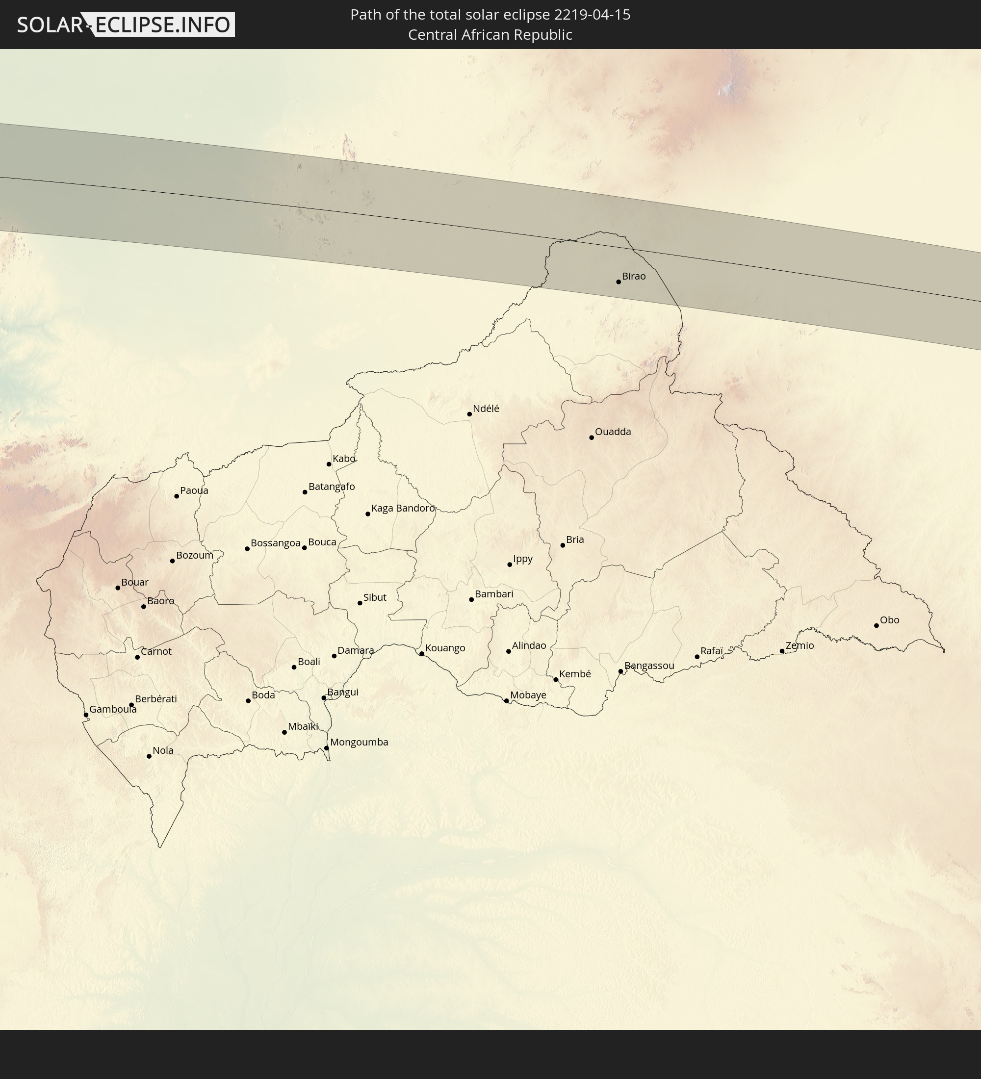
Birao, Vakaga
|
total | - | 16:59:38 UTC+01:00 | 55 km | 28% |
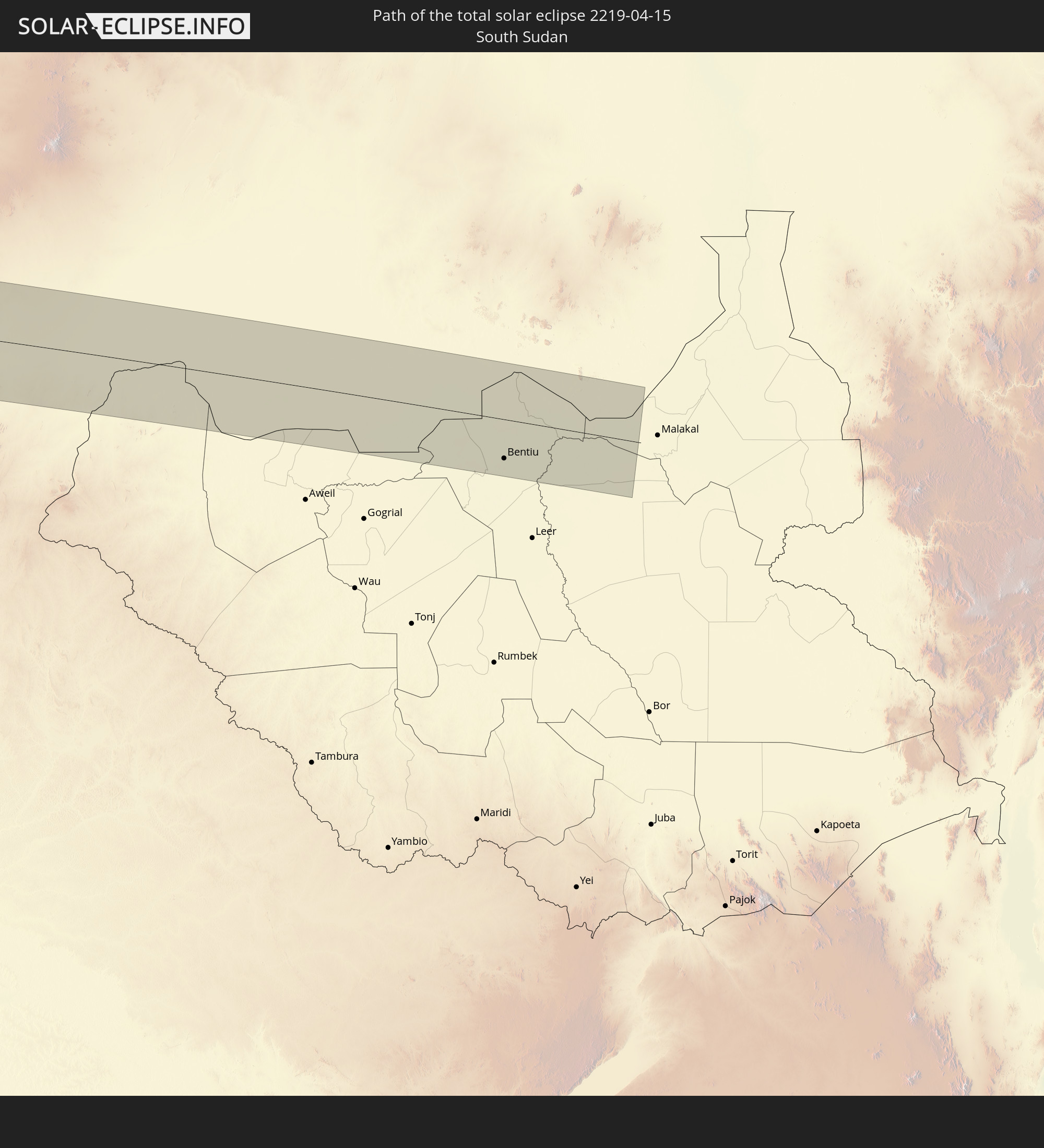
 Bentiu, Unity
|
total | - | 18:00:51 UTC+02:00 | 51 km | 47% |