Totale Sonnenfinsternis vom 08.08.2241
| Wochentag: | Sonntag |
| Maximale Dauer der Verfinsterung: | 04m02s |
| Maximale Breite des Finsternispfades: | 159 km |
| Saroszyklus: | 149 |
| Bedeckungsgrad: | 100% |
| Magnitude: | 1.0457 |
| Gamma: | 0.292 |
Wo kann man die Sonnenfinsternis vom 08.08.2241 sehen?
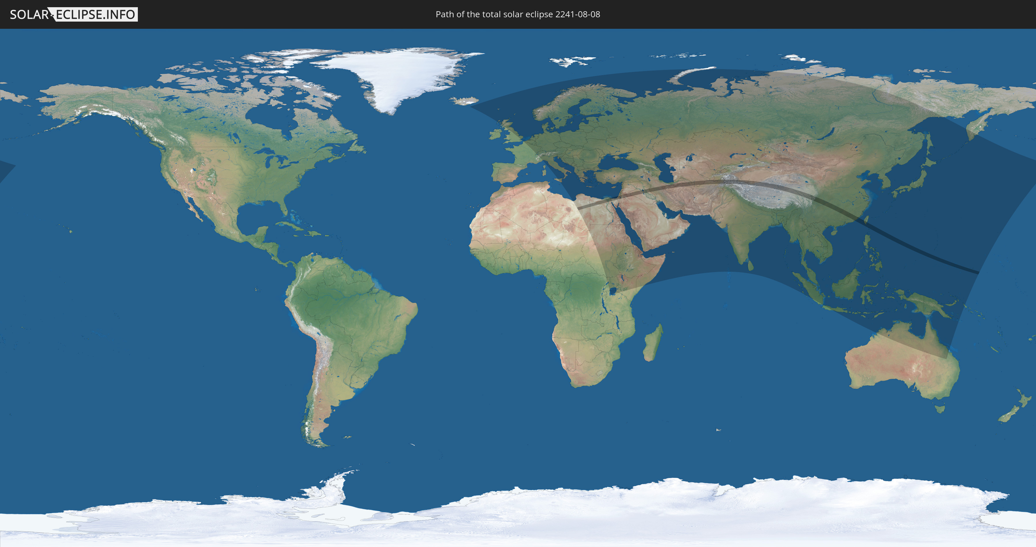
Die Sonnenfinsternis am 08.08.2241 kann man in 109 Ländern als partielle Sonnenfinsternis beobachten.
Der Finsternispfad verläuft durch 17 Länder. Nur in diesen Ländern ist sie als totale Sonnenfinsternis zu sehen.
In den folgenden Ländern ist die Sonnenfinsternis total zu sehen
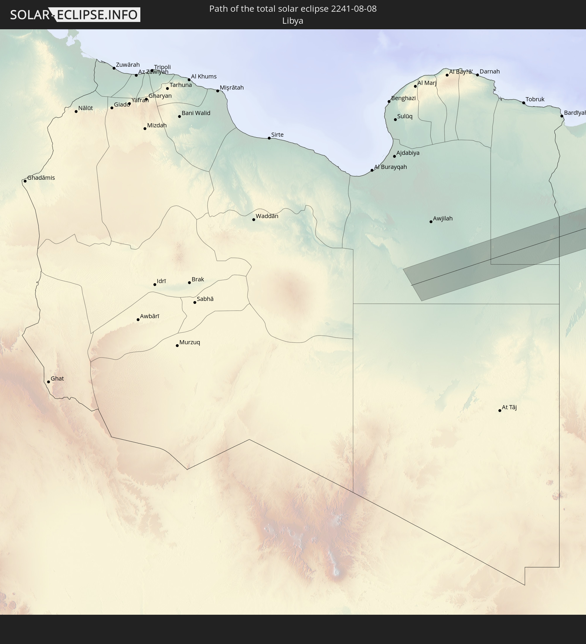 Libyen
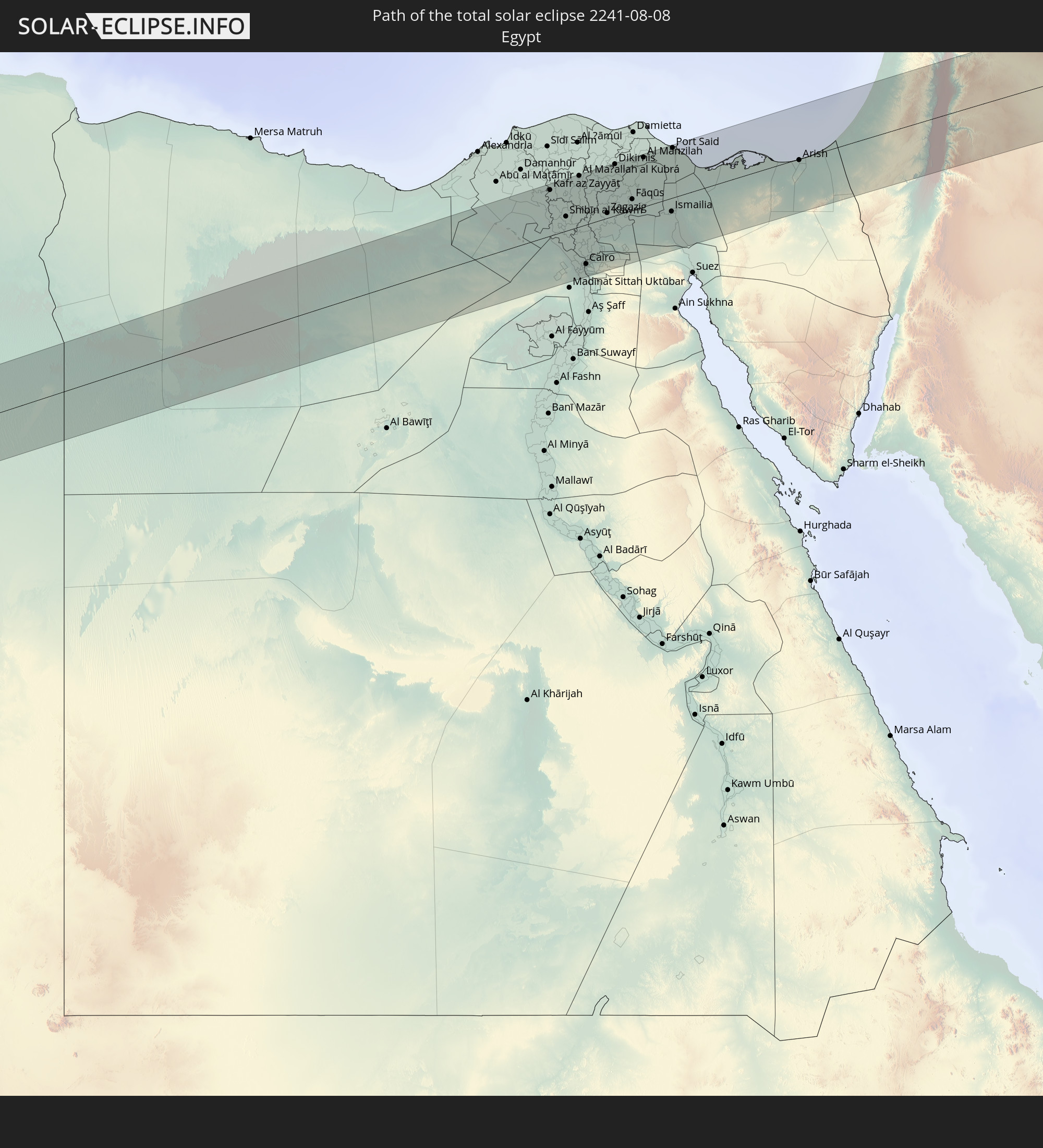 Ägypten
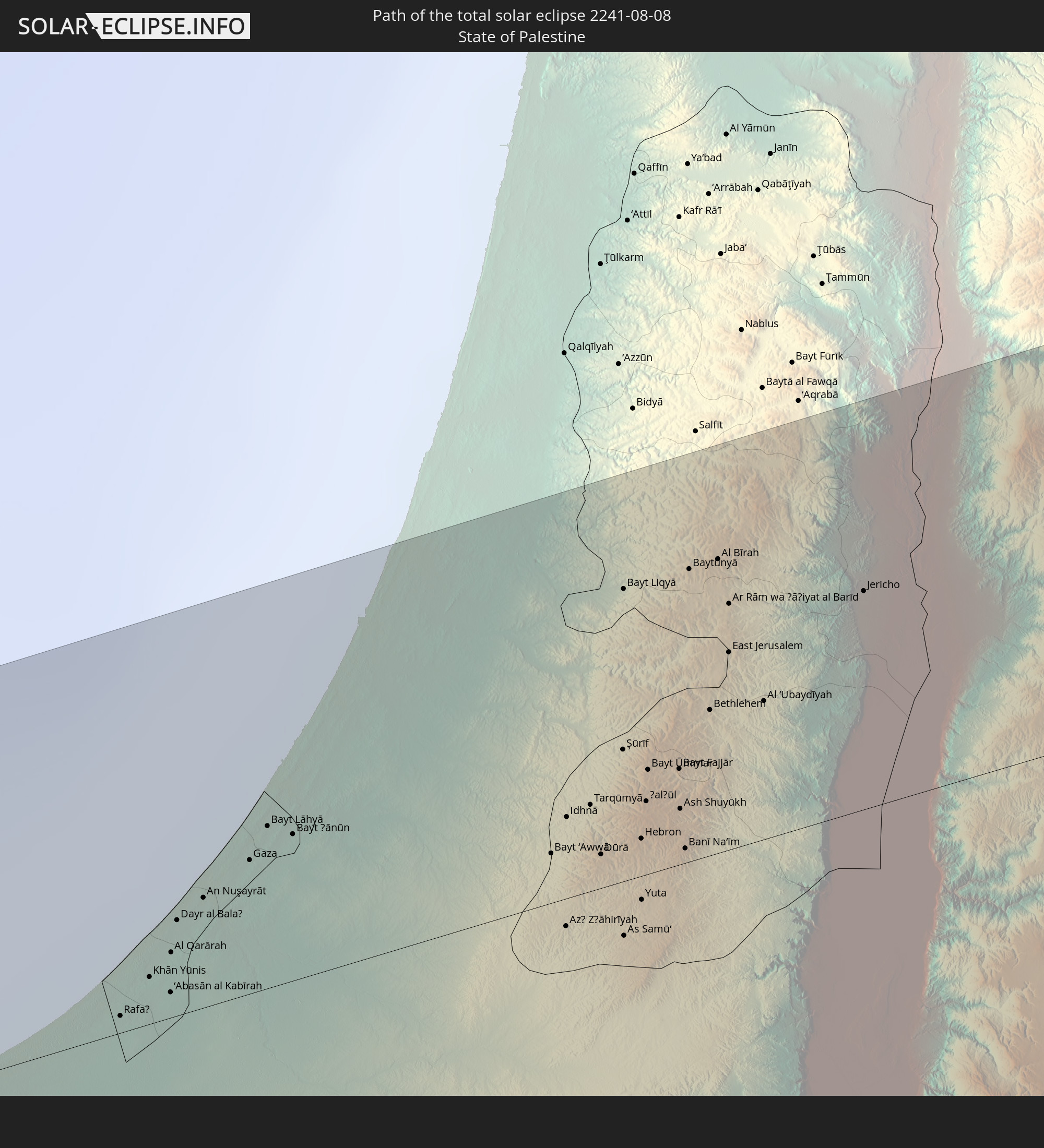 Staat Palästina
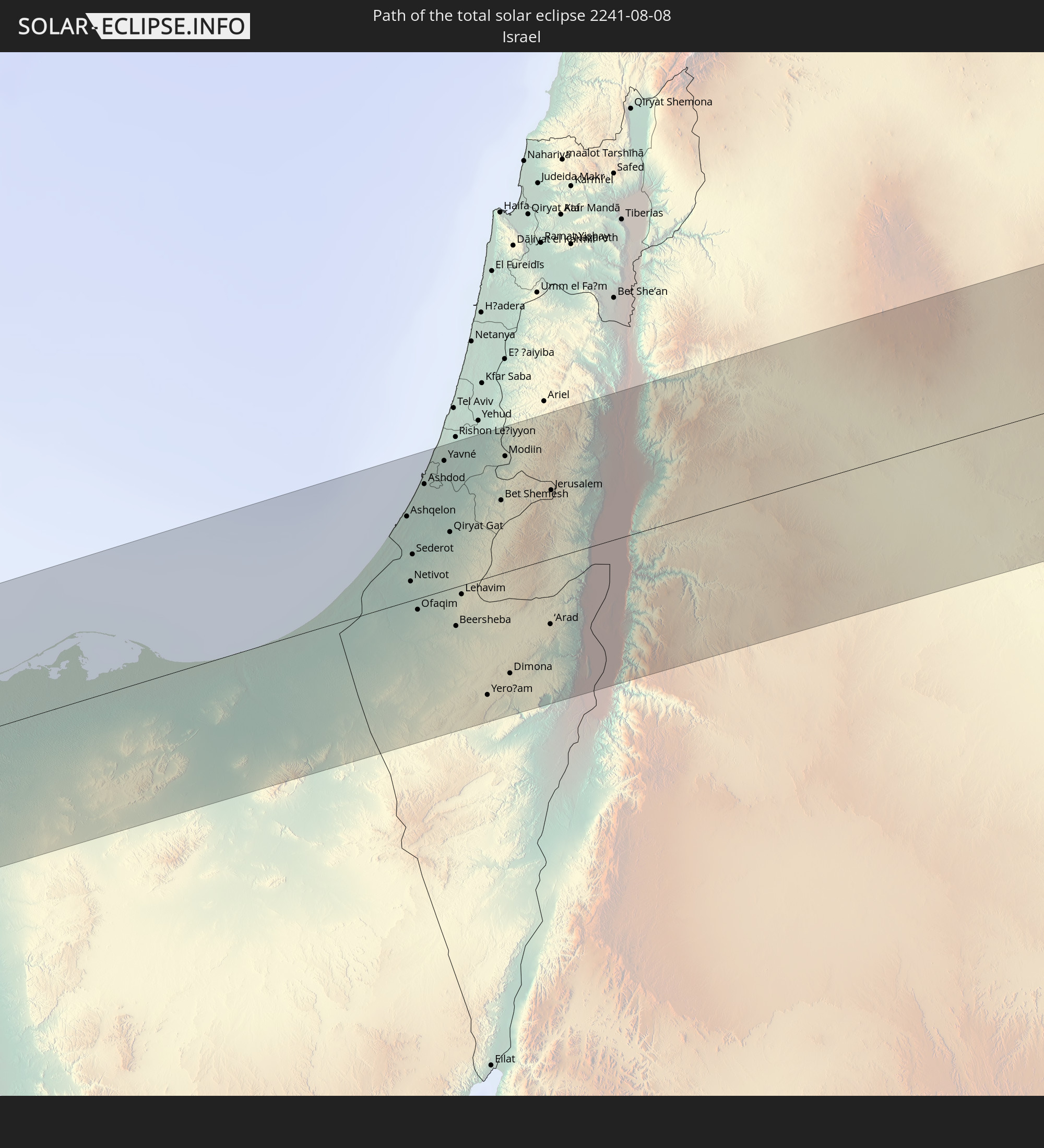 Israel
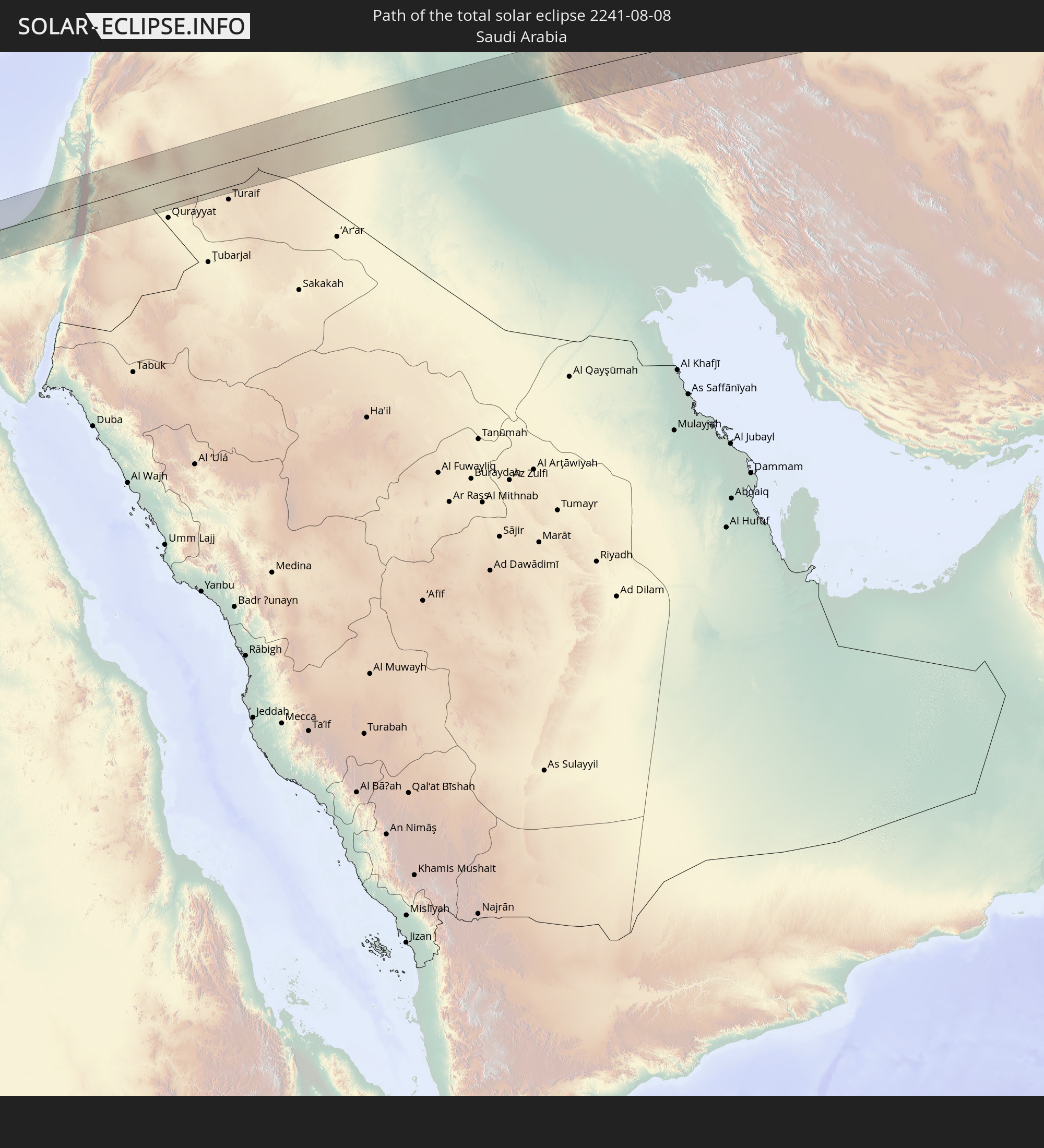 Saudi-Arabien
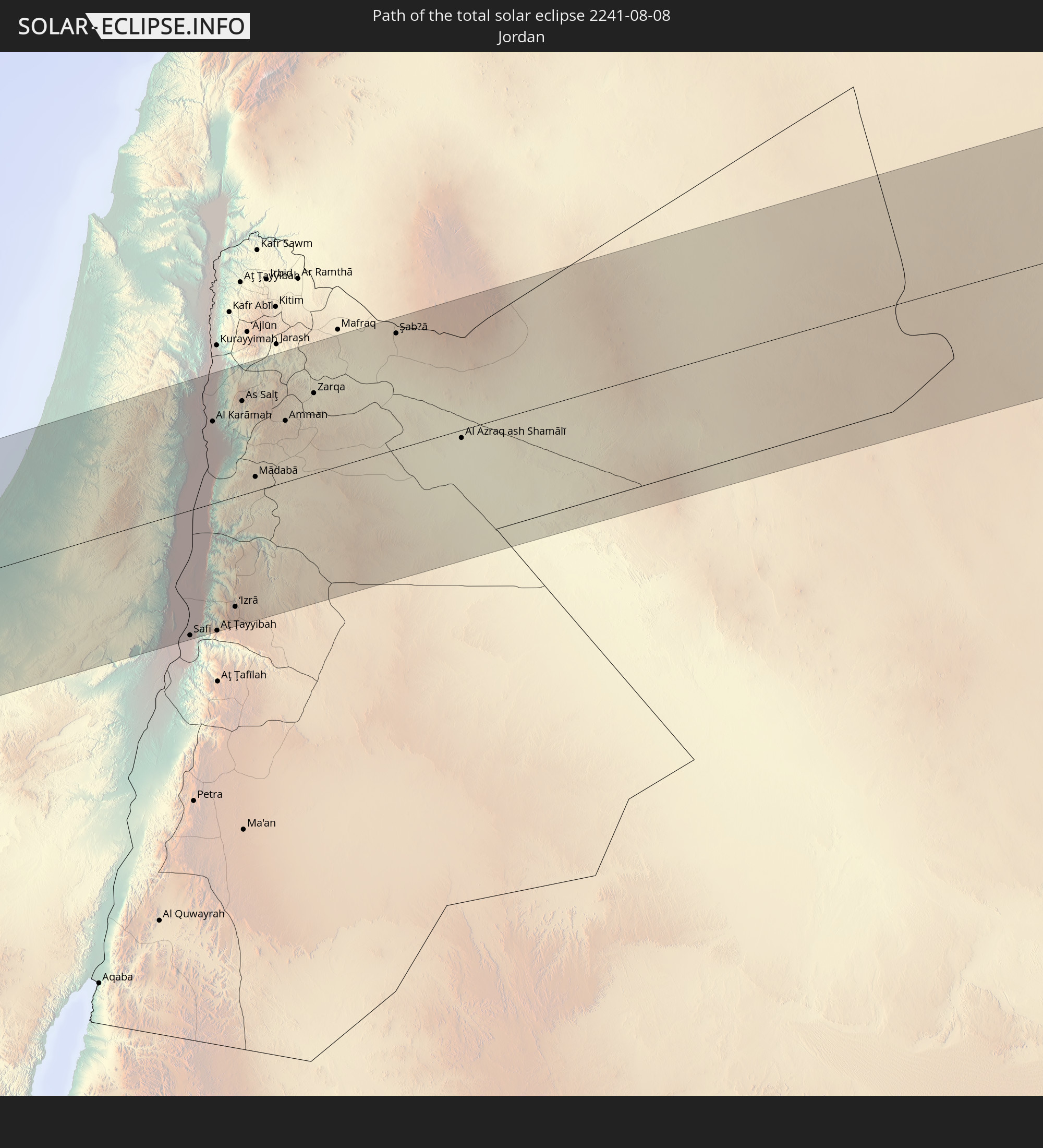 Jordanien
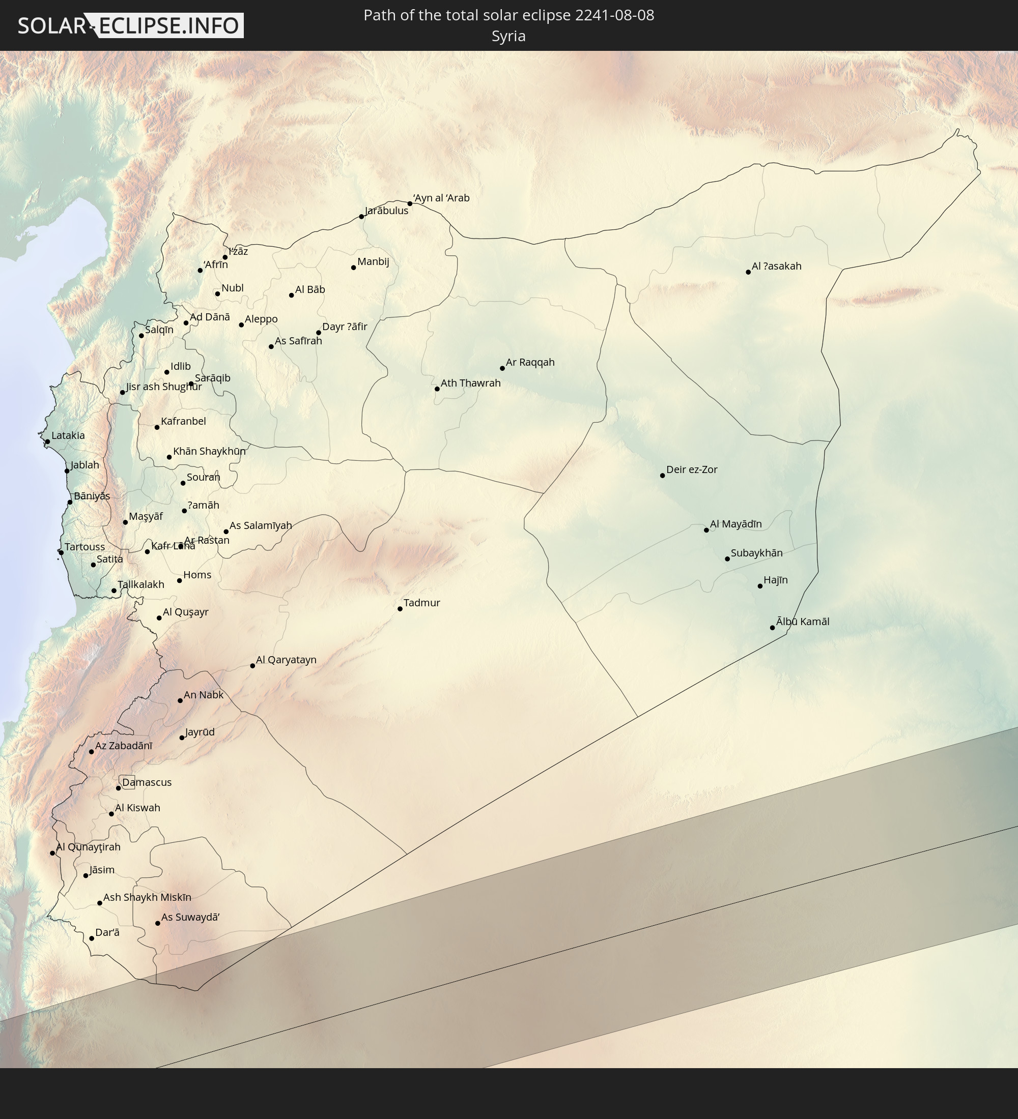 Syrien
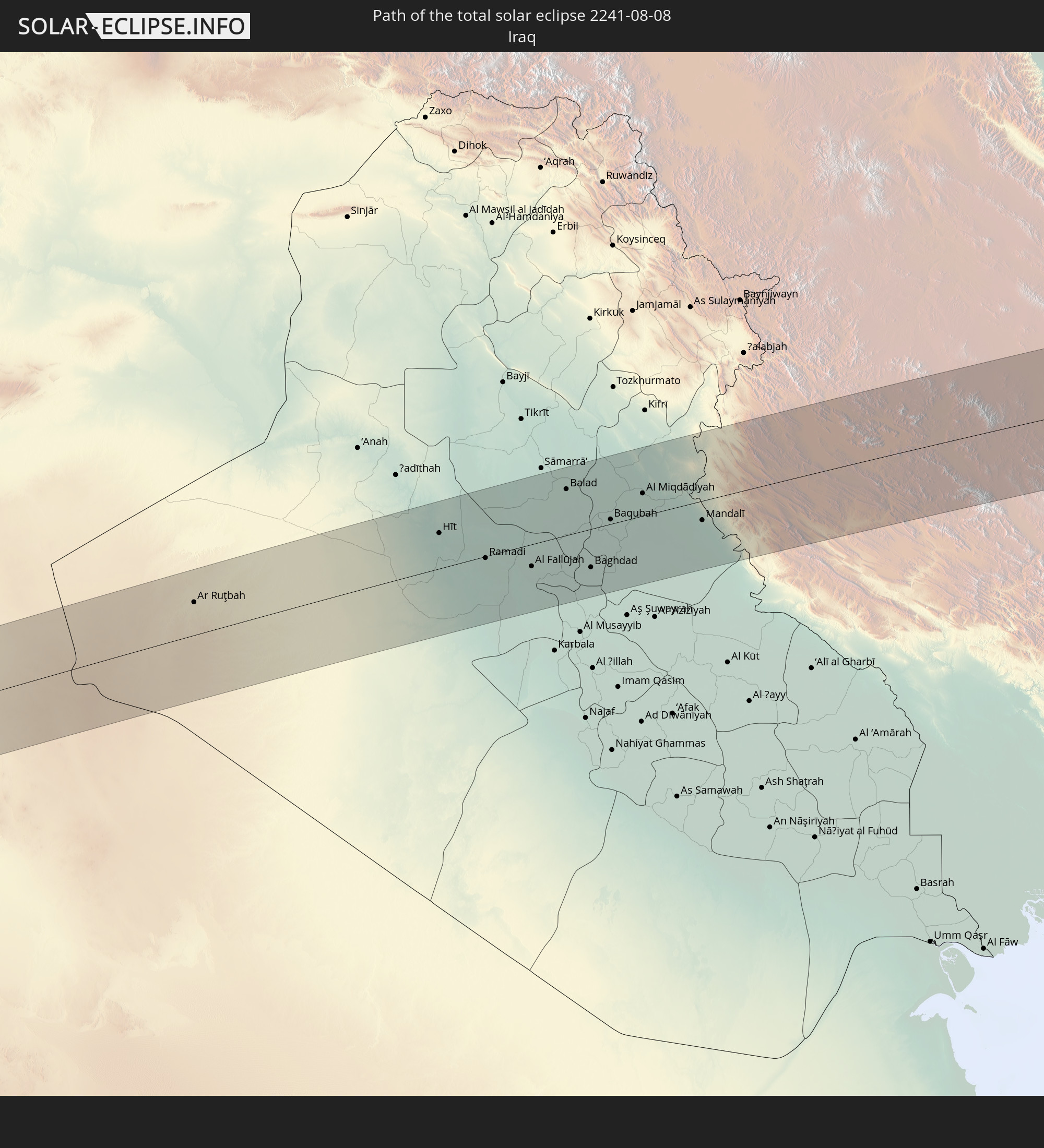 Irak
Irak
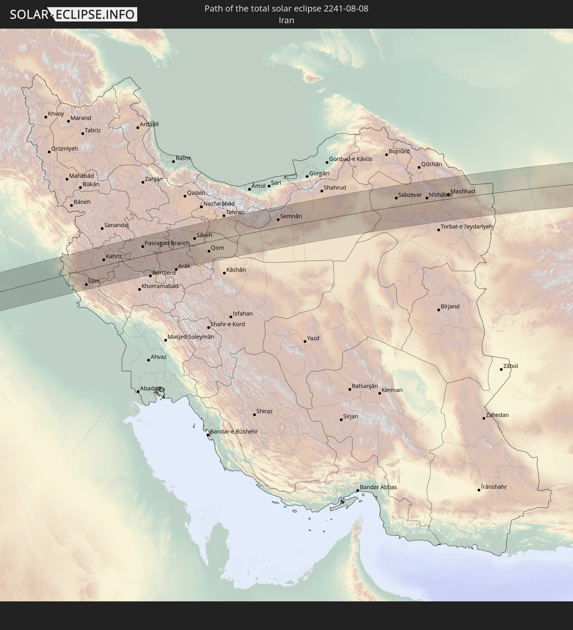 Iran
Iran
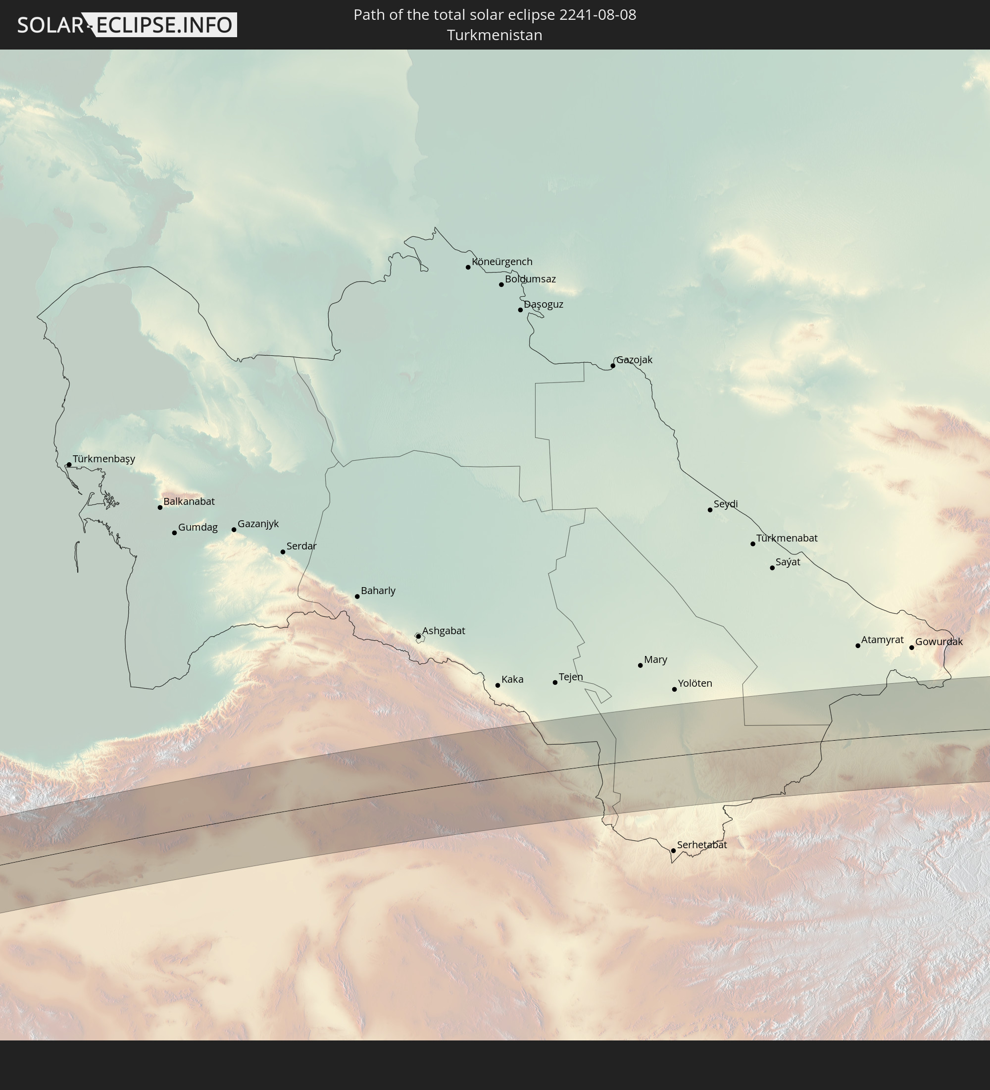 Turkmenistan
 Usbekistan
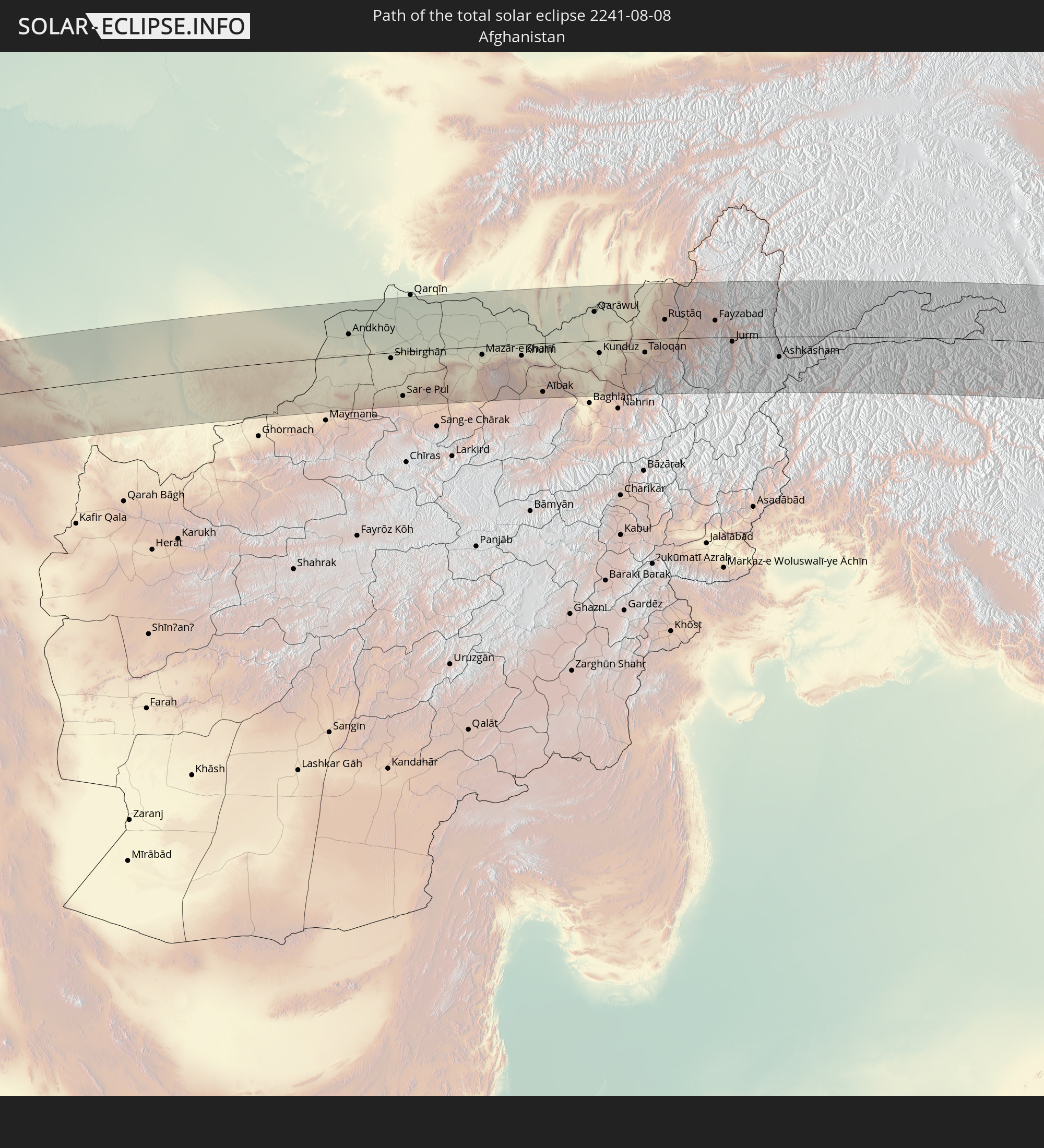 Afghanistan
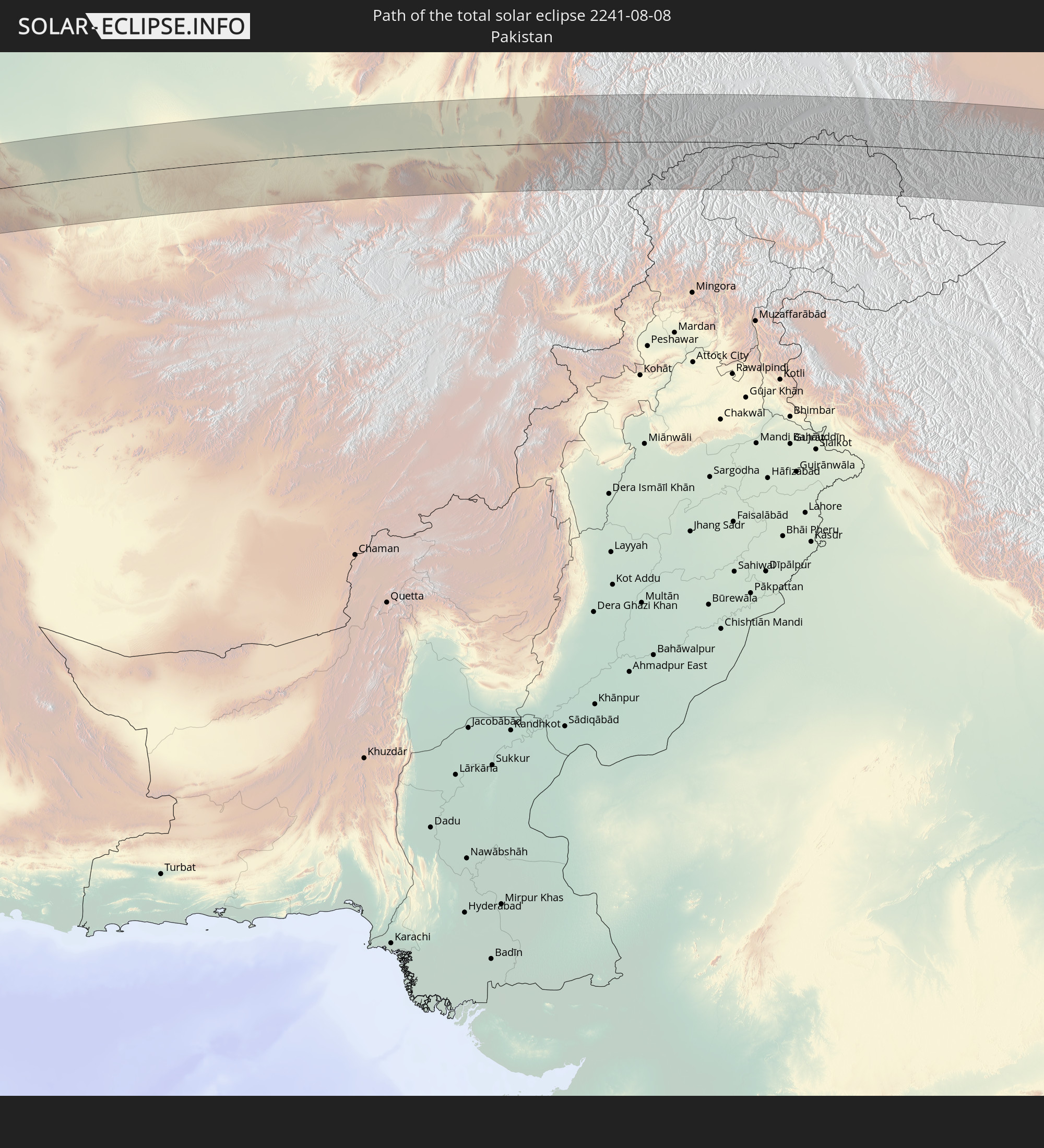 Pakistan
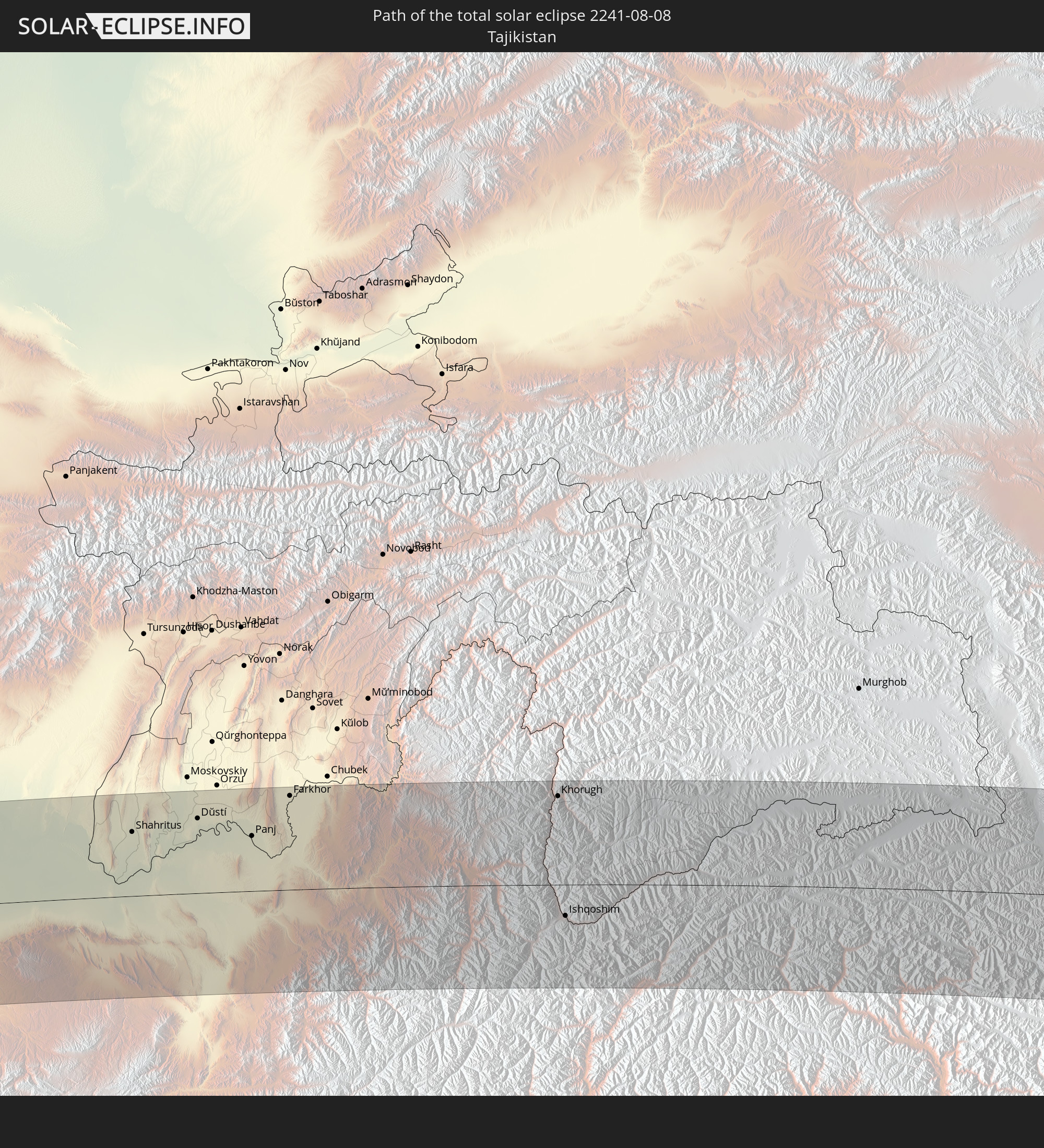 Tadschikistan
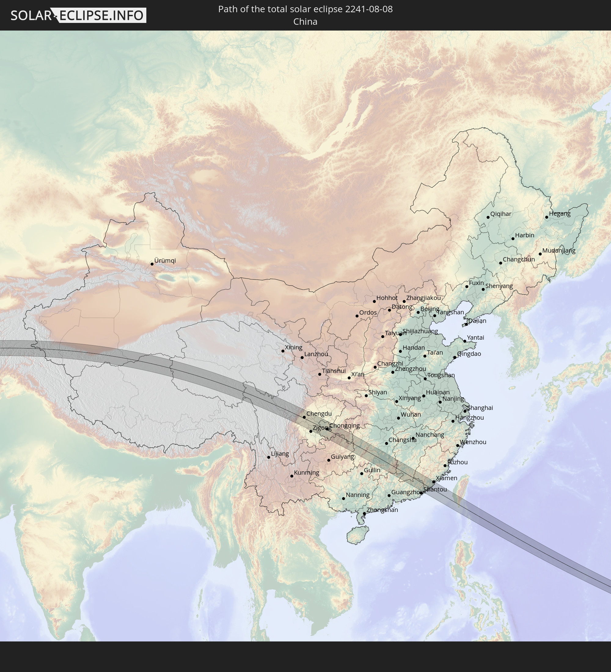 Volksrepublik China
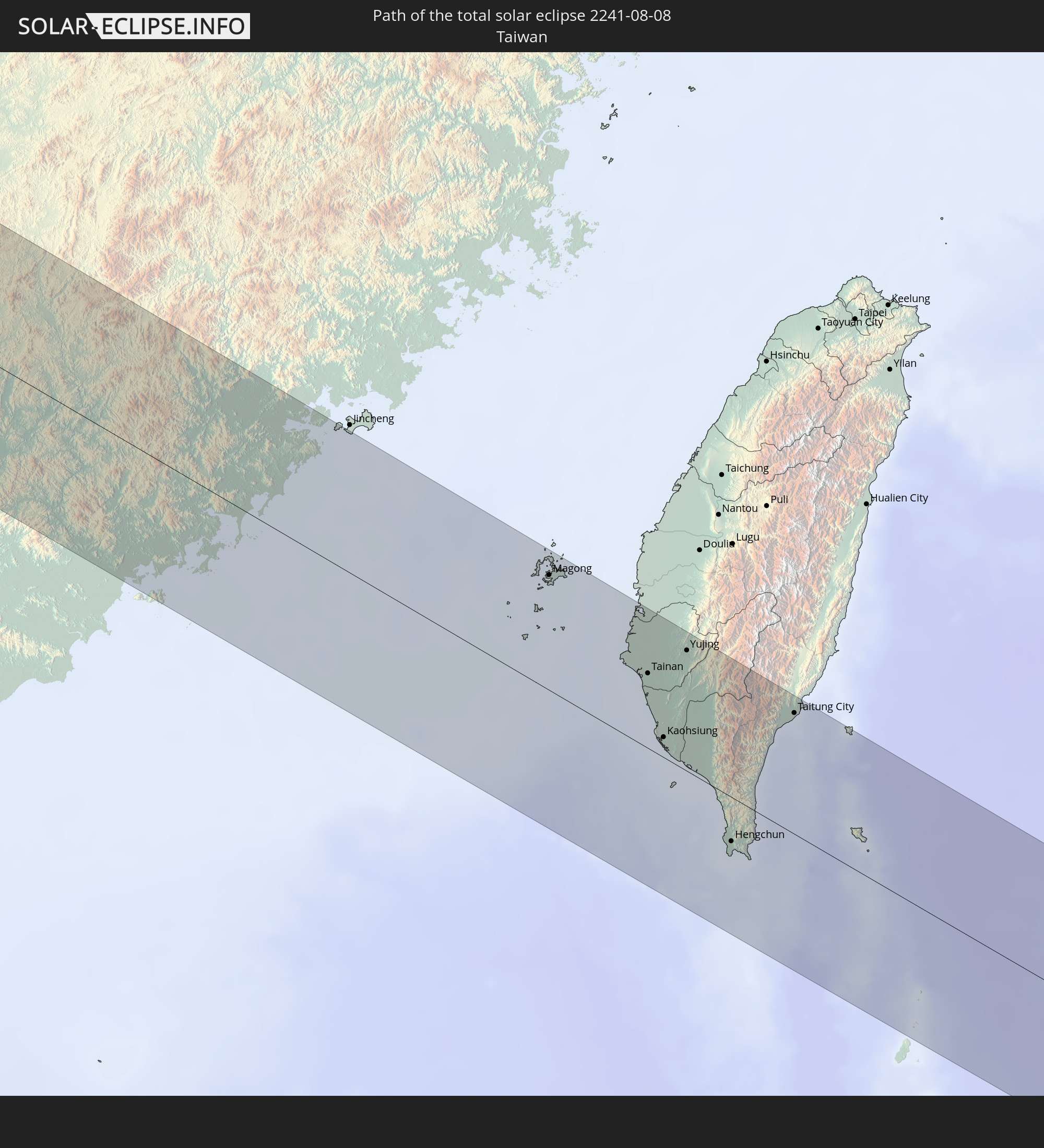 Taiwan
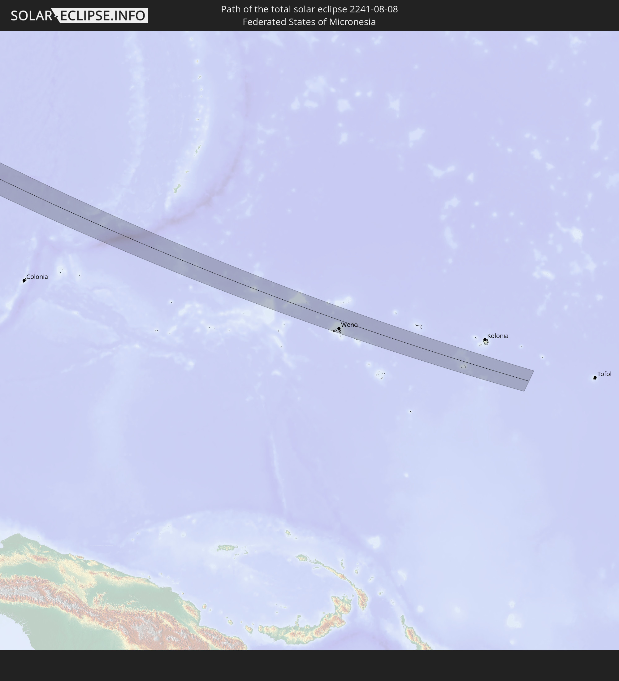 Föderierte Staaten von Mikronesien
In den folgenden Ländern ist die Sonnenfinsternis partiell zu sehen
 Russland
 United States Minor Outlying Islands
 Vereinigtes Königreich
 Färöer
 Frankreich
 Belgien
 Niederlande
 Norwegen
 Luxemburg
 Deutschland
 Schweiz
 Italien
 Dänemark
 Libyen
 Liechtenstein
 Österreich
 Schweden
 Tschechien
 Demokratische Republik Kongo
 San Marino
 Vatikanstadt
 Slowenien
 Kroatien
 Polen
Polen
 Bosnien und Herzegowina
 Ungarn
 Slowakei
 Montenegro
 Serbien
 Albanien
 Åland Islands
 Griechenland
 Rumänien
 Mazedonien
 Finnland
 Litauen
 Lettland
 Estland
 Sudan
Sudan
 Ukraine
 Bulgarien
 Weißrussland
 Ägypten
 Türkei
 Moldawien
 Tansania
 Uganda
 Republik Zypern
 Äthiopien
 Kenia
Kenia
 Staat Palästina
 Israel
 Saudi-Arabien
 Jordanien
 Libanon
 Syrien
 Eritrea
 Irak
Irak
 Georgien
 Somalia
 Dschibuti
 Jemen
Jemen
 Armenien
 Iran
Iran
 Aserbaidschan
 Kasachstan
 Kuwait
 Bahrain
 Katar
Katar
 Vereinigte Arabische Emirate
 Oman
Oman
 Turkmenistan
 Usbekistan
 Afghanistan
 Pakistan
 Tadschikistan
 Indien
 Kirgisistan
 Malediven
 Volksrepublik China
 Sri Lanka
 Nepal
Nepal
 Mongolei
 Bangladesch
 Bhutan
 Myanmar
 Indonesien
 Thailand
 Malaysia
 Laos
Laos
 Vietnam
 Kambodscha
 Singapur
 Australien
 Macau
Macau
 Hongkong
 Brunei
 Taiwan
 Philippinen
 Japan
Japan
 Osttimor
 Nordkorea
 Südkorea
 Palau
Palau
 Föderierte Staaten von Mikronesien
 Papua-Neuguinea
 Guam
Guam
 Nördliche Marianen
 Marshallinseln
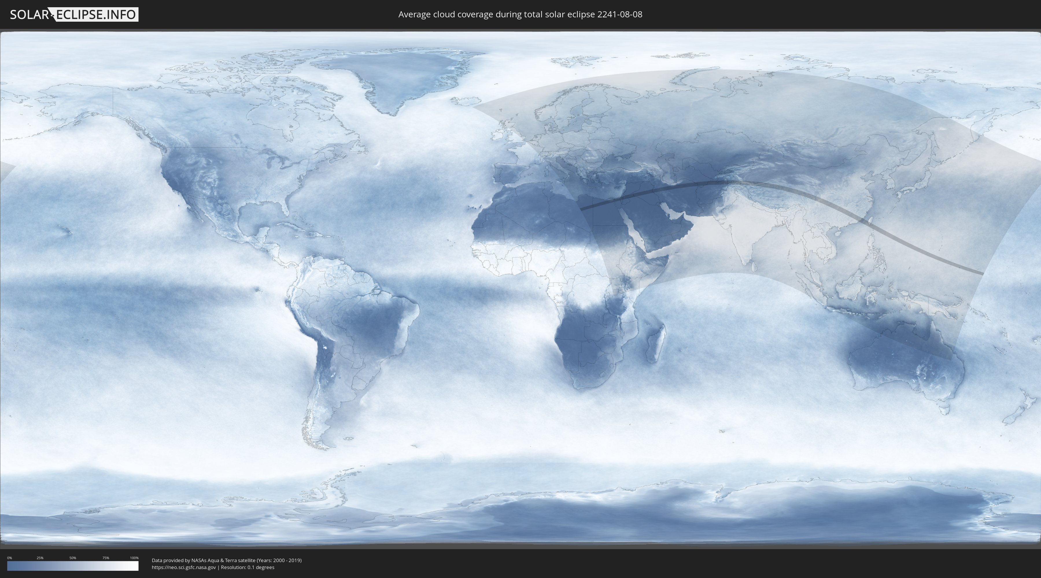
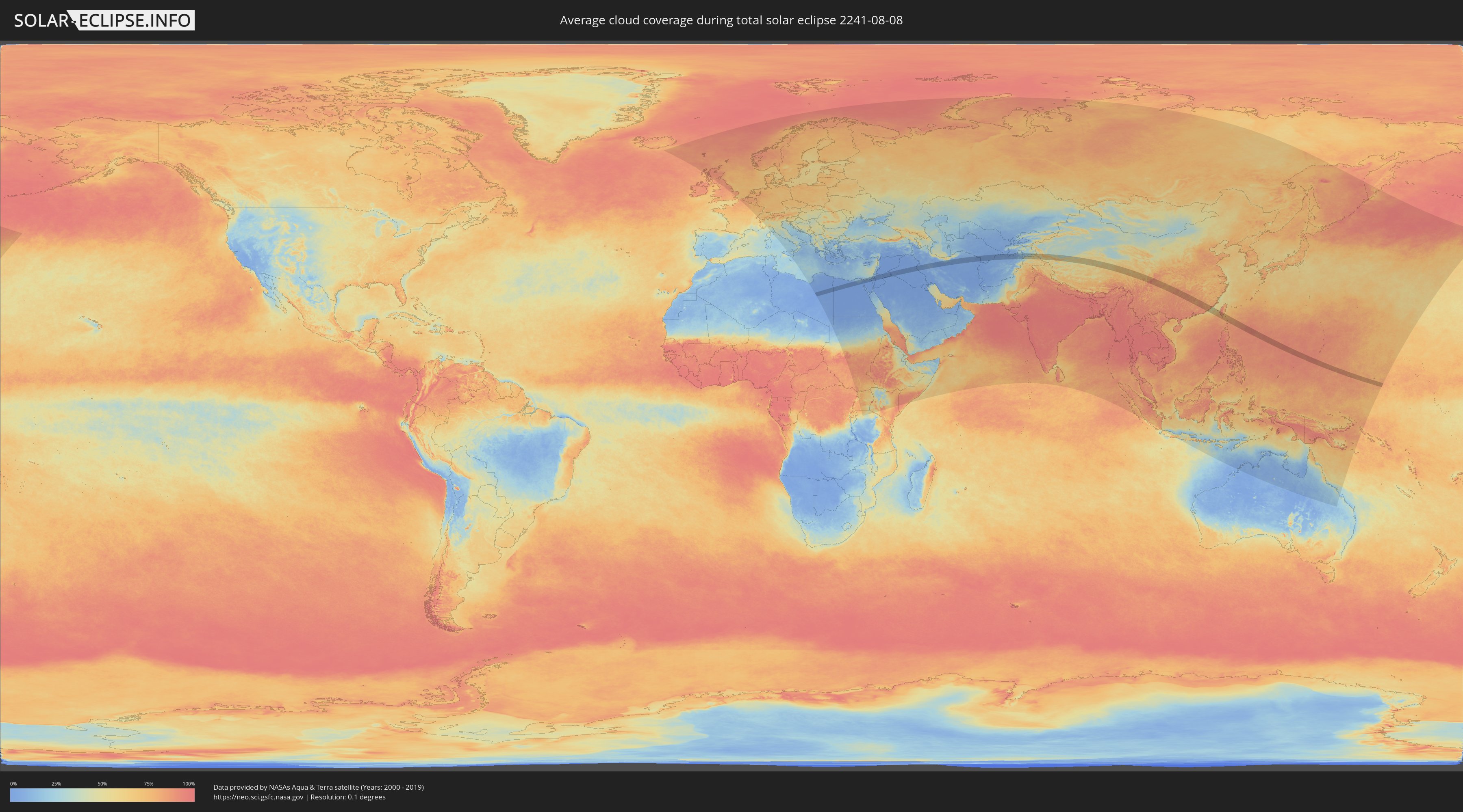
Wie wird das Wetter während der totalen Sonnenfinsternis am 08.08.2241?
Wo ist der beste Ort, um die totale Sonnenfinsternis vom 08.08.2241 zu beobachten?
Die folgenden Karten zeigen die durchschnittliche Bewölkung für den Tag, an dem die totale Sonnenfinsternis
stattfindet. Mit Hilfe der Karten lässt sich der Ort entlang des Finsternispfades eingrenzen,
der die besten Aussichen auf einen klaren wolkenfreien Himmel bietet.
Trotzdem muss man immer lokale Gegenenheiten beachten und sollte sich genau über das Wetter an seinem
gewählten Beobachtungsort informieren.
Die Daten stammen von den beiden NASA-Satelliten
AQUA und TERRA
und wurden über einen Zeitraum von 19 Jahren (2000 - 2019) gemittelt.
Detaillierte Länderkarten
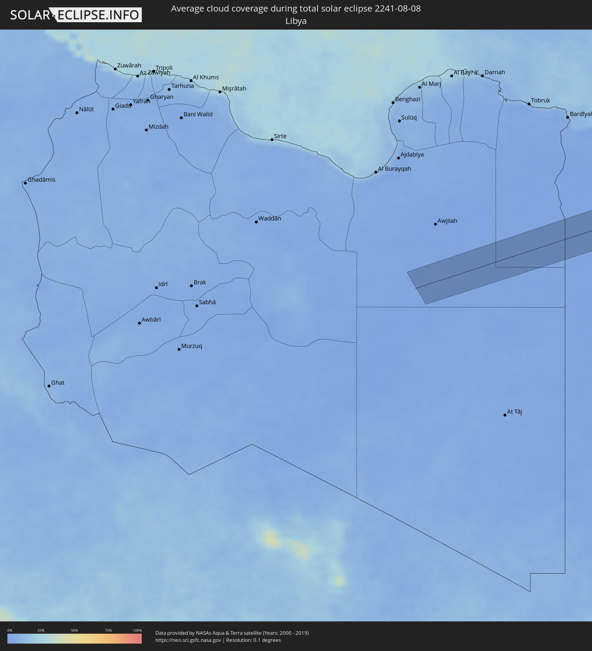 Libyen
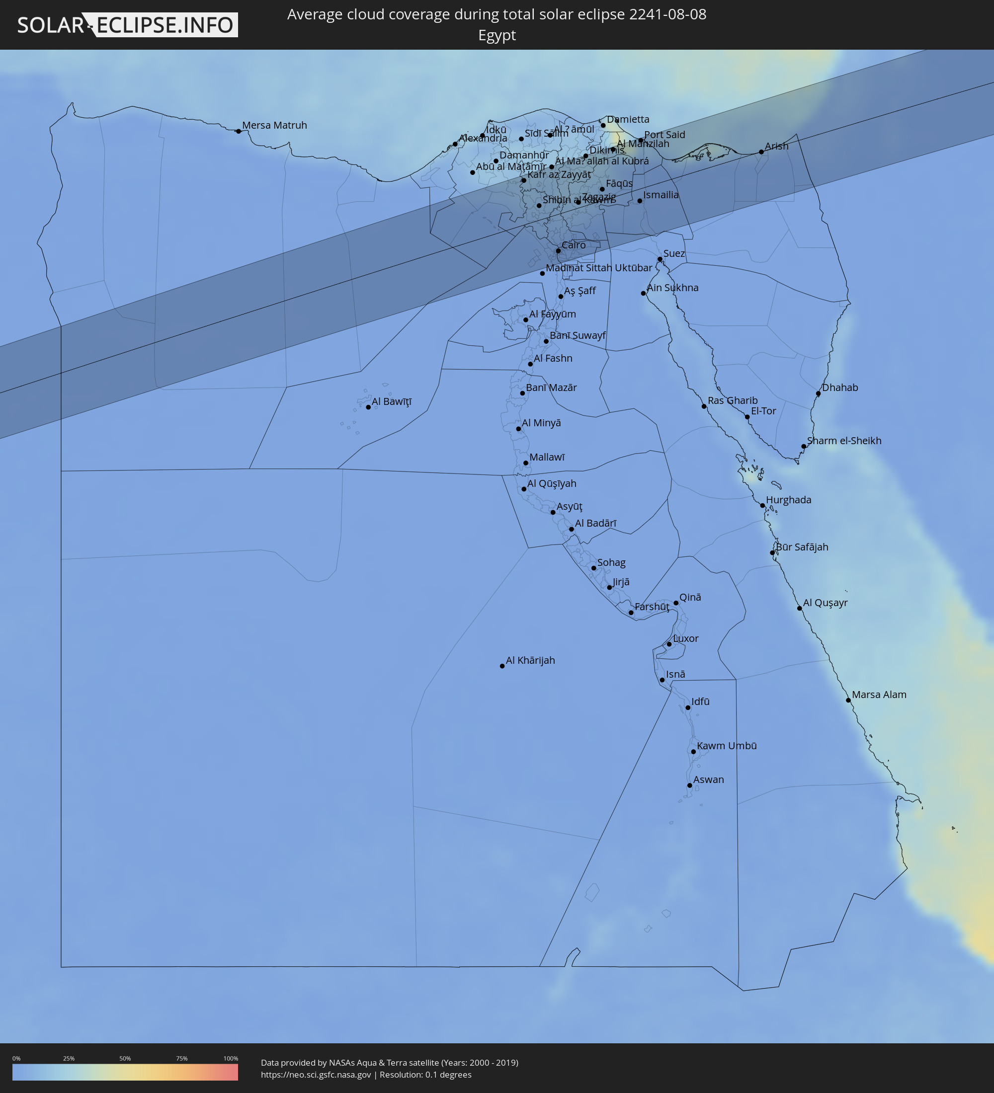 Ägypten
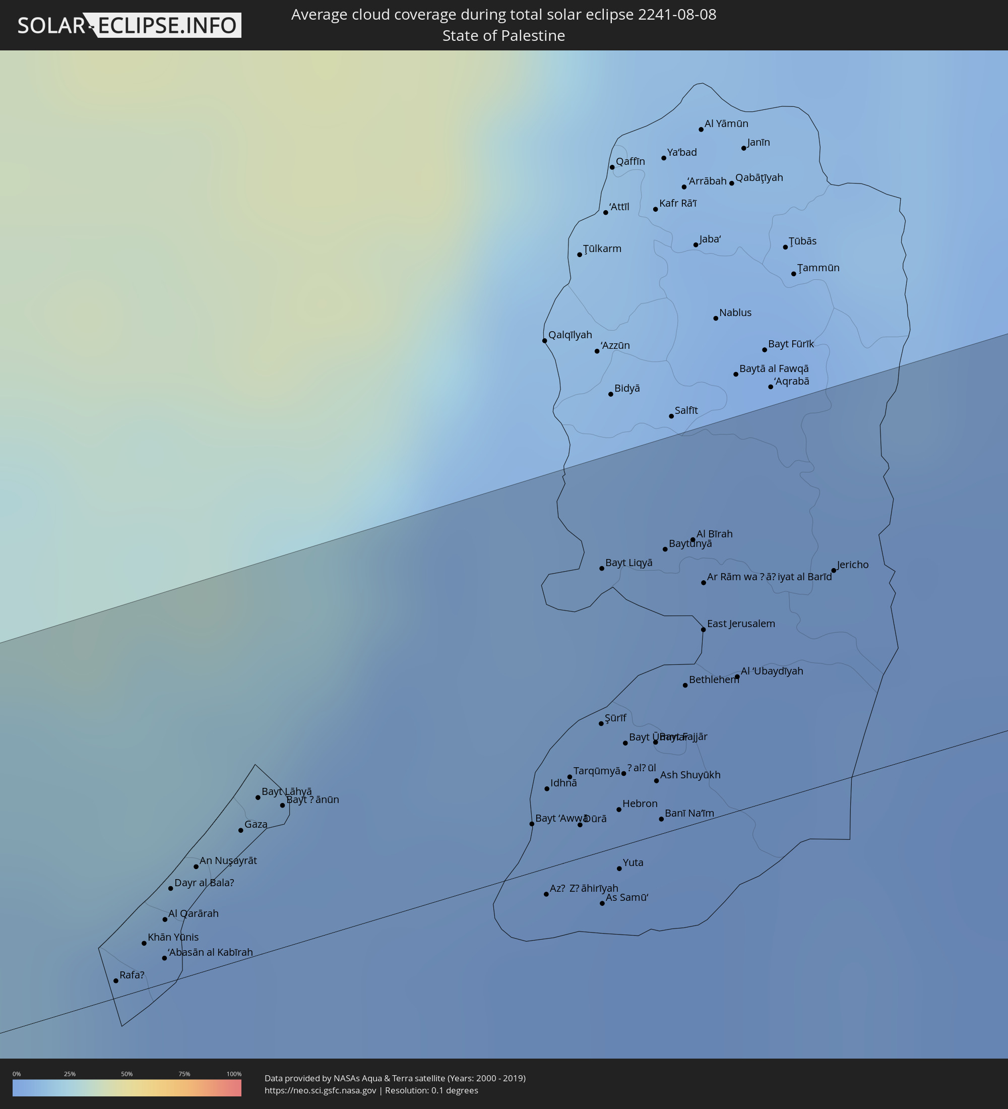 Staat Palästina
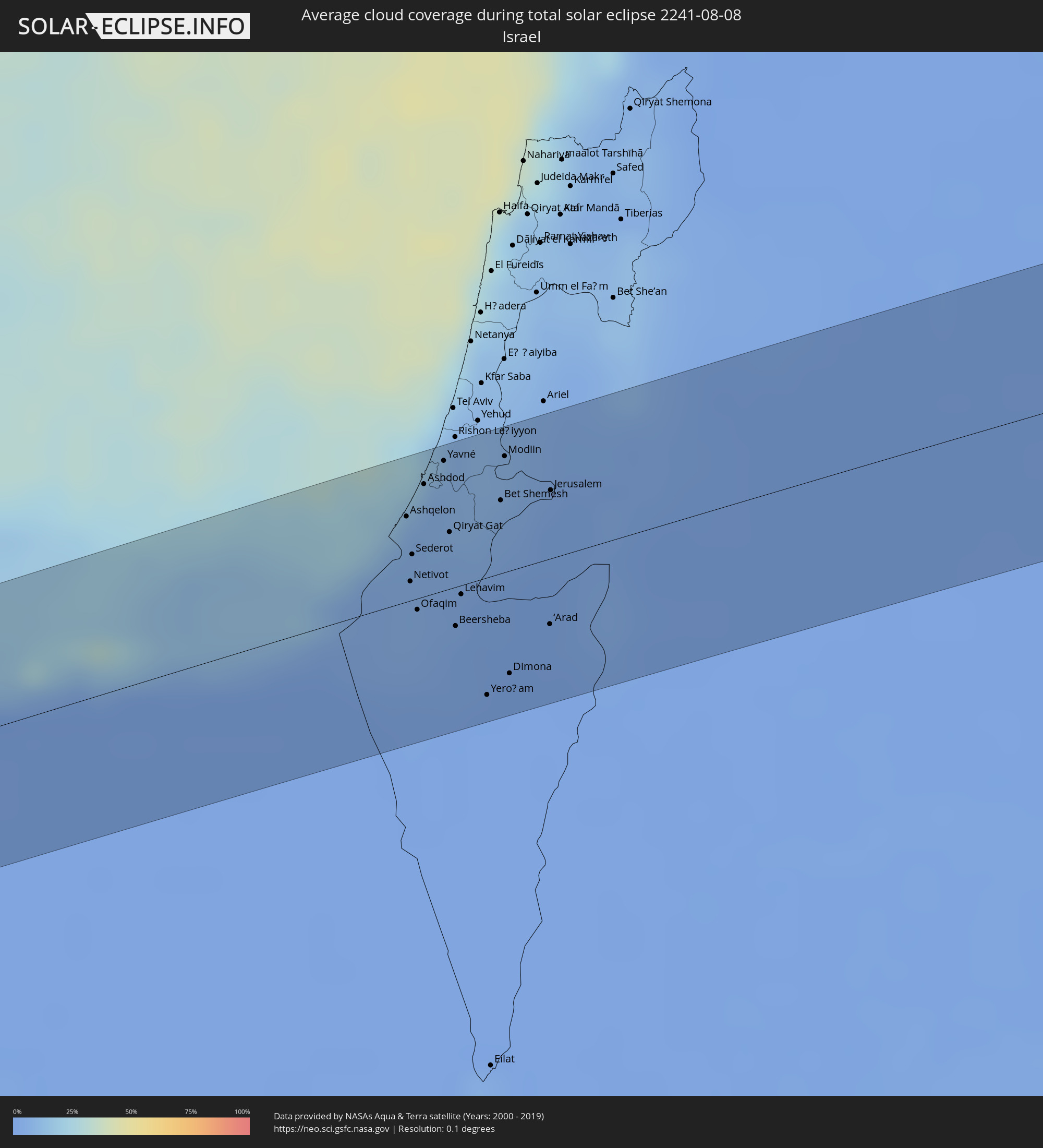 Israel
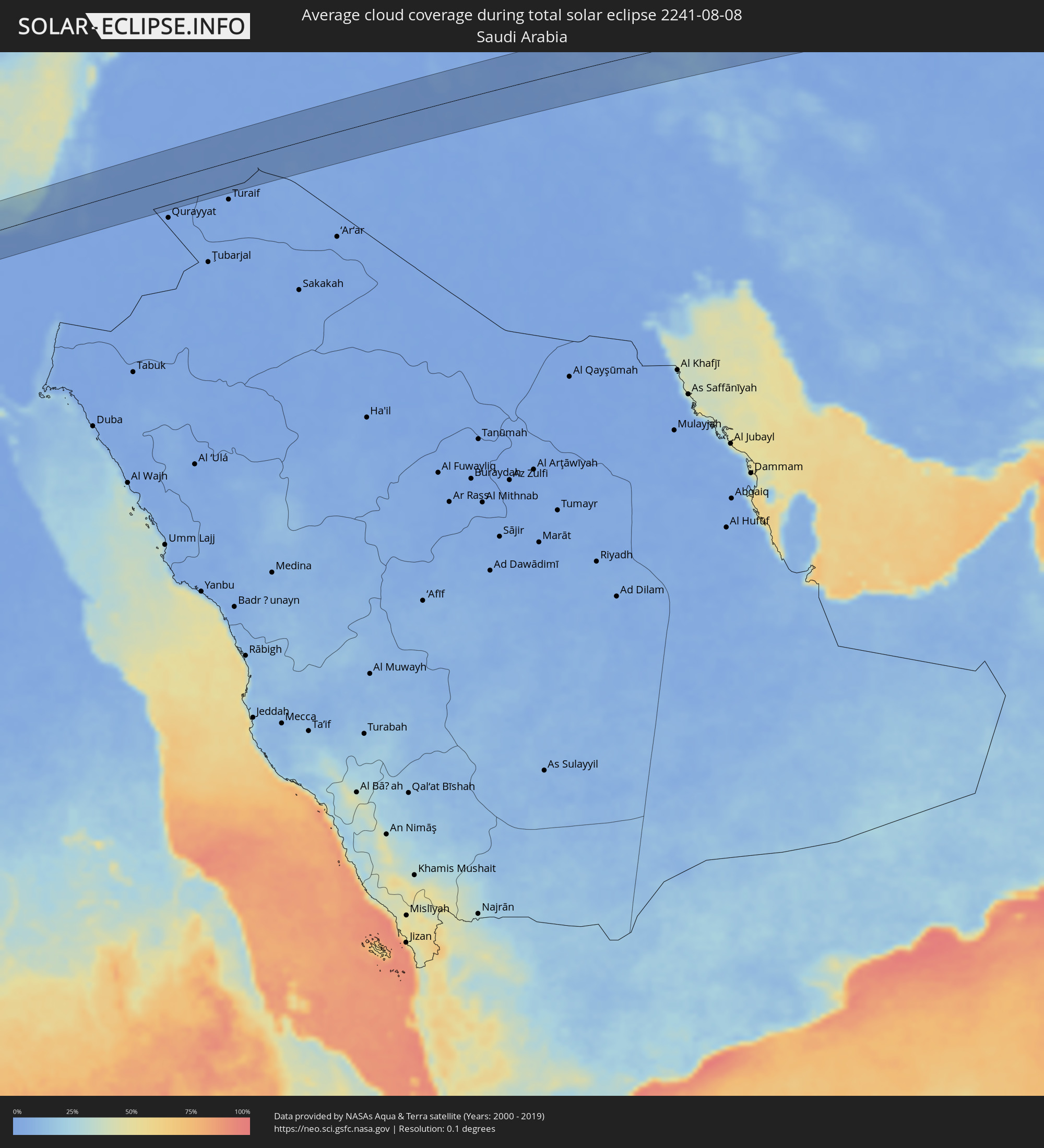 Saudi-Arabien
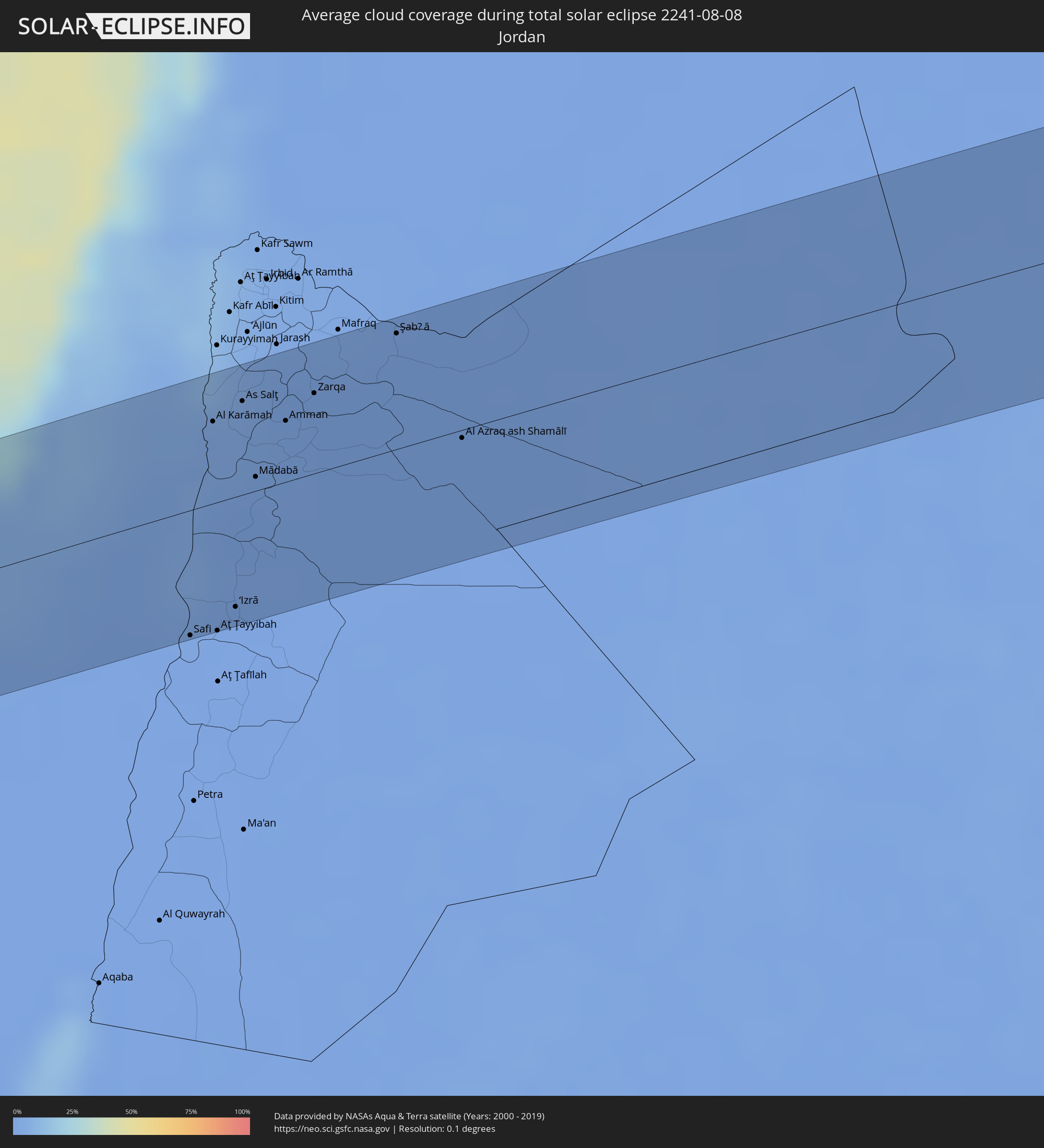 Jordanien
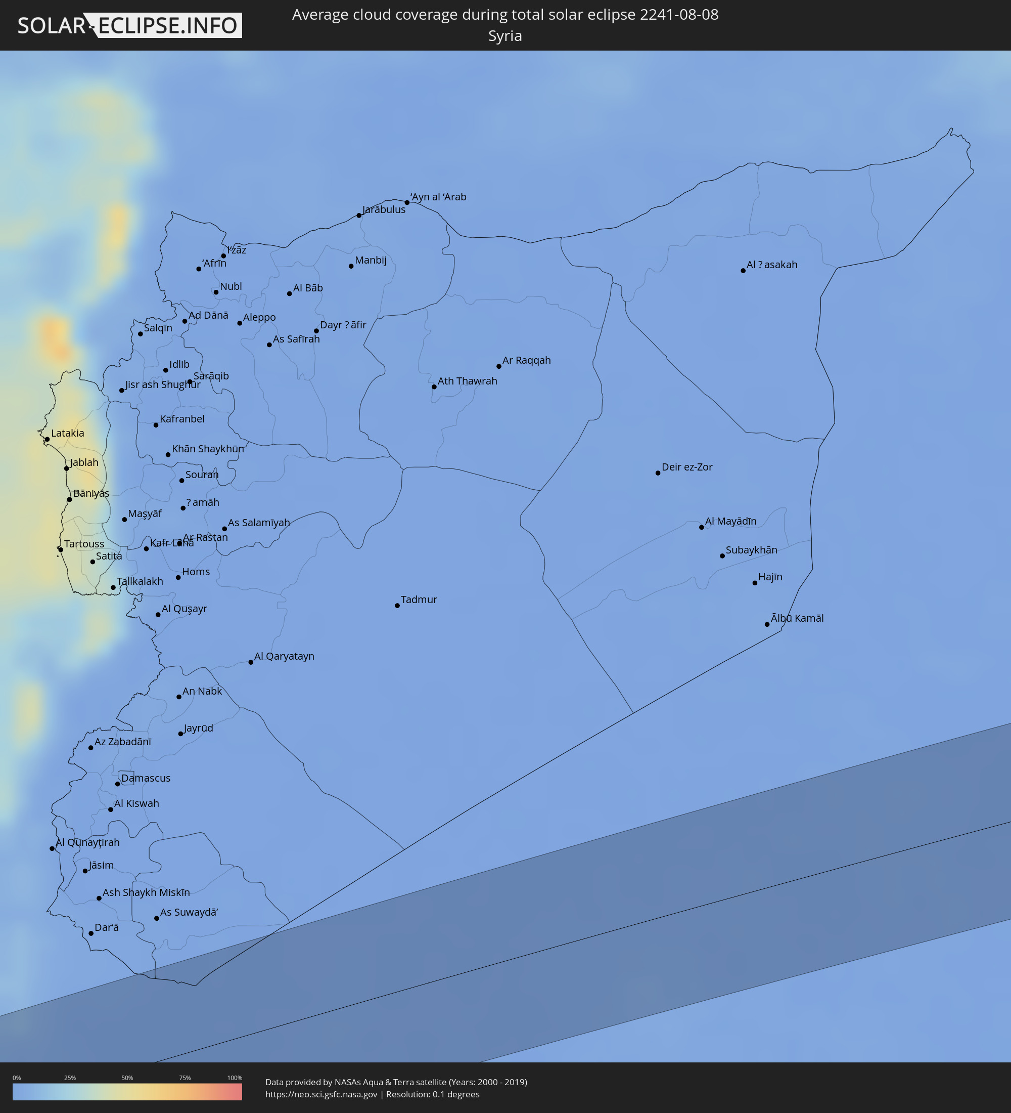 Syrien
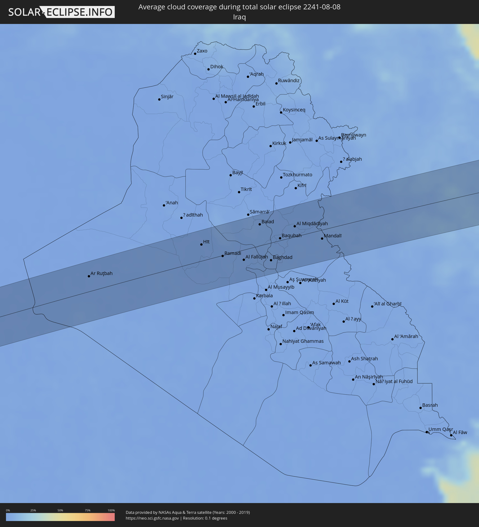 Irak
Irak
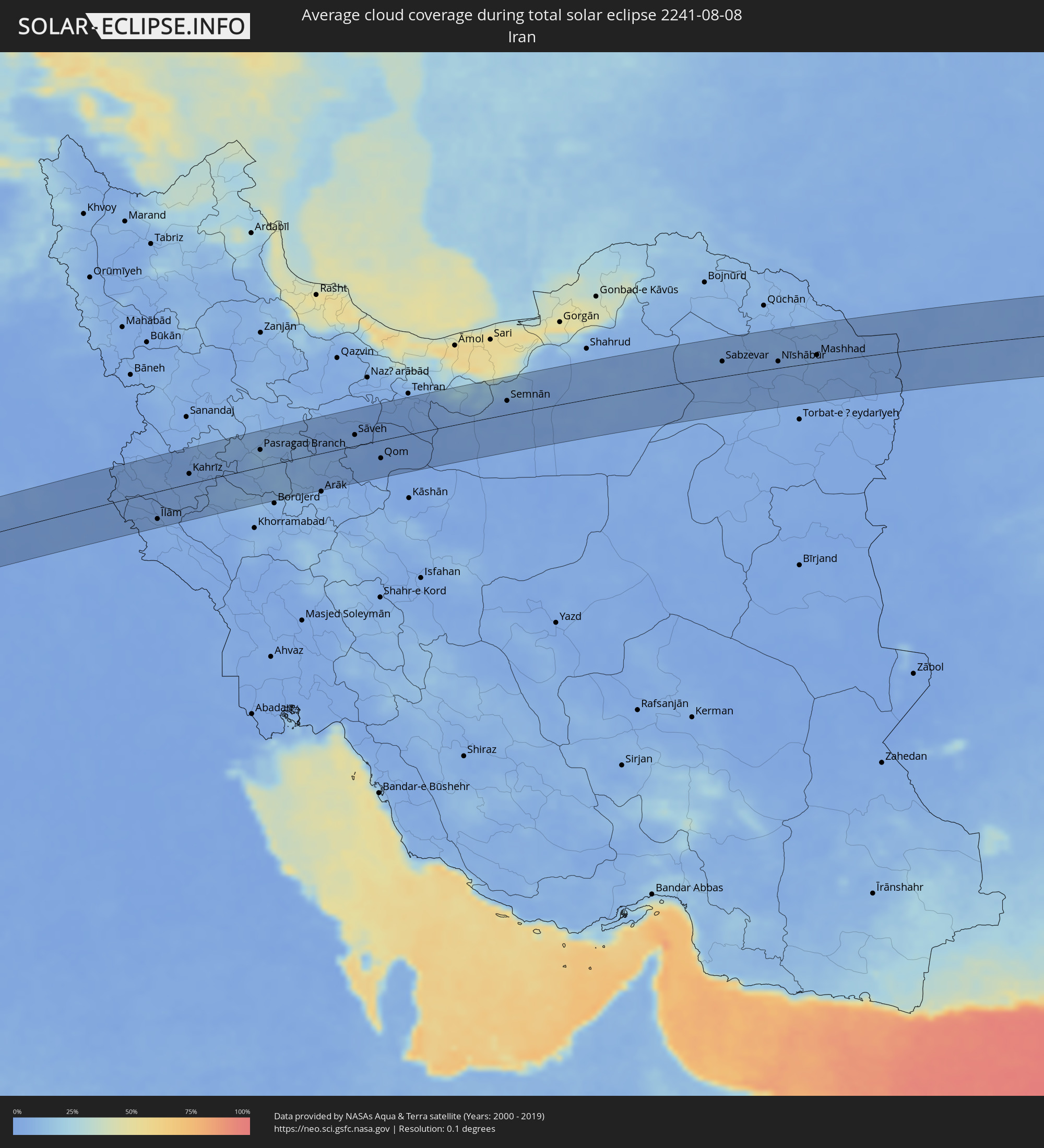 Iran
Iran
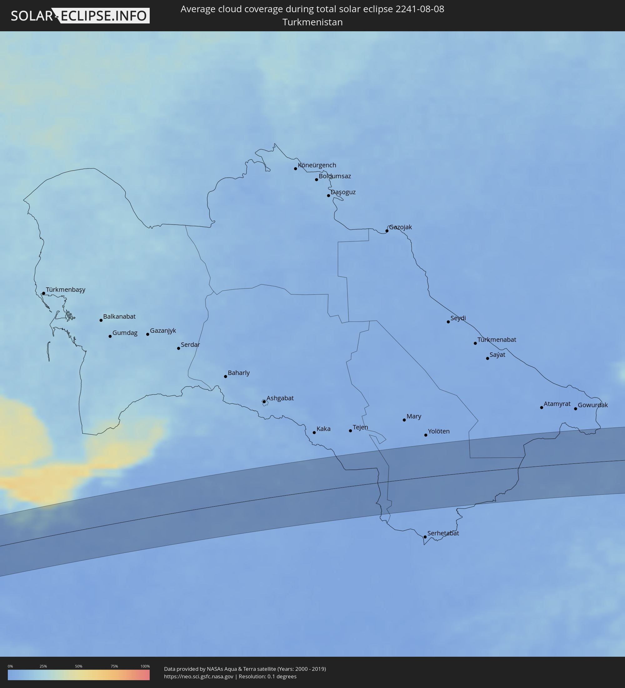 Turkmenistan
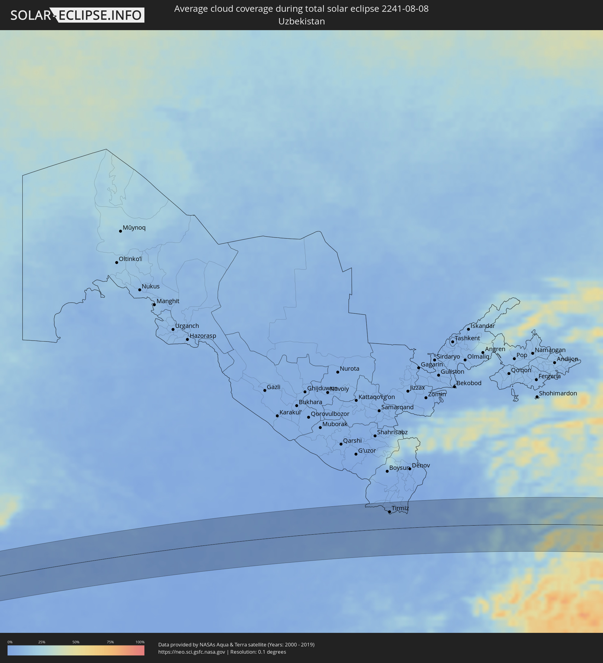 Usbekistan
 Afghanistan
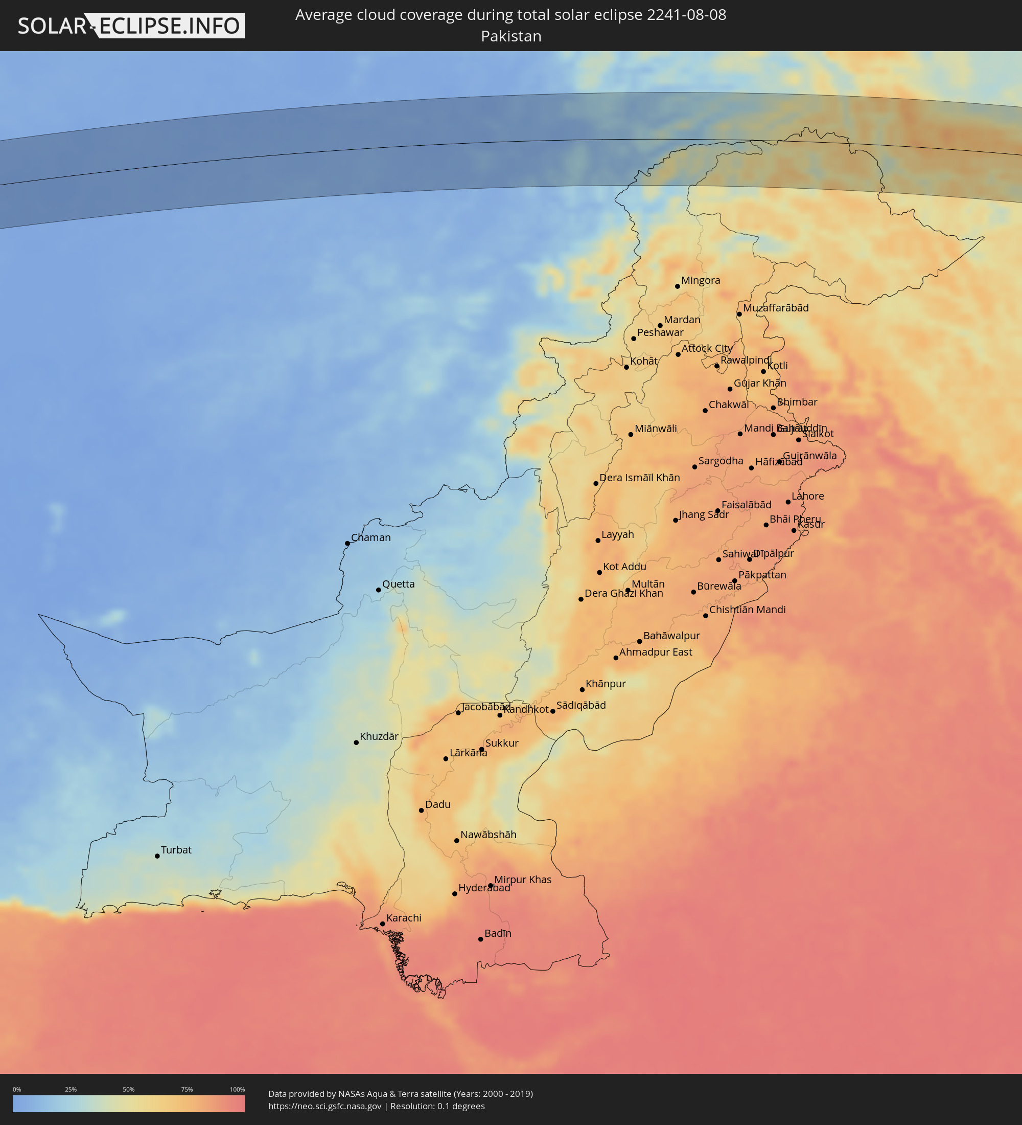 Pakistan
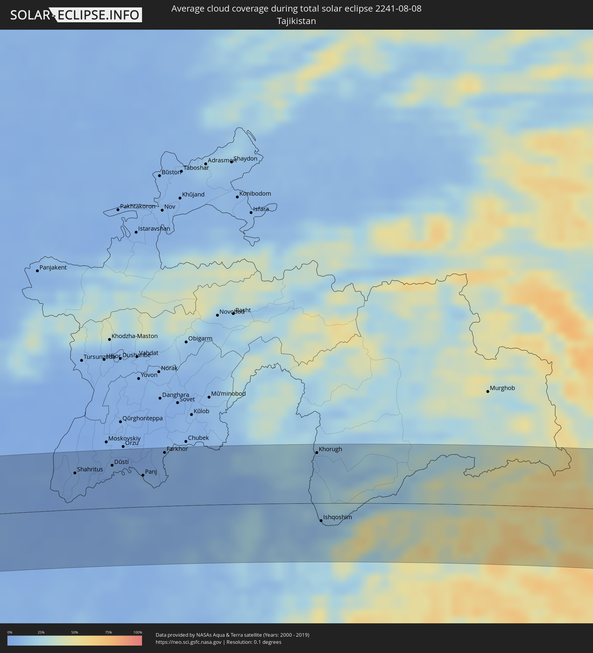 Tadschikistan
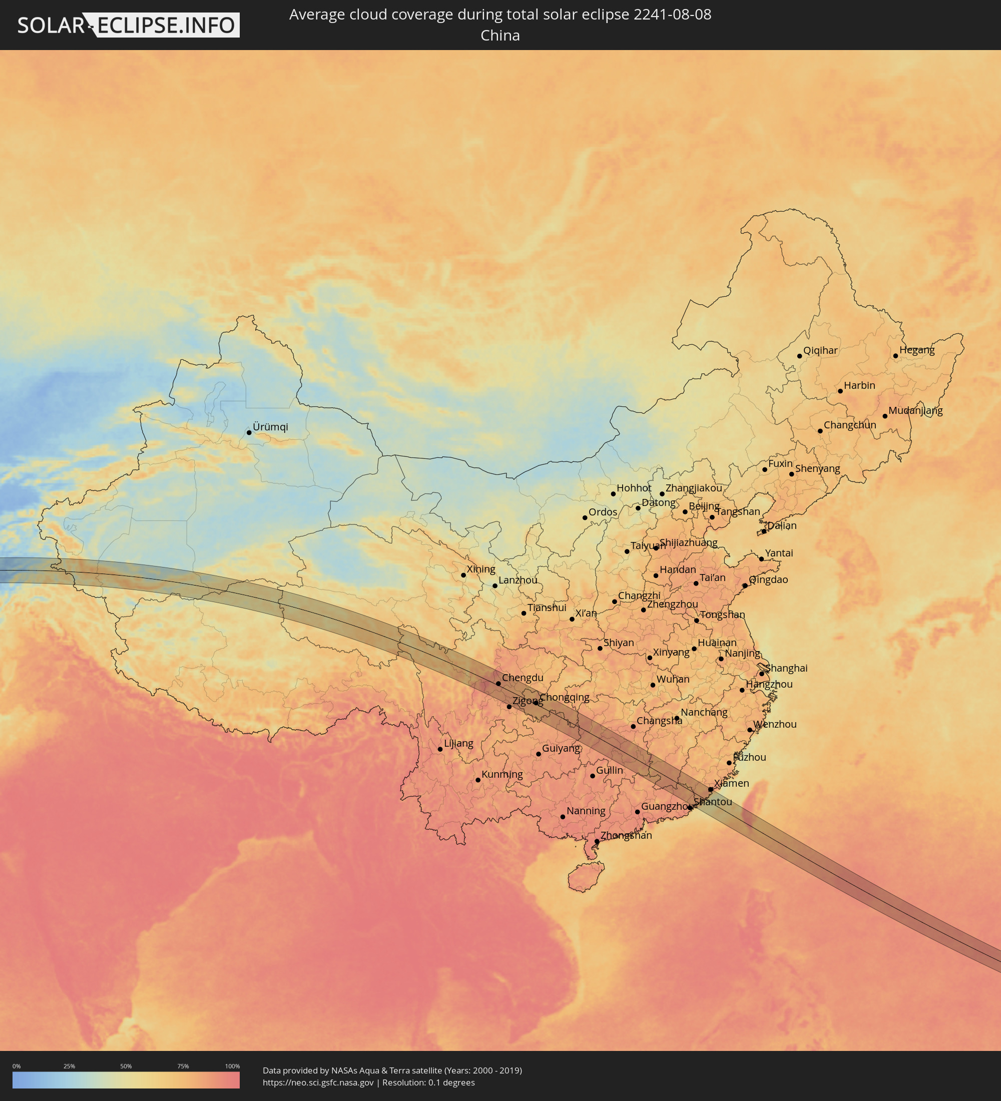 Volksrepublik China
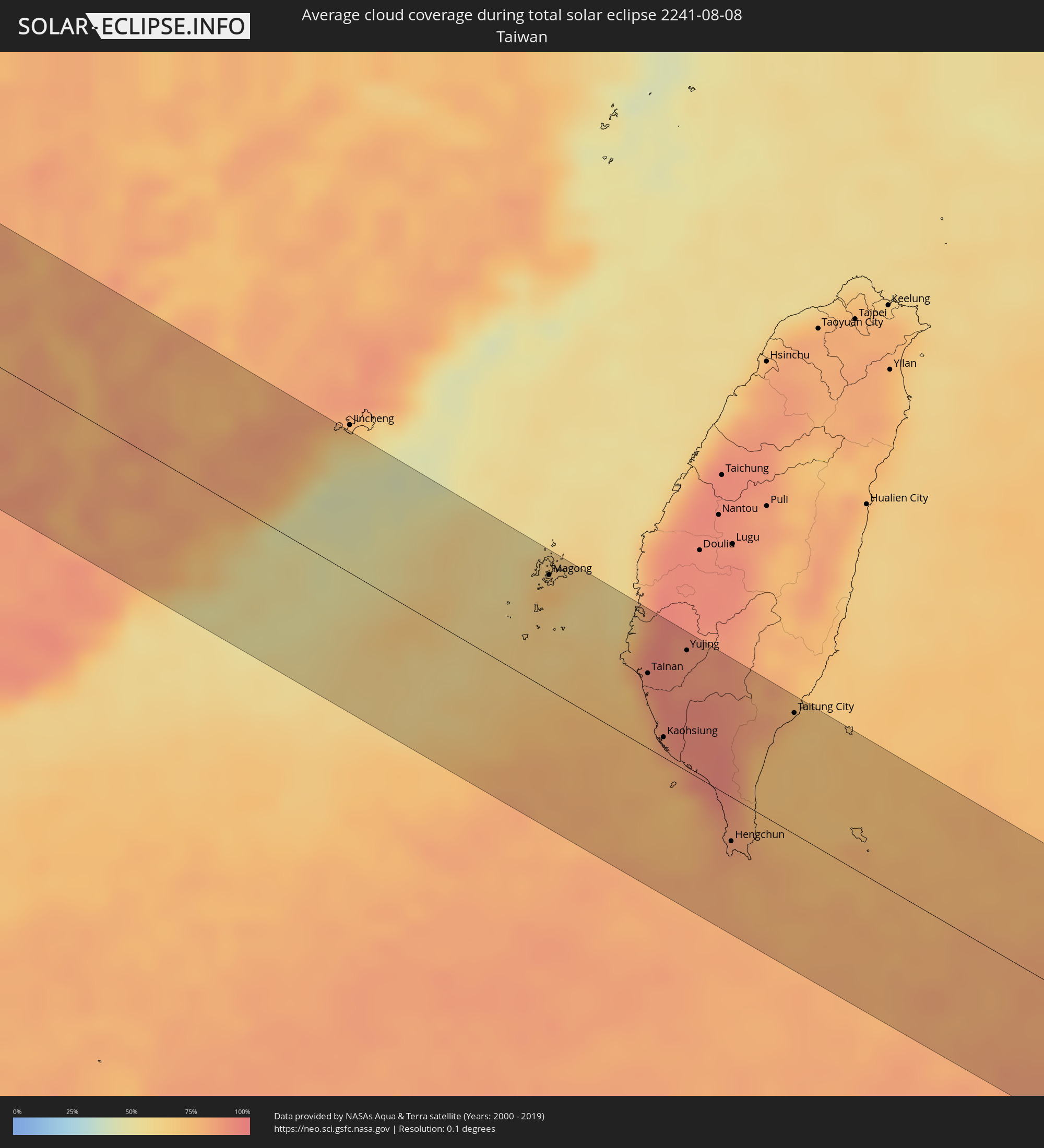 Taiwan
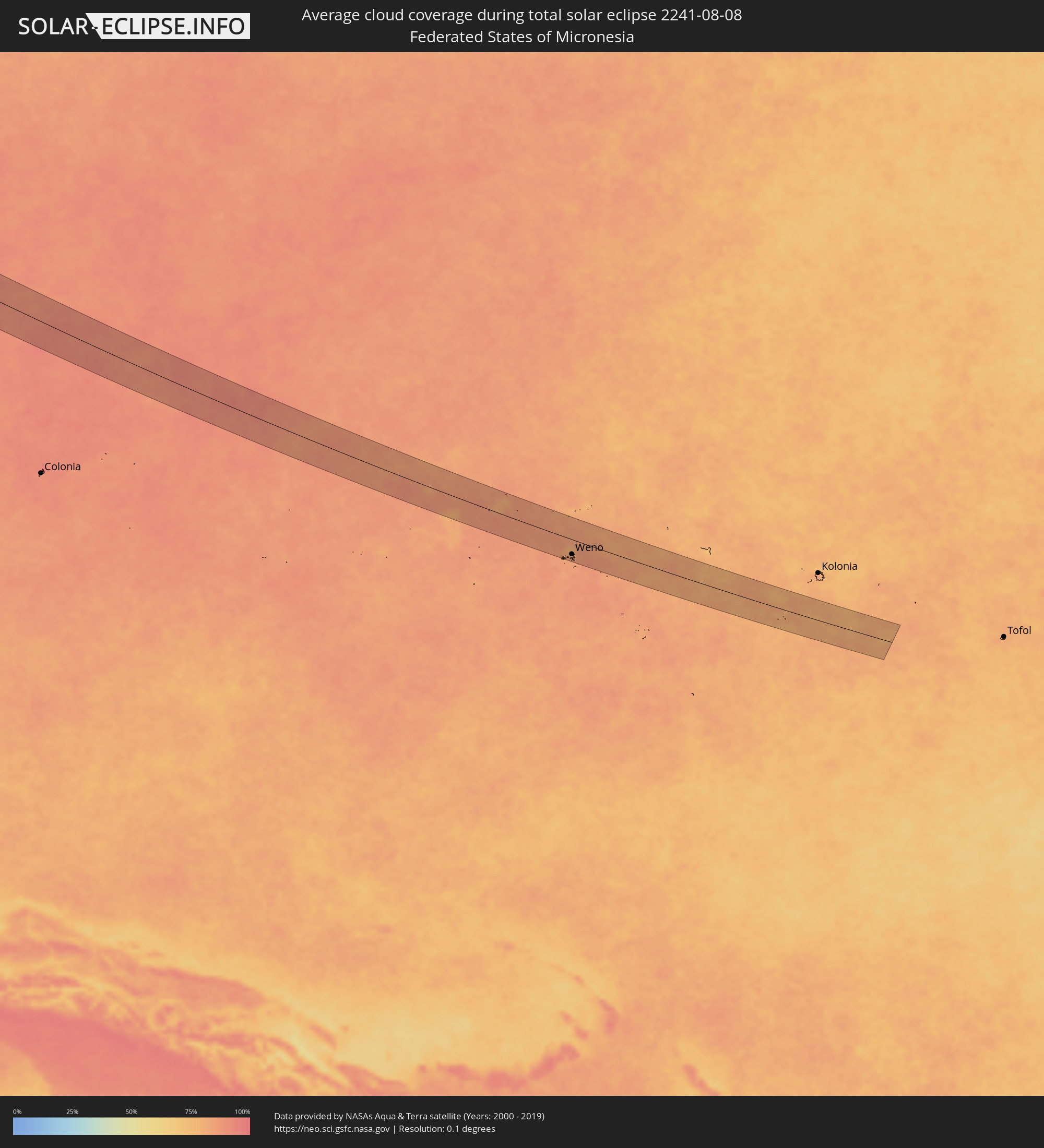 Föderierte Staaten von Mikronesien
Orte im Finsternispfad
Die nachfolgene Tabelle zeigt Städte und Orte mit mehr als 5.000 Einwohnern, die sich im Finsternispfad befinden. Städte mit mehr als 100.000 Einwohnern sind dick gekennzeichnet. Mit einem Klick auf den Ort öffnet sich eine Detailkarte die die Lage des jeweiligen Ortes zusammen mit dem Verlauf der zentralen Finsternis präsentiert.
| Ort | Typ | Dauer der Verfinsterung | Ortszeit bei maximaler Verfinsterung | Entfernung zur Zentrallinie | Ø Bewölkung |
|
Kafr az Zayyāt, Gharbia
|
total | - | 06:10:45 UTC+02:00 | 50 km | 11% |
|
Ashmūn, Monufia
|
total | - | 06:10:21 UTC+02:00 | 10 km | 3% |
|
Tanda, Gharbia
|
total | - | 06:10:45 UTC+02:00 | 41 km | 12% |
|
Shibīn al Kawm, Monufia
|
total | - | 06:10:33 UTC+02:00 | 16 km | 8% |
|
Al Maḩallah al Kubrá, Gharbia
|
total | - | 06:10:55 UTC+02:00 | 56 km | 15% |
|
Banhā, Qalyubia
|
total | - | 06:10:30 UTC+02:00 | 1 km | 7% |
|
Ziftá, Gharbia
|
total | - | 06:10:43 UTC+02:00 | 26 km | 10% |
|
Cairo, Cairo
|
total | - | 06:10:11 UTC+02:00 | 43 km | 1% |
|
Al Manşūrah, Dakahlia
|
total | - | 06:11:00 UTC+02:00 | 56 km | 15% |
|
Zagazig, Sharqia
|
total | - | 06:10:38 UTC+02:00 | 5 km | 9% |
|
Bilbays, Sharqia
|
total | - | 06:10:30 UTC+02:00 | 14 km | 1% |
|
Dikirnis, Dakahlia
|
total | - | 06:11:04 UTC+02:00 | 56 km | 18% |
|
Abū Kabīr, Sharqia
|
total | - | 06:10:46 UTC+02:00 | 15 km | 9% |
|
Al Maţarīyah, Dakahlia
|
total | - | 06:11:12 UTC+02:00 | 54 km | 14% |
|
Ismailia, Ismailia
|
total | - | 06:10:45 UTC+02:00 | 15 km | 2% |
|
Port Said, Port Said
|
total | - | 06:11:18 UTC+02:00 | 54 km | 14% |
|
Arish, North Sinai
|
total | - | 06:11:27 UTC+02:00 | 1 km | 1% |
|
An Naşr, Gaza Strip
|
total | - | 06:11:40 UTC+02:00 | 1 km | 3% |
|
Khān Yūnis, Gaza Strip
|
total | - | 06:11:43 UTC+02:00 | 7 km | 3% |
|
‘Abasān al Jadīdah
|
total | - | 06:11:44 UTC+02:00 | 6 km | 3% |
|
Gaza, Gaza Strip
|
total | - | 06:11:54 UTC+02:00 | 19 km | 5% |
|
Ashqelon, Southern District
|
total | - | 06:12:04 UTC+02:00 | 35 km | 7% |
|
Netivot, Southern District
|
total | - | 06:11:51 UTC+02:00 | 8 km | 5% |
|
Sederot, Southern District
|
total | - | 06:11:57 UTC+02:00 | 19 km | 5% |
|
Ofaqim, Southern District
|
total | - | 06:11:46 UTC+02:00 | 5 km | 4% |
|
Ashdod, Southern District
|
total | - | 06:12:11 UTC+02:00 | 46 km | 12% |
|
Gan Yavne, Central District
|
total | - | 06:12:11 UTC+02:00 | 44 km | 6% |
|
Yavné, Central District
|
total | - | 06:12:17 UTC+02:00 | 53 km | 9% |
|
Qiryat Gat, Southern District
|
total | - | 06:12:03 UTC+02:00 | 23 km | 5% |
|
Gedera, Central District
|
total | - | 06:12:14 UTC+02:00 | 44 km | 7% |
|
Beersheba, Southern District
|
total | - | 06:11:45 UTC+02:00 | 16 km | 2% |
|
Ness Ziona, Central District
|
total | - | 06:12:20 UTC+02:00 | 56 km | 8% |
|
Az̧ Z̧āhirīyah, West Bank
|
total | - | 06:11:56 UTC+02:00 | 4 km | 2% |
|
Dayr Sāmit
|
total | - | 06:12:01 UTC+02:00 | 8 km | 2% |
|
Bet Shemesh, Jerusalem
|
total | - | 06:12:13 UTC+02:00 | 30 km | 5% |
|
Modiin, Central District
|
total | - | 06:12:21 UTC+02:00 | 47 km | 8% |
|
Dimona, Southern District
|
total | - | 06:11:39 UTC+02:00 | 42 km | 0% |
|
Bayt Liqyā, West Bank
|
total | - | 06:12:21 UTC+02:00 | 43 km | 5% |
|
Hebron, West Bank
|
total | - | 06:12:04 UTC+02:00 | 5 km | 1% |
|
Mevo Betar, Jerusalem
|
total | - | 06:12:14 UTC+02:00 | 26 km | 4% |
|
Naḩḩālīn, West Bank
|
total | - | 06:12:12 UTC+02:00 | 21 km | 4% |
|
Biddū, West Bank
|
total | - | 06:12:20 UTC+02:00 | 37 km | 5% |
|
Az Zaytūnīyah, West Bank
|
total | - | 06:12:26 UTC+02:00 | 49 km | 4% |
|
Bīr Zayt, West Bank
|
total | - | 06:12:28 UTC+02:00 | 50 km | 4% |
|
‘Arad, Southern District
|
total | - | 06:11:51 UTC+02:00 | 27 km | 1% |
|
Jerusalem, Jerusalem
|
total | - | 06:12:18 UTC+02:00 | 28 km | 3% |
|
East Jerusalem, West Bank
|
total | - | 06:12:19 UTC+02:00 | 29 km | 3% |
|
Za‘tarah, West Bank
|
total | - | 06:12:13 UTC+02:00 | 16 km | 2% |
|
Silwād, West Bank
|
total | - | 06:12:29 UTC+02:00 | 49 km | 3% |
|
Ḩizmā, West Bank
|
total | - | 06:12:22 UTC+02:00 | 33 km | 2% |
|
Jericho, West Bank
|
total | - | 06:12:26 UTC+02:00 | 32 km | 2% |
|
Safi, Karak
|
total | - | 06:11:44 UTC+02:00 | 57 km | 0% |
|
Al Karāmah, Balqa
|
total | - | 06:12:33 UTC+02:00 | 37 km | 2% |
|
‘Ayy, Karak
|
total | - | 06:11:51 UTC+02:00 | 52 km | 0% |
|
‘Izrā, Karak
|
total | - | 06:11:53 UTC+02:00 | 50 km | 0% |
|
Qīr Moāv, Ma’an
|
total | - | 06:11:55 UTC+02:00 | 48 km | 0% |
|
As Salţ, Balqa
|
total | - | 06:12:39 UTC+02:00 | 43 km | 2% |
|
Karak City, Karak
|
total | - | 06:11:55 UTC+02:00 | 52 km | 0% |
|
Mādabā, Madaba
|
total | - | 06:12:24 UTC+02:00 | 6 km | 0% |
|
Umm as Summāq, Amman
|
total | - | 06:12:33 UTC+02:00 | 23 km | 1% |
|
Ḩayy al Bunayyāt, Amman
|
total | - | 06:12:34 UTC+02:00 | 23 km | 1% |
|
Al Jubayhah, Amman
|
total | - | 06:12:41 UTC+02:00 | 35 km | 1% |
|
Jāwā, Amman
|
total | - | 06:12:33 UTC+02:00 | 17 km | 1% |
|
Amman, Amman
|
total | - | 06:12:38 UTC+02:00 | 28 km | 1% |
|
Ḩayy al Quwaysimah, Amman
|
total | - | 06:12:36 UTC+02:00 | 23 km | 1% |
|
Saḩāb, Amman
|
total | - | 06:12:35 UTC+02:00 | 17 km | 1% |
|
Zarqa, Zarqa
|
total | - | 06:12:47 UTC+02:00 | 37 km | 0% |
|
Al Azraq ash Shamālī, Zarqa
|
total | - | 06:12:50 UTC+02:00 | 4 km | 0% |
|
Ar Ruţbah, Anbar
|
total | - | 07:15:05 UTC+03:00 | 31 km | 1% |
|
Hīt, Anbar
|
total | - | 07:16:49 UTC+03:00 | 33 km | 0% |
|
Ramadi, Anbar
|
total | - | 07:16:53 UTC+03:00 | 2 km | 1% |
|
Al Fallūjah, Anbar
|
total | - | 07:17:04 UTC+03:00 | 21 km | 0% |
|
Balad, Salah ad Din Governorate
|
total | - | 07:17:53 UTC+03:00 | 43 km | 2% |
|
Abū Ghurayb, Mayorality of Baghdad
|
total | - | 07:17:15 UTC+03:00 | 35 km | 2% |
|
Ad Dujayl, Salah ad Din Governorate
|
total | - | 07:17:47 UTC+03:00 | 23 km | 2% |
|
Baghdad, Mayorality of Baghdad
|
total | - | 07:17:25 UTC+03:00 | 36 km | 1% |
|
Khāliş, Diyālá
|
total | - | 07:17:55 UTC+03:00 | 12 km | 1% |
|
Baqubah, Diyālá
|
total | - | 07:17:54 UTC+03:00 | 4 km | 1% |
|
Al Miqdādīyah, Diyālá
|
total | - | 07:18:18 UTC+03:00 | 21 km | 1% |
|
Mandalī, Diyālá
|
total | - | 07:18:28 UTC+03:00 | 18 km | 1% |
|
Īlām, Īlām
|
total | - | 07:48:56 UTC+03:30 | 49 km | 3% |
|
Kahrīz, Kermānshāh
|
total | - | 07:50:02 UTC+03:30 | 18 km | 2% |
|
Harsīn, Kermānshāh
|
total | - | 07:50:18 UTC+03:30 | 6 km | 6% |
|
Nūrābād, Lorestān
|
total | - | 07:50:23 UTC+03:30 | 35 km | 9% |
|
Asadābād, Hamadān
|
total | - | 07:51:09 UTC+03:30 | 38 km | 6% |
|
Nahāvand, Hamadān
|
total | - | 07:50:47 UTC+03:30 | 31 km | 7% |
|
Pasragad Branch, Hamadān
|
total | - | 07:51:24 UTC+03:30 | 31 km | 13% |
|
Malāyer, Hamadān
|
total | - | 07:51:13 UTC+03:30 | 29 km | 10% |
|
Sāveh, Markazi
|
total | - | 07:53:05 UTC+03:30 | 19 km | 3% |
|
Qom, Qom
|
total | - | 07:53:10 UTC+03:30 | 32 km | 1% |
|
Robāţ Karīm, Tehrān
|
total | - | 07:54:06 UTC+03:30 | 56 km | 2% |
|
Qarchak, Tehrān
|
total | - | 07:54:29 UTC+03:30 | 41 km | 3% |
|
Pīshvā, Tehrān
|
total | - | 07:54:30 UTC+03:30 | 25 km | 3% |
|
Semnān, Semnān
|
total | - | 07:56:15 UTC+03:30 | 24 km | 3% |
|
Sabzevar, Razavi Khorasan
|
total | - | 08:01:14 UTC+03:30 | 27 km | 4% |
|
Nīshābūr, Razavi Khorasan
|
total | - | 08:02:31 UTC+03:30 | 12 km | 2% |
|
Mashhad, Razavi Khorasan
|
total | - | 08:03:31 UTC+03:30 | 13 km | 4% |
|
Andkhōy, Faryab
|
total | - | 09:11:23 UTC+04:30 | 29 km | 3% |
|
Shibirghān, Jowzjan
|
total | - | 09:12:06 UTC+04:30 | 7 km | 3% |
|
Sar-e Pul, Sar-e Pol
|
total | - | 09:12:05 UTC+04:30 | 59 km | 6% |
|
Balkh, Balkh
|
total | - | 09:13:53 UTC+04:30 | 5 km | 7% |
|
Mazār-e Sharīf, Balkh
|
total | - | 09:14:11 UTC+04:30 | 11 km | 6% |
|
Tirmiz, Surxondaryo
|
total | - | 09:44:46 UTC+05:00 | 45 km | 4% |
|
Khulm, Balkh
|
total | - | 09:15:06 UTC+04:30 | 15 km | 3% |
|
Aībak, Samangan
|
total | - | 09:15:21 UTC+04:30 | 65 km | 6% |
|
Shahritus, Khatlon
|
total | - | 09:46:08 UTC+05:00 | 46 km | 5% |
|
Jilikŭl, Khatlon
|
total | - | 09:46:53 UTC+05:00 | 70 km | 4% |
|
Dŭstí, Khatlon
|
total | - | 09:47:01 UTC+05:00 | 53 km | 4% |
|
Qarāwul, Kunduz
|
total | - | 09:17:07 UTC+04:30 | 38 km | 5% |
|
Kunduz, Kunduz
|
total | - | 09:16:58 UTC+04:30 | 16 km | 11% |
|
Panj, Khatlon
|
total | - | 09:47:39 UTC+05:00 | 39 km | 9% |
|
Khanabad, Kunduz
|
total | - | 09:17:22 UTC+04:30 | 22 km | 8% |
|
Farkhor, Khatlon
|
total | - | 09:48:17 UTC+05:00 | 67 km | 8% |
|
Ārt Khwājah, Takhar
|
total | - | 09:18:11 UTC+04:30 | 21 km | 6% |
|
Taloqan, Takhar
|
total | - | 09:18:05 UTC+04:30 | 18 km | 6% |
|
Rustāq, Takhar
|
total | - | 09:18:47 UTC+04:30 | 25 km | 6% |
|
Farkhār, Takhar
|
total | - | 09:18:32 UTC+04:30 | 37 km | 8% |
|
Fayzabad, Badakhshan
|
total | - | 09:20:01 UTC+04:30 | 22 km | 7% |
|
Jurm, Badakhshan
|
total | - | 09:20:20 UTC+04:30 | 6 km | 13% |
|
Ashkāsham, Badakhshan
|
total | - | 09:21:27 UTC+04:30 | 27 km | 11% |
|
Khorugh, Gorno-Badakhshan
|
total | - | 09:51:51 UTC+05:00 | 63 km | 11% |
|
Ishqoshim, Gorno-Badakhshan
|
total | - | 09:51:36 UTC+05:00 | 22 km | 13% |
|
Hotan, Xinjiang Uyghur Autonomous Region
|
total | - | 13:07:27 UTC+08:00 | 58 km | 47% |
|
Chengdu, Sichuan
|
total | - | 14:06:42 UTC+08:00 | 8 km | 88% |
|
Deyang, Sichuan
|
total | - | 14:06:46 UTC+08:00 | 68 km | 85% |
|
Neijiang, Sichuan
|
total | - | 14:10:22 UTC+08:00 | 57 km | 84% |
|
Suining, Sichuan
|
total | - | 14:10:12 UTC+08:00 | 57 km | 80% |
|
Chongqing, Chongqing
|
total | - | 14:13:38 UTC+08:00 | 6 km | 79% |
|
Fuling, Chongqing
|
total | - | 14:15:12 UTC+08:00 | 58 km | 77% |
|
Fenghuang, Hunan
|
total | - | 14:22:23 UTC+08:00 | 14 km | 89% |
|
Huaihua, Hunan
|
total | - | 14:23:46 UTC+08:00 | 32 km | 85% |
|
Lengshuijiang, Hunan
|
total | - | 14:26:23 UTC+08:00 | 49 km | 85% |
|
Hengyang, Hunan
|
total | - | 14:29:54 UTC+08:00 | 30 km | 85% |
|
Leiyang, Hunan
|
total | - | 14:31:07 UTC+08:00 | 6 km | 83% |
|
Chenzhou, Hunan
|
total | - | 14:32:23 UTC+08:00 | 55 km | 86% |
|
Meizhou, Guangdong
|
total | - | 14:40:17 UTC+08:00 | 45 km | 83% |
|
Huanggang, Guangdong
|
total | - | 14:42:47 UTC+08:00 | 59 km | 80% |
|
Zhangzhou, Fujian
|
total | - | 14:42:32 UTC+08:00 | 55 km | 85% |
|
Xiamen, Fujian
|
total | - | 14:43:16 UTC+08:00 | 74 km | 76% |
|
Magong, Taiwan
|
total | - | 14:47:05 UTC+08:00 | 65 km | 73% |
|
Tainan, Taiwan
|
total | - | 14:48:57 UTC+08:00 | 42 km | 87% |
|
Kaohsiung, Takao
|
total | - | 14:49:41 UTC+08:00 | 11 km | 84% |
|
Yujing, Taiwan
|
total | - | 14:49:06 UTC+08:00 | 68 km | 88% |
|
Hengchun, Taiwan
|
total | - | 14:51:17 UTC+08:00 | 25 km | 82% |
|
Taitung City, Taiwan
|
total | - | 14:50:41 UTC+08:00 | 68 km | 78% |
|
Weno, Chuuk
|
total | - | 17:30:40 UTC+10:00 | 40 km | 86% |