Totale Sonnenfinsternis vom 26.05.2245
| Wochentag: | Montag |
| Maximale Dauer der Verfinsterung: | 01m30s |
| Maximale Breite des Finsternispfades: | 86 km |
| Saroszyklus: | 151 |
| Bedeckungsgrad: | 100% |
| Magnitude: | 1.0201 |
| Gamma: | 0.6089 |
Wo kann man die Sonnenfinsternis vom 26.05.2245 sehen?
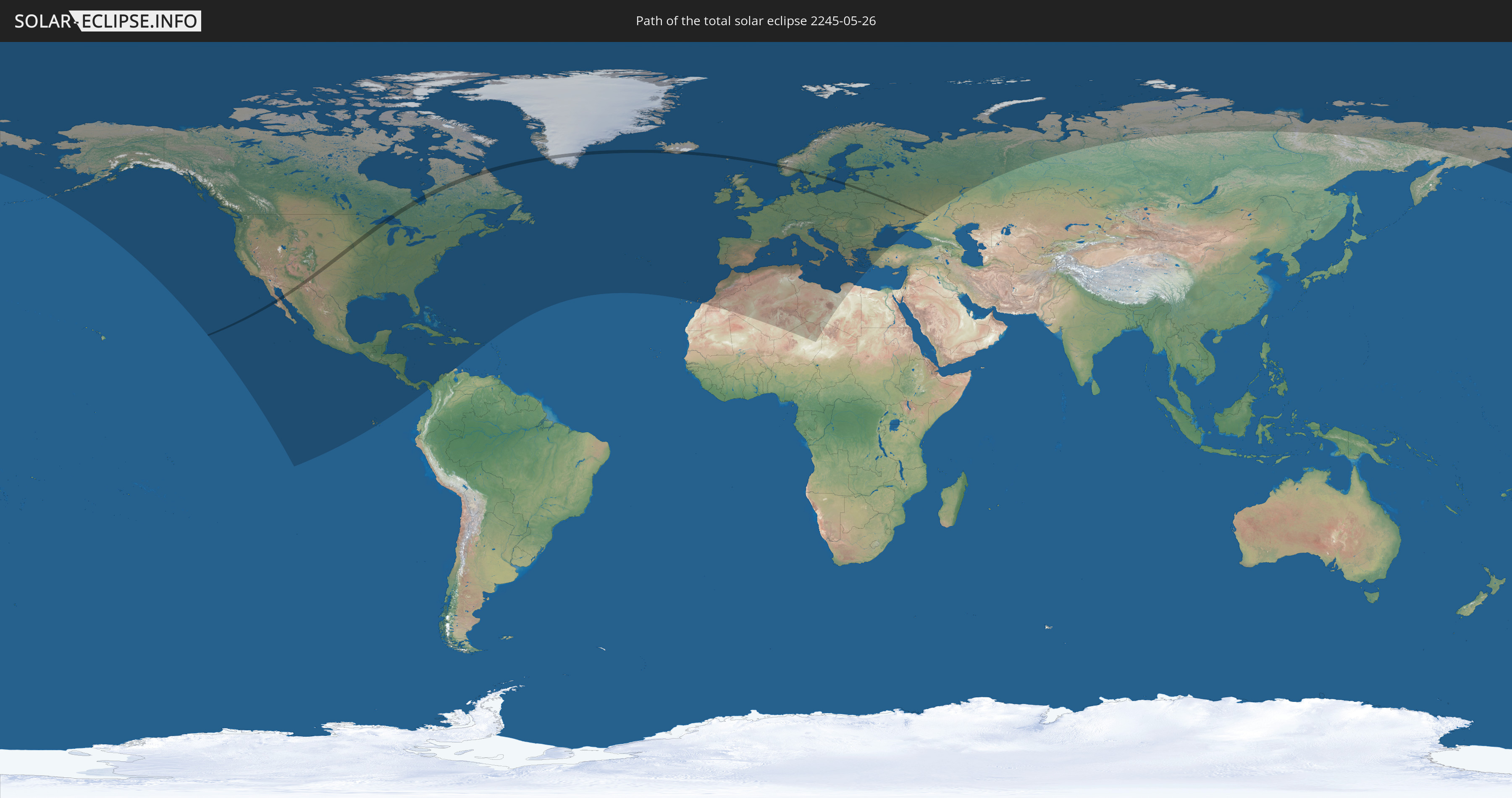
Die Sonnenfinsternis am 26.05.2245 kann man in 85 Ländern als partielle Sonnenfinsternis beobachten.
Der Finsternispfad verläuft durch 13 Länder. Nur in diesen Ländern ist sie als totale Sonnenfinsternis zu sehen.
In den folgenden Ländern ist die Sonnenfinsternis total zu sehen
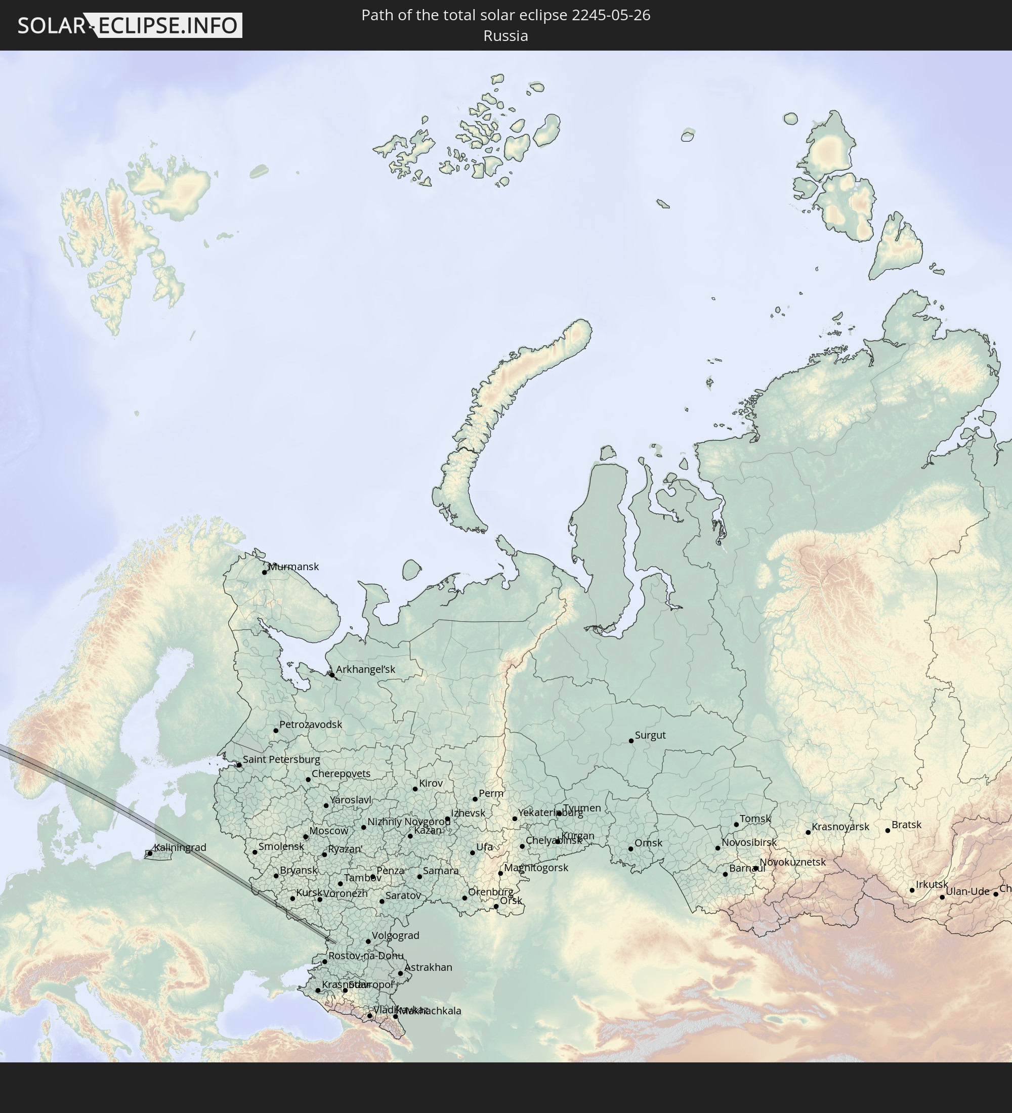 Russland
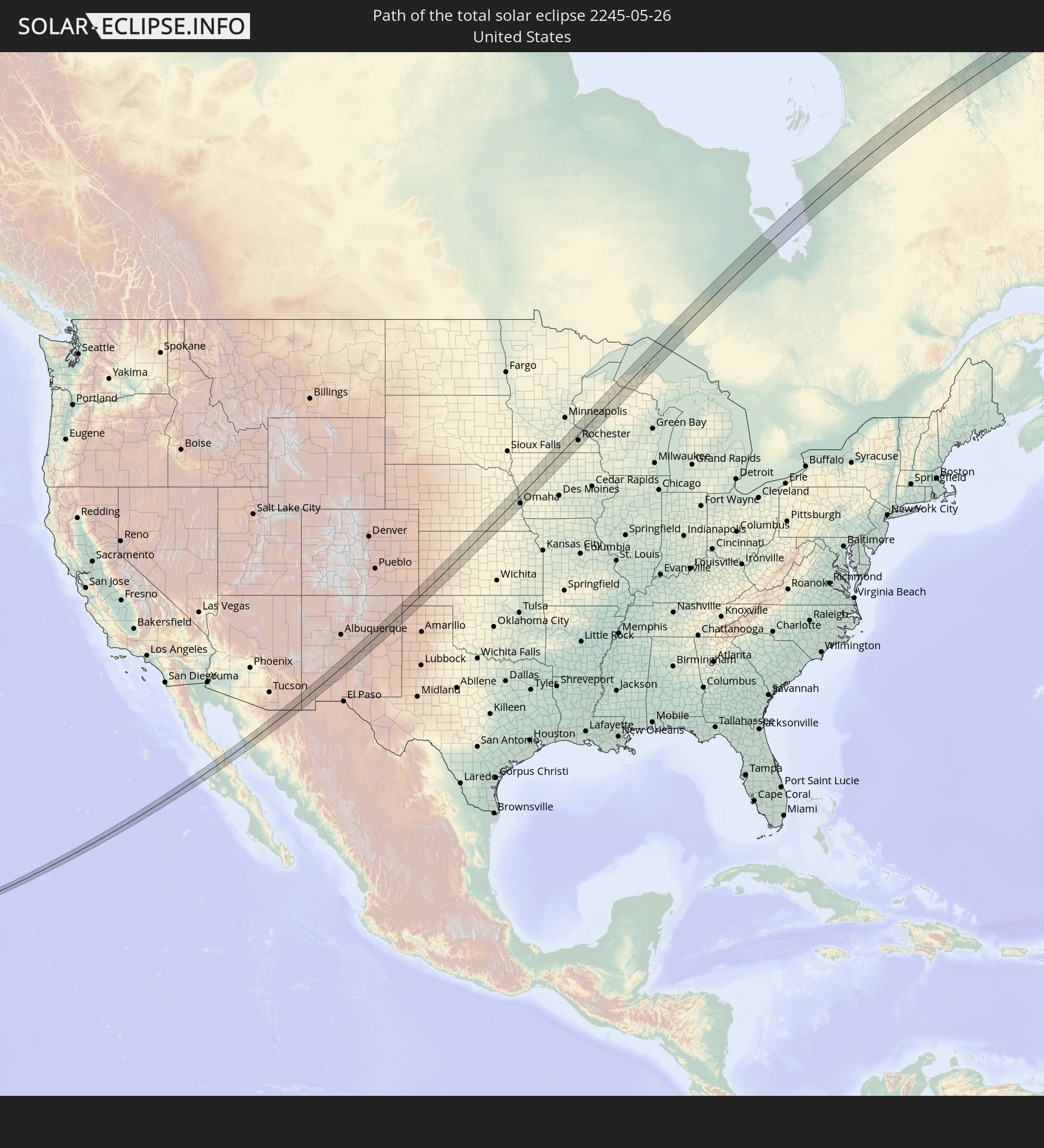 Vereinigte Staaten
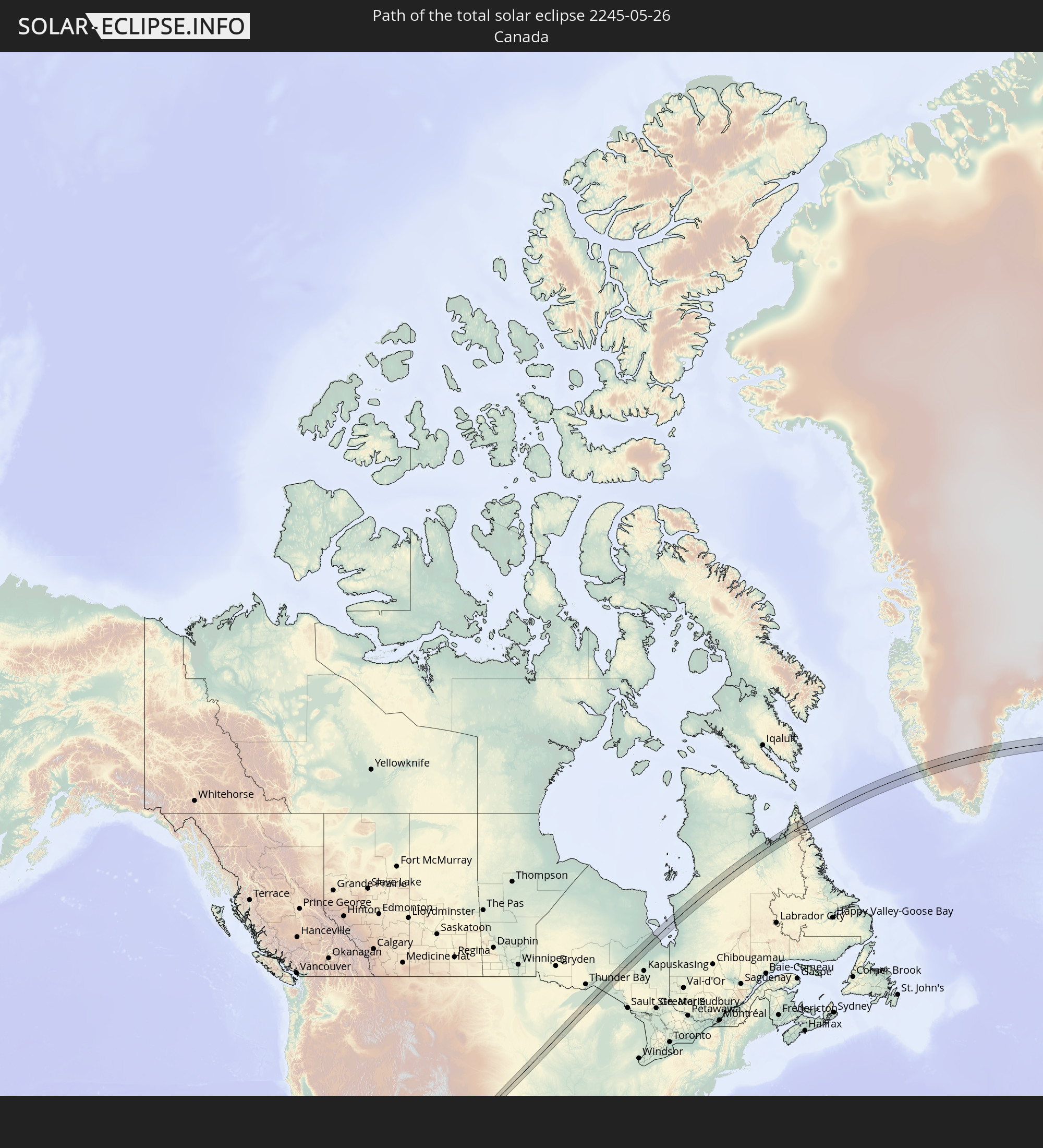 Kanada
 Mexiko
 Grönland
 Island
 Färöer
 Norwegen
 Schweden
 Litauen
 Lettland
 Ukraine
 Weißrussland
In den folgenden Ländern ist die Sonnenfinsternis partiell zu sehen
 Russland
 Vereinigte Staaten
 United States Minor Outlying Islands
 Kanada
 Mexiko
 Grönland
 Guatemala
 Ecuador
 El Salvador
 Honduras
 Belize
 Nicaragua
 Costa Rica
 Kuba
Kuba
 Panama
 Kolumbien
 Kaimaninseln
 Bahamas
 Jamaika
 Haiti
Haiti
 Turks- und Caicosinseln
 Dominikanische Republik
 Puerto Rico
 Amerikanische Jungferninseln
 Bermuda
 Britische Jungferninseln
 Saint-Pierre und Miquelon
 Portugal
 Island
 Spanien
 Mauretanien
 Marokko
 Irland
 Spitzbergen
 Algerien
 Vereinigtes Königreich
 Färöer
 Gibraltar
 Frankreich
 Isle of Man
 Guernsey
 Jersey
 Niger
Niger
 Andorra
 Belgien
 Niederlande
 Norwegen
 Luxemburg
 Deutschland
 Schweiz
 Italien
 Monaco
 Tunesien
 Dänemark
 Libyen
 Liechtenstein
 Österreich
 Schweden
 Tschechien
 San Marino
 Vatikanstadt
 Slowenien
 Tschad
 Kroatien
 Polen
Polen
 Malta
Malta
 Bosnien und Herzegowina
 Ungarn
 Slowakei
 Montenegro
 Serbien
 Albanien
 Åland Islands
 Griechenland
 Rumänien
 Mazedonien
 Finnland
 Litauen
 Lettland
 Estland
 Ukraine
 Bulgarien
 Weißrussland
 Türkei
 Moldawien
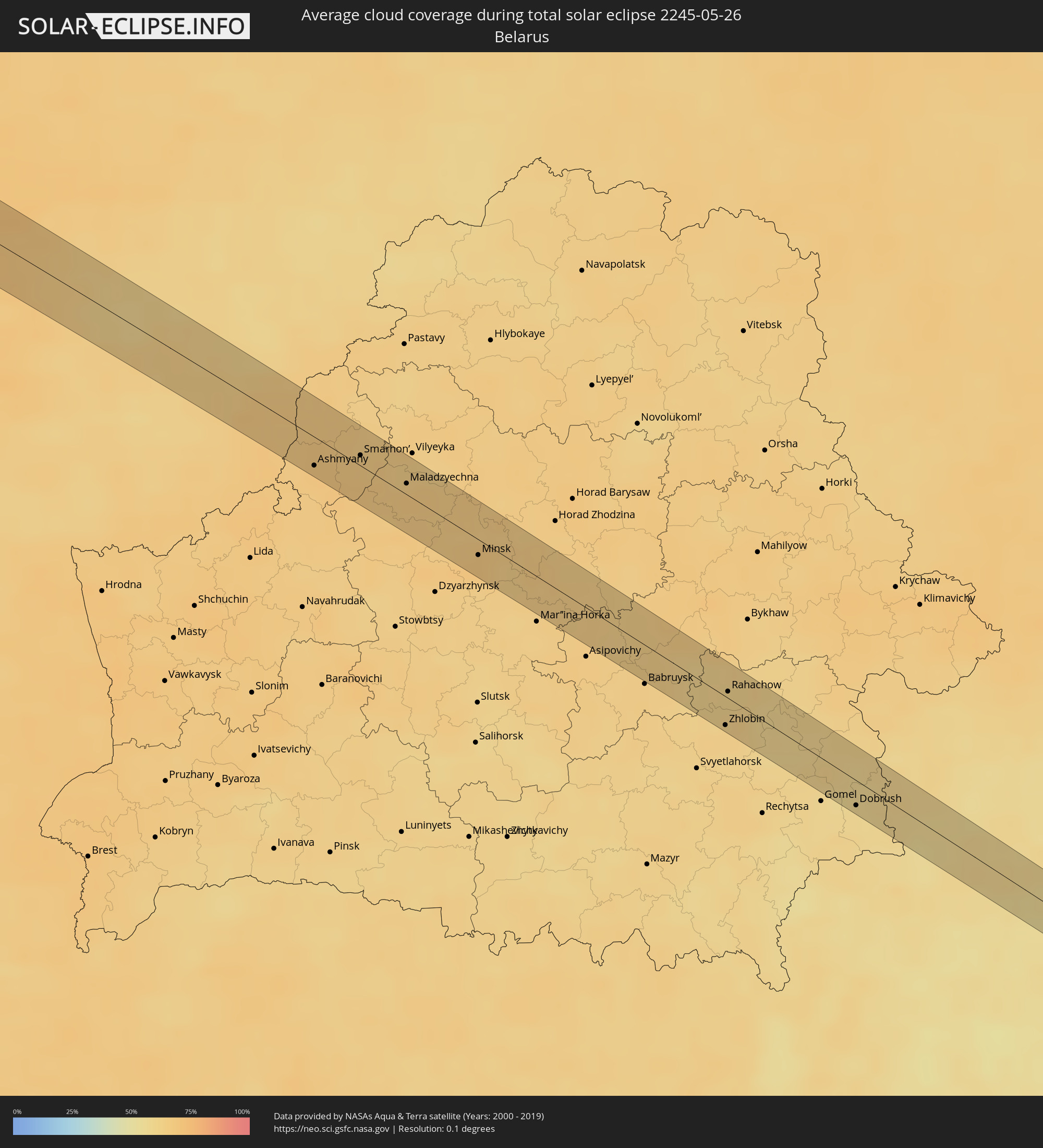
Wie wird das Wetter während der totalen Sonnenfinsternis am 26.05.2245?
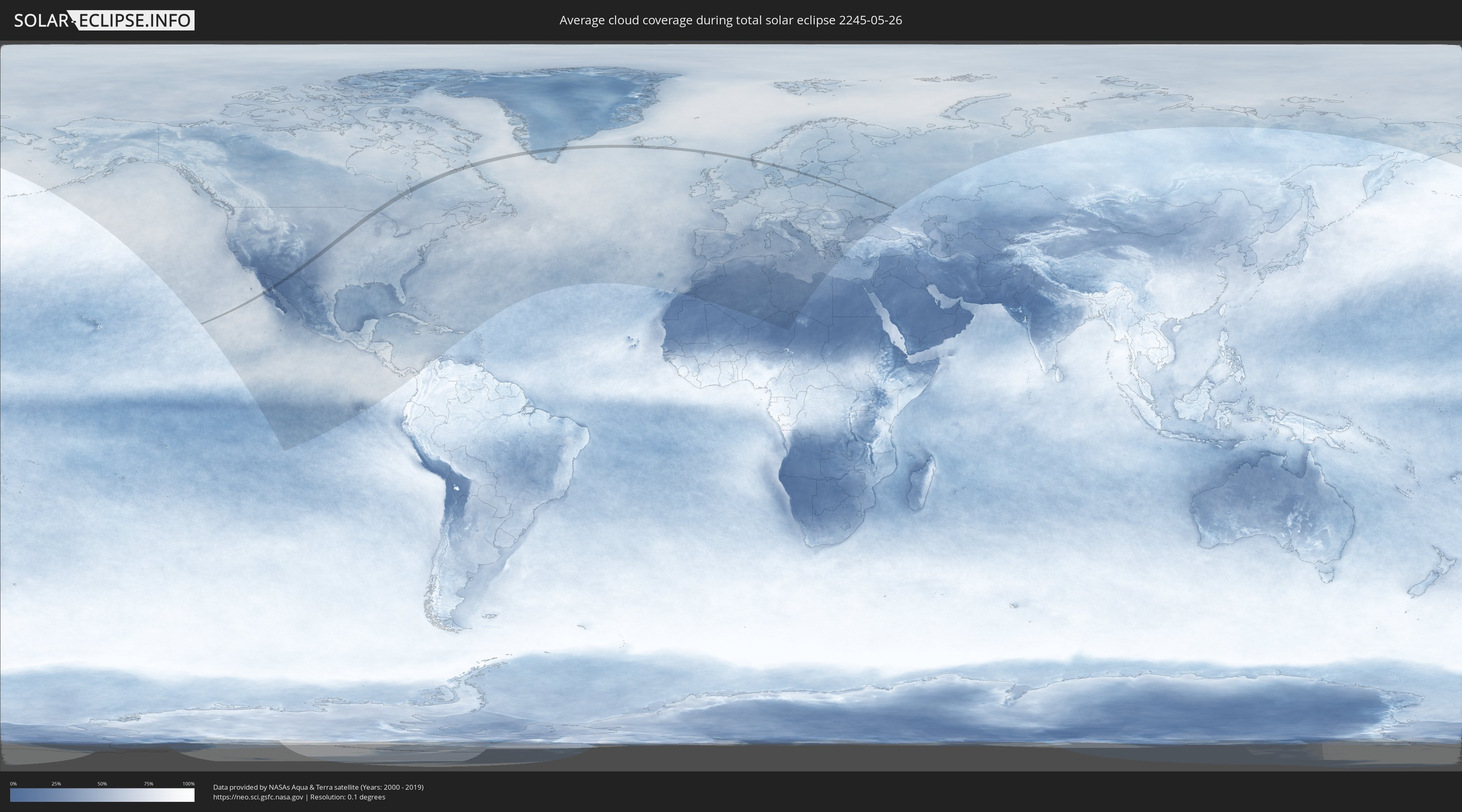
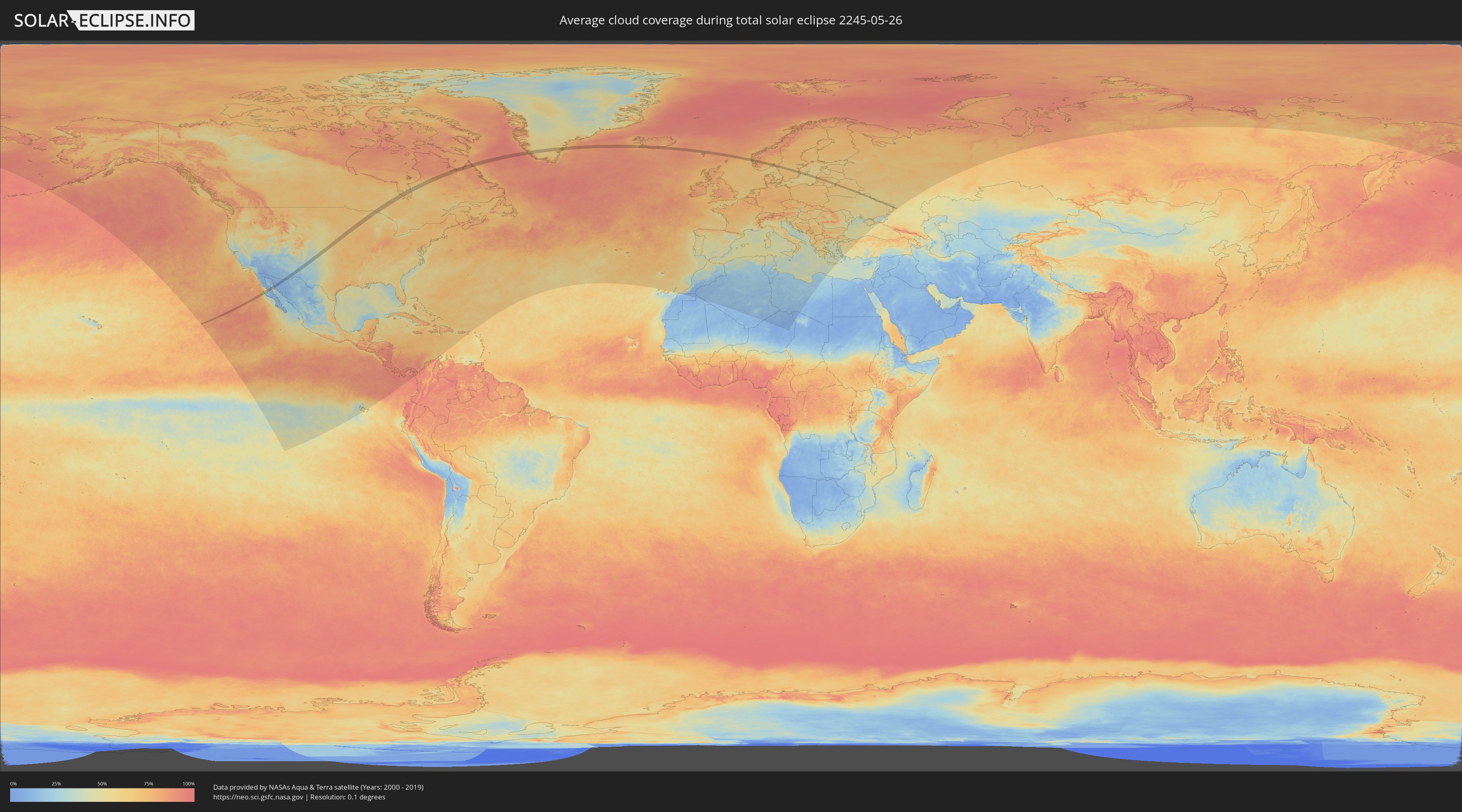
Wo ist der beste Ort, um die totale Sonnenfinsternis vom 26.05.2245 zu beobachten?
Die folgenden Karten zeigen die durchschnittliche Bewölkung für den Tag, an dem die totale Sonnenfinsternis
stattfindet. Mit Hilfe der Karten lässt sich der Ort entlang des Finsternispfades eingrenzen,
der die besten Aussichen auf einen klaren wolkenfreien Himmel bietet.
Trotzdem muss man immer lokale Gegenenheiten beachten und sollte sich genau über das Wetter an seinem
gewählten Beobachtungsort informieren.
Die Daten stammen von den beiden NASA-Satelliten
AQUA und TERRA
und wurden über einen Zeitraum von 19 Jahren (2000 - 2019) gemittelt.
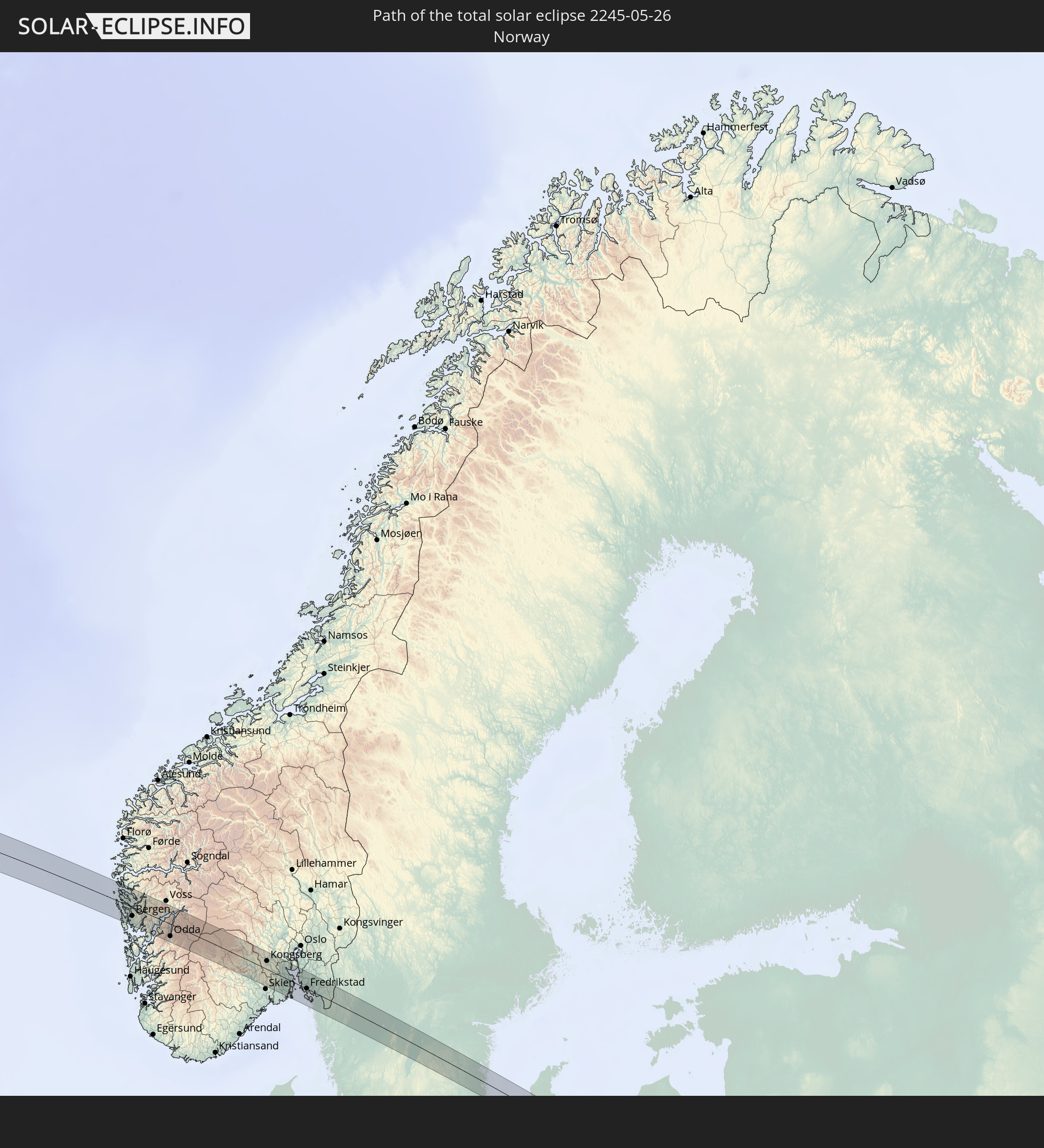
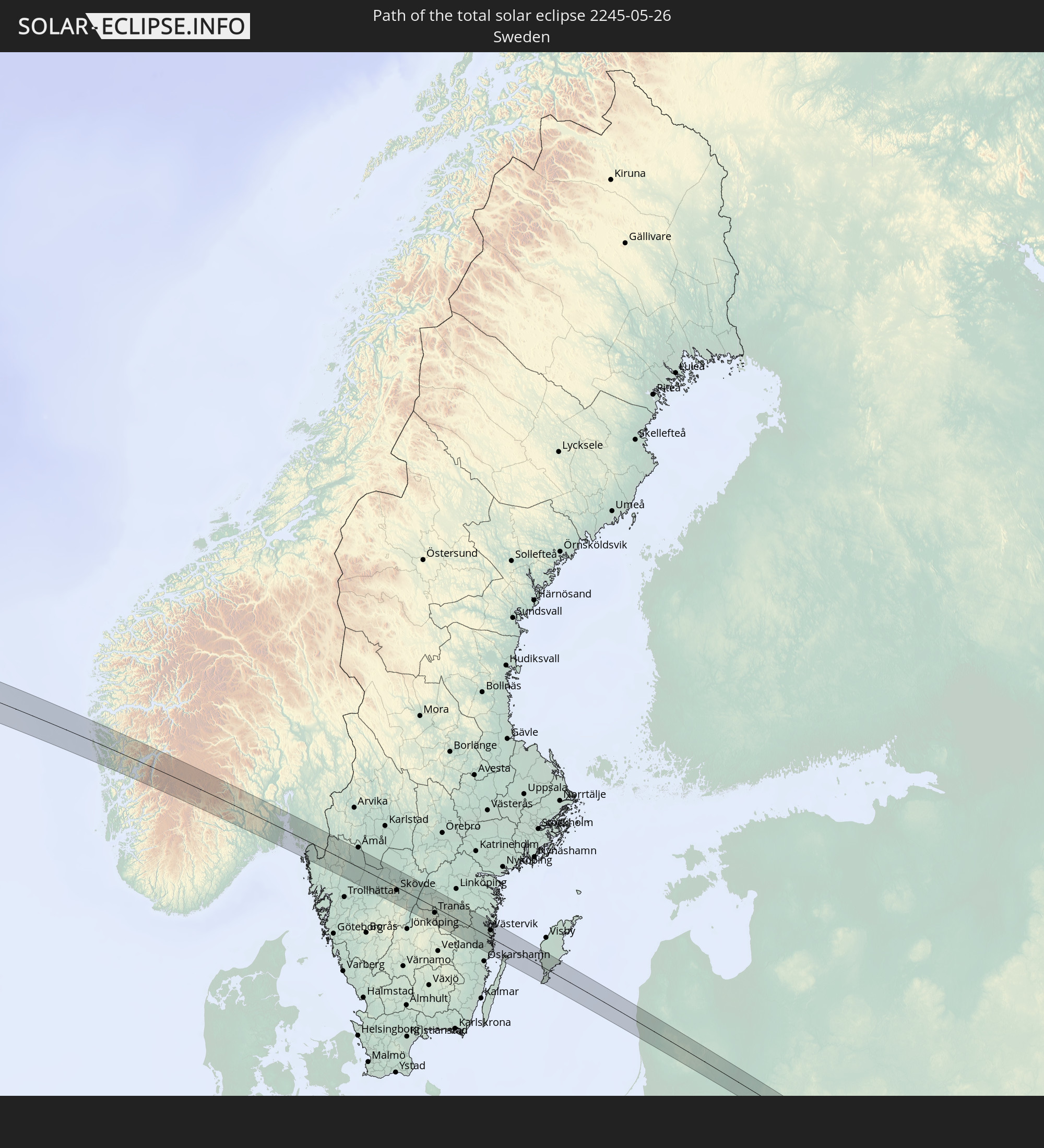
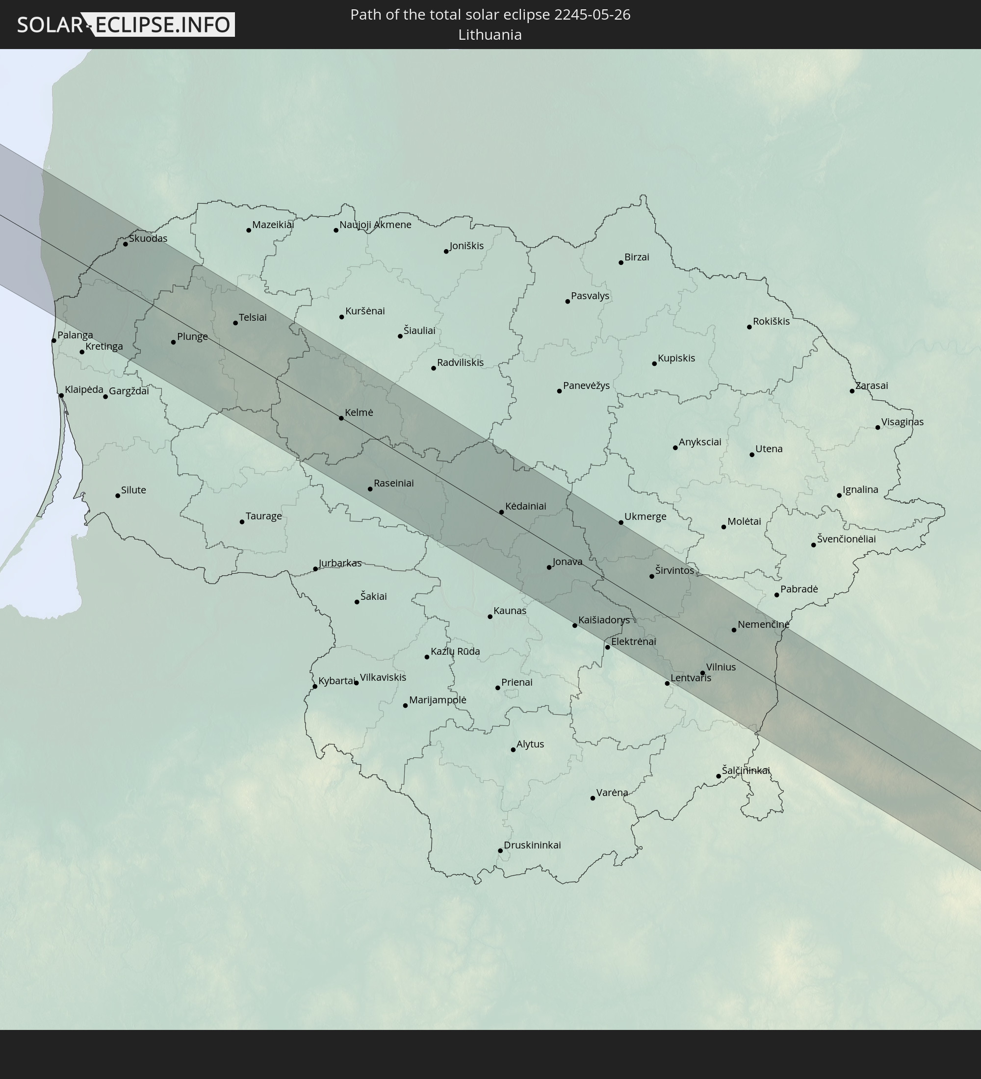
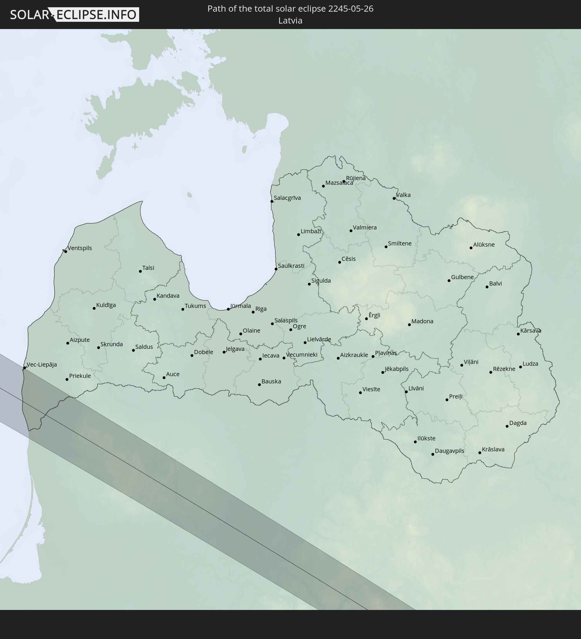
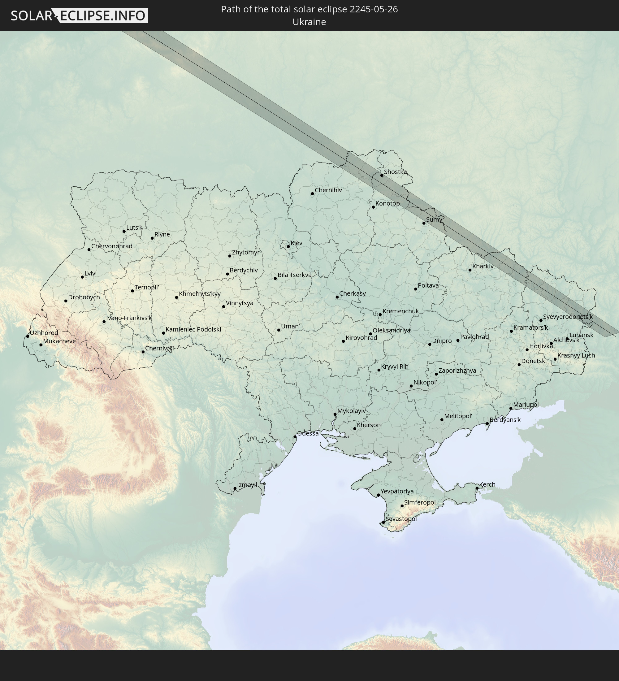
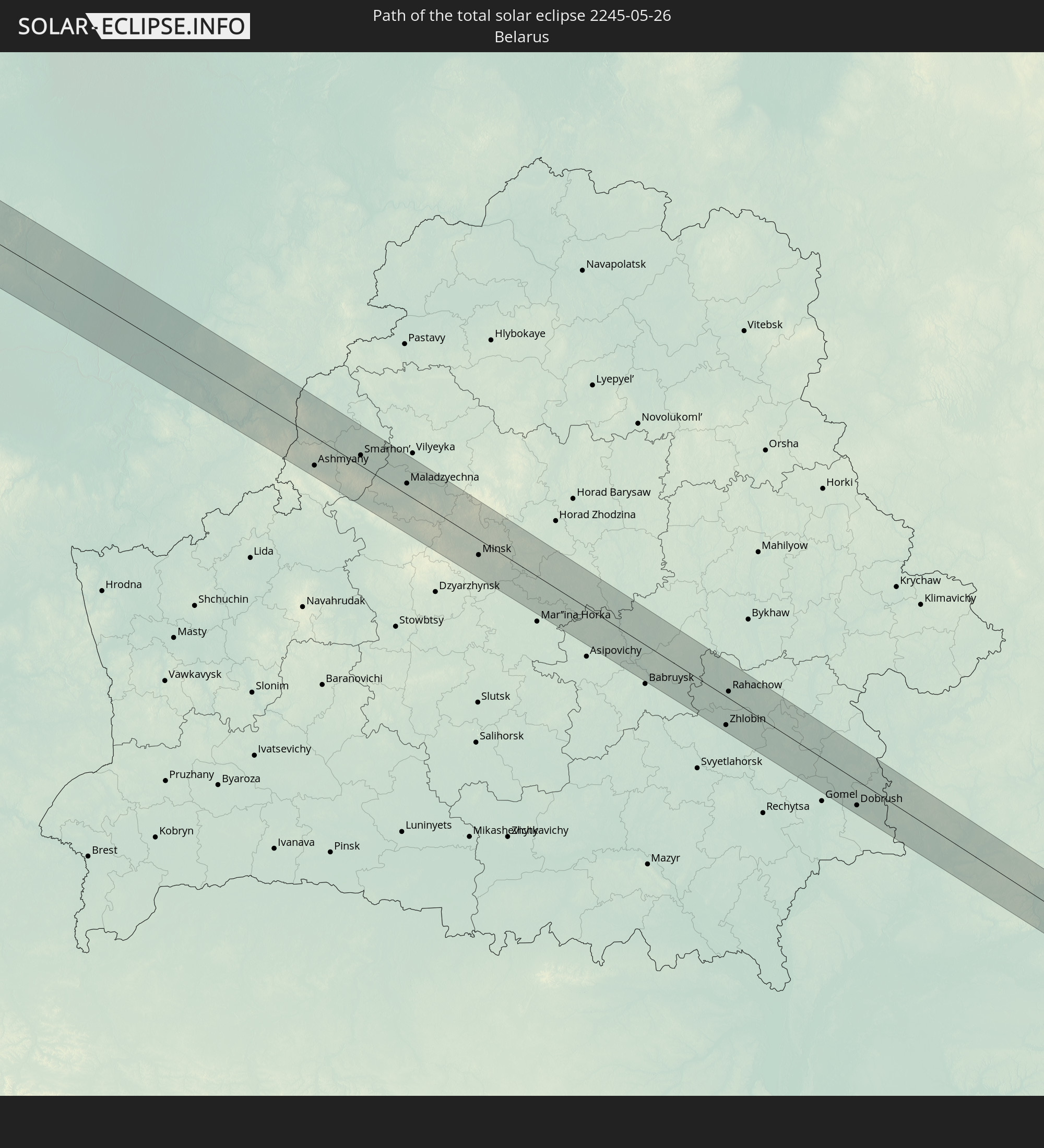
Detaillierte Länderkarten
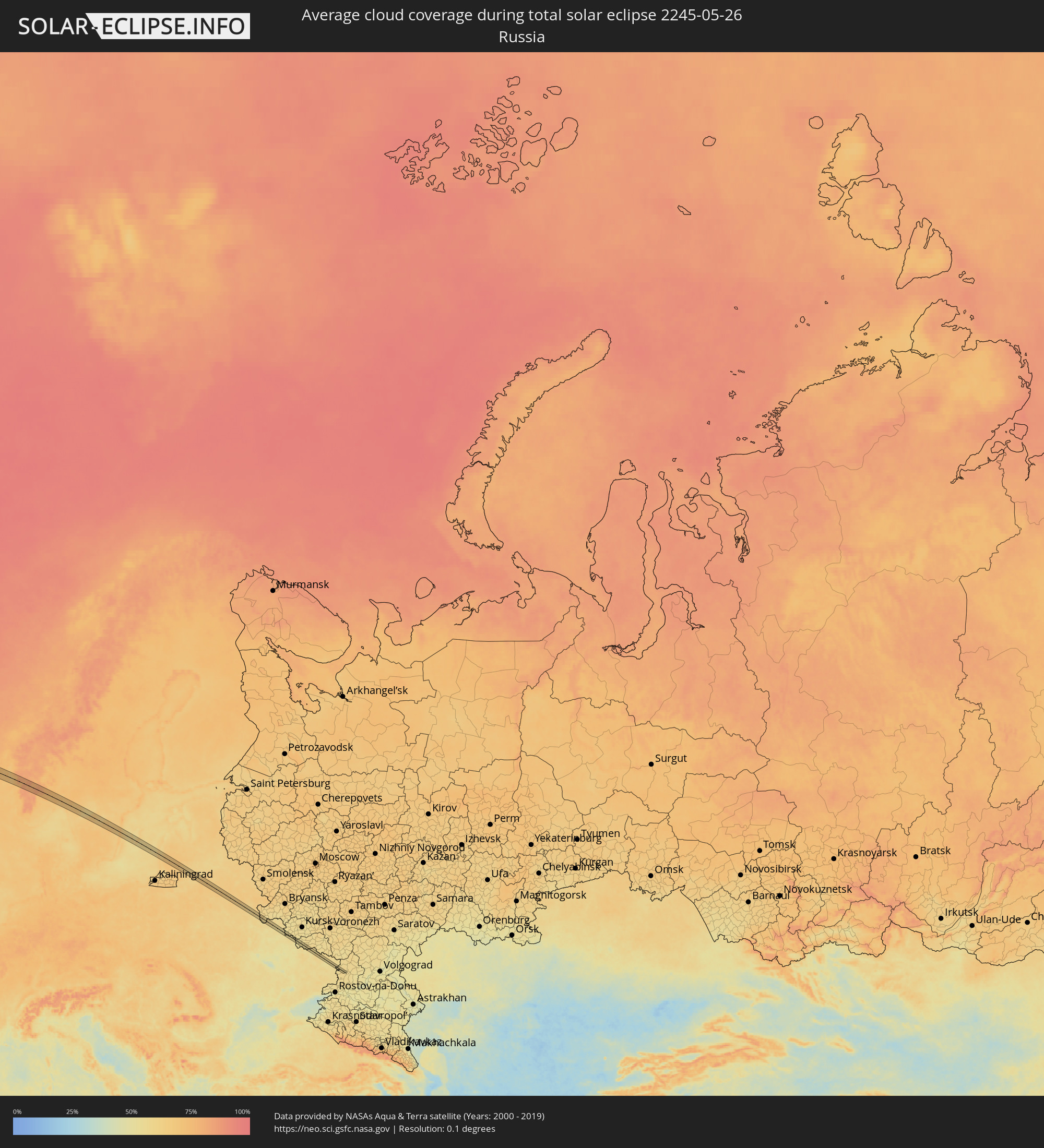 Russland
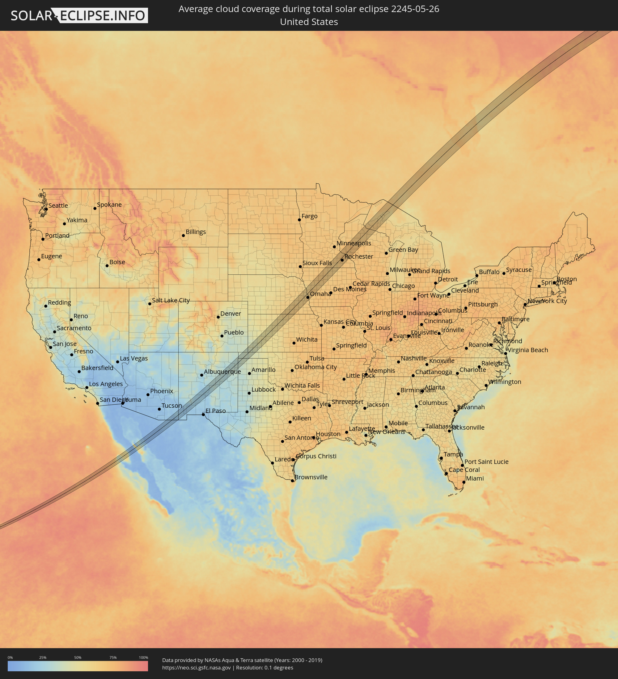 Vereinigte Staaten
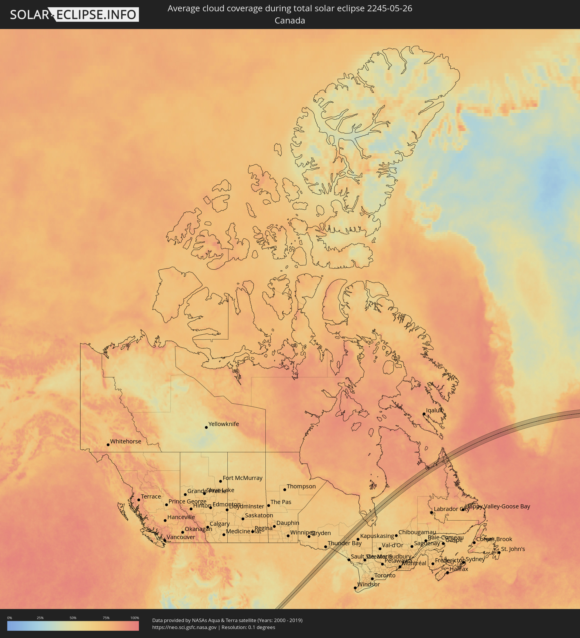 Kanada
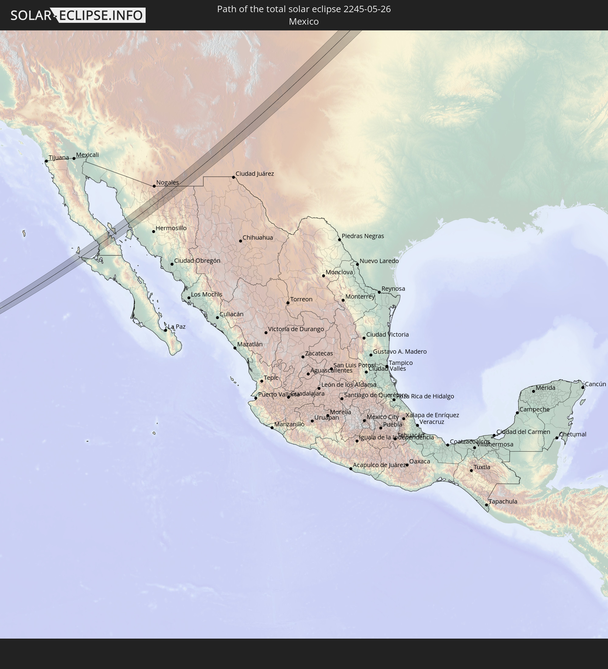
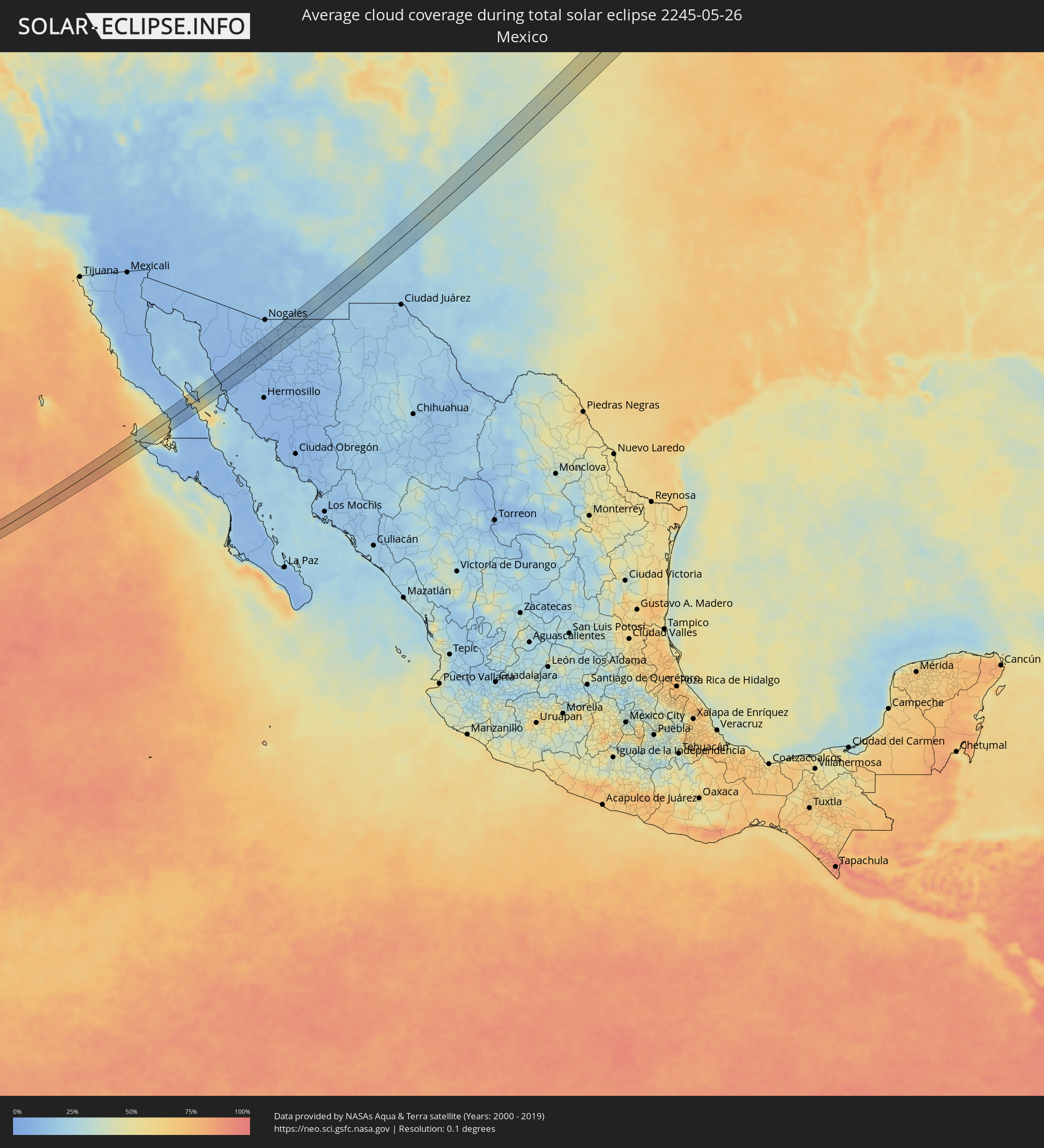 Mexiko
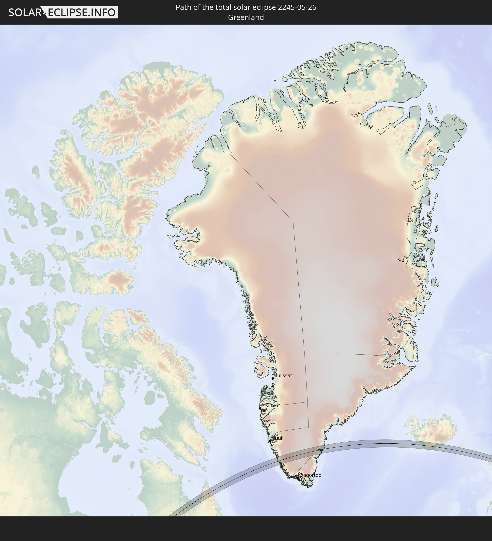
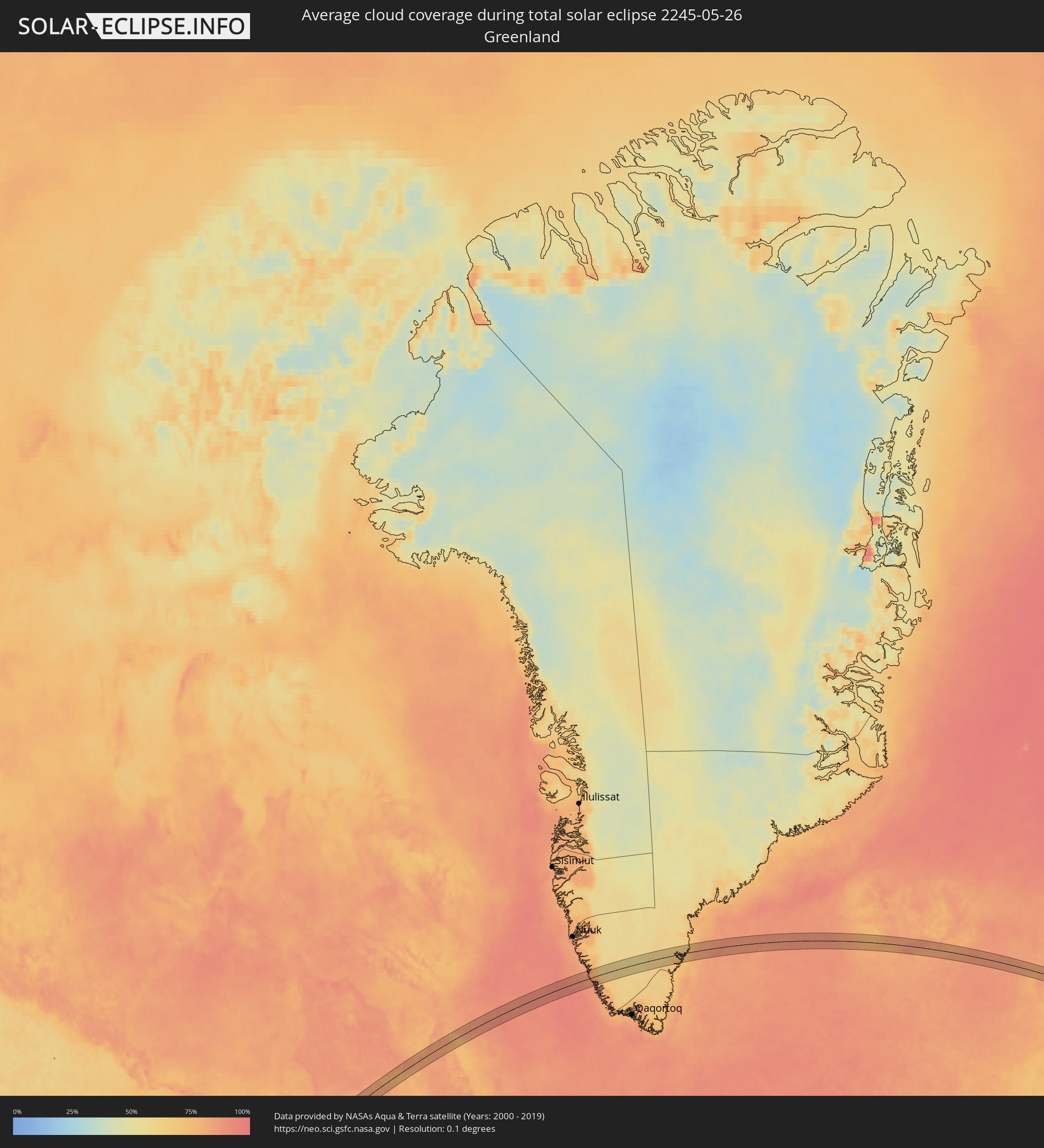 Grönland
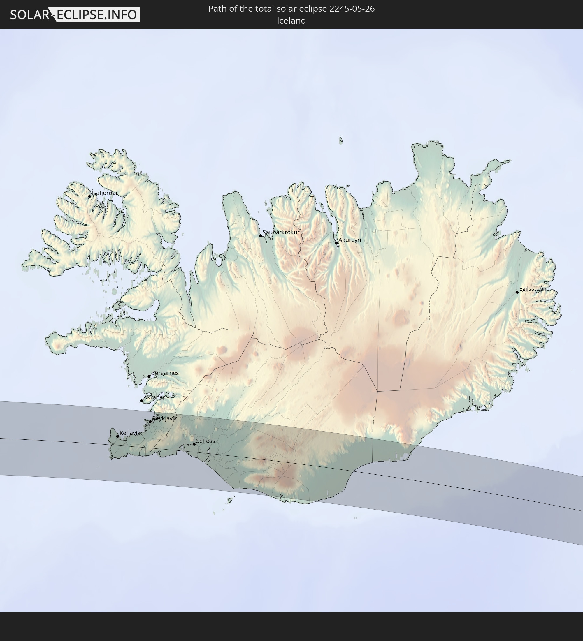
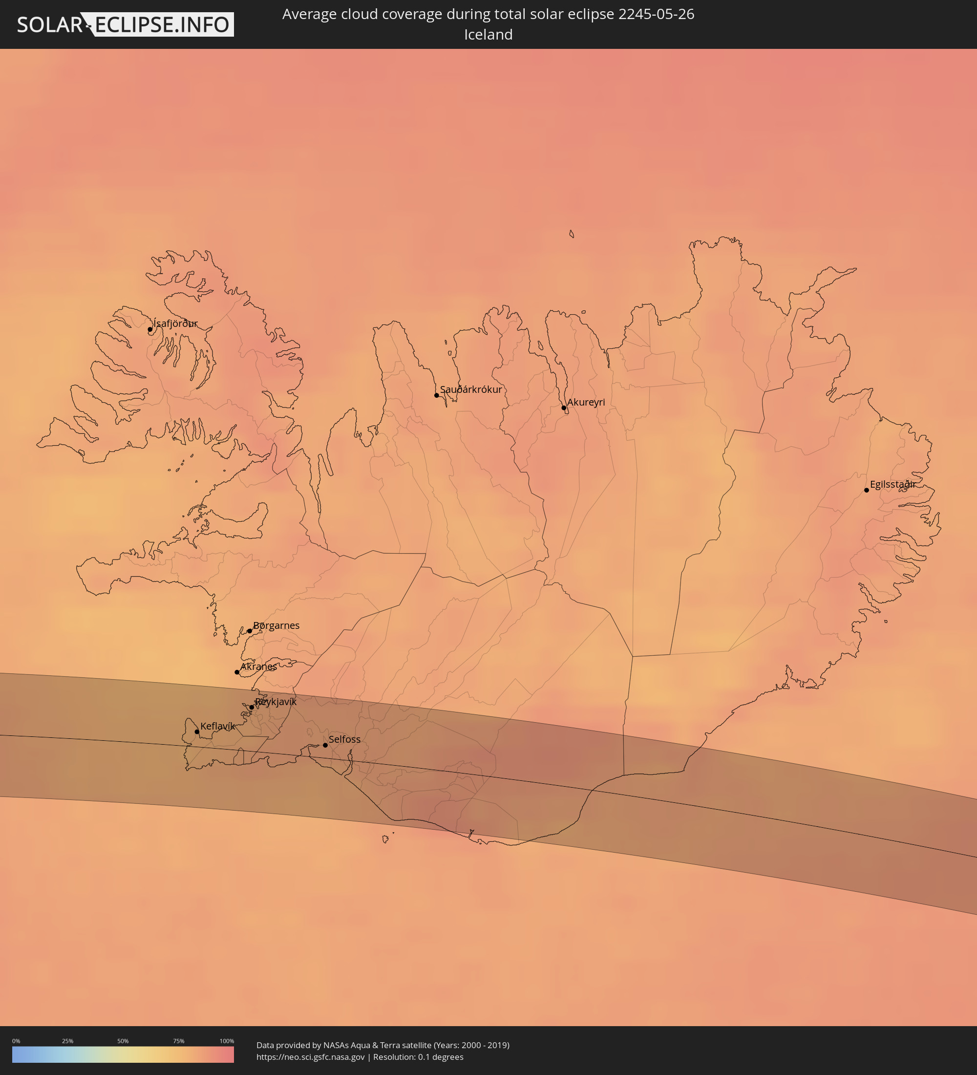 Island
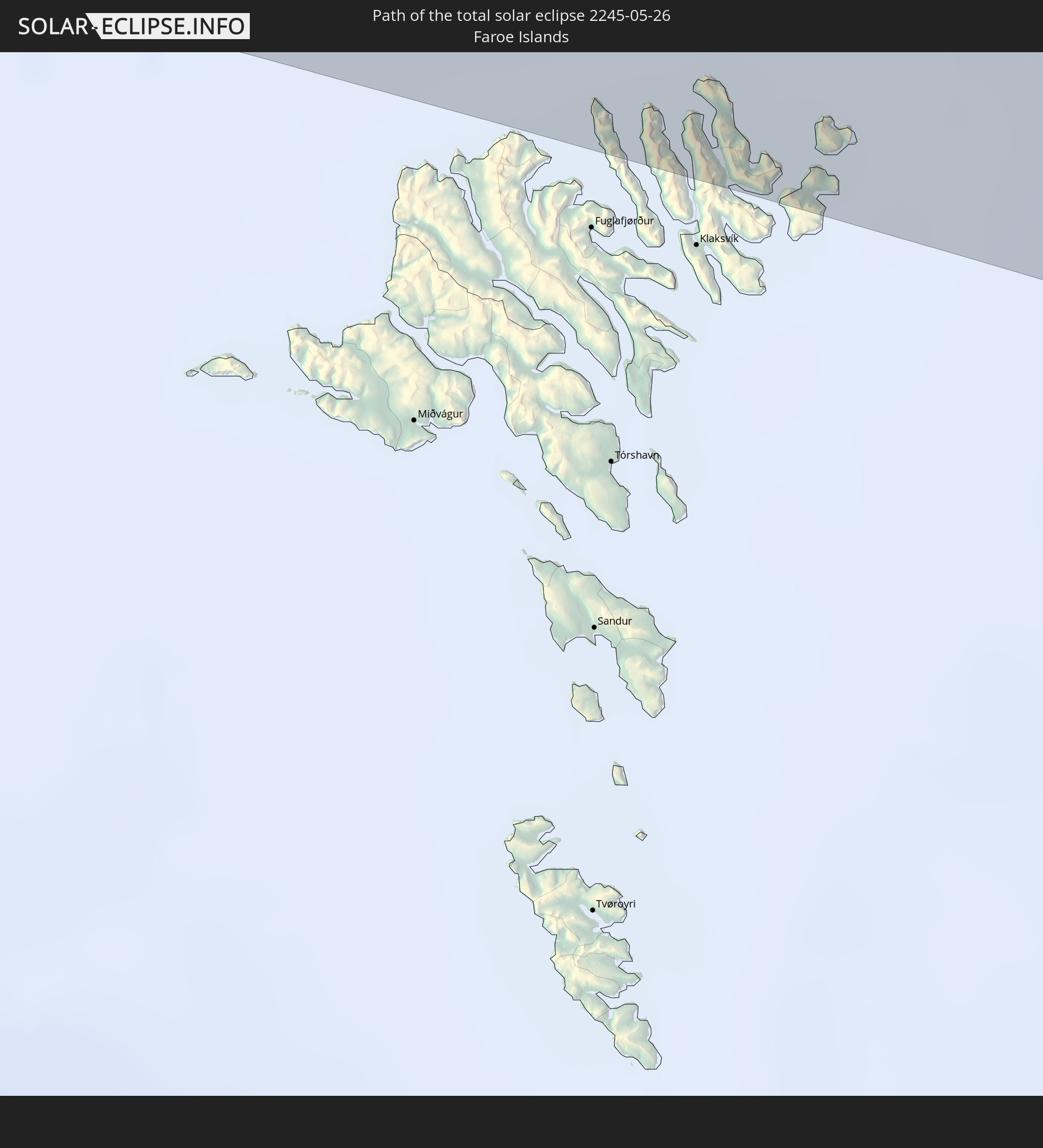
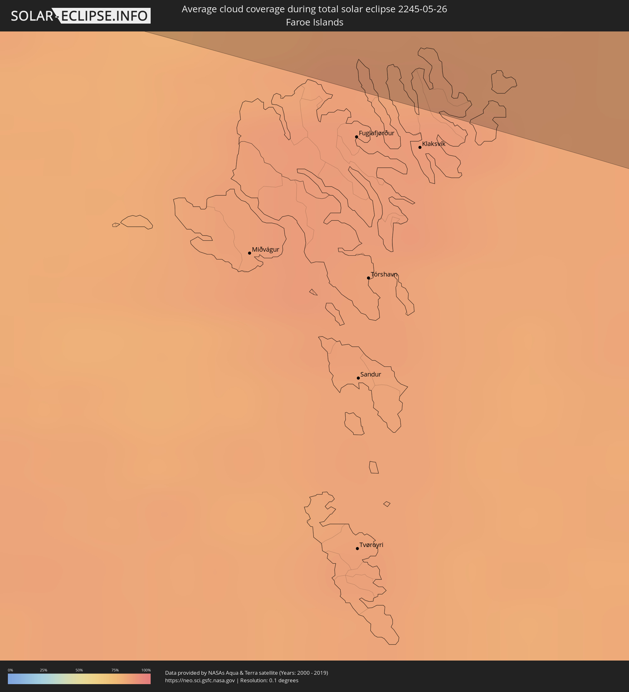 Färöer
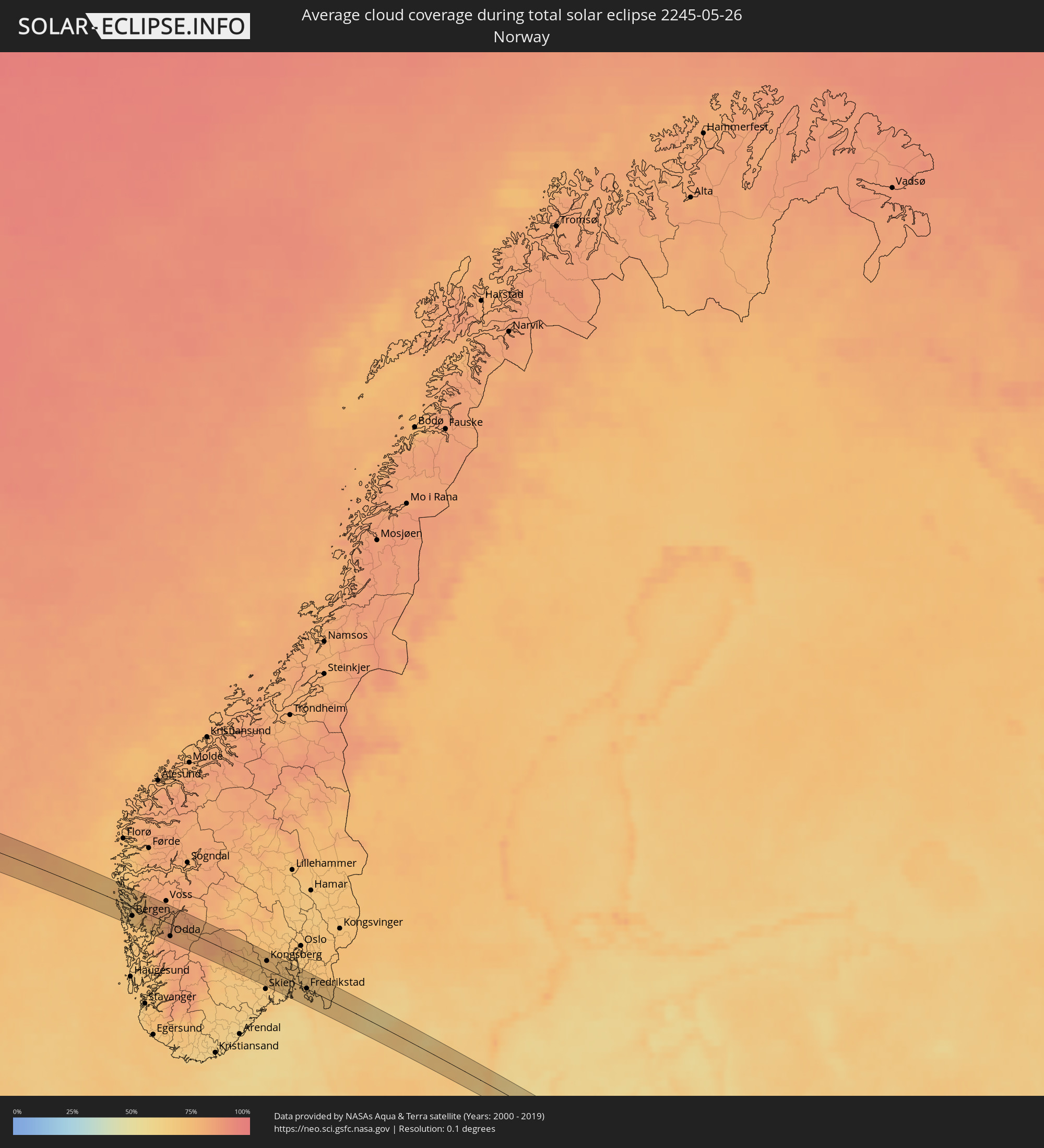 Norwegen
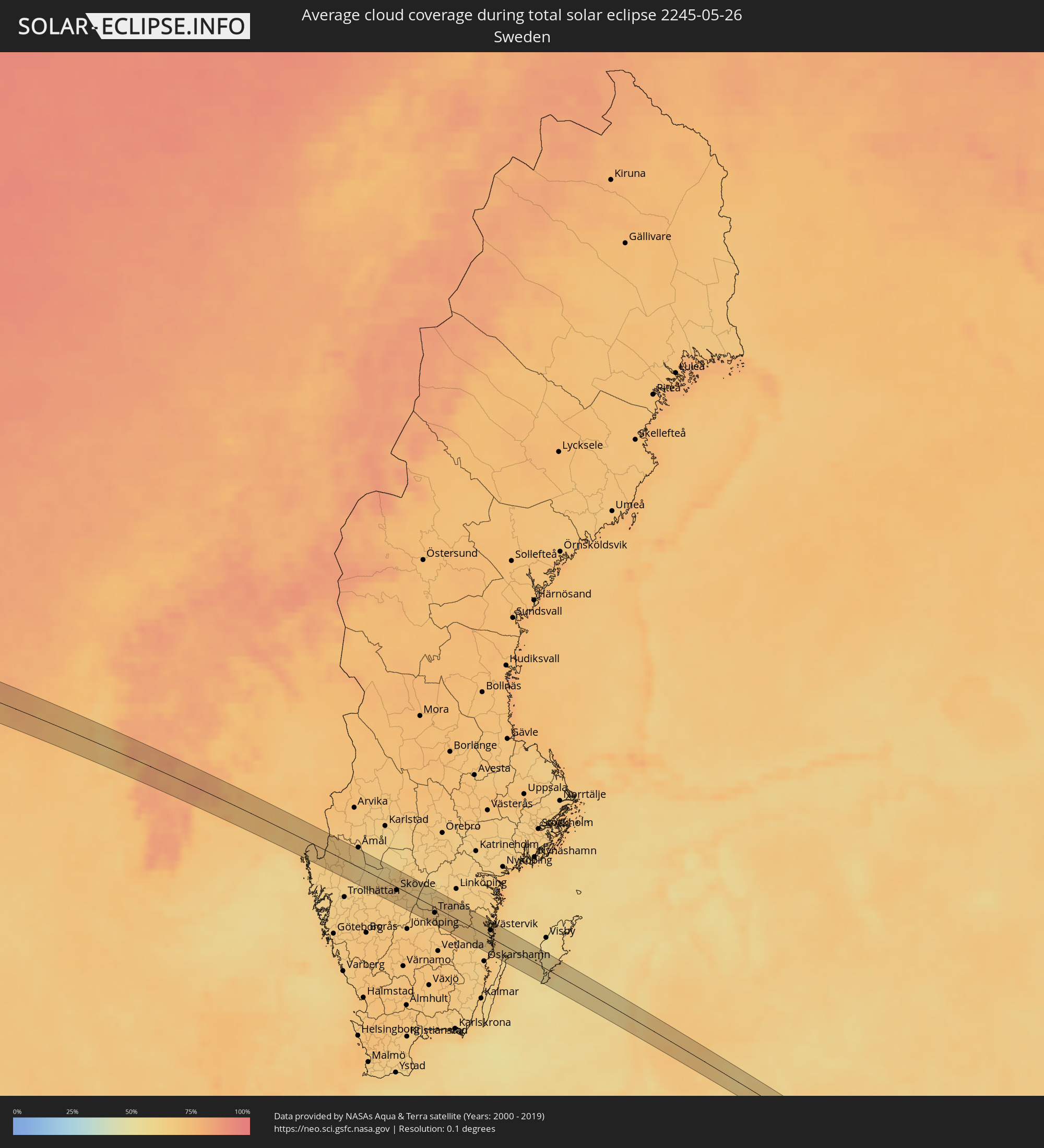 Schweden
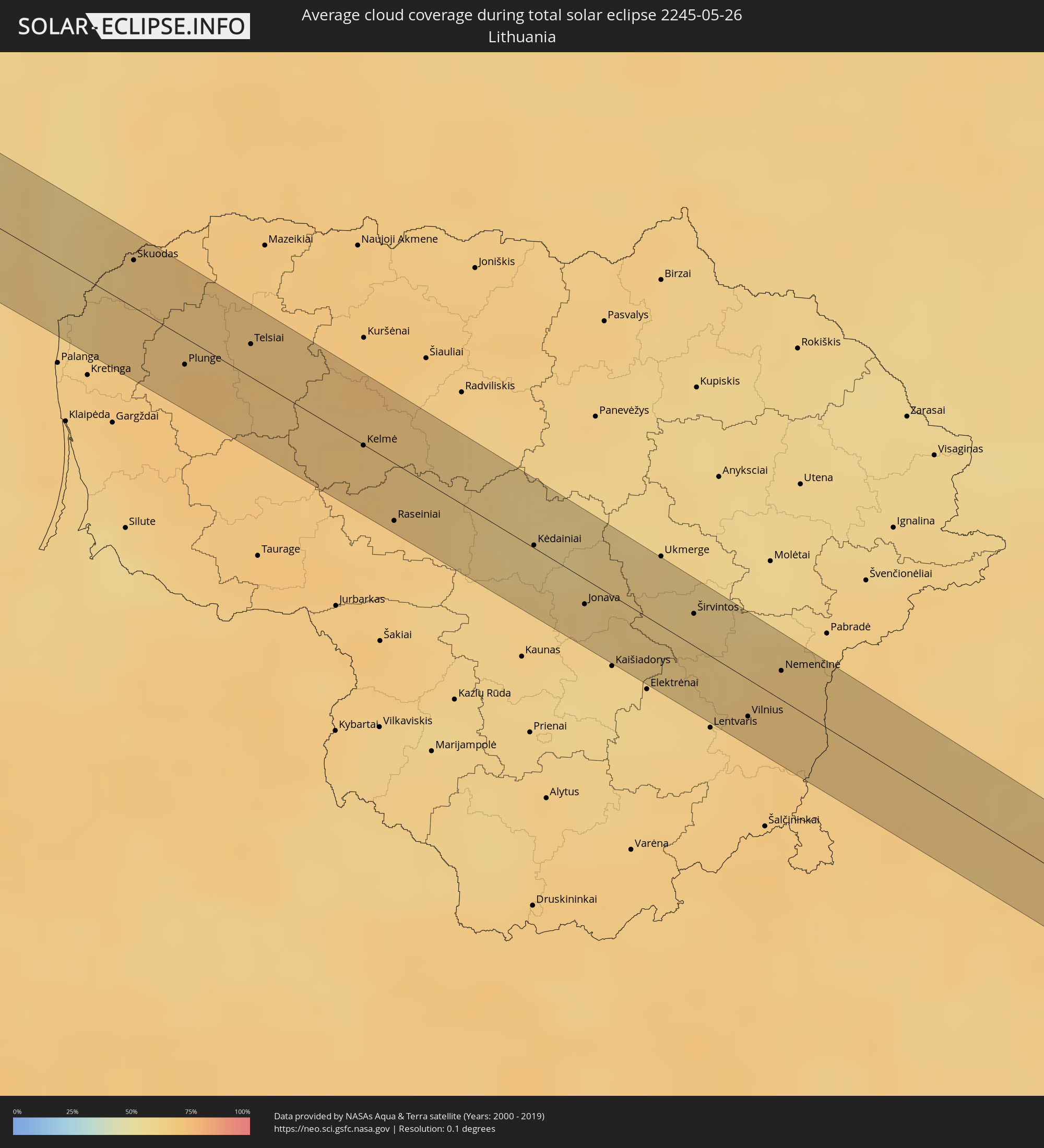 Litauen
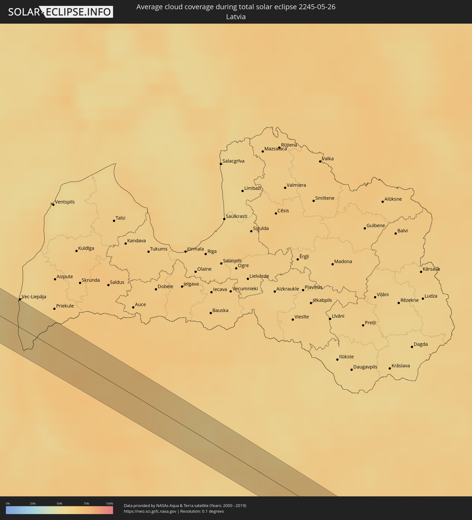 Lettland
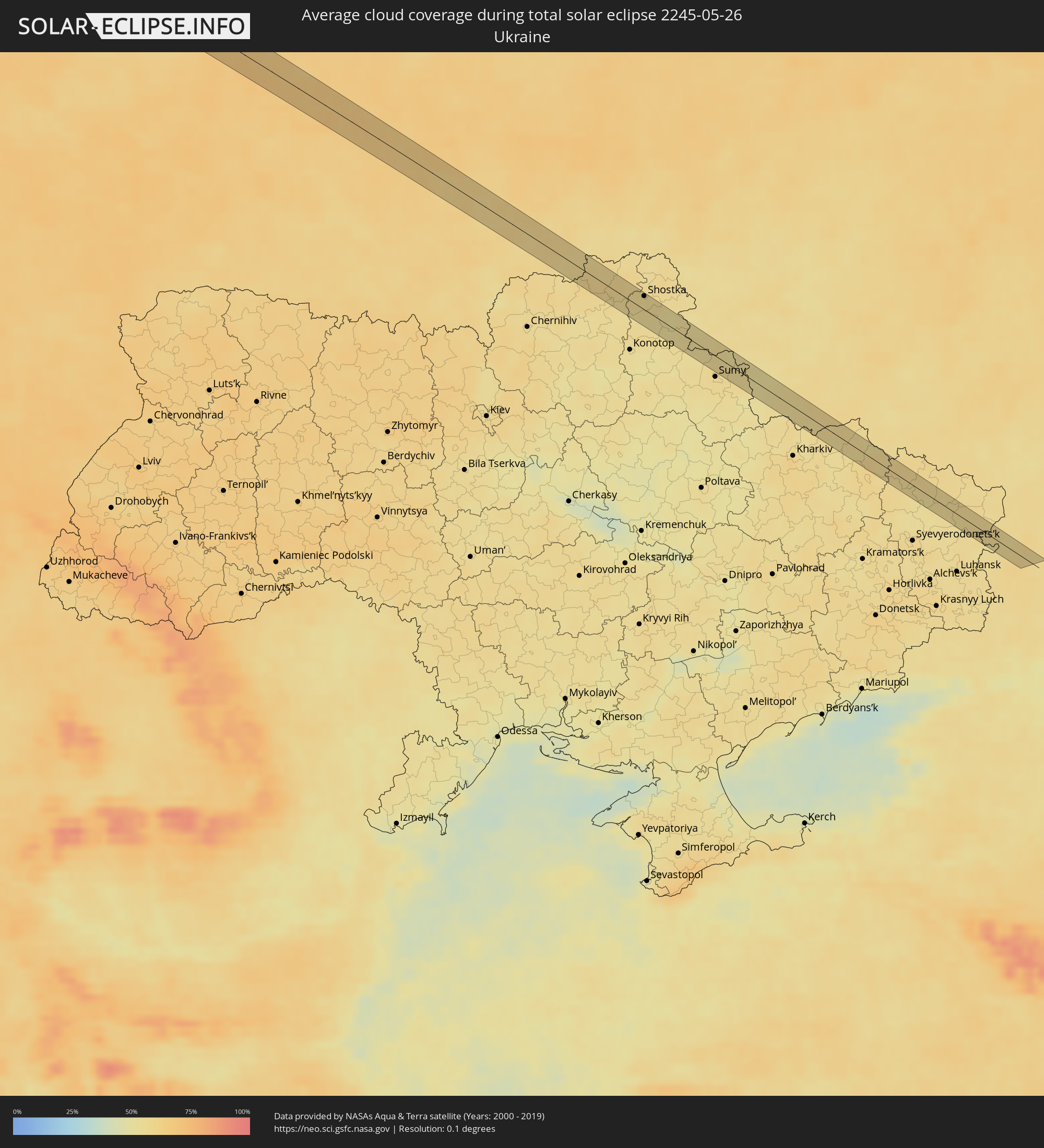 Ukraine
 Weißrussland
Orte im Finsternispfad
Die nachfolgene Tabelle zeigt Städte und Orte mit mehr als 5.000 Einwohnern, die sich im Finsternispfad befinden. Städte mit mehr als 100.000 Einwohnern sind dick gekennzeichnet. Mit einem Klick auf den Ort öffnet sich eine Detailkarte die die Lage des jeweiligen Ortes zusammen mit dem Verlauf der zentralen Finsternis präsentiert.
| Ort | Typ | Dauer der Verfinsterung | Ortszeit bei maximaler Verfinsterung | Entfernung zur Zentrallinie | Ø Bewölkung |
|
San Luis, Baja California
|
total | - | 06:13:49 UTC-08:00 | 23 km | 10% |
|
Santa Ana, Sonora
|
total | - | 07:17:15 UTC-07:00 | 15 km | 8% |
|
Benjamin Hill, Sonora
|
total | - | 07:16:40 UTC-07:00 | 33 km | 8% |
|
Magdalena de Kino, Sonora
|
total | - | 07:17:25 UTC-07:00 | 20 km | 10% |
|
Imuris, Sonora
|
total | - | 07:17:41 UTC-07:00 | 33 km | 11% |
|
Cananea, Sonora
|
total | - | 07:18:04 UTC-07:00 | 30 km | 15% |
|
Naco, Sonora
|
total | - | 07:18:40 UTC-07:00 | 23 km | 13% |
|
Agua Prieta, Sonora
|
total | - | 07:18:44 UTC-07:00 | 15 km | 14% |
|
Douglas, Arizona
|
total | - | 07:18:46 UTC-07:00 | 14 km | 14% |
|
Deming, New Mexico
|
total | - | 07:20:37 UTC-07:00 | 35 km | 18% |
|
Garden City, Kansas
|
total | - | 08:33:04 UTC-06:00 | 33 km | 47% |
|
Hays, Kansas
|
total | - | 08:35:32 UTC-06:00 | 15 km | 54% |
|
Lincoln, Nebraska
|
total | - | 08:40:41 UTC-06:00 | 28 km | 64% |
|
Fremont, Nebraska
|
total | - | 08:42:00 UTC-06:00 | 28 km | 65% |
|
Chalco, Nebraska
|
total | - | 08:41:44 UTC-06:00 | 29 km | 63% |
|
Omaha, Nebraska
|
total | - | 08:42:01 UTC-06:00 | 36 km | 65% |
|
Denison, Iowa
|
total | - | 08:43:51 UTC-06:00 | 14 km | 66% |
|
Storm Lake, Iowa
|
total | - | 08:45:09 UTC-06:00 | 37 km | 67% |
|
Carroll, Iowa
|
total | - | 08:44:17 UTC-06:00 | 33 km | 67% |
|
Fort Dodge, Iowa
|
total | - | 08:45:36 UTC-06:00 | 38 km | 68% |
|
Albert Lea, Minnesota
|
total | - | 08:48:23 UTC-06:00 | 20 km | 66% |
|
Owatonna, Minnesota
|
total | - | 08:49:20 UTC-06:00 | 29 km | 67% |
|
Austin, Minnesota
|
total | - | 08:48:43 UTC-06:00 | 23 km | 63% |
|
Red Wing, Minnesota
|
total | - | 08:50:46 UTC-06:00 | 35 km | 68% |
|
Rochester, Minnesota
|
total | - | 08:49:47 UTC-06:00 | 26 km | 69% |
|
Menomonie, Wisconsin
|
total | - | 08:51:51 UTC-06:00 | 28 km | 71% |
|
Eau Claire, Wisconsin
|
total | - | 08:52:03 UTC-06:00 | 21 km | 71% |
|
Chippewa Falls, Wisconsin
|
total | - | 08:52:23 UTC-06:00 | 11 km | 71% |
|
Keflavík, Southern Peninsula
|
total | - | 16:26:21 UTC+00:00 | 9 km | 77% |
|
Hafnarfjörður, Capital Region
|
total | - | 16:26:45 UTC+00:00 | 18 km | 80% |
|
Garðabær, Capital Region
|
total | - | 16:26:45 UTC+00:00 | 20 km | 80% |
|
Kópavogur, Capital Region
|
total | - | 16:26:44 UTC+00:00 | 23 km | 80% |
|
Reykjavík, Capital Region
|
total | - | 16:26:43 UTC+00:00 | 26 km | 80% |
|
Mosfellsbær, Capital Region
|
total | - | 16:26:50 UTC+00:00 | 32 km | 81% |
|
Selfoss, South
|
total | - | 16:27:35 UTC+00:00 | 7 km | 79% |
|
Askøy, Hordaland
|
total | - | 17:45:54 UTC+01:00 | 20 km | 67% |
|
Ytrebygda, Hordaland
|
total | - | 17:46:05 UTC+01:00 | 24 km | 69% |
|
Bergen, Hordaland
|
total | - | 17:45:57 UTC+01:00 | 15 km | 68% |
|
Indre Arna, Hordaland
|
total | - | 17:45:58 UTC+01:00 | 9 km | 73% |
|
Odda, Hordaland
|
total | - | 17:46:46 UTC+01:00 | 23 km | 82% |
|
Notodden, Telemark
|
total | - | 17:48:10 UTC+01:00 | 14 km | 72% |
|
Kongsberg, Buskerud
|
total | - | 17:48:05 UTC+01:00 | 14 km | 72% |
|
Sandefjord, Vestfold
|
total | - | 17:48:59 UTC+01:00 | 27 km | 65% |
|
Holmestrand, Vestfold
|
total | - | 17:48:29 UTC+01:00 | 18 km | 70% |
|
Tønsberg, Vestfold
|
total | - | 17:48:49 UTC+01:00 | 8 km | 69% |
|
Horten, Vestfold
|
total | - | 17:48:37 UTC+01:00 | 10 km | 69% |
|
Moss, Østfold
|
total | - | 17:48:38 UTC+01:00 | 15 km | 69% |
|
Fredrikstad, Østfold
|
total | - | 17:49:00 UTC+01:00 | 5 km | 69% |
|
Sarpsborg, Østfold
|
total | - | 17:48:56 UTC+01:00 | 12 km | 68% |
|
Strömstad, Västra Götaland
|
total | - | 17:49:27 UTC+01:00 | 24 km | 66% |
|
Halden, Østfold
|
total | - | 17:49:13 UTC+01:00 | 9 km | 68% |
|
Lidköping, Västra Götaland
|
total | - | 17:50:23 UTC+01:00 | 20 km | 65% |
|
Skara, Västra Götaland
|
total | - | 17:50:35 UTC+01:00 | 17 km | 67% |
|
Åkarp, Västra Götaland
|
total | - | 17:50:50 UTC+01:00 | 27 km | 67% |
|
Mariestad, Västra Götaland
|
total | - | 17:50:10 UTC+01:00 | 27 km | 64% |
|
Skövde, Västra Götaland
|
total | - | 17:50:38 UTC+01:00 | 9 km | 68% |
|
Tidaholm, Västra Götaland
|
total | - | 17:50:57 UTC+01:00 | 24 km | 67% |
|
Tibro, Västra Götaland
|
total | - | 17:50:37 UTC+01:00 | 10 km | 65% |
|
Hjo, Västra Götaland
|
total | - | 17:50:49 UTC+01:00 | 13 km | 64% |
|
Tranås, Jönköping
|
total | - | 17:51:16 UTC+01:00 | 9 km | 68% |
|
Mjölby, Östergötland
|
total | - | 17:50:52 UTC+01:00 | 24 km | 65% |
|
Vimmerby, Kalmar
|
total | - | 17:51:53 UTC+01:00 | 20 km | 67% |
|
Västervik, Kalmar
|
total | - | 17:51:48 UTC+01:00 | 12 km | 65% |
|
Liepāja, Liepāja
|
total | - | 18:53:38 UTC+02:00 | 26 km | 61% |
|
Nīca, Nīca
|
total | - | 18:53:52 UTC+02:00 | 8 km | 61% |
|
Rucava, Rucavas
|
total | - | 18:54:07 UTC+02:00 | 17 km | 63% |
|
Skuodas, Klaipėda County
|
total | - | 18:53:58 UTC+02:00 | 17 km | 65% |
|
Plunge, Telšiai County
|
total | - | 18:54:27 UTC+02:00 | 11 km | 69% |
|
Telsiai, Telšiai County
|
total | - | 18:54:20 UTC+02:00 | 16 km | 68% |
|
Kelmė
|
total | - | 18:54:46 UTC+02:00 | 5 km | 68% |
|
Raseiniai, Kaunas County
|
total | - | 18:55:06 UTC+02:00 | 25 km | 67% |
|
Kėdainiai, Kaunas County
|
total | - | 18:55:09 UTC+02:00 | 3 km | 61% |
|
Jonava, Kaunas County
|
total | - | 18:55:23 UTC+02:00 | 14 km | 63% |
|
Vievis, Vilnius County
|
total | - | 18:55:45 UTC+02:00 | 21 km | 62% |
|
Širvintos, Vilnius County
|
total | - | 18:55:22 UTC+02:00 | 15 km | 62% |
|
Grigiškės
|
total | - | 18:55:50 UTC+02:00 | 27 km | 64% |
|
Pilaitė, Vilnius County
|
total | - | 18:55:48 UTC+02:00 | 21 km | 66% |
|
Lazdynai, Vilnius County
|
total | - | 18:55:50 UTC+02:00 | 21 km | 66% |
|
Justiniškės, Vilnius County
|
total | - | 18:55:47 UTC+02:00 | 18 km | 66% |
|
Pašilaičiai, Vilnius County
|
total | - | 18:55:45 UTC+02:00 | 18 km | 66% |
|
Vilkpėdė, Vilnius County
|
total | - | 18:55:50 UTC+02:00 | 18 km | 66% |
|
Šeškinė, Vilnius County
|
total | - | 18:55:47 UTC+02:00 | 16 km | 66% |
|
Naujamiestis, Vilnius County
|
total | - | 18:55:49 UTC+02:00 | 16 km | 66% |
|
Vilnius, Vilnius County
|
total | - | 18:55:48 UTC+02:00 | 15 km | 66% |
|
Rasos, Vilnius County
|
total | - | 18:55:49 UTC+02:00 | 14 km | 66% |
|
Nemenčinė, Vilnius County
|
total | - | 18:55:34 UTC+02:00 | 12 km | 66% |
|
Ashmyany, Grodnenskaya
|
total | - | 19:56:04 UTC+03:00 | 16 km | 67% |
|
Astravyets, Grodnenskaya
|
total | - | 19:55:49 UTC+03:00 | 6 km | 68% |
|
Smarhon’, Grodnenskaya
|
total | - | 19:55:56 UTC+03:00 | 13 km | 66% |
|
Maladzyechna, Minsk
|
total | - | 19:56:05 UTC+03:00 | 16 km | 67% |
|
Rakaw, Minsk
|
total | - | 19:56:30 UTC+03:00 | 26 km | 65% |
|
Zaslawye, Minsk
|
total | - | 19:56:25 UTC+03:00 | 15 km | 65% |
|
Minsk, Minsk City
|
total | - | 19:56:30 UTC+03:00 | 14 km | 68% |
|
Machulishchy, Minsk
|
total | - | 19:56:39 UTC+03:00 | 27 km | 64% |
|
Hatava, Minsk
|
total | - | 19:56:38 UTC+03:00 | 24 km | 64% |
|
Lyasny, Minsk
|
total | - | 19:56:21 UTC+03:00 | 13 km | 66% |
|
Kalodzishchy, Minsk
|
total | - | 19:56:25 UTC+03:00 | 19 km | 64% |
|
Chervyen’, Minsk
|
total | - | 19:56:36 UTC+03:00 | 8 km | 65% |
|
Klichaw, Mogilev
|
total | - | 19:56:42 UTC+03:00 | 23 km | 64% |
|
Kirawsk, Mogilev
|
total | - | 19:56:57 UTC+03:00 | 2 km | 62% |
|
Zhlobin, Gomel
|
total | - | 19:57:18 UTC+03:00 | 20 km | 63% |
|
Rahachow, Gomel
|
total | - | 19:57:03 UTC+03:00 | 4 km | 61% |
|
Kastsyukowka, Gomel
|
total | - | 19:57:32 UTC+03:00 | 17 km | 59% |
|
Chachersk, Gomel
|
total | - | 19:57:04 UTC+03:00 | 26 km | 60% |
|
Vyetka, Gomel
|
total | - | 19:57:26 UTC+03:00 | 19 km | 59% |
|
Dobrush, Gomel
|
total | - | 19:57:35 UTC+03:00 | 15 km | 58% |
|
Zlynka, Brjansk
|
total | - | 19:57:28 UTC+03:00 | 18 km | 59% |
|
Klimovo, Brjansk
|
total | - | 19:57:24 UTC+03:00 | 16 km | 57% |
|
Semenivka, Chernihiv
|
total | - | 18:57:33 UTC+02:00 | 11 km | 58% |
|
Krolevets’, Sumy
|
total | - | 18:58:04 UTC+02:00 | 18 km | 57% |
|
Shostka, Sumy
|
total | - | 18:57:40 UTC+02:00 | 19 km | 56% |
|
Hlukhiv, Sumy
|
total | - | 18:57:45 UTC+02:00 | 21 km | 53% |
|
Glushkovo, Kursk
|
total | - | 19:57:56 UTC+03:00 | 11 km | 53% |
|
Krasnaya Yaruga, Belgorod
|
total | - | 19:58:12 UTC+03:00 | 14 km | 52% |
|
Proletarskiy, Belgorod
|
total | - | 19:58:11 UTC+03:00 | 21 km | 54% |
|
Rakitnoye, Belgorod
|
total | - | 19:58:06 UTC+03:00 | 21 km | 54% |
|
Borisovka, Belgorod
|
total | - | 19:58:18 UTC+03:00 | 5 km | 52% |
|
Borisovka, Belgorod
|
total | - | 19:58:19 UTC+03:00 | 8 km | 52% |
|
Tomarovka, Belgorod
|
total | - | 19:58:09 UTC+03:00 | 16 km | 55% |
|
Mayskiy, Belgorod
|
total | - | 19:58:15 UTC+03:00 | 7 km | 54% |
|
Razumnoye, Belgorod
|
total | - | 19:58:09 UTC+03:00 | 15 km | 54% |
|
Maslova Pristan’, Belgorod
|
total | - | 19:58:13 UTC+03:00 | 17 km | 54% |
|
Novaya Tavolzhanka, Belgorod
|
total | - | 19:58:18 UTC+03:00 | 16 km | 57% |
|
Shebekino, Belgorod
|
total | - | 19:58:13 UTC+03:00 | 18 km | 57% |
|
Vovchans’k, Kharkiv
|
total | - | 18:58:20 UTC+02:00 | 6 km | 56% |
|
Bilokurakyne, Luhansk
|
total | - | 18:58:28 UTC+02:00 | 19 km | 53% |
|
Bilovods'k, Luhansk
|
total | - | 18:58:28 UTC+02:00 | 5 km | 57% |
|
Tarasovskiy, Rostov Oblast
|
total | - | 19:58:38 UTC+03:00 | 11 km | 60% |
|
Millerovo, Rostov Oblast
|
total | - | 19:58:25 UTC+03:00 | 11 km | 57% |