Totale Sonnenfinsternis vom 07.05.2255
| Wochentag: | Montag |
| Maximale Dauer der Verfinsterung: | 06m22s |
| Maximale Breite des Finsternispfades: | 230 km |
| Saroszyklus: | 142 |
| Bedeckungsgrad: | 100% |
| Magnitude: | 1.0706 |
| Gamma: | -0.0076 |
Wo kann man die Sonnenfinsternis vom 07.05.2255 sehen?
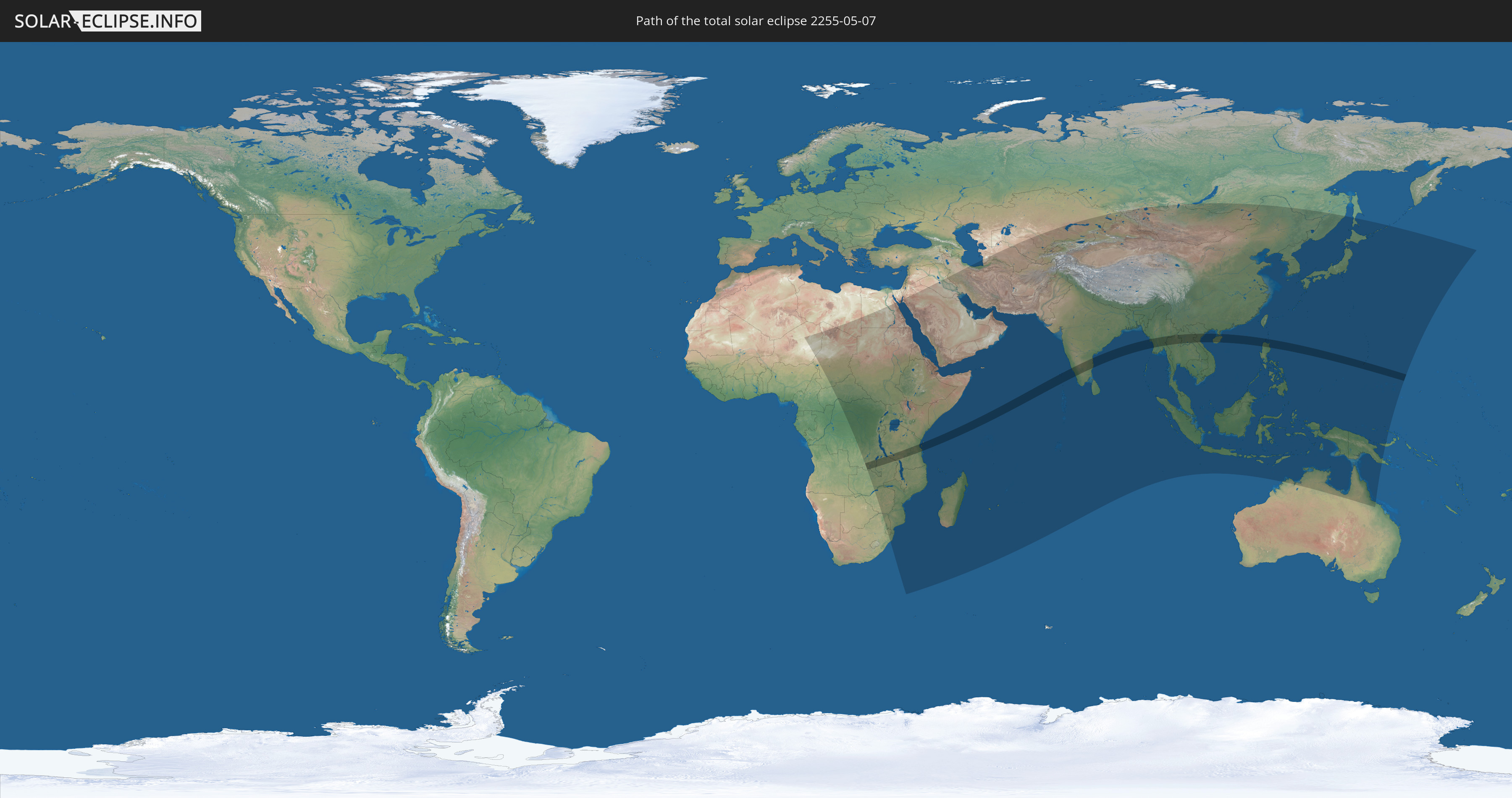
Die Sonnenfinsternis am 07.05.2255 kann man in 81 Ländern als partielle Sonnenfinsternis beobachten.
Der Finsternispfad verläuft durch 12 Länder. Nur in diesen Ländern ist sie als totale Sonnenfinsternis zu sehen.
In den folgenden Ländern ist die Sonnenfinsternis total zu sehen
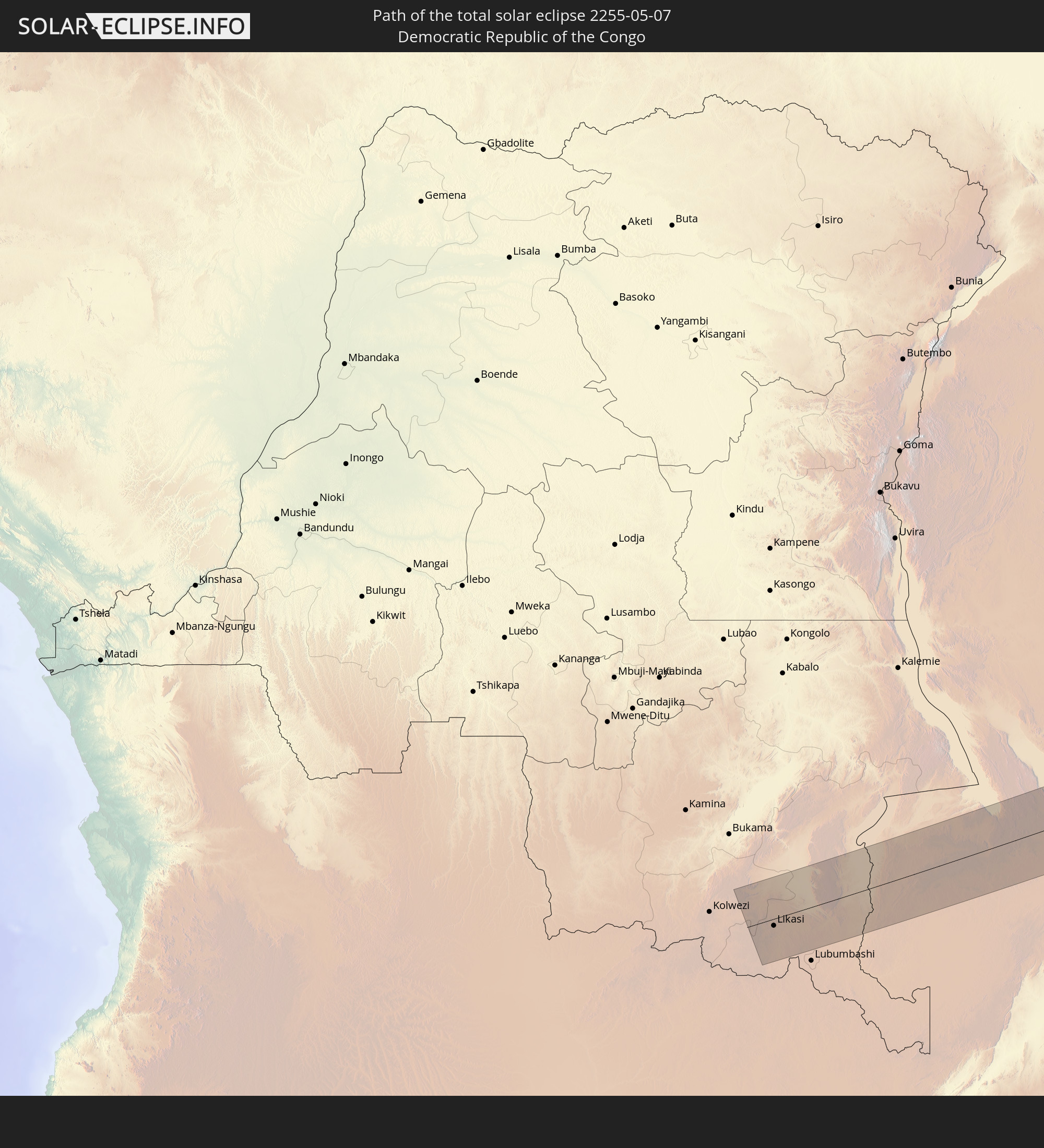 Demokratische Republik Kongo
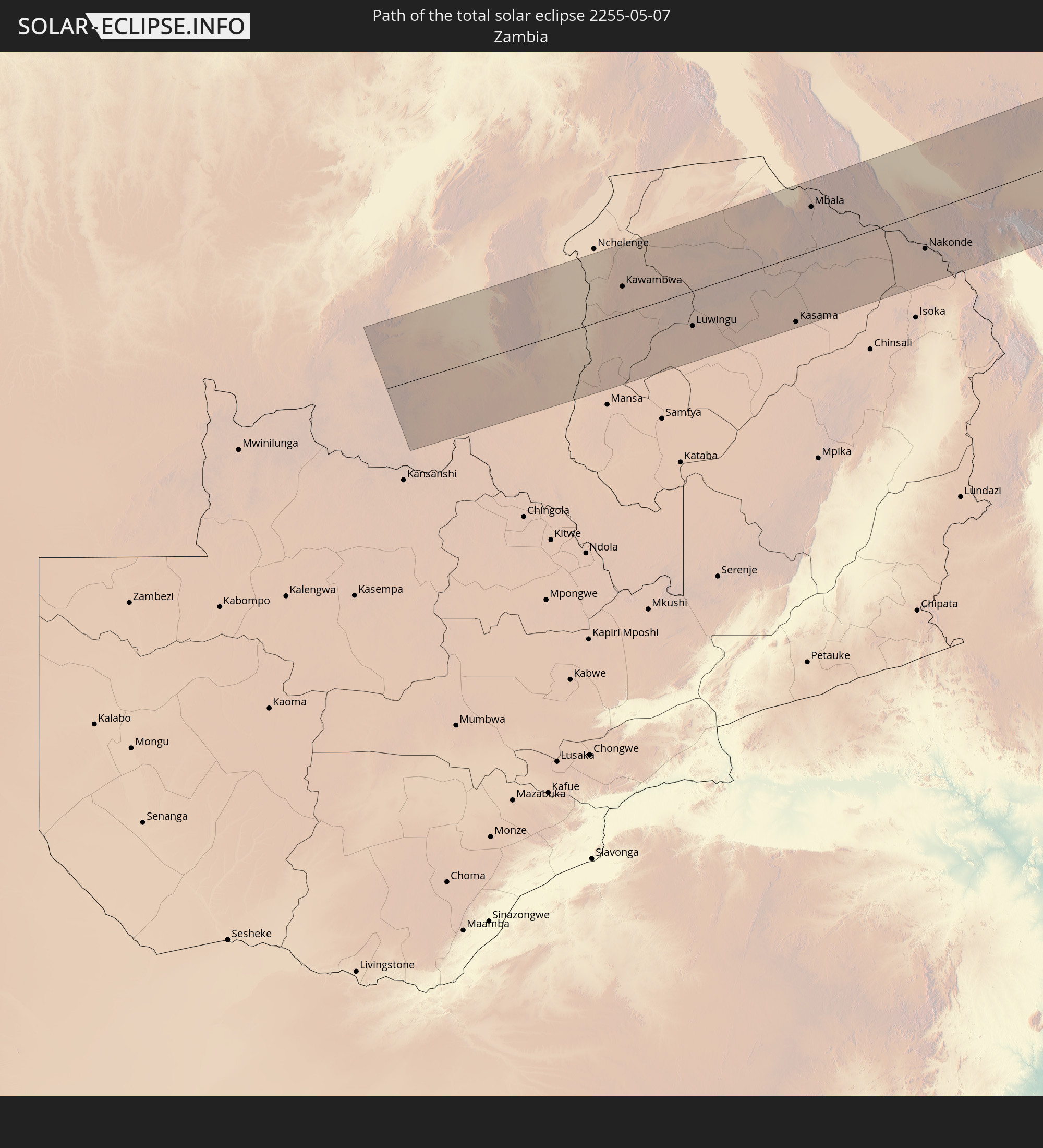 Sambia
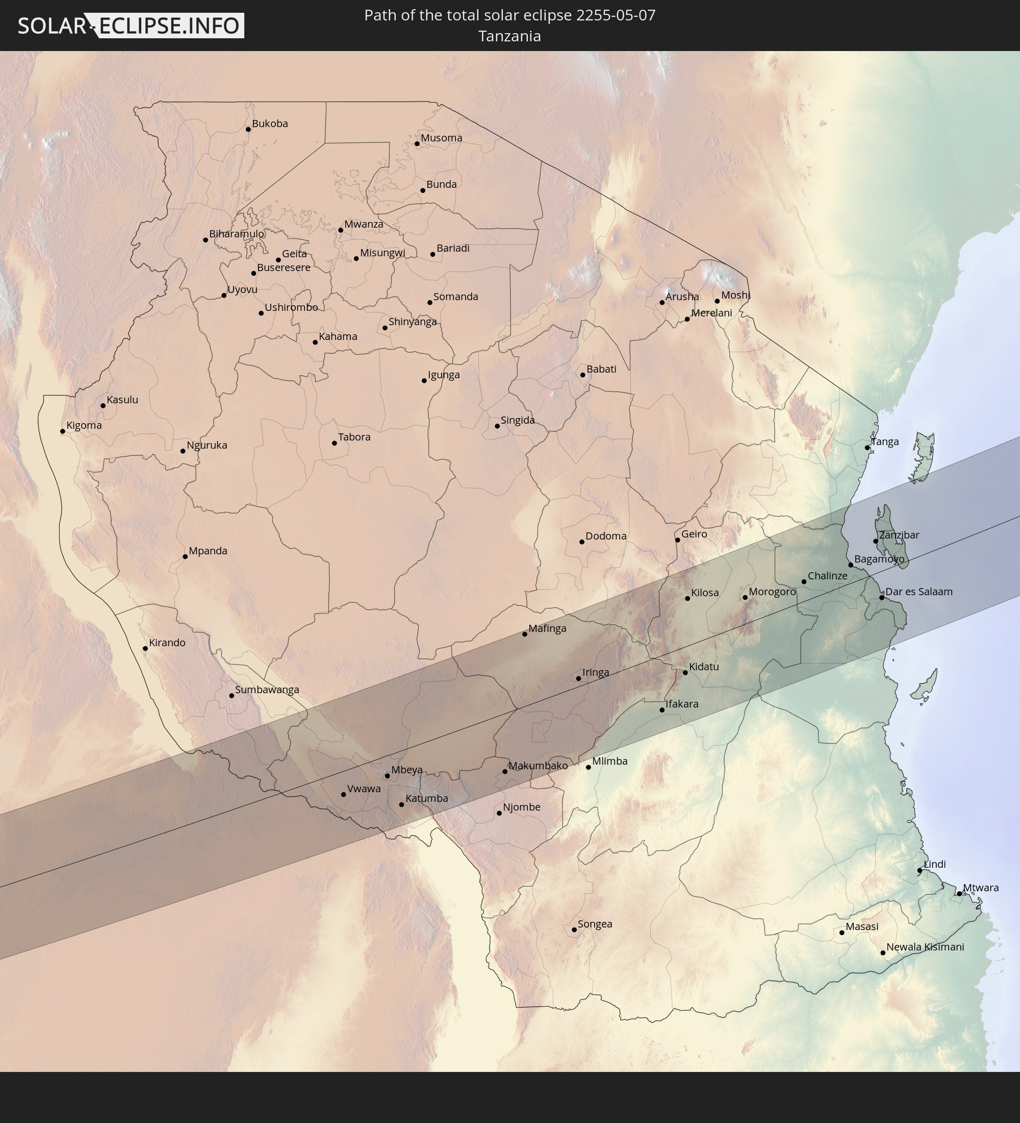 Tansania
 Malawi
 Indien
 Volksrepublik China
 Myanmar
 Thailand
 Laos
Laos
 Vietnam
 Philippinen
 Guam
Guam
In den folgenden Ländern ist die Sonnenfinsternis partiell zu sehen
 Russland
 Niger
Niger
 Libyen
 Demokratische Republik Kongo
 Tschad
 Zentralafrikanische Republik
 Südafrika
 Sudan
Sudan
 Sambia
 Ägypten
 Simbabwe
 Ruanda
 Burundi
 Tansania
 Uganda
 Mosambik
 Swasiland
 Malawi
 Äthiopien
 Kenia
Kenia
 Saudi-Arabien
 Jordanien
 Eritrea
 Irak
Irak
 Französische Süd- und Antarktisgebiete
 Somalia
 Dschibuti
 Jemen
Jemen
 Madagaskar
 Komoren
 Iran
Iran
 Mayotte
 Seychellen
 Kasachstan
 Kuwait
 Bahrain
 Katar
Katar
 Vereinigte Arabische Emirate
 Oman
Oman
 Turkmenistan
 Réunion
 Usbekistan
 Mauritius
 Afghanistan
 Pakistan
 Tadschikistan
 Indien
 Kirgisistan
 Britisches Territorium im Indischen Ozean
 Malediven
 Volksrepublik China
 Sri Lanka
 Nepal
Nepal
 Mongolei
 Bangladesch
 Bhutan
 Myanmar
 Indonesien
 Kokosinseln
 Thailand
 Malaysia
 Laos
Laos
 Vietnam
 Kambodscha
 Singapur
 Weihnachtsinsel
 Australien
 Macau
Macau
 Hongkong
 Brunei
 Taiwan
 Philippinen
 Japan
Japan
 Osttimor
 Nordkorea
 Südkorea
 Palau
Palau
 Föderierte Staaten von Mikronesien
 Papua-Neuguinea
 Guam
Guam
 Nördliche Marianen
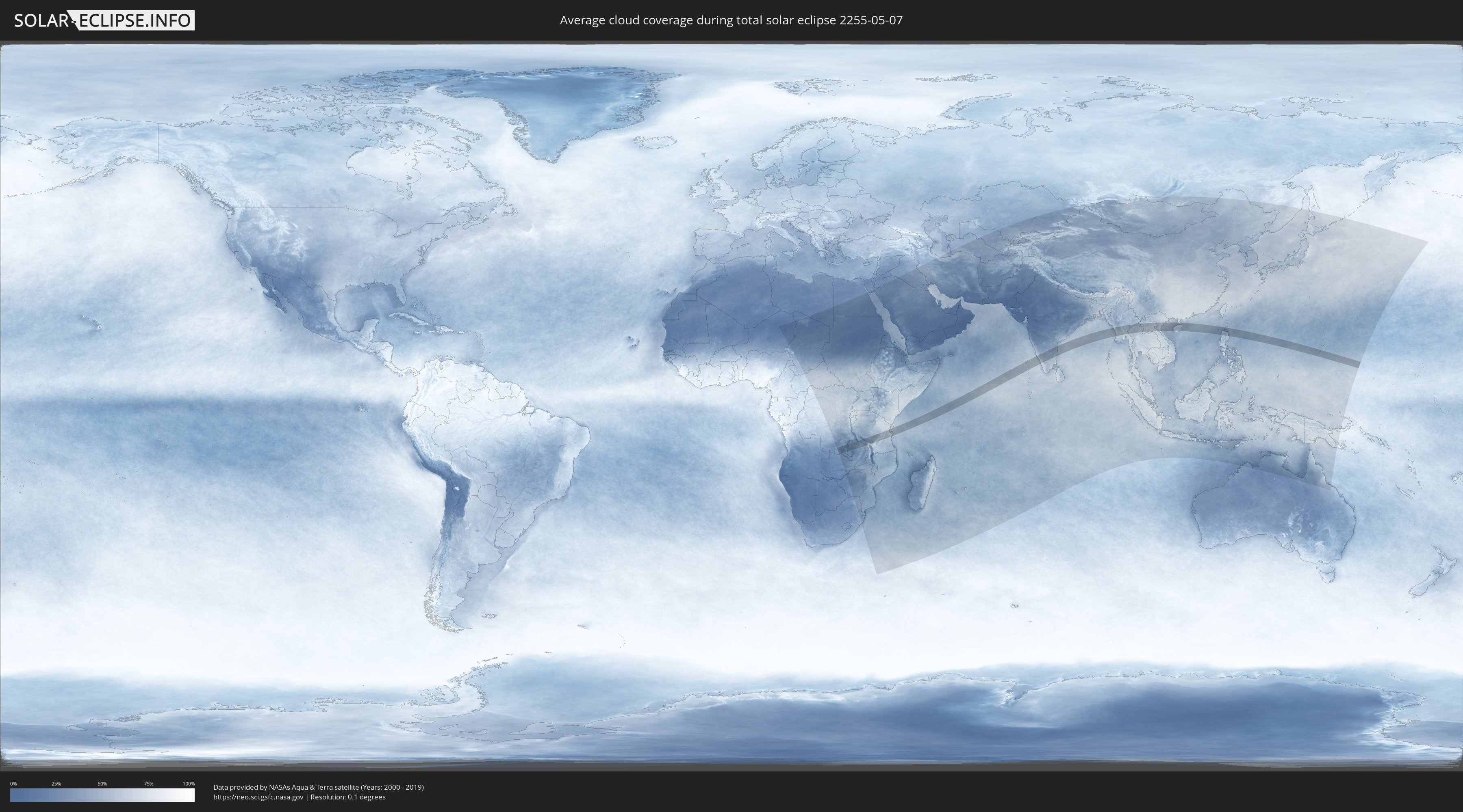
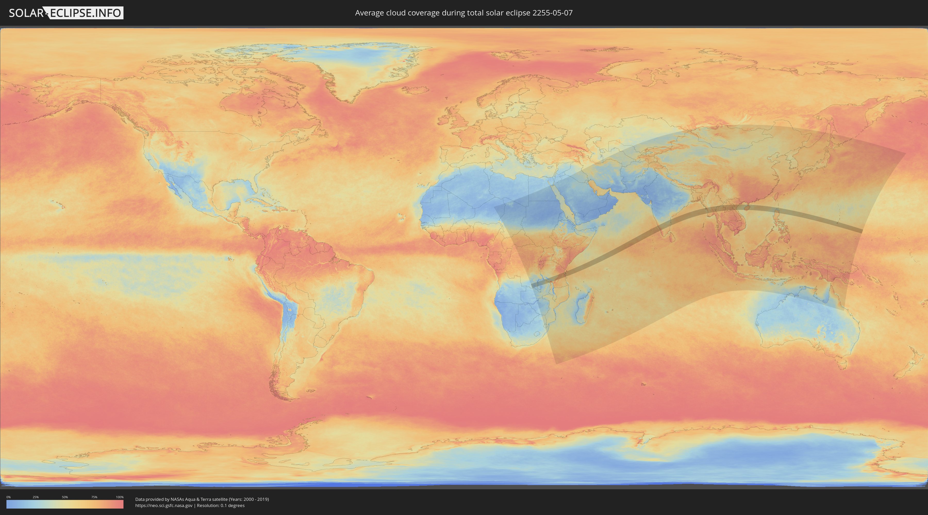
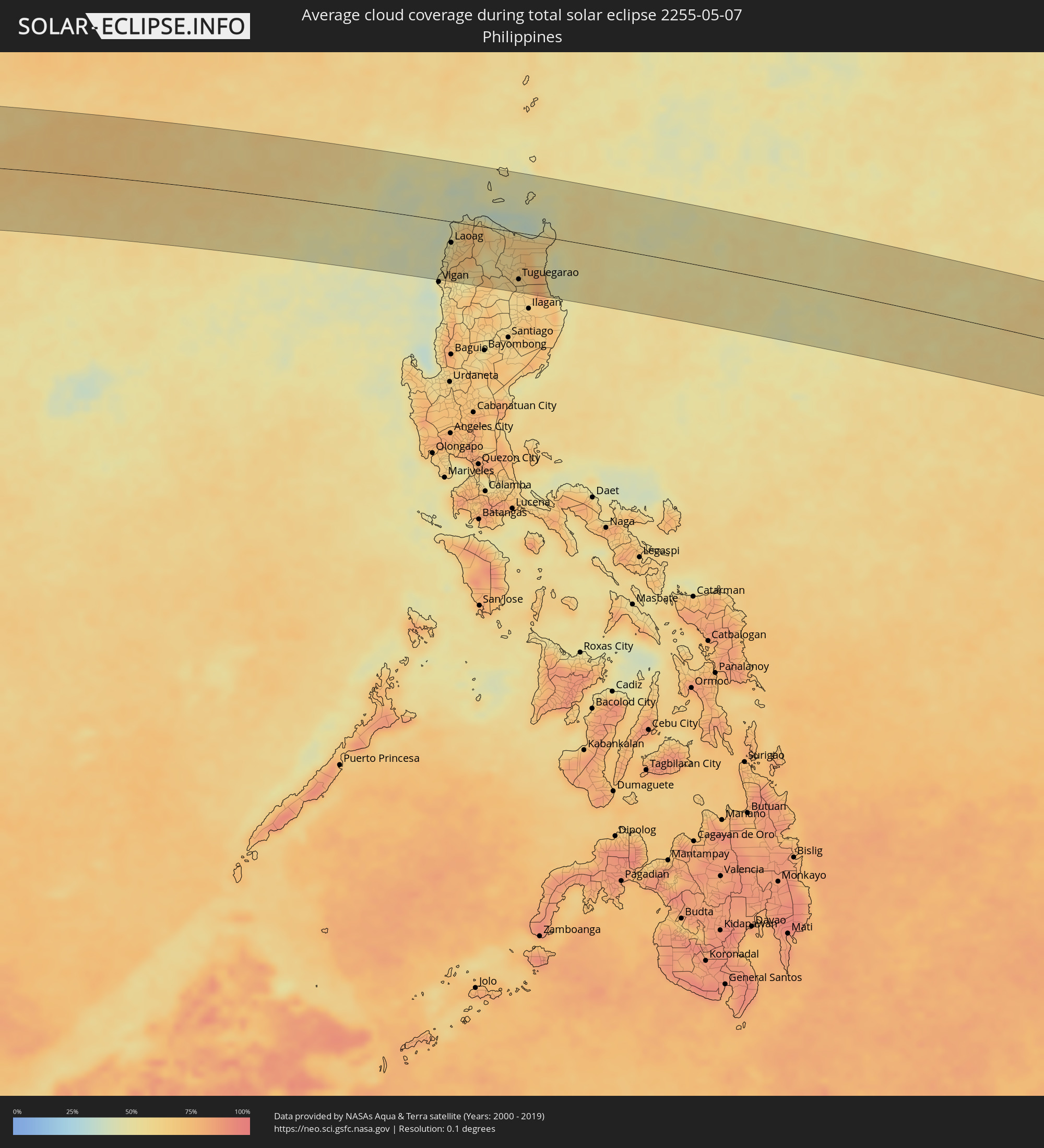
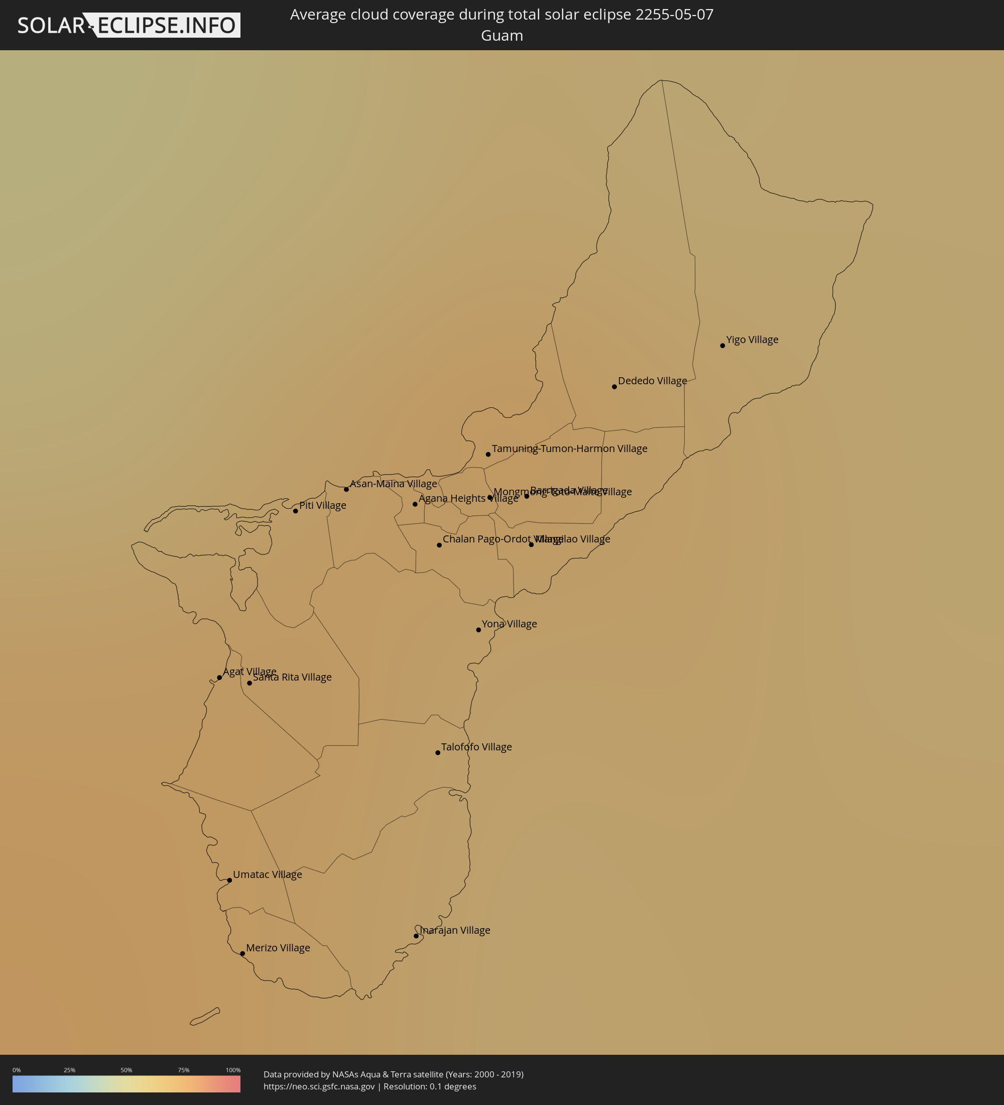
Wie wird das Wetter während der totalen Sonnenfinsternis am 07.05.2255?
Wo ist der beste Ort, um die totale Sonnenfinsternis vom 07.05.2255 zu beobachten?
Die folgenden Karten zeigen die durchschnittliche Bewölkung für den Tag, an dem die totale Sonnenfinsternis
stattfindet. Mit Hilfe der Karten lässt sich der Ort entlang des Finsternispfades eingrenzen,
der die besten Aussichen auf einen klaren wolkenfreien Himmel bietet.
Trotzdem muss man immer lokale Gegenenheiten beachten und sollte sich genau über das Wetter an seinem
gewählten Beobachtungsort informieren.
Die Daten stammen von den beiden NASA-Satelliten
AQUA und TERRA
und wurden über einen Zeitraum von 19 Jahren (2000 - 2019) gemittelt.
Detaillierte Länderkarten
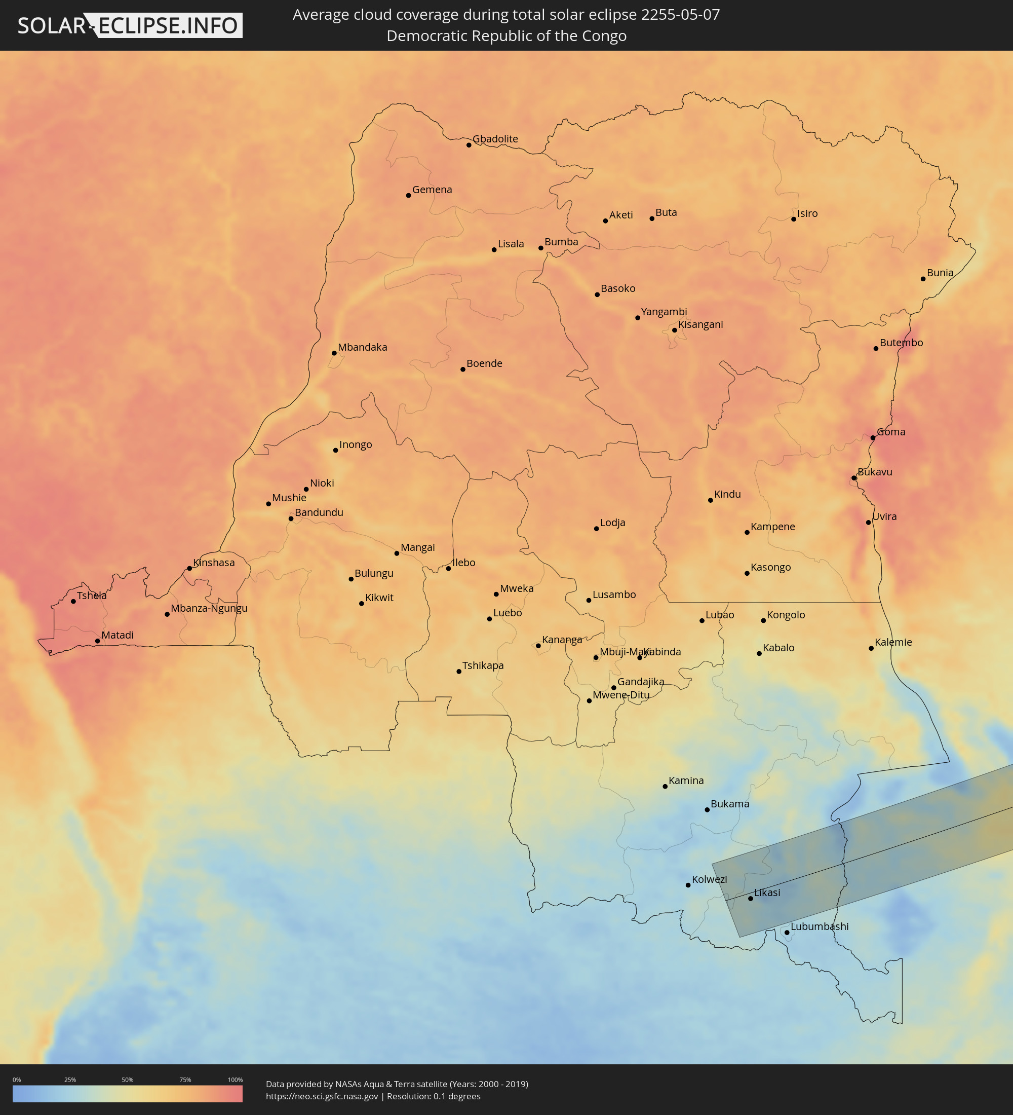 Demokratische Republik Kongo
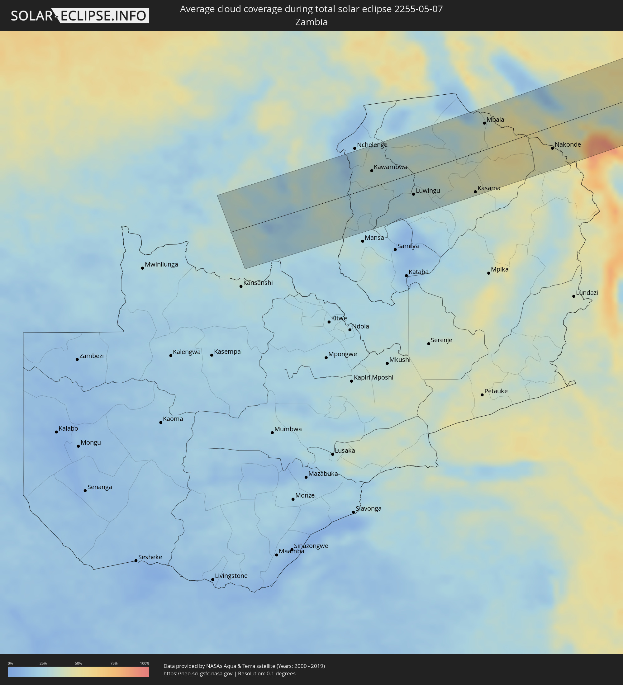 Sambia
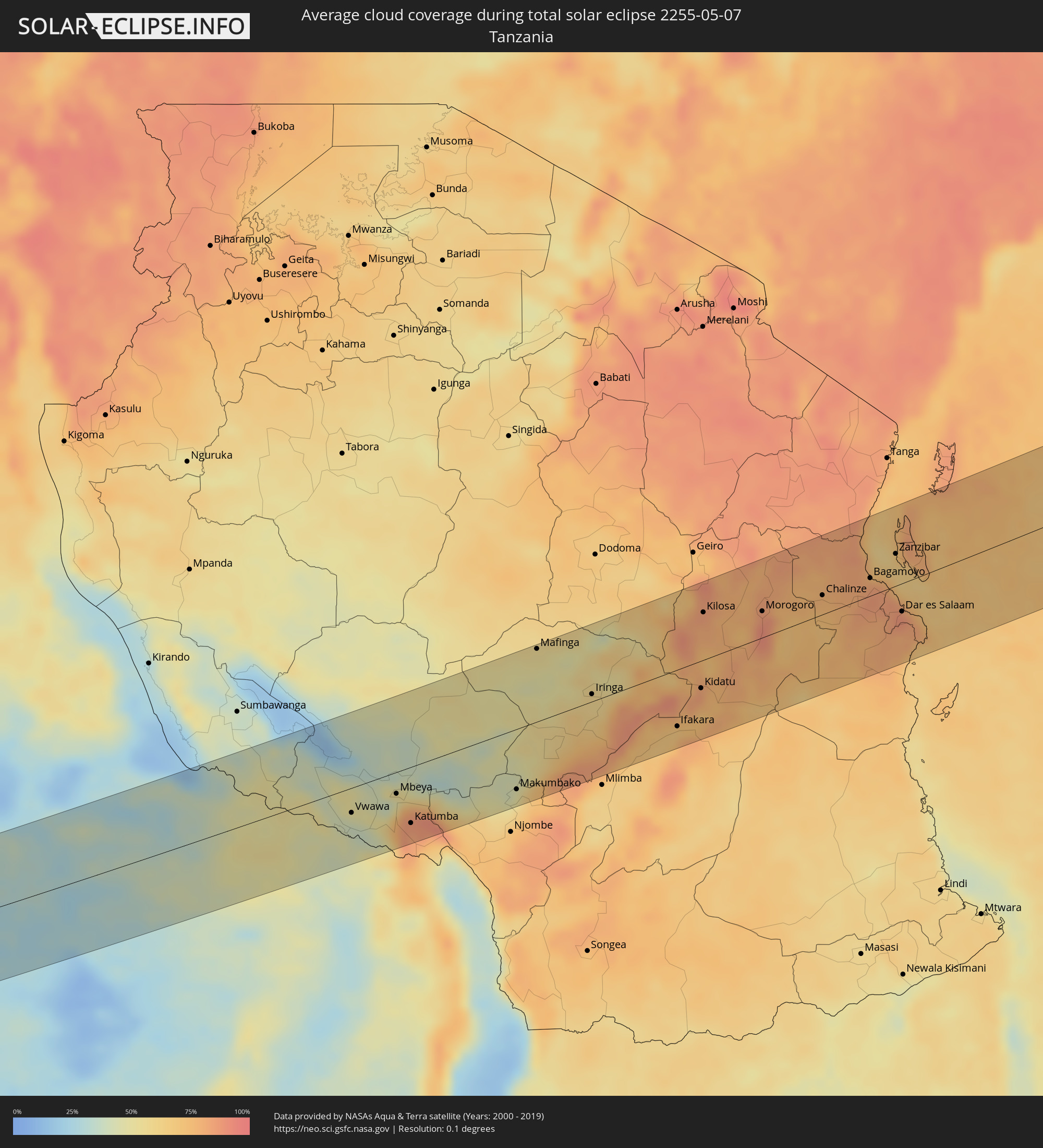 Tansania
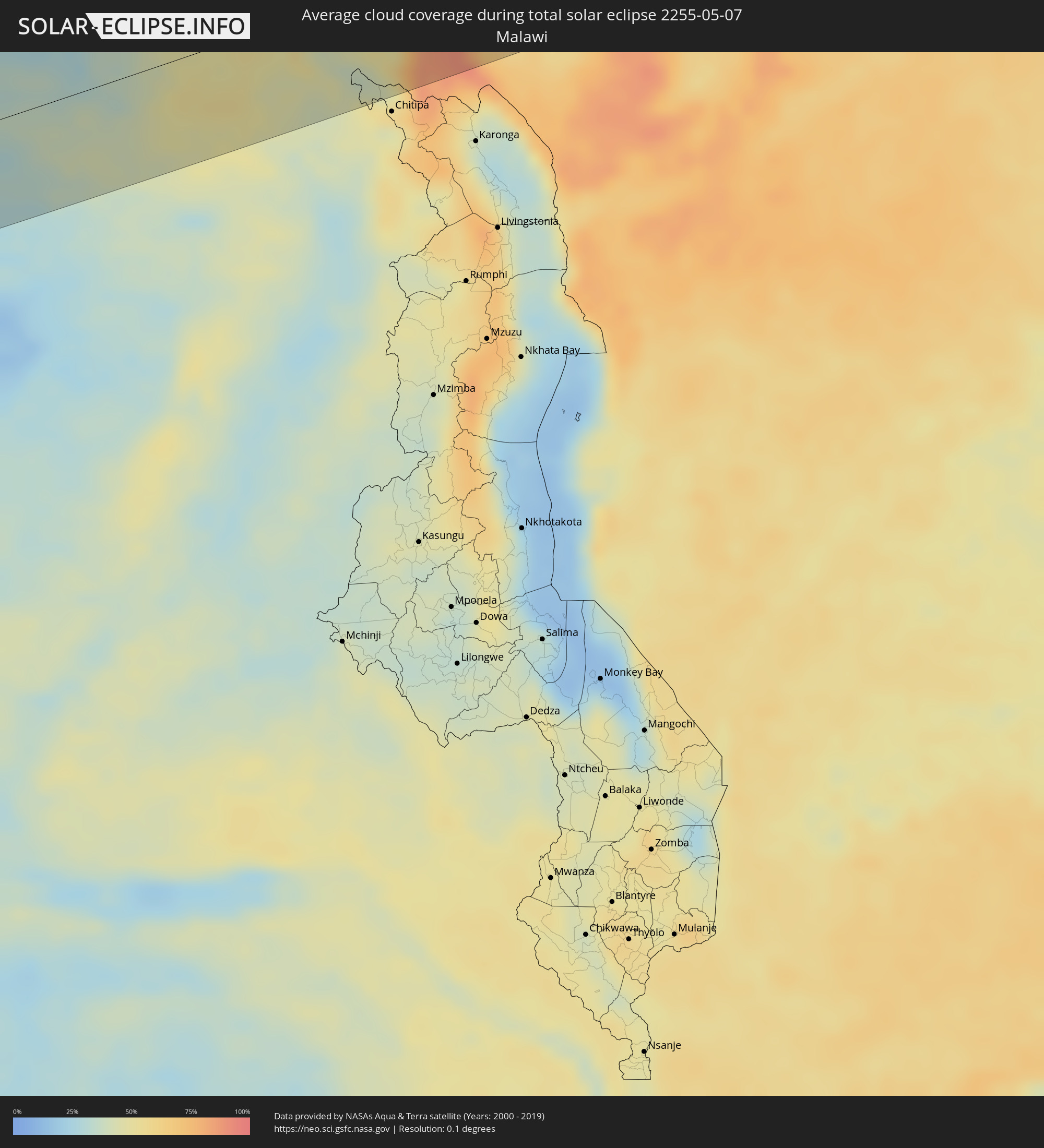 Malawi
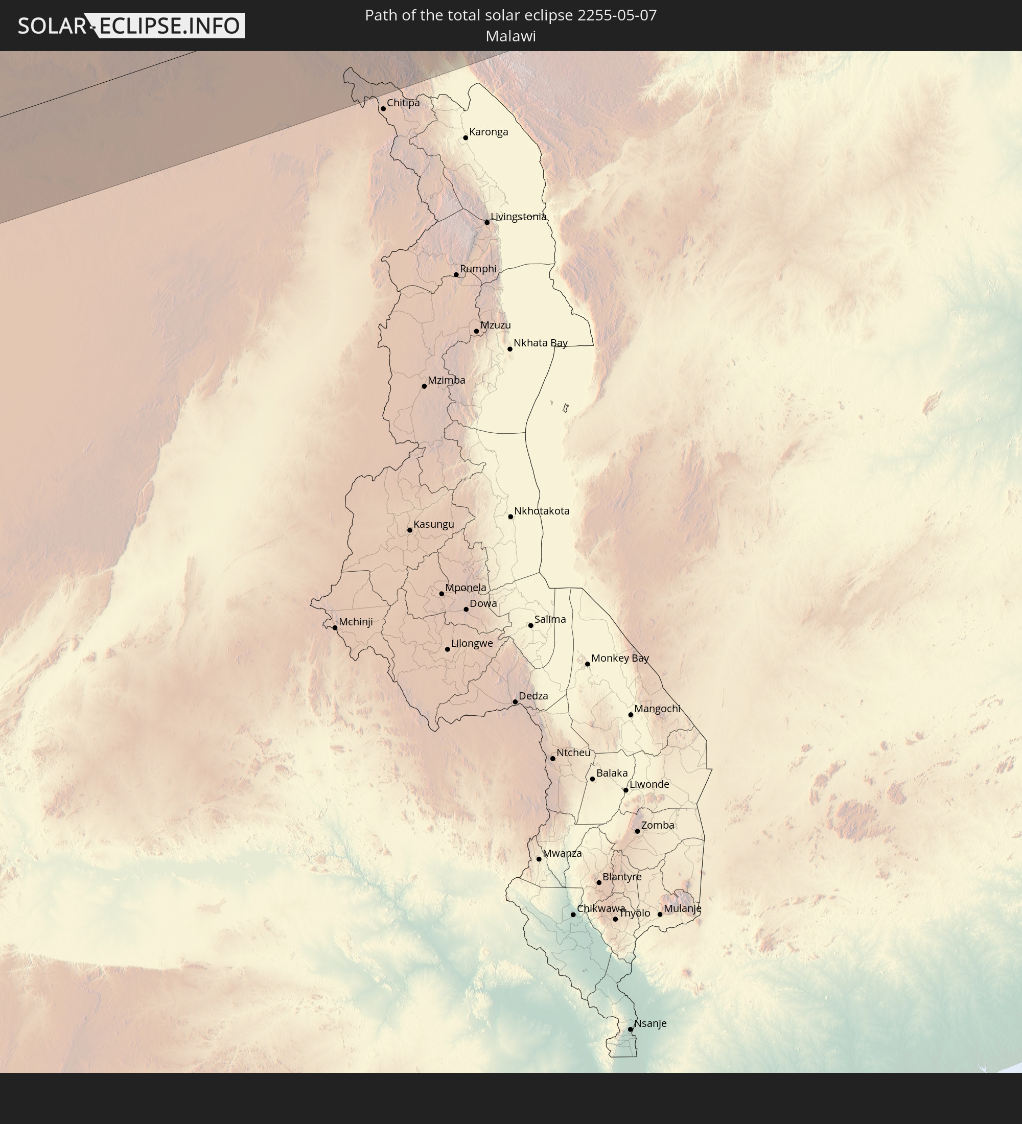
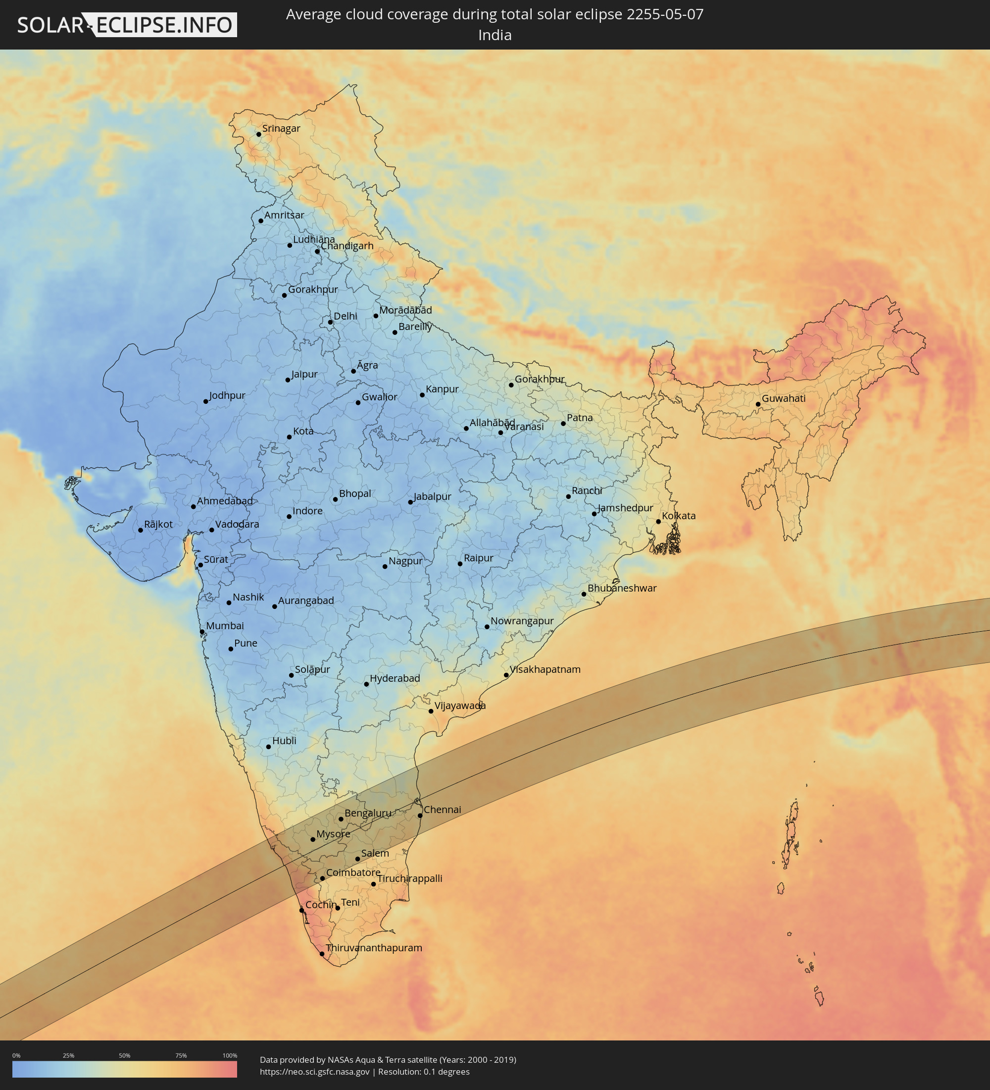 Indien
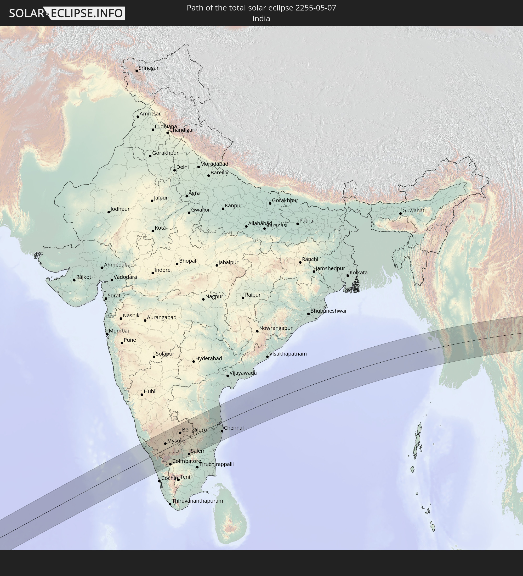
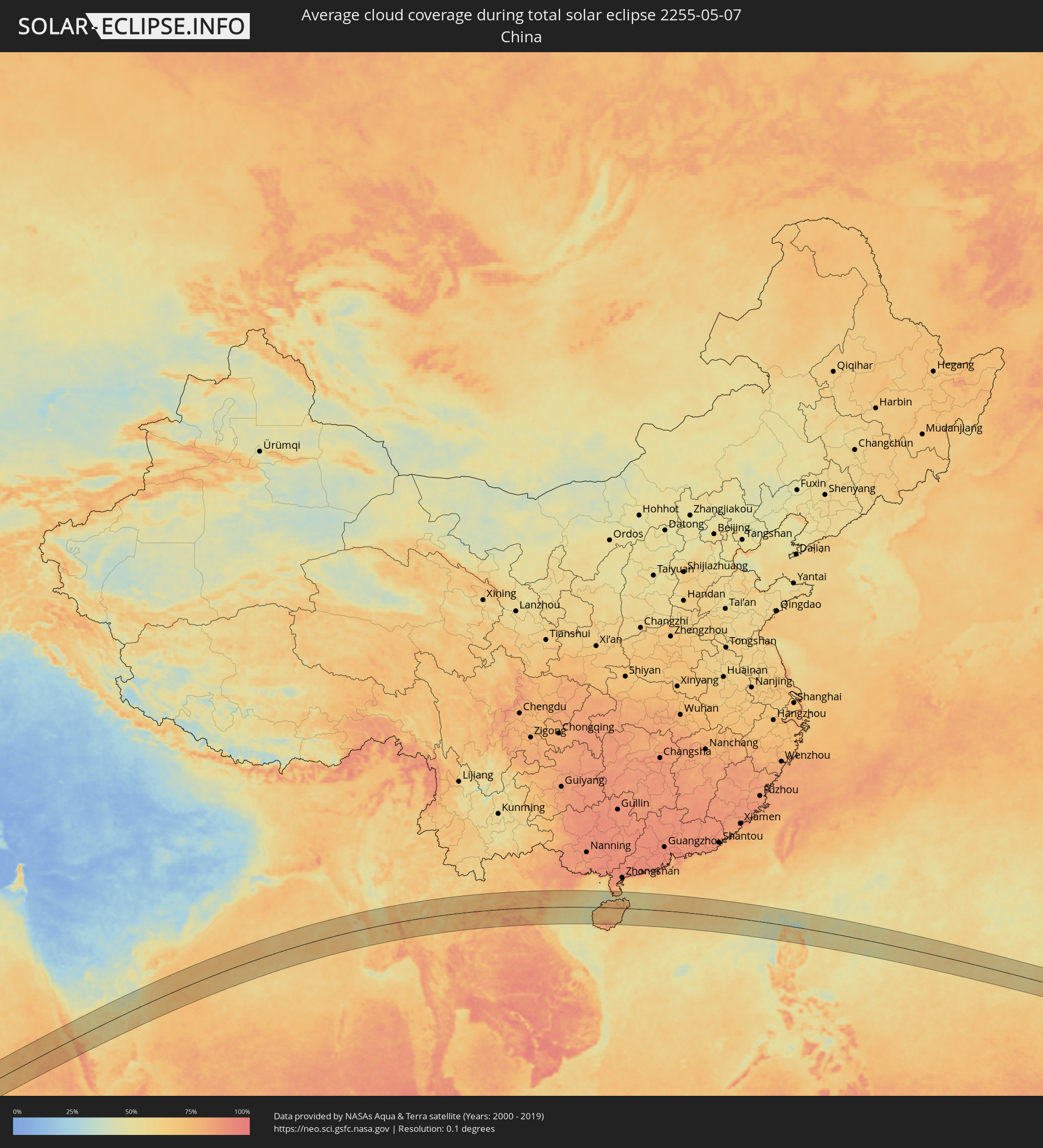 Volksrepublik China
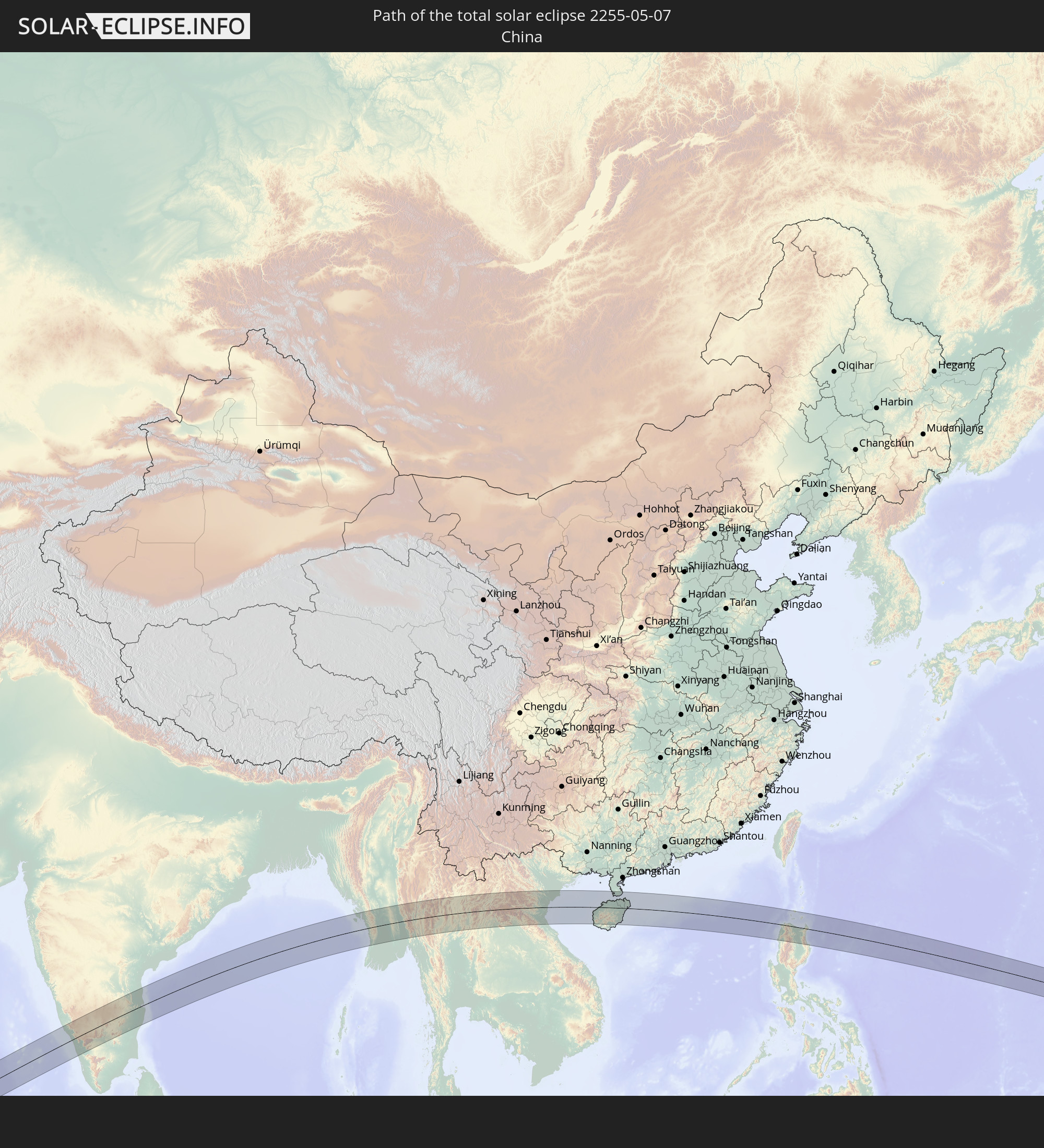
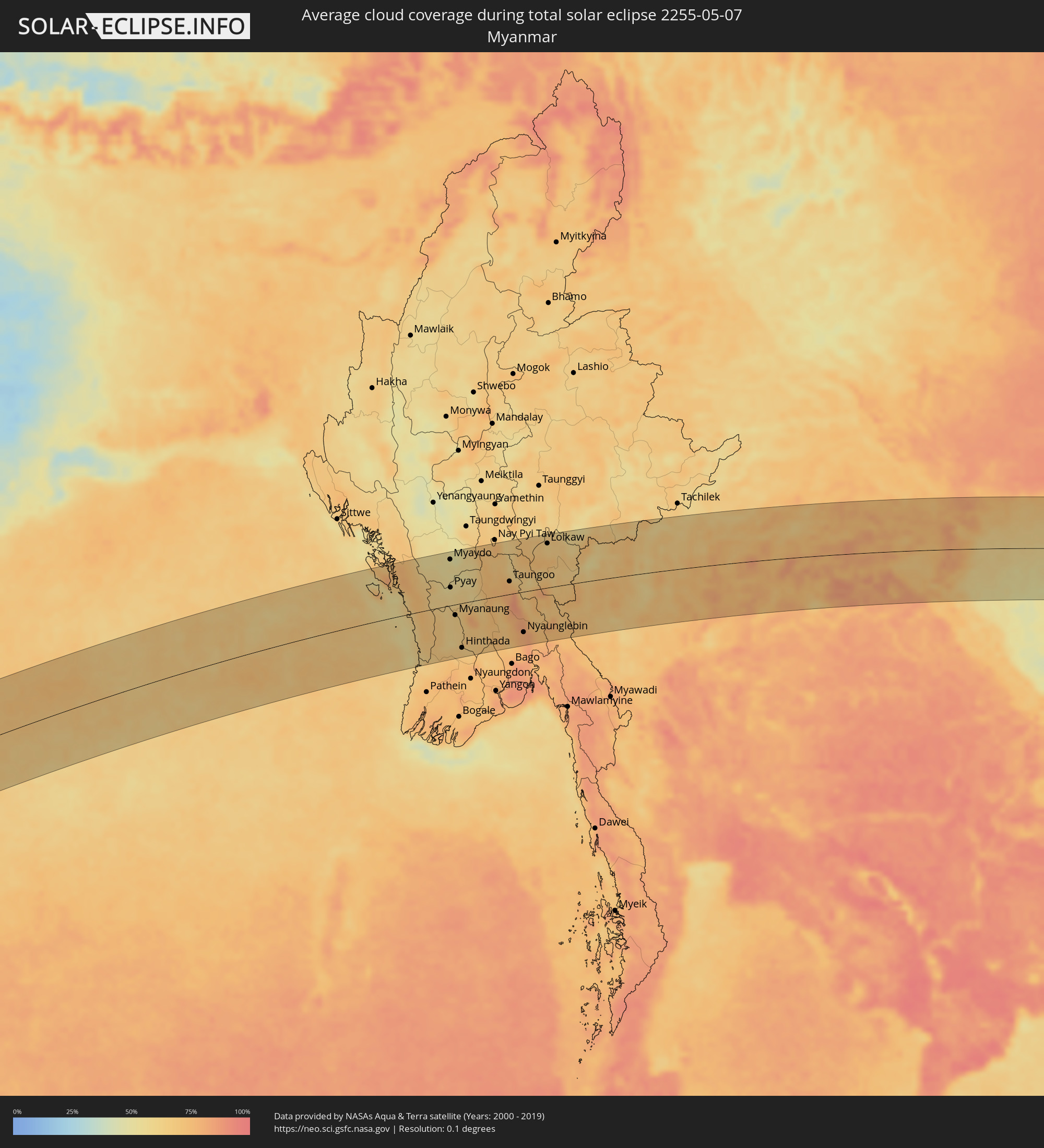 Myanmar
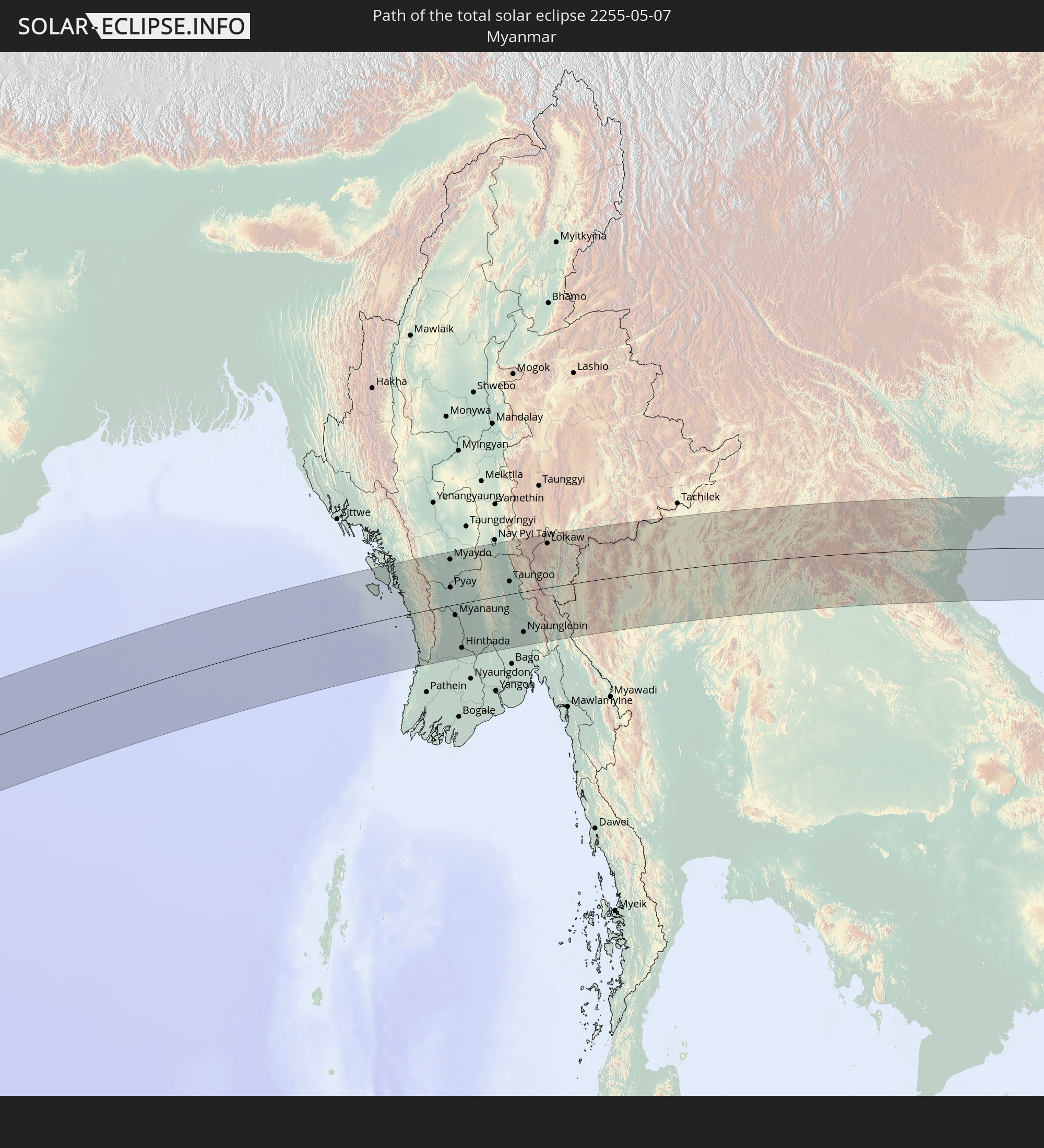
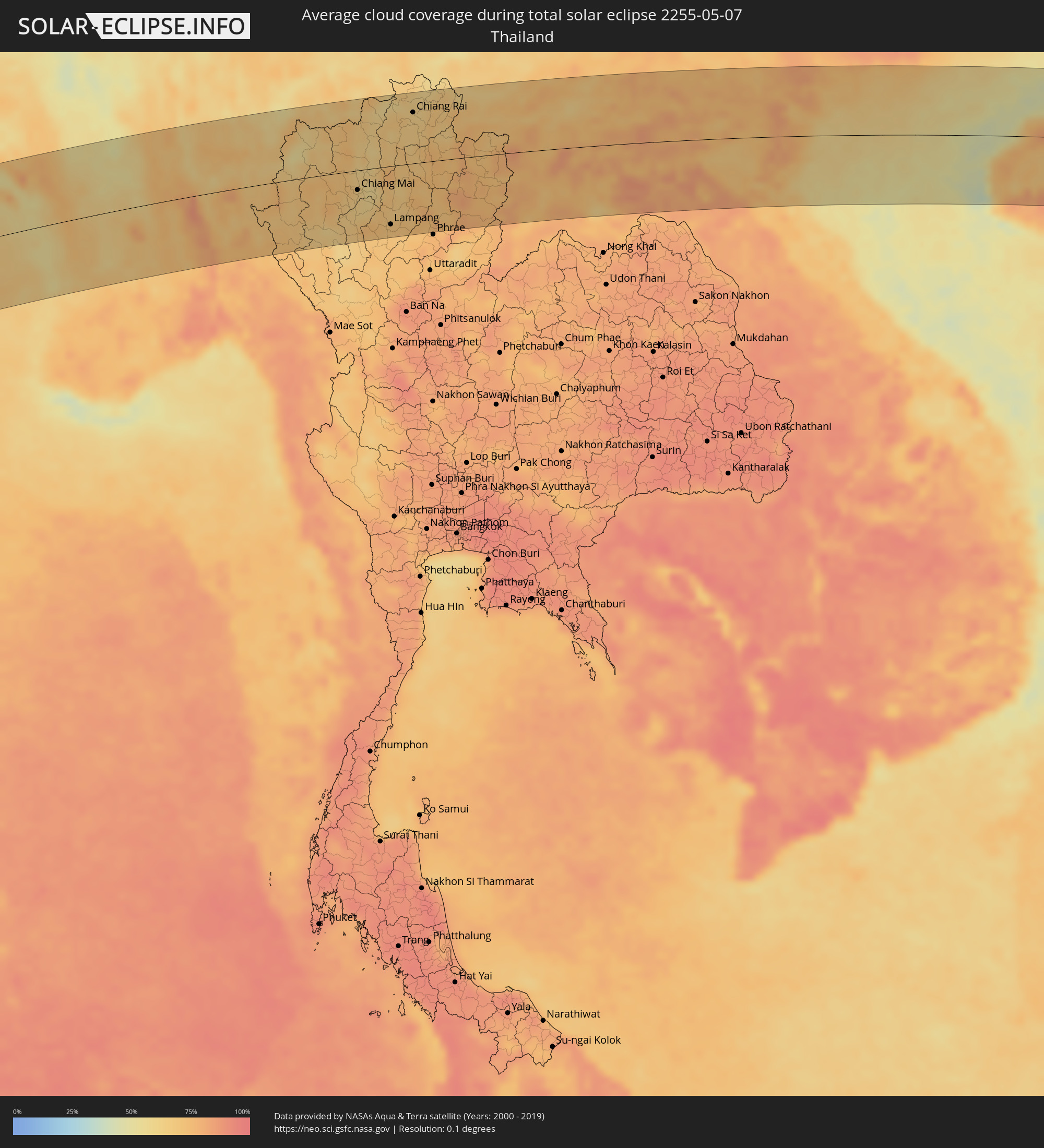 Thailand
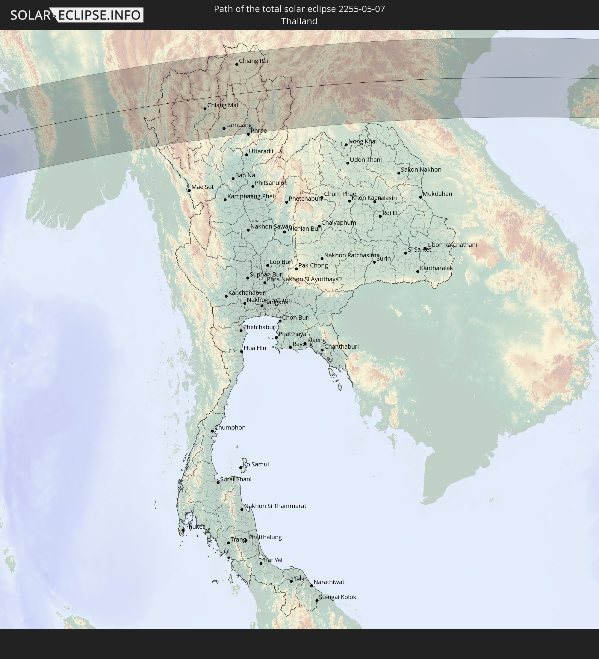
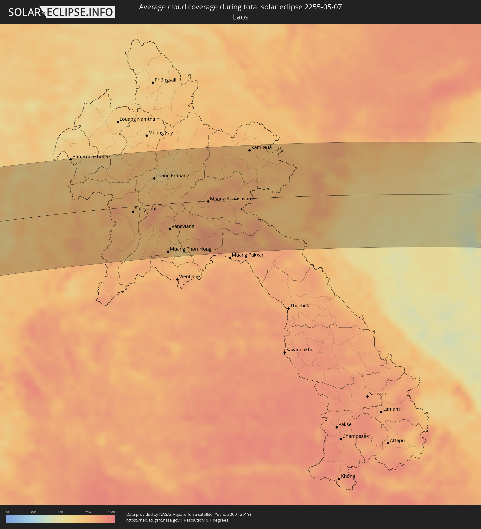 Laos
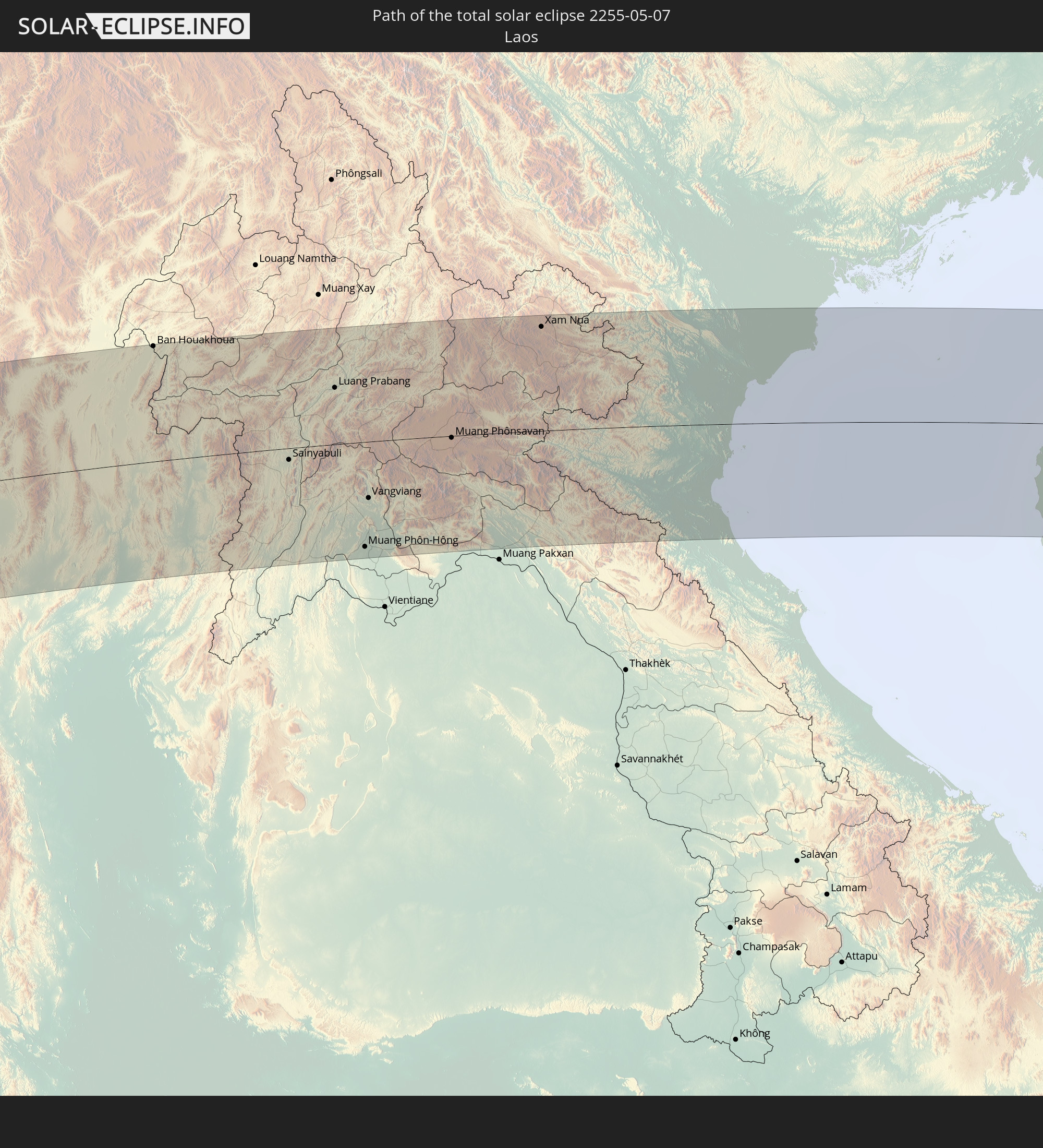
Laos
 Vietnam
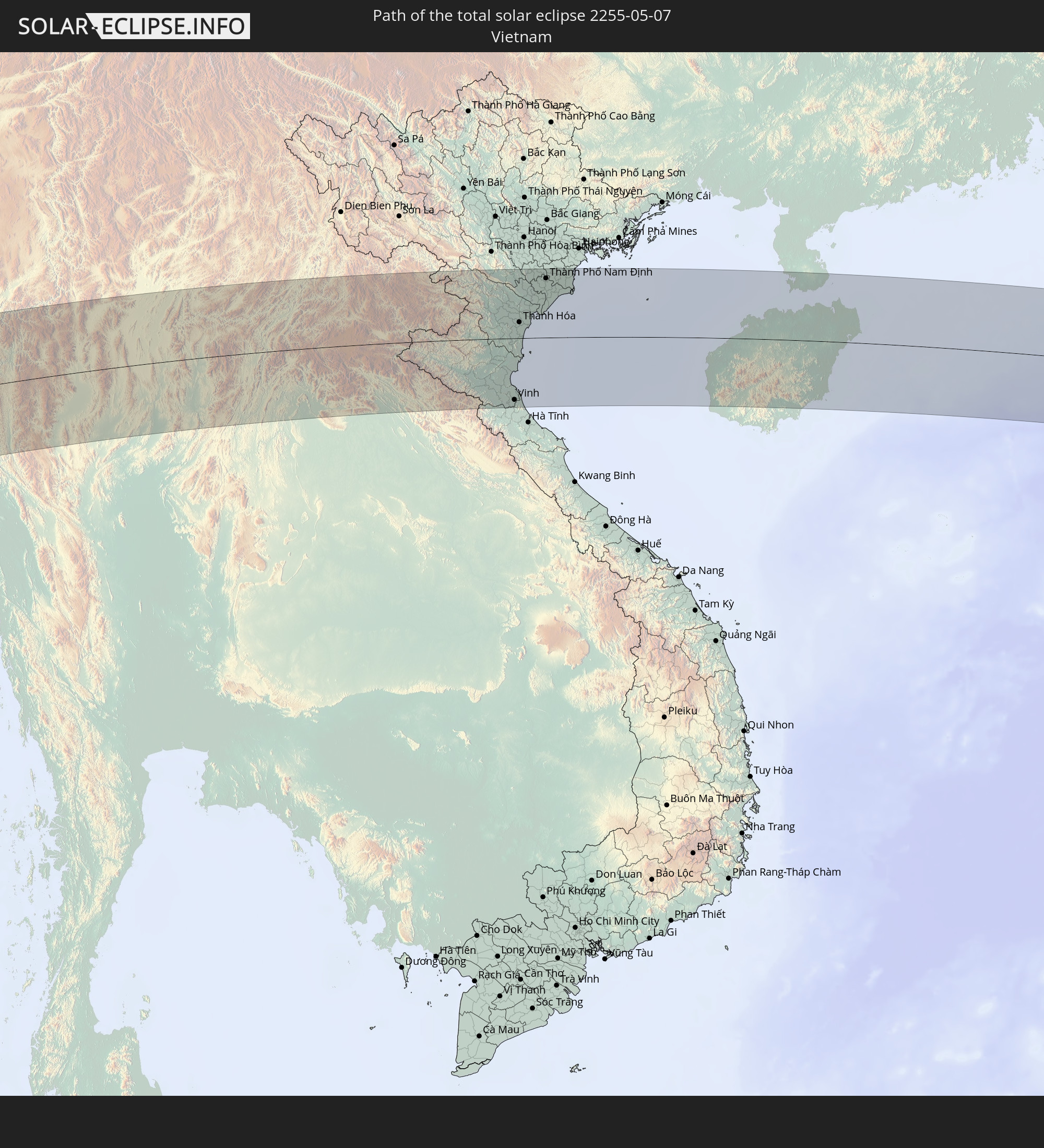
 Philippinen
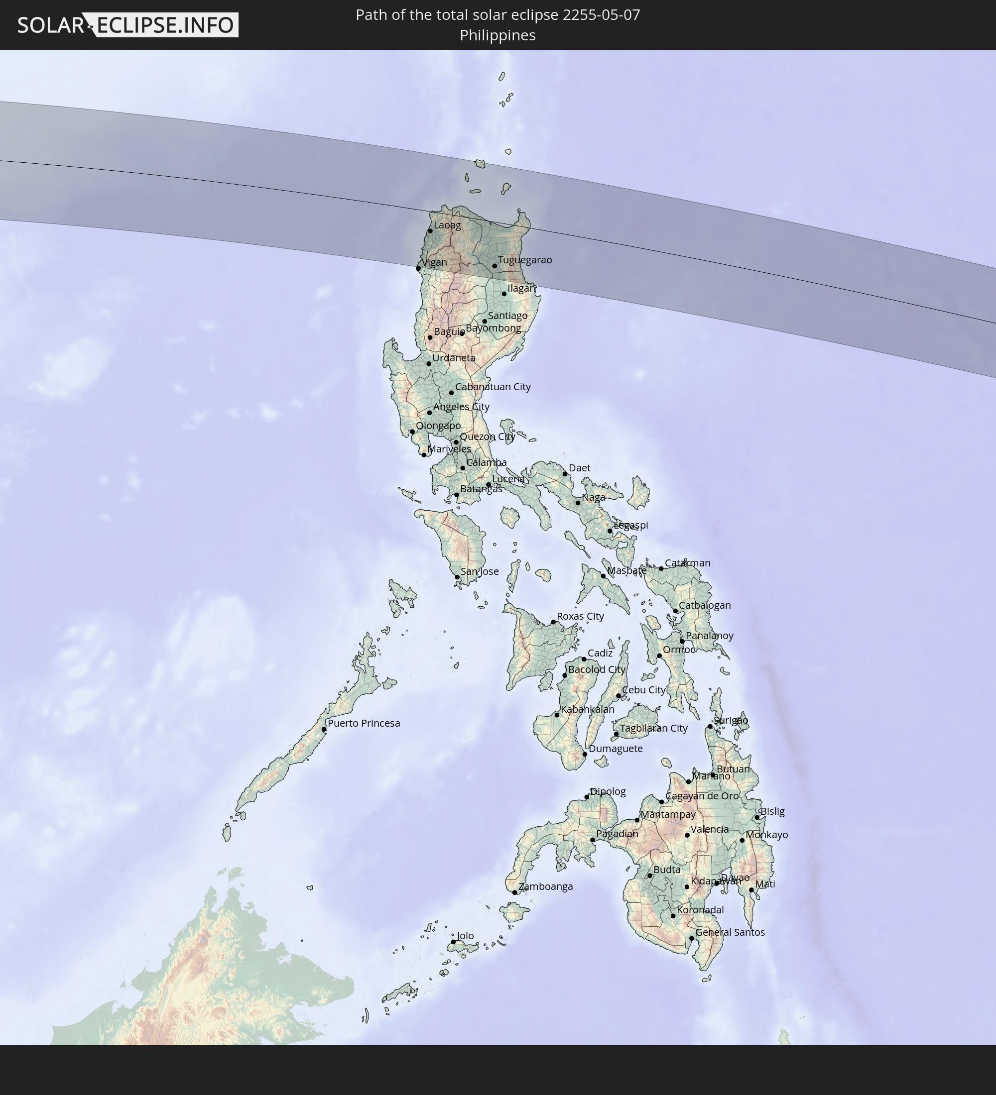
 Guam
Guam
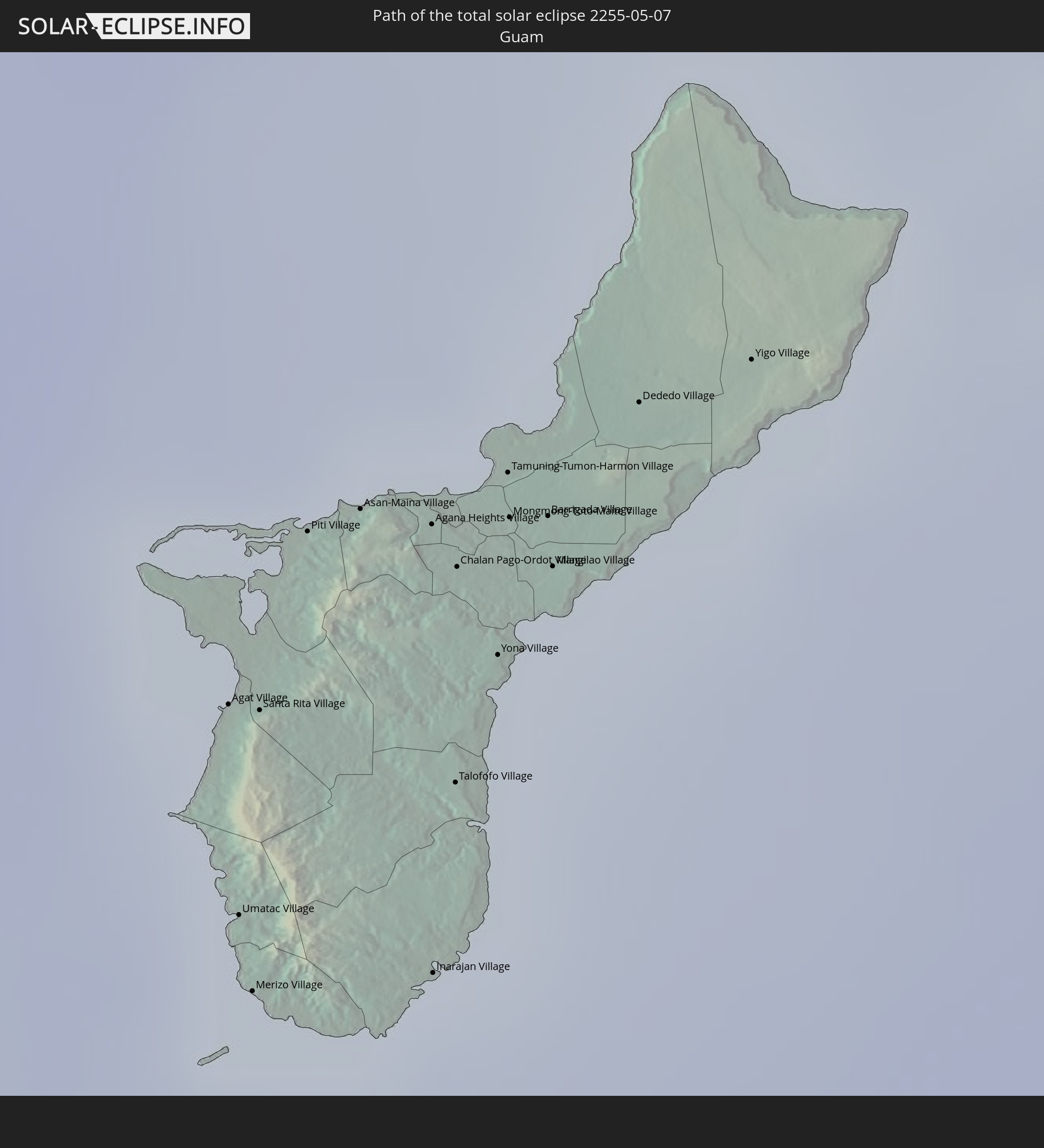
Orte im Finsternispfad
Die nachfolgene Tabelle zeigt Städte und Orte mit mehr als 5.000 Einwohnern, die sich im Finsternispfad befinden. Städte mit mehr als 100.000 Einwohnern sind dick gekennzeichnet. Mit einem Klick auf den Ort öffnet sich eine Detailkarte die die Lage des jeweiligen Ortes zusammen mit dem Verlauf der zentralen Finsternis präsentiert.
| Ort | Typ | Dauer der Verfinsterung | Ortszeit bei maximaler Verfinsterung | Entfernung zur Zentrallinie | Ø Bewölkung |
|
Kambove, Katanga
|
total | - | 06:25:26 UTC+02:00 | 12 km | 32% |
|
Likasi, Katanga
|
total | - | 06:25:25 UTC+02:00 | 14 km | 30% |
|
Kawambwa, Luapula
|
total | - | 06:25:39 UTC+02:00 | 35 km | 30% |
|
Luwingu, Northern
|
total | - | 06:25:34 UTC+02:00 | 44 km | 28% |
|
Mpulungu, Northern
|
total | - | 06:26:03 UTC+02:00 | 73 km | 34% |
|
Kasama, Northern
|
total | - | 06:25:39 UTC+02:00 | 83 km | 36% |
|
Mbala, Northern
|
total | - | 06:26:03 UTC+02:00 | 56 km | 36% |
|
Mungwi, Northern
|
total | - | 06:25:41 UTC+02:00 | 85 km | 39% |
|
Nakonde, Muchinga Province
|
total | - | 06:26:03 UTC+02:00 | 47 km | 46% |
|
Tunduma, Mbeya
|
total | - | 07:26:04 UTC+03:00 | 43 km | 46% |
|
Vwawa, Mbeya
|
total | - | 07:26:09 UTC+03:00 | 30 km | 44% |
|
Mbeya, Mbeya
|
total | - | 07:26:17 UTC+03:00 | 26 km | 59% |
|
Katumba, Mbeya
|
total | - | 07:26:13 UTC+03:00 | 67 km | 86% |
|
Rujewa, Mbeya
|
total | - | 07:26:31 UTC+03:00 | 39 km | 44% |
|
Makumbako, Njombe
|
total | - | 07:26:33 UTC+03:00 | 72 km | 51% |
|
Mafinga, Iringa
|
total | - | 07:27:10 UTC+03:00 | 87 km | 52% |
|
Iringa, Iringa
|
total | - | 07:27:07 UTC+03:00 | 9 km | 58% |
|
Ilula, Iringa
|
total | - | 07:27:14 UTC+03:00 | 5 km | 70% |
|
Ifakara, Morogoro
|
total | - | 07:27:13 UTC+03:00 | 67 km | 71% |
|
Kidatu, Morogoro
|
total | - | 07:27:27 UTC+03:00 | 33 km | 76% |
|
Kilosa, Morogoro
|
total | - | 07:27:48 UTC+03:00 | 57 km | 83% |
|
Morogoro, Morogoro
|
total | - | 07:28:01 UTC+03:00 | 31 km | 88% |
|
Chalinze, Pwani
|
total | - | 07:28:18 UTC+03:00 | 23 km | 76% |
|
Mvomero, Pwani
|
total | - | 07:28:35 UTC+03:00 | 50 km | 82% |
|
Mlandizi, Pwani
|
total | - | 07:28:24 UTC+03:00 | 1 km | 82% |
|
Bagamoyo, Pwani
|
total | - | 07:28:35 UTC+03:00 | 21 km | 82% |
|
Zanzibar, Zanzibar Urban/West
|
total | - | 07:28:48 UTC+03:00 | 38 km | 64% |
|
Dar es Salaam, Dar es Salaam
|
total | - | 07:28:32 UTC+03:00 | 33 km | 85% |
|
Kozhikode, Kerala
|
total | - | 11:02:10 UTC+05:30 | 28 km | 69% |
|
Mysore, Karnataka
|
total | - | 11:05:34 UTC+05:30 | 34 km | 56% |
|
Mandya, Karnataka
|
total | - | 11:06:29 UTC+05:30 | 44 km | 53% |
|
Coimbatore, Tamil Nadu
|
total | - | 11:04:43 UTC+05:30 | 111 km | 57% |
|
Bengaluru, Karnataka
|
total | - | 11:08:46 UTC+05:30 | 55 km | 55% |
|
Erode, Tamil Nadu
|
total | - | 11:07:01 UTC+05:30 | 114 km | 62% |
|
Kolār, Karnataka
|
total | - | 11:10:18 UTC+05:30 | 47 km | 56% |
|
Salem, Tamil Nadu
|
total | - | 11:08:29 UTC+05:30 | 104 km | 57% |
|
Robertsonpet, Karnataka
|
total | - | 11:10:26 UTC+05:30 | 22 km | 54% |
|
Madanapalle, Andhra Pradesh
|
total | - | 11:11:45 UTC+05:30 | 71 km | 45% |
|
Ambur, Tamil Nadu
|
total | - | 11:11:20 UTC+05:30 | 16 km | 53% |
|
Tiruvannāmalai, Tamil Nadu
|
total | - | 11:11:32 UTC+05:30 | 89 km | 60% |
|
Vellore, Tamil Nadu
|
total | - | 11:12:33 UTC+05:30 | 22 km | 51% |
|
Tirupati, Andhra Pradesh
|
total | - | 11:14:10 UTC+05:30 | 37 km | 50% |
|
Kānchipuram, Tamil Nadu
|
total | - | 11:13:54 UTC+05:30 | 57 km | 63% |
|
Nellore, Andhra Pradesh
|
total | - | 11:16:38 UTC+05:30 | 94 km | 46% |
|
Āvadi, Tamil Nadu
|
total | - | 11:15:18 UTC+05:30 | 47 km | 58% |
|
Pallāvaram, Tamil Nadu
|
total | - | 11:15:14 UTC+05:30 | 64 km | 59% |
|
Chennai, Tamil Nadu
|
total | - | 11:15:43 UTC+05:30 | 58 km | 60% |
|
Thayetmyo, Magway
|
total | - | 13:02:50 UTC+06:30 | 93 km | 55% |
|
Myaydo, Magway
|
total | - | 13:02:56 UTC+06:30 | 98 km | 54% |
|
Pyay, Bago
|
total | - | 13:02:39 UTC+06:30 | 38 km | 57% |
|
Myanaung, Ayeyarwady
|
total | - | 13:02:36 UTC+06:30 | 23 km | 64% |
|
Hinthada, Ayeyarwady
|
total | - | 13:02:36 UTC+06:30 | 95 km | 68% |
|
Paungde, Bago
|
total | - | 13:03:14 UTC+06:30 | 4 km | 63% |
|
Letpandan, Bago
|
total | - | 13:03:29 UTC+06:30 | 86 km | 70% |
|
Tharyarwady, Bago
|
total | - | 13:03:31 UTC+06:30 | 101 km | 68% |
|
Taungoo, Bago
|
total | - | 13:06:00 UTC+06:30 | 27 km | 75% |
|
Pyu, Bago
|
total | - | 13:05:46 UTC+06:30 | 23 km | 81% |
|
Nyaunglebin, Bago
|
total | - | 13:06:16 UTC+06:30 | 86 km | 80% |
|
Loikaw, Kayah
|
total | - | 13:08:27 UTC+06:30 | 94 km | 63% |
|
Chom Thong, Chiang Mai
|
total | - | 13:41:47 UTC+07:00 | 68 km | 68% |
|
San Pa Tong, Chiang Mai
|
total | - | 13:42:27 UTC+07:00 | 48 km | 64% |
|
Hang Dong, Chiang Mai
|
total | - | 13:42:33 UTC+07:00 | 42 km | 64% |
|
Pa Sang, Lamphun
|
total | - | 13:42:32 UTC+07:00 | 60 km | 65% |
|
Chiang Mai, Chiang Mai
|
total | - | 13:42:45 UTC+07:00 | 31 km | 64% |
|
Lamphun, Lamphun
|
total | - | 13:42:44 UTC+07:00 | 55 km | 63% |
|
San Kamphaeng, Chiang Mai
|
total | - | 13:43:06 UTC+07:00 | 38 km | 61% |
|
Mae Tha, Lamphun
|
total | - | 13:43:02 UTC+07:00 | 69 km | 65% |
|
Lampang, Lampang
|
total | - | 13:43:54 UTC+07:00 | 93 km | 70% |
|
Chiang Rai, Chiang Rai
|
total | - | 13:45:22 UTC+07:00 | 81 km | 64% |
|
Mae Chan, Chiang Rai
|
total | - | 13:45:30 UTC+07:00 | 107 km | 64% |
|
Phayao, Phayao
|
total | - | 13:45:15 UTC+07:00 | 1 km | 67% |
|
Pa Daet, Chiang Rai
|
total | - | 13:45:39 UTC+07:00 | 35 km | 72% |
|
Dok Kham Tai, Phayao
|
total | - | 13:45:32 UTC+07:00 | 3 km | 69% |
|
Pong, Phayao
|
total | - | 13:46:16 UTC+07:00 | 8 km | 70% |
|
Chiang Kham, Phayao
|
total | - | 13:46:27 UTC+07:00 | 33 km | 71% |
|
Rong Kwang, Phrae
|
total | - | 13:46:06 UTC+07:00 | 98 km | 74% |
|
Ban Houakhoua, Bokeo Province
|
total | - | 13:47:03 UTC+07:00 | 111 km | 62% |
|
Nan, Nan
|
total | - | 13:47:27 UTC+07:00 | 54 km | 75% |
|
Chiang Klang, Nan
|
total | - | 13:47:49 UTC+07:00 | 1 km | 71% |
|
Sainyabuli, Xiagnabouli
|
total | - | 13:49:57 UTC+07:00 | 11 km | 75% |
|
Luang Prabang, Louangphabang
|
total | - | 13:51:10 UTC+07:00 | 55 km | 69% |
|
Muang Phôn-Hông, Vientiane Province
|
total | - | 13:51:32 UTC+07:00 | 102 km | 79% |
|
Vangviang, Vientiane Province
|
total | - | 13:51:43 UTC+07:00 | 55 km | 73% |
|
Muang Phônsavan, Xiangkhoang
|
total | - | 13:53:44 UTC+07:00 | 2 km | 77% |
|
Xam Nua, Houaphan
|
total | - | 13:55:53 UTC+07:00 | 101 km | 74% |
|
Yên Vinh, Nghệ An
|
total | - | 13:59:31 UTC+07:00 | 100 km | 67% |
|
Vinh, Nghệ An
|
total | - | 13:59:34 UTC+07:00 | 100 km | 67% |
|
Thanh Hóa, Thanh Hóa
|
total | - | 13:59:50 UTC+07:00 | 26 km | 74% |
|
Bỉm Sơn, Thanh Hóa
|
total | - | 14:00:04 UTC+07:00 | 56 km | 79% |
|
Thành Phố Phủ Lý, Hà Nam
|
total | - | 14:00:13 UTC+07:00 | 108 km | 80% |
|
Thành Phố Ninh Bình, Ninh Bình
|
total | - | 14:00:21 UTC+07:00 | 76 km | 75% |
|
Thành Phố Nam Định, Nam Định
|
total | - | 14:00:48 UTC+07:00 | 95 km | 72% |
|
Thành Phố Thái Bình, Thái Bình
|
total | - | 14:01:10 UTC+07:00 | 97 km | 73% |
|
Lincheng, Hainan
|
total | - | 15:08:26 UTC+08:00 | 40 km | 78% |
|
Jinjiang, Hainan
|
total | - | 15:09:07 UTC+08:00 | 21 km | 73% |
|
Xucheng, Guangdong
|
total | - | 15:09:23 UTC+08:00 | 88 km | 61% |
|
Xiuying, Hainan
|
total | - | 15:09:40 UTC+08:00 | 52 km | 79% |
|
Haikou, Hainan
|
total | - | 15:09:46 UTC+08:00 | 58 km | 79% |
|
Qiongshan, Hainan
|
total | - | 15:09:48 UTC+08:00 | 53 km | 79% |
|
Wanning, Hainan
|
total | - | 15:09:58 UTC+08:00 | 81 km | 73% |
|
Cabugao, Ilocos
|
total | - | 15:28:01 UTC+08:00 | 83 km | 64% |
|
Batac City, Ilocos
|
total | - | 15:28:05 UTC+08:00 | 53 km | 59% |
|
Laoag, Ilocos
|
total | - | 15:28:05 UTC+08:00 | 37 km | 55% |
|
Bacarra, Ilocos
|
total | - | 15:28:06 UTC+08:00 | 30 km | 54% |
|
Dingras, Ilocos
|
total | - | 15:28:16 UTC+08:00 | 45 km | 67% |
|
Claveria, Cagayan Valley
|
total | - | 15:28:39 UTC+08:00 | 16 km | 54% |
|
Tabuk, Cordillera
|
total | - | 15:29:33 UTC+08:00 | 101 km | 57% |
|
Cabaritan East, Cagayan Valley
|
total | - | 15:29:17 UTC+08:00 | 3 km | 58% |
|
Lasam, Cagayan Valley
|
total | - | 15:29:33 UTC+08:00 | 34 km | 64% |
|
Aparri, Cagayan Valley
|
total | - | 15:29:31 UTC+08:00 | 2 km | 55% |
|
Magapit, Aguiguican, Cagayan Valley
|
total | - | 15:29:39 UTC+08:00 | 28 km | 68% |
|
Bauan, Cagayan Valley
|
total | - | 15:29:47 UTC+08:00 | 70 km | 63% |
|
Atulayan, Cagayan Valley
|
total | - | 15:29:49 UTC+08:00 | 77 km | 63% |
|
Enrile, Cagayan Valley
|
total | - | 15:29:51 UTC+08:00 | 88 km | 60% |
|
Dassun, Cagayan Valley
|
total | - | 15:29:49 UTC+08:00 | 67 km | 63% |
|
Tuguegarao, Cagayan Valley
|
total | - | 15:29:52 UTC+08:00 | 81 km | 60% |
|
Cabagan, Cagayan Valley
|
total | - | 15:30:00 UTC+08:00 | 101 km | 64% |
|
Gonzaga, Cagayan Valley
|
total | - | 15:30:02 UTC+08:00 | 6 km | 59% |
|
Santa Ana, Cagayan Valley
|
total | - | 15:30:10 UTC+08:00 | 20 km | 46% |
|
Agat Village, Agat
|
total | - | 17:49:25 UTC+10:00 | 39 km | 70% |
|
Umatac Village, Umatac
|
total | - | 17:49:27 UTC+10:00 | 29 km | 66% |
|
Merizo Village, Merizo
|
total | - | 17:49:28 UTC+10:00 | 26 km | 66% |
|
Santa Rita Village, Santa Rita
|
total | - | 17:49:26 UTC+10:00 | 39 km | 70% |
|
Piti Village, Piti
|
total | - | 17:49:25 UTC+10:00 | 48 km | 71% |
|
Asan-Maina Village, Asan
|
total | - | 17:49:25 UTC+10:00 | 49 km | 71% |
|
Agana Heights Village, Agana Heights
|
total | - | 17:49:25 UTC+10:00 | 49 km | 71% |
|
Inarajan Village, Inarajan
|
total | - | 17:49:29 UTC+10:00 | 29 km | 66% |
|
Hagåtña, Hagatna
|
total | - | 17:49:25 UTC+10:00 | 51 km | 71% |
|
Guam Government House, Hagatna
|
total | - | 17:49:25 UTC+10:00 | 50 km | 71% |
|
Sinajana Village, Sinajana
|
total | - | 17:49:26 UTC+10:00 | 49 km | 66% |
|
Talofofo Village, Talofofo
|
total | - | 17:49:28 UTC+10:00 | 38 km | 63% |
|
Chalan Pago-Ordot Village, Chalan Pago-Ordot
|
total | - | 17:49:26 UTC+10:00 | 48 km | 63% |
|
Yona Village, Yona
|
total | - | 17:49:27 UTC+10:00 | 44 km | 63% |
|
Tamuning-Tumon-Harmon Village, Tamuning
|
total | - | 17:49:26 UTC+10:00 | 53 km | 66% |
|
Mongmong-Toto-Maite Village, Mongmong-Toto-Maite
|
total | - | 17:49:26 UTC+10:00 | 51 km | 66% |
|
Barrigada Village, Barrigada
|
total | - | 17:49:26 UTC+10:00 | 51 km | 66% |
|
Mangilao Village, Mangilao
|
total | - | 17:49:27 UTC+10:00 | 49 km | 63% |
|
Dededo Village, Dededo
|
total | - | 17:49:26 UTC+10:00 | 58 km | 66% |