Totale Sonnenfinsternis vom 22.01.2289
| Wochentag: | Dienstag |
| Maximale Dauer der Verfinsterung: | 03m18s |
| Maximale Breite des Finsternispfades: | 178 km |
| Saroszyklus: | 155 |
| Bedeckungsgrad: | 100% |
| Magnitude: | 1.0374 |
| Gamma: | 0.7181 |
Wo kann man die Sonnenfinsternis vom 22.01.2289 sehen?
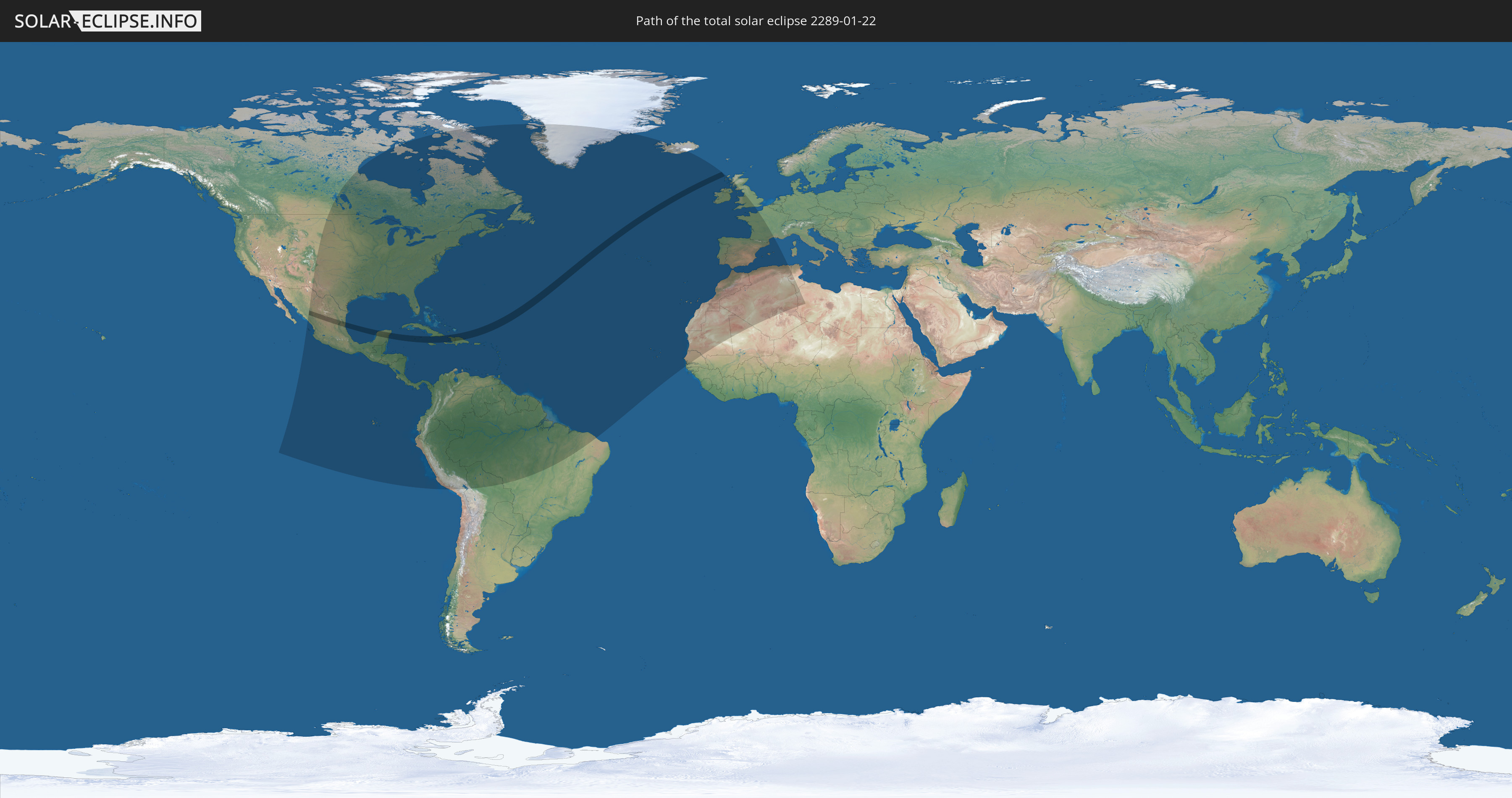
Die Sonnenfinsternis am 22.01.2289 kann man in 68 Ländern als partielle Sonnenfinsternis beobachten.
Der Finsternispfad verläuft durch 7 Länder. Nur in diesen Ländern ist sie als totale Sonnenfinsternis zu sehen.
In den folgenden Ländern ist die Sonnenfinsternis total zu sehen
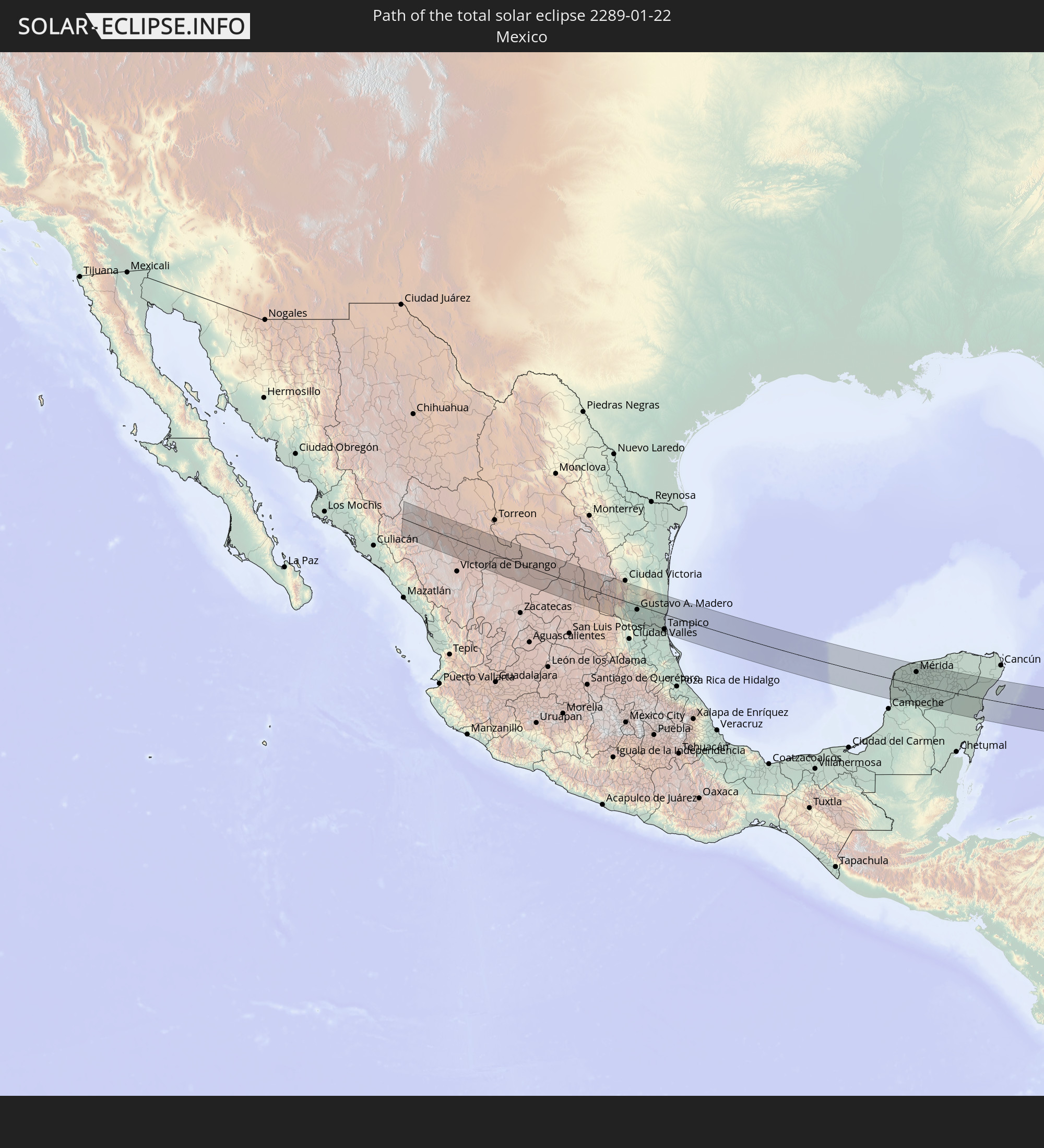 Mexiko
 Kuba
Kuba
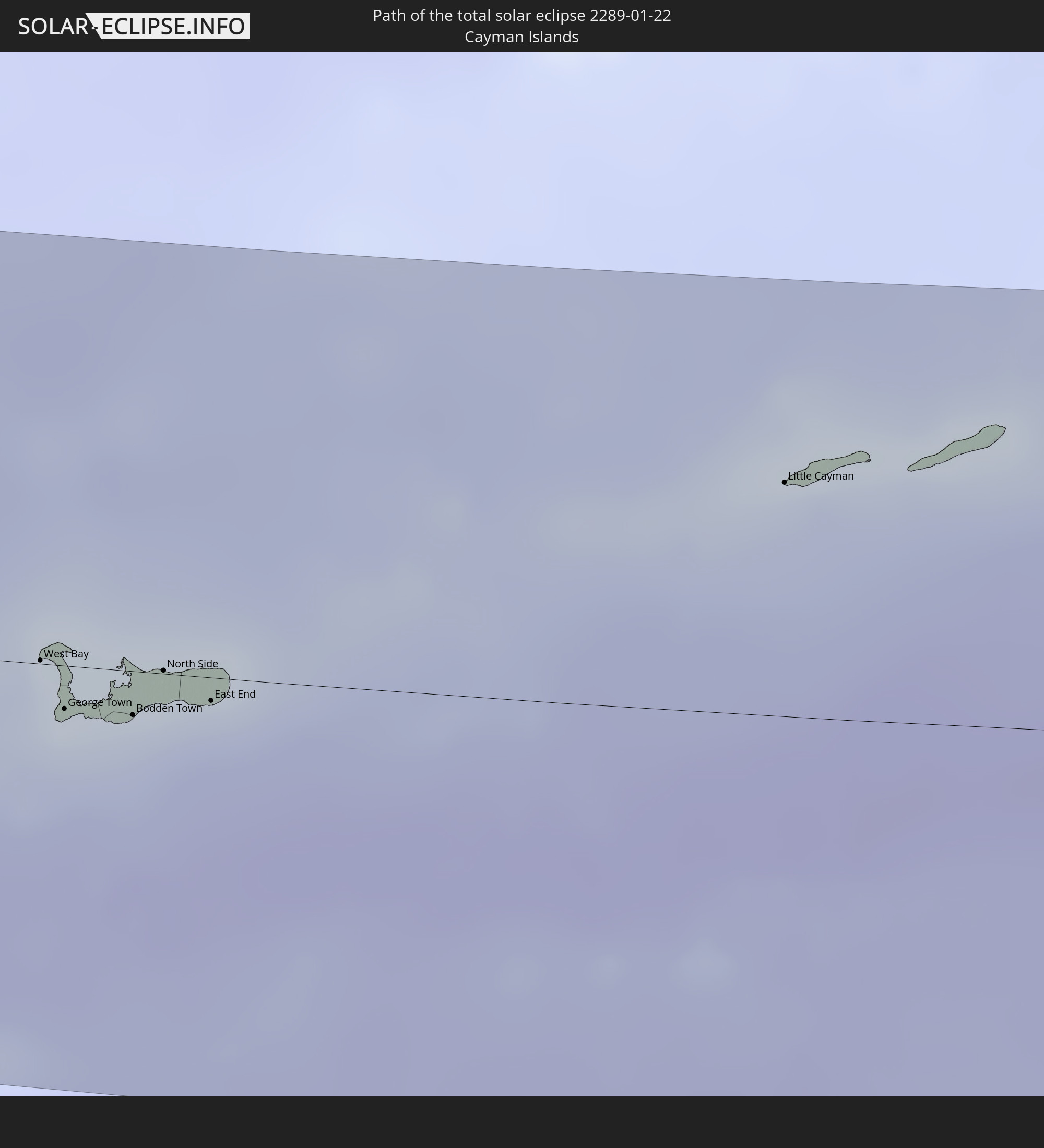 Kaimaninseln
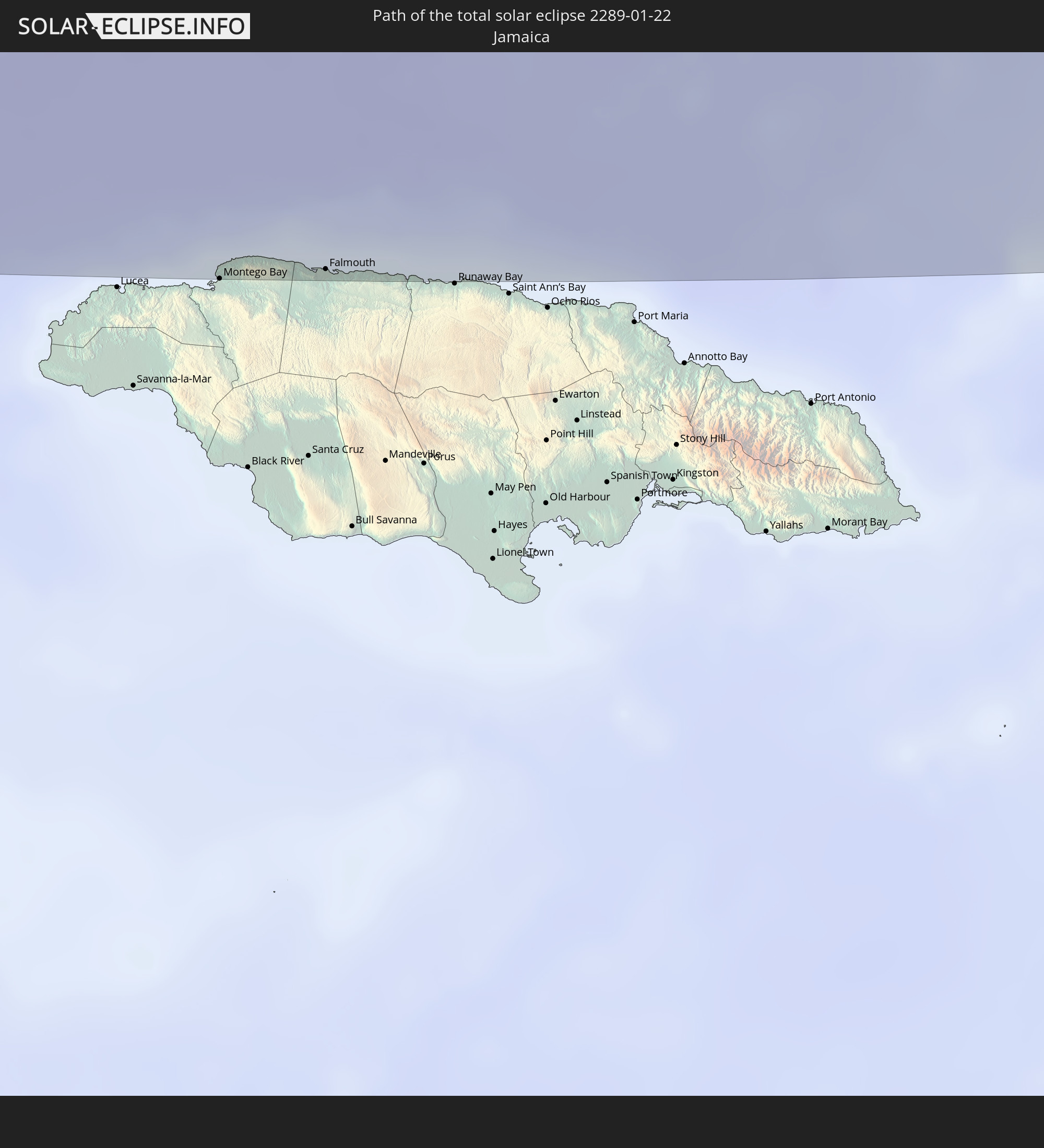 Jamaika
 Haiti
Haiti
 Dominikanische Republik
 Vereinigtes Königreich
In den folgenden Ländern ist die Sonnenfinsternis partiell zu sehen
 Vereinigte Staaten
 United States Minor Outlying Islands
 Kanada
 Mexiko
 Grönland
 Guatemala
 Ecuador
 El Salvador
 Honduras
 Belize
 Nicaragua
 Costa Rica
 Kuba
Kuba
 Panama
 Kolumbien
 Kaimaninseln
 Peru
Peru
 Bahamas
 Jamaika
 Haiti
Haiti
 Brasilien
 Venezuela
 Turks- und Caicosinseln
 Dominikanische Republik
 Aruba
Aruba
 Bolivien
 Puerto Rico
 Amerikanische Jungferninseln
 Bermuda
 Britische Jungferninseln
 Anguilla
 Saint-Martin
 Saint-Barthélemy
 St. Kitts und Nevis
 Antigua und Barbuda
 Montserrat
 Trinidad und Tobago
 Guadeloupe
 Grenada
 Dominica
 St. Vincent und die Grenadinen
 Guyana
 Martinique
 St. Lucia
 Barbados
 Suriname
 Saint-Pierre und Miquelon
 Französisch-Guayana
 Portugal
 Kap Verde
 Island
 Spanien
 Senegal
 Mauretanien
 Gambia
 Marokko
 Mali
Mali
 Irland
 Algerien
 Vereinigtes Königreich
 Gibraltar
 Frankreich
 Isle of Man
 Guernsey
 Jersey
 Andorra
 Tunesien
 Libyen
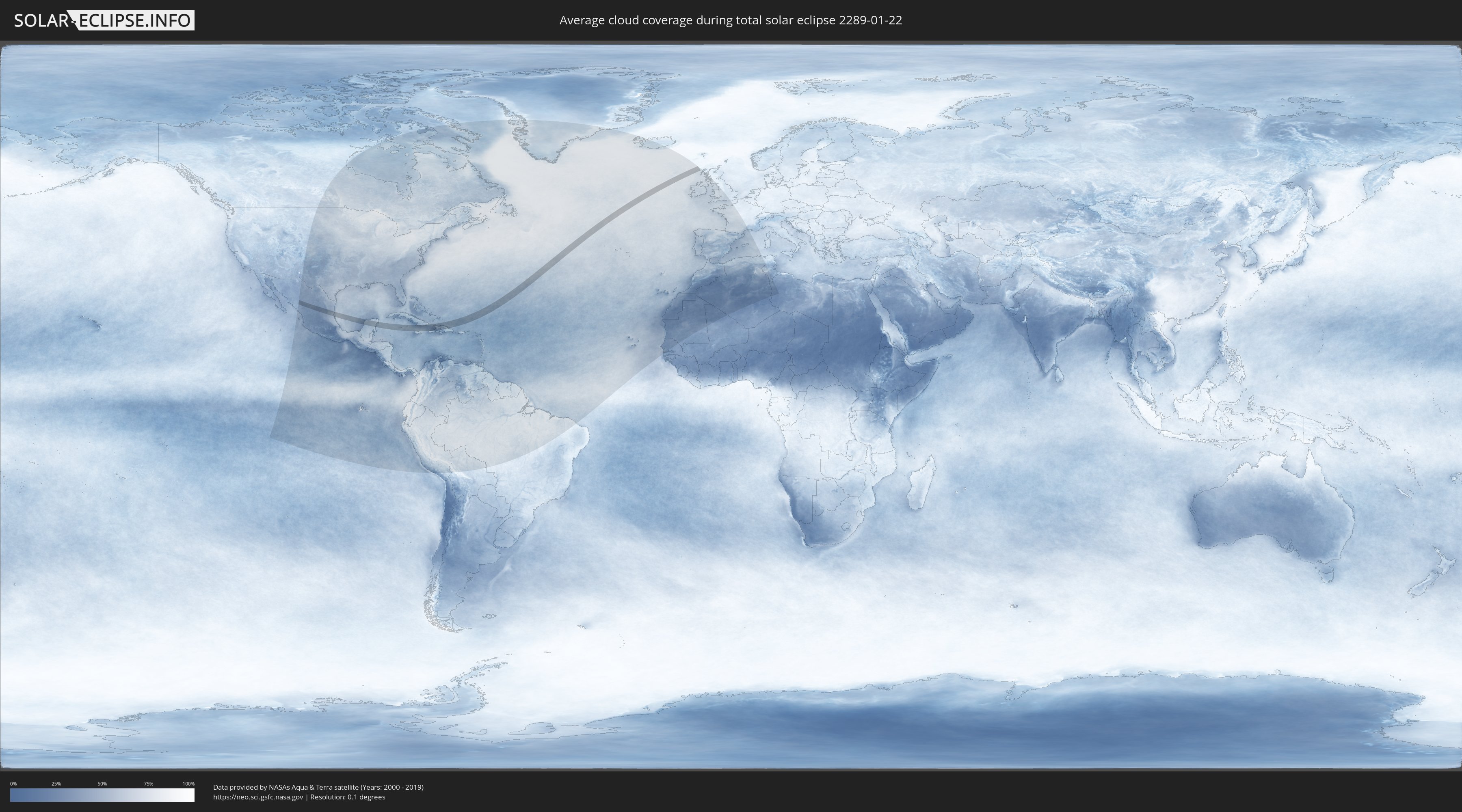
Wie wird das Wetter während der totalen Sonnenfinsternis am 22.01.2289?
Wo ist der beste Ort, um die totale Sonnenfinsternis vom 22.01.2289 zu beobachten?
Die folgenden Karten zeigen die durchschnittliche Bewölkung für den Tag, an dem die totale Sonnenfinsternis
stattfindet. Mit Hilfe der Karten lässt sich der Ort entlang des Finsternispfades eingrenzen,
der die besten Aussichen auf einen klaren wolkenfreien Himmel bietet.
Trotzdem muss man immer lokale Gegenenheiten beachten und sollte sich genau über das Wetter an seinem
gewählten Beobachtungsort informieren.
Die Daten stammen von den beiden NASA-Satelliten
AQUA und TERRA
und wurden über einen Zeitraum von 19 Jahren (2000 - 2019) gemittelt.

Detaillierte Länderkarten
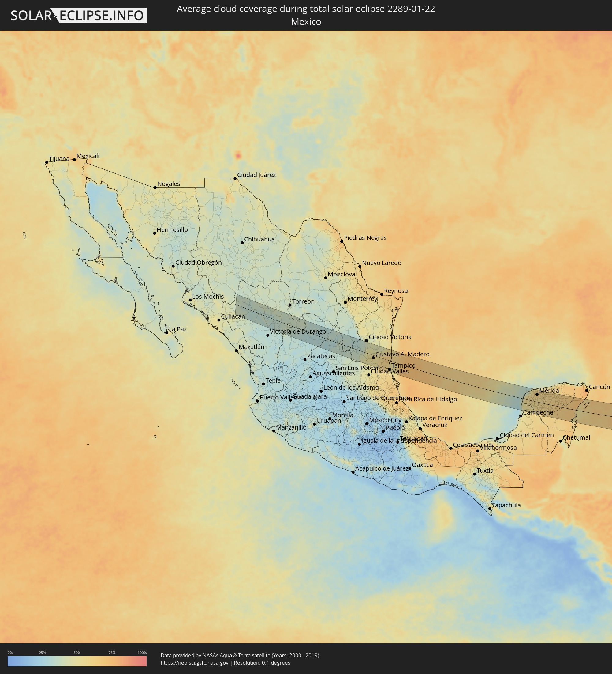 Mexiko
 Kuba
Kuba
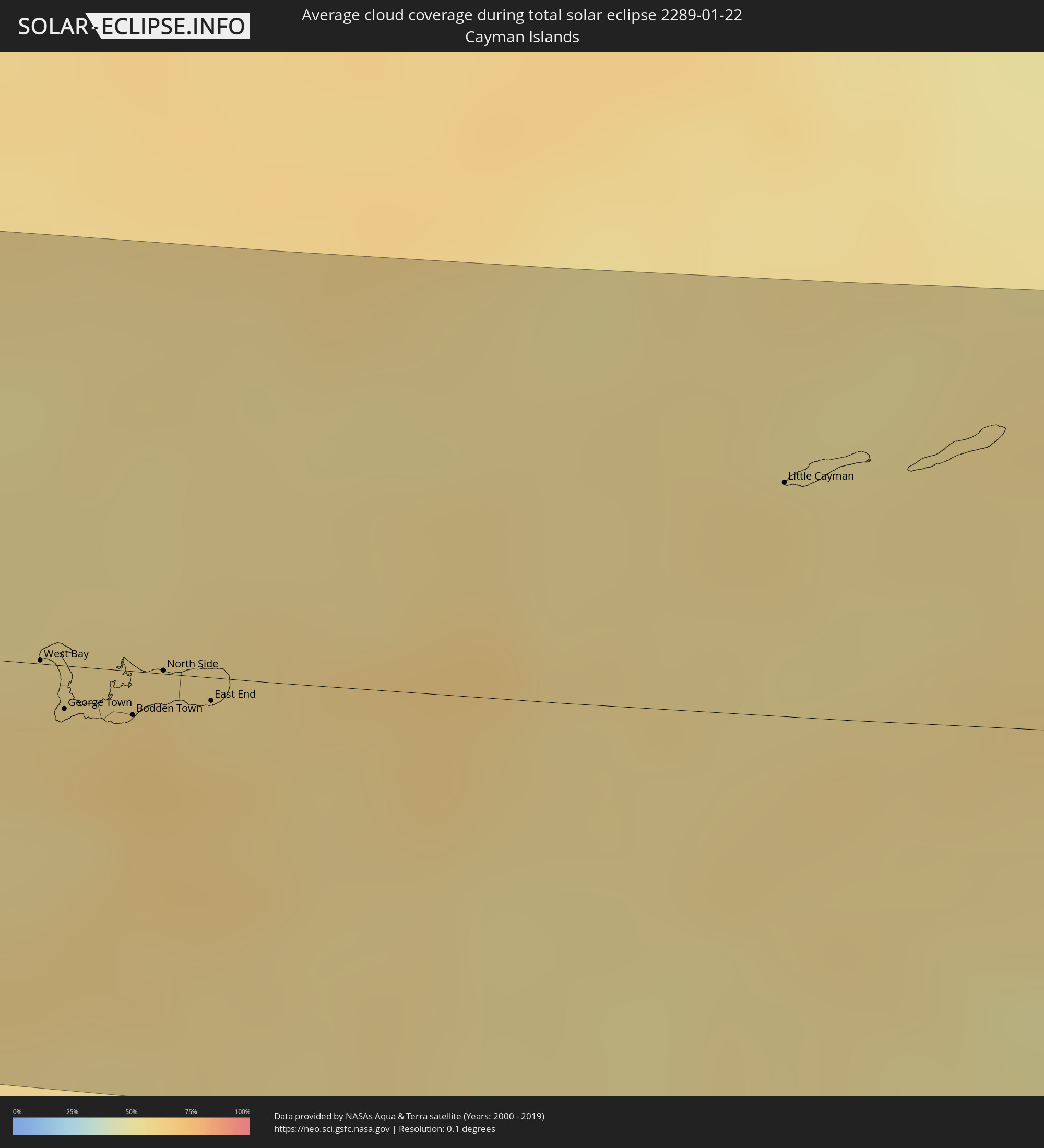 Kaimaninseln
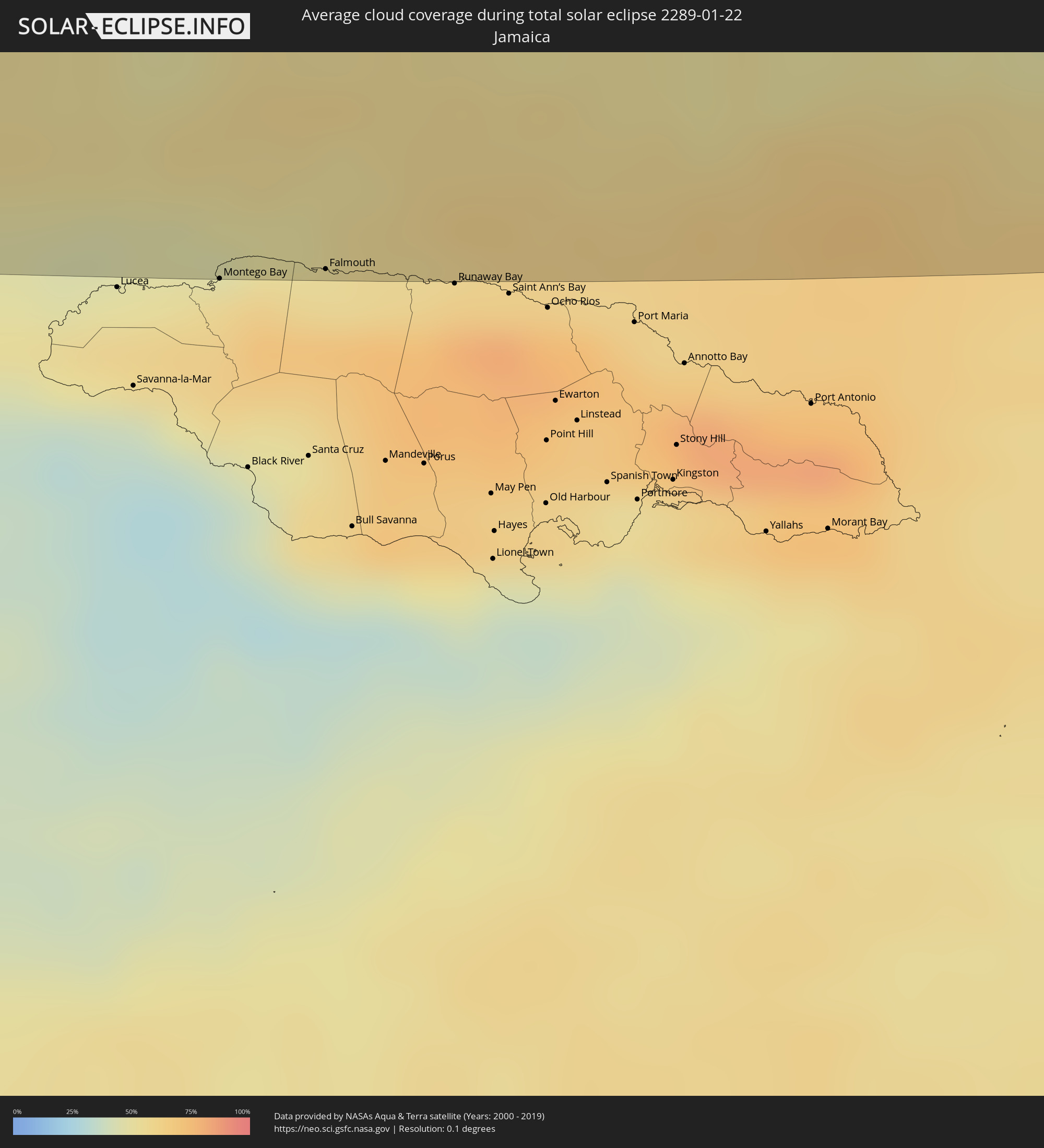 Jamaika
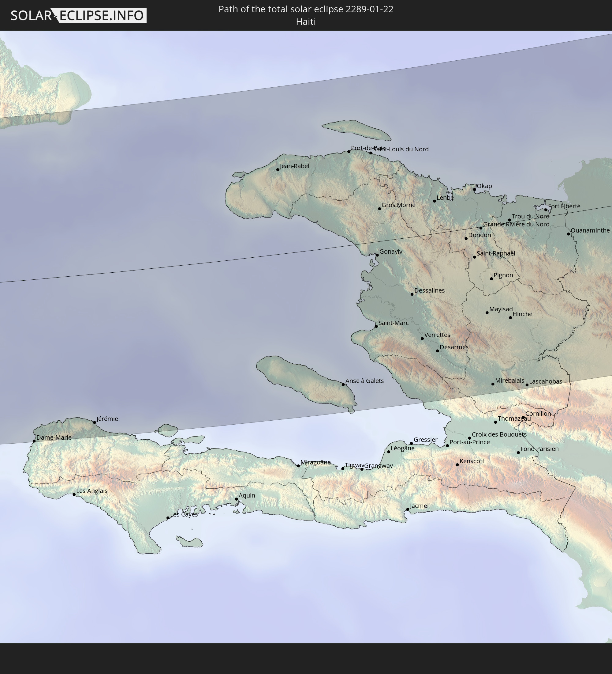
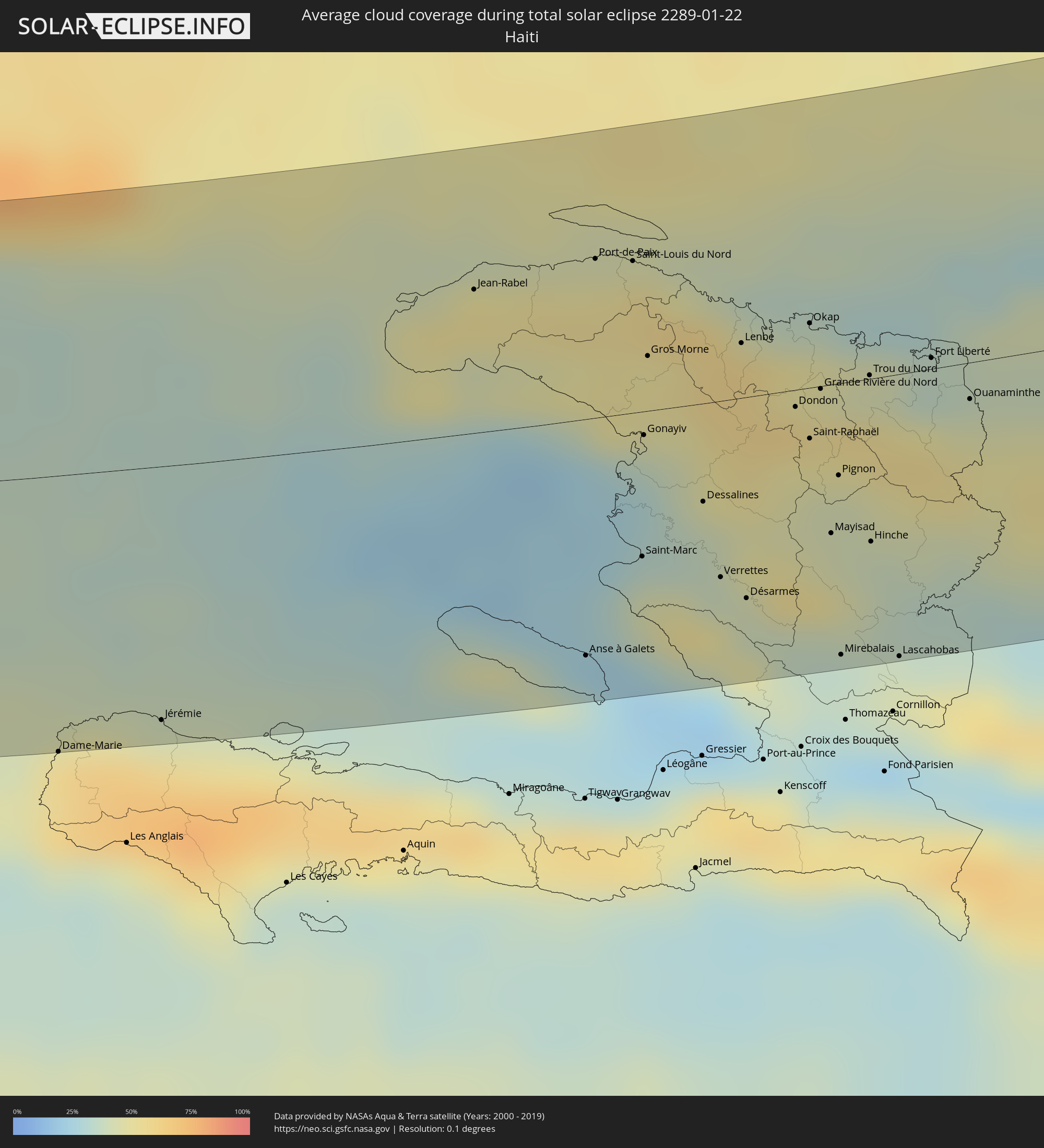 Haiti
Haiti
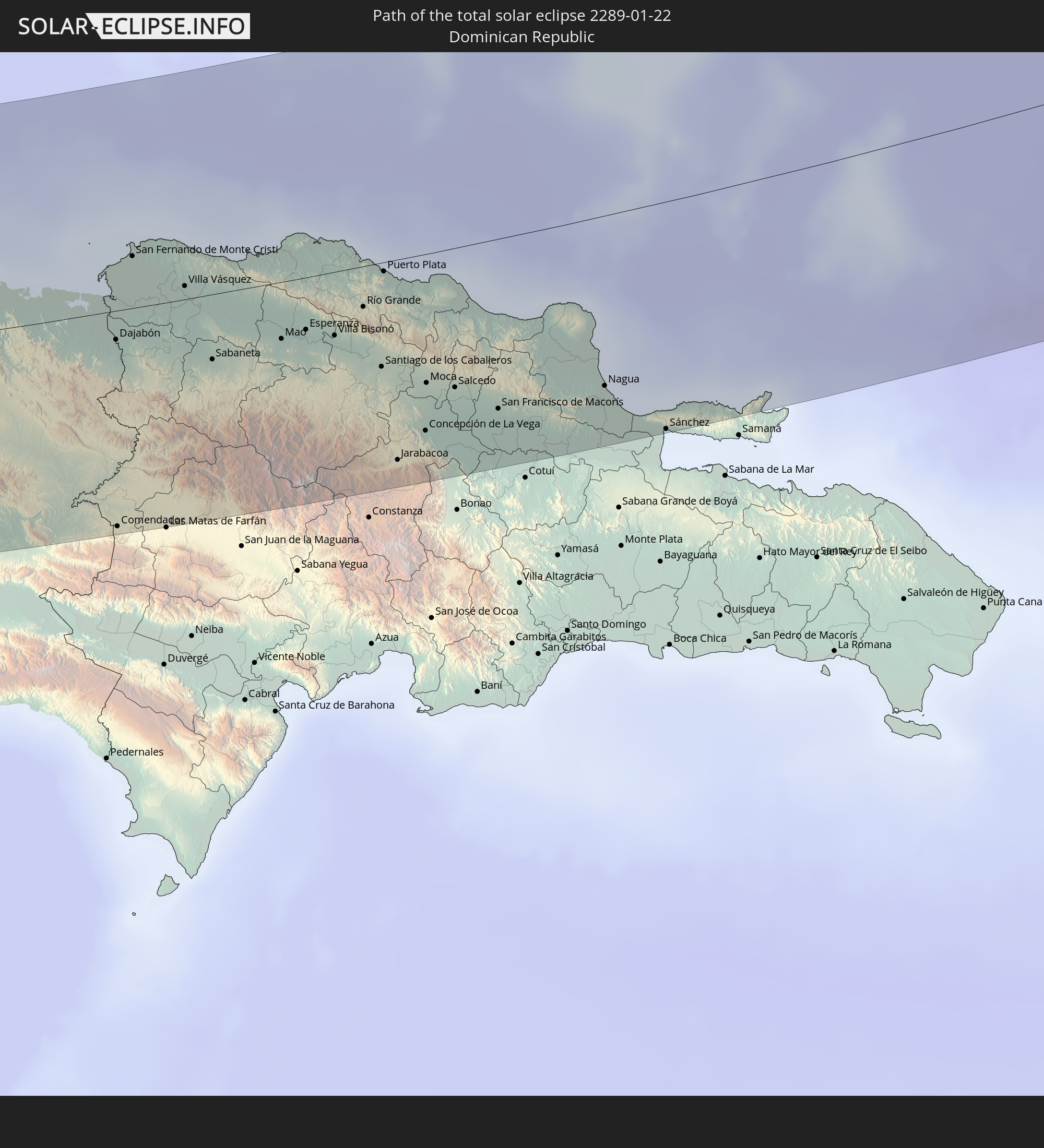
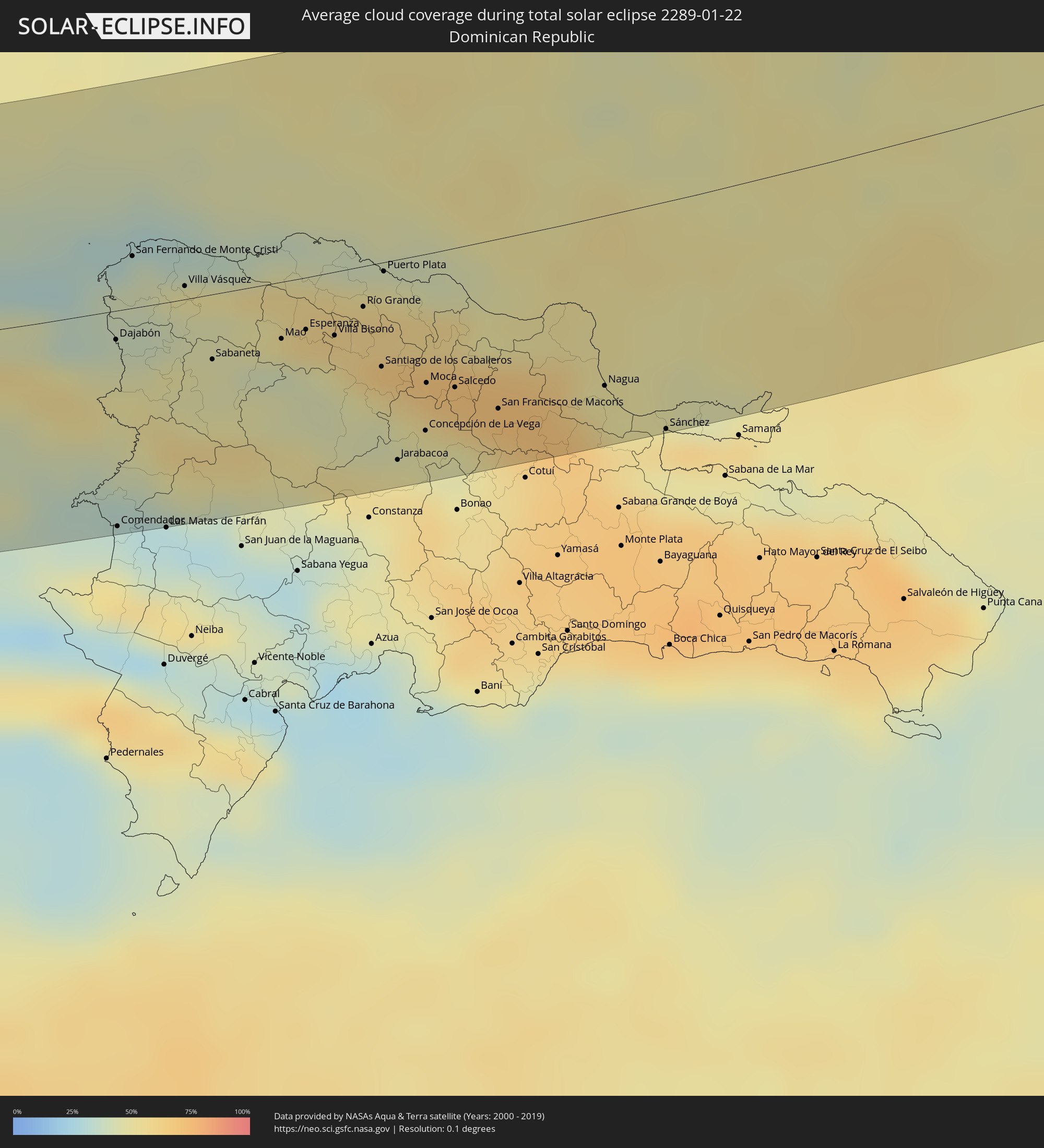 Dominikanische Republik
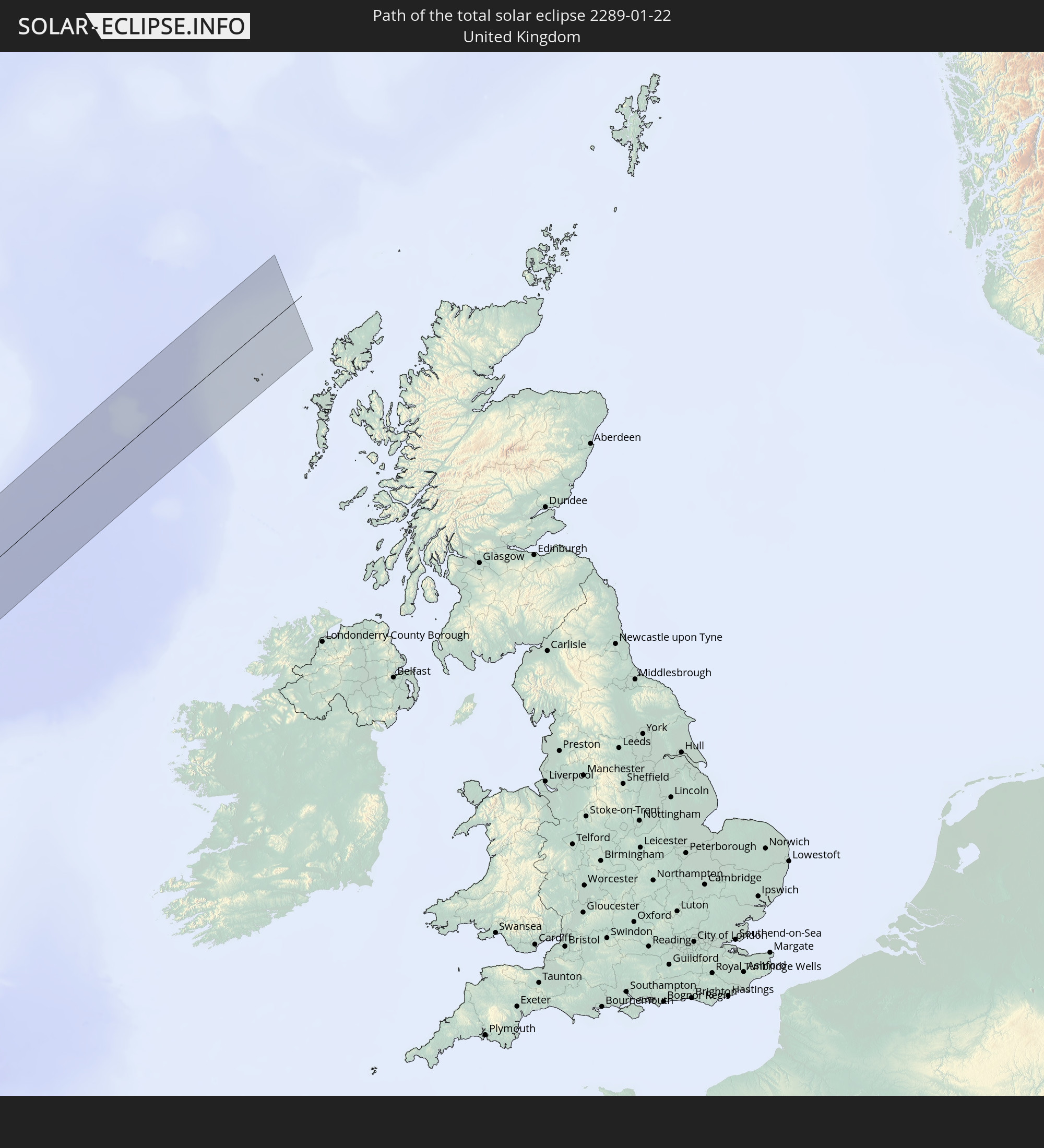
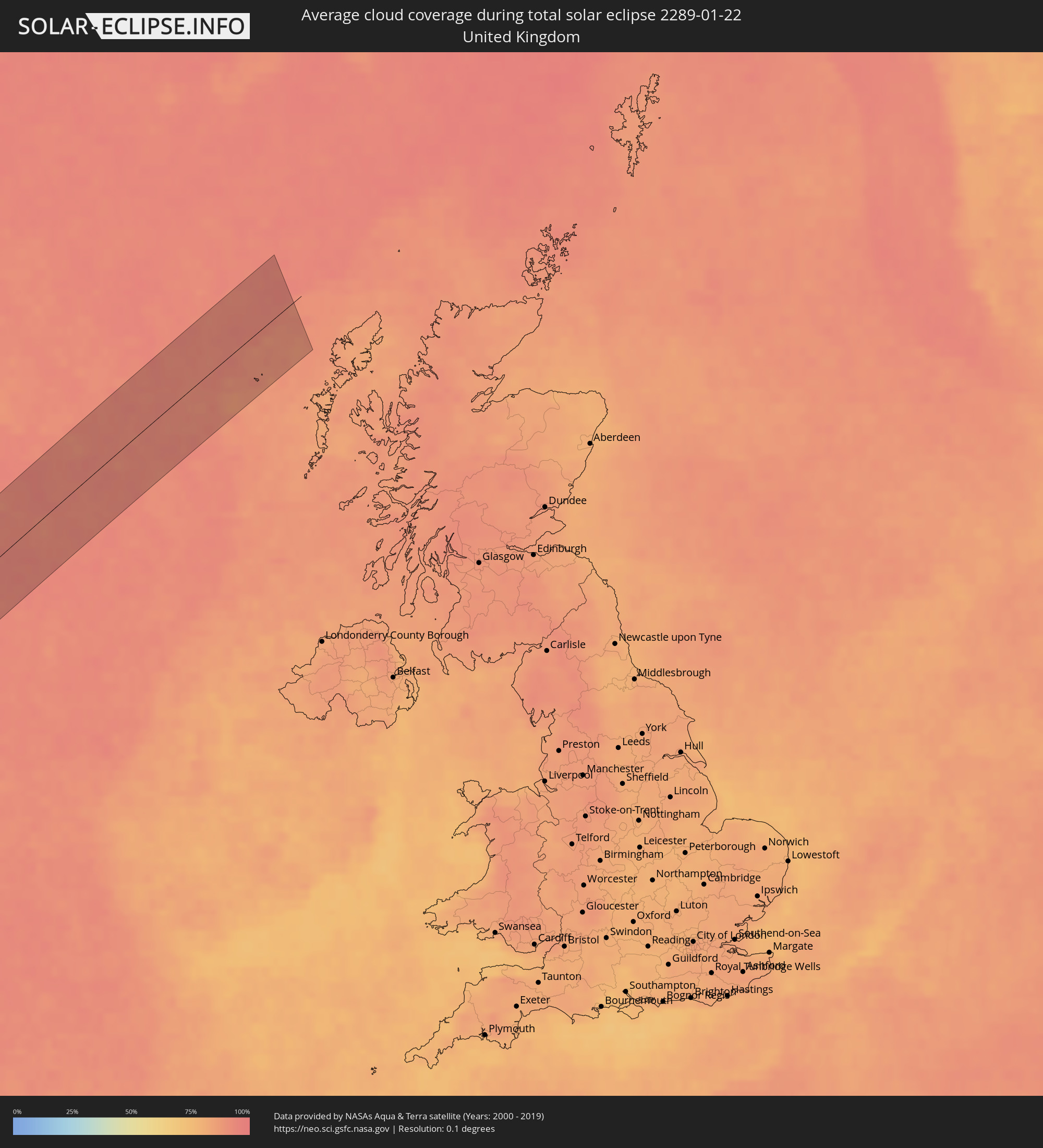 Vereinigtes Königreich
Orte im Finsternispfad
Die nachfolgene Tabelle zeigt Städte und Orte mit mehr als 5.000 Einwohnern, die sich im Finsternispfad befinden. Städte mit mehr als 100.000 Einwohnern sind dick gekennzeichnet. Mit einem Klick auf den Ort öffnet sich eine Detailkarte die die Lage des jeweiligen Ortes zusammen mit dem Verlauf der zentralen Finsternis präsentiert.
| Ort | Typ | Dauer der Verfinsterung | Ortszeit bei maximaler Verfinsterung | Entfernung zur Zentrallinie | Ø Bewölkung |
|
Santiago Papasquiaro, Durango
|
total | - | 07:55:55 UTC-06:00 | 19 km | 33% |
|
San Miguel de Papasquiaro, Durango
|
total | - | 07:55:42 UTC-06:00 | 38 km | 34% |
|
Canatlán, Durango
|
total | - | 07:55:37 UTC-06:00 | 49 km | 30% |
|
Guadalupe Victoria, Durango
|
total | - | 07:55:51 UTC-06:00 | 34 km | 33% |
|
Juan Aldama, Zacatecas
|
total | - | 07:56:03 UTC-06:00 | 24 km | 35% |
|
Matehuala, San Luis Potosí
|
total | - | 07:56:56 UTC-06:00 | 5 km | 36% |
|
Tula, Tamaulipas
|
total | - | 07:56:48 UTC-06:00 | 32 km | 37% |
|
Ciudad Mante, Tamaulipas
|
total | - | 07:57:02 UTC-06:00 | 35 km | 49% |
|
Xicoténcatl, Tamaulipas
|
total | - | 07:57:21 UTC-06:00 | 7 km | 51% |
|
Gustavo A. Madero, Tamaulipas
|
total | - | 07:57:20 UTC-06:00 | 14 km | 52% |
|
Ursulo Galván, Tamaulipas
|
total | - | 07:57:29 UTC-06:00 | 15 km | 60% |
|
Aldama, Tamaulipas
|
total | - | 07:57:54 UTC-06:00 | 13 km | 64% |
|
Nuevo Progreso, Tamaulipas
|
total | - | 07:58:18 UTC-06:00 | 44 km | 59% |
|
Moralillo, Veracruz
|
total | - | 07:57:13 UTC-06:00 | 55 km | 54% |
|
Tampico, Tamaulipas
|
total | - | 07:57:19 UTC-06:00 | 48 km | 57% |
|
Villa Cuauhtemoc, Veracruz
|
total | - | 07:57:14 UTC-06:00 | 57 km | 52% |
|
Hecelchakán, Campeche
|
total | - | 08:02:13 UTC-06:00 | 57 km | 55% |
|
Halachó, Yucatán
|
total | - | 08:02:38 UTC-06:00 | 23 km | 55% |
|
Dzitbalché, Campeche
|
total | - | 08:02:28 UTC-06:00 | 40 km | 53% |
|
Calkiní, Campeche
|
total | - | 08:02:32 UTC-06:00 | 34 km | 53% |
|
Maxcanú, Yucatán
|
total | - | 08:02:51 UTC-06:00 | 10 km | 55% |
|
Hunucmá, Yucatán
|
total | - | 08:03:30 UTC-06:00 | 40 km | 59% |
|
Uman, Yucatán
|
total | - | 08:03:30 UTC-06:00 | 28 km | 59% |
|
Muna, Yucatán
|
total | - | 08:03:04 UTC-06:00 | 14 km | 58% |
|
Mérida, Yucatán
|
total | - | 08:03:46 UTC-06:00 | 42 km | 64% |
|
Ticul, Yucatán
|
total | - | 08:03:10 UTC-06:00 | 19 km | 57% |
|
Acanceh, Yucatán
|
total | - | 08:03:45 UTC-06:00 | 28 km | 57% |
|
Oxkutzkab, Yucatán
|
total | - | 08:03:12 UTC-06:00 | 26 km | 57% |
|
Tixkokob, Yucatán
|
total | - | 08:04:03 UTC-06:00 | 50 km | 59% |
|
Akil, Yucatán
|
total | - | 08:03:14 UTC-06:00 | 29 km | 57% |
|
Tecax, Yucatán
|
total | - | 08:03:14 UTC-06:00 | 35 km | 57% |
|
Motul, Yucatán
|
total | - | 08:04:18 UTC-06:00 | 62 km | 59% |
|
Tzucacab, Yucatán
|
total | - | 08:03:22 UTC-06:00 | 44 km | 58% |
|
Izamal, Yucatán
|
total | - | 08:04:26 UTC-06:00 | 51 km | 59% |
|
Peto, Yucatán
|
total | - | 08:03:35 UTC-06:00 | 35 km | 60% |
|
Chichén-Itzá, Yucatán
|
total | - | 08:04:39 UTC-06:00 | 32 km | 63% |
|
Valladolid, Yucatán
|
total | - | 08:05:08 UTC-06:00 | 42 km | 64% |
|
Chemax, Yucatán
|
total | - | 08:05:26 UTC-06:00 | 44 km | 65% |
|
Playa del Carmen, Quintana Roo
|
total | - | 09:06:30 UTC-05:00 | 58 km | 59% |
|
San Miguel de Cozumel, Quintana Roo
|
total | - | 09:06:32 UTC-05:00 | 47 km | 66% |
|
West Bay, West Bay
|
total | - | 09:13:19 UTC-05:00 | 1 km | 59% |
|
George Town, George Town
|
total | - | 09:13:17 UTC-05:00 | 8 km | 59% |
|
Bodden Town, Bodden Town
|
total | - | 09:13:28 UTC-05:00 | 8 km | 62% |
|
North Side, North Side
|
total | - | 09:13:39 UTC-05:00 | 1 km | 62% |
|
East End, East End
|
total | - | 09:13:43 UTC-05:00 | 4 km | 63% |
|
Little Cayman, Sister Island
|
total | - | 09:15:52 UTC-05:00 | 43 km | 58% |
|
Montego Bay, St. James
|
total | - | 09:18:15 UTC-05:00 | 82 km | 56% |
|
Falmouth, Trelawny
|
total | - | 09:18:45 UTC-05:00 | 79 km | 57% |
|
Dame-Marie, GrandʼAnse
|
total | - | 09:25:04 UTC-05:00 | 86 km | 54% |
|
Jérémie, GrandʼAnse
|
total | - | 09:25:48 UTC-05:00 | 79 km | 42% |
|
Jean-Rabel, Nord-Ouest
|
total | - | 09:29:17 UTC-05:00 | 44 km | 49% |
|
Anse à Galets, Ouest
|
total | - | 09:28:38 UTC-05:00 | 73 km | 36% |
|
Ti Port-de-Paix, Nord-Ouest
|
total | - | 09:30:08 UTC-05:00 | 48 km | 52% |
|
Port-de-Paix, Nord-Ouest
|
total | - | 09:30:08 UTC-05:00 | 49 km | 52% |
|
Saint-Louis du Nord, Nord-Ouest
|
total | - | 09:30:22 UTC-05:00 | 47 km | 54% |
|
Saint-Marc, Artibonite
|
total | - | 09:29:20 UTC-05:00 | 45 km | 43% |
|
Gonayiv, Artibonite
|
total | - | 09:29:48 UTC-05:00 | 7 km | 30% |
|
Gros Morne, Artibonite
|
total | - | 09:30:07 UTC-05:00 | 17 km | 51% |
|
Dessalines, Artibonite
|
total | - | 09:29:55 UTC-05:00 | 30 km | 41% |
|
Verrettes, Artibonite
|
total | - | 09:29:45 UTC-05:00 | 54 km | 40% |
|
Lenbe, Nord
|
total | - | 09:30:45 UTC-05:00 | 17 km | 56% |
|
Désarmes, Artibonite
|
total | - | 09:29:50 UTC-05:00 | 62 km | 40% |
|
Dondon, Nord
|
total | - | 09:30:51 UTC-05:00 | 5 km | 50% |
|
Milot, Nord
|
total | - | 09:31:01 UTC-05:00 | 3 km | 54% |
|
Okap, Nord
|
total | - | 09:31:15 UTC-05:00 | 20 km | 37% |
|
Saint-Raphaël, Nord
|
total | - | 09:30:49 UTC-05:00 | 16 km | 43% |
|
Grande Rivière du Nord, Nord
|
total | - | 09:31:04 UTC-05:00 | 1 km | 54% |
|
Mayisad, Centre
|
total | - | 09:30:37 UTC-05:00 | 46 km | 41% |
|
Pignon, Nord
|
total | - | 09:30:52 UTC-05:00 | 28 km | 41% |
|
Mirebalais, Centre
|
total | - | 09:30:14 UTC-05:00 | 84 km | 37% |
|
Trou du Nord, Nord-Est
|
total | - | 09:31:26 UTC-05:00 | 1 km | 52% |
|
Hinche, Centre
|
total | - | 09:30:50 UTC-05:00 | 50 km | 38% |
|
Lascahobas, Centre
|
total | - | 09:30:35 UTC-05:00 | 87 km | 46% |
|
Fort Liberté, Nord-Est
|
total | - | 09:31:53 UTC-05:00 | 3 km | 37% |
|
Ouanaminthe, Nord-Est
|
total | - | 09:31:59 UTC-05:00 | 11 km | 49% |
|
Dajabón, Dajabón
|
total | - | 10:32:01 UTC-04:00 | 11 km | 49% |
|
Comendador, Elías Piña
|
total | - | 10:31:09 UTC-04:00 | 85 km | 36% |
|
San Fernando de Monte Cristi, Monte Cristi
|
total | - | 10:32:33 UTC-04:00 | 20 km | 43% |
|
Loma de Cabrera, Dajabón
|
total | - | 10:32:06 UTC-04:00 | 26 km | 52% |
|
Las Matas de Santa Cruz, Monte Cristi
|
total | - | 10:32:37 UTC-04:00 | 1 km | 42% |
|
Villa Vásquez, Monte Cristi
|
total | - | 10:32:50 UTC-04:00 | 5 km | 45% |
|
Sabaneta, Santiago Rodríguez
|
total | - | 10:32:43 UTC-04:00 | 26 km | 46% |
|
Monción, Santiago Rodríguez
|
total | - | 10:33:02 UTC-04:00 | 36 km | 48% |
|
Laguna Salada, Valverde
|
total | - | 10:33:30 UTC-04:00 | 11 km | 51% |
|
Mao, Valverde
|
total | - | 10:33:23 UTC-04:00 | 22 km | 41% |
|
Esperanza, Valverde
|
total | - | 10:33:38 UTC-04:00 | 20 km | 44% |
|
San José de Las Matas, Santiago
|
total | - | 10:33:25 UTC-04:00 | 48 km | 47% |
|
Villa Bisonó, Santiago
|
total | - | 10:33:51 UTC-04:00 | 25 km | 48% |
|
Imbert, Puerto Plata
|
total | - | 10:34:12 UTC-04:00 | 5 km | 53% |
|
Villa González, Santiago
|
total | - | 10:34:00 UTC-04:00 | 29 km | 48% |
|
Río Grande, Puerto Plata
|
total | - | 10:34:13 UTC-04:00 | 16 km | 59% |
|
Santiago de los Caballeros, Santiago
|
total | - | 10:34:05 UTC-04:00 | 41 km | 54% |
|
Puerto Plata, Puerto Plata
|
total | - | 10:34:33 UTC-04:00 | 4 km | 52% |
|
Jarabacoa, La Vega
|
total | - | 10:33:47 UTC-04:00 | 79 km | 56% |
|
Tamboril, Santiago
|
total | - | 10:34:19 UTC-04:00 | 39 km | 61% |
|
Licey al Medio, Santiago
|
total | - | 10:34:17 UTC-04:00 | 45 km | 50% |
|
Concepción de La Vega, La Vega
|
total | - | 10:34:09 UTC-04:00 | 69 km | 47% |
|
Moca, Espaillat
|
total | - | 10:34:23 UTC-04:00 | 51 km | 56% |
|
Salcedo, Hermanas Mirabal
|
total | - | 10:34:36 UTC-04:00 | 54 km | 63% |
|
Rincón, La Vega
|
total | - | 10:34:17 UTC-04:00 | 83 km | 50% |
|
Salsipuedes, Hermanas Mirabal
|
total | - | 10:34:43 UTC-04:00 | 52 km | 63% |
|
Jima Abajo, La Vega
|
total | - | 10:34:22 UTC-04:00 | 82 km | 50% |
|
Tenares, Hermanas Mirabal
|
total | - | 10:34:45 UTC-04:00 | 56 km | 63% |
|
Veragua Arriba, Espaillat
|
total | - | 10:35:04 UTC-04:00 | 34 km | 66% |
|
Fantino, Sánchez Ramírez
|
total | - | 10:34:31 UTC-04:00 | 85 km | 53% |
|
Gaspar Hernández, Espaillat
|
total | - | 10:35:15 UTC-04:00 | 30 km | 66% |
|
San Francisco de Macorís, Duarte
|
total | - | 10:34:52 UTC-04:00 | 66 km | 55% |
|
Las Guáranas, Duarte
|
total | - | 10:34:49 UTC-04:00 | 79 km | 57% |
|
Pimentel, Duarte
|
total | - | 10:35:02 UTC-04:00 | 82 km | 62% |
|
Río San Juan, María Trinidad Sánchez
|
total | - | 10:35:43 UTC-04:00 | 33 km | 63% |
|
Castillo, Duarte
|
total | - | 10:35:15 UTC-04:00 | 81 km | 65% |
|
El Factor, María Trinidad Sánchez
|
total | - | 10:35:42 UTC-04:00 | 72 km | 66% |
|
Nagua, María Trinidad Sánchez
|
total | - | 10:35:52 UTC-04:00 | 66 km | 50% |
|
Sánchez, Samaná
|
total | - | 10:36:11 UTC-04:00 | 89 km | 49% |
|
Las Terrenas, Samaná
|
total | - | 10:36:28 UTC-04:00 | 81 km | 62% |