Totale Sonnenfinsternis vom 21.07.2335
| Wochentag: | Sonntag |
| Maximale Dauer der Verfinsterung: | 03m58s |
| Maximale Breite des Finsternispfades: | 151 km |
| Saroszyklus: | 151 |
| Bedeckungsgrad: | 100% |
| Magnitude: | 1.044 |
| Gamma: | 0.2306 |
Wo kann man die Sonnenfinsternis vom 21.07.2335 sehen?
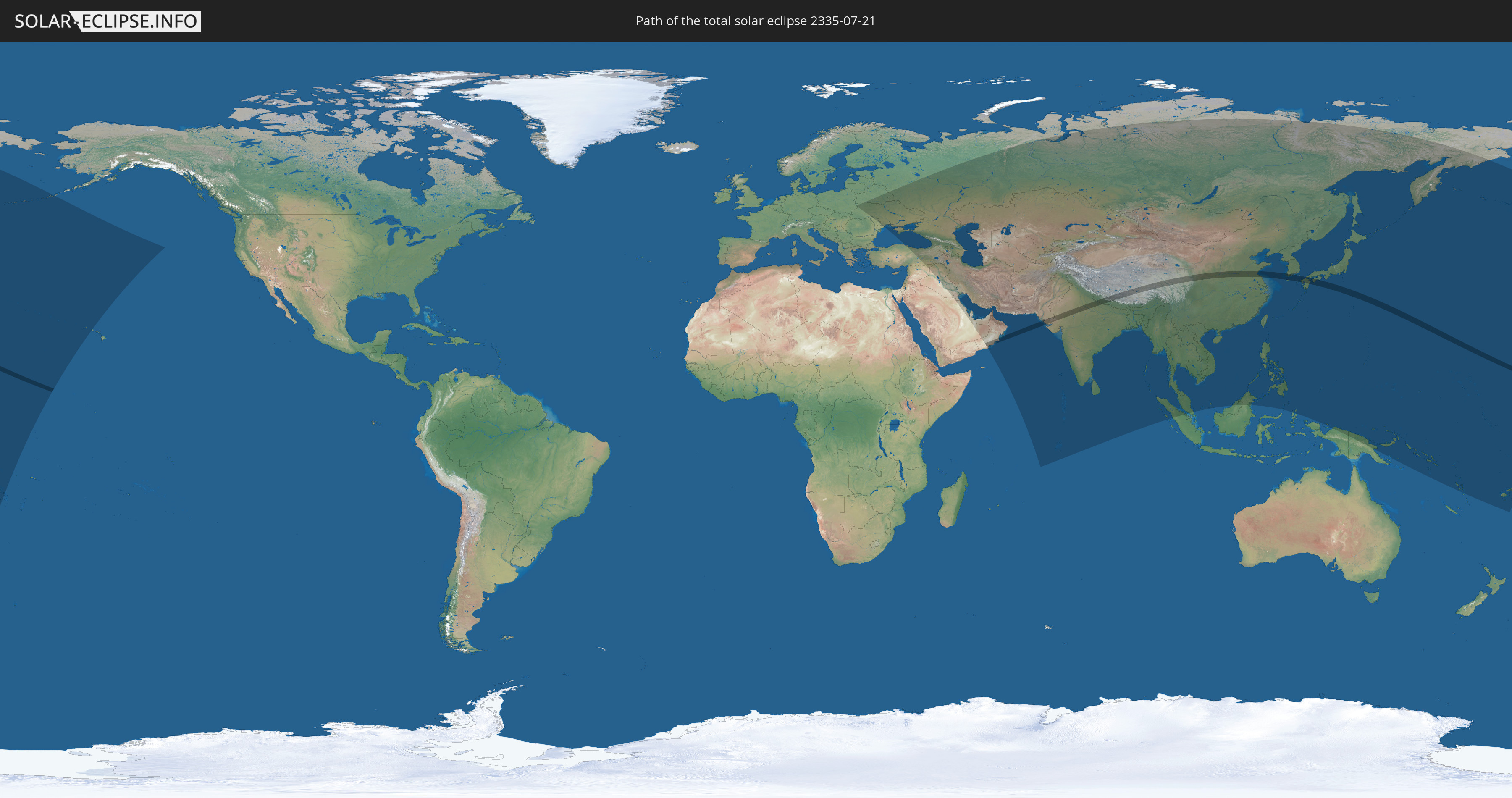
Die Sonnenfinsternis am 21.07.2335 kann man in 64 Ländern als partielle Sonnenfinsternis beobachten.
Der Finsternispfad verläuft durch 8 Länder. Nur in diesen Ländern ist sie als totale Sonnenfinsternis zu sehen.
In den folgenden Ländern ist die Sonnenfinsternis total zu sehen
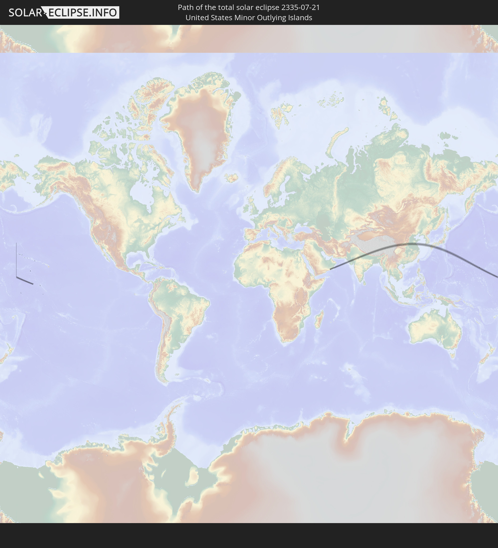 United States Minor Outlying Islands
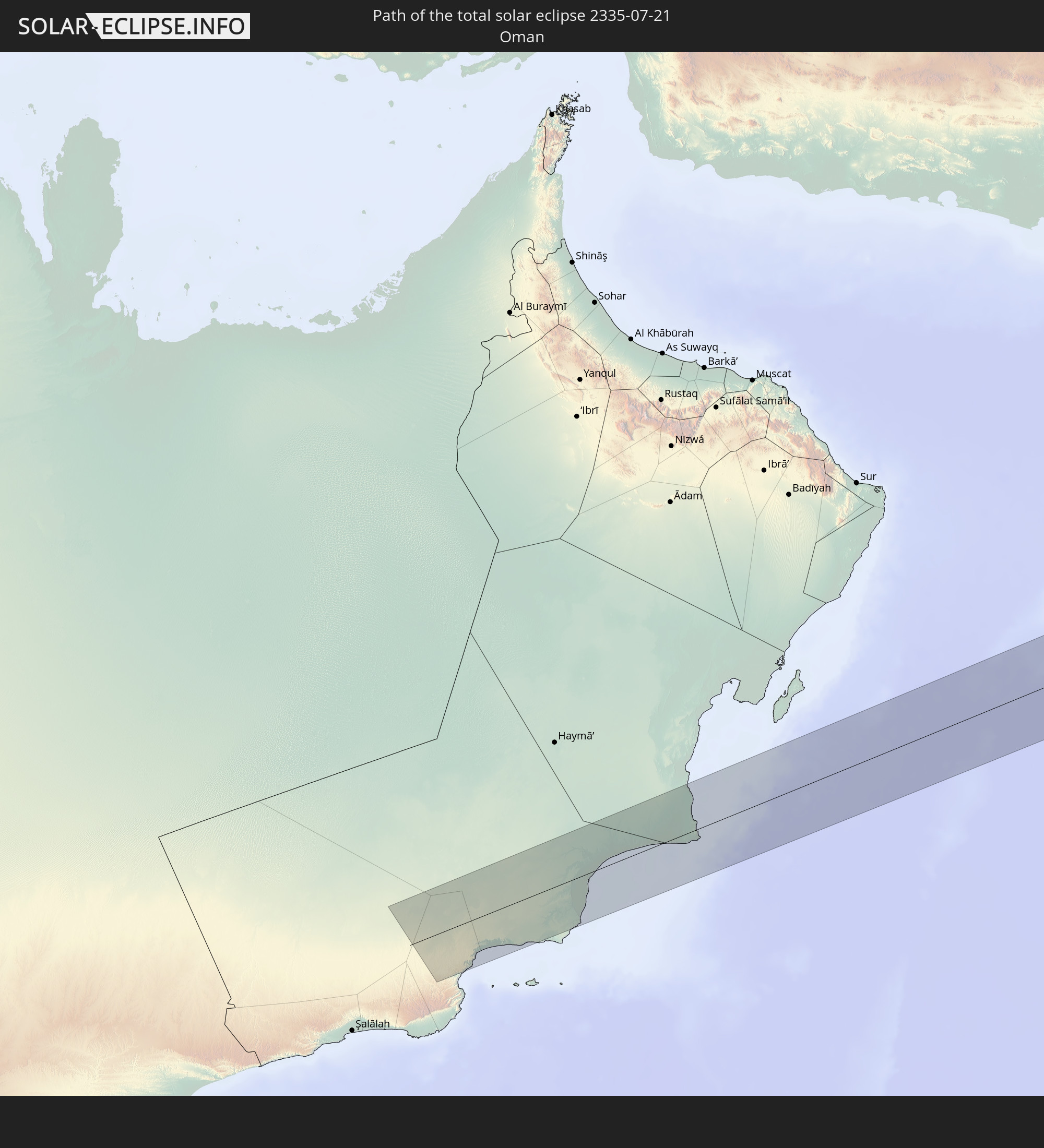 Oman
Oman
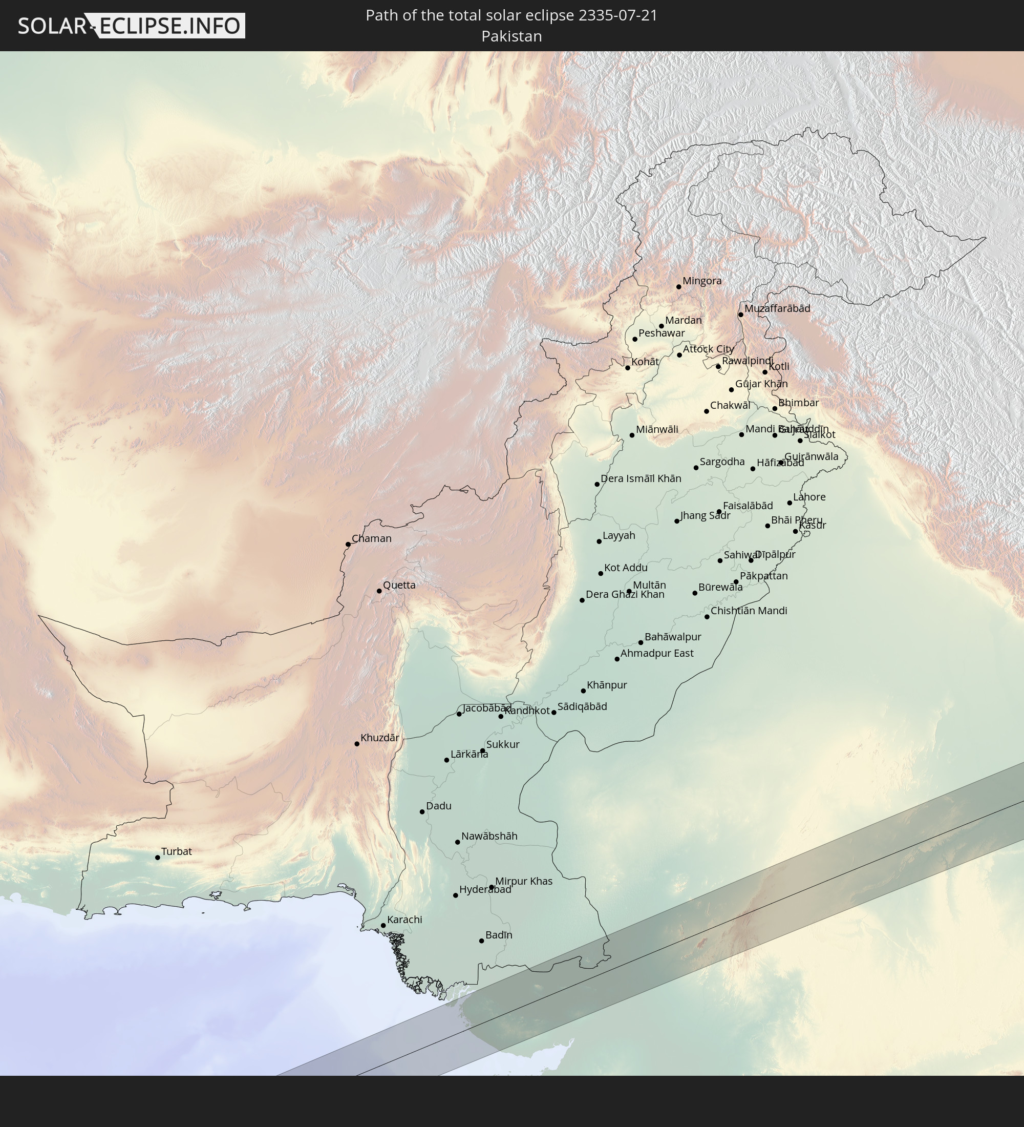 Pakistan
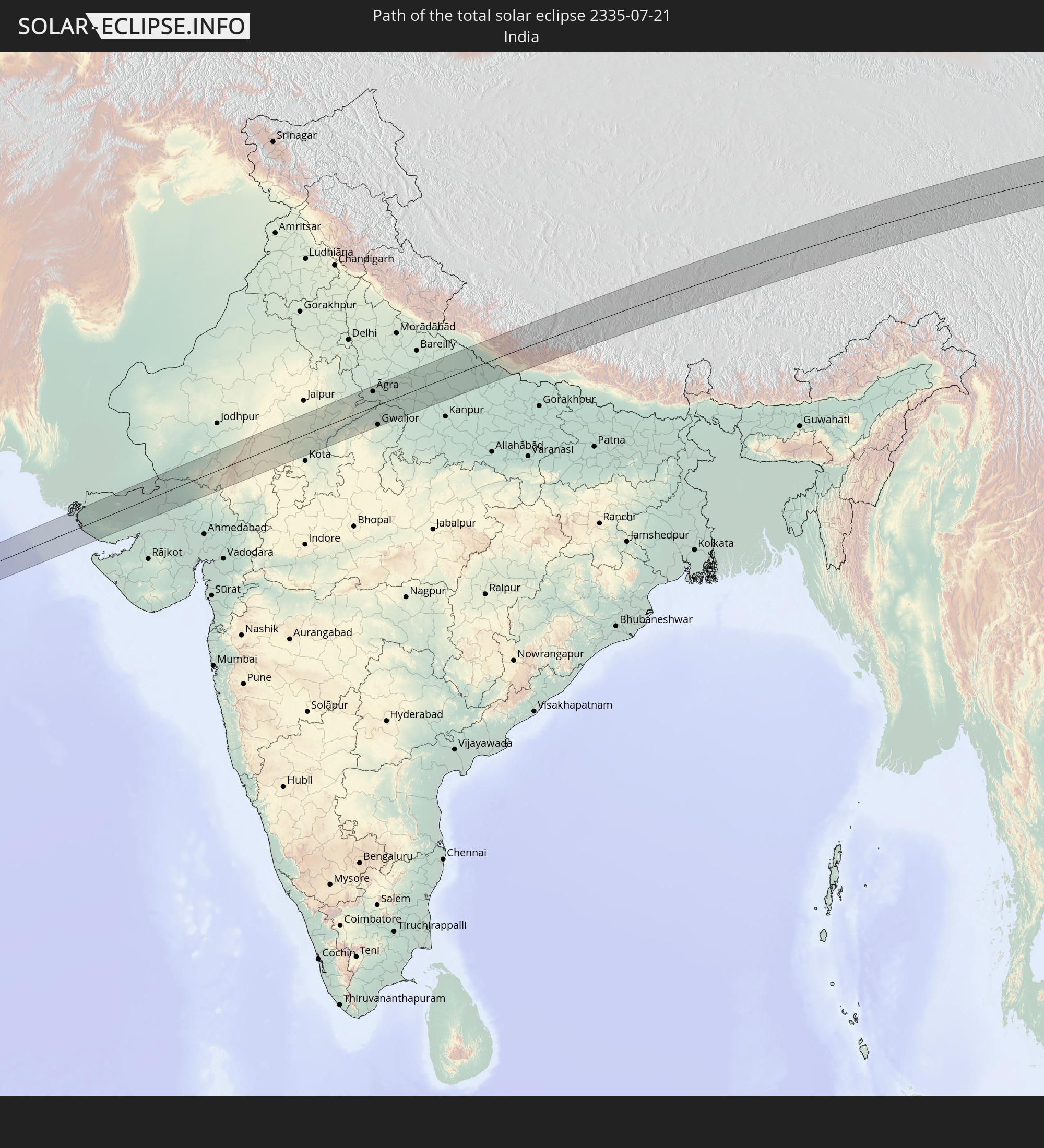 Indien
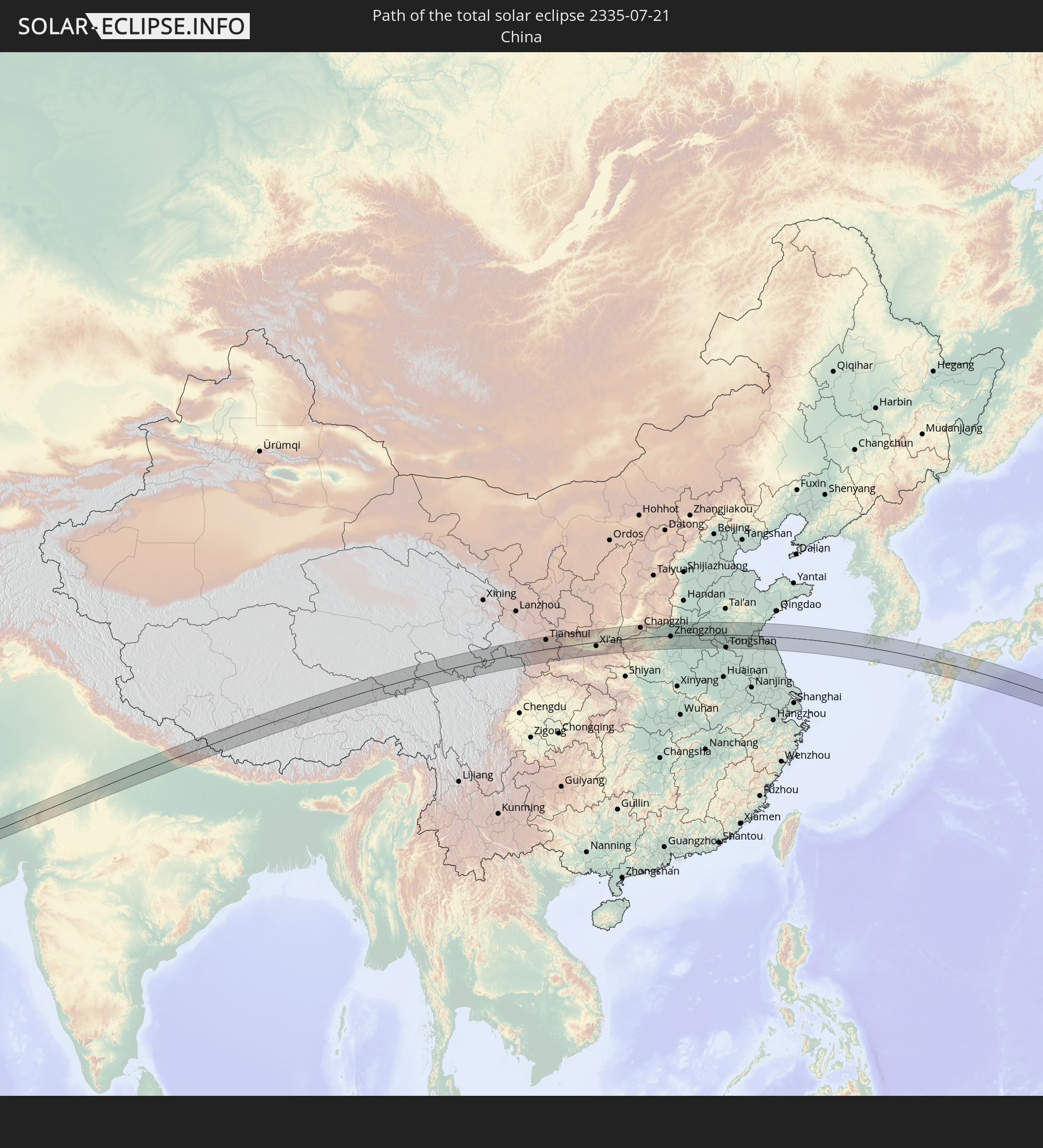 Volksrepublik China
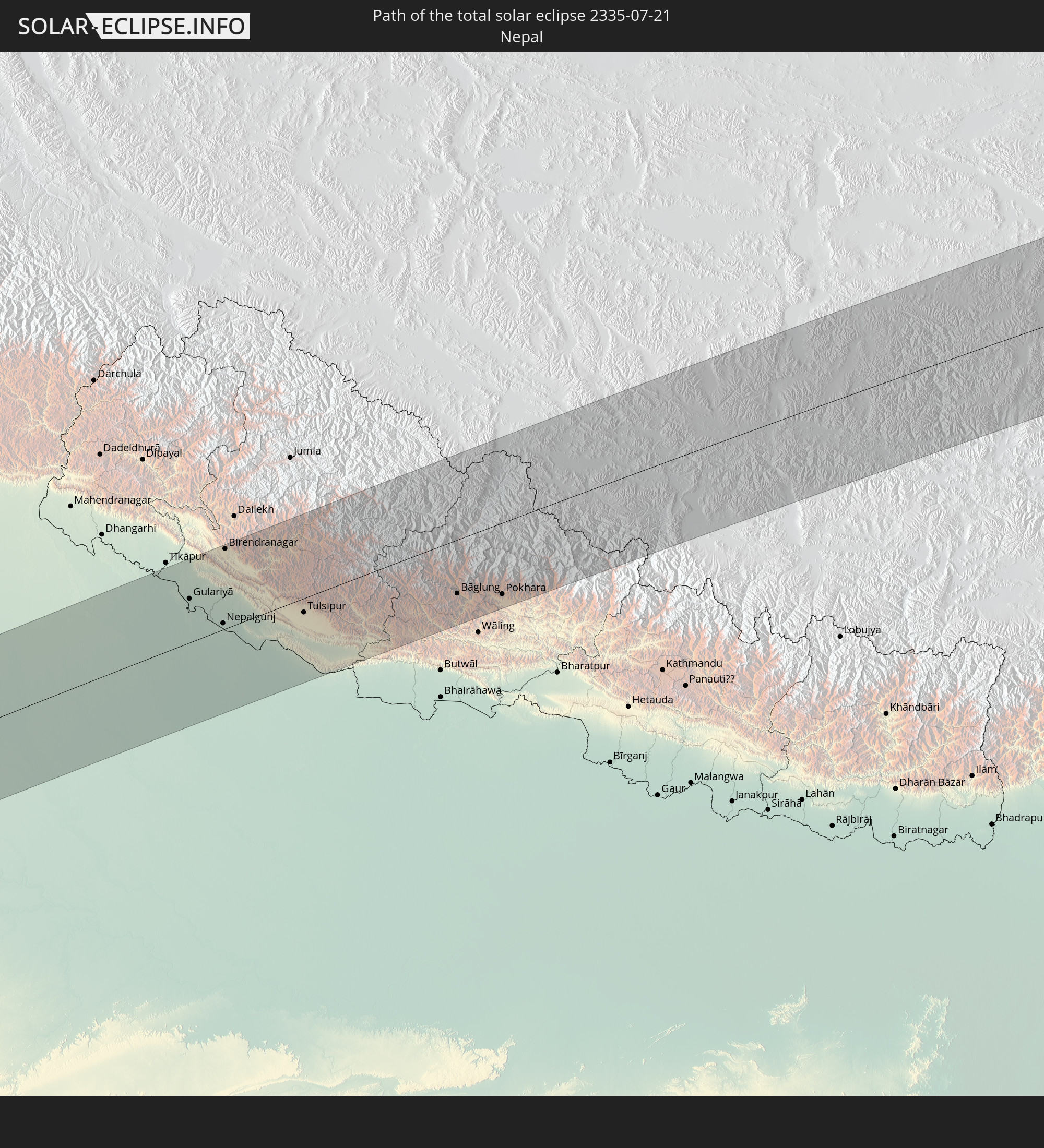 Nepal
Nepal
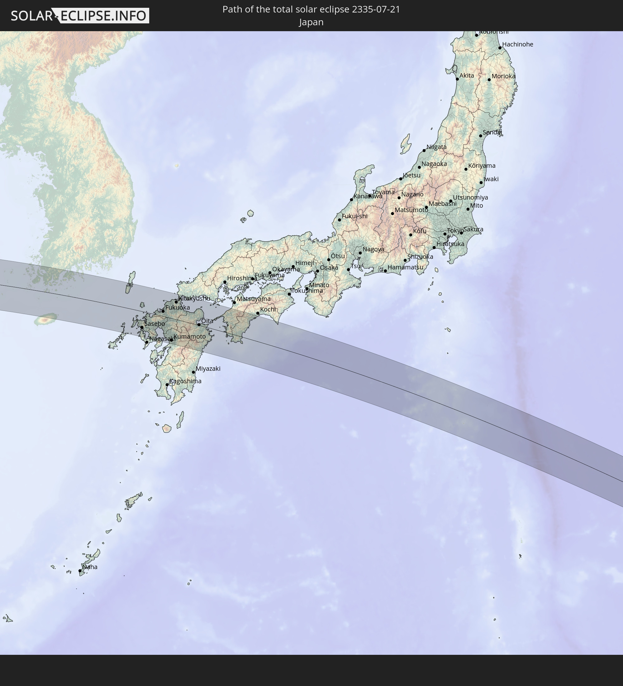 Japan
Japan
 Südkorea
In den folgenden Ländern ist die Sonnenfinsternis partiell zu sehen
 Russland
 Fidschi
 Vereinigte Staaten
 United States Minor Outlying Islands
 Wallis und Futuna
 Kiribati
 Polen
Polen
 Ukraine
 Weißrussland
 Türkei
 Moldawien
 Saudi-Arabien
 Syrien
 Irak
Irak
 Georgien
 Armenien
 Iran
Iran
 Aserbaidschan
 Kasachstan
 Kuwait
 Bahrain
 Katar
Katar
 Vereinigte Arabische Emirate
 Oman
Oman
 Turkmenistan
 Usbekistan
 Afghanistan
 Pakistan
 Tadschikistan
 Indien
 Kirgisistan
 Britisches Territorium im Indischen Ozean
 Malediven
 Volksrepublik China
 Sri Lanka
 Nepal
Nepal
 Mongolei
 Bangladesch
 Bhutan
 Myanmar
 Indonesien
 Thailand
 Malaysia
 Laos
Laos
 Vietnam
 Kambodscha
 Macau
Macau
 Hongkong
 Brunei
 Taiwan
 Philippinen
 Japan
Japan
 Nordkorea
 Südkorea
 Palau
Palau
 Föderierte Staaten von Mikronesien
 Papua-Neuguinea
 Guam
Guam
 Nördliche Marianen
 Salomonen
 Marshallinseln
 Vanuatu
 Nauru
Nauru
 Tuvalu
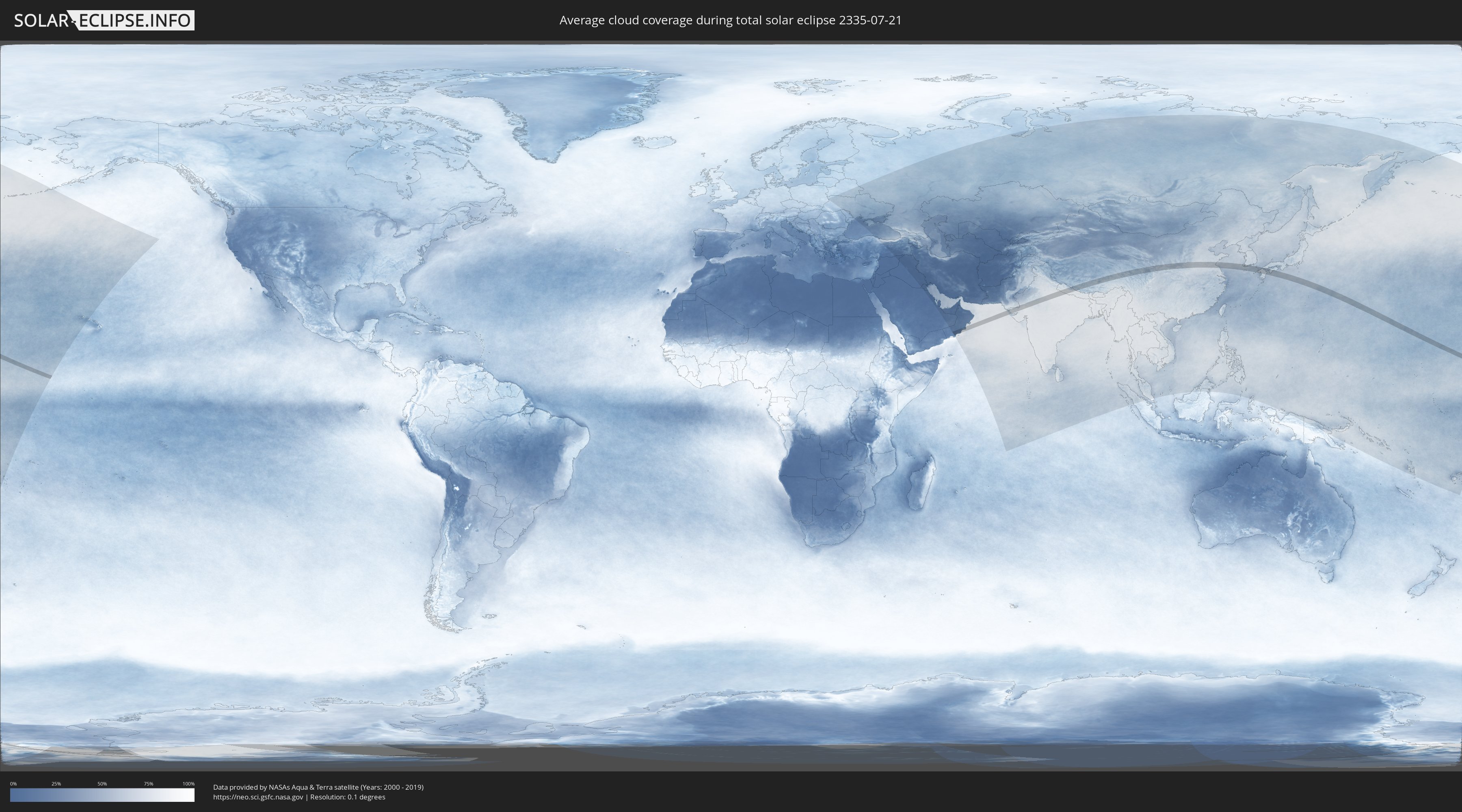
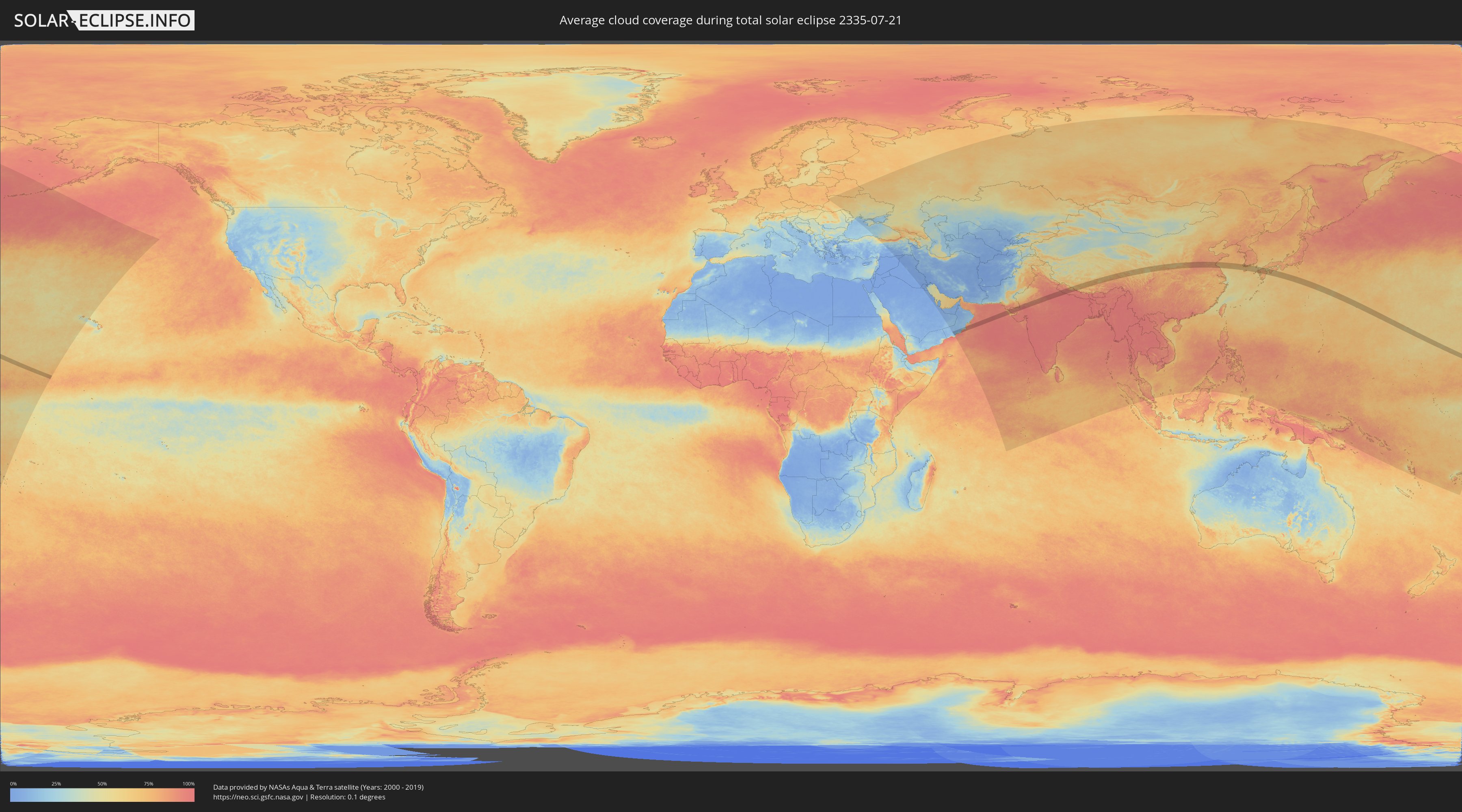
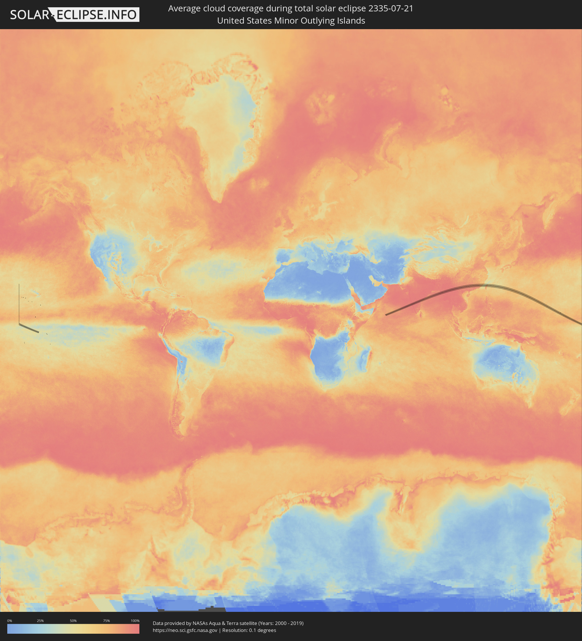
Wie wird das Wetter während der totalen Sonnenfinsternis am 21.07.2335?
Wo ist der beste Ort, um die totale Sonnenfinsternis vom 21.07.2335 zu beobachten?
Die folgenden Karten zeigen die durchschnittliche Bewölkung für den Tag, an dem die totale Sonnenfinsternis
stattfindet. Mit Hilfe der Karten lässt sich der Ort entlang des Finsternispfades eingrenzen,
der die besten Aussichen auf einen klaren wolkenfreien Himmel bietet.
Trotzdem muss man immer lokale Gegenenheiten beachten und sollte sich genau über das Wetter an seinem
gewählten Beobachtungsort informieren.
Die Daten stammen von den beiden NASA-Satelliten
AQUA und TERRA
und wurden über einen Zeitraum von 19 Jahren (2000 - 2019) gemittelt.
Detaillierte Länderkarten
 United States Minor Outlying Islands
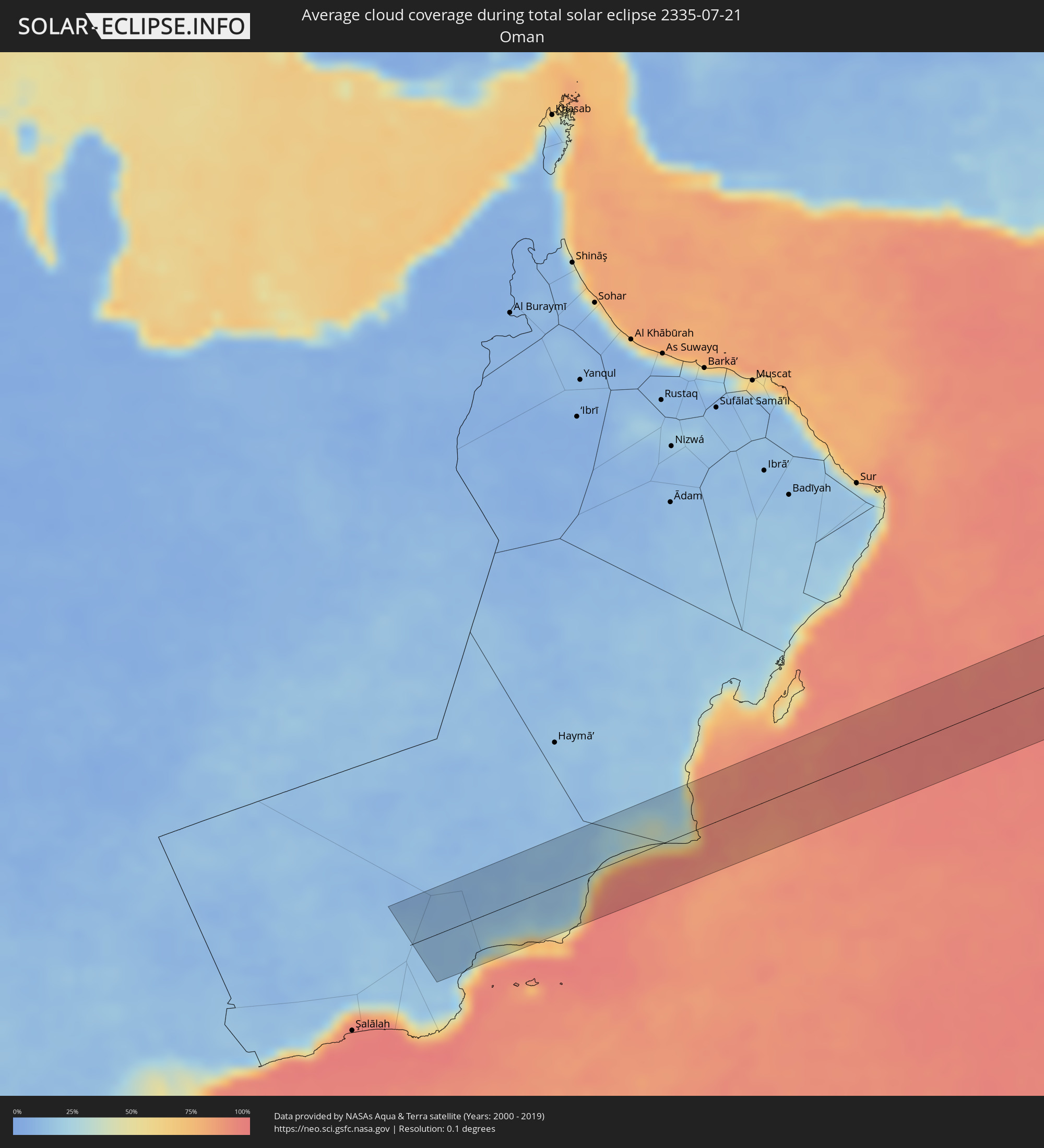 Oman
Oman
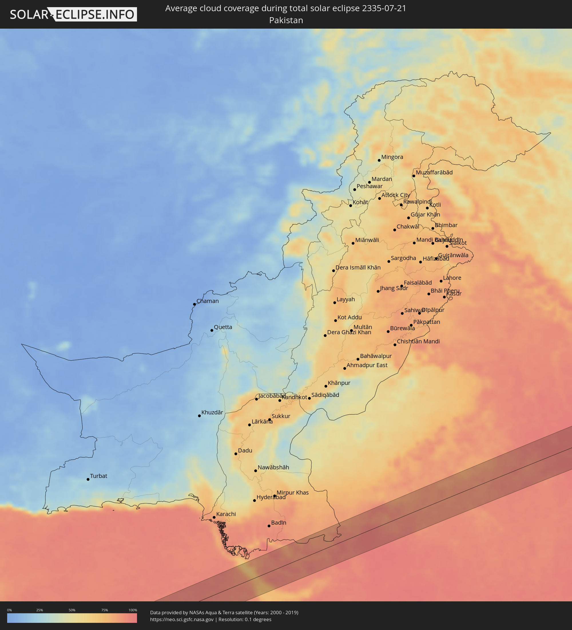 Pakistan
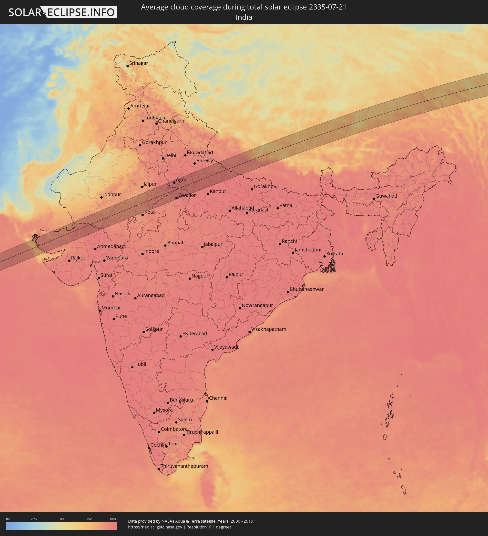 Indien
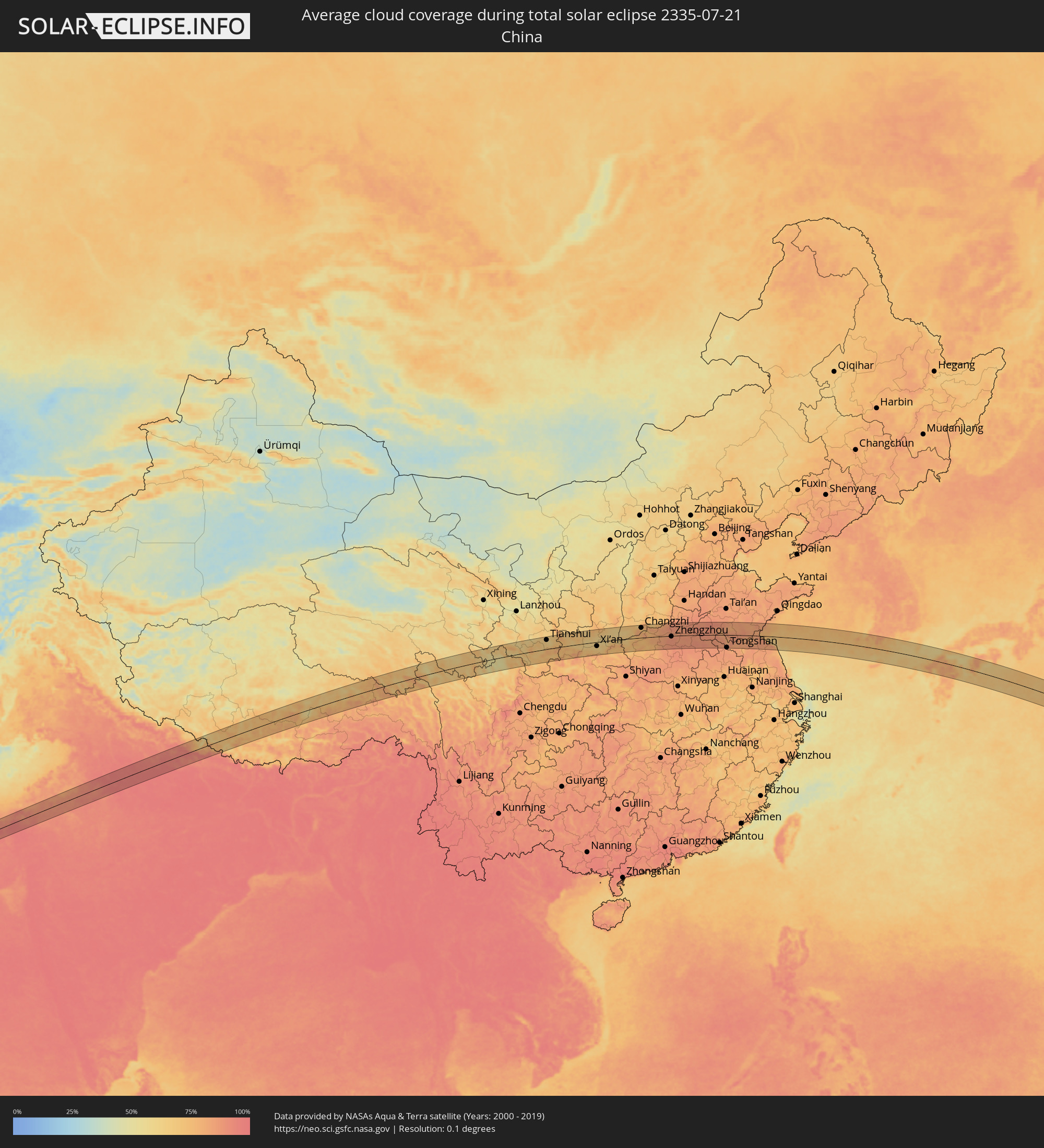 Volksrepublik China
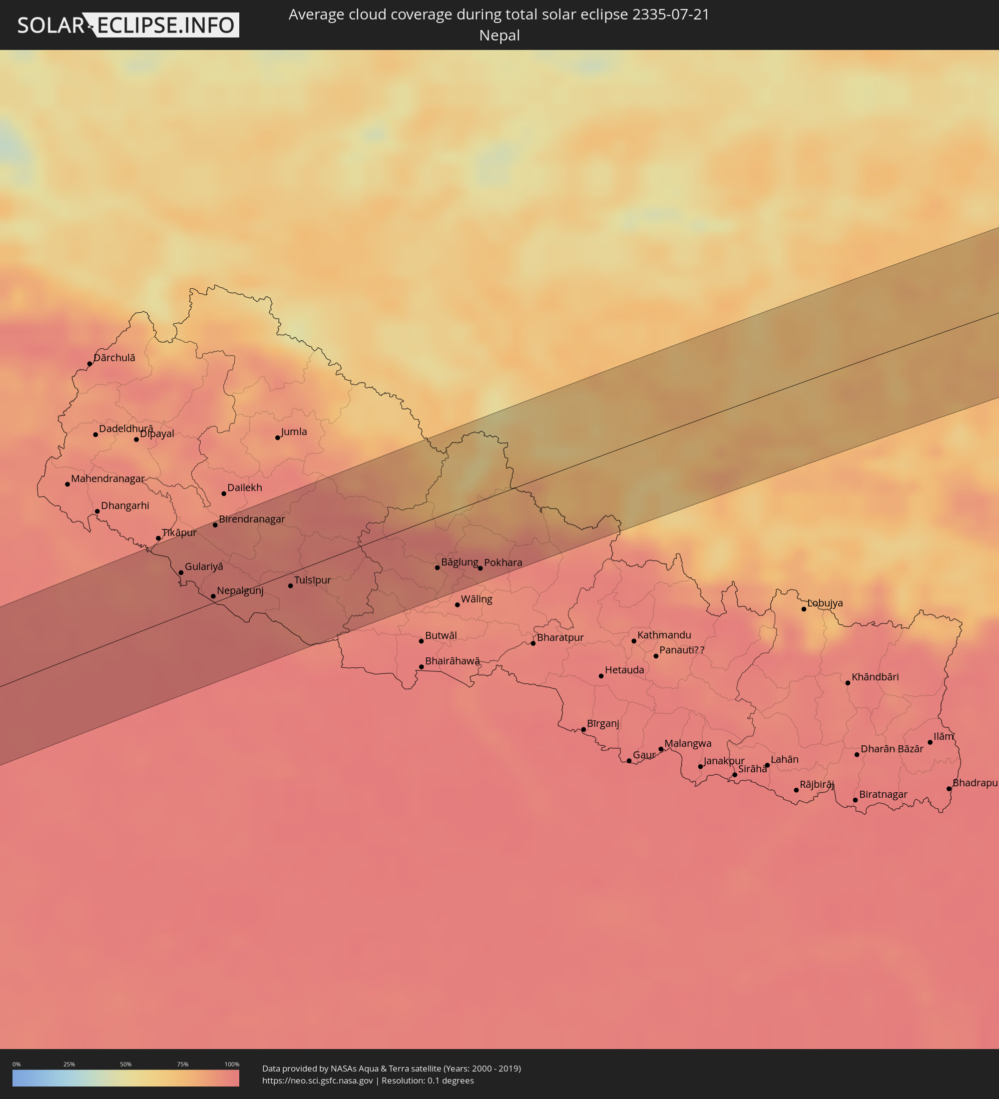 Nepal
Nepal
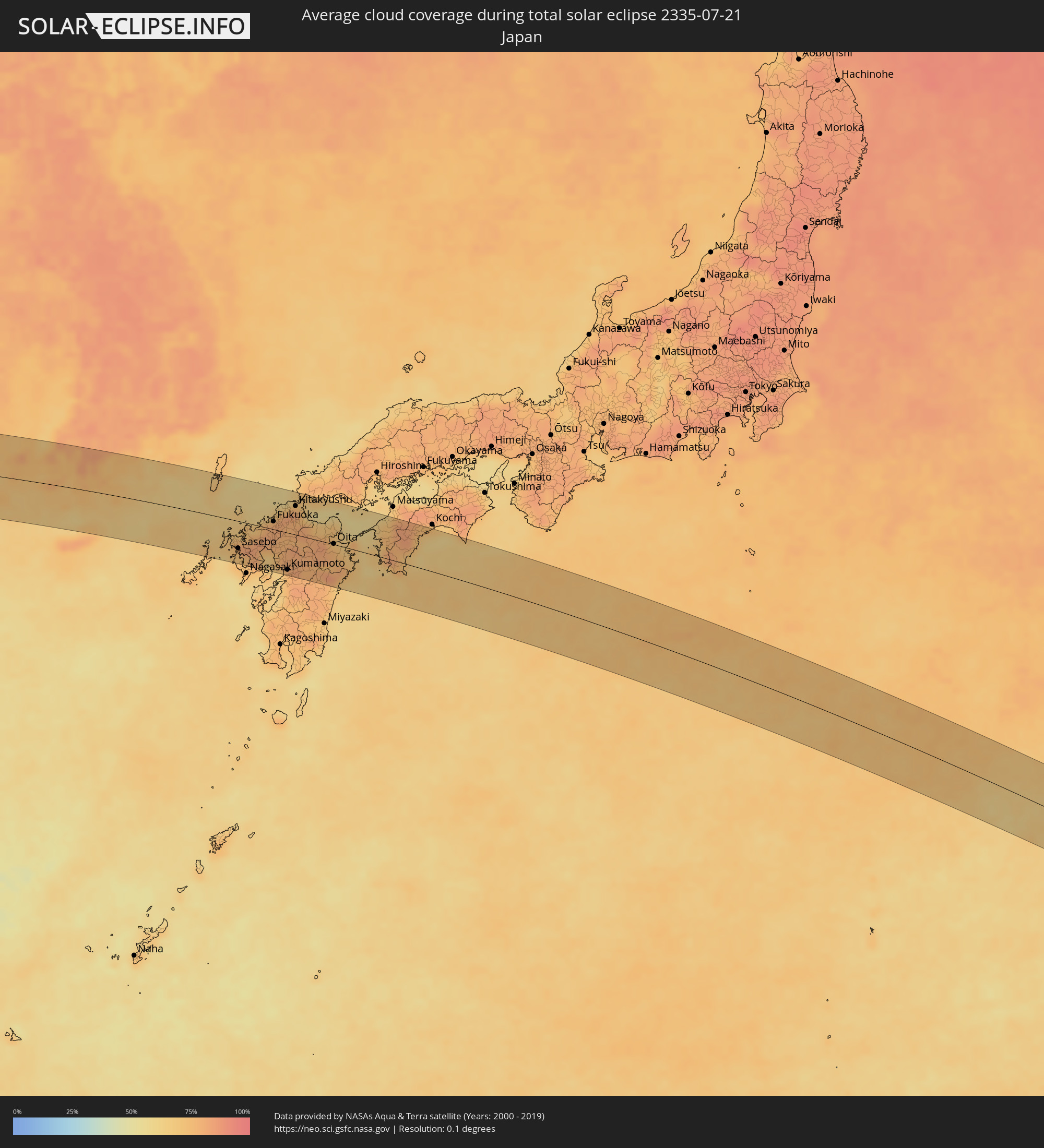 Japan
Japan
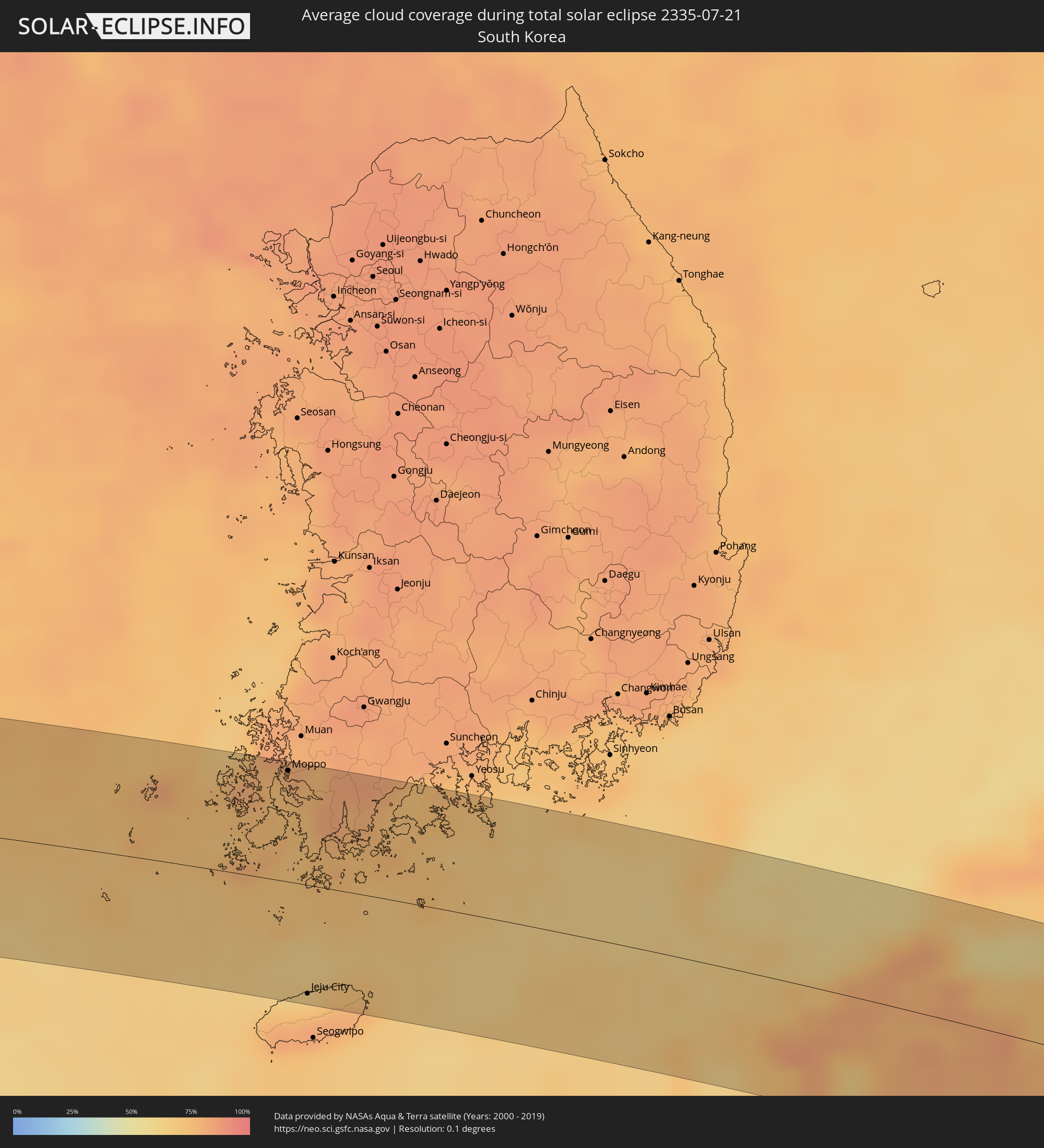 Südkorea
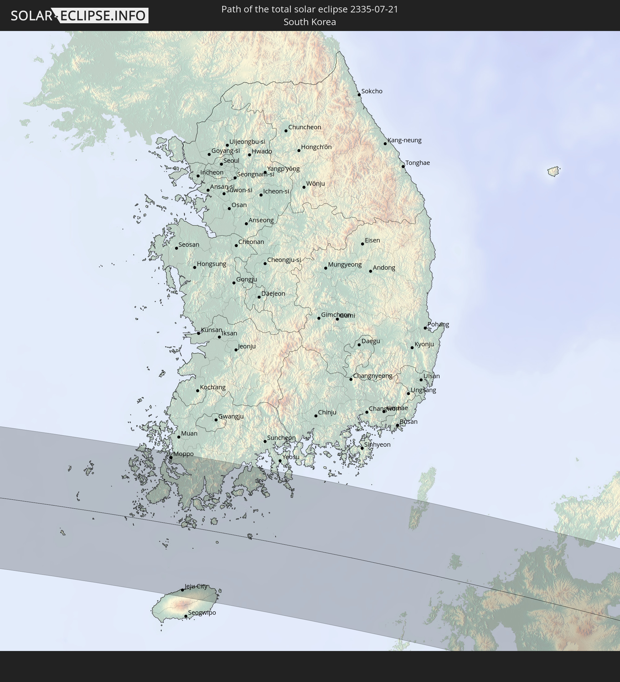
Orte im Finsternispfad
Die nachfolgene Tabelle zeigt Städte und Orte mit mehr als 5.000 Einwohnern, die sich im Finsternispfad befinden. Städte mit mehr als 100.000 Einwohnern sind dick gekennzeichnet. Mit einem Klick auf den Ort öffnet sich eine Detailkarte die die Lage des jeweiligen Ortes zusammen mit dem Verlauf der zentralen Finsternis präsentiert.
| Ort | Typ | Dauer der Verfinsterung | Ortszeit bei maximaler Verfinsterung | Entfernung zur Zentrallinie | Ø Bewölkung |
|
Bhuj, Gujarat
|
total | - | 07:34:19 UTC+05:30 | 40 km | 92% |
|
Dīsa, Gujarat
|
total | - | 07:35:58 UTC+05:30 | 35 km | 97% |
|
Pālanpur, Gujarat
|
total | - | 07:35:59 UTC+05:30 | 53 km | 95% |
|
Ābu Road, Rajasthan
|
total | - | 07:36:23 UTC+05:30 | 35 km | 94% |
|
Udaipur, Rajasthan
|
total | - | 07:36:50 UTC+05:30 | 60 km | 89% |
|
Rājsamand, Rajasthan
|
total | - | 07:37:22 UTC+05:30 | 16 km | 91% |
|
Bhīlwāra, Rajasthan
|
total | - | 07:37:58 UTC+05:30 | 17 km | 90% |
|
Būndi, Rajasthan
|
total | - | 07:38:32 UTC+05:30 | 45 km | 92% |
|
Tonk, Rajasthan
|
total | - | 07:39:18 UTC+05:30 | 24 km | 88% |
|
Sawāi Mādhopur, Rajasthan
|
total | - | 07:39:27 UTC+05:30 | 12 km | 93% |
|
Sheopur, Madhya Pradesh
|
total | - | 07:39:17 UTC+05:30 | 62 km | 93% |
|
Gangāpur, Rajasthan
|
total | - | 07:40:06 UTC+05:30 | 21 km | 93% |
|
Karauli, Rajasthan
|
total | - | 07:40:17 UTC+05:30 | 12 km | 90% |
|
Hindaun, Rajasthan
|
total | - | 07:40:32 UTC+05:30 | 36 km | 94% |
|
Bāri, Rajasthan
|
total | - | 07:40:46 UTC+05:30 | 5 km | 92% |
|
Dhaulpur, Rajasthan
|
total | - | 07:40:58 UTC+05:30 | 0 km | 94% |
|
Morena, Madhya Pradesh
|
total | - | 07:40:51 UTC+05:30 | 24 km | 96% |
|
Āgra, Uttar Pradesh
|
total | - | 07:41:33 UTC+05:30 | 46 km | 95% |
|
Gwalior, Madhya Pradesh
|
total | - | 07:40:41 UTC+05:30 | 59 km | 93% |
|
Tūndla, Uttar Pradesh
|
total | - | 07:41:43 UTC+05:30 | 41 km | 97% |
|
Fīrozābād, Uttar Pradesh
|
total | - | 07:41:45 UTC+05:30 | 28 km | 96% |
|
Gohadi, Madhya Pradesh
|
total | - | 07:41:03 UTC+05:30 | 48 km | 96% |
|
Shikohābād, Uttar Pradesh
|
total | - | 07:41:49 UTC+05:30 | 17 km | 96% |
|
Bhind, Madhya Pradesh
|
total | - | 07:41:24 UTC+05:30 | 47 km | 96% |
|
Etāwah, Uttar Pradesh
|
total | - | 07:41:46 UTC+05:30 | 33 km | 96% |
|
Mainpuri, Uttar Pradesh
|
total | - | 07:42:13 UTC+05:30 | 13 km | 96% |
|
Chhibrāmau, Uttar Pradesh
|
total | - | 07:42:27 UTC+05:30 | 12 km | 97% |
|
Farrukhābād, Uttar Pradesh
|
total | - | 07:42:45 UTC+05:30 | 10 km | 96% |
|
Tilhar, Uttar Pradesh
|
total | - | 07:43:27 UTC+05:30 | 63 km | 96% |
|
Shāhjānpur, Uttar Pradesh
|
total | - | 07:43:28 UTC+05:30 | 49 km | 95% |
|
Kannauj, Uttar Pradesh
|
total | - | 07:42:38 UTC+05:30 | 37 km | 96% |
|
Shāhābād, Uttar Pradesh
|
total | - | 07:43:15 UTC+05:30 | 23 km | 96% |
|
Hardoī, Uttar Pradesh
|
total | - | 07:43:08 UTC+05:30 | 10 km | 97% |
|
Gola Gokarannāth, Uttar Pradesh
|
total | - | 07:44:04 UTC+05:30 | 49 km | 95% |
|
Sandīla, Uttar Pradesh
|
total | - | 07:43:04 UTC+05:30 | 57 km | 97% |
|
Sītāpur, Uttar Pradesh
|
total | - | 07:43:41 UTC+05:30 | 13 km | 97% |
|
Lakhīmpur, Uttar Pradesh
|
total | - | 07:44:09 UTC+05:30 | 24 km | 95% |
|
Lāharpur, Uttar Pradesh
|
total | - | 07:44:00 UTC+05:30 | 5 km | 97% |
|
Biswān, Uttar Pradesh
|
total | - | 07:43:51 UTC+05:30 | 31 km | 97% |
|
Gulariyā, Mid Western
|
total | - | 07:59:52 UTC+05:45 | 34 km | 95% |
|
Bahraigh, Uttar Pradesh
|
total | - | 07:44:23 UTC+05:30 | 44 km | 97% |
|
Nepalgunj, Mid Western
|
total | - | 07:59:53 UTC+05:45 | 5 km | 95% |
|
Birendranagar, Mid Western
|
total | - | 08:00:28 UTC+05:45 | 61 km | 92% |
|
Tulsīpur, Mid Western
|
total | - | 08:00:30 UTC+05:45 | 11 km | 93% |
|
Besisahar
|
total | - | 08:00:42 UTC+05:45 | 4 km | 96% |
|
Bāglung, Western Region
|
total | - | 08:01:43 UTC+05:45 | 41 km | 89% |
|
Pokhara, Western Region
|
total | - | 08:02:02 UTC+05:45 | 55 km | 92% |
|
Tianshui, Gansu
|
total | - | 10:54:04 UTC+08:00 | 53 km | 65% |
|
Beidao, Gansu
|
total | - | 10:54:21 UTC+08:00 | 49 km | 60% |
|
Guozhen, Shaanxi
|
total | - | 10:57:07 UTC+08:00 | 7 km | 66% |
|
Xianyang, Shaanxi
|
total | - | 10:59:51 UTC+08:00 | 12 km | 64% |
|
Xi’an, Shaanxi
|
total | - | 11:00:17 UTC+08:00 | 24 km | 63% |
|
Tongchuan, Shaanxi
|
total | - | 11:01:06 UTC+08:00 | 66 km | 71% |
|
Lintong, Shaanxi
|
total | - | 11:00:56 UTC+08:00 | 13 km | 65% |
|
Weinan, Shaanxi
|
total | - | 11:01:38 UTC+08:00 | 2 km | 62% |
|
Huayin, Shaanxi
|
total | - | 11:02:51 UTC+08:00 | 1 km | 69% |
|
Yuncheng, Shanxi
|
total | - | 11:05:04 UTC+08:00 | 42 km | 67% |
|
Changzhi, Shanxi
|
total | - | 11:06:46 UTC+08:00 | 57 km | 75% |
|
Yima, Henan
|
total | - | 11:06:52 UTC+08:00 | 4 km | 74% |
|
Luoyang, Henan
|
total | - | 11:08:06 UTC+08:00 | 6 km | 80% |
|
Songyang, Henan
|
total | - | 11:09:18 UTC+08:00 | 35 km | 83% |
|
Jiaozuo, Henan
|
total | - | 11:10:03 UTC+08:00 | 52 km | 85% |
|
Yingchuan, Henan
|
total | - | 11:10:11 UTC+08:00 | 69 km | 86% |
|
Zhengzhou, Henan
|
total | - | 11:10:49 UTC+08:00 | 4 km | 87% |
|
Nangandao, Henan
|
total | - | 11:11:18 UTC+08:00 | 44 km | 88% |
|
Jiangguanchi, Henan
|
total | - | 11:10:58 UTC+08:00 | 74 km | 90% |
|
Kaifeng, Henan
|
total | - | 11:12:19 UTC+08:00 | 2 km | 86% |
|
Heze, Shandong
|
total | - | 11:15:06 UTC+08:00 | 45 km | 88% |
|
Shangqiu, Henan
|
total | - | 11:15:20 UTC+08:00 | 43 km | 89% |
|
Shancheng, Shandong
|
total | - | 11:16:25 UTC+08:00 | 5 km | 87% |
|
Jining, Shandong
|
total | - | 11:17:41 UTC+08:00 | 62 km | 86% |
|
Tangzhai, Anhui
|
total | - | 11:17:32 UTC+08:00 | 46 km | 85% |
|
Zoucheng, Shandong
|
total | - | 11:18:34 UTC+08:00 | 62 km | 86% |
|
Xiazhen, Shandong
|
total | - | 11:18:49 UTC+08:00 | 4 km | 82% |
|
Tengzhou, Shandong
|
total | - | 11:18:57 UTC+08:00 | 26 km | 86% |
|
Tongshan, Jiangsu
|
total | - | 11:18:51 UTC+08:00 | 74 km | 85% |
|
Shanting, Shandong
|
total | - | 11:19:40 UTC+08:00 | 26 km | 83% |
|
Zaozhuang, Shandong
|
total | - | 11:19:53 UTC+08:00 | 3 km | 87% |
|
Pingyi, Shandong
|
total | - | 11:20:08 UTC+08:00 | 74 km | 83% |
|
Pizhou, Jiangsu
|
total | - | 11:20:46 UTC+08:00 | 58 km | 82% |
|
Feicheng, Shandong
|
total | - | 11:20:53 UTC+08:00 | 48 km | 84% |
|
Bianzhuang, Shandong
|
total | - | 11:21:02 UTC+08:00 | 2 km | 84% |
|
Linyi, Shandong
|
total | - | 11:21:45 UTC+08:00 | 27 km | 87% |
|
Xiazhuang, Shandong
|
total | - | 11:22:27 UTC+08:00 | 12 km | 84% |
|
Shizilu, Shandong
|
total | - | 11:22:55 UTC+08:00 | 41 km | 82% |
|
Xinpu, Jiangsu
|
total | - | 11:23:42 UTC+08:00 | 22 km | 85% |
|
Rizhao, Shandong
|
total | - | 11:24:24 UTC+08:00 | 72 km | 83% |
|
Sinan, Jeollanam-do
|
total | - | 12:40:31 UTC+09:00 | 69 km | 79% |
|
Moppo, Jeollanam-do
|
total | - | 12:41:13 UTC+09:00 | 70 km | 79% |
|
Jeju City, Jeju-do
|
total | - | 12:42:09 UTC+09:00 | 69 km | 73% |
|
Haenam, Jeollanam-do
|
total | - | 12:41:50 UTC+09:00 | 49 km | 81% |
|
Sasebo, Nagasaki
|
total | - | 12:50:18 UTC+09:00 | 48 km | 75% |
|
Imarichō-kō, Saga Prefecture
|
total | - | 12:50:36 UTC+09:00 | 33 km | 81% |
|
Ōmura, Nagasaki
|
total | - | 12:51:02 UTC+09:00 | 69 km | 74% |
|
Karatsu, Saga Prefecture
|
total | - | 12:50:42 UTC+09:00 | 13 km | 79% |
|
Takeochō-takeo, Saga Prefecture
|
total | - | 12:51:01 UTC+09:00 | 39 km | 83% |
|
Kashima, Saga Prefecture
|
total | - | 12:51:15 UTC+09:00 | 46 km | 80% |
|
Maebaru-chūō, Fukuoka
|
total | - | 12:51:11 UTC+09:00 | 5 km | 75% |
|
Saga, Saga Prefecture
|
total | - | 12:51:40 UTC+09:00 | 28 km | 73% |
|
Ōkawa, Saga Prefecture
|
total | - | 12:51:48 UTC+09:00 | 31 km | 75% |
|
Shimabara, Nagasaki
|
total | - | 12:52:09 UTC+09:00 | 76 km | 67% |
|
Yanagawa, Fukuoka
|
total | - | 12:51:57 UTC+09:00 | 33 km | 75% |
|
Fukuoka, Fukuoka
|
total | - | 12:51:41 UTC+09:00 | 14 km | 79% |
|
Ōmuta, Fukuoka
|
total | - | 12:52:10 UTC+09:00 | 47 km | 73% |
|
Koga, Fukuoka
|
total | - | 12:51:42 UTC+09:00 | 30 km | 78% |
|
Umi, Fukuoka
|
total | - | 12:51:56 UTC+09:00 | 13 km | 81% |
|
Kurume, Fukuoka
|
total | - | 12:52:08 UTC+09:00 | 15 km | 78% |
|
Sasaguri, Fukuoka
|
total | - | 12:51:59 UTC+09:00 | 19 km | 80% |
|
Tamana, Kumamoto
|
total | - | 12:52:33 UTC+09:00 | 57 km | 71% |
|
Amagi, Fukuoka
|
total | - | 12:52:23 UTC+09:00 | 1 km | 77% |
|
Yamaga, Kumamoto
|
total | - | 12:52:45 UTC+09:00 | 43 km | 80% |
|
Iizuka, Fukuoka
|
total | - | 12:52:18 UTC+09:00 | 24 km | 78% |
|
Uekimachi-mōno, Kumamoto
|
total | - | 12:52:52 UTC+09:00 | 56 km | 78% |
|
Kumamoto, Kumamoto
|
total | - | 12:52:56 UTC+09:00 | 66 km | 75% |
|
Kitakyushu, Fukuoka
|
total | - | 12:52:32 UTC+09:00 | 51 km | 77% |
|
Ōzu, Kumamoto
|
total | - | 12:53:19 UTC+09:00 | 54 km | 82% |
|
Hita, Oita
|
total | - | 12:53:09 UTC+09:00 | 5 km | 80% |
|
Yukuhashi, Fukuoka
|
total | - | 12:52:57 UTC+09:00 | 40 km | 73% |
|
Kanda, Fukuoka
|
total | - | 12:52:54 UTC+09:00 | 46 km | 72% |
|
Aso, Kumamoto
|
total | - | 12:53:47 UTC+09:00 | 43 km | 77% |
|
Buzen, Fukuoka
|
total | - | 12:53:23 UTC+09:00 | 31 km | 78% |
|
Nakatsu, Fukuoka
|
total | - | 12:53:32 UTC+09:00 | 31 km | 73% |
|
Ube, Yamaguchi
|
total | - | 12:53:25 UTC+09:00 | 70 km | 58% |
|
Hiji, Oita
|
total | - | 12:54:32 UTC+09:00 | 14 km | 76% |
|
Ōita, Oita
|
total | - | 12:54:49 UTC+09:00 | 1 km | 77% |
|
Nobeoka, Miyazaki
|
total | - | 12:55:30 UTC+09:00 | 67 km | 66% |
|
Usuki, Oita
|
total | - | 12:55:23 UTC+09:00 | 6 km | 72% |
|
Saiki, Oita
|
total | - | 12:55:46 UTC+09:00 | 22 km | 71% |
|
Ōzu, Ehime
|
total | - | 12:56:51 UTC+09:00 | 53 km | 75% |
|
Uwajima, Ehime
|
total | - | 12:57:06 UTC+09:00 | 23 km | 77% |
|
Nakamura, Kochi
|
total | - | 12:58:12 UTC+09:00 | 7 km | 74% |