Totale Sonnenfinsternis vom 18.03.2360
| Wochentag: | Freitag |
| Maximale Dauer der Verfinsterung: | 04m33s |
| Maximale Breite des Finsternispfades: | 181 km |
| Saroszyklus: | 145 |
| Bedeckungsgrad: | 100% |
| Magnitude: | 1.0549 |
| Gamma: | -0.0177 |
Wo kann man die Sonnenfinsternis vom 18.03.2360 sehen?
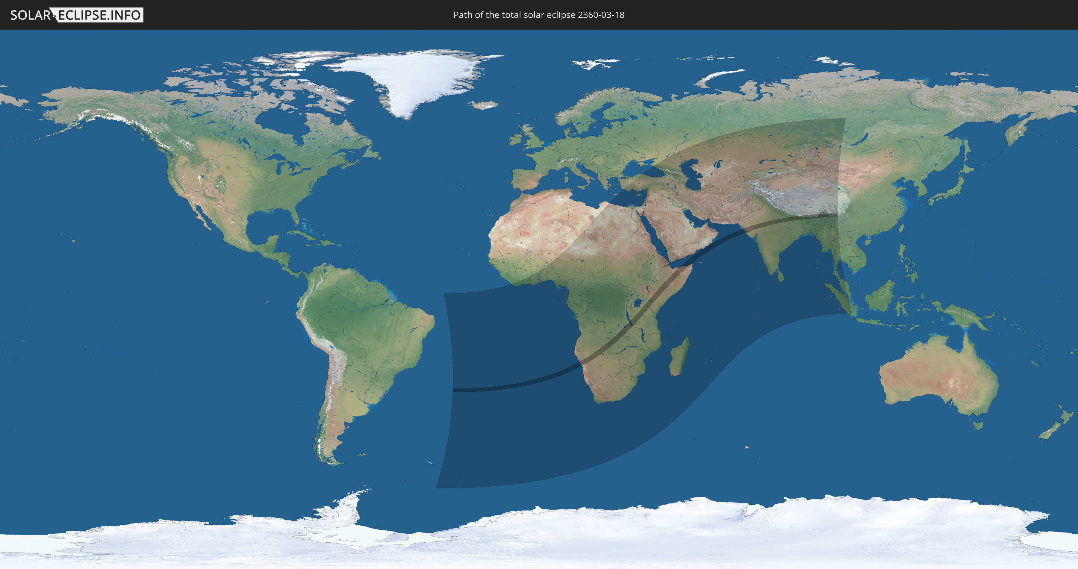
Die Sonnenfinsternis am 18.03.2360 kann man in 89 Ländern als partielle Sonnenfinsternis beobachten.
Der Finsternispfad verläuft durch 15 Länder. Nur in diesen Ländern ist sie als totale Sonnenfinsternis zu sehen.
In den folgenden Ländern ist die Sonnenfinsternis total zu sehen
 Angola
 Namibia
 Demokratische Republik Kongo
 Sambia
 Tansania
 Äthiopien
 Kenia
Kenia
 Somalia
 Oman
Oman
 Pakistan
 Indien
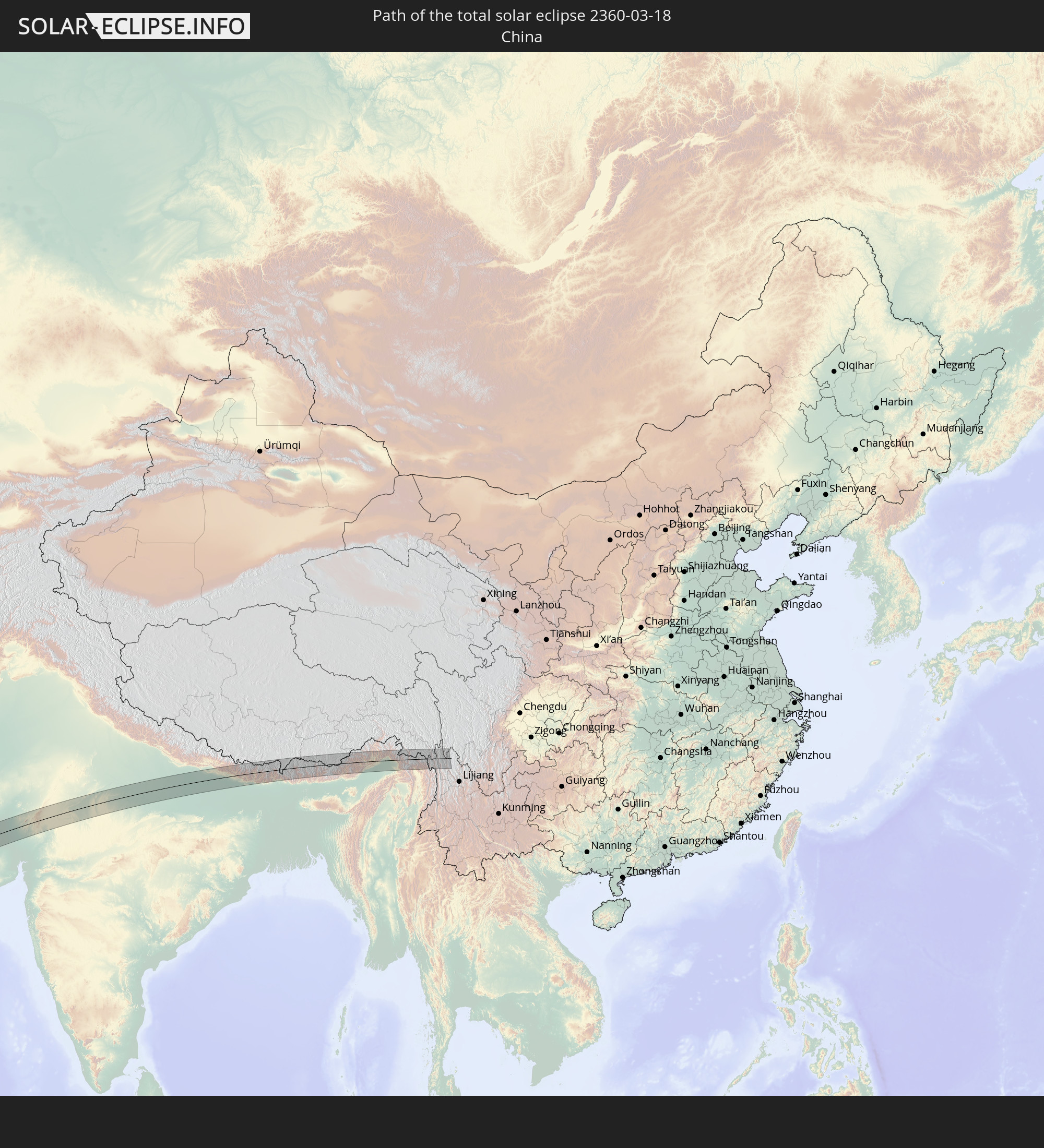 Volksrepublik China
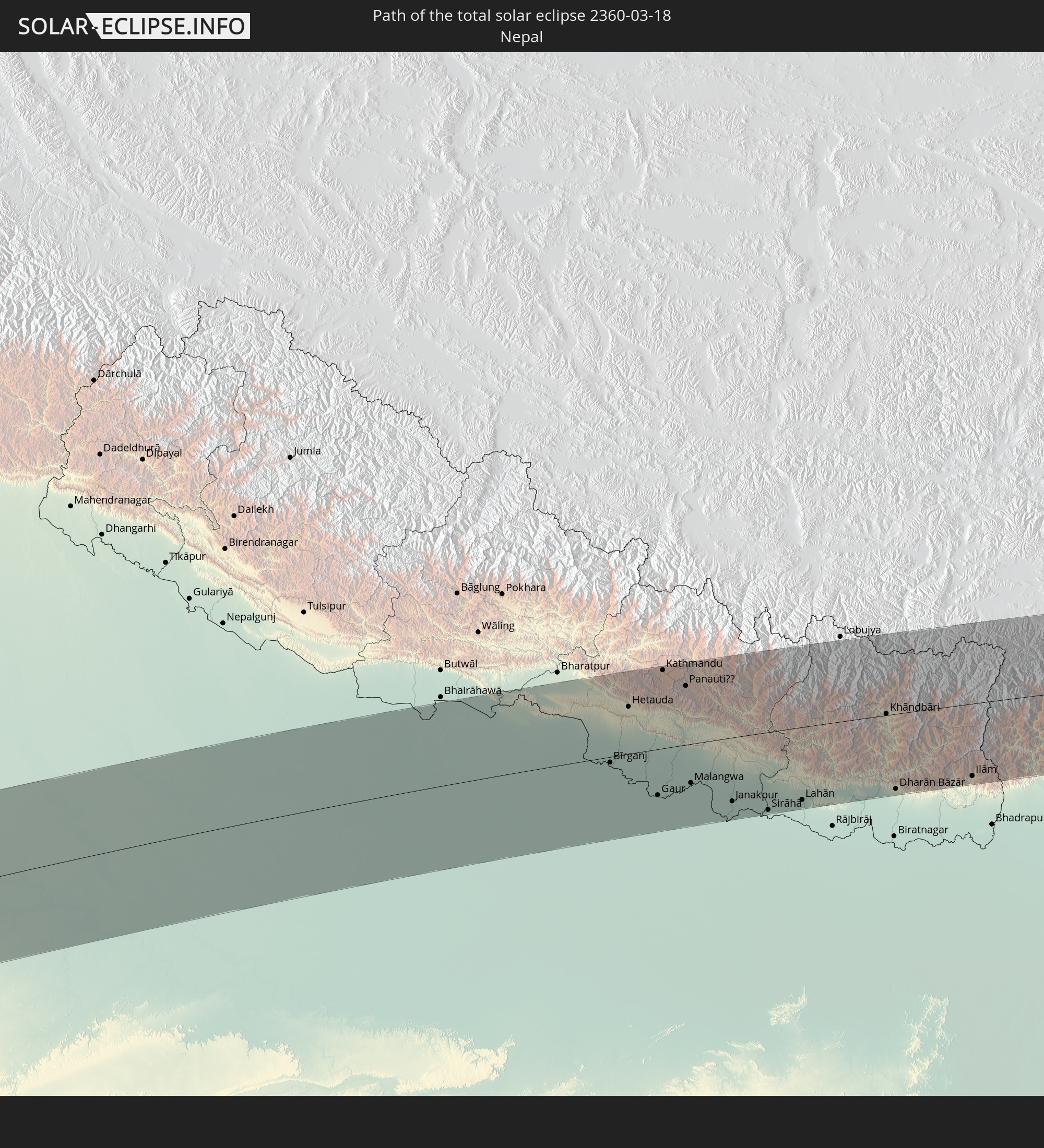 Nepal
Nepal
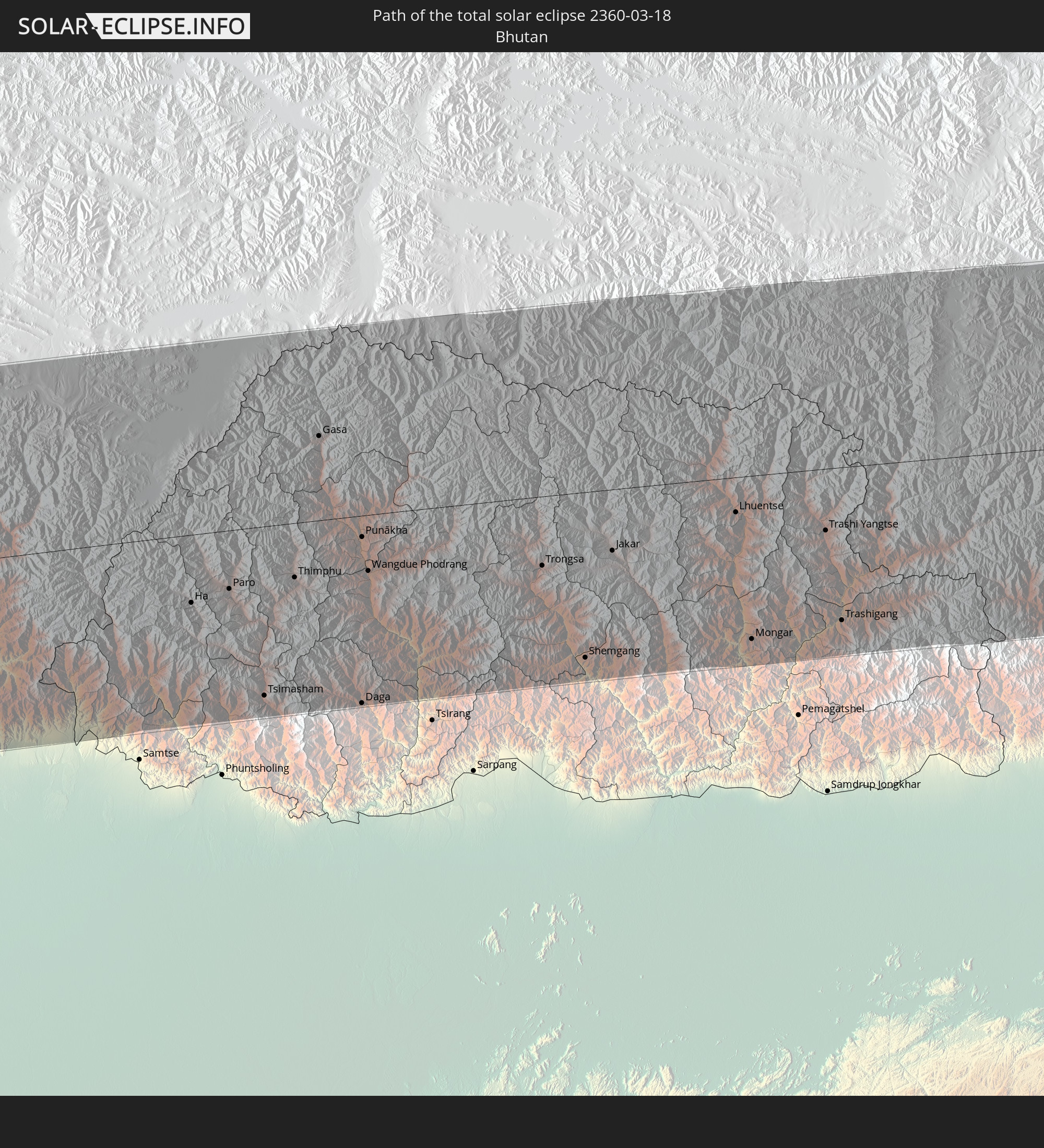 Bhutan
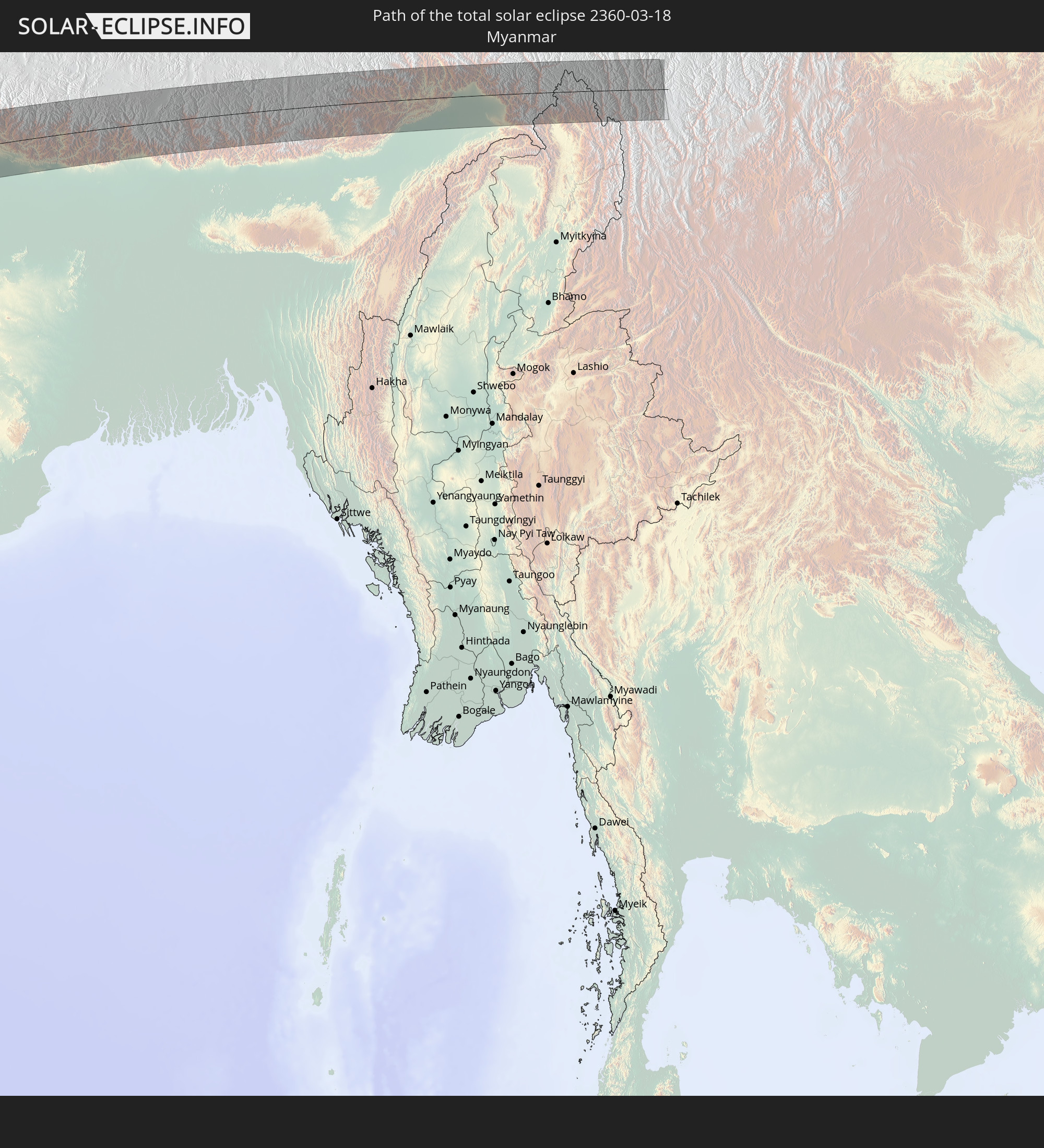 Myanmar
In den folgenden Ländern ist die Sonnenfinsternis partiell zu sehen
 Russland
 Südgeorgien und die Südlichen Sandwichinseln
 St. Helena
 Liberia
 Elfenbeinküste
 Ghana
Ghana
 Togo
Togo
 Niger
Niger
 Benin
Benin
 Nigeria
 Bouvetinsel
 Äquatorialguinea
 São Tomé und Príncipe
 Kamerun
 Gabun
Gabun
 Libyen
 Republik Kongo
 Angola
 Namibia
 Demokratische Republik Kongo
 Tschad
 Zentralafrikanische Republik
 Südafrika
 Griechenland
 Botswana
 Sudan
Sudan
 Sambia
 Ägypten
 Simbabwe
 Türkei
 Lesotho
 Ruanda
 Burundi
 Tansania
 Uganda
 Mosambik
 Swasiland
 Republik Zypern
 Malawi
 Äthiopien
 Kenia
Kenia
 Staat Palästina
 Israel
 Saudi-Arabien
 Jordanien
 Libanon
 Syrien
 Eritrea
 Irak
Irak
 Georgien
 Französische Süd- und Antarktisgebiete
 Somalia
 Dschibuti
 Jemen
Jemen
 Madagaskar
 Komoren
 Armenien
 Iran
Iran
 Aserbaidschan
 Mayotte
 Seychellen
 Kasachstan
 Kuwait
 Bahrain
 Katar
Katar
 Vereinigte Arabische Emirate
 Oman
Oman
 Turkmenistan
 Réunion
 Usbekistan
 Mauritius
 Afghanistan
 Pakistan
 Tadschikistan
 Indien
 Kirgisistan
 Britisches Territorium im Indischen Ozean
 Malediven
 Volksrepublik China
 Sri Lanka
 Nepal
Nepal
 Mongolei
 Bangladesch
 Bhutan
 Myanmar
 Indonesien
 Thailand
 Malaysia
 Laos
Laos
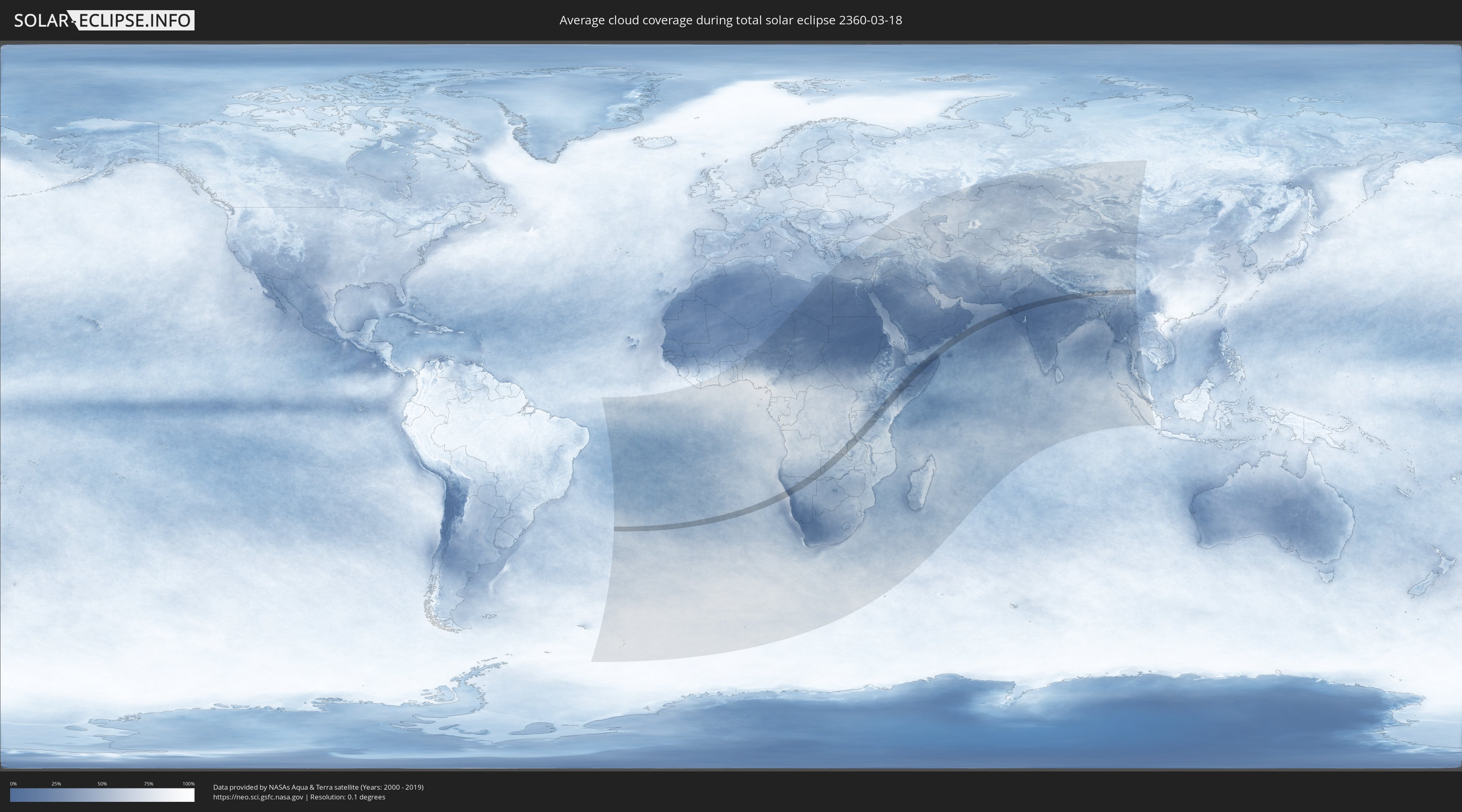
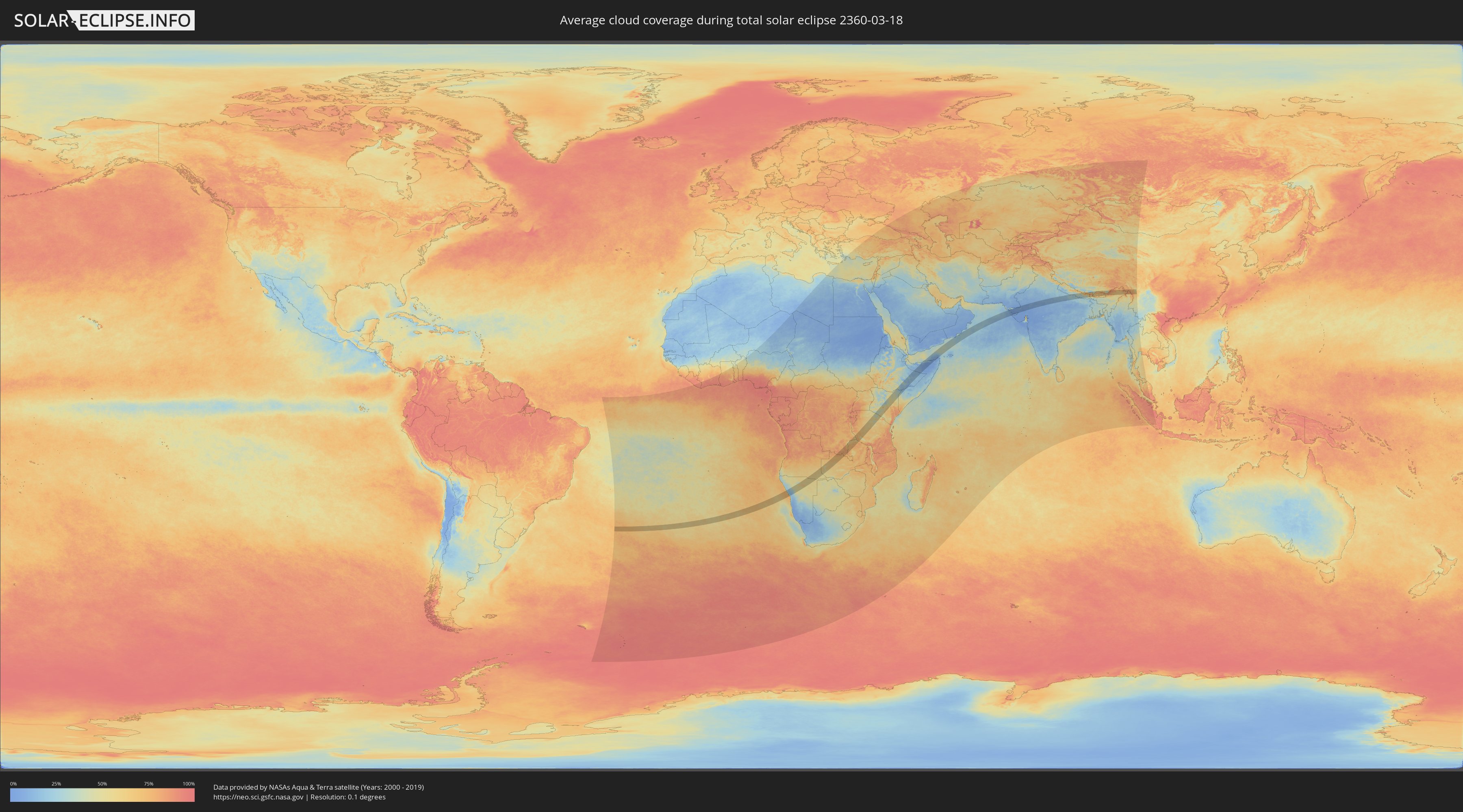
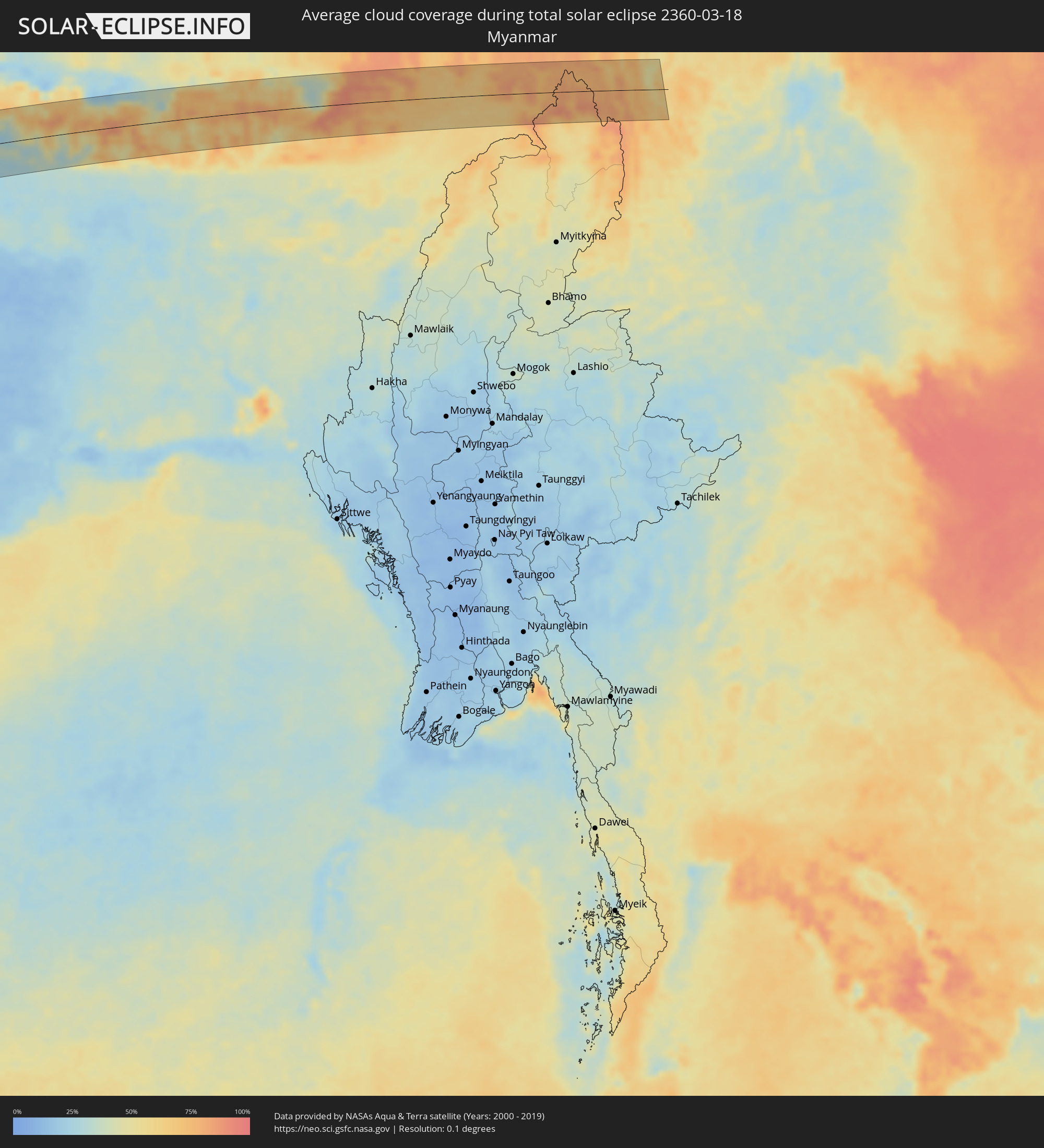
Wie wird das Wetter während der totalen Sonnenfinsternis am 18.03.2360?
Wo ist der beste Ort, um die totale Sonnenfinsternis vom 18.03.2360 zu beobachten?
Die folgenden Karten zeigen die durchschnittliche Bewölkung für den Tag, an dem die totale Sonnenfinsternis
stattfindet. Mit Hilfe der Karten lässt sich der Ort entlang des Finsternispfades eingrenzen,
der die besten Aussichen auf einen klaren wolkenfreien Himmel bietet.
Trotzdem muss man immer lokale Gegenenheiten beachten und sollte sich genau über das Wetter an seinem
gewählten Beobachtungsort informieren.
Die Daten stammen von den beiden NASA-Satelliten
AQUA und TERRA
und wurden über einen Zeitraum von 19 Jahren (2000 - 2019) gemittelt.
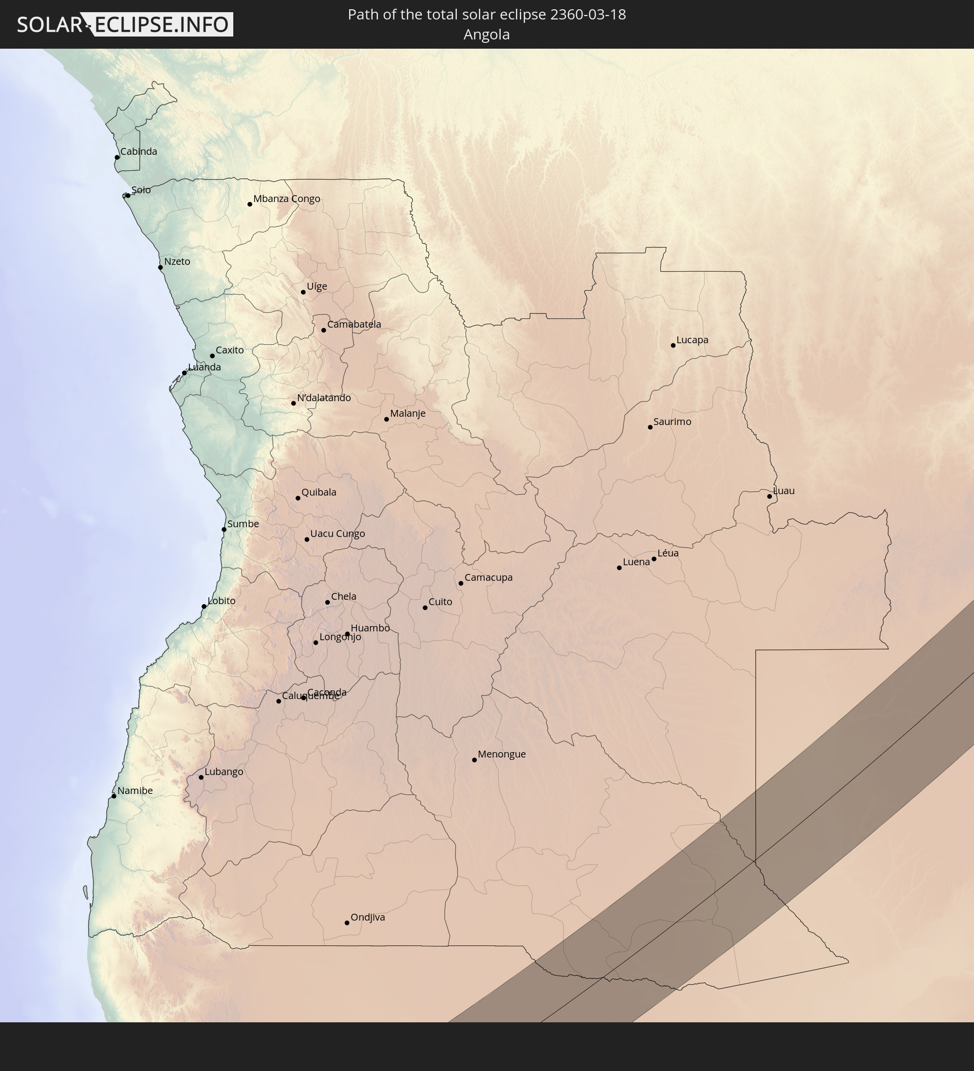
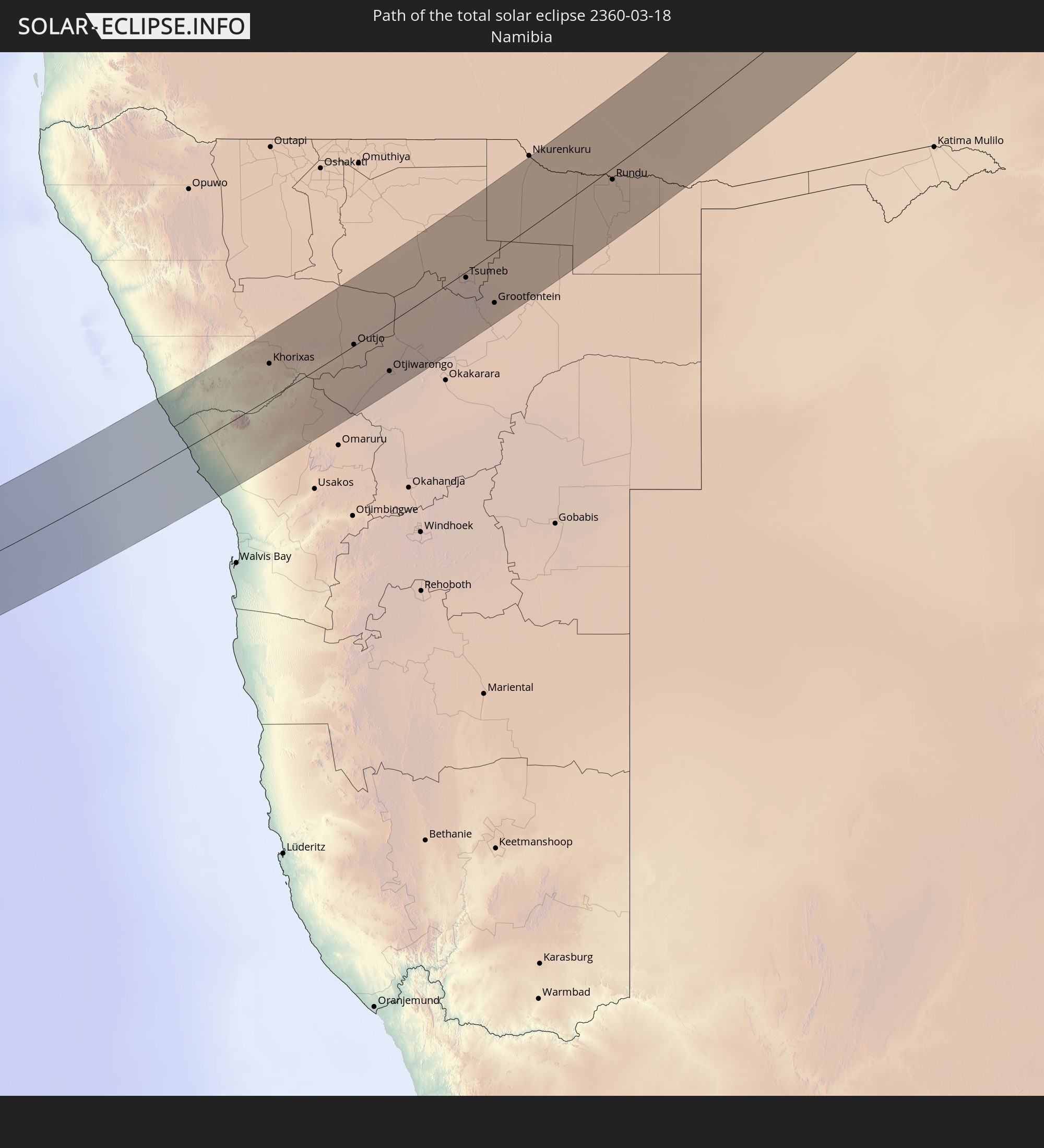
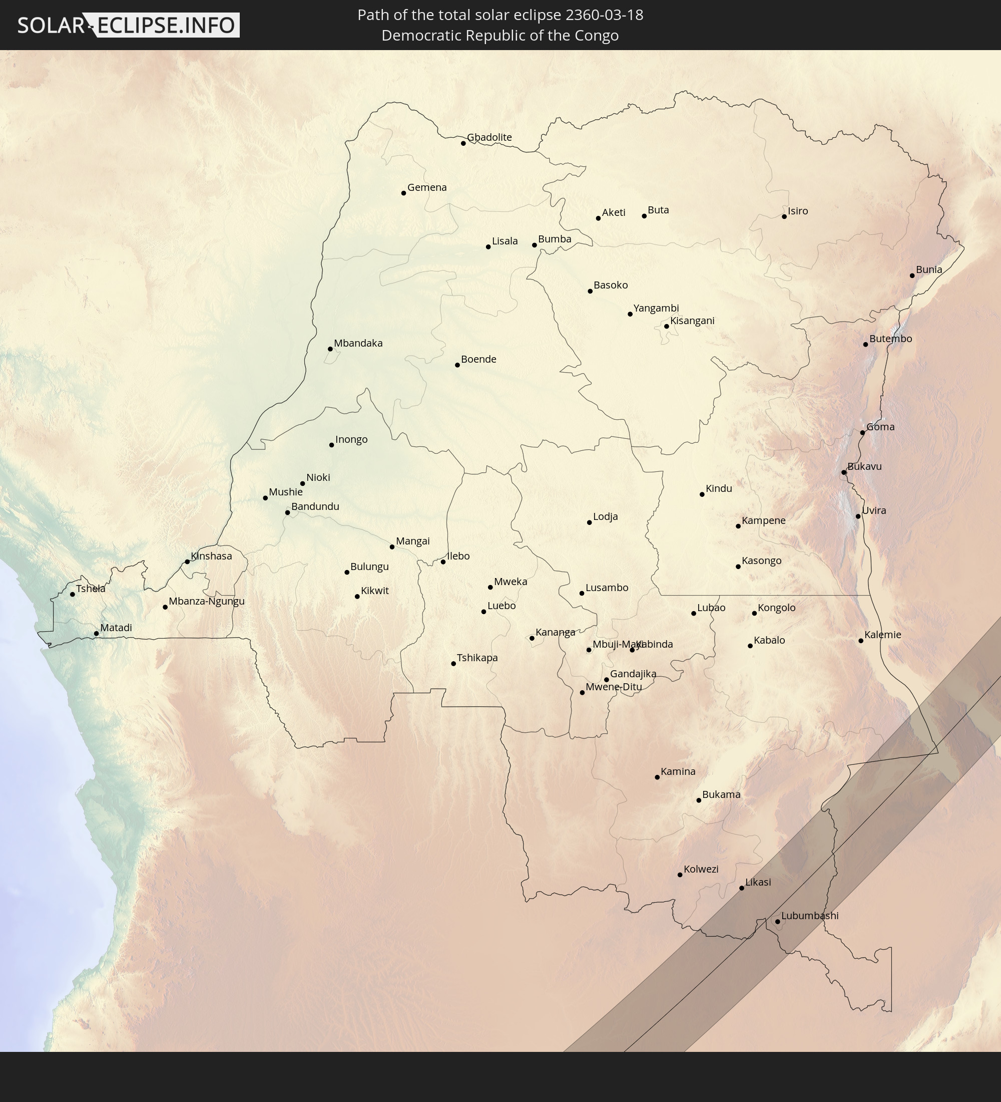
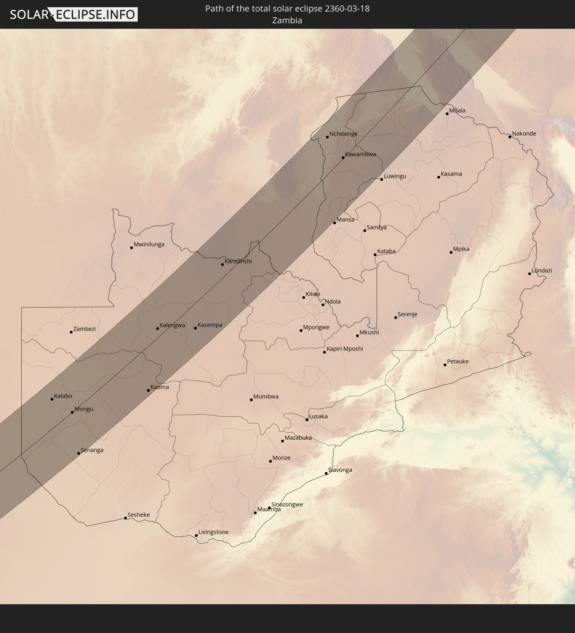
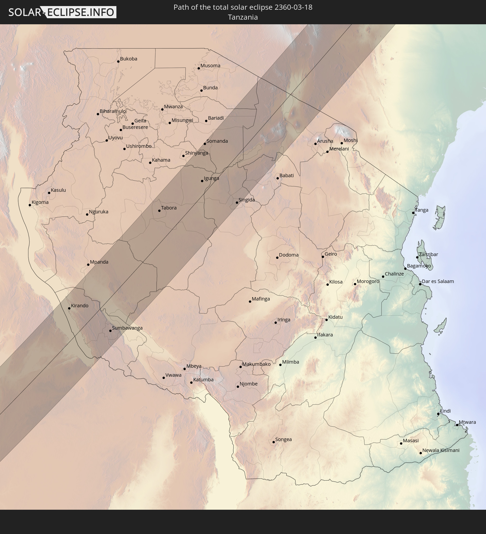
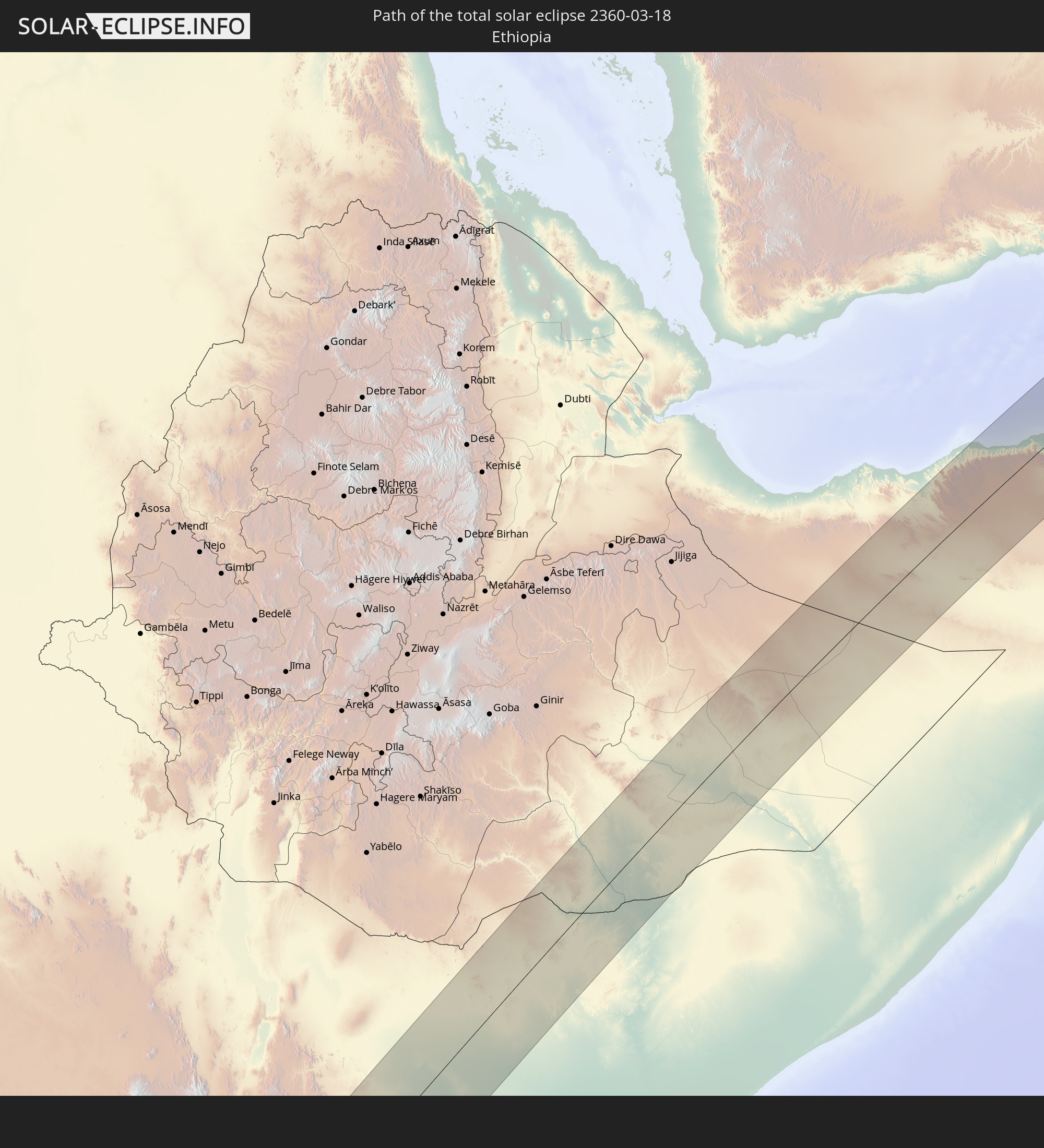
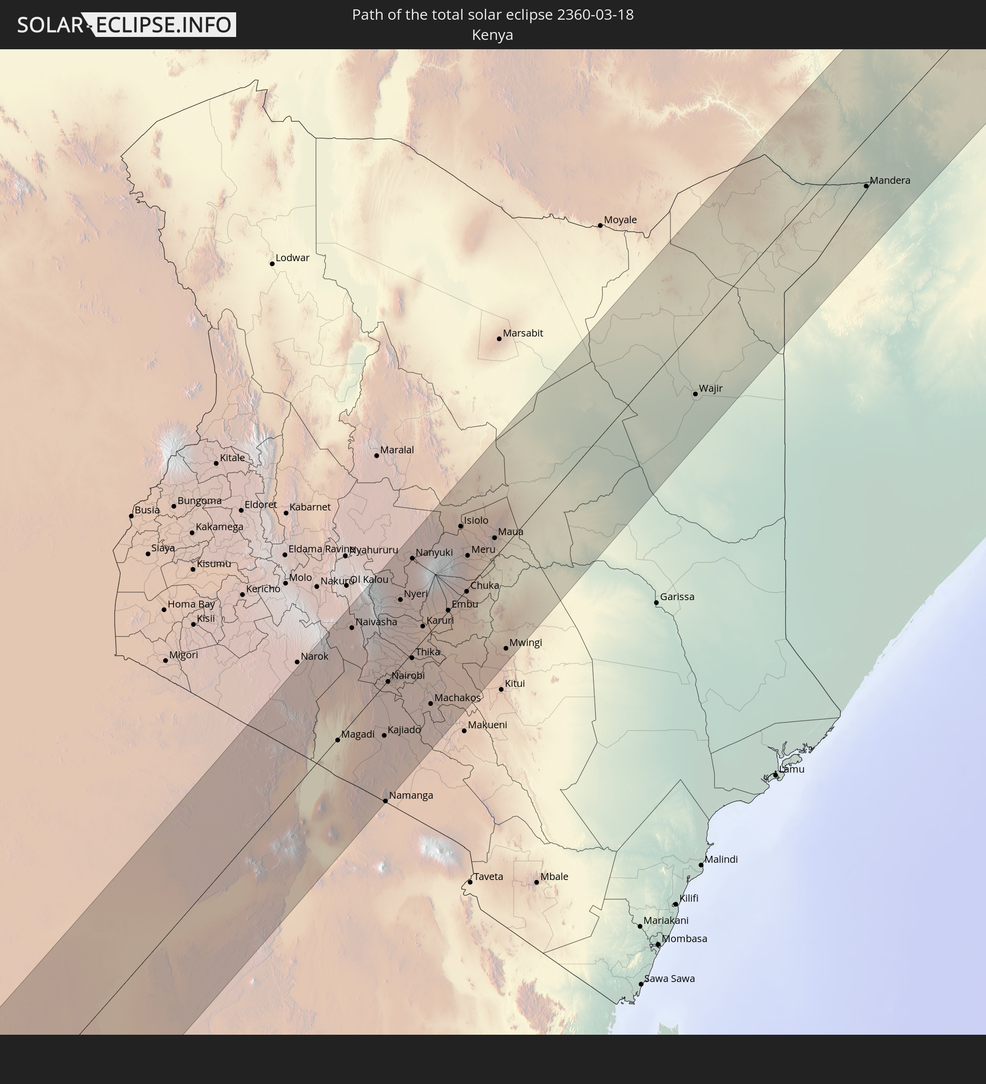
Detaillierte Länderkarten
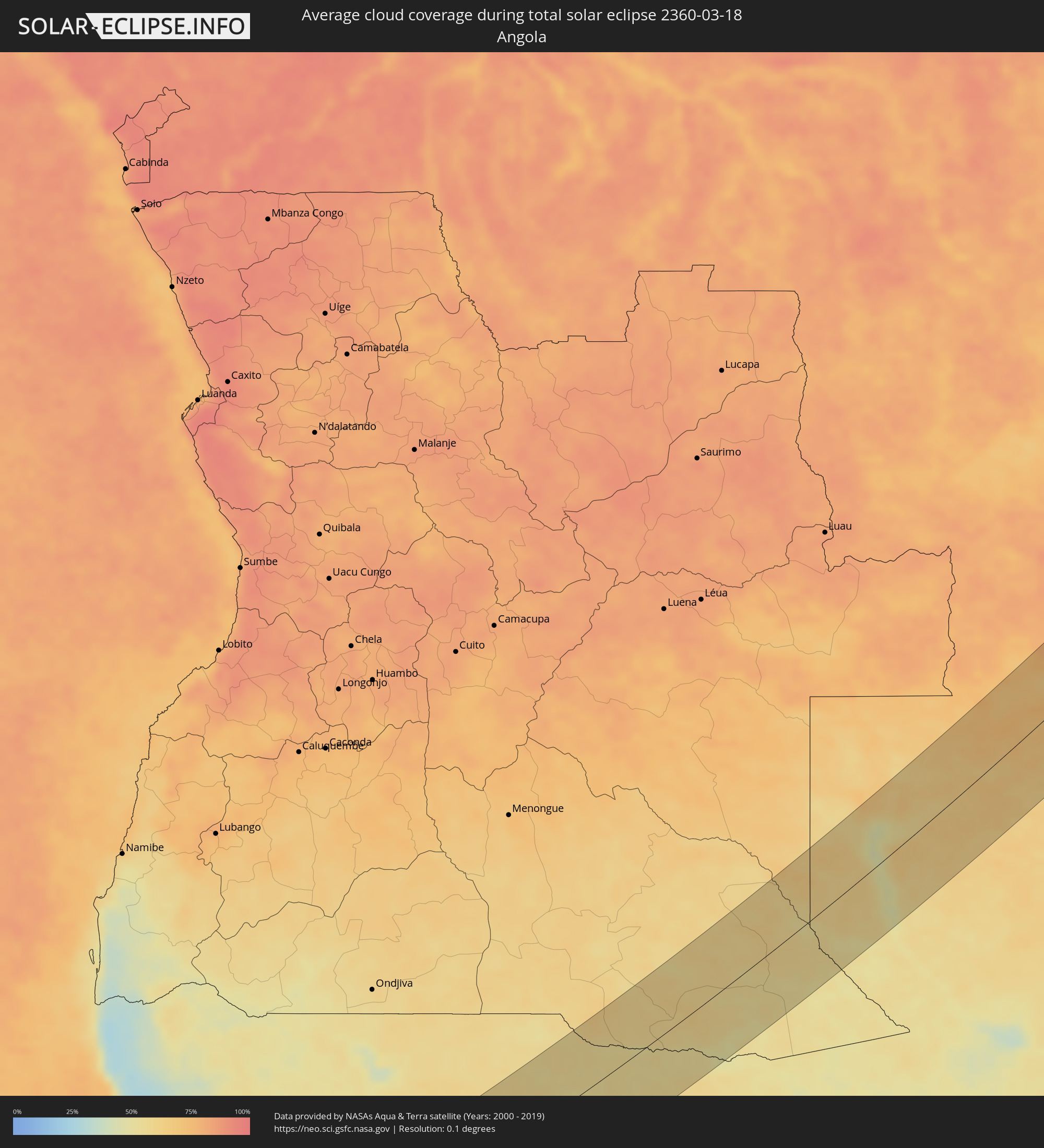 Angola
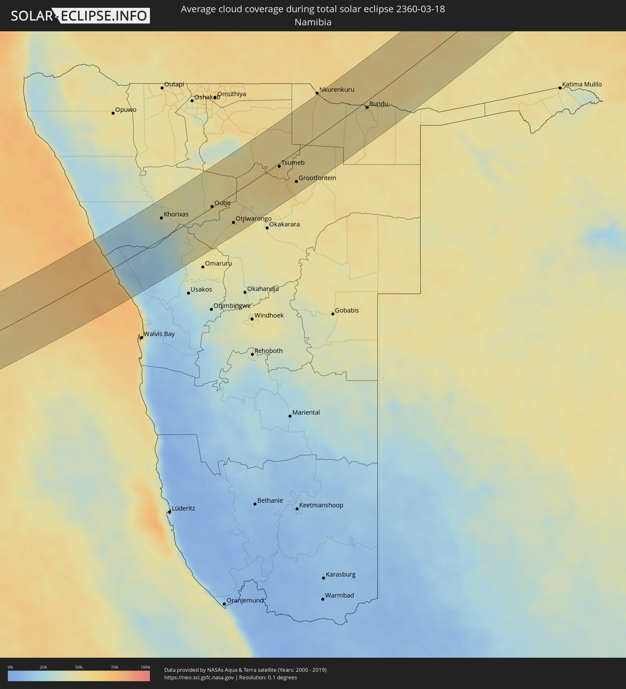 Namibia
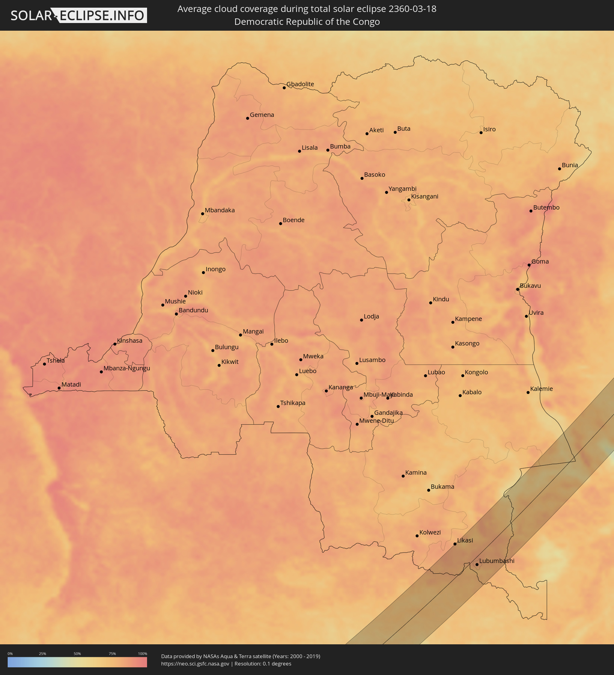 Demokratische Republik Kongo
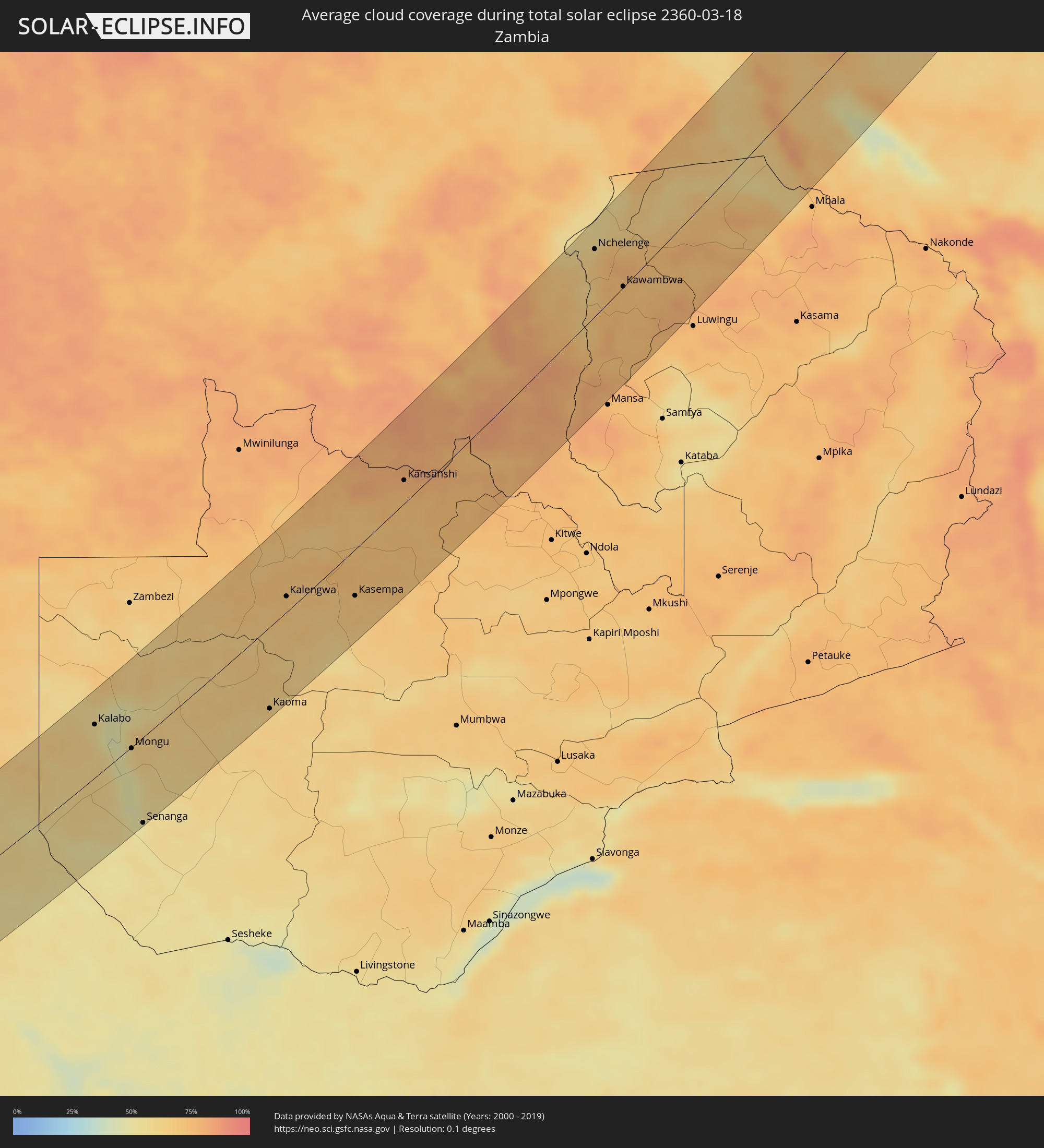 Sambia
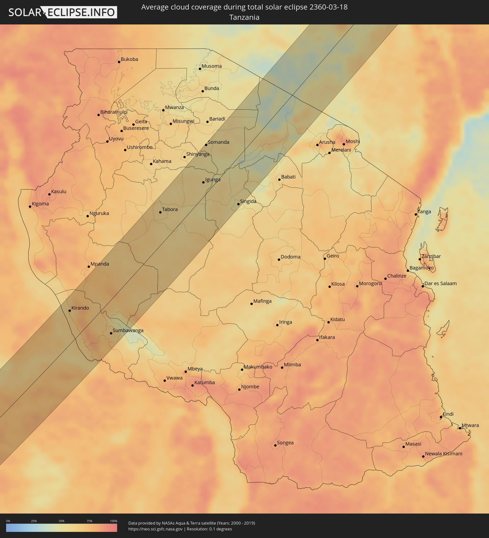 Tansania
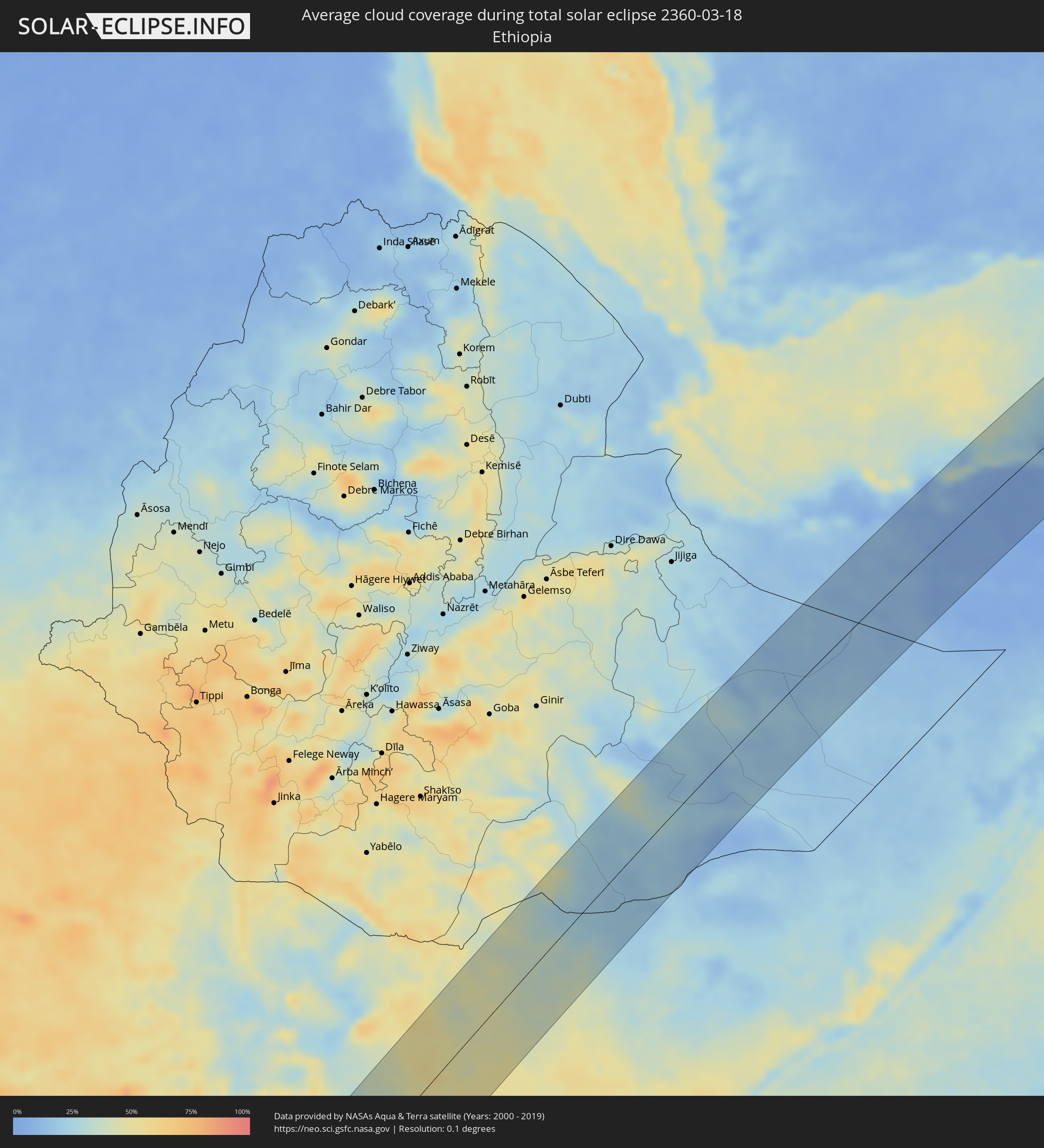 Äthiopien
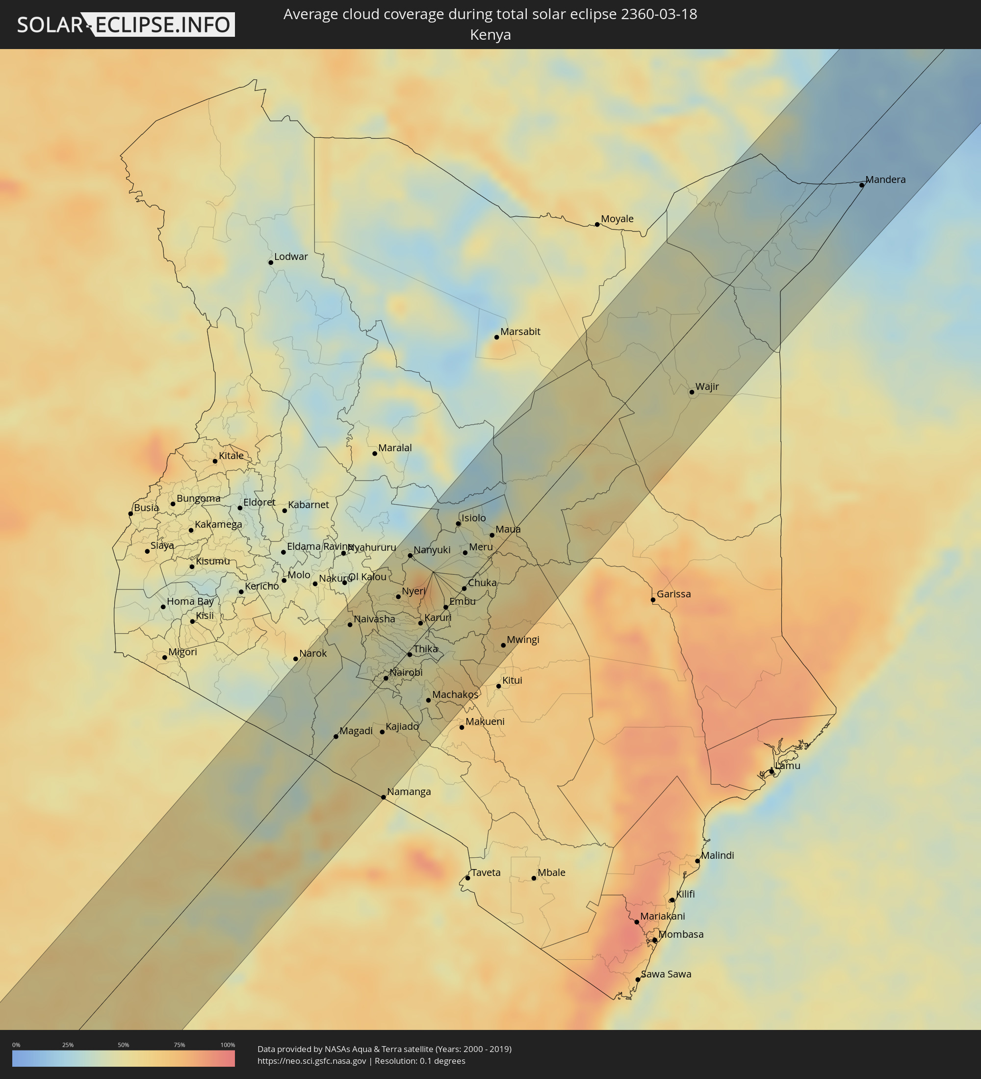 Kenia
Kenia
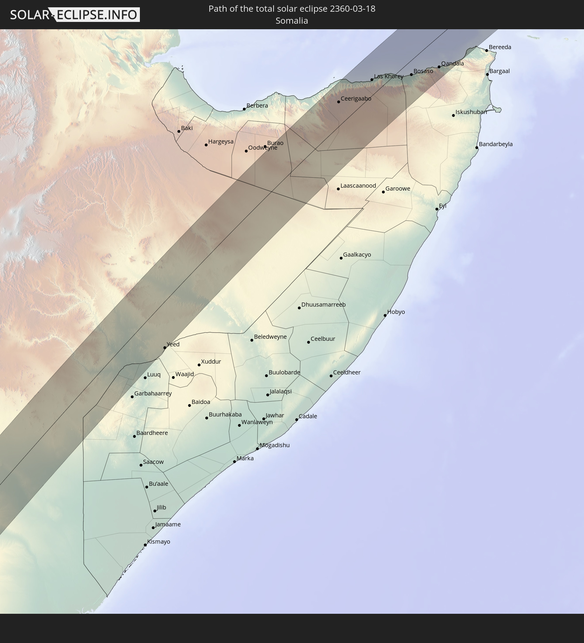
 Somalia
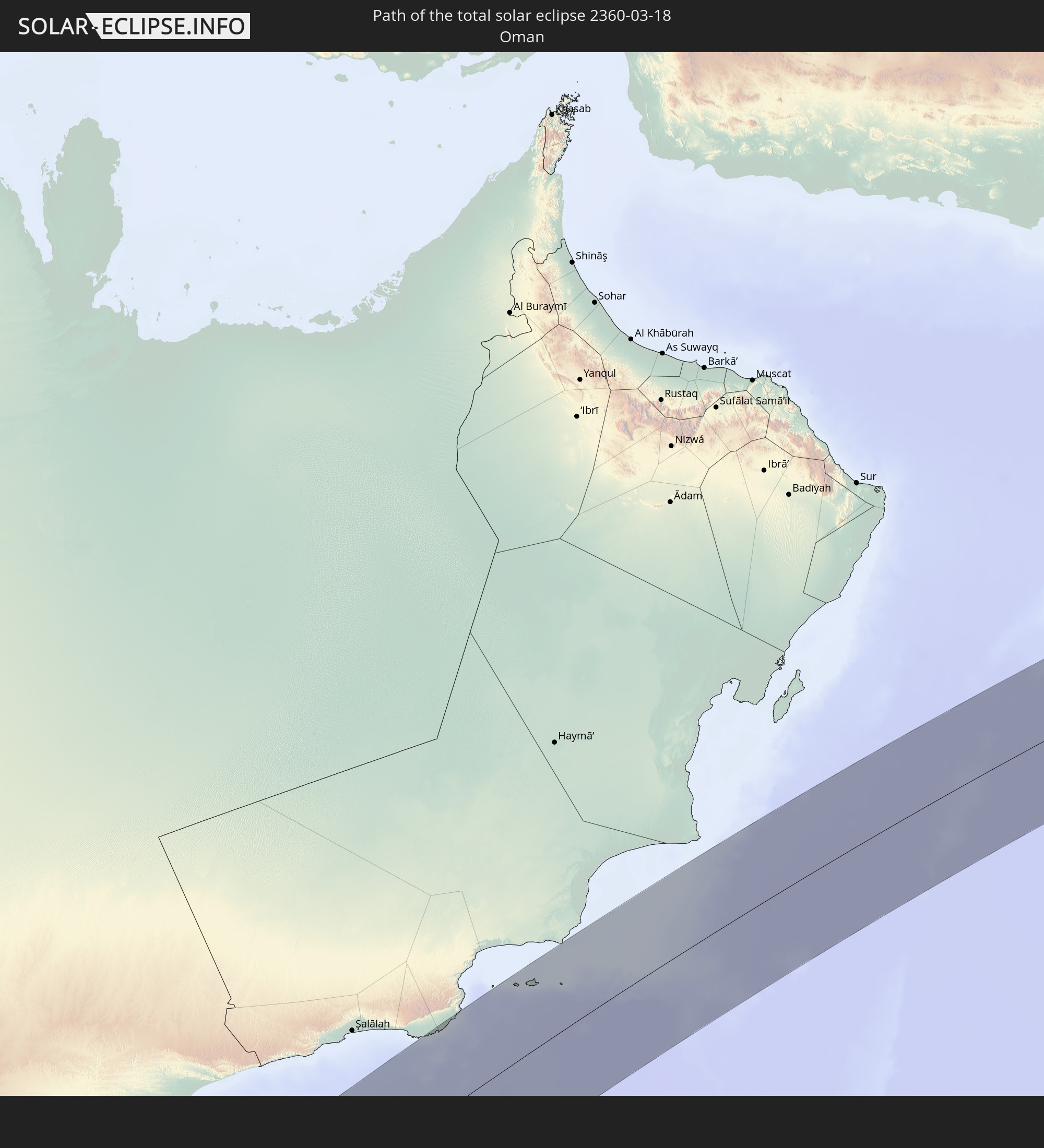
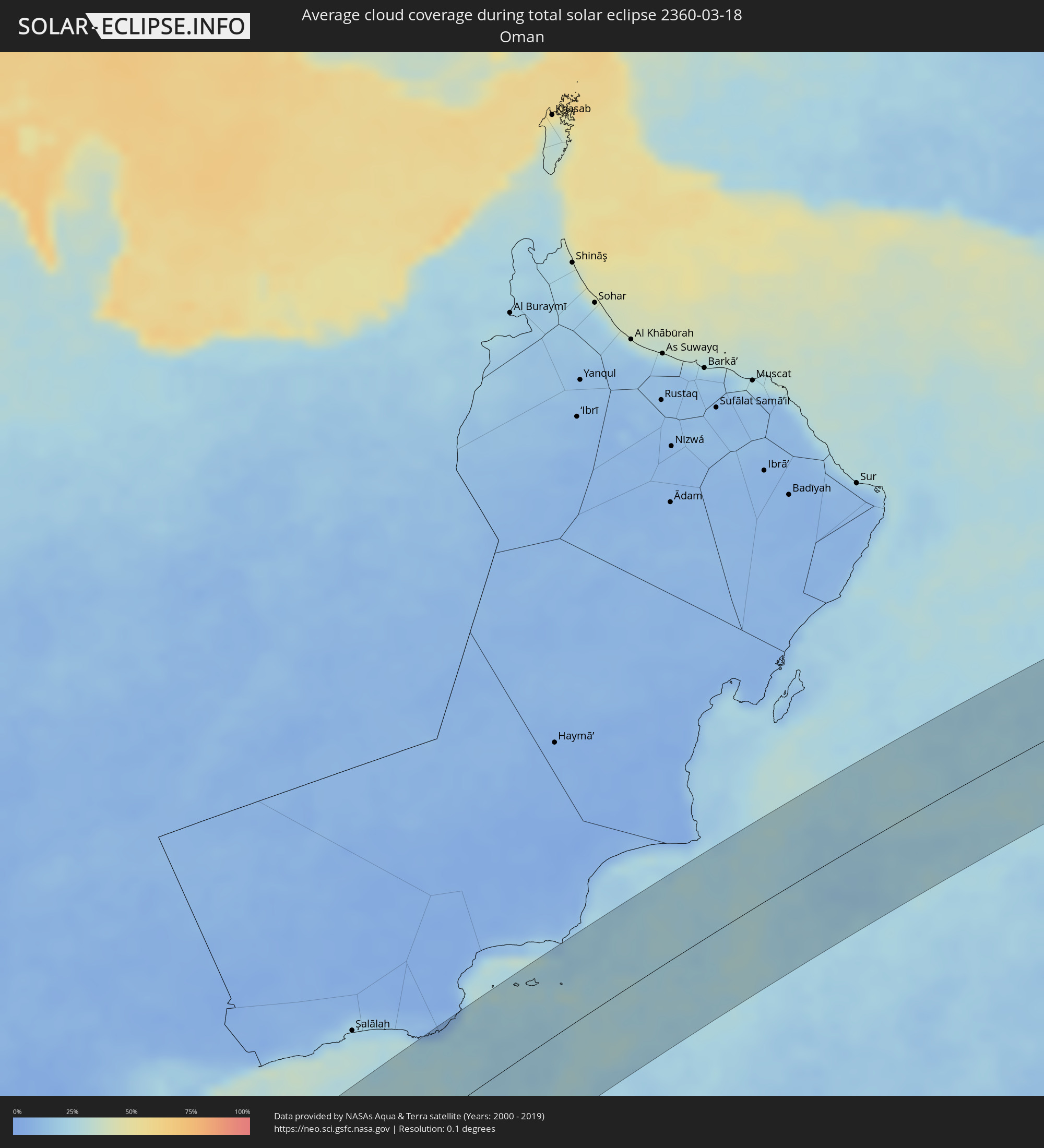 Oman
Oman
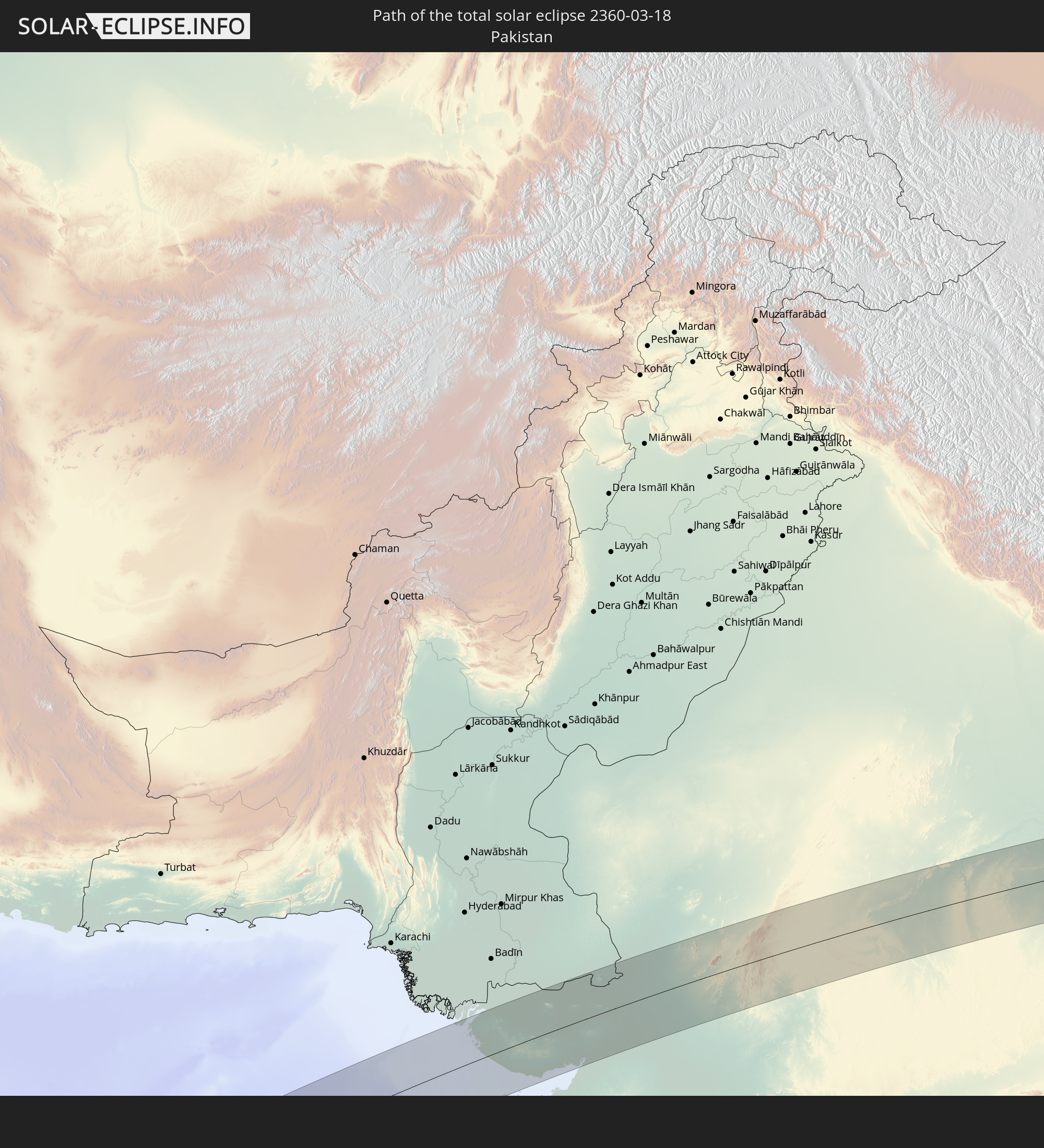
 Pakistan
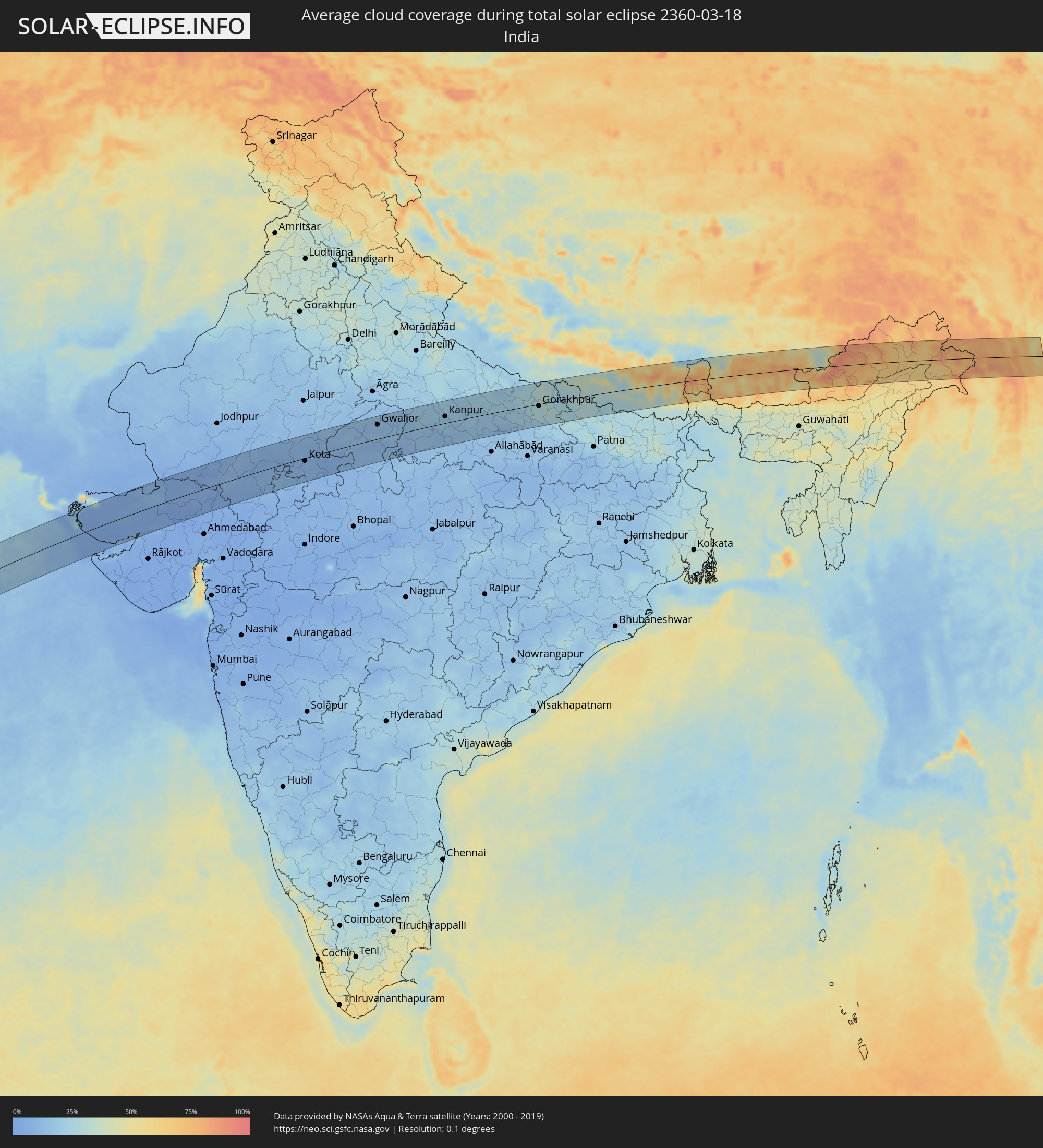 Indien
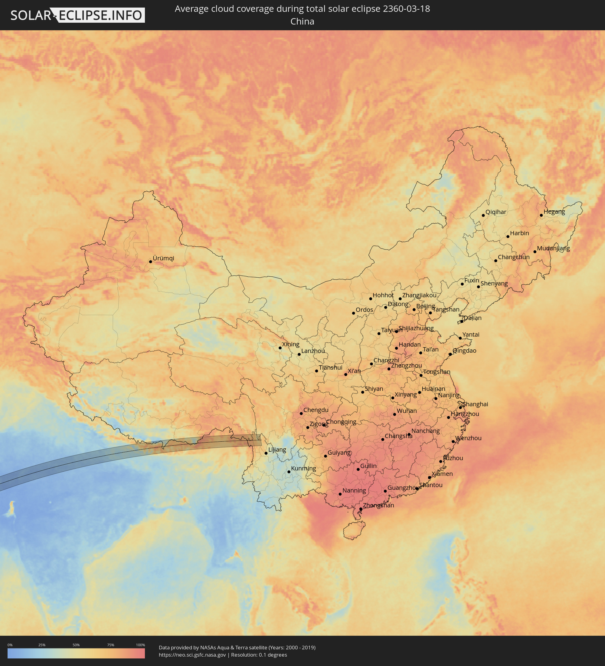 Volksrepublik China
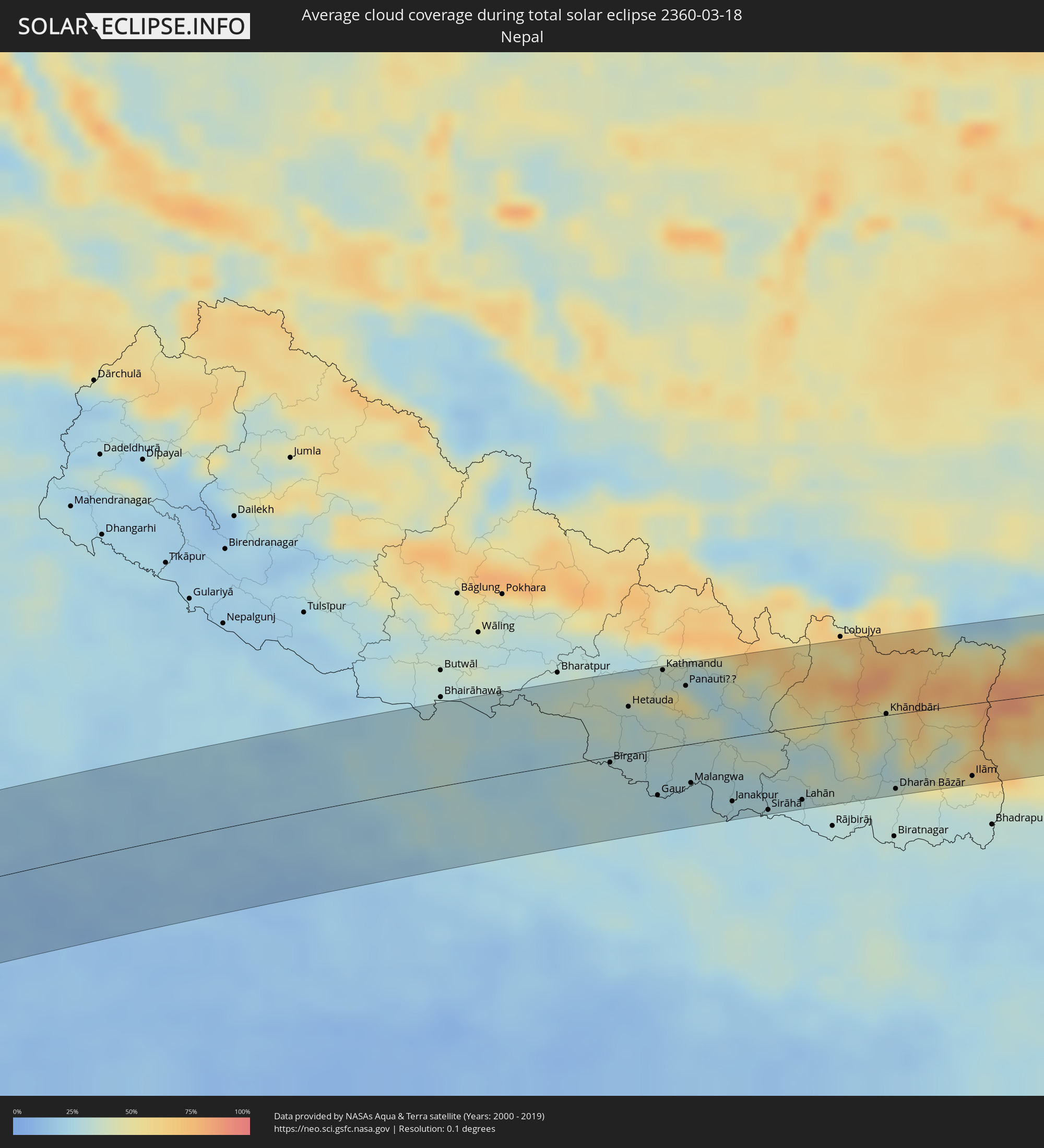 Nepal
Nepal
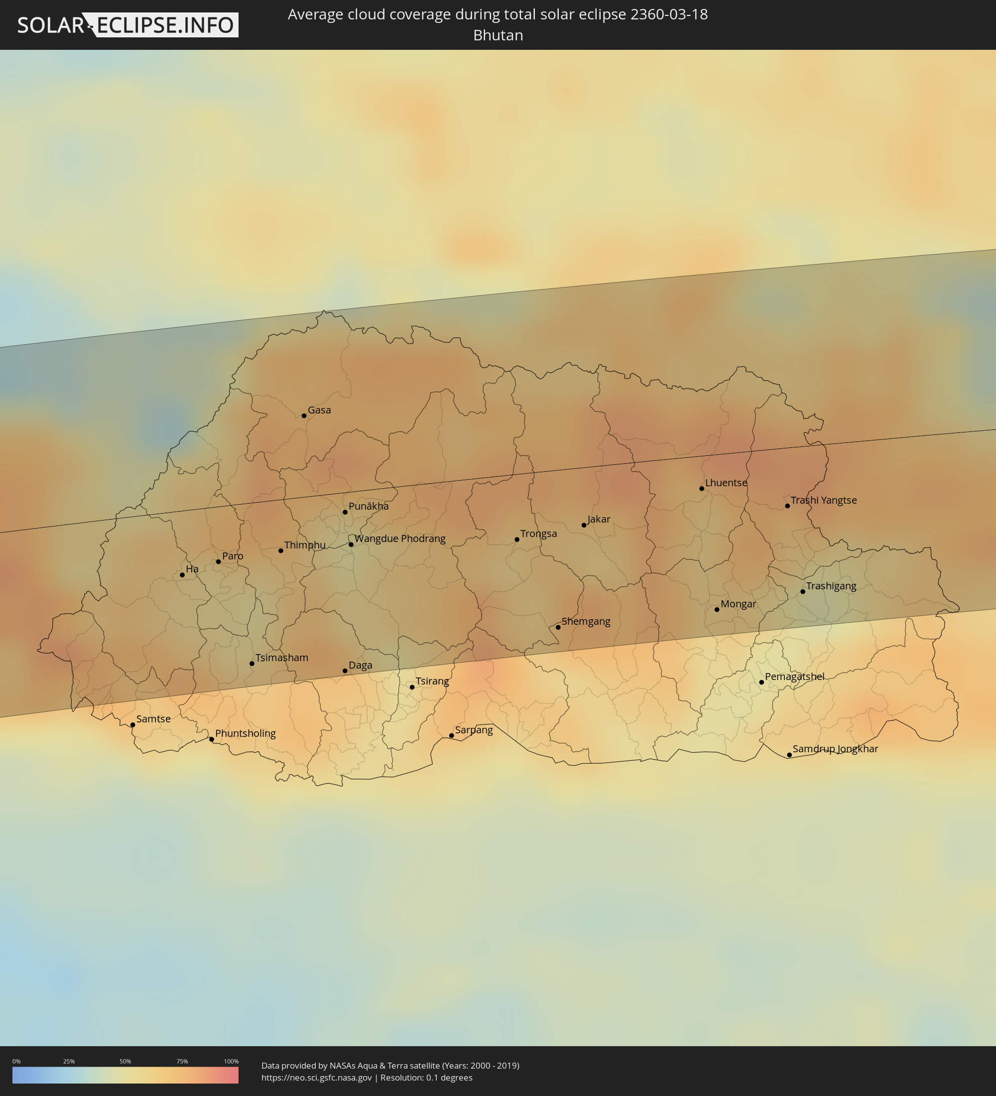 Bhutan
 Myanmar
Orte im Finsternispfad
Die nachfolgene Tabelle zeigt Städte und Orte mit mehr als 5.000 Einwohnern, die sich im Finsternispfad befinden. Städte mit mehr als 100.000 Einwohnern sind dick gekennzeichnet. Mit einem Klick auf den Ort öffnet sich eine Detailkarte die die Lage des jeweiligen Ortes zusammen mit dem Verlauf der zentralen Finsternis präsentiert.
| Ort | Typ | Dauer der Verfinsterung | Ortszeit bei maximaler Verfinsterung | Entfernung zur Zentrallinie | Ø Bewölkung |
|
Khorixas, Kunene
|
total | - | 10:35:18 UTC+02:00 | 43 km | 36% |
|
Outjo, Kunene
|
total | - | 10:37:15 UTC+02:00 | 1 km | 51% |
|
Otjiwarongo, Otjozondjupa
|
total | - | 10:37:32 UTC+02:00 | 59 km | 52% |
|
Tsumeb, Oshikoto
|
total | - | 10:40:36 UTC+02:00 | 7 km | 58% |
|
Grootfontein, Otjozondjupa
|
total | - | 10:40:46 UTC+02:00 | 61 km | 55% |
|
Rundu, Kavango East
|
total | - | 10:45:25 UTC+02:00 | 14 km | 56% |
|
Kalabo, Western
|
total | - | 10:54:29 UTC+02:00 | 53 km | 54% |
|
Mongu, Western
|
total | - | 10:54:47 UTC+02:00 | 1 km | 55% |
|
Limulunga, Western
|
total | - | 10:55:02 UTC+02:00 | 11 km | 56% |
|
Senanga, Western
|
total | - | 10:53:38 UTC+02:00 | 85 km | 52% |
|
Kaoma, Western
|
total | - | 10:58:18 UTC+02:00 | 80 km | 63% |
|
Mufumbwe, North-Western
|
total | - | 11:00:08 UTC+02:00 | 12 km | 69% |
|
Kalengwa, North-Western
|
total | - | 11:00:51 UTC+02:00 | 15 km | 70% |
|
Kasempa, North-Western
|
total | - | 11:02:16 UTC+02:00 | 45 km | 70% |
|
Solwezi, North-Western
|
total | - | 11:05:29 UTC+02:00 | 19 km | 75% |
|
Kansanshi, North-Western
|
total | - | 11:05:41 UTC+02:00 | 22 km | 78% |
|
Likasi, Katanga
|
total | - | 11:08:14 UTC+02:00 | 88 km | 80% |
|
Kipushi, Katanga
|
total | - | 11:07:43 UTC+02:00 | 13 km | 72% |
|
Lubumbashi, Katanga
|
total | - | 11:08:18 UTC+02:00 | 23 km | 77% |
|
Nchelenge, Luapula
|
total | - | 11:14:50 UTC+02:00 | 63 km | 61% |
|
Kawambwa, Luapula
|
total | - | 11:14:36 UTC+02:00 | 1 km | 73% |
|
Kirando, Rukwa
|
total | - | 12:21:57 UTC+03:00 | 62 km | 65% |
|
Namanyere, Rukwa
|
total | - | 12:22:34 UTC+03:00 | 18 km | 68% |
|
Mpulungu, Northern
|
total | - | 11:20:13 UTC+02:00 | 82 km | 66% |
|
Usevia, Katavi
|
total | - | 12:23:44 UTC+03:00 | 34 km | 64% |
|
Chala, Rukwa
|
total | - | 12:22:50 UTC+03:00 | 5 km | 66% |
|
Matai, Rukwa
|
total | - | 12:21:51 UTC+03:00 | 79 km | 68% |
|
Sumbawanga, Rukwa
|
total | - | 12:22:42 UTC+03:00 | 62 km | 67% |
|
Sikonge, Tabora
|
total | - | 12:29:29 UTC+03:00 | 18 km | 60% |
|
Tabora, Tabora
|
total | - | 12:30:51 UTC+03:00 | 59 km | 59% |
|
Nzega, Tabora
|
total | - | 12:33:09 UTC+03:00 | 88 km | 59% |
|
Igunga, Tabora
|
total | - | 12:34:18 UTC+03:00 | 25 km | 53% |
|
Lalago, Simiyu
|
total | - | 12:36:09 UTC+03:00 | 81 km | 54% |
|
Somanda, Simiyu
|
total | - | 12:36:19 UTC+03:00 | 87 km | 55% |
|
Shelui, Singida
|
total | - | 12:34:42 UTC+03:00 | 7 km | 60% |
|
Kiomboi, Singida
|
total | - | 12:35:13 UTC+03:00 | 14 km | 59% |
|
Sepuka, Singida
|
total | - | 12:34:31 UTC+03:00 | 63 km | 56% |
|
Igugunu, Singida
|
total | - | 12:35:05 UTC+03:00 | 58 km | 52% |
|
Singida, Singida
|
total | - | 12:34:46 UTC+03:00 | 86 km | 53% |
|
Mtinko, Singida
|
total | - | 12:35:31 UTC+03:00 | 75 km | 52% |
|
Ilongero, Singida
|
total | - | 12:35:18 UTC+03:00 | 85 km | 52% |
|
Basotu, Manyara
|
total | - | 12:36:19 UTC+03:00 | 81 km | 52% |
|
Dongobesh, Manyara
|
total | - | 12:37:30 UTC+03:00 | 84 km | 47% |
|
Kiratu, Arusha
|
total | - | 12:39:32 UTC+03:00 | 54 km | 49% |
|
Mto wa Mbu, Arusha
|
total | - | 12:39:50 UTC+03:00 | 71 km | 55% |
|
Magadi, Kajiado
|
total | - | 12:43:40 UTC+03:00 | 2 km | 50% |
|
Naivasha, Nakuru
|
total | - | 12:46:24 UTC+03:00 | 72 km | 46% |
|
Ngong, Kajiado
|
total | - | 12:45:28 UTC+03:00 | 6 km | 47% |
|
Kajiado, Kajiado
|
total | - | 12:44:40 UTC+03:00 | 39 km | 57% |
|
Nairobi, Nairobi Area
|
total | - | 12:45:55 UTC+03:00 | 1 km | 44% |
|
Kiambu, Kiambu
|
total | - | 12:46:12 UTC+03:00 | 6 km | 45% |
|
Pumwani, Nairobi Area
|
total | - | 12:45:59 UTC+03:00 | 4 km | 42% |
|
Nyeri, Nyeri
|
total | - | 12:47:58 UTC+03:00 | 51 km | 49% |
|
Athi River, Machakos
|
total | - | 12:45:51 UTC+03:00 | 28 km | 51% |
|
Thika, Nairobi Area
|
total | - | 12:46:54 UTC+03:00 | 4 km | 48% |
|
Nanyuki, Laikipia
|
total | - | 12:49:06 UTC+03:00 | 72 km | 56% |
|
Murang’a, Murang'A
|
total | - | 12:47:43 UTC+03:00 | 12 km | 44% |
|
Karuri, Murang'A
|
total | - | 12:47:49 UTC+03:00 | 10 km | 44% |
|
Machakos, Machakos
|
total | - | 12:46:16 UTC+03:00 | 56 km | 47% |
|
Keruguya, Kirinyaga
|
total | - | 12:48:25 UTC+03:00 | 17 km | 56% |
|
Kangundo, Machakos
|
total | - | 12:46:52 UTC+03:00 | 47 km | 48% |
|
Embu, Embu
|
total | - | 12:48:39 UTC+03:00 | 0 km | 48% |
|
Isiolo, Isiolo
|
total | - | 12:50:45 UTC+03:00 | 54 km | 46% |
|
Meru, Meru
|
total | - | 12:50:14 UTC+03:00 | 25 km | 43% |
|
Maua, Isiolo
|
total | - | 12:51:09 UTC+03:00 | 15 km | 52% |
|
Mwingi, Kitui
|
total | - | 12:48:56 UTC+03:00 | 81 km | 61% |
|
Wajir, Wajir
|
total | - | 12:58:09 UTC+03:00 | 52 km | 49% |
|
Mandera, Mandera
|
total | - | 13:05:52 UTC+03:00 | 38 km | 20% |
|
Yeed, Bakool
|
total | - | 13:09:11 UTC+03:00 | 88 km | 16% |
|
Ceerigaabo, Sanaag
|
total | - | 13:28:05 UTC+03:00 | 48 km | 7% |
|
Las Khorey, Sanaag
|
total | - | 13:30:24 UTC+03:00 | 31 km | 23% |
|
Bosaso, Bari
|
total | - | 13:32:13 UTC+03:00 | 30 km | 4% |
|
Qandala, Bari
|
total | - | 13:33:39 UTC+03:00 | 64 km | 8% |
|
Bhuj, Gujarat
|
total | - | 16:42:51 UTC+05:30 | 17 km | 4% |
|
Gāndhīdhām, Gujarat
|
total | - | 16:43:09 UTC+05:30 | 51 km | 4% |
|
Pālanpur, Gujarat
|
total | - | 16:45:45 UTC+05:30 | 15 km | 6% |
|
Udaipur, Rajasthan
|
total | - | 16:46:57 UTC+05:30 | 12 km | 10% |
|
Bhīlwāra, Rajasthan
|
total | - | 16:48:01 UTC+05:30 | 43 km | 6% |
|
Kota, Rajasthan
|
total | - | 16:48:47 UTC+05:30 | 9 km | 8% |
|
Shivpuri, Madhya Pradesh
|
total | - | 16:50:05 UTC+05:30 | 30 km | 12% |
|
Gwalior, Madhya Pradesh
|
total | - | 16:50:42 UTC+05:30 | 44 km | 12% |
|
Jhānsi, Uttar Pradesh
|
total | - | 16:50:39 UTC+05:30 | 49 km | 11% |
|
Bhind, Madhya Pradesh
|
total | - | 16:51:10 UTC+05:30 | 66 km | 13% |
|
Orai, Uttar Pradesh
|
total | - | 16:51:21 UTC+05:30 | 12 km | 15% |
|
Kanpur, Uttar Pradesh
|
total | - | 16:52:00 UTC+05:30 | 20 km | 14% |
|
Unnāo, Uttar Pradesh
|
total | - | 16:52:06 UTC+05:30 | 26 km | 17% |
|
Fatehpur, Uttar Pradesh
|
total | - | 16:52:05 UTC+05:30 | 48 km | 14% |
|
Lucknow, Uttar Pradesh
|
total | - | 16:52:25 UTC+05:30 | 49 km | 17% |
|
Raebareli, Uttar Pradesh
|
total | - | 16:52:24 UTC+05:30 | 24 km | 16% |
|
Gondā City, Uttar Pradesh
|
total | - | 16:53:00 UTC+05:30 | 60 km | 20% |
|
Fyzābād, Uttar Pradesh
|
total | - | 16:53:00 UTC+05:30 | 18 km | 21% |
|
Gorakhpur, Uttar Pradesh
|
total | - | 16:53:34 UTC+05:30 | 6 km | 26% |
|
Deoria, Uttar Pradesh
|
total | - | 16:53:40 UTC+05:30 | 42 km | 26% |
|
Bettiah, Bihar
|
total | - | 16:54:03 UTC+05:30 | 21 km | 29% |
|
Bīrganj, Central Region
|
total | - | 17:09:15 UTC+05:45 | 5 km | 29% |
|
Hetauda, Central Region
|
total | - | 17:09:24 UTC+05:45 | 39 km | 32% |
|
Kirtipur, Central Region
|
total | - | 17:09:33 UTC+05:45 | 63 km | 36% |
|
Gaur, Central Region
|
total | - | 17:09:21 UTC+05:45 | 38 km | 27% |
|
Pātan, Central Region
|
total | - | 17:09:34 UTC+05:45 | 62 km | 36% |
|
Kathmandu, Central Region
|
total | - | 17:09:34 UTC+05:45 | 64 km | 36% |
|
Hari Bdr Tamang House, Central Region
|
total | - | 17:09:36 UTC+05:45 | 54 km | 48% |
|
kankrabari Dovan, Central Region
|
total | - | 17:09:36 UTC+05:45 | 54 km | 48% |
|
Panauti̇̄, Central Region
|
total | - | 17:09:37 UTC+05:45 | 49 km | 48% |
|
Banepā, Central Region
|
total | - | 17:09:38 UTC+05:45 | 54 km | 48% |
|
Malangwa, Central Region
|
total | - | 17:09:29 UTC+05:45 | 32 km | 27% |
|
Jaleswar, Central Region
|
total | - | 17:09:32 UTC+05:45 | 59 km | 28% |
|
Janakpur, Central Region
|
total | - | 17:09:35 UTC+05:45 | 53 km | 26% |
|
Sirāhā, Eastern Region
|
total | - | 17:09:41 UTC+05:45 | 64 km | 28% |
|
Lahān, Eastern Region
|
total | - | 17:09:48 UTC+05:45 | 60 km | 28% |
|
Khāndbāri, Eastern Region
|
total | - | 17:10:10 UTC+05:45 | 1 km | 42% |
|
Dharān Bāzār, Eastern Region
|
total | - | 17:10:05 UTC+05:45 | 62 km | 33% |
|
Dhankutā, Eastern Region
|
total | - | 17:10:08 UTC+05:45 | 44 km | 31% |
|
Ilām, Eastern Region
|
total | - | 17:10:19 UTC+05:45 | 60 km | 44% |
|
Dārjiling, West Bengal
|
total | - | 16:55:27 UTC+05:30 | 50 km | 70% |
|
Ha, Haa District
|
total | - | 17:25:48 UTC+06:00 | 23 km | 58% |
|
Paro, Paro
|
total | - | 17:25:50 UTC+06:00 | 20 km | 56% |
|
Tsimasham, Chukha District
|
total | - | 17:25:49 UTC+06:00 | 58 km | 71% |
|
Thimphu, Thimphu
|
total | - | 17:25:54 UTC+06:00 | 19 km | 60% |
|
Lungtenzampa, Thimphu
|
total | - | 17:25:54 UTC+06:00 | 18 km | 60% |
|
Gasa, Gasa District
|
total | - | 17:25:59 UTC+06:00 | 29 km | 73% |
|
Daga, Dagana District
|
total | - | 17:25:54 UTC+06:00 | 64 km | 64% |
|
Punākha, Punakha
|
total | - | 17:25:59 UTC+06:00 | 7 km | 50% |
|
Wangdue Phodrang, Wangdi Phodrang
|
total | - | 17:25:58 UTC+06:00 | 19 km | 51% |
|
Trongsa, Tongsa
|
total | - | 17:26:07 UTC+06:00 | 24 km | 59% |
|
Shemgang, Shemgang
|
total | - | 17:26:07 UTC+06:00 | 57 km | 57% |
|
Jakar, Bumthang
|
total | - | 17:26:11 UTC+06:00 | 21 km | 62% |
|
Lhuentse, Lhuntse District
|
total | - | 17:26:18 UTC+06:00 | 12 km | 61% |
|
Mongar, Mongar District
|
total | - | 17:26:16 UTC+06:00 | 56 km | 54% |
|
Trashi Yangtse, Trashi Yangste
|
total | - | 17:26:22 UTC+06:00 | 21 km | 65% |
|
Trashigang, Tashigang
|
total | - | 17:26:20 UTC+06:00 | 53 km | 57% |
|
Dibrugarh, Assam
|
total | - | 16:56:55 UTC+05:30 | 61 km | 59% |