Totale Sonnenfinsternis vom 12.07.2363
| Wochentag: | Freitag |
| Maximale Dauer der Verfinsterung: | 05m51s |
| Maximale Breite des Finsternispfades: | 279 km |
| Saroszyklus: | 142 |
| Bedeckungsgrad: | 100% |
| Magnitude: | 1.0792 |
| Gamma: | 0.4012 |
Wo kann man die Sonnenfinsternis vom 12.07.2363 sehen?
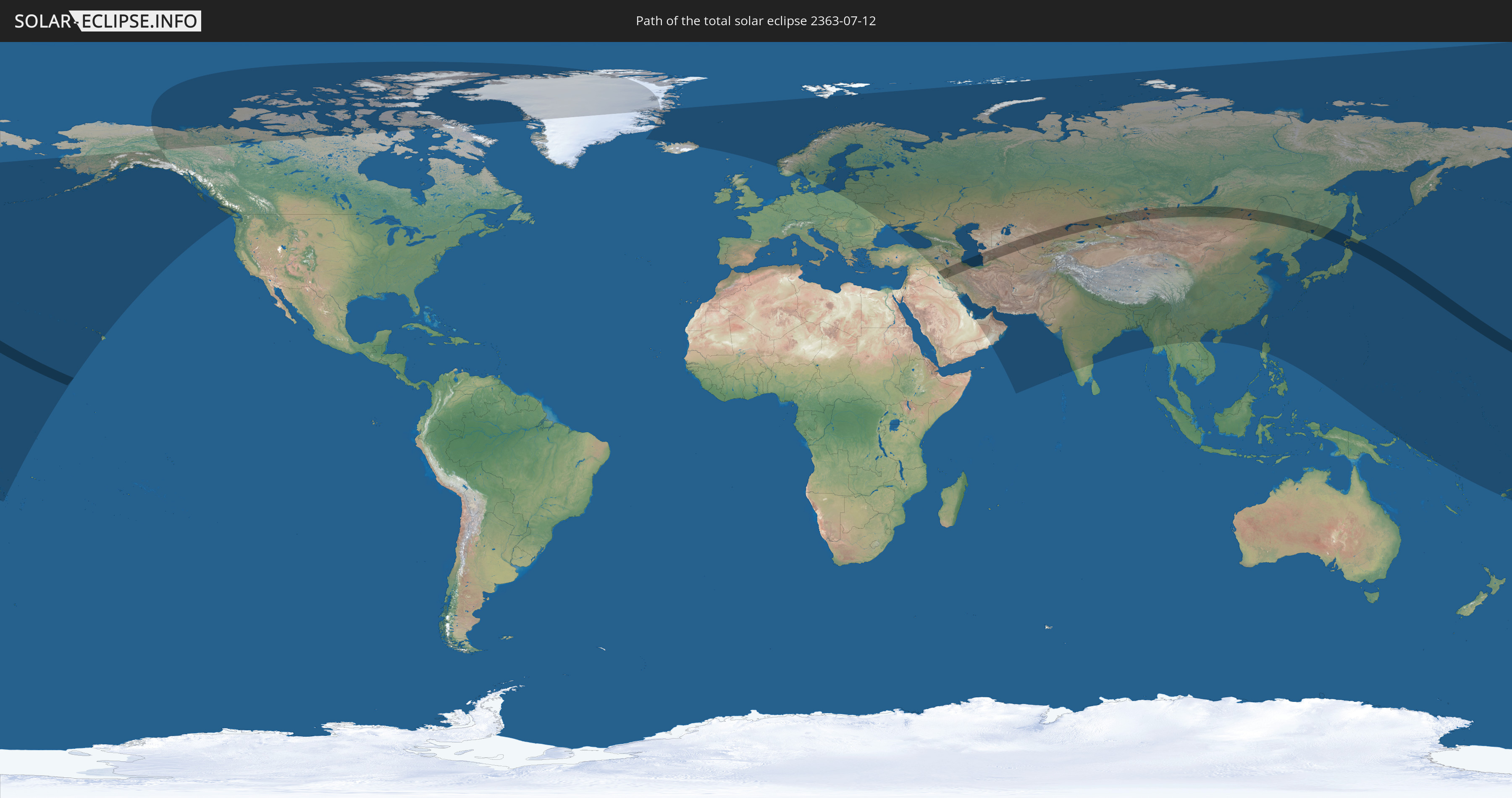
Die Sonnenfinsternis am 12.07.2363 kann man in 66 Ländern als partielle Sonnenfinsternis beobachten.
Der Finsternispfad verläuft durch 9 Länder. Nur in diesen Ländern ist sie als totale Sonnenfinsternis zu sehen.
In den folgenden Ländern ist die Sonnenfinsternis total zu sehen
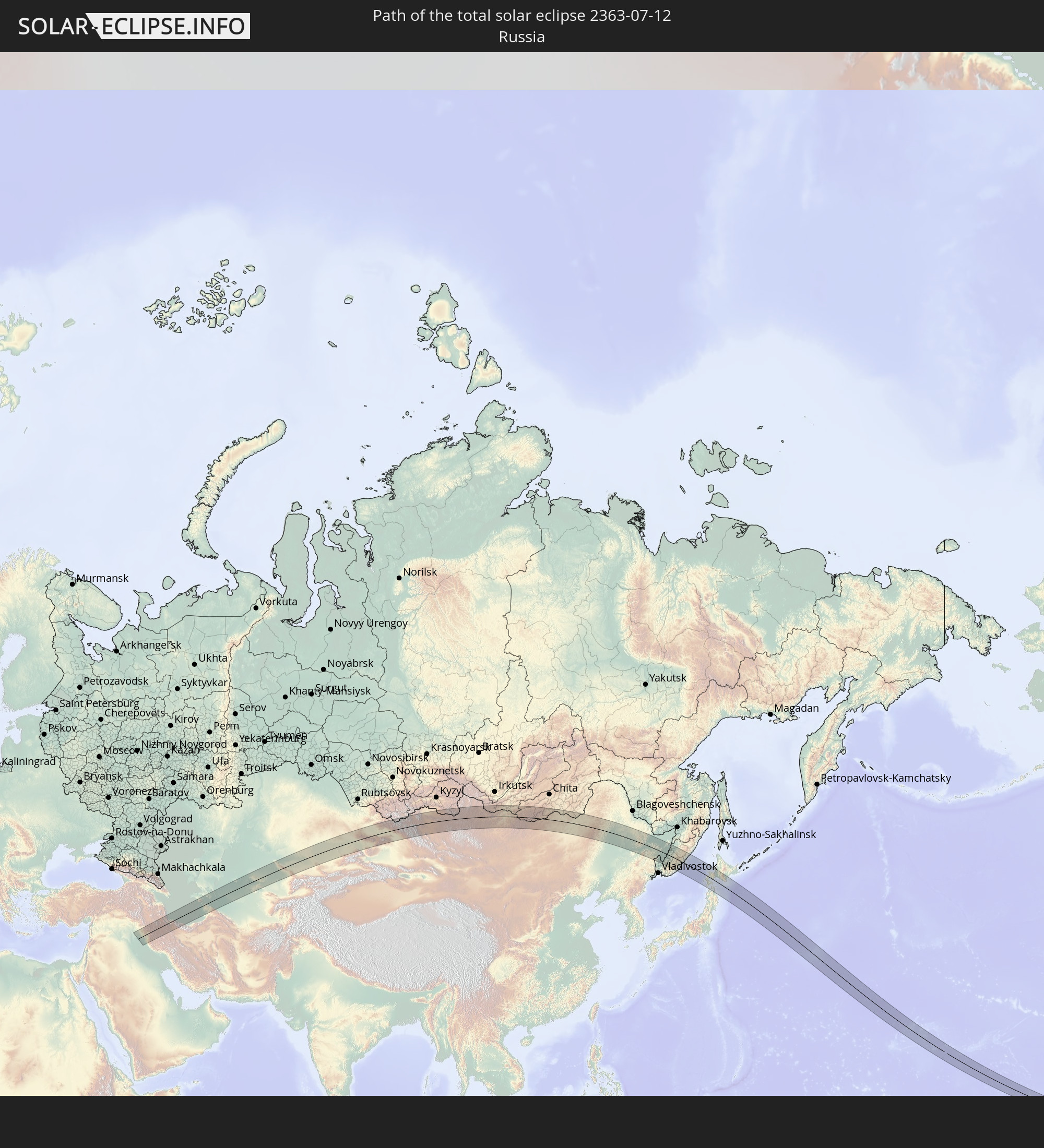 Russland
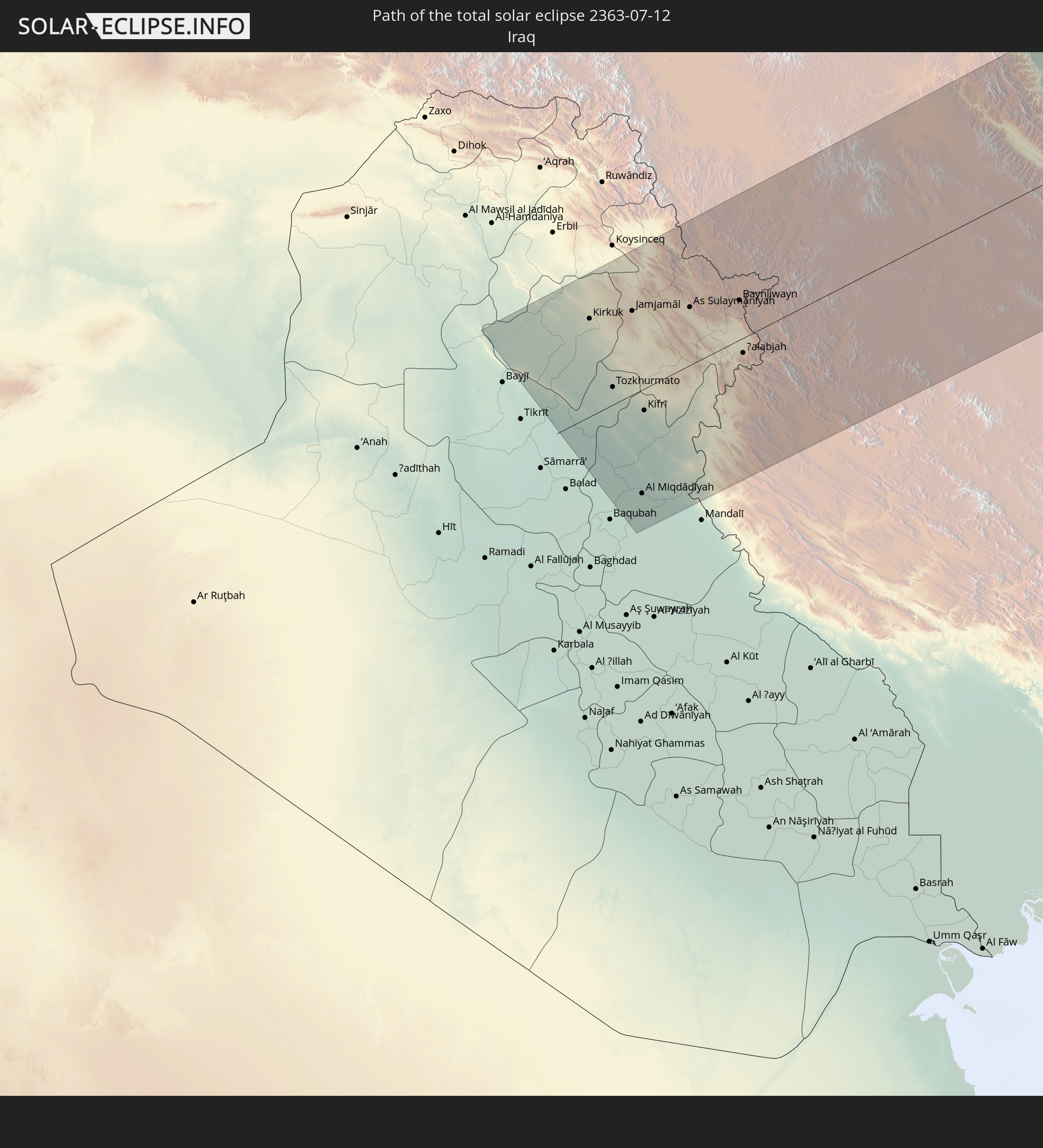 Irak
Irak
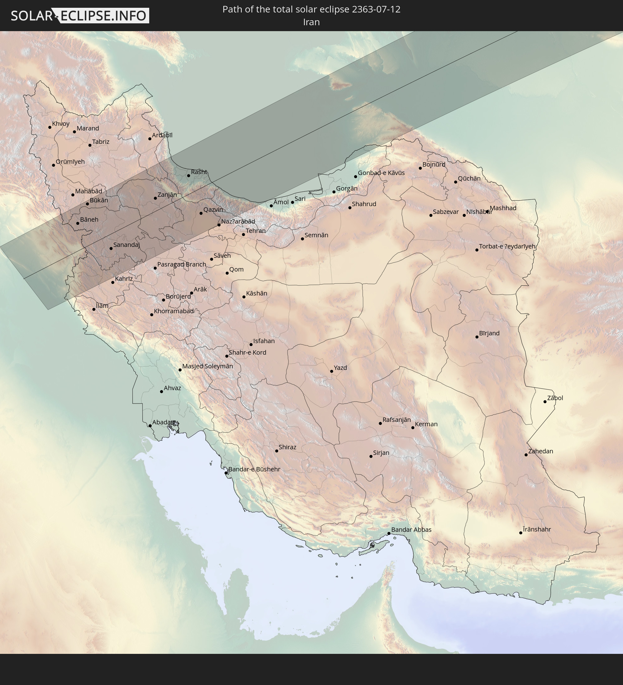 Iran
Iran
 Kasachstan
 Turkmenistan
 Usbekistan
 Volksrepublik China
 Mongolei
 Japan
Japan
In den folgenden Ländern ist die Sonnenfinsternis partiell zu sehen
 Fidschi
 Russland
 Vereinigte Staaten
 United States Minor Outlying Islands
 Wallis und Futuna
 Kiribati
 Kanada
 Grönland
 Island
 Spitzbergen
 Norwegen
 Schweden
 Polen
Polen
 Åland Islands
 Finnland
 Litauen
 Lettland
 Estland
 Ukraine
 Weißrussland
 Türkei
 Moldawien
 Saudi-Arabien
 Syrien
 Irak
Irak
 Georgien
 Armenien
 Iran
Iran
 Aserbaidschan
 Kasachstan
 Kuwait
 Bahrain
 Katar
Katar
 Vereinigte Arabische Emirate
 Oman
Oman
 Turkmenistan
 Usbekistan
 Afghanistan
 Pakistan
 Tadschikistan
 Indien
 Kirgisistan
 Volksrepublik China
 Nepal
Nepal
 Mongolei
 Bangladesch
 Bhutan
 Myanmar
 Thailand
 Laos
Laos
 Vietnam
 Macau
Macau
 Hongkong
 Taiwan
 Philippinen
 Japan
Japan
 Nordkorea
 Südkorea
 Föderierte Staaten von Mikronesien
 Papua-Neuguinea
 Guam
Guam
 Nördliche Marianen
 Salomonen
 Marshallinseln
 Nauru
Nauru
 Tuvalu
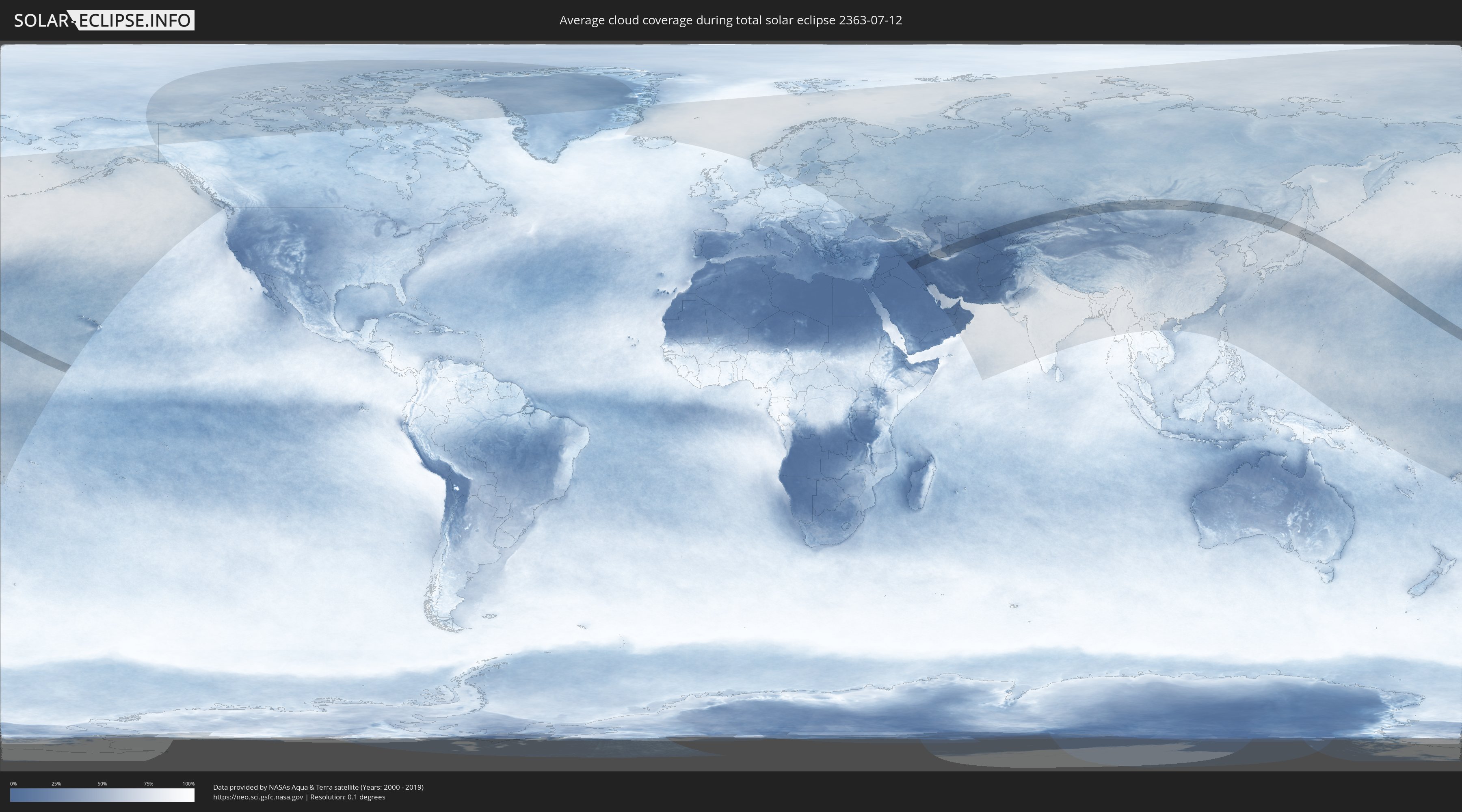
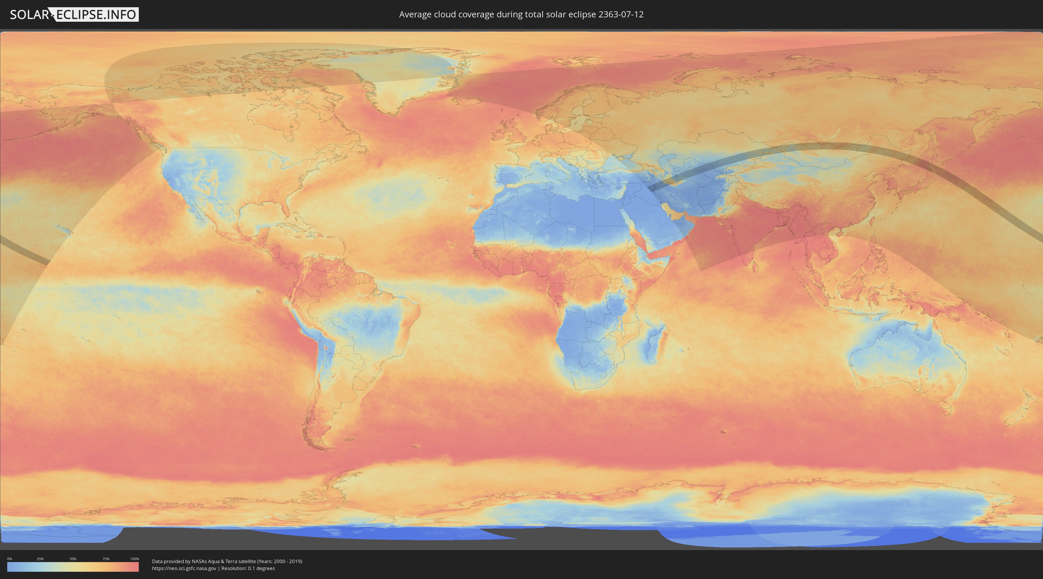
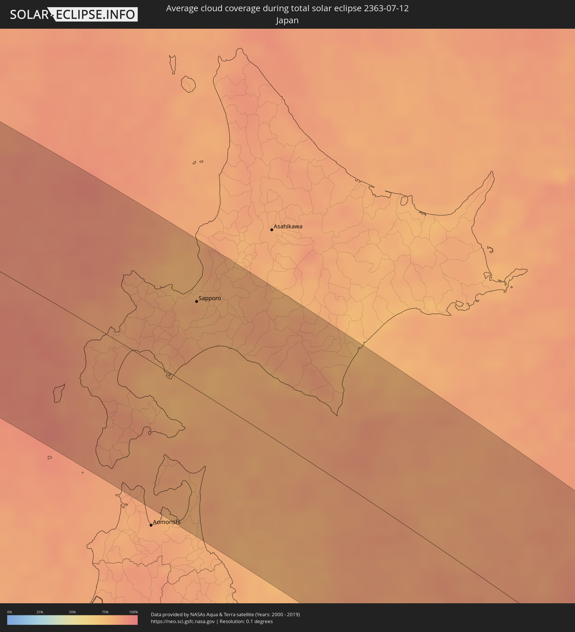
Wie wird das Wetter während der totalen Sonnenfinsternis am 12.07.2363?
Wo ist der beste Ort, um die totale Sonnenfinsternis vom 12.07.2363 zu beobachten?
Die folgenden Karten zeigen die durchschnittliche Bewölkung für den Tag, an dem die totale Sonnenfinsternis
stattfindet. Mit Hilfe der Karten lässt sich der Ort entlang des Finsternispfades eingrenzen,
der die besten Aussichen auf einen klaren wolkenfreien Himmel bietet.
Trotzdem muss man immer lokale Gegenenheiten beachten und sollte sich genau über das Wetter an seinem
gewählten Beobachtungsort informieren.
Die Daten stammen von den beiden NASA-Satelliten
AQUA und TERRA
und wurden über einen Zeitraum von 19 Jahren (2000 - 2019) gemittelt.
Detaillierte Länderkarten
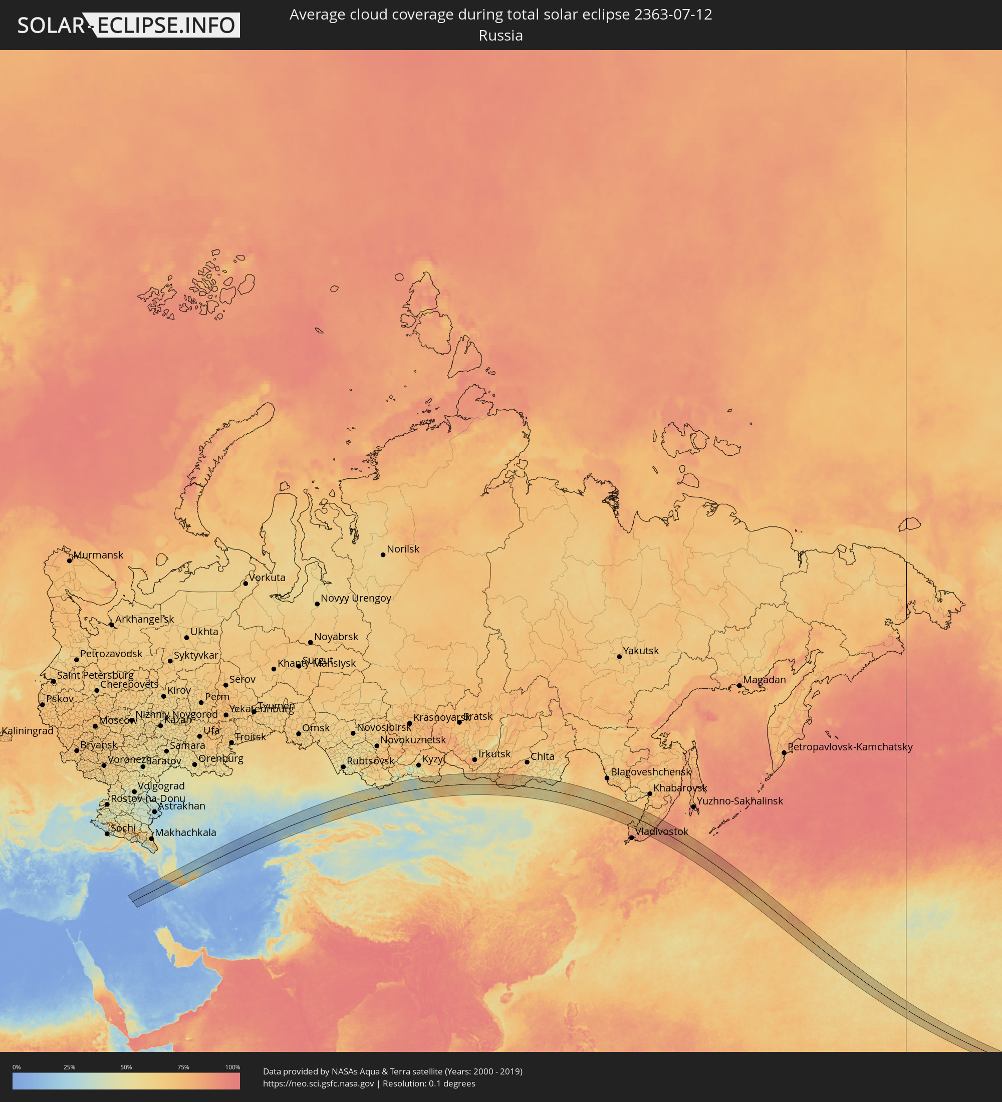 Russland
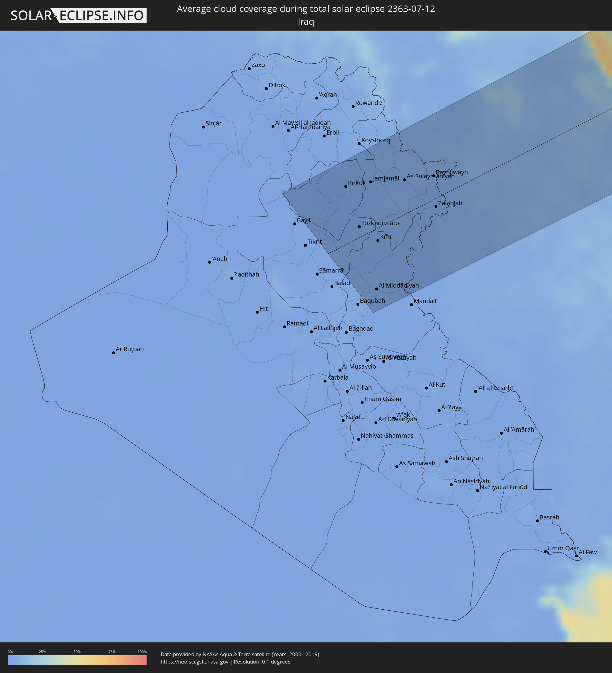 Irak
Irak
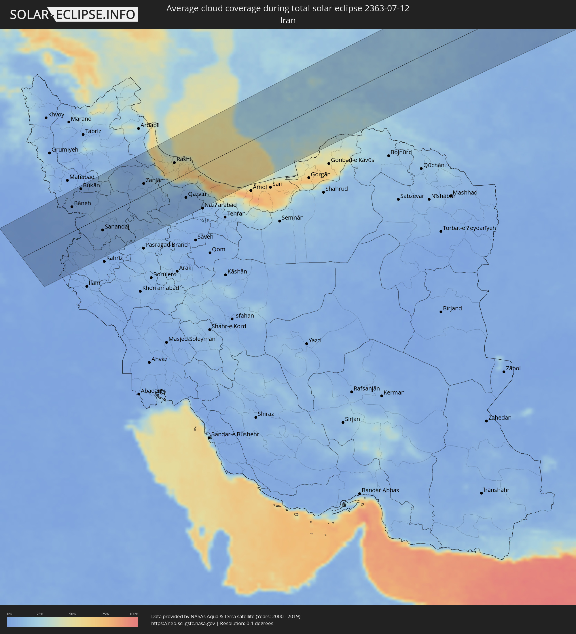 Iran
Iran
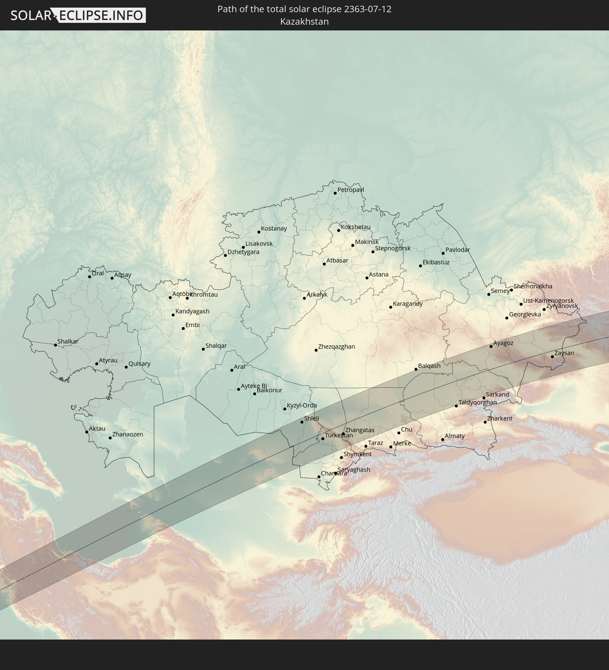
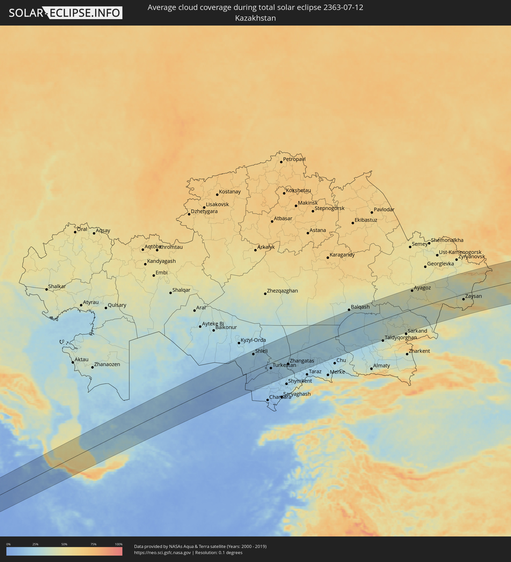 Kasachstan
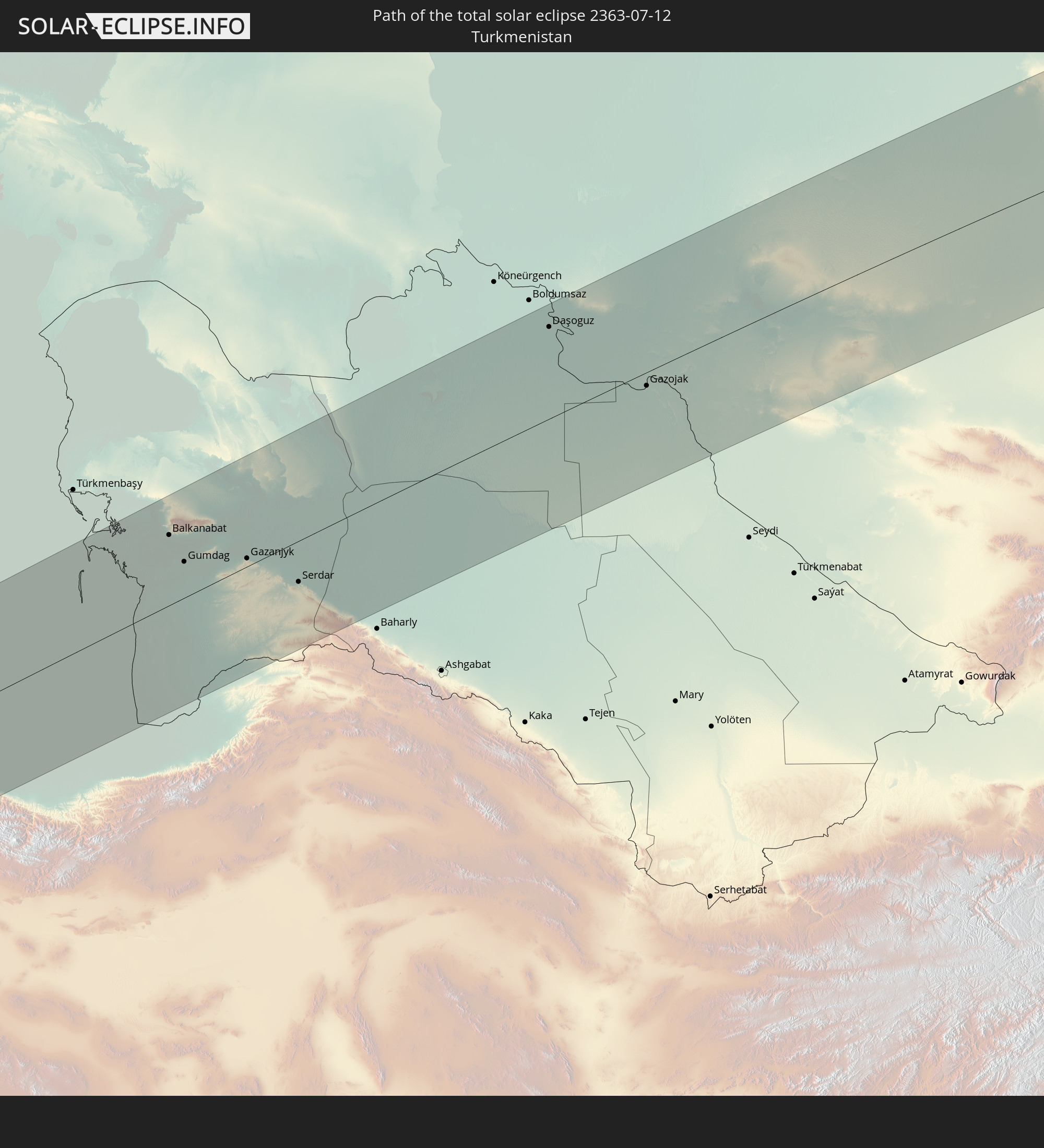
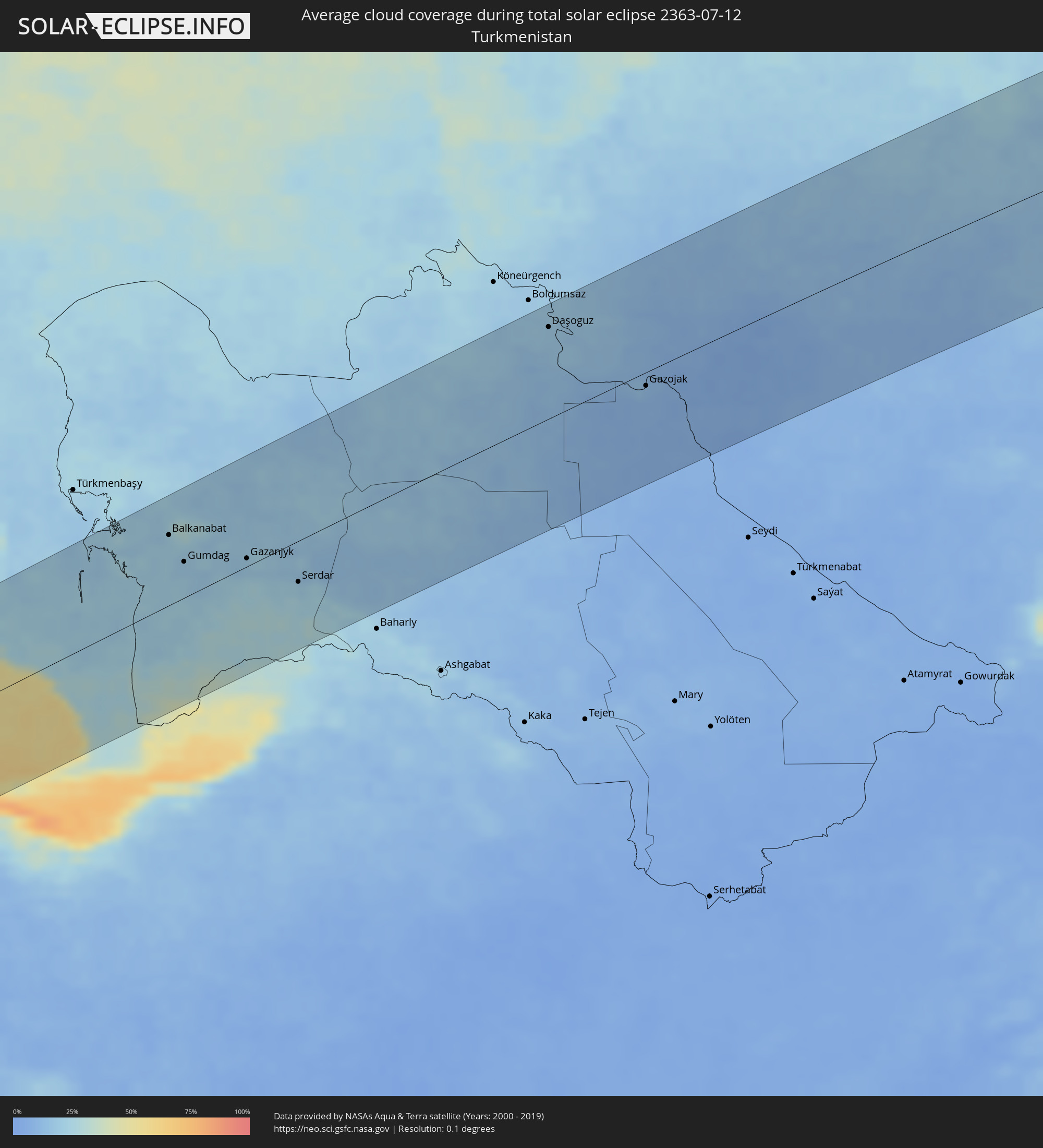 Turkmenistan
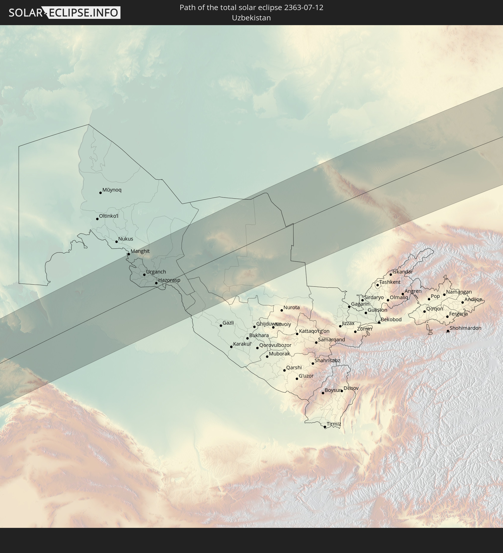
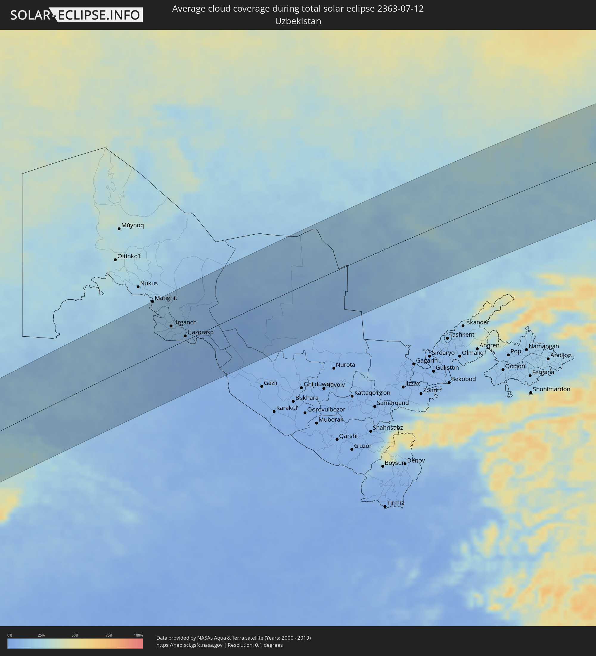 Usbekistan
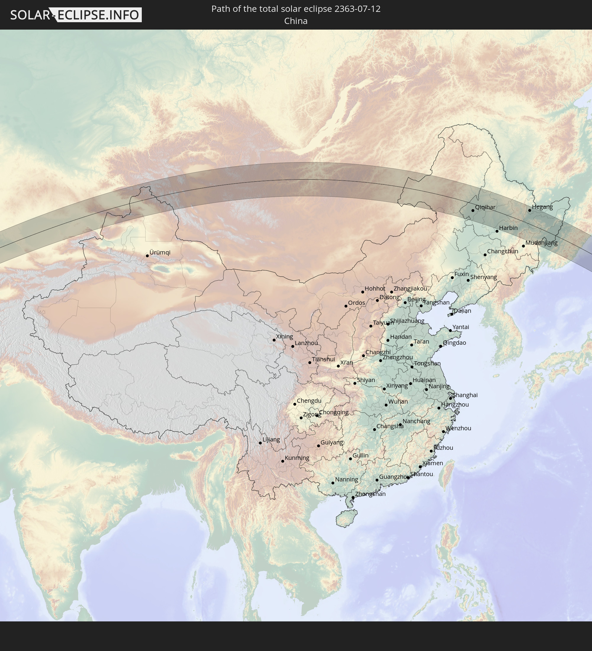
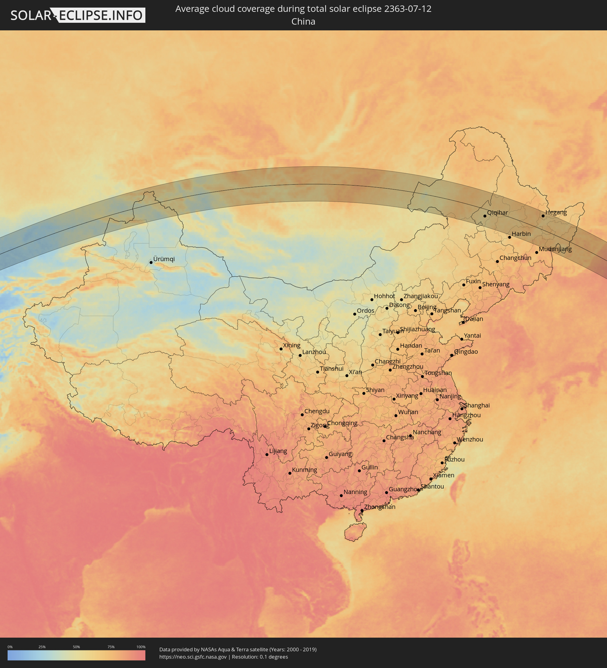 Volksrepublik China
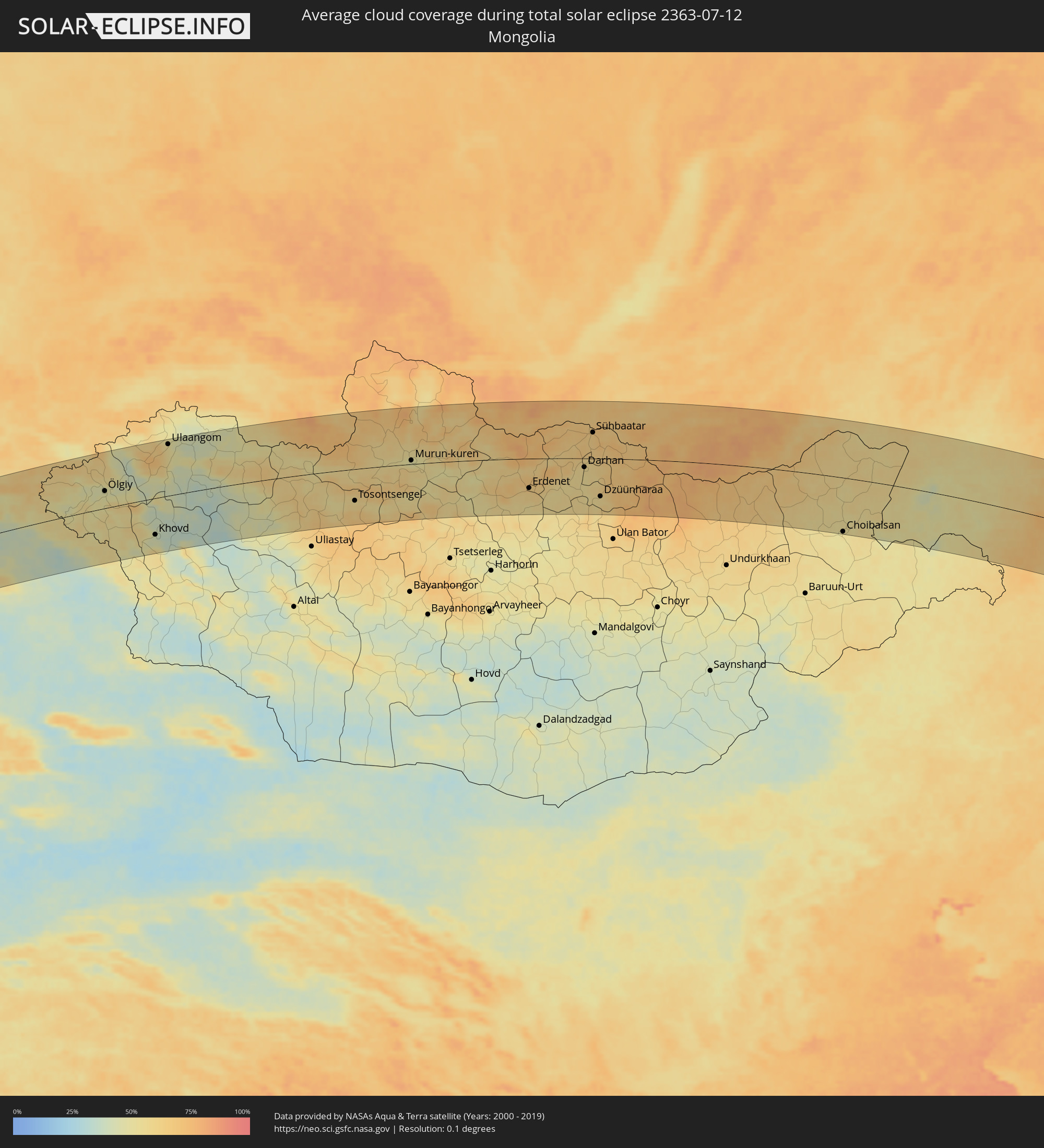 Mongolei
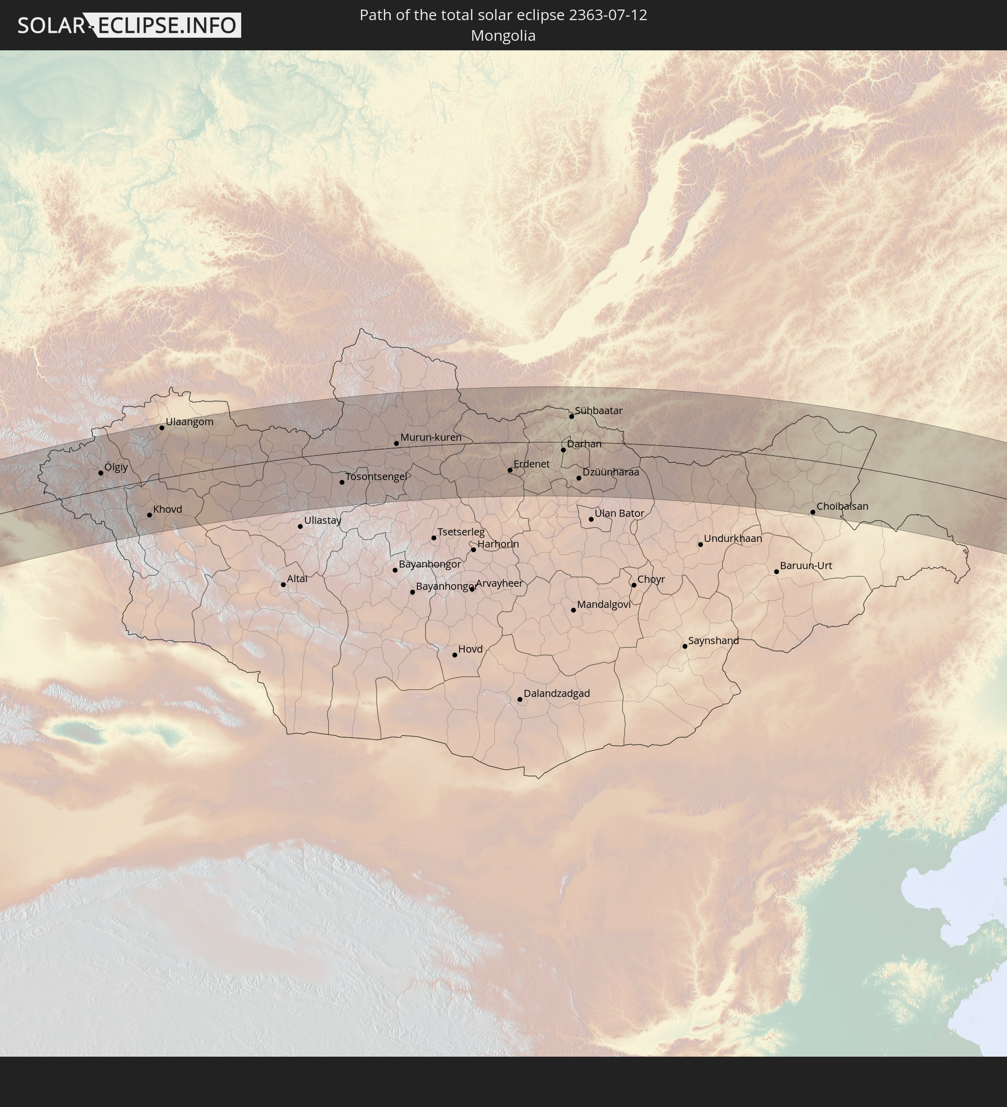
 Japan
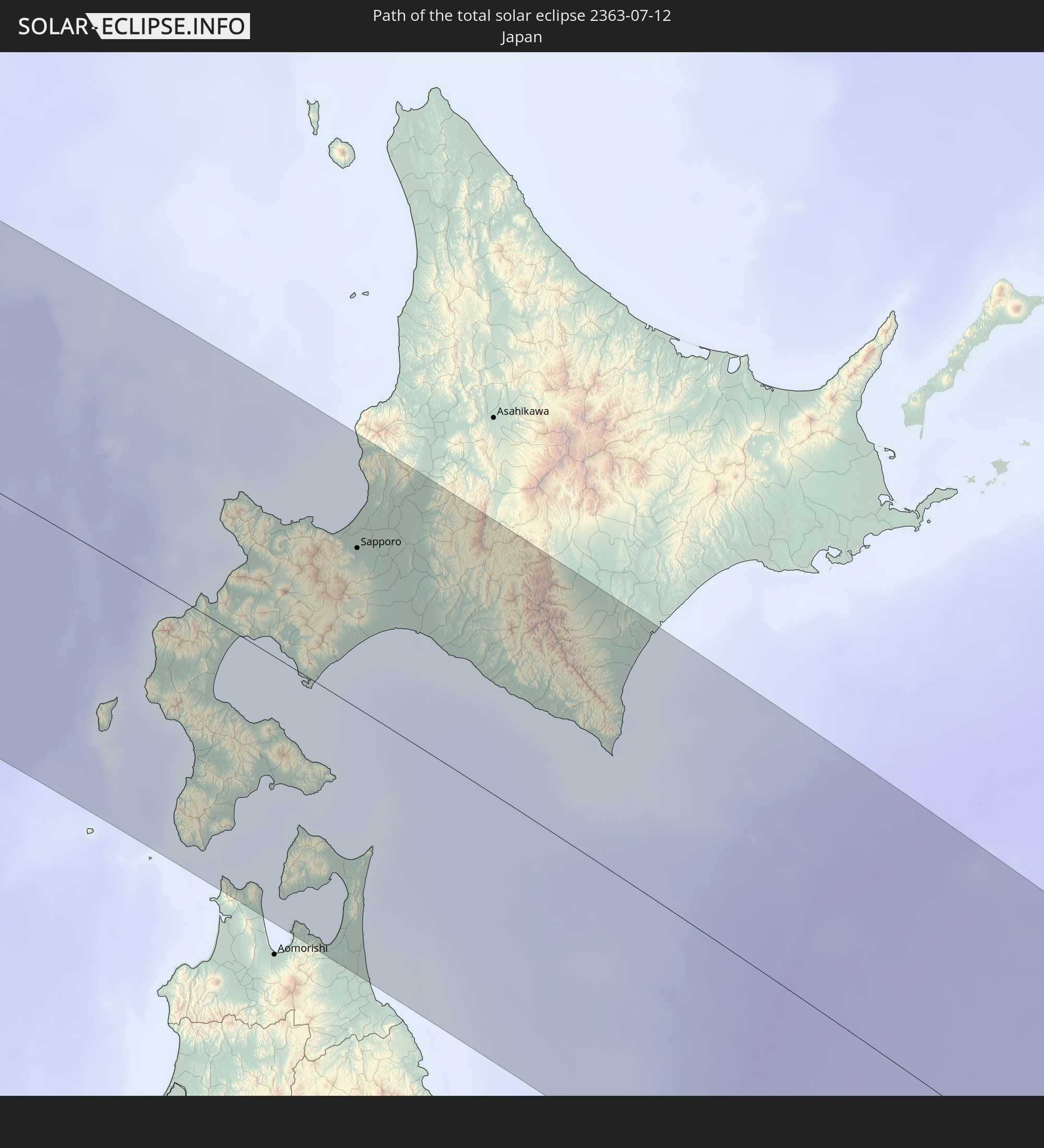
Japan
Orte im Finsternispfad
Die nachfolgene Tabelle zeigt Städte und Orte mit mehr als 5.000 Einwohnern, die sich im Finsternispfad befinden. Städte mit mehr als 100.000 Einwohnern sind dick gekennzeichnet. Mit einem Klick auf den Ort öffnet sich eine Detailkarte die die Lage des jeweiligen Ortes zusammen mit dem Verlauf der zentralen Finsternis präsentiert.
| Ort | Typ | Dauer der Verfinsterung | Ortszeit bei maximaler Verfinsterung | Entfernung zur Zentrallinie | Ø Bewölkung |
|
Kirkuk, At Taʼmīm
|
total | - | 05:06:22 UTC+03:00 | 82 km | 1% |
|
Tozkhurmato, Salah ad Din Governorate
|
total | - | 05:05:49 UTC+03:00 | 15 km | 1% |
|
Jamjamāl, As Sulaymānīyah
|
total | - | 05:06:17 UTC+03:00 | 70 km | 1% |
|
Al Miqdādīyah, Diyālá
|
total | - | 05:05:01 UTC+03:00 | 88 km | 2% |
|
Kifrī, Diyālá
|
total | - | 05:05:34 UTC+03:00 | 18 km | 1% |
|
As Sulaymānīyah, As Sulaymānīyah
|
total | - | 05:06:08 UTC+03:00 | 49 km | 2% |
|
Sarpol-e Z̄ahāb, Kermānshāh
|
total | - | 05:35:07 UTC+03:30 | 79 km | 2% |
|
Bāneh, Kordestān
|
total | - | 05:36:21 UTC+03:30 | 73 km | 4% |
|
Baynjiwayn, As Sulaymānīyah
|
total | - | 05:06:02 UTC+03:00 | 33 km | 2% |
|
Ḩalabjah, As Sulaymānīyah
|
total | - | 05:05:39 UTC+03:00 | 13 km | 2% |
|
Būkān, Āz̄ārbāyjān-e Gharbī
|
total | - | 05:36:42 UTC+03:30 | 111 km | 4% |
|
Saqqez, Kordestān
|
total | - | 05:36:28 UTC+03:30 | 82 km | 4% |
|
Kāmyārān, Kordestān
|
total | - | 05:35:04 UTC+03:30 | 90 km | 3% |
|
Sanandaj, Kordestān
|
total | - | 05:35:29 UTC+03:30 | 41 km | 4% |
|
Takāb, Āz̄ārbāyjān-e Gharbī
|
total | - | 05:36:22 UTC+03:30 | 62 km | 9% |
|
Sonqor, Kermānshāh
|
total | - | 05:34:53 UTC+03:30 | 118 km | 5% |
|
Bījār, Kordestān
|
total | - | 05:35:47 UTC+03:30 | 11 km | 7% |
|
Qorveh, Kordestān
|
total | - | 05:35:09 UTC+03:30 | 89 km | 8% |
|
Zanjān, Zanjan
|
total | - | 05:36:17 UTC+03:30 | 33 km | 9% |
|
Alvand, Zanjan
|
total | - | 05:35:49 UTC+03:30 | 30 km | 8% |
|
Khorramdarreh, Zanjan
|
total | - | 05:35:43 UTC+03:30 | 42 km | 9% |
|
Abhar, Zanjan
|
total | - | 05:35:40 UTC+03:30 | 49 km | 6% |
|
Bandar-e Anzalī, Gīlān
|
total | - | 05:36:47 UTC+03:30 | 72 km | 39% |
|
Rasht, Gīlān
|
total | - | 05:36:35 UTC+03:30 | 48 km | 55% |
|
Tākestān, Qazvīn
|
total | - | 05:35:30 UTC+03:30 | 76 km | 7% |
|
Āstāneh-ye Ashrafīyeh, Gīlān
|
total | - | 05:36:30 UTC+03:30 | 32 km | 55% |
|
Qazvin, Qazvīn
|
total | - | 05:35:36 UTC+03:30 | 69 km | 8% |
|
Langarūd, Gīlān
|
total | - | 05:36:24 UTC+03:30 | 17 km | 55% |
|
Rūdsar, Gīlān
|
total | - | 05:36:19 UTC+03:30 | 6 km | 61% |
|
Ābyek, Markazi
|
total | - | 05:35:20 UTC+03:30 | 111 km | 7% |
|
Chālūs, Māzandarān
|
total | - | 05:35:42 UTC+03:30 | 88 km | 64% |
|
Balkanabat, Balkan
|
total | - | 07:08:03 UTC+05:00 | 80 km | 22% |
|
Gumdag, Balkan
|
total | - | 07:07:44 UTC+05:00 | 41 km | 18% |
|
Gazanjyk, Balkan
|
total | - | 07:07:43 UTC+05:00 | 9 km | 19% |
|
Serdar, Balkan
|
total | - | 07:07:26 UTC+05:00 | 47 km | 20% |
|
Yylanly, Daşoguz
|
total | - | 07:10:26 UTC+05:00 | 113 km | 18% |
|
Tagta, Daşoguz
|
total | - | 07:10:16 UTC+05:00 | 85 km | 16% |
|
Daşoguz, Daşoguz
|
total | - | 07:10:28 UTC+05:00 | 102 km | 17% |
|
Manghit, Karakalpakstan
|
total | - | 07:10:46 UTC+05:00 | 127 km | 19% |
|
Showot, Xorazm
|
total | - | 07:10:18 UTC+05:00 | 72 km | 17% |
|
Qŭshkŭpir, Xorazm
|
total | - | 07:10:10 UTC+05:00 | 58 km | 15% |
|
Khiwa, Xorazm
|
total | - | 07:10:01 UTC+05:00 | 42 km | 14% |
|
Gurlan, Xorazm
|
total | - | 07:10:31 UTC+05:00 | 87 km | 15% |
|
Urganch, Xorazm
|
total | - | 07:10:13 UTC+05:00 | 49 km | 15% |
|
Beruniy, Karakalpakstan
|
total | - | 07:10:23 UTC+05:00 | 59 km | 15% |
|
Novyy Turtkul’, Karakalpakstan
|
total | - | 07:10:15 UTC+05:00 | 35 km | 13% |
|
Hazorasp, Xorazm
|
total | - | 07:10:01 UTC+05:00 | 10 km | 12% |
|
Gazojak, Lebap
|
total | - | 07:09:55 UTC+05:00 | 15 km | 10% |
|
Shīeli, Qyzylorda
|
total | - | 07:14:14 UTC+05:00 | 104 km | 23% |
|
Yanykurgan, Qyzylorda
|
total | - | 07:14:05 UTC+05:00 | 61 km | 18% |
|
Turkestan, Ongtüstik Qazaqstan
|
total | - | 07:13:41 UTC+05:00 | 34 km | 17% |
|
Kentau, Ongtüstik Qazaqstan
|
total | - | 07:14:01 UTC+05:00 | 19 km | 17% |
|
Kantagi, Ongtüstik Qazaqstan
|
total | - | 07:14:03 UTC+05:00 | 21 km | 18% |
|
Ashchysay, Ongtüstik Qazaqstan
|
total | - | 07:14:11 UTC+05:00 | 28 km | 25% |
|
Chulakkurgan, Ongtüstik Qazaqstan
|
total | - | 07:14:31 UTC+05:00 | 15 km | 21% |
|
Chayan, Ongtüstik Qazaqstan
|
total | - | 07:13:46 UTC+05:00 | 96 km | 20% |
|
Zhangatas, Zhambyl
|
total | - | 07:14:29 UTC+05:00 | 53 km | 20% |
|
Karatau, Zhambyl
|
total | - | 07:14:20 UTC+05:00 | 115 km | 23% |
|
Moyynkum, Zhambyl
|
total | - | 07:16:36 UTC+05:00 | 75 km | 25% |
|
Priozersk
|
total | - | 07:18:58 UTC+05:00 | 84 km | 27% |
|
Bakanas, Almaty Oblysy
|
total | - | 07:18:53 UTC+05:00 | 114 km | 26% |
|
Ush-Tyube, Almaty Oblysy
|
total | - | 07:20:23 UTC+05:00 | 112 km | 36% |
|
Lepsy, Almaty Oblysy
|
total | - | 07:22:05 UTC+05:00 | 32 km | 37% |
|
Ayagoz, East Kazakhstan
|
total | - | 07:25:01 UTC+05:00 | 115 km | 45% |
|
Urzhar, East Kazakhstan
|
total | - | 07:24:51 UTC+05:00 | 4 km | 37% |
|
Kurchum, East Kazakhstan
|
total | - | 07:27:58 UTC+05:00 | 109 km | 40% |
|
Aksuat
|
total | - | 07:28:10 UTC+05:00 | 125 km | 43% |
|
Tūghyl, East Kazakhstan
|
total | - | 07:27:28 UTC+05:00 | 8 km | 42% |
|
Zaysan, East Kazakhstan
|
total | - | 07:27:43 UTC+05:00 | 33 km | 45% |
|
Altay, Xinjiang Uyghur Autonomous Region
|
total | - | 10:30:54 UTC+08:00 | 51 km | 38% |
|
Ölgiy, Bayan-Ölgiy
|
total | - | 09:33:43 UTC+07:00 | 41 km | 47% |
|
Khovd, Hovd
|
total | - | 09:34:25 UTC+07:00 | 88 km | 42% |
|
Ulaangom, Uvs
|
total | - | 09:36:43 UTC+07:00 | 122 km | 52% |
|
Tosontsengel, Dzabkhan
|
total | - | 09:42:23 UTC+07:00 | 76 km | 56% |
|
Murun-kuren, Hövsgöl
|
total | - | 10:45:17 UTC+08:00 | 9 km | 50% |
|
Zakamensk, Respublika Buryatiya
|
total | - | 10:49:37 UTC+08:00 | 80 km | 68% |
|
Bulgan, Bulgan
|
total | - | 10:49:03 UTC+08:00 | 95 km | 59% |
|
Erdenet, Orhon
|
total | - | 10:49:54 UTC+08:00 | 71 km | 61% |
|
Petropavlovka, Respublika Buryatiya
|
total | - | 10:52:21 UTC+08:00 | 104 km | 68% |
|
Darhan, Darhan Uul
|
total | - | 10:52:36 UTC+08:00 | 21 km | 56% |
|
Sühbaatar, Selenge
|
total | - | 10:53:20 UTC+08:00 | 62 km | 64% |
|
Kyakhta, Respublika Buryatiya
|
total | - | 10:53:42 UTC+08:00 | 76 km | 69% |
|
Dzüünharaa, Selenge
|
total | - | 10:53:03 UTC+08:00 | 91 km | 57% |
|
Bichura, Respublika Buryatiya
|
total | - | 10:55:21 UTC+08:00 | 104 km | 65% |
|
Krasnyy Chikoy, Transbaikal Territory
|
total | - | 11:56:49 UTC+09:00 | 82 km | 67% |
|
Choibalsan, East Aimak
|
total | - | 11:04:54 UTC+08:00 | 131 km | 52% |
|
Zabaykal’sk, Transbaikal Territory
|
total | - | 12:09:10 UTC+09:00 | 76 km | 55% |
|
Krasnokamensk, Transbaikal Territory
|
total | - | 12:10:12 UTC+09:00 | 135 km | 55% |
|
Hailar, Inner Mongolia
|
total | - | 11:12:53 UTC+08:00 | 62 km | 54% |
|
Yakeshi, Inner Mongolia
|
total | - | 11:14:28 UTC+08:00 | 88 km | 57% |
|
Zhalantun, Inner Mongolia
|
total | - | 11:18:05 UTC+08:00 | 11 km | 65% |
|
Hulan Ergi, Heilongjiang
|
total | - | 11:19:55 UTC+08:00 | 79 km | 55% |
|
Qiqihar, Heilongjiang
|
total | - | 11:20:23 UTC+08:00 | 57 km | 58% |
|
Fendou, Heilongjiang
|
total | - | 11:22:16 UTC+08:00 | 111 km | 68% |
|
Honggang, Heilongjiang
|
total | - | 11:22:26 UTC+08:00 | 136 km | 69% |
|
Longfeng, Heilongjiang
|
total | - | 11:22:44 UTC+08:00 | 117 km | 65% |
|
Anda, Heilongjiang
|
total | - | 11:23:10 UTC+08:00 | 126 km | 65% |
|
Bei’an, Heilongjiang
|
total | - | 11:24:10 UTC+08:00 | 102 km | 65% |
|
Hulan, Heilongjiang
|
total | - | 11:25:37 UTC+08:00 | 138 km | 69% |
|
Hailun, Heilongjiang
|
total | - | 11:25:14 UTC+08:00 | 26 km | 62% |
|
Suihua, Heilongjiang
|
total | - | 11:25:51 UTC+08:00 | 59 km | 67% |
|
Tieli, Heilongjiang
|
total | - | 11:27:21 UTC+08:00 | 4 km | 65% |
|
Yichun, Heilongjiang
|
total | - | 11:28:09 UTC+08:00 | 104 km | 69% |
|
Lianhe, Heilongjiang
|
total | - | 11:29:14 UTC+08:00 | 54 km | 69% |
|
Hegang, Heilongjiang
|
total | - | 11:30:43 UTC+08:00 | 106 km | 70% |
|
Jiamusi, Heilongjiang
|
total | - | 11:31:12 UTC+08:00 | 49 km | 65% |
|
Taihe, Heilongjiang
|
total | - | 11:32:58 UTC+08:00 | 41 km | 73% |
|
Jixi, Heilongjiang
|
total | - | 11:33:33 UTC+08:00 | 85 km | 73% |
|
Shuangyashan, Heilongjiang
|
total | - | 11:32:42 UTC+08:00 | 58 km | 69% |
|
Baoshan, Heilongjiang
|
total | - | 11:33:12 UTC+08:00 | 58 km | 67% |
|
Kamen’-Rybolov, Primorskiy
|
total | - | 13:35:55 UTC+10:00 | 107 km | 72% |
|
Khorol’, Primorskiy
|
total | - | 13:36:17 UTC+10:00 | 138 km | 72% |
|
Chernigovka, Primorskiy
|
total | - | 13:37:12 UTC+10:00 | 130 km | 72% |
|
Spasskoye, Primorskiy
|
total | - | 13:37:19 UTC+10:00 | 95 km | 72% |
|
Spassk-Dal’niy, Primorskiy
|
total | - | 13:37:23 UTC+10:00 | 96 km | 72% |
|
Arsen’yev, Primorskiy
|
total | - | 13:38:36 UTC+10:00 | 125 km | 69% |
|
Lesozavodsk, Primorskiy
|
total | - | 13:37:29 UTC+10:00 | 13 km | 71% |
|
Kirovskiy, Primorskiy
|
total | - | 13:38:00 UTC+10:00 | 23 km | 68% |
|
Gornyye Klyuchi, Primorskiy
|
total | - | 13:37:51 UTC+10:00 | 8 km | 69% |
|
Dal’nerechensk, Primorskiy
|
total | - | 13:37:32 UTC+10:00 | 69 km | 72% |
|
Chuguyevka, Primorskiy
|
total | - | 13:39:35 UTC+10:00 | 103 km | 67% |
|
Luchegorsk, Primorskiy
|
total | - | 13:37:42 UTC+10:00 | 139 km | 71% |
|
Kavalerovo, Primorskiy
|
total | - | 13:41:26 UTC+10:00 | 51 km | 69% |
|
Dal'negorsk, Primorskiy
|
total | - | 13:41:57 UTC+10:00 | 3 km | 69% |
|
Plastun, Primorskiy
|
total | - | 13:42:52 UTC+10:00 | 43 km | 76% |
|
Iwanai, Hokkaido
|
total | - | 12:51:47 UTC+09:00 | 38 km | 82% |
|
Kamiiso, Hokkaido
|
total | - | 12:53:35 UTC+09:00 | 66 km | 82% |
|
Nanae, Hokkaido
|
total | - | 12:53:33 UTC+09:00 | 58 km | 84% |
|
Hakodate, Hokkaido
|
total | - | 12:53:47 UTC+09:00 | 66 km | 82% |
|
Yoichi, Hokkaido
|
total | - | 12:51:53 UTC+09:00 | 71 km | 82% |
|
Date, Hokkaido
|
total | - | 12:53:02 UTC+09:00 | 5 km | 78% |
|
Muroran, Hokkaido
|
total | - | 12:53:26 UTC+09:00 | 4 km | 79% |
|
Otaru, Hokkaido
|
total | - | 12:52:15 UTC+09:00 | 79 km | 80% |
|
Mutsu, Aomori
|
total | - | 12:55:13 UTC+09:00 | 91 km | 79% |
|
Sapporo, Hokkaido
|
total | - | 12:52:57 UTC+09:00 | 83 km | 80% |
|
Shiraoi, Hokkaido
|
total | - | 12:53:40 UTC+09:00 | 34 km | 81% |
|
Ishikari, Hokkaido
|
total | - | 12:52:43 UTC+09:00 | 99 km | 79% |
|
Misawa, Aomori
|
total | - | 12:56:22 UTC+09:00 | 140 km | 80% |
|
Tōbetsu, Hokkaido
|
total | - | 12:53:00 UTC+09:00 | 104 km | 78% |
|
Ebetsu, Hokkaido
|
total | - | 12:53:12 UTC+09:00 | 95 km | 80% |
|
Kitahiroshima, Hokkaido
|
total | - | 12:53:24 UTC+09:00 | 83 km | 80% |
|
Tomakomai, Hokkaido
|
total | - | 12:53:56 UTC+09:00 | 53 km | 80% |
|
Chitose, Hokkaido
|
total | - | 12:53:45 UTC+09:00 | 72 km | 78% |
|
Iwamizawa, Hokkaido
|
total | - | 12:53:23 UTC+09:00 | 113 km | 79% |
|
Bibai, Hokkaido
|
total | - | 12:53:22 UTC+09:00 | 129 km | 81% |
|
Shizunai-furukawachō, Hokkaido
|
total | - | 12:55:31 UTC+09:00 | 58 km | 81% |