Totale Sonnenfinsternis vom 30.04.2413
| Wochentag: | Dienstag |
| Maximale Dauer der Verfinsterung: | 02m13s |
| Maximale Breite des Finsternispfades: | 183 km |
| Saroszyklus: | 135 |
| Bedeckungsgrad: | 100% |
| Magnitude: | 1.0274 |
| Gamma: | -0.8677 |
Wo kann man die Sonnenfinsternis vom 30.04.2413 sehen?
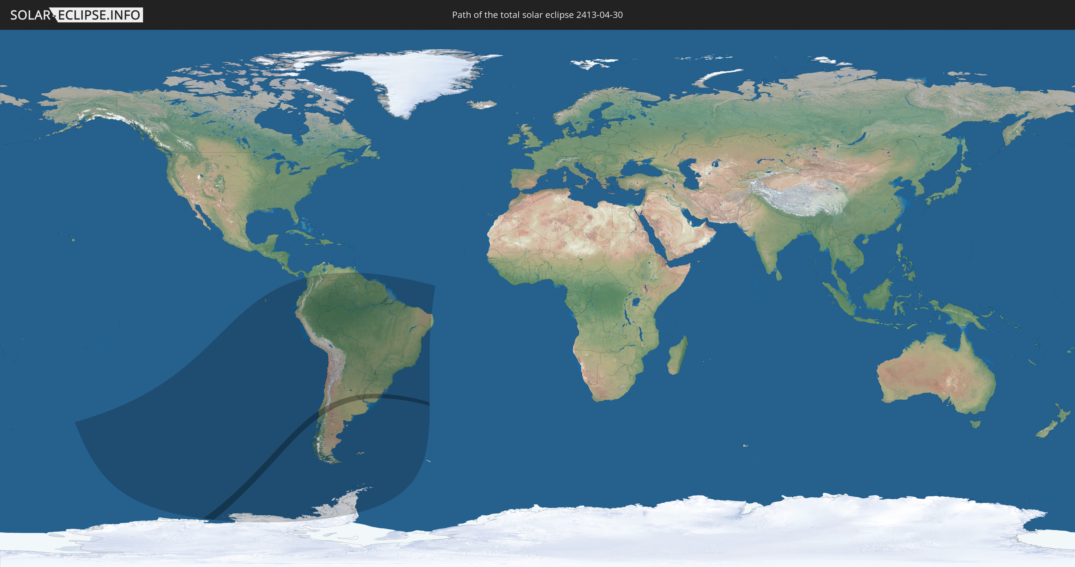
Die Sonnenfinsternis am 30.04.2413 kann man in 16 Ländern als partielle Sonnenfinsternis beobachten.
Der Finsternispfad verläuft durch 4 Länder. Nur in diesen Ländern ist sie als totale Sonnenfinsternis zu sehen.
In den folgenden Ländern ist die Sonnenfinsternis total zu sehen
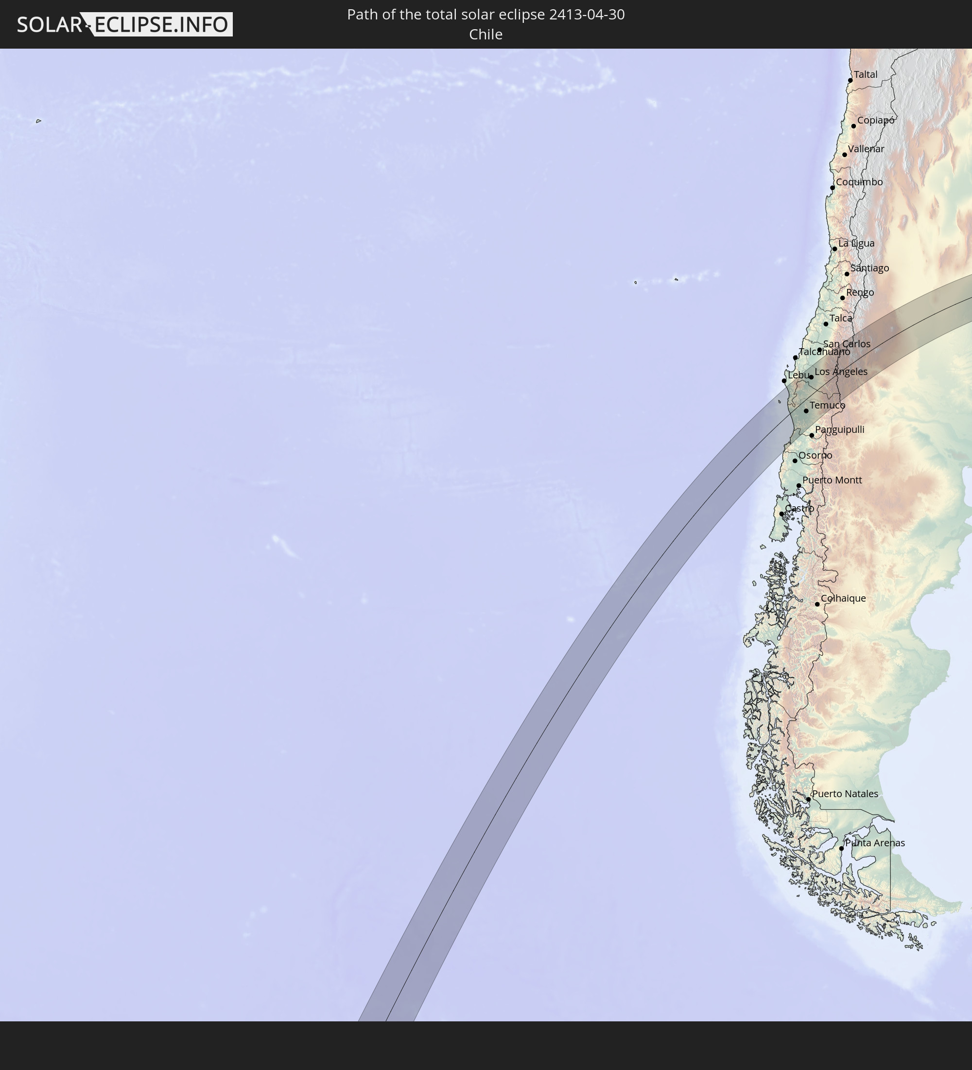 Chile
Chile
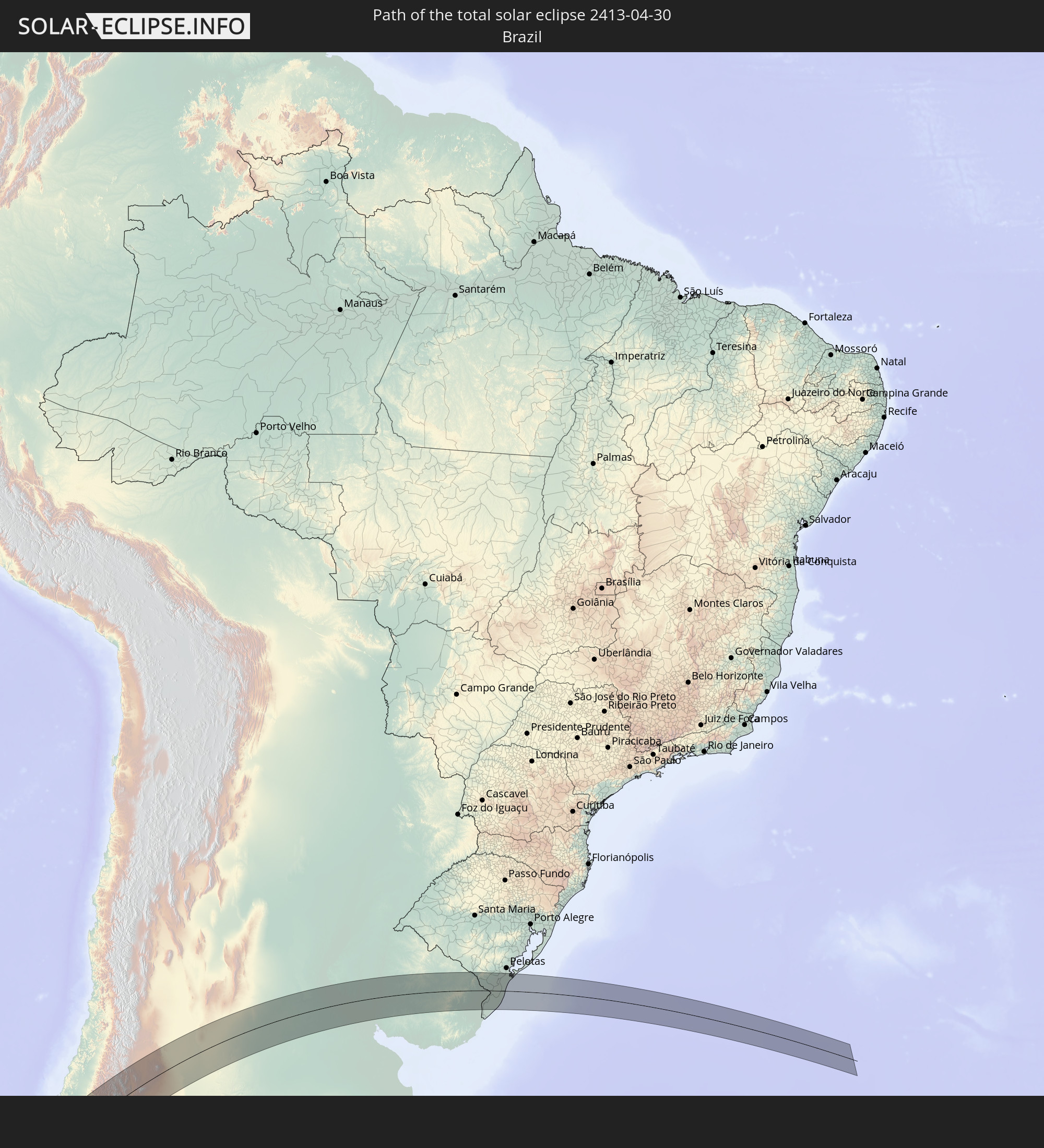 Brasilien
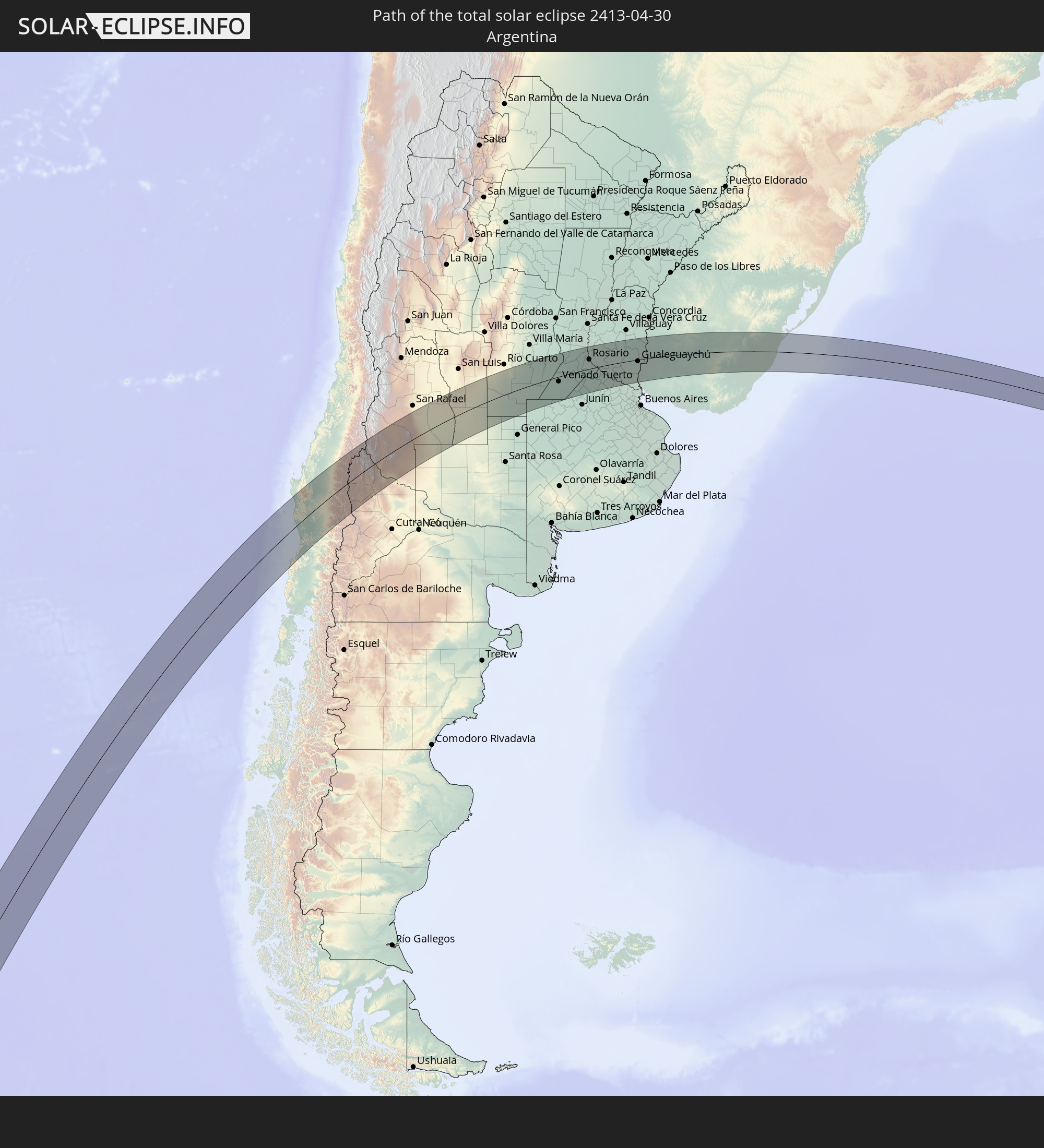 Argentinien
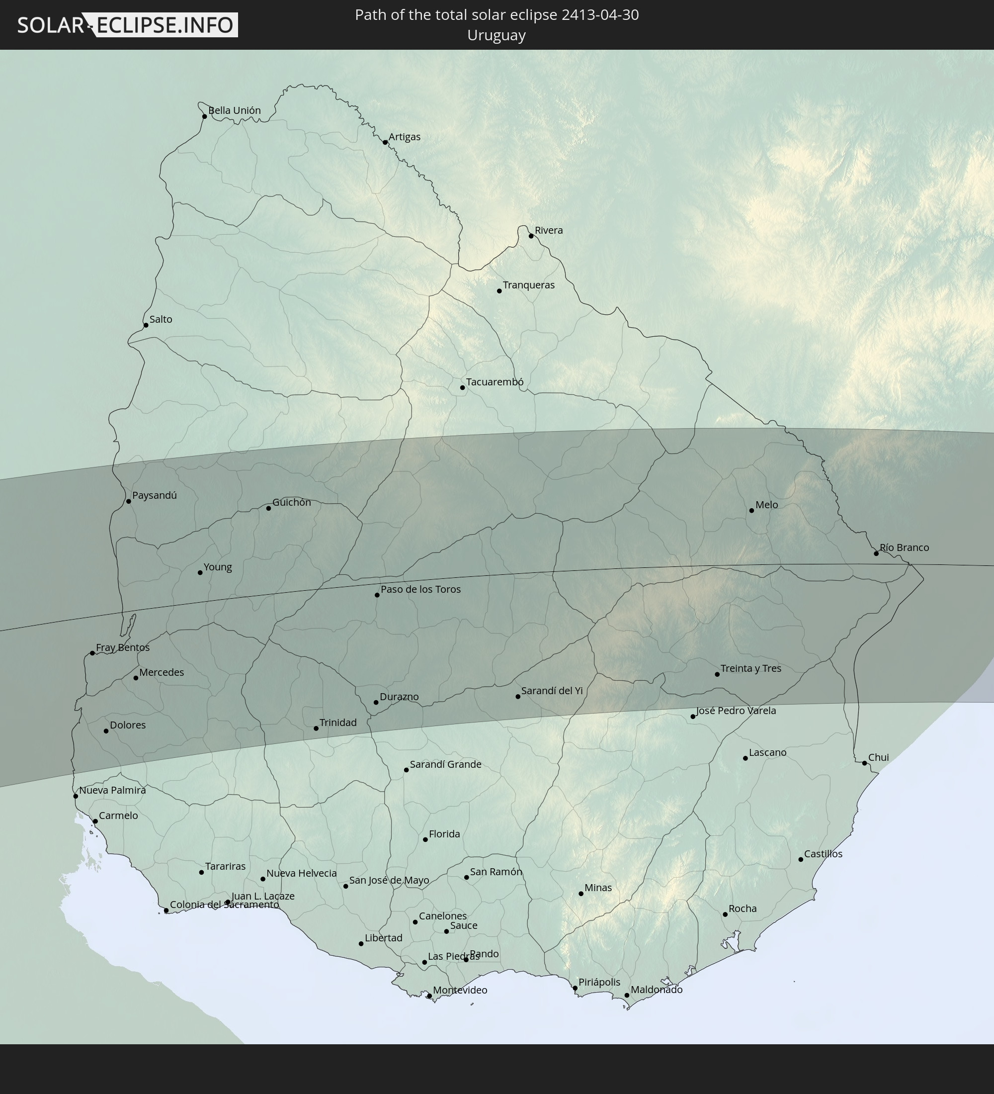 Uruguay
In den folgenden Ländern ist die Sonnenfinsternis partiell zu sehen


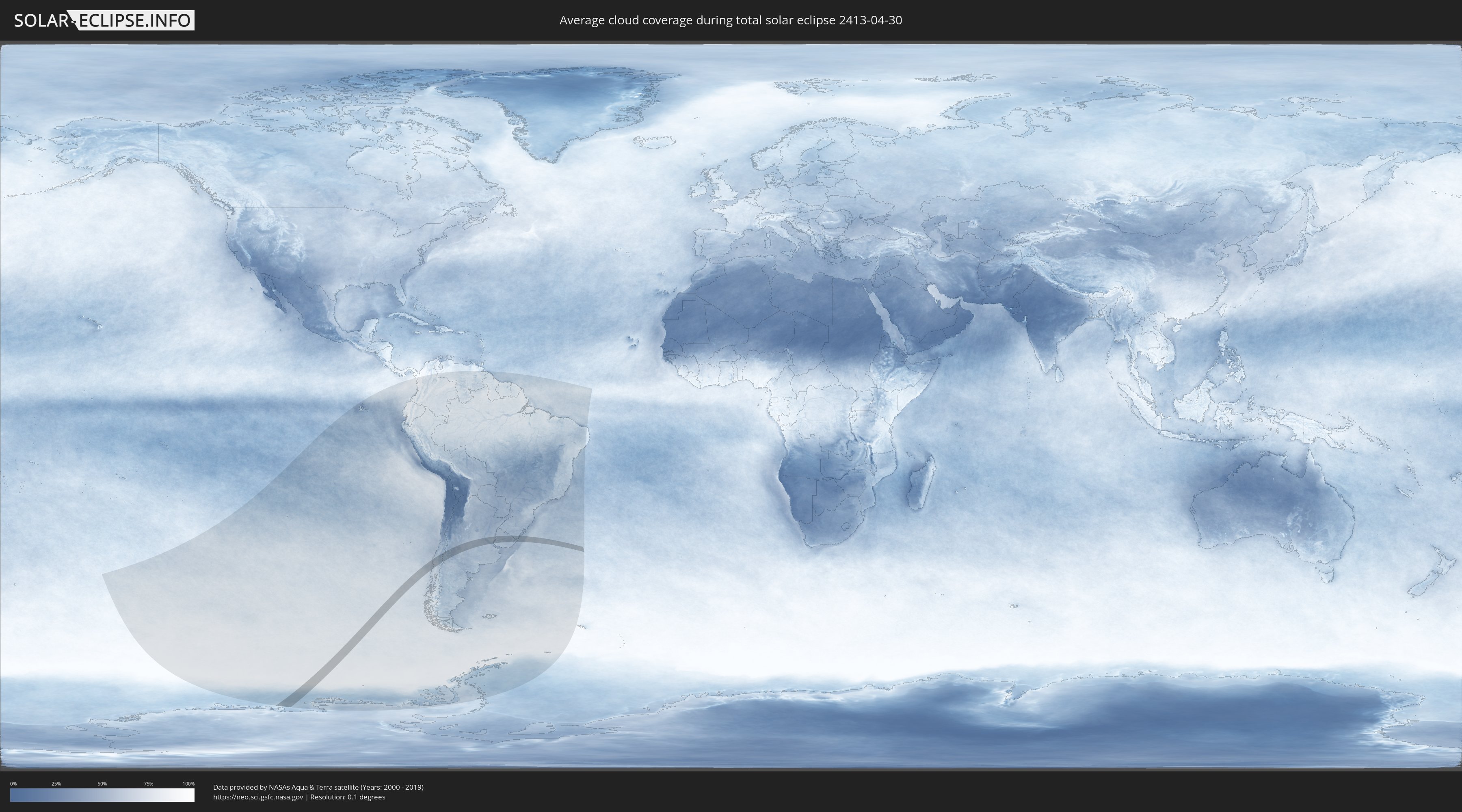
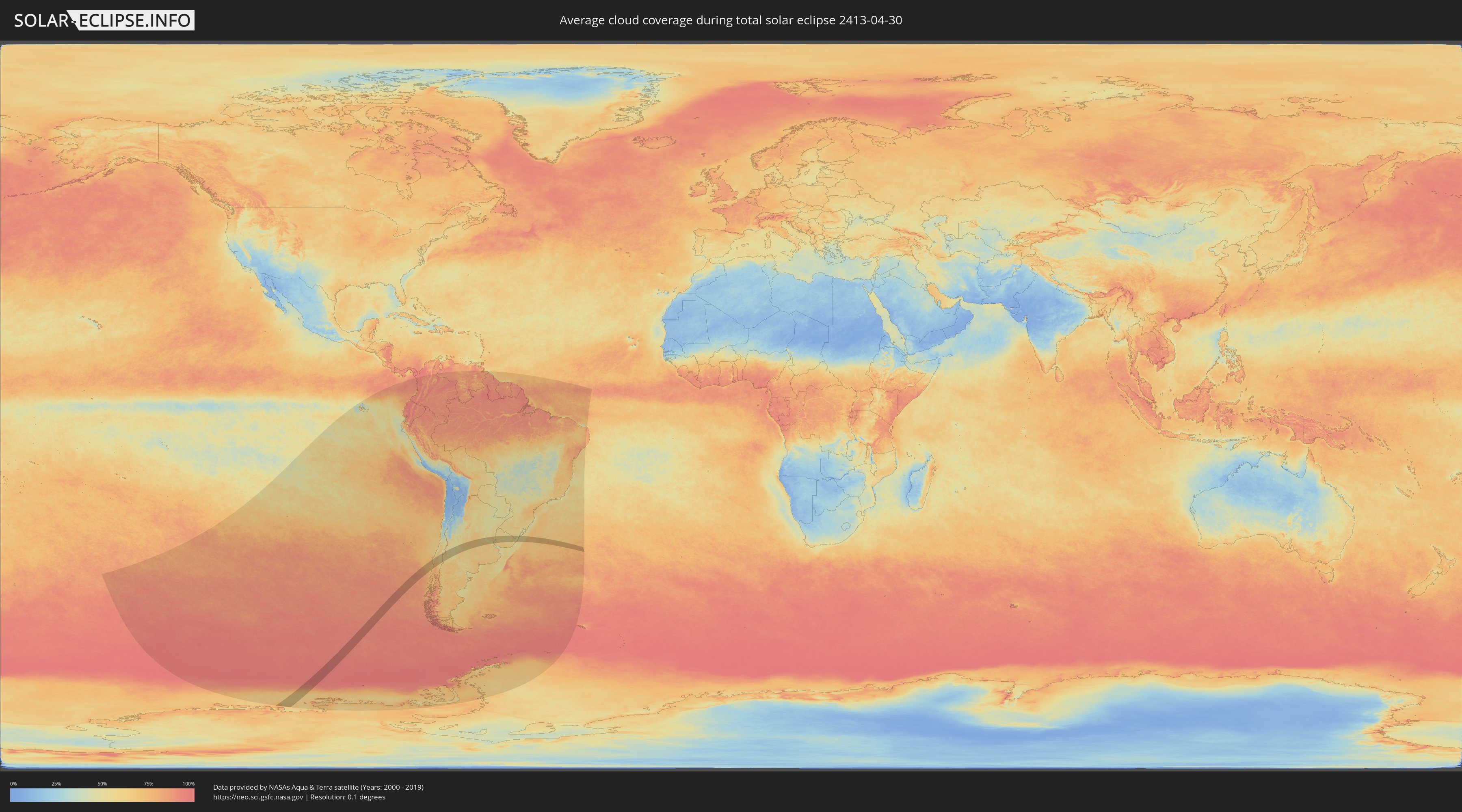
Wie wird das Wetter während der totalen Sonnenfinsternis am 30.04.2413?
Wo ist der beste Ort, um die totale Sonnenfinsternis vom 30.04.2413 zu beobachten?
Die folgenden Karten zeigen die durchschnittliche Bewölkung für den Tag, an dem die totale Sonnenfinsternis
stattfindet. Mit Hilfe der Karten lässt sich der Ort entlang des Finsternispfades eingrenzen,
der die besten Aussichen auf einen klaren wolkenfreien Himmel bietet.
Trotzdem muss man immer lokale Gegenenheiten beachten und sollte sich genau über das Wetter an seinem
gewählten Beobachtungsort informieren.
Die Daten stammen von den beiden NASA-Satelliten
AQUA und TERRA
und wurden über einen Zeitraum von 19 Jahren (2000 - 2019) gemittelt.
Detaillierte Länderkarten
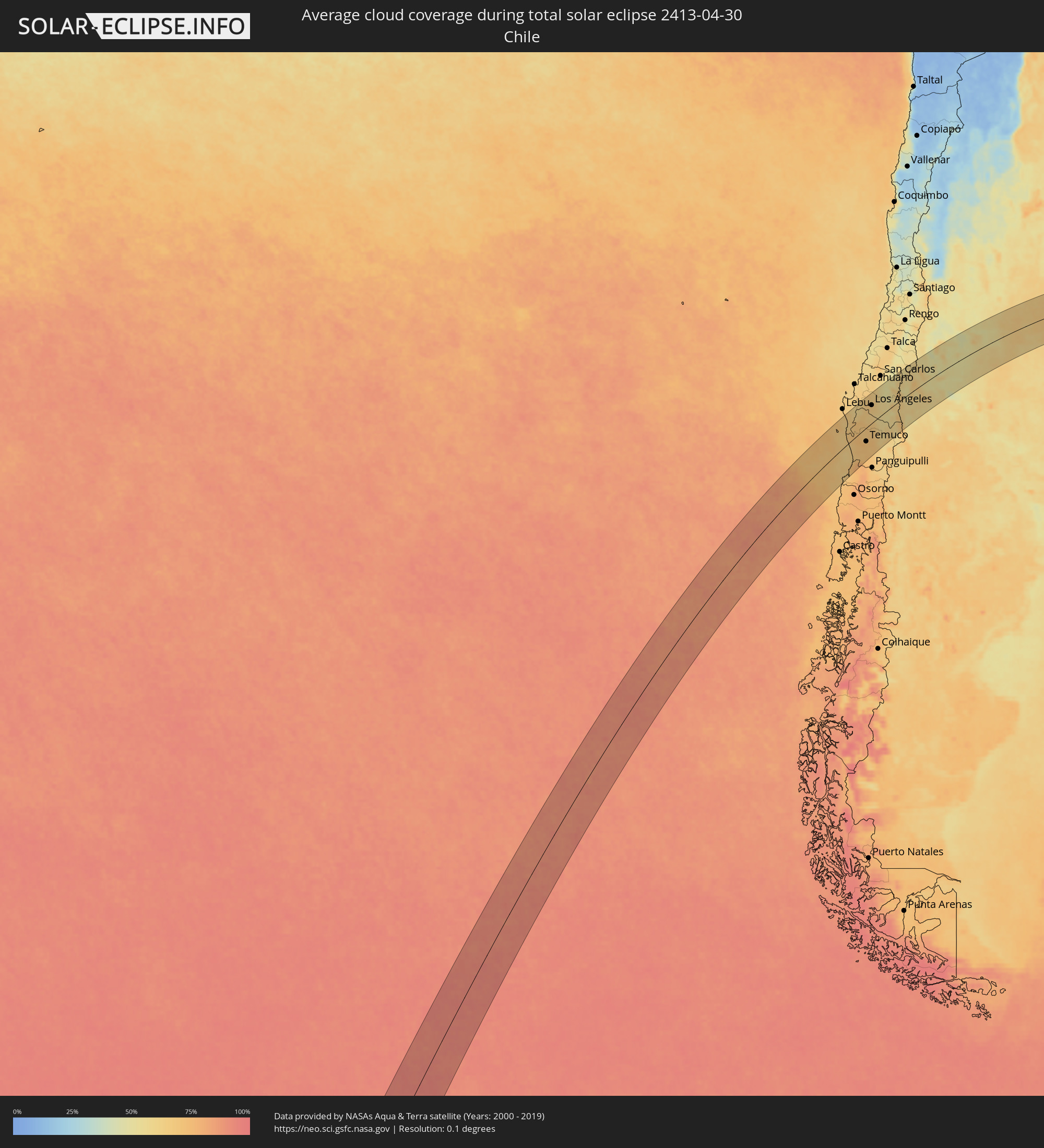 Chile
Chile
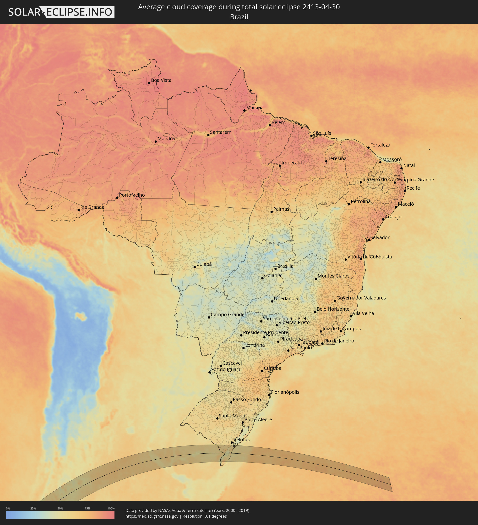 Brasilien
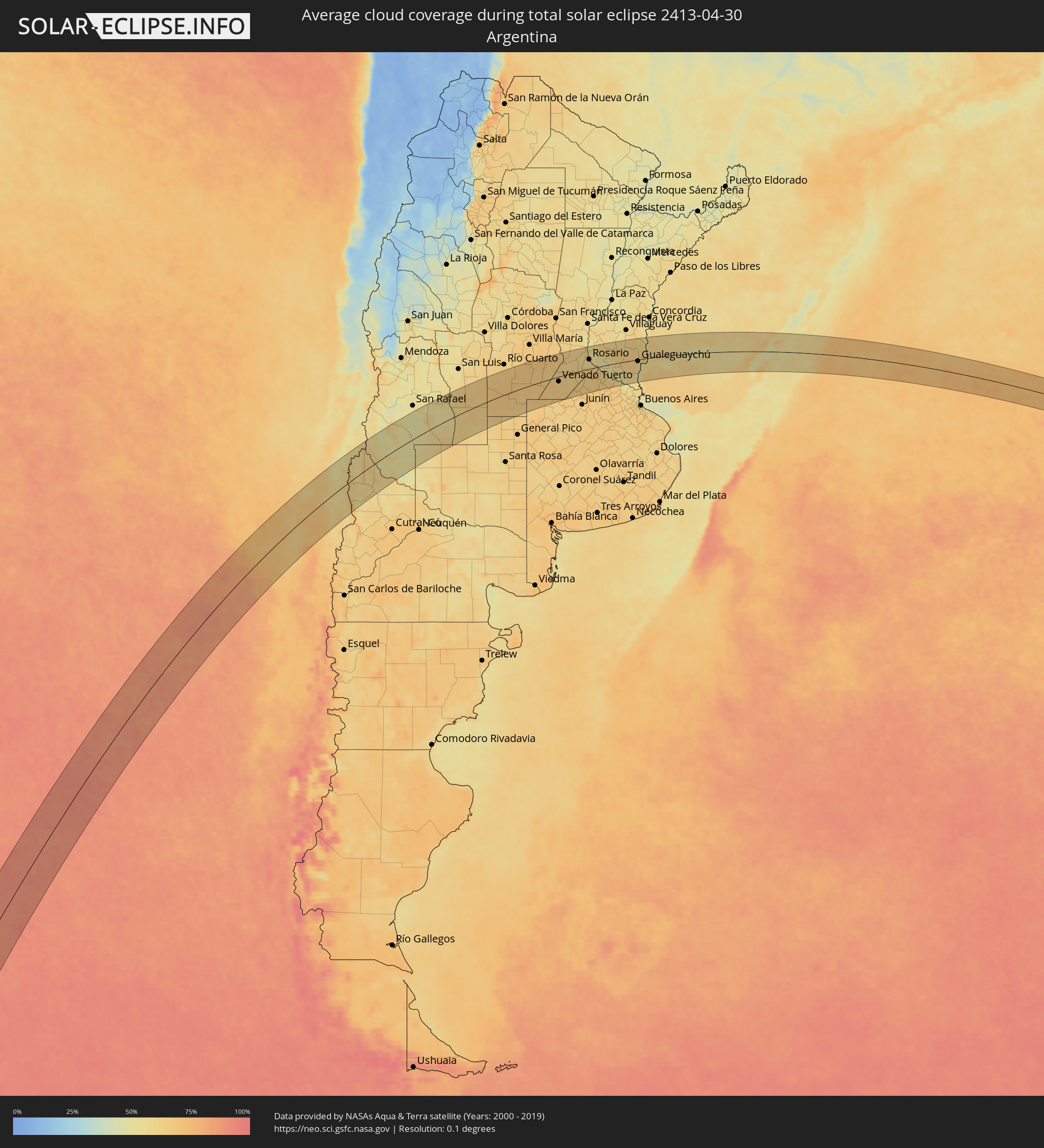 Argentinien
 Uruguay
Orte im Finsternispfad
Die nachfolgene Tabelle zeigt Städte und Orte mit mehr als 5.000 Einwohnern, die sich im Finsternispfad befinden. Städte mit mehr als 100.000 Einwohnern sind dick gekennzeichnet. Mit einem Klick auf den Ort öffnet sich eine Detailkarte die die Lage des jeweiligen Ortes zusammen mit dem Verlauf der zentralen Finsternis präsentiert.
| Ort | Typ | Dauer der Verfinsterung | Ortszeit bei maximaler Verfinsterung | Entfernung zur Zentrallinie | Ø Bewölkung |
 Cañete, Biobío
|
total | - | 15:51:34 UTC-03:00 | 85 km | 66% |
|
Valdivia, Los Ríos
|
total | - | 15:48:43 UTC-03:00 | 91 km | 70% |
|
Las Animas, Los Lagos
|
total | - | 15:48:47 UTC-03:00 | 92 km | 70% |
|
Carahue, Araucanía
|
total | - | 15:50:33 UTC-03:00 | 5 km | 68% |
|
Nueva Imperial, Araucanía
|
total | - | 15:50:51 UTC-03:00 | 20 km | 72% |
|
Angol, Araucanía
|
total | - | 15:52:44 UTC-03:00 | 47 km | 67% |
|
La Laja, Biobío
|
total | - | 15:53:32 UTC-03:00 | 90 km | 63% |
|
Nacimiento, Biobío
|
total | - | 15:53:16 UTC-03:00 | 69 km | 64% |
|
Traiguén, Araucanía
|
total | - | 15:52:06 UTC-03:00 | 5 km | 68% |
|
Pitrufquén, Araucanía
|
total | - | 15:51:00 UTC-03:00 | 58 km | 71% |
|
Loncoche, Araucanía
|
total | - | 15:50:26 UTC-03:00 | 90 km | 73% |
|
Freire, Araucanía
|
total | - | 15:51:05 UTC-03:00 | 56 km | 71% |
|
Temuco, Araucanía
|
total | - | 15:51:27 UTC-03:00 | 40 km | 72% |
|
Lautaro, Araucanía
|
total | - | 15:52:03 UTC-03:00 | 32 km | 69% |
|
Collipulli, Araucanía
|
total | - | 15:52:57 UTC-03:00 | 17 km | 66% |
|
Los Ángeles, Biobío
|
total | - | 15:53:51 UTC-03:00 | 54 km | 66% |
|
Victoria, Araucanía
|
total | - | 15:52:41 UTC-03:00 | 12 km | 68% |
|
Mulchén, Biobío
|
total | - | 15:53:39 UTC-03:00 | 27 km | 61% |
|
Vilcún, Araucanía
|
total | - | 15:52:11 UTC-03:00 | 55 km | 70% |
 Chos Malal, Neuquén Province
|
total | - | 15:57:30 UTC-03:00 | 49 km | 59% |
|
Justo Daract, San Luis Province
|
total | - | 16:11:35 UTC-03:00 | 67 km | 66% |
|
Coronel Moldes, Cordoba Province
|
total | - | 16:12:54 UTC-03:00 | 72 km | 65% |
|
Villa Huidobro, Cordoba Province
|
total | - | 16:10:50 UTC-03:00 | 54 km | 66% |
|
Vicuña Mackenna, Cordoba Province
|
total | - | 16:12:43 UTC-03:00 | 34 km | 67% |
|
Huinca Renancó, Cordoba Province
|
total | - | 16:11:10 UTC-03:00 | 62 km | 65% |
|
Realicó, La Pampa Province
|
total | - | 16:11:01 UTC-03:00 | 87 km | 63% |
|
Adelia María, Cordoba Province
|
total | - | 16:13:46 UTC-03:00 | 52 km | 65% |
|
General Levalle, Cordoba Province
|
total | - | 16:13:16 UTC-03:00 | 9 km | 68% |
|
Laboulaye, Cordoba Province
|
total | - | 16:13:52 UTC-03:00 | 19 km | 67% |
|
La Carlota, Cordoba Province
|
total | - | 16:15:14 UTC-03:00 | 53 km | 68% |
|
Canals, Cordoba Province
|
total | - | 16:15:35 UTC-03:00 | 25 km | 65% |
|
Laborde, Cordoba Province
|
total | - | 16:16:20 UTC-03:00 | 68 km | 68% |
|
Rufino, Santa Fe Province
|
total | - | 16:14:38 UTC-03:00 | 54 km | 64% |
|
Justiniano Posse, Cordoba Province
|
total | - | 16:17:04 UTC-03:00 | 92 km | 67% |
|
Monte Maíz, Cordoba Province
|
total | - | 16:16:38 UTC-03:00 | 56 km | 65% |
|
Monte Buey, Cordoba Province
|
total | - | 16:17:20 UTC-03:00 | 83 km | 67% |
|
Arias, Cordoba Province
|
total | - | 16:16:10 UTC-03:00 | 4 km | 65% |
|
Corral de Bustos, Cordoba Province
|
total | - | 16:17:06 UTC-03:00 | 37 km | 65% |
|
Chañar Ladeado, Santa Fe Province
|
total | - | 16:17:15 UTC-03:00 | 28 km | 65% |
|
Venado Tuerto, Santa Fe Province
|
total | - | 16:16:37 UTC-03:00 | 18 km | 65% |
|
Cruz Alta, Cordoba Province
|
total | - | 16:18:07 UTC-03:00 | 57 km | 64% |
|
Villa Cañás, Santa Fe Province
|
total | - | 16:16:42 UTC-03:00 | 55 km | 63% |
|
Armstrong, Santa Fe Province
|
total | - | 16:18:49 UTC-03:00 | 76 km | 61% |
|
Las Parejas, Santa Fe Province
|
total | - | 16:19:06 UTC-03:00 | 85 km | 62% |
|
Firmat, Santa Fe Province
|
total | - | 16:17:49 UTC-03:00 | 0 km | 63% |
|
Cañada de Gómez, Santa Fe Province
|
total | - | 16:19:03 UTC-03:00 | 68 km | 62% |
|
Totoras, Santa Fe Province
|
total | - | 16:19:46 UTC-03:00 | 88 km | 60% |
|
Casilda, Santa Fe Province
|
total | - | 16:18:59 UTC-03:00 | 38 km | 60% |
|
Carcarañá, Santa Fe Province
|
total | - | 16:19:19 UTC-03:00 | 58 km | 61% |
|
Roldán, Santa Fe Province
|
total | - | 16:19:36 UTC-03:00 | 48 km | 61% |
|
Funes, Santa Fe Province
|
total | - | 16:19:42 UTC-03:00 | 44 km | 62% |
|
Pérez, Santa Fe Province
|
total | - | 16:19:37 UTC-03:00 | 34 km | 59% |
|
Fray Luis A. Beltrán, Santa Fe Province
|
total | - | 16:20:02 UTC-03:00 | 56 km | 61% |
|
Capitán Bermúdez, Santa Fe Province
|
total | - | 16:20:00 UTC-03:00 | 52 km | 61% |
|
Granadero Baigorria, Santa Fe Province
|
total | - | 16:19:56 UTC-03:00 | 49 km | 64% |
|
Gobernador Gálvez, Santa Fe Province
|
total | - | 16:19:45 UTC-03:00 | 28 km | 58% |
|
Rosario, Santa Fe Province
|
total | - | 16:19:54 UTC-03:00 | 37 km | 55% |
|
Pergamino, Buenos Aires
|
total | - | 16:18:21 UTC-03:00 | 66 km | 64% |
|
Arroyo Seco, Santa Fe Province
|
total | - | 16:19:43 UTC-03:00 | 12 km | 64% |
|
Villa Constitución, Santa Fe Province
|
total | - | 16:19:50 UTC-03:00 | 0 km | 58% |
|
San Nicolás de los Arroyos, Buenos Aires
|
total | - | 16:19:48 UTC-03:00 | 13 km | 60% |
|
Victoria, Entre Ríos Province
|
total | - | 16:21:08 UTC-03:00 | 63 km | 56% |
|
Gualeguay, Entre Ríos Province
|
total | - | 16:21:23 UTC-03:00 | 9 km | 61% |
|
Rosario del Tala, Entre Ríos Province
|
total | - | 16:23:03 UTC-03:00 | 81 km | 59% |
|
Larroque, Entre Ríos Province
|
total | - | 16:21:59 UTC-03:00 | 2 km | 65% |
|
Urdinarrain, Entre Ríos Province
|
total | - | 16:22:44 UTC-03:00 | 35 km | 65% |
|
Gualeguaychú, Entre Ríos Province
|
total | - | 16:22:40 UTC-03:00 | 6 km | 57% |
|
Villa Elisa, Entre Ríos Province
|
total | - | 16:24:17 UTC-03:00 | 85 km | 59% |
 Fray Bentos, Río Negro
|
total | - | 16:22:45 UTC-03:00 | 22 km | 55% |
|
Concepción del Uruguay, Entre Ríos Province
|
total | - | 16:23:56 UTC-03:00 | 48 km | 56% |
|
Dolores, Soriano
|
total | - | 16:22:10 UTC-03:00 | 68 km | 64% |
|
Paysandú, Paysandú
|
total | - | 16:24:26 UTC-03:00 | 64 km | 57% |
|
Mercedes, Soriano
|
total | - | 16:22:53 UTC-03:00 | 40 km | 63% |
|
Young, Río Negro
|
total | - | 16:24:22 UTC-03:00 | 17 km | 64% |
|
Guichón, Paysandú
|
total | - | 16:25:29 UTC-03:00 | 50 km | 58% |
|
Trinidad, Flores
|
total | - | 16:23:52 UTC-03:00 | 81 km | 63% |
|
Trinidad, Flores
|
total | - | 16:23:51 UTC-03:00 | 84 km | 63% |
|
Durazno, Durazno
|
total | - | 16:24:34 UTC-03:00 | 70 km | 63% |
|
Paso de los Toros, Tacuarembó
|
total | - | 16:25:33 UTC-03:00 | 7 km | 56% |
|
Sarandí del Yi, Durazno
|
total | - | 16:25:42 UTC-03:00 | 72 km | 57% |
|
Treinta y Tres, Treinta y Tres
|
total | - | 16:27:23 UTC-03:00 | 64 km | 60% |
|
Melo, Cerro Largo
|
total | - | 16:29:06 UTC-03:00 | 31 km | 57% |
 Herval, Rio Grande do Sul
|
total | - | 16:30:33 UTC-03:00 | 70 km | 60% |
|
Río Branco, Cerro Largo
|
total | - | 16:29:35 UTC-03:00 | 6 km | 64% |
|
Jaguarão, Rio Grande do Sul
|
total | - | 16:29:39 UTC-03:00 | 9 km | 64% |
|
Arroio Grande, Rio Grande do Sul
|
total | - | 16:30:32 UTC-03:00 | 46 km | 63% |
|
Rio Grande, Rio Grande do Sul
|
total | - | 16:31:56 UTC-03:00 | 71 km | 56% |