Totale Sonnenfinsternis vom 20.04.2414
| Wochentag: | Sonntag |
| Maximale Dauer der Verfinsterung: | 05m33s |
| Maximale Breite des Finsternispfades: | 218 km |
| Saroszyklus: | 145 |
| Bedeckungsgrad: | 100% |
| Magnitude: | 1.0661 |
| Gamma: | -0.1279 |
Wo kann man die Sonnenfinsternis vom 20.04.2414 sehen?
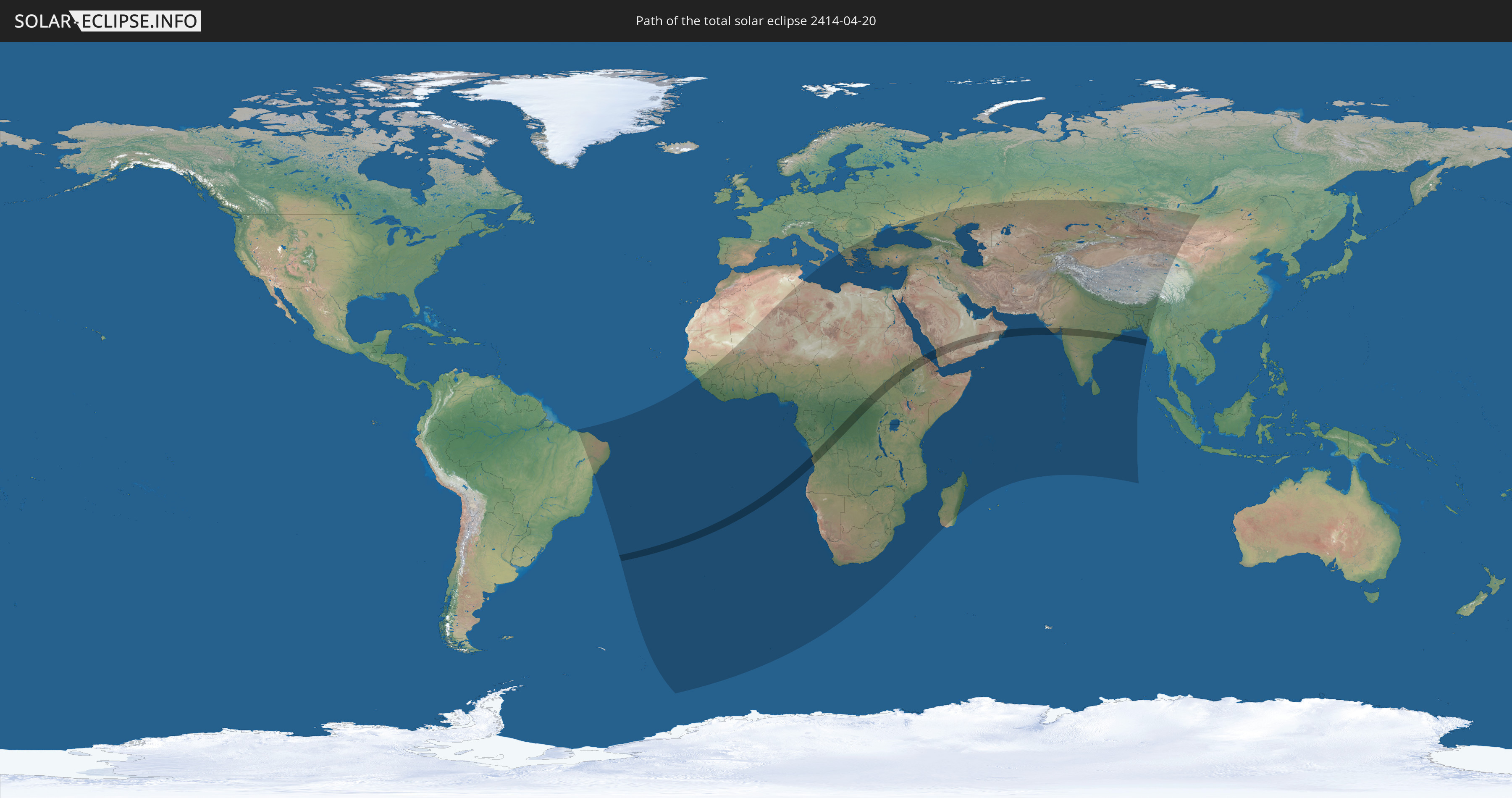
Die Sonnenfinsternis am 20.04.2414 kann man in 97 Ländern als partielle Sonnenfinsternis beobachten.
Der Finsternispfad verläuft durch 11 Länder. Nur in diesen Ländern ist sie als totale Sonnenfinsternis zu sehen.
In den folgenden Ländern ist die Sonnenfinsternis total zu sehen
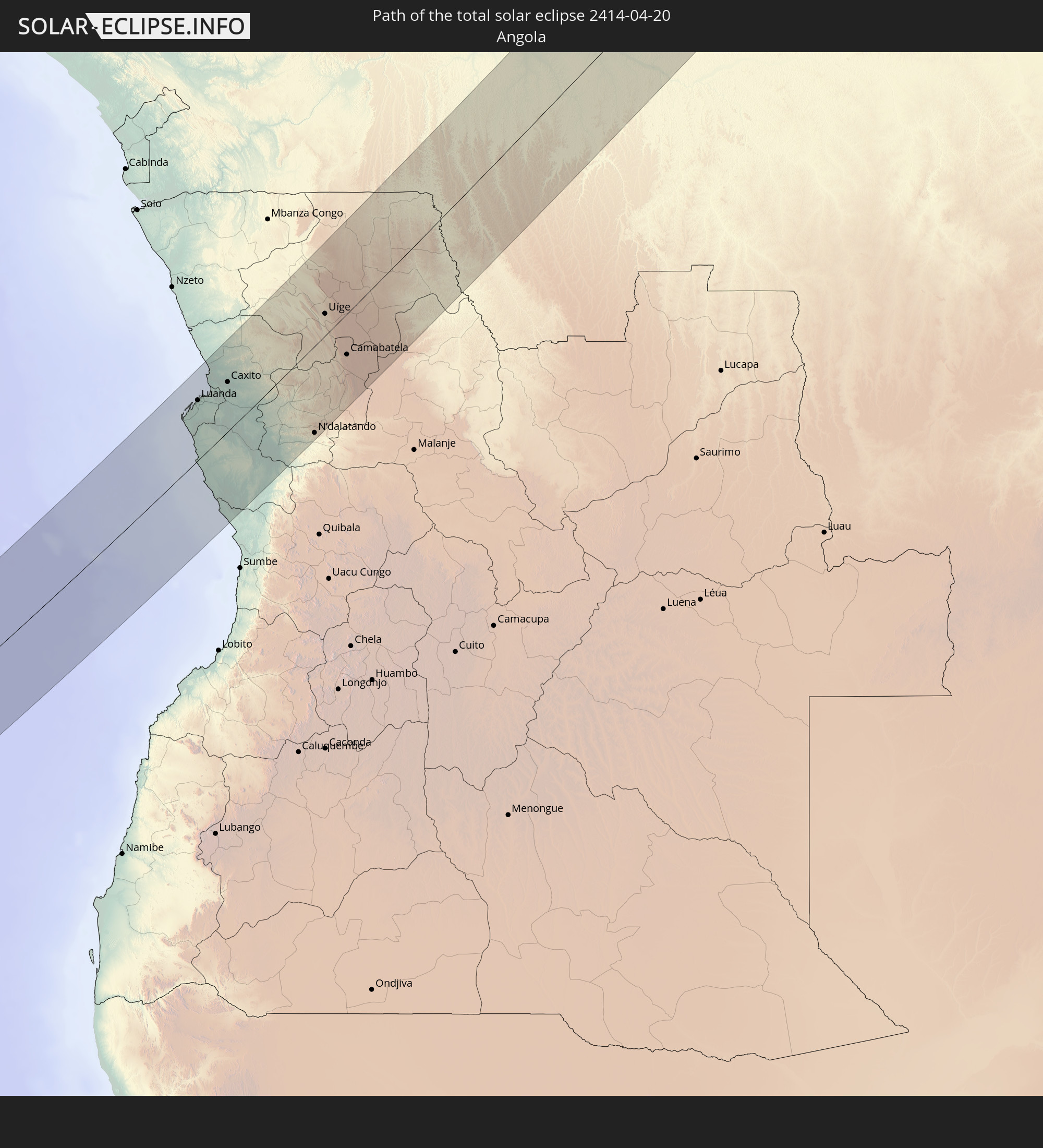 Angola
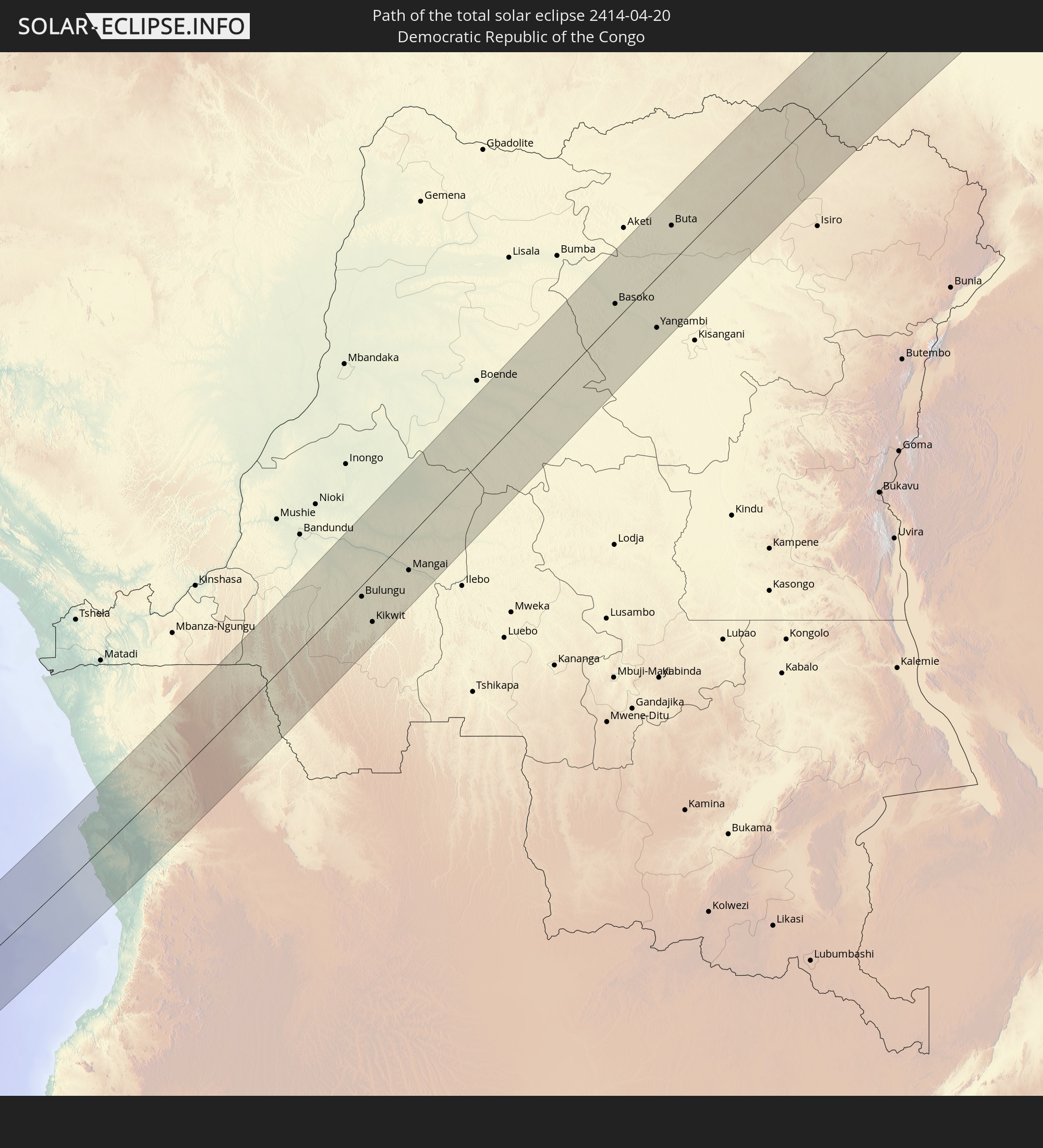 Demokratische Republik Kongo
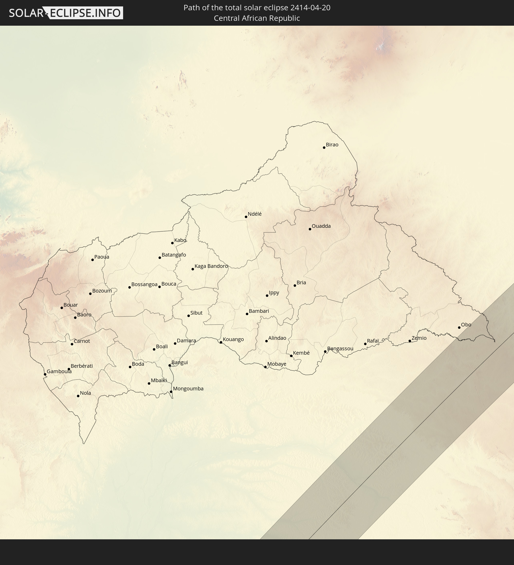 Zentralafrikanische Republik
 Sudan
Sudan
 Südsudan
 Äthiopien
 Saudi-Arabien
 Eritrea
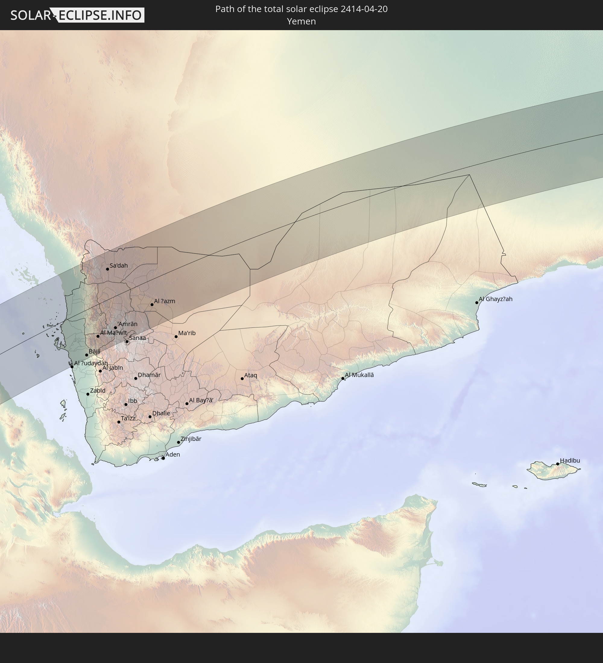 Jemen
Jemen
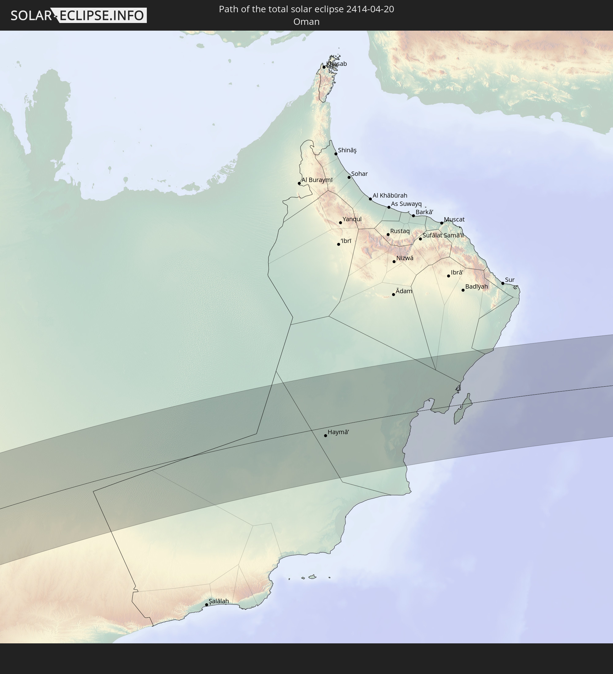 Oman
Oman
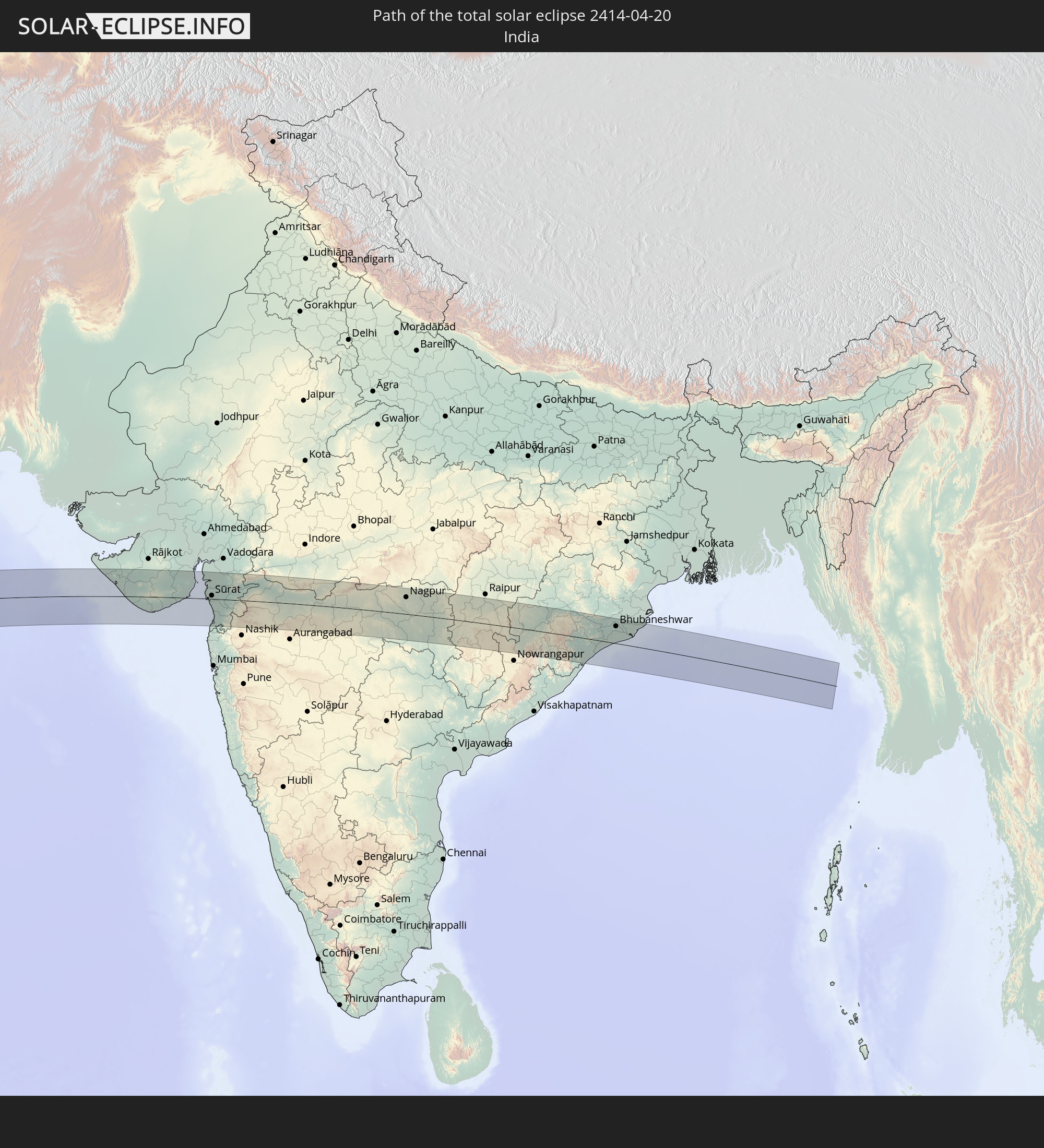 Indien
In den folgenden Ländern ist die Sonnenfinsternis partiell zu sehen
 Russland
 Brasilien
 Mauretanien
 Guinea
 St. Helena
 Sierra Leone
 Mali
Mali
 Liberia
 Algerien
 Elfenbeinküste
 Burkina Faso
 Ghana
Ghana
 Togo
Togo
 Niger
Niger
 Benin
Benin
 Nigeria
 Bouvetinsel
 Äquatorialguinea
 São Tomé und Príncipe
 Tunesien
 Kamerun
 Gabun
Gabun
 Libyen
 Republik Kongo
 Angola
 Namibia
 Demokratische Republik Kongo
 Tschad
 Malta
Malta
 Zentralafrikanische Republik
 Südafrika
 Albanien
 Griechenland
 Botswana
 Rumänien
 Mazedonien
 Sudan
Sudan
 Sambia
 Ukraine
 Bulgarien
 Ägypten
 Simbabwe
 Türkei
 Lesotho
 Ruanda
 Burundi
 Tansania
 Uganda
 Mosambik
 Swasiland
 Republik Zypern
 Malawi
 Äthiopien
 Kenia
Kenia
 Staat Palästina
 Israel
 Saudi-Arabien
 Jordanien
 Libanon
 Syrien
 Eritrea
 Irak
Irak
 Georgien
 Französische Süd- und Antarktisgebiete
 Somalia
 Dschibuti
 Jemen
Jemen
 Madagaskar
 Komoren
 Armenien
 Iran
Iran
 Aserbaidschan
 Mayotte
 Seychellen
 Kasachstan
 Kuwait
 Bahrain
 Katar
Katar
 Vereinigte Arabische Emirate
 Oman
Oman
 Turkmenistan
 Usbekistan
 Mauritius
 Afghanistan
 Pakistan
 Tadschikistan
 Indien
 Kirgisistan
 Britisches Territorium im Indischen Ozean
 Malediven
 Volksrepublik China
 Sri Lanka
 Nepal
Nepal
 Mongolei
 Bangladesch
 Bhutan
 Myanmar
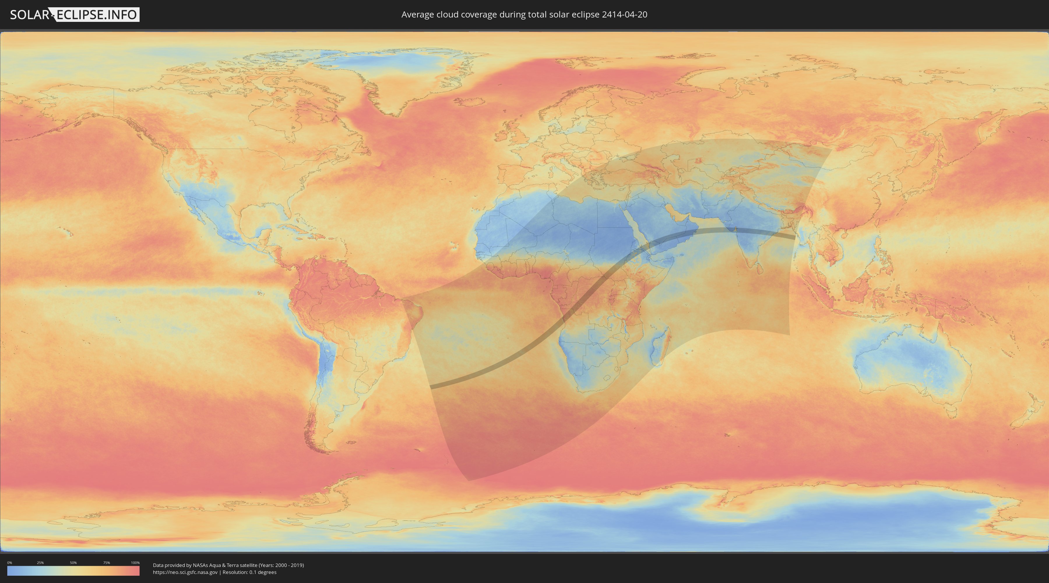
Wie wird das Wetter während der totalen Sonnenfinsternis am 20.04.2414?
Wo ist der beste Ort, um die totale Sonnenfinsternis vom 20.04.2414 zu beobachten?
Die folgenden Karten zeigen die durchschnittliche Bewölkung für den Tag, an dem die totale Sonnenfinsternis
stattfindet. Mit Hilfe der Karten lässt sich der Ort entlang des Finsternispfades eingrenzen,
der die besten Aussichen auf einen klaren wolkenfreien Himmel bietet.
Trotzdem muss man immer lokale Gegenenheiten beachten und sollte sich genau über das Wetter an seinem
gewählten Beobachtungsort informieren.
Die Daten stammen von den beiden NASA-Satelliten
AQUA und TERRA
und wurden über einen Zeitraum von 19 Jahren (2000 - 2019) gemittelt.

Detaillierte Länderkarten
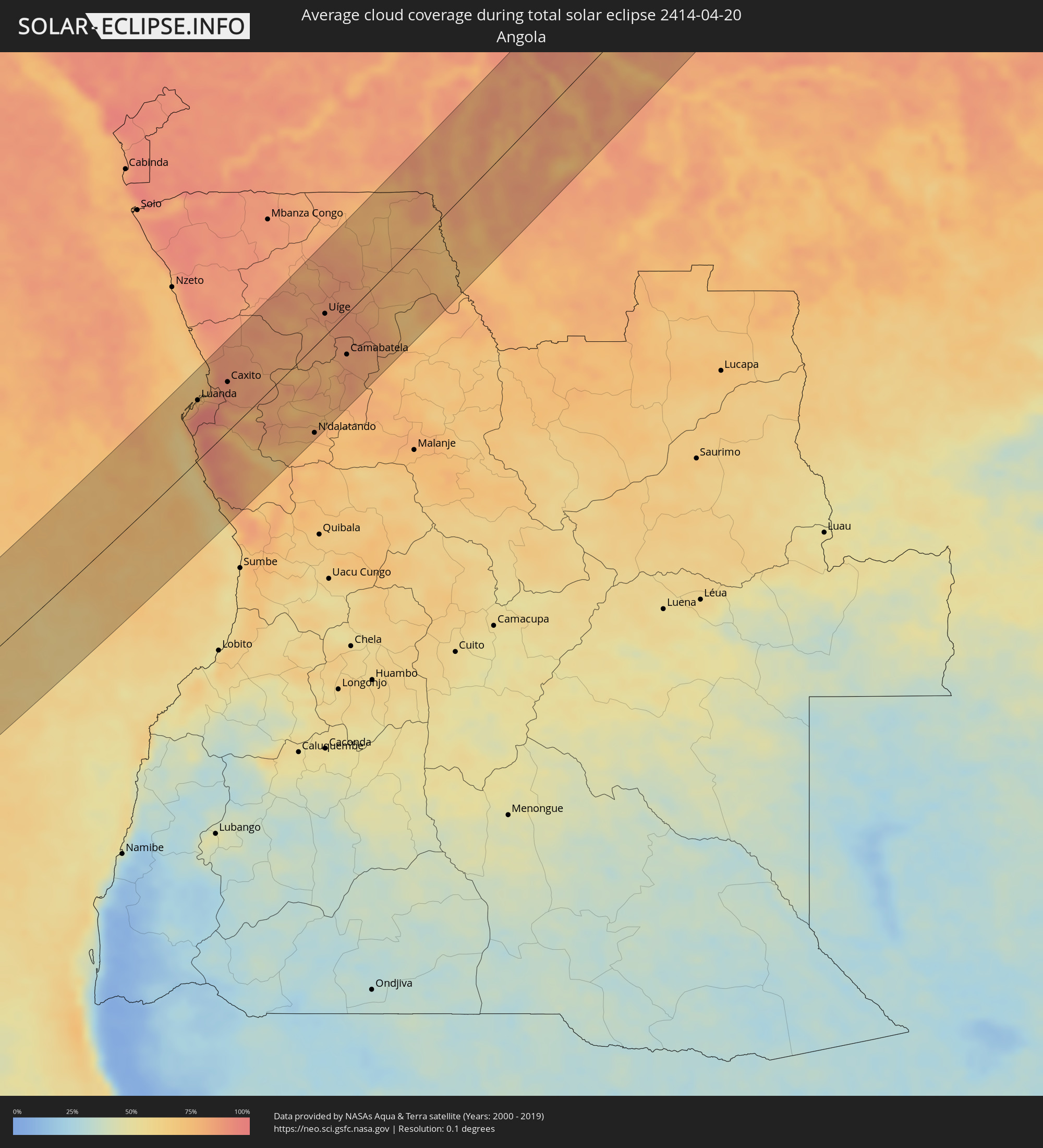 Angola
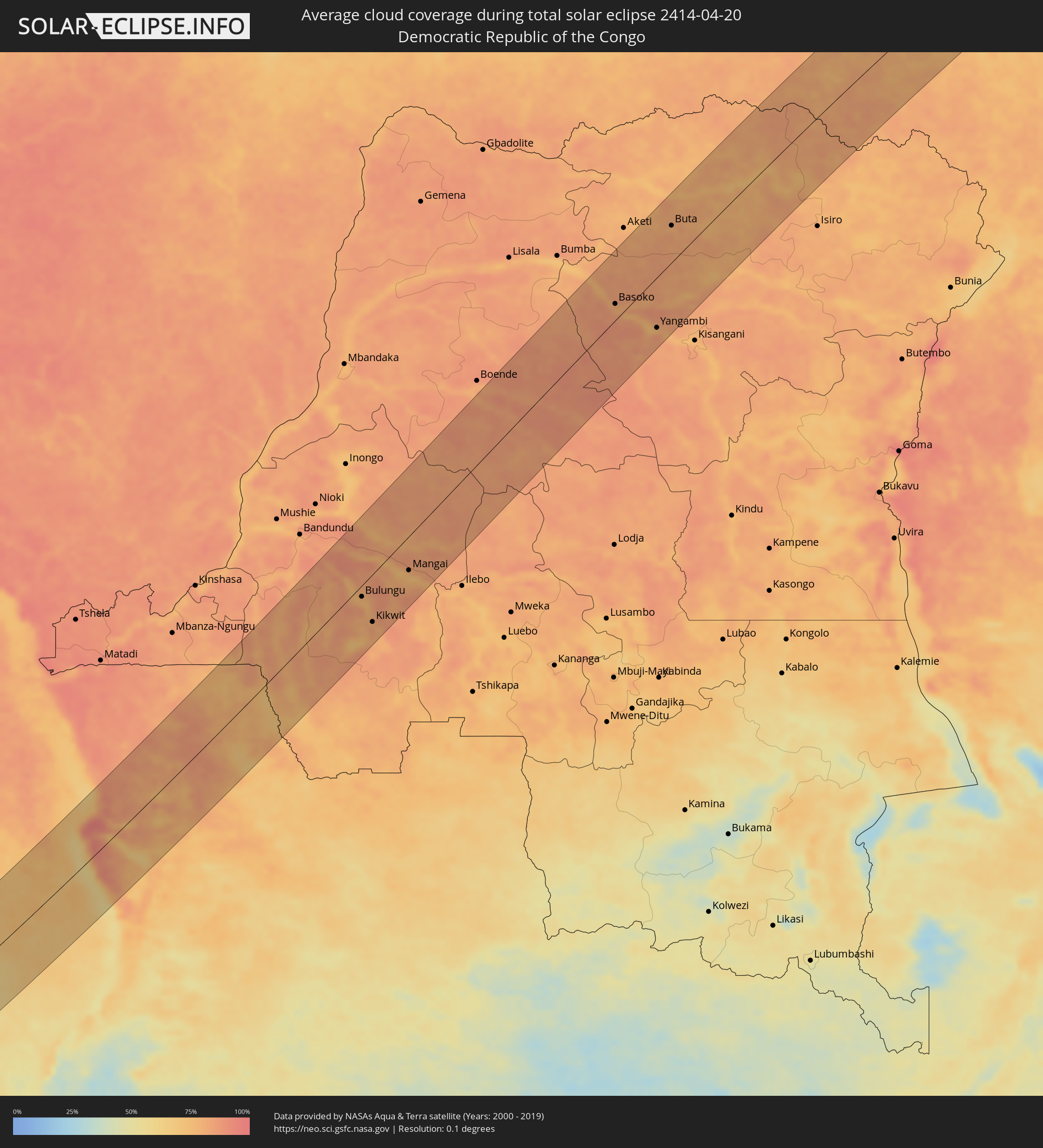 Demokratische Republik Kongo
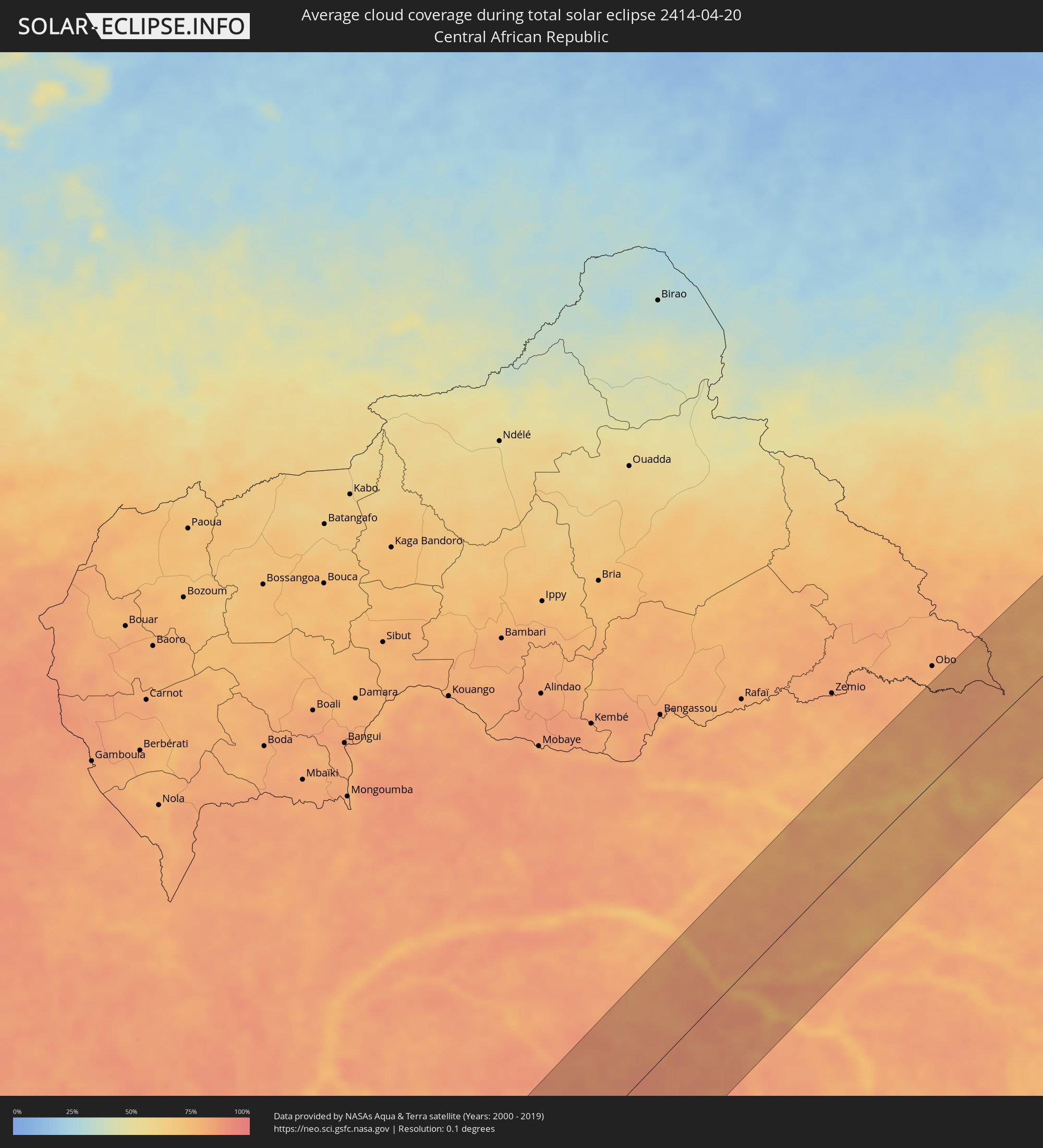 Zentralafrikanische Republik
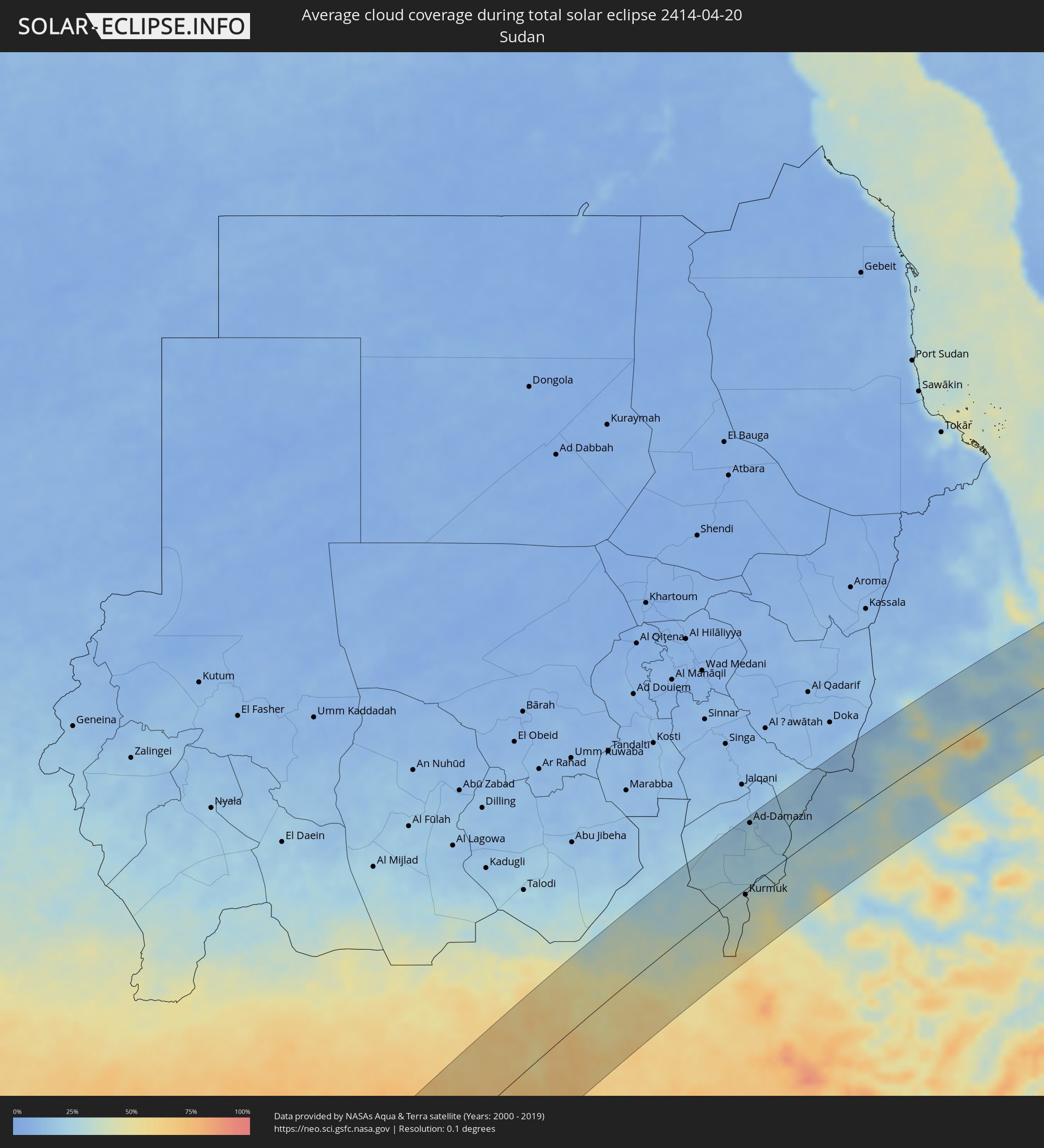 Sudan
Sudan
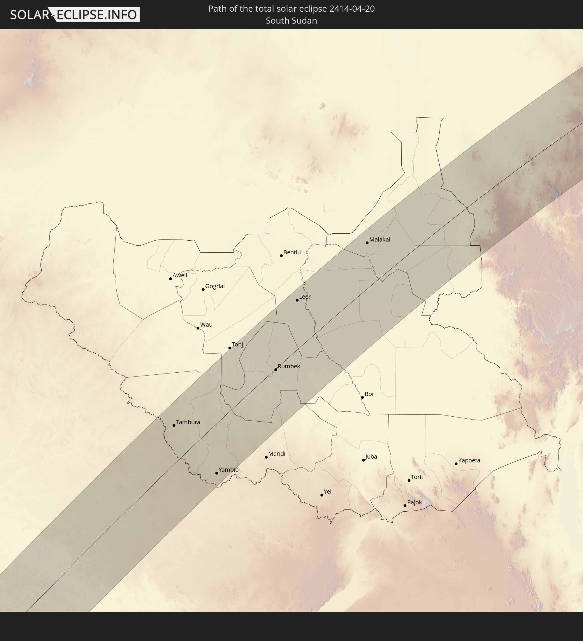
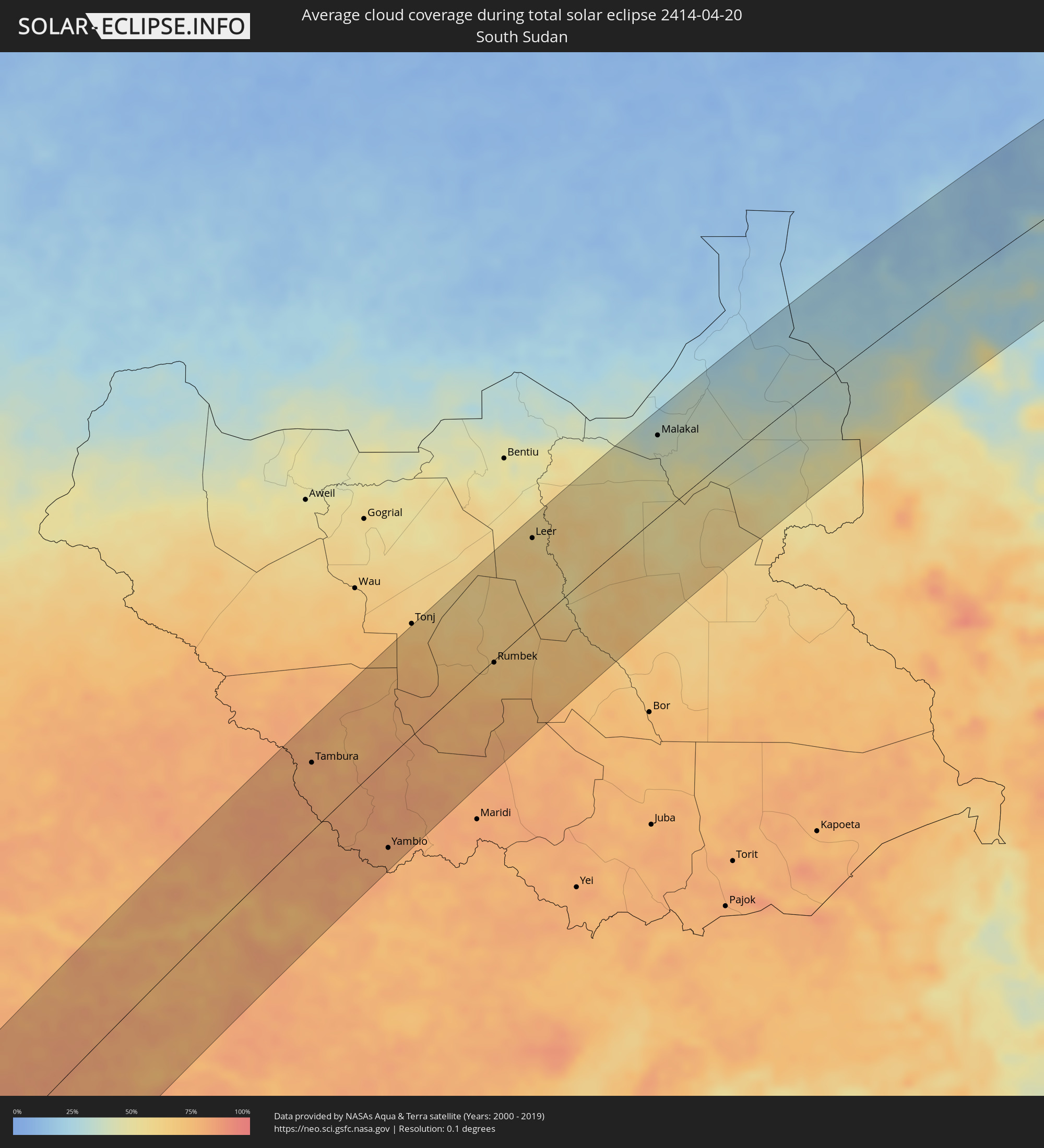 Südsudan
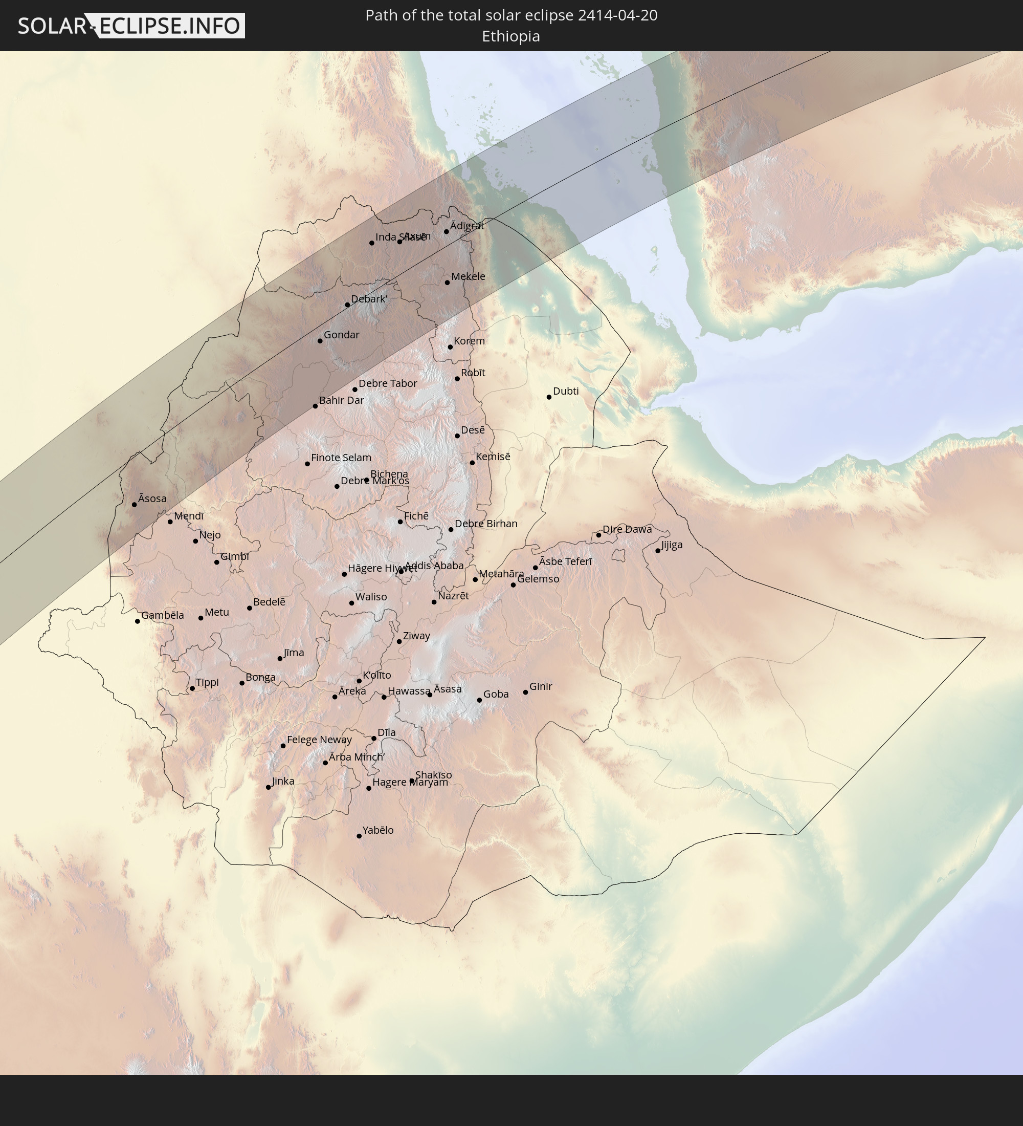
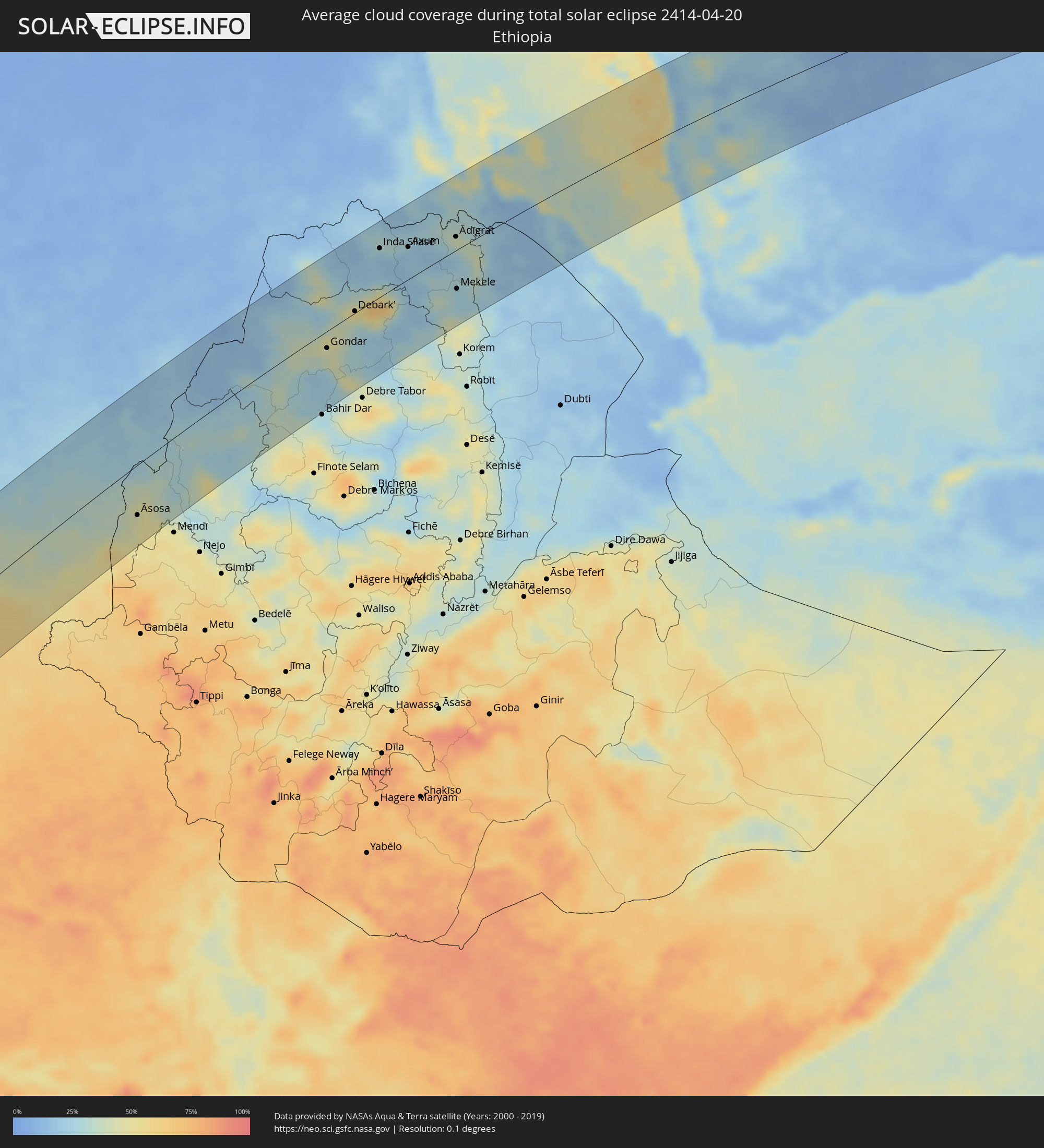 Äthiopien
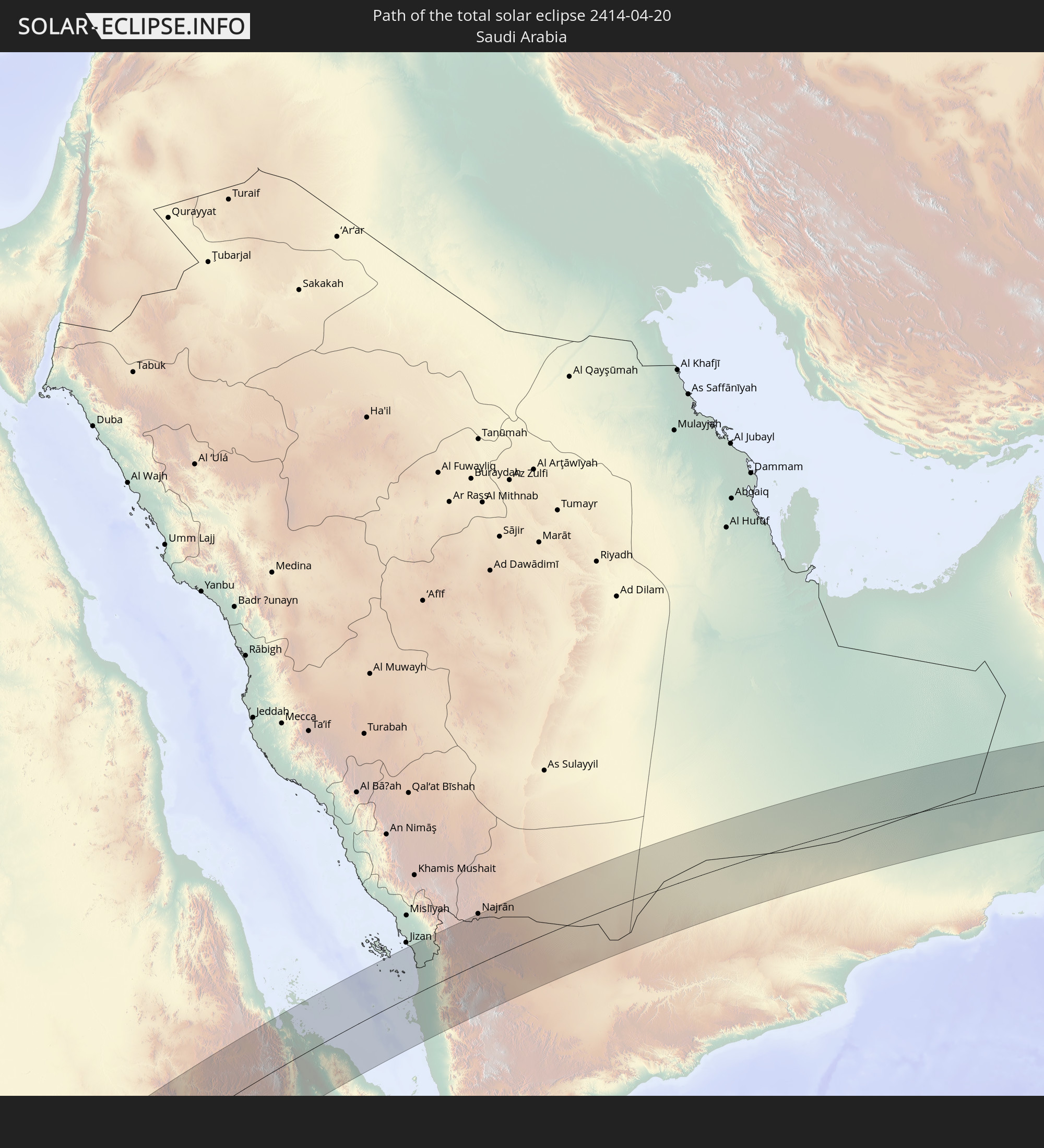
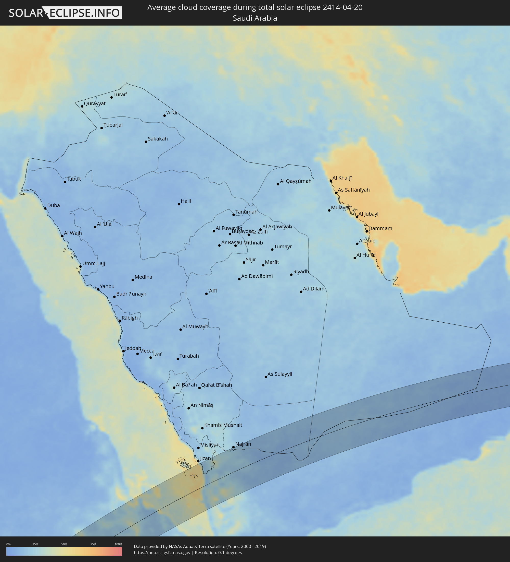 Saudi-Arabien
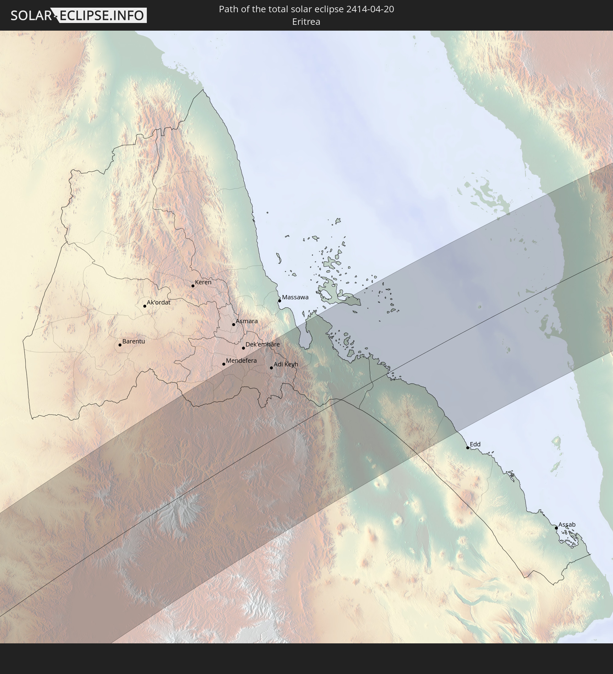
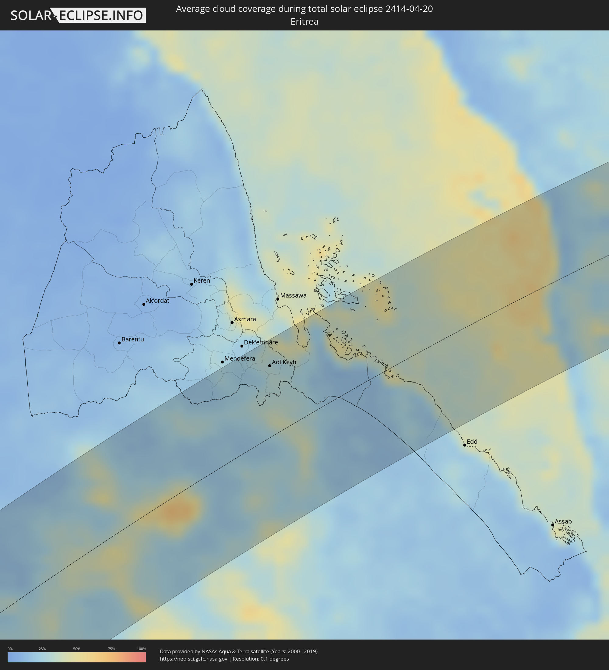 Eritrea
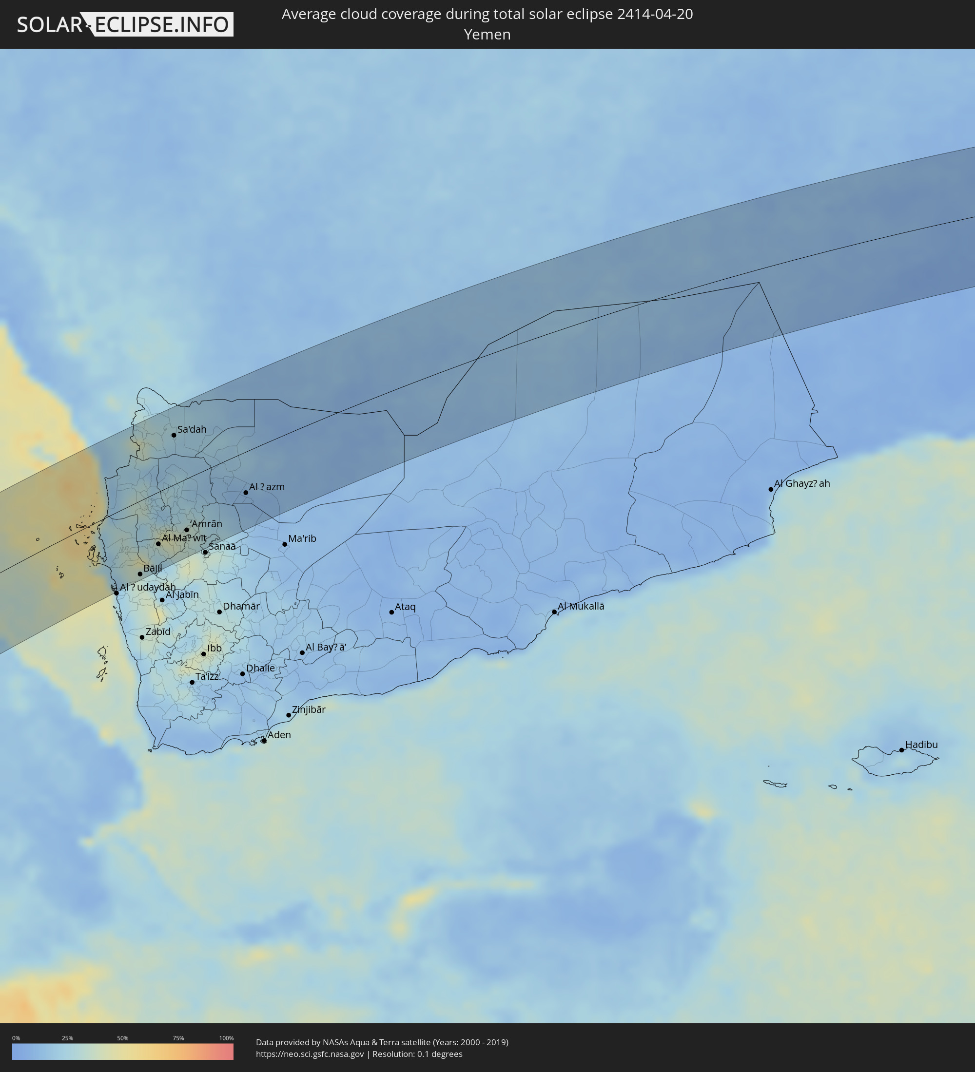 Jemen
Jemen
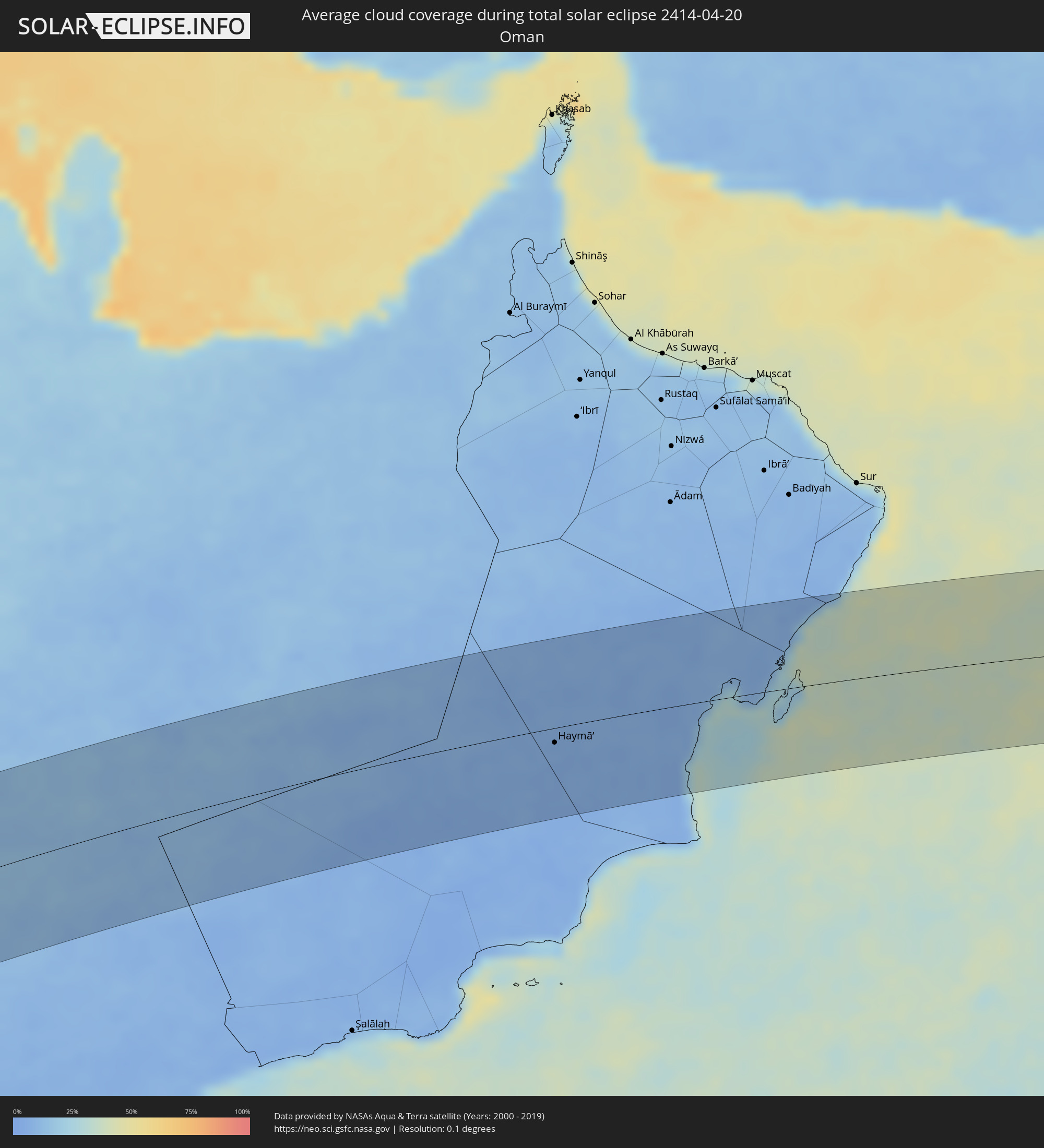 Oman
Oman
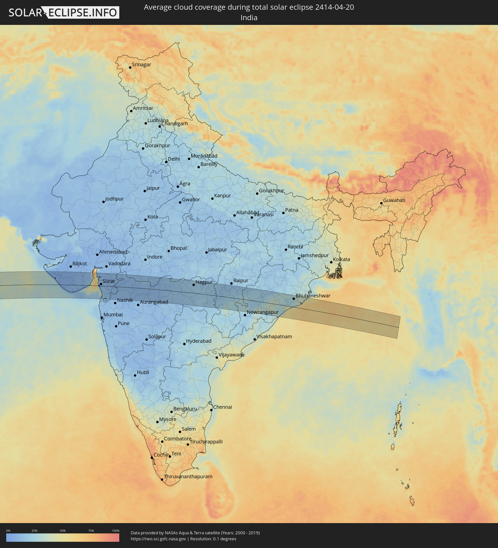 Indien
Orte im Finsternispfad
Die nachfolgene Tabelle zeigt Städte und Orte mit mehr als 5.000 Einwohnern, die sich im Finsternispfad befinden. Städte mit mehr als 100.000 Einwohnern sind dick gekennzeichnet. Mit einem Klick auf den Ort öffnet sich eine Detailkarte die die Lage des jeweiligen Ortes zusammen mit dem Verlauf der zentralen Finsternis präsentiert.
| Ort | Typ | Dauer der Verfinsterung | Ortszeit bei maximaler Verfinsterung | Entfernung zur Zentrallinie | Ø Bewölkung |
|
Luanda, Luanda
|
total | - | 10:29:00 UTC+01:00 | 68 km | 86% |
|
Caxito, Bengo
|
total | - | 10:30:05 UTC+01:00 | 56 km | 84% |
|
N’dalatando, Cuanza Norte
|
total | - | 10:30:54 UTC+01:00 | 97 km | 75% |
|
Uíge, Uíge
|
total | - | 10:33:53 UTC+01:00 | 24 km | 85% |
|
Camabatela, Cuanza Norte
|
total | - | 10:33:26 UTC+01:00 | 46 km | 85% |
|
Kasongo-Lunda, Bandundu
|
total | - | 10:38:42 UTC+01:00 | 25 km | 73% |
|
Bulungu, Bandundu
|
total | - | 10:45:11 UTC+01:00 | 17 km | 75% |
|
Kikwit, Bandundu
|
total | - | 10:44:40 UTC+01:00 | 72 km | 84% |
|
Mangai, Bandundu
|
total | - | 10:47:48 UTC+01:00 | 52 km | 74% |
|
Basoko, Orientale
|
total | - | 12:05:28 UTC+02:00 | 25 km | 79% |
|
Yangambi, Orientale
|
total | - | 12:06:11 UTC+02:00 | 77 km | 76% |
|
Buta, Orientale
|
total | - | 12:10:42 UTC+02:00 | 57 km | 78% |
 Tambura, Western Equatoria
|
total | - | 12:21:47 UTC+02:00 | 66 km | 79% |
|
Yambio, Western Equatoria
|
total | - | 12:21:42 UTC+02:00 | 88 km | 80% |
|
Rumbek, Lakes
|
total | - | 12:28:43 UTC+02:00 | 3 km | 68% |
|
Leer, Unity
|
total | - | 12:32:32 UTC+02:00 | 88 km | 61% |
|
Malakal, Upper Nile
|
total | - | 12:38:02 UTC+02:00 | 83 km | 40% |
|
Kurmuk, Blue Nile
|
total | - | 12:45:25 UTC+02:00 | 8 km | 34% |
|
Ad-Damazin, Blue Nile
|
total | - | 12:47:44 UTC+02:00 | 97 km | 24% |
|
Ar Ruseris, Blue Nile
|
total | - | 12:47:55 UTC+02:00 | 102 km | 19% |
|
Āsosa, Bīnshangul Gumuz
|
total | - | 13:45:06 UTC+03:00 | 68 km | 43% |
|
Gondar, Amhara
|
total | - | 13:55:37 UTC+03:00 | 24 km | 45% |
|
Werota, Amhara
|
total | - | 13:55:00 UTC+03:00 | 101 km | 33% |
|
Dabat, Amhara
|
total | - | 13:56:51 UTC+03:00 | 6 km | 39% |
|
Ādīs Zemen, Amhara
|
total | - | 13:55:30 UTC+03:00 | 88 km | 37% |
|
Debark’, Amhara
|
total | - | 13:57:24 UTC+03:00 | 3 km | 55% |
|
Inda Silasē, Tigray
|
total | - | 13:59:40 UTC+03:00 | 69 km | 22% |
|
Axum, Tigray
|
total | - | 14:00:36 UTC+03:00 | 46 km | 19% |
|
Adi Keyh, Debub
|
total | - | 14:03:01 UTC+03:00 | 79 km | 31% |
|
Ādīgrat, Tigray
|
total | - | 14:02:21 UTC+03:00 | 20 km | 41% |
|
Mekele, Tigray
|
total | - | 14:01:12 UTC+03:00 | 56 km | 25% |
|
Mizhirah, Jizan
|
total | - | 14:12:22 UTC+03:00 | 102 km | 33% |
|
Al Jarādīyah, Jizan
|
total | - | 14:12:24 UTC+03:00 | 69 km | 19% |
|
Şāmitah, Jizan
|
total | - | 14:12:29 UTC+03:00 | 69 km | 19% |
|
Bājil, Muḩāfaz̧at al Ḩudaydah
|
total | - | 14:11:10 UTC+03:00 | 100 km | 35% |
|
Al Maḩwīt, Al Maḩwīt
|
total | - | 14:12:13 UTC+03:00 | 71 km | 28% |
|
Ḩajjah, Ḩajjah
|
total | - | 14:12:38 UTC+03:00 | 52 km | 41% |
|
Sa'dah, Şa‘dah
|
total | - | 14:14:30 UTC+03:00 | 66 km | 20% |
|
‘Amrān, Omran
|
total | - | 14:13:14 UTC+03:00 | 71 km | 37% |
|
Najrān, Najran
|
total | - | 14:15:51 UTC+03:00 | 106 km | 19% |
|
Al Ḩazm, Al Jawf
|
total | - | 14:15:29 UTC+03:00 | 57 km | 12% |
|
Haymā’, Al Wusţá
|
total | - | 15:38:25 UTC+04:00 | 16 km | 6% |
|
Verāval, Gujarat
|
total | - | 17:24:37 UTC+05:30 | 29 km | 24% |
|
Jūnāgadh, Gujarat
|
total | - | 17:24:50 UTC+05:30 | 39 km | 6% |
|
Bhāvnagar, Gujarat
|
total | - | 17:26:10 UTC+05:30 | 72 km | 18% |
|
Sūrat, Gujarat
|
total | - | 17:26:33 UTC+05:30 | 11 km | 13% |
|
Bilimora, Gujarat
|
total | - | 17:26:33 UTC+05:30 | 36 km | 15% |
|
Bharūch, Gujarat
|
total | - | 17:26:44 UTC+05:30 | 67 km | 9% |
|
Mālegaon, Maharashtra
|
total | - | 17:27:35 UTC+05:30 | 51 km | 8% |
|
Dhūlia, Maharashtra
|
total | - | 17:27:48 UTC+05:30 | 11 km | 9% |
|
Jalgaon, Maharashtra
|
total | - | 17:28:18 UTC+05:30 | 6 km | 9% |
|
Bhusāval, Maharashtra
|
total | - | 17:28:26 UTC+05:30 | 13 km | 9% |
|
Burhānpur, Madhya Pradesh
|
total | - | 17:28:43 UTC+05:30 | 46 km | 10% |
|
Akola, Maharashtra
|
total | - | 17:29:05 UTC+05:30 | 14 km | 11% |
|
Amrāvati, Maharashtra
|
total | - | 17:29:30 UTC+05:30 | 18 km | 16% |
|
Nagpur, Maharashtra
|
total | - | 17:30:10 UTC+05:30 | 56 km | 17% |
|
Chānda, Maharashtra
|
total | - | 17:30:09 UTC+05:30 | 74 km | 17% |
|
Rāj-Nāndgaon, Chhattisgarh
|
total | - | 17:31:00 UTC+05:30 | 74 km | 16% |
|
Brahmapur, Odisha
|
total | - | 17:32:06 UTC+05:30 | 67 km | 35% |
|
Puri, Odisha
|
total | - | 17:32:24 UTC+05:30 | 4 km | 46% |
|
Bhubaneshwar, Odisha
|
total | - | 17:32:26 UTC+05:30 | 57 km | 29% |
|
Cuttack, Odisha
|
total | - | 17:32:27 UTC+05:30 | 79 km | 31% |