Totale Sonnenfinsternis vom 05.08.2548
| Wochentag: | Montag |
| Maximale Dauer der Verfinsterung: | 04m49s |
| Maximale Breite des Finsternispfades: | 184 km |
| Saroszyklus: | 154 |
| Bedeckungsgrad: | 100% |
| Magnitude: | 1.0556 |
| Gamma: | 0.0862 |
Wo kann man die Sonnenfinsternis vom 05.08.2548 sehen?
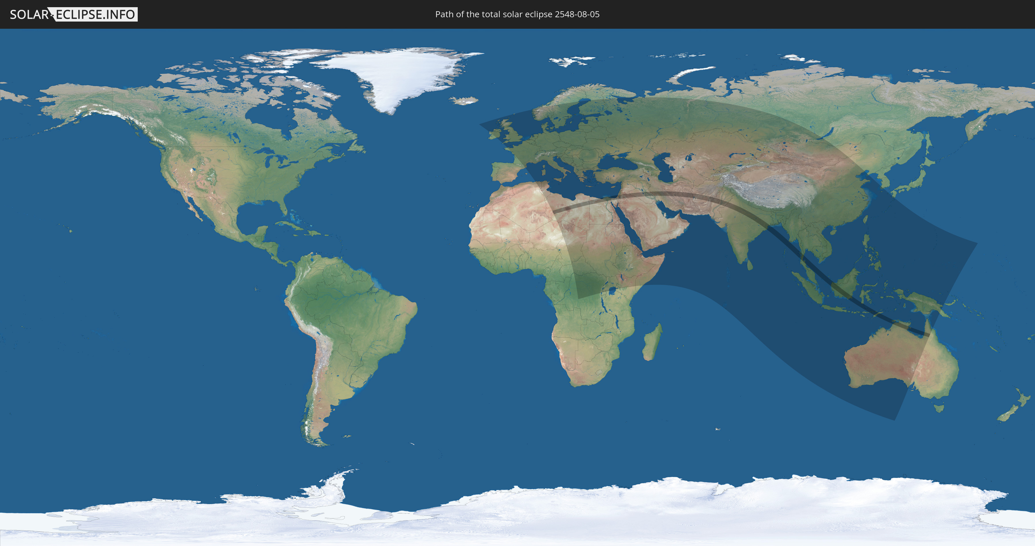
Die Sonnenfinsternis am 05.08.2548 kann man in 121 Ländern als partielle Sonnenfinsternis beobachten.
Der Finsternispfad verläuft durch 18 Länder. Nur in diesen Ländern ist sie als totale Sonnenfinsternis zu sehen.
In den folgenden Ländern ist die Sonnenfinsternis total zu sehen
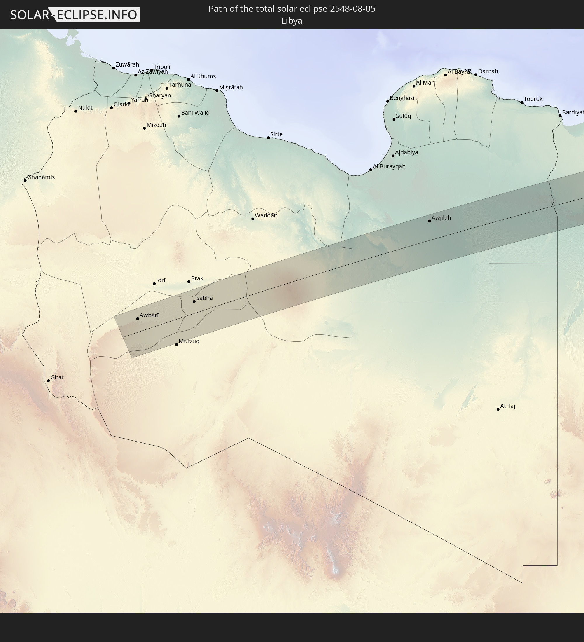 Libyen
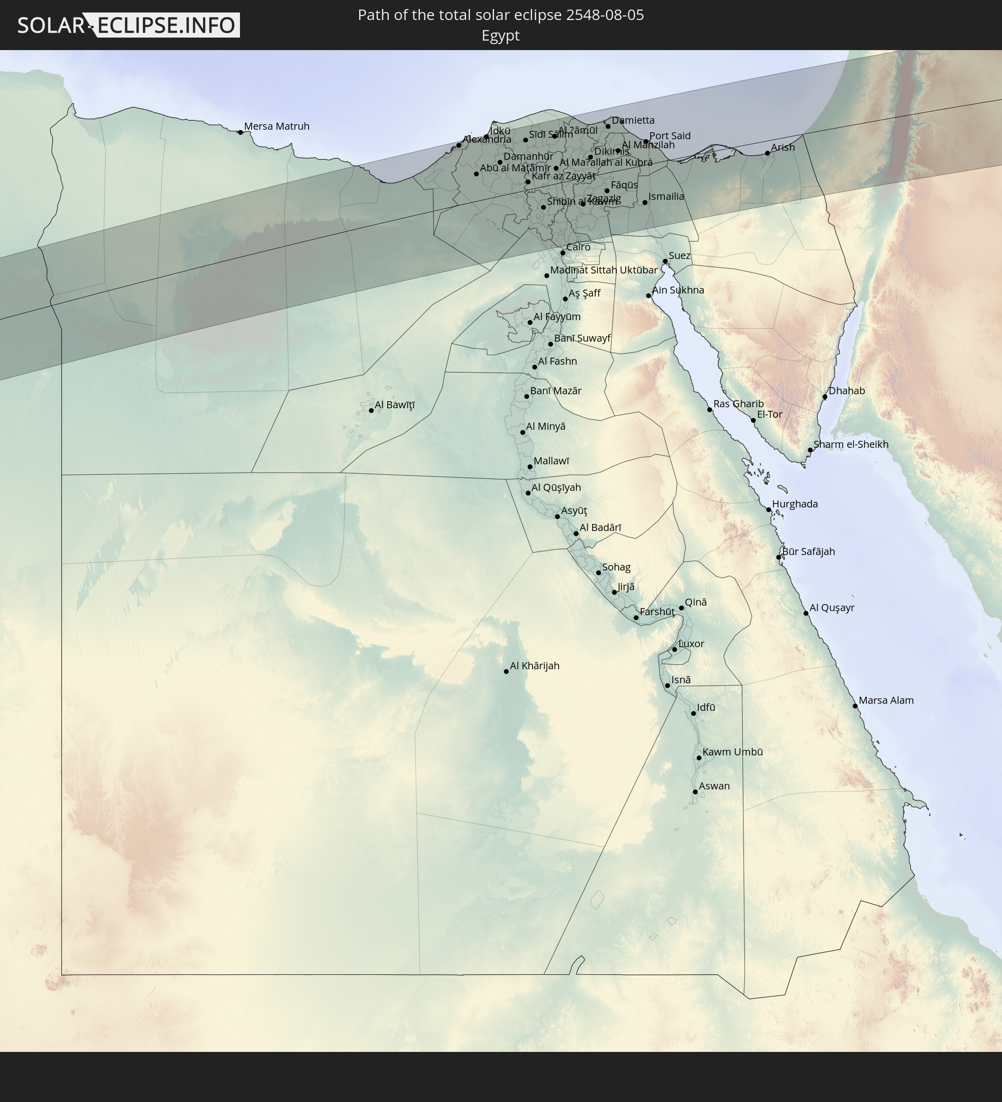 Ägypten
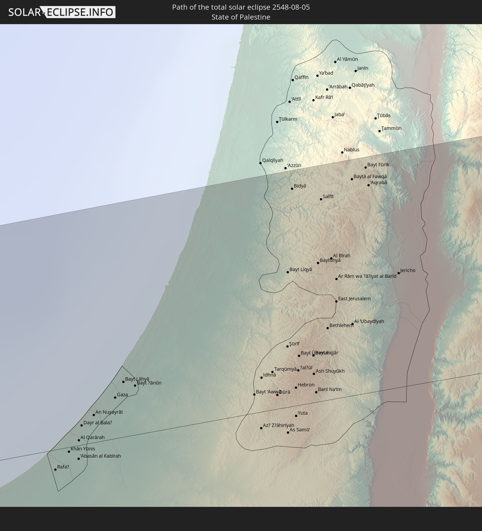 Staat Palästina
 Israel
 Saudi-Arabien
 Jordanien
 Syrien
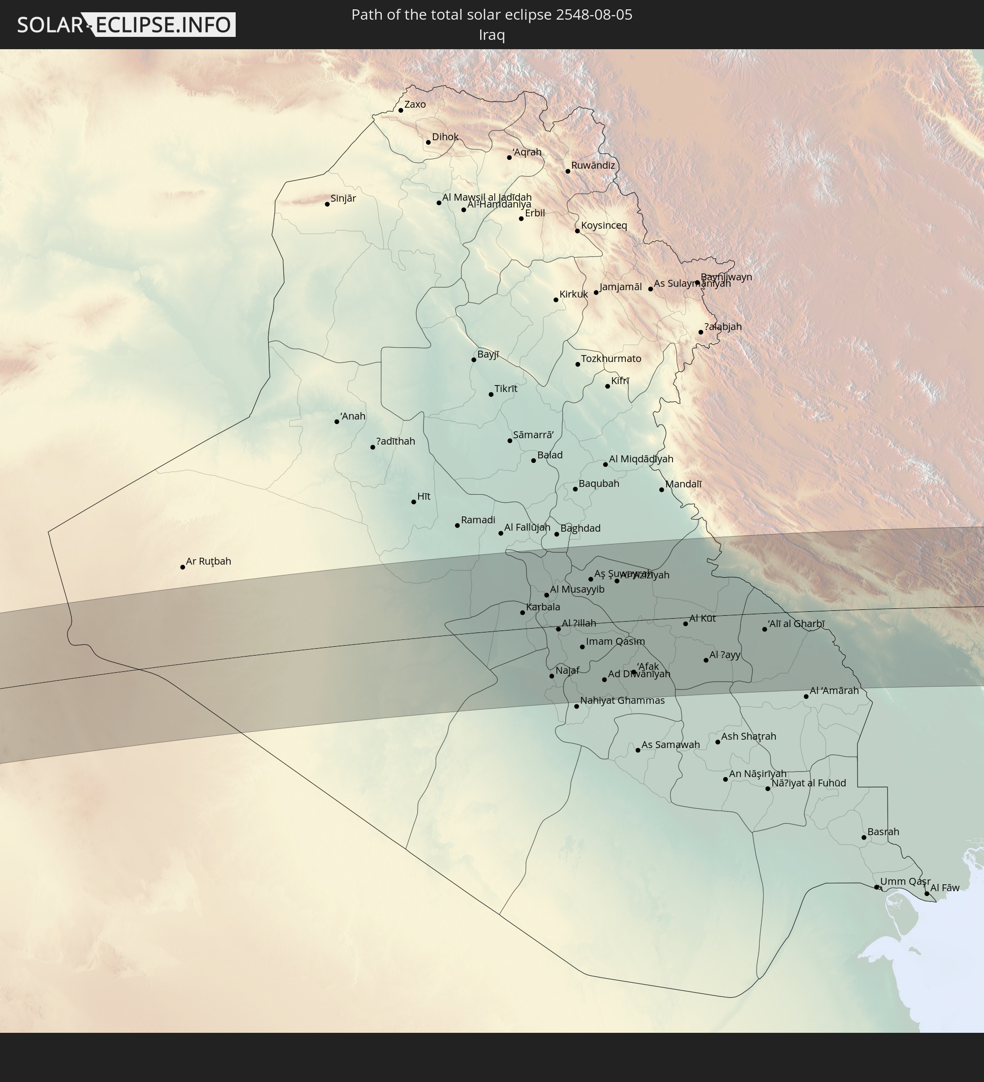 Irak
Irak
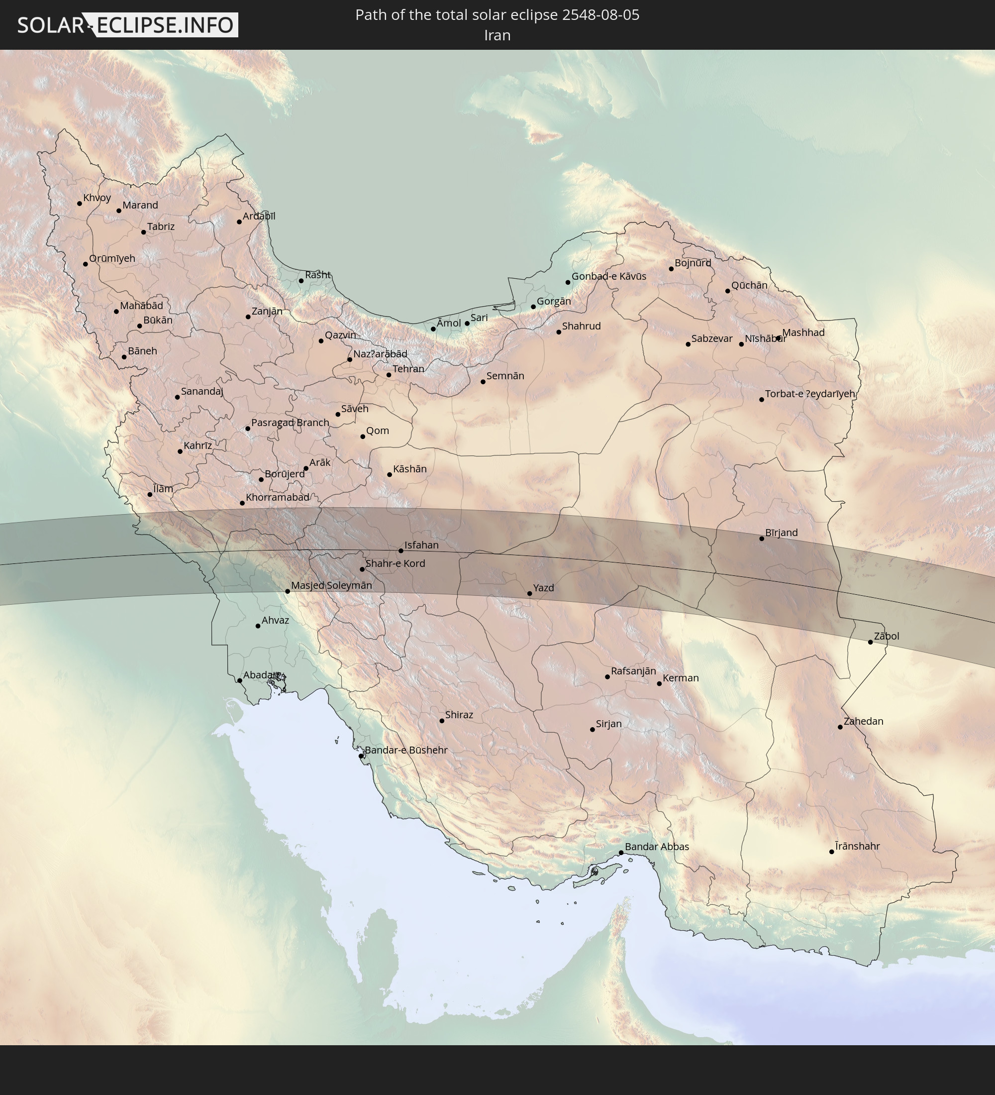 Iran
Iran
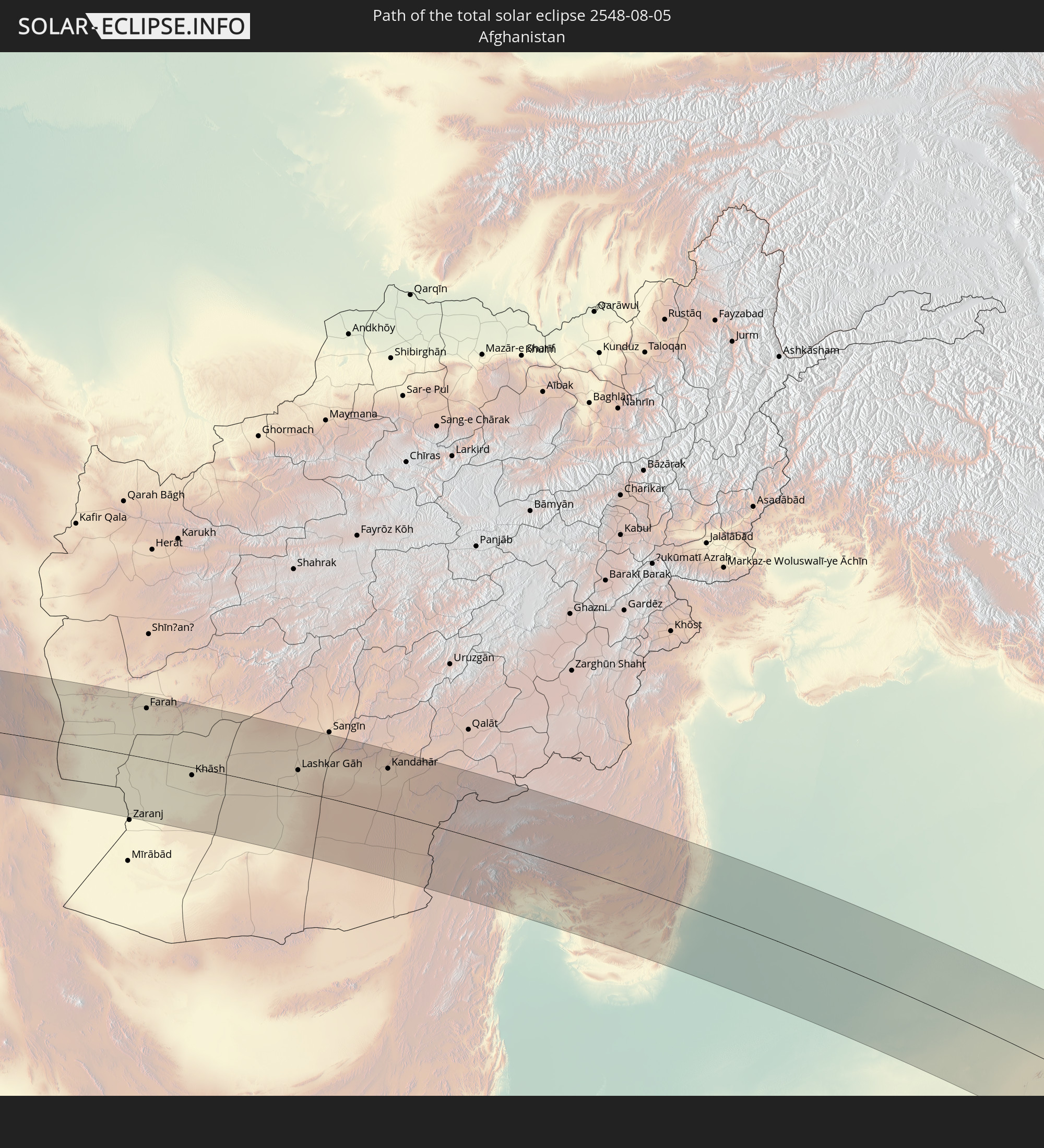 Afghanistan
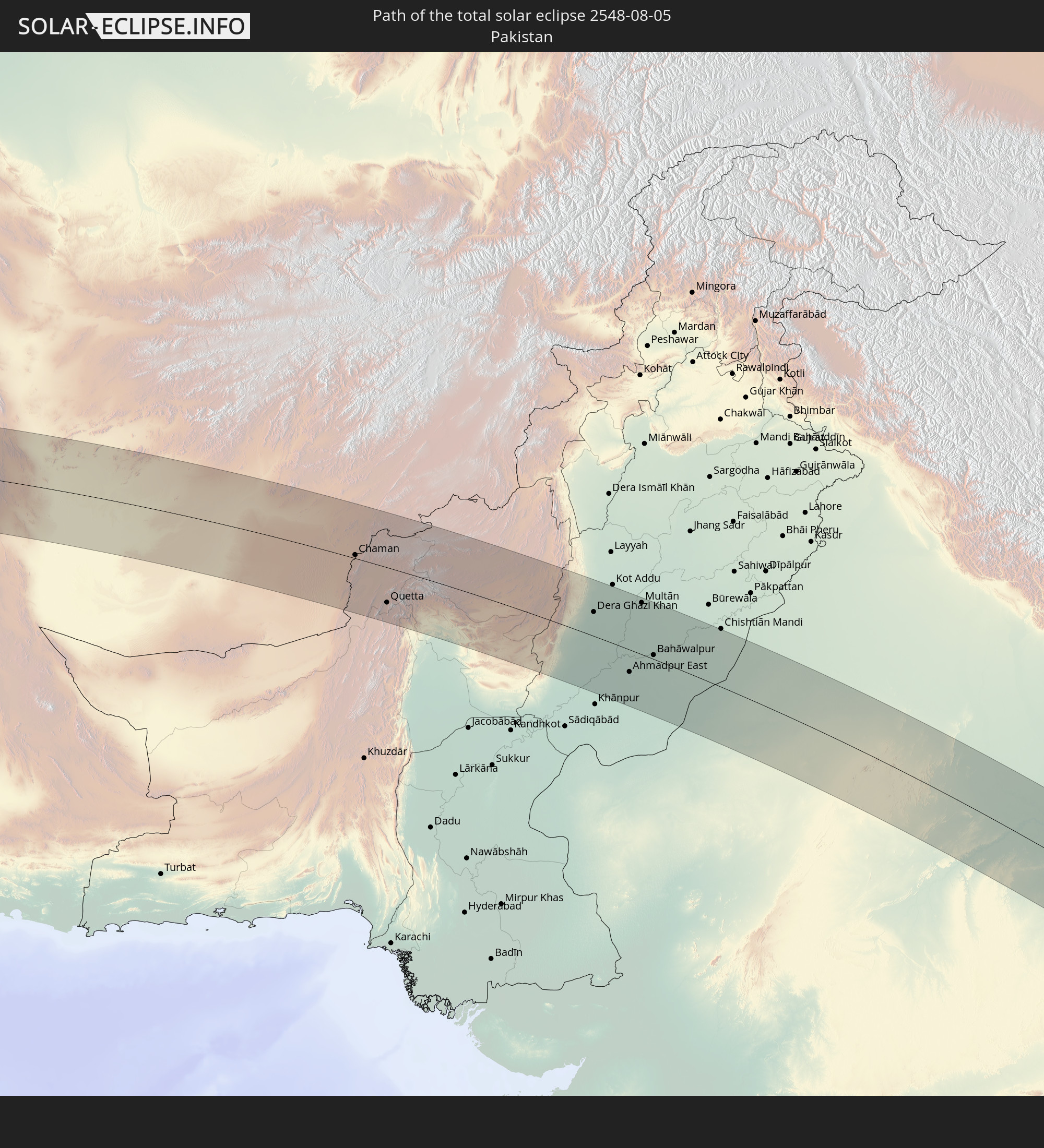 Pakistan
 Indien
 Myanmar
 Indonesien
 Thailand
 Malaysia
 Australien
 Osttimor
In den folgenden Ländern ist die Sonnenfinsternis partiell zu sehen
 Russland
 Spanien
 Irland
 Algerien
 Vereinigtes Königreich
 Frankreich
 Isle of Man
 Guernsey
 Jersey
 Niger
Niger
 Belgien
 Niederlande
 Norwegen
 Luxemburg
 Deutschland
 Schweiz
 Italien
 Monaco
 Tunesien
 Dänemark
 Libyen
 Liechtenstein
 Österreich
 Schweden
 Tschechien
 Demokratische Republik Kongo
 San Marino
 Vatikanstadt
 Slowenien
 Tschad
 Kroatien
 Polen
Polen
 Malta
Malta
 Zentralafrikanische Republik
 Bosnien und Herzegowina
 Ungarn
 Slowakei
 Montenegro
 Serbien
 Albanien
 Åland Islands
 Griechenland
 Rumänien
 Mazedonien
 Finnland
 Litauen
 Lettland
 Estland
 Sudan
Sudan
 Ukraine
 Bulgarien
 Weißrussland
 Ägypten
 Türkei
 Moldawien
 Ruanda
 Tansania
 Uganda
 Republik Zypern
 Äthiopien
 Kenia
Kenia
 Staat Palästina
 Israel
 Saudi-Arabien
 Jordanien
 Libanon
 Syrien
 Eritrea
 Irak
Irak
 Georgien
 Somalia
 Dschibuti
 Jemen
Jemen
 Armenien
 Iran
Iran
 Aserbaidschan
 Kasachstan
 Kuwait
 Bahrain
 Katar
Katar
 Vereinigte Arabische Emirate
 Oman
Oman
 Turkmenistan
 Usbekistan
 Afghanistan
 Pakistan
 Tadschikistan
 Indien
 Kirgisistan
 Britisches Territorium im Indischen Ozean
 Malediven
 Volksrepublik China
 Sri Lanka
 Nepal
Nepal
 Mongolei
 Bangladesch
 Bhutan
 Myanmar
 Indonesien
 Kokosinseln
 Thailand
 Malaysia
 Laos
Laos
 Vietnam
 Kambodscha
 Singapur
 Weihnachtsinsel
 Australien
 Macau
Macau
 Hongkong
 Brunei
 Taiwan
 Philippinen
 Japan
Japan
 Osttimor
 Südkorea
 Palau
Palau
 Föderierte Staaten von Mikronesien
 Papua-Neuguinea
 Guam
Guam
 Nördliche Marianen
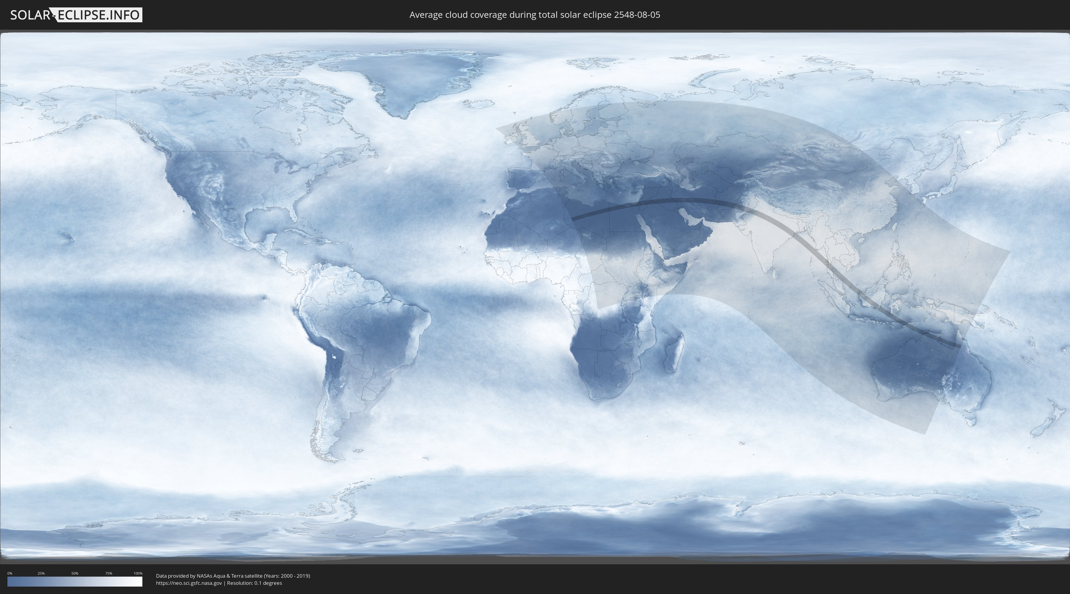
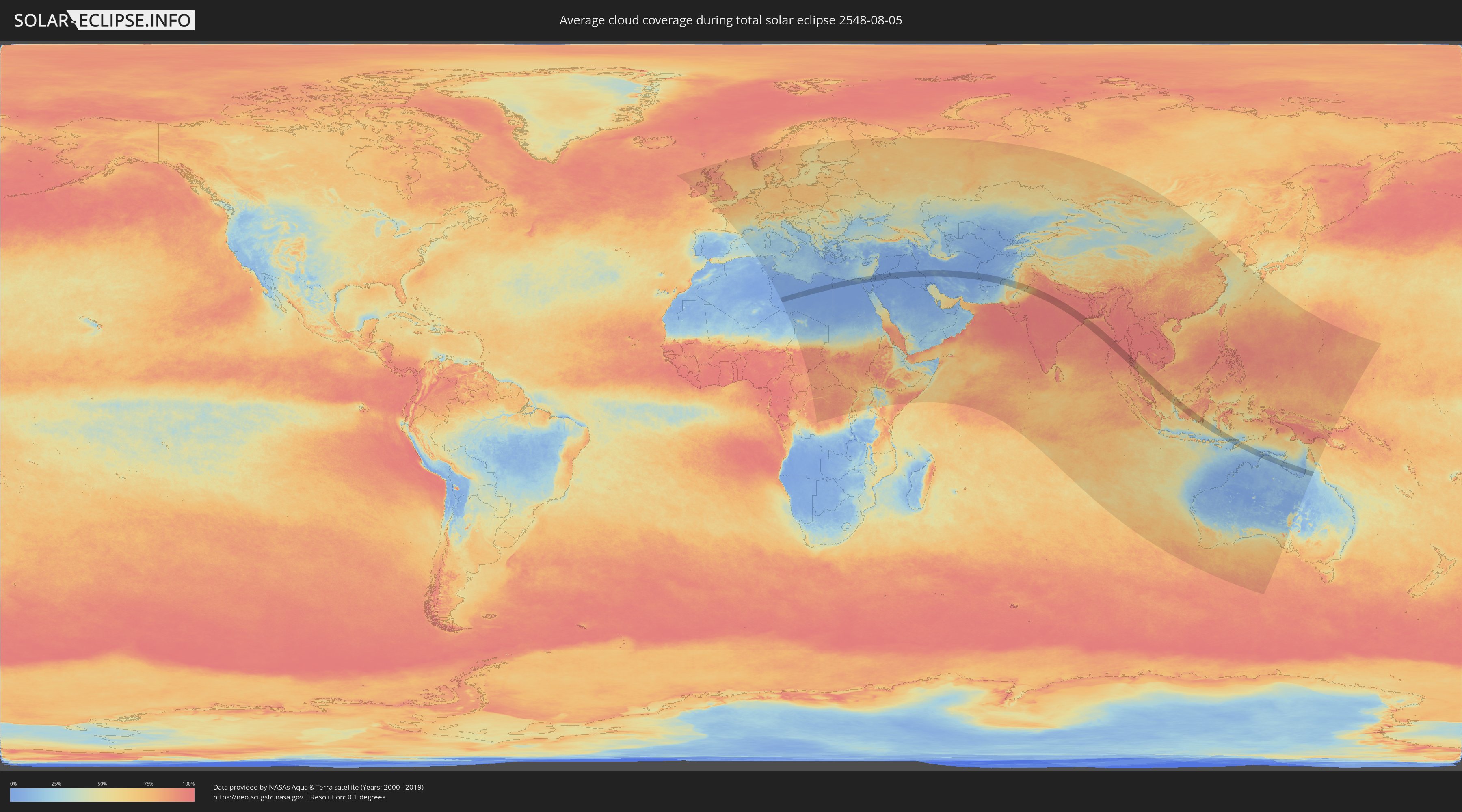
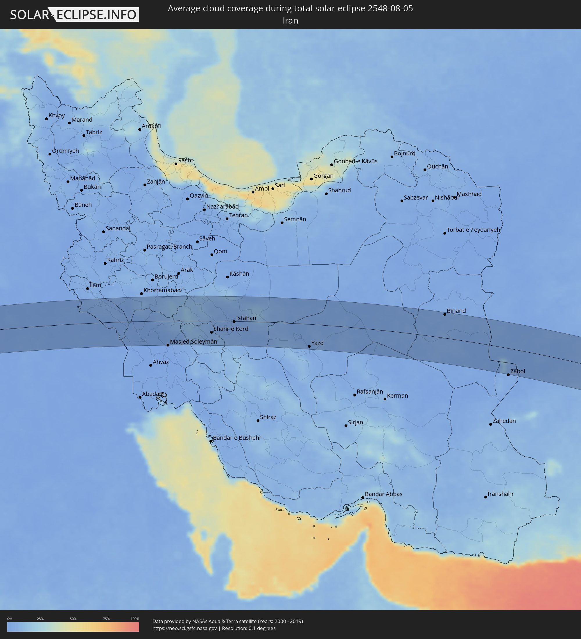
Wie wird das Wetter während der totalen Sonnenfinsternis am 05.08.2548?
Wo ist der beste Ort, um die totale Sonnenfinsternis vom 05.08.2548 zu beobachten?
Die folgenden Karten zeigen die durchschnittliche Bewölkung für den Tag, an dem die totale Sonnenfinsternis
stattfindet. Mit Hilfe der Karten lässt sich der Ort entlang des Finsternispfades eingrenzen,
der die besten Aussichen auf einen klaren wolkenfreien Himmel bietet.
Trotzdem muss man immer lokale Gegenenheiten beachten und sollte sich genau über das Wetter an seinem
gewählten Beobachtungsort informieren.
Die Daten stammen von den beiden NASA-Satelliten
AQUA und TERRA
und wurden über einen Zeitraum von 19 Jahren (2000 - 2019) gemittelt.
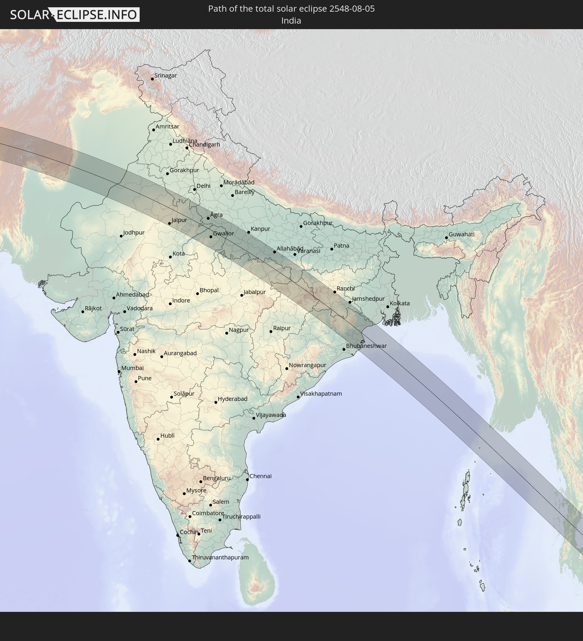
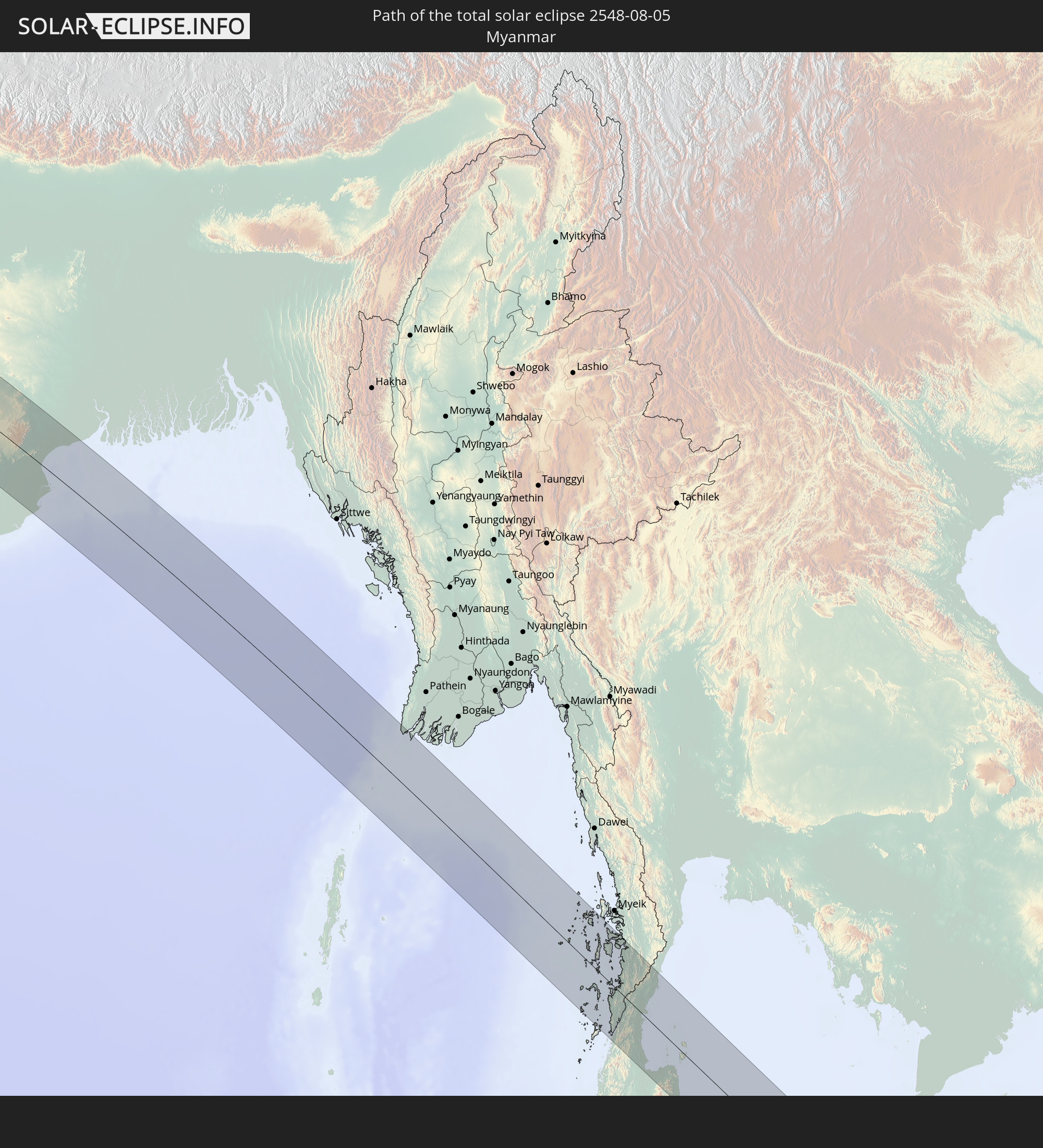
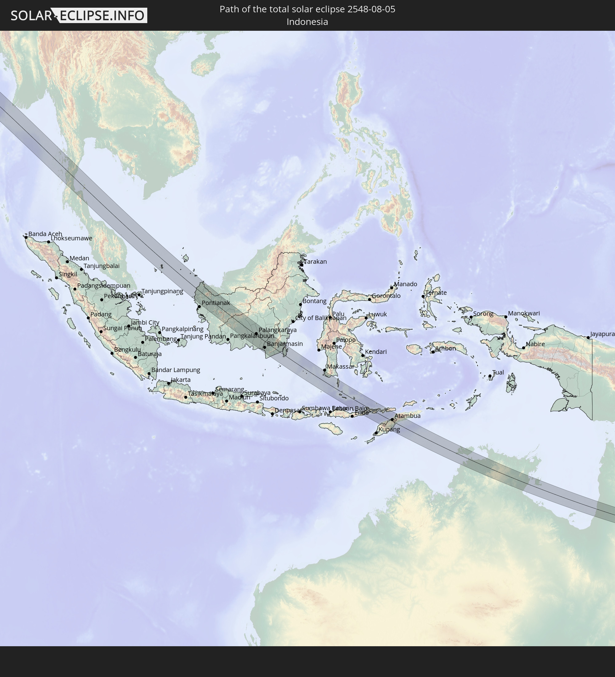
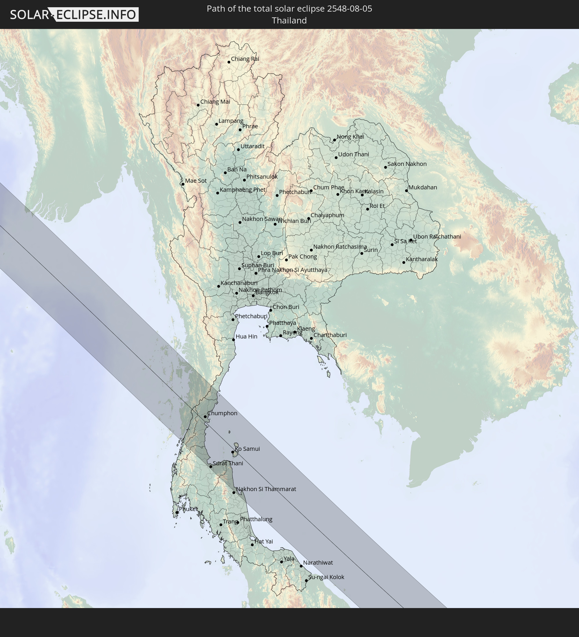
Detaillierte Länderkarten
 Libyen
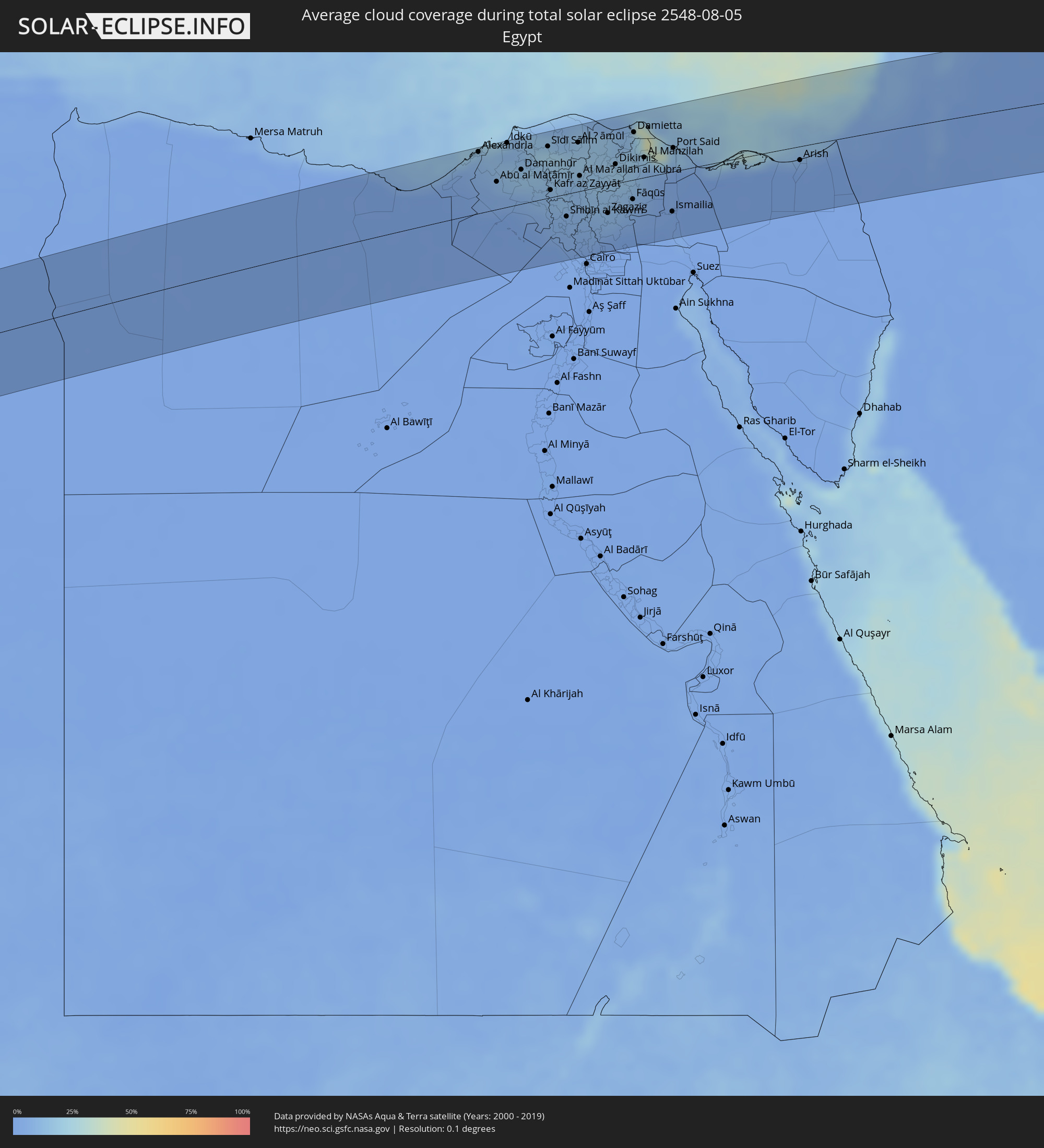 Ägypten
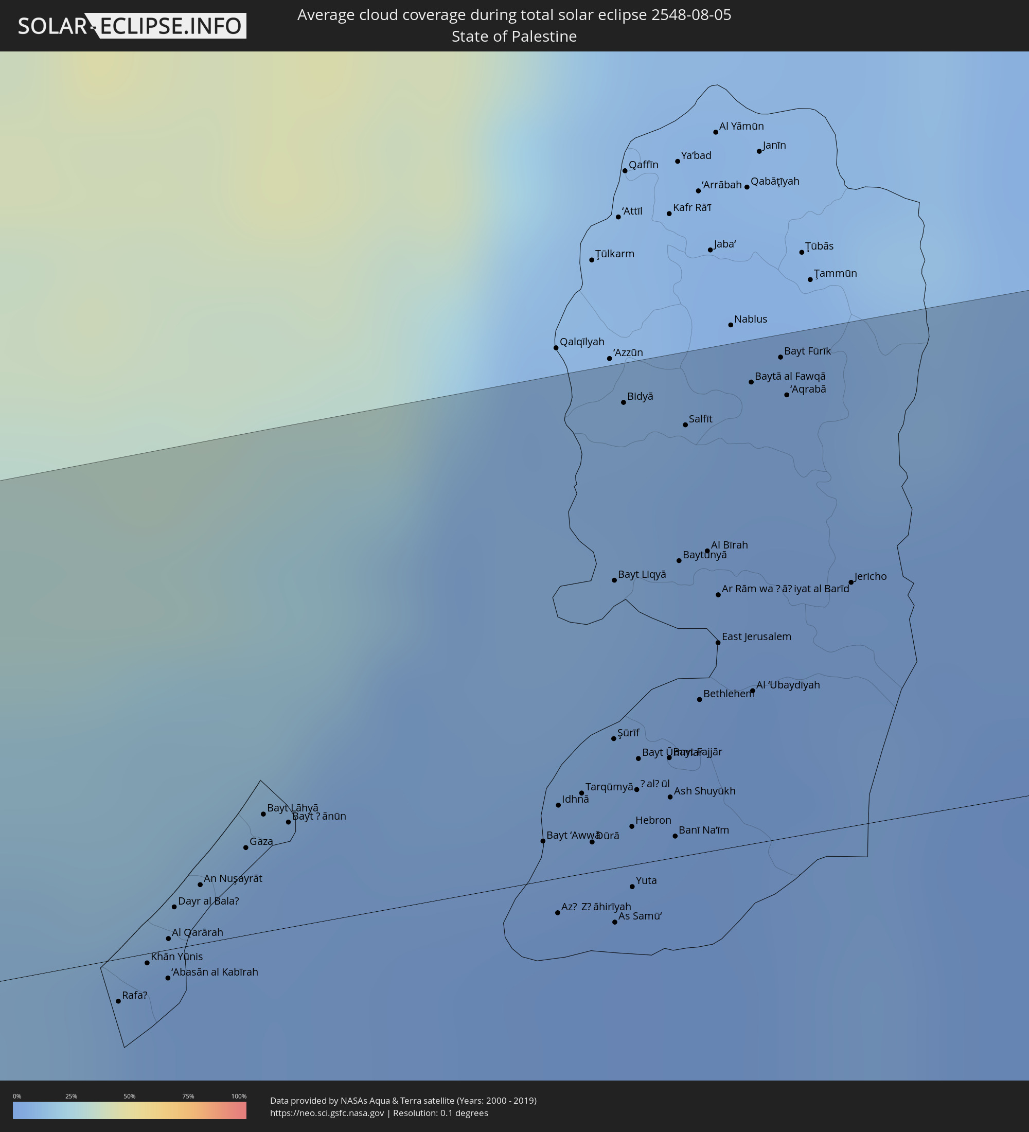 Staat Palästina
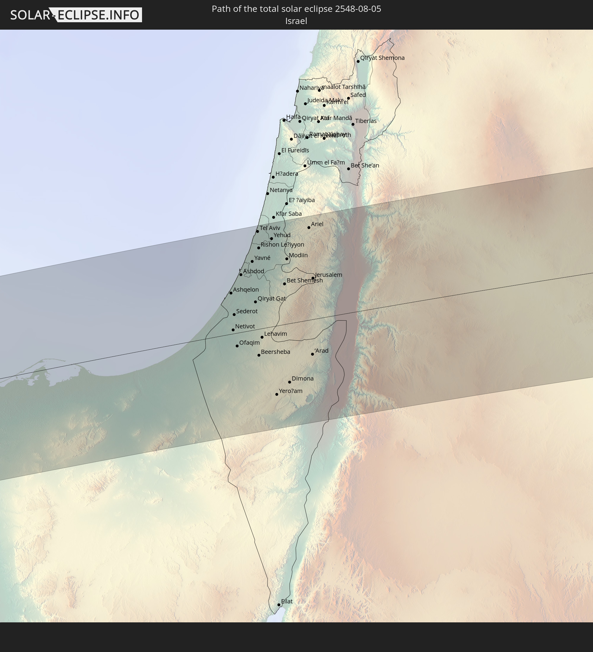
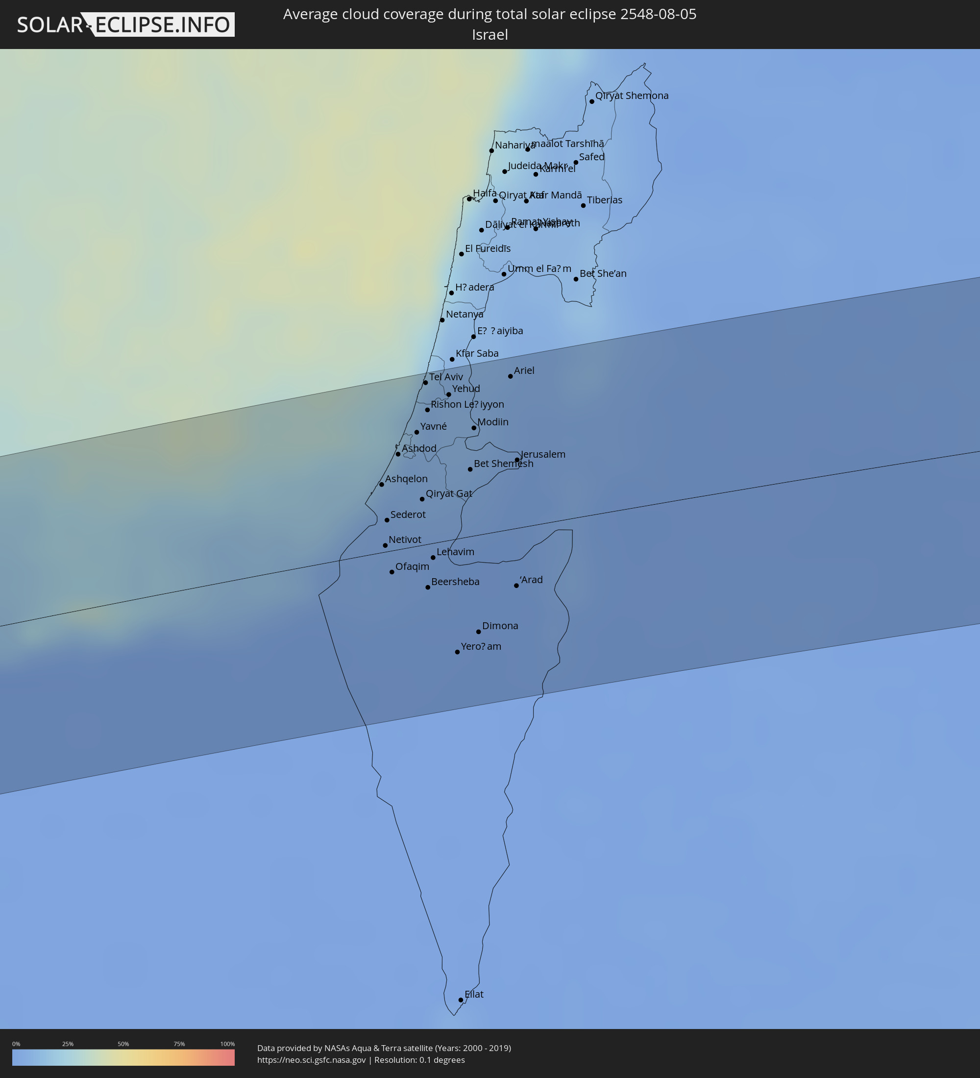 Israel
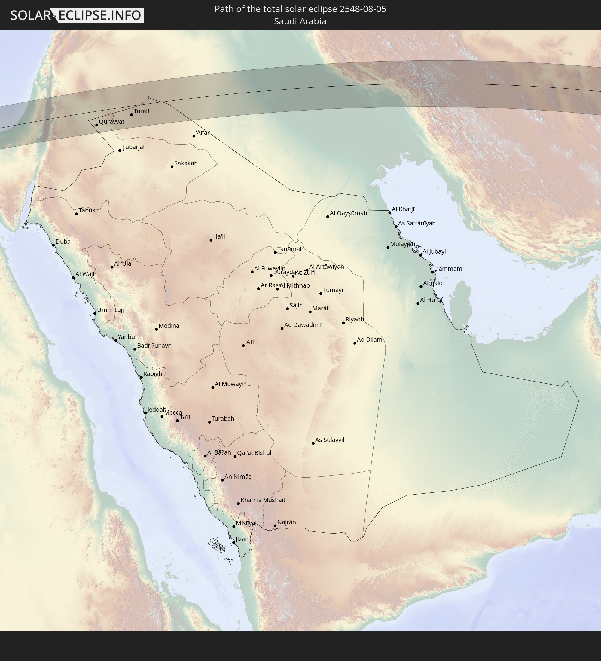
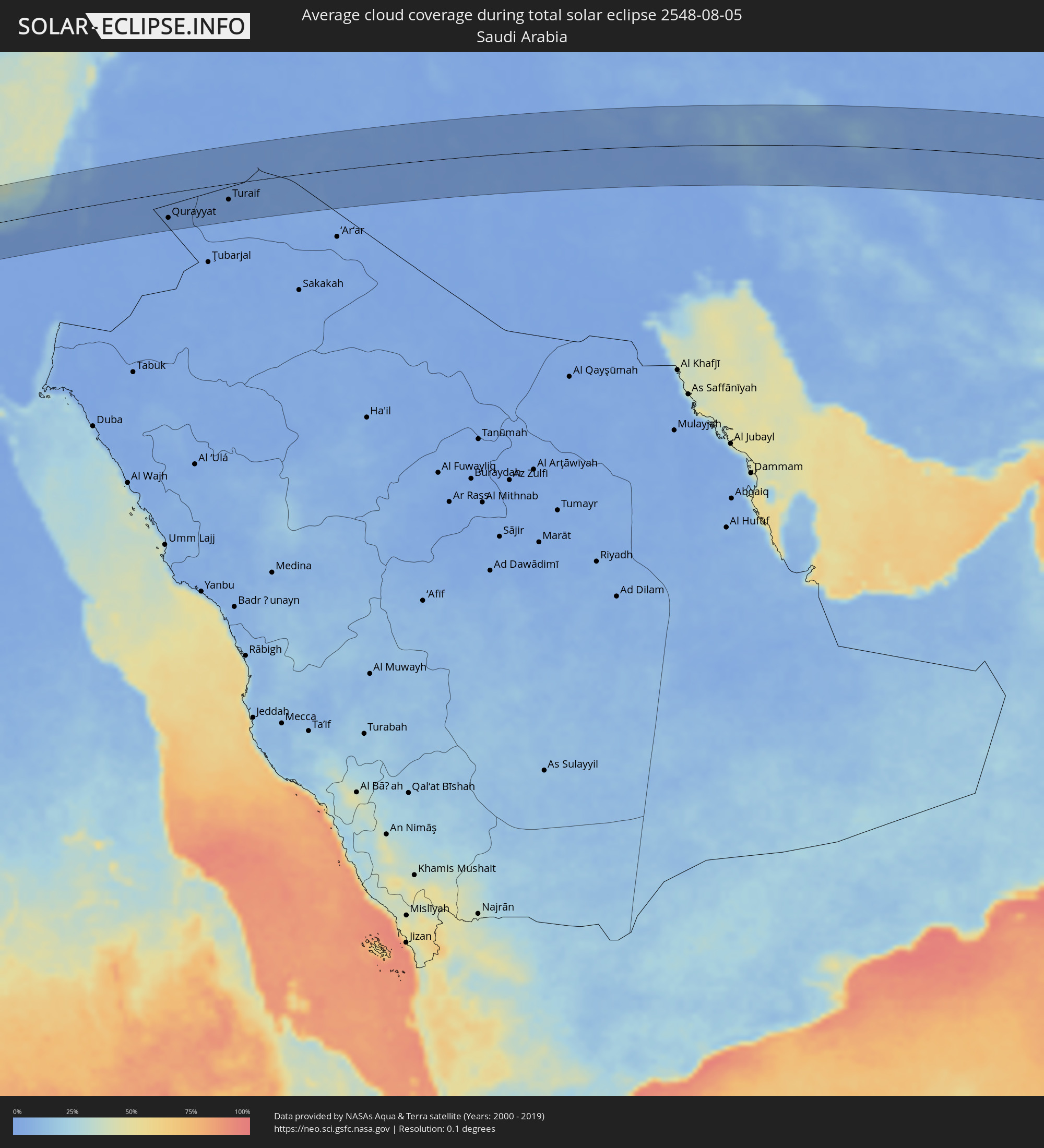 Saudi-Arabien
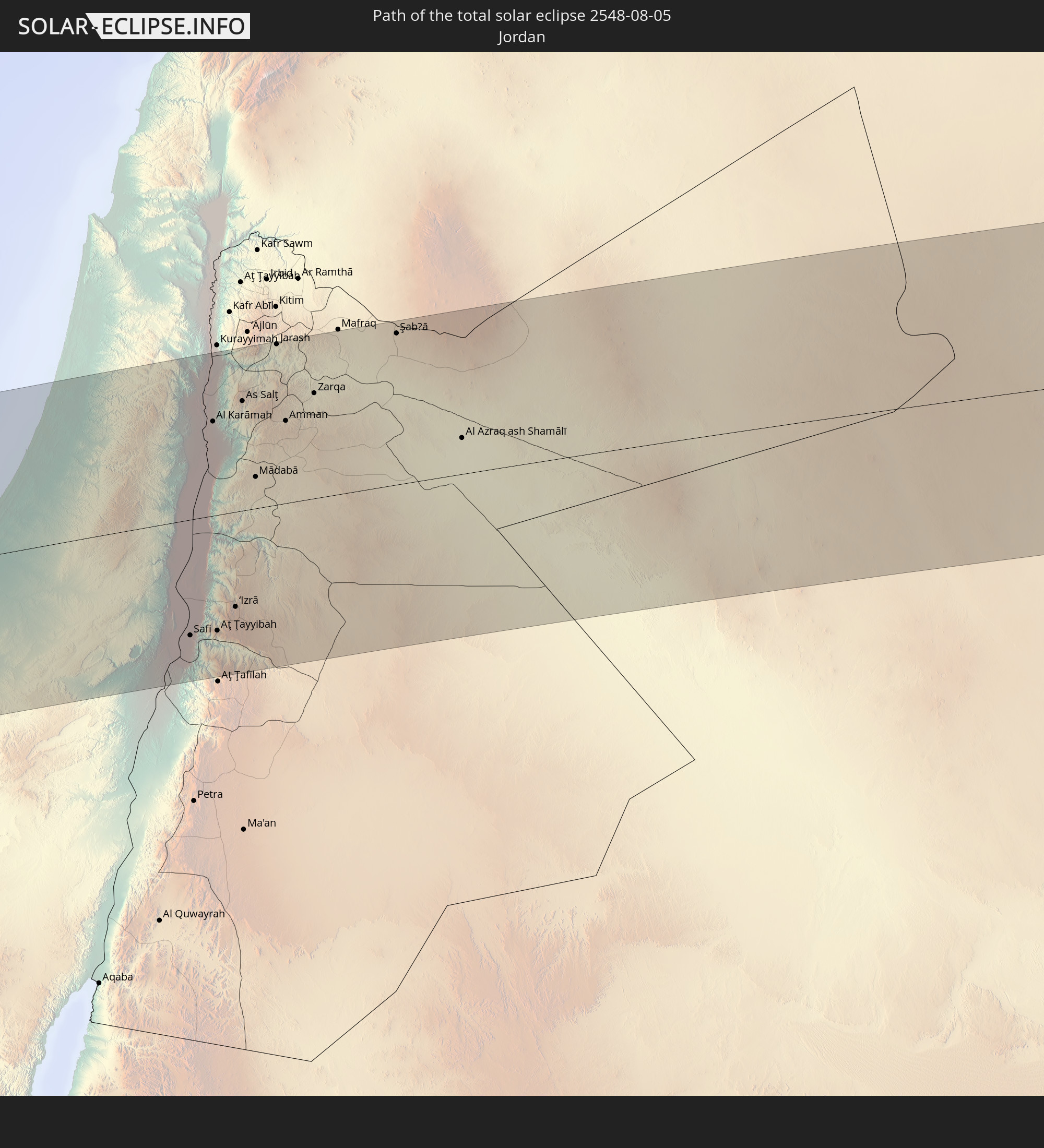
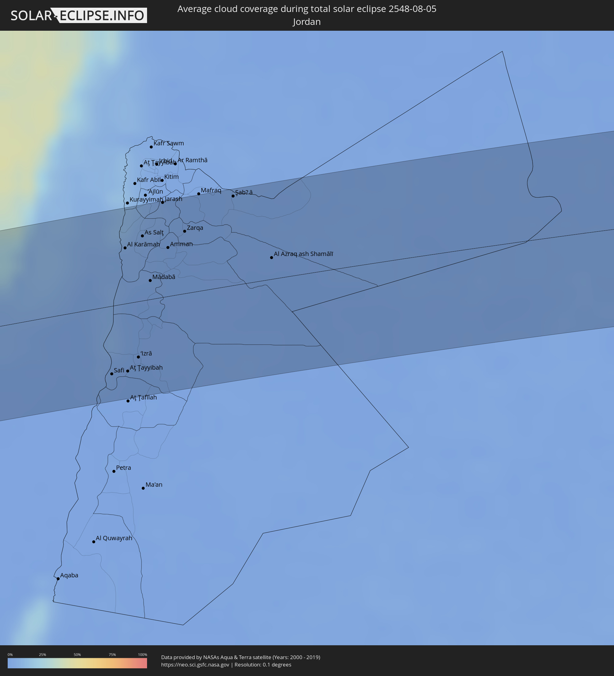 Jordanien
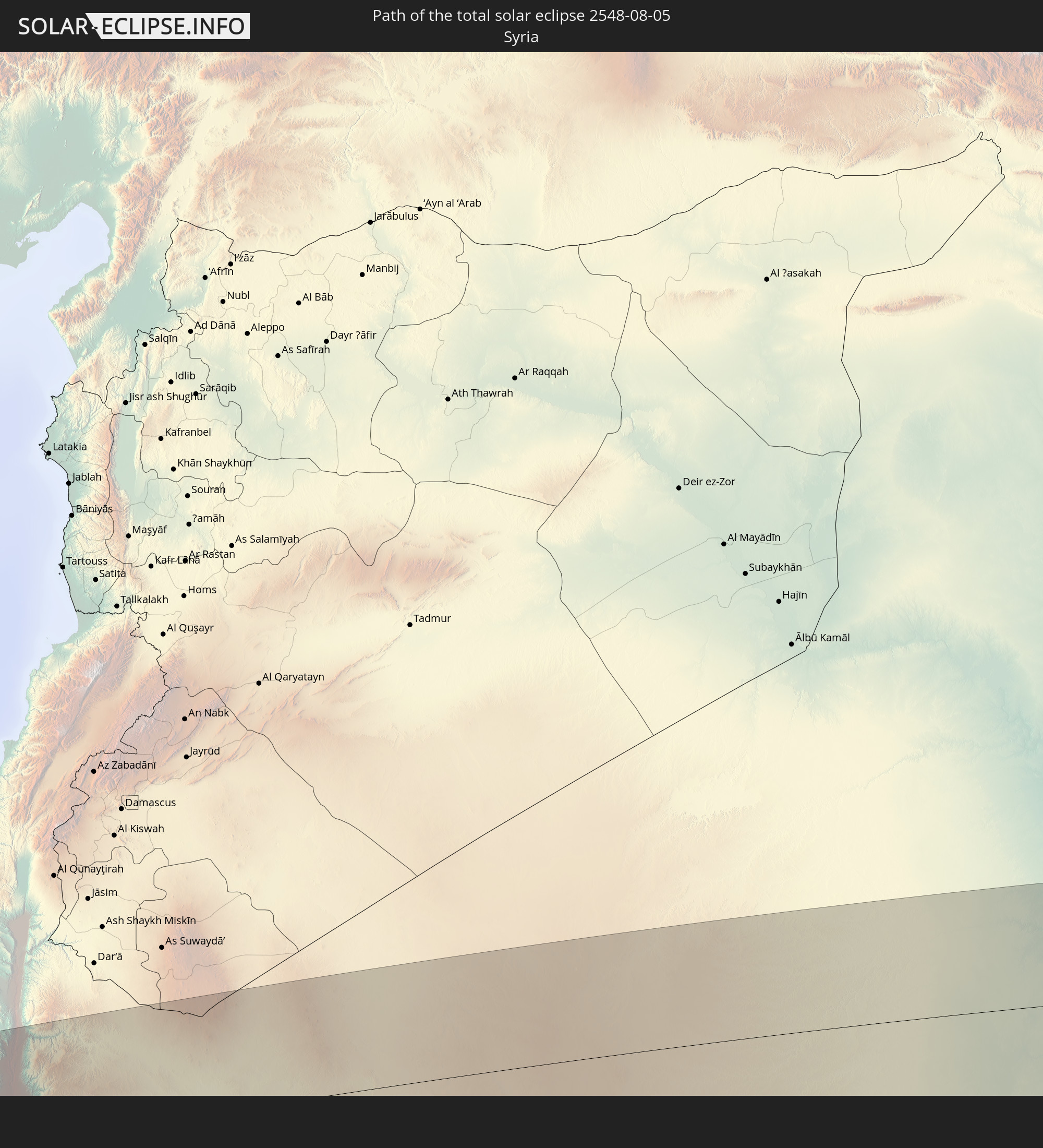
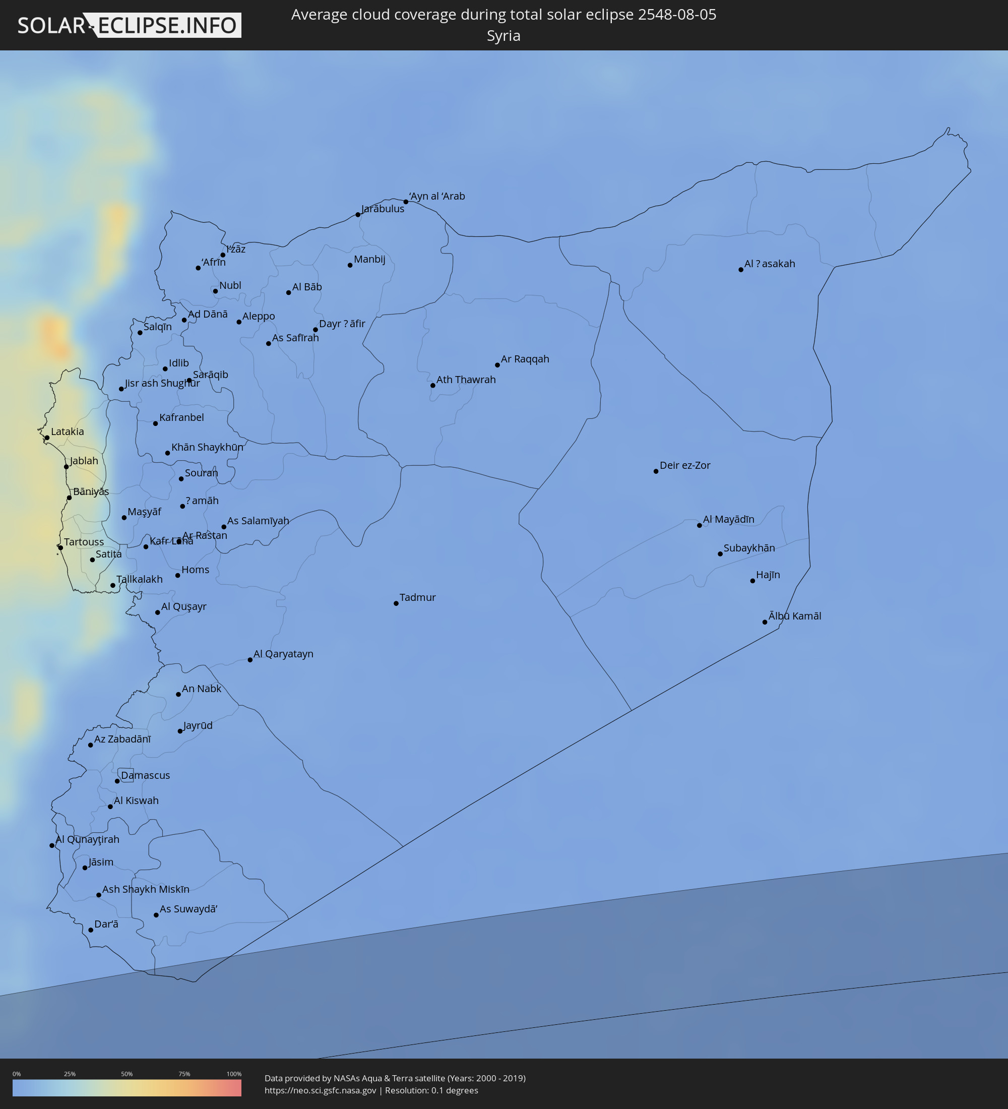 Syrien
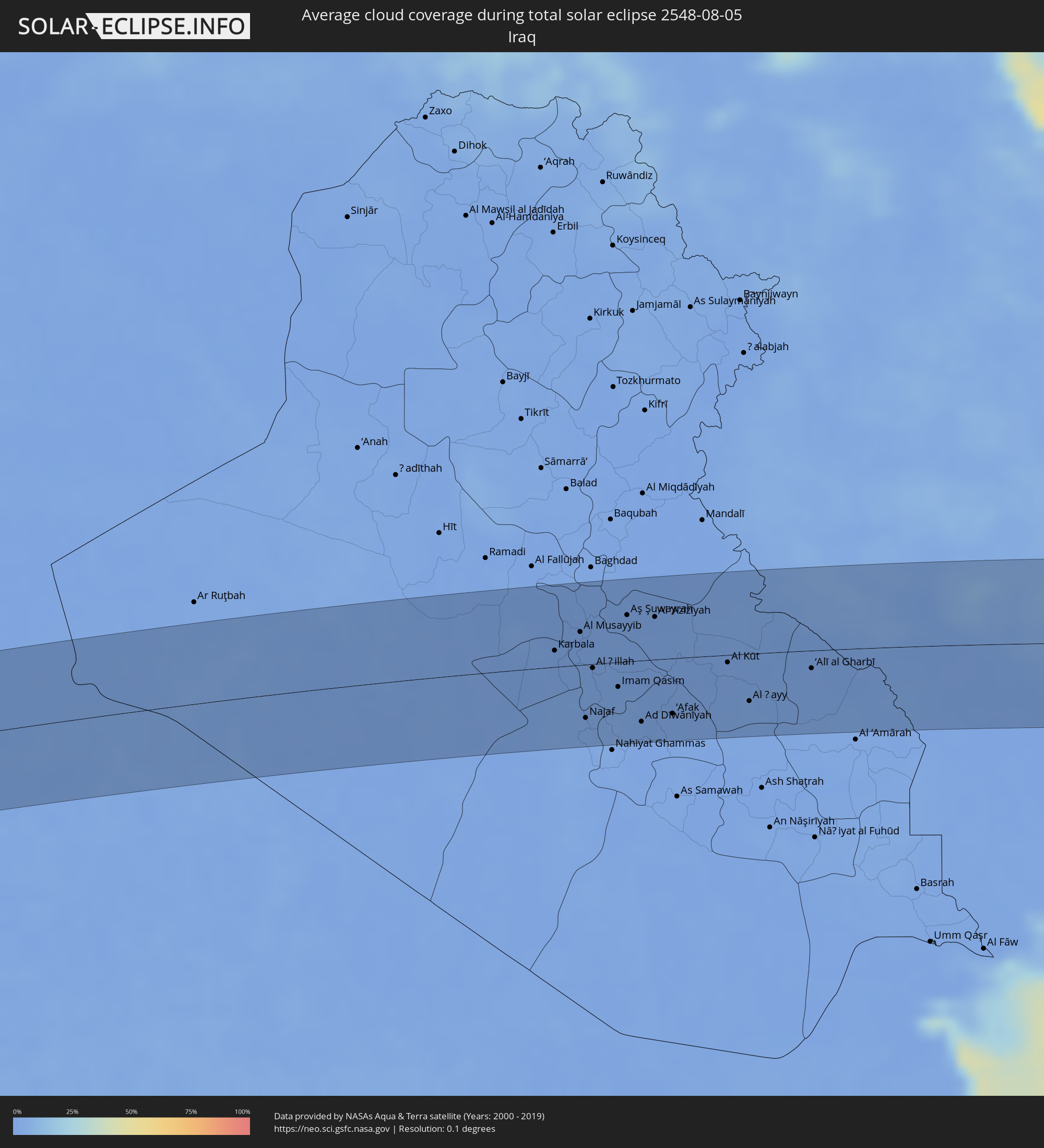 Irak
Irak
 Iran
Iran
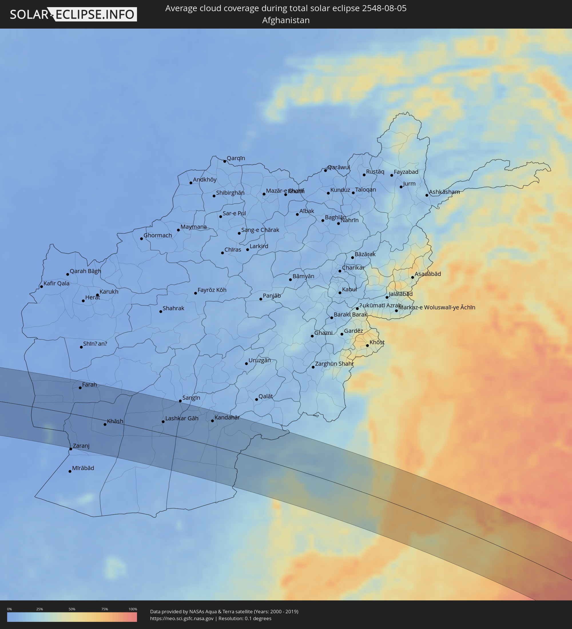 Afghanistan
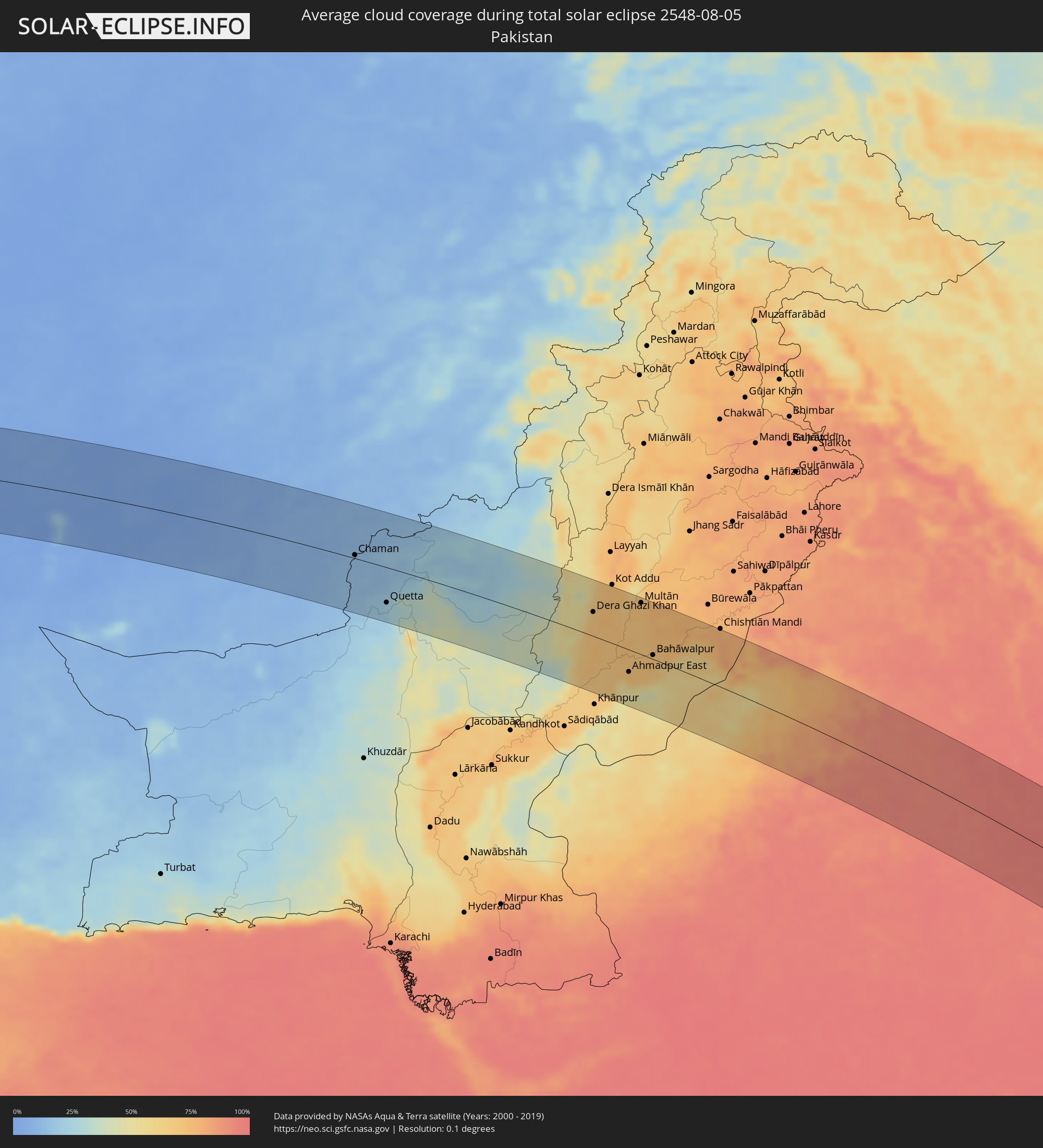 Pakistan
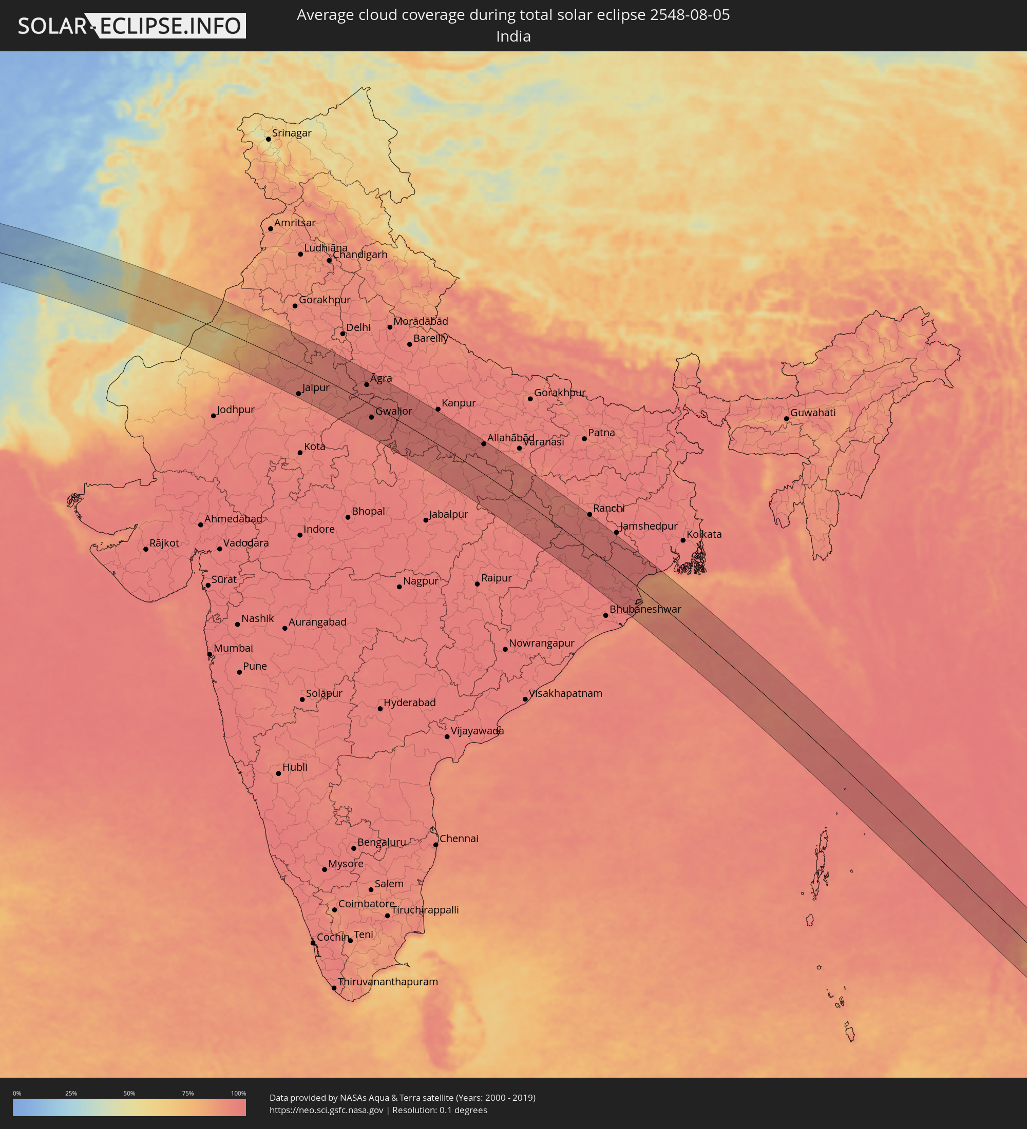 Indien
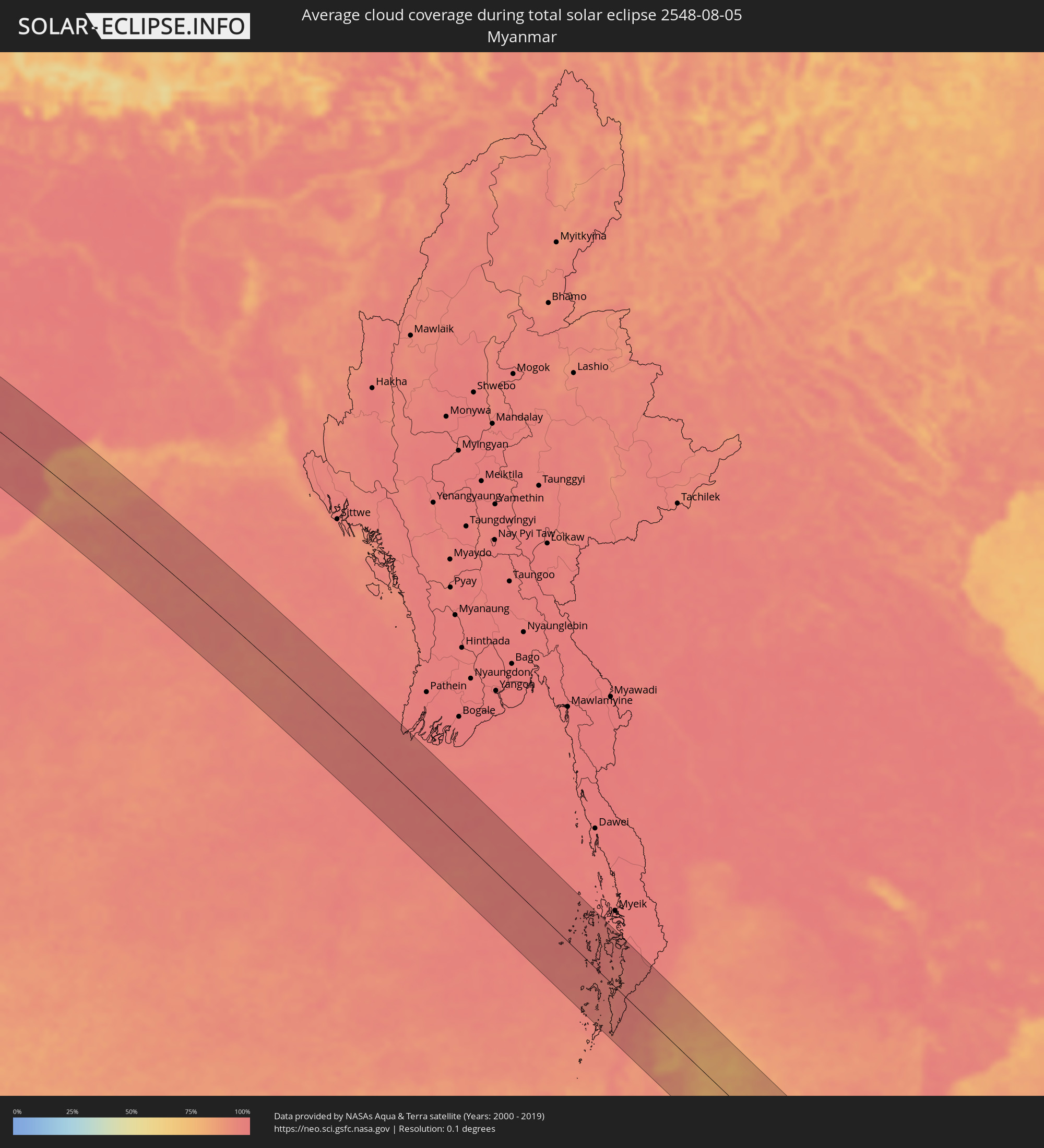 Myanmar
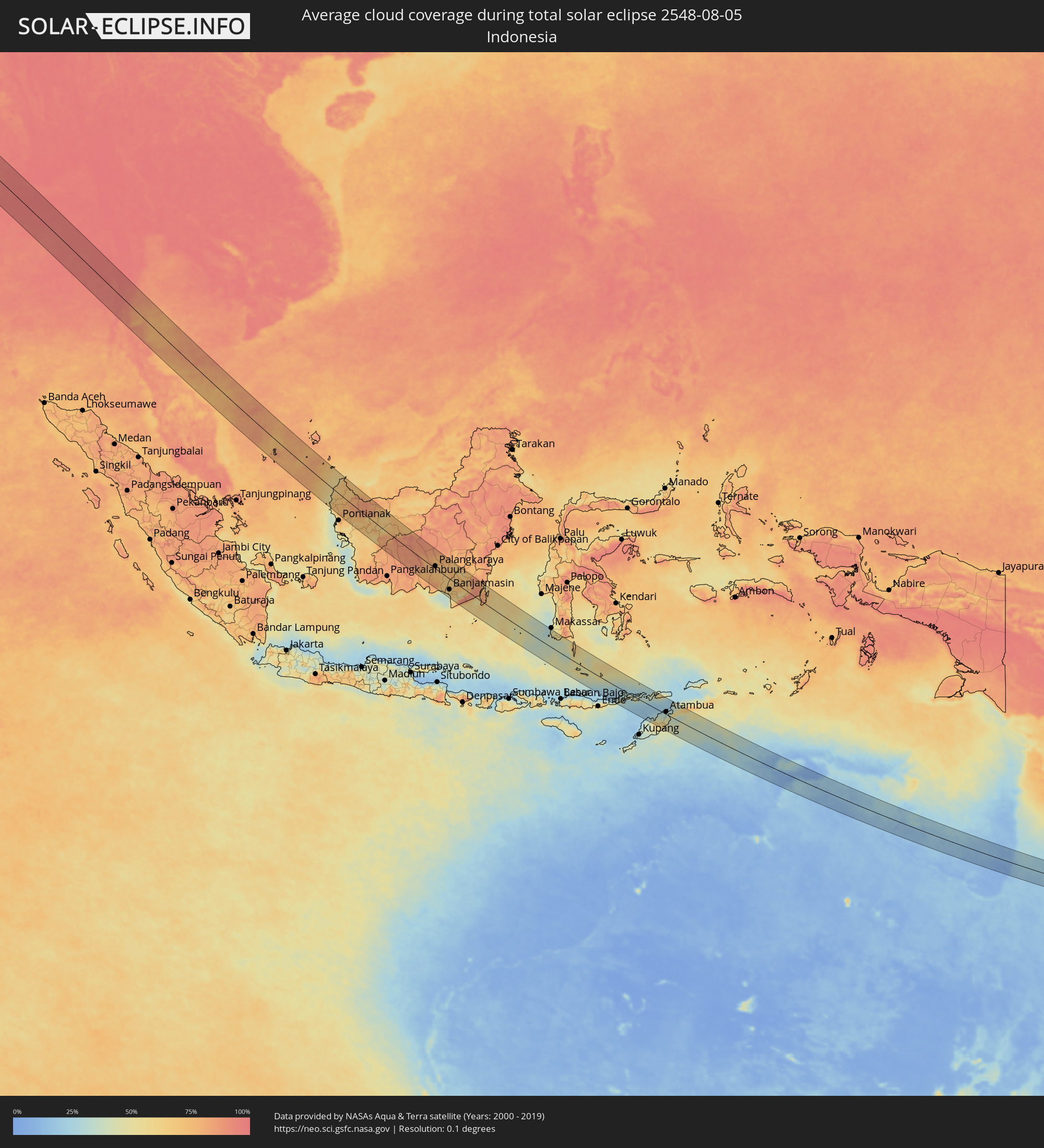 Indonesien
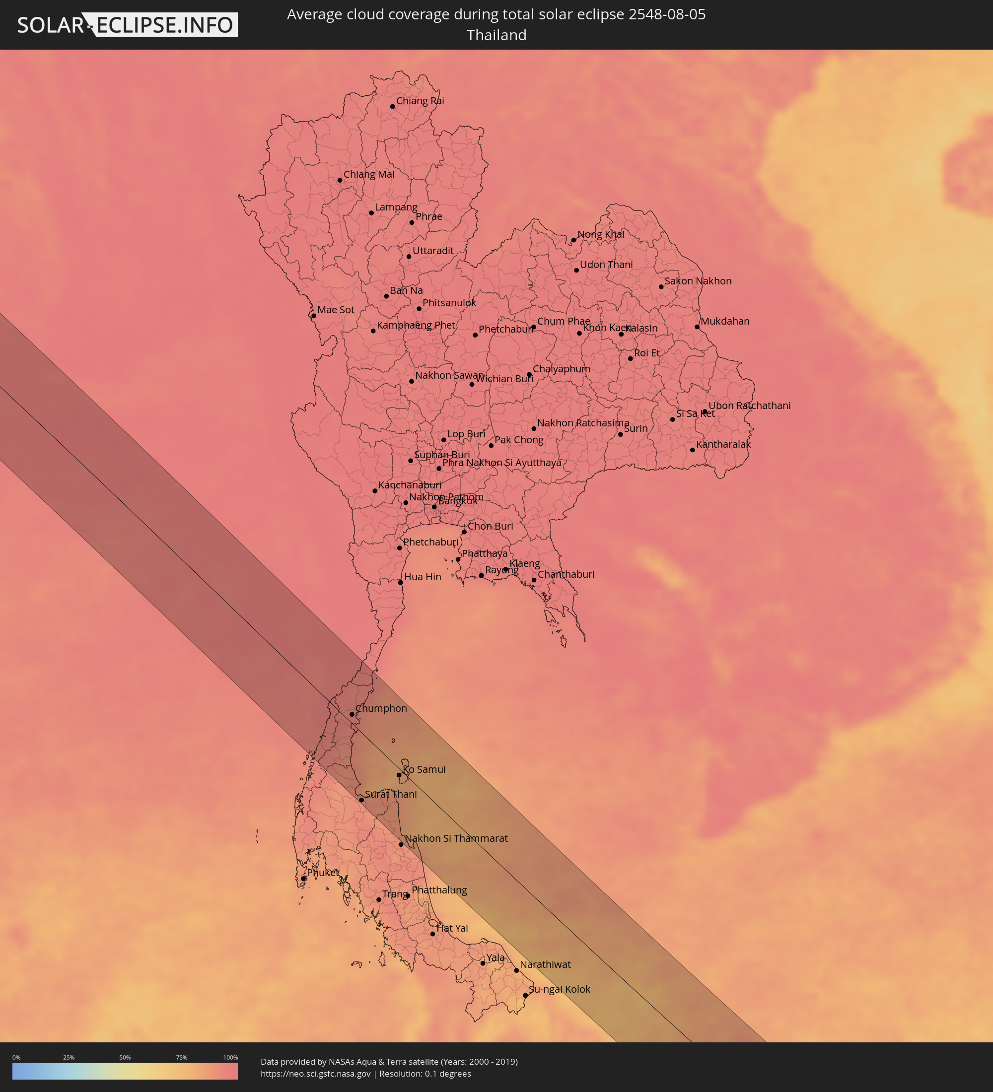 Thailand
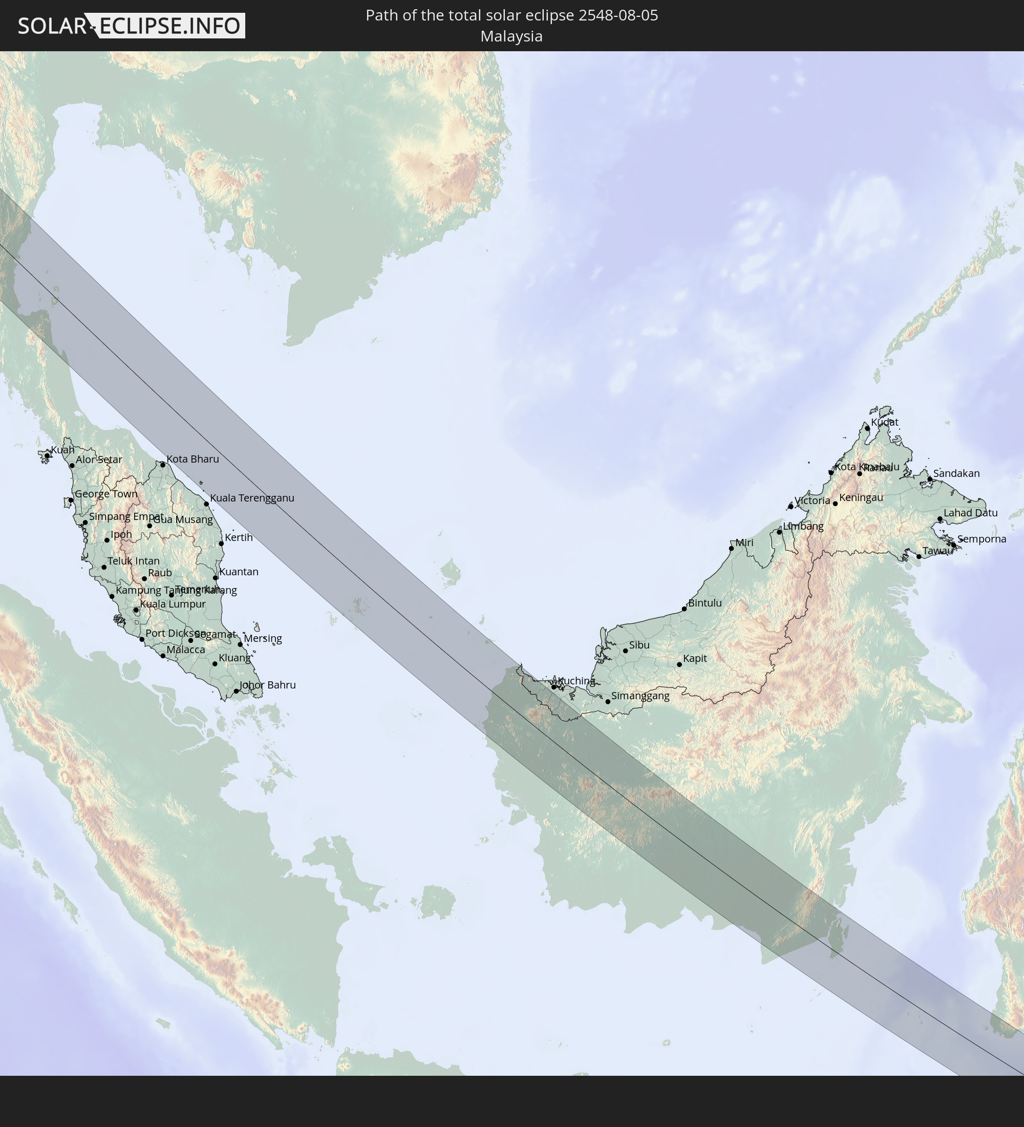
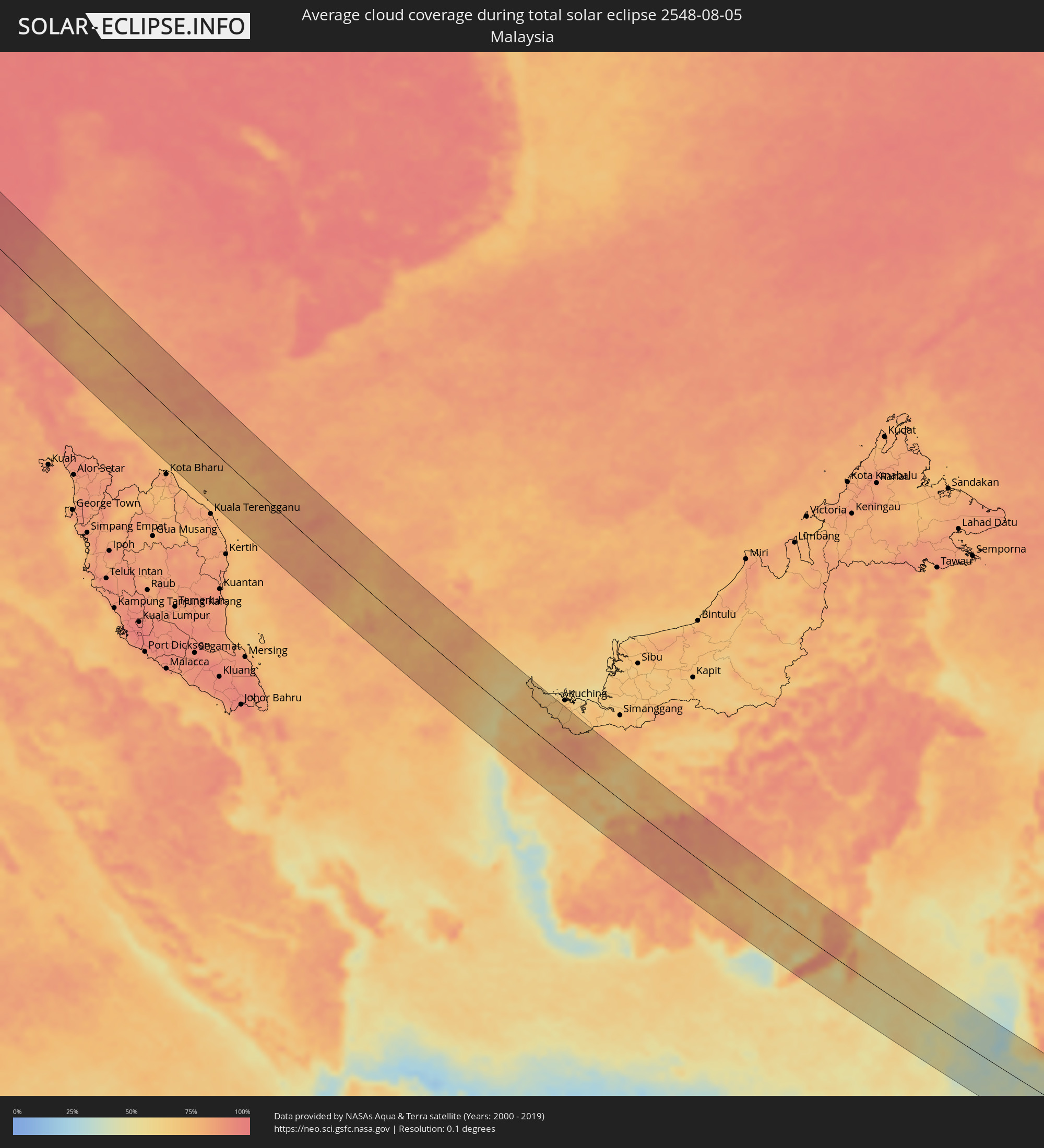 Malaysia
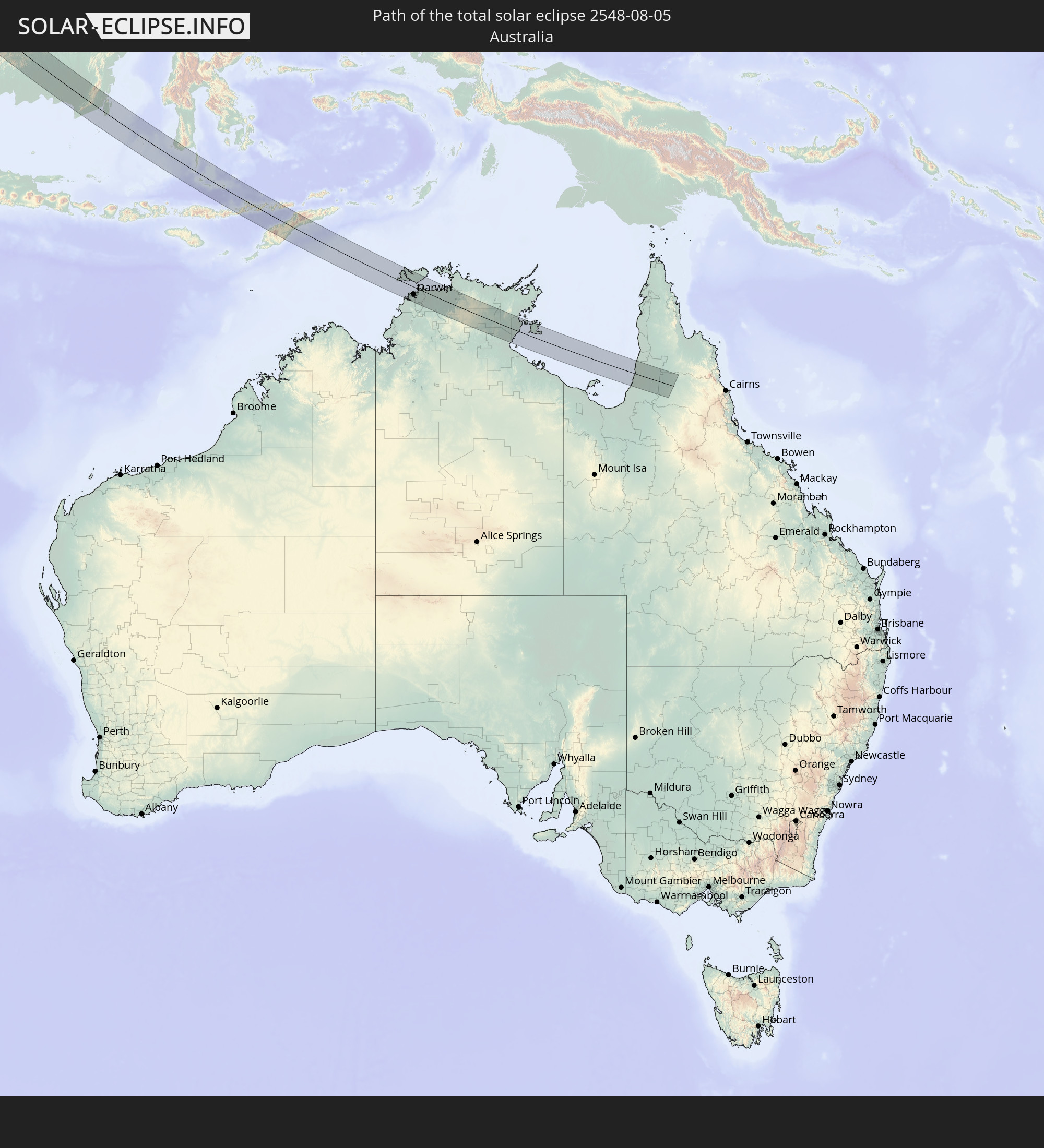
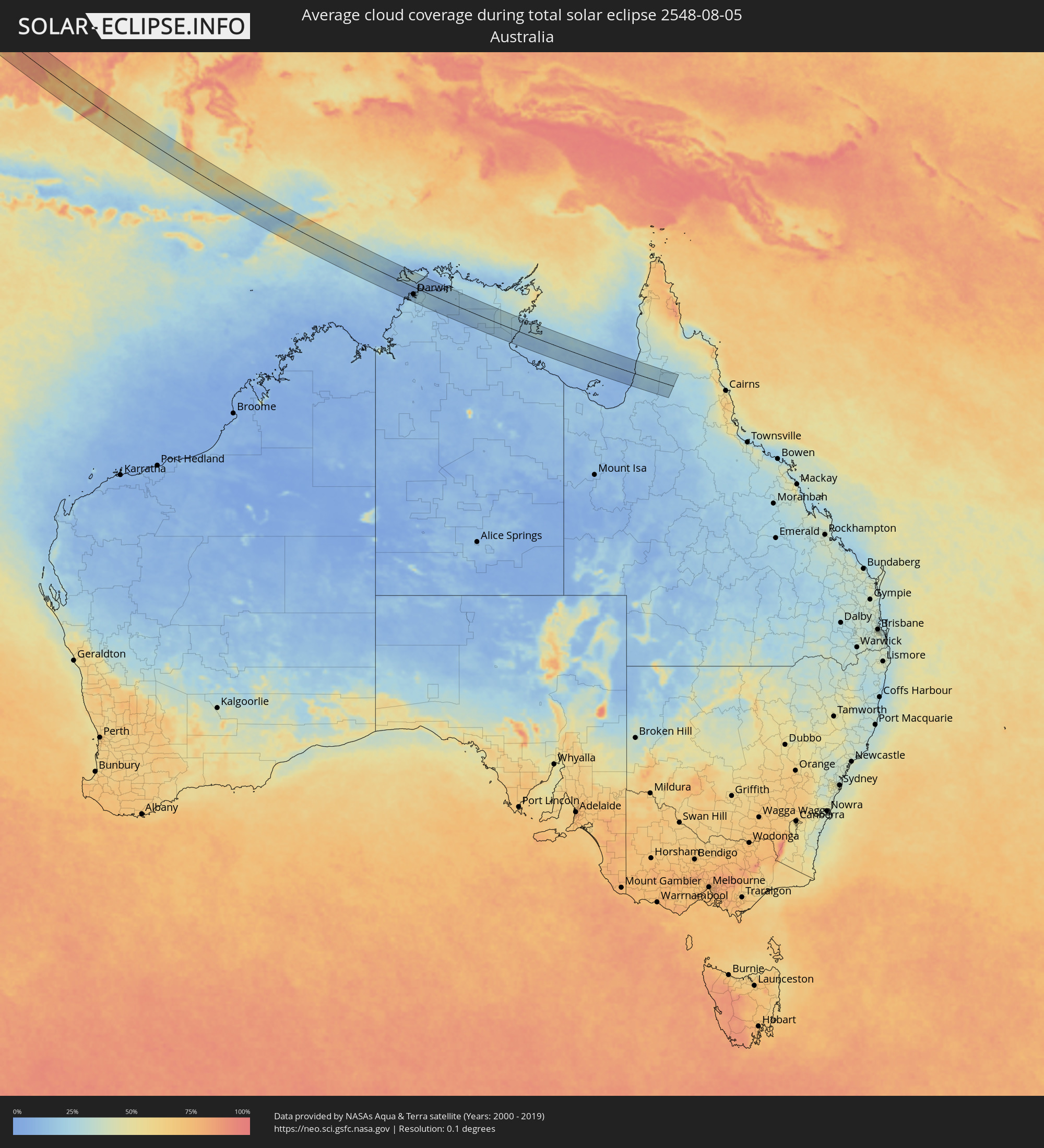 Australien
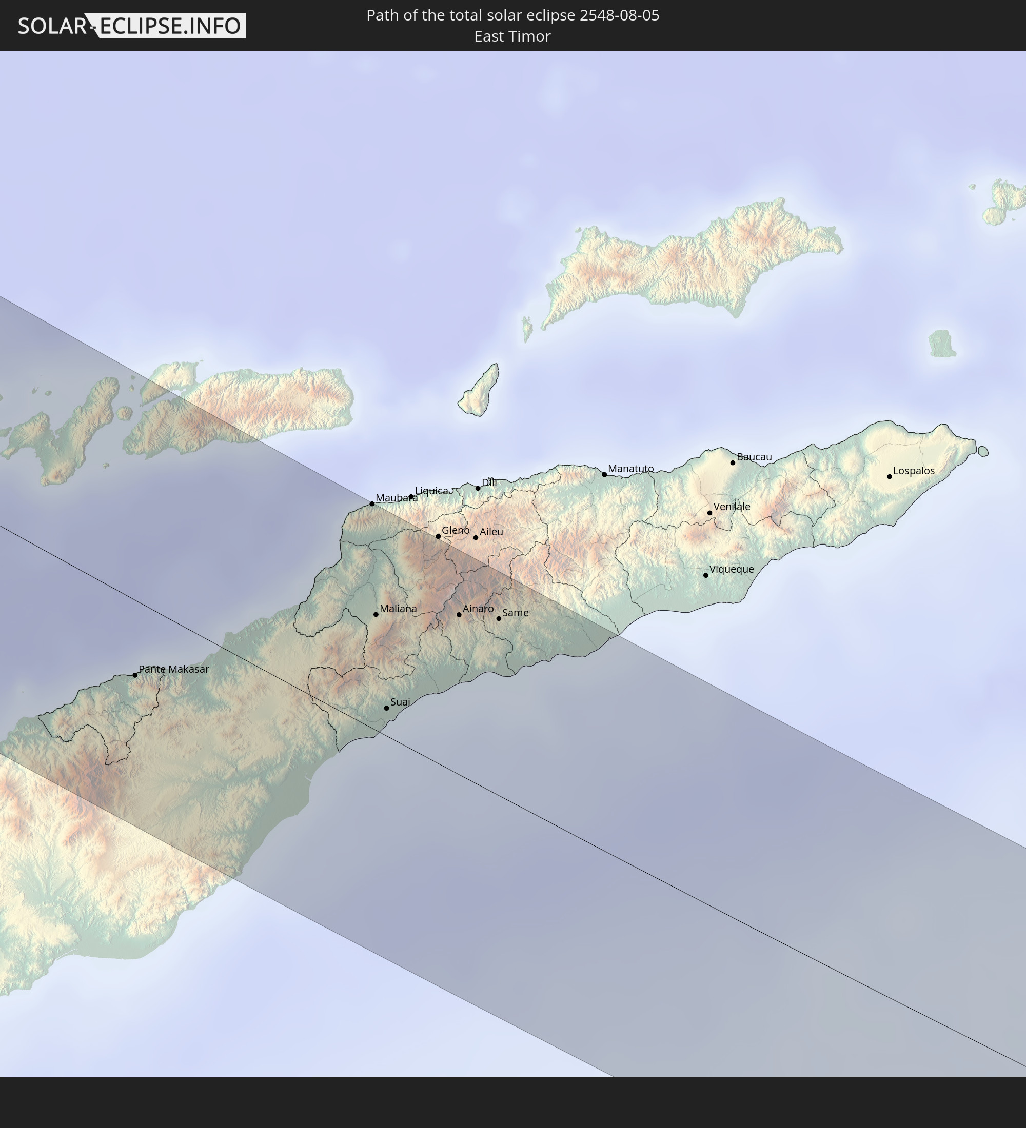
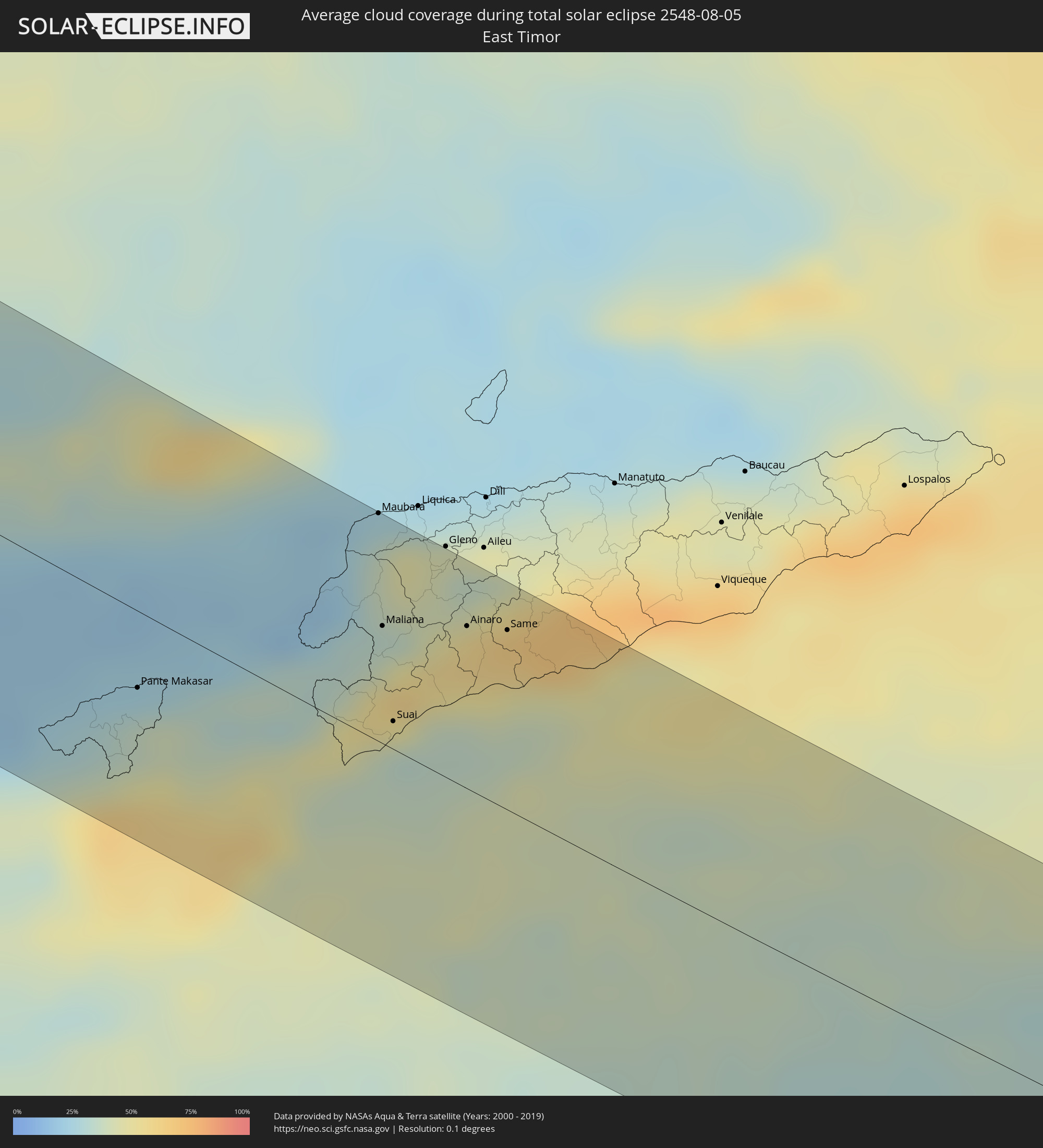 Osttimor
Orte im Finsternispfad
Die nachfolgene Tabelle zeigt Städte und Orte mit mehr als 5.000 Einwohnern, die sich im Finsternispfad befinden. Städte mit mehr als 100.000 Einwohnern sind dick gekennzeichnet. Mit einem Klick auf den Ort öffnet sich eine Detailkarte die die Lage des jeweiligen Ortes zusammen mit dem Verlauf der zentralen Finsternis präsentiert.
| Ort | Typ | Dauer der Verfinsterung | Ortszeit bei maximaler Verfinsterung | Entfernung zur Zentrallinie | Ø Bewölkung |
|
Awbārī, Sha‘bīyat Wādī al Ḩayāt
|
total | - | 06:44:06 UTC+02:00 | 36 km | 2% |
|
Al Jadīd, Sabhā
|
total | - | 06:44:09 UTC+02:00 | 33 km | 0% |
|
Sabhā, Sabhā
|
total | - | 06:44:09 UTC+02:00 | 31 km | 0% |
|
Awjilah, Sha‘bīyat al Wāḩāt
|
total | - | 06:45:22 UTC+02:00 | 51 km | 0% |
|
Alexandria, Alexandria
|
total | - | 06:48:56 UTC+02:00 | 69 km | 9% |
|
Kafr ad Dawwār, Beheira
|
total | - | 06:48:58 UTC+02:00 | 56 km | 9% |
|
Damanhūr, Beheira
|
total | - | 06:49:05 UTC+02:00 | 38 km | 14% |
|
Kafr ash Shaykh, Kafr el-Sheikh
|
total | - | 06:49:21 UTC+02:00 | 37 km | 15% |
|
Tanda, Gharbia
|
total | - | 06:49:13 UTC+02:00 | 1 km | 12% |
|
Shibīn al Kawm, Monufia
|
total | - | 06:49:07 UTC+02:00 | 25 km | 7% |
|
Al Maḩallah al Kubrá, Gharbia
|
total | - | 06:49:23 UTC+02:00 | 17 km | 13% |
|
Banhā, Qalyubia
|
total | - | 06:49:10 UTC+02:00 | 39 km | 6% |
|
Al Manşūrah, Dakahlia
|
total | - | 06:49:32 UTC+02:00 | 20 km | 14% |
|
Zagazig, Sharqia
|
total | - | 06:49:23 UTC+02:00 | 31 km | 9% |
|
Bilbays, Sharqia
|
total | - | 06:49:20 UTC+02:00 | 51 km | 2% |
|
Dikirnis, Dakahlia
|
total | - | 06:49:40 UTC+02:00 | 21 km | 17% |
|
Ismailia, Ismailia
|
total | - | 06:49:48 UTC+02:00 | 45 km | 2% |
|
Port Said, Port Said
|
total | - | 06:50:06 UTC+02:00 | 26 km | 15% |
|
Khān Yūnis, Gaza Strip
|
total | - | 06:51:18 UTC+02:00 | 2 km | 2% |
|
‘Abasān al Jadīdah
|
total | - | 06:51:19 UTC+02:00 | 2 km | 2% |
|
Gaza, Gaza Strip
|
total | - | 06:51:28 UTC+02:00 | 13 km | 4% |
|
Ashqelon, Southern District
|
total | - | 06:51:36 UTC+02:00 | 30 km | 6% |
|
Netivot, Southern District
|
total | - | 06:51:30 UTC+02:00 | 3 km | 3% |
|
Ashdod, Southern District
|
total | - | 06:51:42 UTC+02:00 | 42 km | 11% |
|
Qiryat Gat, Southern District
|
total | - | 06:51:42 UTC+02:00 | 20 km | 5% |
|
Tel Aviv, Tel Aviv
|
total | - | 06:51:55 UTC+02:00 | 71 km | 10% |
|
Beersheba, Southern District
|
total | - | 06:51:33 UTC+02:00 | 20 km | 2% |
|
Ness Ziona, Central District
|
total | - | 06:51:52 UTC+02:00 | 55 km | 7% |
|
Giv‘at Shemu’él, Tel Aviv
|
total | - | 06:51:58 UTC+02:00 | 70 km | 10% |
|
Rosh Ha‘Ayin, Central District
|
total | - | 06:52:02 UTC+02:00 | 70 km | 7% |
|
Az̧ Z̧āhirīyah, West Bank
|
total | - | 06:51:45 UTC+02:00 | 5 km | 1% |
|
Oranit, West Bank
|
total | - | 06:52:04 UTC+02:00 | 73 km | 7% |
|
Bet Shemesh, Jerusalem
|
total | - | 06:51:54 UTC+02:00 | 30 km | 5% |
|
Modiin, Central District
|
total | - | 06:51:59 UTC+02:00 | 48 km | 8% |
|
Dimona, Southern District
|
total | - | 06:51:38 UTC+02:00 | 43 km | 1% |
|
Bayt Liqyā, West Bank
|
total | - | 06:52:00 UTC+02:00 | 44 km | 6% |
|
Hebron, West Bank
|
total | - | 06:51:52 UTC+02:00 | 6 km | 1% |
|
Naḩḩālīn, West Bank
|
total | - | 06:51:57 UTC+02:00 | 22 km | 4% |
|
Az Zaytūnīyah, West Bank
|
total | - | 06:52:06 UTC+02:00 | 51 km | 5% |
|
Salfīt, West Bank
|
total | - | 06:52:10 UTC+02:00 | 65 km | 5% |
|
‘Arad, Southern District
|
total | - | 06:51:50 UTC+02:00 | 26 km | 1% |
|
Jerusalem, Jerusalem
|
total | - | 06:52:03 UTC+02:00 | 30 km | 3% |
|
East Jerusalem, West Bank
|
total | - | 06:52:04 UTC+02:00 | 31 km | 3% |
|
Ḩizmā, West Bank
|
total | - | 06:52:07 UTC+02:00 | 36 km | 2% |
|
Bayt Fūrīk, West Bank
|
total | - | 06:52:19 UTC+02:00 | 73 km | 5% |
|
Jericho, West Bank
|
total | - | 06:52:15 UTC+02:00 | 37 km | 3% |
|
Safi, Karak
|
total | - | 06:51:54 UTC+02:00 | 54 km | 1% |
|
Al Karāmah, Balqa
|
total | - | 06:52:22 UTC+02:00 | 44 km | 3% |
|
‘Izrā, Karak
|
total | - | 06:52:06 UTC+02:00 | 45 km | 0% |
|
Al Mazār al Janūbī, Karak
|
total | - | 06:52:04 UTC+02:00 | 55 km | 0% |
|
Qīr Moāv, Ma’an
|
total | - | 06:52:07 UTC+02:00 | 42 km | 0% |
|
As Salţ, Balqa
|
total | - | 06:52:31 UTC+02:00 | 51 km | 3% |
|
Karak City, Karak
|
total | - | 06:52:09 UTC+02:00 | 45 km | 0% |
|
Mādabā, Madaba
|
total | - | 06:52:25 UTC+02:00 | 15 km | 1% |
|
Umm as Summāq, Amman
|
total | - | 06:52:32 UTC+02:00 | 32 km | 2% |
|
Jarash, Jerash
|
total | - | 06:52:44 UTC+02:00 | 75 km | 3% |
|
Jāwā, Amman
|
total | - | 06:52:34 UTC+02:00 | 27 km | 2% |
|
Amman, Amman
|
total | - | 06:52:37 UTC+02:00 | 39 km | 2% |
|
Zarqa, Zarqa
|
total | - | 06:52:46 UTC+02:00 | 49 km | 1% |
|
Al Azraq ash Shamālī, Zarqa
|
total | - | 06:53:12 UTC+02:00 | 17 km | 0% |
|
Qurayyat, Al Jawf
|
total | - | 07:53:20 UTC+03:00 | 51 km | 0% |
|
Turaif, Northern Borders
|
total | - | 07:54:29 UTC+03:00 | 32 km | 1% |
|
Karbala, Karbalāʼ
|
total | - | 07:59:37 UTC+03:00 | 16 km | 0% |
|
Al Hindīyah, Karbalāʼ
|
total | - | 07:59:48 UTC+03:00 | 7 km | 1% |
|
Nāḩīyat Saddat al Hindīyah, Bābil
|
total | - | 07:59:54 UTC+03:00 | 25 km | 1% |
|
Al Musayyib, Bābil
|
total | - | 07:59:56 UTC+03:00 | 32 km | 1% |
|
Najaf, An Najaf
|
total | - | 07:59:45 UTC+03:00 | 52 km | 2% |
|
Al Ḩillah, Bābil
|
total | - | 07:59:58 UTC+03:00 | 4 km | 1% |
|
Kufa, An Najaf
|
total | - | 07:59:52 UTC+03:00 | 50 km | 2% |
|
Ash Shāmīyah, Al Qādisīyah
|
total | - | 08:00:00 UTC+03:00 | 61 km | 2% |
|
Imam Qasim, Bābil
|
total | - | 08:00:11 UTC+03:00 | 24 km | 2% |
|
Aş Şuwayrah, Wāsiţ
|
total | - | 08:00:28 UTC+03:00 | 45 km | 0% |
|
Ad Dīwānīyah, Al Qādisīyah
|
total | - | 08:00:21 UTC+03:00 | 60 km | 1% |
|
Al ‘Azīzīyah, Wāsiţ
|
total | - | 08:00:46 UTC+03:00 | 41 km | 1% |
|
Al Kūt, Wāsiţ
|
total | - | 08:01:27 UTC+03:00 | 7 km | 1% |
|
Al Ḩayy, Wāsiţ
|
total | - | 08:01:36 UTC+03:00 | 46 km | 2% |
|
Dehlorān, Īlām
|
total | - | 08:33:06 UTC+03:30 | 6 km | 1% |
|
Shūsh, Khuzestan
|
total | - | 08:34:07 UTC+03:30 | 52 km | 0% |
|
Shūshtar, Khuzestan
|
total | - | 08:34:49 UTC+03:30 | 70 km | 0% |
|
Alīgūdarz, Lorestān
|
total | - | 08:36:07 UTC+03:30 | 80 km | 8% |
|
Shahr-e Kord, Chahār Maḩāll va Bakhtīārī
|
total | - | 08:37:25 UTC+03:30 | 40 km | 6% |
|
Borūjen, Chahār Maḩāll va Bakhtīārī
|
total | - | 08:37:56 UTC+03:30 | 79 km | 9% |
|
Najafābād, Isfahan
|
total | - | 08:38:07 UTC+03:30 | 5 km | 3% |
|
Falāvarjān, Isfahan
|
total | - | 08:38:18 UTC+03:30 | 13 km | 4% |
|
Dorcheh Pīāz, Isfahan
|
total | - | 08:38:22 UTC+03:30 | 7 km | 3% |
|
Isfahan, Isfahan
|
total | - | 08:38:31 UTC+03:30 | 2 km | 3% |
|
Shāhreẕā, Isfahan
|
total | - | 08:38:44 UTC+03:30 | 71 km | 5% |
|
Ardakān, Yazd
|
total | - | 08:41:44 UTC+03:30 | 32 km | 1% |
|
Yazd, Yazd
|
total | - | 08:42:14 UTC+03:30 | 75 km | 3% |
|
Bīrjand, Khorāsān-e Jonūbī
|
total | - | 08:49:39 UTC+03:30 | 78 km | 2% |
|
Farah, Farah
|
total | - | 09:54:37 UTC+04:30 | 69 km | 1% |
|
Khāsh, Nimroz
|
total | - | 09:56:05 UTC+04:30 | 11 km | 1% |
|
Markaz-e Ḩukūmat-e Darwēshān, Helmand
|
total | - | 09:58:48 UTC+04:30 | 25 km | 5% |
|
Lashkar Gāh, Helmand
|
total | - | 09:58:56 UTC+04:30 | 29 km | 5% |
|
Gereshk, Helmand
|
total | - | 09:59:11 UTC+04:30 | 58 km | 5% |
|
Kandahār, Kandahar
|
total | - | 10:01:24 UTC+04:30 | 62 km | 8% |
|
Chaman, Balochistān
|
total | - | 10:33:10 UTC+05:00 | 5 km | 13% |
|
Quetta, Balochistān
|
total | - | 10:34:41 UTC+05:00 | 57 km | 22% |
|
Jāmpur, Punjab
|
total | - | 10:42:19 UTC+05:00 | 6 km | 70% |
|
Dera Ghazi Khan, Punjab
|
total | - | 10:42:03 UTC+05:00 | 38 km | 66% |
|
Muzaffargarh, Punjab
|
total | - | 10:43:10 UTC+05:00 | 59 km | 69% |
|
Ahmadpur East, Punjab
|
total | - | 10:44:07 UTC+05:00 | 35 km | 70% |
|
Shujāābād, Punjab
|
total | - | 10:43:33 UTC+05:00 | 42 km | 69% |
|
Multān, Punjab
|
total | - | 10:43:39 UTC+05:00 | 82 km | 70% |
|
Lodhrān, Punjab
|
total | - | 10:44:33 UTC+05:00 | 19 km | 73% |
|
Bahāwalpur, Punjab
|
total | - | 10:44:46 UTC+05:00 | 6 km | 72% |
|
Kohror Pakka, Punjab
|
total | - | 10:45:03 UTC+05:00 | 38 km | 72% |
|
Mailsi, Punjab
|
total | - | 10:45:26 UTC+05:00 | 66 km | 76% |
|
Hāsilpur, Punjab
|
total | - | 10:46:18 UTC+05:00 | 70 km | 74% |
|
Haru Zbad, Punjab
|
total | - | 10:47:36 UTC+05:00 | 82 km | 78% |
|
Bīkaner, Rajasthan
|
total | - | 11:19:34 UTC+05:30 | 74 km | 74% |
|
Sīkar, Rajasthan
|
total | - | 11:23:58 UTC+05:30 | 39 km | 91% |
|
Jaipur, Rajasthan
|
total | - | 11:26:12 UTC+05:30 | 80 km | 92% |
|
Alwar, Rajasthan
|
total | - | 11:27:15 UTC+05:30 | 22 km | 92% |
|
Bharatpur, Rajasthan
|
total | - | 11:29:34 UTC+05:30 | 28 km | 95% |
|
Mathura, Uttar Pradesh
|
total | - | 11:29:36 UTC+05:30 | 64 km | 95% |
|
Āgra, Uttar Pradesh
|
total | - | 11:30:45 UTC+05:30 | 50 km | 95% |
|
Gwalior, Madhya Pradesh
|
total | - | 11:32:22 UTC+05:30 | 35 km | 95% |
|
Fīrozābād, Uttar Pradesh
|
total | - | 11:31:37 UTC+05:30 | 65 km | 95% |
|
Jhānsi, Uttar Pradesh
|
total | - | 11:34:19 UTC+05:30 | 90 km | 93% |
|
Etāwah, Uttar Pradesh
|
total | - | 11:33:29 UTC+05:30 | 59 km | 95% |
|
Satna, Madhya Pradesh
|
total | - | 11:40:38 UTC+05:30 | 55 km | 95% |
|
Rewa, Madhya Pradesh
|
total | - | 11:41:44 UTC+05:30 | 33 km | 96% |
|
Allahābād, Uttar Pradesh
|
total | - | 11:41:32 UTC+05:30 | 82 km | 96% |
|
Ranong, Ranong
|
total | - | 14:13:34 UTC+07:00 | 73 km | 93% |
|
Ban Nam Yuen, Chumphon
|
total | - | 14:14:06 UTC+07:00 | 62 km | 94% |
|
Lang Suan, Chumphon
|
total | - | 14:14:19 UTC+07:00 | 41 km | 90% |
|
Chumphon, Chumphon
|
total | - | 14:13:27 UTC+07:00 | 11 km | 94% |
|
Chaiya, Surat Thani
|
total | - | 14:15:34 UTC+07:00 | 76 km | 90% |
|
Surat Thani, Surat Thani
|
total | - | 14:16:14 UTC+07:00 | 86 km | 90% |
|
Don Sak, Surat Thani
|
total | - | 14:16:29 UTC+07:00 | 44 km | 86% |
|
Ko Samui, Surat Thani
|
total | - | 14:16:27 UTC+07:00 | 8 km | 80% |
|
Ko Pha Ngan, Nakhon Si Thammarat
|
total | - | 14:16:12 UTC+07:00 | 17 km | 82% |
|
Pak Phanang, Nakhon Si Thammarat
|
total | - | 14:19:03 UTC+07:00 | 84 km | 87% |
|
Sungai Raya, West Kalimantan
|
total | - | 14:43:13 UTC+07:00 | 76 km | 57% |
|
Pemangkat, West Kalimantan
|
total | - | 14:42:37 UTC+07:00 | 32 km | 65% |
|
Singkawang, West Kalimantan
|
total | - | 14:43:01 UTC+07:00 | 52 km | 68% |
|
Sampit, Central Kalimantan
|
total | - | 14:51:41 UTC+07:00 | 82 km | 85% |
|
Palangkaraya, Central Kalimantan
|
total | - | 14:52:07 UTC+07:00 | 10 km | 79% |
|
Kualakapuas, Central Kalimantan
|
total | - | 14:53:31 UTC+07:00 | 31 km | 66% |
|
Banjarmasin, South Kalimantan
|
total | - | 15:54:04 UTC+08:00 | 46 km | 68% |
|
Martapura, South Kalimantan
|
total | - | 15:54:25 UTC+08:00 | 37 km | 64% |
|
Amuntai, South Kalimantan
|
total | - | 15:53:31 UTC+08:00 | 78 km | 58% |
|
Barabai, South Kalimantan
|
total | - | 15:53:50 UTC+08:00 | 72 km | 70% |
|
Galesong, South Sulawesi
|
total | - | 15:59:52 UTC+08:00 | 66 km | 45% |
|
Pante Makasar, Oecusse
|
total | - | 17:06:15 UTC+09:00 | 25 km | 35% |
|
Kefamenanu, East Nusa Tenggara
|
total | - | 16:06:30 UTC+08:00 | 44 km | 49% |
|
Atambua, East Nusa Tenggara
|
total | - | 16:06:23 UTC+08:00 | 11 km | 34% |
|
Maubara, Liquiçá
|
total | - | 17:06:07 UTC+09:00 | 75 km | 34% |
|
Maliana, Bobonaro
|
total | - | 17:06:26 UTC+09:00 | 39 km | 39% |
|
Suai, Cova Lima
|
total | - | 17:06:43 UTC+09:00 | 9 km | 34% |
|
Ainaro, Ainaro
|
total | - | 17:06:33 UTC+09:00 | 54 km | 58% |
|
Same, Manufahi
|
total | - | 17:06:37 UTC+09:00 | 60 km | 60% |
|
Darwin, Northern Territory
|
total | - | 17:40:45 UTC+09:30 | 35 km | 15% |
|
Palmerston, Northern Territory
|
total | - | 17:40:48 UTC+09:30 | 31 km | 24% |
|
McMinns Lagoon, Northern Territory
|
total | - | 17:40:52 UTC+09:30 | 33 km | 24% |