Totale Sonnenfinsternis vom 19.09.2639
| Wochentag: | Donnerstag |
| Maximale Dauer der Verfinsterung: | 05m28s |
| Maximale Breite des Finsternispfades: | 234 km |
| Saroszyklus: | 164 |
| Bedeckungsgrad: | 100% |
| Magnitude: | 1.0683 |
| Gamma: | -0.3212 |
Wo kann man die Sonnenfinsternis vom 19.09.2639 sehen?
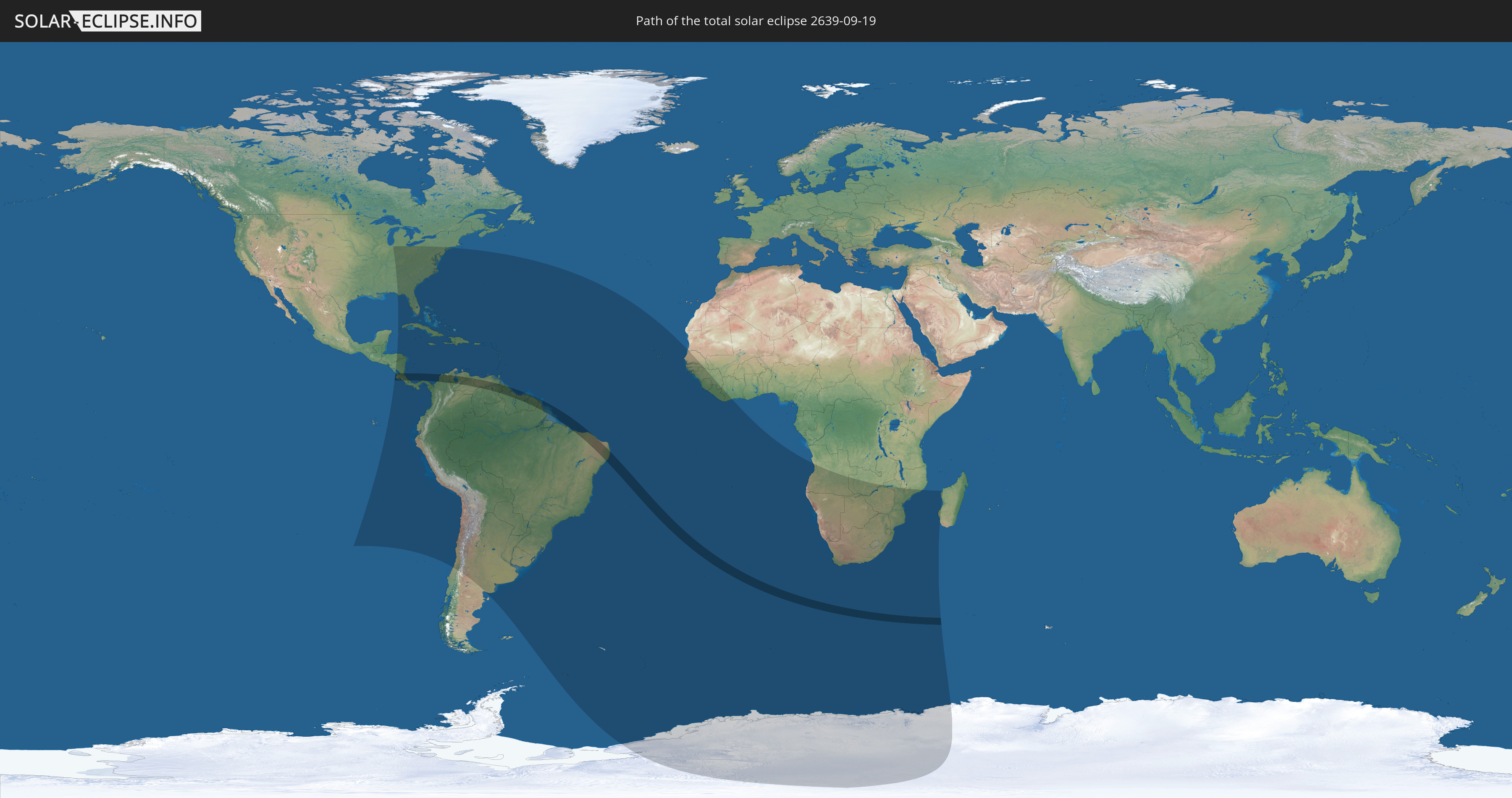
Die Sonnenfinsternis am 19.09.2639 kann man in 70 Ländern als partielle Sonnenfinsternis beobachten.
Der Finsternispfad verläuft durch 9 Länder. Nur in diesen Ländern ist sie als totale Sonnenfinsternis zu sehen.
In den folgenden Ländern ist die Sonnenfinsternis total zu sehen
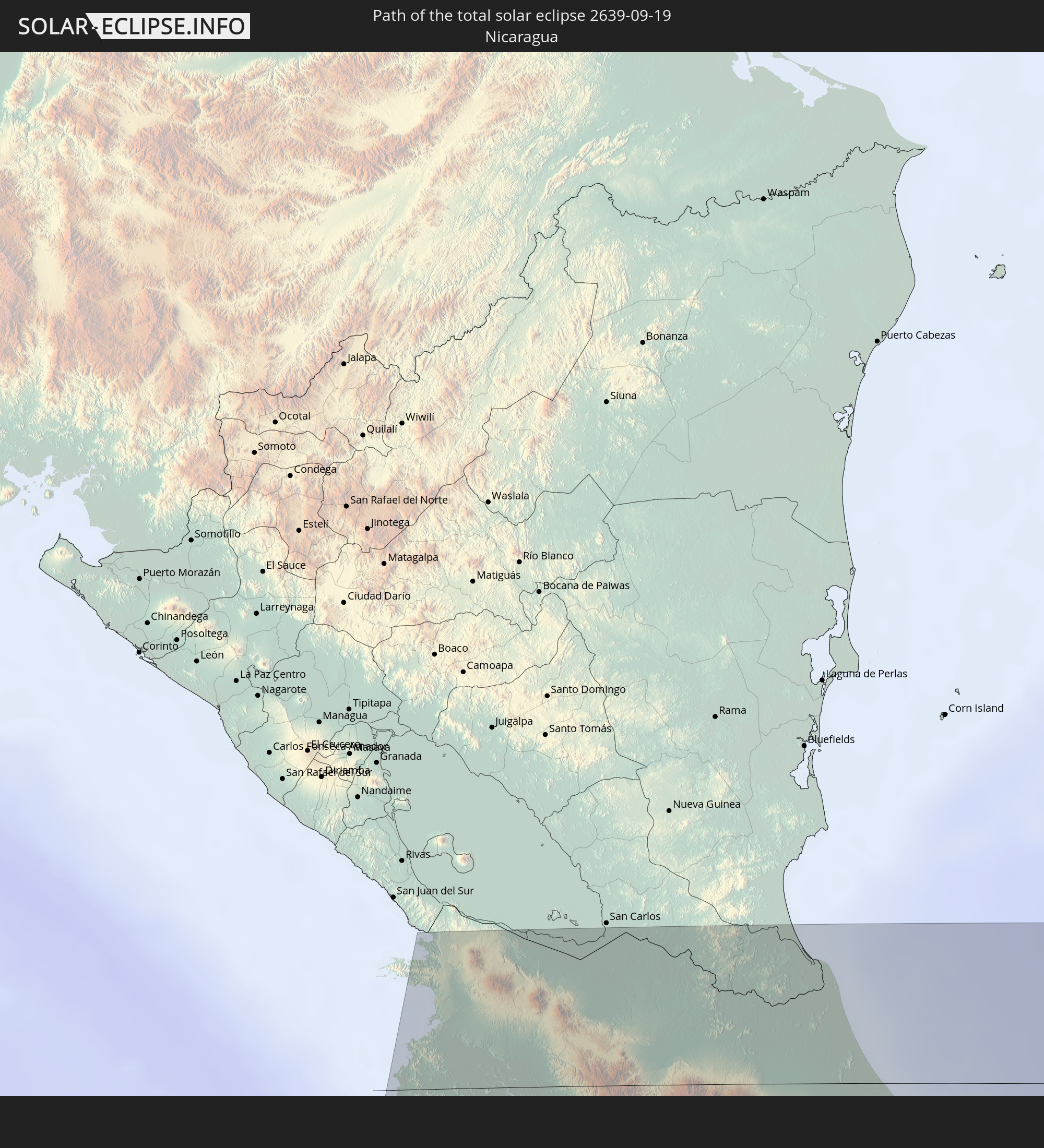 Nicaragua
 Costa Rica
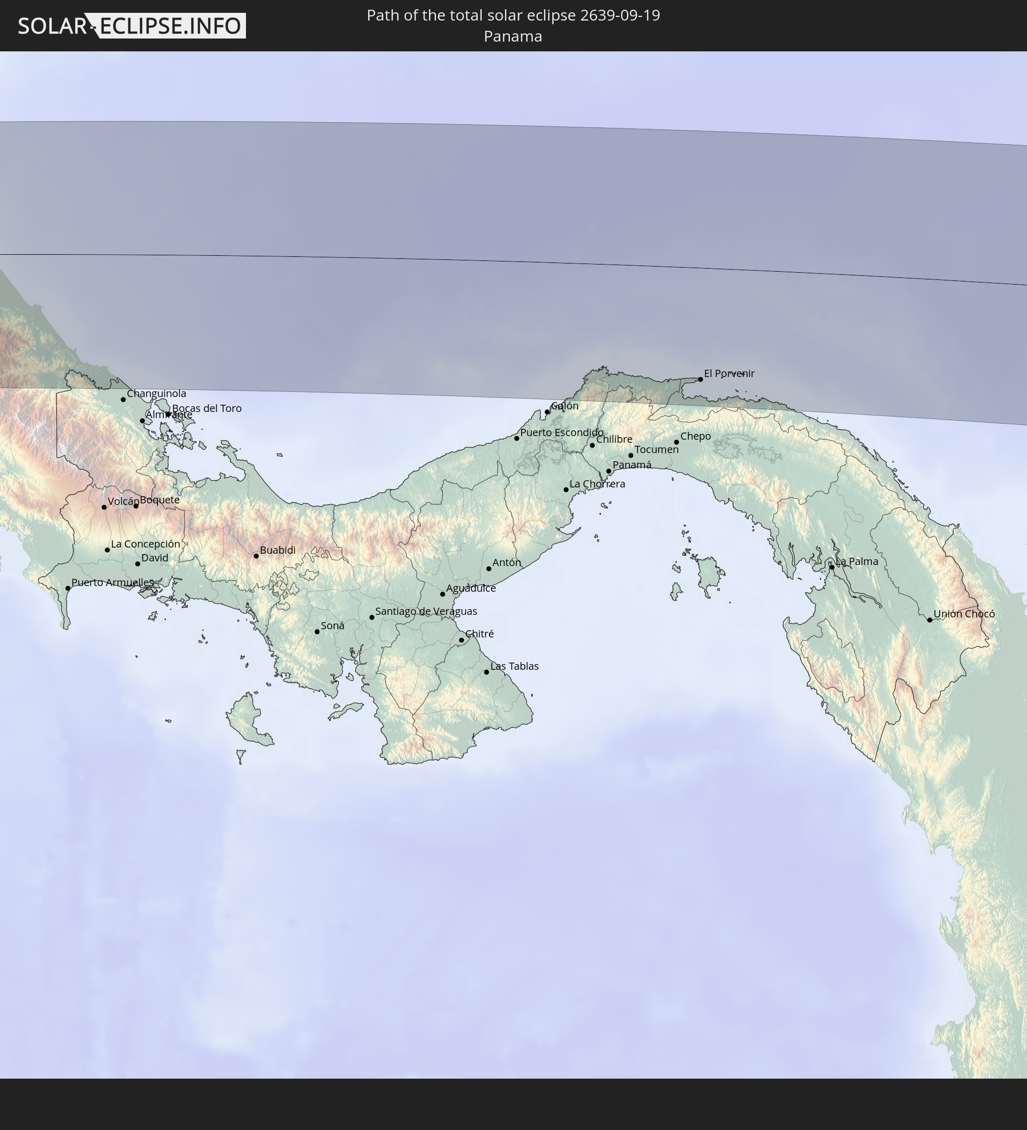 Panama
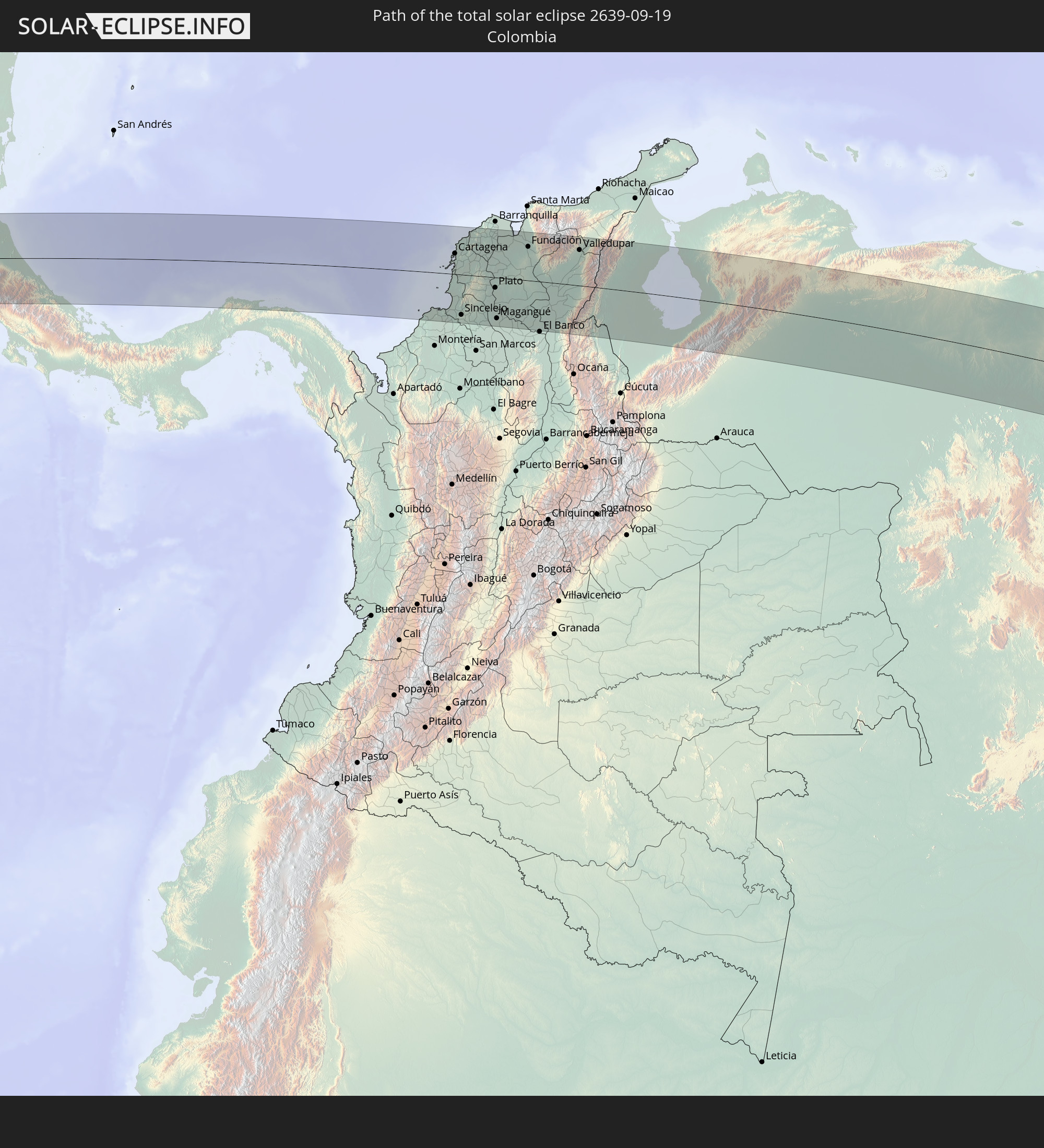 Kolumbien
 Brasilien
 Venezuela
 Guyana
 Suriname
 Französisch-Guayana
In den folgenden Ländern ist die Sonnenfinsternis partiell zu sehen
 Antarktika
 Vereinigte Staaten
 United States Minor Outlying Islands
 Chile
Chile
 Ecuador
 Honduras
 Nicaragua
 Costa Rica
 Kuba
Kuba
 Panama
 Kolumbien
 Kaimaninseln
 Peru
Peru
 Bahamas
 Jamaika
 Haiti
Haiti
 Brasilien
 Argentinien
 Venezuela
 Turks- und Caicosinseln
 Dominikanische Republik
 Aruba
Aruba
 Bolivien
 Puerto Rico
 Amerikanische Jungferninseln
 Bermuda
 Britische Jungferninseln
 Anguilla
 Saint-Martin
 Saint-Barthélemy
 St. Kitts und Nevis
 Paraguay
 Antigua und Barbuda
 Montserrat
 Trinidad und Tobago
 Guadeloupe
 Grenada
 Dominica
 St. Vincent und die Grenadinen
 Guyana
 Martinique
 St. Lucia
 Barbados
 Uruguay
 Suriname
 Französisch-Guayana
 Südgeorgien und die Südlichen Sandwichinseln
 Kap Verde
 Senegal
 Mauretanien
 Gambia
 Guinea-Bissau
 Guinea
 St. Helena
 Sierra Leone
 Liberia
 Elfenbeinküste
 Bouvetinsel
 Angola
 Namibia
 Südafrika
 Botswana
 Sambia
 Simbabwe
 Lesotho
 Mosambik
 Swasiland
 Malawi
 Französische Süd- und Antarktisgebiete
 Madagaskar
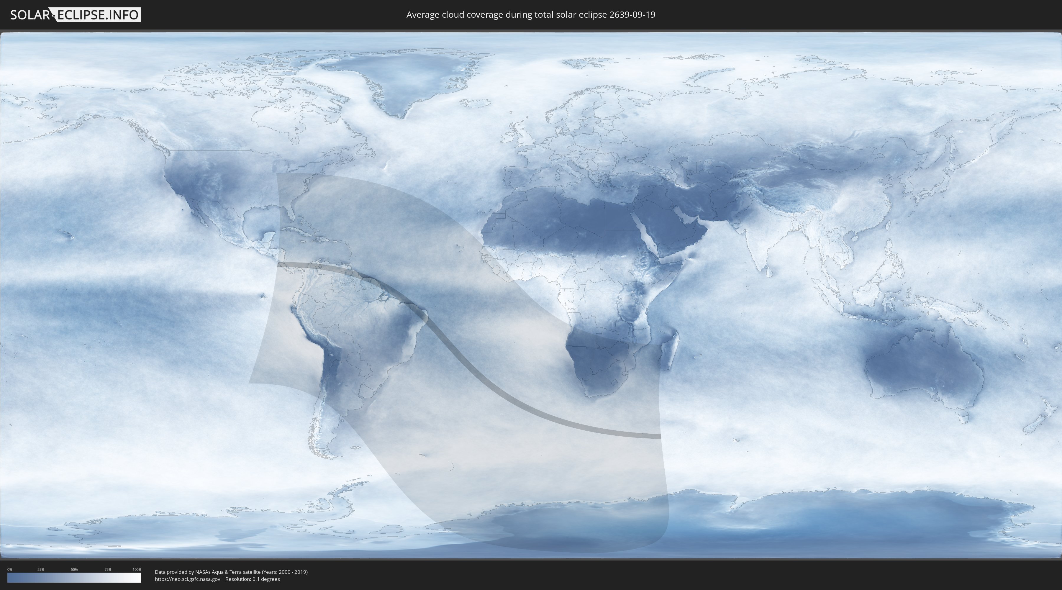
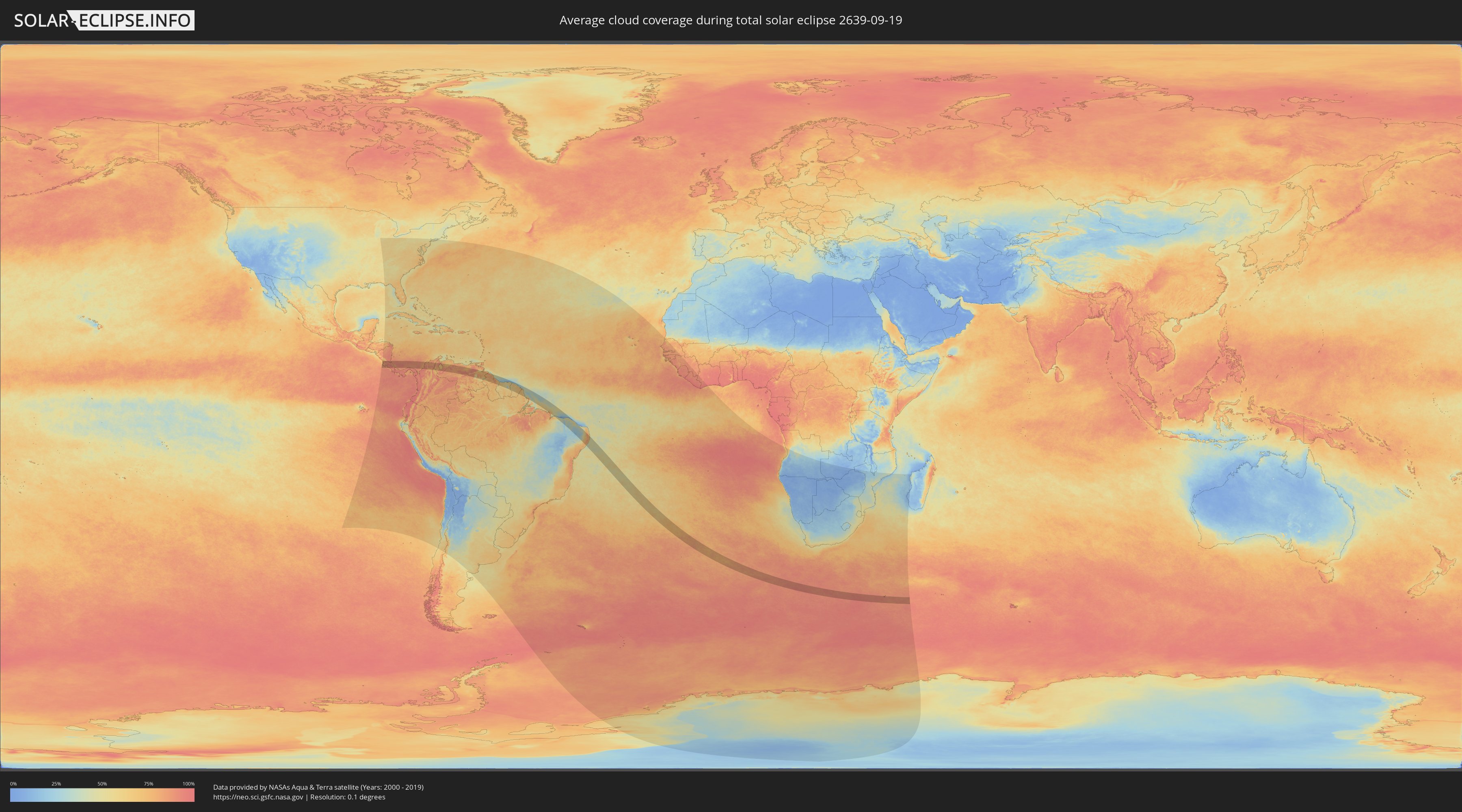
Wie wird das Wetter während der totalen Sonnenfinsternis am 19.09.2639?
Wo ist der beste Ort, um die totale Sonnenfinsternis vom 19.09.2639 zu beobachten?
Die folgenden Karten zeigen die durchschnittliche Bewölkung für den Tag, an dem die totale Sonnenfinsternis
stattfindet. Mit Hilfe der Karten lässt sich der Ort entlang des Finsternispfades eingrenzen,
der die besten Aussichen auf einen klaren wolkenfreien Himmel bietet.
Trotzdem muss man immer lokale Gegenenheiten beachten und sollte sich genau über das Wetter an seinem
gewählten Beobachtungsort informieren.
Die Daten stammen von den beiden NASA-Satelliten
AQUA und TERRA
und wurden über einen Zeitraum von 19 Jahren (2000 - 2019) gemittelt.
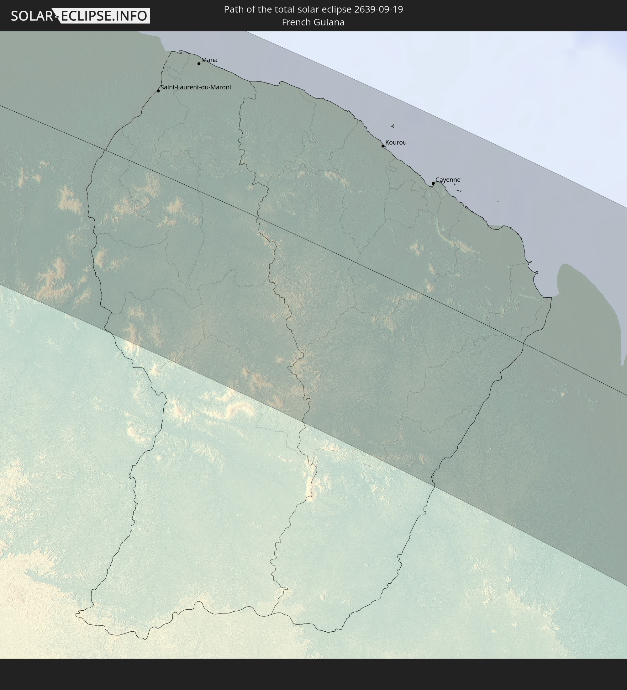
Detaillierte Länderkarten
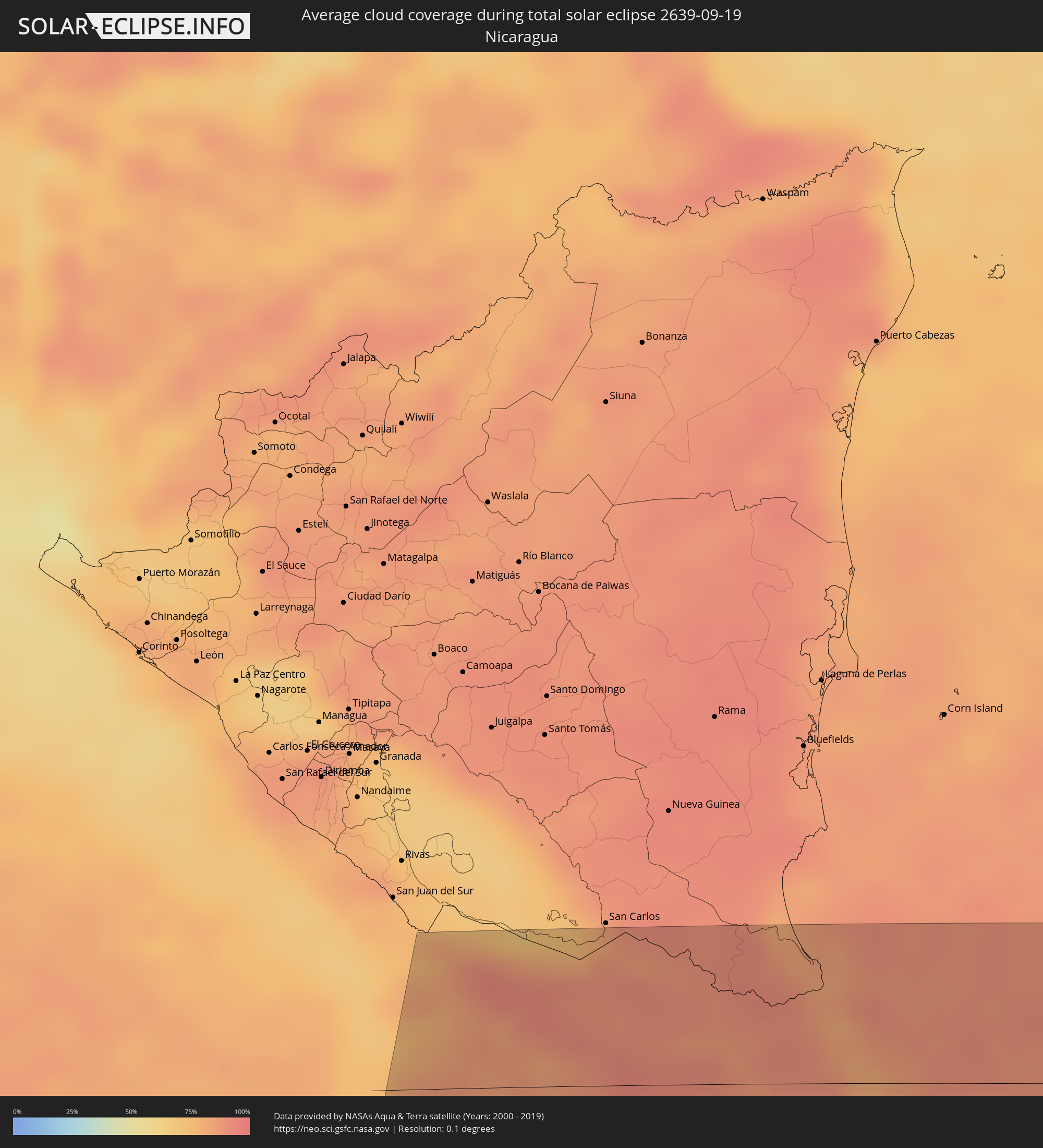 Nicaragua
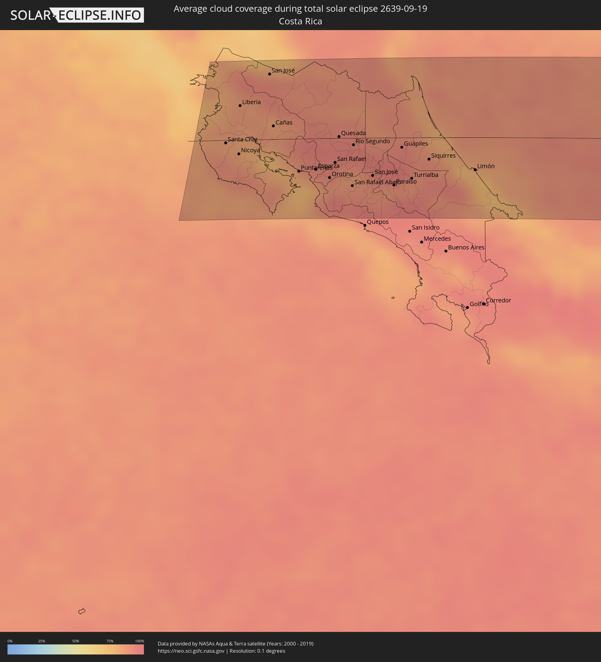 Costa Rica
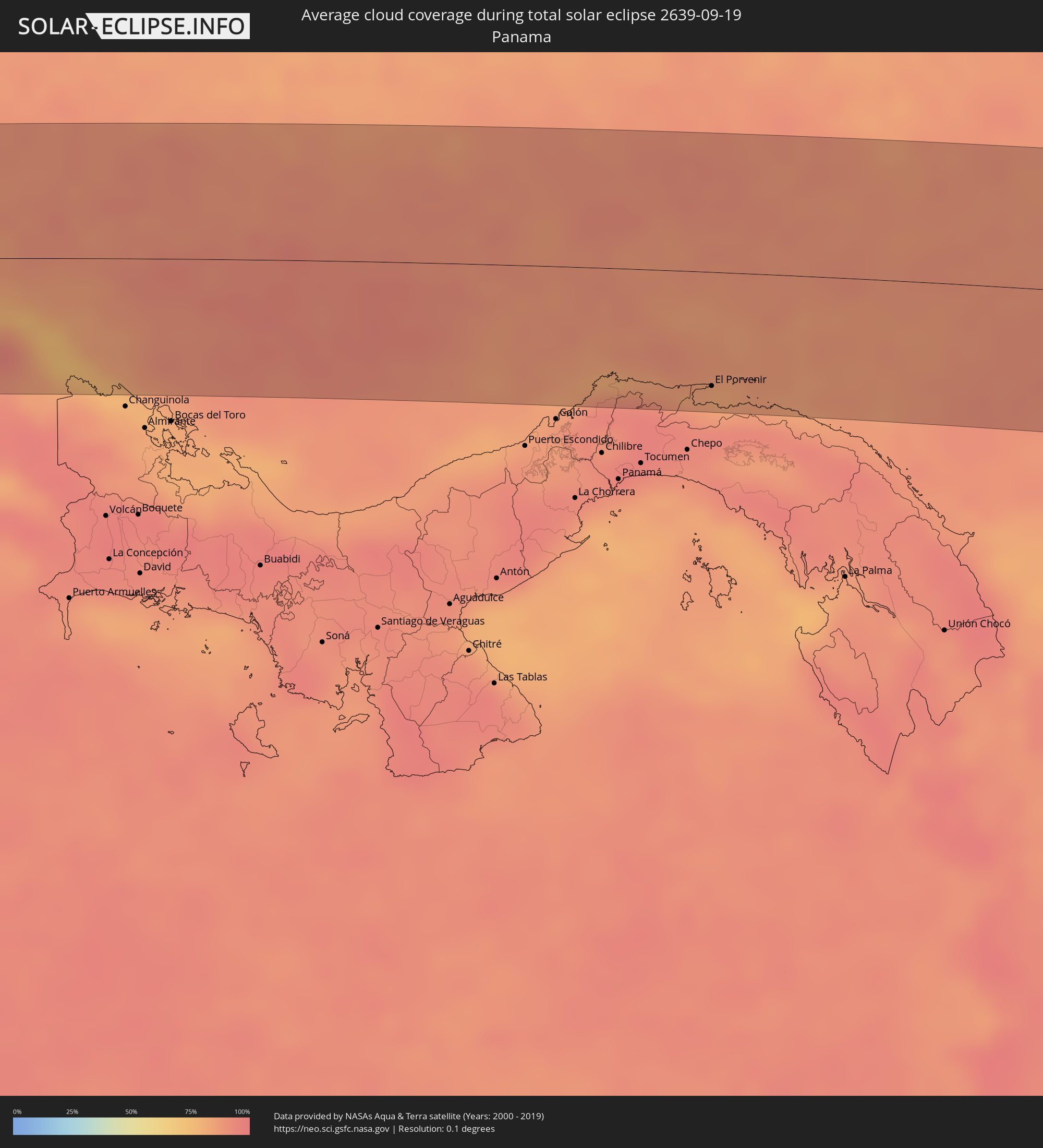 Panama
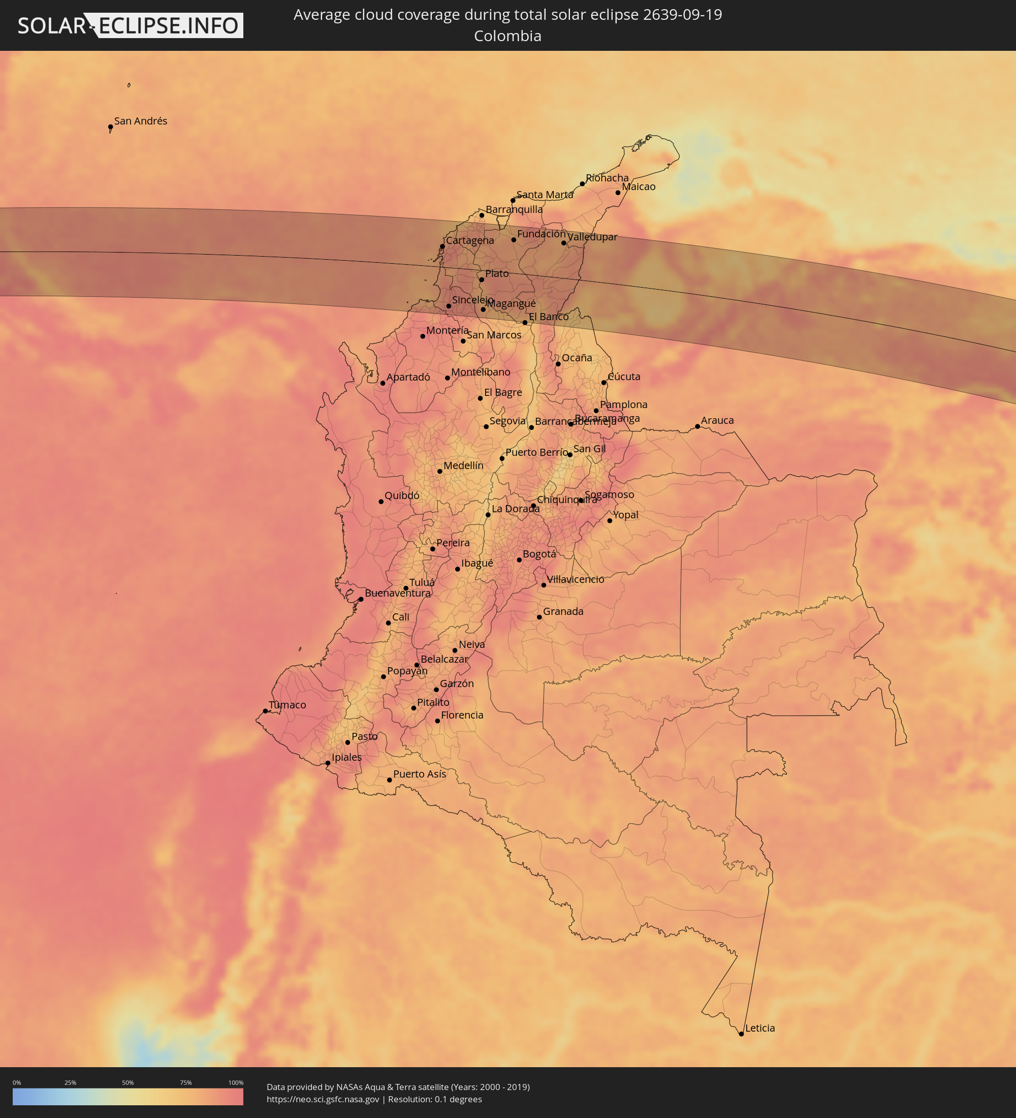 Kolumbien
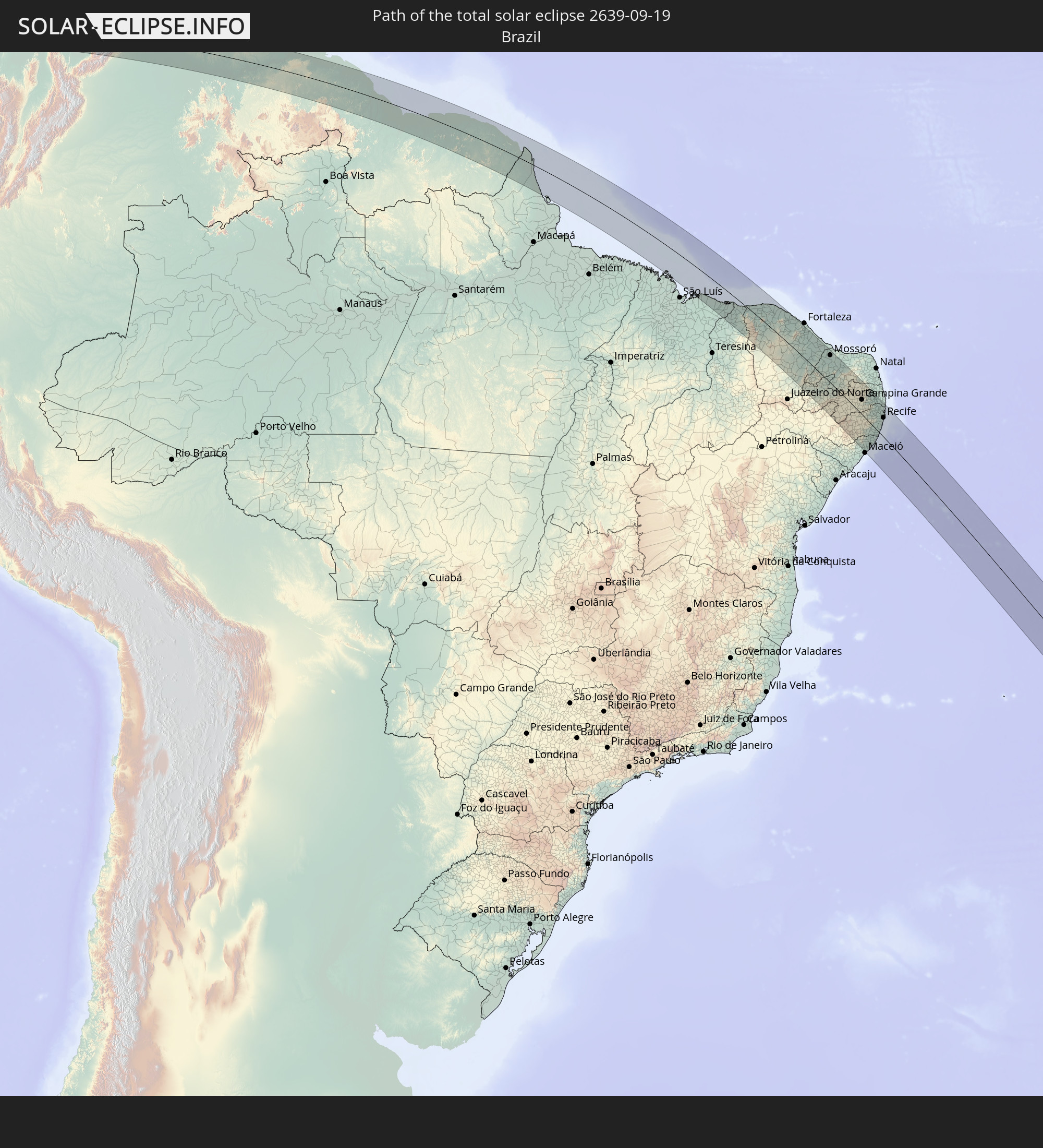
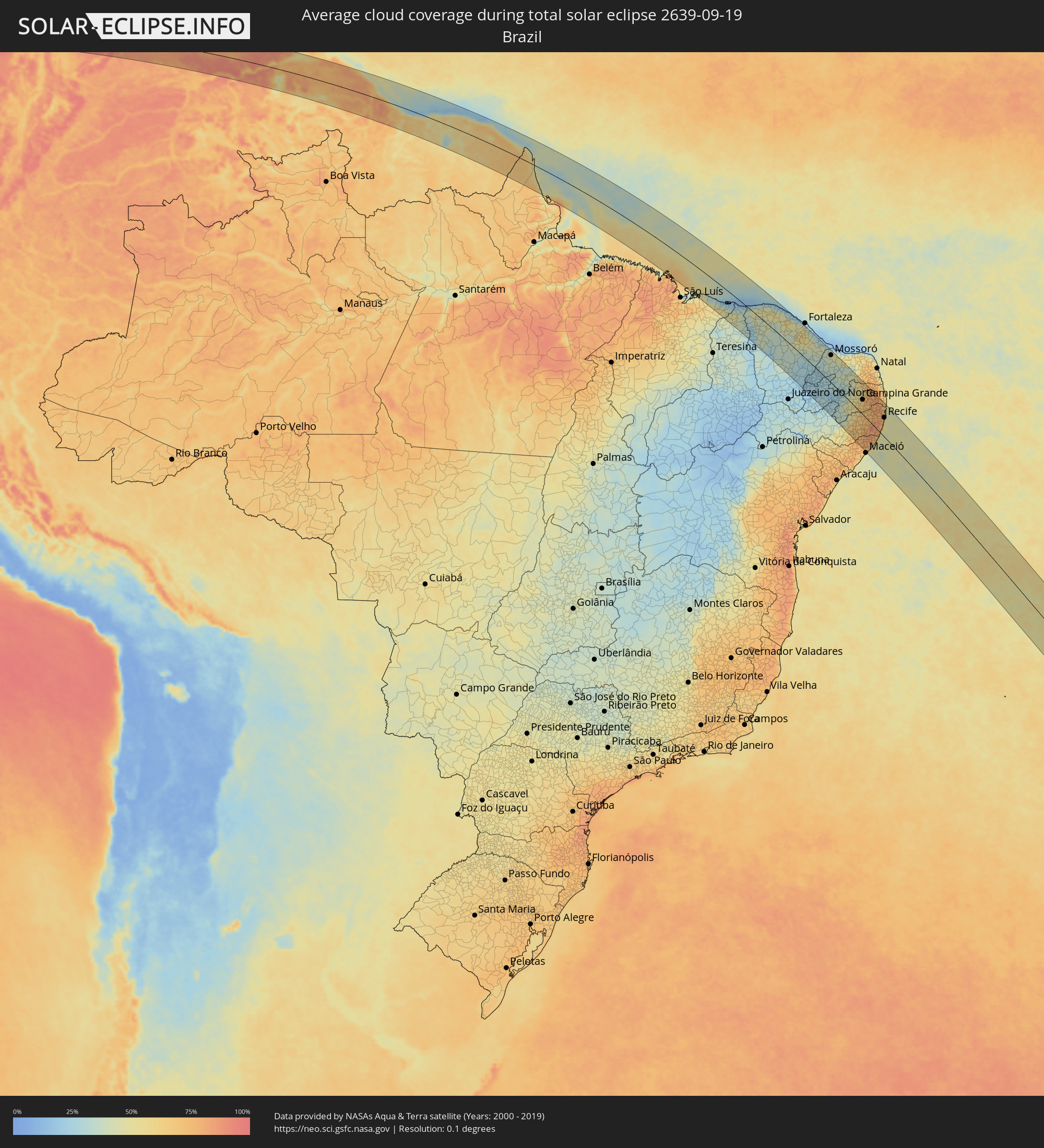 Brasilien
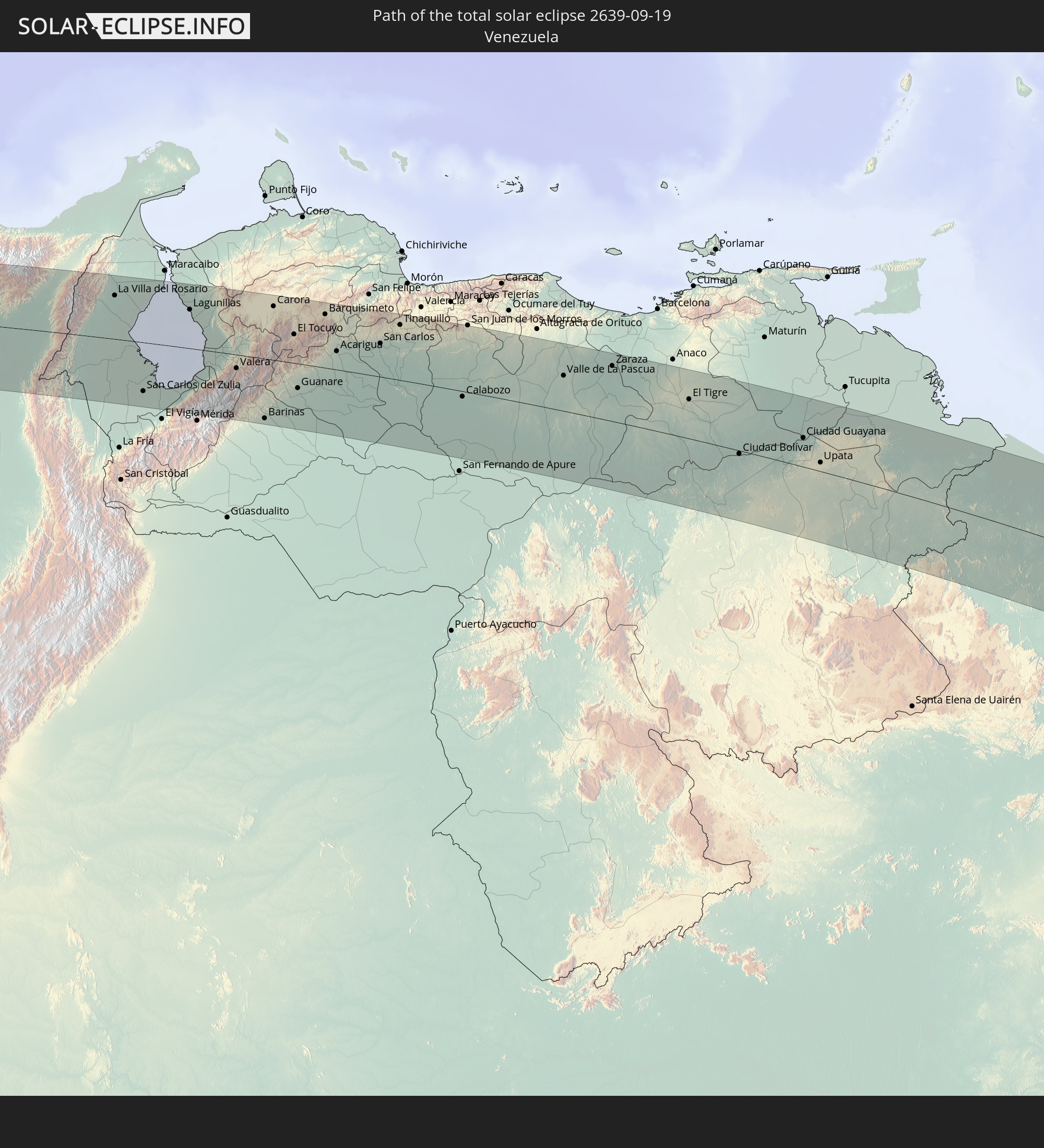
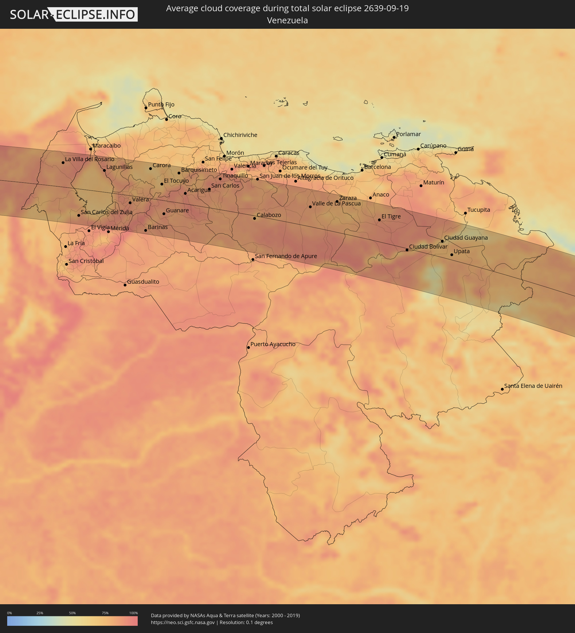 Venezuela
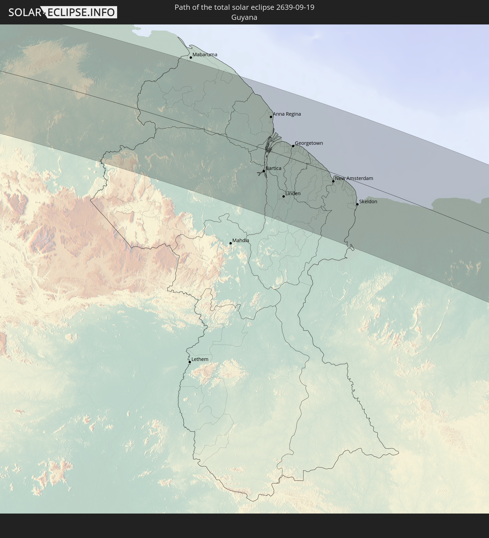
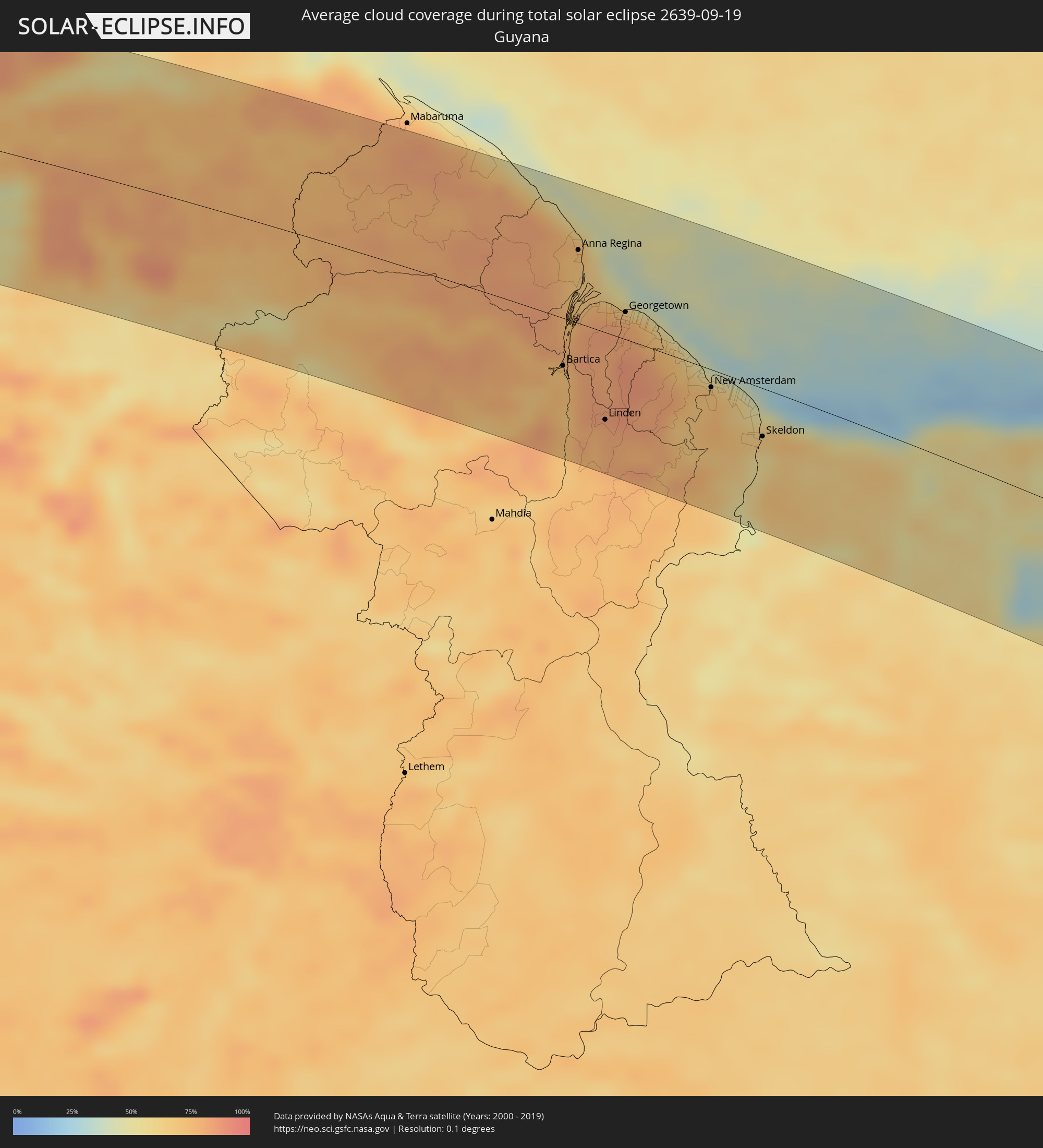 Guyana
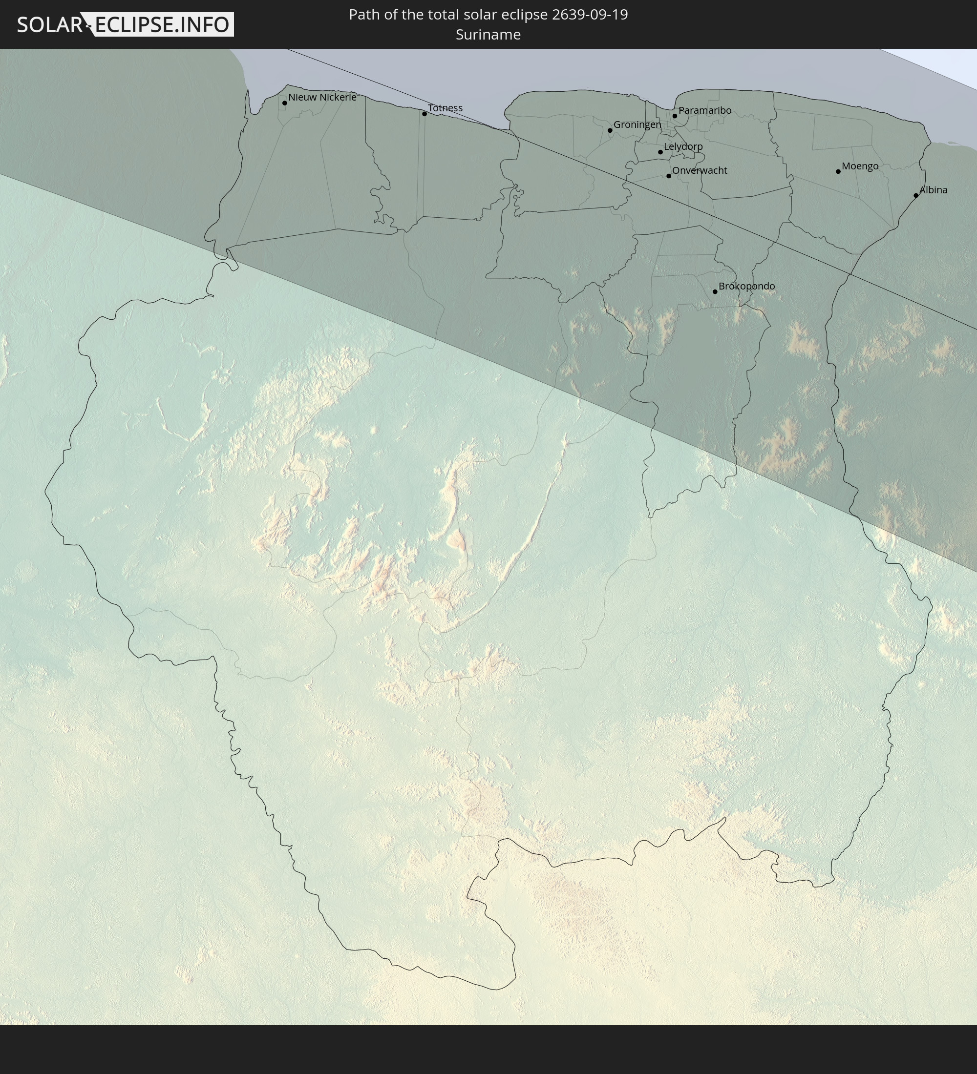
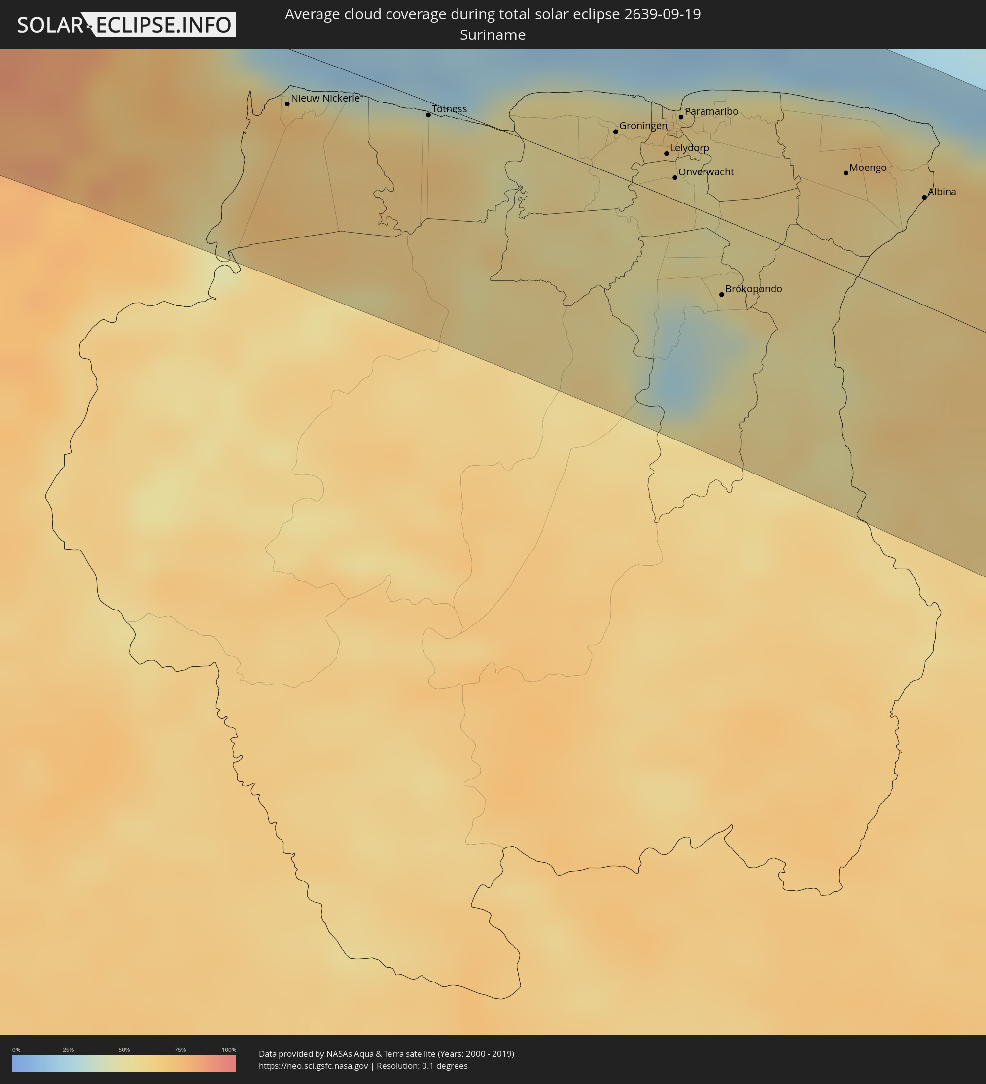 Suriname
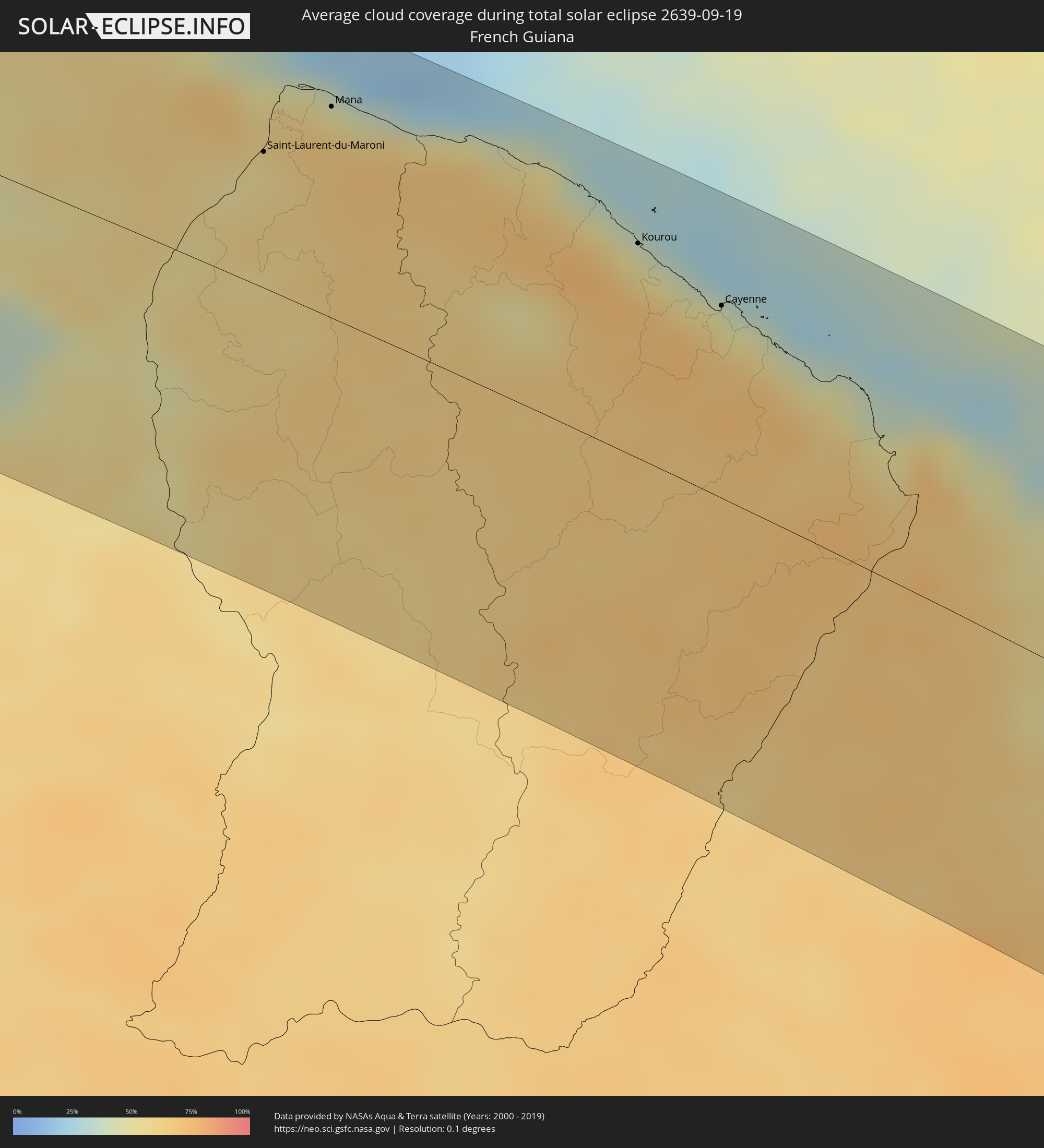 Französisch-Guayana
Orte im Finsternispfad
Die nachfolgene Tabelle zeigt Städte und Orte mit mehr als 5.000 Einwohnern, die sich im Finsternispfad befinden. Städte mit mehr als 100.000 Einwohnern sind dick gekennzeichnet. Mit einem Klick auf den Ort öffnet sich eine Detailkarte die die Lage des jeweiligen Ortes zusammen mit dem Verlauf der zentralen Finsternis präsentiert.
| Ort | Typ | Dauer der Verfinsterung | Ortszeit bei maximaler Verfinsterung | Entfernung zur Zentrallinie | Ø Bewölkung |
|
Santa Cruz, Guanacaste
|
total | - | 05:37:28 UTC-06:00 | 3 km | 85% |
|
Nicoya, Guanacaste
|
total | - | 05:37:32 UTC-06:00 | 16 km | 87% |
|
Liberia, Guanacaste
|
total | - | 05:37:16 UTC-06:00 | 38 km | 85% |
|
San José, Alajuela
|
total | - | 05:37:06 UTC-06:00 | 73 km | 92% |
|
Cañas, Guanacaste
|
total | - | 05:37:23 UTC-06:00 | 15 km | 85% |
|
Puntarenas, Puntarenas
|
total | - | 05:37:39 UTC-06:00 | 37 km | 79% |
|
Esparza, Puntarenas
|
total | - | 05:37:39 UTC-06:00 | 35 km | 83% |
|
San Ramón, Alajuela
|
total | - | 05:37:37 UTC-06:00 | 25 km | 93% |
|
San Rafael, Alajuela
|
total | - | 05:37:38 UTC-06:00 | 27 km | 93% |
|
Quesada, Alajuela
|
total | - | 05:37:29 UTC-06:00 | 2 km | 95% |
|
Naranjo, Alajuela
|
total | - | 05:37:37 UTC-06:00 | 24 km | 90% |
|
San Rafael Abajo, San José
|
total | - | 05:37:46 UTC-06:00 | 53 km | 91% |
|
Río Segundo, Alajuela
|
total | - | 05:37:32 UTC-06:00 | 8 km | 93% |
|
Alajuela, Alajuela
|
total | - | 05:37:40 UTC-06:00 | 33 km | 87% |
|
San Antonio, Heredia
|
total | - | 05:37:41 UTC-06:00 | 37 km | 87% |
|
Escazú, San José
|
total | - | 05:37:44 UTC-06:00 | 44 km | 89% |
|
San Josecito, Heredia
|
total | - | 05:37:41 UTC-06:00 | 33 km | 89% |
|
San José, San José
|
total | - | 05:37:44 UTC-06:00 | 42 km | 89% |
|
Granadilla, San José
|
total | - | 05:37:44 UTC-06:00 | 42 km | 88% |
|
Tres Ríos, Cartago
|
total | - | 05:37:45 UTC-06:00 | 45 km | 88% |
|
Paraíso, Cartago
|
total | - | 05:37:48 UTC-06:00 | 53 km | 92% |
|
Guápiles, Limón
|
total | - | 05:37:35 UTC-06:00 | 11 km | 96% |
|
Turrialba, Cartago
|
total | - | 05:37:47 UTC-06:00 | 46 km | 88% |
|
Siquirres, Limón
|
total | - | 05:37:41 UTC-06:00 | 24 km | 91% |
|
Limón, Limón
|
total | - | 05:37:47 UTC-06:00 | 36 km | 75% |
|
El Porvenir, Guna Yala
|
total | - | 06:38:44 UTC-05:00 | 76 km | 83% |
|
Lorica, Córdoba
|
total | - | 06:39:50 UTC-05:00 | 91 km | 90% |
|
Tolú, Sucre
|
total | - | 06:39:42 UTC-05:00 | 57 km | 85% |
|
San Onofre, Sucre
|
total | - | 06:39:34 UTC-05:00 | 33 km | 89% |
|
Cartagena, Bolívar
|
total | - | 06:39:07 UTC-05:00 | 41 km | 90% |
|
Sincelejo, Sucre
|
total | - | 06:39:55 UTC-05:00 | 80 km | 93% |
|
Arjona, Bolívar
|
total | - | 06:39:16 UTC-05:00 | 26 km | 87% |
|
María la Baja, Bolívar
|
total | - | 06:39:28 UTC-05:00 | 4 km | 83% |
|
Sincé, Sucre
|
total | - | 06:40:03 UTC-05:00 | 84 km | 90% |
|
Repelón, Atlántico
|
total | - | 06:39:11 UTC-05:00 | 54 km | 81% |
|
El Carmen de Bolívar, Bolívar
|
total | - | 06:39:43 UTC-05:00 | 31 km | 90% |
|
San Juan Nepomuceno, Bolívar
|
total | - | 06:39:34 UTC-05:00 | 5 km | 91% |
|
Sabanalarga, Atlántico
|
total | - | 06:39:09 UTC-05:00 | 72 km | 86% |
|
Baranoa, Atlántico
|
total | - | 06:39:03 UTC-05:00 | 90 km | 88% |
|
Campo de la Cruz, Atlántico
|
total | - | 06:39:20 UTC-05:00 | 44 km | 81% |
|
Plato, Magdalena
|
total | - | 06:39:47 UTC-05:00 | 20 km | 79% |
|
Magangué, Bolívar
|
total | - | 06:40:12 UTC-05:00 | 81 km | 83% |
|
Palmar de Varela, Atlántico
|
total | - | 06:39:08 UTC-05:00 | 85 km | 87% |
|
Pivijay, Magdalena
|
total | - | 06:39:23 UTC-05:00 | 56 km | 85% |
|
Mompós, Bolívar
|
total | - | 06:40:19 UTC-05:00 | 78 km | 78% |
|
Fundación, Magdalena
|
total | - | 06:39:29 UTC-05:00 | 67 km | 82% |
|
Ariguaní, Cesar
|
total | - | 06:39:45 UTC-05:00 | 39 km | 81% |
|
Curumaní, Cesar
|
total | - | 06:40:41 UTC-05:00 | 73 km | 86% |
|
Valledupar, Cesar
|
total | - | 06:39:53 UTC-05:00 | 70 km | 81% |
|
Agustín Codazzi, Cesar
|
total | - | 06:40:12 UTC-05:00 | 23 km | 86% |
|
Villanueva, La Guajira
|
total | - | 06:39:53 UTC-05:00 | 89 km | 85% |
|
Machiques, Zulia
|
total | - | 07:40:28 UTC-04:00 | 34 km | 80% |
|
La Villa del Rosario, Zulia
|
total | - | 07:40:22 UTC-04:00 | 67 km | 87% |
|
San Carlos del Zulia, Zulia
|
total | - | 07:41:33 UTC-04:00 | 75 km | 87% |
|
Cabimas, Zulia
|
total | - | 07:40:43 UTC-04:00 | 85 km | 82% |
|
Lagunillas, Zulia
|
total | - | 07:40:59 UTC-04:00 | 59 km | 75% |
|
Valera, Trujillo
|
total | - | 07:41:56 UTC-04:00 | 21 km | 86% |
|
Barinas, Barinas
|
total | - | 07:42:42 UTC-04:00 | 91 km | 86% |
|
Carora, Lara
|
total | - | 07:41:31 UTC-04:00 | 82 km | 72% |
|
El Tocuyo, Lara
|
total | - | 07:41:58 UTC-04:00 | 44 km | 75% |
|
Guanare, Portuguesa
|
total | - | 07:42:36 UTC-04:00 | 37 km | 87% |
|
Quíbor, Lara
|
total | - | 07:41:57 UTC-04:00 | 62 km | 79% |
|
Barquisimeto, Lara
|
total | - | 07:41:59 UTC-04:00 | 81 km | 71% |
|
Araure, Portuguesa
|
total | - | 07:42:28 UTC-04:00 | 28 km | 91% |
|
Acarigua, Portuguesa
|
total | - | 07:42:29 UTC-04:00 | 28 km | 91% |
|
Yaritagua, Yaracuy
|
total | - | 07:42:06 UTC-04:00 | 87 km | 83% |
|
Chivacoa, Yaracuy
|
total | - | 07:42:09 UTC-04:00 | 100 km | 80% |
|
San Carlos, Cojedes
|
total | - | 07:42:44 UTC-04:00 | 51 km | 85% |
|
Tinaquillo, Cojedes
|
total | - | 07:42:40 UTC-04:00 | 84 km | 85% |
|
Calabozo, Guárico
|
total | - | 07:44:02 UTC-04:00 | 8 km | 85% |
|
Valle de La Pascua, Guárico
|
total | - | 07:44:40 UTC-04:00 | 54 km | 82% |
|
El Tigre, Anzoátegui
|
total | - | 07:46:11 UTC-04:00 | 59 km | 88% |
|
San José de Guanipa, Anzoátegui
|
total | - | 07:46:15 UTC-04:00 | 61 km | 88% |
|
Ciudad Bolívar, Bolívar
|
total | - | 07:47:26 UTC-04:00 | 5 km | 89% |
|
Ciudad Guayana, Bolívar
|
total | - | 07:47:54 UTC-04:00 | 43 km | 75% |
|
Upata, Bolívar
|
total | - | 07:48:26 UTC-04:00 | 13 km | 80% |
|
Bartica, Cuyuni-Mazaruni
|
total | - | 07:53:29 UTC-04:00 | 37 km | 72% |
|
Anna Regina, Pomeroon-Supenaam
|
total | - | 07:52:38 UTC-04:00 | 57 km | 72% |
|
Linden, Upper Demerara-Berbice
|
total | - | 07:54:15 UTC-04:00 | 68 km | 82% |
|
Vreed-en-Hoop, Essequibo Islands-West Demerara
|
total | - | 07:53:26 UTC-04:00 | 20 km | 80% |
|
Georgetown, Demerara-Mahaica
|
total | - | 07:53:29 UTC-04:00 | 21 km | 80% |
|
Fort Wellington, Mahaica-Berbice
|
total | - | 07:54:30 UTC-04:00 | 2 km | 58% |
|
Rosignol, Mahaica-Berbice
|
total | - | 07:54:43 UTC-04:00 | 12 km | 66% |
|
New Amsterdam, East Berbice-Corentyne
|
total | - | 07:54:45 UTC-04:00 | 14 km | 72% |
|
Skeldon, East Berbice-Corentyne
|
total | - | 07:55:35 UTC-04:00 | 37 km | 65% |
|
Nieuw Nickerie, Nickerie
|
total | - | 08:55:42 UTC-03:00 | 27 km | 71% |
|
Totness, Coronie
|
total | - | 08:56:25 UTC-03:00 | 6 km | 46% |
|
Groningen, Saramacca
|
total | - | 08:57:26 UTC-03:00 | 21 km | 58% |
|
Lelydorp, Wanica
|
total | - | 08:57:49 UTC-03:00 | 20 km | 57% |
|
Onverwacht, Para
|
total | - | 08:57:59 UTC-03:00 | 10 km | 58% |
|
Paramaribo, Paramaribo
|
total | - | 08:57:40 UTC-03:00 | 40 km | 62% |
|
Nieuw Amsterdam, Commewijne
|
total | - | 08:57:44 UTC-03:00 | 45 km | 60% |
|
Brokopondo, Brokopondo
|
total | - | 08:58:54 UTC-03:00 | 36 km | 50% |
|
Moengo, Marowijne
|
total | - | 08:58:50 UTC-03:00 | 46 km | 61% |
|
Albina, Marowijne
|
total | - | 08:59:22 UTC-03:00 | 50 km | 54% |
|
Saint-Laurent-du-Maroni, Guyane
|
total | - | 08:59:24 UTC-03:00 | 51 km | 58% |
|
Mana, Guyane
|
total | - | 08:59:28 UTC-03:00 | 79 km | 50% |
|
Kourou, Guyane
|
total | - | 09:01:26 UTC-03:00 | 80 km | 38% |
|
Macouria, Guyane
|
total | - | 09:02:06 UTC-03:00 | 67 km | 60% |
|
Cayenne, Guyane
|
total | - | 09:02:07 UTC-03:00 | 71 km | 49% |
|
Matoury, Guyane
|
total | - | 09:02:14 UTC-03:00 | 63 km | 63% |
|
Rémire-Montjoly, Guyane
|
total | - | 09:02:13 UTC-03:00 | 73 km | 49% |
|
Parnaíba, Piauí
|
total | - | 09:29:39 UTC-03:00 | 35 km | 32% |
|
Sobral, Ceará
|
total | - | 09:33:25 UTC-03:00 | 1 km | 42% |
|
Itapipoca, Ceará
|
total | - | 09:34:19 UTC-03:00 | 73 km | 50% |
|
Quixadá, Ceará
|
total | - | 09:38:04 UTC-03:00 | 7 km | 35% |
|
Maracanaú, Ceará
|
total | - | 09:36:37 UTC-03:00 | 112 km | 51% |
|
Horizonte, Ceará
|
total | - | 09:37:17 UTC-03:00 | 104 km | 47% |
|
Cascavel, Ceará
|
total | - | 09:37:45 UTC-03:00 | 119 km | 29% |
|
Mossoró, Rio Grande do Norte
|
total | - | 09:41:18 UTC-03:00 | 102 km | 45% |
|
Patos, Paraíba
|
total | - | 09:45:01 UTC-03:00 | 40 km | 23% |
|
Caicó, Rio Grande do Norte
|
total | - | 09:44:12 UTC-03:00 | 19 km | 30% |
|
Belo Jardim, Pernambuco
|
total | - | 09:49:06 UTC-03:00 | 76 km | 64% |
|
Santa Cruz do Capibaribe, Pernambuco
|
total | - | 09:48:43 UTC-03:00 | 29 km | 65% |
|
Caruaru, Pernambuco
|
total | - | 09:49:46 UTC-03:00 | 36 km | 68% |
|
Campina Grande, Paraíba
|
total | - | 09:47:50 UTC-03:00 | 53 km | 66% |
|
Rio Largo, Alagoas
|
total | - | 09:52:23 UTC-03:00 | 119 km | 69% |
|
Bezerros, Pernambuco
|
total | - | 09:49:59 UTC-03:00 | 18 km | 70% |
|
Gravatá, Pernambuco
|
total | - | 09:50:19 UTC-03:00 | 2 km | 75% |
|
Vitória de Santo Antão, Pernambuco
|
total | - | 09:50:38 UTC-03:00 | 31 km | 82% |
|
Carpina, Pernambuco
|
total | - | 09:50:09 UTC-03:00 | 54 km | 77% |
|
Escada, Pernambuco
|
total | - | 09:51:14 UTC-03:00 | 17 km | 82% |
|
Ipojuca, Pernambuco
|
total | - | 09:51:35 UTC-03:00 | 27 km | 75% |
|
São Lourenço da Mata, Pernambuco
|
total | - | 09:50:52 UTC-03:00 | 61 km | 78% |
|
Jaboatão, Pernambuco
|
total | - | 09:51:15 UTC-03:00 | 49 km | 69% |
|
Igarassu, Pernambuco
|
total | - | 09:50:43 UTC-03:00 | 83 km | 66% |
|
Recife, Pernambuco
|
total | - | 09:51:13 UTC-03:00 | 68 km | 56% |